Embed Size (px)
DESCRIPTION
Update on the wildfire situation on August 16, 2012
Citation preview
Kamloops Fire Centre As of August 16, 2012, the Kamloops Fire Centre has
responded to 267 wildfires that have consumed 987
hectares since April 1, 2012. This is below the 10-
year average for this date of 404 wildfires burning a
total of 9,815 hectares.
As we enter the last half of August, the forest condi-
tions are dry and most of the Kamloops Fire Centre is
at a “high” to “extreme” Fire Danger Rating. Fire
personnel have kept busy responding to holdover
lightning fires as well as human-caused fires.
Most fires that started in the past week have dis-
played aggressive fire behaviour and have required
additional resources for full fire suppression.
Due to the dry forest conditions and the forecast for
lightning this coming weekend, forest officials have
ordered a campfire ban throughout the Kamloops
Fire Centre, excluding the Clearwater Fire Zone. Ef-
fective at 12 noon on Friday, all campfires, tiki
torches and fireworks are prohibited (see Page 2).
With the current conditions and heightened level of
fire activity, we ask that the public remain vigilant
when in the backcountry.
For the latest information on fire activity, current
prohibitions and conditions, visit the Wildfire
Management Branch website at www.bcwildfire.ca.
August 2, 2012
Fire Zone # of Fires # of Hectares
Clearwater 11 0
Kamloops 56 48
Salmon Arm 19 1
Vernon 20 36
Penticton 47 42
Merritt 90 621
Lillooet 25 240
Info current as of noon on August 16, 2012
P A G E 2
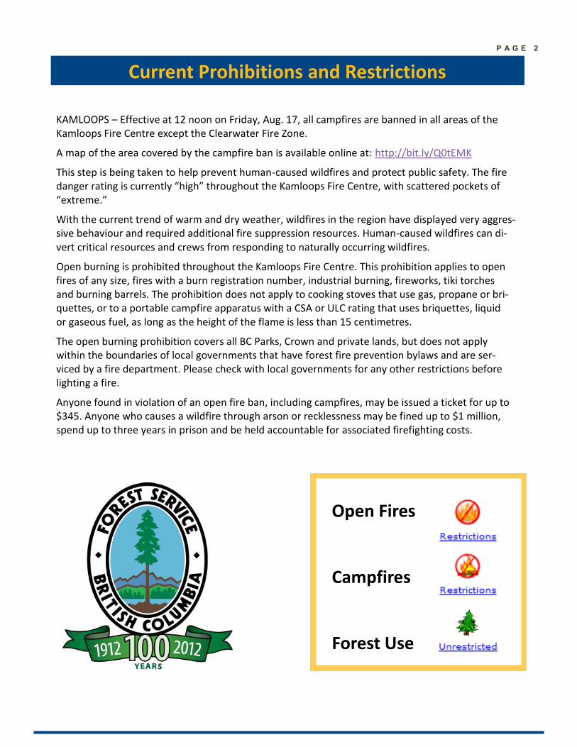
Current Prohibitions and Restrictions
Open Fires
Campfires
Forest Use
KAMLOOPS – Effective at 12 noon on Friday, Aug. 17, all campfires are banned in all areas of the Kamloops Fire Centre except the Clearwater Fire Zone.
A map of the area covered by the campfire ban is available online at: http://bit.ly/Q0tEMK
This step is being taken to help prevent human-caused wildfires and protect public safety. The fire danger rating is currently “high” throughout the Kamloops Fire Centre, with scattered pockets of “extreme.”
With the current trend of warm and dry weather, wildfires in the region have displayed very aggres-sive behaviour and required additional fire suppression resources. Human-caused wildfires can di-vert critical resources and crews from responding to naturally occurring wildfires.
Open burning is prohibited throughout the Kamloops Fire Centre. This prohibition applies to open fires of any size, fires with a burn registration number, industrial burning, fireworks, tiki torches and burning barrels. The prohibition does not apply to cooking stoves that use gas, propane or bri-quettes, or to a portable campfire apparatus with a CSA or ULC rating that uses briquettes, liquid or gaseous fuel, as long as the height of the flame is less than 15 centimetres.
The open burning prohibition covers all BC Parks, Crown and private lands, but does not apply within the boundaries of local governments that have forest fire prevention bylaws and are ser-viced by a fire department. Please check with local governments for any other restrictions before lighting a fire.
Anyone found in violation of an open fire ban, including campfires, may be issued a ticket for up to $345. Anyone who causes a wildfire through arson or recklessness may be fined up to $1 million, spend up to three years in prison and be held accountable for associated firefighting costs.
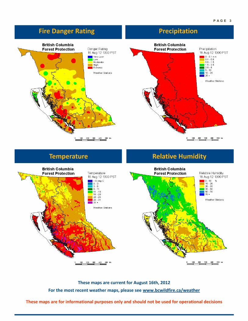
P A G E 3
Precipitation
Temperature Relative Humidity
These maps are for informational purposes only and should not be used for operational decisions
Fire Danger Rating
These maps are current for August 16th, 2012
For the most recent weather maps, please see www.bcwildfire.ca/weather
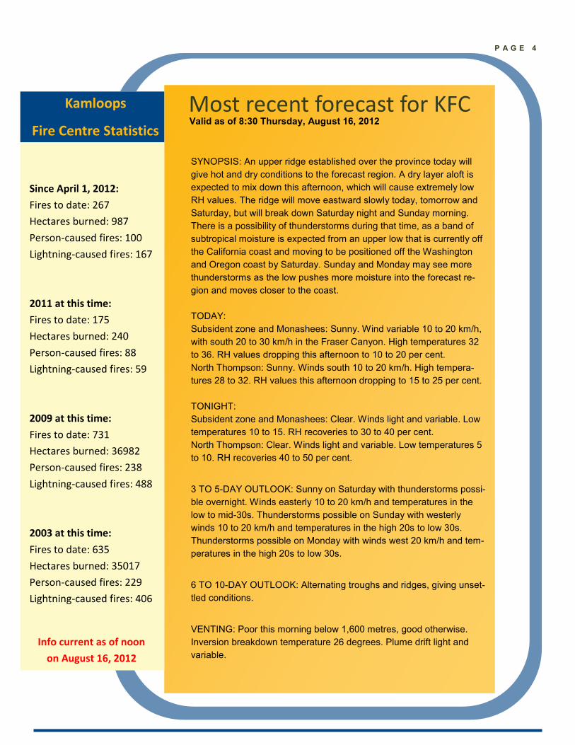
Most recent forecast for KFC
Kamloops
Fire Centre Statistics
Since April 1, 2012:
Fires to date: 267
Hectares burned: 987
Person-caused fires: 100
Lightning-caused fires: 167
2011 at this time:
Fires to date: 175
Hectares burned: 240
Person-caused fires: 88
Lightning-caused fires: 59
2009 at this time:
Fires to date: 731
Hectares burned: 36982
Person-caused fires: 238
Lightning-caused fires: 488
2003 at this time:
Fires to date: 635
Hectares burned: 35017
Person-caused fires: 229
Lightning-caused fires: 406
SYNOPSIS: An upper ridge established over the province today will
give hot and dry conditions to the forecast region. A dry layer aloft is
expected to mix down this afternoon, which will cause extremely low
RH values. The ridge will move eastward slowly today, tomorrow and
Saturday, but will break down Saturday night and Sunday morning.
There is a possibility of thunderstorms during that time, as a band of
subtropical moisture is expected from an upper low that is currently off
the California coast and moving to be positioned off the Washington
and Oregon coast by Saturday. Sunday and Monday may see more
thunderstorms as the low pushes more moisture into the forecast re-
gion and moves closer to the coast.
TODAY:
Subsident zone and Monashees: Sunny. Wind variable 10 to 20 km/h,
with south 20 to 30 km/h in the Fraser Canyon. High temperatures 32
to 36. RH values dropping this afternoon to 10 to 20 per cent.
North Thompson: Sunny. Winds south 10 to 20 km/h. High tempera-
tures 28 to 32. RH values this afternoon dropping to 15 to 25 per cent.
TONIGHT:
Subsident zone and Monashees: Clear. Winds light and variable. Low
temperatures 10 to 15. RH recoveries to 30 to 40 per cent.
North Thompson: Clear. Winds light and variable. Low temperatures 5
to 10. RH recoveries 40 to 50 per cent.
3 TO 5-DAY OUTLOOK: Sunny on Saturday with thunderstorms possi-
ble overnight. Winds easterly 10 to 20 km/h and temperatures in the
low to mid-30s. Thunderstorms possible on Sunday with westerly
winds 10 to 20 km/h and temperatures in the high 20s to low 30s.
Thunderstorms possible on Monday with winds west 20 km/h and tem-
peratures in the high 20s to low 30s.
6 TO 10-DAY OUTLOOK: Alternating troughs and ridges, giving unset-
tled conditions.
VENTING: Poor this morning below 1,600 metres, good otherwise.
Inversion breakdown temperature 26 degrees. Plume drift light and
variable.
Info current as of noon
on August 16, 2012
P A G E 4
Valid as of 8:30 Thursday, August 16, 2012
P A G E 5
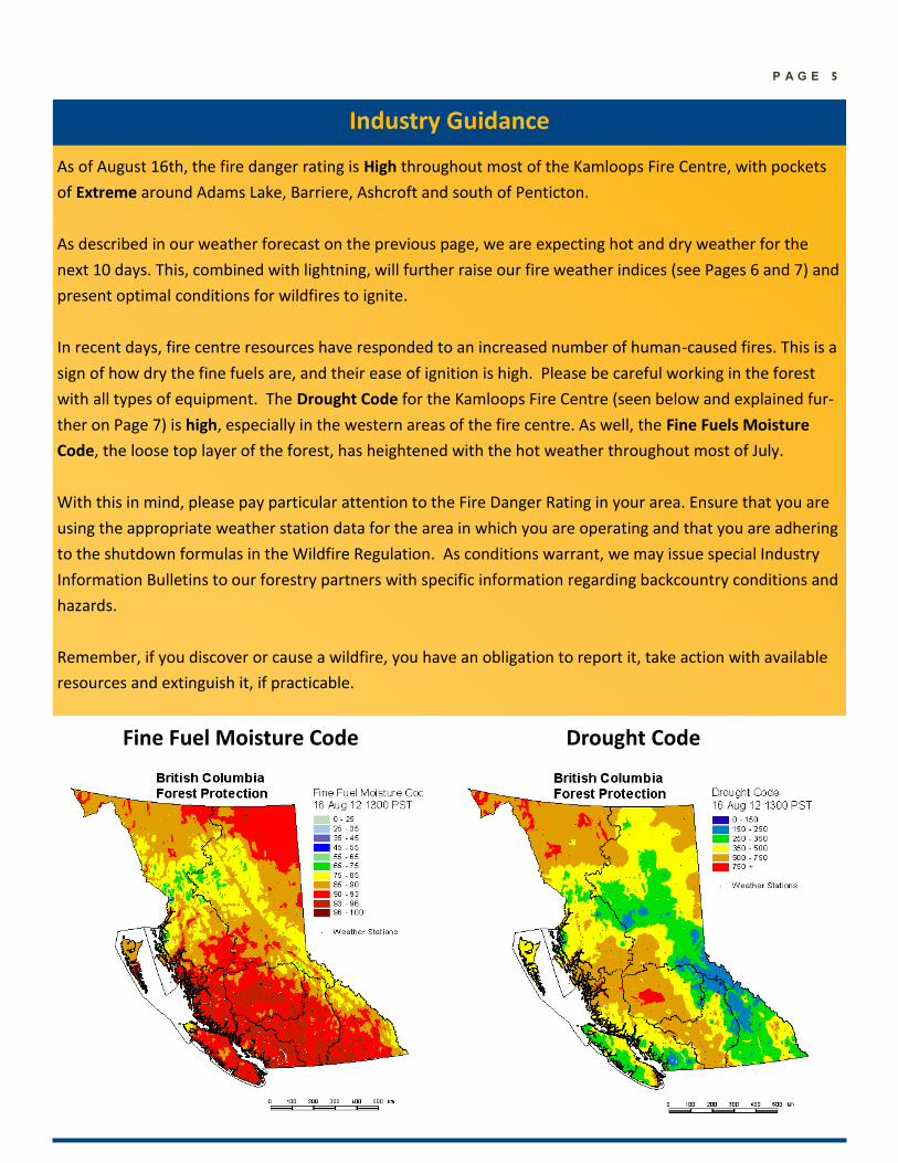
As of August 16th, the fire danger rating is High throughout most of the Kamloops Fire Centre, with pockets
of Extreme around Adams Lake, Barriere, Ashcroft and south of Penticton.
As described in our weather forecast on the previous page, we are expecting hot and dry weather for the
next 10 days. This, combined with lightning, will further raise our fire weather indices (see Pages 6 and 7) and
present optimal conditions for wildfires to ignite.
In recent days, fire centre resources have responded to an increased number of human-caused fires. This is a
sign of how dry the fine fuels are, and their ease of ignition is high. Please be careful working in the forest
with all types of equipment. The Drought Code for the Kamloops Fire Centre (seen below and explained fur-
ther on Page 7) is high, especially in the western areas of the fire centre. As well, the Fine Fuels Moisture
Code, the loose top layer of the forest, has heightened with the hot weather throughout most of July.
With this in mind, please pay particular attention to the Fire Danger Rating in your area. Ensure that you are
using the appropriate weather station data for the area in which you are operating and that you are adhering
to the shutdown formulas in the Wildfire Regulation. As conditions warrant, we may issue special Industry
Information Bulletins to our forestry partners with specific information regarding backcountry conditions and
hazards.
Remember, if you discover or cause a wildfire, you have an obligation to report it, take action with available
resources and extinguish it, if practicable.
Industry Guidance
Fine Fuel Moisture Code Drought Code
P A G E 6
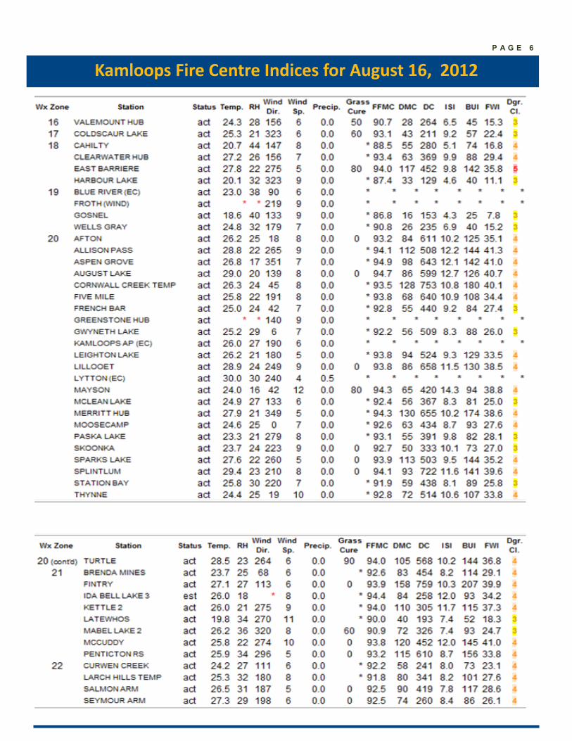
Kamloops Fire Centre Indices for August 16, 2012
P A G E 7
An explanation of fire weather statistics
The information collected from our weather stations (as seen on the previous page) is used to develop codes
that reflect to how dry the different classes of fuels are in the forest. Using this information, we set prepar-
edness levels (and our Fire Danger Rating) on a daily basis.
The FFMC (Fine Fuel Moisture Code) measures the dryness of fine fuels (grasses, needles, etc.). A number of
85 or higher indicates a good chance of a fire start from an ignition source. Once 90 or higher is reached, all
the fine fuels are available to burn.
The DMC (Duff Moisture Code) measures about 10 cm into the ground and is an indication of whether a fire
that starts will continue to burn in the duff. A number of 40 or greater would indicate that a fire will con-
tinue to burn.
The DC (Drought Code), measures deeper in the ground. A number of 300 or greater indicates that the fire
will burn deep into the ground, providing challenges to mop up the fire.
The BUI (Build-Up Index) is a numerical rating of the total amount of fuel available for combustion using the
DC and DMC figures.
The Danger Class is the typical Fire Danger Rating that is seen on fire signage. The numbers 1 and 2 repre-
sent “Low”, 3 is “Moderate”, 4 is “High” and 5 is “Extreme”. A map of the current Fire Danger Ratings is on
Page 3. If you have any questions about which station you should be monitoring, please contact your com-
pany forester or local fire zone for more information.
Industry and Stakeholder Online Resources
For information about high-risk activity
restrictions, details about the Wildfire Act and
Regulations, prescribed fire guidelines and
information for contract crews, aircraft and
equipment suppliers, please visit the link below.
http://www.bcwildfire.ca/
Industry_Stakeholders/
Contacts for Kamloops Fire Information We would like to provide our readers with the most current contact information for getting in touch with us.
Michaela Swan
Fire Information Officer
Office: 250 554-5532
E-mail: [email protected]
Kayla Pepper
Fire Information Officer
Office: 250 554-5530
E-mail: [email protected]
Report a wildfire *5555 on a cell or 1-800-663-5555
Wildfire Information Line 1-888-3FOREST
Burn Registration Line 1-888-797-1717
Kamloops Fire Information Officer 1-250-554-5532
Important Numbers
For more information, visit our website at bcwildfire.ca
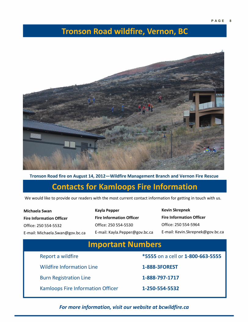
Tronson Road wildfire, Vernon, BC
P A G E 8
Kevin Skrepnek
Fire Information Officer
Office: 250 554-5964
E-mail: [email protected]
Tronson Road fire on August 14, 2012—Wildfire Management Branch and Vernon Fire Rescue