Embed Size (px)
DESCRIPTION
News from the Kamloops Fire Centre.
Citation preview
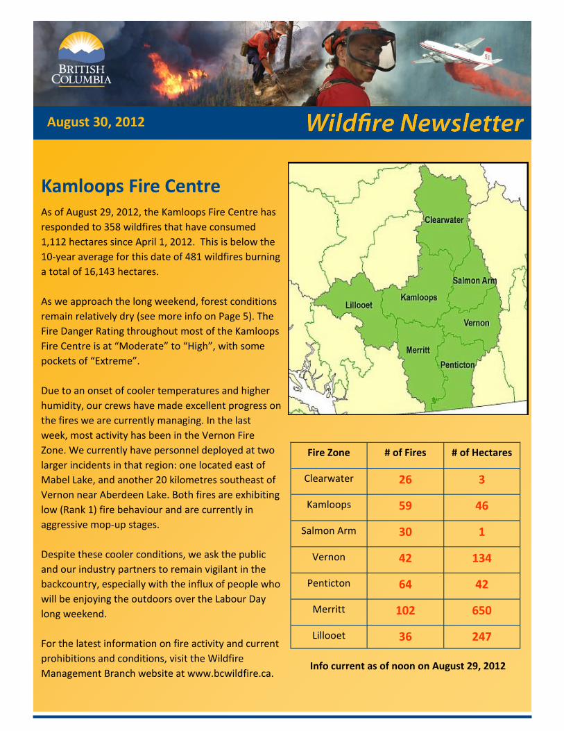
Kamloops Fire Centre As of August 29, 2012, the Kamloops Fire Centre has
responded to 358 wildfires that have consumed
1,112 hectares since April 1, 2012. This is below the
10-year average for this date of 481 wildfires burning
a total of 16,143 hectares.
As we approach the long weekend, forest conditions
remain relatively dry (see more info on Page 5). The
Fire Danger Rating throughout most of the Kamloops
Fire Centre is at “Moderate” to “High”, with some
pockets of “Extreme”.
Due to an onset of cooler temperatures and higher
humidity, our crews have made excellent progress on
the fires we are currently managing. In the last
week, most activity has been in the Vernon Fire
Zone. We currently have personnel deployed at two
larger incidents in that region: one located east of
Mabel Lake, and another 20 kilometres southeast of
Vernon near Aberdeen Lake. Both fires are exhibiting
low (Rank 1) fire behaviour and are currently in
aggressive mop-up stages.
Despite these cooler conditions, we ask the public
and our industry partners to remain vigilant in the
backcountry, especially with the influx of people who
will be enjoying the outdoors over the Labour Day
long weekend.
For the latest information on fire activity and current
prohibitions and conditions, visit the Wildfire
Management Branch website at www.bcwildfire.ca.
August 30, 2012
Fire Zone # of Fires # of Hectares
Clearwater 26 3
Kamloops 59 46
Salmon Arm 30 1
Vernon 42 134
Penticton 64 42
Merritt 102 650
Lillooet 36 247
Info current as of noon on August 29, 2012
P A G E 2
Current Prohibitions and Restrictions
Open Fires
Campfires
Forest Use
KAMLOOPS – Effective at noon on Wednesday, Aug. 29, 2012, the current campfire ban in the
Vernon and Penticton fire zones will be rescinded due to a decreased risk of wildfires. Campfires
will now be permitted throughout the Kamloops Fire Centre.
The public is reminded that campfires cannot be larger than a half-metre high by a half-metre wide.
Anyone who lights a campfire must have a hand tool (such as a shovel) or at least eight litres of wa-
ter available nearby to fully extinguish it. Never leave a campfire unattended and make sure the
ashes are completely cold to the touch before leaving the area.
All other types of open burning remain prohibited within the Kamloops Fire Centre. This includes:
The burning of any material larger than a half-metre high by a half-metre wide.
The burning of stubble or grass.
Using fireworks or burning barrels of any size or description.
Anyone found in violation of an open fire prohibition may be issued a ticket for up to $345. Anyone
who causes a wildfire through arson or recklessness may be fined up to $1 million, spend up to
three years in prison and be held accountable for associated firefighting costs.
The open fire prohibition covers all BC Parks, Crown and private lands, but does not apply within
the boundaries of local governments that have forest fire prevention bylaws and are serviced by a
fire department. Please check with local governments for any other restrictions before lighting a
fire.
The open fire prohibition will remain in place until the public is notified that it has been rescinded.
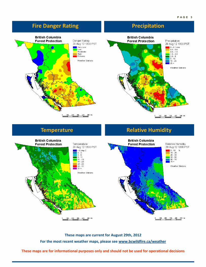
P A G E 3
Precipitation
Temperature Relative Humidity
These maps are for informational purposes only and should not be used for operational decisions
Fire Danger Rating
These maps are current for August 29th, 2012
For the most recent weather maps, please see www.bcwildfire.ca/weather
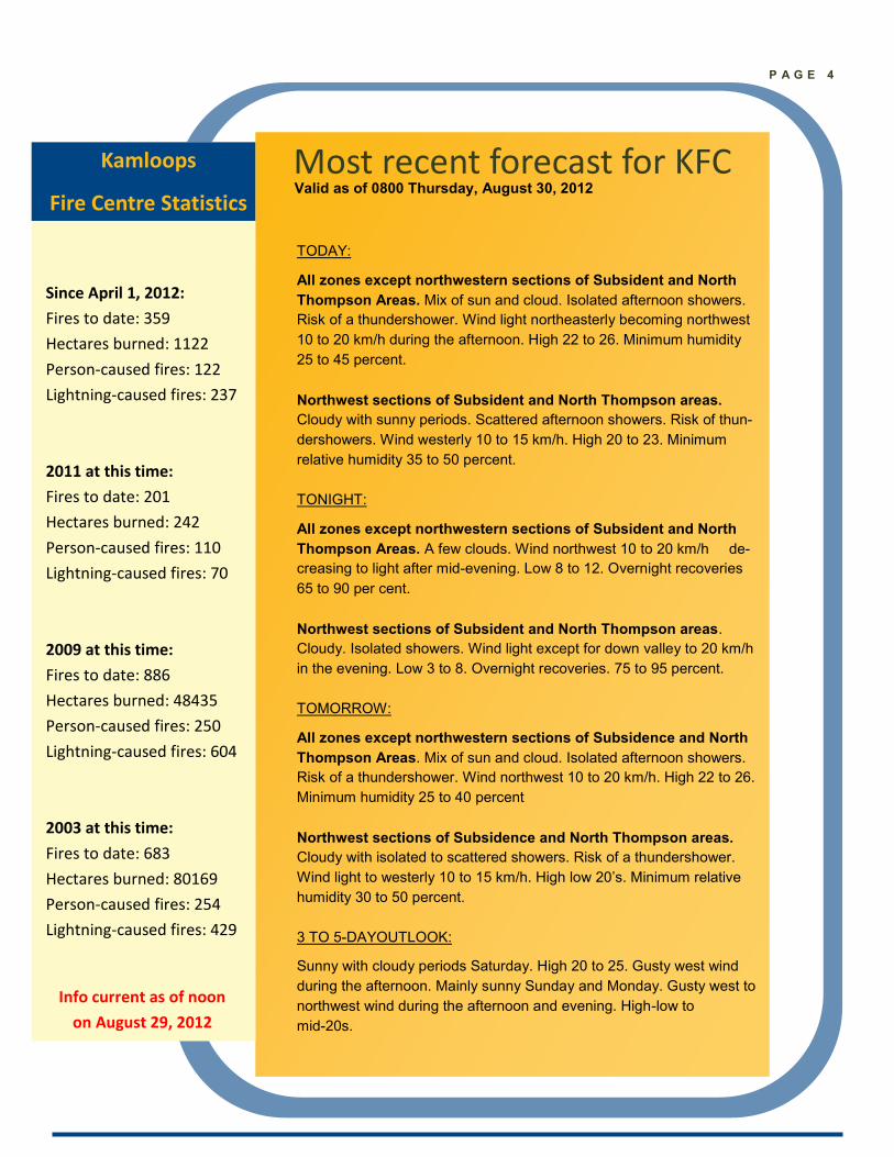
Most recent forecast for KFC
Kamloops
Fire Centre Statistics
Since April 1, 2012:
Fires to date: 359
Hectares burned: 1122
Person-caused fires: 122
Lightning-caused fires: 237
2011 at this time:
Fires to date: 201
Hectares burned: 242
Person-caused fires: 110
Lightning-caused fires: 70
2009 at this time:
Fires to date: 886
Hectares burned: 48435
Person-caused fires: 250
Lightning-caused fires: 604
2003 at this time:
Fires to date: 683
Hectares burned: 80169
Person-caused fires: 254
Lightning-caused fires: 429
TODAY:
All zones except northwestern sections of Subsident and North
Thompson Areas. Mix of sun and cloud. Isolated afternoon showers.
Risk of a thundershower. Wind light northeasterly becoming northwest
10 to 20 km/h during the afternoon. High 22 to 26. Minimum humidity
25 to 45 percent.
Northwest sections of Subsident and North Thompson areas.
Cloudy with sunny periods. Scattered afternoon showers. Risk of thun-
dershowers. Wind westerly 10 to 15 km/h. High 20 to 23. Minimum
relative humidity 35 to 50 percent.
TONIGHT:
All zones except northwestern sections of Subsident and North
Thompson Areas. A few clouds. Wind northwest 10 to 20 km/h de-
creasing to light after mid-evening. Low 8 to 12. Overnight recoveries
65 to 90 per cent.
Northwest sections of Subsident and North Thompson areas.
Cloudy. Isolated showers. Wind light except for down valley to 20 km/h
in the evening. Low 3 to 8. Overnight recoveries. 75 to 95 percent.
TOMORROW:
All zones except northwestern sections of Subsidence and North
Thompson Areas. Mix of sun and cloud. Isolated afternoon showers.
Risk of a thundershower. Wind northwest 10 to 20 km/h. High 22 to 26.
Minimum humidity 25 to 40 percent
Northwest sections of Subsidence and North Thompson areas.
Cloudy with isolated to scattered showers. Risk of a thundershower.
Wind light to westerly 10 to 15 km/h. High low 20’s. Minimum relative
humidity 30 to 50 percent.
3 TO 5-DAYOUTLOOK:
Sunny with cloudy periods Saturday. High 20 to 25. Gusty west wind
during the afternoon. Mainly sunny Sunday and Monday. Gusty west to
northwest wind during the afternoon and evening. High-low to
mid-20s.
Info current as of noon
on August 29, 2012
P A G E 4
Valid as of 0800 Thursday, August 30, 2012
P A G E 5
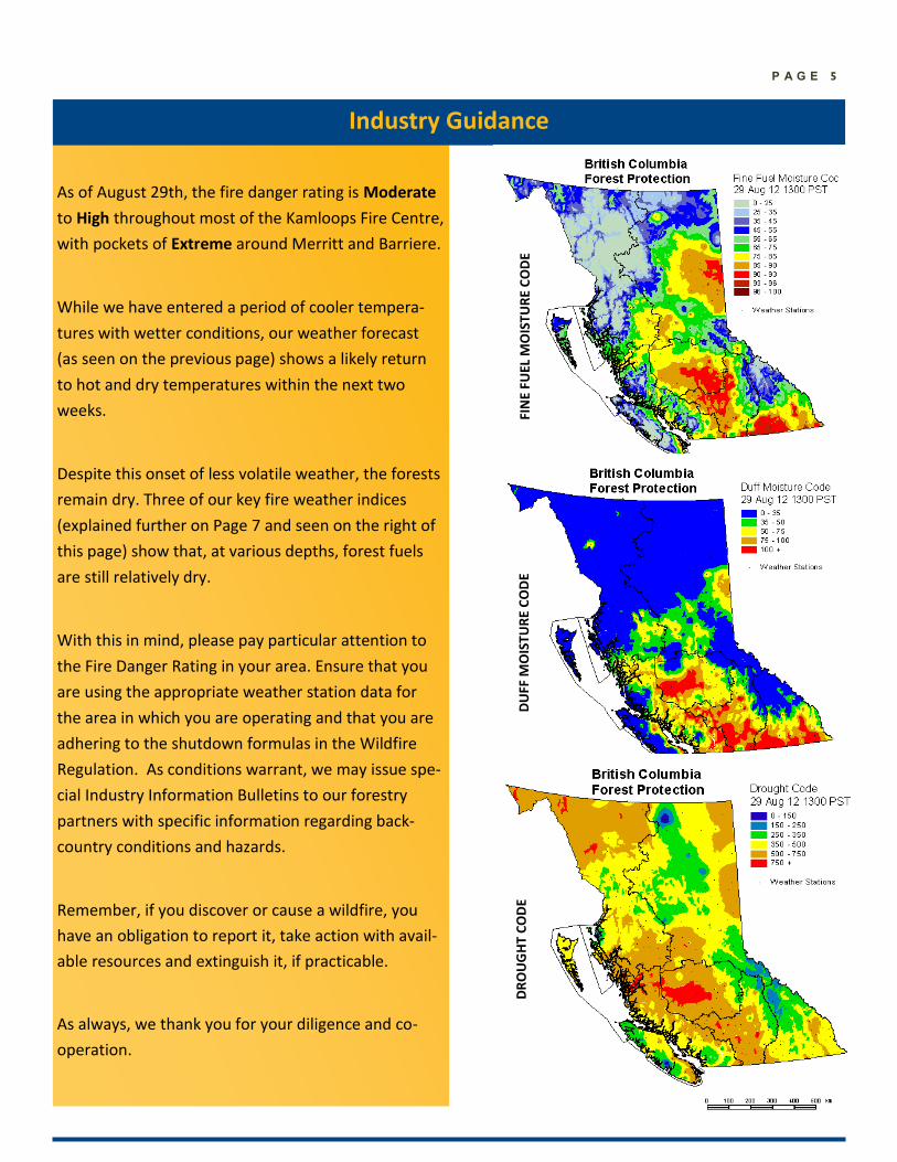
As of August 29th, the fire danger rating is Moderate
to High throughout most of the Kamloops Fire Centre,
with pockets of Extreme around Merritt and Barriere.
While we have entered a period of cooler tempera-
tures with wetter conditions, our weather forecast
(as seen on the previous page) shows a likely return
to hot and dry temperatures within the next two
weeks.
Despite this onset of less volatile weather, the forests
remain dry. Three of our key fire weather indices
(explained further on Page 7 and seen on the right of
this page) show that, at various depths, forest fuels
are still relatively dry.
With this in mind, please pay particular attention to
the Fire Danger Rating in your area. Ensure that you
are using the appropriate weather station data for
the area in which you are operating and that you are
adhering to the shutdown formulas in the Wildfire
Regulation. As conditions warrant, we may issue spe-
cial Industry Information Bulletins to our forestry
partners with specific information regarding back-
country conditions and hazards.
Remember, if you discover or cause a wildfire, you
have an obligation to report it, take action with avail-
able resources and extinguish it, if practicable.
As always, we thank you for your diligence and co-
operation.
Industry Guidance
FIN
E FU
EL M
OIS
TU
RE
CO
DE
DU
FF M
OIS
TU
RE
CO
DE
DR
OU
GH
T C
OD
E
P A G E 6
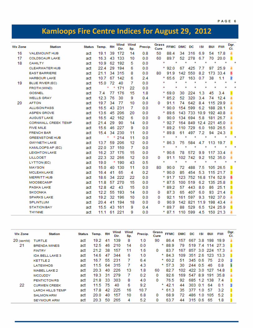
Kamloops Fire Centre Indices for August 29, 2012
P A G E 7
An explanation of fire weather statistics
The information collected from our weather stations (as seen on the previous page) is used to develop codes
that reflect to how dry the different classes of fuels are in the forest. Using this information, we set prepar-
edness levels (and our Fire Danger Rating) on a daily basis.
The FFMC (Fine Fuel Moisture Code) measures the dryness of fine fuels (grasses, needles, etc.). A number of
85 or higher indicates a good chance of a fire start from an ignition source. Once 90 or higher is reached, all
the fine fuels are available to burn.
The DMC (Duff Moisture Code) measures about 10 cm into the ground and is an indication of whether a fire
that starts will continue to burn in the duff. A number of 40 or greater would indicate that a fire will con-
tinue to burn.
The DC (Drought Code), measures deeper in the ground. A number of 300 or greater indicates that the fire
will burn deep into the ground, providing challenges to mop up the fire.
The BUI (Build-Up Index) is a numerical rating of the total amount of fuel available for combustion using the
DC and DMC figures.
The Danger Class is the typical Fire Danger Rating that is seen on fire signage. The numbers 1 and 2 repre-
sent “Low”, 3 is “Moderate”, 4 is “High” and 5 is “Extreme”. A map of the current Fire Danger Ratings is on
Page 3. If you have any questions about which station you should be monitoring, please contact your com-
pany forester or local fire zone for more information.
Industry and Stakeholder Online Resources
For information about high-risk activity
restrictions, details about the Wildfire Act and
Regulations, prescribed fire guidelines and
information for contract crews, aircraft and
equipment suppliers, please visit the link below.
http://www.bcwildfire.ca/
Industry_Stakeholders/
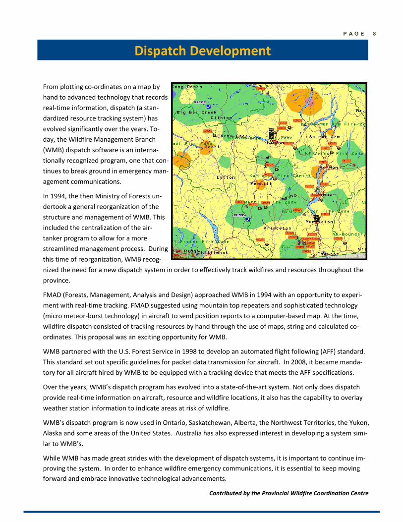
Dispatch Development
P A G E 8
From plotting co-ordinates on a map by
hand to advanced technology that records
real-time information, dispatch (a stan-
dardized resource tracking system) has
evolved significantly over the years. To-
day, the Wildfire Management Branch
(WMB) dispatch software is an interna-
tionally recognized program, one that con-
tinues to break ground in emergency man-
agement communications.
In 1994, the then Ministry of Forests un-
dertook a general reorganization of the
structure and management of WMB. This
included the centralization of the air-
tanker program to allow for a more
streamlined management process. During
this time of reorganization, WMB recog-
nized the need for a new dispatch system in order to effectively track wildfires and resources throughout the
province.
FMAD (Forests, Management, Analysis and Design) approached WMB in 1994 with an opportunity to experi-
ment with real-time tracking. FMAD suggested using mountain top repeaters and sophisticated technology
(micro meteor-burst technology) in aircraft to send position reports to a computer-based map. At the time,
wildfire dispatch consisted of tracking resources by hand through the use of maps, string and calculated co-
ordinates. This proposal was an exciting opportunity for WMB.
WMB partnered with the U.S. Forest Service in 1998 to develop an automated flight following (AFF) standard.
This standard set out specific guidelines for packet data transmission for aircraft. In 2008, it became manda-
tory for all aircraft hired by WMB to be equipped with a tracking device that meets the AFF specifications.
Over the years, WMB’s dispatch program has evolved into a state-of-the-art system. Not only does dispatch
provide real-time information on aircraft, resource and wildfire locations, it also has the capability to overlay
weather station information to indicate areas at risk of wildfire.
WMB’s dispatch program is now used in Ontario, Saskatchewan, Alberta, the Northwest Territories, the Yukon,
Alaska and some areas of the United States. Australia has also expressed interest in developing a system simi-
lar to WMB’s.
While WMB has made great strides with the development of dispatch systems, it is important to continue im-
proving the system. In order to enhance wildfire emergency communications, it is essential to keep moving
forward and embrace innovative technological advancements.
Contributed by the Provincial Wildfire Coordination Centre
Contacts for Kamloops Fire Information We would like to provide our readers with the most current contact information for getting in touch with us.
Michaela Swan
Fire Information Officer
Office: 250 554-5532
E-mail: [email protected]
Kayla Pepper
Fire Information Officer
Office: 250 554-5530
E-mail: [email protected]
Report a wildfire *5555 on a cell or 1-800-663-5555
Wildfire Information Line 1-888-3FOREST
Burn Registration Line 1-888-797-1717
Kamloops Fire Information Officer 1-250-554-5532
Important Numbers
For more information, visit our website at bcwildfire.ca
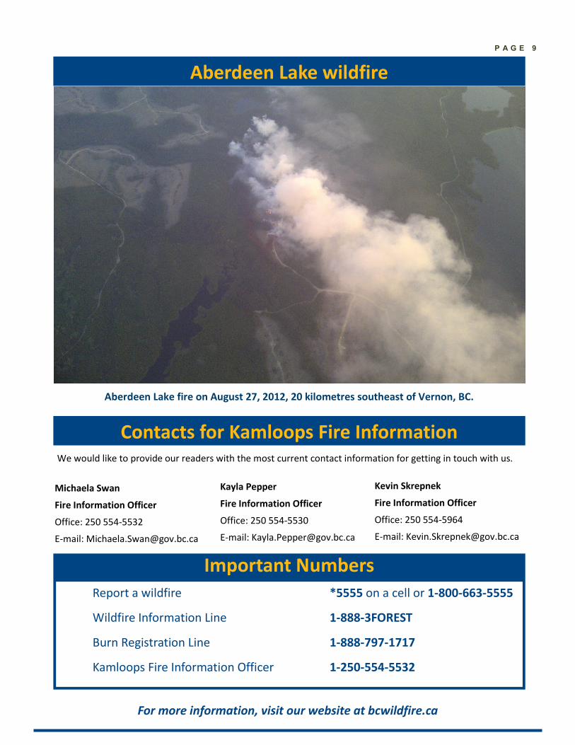
Aberdeen Lake wildfire
P A G E 9
Kevin Skrepnek
Fire Information Officer
Office: 250 554-5964
E-mail: [email protected]
Aberdeen Lake fire on August 27, 2012, 20 kilometres southeast of Vernon, BC.