Embed Size (px)
Citation preview

1
Aerial view of Karori Reservoir, Wellington, 10 February 1985. Dominion Post (Newspaper): Photographic negatives and prints of the Evening Post and Dominion newspapers, Alexander Turnbull Library (ATL), Wellington, New Zealand, ID: EP/1984/0621. The Lower Karori Dam and Reservoir is in the foreground and the Upper Karori Dam and Reservoir is towards the top of the image.
IPENZ Engineering Heritage Register Report
Karori Water Supply Dams and Reservoirs Written by: Karen Astwood and Georgina Fell Date: 12 September 2012

IPENZ Engineering Heritage Report 2
Karori Water Supply Dams and Reservoirs
Contents
A. General information ........................................................................................................... 3
B. Description ......................................................................................................................... 5
Summary ................................................................................................................................. 5
Historical narrative .................................................................................................................... 6
Social narrative ...................................................................................................................... 10
Physical narrative ................................................................................................................... 18
C. Assessment of significance ............................................................................................. 24
D. Supporting information ...................................................................................................... 25
List of supporting documents ................................................................................................... 25
Bibliography ........................................................................................................................... 25

IPENZ Engineering Heritage Report 3
Karori Water Supply Dams and Reservoirs
A. General information
Name: Karori Water Supply Dams and Reservoirs
Alternative names: Kaiwarra Dam; Kaiwharawhara Stream Valley Dam; Karori Dam;
Karori Reservoir; Karori Pump Station; Karori Waterworks; Lower Karori Dam and
Reservoir; Upper Karori Dam and Reservoir
Location:
Waiapu Road
Karori
Wellington
Wellington Region
Geo-reference:
Lower Karori Dam (taken at the valve tower) - Latitude: -41.291, Longitude: 174.753
Upper Karori Dam (taken northwest end of dam) - Latitude: -41.298, Longitude:
174.744
Legal description:
Lower Karori Dam and Reservoir - Lot 1 DP 313319 (CT WN 52413), part Legal
Road (made public by T 72086), Wellington Land District, Pt Sec 1 Upper
Kaiwharawhara District marked A on SO 32281 (NZ Gazette 1982, p. 714), Pt Sec 10
Owhiro District marked A on SO 32922 (NZ Gazette 1982, p. 1390)
Upper Karori Dam and Reservoir - Lot 1 DP 313319 (CT 52413), Wellington Land
District
Access information: The Lower and Upper Karori dams and reservoirs are within
the fenced boundary of the Karori Wildlife Sanctuary. The Lower Karori Dam is
accessed most directly from the Waiapu Road entrance. The Upper Karori Dam is
located further into the Sanctuary and can be reached via various walking tracks.
City/District Council: Wellington City Council

IPENZ Engineering Heritage Report 4
Karori Water Supply Dams and Reservoirs
Location map courtesy of Google Maps
IPENZ category: Engineering work
IPENZ subcategory: Infrastructure
IPENZ Engineering Heritage number: Lower Karori Dam – 104
Date registered: 28 August 2012
Other IPENZ recognition: Lower Karori Dam heritage recognition plaque (installed
2004)
Other heritage recognition:
New Zealand Historic Places Trust: Lower Karori Dam - Category 1 historic
place (Register no. 7750); Upper Karori Dam – Category 2 historic place
(Register no. 7749)
Local Authority District Plan: Not listed in Wellington City District Plan
Other: Lower Karori Dam and associated features – New Zealand
Archaeological Site Recording Scheme, R27/276
Upper Karori Dam and Reservoir
Lower Karori Dam and Reservoir

IPENZ Engineering Heritage Report 5
Karori Water Supply Dams and Reservoirs
B. Description
Summary
The Karori Water Supply Dams and Reservoirs captured the water resources of the
Kaiwharawhara Stream in the west Wellington hill suburb of Karori, and are now
within the Karori Wildlife Sanctuary. The Lower and Upper Karori Dams were
completed in 1878 and 1908 respectively, and continued to contribute to the New
Zealand capital city‟s water supply until the late 20th century.
A good water supply is essential to human existence. The population of Wellington
rose rapidly in the 1860s and 1870s, with residents and industry putting severe
pressure on streams and wells. Public health was at risk and this motivated local
government to investigate establishing a public waterworks system, with various
proposals put forward. However, it was not until the passing of the Wellington
Waterworks Act in 1871 that earnest planning could commence, and with the
completion of the Lower Karori Dam in 1878 Wellington became the first municipality
in New Zealand to construct a public water supply dam. From that time progressive
development of the water resources at Karori, and around the Wellington region,
struggled to keep up with demand. Another early addition to the water supply system
was the Upper Karori Dam, constructed between 1906 and 1908.
The Lower Karori dam was designed by Nicholas Marchant (1836-1907) and is an
earth dam with a puddled clay core. Availability of materials meant that this structure
was innovative in its use of concrete, rather than stone, for its wave protection lining
and culverts. It was the use of concrete which also made the Upper Karori Dam a
pioneering structure; it being one of the earliest New Zealand examples of a large
scale concrete gravity dam. This structure was designed by another notable
Wellington City Engineer, William Hobbard Morton (1866-1923).
The Karori Water Supply Dams and Reservoirs have outstanding engineering
heritage value because the dams both represent early large scale examples of their
respective dam types. Located on the Wellington fault, these dams were
decommissioned in the 1990s due to earthquake safety concerns. However, for over
a century the Karori waterworks was heart of the wider system in Wellington and, as
a result, had considerable social impact.

IPENZ Engineering Heritage Report 6
Karori Water Supply Dams and Reservoirs
Historical narrative
In 1865 the seat of New Zealand‟s Government shifted south from Auckland to
Wellington. This was a contributing factor in Wellington‟s rapid population increase by
the end of the century, from 7,460 in 1867 to 49,344. This boost in people led to
overcrowding which, along with poor hygiene and a lack of adequate public water
supply and sewerage facilities, resulted in a high rate of disease and infant mortality.1
In 1871, Government scientist James Hector referred to the “misery and suffering
entailed especially of the children from the presence of intestinal worms” and
concluded that “no water collected from within the crowded part of the city either from
wells or housetops, is safe or proper for human consumption.”2 At the time, water
reticulation in Wellington was limited to a few pipes laid by the Government to supply
their own buildings and the naval vessels in port. Residential water was “collected
from house-tops into barrels and iron tanks, and also shallow wells.”3
Even in 1867 it was recognised that the city‟s water supply was inadequate. Various
plans had been formulated, but nothing came of them because they were “more or
less grand in design, and expensive in character.”4 The chief difficulty was a financial
one. Wellington‟s first town surveyor/engineer, Robert Skeet (1832-1894), developed
a scheme to supply the southern wards of the town with water from the Te Aro (or
Waimapihi) Stream in Polhill‟s Gully (upper Aro Valley), with the Thorndon ward being
supplied from the Kaiwharawhara Stream (or Kaiwarra Stream as it was known by
early European settlers) tapped near Baker‟s cutting. However, the estimated cost
was over £41,000, which was a huge sum and beyond local government financial
capacity. Other engineers generally agreed with the scheme, George Aickin (1822-
1882) added that a reasonably deep four acre reservoir would contain enough water
to adequately supply double Wellington‟s population at the time.5
1 C. Maclean, 'Wellington region - From town to city: 1865–1899', Te Ara - the Encyclopedia of New Zealand, URL:
http://www.TeAra.govt.nz/en/wellington-region/8 (updated 24 November 2009); S. Morrison, History of Water Supply
in the Wellington Region, 1872-1985, Wellington, 1986, p.1
2 A. Mulgan, The City and its Strait: Wellington and its Province, Wellington, 1939, p.211
3 „Report of the Select Committee on the Wellington Waterworks Bill,‟ Appendix to the Journals of the House of
Representatives, 1871, Session I, H-03, p.3. URL: http://www.atojs.natlib.govt.nz/cgi-
bin/atojs?a=d&cl=search&d=AJHR1871-I.2.2.5.3&srpos=1&e=-----1871--10--1------2wellington+waterworks--
(accessed 26 March 2012). This was stated by Nicholas Marchant, Wellington City Engineer, when he was before
the Select Committee.
4 Wellington Independent, 19 February 1867, p.3
5 Wellington Independent, 16 May 1867, p.5

IPENZ Engineering Heritage Report 7
Karori Water Supply Dams and Reservoirs
In April 1868, consulting engineer Robert Mudge Marchant (1820-1902) prepared
another scheme which he promoted through a pamphlet with lithographed drawings.
Robert Marchant was related to famous British engineer, Isambard Kingdom Brunel
(1806-1859), and early in his career he had worked as an assistant to Brunel.6 Robert
suggested piping water down the Kaiwharawhara Valley and then tunnelling through
Northland Hill to Tinakori Road. Including plans for a dam and a 136 million-litre
reservoir, according to Nicholas Marchant (1836-1907) this was the first feasible
proposal submitted to the Town Board.7 Nicholas (no relation of Robert) had
emigrated from England in 1864 and within a few years had become Wellington‟s
Waterworks Engineer. Between 1875 and 1878 he was the City Engineer, before
resigning to go into private practice after the Lower Karori Dam was completed.8
In order to pay for Robert‟s scheme, it was proposed that Wellington should follow
Dunedin‟s example in passing the Dunedin Waterworks Act 1864. This assigned
responsibility for building waterworks, and rating users, to the Dunedin Waterworks
Company Limited. Their two dams on Ross Creek were privately built between 1865
and 1867.9 The decision by Wellington‟s Town Board to accept Robert‟s scheme led
to a well-publicised furore with ratepayers angered at the heavy water rates they
would be obliged to pay to fund the expensive proposal.10
Therefore, when the
Wellington Water Works Company was established its shares were issued secretly.
However, in the end this company played no part in Wellington‟s first public
waterworks system.11
When the Wellington City Council formed in 1870, Nicholas was asked to develop yet
another waterworks scheme for the city. He combined elements of many of the
previous proposals, recommending that water be taken from the elevated
Kaiwharawhara Stream catchment. The stream was clean and its altitude meant a
gravitational water supply system could be created. Nicholas suggested that the
water be tapped near Baker‟s Hill, 130 metres above the sea-level, before passing
6 Peter Cross-Rudkin and Mike Chrimes (ed.), Biographical Dictionary of Civil engineering, Volume 2 – 1830 to 1890,
London, 2008, p.521. The working relationship between Brunel and Marchant seems to have been consistently
acrimonious. Brunel was involved in the „battle of Mickleton Hill‟ incident which virtually bankrupted Marchant, and it
was after this that he immigrated to Brazil and then onto Australia and New Zealand.
7 P. Cooke, Our water history – on tap: Water supply in the Wellington region 1867-2006, Wellington, 2007, pp.6, 36.
URL - http://www.gw.govt.nz/assets/Our-Environment/Water-Supply/PDFs/Covers-foreword-introduction-water-
history.pdf (accessed 2 April 2012)
8 Furkert, p.219
9 Ibid.
10 S. Morrison, History of Water Supply in the Wellington Region, 1872-1985, Wellington, 1986, p.1; Cooke, 2007,
p.6; Wellington Independent, 20 August 1968, p.4
11 Cooke, p.6

IPENZ Engineering Heritage Report 8
Karori Water Supply Dams and Reservoirs
through a tunnel and collecting in a distributing basin.12
A water main would run down
the gully near Aro Street, to Willis Street, where it diverged in two. These mains
would convey water along Willis Street and Lambton Quay, while the other travelled
down Ingestre and Vivian Streets to Cambridge Terrace. The estimated cost of the
works was £17,358.13
The Wellington Waterworks Act (1871) defined an area of 92 hectares to be
purchased by the Council from land owners, which included two gold mining
companies.14
After many years of trying the project was effectively underway on 12
December 1871 when the Council created a permanent waterworks committee. The
Act stated that the Council was not allowed to construct a dam on the land until 1873
at the earliest. However, they could progress the first stage for the water supply
system. John Blackett (1818-1893) acted as a consulting engineer and the initial
works involved creating the Baker‟s Hill tunnel, which was completed on 24 October
1872.15
Tenders were received in early 1873 for the Aro Valley distributing basin (on
what is now the corner of Raroa and Mount Pleasant roads), to receive water from
the tunnel. This contract was awarded to Saunders and O‟Malley.16
However, a
shortage of money meant that the construction of the proposed dam across the
Kaiwharawhara Stream had to be postponed. Instead it was decided to increase the
capacity of the reservoir in Pollhill‟s Gully, from 2.3 million litres to over 4.5 million
litres. This basin became the source of Wellington‟s first public water supply, not the
Lower Karori Reservoir as is commonly believed.17
On Saturday 2 May 1874 it was reported that “all difficulty or apprehension in regard
to the water mains” was finally at an end when “the full force from the [Pollhill‟s Gully]
reservoir was flushed through the mains to their extreme range as far as the lower
end of Tinakori Road, and the pipes with one exception, proved equal to the
pressure.”18
Because of this success the Council wanted to push forward with further
works and spending despite the increased cost of iron and labour meaning the
estimate for the first stage work had been exceeded. Therefore, in August 1874 a
12
Ibid.; Morrison, pp.1-2
13 Evening Post, 29 March 1871, p.2
14 Cooke, 2007, p.6
15 „Wellington Waterworks Act, 1871 - Powers of the Council in connection with the undertaking,‟ New Zealand
Legislation: Acts, URL: http://www.legislation.govt.nz/act/private/1871/0003/latest/DLM89257.html (accessed 26
March 2012); Cooke, 2007, p.7; „Wellington Waterworks Act, 1871 - Schedule,‟ New Zealand Legislation: Acts, URL:
http://www.legislation.govt.nz/act/private/1871/0003/latest/DLM89747.html (accessed 26 March 2012)
16 Cooke, 2007, p.7
17 Cooke, 2007, pp.7, 21. This distribution basin was filled in during 1964.
18 Wellington Independent, 4 May 1874, p.2

IPENZ Engineering Heritage Report 9
Karori Water Supply Dams and Reservoirs
new Act was passed authorising an extra £25,000 in borrowings to extend the
scheme, including building the Lower Karori Dam.19
The Lower Karori Dam was the first dam in New Zealand to be built by a municipality
for the purpose of public water supply.20
Construction tenders for the dam were called
in 1875, but the contract with J. Saunders was not entered into until October 1876.21
Nicholas Marchant designed the earth dam with a puddled clay core.22
This feature
was typical of British best practice at the time, and was similar to the Ross Creek
Dam in Dunedin. However, a difference was that the Lower Karori Dam‟s upstream
protection from wave action was through a concrete facing instead of the traditional
hand placed riprap, which is a layer stones.23
Under Marchant‟s supervision the
construction was completed in January 1878, and water storage commenced at
daybreak on 25 January.24
With some work remaining to be done the reservoir was
19
New Zealand Parliament, Parliamentary Debates, Wellington, 1874, Vol XVI, pp.305, 546; Cooke, 2007, p.8
20 P. Cooke, „Registration Report for a Historic Place: Lower Karori Dam,‟ New Zealand Historic Places Trust , 2008
(Register no.7750), p.3
21 Cooke, 2007, p.8
22 See the Physical Narrative section of this report for a definition of a puddled clay core dam
23 R. E. Offer, „Heritage Assessment Programme: IPENZ National Heritage Committee, Lower Karori Dam‟, 24 June
2002, URL: http://www.ipenz.org.nz/heritage/documents/Lwr%20Karori%20dam%20submsn1.pdf (accessed 2 April
2012); R. E. Offer, Walls for Water: Pioneer dam building in New Zealand, Wellington, 1997, p.203
24 Cooke, 2007, p.8
Figure 1: Karori Reservoir, Wellington, ca 1874. Zoe Martin -Carter Collection, ATL, Reference Number: PA1-F-171-75. Please note that the date for this image is inaccurate. Research has shown that the dam would not
have been in this state of completion until circa 1878

IPENZ Engineering Heritage Report 10
Karori Water Supply Dams and Reservoirs
only allowed to partially fill. In March 1878 it was reported that little remained to be
done aside from cleaning up the site and grassing the slopes of the dam.25
By February 1878 water supply from the Lower Karori Reservoir had begun and
Wellingtonians were able to “at last congratulate ourselves upon an abundant
supply.”26
However, the greatly increased water supply was soon viewed by the
Council as insufficient. The reasons for the shortfalls were varied. Firstly, there were
consecutively dry summers in the late 1870s, and, the city‟s population continued to
rise rapidly. Furthermore, the waterworks also became a victim of its own success,
because the increased availability led to residents and industry, in particular,
consuming more than expected.27
The need for a consistent supply of water at a
reasonable pressure became a pressing matter with fire a significant threat for the
city‟s closely packed timber buildings.28
Therefore, in 1884 a supply from
Wainuiomata was completed, with this becoming the main source and the Karori
supply augmenting it in order to maintain a reasonable amount of water pressure for
customers.29
This situation remained for years even when additional dams at Karori
and Wainuiomata were constructed in the early twentieth century.30
The creation of these dams reflects the continued growth of Wellington‟s population
and commercial operations. History repeated itself, because additions to the existing
supply through extensions to the Karori and Wainuiomata catchments only came after
several years and many proposals. It was not until 1904, with the appointment of City
Engineer, William Hobbard Morton (1866-1923), that a proposal was accepted which
included Morton‟s plans for a curved concrete gravity dam at Karori and a buttress
dam at Wainuiomata, which became known as the Morton Dam (1911).31
Morton had
been a public works engineer prior to emigrating from Australia. Later Morton was a
foundation member of the New Zealand Society of Civil Engineers, as well its
Secretary and a Council member for many years.32
Morton‟s Upper Karori Dam was one of the earliest concrete gravity dams
constructed in New Zealand, following one built at Korokoro, Lower Hutt (1903), and
25
„City Council,‟ Evening Post, 8 March 1878, p.2
26 Evening Post, 23 February 1878, p.2
27 Morrison, p.2; Cooke, 2007, p.8
28 Cooke, 2007, p.9
29 Cyclopedia Company Limited, „Water Supply,‟ The Cyclopedia of New Zealand [Wellington Provincial District],
Wellington, 1897, p.274
30 „The New Reservoir,‟ Evening Post, 13 March 1908, p.3
31 Offer, 1997, pp.63-64
32 New Zealand Society of Civil Engineers, Proceedings of the New Zealand Society of Civil Engineers, Vol. X (1923-
24), Wellington, 1924, pp.234-35

IPENZ Engineering Heritage Report 11
Karori Water Supply Dams and Reservoirs
at the Okehu Stream in Wanganui and the Brook Dam, Nelson, both in 1904.33
The
construction of the Upper Karori Dam was undertaken by Mitchell and King and
included the construction of a tramway and temporary weir. Mitchell and King seem to
have been a Sydney construction firm which opened a Wellington branch in the early
20th century. Although they tendered for other engineering structures, this company
mostly constructed buildings, such as the Union Steam Ship Company Offices
(1909). In particular, they are noted for the remodelling of the James Smith Building
façade in 1932, and the construction of the Waterloo Hotel opposite Wellington
Railway Station.34
Site work for the Upper Karori Dam began in late 1906, with the workforce of 55 men
beginning to dig out the dam‟s foundations by early 1907.35
There were stipulations in
place to protect the integrity of the catchment while construction was taking place. For
example, horses were not stabled near the water and workers were prohibited from
camping too close. Also, during excavation explosives were not used, only picks and
33
Offer, 1997, pp.25-26
34 „Kelburn Viaduct,‟ Evening Post, 4 December 1929, p.12; „Union Company Offices,‟ Taranaki Herald, 18 March
1909, p.5; „Alterations to Business Premises,‟ Evening Post, 3 September 1932, p.15; „Hotel Waterloo,‟ Evening Post,
27 February 1936, p.10
35 Colonist, 24 September 1906, p.1; „Building a Reservoir,‟ Evening Post, 27 February 1907, p.2
Figure 2: Dam under construction in the Karori Reservoir valley, Wellington, 1907. ATL, ID: 1/1-019829-G

IPENZ Engineering Heritage Report 12
Karori Water Supply Dams and Reservoirs
shovels. It seems that this digging was a greater task than anticipated, with poor
quality rock forcing the men to go deeper to find a good foundation for the dam.36
Morton was happy with the way the dam turned out upon its completion in March
1908. Morton stated that:
Water was looked upon by engineers and contractors as an insidious enemy,
still there were thirty-five feet of water already in the new reservoir, and he
had not been able to trace the slightest degree of soakage. He believed that
the work would prove perfectly satisfactory.37
The dam was formally opened on 29 November 1908.38
Like the Waitakere Dam
completed two years later, the Upper Karori Dam was lauded as a major New
Zealand engineering feat of the time.39
Dry summers during World War One soon put pressure on the Council to again
expand its water supply infrastructure. Therefore, Morton looked to the Orongorongo
catchment, further northeast of the Wainuiomata reservoir. Rather than create a dam
and reservoir, a weir was built and the water was piped to the Lower Karori reservoir
and distributed from there.40
In the 1930s there seems to a have been a constant effort by Wellington‟s heavily in
debt Water Supply Board to locate and tap into good water sources around the region
for central Wellington and its expanding suburbs. The Hutt River was a likely source,
although the water quality was variable. A further Wainuiomata dam was also
proposed, as was exploitation of the Hutt aquifer. Much negotiating with the Petone
and Hutt Borough Councils eventually led to the Water Supply Board building a
pumping station at Gear Island, Petone, completed in 1935. This drew water from the
Waiwhetu aquifer and linked into the Orongorongo to Karori water main. In the
meantime a chlorination plant and pump station were built at Karori. However, the
36
Emma Meyer, „Registration Report for a Historic Place: Upper Karori Dam,‟ New Zealand Historic Places Trust, 1
May 2008, pp.7-9
37 „The New Reservoir‟
38 Meyer, p.17
39 Offer, 1997, p.64
40 Cooke, 2007, p.16
IPENZ Engineering Heritage Report 13
Karori Water Supply Dams and Reservoirs
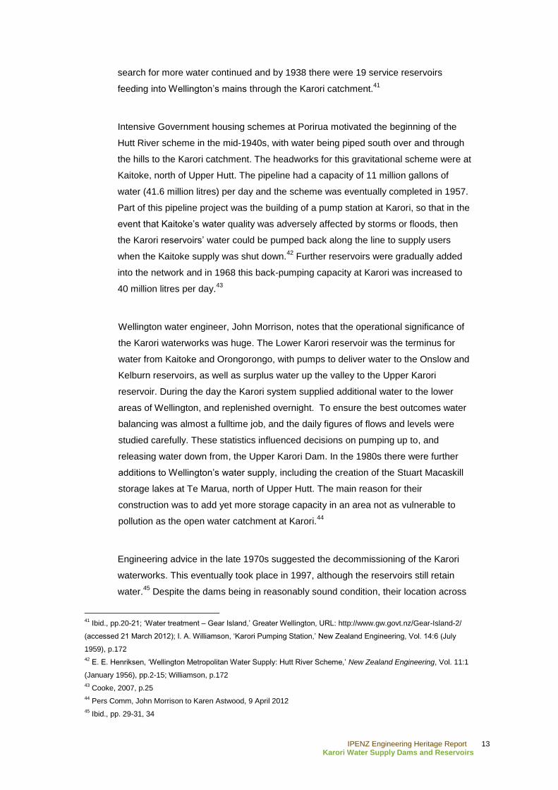
search for more water continued and by 1938 there were 19 service reservoirs
feeding into Wellington‟s mains through the Karori catchment.41
Intensive Government housing schemes at Porirua motivated the beginning of the
Hutt River scheme in the mid-1940s, with water being piped south over and through
the hills to the Karori catchment. The headworks for this gravitational scheme were at
Kaitoke, north of Upper Hutt. The pipeline had a capacity of 11 million gallons of
water (41.6 million litres) per day and the scheme was eventually completed in 1957.
Part of this pipeline project was the building of a pump station at Karori, so that in the
event that Kaitoke‟s water quality was adversely affected by storms or floods, then
the Karori reservoirs‟ water could be pumped back along the line to supply users
when the Kaitoke supply was shut down.42
Further reservoirs were gradually added
into the network and in 1968 this back-pumping capacity at Karori was increased to
40 million litres per day.43
Wellington water engineer, John Morrison, notes that the operational significance of
the Karori waterworks was huge. The Lower Karori reservoir was the terminus for
water from Kaitoke and Orongorongo, with pumps to deliver water to the Onslow and
Kelburn reservoirs, as well as surplus water up the valley to the Upper Karori
reservoir. During the day the Karori system supplied additional water to the lower
areas of Wellington, and replenished overnight. To ensure the best outcomes water
balancing was almost a fulltime job, and the daily figures of flows and levels were
studied carefully. These statistics influenced decisions on pumping up to, and
releasing water down from, the Upper Karori Dam. In the 1980s there were further
additions to Wellington‟s water supply, including the creation of the Stuart Macaskill
storage lakes at Te Marua, north of Upper Hutt. The main reason for their
construction was to add yet more storage capacity in an area not as vulnerable to
pollution as the open water catchment at Karori.44
Engineering advice in the late 1970s suggested the decommissioning of the Karori
waterworks. This eventually took place in 1997, although the reservoirs still retain
water.45
Despite the dams being in reasonably sound condition, their location across
41
Ibid., pp.20-21; „Water treatment – Gear Island,‟ Greater Wellington, URL: http://www.gw.govt.nz/Gear-Island-2/
(accessed 21 March 2012); I. A. Williamson, „Karori Pumping Station,‟ New Zealand Engineering, Vol. 14:6 (July
1959), p.172
42 E. E. Henriksen, „Wellington Metropolitan Water Supply: Hutt River Scheme,‟ New Zealand Engineering, Vol. 11:1
(January 1956), pp.2-15; Williamson, p.172
43 Cooke, 2007, p.25
44 Pers Comm, John Morrison to Karen Astwood, 9 April 2012
45 Ibid., pp. 29-31, 34
IPENZ Engineering Heritage Report 14
Karori Water Supply Dams and Reservoirs
the Wellington fault line was identified as a significant argument in favour of their
decommissioning. The presence of the fault was unknown to engineers when the
dams were built.46
Another factor not considered as part of standard engineering
practice at the time of the Upper Karori Dam‟s construction was the effect of water
pressure from underneath the structure, which in its case posed a risk to stability
during an earthquake. The main concern of engineers was if the Upper Karori Dam
failed during an earthquake this would have a domino effect, causing the failure of the
Lower Karori Dam through overtopping due to insufficient spillway capacity.47
By the late 20th century the Wellington Regional Council no longer required the Karori
dams and reservoirs for water supply and the land was transferred back to the
Wellington City Council in 2004.48
Because the Karori waterworks was the heart of
the regional system it took a significant amount of work to circumvent, including major
pipeline disconnections and realignments, as well as building yet more reservoir and
pumping capacity at Ngauranga. Although the Karori waterworks are now out of
service, a lot of water still passes through the site. 49
The former Karori water supply dams and reservoirs are now features within the
Karori Wildlife Sanctuary, whose predator-proof fence was finished just a few years
after the dams were decommissioned.50
In the future the former reservoirs will
provide the Sanctuary with the opportunity to develop its native aquatic species
programmes.51
In particular, the attractive valve tower turret of the Lower Karori Dam
has become a focal point of the Sanctuary. However, this is not a new phenomenon,
with the dam and reservoir‟s picturesque qualities being recognised and publicised
through photographs and postcards since the late 19th century.
52 Interpretation panels
for the dams and reservoirs, as well as other remnants of their construction and
operation, have been installed to help explain them to the Sanctuary‟s visitors.53
46
Meyer, p.12. This reference applies specifically to the Upper Karori Dam. However, it is also assumed that this was
the case with the Lower Karori Dam considering it has been retained as a reservoir lake with no significant structural
change.
47 Offer, 1997, p.65. Pers Comm. John Morrison
48 Cooke, 2007, p.34
49 Pers Comm. John Morrison
50 „Trust Timeline,‟ Karori Sanctuary Trust, URL:
http://www.sanctuary.org.nz/Site/About_us/Key_achievements_and_wildlife_releases.aspx (accessed 26 March
2012)
51 „Wetland fauna restoration,‟ Karori Sanctuary Trust, URL:
http://www.sanctuary.org.nz/Site/Conservation_and_Research/Restoration/Wetland_flora_and_fauna/Wetland_fauna
_restoration.aspx (accessed 26 March 2012)
52 Cooke, 2008, p.15
53 Meyer, p.10

IPENZ Engineering Heritage Report 15
Karori Water Supply Dams and Reservoirs
The heritage values of the two dams, and associated structures, were recognised by
the New Zealand Historic Places Trust in 2008. This was through individual
registrations for each place: the Lower Karori Dam as a Category 1 historic place
(Register no. 7750) and the Upper Karori Dam as a Category 2 historic place
(Register no. 7749).54
IPENZ had recognised the engineering heritage importance of
the Lower Karori Dam with a plaque in August 2004.
54
Lower Karori Dam, New Zealand Historic Places Trust Category 1 historic place (Register no. 7750), URL -
http://www.historic.org.nz/TheRegister/RegisterSearch/RegisterResults.aspx?RID=7750 (accessed 27 March 2012);
Upper Karori Dam, New Zealand Historic Places Trust Category 2 historic place (Register no. 7749), URL -
http://www.historic.org.nz/TheRegister/RegisterSearch/RegisterResults.aspx?RID=7749 (accessed 27 March 2012)

IPENZ Engineering Heritage Report 16
Karori Water Supply Dams and Reservoirs
Social narrative
Dams were constructed in New Zealand from early in the history of earnest European
settlement. There were a number of uses in the early period for this type of human
intervention to control water, such as in gold extraction or providing water supplies for
the populous. These, usually small, structures were prolific, numbering in the
thousands nationally. It was not until the early 20th century that the public
infrastructure functions of dams expanded to include large scale structures for hydro-
electric power generation. These became possible because of technological
developments and greater understanding of how concrete could be utilised, which in
New Zealand began with structures like the Upper Karori Dam.55
As a basic societal necessity, pressures on the existing early water supply grew as
the population of New Zealand did. Rapid growth in urban centres in the mid to late
19th century meant that springs and wells were soon unable to meet the needs of the
population, which caused public health and safety problems. Therefore, water supply
55
Offer, 1997, pp.13, 16
Figure 3: Water testing at Karori reservoir, Wellington, ca 3 December 1952. ATL, ID: PACOll-6203-06
IPENZ Engineering Heritage Report 17
Karori Water Supply Dams and Reservoirs
schemes were soon being developed in Wellington and other main centres.56
In New
Zealand water supply became the responsibility of local authorities relatively early on,
along with other essential services, such as sewage and refuse disposal.57
Aside
from being important personally because of the provision for drinking water, adequate
water supply systems were especially important to industry, as well as for activities
like fire fighting.58
The creation of the Lower Karori Dam in 1878 was beneficial to the community
because it was the first major water supply dam in the region and promised an
increased and more certain public water supply.59
Population growth meant that a few
years later residential and industrial consumption had increased to the point where
the supply “failed deplorably.”60
Built in the early 20th century, the Upper Karori Dam
was the third major undertaking to augment that public supply.
56
Ibid., p.38
57 Bush, 1991, p.70
58 Offer, 1997, p.16
59 Offer, 2002
60 Cyclopedia Company Limited, p.274

IPENZ Engineering Heritage Report 18
Karori Water Supply Dams and Reservoirs
Physical narrative
The Lower and Upper Karori Dams and Reservoirs stretch across the upper
Kaiwharawhara Valley. These form the main components of engineering importance
of the Karori Water Supply Dams and Reservoirs, which were the heart of
Wellington‟s regional water supply system until the late 20th century.
The dams are each recognised for their engineering significance as early New
Zealand large scale examples of their respective dam types: the Lower Karori Dam
being a puddled clay core earth dam and the Upper Karori Dam is a concrete gravity
dam. The dams and reservoirs are individually discussed below.
While buildings and the networks of bridges, aqueducts, tunnels and pipeline are only
discussed briefly in this section, these are acknowledged as being intrinsic parts of
the Karori waterworks‟ former operational effectiveness. For example, generations of
Wellington water engineers modified the functionality at Karori as necessity dictated
and needs changed, from the late nineteenth century until recently. As a result, an
aspect of the system which is of engineering note was that there were some
extremely complicated pipe intersections, many of which were in tunnels, to allow for
a series of different operational conditions.61
Lower Karori Dam and Reservoir
The Lower Karori Reservoir is high in Wellington‟s western hills, with a top water level
141 metres (m) above sea level, and an original water capacity of 207 million litres.62
The Lower Karori Dam, completed in 1878, “deserves to be described as a landmark
in New Zealand‟s dam-building history.”63
This earth dam has a central core of
puddled clay, similar to the Ross Creek Dam in Dunedin (1867), and rises to a height
of 21.6 m. A puddled clay core dam is one where water was added to the clay and
then it was compacted into place by ramming.64
The shoulder material on the upstream side of the puddle clay core was treated
differently to its counterpart in Dunedin. It was graded from fine to coarse as
recommended for British dams after 1852 as the result of the failure of the Bilberry
61
Pers Comm. John Morrison to Karen Astwood, 9 April 2012
62 Cooke, 2008, p.22; Offer, 1997, p.35
63 Offer, 1997, p.37
64 Ibid., p.203

IPENZ Engineering Heritage Report 19
Karori Water Supply Dams and Reservoirs
Dam, which killed 80 people. Wave protection on the upstream face was in the form
of a concrete skin, instead of the hand-placed stone (or riprap) which had been
shown in the original drawings and was the usual Victorian practice (Figure 4).65
This
innovation was probably born out of necessity due to the “difficulty of finding durable
stone in the vicinity of the dam without large scale quarrying.”66
By the 1870s
concrete was becoming more widespread in construction in New Zealand, although it
was not until the 1880s that the first small scale concrete weirs and dams were
constructed.67
During construction, the engineer “altered the relative positions of the front [upstream]
wall and the puddle wall in the centre of the dam, bringing them about 29 feet (nine
metres) nearer together…to suit the ground.”68
Other modifications included: reducing
the height of the dam; shortening the front slope to 3:1, which reduced the earthworks
and length of the pipe culvert underneath; changing the outlet to a culvert type; and
launching the valve tower bridge from the side rather than the crest of the dam.69
The culvert was used to pipe water out of the reservoir and is another difference
between the Lower Karori Dam and Ross Creek Dams. This culvert passes through a
tunnel in the rock ridge on the right abutment. This was considered best practice in
British engineering of the time and was used to minimise the chance of leakage that
could occur along the outside of the culvert. Such leakage was dangerous since it
could cause internal erosion, therein undermining the dam.70
The Lower Karori Dam‟s valve tower has been described by Geoffrey Thornton as a
“visual delight.”71
Beneath the surface of the lake, this is a simple concrete shaft
which is about 3 m in diameter.72
However, the column terminates with decorative
corbels and has a Gothic inspired turret on top, which is a focal point of the Karori
Wildlife Sanctuary. It was from the valve tower that Council staff monitored and
controlled the outflow of water (see Figure 3). The current bridge between the valve
tower and the reservoir‟s shore was constructed in late 1990s.73
65
Ibid., p.34
66 Offer, 2002
67 G. Thornton, Cast in Concrete: Concrete construction in New Zealand 1850-1939, Auckland, 1996, p.26; Offer,
1997, p.40
68 Cooke, 2007, p.8
69 Ibid.
70 Offer, 1997, p.36
71 Thornton, p.31
72 Cooke, 2008, p.23
73 Ibid.

IPENZ Engineering Heritage Report 20
Karori Water Supply Dams and Reservoirs
Figure 4: Karori Dam, Section Through Lower Dam and Valve Tower, Sheet 3, circa 1874. Wellington City Archives (WCA), Reference: 00456:1:1

IPENZ Engineering Heritage Report 21
Karori Water Supply Dams and Reservoirs
The Lower Karori Dam has an eastern spillway, or bywash channel, which at various
points is an open ditch, concrete lined, or carried using timber flume structures. This
spillway is no longer used. The opposite (western) spillway, was originally very similar
in materials. However, aside from the first few metres, this spillway was subsequently
changed, with the water being carried through a pipe. The western spillway still
carries overflow from the reservoir to the stream below.74
Lower Karori Dam and Reservoir associated features
The tunnels associated with the Karori waterworks connecting to the reservoir date
from 1872 and are important extant parts of the scheme. There are also many other
features associated with the dam and reservoir which are close by, such as the break
pressure tank, remaining buildings (some plant in situ) and the foundations of various
pump houses, as well as the chlorine and valve houses.
Upper Karori Dam and Reservoir
About one kilometre upstream of its counterpart, the Upper Karori Dam is one of New
Zealand‟s earliest large concrete gravity dams. The outward curve of the dam has a
90 m radius, which means it has a crest length of 107 m, and the structure is 24 m tall
at its highest point.75
Originally the reservoir was designed to hold approximately 284
million litres of water, but this was lowered significantly in 1992 as a result of
concerns over the earthquake safety of the structure.76
The water level behind Upper
dam was lowered by leaving open one of the outlet valves part way down. In heavy
rain operational staff still have to go to the dam and manually open the main scour
(drain) valve as the outlet valve has only limited flow capacity.77
The New Zealand Portland Cement Company provided nearly 4000 tons of cement
for the Upper Karori Dam.78
There are two different qualities of concrete used in the
structure, with a coarse aggregate used for the core, and a “higher strength concrete
made with clean river gravel aggregate” used for the outer shell of the dam. This was
an unusual method at the time, but is akin to modern techniques.79
The plans for the Upper Karori Dam show that its valve tower adjoins the main mass
of the structure, off-centre to the east (Figure 5). The planned spillway was located on
74
Ibid., pp.23-24
75 Offer, 1997, p.65
76 Cooke, 2007, p.14; Meyer, p.12
77 Pers Comm. John Morrison
78 „N.Z. Portland Cement,‟ Observer, 15 August 1908, p.37
79 Offer, 1997, p.65

IPENZ Engineering Heritage Report 22
Karori Water Supply Dams and Reservoirs
the west side of the structure. However it was eventually constructed on the east
side.80
The timber in the spillway had seriously degraded by 1980 which is when it
was replaced in concrete.81
80
Pers Comm. John Morrison
81 Ibid.
Figure 5: Proposed Dam, Karori. Sheet 1, Plan and Elevation, 1906. WCA, Reference: 00456:2:13

IPENZ Engineering Heritage Report 23
Karori Water Supply Dams and Reservoirs
Upper Karori Dam and Reservoir associated features
Sections of Lake Road, which leads to the dam, follow the line of the tramway used
during construction of the Upper Karori Dam. Parts of the tramway lie beside the track
at the junction of Lake Road and Swamp Track. Other remnants from the construction
of the Upper Karori Dam include the quarry, which is near the top of the Campbell
Street Track. Interpretation panels have been created for this and some nearby bogie
wheels. The upper construction area, known as The Terrace, now features a
reconstruction of the cable-way tower used during the building of the dam. There are
also the foundations and other remains of buildings, such as storage huts, around the
dam site. A replica hut has been built to house interpretation about the dam‟s
construction and history.82
Key physical dates
1878 Lower Karori Dam completed
1906 - March 1908 Upper Karori Dam constructed
1930 Chlorination treatment plant added
1935 Pump house added (foundations remain) and distributing
basin decommissioned (later filled in)
1957 Pumping station and valve house added for new Kaitoke
scheme
1980 Upper Karori Dam timber spillway replacement
1990s 1924 bridge to Lower Karori Dam valve tower replaced
1992 Water level of Upper Karori Dam reduced
1997 Dams decommissioned for water supply, but reservoirs not
drained
82
Meyer, pp.16-17. A bogie is also known as a wheel truck and is typically the wheeled section of a tram or train
which the carriage is then connected to.

IPENZ Engineering Heritage Report 24
Karori Water Supply Dams and Reservoirs
C. Assessment of significance
The Kaiwharawhara Stream Valley, or Karori, water catchment was utilised for water
supply for over a century, and became the heart of the Wellington region‟s system.
As such, the Karori Water Supply Dams and Reservoirs were integral to the social
and economic development of New Zealand‟s capital city. This gravitational public
water supply system, with its impressive dams, also has importance because the
structures are closely associated with noteworthy New Zealand engineers, Nicholas
Marchant and William Hobbard Morton. This place is representative of their
respective engineering skill, as well as the Wellington City Council‟s early innovative
commitment to supporting large scale works in order to create a sustainable water
supply.
In particular, Marchant‟s Lower Karori Dam, completed in 1878, has considerable
engineering and social importance because it was the first water supply dam
constructed in New Zealand by a municipality. This is a fine example of puddled clay
core earth dam technology and best practice in dam construction at the time.
Likewise, Morton‟s Upper Karori Dam, which augmented the waterworks system in
1908, is an engineering accomplishment because it is was one of the earliest large
scale mass concrete gravity dams built in New Zealand.
Therefore, the Karori Water Supply Dams and Reservoirs have sufficient engineering
heritage significance to merit inclusion on the IPENZ Engineering Heritage Register.

IPENZ Engineering Heritage Report 25
Karori Water Supply Dams and Reservoirs
D. Supporting information
List of supporting information
Link to: Lower Karori Dam, New Zealand Historic Places Trust Category 1 historic
place (Register no. 7750), URL -
http://www.historic.org.nz/TheRegister/RegisterSearch/RegisterResults.aspx?RID=77
50
Link to: Upper Karori Dam, New Zealand Historic Places Trust Category 2 historic
place (Register no. 7749), URL -
http://www.historic.org.nz/TheRegister/RegisterSearch/RegisterResults.aspx?RID=77
49
Link to: „Biographies: W. H. Morton,‟ IPENZ Engineering Heritage, URL:
http://www.ipenz.org.nz/heritage/bio-detail.cfm?id=35
Link to: E. E. Henriksen, „Wellington Metropolitan Water Supply: Hutt River Scheme,‟
New Zealand Engineering, Vol. 11:1 (January 1956), pp.2-15
Link to: I. A. Williamson, Karori Pumping Station,‟ New Zealand Engineering, Vol.
14:6 (July 1959), pp.172-79
Bibliography
Published sources
Brodie, J., The Karori Gold-Rush, 1869-1873, Wellington, 1997
Burch, J., The Karori Reservoir Area: A Brief History, Wellington, 1997
Cross-Rudkin, Peter, and Mike Chrimes (ed.), Biographical Dictionary of Civil
engineering, Volume 2 – 1830 to 1890, London, 2008
Cyclopedia Company Limited, The Cyclopedia of New Zealand [Wellington Provincial
District], Wellington, 1897

IPENZ Engineering Heritage Report 26
Karori Water Supply Dams and Reservoirs
Henriksen, E. E., „Wellington Metropolitan Water Supply: Hutt River Scheme,‟ New
Zealand Engineering, Vol. 11:1 (January 1956)
Morrison, S., History of Water Supply in the Wellington Region, 1872-1985,
Wellington, 1986
Mulgan, A., The City and its Strait: Wellington and its Province, Wellington, 1939
New Zealand Parliament, Appendix to the Journals of the House of Representatives,
Wellington, 1871, Session I, H-03
New Zealand Parliament, Parliamentary Debates, Wellington, 1874, Vol XVI
New Zealand Society of Civil Engineers, Proceedings of the New Zealand Society of
Civil Engineers, Vol. X (1923-24), Wellington, 1924
Offer, R. E., Walls for Water: Pioneer Dam Building in New Zealand, Wellington, 1997
Thornton, G., Cast in Concrete: Concrete construction in New Zealand 1850-1939,
Auckland, 1996
Ward, L. E., Early Wellington, Auckland, 1928
Williamson, I. A., „Karori Pumping Station,‟ New Zealand Engineering, Vol. 14:6 (July
1959)
Archival and unpublished sources
Available from New Zealand Historic Places Trust, Central Region Office, Wellington:
Cooke, P., „Registration Report for a Historic Place: Lower Karori Dam,‟ New Zealand
Historic Places Trust, 2008 (Register no.7750)
Meyer, Emma, „Registration Report for a Historic Place: Upper Karori Dam,‟ New
Zealand Historic Places Trust, 1 May 2008
Electronic Sources

IPENZ Engineering Heritage Report 27
Karori Water Supply Dams and Reservoirs
„Trust Timeline,‟ Karori Sanctuary Trust, URL:
http://www.sanctuary.org.nz/Site/About_us/Key_achievements_and_wildlife_releases
.aspx (accessed 26 March 2012)
„Water treatment – Gear Island,‟ Greater Wellington, URL:
http://www.gw.govt.nz/Gear-Island-2/ (accessed 21 March 2012)
„Wellington Waterworks Act, 1871 - Powers of the Council in connection with the
undertaking,‟ New Zealand Legislation: Acts, URL:
http://www.legislation.govt.nz/act/private/1871/0003/latest/DLM89257.html (accessed
26 March 2012)
„Wellington Waterworks Act, 1871 - Schedule,‟ New Zealand Legislation: Acts, URL:
http://www.legislation.govt.nz/act/private/1871/0003/latest/DLM89747.html (accessed
26 March 2012)
„Wetland fauna restoration,‟ Karori Sanctuary Trust, URL:
http://www.sanctuary.org.nz/Site/Conservation_and_Research/Restoration/Wetland_f
lora_and_fauna/Wetland_fauna_restoration.aspx (accessed 26 March 2012)
Cook, P., Our water history – on tap: Water supply in the Wellington region 1867-
2006, Wellington, 2007. URL - http://www.gw.govt.nz/assets/Our-Environment/Water-
Supply/PDFs/Covers-foreword-introduction-water-history.pdf (accessed 2 April 2012)
[also available in hardcopy]
Maclean, C., 'Wellington region - From town to city: 1865–1899', Te Ara - the
Encyclopedia of New Zealand, URL: http://www.TeAra.govt.nz/en/wellington-region/8
(updated 24 November 2009)
Offer, R. E., „Heritage Assessment Programme: IPENZ National Heritage Committee,
Lower Karori Dam‟, 24 June 2002, URL:
http://www.ipenz.org.nz/heritage/documents/Lwr%20Karori%20dam%20submsn1.pdf
(accessed 2 April 2012)
Available from AtoJs Online, http://www.atojs.natlib.govt.nz
‘Report of the Select Committee on the Wellington Waterworks Bill, 1871, Session I,
H-03

IPENZ Engineering Heritage Report 28
Karori Water Supply Dams and Reservoirs
Available from Papers Past, http://paperspast.natlib.govt.nz/cgi-bin/paperspast
Colonist, 24 September 1906
Evening Post, 29 March 1871, 23 February 1878, 8 March 1878, 22 September 1879,
27 February 1907, 13 March 1908, 4 December 1929, 3 September 1932, 27
February 1936
Observer, 15 August 1908
Taranaki Herald, 18 March 1909
Wellington Independent, 4 May 1874, 19 February 1867, 16 May 1867, 20 August
1868, 15 October 1870, 19 April 1872, 4 May 1874