Embed Size (px)
Citation preview

KARST FEATURES AND RELATED SOCIAL PROCESSES IN THE REGION OF THE VIKOS GORGE AND TYMPHI MOUNTAIN
(NORTHERN PINDOS NATIONAL PARK, GREECE)
KRAŠKE OBLIKE IN S KRASOM POVEZANE DRUŽBENE SPREMEMBE NA OBMOČJU SOTESKE VIKOS TER V GOROVJU
TIMFI (NARODNI PARK SEVERNI PINDI, GRČIJA)
Tamás TELBISZ1,*, Christos L. STERGIOU2, Andrea MINDSZENTY3 & Alexandros CHATZIPETROS4
Abstract UDC 551.435.11(495), 911.37:314(495)Tamás Telbisz, Christos L. Stergiou, Andrea Mindszenty & Al-exandros Chatzipetros: Karst features and related social pro-cesses in the region of the Vikos Gorge and Tymphi Mountain (Northern Pindos National Park, Greece)Due to unfavourable natural conditions (poor soils, lack of wa-ter, special relief conditions), karst terrains have always been relatively sparsely populated, and they have been seriously af-fected by recent depopulation processes. However, the creation of national parks on karst terrains and the recent increase of (geo)tourism may influence and even turn these population trends. Our study examines the validity of this statement in the context of Vikos Gorge and Tymphi Mountain (NW Greece). Geological and geomorphological values are presented first, in-cluding Vikos Gorge, the glaciokarst landscape of Tymphi and the particular spherical rock concretions. Digital terrain analysis is used to obtain scientifically based, reliable morphometric pa-rameters about Vikos Gorge, and it is found that the maximum gorge depth is 1144 m, the maximum width is 2420 m, and the maximum of depth/width ratio is 0.76. Thereafter, rural de-population trends are examined and it is found that this region (Zagori) is seriously affected by depopulation. It is observed that there are differences among settlements, and a relative stabili-zation of population is sensible in only few settlements around Vikos Gorge, which are linked to tourism. As for nature protec-tion, while at the beginning conflicts were perceptible among management and local people, now new conflicts are emerging between growing tourism and nature protection goals.Key words: gorge morphometry, glaciokarst, spherical concre-tions, rural depopulation, geotourism, national park.
Izvleček UDK 551.435.11(495), 911.37:314(495)Tamás Telbisz, Christos L. Stergiou, Andrea Mindszenty & Alexandros Chatzipetros: Kraške oblike in s krasom povezane družbene spremembe na območju soteske Vikos ter v gorovju Timfi (narodni park Severni Pindi, Grčija)Zaradi neugodnih naravnih razmer, kot so manj rodovitna prst, pomanjkanje vode in svojstvena oblikovanost površja, je kraško površje od nekdaj relativno redko poseljeno, v zadnjem obdob-ju pa je podvrženo tudi procesom odseljevanja. V zadnjem času je vse več tudi geoturizma in z njim povezanega ustanavljanja geoparkov, ki trend depopulacije lahko tudi obrnejo. Priču-joča študija se nanaša na vrednotenje omenjenih procesov na primeru doline Vikos in gorovja Timfi (SZ Grčija). Najprej so predstavljene geomorfološke in geološke značilnosti območja, kjer so izpostavljene značilnosti soteske Vikos, glaciokras goro-vja Timfi in za to območje značilne okrogle skalne konkrecije. Digitalni model višin je bil namenjen morfometrični analizi so-teske Vikos. Ta je pokazala, da je njena največja globina 1144 m, največja širina 2420 m, največje razmerje med globino in širino pa 0,76. V nadaljevanju so analizirane značilnosti odseljevan-ja s podeželja, katerim je najbolj podvrženo območje Zagori. Demografski vzorci kažejo na razlike med posameznimi naselji, kjer je število prebivalcev stabilno le v nekaterih naseljih v bli-žini turistično zanimive soteske Vikos. Z ustanovitvijo parka so se pojavili tudi konflikti. V začetku so se navzkrižja interesov pojavila med lokalnim prebivalstvom in upravljavci, sedaj pa se konflikt pojavlja ob istočasnem naraščanju turizma in želji po varovanju narave.Kjučne besede: morfometrija soteske, glaciokras, okrogle kon-krecije, depopulacija podeželja, geoturizem, narodni park.
1 Department of Physical Geography, Eötvös University, Pázmány Péter sétány 1/C, 1117 Budapest, Hungary, email: [email protected]
2 Department of Mineralogy, Petrology, Economic Geology, Faculty of Geology, Aristotle University of Thessaloniki, 54124 Thessaloniki, Greece, e-mail: [email protected]
3 Department of Physical and Applied Geology, Eötvös University, Pázmány Péter sétány 1/C, 1117 Budapest, Hungary, e-mail: [email protected]
4 Department of Geology, Faculty of Geology, Aristotle University of Thessaloniki, 54124 Thessaloniki, Greece, e-mail: [email protected] * Corresponding author
Received/Prejeto: 12.06.2018 DOI: https://doi.org/10.3986/ac.v48i1.6806
ACTA CARSOLOGICA 48/1, 29-42, POSTOJNA 2019
COBISS: 1.01

INTRODUCTION
Human-environment relations have always been in the focus of geographical thinking (see Kőszegi et al. 2015). The idea that the physical environment, including the geological settings, influence people living there has a long tradition. Deterministic views about this influence are now outdated, but the links between geological/geomorphological settings and social processes can be studied in the framework of the theory of geographic possibilism. According to this theory, natural settings provide possibilities for the society, but people can use them in different ways. That is just the situation with karst terrains, because they provide relatively harsh conditions for people of traditional societies, however, they have several advantages due to touristic possibili-ties in the present-day post-industrial societies. This is why we study in the present paper the geological/geomorphological settings, together with population trends and (geo)tourism possibilities.
The human-karst relationship as a specific type of human-environment relations is a complex system, which can be investigated from several viewpoints (Williams 1993; Keveiné Bárány 2014). Most human-karst studies approach the question by examining hu-man impact on karst (van Beynen & Townsend 2005; Tanács et al. 2007; Gutierrez et al. 2014). The present study, in turn, examines the effect of karst on social processes, based on the following thesis: due to the un-favourable natural conditions (poor soils, lack of wa-ter, special relief conditions), karst terrains have always been relatively sparsely populated, and they have been severely affected by recent depopulation processes. Nat-urally, there are exceptions, but the validity of the above statement has been demonstrated for several karst areas in the Carpathian Basin (Telbisz et al. 2015, 2016), or
in the Balkan (Pejnović & Husanović-Pejnović 2008; Milošević et al. 2010; Telbisz et al. 2014), and this trend is generally valid for a large part of the Mediterranean region (McNeill 1992; Vogiatzakis 2012). It is noted that the effects of karst and of the mountainous environment are often intermingled and in most cases it is not pos-sible to discriminate them. However, karsts often have special features, which may provide a basis for nature protection and tourism stimulation. First, geological and geomorphological values (e.g., caves, gorges, etc.) can be mentioned, second, since karsts are disadvan-tageous for agriculture, the (near) natural vegetation (forests) could be preserved at many locations. But not everywhere, there are numerous examples for deforest-ed karsts, which are today bare due to subsequent soil erosion. Botanically, it is important to mention the high number of karst-specific, calciphilous species (Ewald 2003). Thus, the (near) natural environment (if it ex-ists), and the spectacular karst morphology may induce nature-based tourism, and karsts may become targets of geotourism, which is a growing segment nowadays (Dowling 2011).
In the present paper, we investigate the validity of the above thesis in the context of Vikos Gorge and Tymphi Mountain. First, the most significant local geo-logical and geomorphological values are presented. The morphometrical parameters of Vikos Gorge are anal-ysed, because they are very important in tourist market-ing as well. Besides the already well-explored features, we describe spherical concretions found in Tymphi that have never been published before to our knowledge. Fi-nally, we present how depopulation took place in the region, and how tourism has become increasingly sig-nificant recently.
DATA AND METHODS
The approach of our study is complex and holistic, and it aims at the synthesis of previous works, thus it is partly a review type study. On the other hand, we try to com-plete the picture with some own field observations and analysis.
In the characterization of geology and geomor-phology, we rely on a wealth of literature and our field experiences especially in the description of the spheri-
cal concretions. Thin sections have been also made from the concretions to explore their inner composition. For the depth analysis of Vikos Gorge, we used digital terrain analysis tools, which are explained in detail in the given chapter. Finally, demographic statistical data of the Hel-lenic Statistical Authority (ELSTAT 2018) were used to analyse depopulation processes.
TAMÁS TELBISZ, CHRISTOS L. STERGIOU, ANDREA MINDSZENTY & ALEXANDROS CHATZIPETROS
ACTA CARSOLOGICA 48/1 – 201930

GEOGRAPHIC LOCATION OF THE STUDY AREA
Vikos Gorge and Tymphi Mountain are found in North-western Greece, in the Pindos Mountains, near the Alba-nian boundary and about 30 km north from the nearest city, Ioannina (Fig. 1). The area of Tymphi Mountain is 260 km2, its main peaks are Gamila (2.497 m a.s.l.), Gou-ra (2.467 m a.s.l.) and Astraka (2.432 m a.s.l.). The main river of the mountain is Vikos, which is dry during most of the summer, but the Voidomatis Springs near Papigko
recharge a permanent water flow in the continuation of Vikos. The Voidomatis River flows through the Lower Vikos Gorge Basin. It is a gravel bedded river with steep rocky slopes of a total length of 15 km and a drainage basin of 384 km2 (Woodward et al. 2004). The Aoos (or Vjosë) River, which borders the Tymphi Massif at north, has a total length of 75 km in Greece and drains an area of 2.154 km2 (Leontaritis & Baltas 2014).
GEOLOGICAL SETTINGS OF THE STUDY AREA
Geotectonically, the Tymphi Mountain belongs to the northeastern part of the Ionian Zone and is described as a S-SW tilting, low-angle segmented anticline (Chatzi-petros & Stergiou 2016). Tertiary compressive tectonics at the Ionian Zone has resulted in strata being folded to anticlines and synclines with NNW-SSE axial directions (Aubouin et al. 1977). Later on, the geologic structure was further shaped by ENE-WSW trending, now inactive or still active faults (Astraka and Konitsa faults; Ntokos 2018). Jurassic to Eocene limestones and Tertiary flysch
formations dominate the stratigraphy of Tymphi Moun-tain, however at the deeper sections of the Vikos Gorge, Jurassic and Cretaceous dolomites are also exposed. These formations contain plenty of chert intercalations either as beds or as nodules (Fig. 2; Perrier et al. 1970). Finally, Pleistocene to Holocene glacial, siliciclastic and red earth deposits, debris and terrace sediments, as well as more recent slope-scree, fluvial and alluvial deposits terminate the regional stratigraphic column (Wood-ward et al. 2008). The broader area is still an uplifting
KARST FEATURES AND RELATED SOCIAL PROCESSES IN THE REGION OF THE VIKOS GORGE AND TYMPHI MOUNTAIN (NORTHERN PINDOS NATIONAL PARK, GREECE)
Fig. 1: Topographic map of the study area (Zagori). Settlement col-ours (A, B, C, D) are according to population change classes as pre-sented in Table 2. Names are pre-sented for settlements with more than 100 inhabitants.
ACTA CARSOLOGICA 48/1 – 2019 31

terrain with abundant narrow V-shaped valleys (Stiros et al. 1999). The downcutting of Vikos Gorge, which ap-pears locally to be drastically enhanced by active brittle tectonics, has been calculated to be 0.4-1 mm/a for the last 25 ka, however, the total incision occurred over a few
million years (Stiros et al. 1999). Relationship of geology, tectonics and geomorphology has been recently studied by Unmanned Aerial Vehicle (UAV) technology (Chatzi-petros & Stergiou 2016).
KARST FEATURES
Karst features of the Tymphi Mountain have been thor-oughly studied by several authors (e.g., Waltham 1978; Hughes et al. 2006a, b, 2007a, b). There are numerous caves in the mountains, but these are mostly shaft caves available only for skilled cavers not for tourists. Epos Chasm (-451 m) and Provatina (-408 m) can be men-tioned as the deepest vertical caves (Waltham 1978). As for show caves, there are none in Tymphi, but Perama Cave at the outskirts of Ioannina is not far from here, and it is a show cave very rich in majestic speleothems, so it could be an ideal tourist target for people visiting the region (Petrocheilou 1952). Some other caves are sig-nificant for their archaeological findings. Rock shelters of Boila, Megalakkos and Klithi in the Lower Vikos Gorge show evidence of Mesolithic human cave use mainly be-
tween 17 ka and 10 ka BP (Bailey et al. 1990; Elefanti et al. 2017). However, from a geomorphological point of view, the most notable karst features of the area are Vikos Gorge and the glaciokarst landscape of Tymphi.
VIKOS GORGEThe Vikos Gorge (Fig. 3) is a typical allogenic karstic val-ley, and based on its dimensions and arrangement, it is most likely of epigenetic origin. The uppermost water-course of Vikos is found on flysch terrain, but due to in-cision it reached the underlying Eocene limestone beds and formed a relatively shallow gorge. Below Koukouli, Vikos turns towards north (Fig. 4), and this is the start of the most remarkable and most spectacular 9 km long section, which basically cuts Tymphi Mountain into two parts, the much more extended and higher eastern part, and the lower and smaller area western part. The river leaves the deepest section of the gorge at the northwest-ern side of the mountain near Vikos settlement. Similarly to the upper parts, it is again incised into flysch at the hanging wall of Astraka fault, reaching the Eocene lime-stone bottom. Here, the river forms a smaller gorge until after further nine km, where it reaches the Konitsa Basin, which is found in the northwestern foreground of the mountains.
There are a number of different data and statements about the size of Vikos Gorge in the literature. In addition, the Vikos Gorge is also reported in the Guinness Book of
TAMÁS TELBISZ, CHRISTOS L. STERGIOU, ANDREA MINDSZENTY & ALEXANDROS CHATZIPETROS
Fig. 2: Chert nodules in the Eocene limestone (Photo: T. Telbisz). Fig. 3: Photo of Vikos Gorge from near Monodendri (Photo: T. Telbisz).
ACTA CARSOLOGICA 48/1 – 201932

World Records (2005) as the “deepest canyon”. This state-ment was made for the first time at the 1997 Guinness Book of World Records (Young 1997) and again at the Guinness World Records 2005: Special 50th Anniversary Edition where it is quoted that “The Vikos Gorge in the Pindus mountains of northwest Greece is 2950 ft. (900 m) deep with only 3600 ft. (1100 m) between its rims. Gorges in many countries have a higher depth/width ratio, but none are as deep”. However, this statement is somewhat vague. Is Vikos Gorge the deepest among high depth/width ratio canyons or does Vikos Gorge has the highest depth/width ratio among deep canyons? Obviously, small but narrow gorges often have extreme high depth/width ratios, where depth can be several times the width of the gorge. The comparison with the large gorges of the Earth could be the subject of a separate study. Here we only demonstrate by the example of Vikos Gorge, how the above parameters can be reliably measured based on digital terrain models (DTMs). In case of large gorges, where width is at least several hundred meters, the 1 arc-second SRTM database is a feasible option. The error of SRTM elevation data is generally below 10 m, though random outliers may occur (Rodriguez et al. 2006). A further error is due to the 30 m horizontal resolution, which may cause again 10-15 m vertical error. Nevertheless, even if these errors are tak-en into account, the DTM-based methodology provides scientifically-based, more reliable results. The calculation flow is the following:
1. The left and right margins of the gorge are delineated using mainly the slope map calculated from the DTM as well as the elevation contours, the shaded relief and the profile curvature maps.
2. The thalweg, i.e., the line connecting the lowermost points of the valley is delineated also based on the above maps.
3. The margin and thalweg lines are distributed into points with 10 m distance intervals.
4. For each thalweg points, the closest left and right mar-gin points are determined by GIS algorithm.
5. The elevation differences between the actual thalweg point and the corresponding left and right margin points are calculated, and the mean of these elevation differences is taken as depth.
6. Width is calculated as the sum of distances from the thalweg point to the left and right margin points.
7. The mean depth is divided by the width to get the depth-width ratio.
Using the above steps, we can calculate the change of the main morphometric parameters as a function of thalweg distance (Fig. 5).
The results show that both width and depth almost continuously increase towards the end of the deep sec-tion. At the entry, the gorge is 720 m wide and 335 m deep, whereas at the exit, it is 2420 m wide and 1144 m deep (left side: 1104 m; right side: 1184 m). However, the depth-width ratio has a different course, and it reaches its
Fig. 4: Map of Vikos Gorge and Tymphi Mountain. The maximum extent of glaciers (MIS 12) is pre-sented after Hughes et al. (2006b). Sections A and B mark the loca-tions of the highest depth-width ratio and of the deepest part, re-spectively.
KARST FEATURES AND RELATED SOCIAL PROCESSES IN THE REGION OF THE VIKOS GORGE AND TYMPHI MOUNTAIN (NORTHERN PINDOS NATIONAL PARK, GREECE)
ACTA CARSOLOGICA 48/1 – 2019 33

maximum at about one third of the deep gorge section, namely at 2580 m it is 0.76 as derived from 649 m depth and 856 m width.
GLACIOKARST OF TYMPHI MOUNTAINSThe glaciokarst of Tymphi Mountain is mostly developed on high-resistance, pure, crystalline Eocene limestones, which are partly overlain by flysch rocks, so the area is a typical mixed karst. Hughes et al. (2006b) stated that Tymphi is „one of the finest examples of a Mediterranean glaciokarst landscape”. Its glaciokarst morphology in-cludes limestone pavements formed on glacially abrad-ed terrains, Schichttreppenkarst (Fig. 6), which means cuesta-like pavement (Bögli 1964), shafts, cemented and unconsolidated moraines (Fig. 6), as well as large depres-sions (Waltham 1978). Doline density is the highest along former glacier margins, due to the spatial distribution of glacial meltwater sinking points. In the higher cirques, periglacial rock glaciers are also found, which are consid-ered today as fossil landforms (Hughes et al. 2003). Three glacial stages were identified also based on moraine and cirque locations. It is noteworthy that Tymphi was the first location, where numerical U-series dating of the carbonate cement of glacial sediments was performed. In addition, fossilized soils were also dated here (Hughes et al. 2006b, 2007b). Based on these measurements, the ages of the three local glacial stages belong to MIS (Marine
TAMÁS TELBISZ, CHRISTOS L. STERGIOU, ANDREA MINDSZENTY & ALEXANDROS CHATZIPETROS
Fig. 6: Glaciokarst features of Mt. Tymphi: Schichttreppenkarst (A) as well as moraines and dry lakes (B) (Photos: T. Telbisz).
Fig. 5: Changes of some morphometric parameters along Vikos Gorge.
ACTA CARSOLOGICA 48/1 – 201934

Isotope Stage) 12 (430 ka BP), MIS 6 (140 ka BP), and MIS 5d (110 ka BP) phases, the first of them having the maximum extent (Fig. 4). During the subsequent stages, the equilibrium line altitude (ELA) moved higher and higher from 1741 m through 1862 m to 2174 m (Hughes et al. 2006b, 2007b). The first stage was characterized by a plateau glacier and outlet glaciers, the second stage by cirque and valley glaciers, whereas the third stage by only cirque glaciers. A hanging valley was identified between Oxia and Beloi viewpoints at cca. 670 m above the bed
of the gorge (Chatzipetros & Stergiou 2016). Since most part of Tymphi is well karstified, and water is drained through the subsurface, the conditions are not favourable for the formation of lakes. However, some small lakes are present, mostly on flysch terrain, but most of them dries out during summer, except Drakolimni (Dragon’s Lake), which is a minor lake with newts, found in a particular position, very close to the mountain ridge, thus it will be likely drained by the receding cliff in the geological near future (Fig. 7).
Fig. 7: Drakolimni (Dragon’s Lake) near the main ridge (Photo: T. Tel-bisz).
Fig. 8: Spherical concretions. A. Spherical boulder; B. Inner struc-ture; C. Within a host rock block; D: closer view of the rings; E: Small piece cut for sampling; F: Thin-sec-tion (Photos: T. Telbisz).
KARST FEATURES AND RELATED SOCIAL PROCESSES IN THE REGION OF THE VIKOS GORGE AND TYMPHI MOUNTAIN (NORTHERN PINDOS NATIONAL PARK, GREECE)
ACTA CARSOLOGICA 48/1 – 2019 35
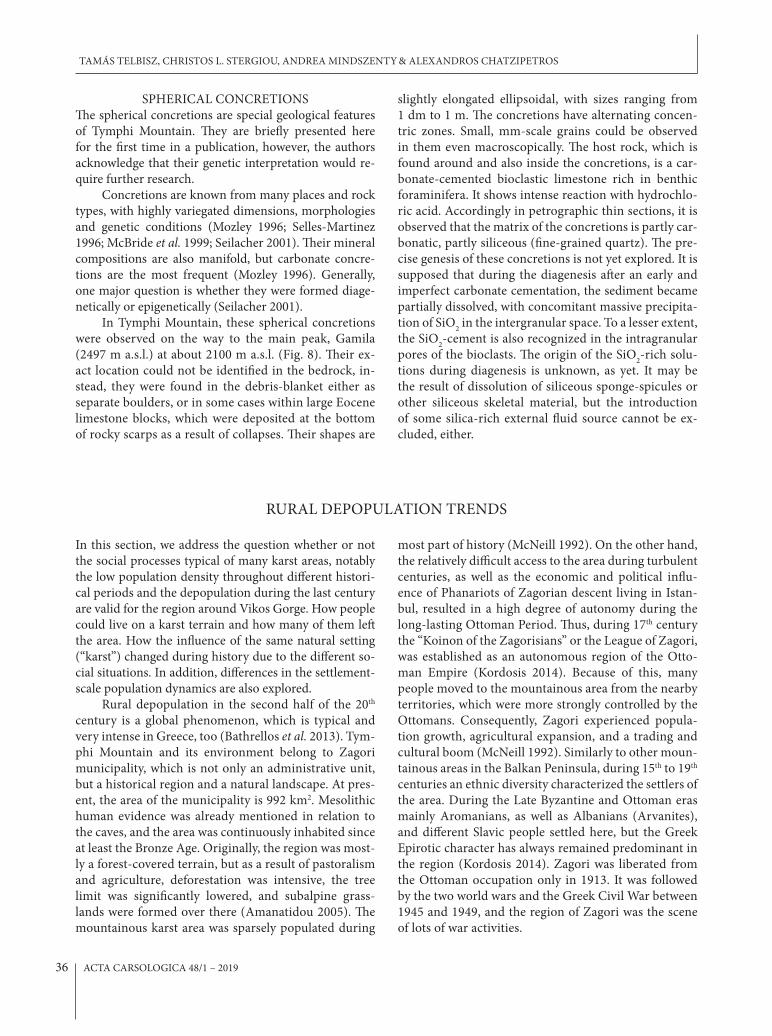
SPHERICAL CONCRETIONSThe spherical concretions are special geological features of Tymphi Mountain. They are briefly presented here for the first time in a publication, however, the authors acknowledge that their genetic interpretation would re-quire further research.
Concretions are known from many places and rock types, with highly variegated dimensions, morphologies and genetic conditions (Mozley 1996; Selles-Martinez 1996; McBride et al. 1999; Seilacher 2001). Their mineral compositions are also manifold, but carbonate concre-tions are the most frequent (Mozley 1996). Generally, one major question is whether they were formed diage-netically or epigenetically (Seilacher 2001).
In Tymphi Mountain, these spherical concretions were observed on the way to the main peak, Gamila (2497 m a.s.l.) at about 2100 m a.s.l. (Fig. 8). Their ex-act location could not be identified in the bedrock, in-stead, they were found in the debris-blanket either as separate boulders, or in some cases within large Eocene limestone blocks, which were deposited at the bottom of rocky scarps as a result of collapses. Their shapes are
slightly elongated ellipsoidal, with sizes ranging from 1 dm to 1 m. The concretions have alternating concen-tric zones. Small, mm-scale grains could be observed in them even macroscopically. The host rock, which is found around and also inside the concretions, is a car-bonate-cemented bioclastic limestone rich in benthic foraminifera. It shows intense reaction with hydrochlo-ric acid. Accordingly in petrographic thin sections, it is observed that the matrix of the concretions is partly car-bonatic, partly siliceous (fine-grained quartz). The pre-cise genesis of these concretions is not yet explored. It is supposed that during the diagenesis after an early and imperfect carbonate cementation, the sediment became partially dissolved, with concomitant massive precipita-tion of SiO2 in the intergranular space. To a lesser extent, the SiO2-cement is also recognized in the intragranular pores of the bioclasts. The origin of the SiO2-rich solu-tions during diagenesis is unknown, as yet. It may be the result of dissolution of siliceous sponge-spicules or other siliceous skeletal material, but the introduction of some silica-rich external fluid source cannot be ex-cluded, either.
RURAL DEPOPULATION TRENDS
In this section, we address the question whether or not the social processes typical of many karst areas, notably the low population density throughout different histori-cal periods and the depopulation during the last century are valid for the region around Vikos Gorge. How people could live on a karst terrain and how many of them left the area. How the influence of the same natural setting (“karst”) changed during history due to the different so-cial situations. In addition, differences in the settlement-scale population dynamics are also explored.
Rural depopulation in the second half of the 20th century is a global phenomenon, which is typical and very intense in Greece, too (Bathrellos et al. 2013). Tym-phi Mountain and its environment belong to Zagori municipality, which is not only an administrative unit, but a historical region and a natural landscape. At pres-ent, the area of the municipality is 992 km2. Mesolithic human evidence was already mentioned in relation to the caves, and the area was continuously inhabited since at least the Bronze Age. Originally, the region was most-ly a forest-covered terrain, but as a result of pastoralism and agriculture, deforestation was intensive, the tree limit was significantly lowered, and subalpine grass-lands were formed over there (Amanatidou 2005). The mountainous karst area was sparsely populated during
most part of history (McNeill 1992). On the other hand, the relatively difficult access to the area during turbulent centuries, as well as the economic and political influ-ence of Phanariots of Zagorian descent living in Istan-bul, resulted in a high degree of autonomy during the long-lasting Ottoman Period. Thus, during 17th century the “Koinon of the Zagorisians” or the League of Zagori, was established as an autonomous region of the Otto-man Empire (Kordosis 2014). Because of this, many people moved to the mountainous area from the nearby territories, which were more strongly controlled by the Ottomans. Consequently, Zagori experienced popula-tion growth, agricultural expansion, and a trading and cultural boom (McNeill 1992). Similarly to other moun-tainous areas in the Balkan Peninsula, during 15th to 19th centuries an ethnic diversity characterized the settlers of the area. During the Late Byzantine and Ottoman eras mainly Aromanians, as well as Albanians (Arvanites), and different Slavic people settled here, but the Greek Epirotic character has always remained predominant in the region (Kordosis 2014). Zagori was liberated from the Ottoman occupation only in 1913. It was followed by the two world wars and the Greek Civil War between 1945 and 1949, and the region of Zagori was the scene of lots of war activities.
TAMÁS TELBISZ, CHRISTOS L. STERGIOU, ANDREA MINDSZENTY & ALEXANDROS CHATZIPETROS
ACTA CARSOLOGICA 48/1 – 201936

In the following, demographic processes are pre-sented by statistical data from the first independent cen-sus in 1920 to our days (Tab. 1). This period can be dis-tributed into three phases. The population of Zagori mu-nicipality increased for a short period after 1920 reach-ing the maximum of 14949 in 1928 that means a density of 15 p/km2. Up to 1951 data show only minor changes in population, something rather unrealistic, as this is the period of wars, which caused serious depopulation. However, it seems likely that at the 1951 census, many people were registered to their original home settlements even if they already moved to larger cities or abroad. The most remarkable depopulation occurred statistically be-tween 1951 and 1961, when the population decrease was 5549 people, i.e., 38%. The next decade was also charac-terized by a significant decrease (2435 people), but the rate of decrease was smaller (27%). Since that time, there is an even smaller rate but permanent decrease that led to the present situation of 3.6 p/km2 population density, which is very low, similarly to other karst terrains (Tel-bisz et al. 2015). The dramatic depopulation can be also characterized by the fact that while in 1928 there were only 3 settlements with less than 100 inhabitants (out of 45), there are now (in 2011) 32.
Population changes were calculated individually for each settlement. We distributed the settlements into four groups based on two selected critical periods. As the most significant population changes occurred between 1951 and 1961, this was selected as the first critical pe-riod. The threshold value was selected as -5.2% annual decrease rate taking into consideration the empirical distribution of the data. The second critical period was the period between 1971 and 2011, when depopulation was already a slower process. For this second period, the threshold value was determined as -1.1% annual rate. It could have been selected theoretically as 0%, but this would have resulted only few elements in some groups,
therefore we chose a smaller value taking into consid-eration a small gap in the distribution of data. Finally, settlements were distributed into four groups according to these two critical values (Tab. 2; Fig. 9).
Group A can be characterized by an abrupt de-crease after 1951 and a relatively strong decrease in the later decades as well. Settlements of this type are found in all parts of Zagori in a relatively even spatial distri-bution (Fig. 1). Group B means settlements with an abrupt decrease after 1951, but stabilization afterwards. These settlements are mostly concentrated around Vikos Gorge, thus, they are generally related to tourism. In fact, real stabilization or population growth after 1971 is true only for Monodendri, Vrisochori, Elati and Papigko, and the increase of population is significant only in case of Papigko (increase by 123 people), which is the main local centre of tourism. Group C includes settlements where depopulation was more gradual after 1951, but their de-crease remained significant up to now. These settlements are scattered within Zagori, but they are found most typically in the smaller tributary valleys, i.e., in the more remote places. Finally, Group D contains settlements, which had very low populations even at the beginning, but their low population was relatively stabilized in the recent decades. They are found in southern Zagori, in the Valley of Zagoritikos River. These settlements include either small ex-pastoral outposts becoming settlements during 19-20th centuries or settlements the inhabitants of which where merchants or transporters travelling throughout the Ottoman Empire. A relevant example is Miliotades, (Fig. 1) which does not have separate census data before 1961, but practically also belong to group D in the meaning that it could maintain its population since 1971. Miliotades historically used to be a small satellite settlement belonging to a larger settlement and serving as the southern entrance to the Zagori region.
The stopping or at least the slowing of rural depopu-
Tab. 2: Grouping criteria for settlements based on population growth rates. GR means annual population growth rate.
Growth rate criteria GR for 1971-2011 < -1.1%/a GR for 1971-2011 > -1.1%/a
GR for 1951-1961 < -5.2%/aGroup Aabrupt post-war decrease, continuous decrease around the millennium
Group Babrupt post-war decrease, relative stabilization around the millennium
GR for 1951-1961 > -5.2%/aGroup Cmore gradual post-war decrease, continuous decrease around the millennium
Group Bmore gradual post-war decrease, relative stabilization around the millennium
Tab. 1: Population changes of Zagori municipality between 1920 and 2011 (Hellenic Statistical Authority, ELSTAT, 2018).
Year 1920 1928 1940 1951 1961 1971 1981 1991 2001 2011Population 11433 14949 13855 14526 8977 6542 6135 5603 4336 3592Pop. density (km-2) 11.5 15.1 14.0 14.6 9.0 6.6 6.2 5.6 4.4 3.6Pop. decrease 3516 -1094 671 -5549 -2435 -407 -532 -1267 -744Rate of pop. decrease 31% -7% 5% -38% -27% -6% -9% -23% -17%
KARST FEATURES AND RELATED SOCIAL PROCESSES IN THE REGION OF THE VIKOS GORGE AND TYMPHI MOUNTAIN (NORTHERN PINDOS NATIONAL PARK, GREECE)
ACTA CARSOLOGICA 48/1 – 2019 37

lation is an important policy goal, however it is difficult to find appropriate means (Bathrellos et al. 2013). The reasons have been investigated in many studies, first, the profitability of farming is low, second, urban life condi-tions are much more attractive, and even people remain-ing in rural settlements send their children to the cities for a better life (Kizos et al. 2011). Rural depopulation, surprisingly at first, is unfavourable even from the view-
point of nature protection, as agricultural decline induc-es a decrease in biodiversity (Tzanopoulos et al. 2011).
At the moment, tourism seems to be the only take-off point, and it is closely related to nature protection. The agricultural and rural development policies of the EU also influence the population retention capacity of rural communities either positively or negatively (Zome-ni et al. 2008; Kizos et al. 2011; Tzanopoulos et al. 2011).
TAMÁS TELBISZ, CHRISTOS L. STERGIOU, ANDREA MINDSZENTY & ALEXANDROS CHATZIPETROS
Fig. 9: Population changes in the different groups of Zagori settle-ments.
ACTA CARSOLOGICA 48/1 – 201938

THE ROLE OF NATURE PROTECTION AND TOURISM
Beside geological and geomorphological values, the bio-logical heritage is also significant. There are rare and en-demic species in the area (Panagiotopoulos et al. 2016), and healing herbs have been collected in Zagori for cen-turies, so the region became an important centre of folk medicine and the „vikogiatri” (meaning „Vikos doctor”) were renowned healers throughout the Balkan Penin-sula in the 17-19th centuries. As for the forests, they are strictly protected in Greece, and in spite of all historical deforestation, the proportion of forests remained rela-tively high in Zagori. It is noteworthy that sometimes even individual trees are traditionally greatly respected in the area with „sacred trees” often taking a symbolic place in Zagori villages (Stara et al. 2015). Moreover, the cultural heritage is also rich, including archaeologi-cal findings, medieval villages, folk architecture using local stone materials, monasteries, arched bridges from the 18-19th centuries (Fig. 10). Thus, the national park is not a true wilderness area in the American sense (Frost & Hall 2009), like most other European national parks. Instead, it is a historical cultural landscape, where the traditional (i.e., agrarian) land use quickly shrinks at present, which in turn induces significant changes in the land cover. The abandoned lands become shrub-lands firsts, and forests later, so the mosaicity of the landscape is ultimately transformed (Zomeni et al. 2008; Stara et al. 2015). Meanwhile, the role of tourism is continuously growing targeting different touristic groups (e.g., ecotourism, rural and gastro tourism). At present, the number of the visitors is around 100,000 people per year, though it is not precisely measured as there are no well-defined entry points where they could be counted (Panagiotopoulos et al. 2016).
Based on the above natural and cultural values, the Vikos-Aoos National Park was set aside in 1973 at an area of 126 km2. A more recent modification is that in 2005, it was merged with the Valia Kalda National Park to form the Northern Pindos National Park. Like in many other natural areas, the „accumulation of protection catego-ries” is characteristic to Vikos. This process obviously serves tourist marketing aims and at the same time, more diverse financial support possibilities. Most of the forests of Northern Pindos National Park are NATURA 2000 territories. Besides, the Vikos-Aoos Geopark was created in 2010, and it became a UNESCO Global Geopark in 2015. In addition, there is an ongoing application for the World Heritage title, too.
Nonetheless, the creation and working of the na-tional park was not without conflicts. In the first decades after the foundation, local stakeholders often perceived restrictions and prohibitions due to the national park
limitations (Panagiotopoulos et al. 2016). In several cas-es, local people had difficulties to accept that their aban-doned and forested agricultural parcels became protect-ed as forests, and so they could not use them anymore. It was at least partly an emotional problem as these lands were usually not used for a long time (Trakolis 2001). A further problem was that the planning and operation of the national park took place without any consideration of the needs and interests of the local communities (Pa-pageorgiou & Kassioumis 2005). However, since the turn of the millennium, the management policy was partly changed, and the positive economic effects of tourism became more and more tangible. According to a ques-tionnaire in 2001 (Trakolis 2001), 48% of the local people remained neutral to the national park, 20% felt worsen-ing economic status due to the national park, but 29% perceived improved conditions, especially the younger people and those who work in tourism. In many cases, people do not have a full job in tourism, but they can earn extra revenue from tourism besides farming (Stara et el. 2015). By now the “traditional” conflicts referred by Trakolis (2001) are almost gone.
Fig. 10: Local architecture: roof slabs from thin-bedded limestone (B) and the famous Kokoris arched stone bridge (A) (Photos: T. Telbisz).
KARST FEATURES AND RELATED SOCIAL PROCESSES IN THE REGION OF THE VIKOS GORGE AND TYMPHI MOUNTAIN (NORTHERN PINDOS NATIONAL PARK, GREECE)
ACTA CARSOLOGICA 48/1 – 2019 39

For long, there was no sensible conflict between na-ture protection and tourism. However, since 2010 there is a dramatic change in the number of the visitors, and certain negative impacts are sensible. For example, the occurrence of eutrophication phenomena at Voidomatis River during 2009 to 2013 summer periods were repeat-edly reported by visitors and the local press, although these phenomena remained significantly unexplored. Furthermore, another potential conflict could rise by the increased uncontrolled number of hiking and canyon-
ing tourists within the core zones of the National Park. Nevertheless, there are two open questions. First, how the cultural landscape can be preserved if the number of people working in traditional agriculture continuously decreases. Second, what kind of tourist development is possible or necessary to increase the incomes and the population retention capacity of the area, naturally tak-ing into consideration the criteria of sustainable devel-opment as well (Papageorgiou & Kassioumis 2005; Tza-nopoulos et al. 2011).
CONCLUSIONS
As a summary, it is stated that Vikos Gorge and its en-vironment, i.e., the Zagori area is a perfect example for the thesis mentioned in the Introduction. Namely, Za-gori is a karst terrain where life is difficult, thus it was sparsely populated historically and seriously affected by recent depopulation. Naturally, this image is specifically coloured by historical events like the relative autonomy during the Ottoman Period or the wars of the 20th cen-tury.
The take-off point can be the protection of natural heritage and the related tourism based on a solid, eco-friendly development plan. The karst features, especially the Vikos Gorge as the main attraction, provide the ba-sis for tourist marketing. In addition, some elements of the cultural heritage, such as Mesolithic caves, the rela-tive isolation, and the folk architecture using local raw materials are also partly related to the karst setting. The
glaciokarst landscape can be a direct appeal primarily for geotourists, but it can be a recommended target to gen-eral hikers as well.
Based on the statistical analysis of population data it is observed that there was an abrupt decrease after the Second World War, but at most places, the depopulation is an ongoing process ever since then. The shrinking of rural settlements could be stopped only in a very limited number of settlements, where tourism has gained some importance. The decay of old buildings could be halted in settlements visited by tourists and even significant mod-ernization took place by preserving the exterior view of the settlements but adjusting the new functions (accom-modation, catering, etc.) to tourism. However, the trans-formation of the traditional agricultural, pastoral land-scape is expected to continue in the future as the number of farmers gradually decreases.
ACKNOWLEDGEMENTS
This research has been supported by the National Re-search, Development and Innovation Office Hungary
(NKFIH) K124497 project. The authors thank the helpful comments of two anonymous reviewers
REFERENCES
Amanatidou, D., 2005: Analysis and evaluation of a tra-ditional cultural landscape as a basis for its conser-vation management. A case study in Vikos-Aoos National Park, Greece.- Dissertation, Fakultät für Forst-und Umweltwissenschaften, Albert-Ludwigs Universität, Freiburg im Breisgau, pp. 234.
Aubouin, J., Desprairies, A. & J. Terry, 1977: Le syncli-
nal d’Epire-Akarnanie, la nappe du Pinde-Olonos et la nappe ophiolitique. Reunion extraordinaire en Grece.- Bulletin Societe Geologique de France, 7, 19, 1, 20–27.
Bailey, G.N., Lewin, J., Macklin, M.G. & J.C. Wood-ward, 1990: The “older fill” of the Voidomatis val-ley, north-west Greece and its relationship to the
TAMÁS TELBISZ, CHRISTOS L. STERGIOU, ANDREA MINDSZENTY & ALEXANDROS CHATZIPETROS
ACTA CARSOLOGICA 48/1 – 201940

Palaeolithic archaeology and glacial history of the region.- Journal of Archaeological Science, 17, 145–150.
Bathrellos, G.D., Gaki-Papanastassiou, K., Skilodimou, H.D., Skianis, G.A. & K.G. Chousianitis, 2013: As-sessment of rural community and agricultural de-velopment using geomorphological–geological factors and GIS in the Trikala prefecture (Central Greece).- Stoch Environ Res Risk Assess, 27, 573–588. DOI: 10.1007%2Fs00477-012-0602-0
Bögli, A., 1964: Le Schichttreppenkarst.- Révue Belgique de Géographie, 88, 63–81.
Chatzipetros, A. & C. Stergiou, 2016: Morphotectonic in-dications of uplift from the Vikos Gorge area using UAV: Preliminary results.- In: Tectonics and Structural Geology Committee of the Geological Society of Greece, 1st TSG Meeting, 6. December 2016, Athens, 4–6.
Dowling, R.K., 2011: Geotourism’s Global Growth.- Geo-heritage, 3, 1–13. DOI: 10.1007/s12371-010-0024-7
Elefanti, P., Marshall, G., Adam, E., Stergiou, C. & E. Kot-jabopoulou, 2017: Hunter-gatherers in transition: The case of Boila rockshelter in the Ioannina Pre-fecture.- 2nd Conference on The archaeological activ-ity and research in North West Greece and the Ionian islands, Ioannina, Greece, 23–26. 11. 2017.
Ewald, J., 2003: The calcareous riddle: Why are there so many calciphilous species in the Central Eu-ropean flora?- Folia Geobot, 38, 357–366. DOI: 10.1007%2FBF02803244
Frost, W. & C.M. Hall, 2009: Tourism and national parks: International perspectives on development, histories, and change (Vol. 14).- Routledge, pp. 357, London.
Guinness World Records, 2005: Special 50th Anniversary Edition. Guinness World Records. 2004, pp. 288.
Gutierrez, F., Parise, M., De Waele, J. & H. Jourde, 2014: A review on natural and human-induced geohaz-ards and impacts in karst.- Earth-Science Reviews, 138, 61–88. DOI: 10.1016/j.earscirev.2014.08.002
Hellenic Statistical Authority (ELSTAT), 2018: Popu-lation-Residential inventory.- [Online] Available from: http://www.statistics.gr/statistics/pop [Ac-cessed June 11th, 2018].
Hughes, P.D., Gibbard, P.L. & J.C. Woodward, 2003: Rel-ict rock glaciers as indicators of Mediterranean pal-aeoclimate during the Last Glacial Maximum (Late Würmian) in northwest Greece.- Journal of Quater-nary Science, 18, 431–440.
Hughes, P.D., Gibbard, P.L. & J.C. Woodward, 2006a: Middle Pleistocene glacier behaviour in the Medi-terranean: sedimentological evidence from the Pindus Mountains, Greece.- Journal of the Geo-logical Society, 163, 857–867. DOI: 10.1144/0016-76492005-131
Hughes, P.D., Gibbard, P.L. & J.C. Woodward, 2007a: Geological controls on Pleistocene glaciation and cirque form in Greece.- Geomorphology, 88, 242–253. DOI: 10.1016/j.geomorph.2006.11.008
Hughes, P.D., Woodward, J.C. & P.L. Gibbard, 2006b: The last glaciers of Greece.- Zeitschrift für Geomorphol-ogie, 50, 37–61.
Hughes, P.D., Woodward, J.C. & P.L. Gibbard, 2007b: Middle Pleistocene cold stage climates in the Medi-terranean: new evidence from the glacial record.- Earth and Planetary Science Letters, 253, 50–56. DOI: 10.1016/j.epsl.2006.10.019
Keveiné Bárány, I., 2014: Landscape Changes In Karsts With Special Regard To Anthropogenic Activity.- Karsztfejlődés, 19, 5–21.
Kizos, T., Vasdeki, M., Chatzikiriakou, C. & D. Dimi-triou, 2011: ‘For my children’: Different functions of the agricultural landscape and attitudes of farm-ers on different areas of Greece towards small scale landscape change.- Geografisk Tidsskrift-Danish Journal of Geography, 111, 117–130. DOI: 10.1080%2F00167223.2011.10669528
Kordosis, S., 2014: Papigo and Zagoria during the post Byzantine period.- Poiotita publications, pp. 13, Athens.
Kőszegi, M., Bottlik, Z., Telbisz, T. & L. Mari, 2015: Human-environment relationships in modern and postmodern geography.- Hungarian Geographical Bulletin, 64, 2, 87–99.
Leontaritis, A.D. & E. Baltas, 2014: Hydrological Anal-ysis of the Aoos (Vjosë) – Voidomatis Hydrosys-tem in Greece.- Austin Journal of Hydrology, 1, 8–14.
McBride, E.F., Abdel‐Wahab, A. & A.R. El‐Younsy, 1999: Origin of spheroidal chert nodules, Drunka Formation (Lower Eocene), Egypt.- Sedimentology, 46, 733–755. DOI: 10.1046/j.1365-3091.1999.00253.x
McNeill, J.R., 1992: The mountains of the Mediterranean world. An environmental history.- Studies in Envi-ronmental History 8, pp. 423, Cambridge.
Milošević, M. V., Milivojević, M. & J. Ćalić, 2010: Spon-taneously abandoned settlements in Serbia, Part 1.- Journal of the Geographical Institute “Jovan Cvijić” SASA, 60, 2, 39–57.
Mozley, P.S., 1996: The internal structure of carbonate concretions in mudrocks: a critical evaluation of the conventional concentric model of concretion growth.- Sedimentary Geology, 103, 85–91. DOI: 10.1016/0037-0738(95)00087-9
Ntokos, D., 2018: Neotectonic study of Northwest-ern Greece.- Journal of Maps, 14, 178–188. DOI: 10.1080/17445647.2018.1445562
KARST FEATURES AND RELATED SOCIAL PROCESSES IN THE REGION OF THE VIKOS GORGE AND TYMPHI MOUNTAIN (NORTHERN PINDOS NATIONAL PARK, GREECE)
ACTA CARSOLOGICA 48/1 – 2019 41

Panagiotopoulos, G., Misthos, L.M. & D. Kaliampakos, 2016: Beyond Existing e-Tourism for Mountains: Findings from the Case of Zagori, Greece.- In: Koulov, B. & G. Zhelezov (eds.) Sustainable Moun-tain Regions: Challenges and Perspectives in South-eastern Europe. Springer, Cham, 123–136. DOI: 10.1007/978-3-319-27905-3_9
Papageorgiou, K. & K. Kassioumis, 2005: The national park policy context in Greece: park users’ perspec-tives of issues in park administration.- Journal for Nature Conservation, 13, 231–246. DOI: 10.1016/j.jnc.2004.11.001
Pejnović, D. & D. Husanović-Pejnović, 2008: Causes and consequences of demographic development in the territory of Velebit Nature Park, 1857-2001.- Peri-odicum Biologorum, 110, 2, 195–204.
Perrier, R., Savoyat, E., Koukouzas, K., Lalexos, N. & N. Filippakis, 1970: “Tsepelovo” map sheet, scale 1:50.000, IGME, Athens.
Petrocheilou, A., 1952: Caves in Epirus.- Bulletin of the Speleological Society of Greece, 1, 262–316.
Rodriguez, E., Morris, C.S. & J.E. Belz, 2006: A global as-sessment of the SRTM performance.- Photogram-metric Engineering & Remote Sensing, 72, 249–260. DOI: 10.14358/PERS.72.3.249
Seilacher, A., 2001: Concretion morphologies reflect-ing diagenetic and epigenetic pathways.- Sedimen-tary Geology, 143, 41–57. DOI: 10.1016/S0037-0738(01)00092-6
Selles-Martinez, J., 1996: Concretion morphology, clas-sification and genesis.- Earth-Science Reviews, 41, 177–210. DOI: 10.1016/S0012-8252(96)00022-0
Stara, K., Tsiakiris, R. & J.L.G. Wong, 2015: The Trees of the Sacred Natural Sites of Zagori, NW Greece.- Landscape Research, 40, 884–904. DOI: /10.1080/01426397.2014.911266
Stiros, S.C., Barkas, N. & M. Moutsoulas, 1999: River ero-sion and landscape reconstruction in Epirus: meth-odology and results.- British School at Athens Stud-ies, 3, 108–114.
Tanács, E., Szmorad, F. & I. Bárány-Kevei, 2007: A Re-view of the Forest Management History and Pres-ent State of the Haragistya Karst Plateau (Aggtelek Karst, Hungary).- Acta Carsologica, 36, 3, 441–451. DOI: 10.3986/ac.v36i3.178
Telbisz, T., Bottlik, Z., Mari, L. & M. Kőszegi, 2014: The impact of topography on social factors, a case study of Montenegro.- Journal of Mountain Sciences, 11, 1, 131–141. DOI: 10.1007/s11629-012-2623-z
Telbisz, T., Bottlik, Z., Mari, L. & A. Petrvalská, 2015: Ex-ploring Relationships Between Karst Terrains and Social Features by the Example of Gömör-Torna
Karst (Hungary-Slovakia).- Acta Carsologica, 44, 1, 121–137. DOI: 10.3986/ac.v44i1.1739
Telbisz, T., Imecs, Z., Mari, L. & Z. Bottlik, 2016: Chang-ing Human-Environment Interactions in Medium Mountains, the Apuseni Mts (Romania) as a Case Study.- Journal of Mountain Science, 13, 9, 1675–1687. DOI: 10.1007/s11629-015-3653-0
Trakolis, D., 2001: Perceptions, preferences, and reac-tions of local inhabitants in Vikos-Aoos National Park, Greece.- Environmental Management, 28, 665–676. DOI: 10.1007/s002670010251
Tzanopoulos, J., Kallimanis, A.S., Bella, I., Labrianidis, L., Sgardelis, S. & J.D. Pantis, 2011: Agricultural decline and sustainable development on mountain areas in Greece: Sustainability assessment of future scenarios.- Land Use Policy, 28, 585–593. DOI: 10.1016%2Fj.landusepol.2010.11.007
van Beynen, P. & K. Townsend, 2005: A disturbance in-dex for karst environments.- Environmental Man-agement, 36, 1, 101–116. DOI: doi.org/10.1007/s00267-004-0265-9
Vogiatzakis, I., 2012: Mediterranean Mountain Environ-ments.- John Wiley & Sons, pp. 232.
Waltham, A.C., 1978: The caves and karst of Astraka, Greece.- Transactions of the British Cave Research Association, 5, 1–12.
Williams, P.W., 1993: Environmental change and human impact on karst terrains: an introduction.- Catena, 25, 1–19.
Woodward, J.C., Hamlin, R.H.B., Macklin, M.G., Hughes, P.D. & J. Lewin, 2008: Glacial activity and catchment dynamics in northwest Greece: long-term river behaviour and the slackwater sediment record for the last glacial to interglacial transition.- Geomorphology, 101, 44–67. DOI: 10.1016/j.geo-morph.2008.05.018
Woodward, J.C., Macklin, M.G. & G.R. Smith, 2004: Pleistocene glaciation in the mountains of Greece.- In: J. Ehlers & P. L. Gibbard (eds.): Quaternary Gla-ciations – Extent and Chronology: Part 1, Elsevier, Amsterdam, pp. 155–173.
Young, M.C., 1997: The Guinness book of world records, 1997.- Guinness Records, pp. 319.
Zomeni, M., Tzanopoulos, J. & J.D. Pantis, 2008: Histori-cal analysis of landscape change using remote sens-ing techniques: An explanatory tool for agricultural transformation in Greek rural areas.- Landscape and Urban Planning, 86, 38–46. DOI: 10.1016%2Fj.landurbplan.2007.12.006
TAMÁS TELBISZ, CHRISTOS L. STERGIOU, ANDREA MINDSZENTY & ALEXANDROS CHATZIPETROS
ACTA CARSOLOGICA 48/1 – 201942