Embed Size (px)
Citation preview
Chapter 7 Transport
Contents
7.1 Objectives and policies7.1.1 Objective 1 Integrated transport system7.1.2 Objective 2 Adverse effects from the transport network
7.2 Rules All zones outside the Central City7.2.1 How to use the rules7.2.2 Activity Status Tables All zones outside of the Central City7.2.3 Rules All zones outside the Central City
7.3 Matters of Discretion 7.3.1 Minimum number of car parks required7.3.2 Parking space dimensions7.3.3 Parking spaces for people with disabilities7.3.4 Minimum number of cycle parking facilities required7.3.5 Minimum number of loading spaces required7.3.6 Manoeuvring for parking and loading areas7.3.7 Gradient of parking and loading areas7.3.8 Illumination of parking and loading areas7.3.9 Surface of parking and loading areas7.3.10 Vehicle access design7.3.11 Queuing spaces7.3.12 Visibility splay7.3.13 Vehicle crossing design7.3.14 Minimum distance between vehicle crossings7.3.15 Maximum number of vehicle crossings7.3.16 Minimum distance between vehicle crossings and intersections7.3.17 Sight lines at vehicle crossings7.3.18 Location of building and access in relation to road/rail level crossings7.3.19 High trip generators
AppendicesAppendix 7.1 Parking space requirementsAppendix 7.2 Cycle parking facilitiesAppendix 7.3 Loading areasAppendix 7.4 85 percentile design motor carAppendix 7.5 99 percentile design vehicleAppendix 7.6 Manoeuvring for parking and loading areasAppendix 7.7 Access designAppendix 7.8 Queuing spacesAppendix 7.9 Visibility splayAppendix 7.10 Design of rural vehicle crossingsAppendix 7.11 Standards for the location of vehicle crossings
Chapter 7 - Transport
Printed: 26/08/2014 Page 1 of 88
Appendix 7.12 Road classification systemAppendix 7.13 Building set backs to level crossingsAppendix 7.14 Parking reduction adjustment factorsAppendix 7.15 Integrated transport assessment requirements checklist
Chapter 7 - Transport
Printed: 26/08/2014 Page 2 of 88
7.1 Objectives and policies
7.1.1 Objective 1 Integrated transport system
7.1.1.1 Policy 1 Establishment of a road classification system
Refer to Appendix 7.12 for a description of the road classification system.
Policy 1 also achieves Objective 2.
7.1.1.2 Policy 2 High trip generating activities
Require that the location and design of high trip generating activities are assessed to ensure that they:
An integrated transport system:
that is accessible, affordable, resilient, safe, sustainable and efficient for people using alltransport modes;
that is responsive to the current recovery needs, future needs, and economic development;
that supports safe, healthy and liveable communities by maximising integration with land use;
that reduces dependency on private motor vehicles and promotes the use of public and activetransport;
that recognises Ngāi Tahu/ Manawhenua values; and
that is managed using the one network approach.
A road network that recognises different access and movement functions for all transport modes,whilst:
ensuring the continued safe and efficient operation of the transport network for all modes,including freight;
providing for public places to enable community activities, including opportunities for peopleto interact and spend time,
providing space for utility services;
reflecting neighbourhood identity and amenity; and
recognising crossboundary connections with adjoining districts.
are accessible by a range of transport modes and promote public and active transport use;
promote the safe, efficient and effective use of the transport system;
optimise use of existing capacity within the transport system;
reduce the impact of trip generation through travel plans and other travel demand managementmeasures;
avoid or mitigate significant adverse effects from development on the transport system, including
a.
i.
ii.
iii.
iv.
v.
vi.
a.
i.
ii.
iii.
iv.
v.
a.
b.
c.
d.
e.
Chapter 7 - Transport
Printed: 26/08/2014 Page 3 of 88
Policy 2 also achieves Objective 2.
7.1.1.3 Policy 3 Vehicle access and manoeuvring
Policy 3 also achieves Objective 2.
7.1.1.4 Policy 4 Requirements for car parking and loading
reverse sensitivity effects on the strategic transport network;
limit adverse effects and maximise positive effects from transport on the amenity of surroundingareas, on the environment, and on Ngāi Tahu/ Manawhenua values;
encourage the use of parking management measures which;
make efficient use of land;
minimise adverse effects on the safety, efficiency and amenity of the surrounding area,including the transport network;
cater for the parking demand of the activity;
support recovery and economic activity;
encourage public and active transport use;
provide for the needs of people with disabilities; and
maximise integration with the transport system, including planned transport infrastructure andservice improvements by coordinating land use and the implementation of transport infrastructureand services.
Ensure the number, location, design and gradient of vehicle accesses and associatedmanoeuvring:
is compatible with the range of functions of that part of the road network;
promotes safety by minimising conflicts between pedestrians, cyclists and vehiclemovements;
is designed to encourage safe and attractive active transport access; and
enables the safe and efficient operation of the transport system.
Require car parking and loading spaces which provide for the expected needs of an activity in away that minimises adverse effects.
Enable an assessment of whether a reduction in the number of car parking spaces required canbe considered as an opportunity to facilitate public and active transport use, but only where:
the function of the surrounding transport network and amenity of the surrounding environmentwill not be adversely affected; and/or
there is good accessibility by active and public transport and the activity is designed toencourage public and active transport use; and/or
the extent of the reduction is appropriate to the characteristics of the activity and it’s location;and/or
the extent of the reduction is appropriate having regard to Appendix 7.14– Parking reduction
f.
g.
i.
ii.
iii.
iv.
v.
h.
i.
a.
i.
ii.
iii.
iv.
a.
b.
i.
ii.
iii.
iv.
Chapter 7 - Transport
Printed: 26/08/2014 Page 4 of 88
Policy 4 also achieves Objective 2.
7.1.1.5 Policy 5 Design of car parking and loading areas
Policy 5 also achieves Objective 2.
7.1.1.6 Policy 6 Promote public transport and active transport
Policy 6 also achieves Objective 2.
7.1.1.7 Policy 7 Rail level crossings
adjustment factors.
Provide for flexible approaches to car parking in local and neighbourhood centres to support theuse of public and active transport and existing parking supply.
Provide car parking for people with disabilities where any car parking is provided and foractivities with a Gross Floor Area greater than 2500m2 even when no other parking is provided.
Require that car parking and loading areas are designed to:
operate safely and efficiently;
mitigate adverse effects on the character and amenity of the surrounding environment;
provide quality urban amenity outcomes within the development;
prevent crime;
support the efficient and safe use and operation of land use activities; and
support amenity and safety for all transport modes.
Promote public and active transport and reduce dependency on private motor vehicles, by:
ensuring new road corridors provide sufficient space and facilities to safely promote walking,cycling and public transport;
ensuring activities provide an adequate amount of safe, secure, attractive and convenientcycle parking and associated end of trip facilities;
encouraging the use of travel demand management options that help facilitate the use ofpublic transport, cycling, walking and options to minimise the need to travel; and
requiring new district centres to provide opportunities for a public transport interchange.
Improve and maintain safety at road/rail level crossings by:
requiring safe visibility at uncontrolled level crossings;
managing vehicle accesses close to level crossings; and
managing the creation of new level crossings.
c.
d.
a.
i.
ii.
iii.
iv.
v.
vi.
a.
i.
ii.
iii.
iv.
a.
i.
ii.
iii.
Chapter 7 - Transport
Printed: 26/08/2014 Page 5 of 88
Policy 7 also achieves Objective 2.
7.1.1.8 Policy 8 Effects from transport infrastructure
Policy 8 also achieves Objective 2.
7.1.2 Objective 2 Adverse effects from the transport system
Notes:
7.2 Rules All zones outside the Central City
7.2.1 How to use the rules
7.2.1.1 The transport rules that apply to activities in all zones outside the Central City arecontained in:
Minimise the adverse effects and maximise positive effects from new transport infrastructure andchanges to existing transport infrastructure on the environment, including:
air quality;
economic recovery;
severance;
water quality;
noise;
vibration;
glare;
amenity;
effects on the built environment; and
safety of users.
The cultural values of Ngāi Tahu/ Manawhenua are recognised, protected and enhanced through:
the use of indigenous species in landscaping and tree planting of transport infrastructure;
a multivalue approach to stormwater management of transport infrastructure; and
the protection and enhancement of wāhi tapu and wāhi taonga including waipuna.
Enable Christchurch’s transport system to provide for the transportation needs of people andfreight whilst managing adverse effects from the transport system.
Policies 7.1.1.1, 7.1.1.2, 7.1.1.3, 7.1.1.4, 7.1.1.5, 7.1.1.6, 7.1.1.7 and 7.1.1.8 also apply toObjective 7.1.2
For more details on Christchurch City Council's vision, expectation and plans for transport, duringthe recovery period and longer term, please refer to the 'Christchurch Transport Strategic Plan'.
a.
i.
ii.
iii.
iv.
v.
vi.
vii.
viii.
ix.
x.
b.
i.
ii.
iii.
a.
1.
2.
Chapter 7 - Transport
Printed: 26/08/2014 Page 6 of 88
7.2.1.2 The Activity Status table and standards for the zone where the activity is located, andthe Activity Status table and standards in the following chapters also apply (whererelevant):
5 Natural Hazards 6 General Rules and Procedures 8 Subdivision, Development and Earthworks 9 Heritage and Natural Environment 11 Utilities, Energy and Infrastructure 12 Hazardous Substances and Contaminated Land.
7.2.2 Activity status tables All zones outside of the Central City
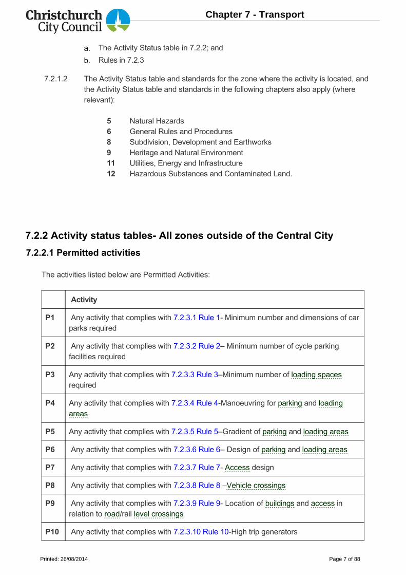
7.2.2.1 Permitted activities
The activities listed below are Permitted Activities:
Activity
P1 Any activity that complies with 7.2.3.1 Rule 1 Minimum number and dimensions of carparks required
P2 Any activity that complies with 7.2.3.2 Rule 2– Minimum number of cycle parkingfacilities required
P3 Any activity that complies with 7.2.3.3 Rule 3–Minimum number of loading spacesrequired
P4 Any activity that complies with 7.2.3.4 Rule 4Manoeuvring for parking and loadingareas
P5 Any activity that complies with 7.2.3.5 Rule 5–Gradient of parking and loading areas
P6 Any activity that complies with 7.2.3.6 Rule 6– Design of parking and loading areas
P7 Any activity that complies with 7.2.3.7 Rule 7 Access design
P8 Any activity that complies with 7.2.3.8 Rule 8 –Vehicle crossings
P9 Any activity that complies with 7.2.3.9 Rule 9 Location of buildings and access inrelation to road/rail level crossings
P10 Any activity that complies with 7.2.3.10 Rule 10High trip generators
The Activity Status table in 7.2.2; and
Rules in 7.2.3
a.
b.
Chapter 7 - Transport
Printed: 26/08/2014 Page 7 of 88
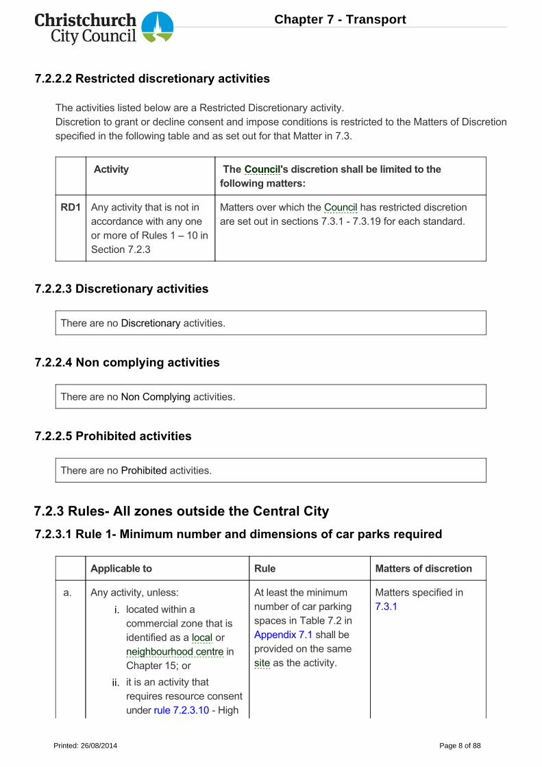
7.2.2.2 Restricted discretionary activities
The activities listed below are a Restricted Discretionary activity.Discretion to grant or decline consent and impose conditions is restricted to the Matters of Discretionspecified in the following table and as set out for that Matter in 7.3.
Activity The Council's discretion shall be limited to thefollowing matters:
RD1 Any activity that is not inaccordance with any oneor more of Rules 1 – 10 inSection 7.2.3
Matters over which the Council has restricted discretionare set out in sections 7.3.1 7.3.19 for each standard.
7.2.2.3 Discretionary activities
There are no Discretionary activities.
7.2.2.4 Non complying activities
There are no Non Complying activities.
7.2.2.5 Prohibited activities
There are no Prohibited activities.
7.2.3 Rules All zones outside the Central City
7.2.3.1 Rule 1 Minimum number and dimensions of car parks required
Applicable to Rule Matters of discretion
a. Any activity, unless: At least the minimumnumber of car parkingspaces in Table 7.2 inAppendix 7.1 shall beprovided on the samesite as the activity.
Matters specified in7.3.1located within a
commercial zone that isidentified as a local orneighbourhood centre inChapter 15; or
it is an activity thatrequires resource consentunder rule 7.2.3.10 High
i.
ii.
Chapter 7 - Transport
Printed: 26/08/2014 Page 8 of 88
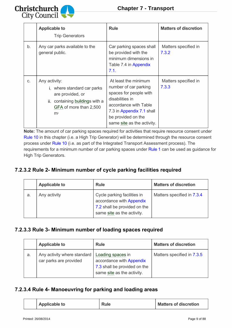
Applicable to Rule Matters of discretion
b. Any car parks available to thegeneral public.
Car parking spaces shallbe provided with theminimum dimensions inTable 7.4 in Appendix7.1.
Matters specified in7.3.2
c. Any activity: At least the minimumnumber of car parkingspaces for people withdisabilities inaccordance with Table7.3 in Appendix 7.1 shallbe provided on thesame site as the activity.
Matters specified in7.3.3
Note: The amount of car parking spaces required for activities that require resource consent underRule 10 in this chapter (i.e. a High Trip Generator) will be determined through the resource consentprocess under Rule 10 (i.e. as part of the Integrated Transport Assessment process). Therequirements for a minimum number of car parking spaces under Rule 1 can be used as guidance forHigh Trip Generators.
7.2.3.2 Rule 2 Minimum number of cycle parking facilities required
Applicable to Rule Matters of discretion
a. Any activity Cycle parking facilities inaccordance with Appendix7.2 shall be provided on thesame site as the activity.
Matters specified in 7.3.4
7.2.3.3 Rule 3 Minimum number of loading spaces required
Applicable to Rule Matters of discretion
a. Any activity where standardcar parks are provided
Loading spaces inaccordance with Appendix7.3 shall be provided on thesame site as the activity.
Matters specified in 7.3.5
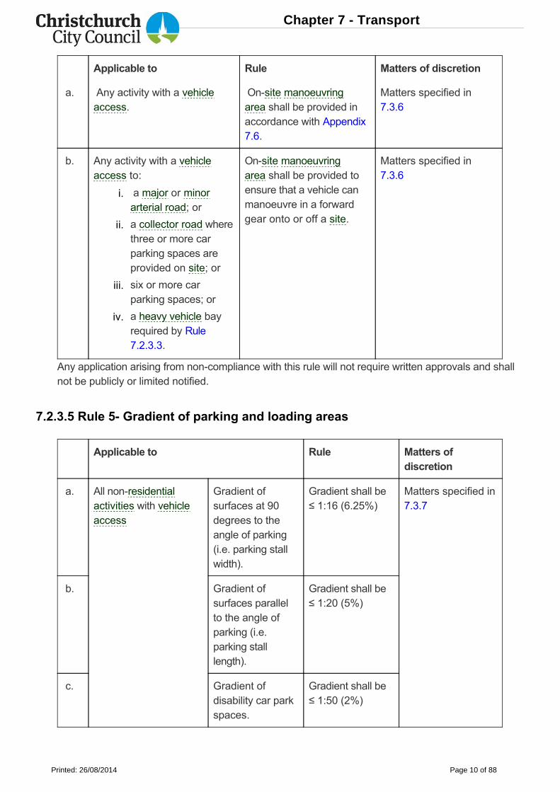
7.2.3.4 Rule 4 Manoeuvring for parking and loading areas
Applicable to Rule Matters of discretion
Trip Generators
where standard car parksare provided, or
containing buildings with aGFA of more than 2,500m2
i.
ii.
Chapter 7 - Transport
Printed: 26/08/2014 Page 9 of 88
Applicable to Rule Matters of discretion
a. Any activity with a vehicleaccess.
Onsite manoeuvringarea shall be provided inaccordance with Appendix7.6.
Matters specified in7.3.6
b. Any activity with a vehicleaccess to:
Onsite manoeuvringarea shall be provided toensure that a vehicle canmanoeuvre in a forwardgear onto or off a site.
Matters specified in7.3.6
Any application arising from noncompliance with this rule will not require written approvals and shallnot be publicly or limited notified.
7.2.3.5 Rule 5 Gradient of parking and loading areas
Applicable to Rule Matters ofdiscretion
a. All nonresidentialactivities with vehicleaccess
Gradient ofsurfaces at 90degrees to theangle of parking(i.e. parking stallwidth).
Gradient shall be≤ 1:16 (6.25%)
Matters specified in7.3.7
b. Gradient ofsurfaces parallelto the angle ofparking (i.e.parking stalllength).
Gradient shall be≤ 1:20 (5%)
c. Gradient ofdisability car parkspaces.
Gradient shall be≤ 1:50 (2%)
a major or minorarterial road; or
a collector road wherethree or more carparking spaces areprovided on site; or
six or more carparking spaces; or
a heavy vehicle bayrequired by Rule7.2.3.3.
i.
ii.
iii.
iv.
Chapter 7 - Transport
Printed: 26/08/2014 Page 10 of 88
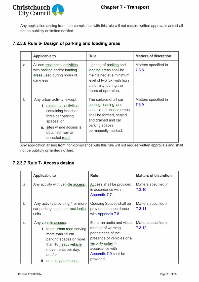
Any application arising from noncompliance with this rule will not require written approvals and shallnot be publicly or limited notified.
7.2.3.6 Rule 6 Design of parking and loading areas
Applicable to Rule Matters of discretion
a. All nonresidential activitieswith parking and/or loadingareas used during hours ofdarkness
Lighting of parking andloading areas shall bemaintained at a minimumlevel of two lux, with highuniformity, during thehours of operation.
Matters specified in7.3.8
b. Any urban activity, except: The surface of all carparking, loading, andassociated access areasshall be formed, sealedand drained and carparking spacespermanently marked.
Matters specified in7.3.9
Any application arising from noncompliance with this rule will not require written approvals and shallnot be publicly or limited notified.
7.2.3.7 Rule 7 Access design
Applicable to Rule Matters of discretion
a. Any activity with vehicle access. Access shall be providedin accordance withAppendix 7.7.
Matters specified in7.3.10
b. Any activity providing 4 or morecar parking spaces or residentialunits.
Queuing Spaces shall beprovided in accordancewith Appendix 7.8
Matters specified in7.3.11
c. Any vehicle access: Either an audio and visualmethod of warningpedestrians of thepresence of vehicles or avisibility splay inaccordance withAppendix 7.9 shall beprovided.
Matters specified in7.3.12
residential activitiescontaining less thanthree car parkingspaces; or
sites where access isobtained from anunsealed road.
to an urban road servingmore than 15 carparking spaces or morethan 10 heavy vehiclemovements per day;and/or
on a key pedestrian
i.
ii.
i.
ii.
Chapter 7 - Transport
Printed: 26/08/2014 Page 11 of 88
Applicable to Rule Matters of discretion
Any application arising from noncompliance with this rule will not require written approvals and shallnot be publicly or limited notified.
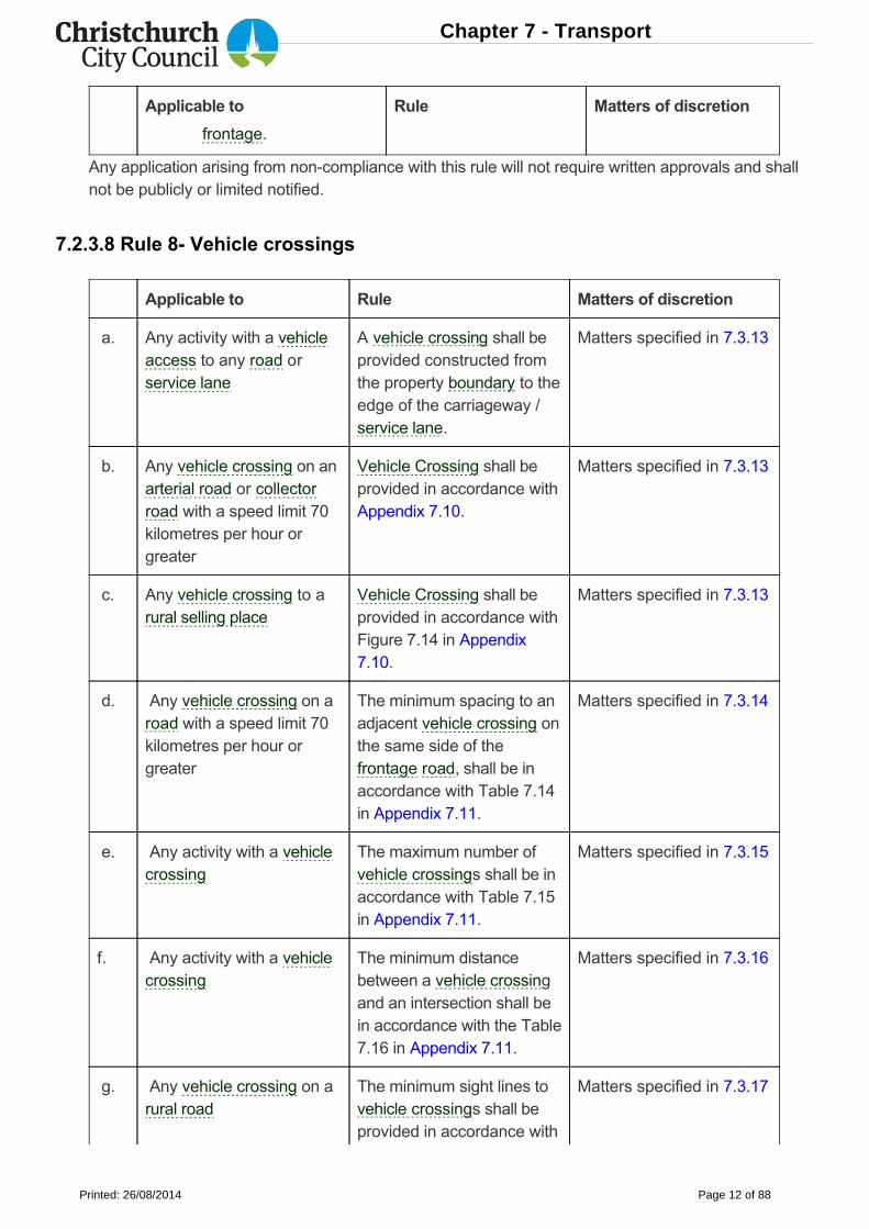
7.2.3.8 Rule 8 Vehicle crossings
Applicable to Rule Matters of discretion
a. Any activity with a vehicleaccess to any road orservice lane
A vehicle crossing shall beprovided constructed fromthe property boundary to theedge of the carriageway /service lane.
Matters specified in 7.3.13
b. Any vehicle crossing on anarterial road or collectorroad with a speed limit 70kilometres per hour orgreater
Vehicle Crossing shall beprovided in accordance withAppendix 7.10.
Matters specified in 7.3.13
c. Any vehicle crossing to arural selling place
Vehicle Crossing shall beprovided in accordance withFigure 7.14 in Appendix7.10.
Matters specified in 7.3.13
d. Any vehicle crossing on aroad with a speed limit 70kilometres per hour orgreater
The minimum spacing to anadjacent vehicle crossing onthe same side of thefrontage road, shall be inaccordance with Table 7.14in Appendix 7.11.
Matters specified in 7.3.14
e. Any activity with a vehiclecrossing
The maximum number ofvehicle crossings shall be inaccordance with Table 7.15in Appendix 7.11.
Matters specified in 7.3.15
f. Any activity with a vehiclecrossing
The minimum distancebetween a vehicle crossingand an intersection shall bein accordance with the Table7.16 in Appendix 7.11.
Matters specified in 7.3.16
g. Any vehicle crossing on arural road
The minimum sight lines to vehicle crossings shall beprovided in accordance with
Matters specified in 7.3.17
frontage.
Chapter 7 - Transport
Printed: 26/08/2014 Page 12 of 88
Applicable to Rule Matters of discretion
Figure 7.16 in Appendix7.11.
Any application arising from noncompliance with this rule will only require written approval from theNZ Transport Agency and only where there is direct access to a state highway. Where writtenapproval from the NZ Transport Agency is provided the application shall not be publicly or limitednotified.
Note: All vehicle crossings designed and constructed onto public roads managed by Council require avehicle crossing application and the form can be found at:resources.ccc.govt.nz/files/VehicleCrossingApplicationdocs.pdf. An approval must be given beforeconstruction can start. Design and construction works shall be at the Owner or Developer’s ownexpense. Standards for the design of vehicle crossings can be found in Council's ConstructionStandard Specifications.
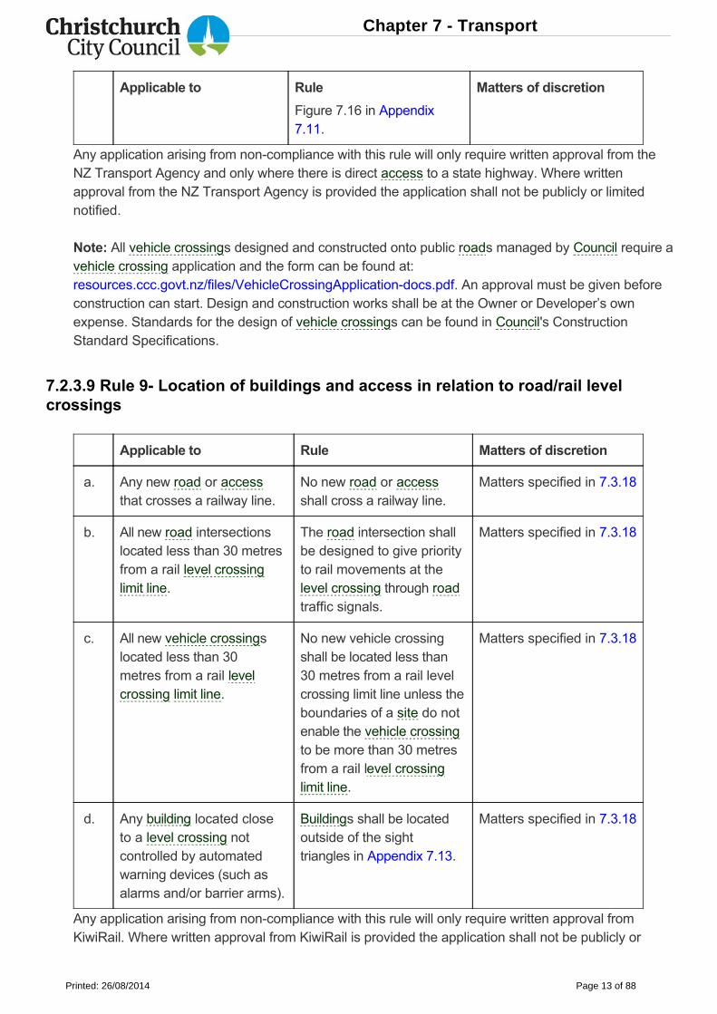
7.2.3.9 Rule 9 Location of buildings and access in relation to road/rail levelcrossings
Applicable to Rule Matters of discretion
a. Any new road or accessthat crosses a railway line.
No new road or accessshall cross a railway line.
Matters specified in 7.3.18
b. All new road intersectionslocated less than 30 metresfrom a rail level crossinglimit line.
The road intersection shallbe designed to give priorityto rail movements at thelevel crossing through roadtraffic signals.
Matters specified in 7.3.18
c. All new vehicle crossingslocated less than 30metres from a rail levelcrossing limit line.
No new vehicle crossingshall be located less than30 metres from a rail levelcrossing limit line unless theboundaries of a site do notenable the vehicle crossingto be more than 30 metresfrom a rail level crossinglimit line.
Matters specified in 7.3.18
d. Any building located closeto a level crossing notcontrolled by automatedwarning devices (such asalarms and/or barrier arms).
Buildings shall be locatedoutside of the sighttriangles in Appendix 7.13.
Matters specified in 7.3.18
Any application arising from noncompliance with this rule will only require written approval fromKiwiRail. Where written approval from KiwiRail is provided the application shall not be publicly or
Chapter 7 - Transport
Printed: 26/08/2014 Page 13 of 88
limited notified.
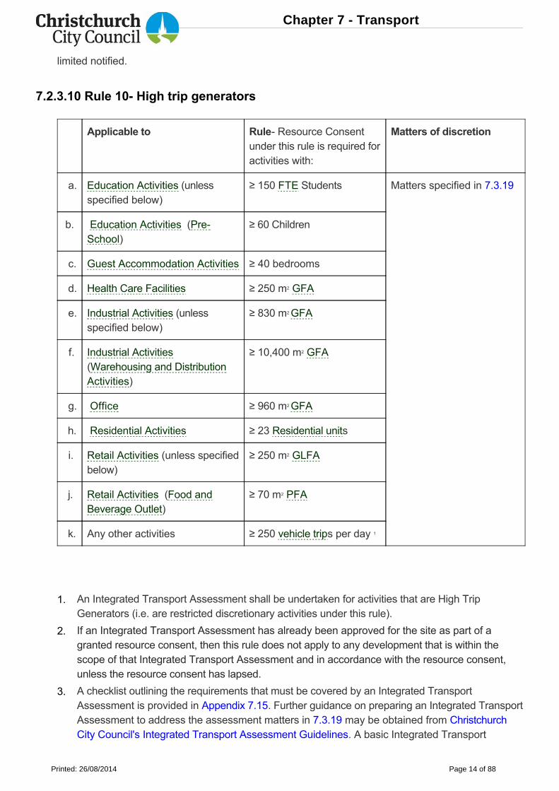
7.2.3.10 Rule 10 High trip generators
Applicable to Rule Resource Consentunder this rule is required foractivities with:
Matters of discretion
a. Education Activities (unlessspecified below)
≥ 150 FTE Students Matters specified in 7.3.19
b. Education Activities (PreSchool)
≥ 60 Children
c. Guest Accommodation Activities ≥ 40 bedrooms
d. Health Care Facilities ≥ 250 m2 GFA
e. Industrial Activities (unlessspecified below)
≥ 830 m2 GFA
f. Industrial Activities(Warehousing and DistributionActivities)
≥ 10,400 m2 GFA
g. Office ≥ 960 m2 GFA
h. Residential Activities ≥ 23 Residential units
i. Retail Activities (unless specifiedbelow)
≥ 250 m2 GLFA
j. Retail Activities (Food andBeverage Outlet)
≥ 70 m2 PFA
k. Any other activities ≥ 250 vehicle trips per day 1
An Integrated Transport Assessment shall be undertaken for activities that are High TripGenerators (i.e. are restricted discretionary activities under this rule).
If an Integrated Transport Assessment has already been approved for the site as part of agranted resource consent, then this rule does not apply to any development that is within thescope of that Integrated Transport Assessment and in accordance with the resource consent,unless the resource consent has lapsed.
A checklist outlining the requirements that must be covered by an Integrated TransportAssessment is provided in Appendix 7.15. Further guidance on preparing an Integrated TransportAssessment to address the assessment matters in 7.3.19 may be obtained from ChristchurchCity Council's Integrated Transport Assessment Guidelines. A basic Integrated Transport
1.
2.
3.
Chapter 7 - Transport
Printed: 26/08/2014 Page 14 of 88
1If the activity has fluctuations in daily vehicle trips, then the calculation should be based on anaverage of the days (across the week) that the activity operates.
7.3 Matters of discretion
The Activity Status table states which activity is a restricted discretionary activity. The matters overwhich the Council has restricted its discretion are specified for each restricted discretionary activitylisted below.
7.3.1 Minimum number of car parks required
The following are assessment matters for Rule 1a, Section 7.2.3.1:
Assessment shall be undertaken for High Trip Generators that do not exceed the thresholds in7.3.19 Table 7.1. A full Integrated Transport Assessment shall be undertaken for activities thatexceed the thresholds in 7.3.19 Table 7.1.
Any application under this rule will require written approval from the NZ Transport Agency and/orKiwiRail, where:
for the NZ Transport Agency, direct vehicle access from the activity is to a state highway.
for KiwiRail, direct access to the activity crosses a railway line.
Whether the equivalent number of parking spaces can be provided on a separate site which:
is sited within safe and easy walking distance of the activity; and
does not require people to cross arterial roads to gain access to the activity, therebycompromising the safety of pedestrians and the function of the road, unless there are safecrossing facilities; and/or
is clearly associated with the activity through signage or other means; and/or
whether a legal agreement has been entered into, bonding the parking to the activity; and/or
is surrounded by appropriate land use activities with which the car parking is compatible.
Whether the parking demand occurs at a different time from another land use activity, with whicha parking area could be shared without adverse effects for on street parking.
Whether a legal agreement has been entered into securing mutual usage of any parking areasshared with other activities.
Where the required number of offstreet car parking spaces are not to be provided:
whether the proposal or application demonstrates that it will generate more or less parkingand/or staff parking demand than is required by this District Plan;
whether the required parking can physically be accommodated on the site and/or off site;
whether the movement function, safety and amenity values of the road network andsurrounding environment may be adversely affected by extra parked and manoeuvringvehicles on these roads;
whether the site is well serviced by public transport and is designed or operated to facilitatepublic transport use;
4.
a.
b.
1.
a.
b.
c.
d.
e.
2.
3.
4.
a.
b.
c.
d.
Chapter 7 - Transport
Printed: 26/08/2014 Page 15 of 88
7.3.2 Parking space dimensions
The following are assessment matters for Rule 1b, Section 7.2.3.1:
7.3.3 Parking spaces for people with disabilities
The following are assessment matters for Rule 1c, Section 7.2.3.1:
7.3.4 Minimum number of cycle parking facilities required
The following are assessment matters for Rule 2, Section 7.2.3.2:
whether additional cycle parking facilities (more than the number required by this District Plan)have been provided to offset a reduction in the number of car parking spaces, and there is areasonable expectation of them being used;
the cumulative effect of the lack of onsite parking spaces for the proposal in conjunction withother activities in the vicinity which are not providing the required number of parking spaces;
whether the reduction in parking will affect the ability of future activities on the site to meet theparking requirements;
whether the safety of pedestrians will be affected by being set down onstreet;
whether a reduction in, or waiver of, the required onsite car parking will reduce travel to theactivity by private vehicles and facilitate public and active transport use, such as through thedevelopment and implementation of a travel plan;
whether a reduction in, or waiver of, the required onsite car parking will enable a significantimprovement in the urban design, appearance, and amenity values of the site and a moreefficient site layout without compromising the amenity values, safety and efficiency of thetransport network;
whether a reduction in, or waiver of, the required onsite car parking is appropriate becausethere are other public parking facilities close to the activity that can be used by peopleaccessing the activity; and
whether there are mitigating factors for a reduced parking supply, with regard given to theparking reduction adjustment factors in Appendix 7.14.
The safety and usability of the parking spaces.
Whether a parking stacker or a similar mechanism is being used.
Whether the equivalent number of disability car park spaces can be provided on a separate sitewhich:
is sited within a readily accessible distance from the activity for persons with disabilities; and
is clearly associated with the activity through signage or other means.
Whether the nature of the particular activity is such that it will generate less disability car parkingdemand than is required by this District Plan.
Whether the safety of people with disabilities will be affected by being set down onstreet.
The assessment matters under 7.3.1 also apply.
e.
f.
g.
h.
i.
j.
k.
l.
1.
2.
1.
a.
b.
2.
3.
4.
Chapter 7 - Transport
Printed: 26/08/2014 Page 16 of 88
7.3.5 Minimum number of loading spaces required
The following are assessment matters for Rule 3, Section 7.2.3.3:
7.3.6 Manoeuvring for parking and loading areas
The following are assessment matters for Rule 4, Section 7.2.3.4:
7.3.7 Gradient of parking and loading areas
The following are assessment matters for Rule 5, Section 7.2.3.5:
Whether adequate alternative, safe and secure cycle parking and end of trip facilities (such asshowers and lockers), that meet the needs of the intended users, are available in a nearbylocation that is readily accessible.
Whether the parking can be provided and maintained in a jointly used cycle parking area.
Whether a legal agreement has been entered into securing mutual usage of any cycle parkingareas shared with other activities.
Whether the cycle parking facilities are designed and located to match the needs of the intendedusers.
Whether the provision, design and location of cycle parking facilities may disrupt pedestriantraffic, disrupt active frontages, or detract from an efficient site layout or street scene amenityvalues.
Whether the nature and operation of the particular activity will require loading spaces of adifferent size, number and frequency of use.
Whether an offstreet shared loading area can be safely and efficiently provided in conjunctionwith an adjacent activity.
Whether a legal agreement has been entered into securing mutual usage of any loading areasshared with other activities.
Whether loading can be safely and efficiently undertaken onstreet.
Whether the movement function and/or safety of the surrounding transport network may beadversely affected by extra parked and manoeuvring vehicles on street.
Whether loading and service functions disrupt pedestrian and cycling traffic, disrupt activefrontages, or detract from street scene amenity values.
Whether there would be any adverse effects on the efficiency, safety and amenity values of usersof transport modes within and passing the site, and/or function of the frontage road.
The number and type of vehicles using the parking or manoeuvring area.
Whether the required manoeuvring area can physically be accommodated on the site.
Whether the strategic transport network is adversely affected.
Whether the gradient noncompliance affects any parking spaces for people with disabilities, andwhether the proposed gradient will make it difficult for people with disabilities to use these parkingspaces.
1.
2.
3.
4.
5.
1.
2.
3.
4.
5.
6.
1.
2.
3.
4.
1.
Chapter 7 - Transport
Printed: 26/08/2014 Page 17 of 88
7.3.8 Illumination of parking and loading areas
The following are assessment matters for Rule 6a, Section 7.2.3.6:
7.3.9 Surface of parking and loading areas
The following are assessment matters for Rule 6b, Section 7.2.3.6:
7.3.10 Vehicle access design
The following are assessment matters for Rule 7a, Section 7.2.3.7:
Where the access exceeds the maximum gradient standards, in addition to (1) to (5) above:
The total number of parking spaces affected by the gradient noncompliance.
Whether the gradient will make the use of the parking and loading spaces impracticable.
Whether the drainage facilities are adequately designed and will not cause adverse effectson neighbouring sites.
Whether the facility is often used during the hours of darkness.
Whether other light sources in the area give adequate light to provide security for users of thearea.
Whether glare from the light source will adversely affect the safety of surrounding roads and/orthe rail corridor.
Whether the noncompliance with this rule will cause adverse effects on the activity and on othersites in the area in terms of noise and dust nuisance.
Whether mud or gravel will be carried on to public roads, footpaths or the rail corridor.
Whether the materials used for the car park surface and the car park’s stormwater managementsystem will adequately manage contaminants from runoff and flooding.
Whether the driveway serves more than one site and the extent to which other users of thedriveway may be adversely affected.
Whether there are any adverse effects on the safety and amenity values of neighbouringproperties and/or the function of the transport network.
The effects on the safety and security of people using the facility.
Whether the access disrupts, or results in conflicts with, active frontages, convenient and safepedestrian circulation and cycling flows.
Whether the safety of pedestrians, particularly the aged and people with disabilities, will becompromised by the length of time needed to cross a wider driveway.
Whether the gradient will make the use of the access impracticable.
Whether the drainage facilities are adequately designed and will not cause adverse effects onneighbouring sites.
2.
3.
4.
1.
2.
3.
1.
2.
3.
1.
2.
3.
4.
5.
6.
7.
Chapter 7 - Transport
Printed: 26/08/2014 Page 18 of 88
7.3.11 Queuing spaces
The following are assessment matters for Rule 7b, Section 7.2.3.7:
7.3.12 Visibility splay
The following are assessment matters for Rule 7c, Section 7.2.3.7:
7.3.13 Vehicle crossing design
The following are assessment matters for Rules 8 a, b and c, Section 7.2.3.8:
7.3.14 Minimum distance between vehicle crossings
The following are assessment matters for Rule 8d, Section 7.2.3.8:
7.3.15 Maximum number of vehicle crossings
The following are assessment matters for Rule 8e, Section 7.2.3.8:
Whether there would be any adverse effects on the safety, amenity values and/or efficientoperation and functioning of the frontage road or a rail level crossing.
The effect of queuing vehicles on the safety of pedestrians and cyclists.
Whether vehicles exiting the vehicle access, and cyclists and pedestrians on the footpath orfrontage road, are likely to be aware of each other in time to avoid conflicts.
Whether the speed and volume of vehicles using a vehicle access, and/or the volumes of cyclistsand pedestrians on the footpath or frontage road, will exacerbate the adverse effects of theaccess on people's safety.
If a visibility splay is unable to be provided, whether alternative adequate methods of improvingpedestrian safety at the vehicle access have been provided, for example an audio and/or visualmethod of warning pedestrians of the presence of vehicles about to exit the access.
The number of pedestrian movements and the number and type of vehicles using or crossing thevehicle crossing.
The ability for vehicles to use the vehicle crossing without adversely affecting the safety and/orefficiency of the frontage road or rail level crossing.
The speed at which vehicles will be able to enter/exit the site and the effect of this on the safetyof pedestrians and other road users.
Whether the landscaping adjacent to the road will be adversely affected by the location of thevehicle crossing.
Whether safety will be adversely affected by conflict between manoeuvring vehicles at thecrossings.
Whether the extra crossing(s) will adversely affect the efficient and safe operation of the road for
1.
2.
1.
2.
3.
1.
2.
3.
1.
2.
1.
Chapter 7 - Transport
Printed: 26/08/2014 Page 19 of 88
7.3.16 Minimum distance between vehicle crossings and intersections
The following are assessment matters for Rule 8f, Section 7.2.3.8:
7.3.17 Sight lines at vehicle crossings
The following are assessment matters for Rule 8g, Section 7.2.3.8:
7.3.18 Location of building and access in relation to rail/road levelcrossings
The following are assessment matters for Rule 9 a, b and c, Section 7.2.3.9:
all road users.
Any cumulative effects of the introduction of extra vehicle crossings when considered in thecontext of existing and future vehicle crossings serving other activities in the vicinity.
Whether the physical form of the road will minimise the adverse effects of the extra vehiclecrossings for example the presence of a solid median to stop right hand turns.
Whether the landscaping adjacent to the road will be adversely affected by the vehicle crossings.
Whether extra conflict may be created by vehicles queuing across the vehicle crossing.
Whether any potential confusion between vehicles turning at the crossing or the intersection mayhave adverse affects on safety.
The effects on the safety of users of all transport modes.
Whether the number and type of vehicles generated by the activity on the site will adversely affectthe frontage road, particularly at times of peak traffic flows on the road.
Whether the speed and volume of vehicles on the road will exacerbate the adverse effects of thevehicle crossing on the safety of users of all transport modes.
Whether the geometry of the frontage road and intersections will mitigate the adverse effects ofthe vehicle crossing.
Whether there are present, or planned, traffic controls along the road corridor where the vehiclecrossing is proposed.
Any cumulative effects when considered in the context of existing and future vehicle crossingsserving other activities in the vicinity.
Whether traffic mitigation measures such as medians, no right turn or left turn signs, or trafficcalming measures are proposed.
Whether the operating speed environment of the road is such that the sight line standards can besafely reduced.
Whether the sight line distances at the vehicle crossing are adequate to provide safeingress/egress.
Where a new road or access crosses a railway line and/or a road intersection or vehicle crossingdoes not comply with the minimum setback from a rail level crossing limit line:
whether the safety and efficiency of rail and road operations will be adversely affected;
2.
3.
4.
1.
2.
3.
4.
5.
6.
7.
8.
9.
1.
2.
1.
a.
Chapter 7 - Transport
Printed: 26/08/2014 Page 20 of 88
The following are assessment matters for Rule 9d, Section 7.2.3.9:
7.3.19 High trip generators
The following are assessment matters for Rule 10, Section 7.2.3.10.
whether a grade separated crossing will be provided; and/or
whether connectivity and accessibility for pedestrians, cyclists and vehicles will be improved,without compromising safety.
Where the minimum setbacks for buildings are not provided:
whether there will be an adverse effect on the safety of the level crossing for vehicles andpedestrians; and/or
whether visibility and safe sight distances will be adversely affected, particularly to the extentthat vehicles entering/exiting the level crossing can see trains.
Whether the environmental effects of vehicles using the site will adversely affect surroundingactivities, particularly residential activities.
Whether the proposed activity is located, designed or operated to minimise or reduce travel toand from the activity by private vehicles and encourage public and active transport use.
Whether the provision of parking, access and manoeuvring areas, including loading and servicingdeliveries, affects the safety, accessibility, and amenity values of the site and surroundingnetwork.
Whether the proposal has demonstrated the accessibility of the site by a range of transportmodes.
Whether the proposal considers and responds to issues and outcomes arising from consultationwith the relevant road controlling authorities, public transport provider1 and/or KiwiRail.
Whether the proposal adequately provides for the mobility needs of all users of the site, includingwhether there are sufficient parking spaces for people with disabilities to meet demand andwhether these parking spaces are coloured blue so they can be easily identified.
Whether the proposal integrates with, and minimises adverse effects on, the safe, efficientfunctioning of the transport network and the amenity values of the surrounding environment.
Whether the proposal minimises the number of vehicle access points to transport corridors,taking into account:
the movement function classification of the frontage road and opportunities that exist forminimising accesses on to arterial roads, in particular the strategic transport network, orgaining access to an alternative road which has a lesser movement function, whilst havingregard to the environmental effects on that alternative road with respect to residential amenity;
opportunities for sharing access with other activities;
the place function classification of the frontage road and opportunities that exist forminimising accesses on to streets that are within the Urban (Centres) place function category,especially Key Pedestrian Frontages shown on the planning maps, or gaining access to analternative road with lesser pedestrian flows or a lesser adverse effect on amenity values;
whether the frontage road is identified as part of one of the five modal networks as described
b.
c.
2.
a.
b.
1.
2.
3.
4.
5.
6.
7.
8.
a.
b.
c.
d.
Chapter 7 - Transport
Printed: 26/08/2014 Page 21 of 88
1The public transport provider for Christchurch is the Canterbury Regional Council (EnvironmentCanterbury).
The following assessment matters (18 21) are only applicable for High Trip Generator activitieswhich exceed the thresholds in the following Table 7.1. A full Integrated Transport Assessment shallbe undertaken for high trip generators that exceed the thresholds in Table 7.1. Only a basic IntegratedTransport Assessment (which does not need to cover assessment matters 1821) needs to beundertaken for High Trip Generators that do not exceed the thresholds in Table 7.1.
in Appendix 7.12.1.b;
whether the location of the access points with respect to adjacent access points has thepotential for vehicle conflict or confusion between drivers turning into and out of accessways;
visibility and obstruction of pedestrian crossings:
access to network utilities; and
the impact of multiple vehicle crossings (which break up berm, landscaping, footpath and cycleway continuity) on streetscape amenity values, retail frontage areas and pedestrian and cyclemovements.
Any effects of any car parking and loading spaces proposed to be provided, and whether thenumber of car parking spaces proposed to be provided meets or exceeds anticipated demand, isappropriate for the needs of the activity (considering people's and communities' social, culturaland economic wellbeing), supports urban consolidation, and supports the recovery needs of thedistrict.
Whether the minimum car parking space requirements (as shown in Table 7.2 of Appendix 7.1)are appropriate for the activity, and whether there are mitigating factors for a reduced parkingsupply, having regard to the parking reduction adjustment factors in Appendix 7.14.
Whether more parking spaces than stated in the minimum car parking space requirements (asshown in Table 7.2 of Appendix 7.1) should be provided to address any adverse effects on thesafety, efficiency and amenity values of the surrounding environment, including the transportnetwork.
The ability to operate parking in a coordinated or shared way with other car park areas.
Where there is more than one public entrance to the building, the extent to which visitor cycleparking is apportioned between the entrances in accordance with their potential usage.
Whether any accesses to the activity are directly opposite a Tintersection and whether theaccess can be moved to avoid this situation.
Whether Crime Prevention through Environment Design (CPTED) principles and techniques havebeen used to mitigate any safety issues.
The extent to which pedestrians and cyclists have safe and easy access to and through the sitefrom the surrounding area and whether any mitigation measures are proposed to improveaccessibility and safety for pedestrians and cyclists, including consideration of whether the trafficvolumes and speed on the nearby streets could affect the ability of pedestrians and cyclists tohave safe and easy access to the site.
Whether the activity will increase the amount of freight and volume of heavy vehicles on local orcollector roads adjoining residential zones.
e.
f.
g.
h.
9.
10.
11.
12.
13.
14.
15.
16.
17.
Chapter 7 - Transport
Printed: 26/08/2014 Page 22 of 88
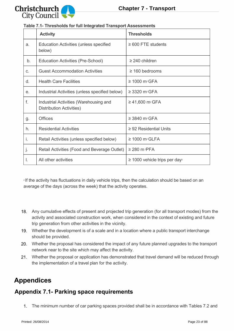
Table 7.1 Thresholds for full Integrated Transport Assessments
Activity Thresholds
a. Education Activities (unless specifiedbelow)
≥ 600 FTE students
b. Education Activities (PreSchool) ≥ 240 children
c. Guest Accommodation Activities ≥ 160 bedrooms
d. Health Care Facilities ≥ 1000 m2 GFA
e. Industrial Activities (unless specified below) ≥ 3320 m2 GFA
f. Industrial Activities (Warehousing andDistribution Activities)
≥ 41,600 m2 GFA
g. Offices ≥ 3840 m2 GFA
h. Residential Activities ≥ 92 Residential Units
i. Retail Activities (unless specified below) ≥ 1000 m2 GLFA
j. Retail Activities (Food and Beverage Outlet) ≥ 280 m 2PFA
l. All other activities ≥ 1000 vehicle trips per day2
2 If the activity has fluctuations in daily vehicle trips, then the calculation should be based on anaverage of the days (across the week) that the activity operates.
Appendices
Appendix 7.1 Parking space requirements
Any cumulative effects of present and projected trip generation (for all transport modes) from theactivity and associated construction work, when considered in the context of existing and futuretrip generation from other activities in the vicinity.
Whether the development is of a scale and in a location where a public transport interchangeshould be provided.
Whether the proposal has considered the impact of any future planned upgrades to the transportnetwork near to the site which may affect the activity.
Whether the proposal or application has demonstrated that travel demand will be reduced throughthe implementation of a travel plan for the activity.
The minimum number of car parking spaces provided shall be in accordance with Tables 7.2 and
18.
19.
20.
21.
1.
Chapter 7 - Transport
Printed: 26/08/2014 Page 23 of 88
7.3.
The car parking requirements listed in Table 7.2 are categorised by activity. When calculatingthe overall parking requirements for an activity the separation of areas into different activitieswill be required where the GFA of an activity (or PFA or other such measurement that thestandards for the relevant activity is based upon) exceeds 10 per cent of the total GFA of theactivity. The total parking requirement for any activity will be the sum of the parkingrequirements for each area.
Where the calculation of the required parks results in a fractional space, any fraction that isless than onehalf will be disregarded and any fraction of onehalf or more will be counted asone space.
Where an activity falls under the definition of more than one activity in Table 7.2, then thehigher parking requirement shall apply.
Where an activity does not fall within a particular category, the activity which is closest indefinition shall apply.
Any space required for offstreet parking other than for a residential activity shall be available forstaff and visitors during the hours of operation and shall not be diminished by the subsequenterection of any structure, storage of goods, or any other use.
All required staff car parking spaces shall be permanently marked and signed for the exclusiveuse of staff. Staff parking may be relocated within the site.
Parking spaces for people with disabilities shall be provided at the closest possible point to theaccessible entrance to the activity with which they are associated, and the most direct route fromthe disability car park spaces to the activity shall be accessible for mobility impaired persons. Thespaces shall be clearly signed.
Each residential unit shall provide at least one parking space for people with disabilities to enablesafe access in wet or icy conditions.
All car parking spaces and aisle widths shall be laid out in accordance with Table 7.4 and Figure
a.
b.
c.
d.
2.
3.
4.
5.
6.
Activity
Car parking spaces
Residents/ Visitors/Students
Staff
Education Activities:
a. PreSchools 1 space/ 10 children0.5 spaceper FTEstaff
7.1.
Critical manoeuvring areas such as aisles in or between major structures, or changes in grade,shall be designed to accommodate the 99 percentile design vehicle as set out in Appendix 7.5.
All other manoeuvring areas shall be designed to accommodate the 85 percentile design motorcar as set out in Appendix 7.4. Note: It is recommended that blue colouring be used to help better identify parking spacesreserved for people with disabilities.
Table 7.2 Minimum number of car parks required
7.
8.
Chapter 7 - Transport
Printed: 26/08/2014 Page 24 of 88
b. Schools
1 space/ 25 pupils (year 8and below) 0.5 spaces/ 25 pupils (year 9and above)
0.5 spaceper FTEstaff
c. Tertiary Education and ResearchActivities
20 spaces/ 100 FTEstudents
5.5 spaces/100 FTEstudents
d. Student Hostel Accommodation 1 space/ 5 beds 1 space/ 20beds
Entertainment Facilities:
e. Cinemas 2.5 spaces/ 10 seats 1 space/ 1screen
f. Theatres 3 spaces/ 10 seats 1 space/ 60seats
g. Museums and Galleries 1 space/ 30m2 PFA 1 space/300m2 PFA
h. Libraries 1 space/ 50m2 PFA 1 space/200m2 PFA
i. Gymnasiums (for public, or privateclub use), Dance Studios
5 space/ 100m2 GFA1 space/300m2 GFA
j. Sports Courts (for public, or privateclub use)
1 space/ 50m2 court area 1 space/200m2 courtarea
k. Sports Fields (for public, or privateclub use)
15 spaces/ ha pitch area 1 space
l. Swimming Pools (for public, orprivate club use)
1 space/ 10m2 pool area 1 spaces/200m2 poolarea
m. Other Entertainment Facilities, if notspecified above
1 space/ 10m2 PFA, or 1space/ 10 seats (whichever isgreater)
10% ofvisitorrequirements
Guest Accommodation Activities:
n. Hotels
1 space/ 4 bedrooms
1 space/ 30bedrooms
Chapter 7 - Transport
Printed: 26/08/2014 Page 25 of 88
o. Other Guest AccommodationActivities, if not specified above
1 space/unit or 1 space/2.5bedrooms, whichever is thegreater (except that for everycoach park provided thenumber of car parking spacesmay be reduced by 3)
1 space/ 10units or 1space/ 10bedrooms,whichever isthe greater
Health Care Facilities:
p. Hospitals 1 space/ 350m2 GFA1 space/350m2 GFA
q. Other Health Care Facilities if notspecified above
1 space/ 25m2 GFA1 space/100m2 GFA
Industrial Activities:
r. Warehousing and DistributionActivities
1 space/ 2000m2 GFA(1space minimum)
4.5 spaces/1000m2 GFA
s. Other Industrial Activities, if notspecified above
1 space/ 800m2 GFA (1space minimum)
11 spaces/800m2 GFA
t. Offices 5% of staff requirement (1space minimum)
2.5 spaces/100m2 GFA
u. Public Transport Interchanges Nil Nil
v. Reserves (if there is not a specified carparking requirement in this table for theactivity on the reserve)
Nil Nil
Residential Activities:
w. Care Facilities 1 space/ 6 clients 1 space/ 6clients
x. Sheltered Housing 1 space/ 4 units1 space/residentstaff unit
y. Social Housing
0.5 space/ 1 unit for unitswith only one bedroom,1 space per unit for units withtwo or more bedrooms
Nil
z. Other Residential Activities, if notspecified above
1 space/ unit, where that unithas less than 150m2 GFA, 2 spaces/ unit otherwise
Nil
Chapter 7 - Transport
Printed: 26/08/2014 Page 26 of 88
Retail Activities and Commercial Services
aa. Food and Beverage Outlets4 spaces/ 100m2 PFA for thefirst 150m2 PFA, 19 spaces/100m2 PFA thereafter
1 space/100m2 PFA (2 spacesminimum)
bb. Motor Servicing Facility 2.5 spaces/ workbay 1 space/workbay
cc. Factory Shops, Retail Activitiesin Retail Park Zones
18 spaces/ 1000m2 PFA 10% ofvisitorrequirements
dd. Other Retail Activities orCommercial Services, if not specifiedabove
4 spaces/100m2 GLFA for thefirst 20,000m2 GLFA, 3.3spaces/100m2 GLFA for thenext 10,000m2 GLFA,3 spaces/100m2 GLFAthereafter.3 spaces/100m2 GLFA ofany outdoor display area
0.5 spaces/100m2 GLFA
ee. Service Stations 1 per 100m2 PFA1 per 100m2
PFA
ff. Spiritual Facilities1 space/10m2 PFA or 1space/10 seats (whichever isthe greater)
10% ofvisitorrequirement
gg. Trade Suppliers 1 space/ 100m2 PFA 1 space/100m2 PFA
hh. YardBased Suppliers 1 space/ 100m2 PFA1 space/100m2 PFA
Notes: Appendix 7.14 contains parking reduction adjustment factors that can be considered forreducing parking requirements through the resource consent process.
Total number of car park spaces beingprovided
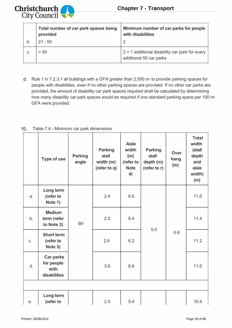
Minimum number of car parks for peoplewith disabilities
a. 1 20 1
Table 7.3 Minimum number of car parks required for people with disabilities9.
Chapter 7 - Transport
Printed: 26/08/2014 Page 27 of 88
Total number of car park spaces beingprovided
Minimum number of car parks for peoplewith disabilities
b. 21 50 2
c. > 50 2 + 1 additional disability car park for everyadditional 50 car parks
Type of useParkingangle
Parkingstall
width (m) (refer to q)
Aislewidth(m)
(refer toNote4)
Parkingstall
depth (m)(refer to r)
Overhang(m)
Totalwidth (stalldepthandaislewidth)(m)
a. Long term(refer toNote 1)
90o
2.4 6.6
5.0
0.6
11.6
b. Mediumterm (referto Note 2)
2.5 6.4 11.4
c. Short term(refer toNote 3)
2.6 6.2 11.2
d.
Car parksfor people
withdisabilities
3.6 6.6 11.6
e. Long term(refer to 2.4 5.4 10.4
Rule 1 in 7.2.3.1 all buildings with a GFA greater than 2,500 m2 to provide parking spaces forpeople with disabilities, even if no other parking spaces are provided. If no other car parks areprovided, the amount of disability car park spaces required shall be calculated by determininghow many disability car park spaces would be required if one standard parking space per 100 m2
GFA were provided.
Table 7.4 Minimum car park dimensions
d.
10.
Chapter 7 - Transport
Printed: 26/08/2014 Page 28 of 88
Type of useParkingangle
Parkingstall
width (m) (refer to q)
Aislewidth(m)
(refer toNote4)
Parkingstall
depth (m)(refer to r)
Overhang(m)
Totalwidth (stalldepthandaislewidth)(m)
Note 1)
60o 5.0
0.4f. Mediumterm (referto Note 2)
2.5 5.1 10.1
g. Short term(refer toNote 3)
2.6 4.8 9.8
h.
Long term(refer toNote1)
45o
2.4 4.5
5.0 0.4
9.5
i.
Mediumterm (referto Note
2)
2.5 4.2 9.2
j.
Short term(refer toNote3)
2.6 3.9 8.9
l.
Long term
(refer toNote1)
30o
2.3 4.1
4.0 0.4
8.1
m.
Mediumterm (referto Note
2)
2.4 3.8 7.8
Short term
Chapter 7 - Transport
Printed: 26/08/2014 Page 29 of 88
Type of useParkingangle
Parkingstall
width (m) (refer to q)
Aislewidth(m)
(refer toNote4)
Parkingstall
depth (m)(refer to r)
Overhang(m)
Totalwidth (stalldepthandaislewidth)(m)
n.(refer toNote3)
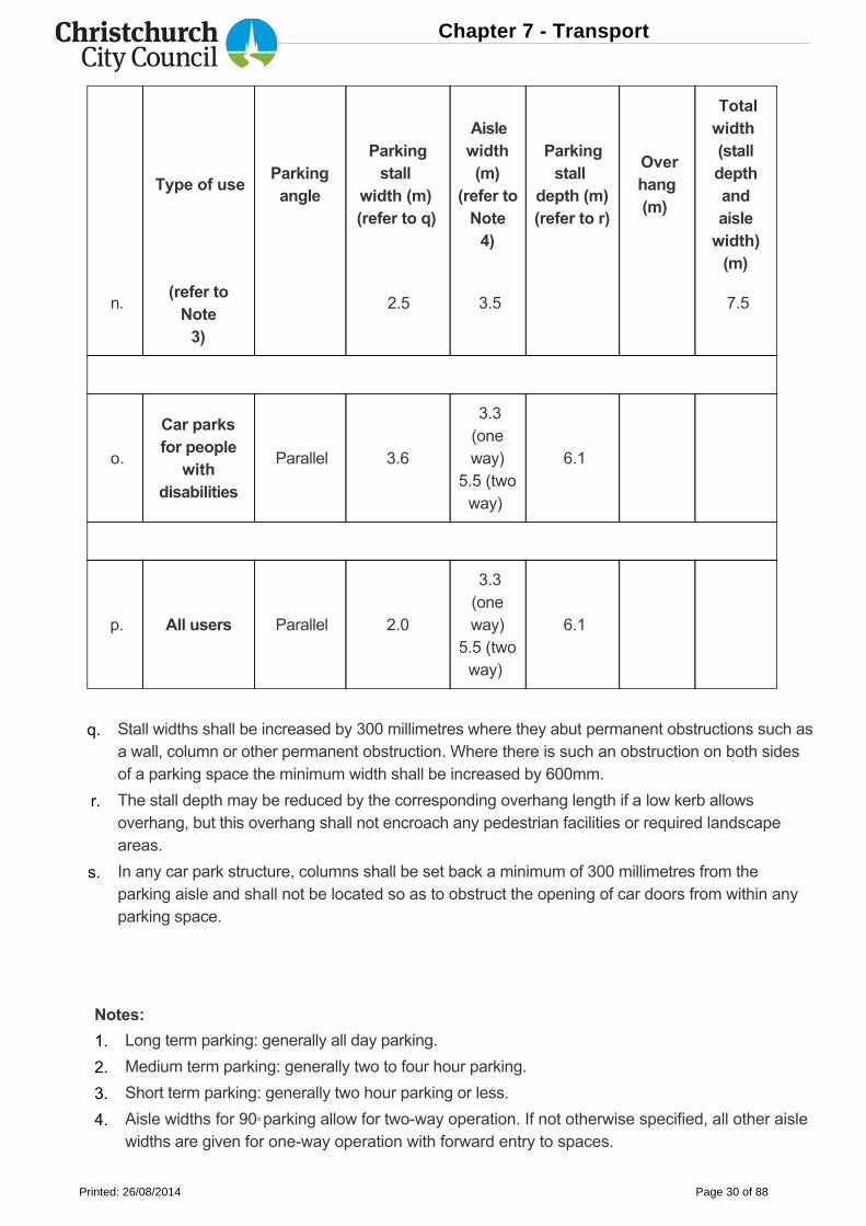
2.5 3.5 7.5
o.
Car parksfor people
withdisabilities
Parallel 3.6
3.3(oneway)
5.5 (twoway)
6.1
p. All users Parallel 2.0
3.3(oneway)
5.5 (twoway)
6.1
Notes:
Stall widths shall be increased by 300 millimetres where they abut permanent obstructions such asa wall, column or other permanent obstruction. Where there is such an obstruction on both sidesof a parking space the minimum width shall be increased by 600mm.
The stall depth may be reduced by the corresponding overhang length if a low kerb allowsoverhang, but this overhang shall not encroach any pedestrian facilities or required landscapeareas.
In any car park structure, columns shall be set back a minimum of 300 millimetres from theparking aisle and shall not be located so as to obstruct the opening of car doors from within anyparking space.
Long term parking: generally all day parking.
Medium term parking: generally two to four hour parking.
Short term parking: generally two hour parking or less.
Aisle widths for 90o parking allow for twoway operation. If not otherwise specified, all other aislewidths are given for oneway operation with forward entry to spaces.
q.
r.
s.
1.
2.
3.
4.
Chapter 7 - Transport
Printed: 26/08/2014 Page 30 of 88
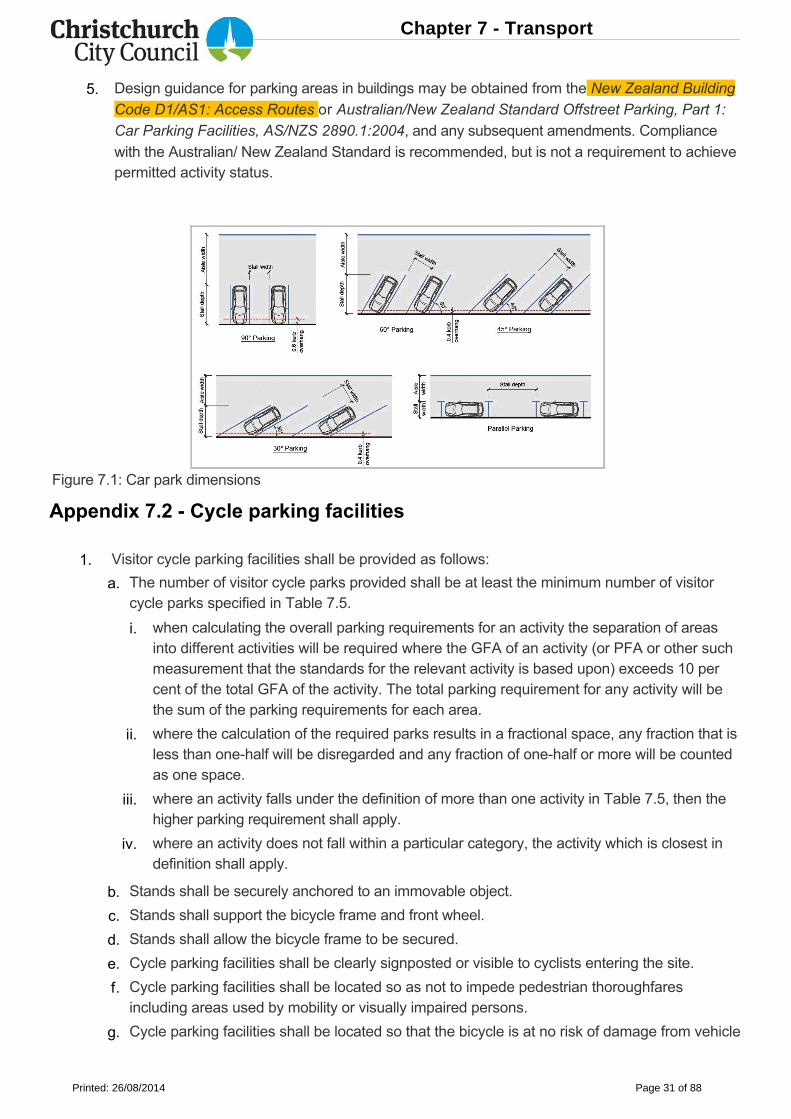
Figure 7.1: Car park dimensions
Appendix 7.2 Cycle parking facilities
Design guidance for parking areas in buildings may be obtained from the New Zealand BuildingCode D1/AS1: Access Routes or Australian/New Zealand Standard Offstreet Parking, Part 1:Car Parking Facilities, AS/NZS 2890.1:2004, and any subsequent amendments. Compliancewith the Australian/ New Zealand Standard is recommended, but is not a requirement to achievepermitted activity status.
Visitor cycle parking facilities shall be provided as follows:
The number of visitor cycle parks provided shall be at least the minimum number of visitorcycle parks specified in Table 7.5.
when calculating the overall parking requirements for an activity the separation of areasinto different activities will be required where the GFA of an activity (or PFA or other suchmeasurement that the standards for the relevant activity is based upon) exceeds 10 percent of the total GFA of the activity. The total parking requirement for any activity will bethe sum of the parking requirements for each area.
where the calculation of the required parks results in a fractional space, any fraction that isless than onehalf will be disregarded and any fraction of onehalf or more will be countedas one space.
where an activity falls under the definition of more than one activity in Table 7.5, then thehigher parking requirement shall apply.
where an activity does not fall within a particular category, the activity which is closest indefinition shall apply.
Stands shall be securely anchored to an immovable object.
Stands shall support the bicycle frame and front wheel.
Stands shall allow the bicycle frame to be secured.
Cycle parking facilities shall be clearly signposted or visible to cyclists entering the site.
Cycle parking facilities shall be located so as not to impede pedestrian thoroughfaresincluding areas used by mobility or visually impaired persons.
Cycle parking facilities shall be located so that the bicycle is at no risk of damage from vehicle
5.
1.
a.
i.
ii.
iii.
iv.
b.
c.
d.
e.
f.
g.
Chapter 7 - Transport
Printed: 26/08/2014 Page 31 of 88
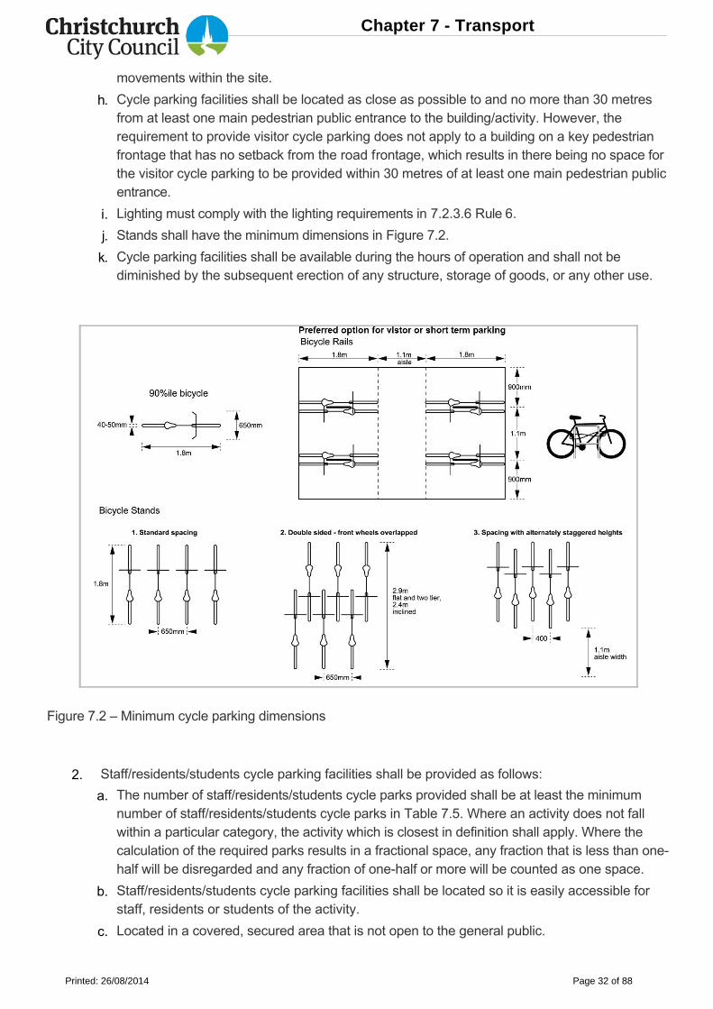
Figure 7.2 – Minimum cycle parking dimensions
movements within the site.
Cycle parking facilities shall be located as close as possible to and no more than 30 metresfrom at least one main pedestrian public entrance to the building/activity. However, therequirement to provide visitor cycle parking does not apply to a building on a key pedestrianfrontage that has no setback from the road frontage, which results in there being no space forthe visitor cycle parking to be provided within 30 metres of at least one main pedestrian publicentrance.
Lighting must comply with the lighting requirements in 7.2.3.6 Rule 6.
Stands shall have the minimum dimensions in Figure 7.2.
Cycle parking facilities shall be available during the hours of operation and shall not bediminished by the subsequent erection of any structure, storage of goods, or any other use.
Staff/residents/students cycle parking facilities shall be provided as follows:
The number of staff/residents/students cycle parks provided shall be at least the minimumnumber of staff/residents/students cycle parks in Table 7.5. Where an activity does not fallwithin a particular category, the activity which is closest in definition shall apply. Where thecalculation of the required parks results in a fractional space, any fraction that is less than onehalf will be disregarded and any fraction of onehalf or more will be counted as one space.
Staff/residents/students cycle parking facilities shall be located so it is easily accessible forstaff, residents or students of the activity.
Located in a covered, secured area that is not open to the general public.
h.
i.
j.
k.
2.
a.
b.
c.
Chapter 7 - Transport
Printed: 26/08/2014 Page 32 of 88
Table 7.5 Minimum numbers of cycle parks required
Activity Visitor cycle parksStaff/ residents/students cycle parks
Education Activities
a. PreSchools 1 space/ 20 FTEstaff
1 staff space/ 3 FTEstaff
b. Schools
1 space/ 30 ofstudent capacity(year 6 and below) 1 space/ 100 ofstudents capacity (year 7 and above)
1 space/ 5 FTEstudents (year 6 andbelow)
1 space/ 1.5 FTEstudents (year 7 andabove)
c. Tertiary Education and ResearchActivities
1 space/ 100 ofstudent capacity
1 staff space/ 4 FTEstaff and 1 studentspace/ 4 FTE students
d. Student Hostel Accommodation 1 space/ 10bedrooms
1 space/ 2 bedrooms
Entertainment Facilities
e. Cinemas and Theatres (Small tomedium venues up to 500 seats)
1 space/ 30 seats 1 space/ 5 FTE staff
f. Cinemas and Theatres (Large venues more than 500 seats)
1 space/ 60 seats 1 space/ 5 FTE staff
g. Museums and Galleries 1 space/ 100m2 PFA 1 space/ 5 FTE staff
h. Libraries 1 space/ 100m2 PFA 1 space/ 5 FTE staff
i. Gymnasiums (for public, or privateclub use), Dance Studios
1 space/ 50m2 GFA 1 space/ 2 FTE staff
j. Sports courts (for public, or privateclub use)
1 space/ 150m2
court area 1 space/ 5 FTE staff
Where a stand is provided, it shall meet the visitor cycle parking requirements in (1) except for(e) and (h).
The number of onsite cycle parking end of trip facilities provided shall be at least theminimum number of cycle parking end of trip facilities set out in Table 7.6.
d.
e.
Chapter 7 - Transport
Printed: 26/08/2014 Page 33 of 88
Activity Visitor cycle parksStaff/ residents/students cycle parks
k. Sports Fields (for public, or privateclub use)
10 spaces/ ha pitcharea
1 space/ 5 FTE staff
l. Swimming Pools (for public, or privateclub use)
1 space/ 10m2 poolarea
1 space/ 5 FTE staff
m.Other Entertainment Facilities, if notspecified above
1 space/ 50m2 PFA 1 space/ 5 FTE staff
n. Guest Accommodation Activities1 space/ 20bedrooms
1 space/ 5 FTE staff
Health Care Facilities
o. Hospitals1 space/ 1000m2
GFA 1 space/ 300m2 GFA
p.Other Health Care Facilities, if notspecified above
1 space/ 100m2 GFA 1 space/ 2 FTE staff
q. Industrial Activities1 space/ 1000m2
GFA
1 space/ 5 FTE staff
r. Offices 1 space/ 500m2 GFA 1 space/ 100m2 GFA
s. Reserves (if there is not a specifiedcycle parking requirement in this tablefor the activity on the reserve)
Nil Nil
Residential Activity
t. Care Facilities 1 space/ 30 clients 1 space/ 2 FTE staff
u. Social Housing 1 space/ 10 units, fordevelopments with10 or more units
1 residents' space/dwelling without agarage
v. Other Residential Activities, if notspecified above
1 space/ 20 units fordevelopments with20 or more units
1 space/ dwellingwithout a garage
Retail Activities and Commercial Services
w. Commercial Services1 space/500m2 GFA
1 space/ 100m2 GFA
x.Factory shops, Retail activities inCommercial Retail Park zones
1 space/600m2 GLFA
1 space/ 750m2 GLFA
Chapter 7 - Transport
Printed: 26/08/2014 Page 34 of 88
Activity Visitor cycle parksStaff/ residents/students cycle parks
y. Food and Beverage Outlets 1 space/ 25m2 PFAplus 1 space/ 100m2
outside area
1 space/ 100m2 PFAplus 1 space/ 200m2
outside area
z. Other Retail Activities, if not specifiedabove
1 space/300m2 GLFA
1 space/ 750m2 GLFA
aa. Service Stations1 space/600m2 GLFA
1 space/ 750m2 GLFA
bb. Spiritual Facility 1 per 50m2 GFA 1 per 2 FTE staff
cc. Trade Suppliers1 space/600m2 GLFA
1 space/ 750m2 GLFA
dd. Yard Based Suppliers1 space/600m2 GLFA
1 space/ 750m2 GLFA
Table 7.6 Minimum number of cycle parking end of trip facilities required
Number of staff/ residents/students cycle parksrequired
Number of end of trip facilities required
ff. 1 None
gg. 2 10 1 locker1 per every staff/resident/student cycle parkprovided
hh. > 101 locker1 per every staff/resident/student cycle parkprovided + 1 shower per every 10 staff cycle parksprovided
1 The minimum internal dimensions of a single locker shall be: height 85 centimetres, depth 45centimetres, width 20 centimetres.
Appendix 7.3 Loading areas
The minimum number of onsite loading spaces provided shall be in accordance with Table 7.7.Where an activity does not fall within a particular category, the activity which is closest in
1.
Chapter 7 - Transport
Printed: 26/08/2014 Page 35 of 88
ActivityNumber of heavy vehicle baysto be provided
Number of 99percentilevehicle bays tobe provided
Education Activities:
i. Schools and PreSchools With 100 or more pupils: 1 bay
With 20 pupils ormore, but lessthan 100: 1 bay
With 100 or morepupils: 1 bay/100pupils
ii.Tertiary Education andResearch Activities
1 bay per site 1 bay/100 FTEstudents
iii. Student Hostel Accommodation 1 bay per hostel 1 bay/100 beds
Entertainment Facilities:
iv. Cinemas 1 bay per cinema complex Nil
v. Theatres 1 bay per theatre Nil
vi. Gymnasium (for public, orprivate use), Dance Studios
1/ 8,000m2 GFA Nil
definition shall apply. Where the calculation of the required loading space results in a fractionalspace, any fraction that is less than onehalf will be disregarded and any fraction of onehalf ormore will be counted as one space.
The loading space requirements listed in Table 7.7 are categorised by activity. Whencalculating the overall loading space requirements for an activity the separation of areas intodifferent activities will be required where the GFA of an activity (or PFA or other suchmeasurement that the standards for the relevant activity is based upon) exceeds 10 per centof the total GFA of the activity. The total loading space requirement for any activity will be thesum of the parking requirements for each area.
Where the calculation of the required loading space results in a fractional space, any fractionthat is less than onehalf will be disregarded and any fraction of onehalf or more will becounted as one space.
Where an activity falls under the definition of more than one activity in Table 7.7, then thehigher loading space requirement shall apply.
Where an activity does not fall within a particular category, the activity which is closest indefinition shall apply.
Any space required for loading other than for a residential activity shall be available for staffand visitors during the hours of operation and shall not be diminished by the subsequenterection of any structure, storage of goods, or any other use.
a.
b.
c.
d.
e.
Chapter 7 - Transport
Printed: 26/08/2014 Page 36 of 88
ActivityNumber of heavy vehicle baysto be provided
Number of 99percentilevehicle bays tobe provided
vii. Sports Courts (for public, orprivate use)
Nil Nil
viii. Sports Fields (for public, orprivate use)
Nil Nil
ix. Swimming Pools (for public,or private use)
1 bay/ 2000m2 pool area Nil
x Other EntertainmentFacilities, if not specified above
Nil 1 bay/ 2000m2
PFA
Guest Accommodation Activities:
xi. Hotels1 bay/ 100 bedrooms (for thefirst 300 bedrooms, nilthereafter)
1 bay /50bedrooms
xii. Other Guest AccommodationActivities, if not specified above
1 bay/ 100 units or 100bedrooms, whichever is thegreater (for the first 200 units or200 nil thereafter)
1 bay/50 units or50 bedrooms,whichever is thegreater
Health Care Facilities:
xiii. Hospitals 1/ bay 8,000m2 GFA Nil
xiv. Other Health CareFacilities, if not specified above
Nil Nil
xv. Industrial Activities1 bay/ 1,000m2 GFA or partthereof
Nil
xvi. Offices
1 bay/ 8,000m2 GFA (up to16,000m2 GFA),1 bay/ 20,000m2 GFA (after16,000m2 GFA)
1 bay/ 8,000m2
GFA or partthereof
xvii. Public TransportInterchanges
Nil Nil
Reserves (if there is not a
Chapter 7 - Transport
Printed: 26/08/2014 Page 37 of 88
ActivityNumber of heavy vehicle baysto be provided
Number of 99percentilevehicle bays tobe provided
xviii.specified loading requirement inthis table for the activity on thereserve)
Nil Nil
Residential activities:
xix. Care Facilities Nil
One forcare facilitieswith more than20 clients
xx. Other Residential Activities, ifnot specified above
Nil Nil
Retail Activities and Commercial Services:
xxi. Food and Beverage Outlets 1 bay/ 1000m2 PFA Nil
xxii.
Other Retail Activities orCommercial Services, if not specifiedabove
1 bay/ 1600m2 GLFA for the first6,400m2 GLFA, 1/ 5,000m2 GLFAthereafter
Nil
xxiii. Service Stations
1 bay/ 1600m2 GLFA for the first
6,400m2 GLFA, 1/ 5,000m2 GLFAthereafter
Nil
xxiv. Spiritual Facilities Nil1 bay/ 200m2
PFA
xxv. Trade suppliers 1 bay/ 1600m2 GLFA for the first6,400m2 GLFA, 1/ 5,000m2 GLFAthereafter
Nil
xxvi. Yard Based suppliers 1 bay/ 1600m2 GLFA for the first6,400m2 GLFA, 1/ 5,000m2 GLFAthereafter
Nil
Note: FTE= Full Time Equivalent
Minimum loading area dimensions:
A Heavy Vehicle Bay shall comply with one of the following vehicle sizes in Table 7.8
2.
a.
Chapter 7 - Transport
Printed: 26/08/2014 Page 38 of 88
Largest vehicleexpected to usethe loadingspace
Minimumdimensions
Minimumdimensions (ifloading space isparallel to theaccess to theloading space)
Associatedmanoeuvring areasshall be designed toaccommodate theminimum turning areashown in:
i. Small rigidvehicle
3.5m x 6.4m 3.5m x 8.4m Figure 7.3
ii. Medium rigidvehicle
3.5m x 8.8m 3.5m x 10.8m Figure 7.4
Table 7.9 Loading space dimensions for 99 percentile vehicle bay
Minimum dimensions
Minimum dimensions (ifloading space is parallelto the access to the
loading space)
Associated manoeuvringareas shall be designed to
accommodate theminimum turning area
shown in:
i. 3.5m x 5.2m 3.5m x 7.2m Appendix 7.5
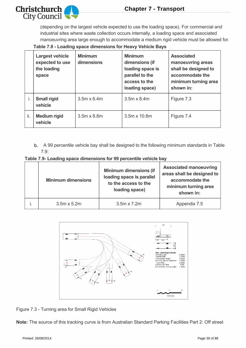
Figure 7.3 Turning area for Small Rigid Vehicles
Note: The source of this tracking curve is from Australian Standard Parking Facilities Part 2: Off street
Table 7.8 Loading space dimensions for Heavy Vehicle Bays
(depending on the largest vehicle expected to use the loading space). For commercial andindustrial sites where waste collection occurs internally, a loading space and associatedmanoeuvring area large enough to accommodate a medium rigid vehicle must be allowed for.
A 99 percentile vehicle bay shall be designed to the following minimum standards in Table7.9:
b.
Chapter 7 - Transport
Printed: 26/08/2014 Page 39 of 88
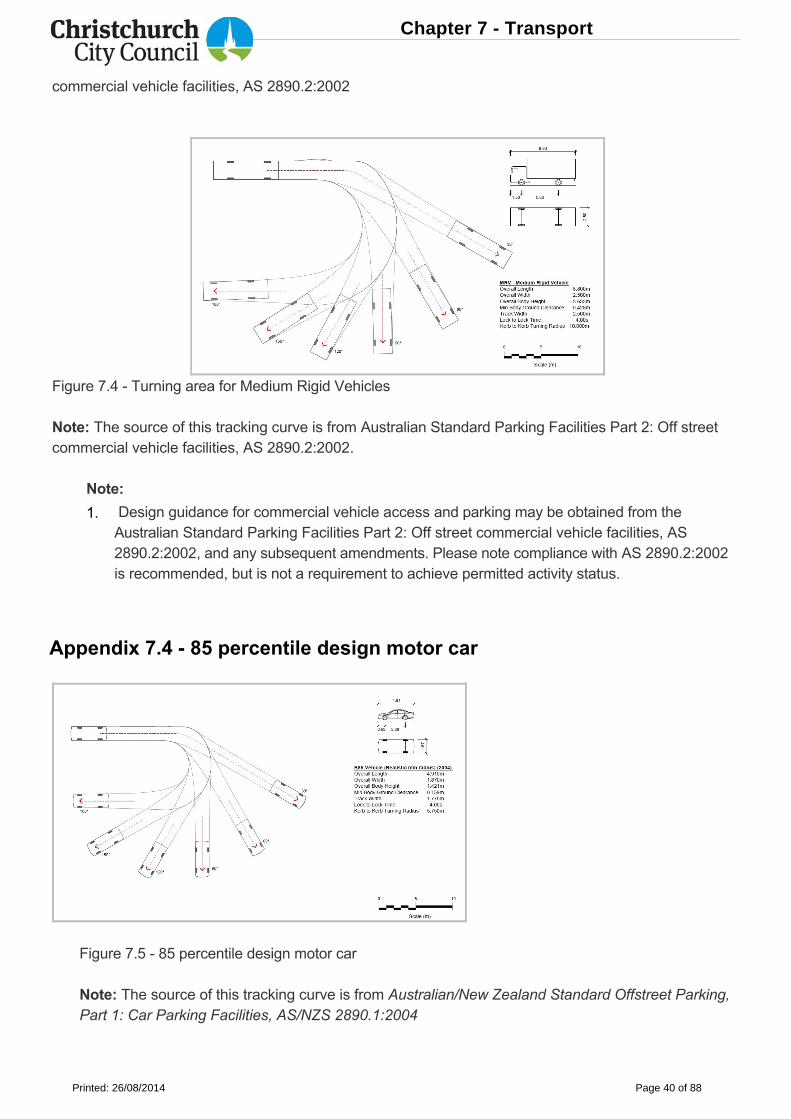
commercial vehicle facilities, AS 2890.2:2002
Figure 7.4 Turning area for Medium Rigid Vehicles
Note: The source of this tracking curve is from Australian Standard Parking Facilities Part 2: Off streetcommercial vehicle facilities, AS 2890.2:2002.
Note:
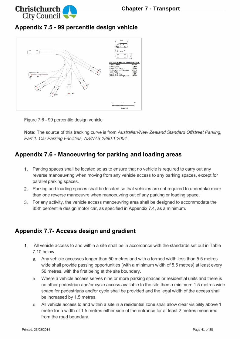
Appendix 7.4 85 percentile design motor car
Figure 7.5 85 percentile design motor car
Note: The source of this tracking curve is from Australian/New Zealand Standard Offstreet Parking,Part 1: Car Parking Facilities, AS/NZS 2890.1:2004
Design guidance for commercial vehicle access and parking may be obtained from theAustralian Standard Parking Facilities Part 2: Off street commercial vehicle facilities, AS2890.2:2002, and any subsequent amendments. Please note compliance with AS 2890.2:2002is recommended, but is not a requirement to achieve permitted activity status.
1.
Chapter 7 - Transport
Printed: 26/08/2014 Page 40 of 88
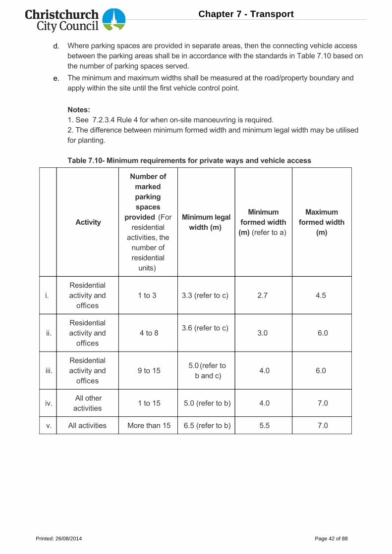
Appendix 7.5 99 percentile design vehicle
Figure 7.6 99 percentile design vehicle
Note: The source of this tracking curve is from Australian/New Zealand Standard Offstreet Parking,Part 1: Car Parking Facilities, AS/NZS 2890.1:2004
Appendix 7.6 Manoeuvring for parking and loading areas
Appendix 7.7 Access design and gradient
Parking spaces shall be located so as to ensure that no vehicle is required to carry out anyreverse manoeuvring when moving from any vehicle access to any parking spaces, except forparallel parking spaces.
Parking and loading spaces shall be located so that vehicles are not required to undertake morethan one reverse manoeuvre when manoeuvring out of any parking or loading space.
For any activity, the vehicle access manoeuvring area shall be designed to accommodate the85th percentile design motor car, as specified in Appendix 7.4, as a minimum.
All vehicle access to and within a site shall be in accordance with the standards set out in Table7.10 below.
Any vehicle accesses longer than 50 metres and with a formed width less than 5.5 metreswide shall provide passing opportunities (with a minimum width of 5.5 metres) at least every50 metres, with the first being at the site boundary.
Where a vehicle access serves nine or more parking spaces or residential units and there isno other pedestrian and/or cycle access available to the site then a minimum 1.5 metres widespace for pedestrians and/or cycle shall be provided and the legal width of the access shallbe increased by 1.5 metres.
All vehicle access to and within a site in a residential zone shall allow clear visibility above 1metre for a width of 1.5 metres either side of the entrance for at least 2 metres measuredfrom the road boundary.
1.
2.
3.
1.
a.
b.
c.
Chapter 7 - Transport
Printed: 26/08/2014 Page 41 of 88
Activity
Number ofmarkedparkingspaces
provided (Forresidential
activities, thenumber ofresidentialunits)
Minimum legalwidth (m)
Minimumformed width(m) (refer to a)
Maximumformed width
(m)
i. Residentialactivity andoffices
1 to 3 3.3 (refer to c) 2.7 4.5
ii.Residentialactivity andoffices
4 to 83.6 (refer to c)
3.0 6.0
iii.Residentialactivity andoffices
9 to 15 5.0 (refer to b and c)
4.0 6.0
iv. All otheractivities
1 to 15 5.0 (refer to b) 4.0 7.0
v. All activities More than 15 6.5 (refer to b) 5.5 7.0
Where parking spaces are provided in separate areas, then the connecting vehicle accessbetween the parking areas shall be in accordance with the standards in Table 7.10 based onthe number of parking spaces served.
The minimum and maximum widths shall be measured at the road/property boundary andapply within the site until the first vehicle control point.
Notes:1. See 7.2.3.4 Rule 4 for when onsite manoeuvring is required.2. The difference between minimum formed width and minimum legal width may be utilisedfor planting.
Table 7.10 Minimum requirements for private ways and vehicle access
d.
e.
Chapter 7 - Transport
Printed: 26/08/2014 Page 42 of 88
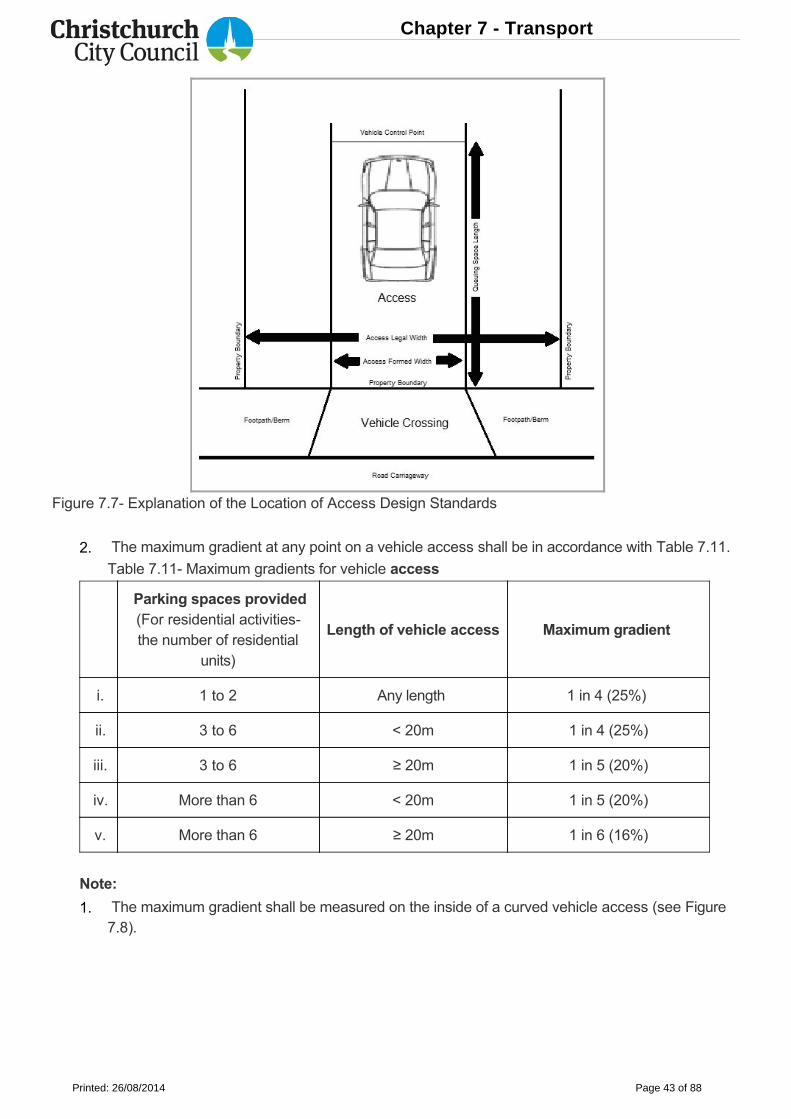
Figure 7.7 Explanation of the Location of Access Design Standards
Parking spaces provided(For residential activitiesthe number of residential
units)
Length of vehicle access Maximum gradient
i. 1 to 2 Any length 1 in 4 (25%)
ii. 3 to 6 < 20m 1 in 4 (25%)
iii. 3 to 6 ≥ 20m 1 in 5 (20%)
iv. More than 6 < 20m 1 in 5 (20%)
v. More than 6 ≥ 20m 1 in 6 (16%)
Note:
The maximum gradient at any point on a vehicle access shall be in accordance with Table 7.11.
Table 7.11 Maximum gradients for vehicle access
The maximum gradient shall be measured on the inside of a curved vehicle access (see Figure7.8).
2.
1.
Chapter 7 - Transport
Printed: 26/08/2014 Page 43 of 88
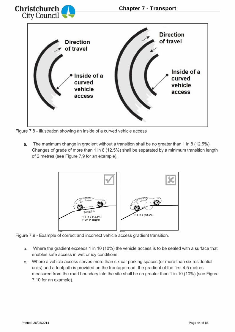
Figure 7.8 Illustration showing an inside of a curved vehicle access
Figure 7.9 Example of correct and incorrect vehicle access gradient transition.
The maximum change in gradient without a transition shall be no greater than 1 in 8 (12.5%).Changes of grade of more than 1 in 8 (12.5%) shall be separated by a minimum transition lengthof 2 metres (see Figure 7.9 for an example).
Where the gradient exceeds 1 in 10 (10%) the vehicle access is to be sealed with a surface thatenables safe access in wet or icy conditions.
Where a vehicle access serves more than six car parking spaces (or more than six residentialunits) and a footpath is provided on the frontage road, the gradient of the first 4.5 metresmeasured from the road boundary into the site shall be no greater than 1 in 10 (10%) (see Figure7.10 for an example).
a.
b.
c.
Chapter 7 - Transport
Printed: 26/08/2014 Page 44 of 88
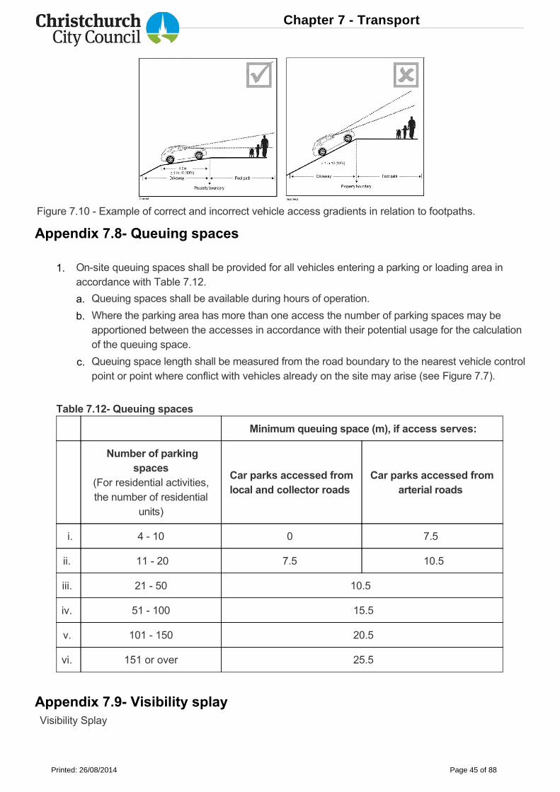
Figure 7.10 Example of correct and incorrect vehicle access gradients in relation to footpaths.
Appendix 7.8 Queuing spaces
Table 7.12 Queuing spaces
Minimum queuing space (m), if access serves:
Number of parkingspaces
(For residential activities,the number of residential
units)
Car parks accessed fromlocal and collector roads
Car parks accessed fromarterial roads
i. 4 10 0 7.5
ii. 11 20 7.5 10.5
iii. 21 50 10.5
iv. 51 100 15.5
v. 101 150 20.5
vi. 151 or over 25.5
Appendix 7.9 Visibility splay Visibility Splay
Onsite queuing spaces shall be provided for all vehicles entering a parking or loading area inaccordance with Table 7.12.
Queuing spaces shall be available during hours of operation.
Where the parking area has more than one access the number of parking spaces may beapportioned between the accesses in accordance with their potential usage for the calculationof the queuing space.
Queuing space length shall be measured from the road boundary to the nearest vehicle controlpoint or point where conflict with vehicles already on the site may arise (see Figure 7.7).
1.
a.
b.
c.
Chapter 7 - Transport
Printed: 26/08/2014 Page 45 of 88
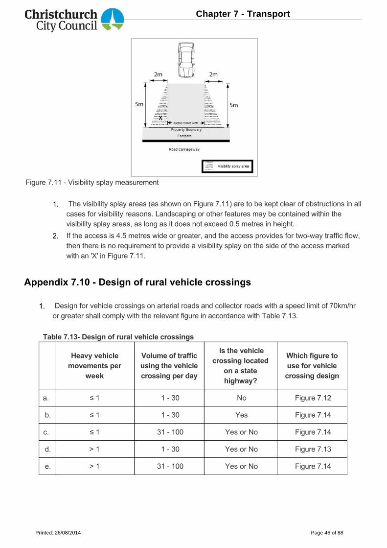
Figure 7.11 Visibility splay measurement
Appendix 7.10 Design of rural vehicle crossings
Table 7.13 Design of rural vehicle crossings
Heavy vehiclemovements per
week
Volume of trafficusing the vehiclecrossing per day
Is the vehiclecrossing located
on a statehighway?
Which figure touse for vehiclecrossing design
a. ≤ 1 1 30 No Figure 7.12
b. ≤ 1 1 30 Yes Figure 7.14
c. ≤ 1 31 100 Yes or No Figure 7.14
d. > 1 1 30 Yes or No Figure 7.13
e. > 1 31 100 Yes or No Figure 7.14
The visibility splay areas (as shown on Figure 7.11) are to be kept clear of obstructions in allcases for visibility reasons. Landscaping or other features may be contained within thevisibility splay areas, as long as it does not exceed 0.5 metres in height.
If the access is 4.5 metres wide or greater, and the access provides for twoway traffic flow,then there is no requirement to provide a visibility splay on the side of the access markedwith an 'X' in Figure 7.11.
Design for vehicle crossings on arterial roads and collector roads with a speed limit of 70km/hror greater shall comply with the relevant figure in accordance with Table 7.13.
1.
2.
1.
Chapter 7 - Transport
Printed: 26/08/2014 Page 46 of 88
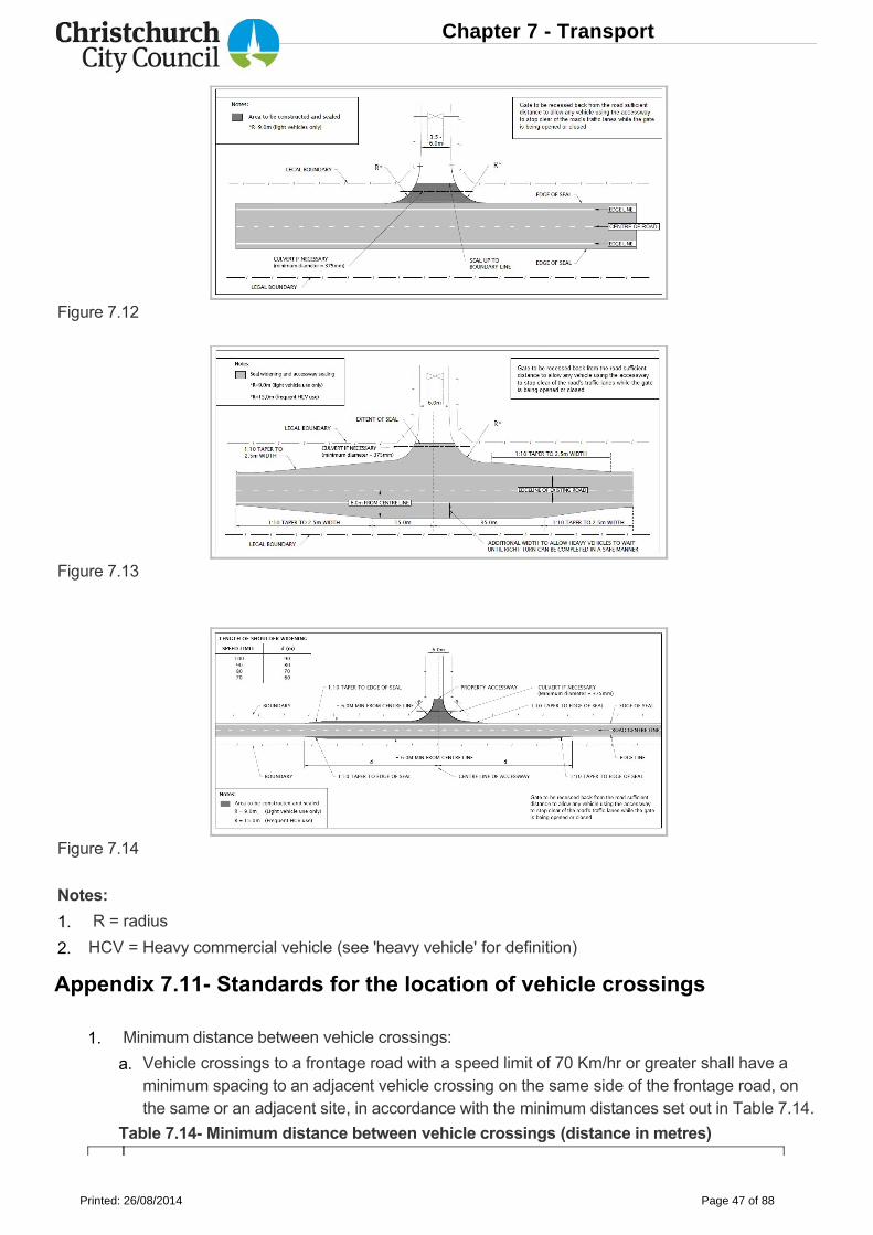
Figure 7.12
Figure 7.13
Figure 7.14
Notes:
Appendix 7.11 Standards for the location of vehicle crossings
R = radius
HCV = Heavy commercial vehicle (see 'heavy vehicle' for definition)
Minimum distance between vehicle crossings:
Table 7.14 Minimum distance between vehicle crossings (distance in metres)
Vehicle crossings to a frontage road with a speed limit of 70 Km/hr or greater shall have aminimum spacing to an adjacent vehicle crossing on the same side of the frontage road, onthe same or an adjacent site, in accordance with the minimum distances set out in Table 7.14.
1.
2.
1.
a.
Chapter 7 - Transport
Printed: 26/08/2014 Page 47 of 88
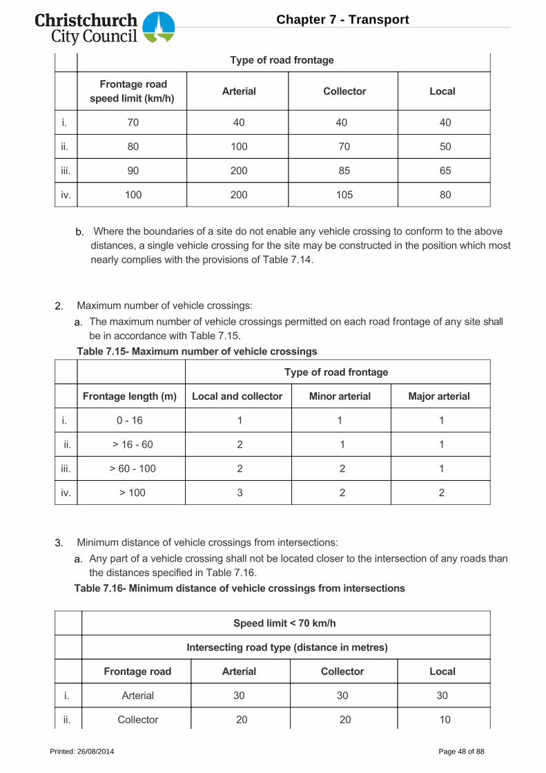
Type of road frontage
Frontage road
speed limit (km/h) Arterial Collector Local
i. 70 40 40 40
ii. 80 100 70 50
iii. 90 200 85 65
iv. 100 200 105 80
Where the boundaries of a site do not enable any vehicle crossing to conform to the abovedistances, a single vehicle crossing for the site may be constructed in the position which mostnearly complies with the provisions of Table 7.14.
b.
Type of road frontage
Frontage length (m) Local and collector Minor arterial Major arterial
i. 0 16 1 1 1
ii. > 16 60 2 1 1
iii. > 60 100 2 2 1
iv. > 100 3 2 2
Speed limit < 70 km/h
Intersecting road type (distance in metres)
Frontage road Arterial Collector Local
i. Arterial 30 30 30
ii. Collector 20 20 10
Maximum number of vehicle crossings:
Table 7.15 Maximum number of vehicle crossings
The maximum number of vehicle crossings permitted on each road frontage of any site shallbe in accordance with Table 7.15.
Minimum distance of vehicle crossings from intersections:
Table 7.16 Minimum distance of vehicle crossings from intersections
Any part of a vehicle crossing shall not be located closer to the intersection of any roads thanthe distances specified in Table 7.16.
2.
a.
3.
a.
Chapter 7 - Transport
Printed: 26/08/2014 Page 48 of 88
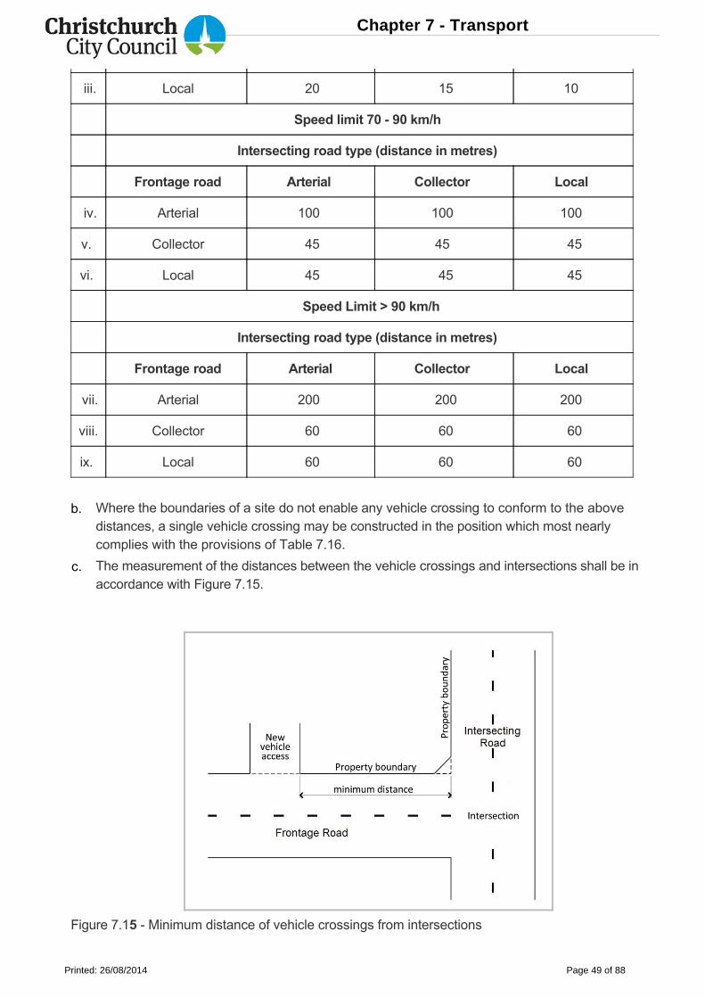
iii. Local 20 15 10
Speed limit 70 90 km/h
Intersecting road type (distance in metres)
Frontage road Arterial Collector Local
iv. Arterial 100 100 100
v. Collector 45 45 45
vi. Local 45 45 45
Speed Limit > 90 km/h
Intersecting road type (distance in metres)
Frontage road Arterial Collector Local
vii. Arterial 200 200 200
viii. Collector 60 60 60
ix. Local 60 60 60
Figure 7.15 Minimum distance of vehicle crossings from intersections
Where the boundaries of a site do not enable any vehicle crossing to conform to the abovedistances, a single vehicle crossing may be constructed in the position which most nearlycomplies with the provisions of Table 7.16.
The measurement of the distances between the vehicle crossings and intersections shall be inaccordance with Figure 7.15.
b.
c.
Chapter 7 - Transport
Printed: 26/08/2014 Page 49 of 88
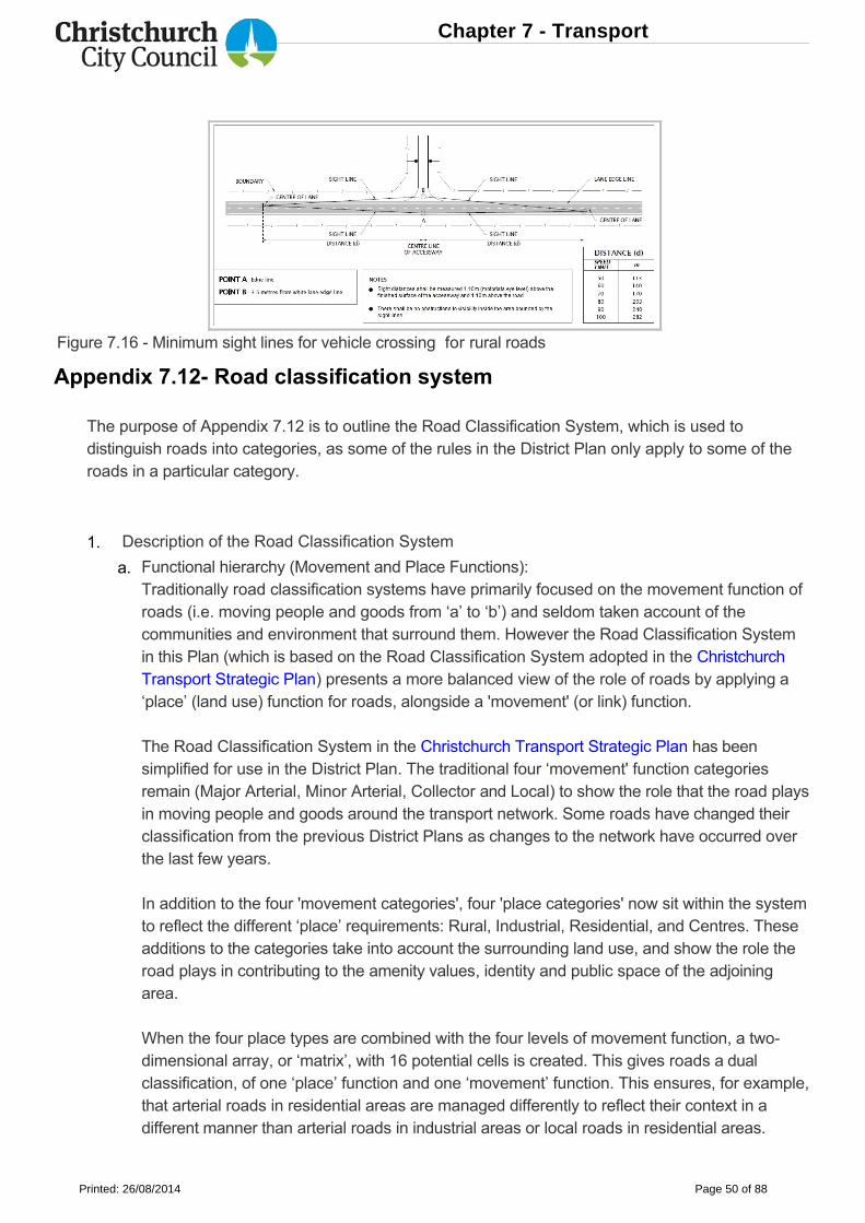
Figure 7.16 Minimum sight lines for vehicle crossing for rural roads
Appendix 7.12 Road classification system
The purpose of Appendix 7.12 is to outline the Road Classification System, which is used todistinguish roads into categories, as some of the rules in the District Plan only apply to some of theroads in a particular category.
Description of the Road Classification System
Functional hierarchy (Movement and Place Functions):Traditionally road classification systems have primarily focused on the movement function ofroads (i.e. moving people and goods from ‘a’ to ‘b’) and seldom taken account of thecommunities and environment that surround them. However the Road Classification Systemin this Plan (which is based on the Road Classification System adopted in the ChristchurchTransport Strategic Plan) presents a more balanced view of the role of roads by applying a‘place’ (land use) function for roads, alongside a 'movement' (or link) function.
The Road Classification System in the Christchurch Transport Strategic Plan has beensimplified for use in the District Plan. The traditional four ‘movement' function categoriesremain (Major Arterial, Minor Arterial, Collector and Local) to show the role that the road playsin moving people and goods around the transport network. Some roads have changed theirclassification from the previous District Plans as changes to the network have occurred overthe last few years.
In addition to the four 'movement categories', four 'place categories' now sit within the systemto reflect the different ‘place’ requirements: Rural, Industrial, Residential, and Centres. Theseadditions to the categories take into account the surrounding land use, and show the role theroad plays in contributing to the amenity values, identity and public space of the adjoiningarea.
When the four place types are combined with the four levels of movement function, a twodimensional array, or ‘matrix’, with 16 potential cells is created. This gives roads a dualclassification, of one ‘place’ function and one ‘movement’ function. This ensures, for example,that arterial roads in residential areas are managed differently to reflect their context in adifferent manner than arterial roads in industrial areas or local roads in residential areas.
1.
a.
Chapter 7 - Transport
Printed: 26/08/2014 Page 50 of 88
Movementfunctioncategory
Explanation
i. Majorarterialroads
State Highways and key roads in Christchurch District that caterespecially for longer trips. Major Arterial Roads are the dominantelements of the roading network which connect the major localities of theregion, both within and beyond the main urban area, and link to the mostimportant external localities. Some major arterials, particularly some statehighways, serve an important bypass function within ChristchurchDistrict, directing traffic through it to areas beyond. They are managed tominimise adverse effects from access on network efficiency. Allmotorways within Christchurch District are classified as major arterialroads.
Use hierarchy (modal networks):In addition to the functional hierarchy, a road use hierarchy has also been defined within theChristchurch Transport Strategic Plan. These networks highlight that different modes oftransport have different priorities within the network. There are five modal networks defined inthe Christchurch Transport Strategic Plan:
the cycle network of major, local and recreational cycle routes (including on and off roadcycle ways, and cycle ways within rail corridors);
the core public transport route network;
the walking network;
the freight network (including the rail network); and
the strategic road network.
These networks are not specifically shown in the District Plan, as they will be subject tochange over time. However, they are an important part of Christchurch’s transport networkand will be considered as part of the Integrated Transport Assessment process.
In addition to the classification system the Christchurch Transport Strategic Plan highlightsthe need to manage the road network more efficiently. The Christchurch NetworkManagement Plan is being developed to guide how the network will be managed based onuser priority and the time of day, to reflect the different demands that occur on thenetworks and the importance of prioritising users during different times of the day.
Note that Appendix 8.6.3 of Chapter 8 contains the standards for new roads.
Summary of the Road Classification categories
Each road will have a dual classification both a ‘movement’ and ‘place’ classification (seeFigures 7.17(af) for maps of the road classification). The ‘movement’ and ‘place’ functioncategories are described in Table 7.17.Table 7.17 Explanation of movement and place categories
b.
i.
ii.
iii.
iv.
v.
vi.
2.
a.
Chapter 7 - Transport
Printed: 26/08/2014 Page 51 of 88
Movementfunctioncategory
Explanation
ii. Minorarterialroads
Roads that provide connections between major arterial roads and themajor rural, suburban and industrial areas and commercialcentres. Generally, these roads cater for trips of intermediate length.They will generally connect to other minor and major arterial roads and tocollector roads. Arterial roads provide the most important movementfunction and as such require the highest degree of movement functionprotection. They may also define the boundaries of neighbourhoodareas.
iii. Collectorroads
Roads that distribute and collect local traffic between neighbourhoodareas and the Arterial road network. These are of little or no regionalsignificance, except for the loads they place on the Arterial road network.They link to the Arterial road network and act as local spine roads, andoften as bus routes within neighbourhoods, but generally do not containtraffic signals. Their traffic movement function must be balanced againstthe significant property access function which they provide. Collectorroads within the central city are known as distributor roads. These roadshave a similar ‘movement’ function to the distributor streets in the CentralCity, which are shown in the Christchurch Central Recovery Plan.
iv. Local roads All other roads in Christchurch District. These roads function almostentirely for access purposes and are not intended to act as throughroutes for motor vehicles
Place function category
v. Urban(Centres)
Any road that is adjacent to a Commercial Zone. These are the areaswhich are shown as the Urban (Centres) Place Type on the RoadClassification Maps (Figures 7.17(af)).
vi. Urban(Industrial)
Any road that is adjacent to an Industrial Zone. These are the areas whichare shown as the Urban (Industrial) Place Type on the RoadClassification Maps (Figures 7.17(af))1.
vii. Urban(Residential)
All other roads within the existing urban area as defined by Map A ofChapter 6 of the Canterbury Regional Policy Statement, as well as roadsthat are adjacent to any other Residential Zone in Christchurch District.These are the areas which are shown as the Urban (Residential) PlaceType on the Road Classification Maps (Figures 7.17(af)).
viii. Rural All roads outside the existing urban area as defined by Map A of Chapter6 of the Canterbury Regional Policy Statement, except for roadsadjoining to any Residential, Industrial, and/or Commercial Zone inChristchurch District. Rural roads are generally the roads classified asrural or semirural in the road classification system in the ChristchurchTransport Strategic Plan.
Chapter 7 - Transport
Printed: 26/08/2014 Page 52 of 88
Movementfunctioncategory
Explanation
Note:The exact area of all the place types is based on zoning and may be modified through the secondphase of the District Plan Review (especially the rural place type). Thus the second phase review areais shown on the Road Classification maps and the rural place type is not shown.
1 If a road is adjacent to a Commercial Zone on one side of the road and adjacent to an IndustrialZone on the other side of the road, then the place function is Urban (centres).
Figure 7.17: Road Classification Maps
Chapter 7 - Transport
Printed: 26/08/2014 Page 53 of 88
Chapter 7 - Transport
Printed: 26/08/2014 Page 54 of 88
Chapter 7 - Transport
Printed: 26/08/2014 Page 55 of 88
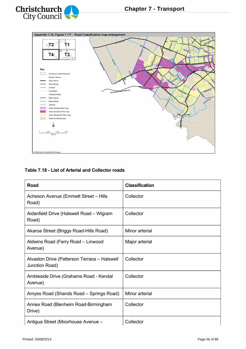
Table 7.18 List of Arterial and Collector roads
Road Classification
Acheson Avenue (Emmett Street – HillsRoad)
Collector
Aidanfield Drive (Halswell Road – WigramRoad)
Collector
Akaroa Street (Briggs RoadHills Road) Minor arterial
Aldwins Road (Ferry Road – LinwoodAvenue)
Major arterial
Alvaston Drive (Patterson Terrace – HalswellJunction Road)
Collector
Ambleside Drive (Grahams Road KendalAvenue)
Collector
Amyes Road (Shands Road – Springs Road) Minor arterial
Annex Road (Blenheim RoadBirminghamDrive)
Collector
Antigua Street (Moorhouse Avenue – Collector
Chapter 7 - Transport
Printed: 26/08/2014 Page 56 of 88
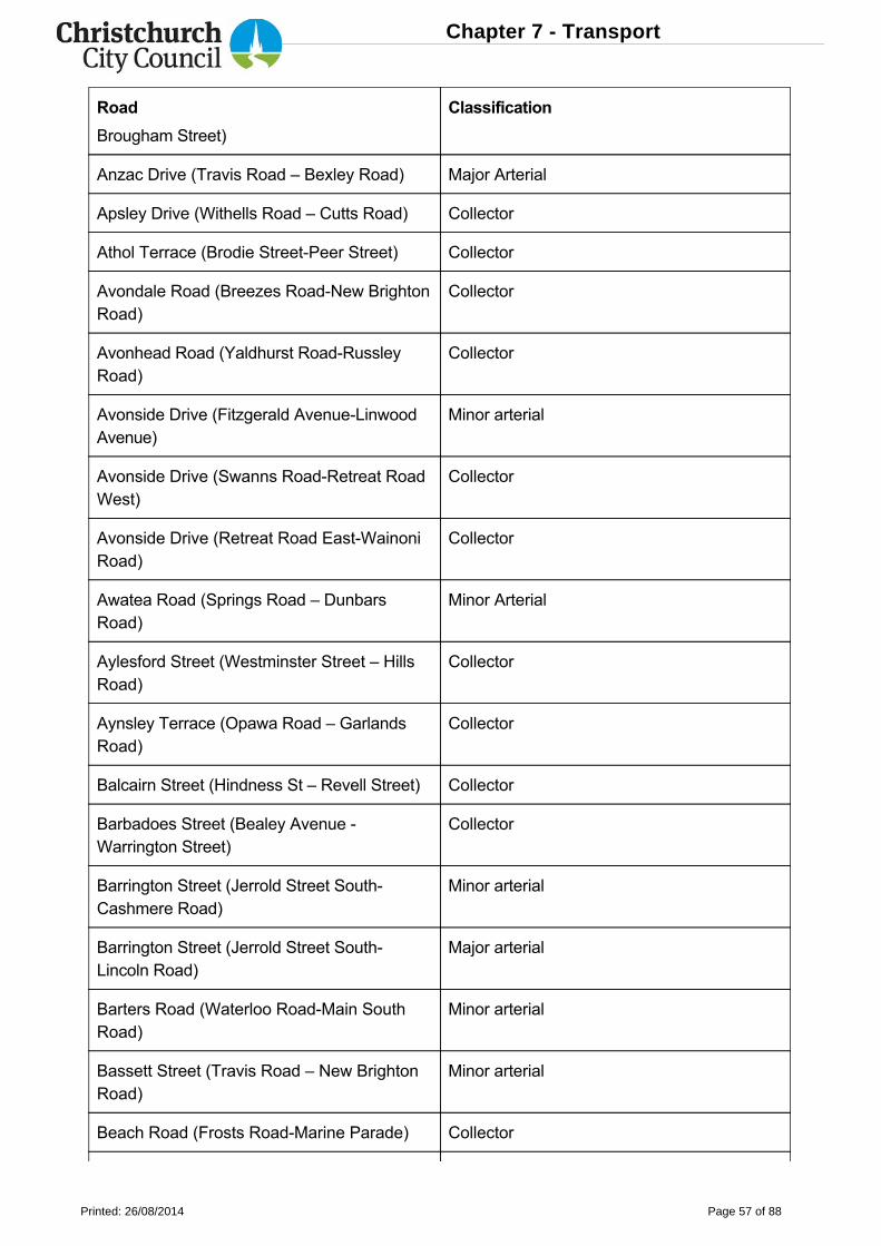
Road Classification
Brougham Street)
Anzac Drive (Travis Road – Bexley Road) Major Arterial
Apsley Drive (Withells Road – Cutts Road) Collector
Athol Terrace (Brodie StreetPeer Street) Collector
Avondale Road (Breezes RoadNew BrightonRoad)
Collector
Avonhead Road (Yaldhurst RoadRussleyRoad)
Collector
Avonside Drive (Fitzgerald AvenueLinwoodAvenue)
Minor arterial
Avonside Drive (Swanns RoadRetreat RoadWest)
Collector
Avonside Drive (Retreat Road EastWainoniRoad)
Collector
Awatea Road (Springs Road – DunbarsRoad)
Minor Arterial
Aylesford Street (Westminster Street – HillsRoad)
Collector
Aynsley Terrace (Opawa Road – GarlandsRoad)
Collector
Balcairn Street (Hindness St – Revell Street) Collector
Barbadoes Street (Bealey Avenue Warrington Street)
Collector
Barrington Street (Jerrold Street SouthCashmere Road)
Minor arterial
Barrington Street (Jerrold Street SouthLincoln Road)
Major arterial
Barters Road (Waterloo RoadMain SouthRoad)
Minor arterial
Bassett Street (Travis Road – New BrightonRoad)
Minor arterial
Beach Road (Frosts RoadMarine Parade) Collector
Chapter 7 - Transport
Printed: 26/08/2014 Page 57 of 88
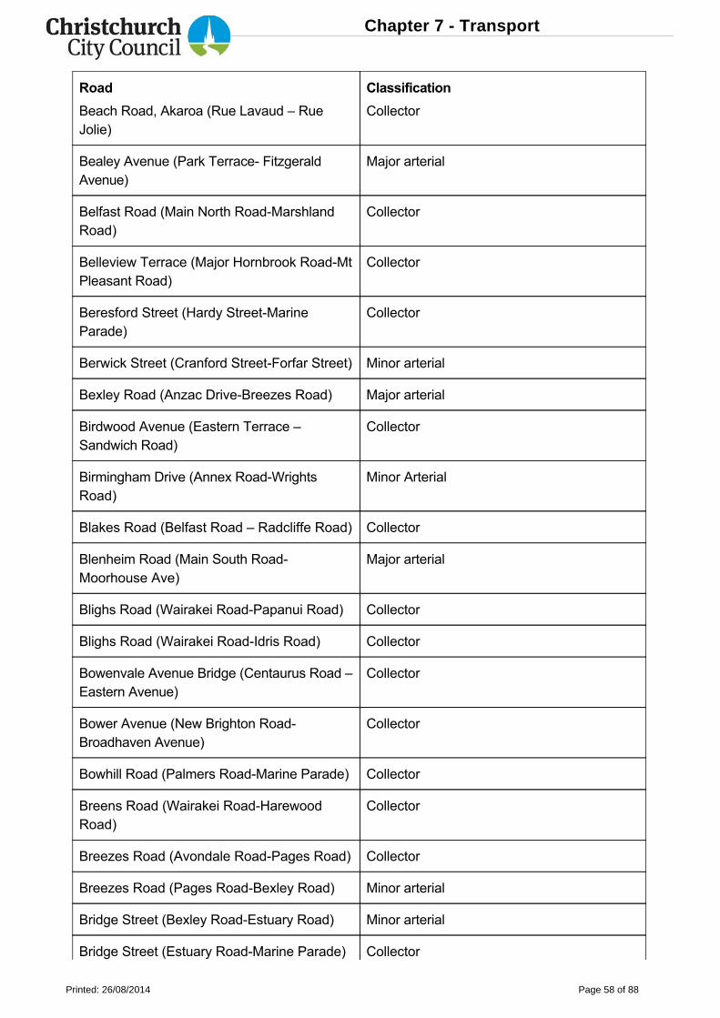
Road Classification
Beach Road, Akaroa (Rue Lavaud – RueJolie)
Collector
Bealey Avenue (Park Terrace FitzgeraldAvenue)
Major arterial
Belfast Road (Main North RoadMarshlandRoad)
Collector
Belleview Terrace (Major Hornbrook RoadMtPleasant Road)
Collector
Beresford Street (Hardy StreetMarineParade)
Collector
Berwick Street (Cranford StreetForfar Street) Minor arterial
Bexley Road (Anzac DriveBreezes Road) Major arterial
Birdwood Avenue (Eastern Terrace –Sandwich Road)
Collector
Birmingham Drive (Annex RoadWrightsRoad)
Minor Arterial
Blakes Road (Belfast Road – Radcliffe Road) Collector
Blenheim Road (Main South RoadMoorhouse Ave)
Major arterial
Blighs Road (Wairakei RoadPapanui Road) Collector
Blighs Road (Wairakei RoadIdris Road) Collector
Bowenvale Avenue Bridge (Centaurus Road –Eastern Avenue)
Collector
Bower Avenue (New Brighton RoadBroadhaven Avenue)
Collector
Bowhill Road (Palmers RoadMarine Parade) Collector
Breens Road (Wairakei RoadHarewoodRoad)
Collector
Breezes Road (Avondale RoadPages Road) Collector
Breezes Road (Pages RoadBexley Road) Minor arterial
Bridge Street (Bexley RoadEstuary Road) Minor arterial
Bridge Street (Estuary RoadMarine Parade) Collector
Chapter 7 - Transport
Printed: 26/08/2014 Page 58 of 88
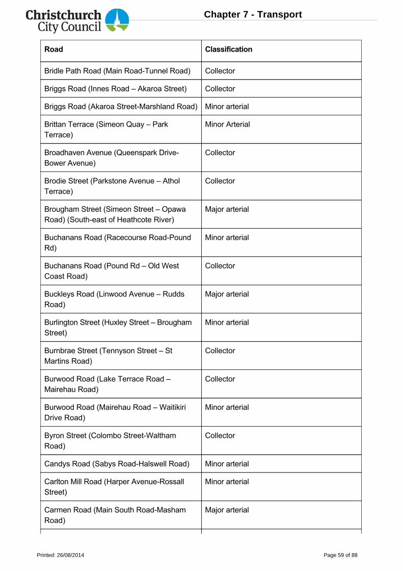
Road Classification
Bridle Path Road (Main RoadTunnel Road) Collector
Briggs Road (Innes Road – Akaroa Street) Collector
Briggs Road (Akaroa StreetMarshland Road) Minor arterial
Brittan Terrace (Simeon Quay – ParkTerrace)
Minor Arterial
Broadhaven Avenue (Queenspark DriveBower Avenue)
Collector
Brodie Street (Parkstone Avenue – AtholTerrace)
Collector
Brougham Street (Simeon Street – OpawaRoad) (Southeast of Heathcote River)
Major arterial
Buchanans Road (Racecourse RoadPoundRd)
Minor arterial
Buchanans Road (Pound Rd – Old WestCoast Road)
Collector
Buckleys Road (Linwood Avenue – RuddsRoad)
Major arterial
Burlington Street (Huxley Street – BroughamStreet)
Minor arterial
Burnbrae Street (Tennyson Street – StMartins Road)
Collector
Burwood Road (Lake Terrace Road –Mairehau Road)
Collector
Burwood Road (Mairehau Road – WaitikiriDrive Road)
Minor arterial
Byron Street (Colombo StreetWalthamRoad)
Collector
Candys Road (Sabys RoadHalswell Road) Minor arterial
Carlton Mill Road (Harper AvenueRossallStreet)
Minor arterial
Carmen Road (Main South RoadMashamRoad)
Major arterial
Chapter 7 - Transport
Printed: 26/08/2014 Page 59 of 88
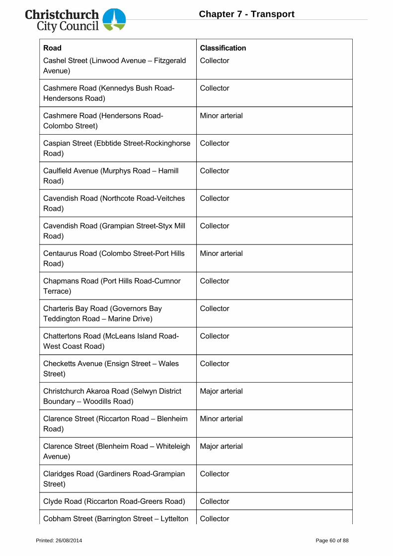
Road Classification
Cashel Street (Linwood Avenue – FitzgeraldAvenue)
Collector
Cashmere Road (Kennedys Bush RoadHendersons Road)
Collector
Cashmere Road (Hendersons RoadColombo Street)
Minor arterial
Caspian Street (Ebbtide StreetRockinghorseRoad)
Collector
Caulfield Avenue (Murphys Road – HamillRoad)
Collector
Cavendish Road (Northcote RoadVeitchesRoad)
Collector
Cavendish Road (Grampian StreetStyx MillRoad)
Collector
Centaurus Road (Colombo StreetPort HillsRoad)
Minor arterial
Chapmans Road (Port Hills RoadCumnorTerrace)
Collector
Charteris Bay Road (Governors BayTeddington Road – Marine Drive)
Collector
Chattertons Road (McLeans Island RoadWest Coast Road)
Collector
Checketts Avenue (Ensign Street – WalesStreet)
Collector
Christchurch Akaroa Road (Selwyn DistrictBoundary – Woodills Road)
Major arterial
Clarence Street (Riccarton Road – BlenheimRoad)
Minor arterial
Clarence Street (Blenheim Road – WhiteleighAvenue)
Major arterial
Claridges Road (Gardiners RoadGrampianStreet)
Collector
Clyde Road (Riccarton RoadGreers Road) Collector
Cobham Street (Barrington Street – Lyttelton Collector
Chapter 7 - Transport
Printed: 26/08/2014 Page 60 of 88
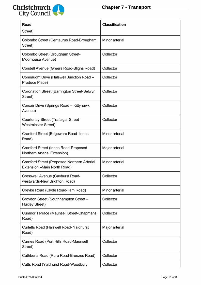
Road Classification
Street)
Colombo Street (Centaurus RoadBroughamStreet)
Minor arterial
Colombo Street (Brougham StreetMoorhouse Avenue)
Collector
Condell Avenue (Greers RoadBlighs Road) Collector
Connaught Drive (Halswell Junction Road –Produce Place)
Collector
Coronation Street (Barrington StreetSelwynStreet)
Collector
Corsair Drive (Springs Road – KittyhawkAvenue)
Collector
Courtenay Street (Trafalgar StreetWestminster Street)
Collector
Cranford Street (Edgeware Road InnesRoad)
Minor arterial
Cranford Street (Innes RoadProposedNorthern Arterial Extension)
Major arterial
Cranford Street (Proposed Northern ArterialExtension –Main North Road)
Minor arterial
Cresswell Avenue (Gayhurst RoadwestwardsNew Brighton Road)
Collector
Creyke Road (Clyde RoadIlam Road) Minor arterial
Croydon Street (Southhampton Street –Huxley Street)
Collector
Cumnor Terrace (Maunsell StreetChapmansRoad)
Collector
Curletts Road (Halswell Road YaldhurstRoad)
Major arterial
Curries Road (Port Hills RoadMaunsellStreet)
Collector
Cuthberts Road (Ruru RoadBreezes Road) Collector
Cutts Road (Yaldhurst RoadWoodbury Collector
Chapter 7 - Transport
Printed: 26/08/2014 Page 61 of 88
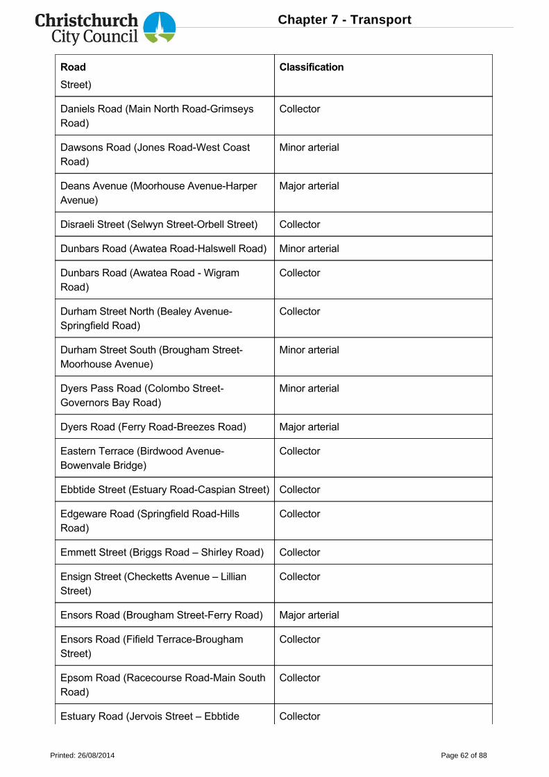
Road Classification
Street)
Daniels Road (Main North RoadGrimseysRoad)
Collector
Dawsons Road (Jones RoadWest CoastRoad)
Minor arterial
Deans Avenue (Moorhouse AvenueHarperAvenue)
Major arterial
Disraeli Street (Selwyn StreetOrbell Street) Collector
Dunbars Road (Awatea RoadHalswell Road) Minor arterial
Dunbars Road (Awatea Road WigramRoad)
Collector
Durham Street North (Bealey AvenueSpringfield Road)
Collector
Durham Street South (Brougham StreetMoorhouse Avenue)
Minor arterial
Dyers Pass Road (Colombo StreetGovernors Bay Road)
Minor arterial
Dyers Road (Ferry RoadBreezes Road) Major arterial
Eastern Terrace (Birdwood AvenueBowenvale Bridge)
Collector
Ebbtide Street (Estuary RoadCaspian Street) Collector
Edgeware Road (Springfield RoadHillsRoad)
Collector
Emmett Street (Briggs Road – Shirley Road) Collector
Ensign Street (Checketts Avenue – LillianStreet)
Collector
Ensors Road (Brougham StreetFerry Road) Major arterial
Ensors Road (Fifield TerraceBroughamStreet)
Collector
Epsom Road (Racecourse RoadMain SouthRoad)
Collector
Estuary Road (Jervois Street – Ebbtide Collector
Chapter 7 - Transport
Printed: 26/08/2014 Page 62 of 88
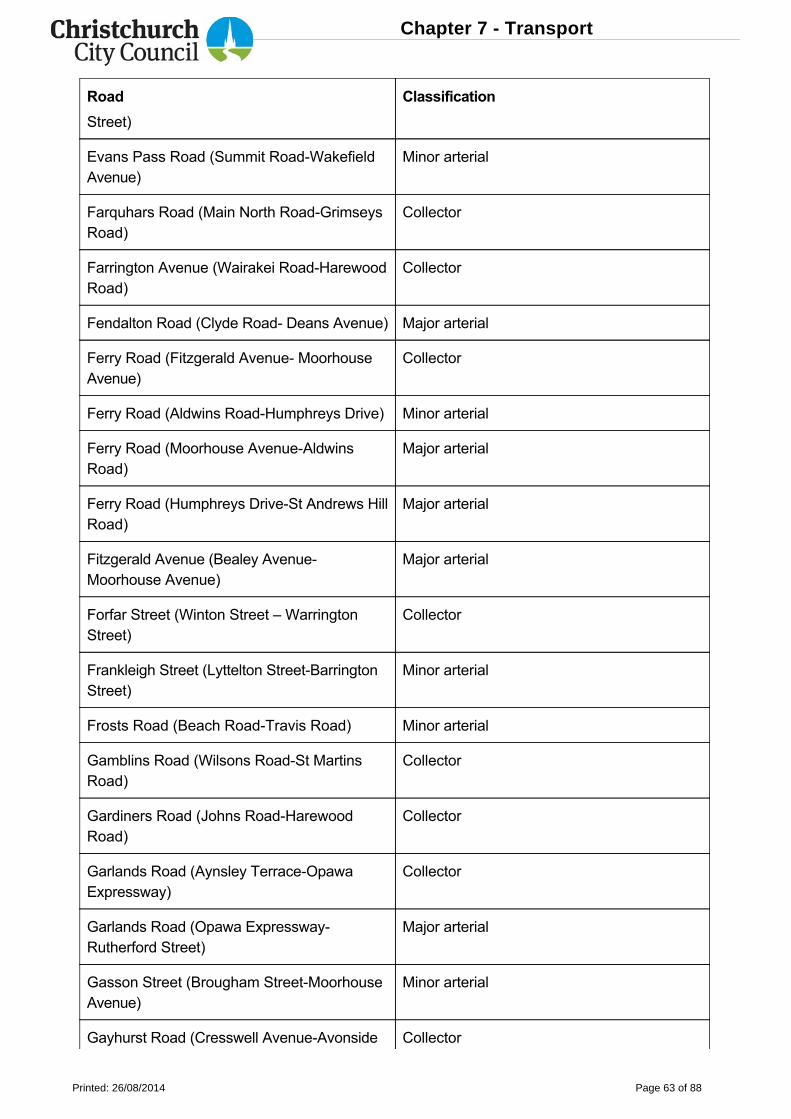
Road Classification
Street)
Evans Pass Road (Summit RoadWakefieldAvenue)
Minor arterial
Farquhars Road (Main North RoadGrimseysRoad)
Collector
Farrington Avenue (Wairakei RoadHarewoodRoad)
Collector
Fendalton Road (Clyde Road Deans Avenue) Major arterial
Ferry Road (Fitzgerald Avenue MoorhouseAvenue)
Collector
Ferry Road (Aldwins RoadHumphreys Drive) Minor arterial
Ferry Road (Moorhouse AvenueAldwinsRoad)
Major arterial
Ferry Road (Humphreys DriveSt Andrews HillRoad)
Major arterial
Fitzgerald Avenue (Bealey AvenueMoorhouse Avenue)
Major arterial
Forfar Street (Winton Street – WarringtonStreet)
Collector
Frankleigh Street (Lyttelton StreetBarringtonStreet)
Minor arterial
Frosts Road (Beach RoadTravis Road) Minor arterial
Gamblins Road (Wilsons RoadSt MartinsRoad)
Collector
Gardiners Road (Johns RoadHarewoodRoad)
Collector
Garlands Road (Aynsley TerraceOpawaExpressway)
Collector
Garlands Road (Opawa ExpresswayRutherford Street)
Major arterial
Gasson Street (Brougham StreetMoorhouseAvenue)
Minor arterial
Gayhurst Road (Cresswell AvenueAvonside Collector
Chapter 7 - Transport
Printed: 26/08/2014 Page 63 of 88
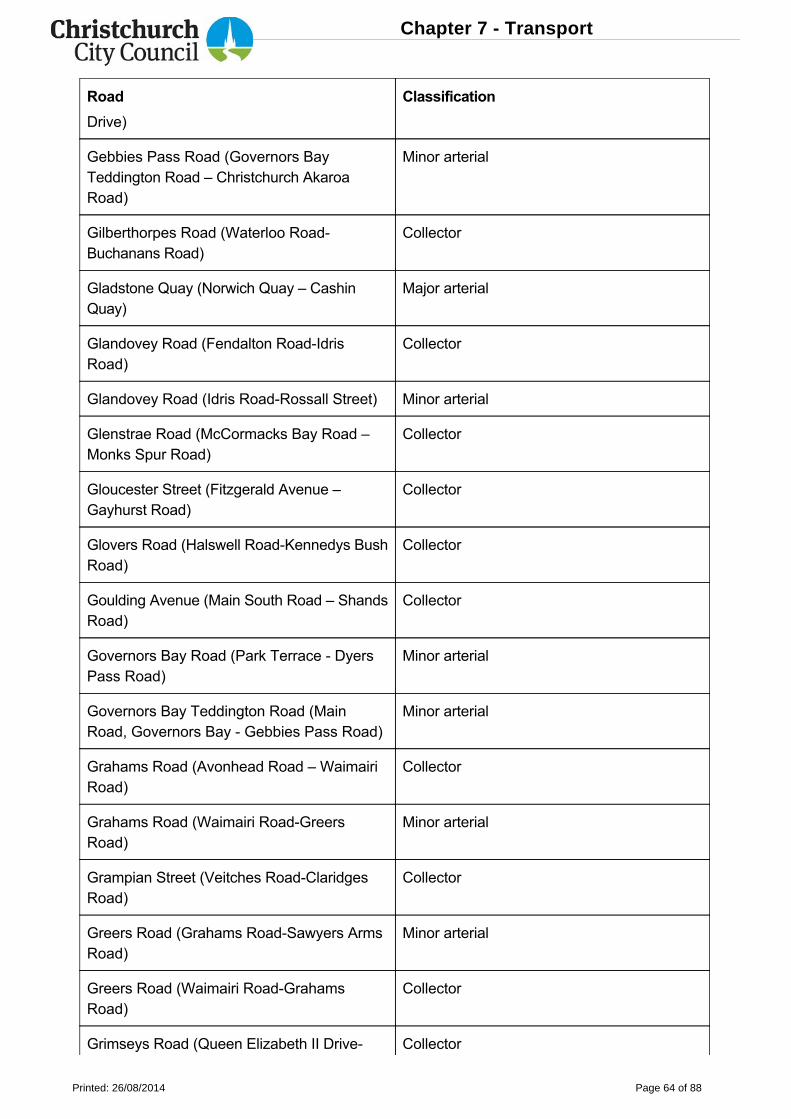
Road Classification
Drive)
Gebbies Pass Road (Governors BayTeddington Road – Christchurch AkaroaRoad)
Minor arterial
Gilberthorpes Road (Waterloo RoadBuchanans Road)
Collector
Gladstone Quay (Norwich Quay – CashinQuay)
Major arterial
Glandovey Road (Fendalton RoadIdrisRoad)
Collector
Glandovey Road (Idris RoadRossall Street) Minor arterial
Glenstrae Road (McCormacks Bay Road –Monks Spur Road)
Collector
Gloucester Street (Fitzgerald Avenue –Gayhurst Road)
Collector
Glovers Road (Halswell RoadKennedys BushRoad)
Collector
Goulding Avenue (Main South Road – ShandsRoad)
Collector
Governors Bay Road (Park Terrace DyersPass Road)
Minor arterial
Governors Bay Teddington Road (MainRoad, Governors Bay Gebbies Pass Road)
Minor arterial
Grahams Road (Avonhead Road – WaimairiRoad)
Collector
Grahams Road (Waimairi RoadGreersRoad)
Minor arterial
Grampian Street (Veitches RoadClaridgesRoad)
Collector
Greers Road (Grahams RoadSawyers ArmsRoad)
Minor arterial
Greers Road (Waimairi RoadGrahamsRoad)
Collector
Grimseys Road (Queen Elizabeth II Drive Collector
Chapter 7 - Transport
Printed: 26/08/2014 Page 64 of 88
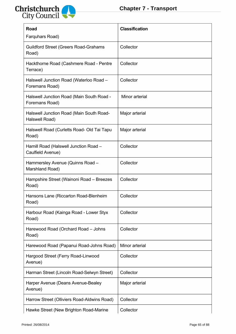
Road Classification
Farquhars Road)
Guildford Street (Greers RoadGrahamsRoad)
Collector
Hackthorne Road (Cashmere Road PentreTerrace)
Collector
Halswell Junction Road (Waterloo Road –Foremans Road)
Collector
Halswell Junction Road (Main South Road Foremans Road)
Minor arterial
Halswell Junction Road (Main South RoadHalswell Road)
Major arterial
Halswell Road (Curletts Road Old Tai TapuRoad)
Major arterial
Hamill Road (Halswell Junction Road –Caulfield Avenue)
Collector
Hammersley Avenue (Quinns Road –Marshland Road)
Collector
Hampshire Street (Wainoni Road – BreezesRoad)
Collector
Hansons Lane (Riccarton RoadBlenheimRoad)
Collector
Harbour Road (Kainga Road Lower StyxRoad)
Collector
Harewood Road (Orchard Road – JohnsRoad)
Collector
Harewood Road (Papanui RoadJohns Road) Minor arterial
Hargood Street (Ferry RoadLinwoodAvenue)
Collector
Harman Street (Lincoln RoadSelwyn Street) Collector
Harper Avenue (Deans AvenueBealeyAvenue)
Major arterial
Harrow Street (Olliviers RoadAldwins Road) Collector
Hawke Street (New Brighton RoadMarine Collector
Chapter 7 - Transport
Printed: 26/08/2014 Page 65 of 88
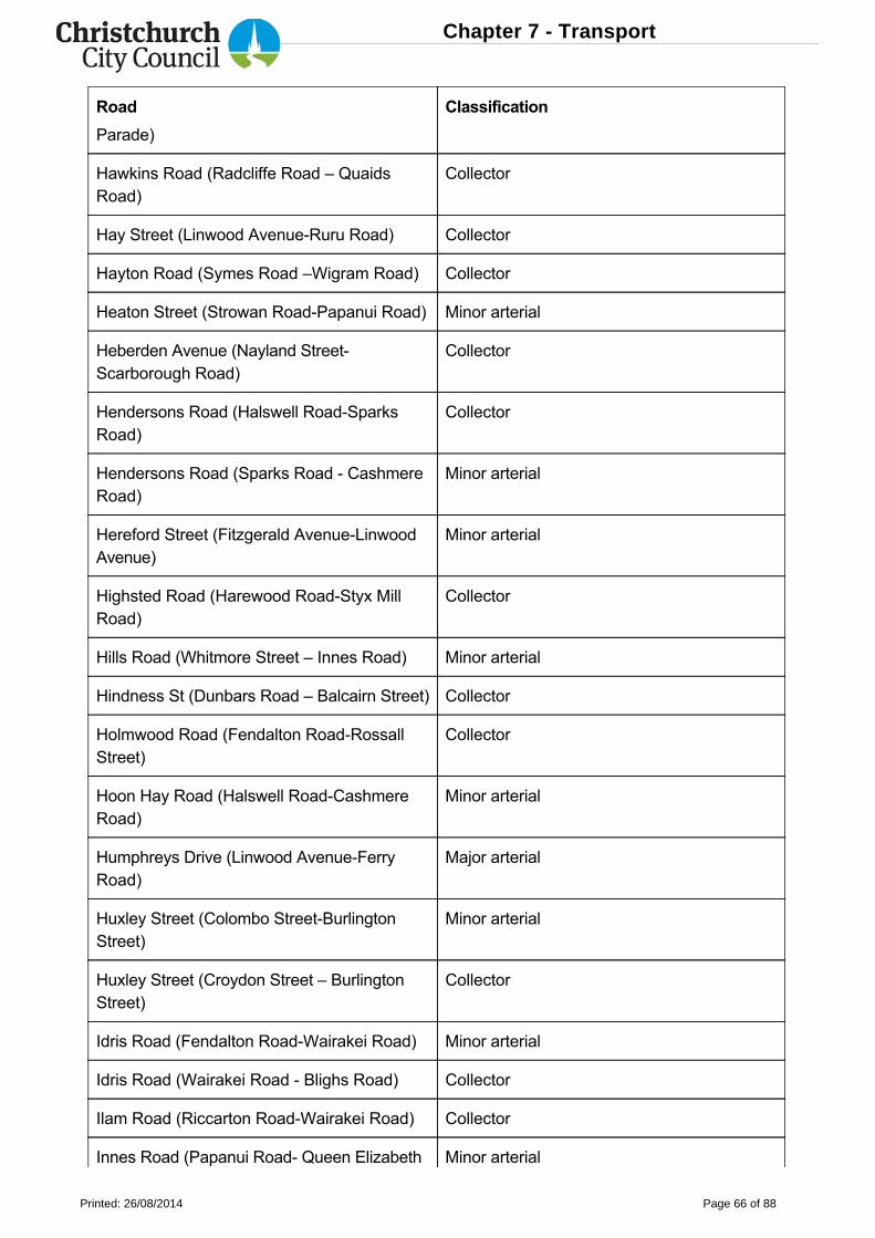
Road Classification
Parade)
Hawkins Road (Radcliffe Road – QuaidsRoad)
Collector
Hay Street (Linwood AvenueRuru Road) Collector
Hayton Road (Symes Road –Wigram Road) Collector
Heaton Street (Strowan RoadPapanui Road) Minor arterial
Heberden Avenue (Nayland StreetScarborough Road)
Collector
Hendersons Road (Halswell RoadSparksRoad)
Collector
Hendersons Road (Sparks Road CashmereRoad)
Minor arterial
Hereford Street (Fitzgerald AvenueLinwoodAvenue)
Minor arterial
Highsted Road (Harewood RoadStyx MillRoad)
Collector
Hills Road (Whitmore Street – Innes Road) Minor arterial
Hindness St (Dunbars Road – Balcairn Street) Collector
Holmwood Road (Fendalton RoadRossallStreet)
Collector
Hoon Hay Road (Halswell RoadCashmereRoad)
Minor arterial
Humphreys Drive (Linwood AvenueFerryRoad)
Major arterial
Huxley Street (Colombo StreetBurlingtonStreet)
Minor arterial
Huxley Street (Croydon Street – BurlingtonStreet)
Collector
Idris Road (Fendalton RoadWairakei Road) Minor arterial
Idris Road (Wairakei Road Blighs Road) Collector
Ilam Road (Riccarton RoadWairakei Road) Collector
Innes Road (Papanui Road Queen Elizabeth Minor arterial
Chapter 7 - Transport
Printed: 26/08/2014 Page 66 of 88
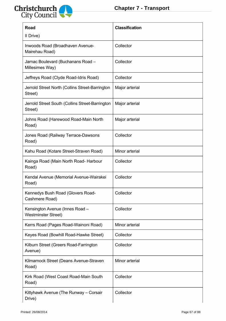
Road Classification
II Drive)
Inwoods Road (Broadhaven AvenueMairehau Road)
Collector
Jarnac Boulevard (Buchanans Road –Millesimes Way)
Collector
Jeffreys Road (Clyde RoadIdris Road) Collector
Jerrold Street North (Collins StreetBarringtonStreet)
Major arterial
Jerrold Street South (Collins StreetBarringtonStreet)
Major arterial
Johns Road (Harewood RoadMain NorthRoad)
Major arterial
Jones Road (Railway TerraceDawsonsRoad)
Collector
Kahu Road (Kotare StreetStraven Road) Minor arterial
Kainga Road (Main North Road HarbourRoad)
Collector
Kendal Avenue (Memorial AvenueWairakeiRoad)
Collector
Kennedys Bush Road (Glovers RoadCashmere Road)
Collector
Kensington Avenue (Innes Road –Westminster Street)
Collector
Kerrs Road (Pages RoadWainoni Road) Minor arterial
Keyes Road (Bowhill RoadHawke Street) Collector
Kilburn Street (Greers RoadFarringtonAvenue)
Collector
Kilmarnock Street (Deans AvenueStravenRoad)
Minor arterial
Kirk Road (West Coast RoadMain SouthRoad)
Collector
Kittyhawk Avenue (The Runway – CorsairDrive)
Collector
Chapter 7 - Transport
Printed: 26/08/2014 Page 67 of 88
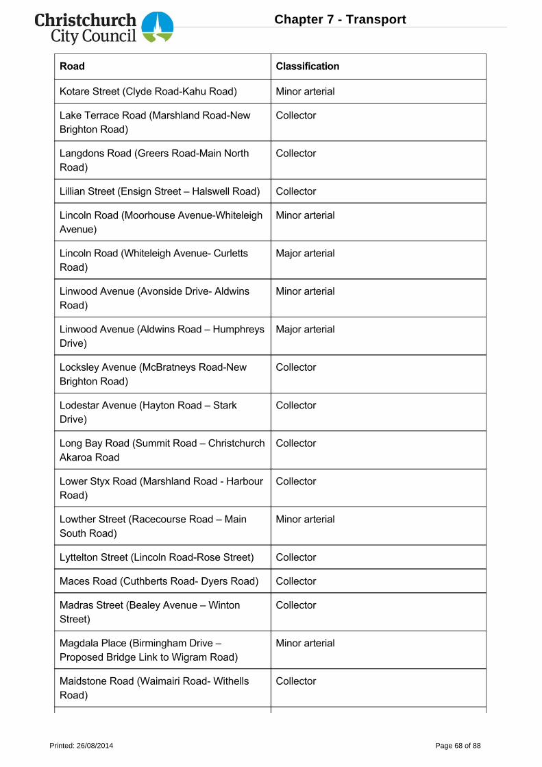
Road Classification
Kotare Street (Clyde RoadKahu Road) Minor arterial
Lake Terrace Road (Marshland RoadNewBrighton Road)
Collector
Langdons Road (Greers RoadMain NorthRoad)
Collector
Lillian Street (Ensign Street – Halswell Road) Collector
Lincoln Road (Moorhouse AvenueWhiteleighAvenue)
Minor arterial
Lincoln Road (Whiteleigh Avenue CurlettsRoad)
Major arterial
Linwood Avenue (Avonside Drive AldwinsRoad)
Minor arterial
Linwood Avenue (Aldwins Road – HumphreysDrive)
Major arterial
Locksley Avenue (McBratneys RoadNewBrighton Road)
Collector
Lodestar Avenue (Hayton Road – StarkDrive)
Collector
Long Bay Road (Summit Road – ChristchurchAkaroa Road
Collector
Lower Styx Road (Marshland Road HarbourRoad)
Collector
Lowther Street (Racecourse Road – MainSouth Road)
Minor arterial
Lyttelton Street (Lincoln RoadRose Street) Collector
Maces Road (Cuthberts Road Dyers Road) Collector
Madras Street (Bealey Avenue – WintonStreet)
Collector
Magdala Place (Birmingham Drive –Proposed Bridge Link to Wigram Road)
Minor arterial
Maidstone Road (Waimairi Road WithellsRoad)
Collector
Chapter 7 - Transport
Printed: 26/08/2014 Page 68 of 88
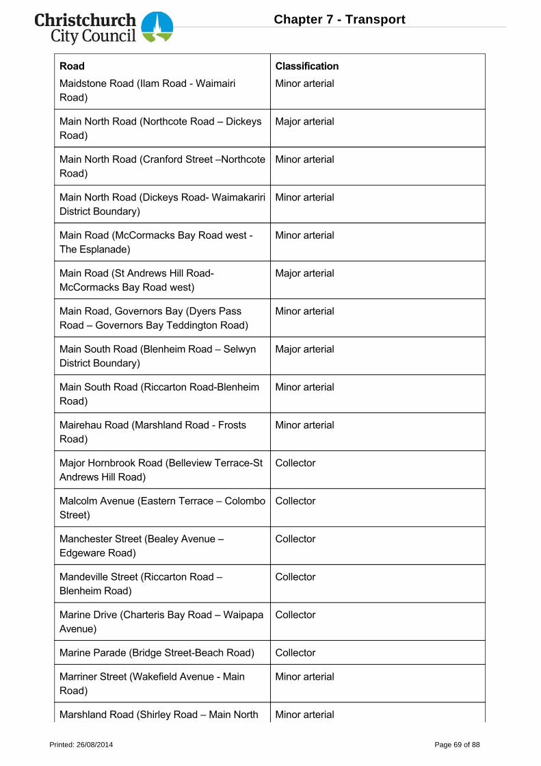
Road Classification
Maidstone Road (Ilam Road WaimairiRoad)
Minor arterial
Main North Road (Northcote Road – DickeysRoad)
Major arterial
Main North Road (Cranford Street –NorthcoteRoad)
Minor arterial
Main North Road (Dickeys Road WaimakaririDistrict Boundary)
Minor arterial
Main Road (McCormacks Bay Road west The Esplanade)
Minor arterial
Main Road (St Andrews Hill RoadMcCormacks Bay Road west)
Major arterial
Main Road, Governors Bay (Dyers PassRoad – Governors Bay Teddington Road)
Minor arterial
Main South Road (Blenheim Road – SelwynDistrict Boundary)
Major arterial
Main South Road (Riccarton RoadBlenheimRoad)
Minor arterial
Mairehau Road (Marshland Road FrostsRoad)
Minor arterial
Major Hornbrook Road (Belleview TerraceStAndrews Hill Road)
Collector
Malcolm Avenue (Eastern Terrace – ColomboStreet)
Collector
Manchester Street (Bealey Avenue –Edgeware Road)
Collector
Mandeville Street (Riccarton Road –Blenheim Road)
Collector
Marine Drive (Charteris Bay Road – WaipapaAvenue)
Collector
Marine Parade (Bridge StreetBeach Road) Collector
Marriner Street (Wakefield Avenue MainRoad)
Minor arterial
Marshland Road (Shirley Road – Main North Minor arterial
Chapter 7 - Transport
Printed: 26/08/2014 Page 69 of 88
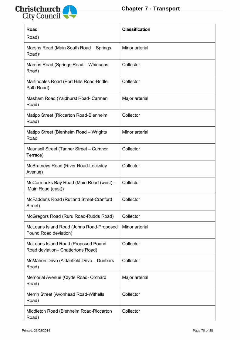
Road Classification
Road)
Marshs Road (Main South Road – SpringsRoad)1
Minor arterial
Marshs Road (Springs Road – WhincopsRoad)
Collector
Martindales Road (Port Hills RoadBridlePath Road)
Collector
Masham Road (Yaldhurst Road CarmenRoad)
Major arterial
Matipo Street (Riccarton RoadBlenheimRoad)
Collector
Matipo Street (Blenheim Road – WrightsRoad
Minor arterial
Maunsell Street (Tanner Street – CumnorTerrace)
Collector
McBratneys Road (River RoadLocksleyAvenue)
Collector
McCormacks Bay Road (Main Road (west) Main Road (east))
Collector
McFaddens Road (Rutland StreetCranfordStreet)
Collector
McGregors Road (Ruru RoadRudds Road) Collector
McLeans Island Road (Johns RoadProposedPound Road deviation)
Minor arterial
McLeans Island Road (Proposed PoundRoad deviation– Chattertons Road)
Collector
McMahon Drive (Aidanfield Drive – DunbarsRoad)
Collector
Memorial Avenue (Clyde Road OrchardRoad)
Major arterial
Merrin Street (Avonhead RoadWithellsRoad)
Collector
Middleton Road (Blenheim RoadRiccartonRoad)
Collector
Chapter 7 - Transport
Printed: 26/08/2014 Page 70 of 88
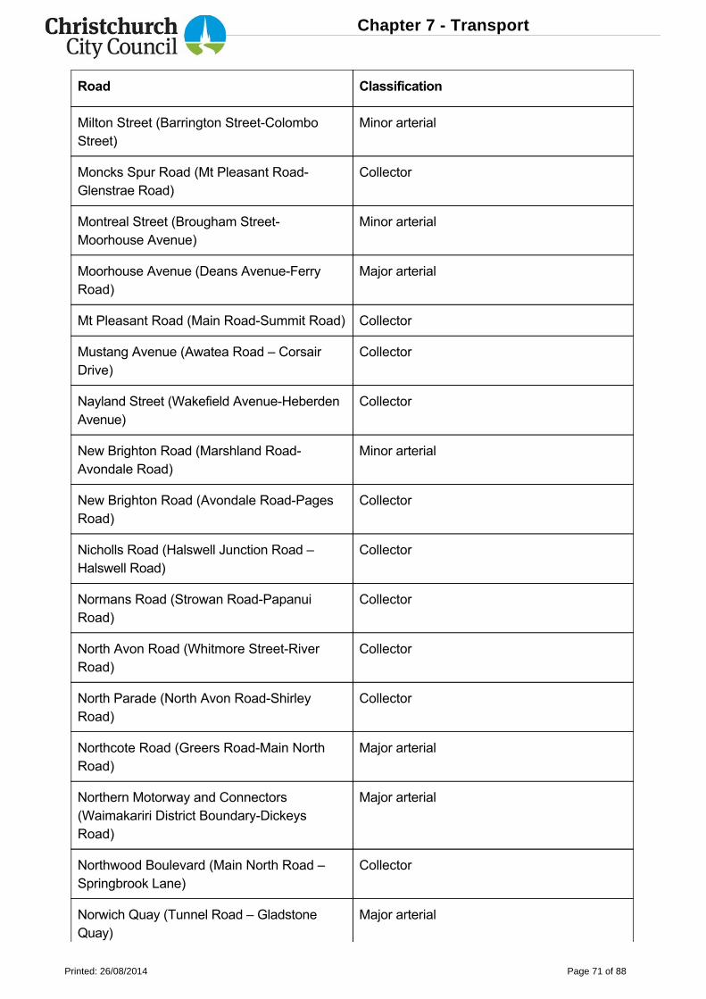
Road Classification
Milton Street (Barrington StreetColomboStreet)
Minor arterial
Moncks Spur Road (Mt Pleasant RoadGlenstrae Road)
Collector
Montreal Street (Brougham StreetMoorhouse Avenue)
Minor arterial
Moorhouse Avenue (Deans AvenueFerryRoad)
Major arterial
Mt Pleasant Road (Main RoadSummit Road) Collector
Mustang Avenue (Awatea Road – CorsairDrive)
Collector
Nayland Street (Wakefield AvenueHeberdenAvenue)
Collector
New Brighton Road (Marshland RoadAvondale Road)
Minor arterial
New Brighton Road (Avondale RoadPagesRoad)
Collector
Nicholls Road (Halswell Junction Road –Halswell Road)
Collector
Normans Road (Strowan RoadPapanuiRoad)
Collector
North Avon Road (Whitmore StreetRiverRoad)
Collector
North Parade (North Avon RoadShirleyRoad)
Collector
Northcote Road (Greers RoadMain NorthRoad)
Major arterial
Northern Motorway and Connectors(Waimakariri District BoundaryDickeysRoad)
Major arterial
Northwood Boulevard (Main North Road –Springbrook Lane)
Collector
Norwich Quay (Tunnel Road – GladstoneQuay)
Major arterial
Chapter 7 - Transport
Printed: 26/08/2014 Page 71 of 88
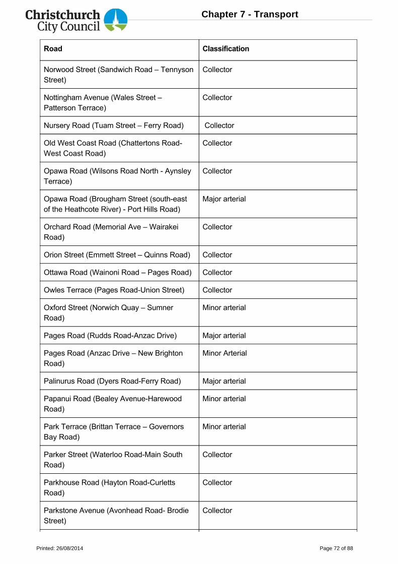
Road Classification
Norwood Street (Sandwich Road – TennysonStreet)
Collector
Nottingham Avenue (Wales Street –Patterson Terrace)
Collector
Nursery Road (Tuam Street – Ferry Road) Collector
Old West Coast Road (Chattertons RoadWest Coast Road)
Collector
Opawa Road (Wilsons Road North AynsleyTerrace)
Collector
Opawa Road (Brougham Street (southeastof the Heathcote River) Port Hills Road)
Major arterial
Orchard Road (Memorial Ave – WairakeiRoad)
Collector
Orion Street (Emmett Street – Quinns Road) Collector
Ottawa Road (Wainoni Road – Pages Road) Collector
Owles Terrace (Pages RoadUnion Street) Collector
Oxford Street (Norwich Quay – SumnerRoad)
Minor arterial
Pages Road (Rudds RoadAnzac Drive) Major arterial
Pages Road (Anzac Drive – New BrightonRoad)
Minor Arterial
Palinurus Road (Dyers RoadFerry Road) Major arterial
Papanui Road (Bealey AvenueHarewoodRoad)
Minor arterial
Park Terrace (Brittan Terrace – GovernorsBay Road)
Minor arterial
Parker Street (Waterloo RoadMain SouthRoad)
Collector
Parkhouse Road (Hayton RoadCurlettsRoad)
Collector
Parkstone Avenue (Avonhead Road BrodieStreet)
Collector
Chapter 7 - Transport
Printed: 26/08/2014 Page 72 of 88
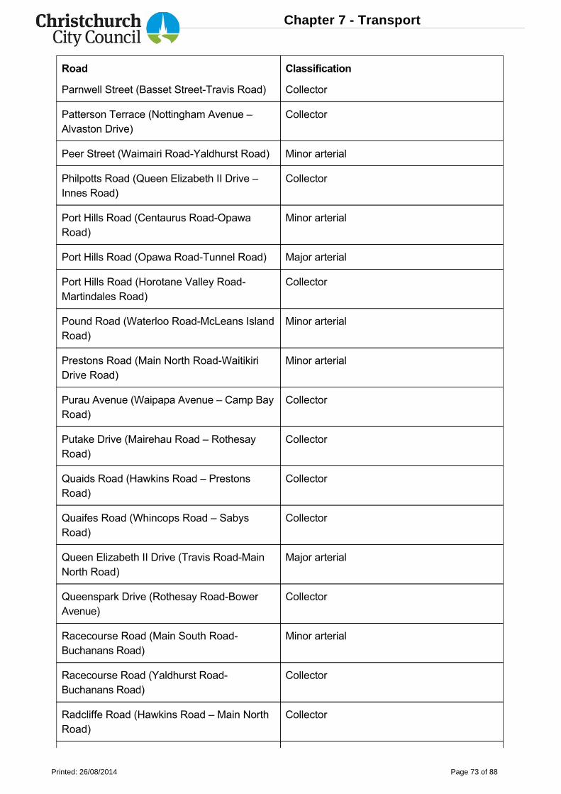
Road Classification
Parnwell Street (Basset StreetTravis Road) Collector
Patterson Terrace (Nottingham Avenue –Alvaston Drive)
Collector
Peer Street (Waimairi RoadYaldhurst Road) Minor arterial
Philpotts Road (Queen Elizabeth II Drive –Innes Road)
Collector
Port Hills Road (Centaurus RoadOpawaRoad)
Minor arterial
Port Hills Road (Opawa RoadTunnel Road) Major arterial
Port Hills Road (Horotane Valley RoadMartindales Road)
Collector
Pound Road (Waterloo RoadMcLeans IslandRoad)
Minor arterial
Prestons Road (Main North RoadWaitikiriDrive Road)
Minor arterial
Purau Avenue (Waipapa Avenue – Camp BayRoad)
Collector
Putake Drive (Mairehau Road – RothesayRoad)
Collector
Quaids Road (Hawkins Road – PrestonsRoad)
Collector
Quaifes Road (Whincops Road – SabysRoad)
Collector
Queen Elizabeth II Drive (Travis RoadMainNorth Road)
Major arterial
Queenspark Drive (Rothesay RoadBowerAvenue)
Collector
Racecourse Road (Main South RoadBuchanans Road)
Minor arterial
Racecourse Road (Yaldhurst RoadBuchanans Road)
Collector
Radcliffe Road (Hawkins Road – Main NorthRoad)
Collector
Chapter 7 - Transport
Printed: 26/08/2014 Page 73 of 88
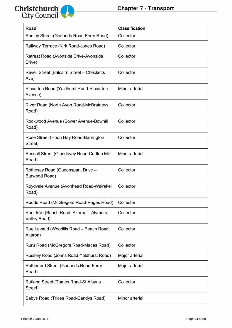
Road Classification
Radley Street (Garlands RoadFerry Road) Collector
Railway Terrace (Kirk RoadJones Road) Collector
Retreat Road (Avonside DriveAvonsideDrive)
Collector
Revell Street (Balcairn Street – CheckettsAve)
Collector
Riccarton Road (Yaldhurst RoadRiccartonAvenue)
Minor arterial
River Road (North Avon RoadMcBratneysRoad)
Collector
Rookwood Avenue (Bower AvenueBowhillRoad)
Collector
Rose Street (Hoon Hay RoadBarringtonStreet)
Collector
Rossall Street (Glandovey RoadCarlton MillRoad)
Minor arterial
Rothesay Road (Queenspark Drive –Burwood Road)
Collector
Roydvale Avenue (Avonhead RoadWairakeiRoad)
Collector
Rudds Road (McGregors RoadPages Road) Collector
Rue Jolie (Beach Road, Akaroa – AlymersValley Road)
Collector
Rue Lavaud (Woodills Road – Beach Road,Akaroa)
Collector
Ruru Road (McGregors RoadMaces Road) Collector
Russley Road (Johns RoadYaldhurst Road) Major arterial
Rutherford Street (Garlands RoadFerryRoad)
Major arterial
Rutland Street (Tomes RoadSt AlbansStreet)
Collector
Sabys Road (Trices RoadCandys Road) Minor arterial
Chapter 7 - Transport
Printed: 26/08/2014 Page 74 of 88
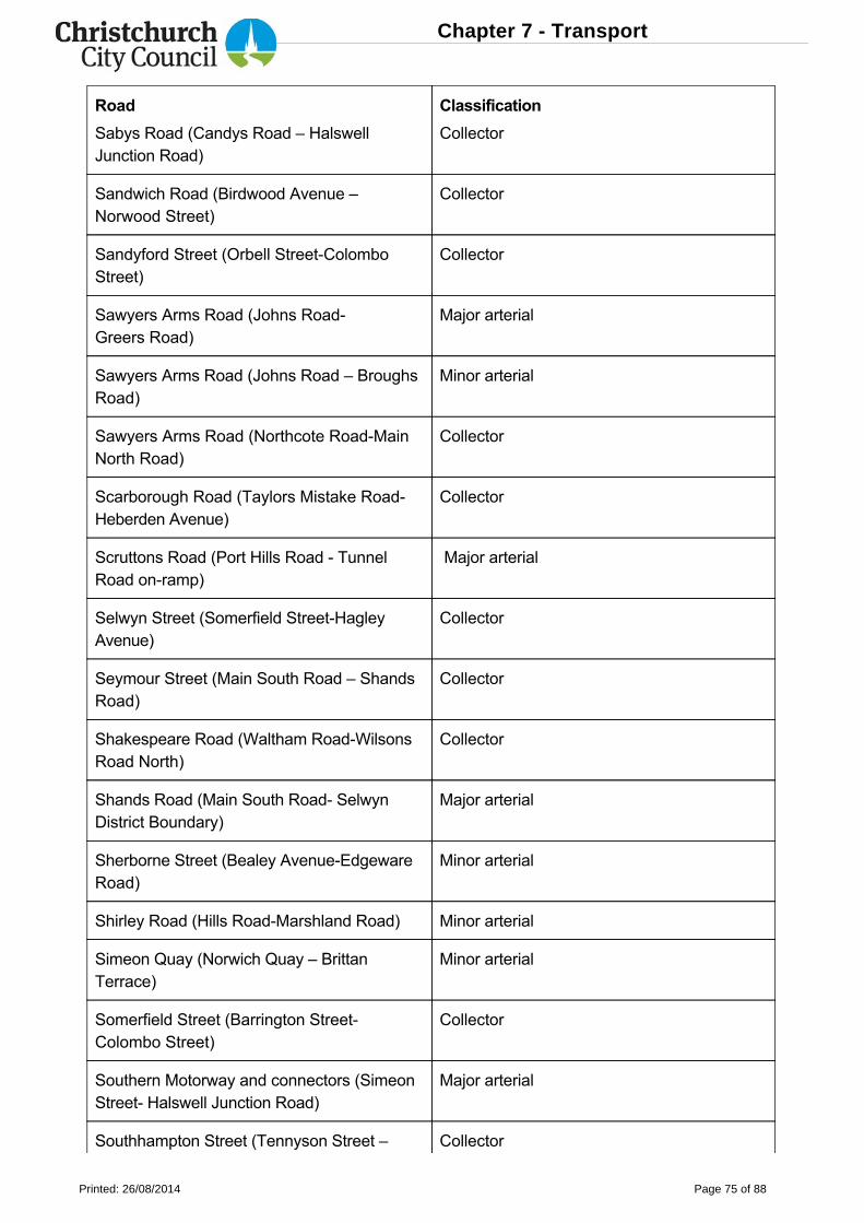
Road Classification
Sabys Road (Candys Road – HalswellJunction Road)
Collector
Sandwich Road (Birdwood Avenue –Norwood Street)
Collector
Sandyford Street (Orbell StreetColomboStreet)
Collector
Sawyers Arms Road (Johns RoadGreers Road)
Major arterial
Sawyers Arms Road (Johns Road – BroughsRoad)
Minor arterial
Sawyers Arms Road (Northcote RoadMainNorth Road)
Collector
Scarborough Road (Taylors Mistake RoadHeberden Avenue)
Collector
Scruttons Road (Port Hills Road TunnelRoad onramp)
Major arterial
Selwyn Street (Somerfield StreetHagleyAvenue)
Collector
Seymour Street (Main South Road – ShandsRoad)
Collector
Shakespeare Road (Waltham RoadWilsonsRoad North)
Collector
Shands Road (Main South Road SelwynDistrict Boundary)
Major arterial
Sherborne Street (Bealey AvenueEdgewareRoad)
Minor arterial
Shirley Road (Hills RoadMarshland Road) Minor arterial
Simeon Quay (Norwich Quay – BrittanTerrace)
Minor arterial
Somerfield Street (Barrington StreetColombo Street)
Collector
Southern Motorway and connectors (SimeonStreet Halswell Junction Road)
Major arterial
Southhampton Street (Tennyson Street – Collector
Chapter 7 - Transport
Printed: 26/08/2014 Page 75 of 88
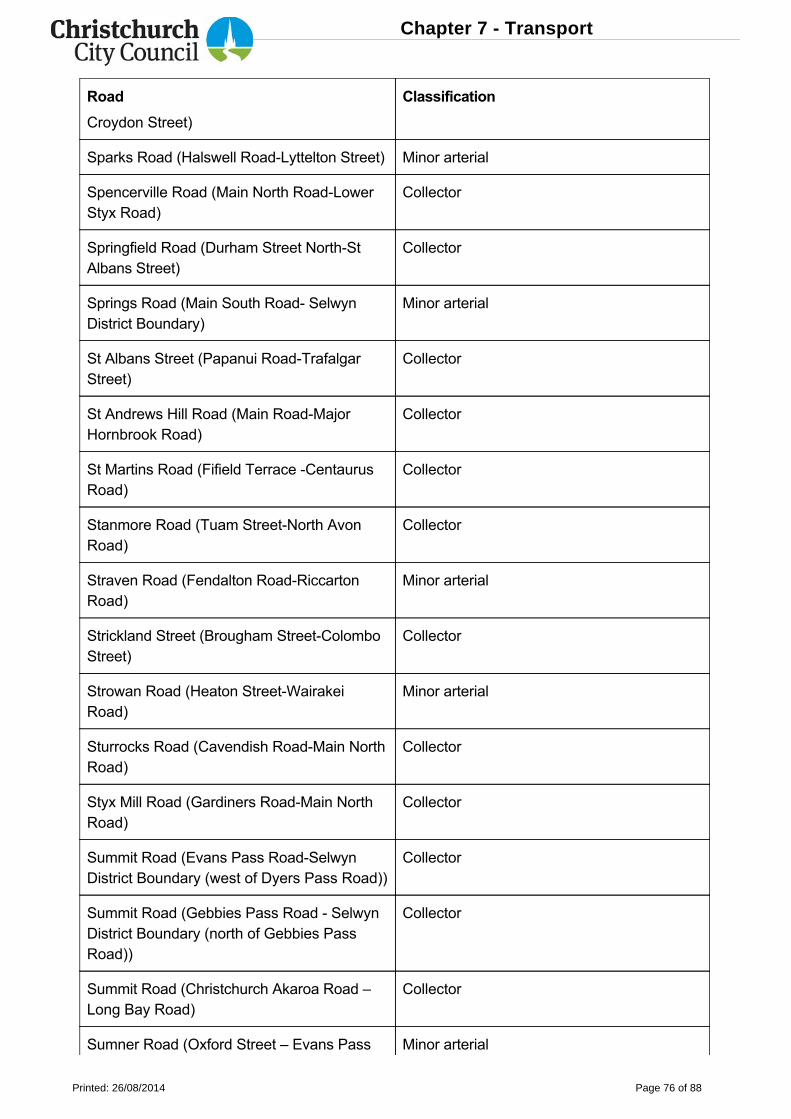
Road Classification
Croydon Street)
Sparks Road (Halswell RoadLyttelton Street) Minor arterial
Spencerville Road (Main North RoadLowerStyx Road)
Collector
Springfield Road (Durham Street NorthStAlbans Street)
Collector
Springs Road (Main South Road SelwynDistrict Boundary)
Minor arterial
St Albans Street (Papanui RoadTrafalgarStreet)
Collector
St Andrews Hill Road (Main RoadMajorHornbrook Road)
Collector
St Martins Road (Fifield Terrace CentaurusRoad)
Collector
Stanmore Road (Tuam StreetNorth AvonRoad)
Collector
Straven Road (Fendalton RoadRiccartonRoad)
Minor arterial
Strickland Street (Brougham StreetColomboStreet)
Collector
Strowan Road (Heaton StreetWairakeiRoad)
Minor arterial
Sturrocks Road (Cavendish RoadMain NorthRoad)
Collector
Styx Mill Road (Gardiners RoadMain NorthRoad)
Collector
Summit Road (Evans Pass RoadSelwynDistrict Boundary (west of Dyers Pass Road))
Collector
Summit Road (Gebbies Pass Road SelwynDistrict Boundary (north of Gebbies PassRoad))
Collector
Summit Road (Christchurch Akaroa Road –Long Bay Road)
Collector
Sumner Road (Oxford Street – Evans Pass Minor arterial
Chapter 7 - Transport
Printed: 26/08/2014 Page 76 of 88
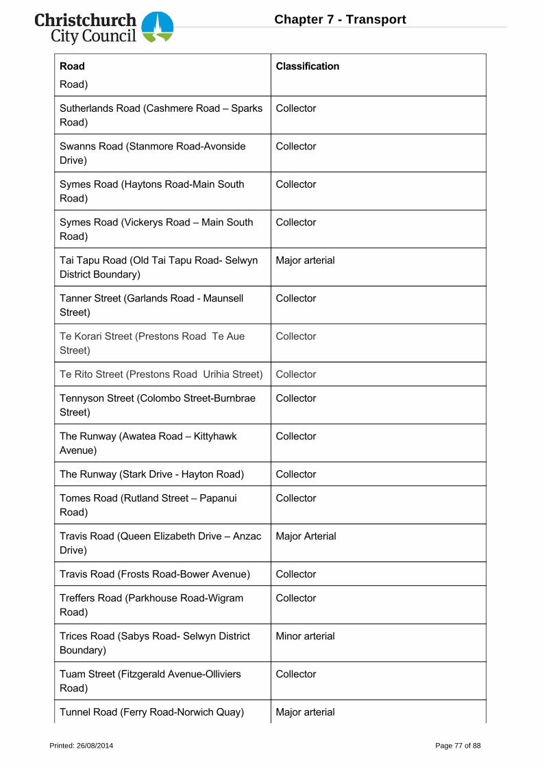
Road Classification
Road)
Sutherlands Road (Cashmere Road – SparksRoad)
Collector
Swanns Road (Stanmore RoadAvonsideDrive)
Collector
Symes Road (Haytons RoadMain SouthRoad)
Collector
Symes Road (Vickerys Road – Main SouthRoad)
Collector
Tai Tapu Road (Old Tai Tapu Road SelwynDistrict Boundary)
Major arterial
Tanner Street (Garlands Road MaunsellStreet)
Collector
Te Korari Street (Prestons Road Te AueStreet)
Collector
Te Rito Street (Prestons Road Urihia Street) Collector
Tennyson Street (Colombo StreetBurnbraeStreet)
Collector
The Runway (Awatea Road – KittyhawkAvenue)
Collector
The Runway (Stark Drive Hayton Road) Collector
Tomes Road (Rutland Street – PapanuiRoad)
Collector
Travis Road (Queen Elizabeth Drive – AnzacDrive)
Major Arterial
Travis Road (Frosts RoadBower Avenue) Collector
Treffers Road (Parkhouse RoadWigramRoad)
Collector
Trices Road (Sabys Road Selwyn DistrictBoundary)
Minor arterial
Tuam Street (Fitzgerald AvenueOlliviersRoad)
Collector
Tunnel Road (Ferry RoadNorwich Quay) Major arterial
Chapter 7 - Transport
Printed: 26/08/2014 Page 77 of 88
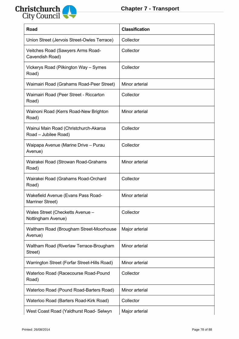
Road Classification
Union Street (Jervois StreetOwles Terrace) Collector
Veitches Road (Sawyers Arms RoadCavendish Road)
Collector
Vickerys Road (Pilkington Way – SymesRoad)
Collector
Waimairi Road (Grahams RoadPeer Street) Minor arterial
Waimairi Road (Peer Street RiccartonRoad)
Collector
Wainoni Road (Kerrs RoadNew BrightonRoad)
Minor arterial
Wainui Main Road (ChristchurchAkaroaRoad – Jubilee Road)
Collector
Waipapa Avenue (Marine Drive – PurauAvenue)
Collector
Wairakei Road (Strowan RoadGrahamsRoad)
Minor arterial
Wairakei Road (Grahams RoadOrchardRoad)
Collector
Wakefield Avenue (Evans Pass RoadMarriner Street)
Minor arterial
Wales Street (Checketts Avenue –Nottingham Avenue)
Collector
Waltham Road (Brougham StreetMoorhouseAvenue)
Major arterial
Waltham Road (Riverlaw TerraceBroughamStreet)
Minor arterial
Warrington Street (Forfar StreetHills Road) Minor arterial
Waterloo Road (Racecourse RoadPoundRoad)
Collector
Waterloo Road (Pound RoadBarters Road) Minor arterial
Waterloo Road (Barters RoadKirk Road) Collector
West Coast Road (Yaldhurst Road Selwyn Major arterial
Chapter 7 - Transport
Printed: 26/08/2014 Page 78 of 88
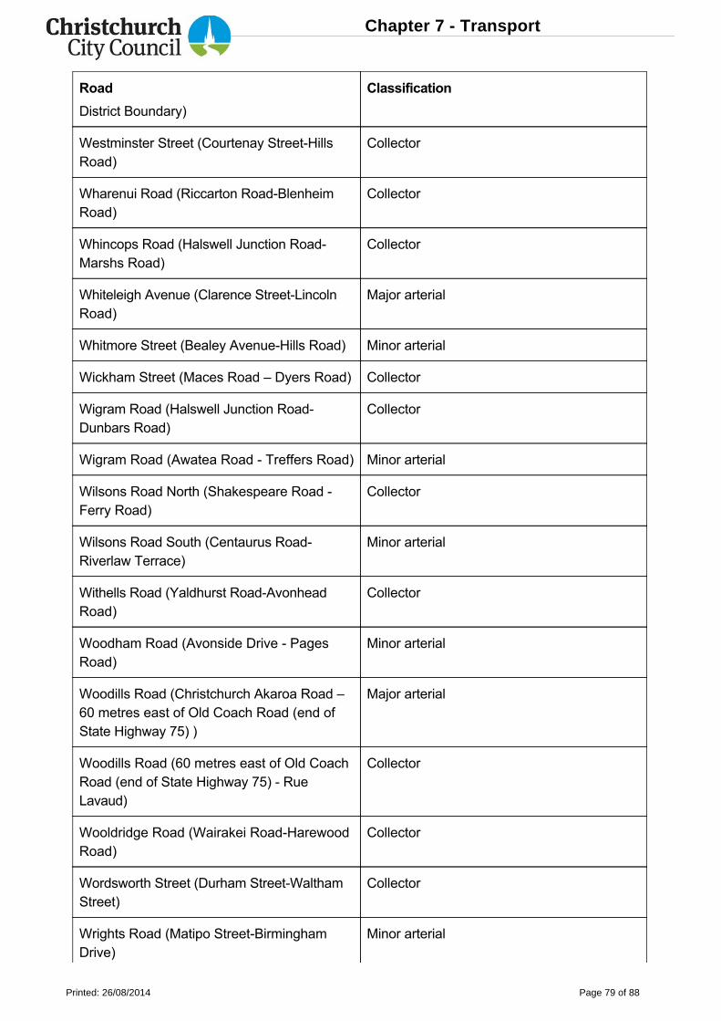
Road Classification
District Boundary)
Westminster Street (Courtenay StreetHillsRoad)
Collector
Wharenui Road (Riccarton RoadBlenheimRoad)
Collector
Whincops Road (Halswell Junction RoadMarshs Road)
Collector
Whiteleigh Avenue (Clarence StreetLincolnRoad)
Major arterial
Whitmore Street (Bealey AvenueHills Road) Minor arterial
Wickham Street (Maces Road – Dyers Road) Collector
Wigram Road (Halswell Junction RoadDunbars Road)
Collector
Wigram Road (Awatea Road Treffers Road) Minor arterial
Wilsons Road North (Shakespeare Road Ferry Road)
Collector
Wilsons Road South (Centaurus RoadRiverlaw Terrace)
Minor arterial
Withells Road (Yaldhurst RoadAvonheadRoad)
Collector
Woodham Road (Avonside Drive PagesRoad)
Minor arterial
Woodills Road (Christchurch Akaroa Road –60 metres east of Old Coach Road (end ofState Highway 75) )
Major arterial
Woodills Road (60 metres east of Old CoachRoad (end of State Highway 75) RueLavaud)
Collector
Wooldridge Road (Wairakei RoadHarewoodRoad)
Collector
Wordsworth Street (Durham StreetWalthamStreet)
Collector
Wrights Road (Matipo StreetBirminghamDrive)
Minor arterial
Chapter 7 - Transport
Printed: 26/08/2014 Page 79 of 88
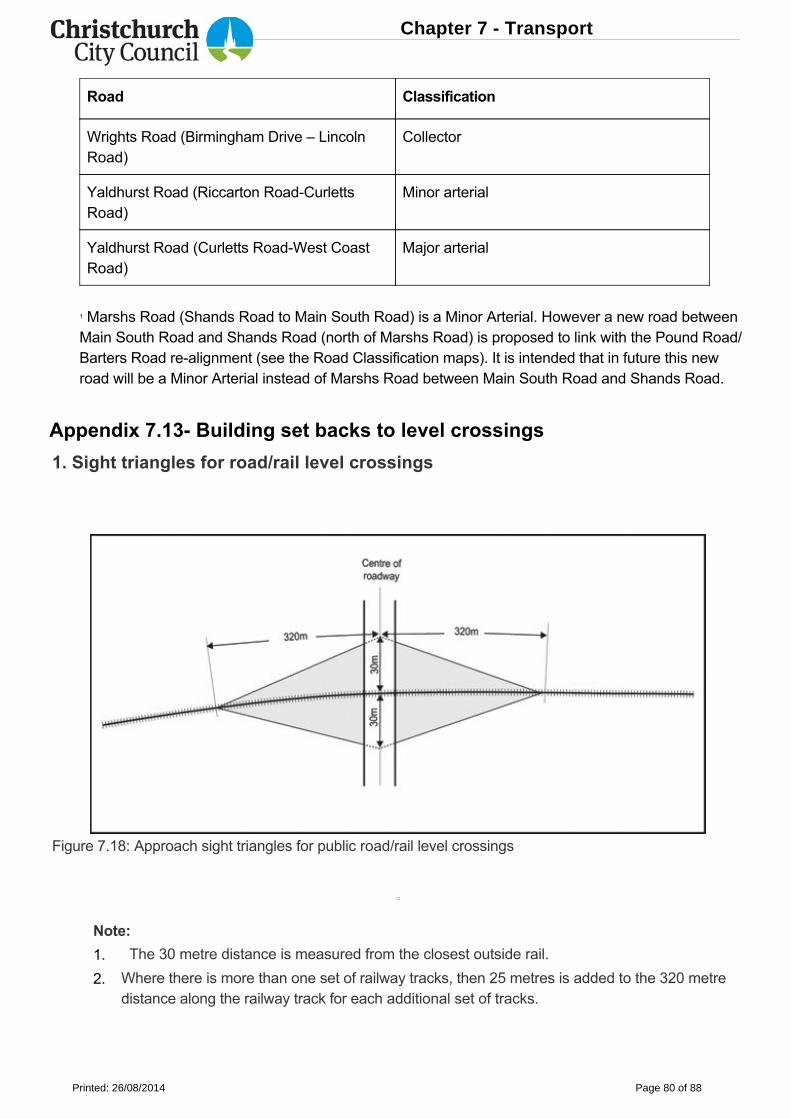
Road Classification
Wrights Road (Birmingham Drive – LincolnRoad)
Collector
Yaldhurst Road (Riccarton RoadCurlettsRoad)
Minor arterial
Yaldhurst Road (Curletts RoadWest CoastRoad)
Major arterial
1 Marshs Road (Shands Road to Main South Road) is a Minor Arterial. However a new road betweenMain South Road and Shands Road (north of Marshs Road) is proposed to link with the Pound Road/Barters Road realignment (see the Road Classification maps). It is intended that in future this newroad will be a Minor Arterial instead of Marshs Road between Main South Road and Shands Road.
Appendix 7.13 Building set backs to level crossings
1. Sight triangles for road/rail level crossings
Figure 7.18: Approach sight triangles for public road/rail level crossings
Note:
The 30 metre distance is measured from the closest outside rail.
Where there is more than one set of railway tracks, then 25 metres is added to the 320 metredistance along the railway track for each additional set of tracks.
1.
2.
Chapter 7 - Transport
Printed: 26/08/2014 Page 80 of 88
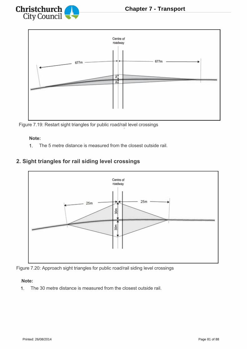
Figure 7.19: Restart sight triangles for public road/rail level crossings
Note:
2. Sight triangles for rail siding level crossings
Figure 7.20: Approach sight triangles for public road/rail siding level crossings
Note:
The 5 metre distance is measured from the closest outside rail.
The 30 metre distance is measured from the closest outside rail.
1.
1.
Chapter 7 - Transport
Printed: 26/08/2014 Page 81 of 88
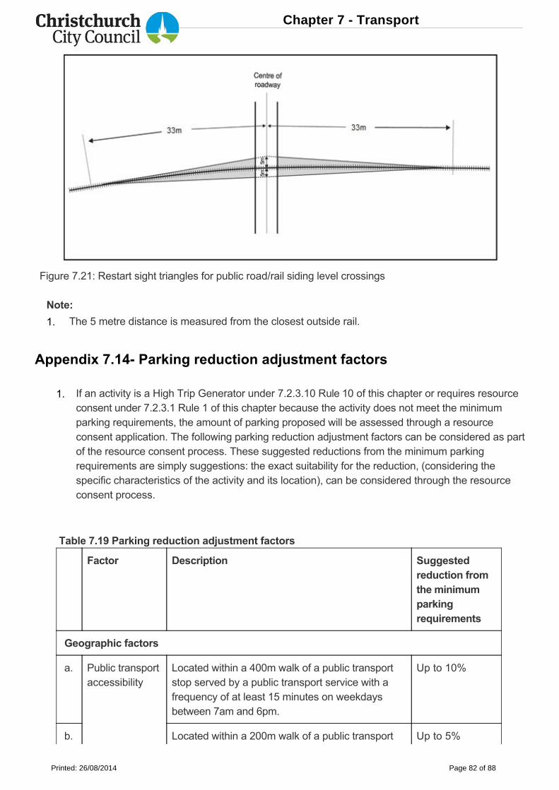
Figure 7.21: Restart sight triangles for public road/rail siding level crossings
Note:
Appendix 7.14 Parking reduction adjustment factors
Table 7.19 Parking reduction adjustment factors
Factor Description Suggestedreduction fromthe minimumparkingrequirements
Geographic factors
a. Public transportaccessibility
Located within a 400m walk of a public transportstop served by a public transport service with afrequency of at least 15 minutes on weekdaysbetween 7am and 6pm.
Up to 10%
b. Located within a 200m walk of a public transport Up to 5%
The 5 metre distance is measured from the closest outside rail.
If an activity is a High Trip Generator under 7.2.3.10 Rule 10 of this chapter or requires resourceconsent under 7.2.3.1 Rule 1 of this chapter because the activity does not meet the minimumparking requirements, the amount of parking proposed will be assessed through a resourceconsent application. The following parking reduction adjustment factors can be considered as partof the resource consent process. These suggested reductions from the minimum parkingrequirements are simply suggestions: the exact suitability for the reduction, (considering thespecific characteristics of the activity and its location), can be considered through the resourceconsent process.
1.
1.
Chapter 7 - Transport
Printed: 26/08/2014 Page 82 of 88
Factor Description Suggestedreduction fromthe minimumparkingrequirements
stop served by a public transport service1 with afrequency of at least 30 minutes on weekdaysbetween 7am and 6pm.
c. Public parkingfacility
Located within a 400m walk from an offstreet carpark that is available for use by the general public.
Up to 10%
d. Walkingaccessibility
Located within:
Up to 10%
e. Access to aMajor CycleRoute
Located within 800m of a Major Cycle Route. Up to 10%
Activity factors
f. Cycle parking The number of cycle parks (and lockers andshowers) provided for the activity exceeds therequirements under 7.2.3.2 Rule 2 (cycle parkingrequirements) by at least 5%.
Up to 5%
g. Cycle parkingfacilities
The activity provides additional cycle parkingfacilities such as secure bicycle storage lockers forvisitors and tyre pump and puncture repairequipment.
Up to 5%
h. Motorcycleparking
The activity provides motorcycle and scooterparking space. The number of motorcycles andscooters that the parking space caters for shall beat least 5% of the number of car parks that are
Up to 5%
an 800m walk of the Central City (i.e.within an 800m walk from one of the 'FourAvenues' (Bealey, Fitzgerald, Moorhouse,Deans, Harper Avenues), or
an 800m walk of a commercial zone that isidentified as a District Centre (refer toChapter 15), or
a 400m walk of a commercial zone that isidentified as a local or neighbourhoodcentre (refer to Chapter 15).
i.
ii.
iii.
Chapter 7 - Transport
Printed: 26/08/2014 Page 83 of 88
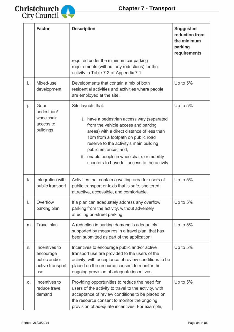
Factor Description Suggestedreduction fromthe minimumparkingrequirements
required under the minimum car parkingrequirements (without any reductions) for theactivity in Table 7.2 of Appendix 7.1.
i. Mixedusedevelopment
Developments that contain a mix of bothresidential activities and activities where peopleare employed at the site.
Up to 5%
j. Goodpedestrian/wheelchairaccess tobuildings
Site layouts that:
Up to 5%
k. Integration withpublic transport
Activities that contain a waiting area for users ofpublic transport or taxis that is safe, sheltered,attractive, accessible, and comfortable.
Up to 5%
l. Overflowparking plan
If a plan can adequately address any overflowparking from the activity, without adverselyaffecting onstreet parking.
Up to 5%
m. Travel plan A reduction in parking demand is adequatelysupported by measures in a travel plan that hasbeen submitted as part of the application3.
Up to 5%
n. Incentives toencouragepublic and/oractive transportuse
Incentives to encourage public and/or activetransport use are provided to the users of theactivity, with acceptance of review conditions to beplaced on the resource consent to monitor theongoing provision of adequate incentives.
Up to 5%
o. Incentives toreduce traveldemand
Providing opportunities to reduce the need forusers of the activity to travel to the activity, withacceptance of review conditions to be placed onthe resource consent to monitor the ongoingprovision of adequate incentives. For example,
Up to 5%
have a pedestrian access way (separatedfrom the vehicle access and parkingareas) with a direct distance of less than10m from a footpath on public roadreserve to the activity's main buildingpublic entrance2, and,
enable people in wheelchairs or mobilityscooters to have full access to the activity.
i.
ii.
Chapter 7 - Transport
Printed: 26/08/2014 Page 84 of 88
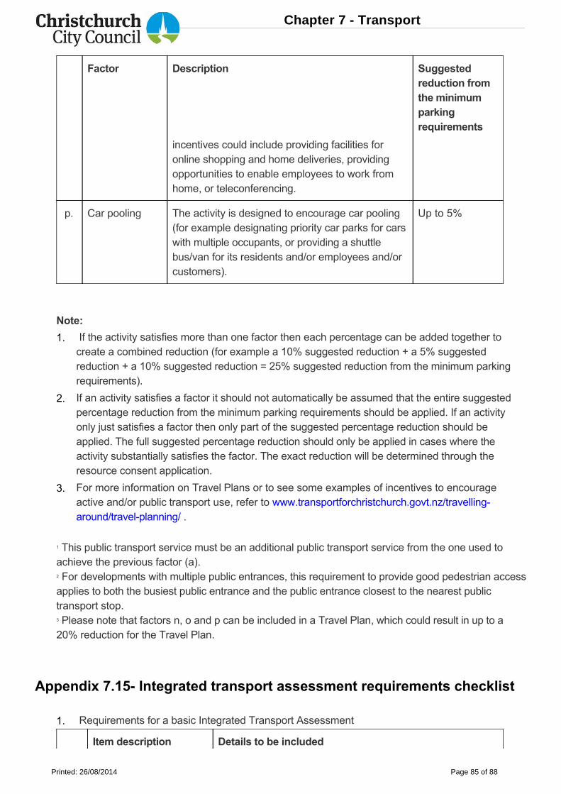
Factor Description Suggestedreduction fromthe minimumparkingrequirements
incentives could include providing facilities foronline shopping and home deliveries, providingopportunities to enable employees to work fromhome, or teleconferencing.
p. Car pooling The activity is designed to encourage car pooling(for example designating priority car parks for carswith multiple occupants, or providing a shuttlebus/van for its residents and/or employees and/orcustomers).
Up to 5%
Note:
1 This public transport service must be an additional public transport service from the one used toachieve the previous factor (a).2 For developments with multiple public entrances, this requirement to provide good pedestrian accessapplies to both the busiest public entrance and the public entrance closest to the nearest publictransport stop.3 Please note that factors n, o and p can be included in a Travel Plan, which could result in up to a20% reduction for the Travel Plan.
Appendix 7.15 Integrated transport assessment requirements checklist
Item description Details to be included
If the activity satisfies more than one factor then each percentage can be added together tocreate a combined reduction (for example a 10% suggested reduction + a 5% suggestedreduction + a 10% suggested reduction = 25% suggested reduction from the minimum parkingrequirements).
If an activity satisfies a factor it should not automatically be assumed that the entire suggestedpercentage reduction from the minimum parking requirements should be applied. If an activityonly just satisfies a factor then only part of the suggested percentage reduction should beapplied. The full suggested percentage reduction should only be applied in cases where theactivity substantially satisfies the factor. The exact reduction will be determined through theresource consent application.
For more information on Travel Plans or to see some examples of incentives to encourageactive and/or public transport use, refer to www.transportforchristchurch.govt.nz/travellingaround/travelplanning/ .
Requirements for a basic Integrated Transport Assessment
1.
2.
3.
1.
Chapter 7 - Transport
Printed: 26/08/2014 Page 85 of 88
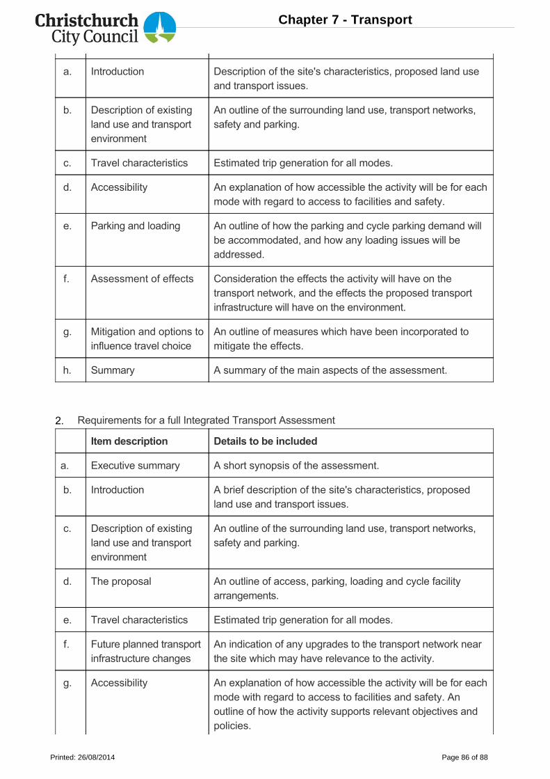
a. Introduction Description of the site's characteristics, proposed land useand transport issues.
b. Description of existingland use and transportenvironment
An outline of the surrounding land use, transport networks,safety and parking.
c. Travel characteristics Estimated trip generation for all modes.
d. Accessibility An explanation of how accessible the activity will be for eachmode with regard to access to facilities and safety.
e. Parking and loading An outline of how the parking and cycle parking demand willbe accommodated, and how any loading issues will beaddressed.
f. Assessment of effects Consideration the effects the activity will have on thetransport network, and the effects the proposed transportinfrastructure will have on the environment.
g. Mitigation and options toinfluence travel choice
An outline of measures which have been incorporated tomitigate the effects.
h. Summary A summary of the main aspects of the assessment.
Item description Details to be included
a. Executive summary A short synopsis of the assessment.
b. Introduction A brief description of the site's characteristics, proposedland use and transport issues.
c. Description of existingland use and transportenvironment
An outline of the surrounding land use, transport networks,safety and parking.
d. The proposal An outline of access, parking, loading and cycle facilityarrangements.
e. Travel characteristics Estimated trip generation for all modes.
f. Future planned transportinfrastructure changes
An indication of any upgrades to the transport network nearthe site which may have relevance to the activity.
g. Accessibility An explanation of how accessible the activity will be for eachmode with regard to access to facilities and safety. Anoutline of how the activity supports relevant objectives andpolicies.
Requirements for a full Integrated Transport Assessment2.
Chapter 7 - Transport
Printed: 26/08/2014 Page 86 of 88
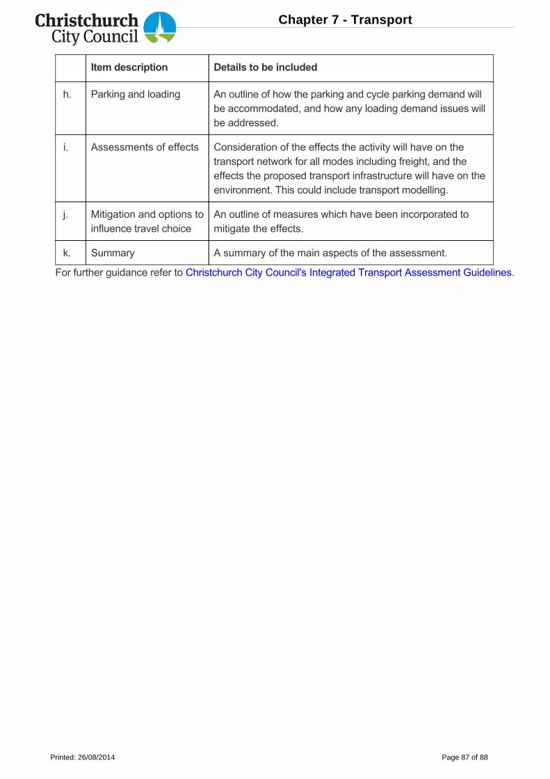
Item description Details to be included
h. Parking and loading An outline of how the parking and cycle parking demand willbe accommodated, and how any loading demand issues willbe addressed.
i. Assessments of effects Consideration of the effects the activity will have on thetransport network for all modes including freight, and theeffects the proposed transport infrastructure will have on theenvironment. This could include transport modelling.
j. Mitigation and options toinfluence travel choice
An outline of measures which have been incorporated tomitigate the effects.
k. Summary A summary of the main aspects of the assessment.
For further guidance refer to Christchurch City Council's Integrated Transport Assessment Guidelines.
Chapter 7 - Transport
Printed: 26/08/2014 Page 87 of 88

Chapter 7 - Transport
Printed: 26/08/2014 Page 88 of 88