Embed Size (px)
Citation preview
Kenya Agricultural Research InstituteNational Agricultural Research Laboratories
P.O. Box 14733, Tel: 4444140-44,4444029-32,4444250-56
KENYA SOIL SURVEY
THE SOILS OF MUGUNA IGOKI IRRIGATION SCHEMEMERU DISTRICT
BYP. K. KIMANI AND C. R. K. NJOROGE
SEMI-DETAILED SOIL SURVEY REPORT NO. S26, AUGUST, 2001KENYA SOIL SURVEY, NAIROBI
TABLE OF CONTENTS
Acknowledgements 11 INTRODUCTION 22 THE ENVIRONMENT 2
2.1 Location and communication 22.2 Climate 22.3 Geology, geomorphology and hydrology 22.4 Vegetation and present land use 3
3 WORKING METHODS 33.1 Office methods 33.2 Field methods 33.3 Laboratory 3
4 THE SOILS 44.1 The legend 44.2 Description of individual soil mapping units 54.3 Soil fertility status 9
5 QUALITY OF IRRIGATION WATER 106 LAND SUITABILITY CLASSIFICATION FORM SPRINKLER IRRIGATION 10
6.1 Introduction 106.2 Horticultural crop (fruits and vegetable) and their requirements 116.3 Land qualities 12
7 RECOMMENDATIONS AND CONCLUSIONS 148 REFERENCES 14
LIST OF TABLESTable 1: The annual potential evaporation (Eo) is about 1500mm giving a rainfall effectiveness
(r/Eo) of about 87% 2Table 2: Key to slope classes 4Table 3: Soil fertility status (0-30cm) 9Table 4: Quality of irrigation water 10Table 5: Suitability classification 13
LIST OF APPENDICESAppendix 1: Description of representative soil profiles with analytical data 15
ii
IIIIIIII
Acknowledgements
Acknowledgements are due to the following Director, National Agricultural ResearchLaboratories for giving us a "go ahead", the Head Kenya Soil, Survey (KSS) through whom therequest was received, CES Consulting Engineers for funding, Kenya Soil Survey Laboratoriesfor analyzing the soils and water samples and to all those who assisted in the work execution.
1
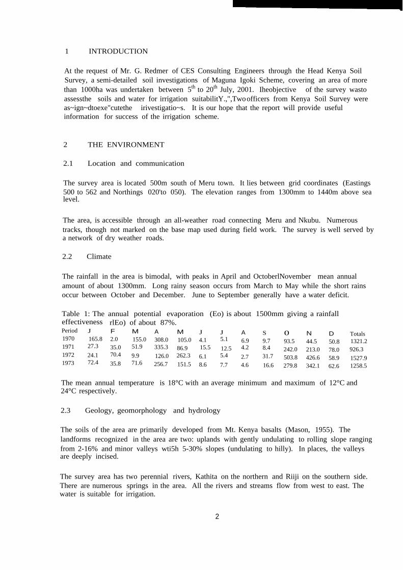
1 INTRODUCTION
At the request of Mr. G. Redmer of CES Consulting Engineers through the Head Kenya SoilSurvey, a semi-detailed soil investigations of Maguna Igoki Scheme, covering an area of morethan 1000ha was undertaken between 5th to 20th July, 2001. Iheobjective of the survey wastoassessthe soils and water for irrigation suitabilitY.,",Twoofficers from Kenya Soil Survey wereas~ign~dtoexe"cutethe irivestigatio~s. It is our hope that the report will provide usefulinformation for success of the irrigation scheme.
2 THE ENVIRONMENT
2.1 Location and communication
The survey area is located 500m south of Meru town. It lies between grid coordinates (Eastings500 to 562 and Northings 020'to 050). The elevation ranges from 1300mm to 1440m above sealevel.
The area, is accessible through an all-weather road connecting Meru and Nkubu. Numeroustracks, though not marked on the base map used during field work. The survey is well served bya network of dry weather roads.
2.2 Climate
The rainfall in the area is bimodal, with peaks in April and OctoberlNovember mean annualamount of about 1300mm. Long rainy season occurs from March to May while the short rainsoccur between October and December. June to September generally have a water deficit.
Table 1: The annual potential evaporation (Eo) is about 1500mm giving a rainfalleffectiveness rlEo) of about 87%.Period J F M A M J J A S 0 N D Totals1970 165.8 2.0 155.0 308.0 105.0 4.1 5.1 6.9 9.7 93.5 44.5 50.8 1321.21971 27.3 35.0 51.9 335.3 86.9 15.5 12.5 4.2 8.4 242.0 213.0 78.0 926.31972 24.1 70.4 9.9 126.0 262.3 6.1 5.4 2.7 31.7 503.8 426.6 58.9 1527.91973 72.4 35.8 71.6 256.7 151.5 8.6 7.7 4.6 16.6 279.8 342.1 62.6 1258.5
The mean annual temperature is 18°C with an average minimum and maximum of 12°C and24°C respectively.
2.3 Geology, geomorphology and hydrology
The soils of the area are primarily developed from Mt. Kenya basalts (Mason, 1955). Thelandforms recognized in the area are two: uplands with gently undulating to rolling slope rangingfrom 2-16% and minor valleys wti5h 5-30% slopes (undulating to hilly). In places, the valleysare deeply incised.
The survey area has two perennial rivers, Kathita on the northern and Riiji on the southern side.There are numerous springs in the area. All the rivers and streams flow from west to east. Thewater is suitable for irrigation.
2
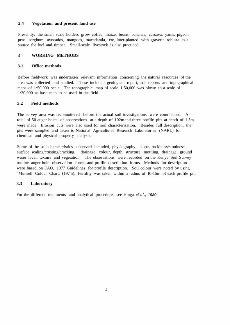
2.4 Vegetation and present land use
Presently, the small scale holders grow coffee, maize, beans, bananas, cassava, yams, pigeonpeas, sorghum, avocados, mangoes, macadamia, etc, inter-planted with graveria robusta as asource for fuel and timber. Small-scale livestock is also practiced.
3 WORKING METHODS
3.1 Office methods
Before fieldwork was undertaken relevant information concerning the natural resources of thearea was collected and studied. These included geological report, soil reports and topographicalmaps of 1:50,000 scale. The topographic map of scale 1:50,000 was blown to a scale of1:20,000 as base map to be used in the field.
3.2 Field methods
The survey area was reconnoitered before the actual soil investigations were commenced. Atotal of 50 auger-holes of observations at a depth of 102mand three profile pits at depth of 1.5mwere made. Erosion cuts were also used for soil characterisation. Besides full description, thepits were sampled and taken to National Agricultural Research Laboratories (NARL) forchemical and physical property analysis.
Some of the soil characteristics observed included, physiography, slope, rockiness/stoniness,surface sealing/crusting/cracking, drainage, colour, depth, structure, mottling, drainage, groundwater level, texture and vegetation. The observations were recorded on the Kenya Soil Surveyroutine auger-hole observation forms and profile description forms. Methods for descriptionwere based on FAO, 1977 Guidelines for profile description. Soil colour were noted by using"Munsell Colour Chart, (197 5). Fertility was taken within a radius of 10-15m of each profile pit.
3.3 Laboratory
For the different treatments and analytical procedure, see Hinga et a!., 1980
3
4 THE SOILS
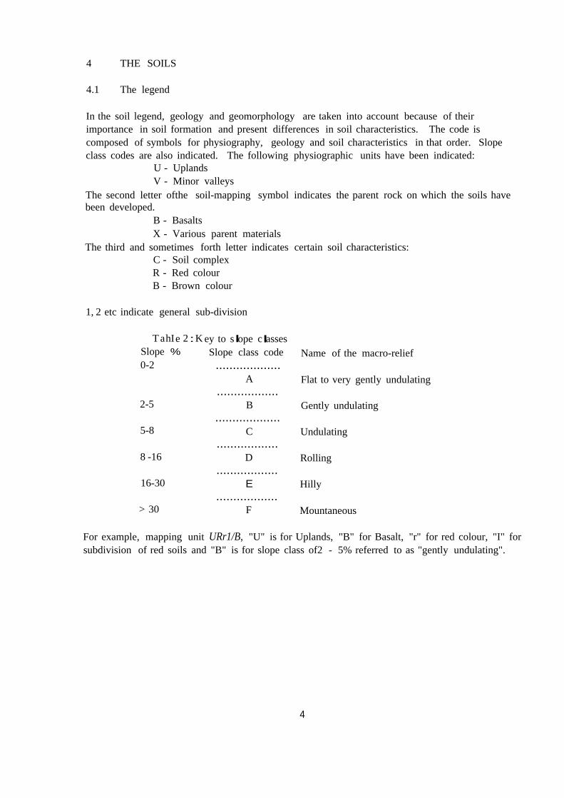
4.1 The legend
In the soil legend, geology and geomorphology are taken into account because of theirimportance in soil formation and present differences in soil characteristics. The code iscomposed of symbols for physiography, geology and soil characteristics in that order. Slopeclass codes are also indicated. The following physiographic units have been indicated:
U - UplandsV - Minor valleys
The second letter ofthe soil-mapping symbol indicates the parent rock on which the soils havebeen developed.
B - BasaltsX - Various parent materials
The third and sometimes forth letter indicates certain soil characteristics:C - Soil complexR - Red colourB - Brown colour
1, 2 etc indicate general sub-division
T hI 2 K I Ia e : ey to s ope c assesSlope % Slope class code Name of the macro-relief0-2 ...................
A Flat to very gently undulating..................
2-5 B Gently undulating...................
5-8 C Undulating..................
8 -16 D Rolling..................
16-30 E Hilly..................
> 30 F Mountaneous
For example, mapping unit URr1/B, "U" is for Uplands, "B" for Basalt, "r" for red colour, "I" forsubdivision of red soils and "B" is for slope class of2 - 5% referred to as "gently undulating".
4
4.2 Description of individual soil mapping units
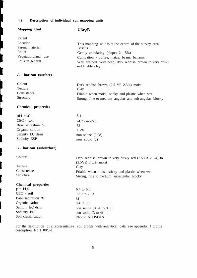
Mapping Unit
ExtentLocationParent materialReliefVegetation/land useSoils in general
This mapping unit is at the centre of the survey areaBasaltsGently undulating (slopes 2 - 5%)Cultivation - coffee, maize, beans, bananasWell drained, very deep, dark reddish brown to very duskyred friable clay
A - horizon (surface)
ColourTextureConsistenceStructure
Dark reddish brown (2.5 YR 2.5/4) moistClayFriable when moist, sticky and plastic when wetStrong, fine to medium angular and sub-angular blocky
Chemical properties
pH-H20CEC - soilBase saturation %Organic carbonSalinity EC ds/mSodicity ESP
6.424.7 cmol/kg531.7%non saline (0.08)non sodic (2)
B - horizon (subsurface)
Colour Dark reddish brown to very dusky red (2.5YR 2.5/4) to(2.5YR 2.5/2) moistClayFriable when moist, sticky and plastic when wetStrong, fine to medium subangular blocky
TextureConsistenceStructure
Chemical propertiespH-H20CEC - soilBase saturation %Organic carbonSalinity EC ds/mSodicity ESPSoil classification
6.4 to 6.617.9 to 25.3610.4 to 0.5non saline (0.04 to 0.06)non sodic (3 to 4)Rhodic NITISOLS
For the description of a representative soil profile with analytical data, see appendix I profiledescription No.1 08/3-1.
5
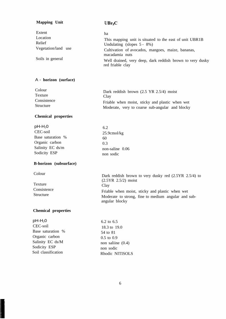
Mapping Unit
ExtentLocationReliefVegetation/land use
haThis mapping unit is situated to the east of unit UBR1BUndulating (slopes 5 - 8%)Cultivation of avocados, mangoes, maize, bananas,macadamia nutsWell drained, very deep, dark reddish brown to very duskyred friable clay
Soils in general
A - horizon (surface)
ColourTextureConsistenceStructure
Dark reddish brown (2.5 YR 2.5/4) moistClayFriable when moist, sticky and plastic when wetModerate, very to coarse sub-angular and blocky
Chemical properties
pH-H20CEC-soilBase saturation %Organic carbonSalinity EC ds/mSodicity ESP
6.225.9cmol/kg600.3non-saline 0.06non sodic
B-horizon (subsurface)
Colour Dark reddish brown to very dusky red (2.5YR 2.5/4) to(2.5YR 2.5/2) moistClayFriable when moist, sticky and plastic when wetModerate to strong, fine to medium angular and sub-angular blocky
TextureConsistenceStructure
Chemical properties
pH-H20CEC-soilBase saturation %Organic carbonSalinity EC ds/MSodicity ESPSoil classification
6.2 to 6.518.3 to 19.054 to 810.5 to 0.9non saliine (0.4)non sodicRhodic NITISOLS
6
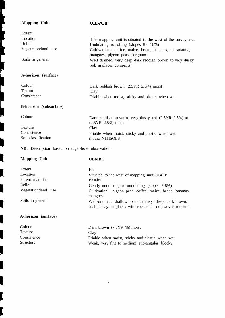
Mapping Unit
ExtentLocationReliefVegetation/land use
This mapping unit is situated to the west of the survey areaUndulating to rolling (slopes 8 - 16%)Cultivation - coffee, maize, beans, bananas, macadamia,mangoes, pigeon peas, sorghumWell drained, very deep dark reddish brown to very duskyred, in places compacts
Soils in general
A-horizon (surface)
ColourTextureConsistence
Dark reddish brown (2.5YR 2.5/4) moistClayFriable when moist, sticky and plastic when wet
B-horizon (subsurface)
Colour Dark reddish brown to very dusky red (2.5YR 2.5/4) to(2.5YR 2.5/2) moistClayFriable when moist, sticky and plastic when wetrhodic NITISOLS
TextureConsistenceSoil classification
NB: Description based on auger-hole observation
Mapping Unit UBbIBC
ExtentLocationParent materialReliefVegetation/land use
HaSituated to the west of mapping unit UBrl/BBasaltsGently undulating to undulating (slopes 2-8%)Cultivation - pigeon peas, coffee, maize, beans, bananas,mangoesWell-drained, shallow to moderately deep, dark brown,friable clay; in places with rock out - crops/over murrum
Soils in general
A-horizon (surface)
ColourTextureConsistenceStructure
Dark brown (7.5YR %) moistClayFriable when moist, sticky and plastic when wetWeak, very fine to medium sub-angular blocky
7
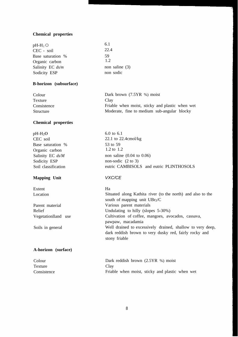
Chemical properties
pH-H20CEC - soilBase saturation %Organic carbonSalinity EC ds/mSodicity ESP
6.122.4591.2non saline (3)non sodic
B-horizon (subsurface)
ColourTextureConsistenceStructure
Dark brown (7.5YR %) moistClayFriable when moist, sticky and plastic when wetModerate, fine to medium sub-angular blocky
Chemical properties
pH-H20CEC soilBase saturation %Organic carbonSalinity EC ds/MSodicity ESPSoil classification
6.0 to 6.122.1 to 22.4cmol/kg53 to 591.2 to 1.2non saline (0.04 to 0.06)non-sodic (2 to 3)eutric CAMBISOLS and eutric PLINTHOSOLS
Mapping Unit VXC/CE
ExtentLocation
HaSituated along Kathita river (to the north) and also to thesouth of mapping unit UBr2/CVarious parent materialsUndulating to hilly (slopes 5-30%)Cultivation of coffee, mangoes, avocados, cassava,pawpaw, macadamiaWell drained to excessively drained, shallow to very deep,dark reddish brown to very dusky red, fairly rocky andstony friable
Parent materialReliefVegetationlland use
Soils in general
A-horizon (surface)
ColourTextureConsistence
Dark reddish brown (2.5YR %) moistClayFriable when moist, sticky and plastic when wet
8
B-horizon (subsurface)
Colour Dark reddish brown to very dusky red (2.5YR %) to(2.5YR 2.5/4) moistClayrhodic NITISOLS, eutric CAMBISOLS and lithicLEPTOSOLS
TextureClassification
NB: Description based on auger-hole observations
4.3 Soil fertility status
The fertility status were based on the data collected from the surface layers (0-30cm). The resultsare considered as indicative of general tendencies of the fertility levels of the soils. The resultsare shown in Table 2.
Table 3: Soil fertility status (O-30cm)Soil mapping Unit UBrllB UBr2/C UBbIBCLab No. 1 2 3pH-H2O 4.9 4.9 4.9Name% 0.4 0.3 0.4Kme/% 1.0 0.4 0.8Came/% 7.3 5.8 4.5Mgme/% 2.2 2.8 2.3Mnme/% 0.8 1.0 0.8P ppm (mehlich) 16 28 7N% 0.1 0.2 0.1C% 1.1 1.9 1.4HPme% 0.5 0.3 0.4EC dslM 0.1 0.01 0.1Fe ppm 56 42.0 61Cu ppm 8.0 3.4 0.8Zn ppm 54 29 19Deficiencies Underlined
As shown from the table above, soil reaction is strongly acid. Most of the plant nutrients viz:potassium, calcium, magnesium, manganese, iron, copper and zinc are adequately suppliedwhereas and phosphorous and nitrogen are deficient. The organic matter is moderate as shownby the % carbon.
In view ofthis:-
Apply at least 2.5 tons of farmyard manure or compost. This will improve the soilstructure and moisture retention capacityApply NPK fertilizers to supply the deficient nutrients (N and P). Though potassium isadequate, the available fertilizers are compound in formulationApply at least 1000kg/ha of dolomitic limestone to raise the pH of the soil. This will alsosupply calcium and magnesium.
9
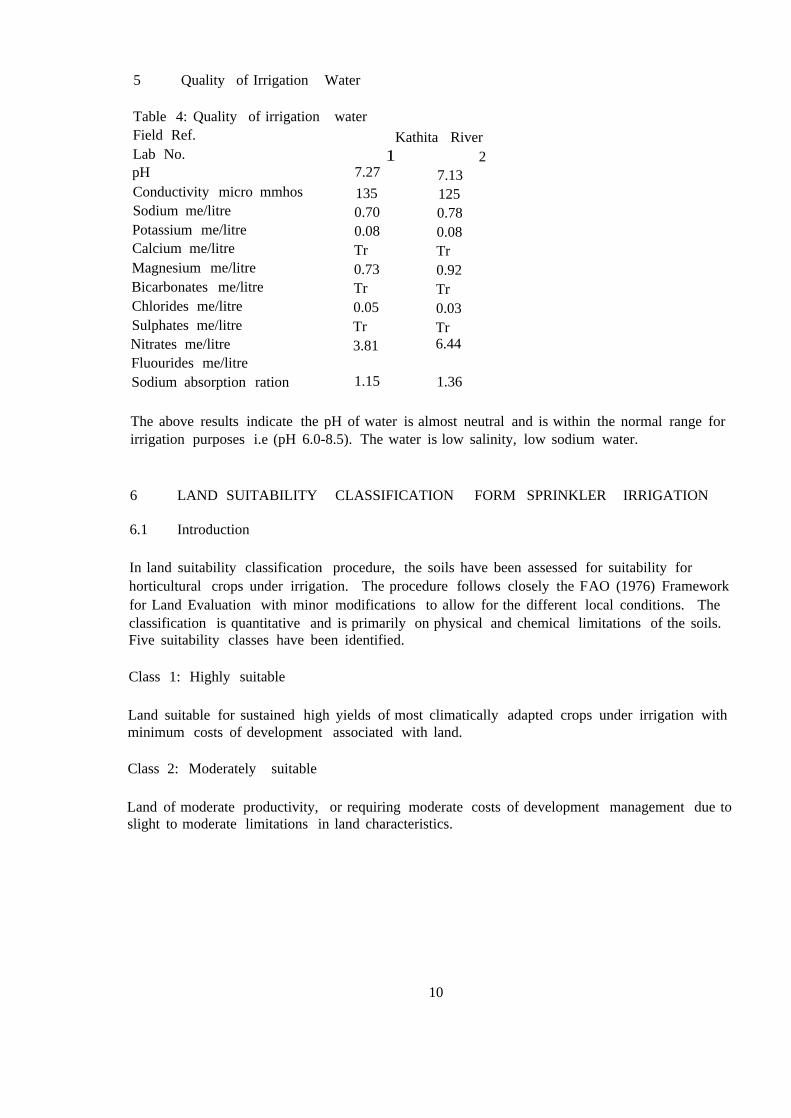
5 Quality of Irrigation Water
Table 4: Quality of irrigation waterField Ref. Kathita RiverLab No. 1 2pH 7.27 7.13Conductivity micro mmhos 135 125Sodium me/litre 0.70 0.78Potassium me/litre 0.08 0.08Calcium me/litre Tr TrMagnesium me/litre 0.73 0.92Bicarbonates me/litre Tr TrChlorides me/litre 0.05 0.03Sulphates me/litre Tr TrNitrates me/litre 3.81 6.44Fluourides me/litreSodium absorption ration 1.15 1.36
The above results indicate the pH of water is almost neutral and is within the normal range forirrigation purposes i.e (pH 6.0-8.5). The water is low salinity, low sodium water.
6 LAND SUITABILITY CLASSIFICATION FORM SPRINKLER IRRIGATION
6.1 Introduction
In land suitability classification procedure, the soils have been assessed for suitability forhorticultural crops under irrigation. The procedure follows closely the FAO (1976) Frameworkfor Land Evaluation with minor modifications to allow for the different local conditions. Theclassification is quantitative and is primarily on physical and chemical limitations of the soils.Five suitability classes have been identified.
Class 1: Highly suitable
Land suitable for sustained high yields of most climatically adapted crops under irrigation withminimum costs of development associated with land.
Class 2: Moderately suitable
Land of moderate productivity, or requiring moderate costs of development management due toslight to moderate limitations in land characteristics.
10
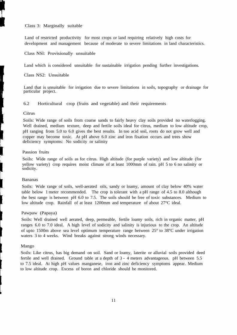
Class 3: Marginally suitable
Land of restricted productivity for most crops or land requiring relatively high costs fordevelopment and management because of moderate to severe limitations in land characteristics.
Class NSl: Provisionally unsuitable
Land which is considered unsuitable for sustainable irrigation pending further investigations.
Class NS2: Unsuitable
Land that is unsuitable for irrigation due to severe limitations in soils, topography or drainage forparticular project.
6.2 Horticultural crop (fruits and vegetable) and their requirements
CitrusSoils: Wide range of soils from coarse sands to fairly heavy clay soils provided no waterlogging.Well drained, medium texture, deep and fertile soils ideal for citrus, medium to low altitude crop,pH ranging from 5.0 to 6.0 gives the best results. In too acid soil, roots do not grow well andcopper may become toxic. At pH above 6.0 zinc and iron fixation occurs and trees showdeficiency symptoms: No sodicity or salinity
Passion fruitsSoils: Wide range of soils as for citrus. High altitude (for purple variety) and low altitude (foryellow variety) crop requires moist climate of at least 1000mm of rain. pH 5 to 6 no salinity orsodicity.
BananasSoils: Wide range of soils, well-aerated oils, sandy or loamy, amount of clay below 40% watertable below 1 meter recommended. The crop is tolerant with a pH range of 4.5 to 8.0 althoughthe best range is between pH 6.0 to 7.5. The soils should be free of toxic substances. Medium tolow altitude crop. Rainfall of at least 1200mm and temperature of about 27°C ideal.
Pawpaw (Papaya)Soils: Well drained well aerated, deep, permeable, fertile loamy soils, rich in organic matter, pHranges 6.0 to 7.0 ideal. A high level of sodicity and salinity is injurious to the crop. An altitudeof upto 1500m above sea level optimum temperature range between 25° to 38°C under irrigationwaters 3 to 4 weeks. Wind breaks against strong winds necessary.
MangoSoils: Like citrus, has big demand on soil. Sand or loamy, laterite or alluvial soils provided deedfertile and well drained. Ground table at a depth of 3 - 4 meters advantageous. pH between 5.5to 7.5 ideal. At high pH values manganese, iron and zinc deficiency symptoms appear. Mediumto low altitude crop. Excess of boron and chloride should be monitored.
11
B: Vegetables
Onion (also leeks, garlic and chivas)Soils: Fertile, well drained, sandy loams but can grow in a wide range of soils, friable and notcompact. pH range between 6.0 to 7.0, cool conditions, adequate moisture supply followed bywarm conditions for maturation, harvesting and curing. Excessive nitrogen slows down bulbing.
Cabbages (also kale's Brussels sprout, cauliflower and rape)Soils: Wide variety of soils with a cool moist climate. The ideal soils for Brassicas is rich sandyloam. Best performance altitudes above 1000 meters. pH range generally between 5.5 andabove. The crop is not acid tolerant.
OkraSoils: Any type of soil but does best on well manured loams.
CucumberSoils: Wide variety of soil but they do best on well manured sand loam. The crop cannotwithstand water logging. pH 6.8 to 7.5. Requires warm climate, but not as hot as for melons.Water melon, melonSoils: Rich laom soils but grows best in fertile sand soils particularly on sandy riverbanks.Fairly drought resistant. Requires hot drier areas with plenty of sunshine. The plant cannotwithstand waterlogging. pH ranges as near neutral as possible for the plant does not tolerateacidity.
ChiliesSoils: Grows best in loam soils rich in lime but can be grown on a variety of soils provided welldrained no water logging. Grows from sea level to 2000 meters and above.
Egg plant (brinjals)Soils: The crop grows best in well drained sand loams but can be grown in a wide variety ofsoils. Grows well upto 1000 meters.
TomatoesSoils: A light frees draining, fertile loam but can be grown on a variety of soils. pH ranges 5.0 to7.0. The crop has a wide climatic tolerant.
BeansSoils: Well-drained, moderately fertile loam with a depth of 50 - 70cm. Low tolerance tosalinity. Optimal daily temperature I5-20De.
6.3 Land qualities
When evaluating the soil for suitability for horticultural crops the following land qualities weretaken into consideration:
Chemical soil fertilityDrainageEffective soil depthTopography/slope
12
i
~
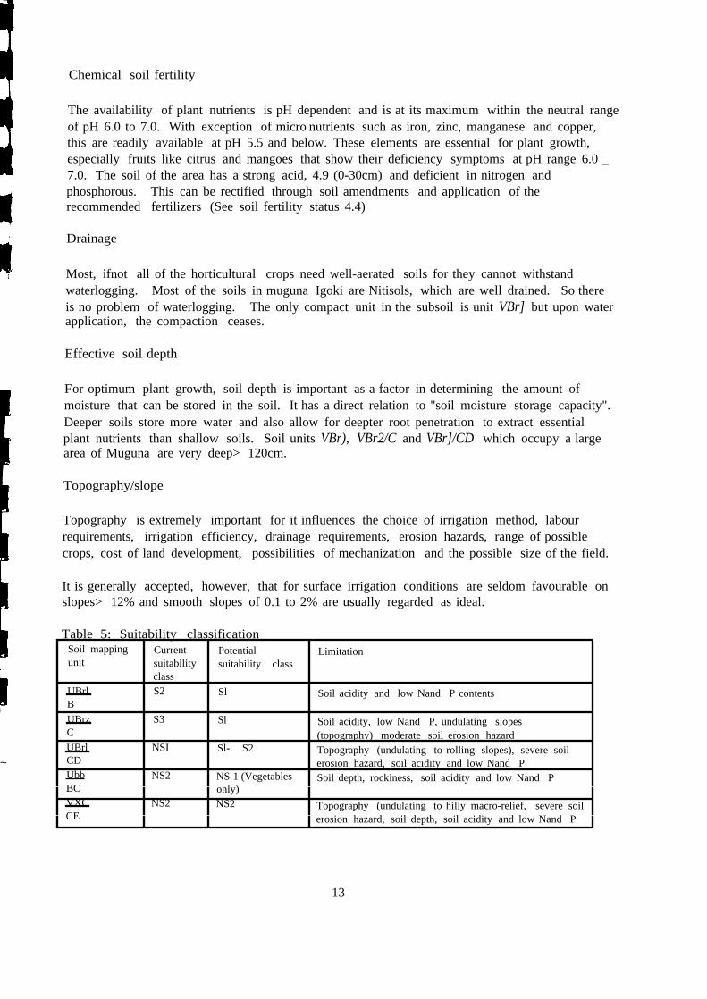
Chemical soil fertility
The availability of plant nutrients is pH dependent and is at its maximum within the neutral rangeof pH 6.0 to 7.0. With exception of micro nutrients such as iron, zinc, manganese and copper,this are readily available at pH 5.5 and below. These elements are essential for plant growth,especially fruits like citrus and mangoes that show their deficiency symptoms at pH range 6.0 _7.0. The soil of the area has a strong acid, 4.9 (0-30cm) and deficient in nitrogen andphosphorous. This can be rectified through soil amendments and application of therecommended fertilizers (See soil fertility status 4.4)
Drainage
Most, ifnot all of the horticultural crops need well-aerated soils for they cannot withstandwaterlogging. Most of the soils in muguna Igoki are Nitisols, which are well drained. So thereis no problem of waterlogging. The only compact unit in the subsoil is unit VBr] but upon waterapplication, the compaction ceases.
Effective soil depth
For optimum plant growth, soil depth is important as a factor in determining the amount ofmoisture that can be stored in the soil. It has a direct relation to "soil moisture storage capacity".Deeper soils store more water and also allow for deepter root penetration to extract essentialplant nutrients than shallow soils. Soil units VBr), VBr2/C and VBr]/CD which occupy a largearea of Muguna are very deep> 120cm.
Topography/slope
Topography is extremely important for it influences the choice of irrigation method, labourrequirements, irrigation efficiency, drainage requirements, erosion hazards, range of possiblecrops, cost of land development, possibilities of mechanization and the possible size of the field.
It is generally accepted, however, that for surface irrigation conditions are seldom favourable onslopes> 12% and smooth slopes of 0.1 to 2% are usually regarded as ideal.
Table 5: Suitability classificationSoil mapping Current Potential Limitationunit suitability suitability class
classUBrl S2 Sl Soil acidity and low Nand P contentsBUBrz S3 Sl Soil acidity, low Nand P, undulating slopesC (topography) moderate soil erosion hazardUBrl NSI Sl- S2 Topography (undulating to rolling slopes), severe soilCD erosion hazard, soil acidity and low Nand PUbb NS2 NS 1 (Vegetables Soil depth, rockiness, soil acidity and low Nand PBC only)VXC NS2 NS2 Topography (undulating to hilly macro-relief, severe soilCE erosion hazard, soil depth, soil acidity and low Nand P
13
7 Recommendations and Conclusions
The best area for irrigation is soil unit UBrl1B
No irrigation can be done in soil unit VXC/CE because of high hazards of soil erosionas a result of steep slopesGravaria robusta and Napier grass be planted in unit VXC/CEUnder whatever type of irrigation, water distribution and management has to behandled properly, particularly on soils of suitability classification "S3" withsignificant slopes.
Soils of units UBrIIB, UBr2/C and UBrJ!CD are easy to till because they are friableand porous, a marked structure stability and their consistence is not extremely hardwhen dry nor sticky and plastic when wet.
Addition of fertilizer and farm yard manure improves soil fertility status and structureThe soils are low in phosphorus and nitrogenSoil and water conservation personnel should be consulted for the design of anti-erosive structures, if any irrigation shall take place on soils of classification NS 1 andS3.
14
8 REFERENCES
FAO, 1974. Soil survey in irrigation suitability. FAO Rome
FAO, 1976. Framework for Land Evaluation. FAO Rome
FAO, 1977. Guidelines for soil profile description (2nd edition), FAO Rome
FAO-UNESCO, 1997. Soil Map of the world. Revised Legend with corrections. ISRIC,Wageningen
Hinga, G. et a11980. Physical and chemical methods of soil analysis. National AgriculturalLaboratories, Nairobi
Kenya Soil Survey, 1977. Internal Communication No.7. Proposal for rating land qualities
Main Report, 1988. Fertilizer Use Recommendation Project, Nairobi
Mason, P. 1955. Geology of the Meru-Isiolo Area. Government Printer, Nairobi
Munsell Colour Co. 1975. Munsel Colour Charts, Baltimore, Maryland (U.S.A)
Sombroek W. G., H. M. H Braun and Van der Pouw, 1982. Exploratory Soil Map of Kenyaand Agro-climatic zone map of Kenya 1:1,000,000. Report E 1, Kenya Soil Survey, Nairobi
Survey of Kenya, 1970. National Atlas of Kenya
Wood Head T., 1968. Studies of potential evaporation in Kenya
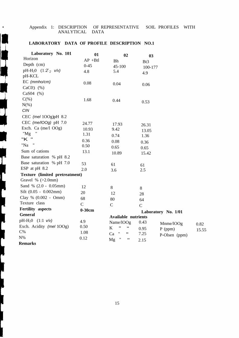
• Appendix 1: DESCRIPTION OF REPRESENTATIVE SOIL PROFILES WITHANALYTICAL DATA
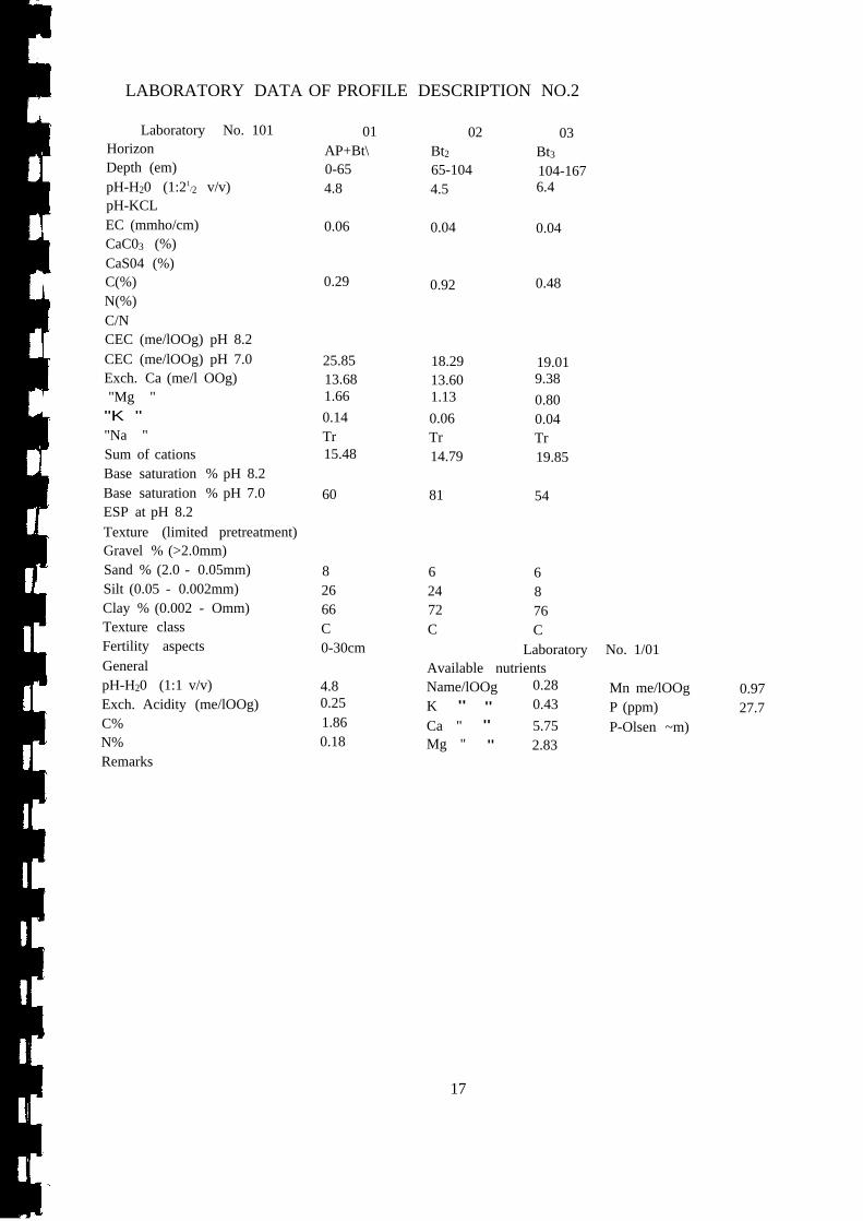
LABORATORY DATA OF PROFILE DESCRIPTION NO.1
Laboratory No. 101 01 02 03Horizon AP +Btl Bh Bt3Depth (cm) 0-45 45-100 100-177pH-H20 (1 :21
/2 v/v) 4.8 5.4 4.9pH-KCLEC (mmho/cm) 0.08 0.04 0.06CaC03 (%)CaS04 (%)C(%) 1.68 0.44 0.53N(%)CINCEC (mel 1OOg)pH 8.2CEC (me/lOOg) pH 7.0 24.77 17.93 26.31Exch. Ca (me/l OOg) 10.93 9.42 13.05"Mg " 1.31 0.74 1.36"K " 0.36 0.08 0.36"Na " 0.50 0.65 0.65Sum of cations 13.1 10.89 15.42Base saturation % pH 8.2Base saturation % pH 7.0 53 61 61ESP at pH 8.2 2.0 3.6 2.5Texture (limited pretreatment)Gravel % (>2.0mm)Sand % (2.0 - 0.05mm) 12 8 8Silt (0.05 - 0.002mm) 20 12 28Clay % (0.002 - Omm) 68 80 64Texture class C C CFertility aspects 0-30cm Laboratory No. 1/01General Available nutrientspH-H20 (1:1 v/v) 4.9 Name/lOOg 0.43 Mnme/lOOg 0.82Exch. Acidity (mel 1OOg) 0.50 K " " 0.95 P (ppm) 15.55C% 1.08 Ca " " 7.25 P-Olsen (ppm)N% 0.12 Mg " " 2.15Remarks
15
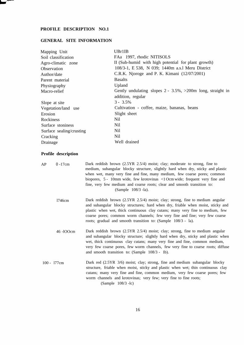
UBr1IBFAa 1997, rhodic NITISOLSII (Sub-humid with high potential for plant growth)108/3-1, E 538, N 039; 1440m a.s.l Meru DistrictC.R.K. Njoroge and P. K. Kimani (12/07/2001)BasaltsUplandGently undulating slopes 2 - 3.5%, >200m long, straight inaddition, regular3 - 3.5%Cultivation - coffee, maize, bananas, beansSlight sheetNilNilNilNilWell drained
PROFILE DESCRIPTION NO.1
GENERAL SITE INFORMATION
Mapping UnitSoil classificationAgro-climatic zoneObservationAuthor/dateParent materialPhysiographyMacro-relief
Slope at siteVegetation/land useErosionRockinessSurface stoninessSurface sealing/crustingCrackingDrainage
Profile description
AP o -17cm
l746cm
46 -lOOcm
100 - l77cm
Dark reddish brown (2.5YR 2.5/4) moist; clay; moderate to strong, fine tomedium, subangular blocky structure, slightly hard when dry, sticky and plasticwhen wet, many very fine and fine, many medium, few coarse pores; commonbiopores, 5 - 10mm wide, few krotovinas <1Ocm wide; frequent very fine andfine, very few medium and coarse roots; clear and smooth transition to:
(Sample 108/3 -la).
Dark reddish brown (2.5YR 2.5/4) moist; clay; strong, fine to medium angularand subangular blocky structures; hard when dry, friable when moist, sticky andplastic when wet, thick continuous clay cutans; many very fine to medium, fewcoarse pores; common worm channels; few very fine and fine; very few coarseroots; gradual and smooth transition to: (Sample 108/3 - la).
Dark reddish brown (2.5YR 2.5/4) moist; clay; strong, fine to medium angularand subangular blocky structure; slightly hard when dry, sticky and plastic whenwet, thick continuous clay cutans; many very fine and fine, common medium,very few coarse pores, few worm channels, few very fine to coarse roots; diffuseand smooth transition to: (Sample 108/3 - 1b).
Dark red (2.5YR 3/6) moist; clay; strong, fine and medium subangular blockystructure, friable when moist, sticky and plastic when wet; thin continuous claycutans; many very fine and fine, common medium, very few coarse pores; fewworm channels and krotovinas; very few; very fine to fine roots;
(Sample 108/3 -lc)
16
LABORATORY DATA OF PROFILE DESCRIPTION NO.2
Laboratory No. 101 01 02 03Horizon AP+Bt\ Bt2 Bt3Depth (em) 0-65 65-104 104-167pH-H20 (1:21
/2 v/v) 4.8 4.5 6.4pH-KCLEC (mmho/cm) 0.06 0.04 0.04CaC03 (%)CaS04 (%)C(%) 0.29 0.92 0.48N(%)C/NCEC (me/lOOg) pH 8.2CEC (me/lOOg) pH 7.0 25.85 18.29 19.01Exch. Ca (me/l OOg) 13.68 13.60 9.38"Mg " 1.66 1.13 0.80"K " 0.14 0.06 0.04"Na " Tr Tr TrSum of cations 15.48 14.79 19.85Base saturation % pH 8.2Base saturation % pH 7.0 60 81 54ESP at pH 8.2Texture (limited pretreatment)Gravel % (>2.0mm)Sand % (2.0 - 0.05mm) 8 6 6Silt (0.05 - 0.002mm) 26 24 8Clay % (0.002 - Omm) 66 72 76Texture class C C CFertility aspects 0-30cm Laboratory No. 1/01General Available nutrientspH-H20 (1:1 v/v) 4.8 Name/lOOg 0.28 Mn me/lOOg 0.97Exch. Acidity (me/lOOg) 0.25 K " " 0.43 P (ppm) 27.7C% 1.86 Ca " " 5.75 P-Olsen ~m)N% 0.18 Mg " " 2.83Remarks
17
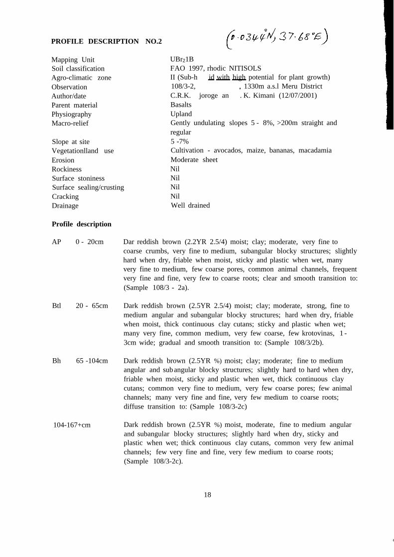
PROFILE DESCRIPTION NO.2
UBr21BFAO 1997, rhodic NITISOLSII (Sub-h id with high potential for plant growth)108/3-2, , 1330m a.s.l Meru DistrictC.R.K. joroge an . K. Kimani (12/07/2001)BasaltsUplandGently undulating slopes 5 - 8%, >200m straight andregular5 -7%Cultivation - avocados, maize, bananas, macadamiaModerate sheetNilNilNilNilWell drained
Mapping UnitSoil classificationAgro-climatic zoneObservationAuthor/dateParent materialPhysiographyMacro-relief
Slope at siteVegetationlland useErosionRockinessSurface stoninessSurface sealing/crustingCrackingDrainage
Profile description
AP 0 - 20cm Dar reddish brown (2.2YR 2.5/4) moist; clay; moderate, very fine tocoarse crumbs, very fine to medium, subangular blocky structures; slightlyhard when dry, friable when moist, sticky and plastic when wet, manyvery fine to medium, few coarse pores, common animal channels, frequentvery fine and fine, very few to coarse roots; clear and smooth transition to:(Sample 108/3 - 2a).
Btl 20 - 65cm Dark reddish brown (2.5YR 2.5/4) moist; clay; moderate, strong, fine tomedium angular and subangular blocky structures; hard when dry, friablewhen moist, thick continuous clay cutans; sticky and plastic when wet;many very fine, common medium, very few coarse, few krotovinas, 1 -3cm wide; gradual and smooth transition to: (Sample 108/3/2b).
Bh 65 -104cm Dark reddish brown (2.5YR %) moist; clay; moderate; fine to mediumangular and subangular blocky structures; slightly hard to hard when dry,friable when moist, sticky and plastic when wet, thick continuous claycutans; common very fine to medium, very few coarse pores; few animalchannels; many very fine and fine, very few medium to coarse roots;diffuse transition to: (Sample 108/3-2c)
104-167+cm Dark reddish brown (2.5YR %) moist, moderate, fine to medium angularand subangular blocky structures; slightly hard when dry, sticky andplastic when wet; thick continuous clay cutans, common very few animalchannels; few very fine and fine, very few medium to coarse roots;(Sample 108/3-2c).
18
(
19
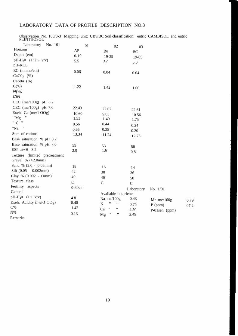
LABORATORY DATA OF PROFILE DESCRIPTION NO.3
Observation No. 108/3-3 Mapping unit: UBv/BC Soil classification: eutric CAMBISOL and eutricPLINTHOSOL
Laboratory No. 101 01 02 03Horizon AP Bu BCDepth (em) 0-19 19-39 19-65pH-H20 (1 :21/2 v/v) 5.5 5.0 5.0pH-KCLEC (mmho/em) 0.06 0.04 0.04CaC03 (%)CaS04 (%)C(%) 1.22 1.42 1.00N(%)CINCEC (me/100g) pH 8.2CEC (me/100g) pH 7.0 22.43 22.07 22.61Exeh. Ca (me/1 OOg) 10.60 9.05 10.56"Mg " 1.53 1.40 1.75"K " 0.56 0.44 0.24"Na " 0.65 0.35 0.20Sum of cations 13.34 11.24 12.75Base saturation % pH 8.2Base saturation % pH 7.0 59 53 56ESP at~H 8.2 2.9 1.6 0.8Texture (limited pretreatmentGravel % (>2.0mm)Sand % (2.0 - 0.05mm) 18 16 14Silt (0.05 - 0.002mm) 42 38 36Clay % (0.002 - Omm) 40 46 50Texture class C C CFertility aspects 0-30cm Laboratory No. 1/01General Available nutrientspH-H20 (1:1 v/v) 4.8 Na me/100g 0.43 Mn me/100g 0.79Exeh. Acidity lme/1 OOg) 0.40 K " " 0.75 P (ppm) 07.2C% 1.42 Ca " " 4.50 P-01sen (ppm)N% 0.13 Mg " " 2.49Remarks

PROFILE DESCRIPTION NO.3
Mapping UnitSoil classificationAgro-climatic zoneObservationAuthor/dateParent materialPhysiographyMacro-relief
Slope at siteVegetation/land use
ErosionRockinessSurface stoninessSurface sealing/crustingCrackingDrainage
Profile description
AP 0-19cm
BU 19-39cm
BC 30-65cm
65+cm
UBbIBCFAO 1997, eutric CAMBISOLS and eutric PLINTHOSOLSII (Sub-humid with high potential for plant growth)108/3-3, E 522', N 037; 1440m a.s.l Meru DistrictC.R.K. Njoroge and P. K. Kimani (12/07/2001)BasaltsUplandFlat to gently undulating; slopes 0 - 3%, convex Regularslopes2%Cultivation - coffee, pigeon peas, maize, bananas,mangoes, beans, etc.Very slight sheetVery few rocksFew stonesNil
Well drained
Dark brown (7.5YR %) moist; clay; weak, very fine to medium subangularblocky structure; friable when moist, sticky and plastic when wet, manyvery fine and fine, common medium, few coarse pores, few termite nests;many very fine and fine roots; clear and smooth transition to:
(Sample 108/3-2a).
Dark brown (7.5YR %) moist; clay; moderate, fine to medium subangularblocky; friable when moist, sticky and plastic when wet; many very fineand fine, common medium, few coarse pores; few animal channels, fewvery fine and fine roots; clear and smooth transition to:
(Sample I08/3-2b).
Dark reddish brown (5YR 3/3) moist; clay; weak very fine to medium,subangular blocky structure; friable when moist, sticky and plastic whenwet, many very fine and fine, medium to coarse pores, few animalchannels; few fine and fine roots;
(Sample I08/3-2c).
Weathering rock
20