Embed Size (px)
Citation preview

BookletChart™ Keweenaw Waterway, Including Torch Lake NOAA Chart 14972
A reduced-scale NOAA nautical chart for small boaters When possible, use the full-size NOAA chart for navigation.
Included Area

2
Published by the National Oceanic and Atmospheric Administration
National Ocean Service Office of Coast Survey
www.NauticalCharts.NOAA.gov 888-990-NOAA
What are Nautical Charts?
Nautical charts are a fundamental tool of marine navigation. They show water depths, obstructions, buoys, other aids to navigation, and much more. The information is shown in a way that promotes safe and efficient navigation. Chart carriage is mandatory on the commercial ships that carry America’s commerce. They are also used on every Navy and Coast Guard ship, fishing and passenger vessels, and are widely carried by recreational boaters.
What is a BookletChart?
This BookletChart is made to help recreational boaters locate themselves on the water. It has been reduced in scale for convenience, but otherwise contains all the information of the full-scale nautical chart. The bar scales have also been reduced, and are accurate when used to measure distances in this BookletChart. See the Note at the bottom of page 5 for the reduction in scale applied to this chart.
Whenever possible, use the official, full scale NOAA nautical chart for navigation. Nautical chart sales agents are listed on the Internet at http://www.NauticalCharts.NOAA.gov.
This BookletChart does NOT fulfill chart carriage requirements for regulated commercial vessels under Titles 33 and 44 of the Code of Federal Regulations.
Notice to Mariners Correction Status
This BookletChart has been updated for chart corrections published in the U.S. Coast Guard Local Notice to Mariners, the National Geospatial Intelligence Agency Weekly Notice to Mariners, and, where applicable, the Canadian Coast Guard Notice to Mariners. Additional chart corrections have been made by NOAA in advance of their publication in a Notice to Mariners. The last Notices to Mariners applied to this chart are listed in the Note at the bottom of page 7. Coast Pilot excerpts are not being corrected.
For latest Coast Pilot excerpt visit the Office of Coast Survey website at http://www.nauticalcharts.noaa.gov/nsd/searchbychart.php?chart=14972.
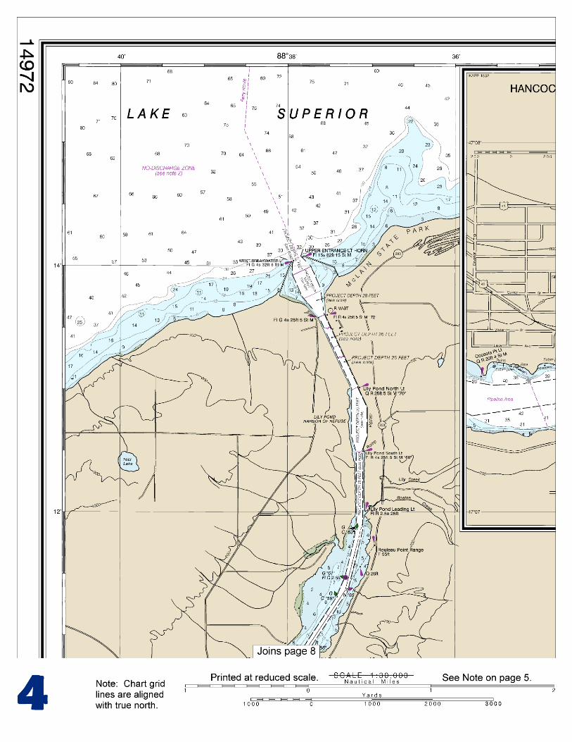
(Selected Excerpts from Coast Pilot) Keweenaw Waterway, about 25 miles long, crosses Keweenaw Peninsula from Keweenaw Bay on the southeast side to the open water of Lake Superior on the northwest side. The waterway follows Portage River from its mouth in Keweenaw Bay for 5 miles to Portage Lake, thence extends for 17.5 miles through the lake to its head, and thence follows a dredged cut from the head of Portage Lake to Lake Superior.
Regulations.–An 8 mph (7 knots) speed limit is enforced in Keweenaw Waterway. (See 33 CFR 162.115, chapter 2, for regulations.)
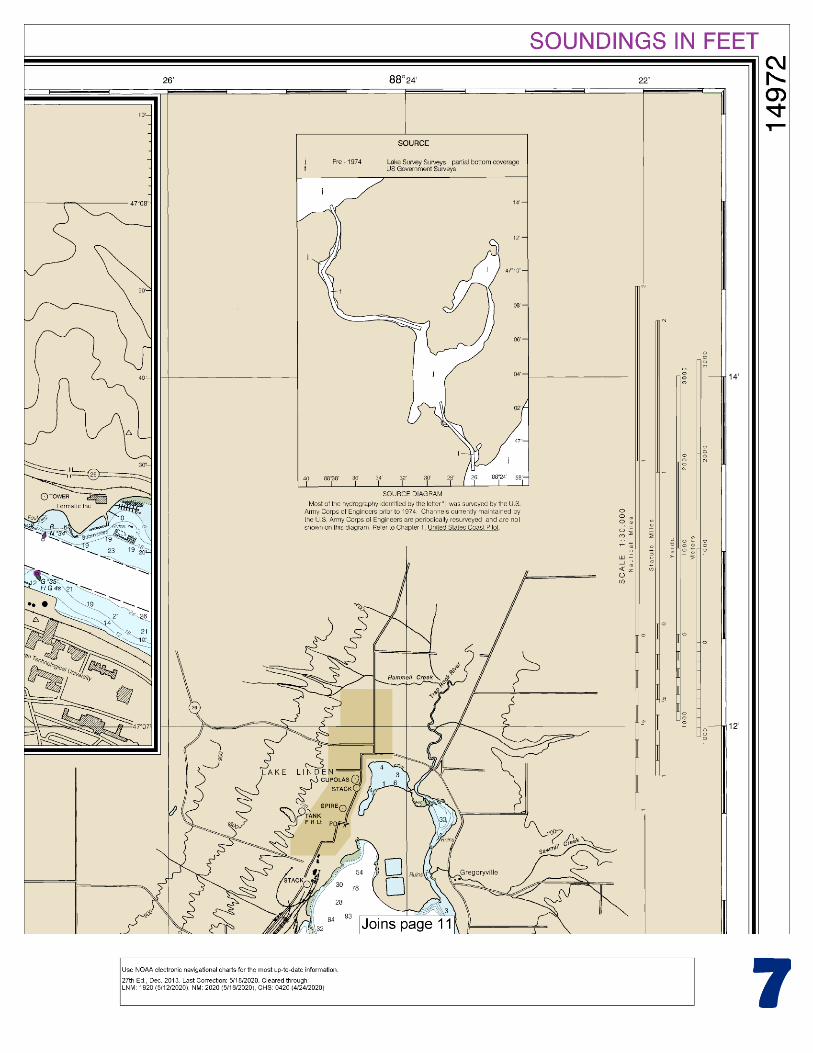
On the vessel route between Sault Ste. Marie and Duluth, the distance through the waterway is about 5 miles greater than by the open lake route. However, between Marquette and Duluth the waterway provides a savings of about 22 miles, and between Marquette and Ashland a savings of about 26 miles, as compared with the route around the outside of Keweenaw Point. The use of the waterway for refuge is indicated by the fact that more freight passes through the canals in October and November, the stormy season, than at any other time in the year, although the commerce on Lake Superior, as shown by the records at the Sault and at the head of the lake, is heaviest during July and August. The East entrance in Keweenaw Bay is protected by a breakwater that extends south from the east side of the mouth of Portage River. The breakwater should not be approached closer than 20 feet by vessels exceeding a 12-foot draft as it is lined with riprap on the channel side. The entrance at Lake Superior is protected by converging breakwaters. Keweenaw Waterway Lower Entrance Light (46°58'08"N., 88°25'51"W.), 68 feet above the water, is shown from a white octagonal tower on the outer end of the breakwater on the east side of the Keweenaw Bay entrance to the waterway. The light has a mariner radio activated sound signal is initiated by keying the microphone five times on VHF-FM channel 79. Portage River Harbor of Refuge is just inside the lower entrance to the waterway at the mouth of Portage River. This 0.5-mile-long basin has a revetment with bollards on the west side where vessels may moor. A small settlement with docks of commercial fishermen is on the west side of the river mouth south of the mooring pier. Marinas at the settlement provide limited transient berths, gasoline, water, electricity, and launching ramps. A marine railway and a 20-ton lift are available for repairs. Water and a launching ramp are available north of the mooring pier. Portage River, the natural outlet of Portage Lake, forms part of the Keweenaw Waterway for 5 miles from its mouth in Keweenaw Bay to Portage Lake. Portage Lake, about 17.5 miles long, is generally narrow, resembling a river, but has no sensible current. The lower 3.5 miles of the lake, locally known as Big Portage, is over 2 miles wide. Portage River flows from the southeast corner of the lake, and Pike Bay is in the southwest corner, the two being divided by the flats at the mouth of Sturgeon River. About 3 miles north of the head of Portage River, the lake is divided by Grosse Point. Torch Bay extends east from the point. The main body of the lake extends 2 miles north, thence turns west at Pilgrim Point for about 5.5 miles between the towns of Hancock and Houghton, and thence extends north for about 5 miles to the head of the lake. Above Grosse Point, the lake narrows to 0.5 mile and in the upper part has widths of 0.15 to 0.4 mile. A 19-foot spot and a 20-foot spot are in the north part of Portgage Lake about 0.7 mile and 1.8 miles south of Pilgrim Point Light, respectively. A shoal marked by buoys, extends about 240 yards off the east shore of the waterway about 1.3 miles north-northwest of Grosse Point. The shoal also extends into the north part of Portage Lake for about 0.7 mile southeast of Grosse Point. Pike Bay, at the southwest corner of Portage Lake, is entered through a narrow channel with depths of about 9 feet. The pile remains of a former lumber wharf are on the west side of the bay at the village of Chassell, MI.
U.S. Coast Guard Rescue Coordination Center 24 hour Regional Contact for Emergencies
RCC Cleveland Commander
9th CG District (216) 902-6117 Cleveland, OH

G
NOAA’s navigation managers serve as ambassadors to the maritime community. They help identify navigational challenges facing professional and recreational mariners, and provide NOAA resources and information for safe navigation. For additional information, please visit nauticalcharts.noaa.gov/service/navmanagers
To make suggestions or ask questions online, go to nauticalcharts.noaa.gov/inquiry. To report a chart discrepancy, please use ocsdata.ncd.noaa.gov/idrs/discrepancy.aspx.
Lateral System As Seen Entering From Seaward on navigable waters except Western Rivers
PORT SIDE
ODD NUMBERED AIDS
GREEN LIGHT ONLY
FLASHING (2)
PREFERRED CHANNEL
NO NUMBERS – MAY BE LETTERED
PREFERRED CHANNEL TO
STARBOARD
TOPMOST BAND GREEN
PREFERRED CHANNEL
NO NUMBERS – MAY BE LETTERED
PREFERRED CHANNEL
TO PORT
TOPMOST BAND RED
STARBOARD SIDE
EVEN NUMBERED AIDS
RED LIGHT ONLY
FLASHING (2)
FLASHING FLASHING
OCCULTING GREEN LIGHT ONLY RED LIGHT ONLY OCCULTING QUICK FLASHING QUICK FLASHING
ISO COMPOSITE GROUP FLASHING (2+1) COMPOSITE GROUP FLASHING (2+1) ISO
"1"
Fl G 6s
G "9"
Fl G 4s
GR "A"
Fl (2+1) G 6s
RG "B"
Fl (2+1) R 6s
"2"
Fl R 6s
8
R "8"
Fl R 4s
LIGHT
G
C "1"
LIGHTED BUOY
G
"5"
GR
"U"
GR
C "S"
RG
N "C"
RG
"G"
LIGHT
6
R
N "6"
LIGHTED BUOY
R
"2
"
CAN DAYBEACON
CAN NUN NUN
DAYBEACON
For more information on aids to navigation, including those on Western Rivers, please consult the latest USCG Light List for your area.
These volumes are available online at http://www.navcen.uscg.gov
Navigation Managers Area of Responsibility
Northeast
Lt. Meghan McGovern
Northwest and
Pacific Islands
Crescent Moegling
Great Lakes Region
Tom Loeper
Chesapeake and
Delaware Bay
Steve Soherr
California
Jeff Ferguson
[email protected] Mid-Atlantic
Lt. Ryan Wartick
Alaska
Lt. Timothy M. Smith
Western Gulf Coast
Alan Bunn
Central Gulf Coast
Tim Osborn
[email protected] South Florida
Puerto Rico
U.S. Virgin Islands
Michael Henderson
Southeast
Kyle Ward
2
2 C U 5
1


VHF Marine Radio channels for use on the waterways:Channel 6 – Inter-ship safety communications.Channel 9 – Communications between boats and ship-to-coast.Channel 13 – Navigation purposes at bridges, locks, and harbors.Channel 16 – Emergency, distress and safety calls to Coast Guard and others, and to initiate calls to other
vessels. Contact the other vessel, agree to another channel, and then switch.Channel 22A – Calls between the Coast Guard and the public. Severe weather warnings, hazards to navigation and safety warnings are broadcast here.Channels 68, 69, 71, 72 and 78A – Recreational boat channels.
Getting and Giving Help — Signal other boaters using visual distress signals (flares, orange flag, lights, arm signals); whistles; horns; and on your VHF radio. You are required by law to help boaters in trouble. Respond to distress signals, but do not endanger yourself.
EMERGENCY INFORMATION
Distress Call Procedures
• Make sure radio is on.• Select Channel 16.• Press/Hold the transmit button.• Clearly say: “MAYDAY, MAYDAY, MAYDAY.”• Also give: Vessel Name and/or Description;Position and/or Location; Nature of Emergency; Number of People on Board.• Release transmit button.• Wait for 10 seconds — If no responseRepeat MAYDAY call.
HAVE ALL PERSONS PUT ON LIFE JACKETS!
This Booklet chart has been designed for duplex printing (printed on front and back of one sheet). If a duplex option is not available on your printer, you may print each sheet and arrange them back-to-back to allow for the proper layout when viewing.
QR
Quick ReferencesNautical chart related products and information - http://www.nauticalcharts.noaa.gov
Interactive chart catalog - http://www.charts.noaa.gov/InteractiveCatalog/nrnc.shtmlReport a chart discrepancy - http://ocsdata.ncd.noaa.gov/idrs/discrepancy.aspx
Chart and chart related inquiries and comments - http://ocsdata.ncd.noaa.gov/idrs/inquiry.aspx?frompage=ContactUs
Chart updates (LNM and NM corrections) - http://www.nauticalcharts.noaa.gov/mcd/updates/LNM_NM.html
Coast Pilot online - http://www.nauticalcharts.noaa.gov/nsd/cpdownload.htm
Tides and Currents - http://tidesandcurrents.noaa.gov
Marine Forecasts - http://www.nws.noaa.gov/om/marine/home.htm
National Data Buoy Center - http://www.ndbc.noaa.gov/
NowCoast web portal for coastal conditions - http://www.nowcoast.noaa.gov/
National Weather Service - http://www.weather.gov/
National Hurrican Center - http://www.nhc.noaa.gov/
Pacific Tsunami Warning Center - http://ptwc.weather.gov/
Contact Us - http://www.nauticalcharts.noaa.gov/staff/contact.htm
NOAA’s Office of Coast Survey The Nation’s Chartmaker
For the latest news from Coast Survey, follow @NOAAcharts
NOAA Weather Radio All Hazards (NWR) is a nationwide network of radio stations broadcasting continuous weather information directly from the nearest National Weather Service office. NWR broadcasts official Weather Service warnings, watches, forecasts and other hazard information 24 hours a day, 7 days a week. http://www.nws.noaa.gov/nwr/