Embed Size (px)
Citation preview
Kings Beach Pier Concept Project E313004004
Prepared for California Tahoe Conservancy
February 2016
Kings Beach Pier Comparative Alternatives Analysis
Kings Beach Pier Concept Project E313004004
Kings Beach Pier Comparative Alternatives Analysis Kings Beach Pier Concept Project
February 2016 Cardno ii
Contact Information
Cardno
295 Highway 50, Suite 1 / PO Box 1533
Zephyr Cove, NV 89448
Telephone: 775.588.9069
Facsimile: 775.588.9219
International: Insert international number
Document Information
Prepared for California Tahoe Conservancy
Project Name Kings Beach Pier Concept
Project
File Reference Document1
Job Reference E313004004
Date February 2016
Kings Beach Pier Comparative Alternatives Analysis Kings Beach Pier Concept Project
February 2016 Cardno iii
Table of Contents
1 Introduction 1
1.1 Scope of this Analysis 1
1.2 Project Goal 1
1.3 Project Objectives 1
2 Background Information 3
Location and Ownership 3
2.1 Project History 3
2.2 Planning Context 6
Multiple agencies create a diversity of planning and regulatory requirements for any pier project along the shoreline of Lake Tahoe. The following summarizes regulations and planning issues important to a consideration of Project feasibility. 6
California Department of Parks and Recreation (State Parks) 6
California Tahoe Conservancy 7
Tahoe Regional Planning Agency (TRPA) 7
County of Placer 9
3 Methods 10
3.1 Baseline Data 10
3.2 Evaluation Criteria 10
4 Concept Design and Proposed Features 12
4.1 Design Assumptions 12
5 Technical Analyses 14
5.1 Winds, Wave, Littoral Drift, Location, Orientation, Dimensions 14
Purpose 14
Literature and Data Review 14
Prior Analysis of Wind-Wave Attenuation 15
2015 Analysis of Wave Transmission 16
Likely Morphological Changes 21
Wind, Wave, and Drift Summary 23
5.2 Biologic Resources 24
Fish Habitat 24
Tahoe Yellow Cress 28
5.3 Storm Drainage, Waters and Wetlands/SEZ 28
5.4 Cultural Resource Constraints 30
5.5 Scenic Impacts 31
Visual Simulations 31
Visual Mass Calculations 35
5.6 Safety Concerns 35
5.7 Other Environmental Considerations 37
6 Comparison and Conclusions 38
7 References Cited 43
8 Appendices 45
Kings Beach Pier Comparative Alternatives Analysis Kings Beach Pier Concept Project
February 2016 Cardno iv
Appendices
Appendix A Kings Beach Pier Alternatives 2015 Concept Plans
Appendix B Kings Beach State Recreation Area Prime Fish Habitat 2015 Survey Memo
Appendix C Wind Wave and Littoral Drift Analysis
Appendix D Kings Beach Pier Alternative 2015 Scenic Analysis Data
Tables
Table 3-1 Regulatory-Based Evaluation Criteria 11
Table 4-1 2015 Design Guidelines for the Central and East Pier Location Options 12
Table 4-2 Pier Characteristics for the Central and East Location Options 13
Table 5-1 SWAN Modelling Results – Impact of Pier Options on Wave Heights (in terms of wave coefficient) at the Shoreline 21
Table 5-2 SWAN Modelling Results – Impact of Pier Options on Wave Direction at the Shoreline 21
Table 5-3 Summary of Visual Mass Calculations for the Existing and Proposed Pier Options at KBSRA 35
Table 6-1 Comparison of Central and East Pier Relative to Regulatory-Based Evaluation Criteria 39
Figures
Figure 2-1 Kings Beach State Recreation Area Location and Land Ownership 4
Figure 2-2 Existing Features of the KBSRA Project Area 5
Figure 2-3 Existing Pier at KBSRA 6
Figure 5-1 Wave Transmission Attenuation for Various Floating Pier Alternatives 16
Figure 5-2 Distribution of Wave Height Attenuation Coefficient at KBSRA with the Central Pier Location Option 19
Figure 5-3 Distribution of Wave Height Attenuation Coefficient at KBSRA with the East Pier Location Option 20
Figure 5-4 Salient Formed by the Floating Dock at the Hyatt, Incline Village, NV 22
Figure 5-5 Minor Salient Formed near Floating Dock at Tahoe Vista, CA 23
Figure 5-6 TRPA Designated ‘Prime Fish Habitat’ in the KBSRA 25
Figure 5-7 Existing Fish Habitat in the KBSRA overlain on the TRPA Designated “Prime Fish Habitat” in the Vicinity 26
Figure 5-8 Existing Prime Fish Habitat and Embeddedness in the KBSRA 27
Figure 5-9 Existing and Planned Stormwater Drainage and Treatment Facilities in the KBSRA 30
Figure 5-10 Selected Photo Point with Lake View to KBSRA for Visual Simulations 32
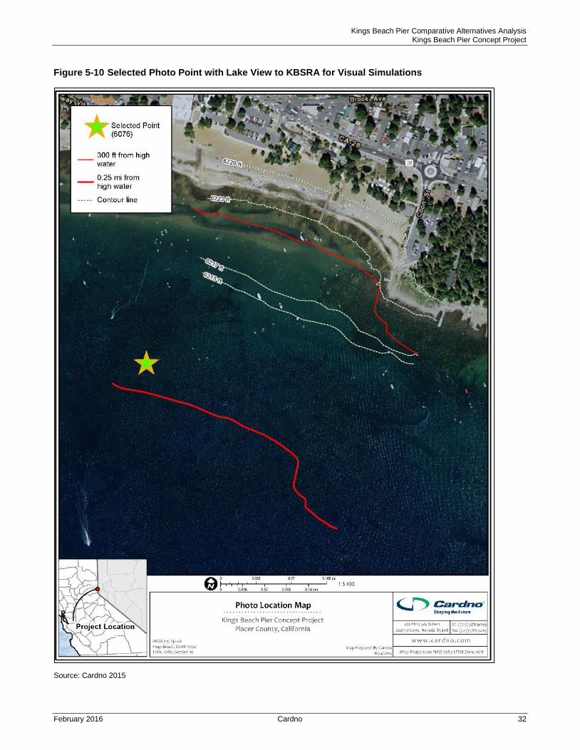
Figure 5-11 Proposed Conditions with Central Pier Viewed from the Lake 33
Figure 5-12 Proposed Conditions with East Pier Viewed from the Lake 34
Figure 5-13 Existing ‘No Wake Zone’ along the KBSRA Study Area 37
Kings Beach Pier Comparative Alternatives Analysis Kings Beach Pier Concept Project
February 2016 Cardno 1
1 Introduction
1.1 Scope of this Analysis
Cardno was retained by the California Tahoe Conservancy (Conservancy) and Department of General
Services (DGS), in collaboration with the California Department of Parks and Recreation (State Parks) to
provide technical support for efforts related to the Kings Beach Pier Reconstruction Project (Project). The
analysis builds on previous planning studies, presenting and examining updated information in five areas
determined to be critical to the feasibility of design, permitting, construction, and function of two
alternative pier locations within the Kings Beach State Recreation Area (KBSRA): the central pier location
and the east pier location. The five areas include fish habitat, Tahoe yellow cress, wind/wave and littoral
drift, scenic (simulations and visual mass calculations), and cultural resources.
The central pier location had been previously developed to a conceptual level of design during a prior
planning phase that included consideration of alternatives (Conservancy, 2001). The east pier location
arose as an option during the proposed Kings Beach Vision Plan (Placer County, 2013). The scope of this
analysis focused on:
Update the site baseline data for the entire site;
Re-evaluate the conclusions regarding feasibility of a central pier (given the updated concept
design guidance and updated data);
Develop a location/orientation and concept design for an east pier using the same level of detail
and guiding assumptions as for the central pier design;
Examine the feasibility of an east pier based on the five key considerations;
Look for fatal flaws at either location;
Prepare a comparative analysis of each option examining the benefits and challenges of each;
and,
Contribute information suitable for initiation of the next phase of KBSRA planning; which will
include environmental analysis pursuant to the California Environmental Quality Act (CEQA) and
Tahoe Regional Planning Agency (TRPA) regulations.
The design effort began with the basic elements of the conceptual plan previously developed by Transpac
(2002) for the central pier location. Updated guidance from the Conservancy, State Parks, other members
of the Technical Advisory Committee and the public in 2015 resulted in modifications to the 2002 concept
design. Therefore, the 2015 conceptual design plan set (Appendix A) includes consistent design
information for each of the two location options and the report includes discussion of proposed conditions
for both possible pier locations, to facilitate the comparative analysis.
1.2 Project Goal
The overall goal of the Project is to provide a public pier at the KBSRA that is functional for multi-use
recreational benefits during normal high through low water conditions (i.e., reaching the 6217 foot lake
bed elevation navigational target).
1.3 Project Objectives
The specific objectives identified for the Project and applied in conceptual design and evaluation of
location options include:
Kings Beach Pier Comparative Alternatives Analysis Kings Beach Pier Concept Project
February 2016 Cardno 2
> Meet most current industry standards for pier structures associated with large inland waterbodies;
> Enhance recreation access to KBSRA (and the community of Kings Beach) from the lake by motorized
and non-motorized craft users;
> Enhance recreation access to the lake from KBSRA beach goers, including general recreation and
non-motorized craft users;
> Improve lake access needs of persons with disabilities;
> Improve functional access of the pier for a range of recreational boating types over a wider range of
lake level conditions;
> Demonstrate compatibility with applicable land use plans and other recreation uses in the KBSRA (on
the beach, at the boat ramp, and in the water);
> Provide opportunities for publicly accessible recreational vistas, interpretation, education, as well as
for craft access;
> Minimize environmental impacts; and,
> Promote public health and safety including a safe access point to Lake Tahoe and a public safe harbor
opportunity for boaters along the North Shore.
Kings Beach Pier Comparative Alternatives Analysis Kings Beach Pier Concept Project
February 2016 Cardno 3
2 Background Information
Location and Ownership
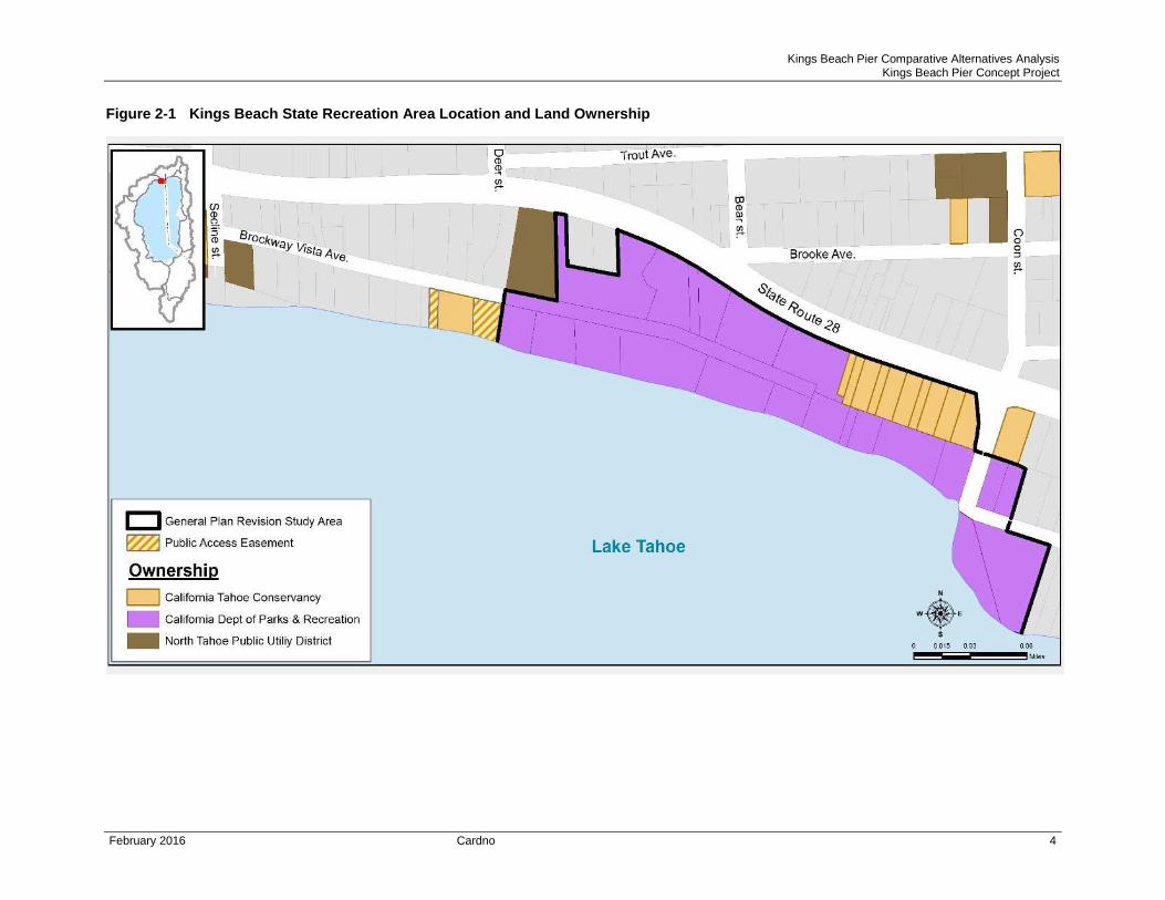
The Project is located in the Kings Beach State Recreation Area (KBSRA), between State Route 28 and
Lake Tahoe, in central Kings Beach, CA. KBSRA encompasses State land made up of parcels owned by
State Parks, including former California Department of Boating and Waterways (DBW) property, and the
Conservancy (Figure 2-1).
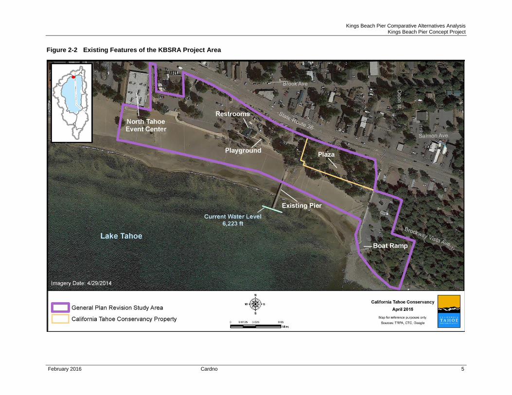
Existing features at KBSRA include: beach, parking, two restroom structures, a children’s playground,
and a plaza for public gathering including a small half basketball court, paved walkways, boat ramp; and a
pier (Figure 2-2). An existing concession offers watercraft rental during the summer months.
A substantial pier in approximately the same location and of approximately the same size as that found
today had been constructed after the 1923 US Coast and Geodetic survey mapping (Harding ESE 2001b)
and before the 1939 USFS aerial photograph of the area (Lindström and Marvin 2015).The current pier
was in place in 1977 when State Parks acquired the property. The pier was repaired in 1980 and 1998,
and modified to include a safety railing.
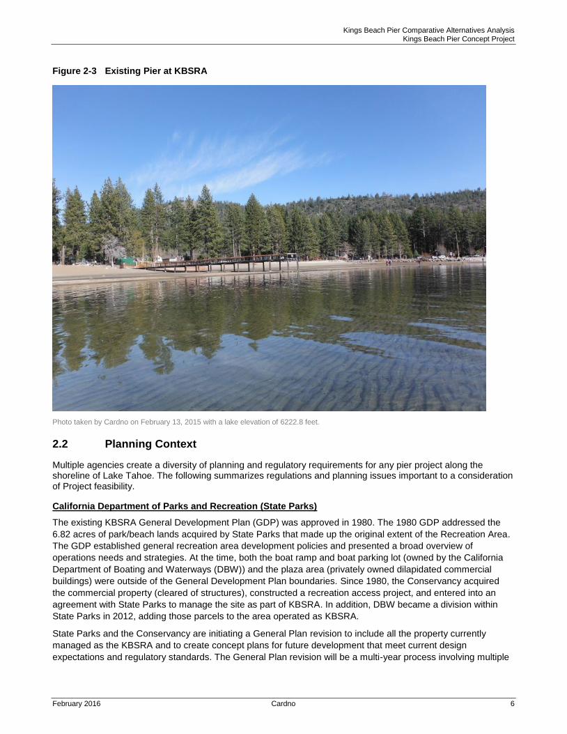
The existing pier structure (Figure 2-3) is 10 feet wide and 207 feet long, with a fixed wood deck at
elevation 6231.5 feet, supported by 26 paired, outer-edge steel pilings (Conservancy 2001). The pier is
functional for boat access only when the lake water surface elevation (WSEL) is between 6227.0 feet and
the legal high water (6229.1 feet). At lake levels of 6223 feet or lower, the pier is completely out of the
water. No catwalks or low freeboard access docks are attached, and the total deck surface area covers
3,151 square feet.
2.1 Project History
Public interest in reconstruction of the existing pier at KBSRA began soon after State Parks’ acquisition in
1977 and adoption of the General Development Plan (GDP) in 1980. Planning efforts resulting in the
1987 Tahoe Regional Planning Agency (TRPA) Regional Plan and Kings Beach Community Plan
included a functional pier at KBSRA as a recommended recreation and transportation project. The
Conservancy first engaged on the issue in the 1990s during the public planning process for the Kings
Beach Recreation Enhancement Project. Members of the public identified inadequacies of the existing
pier given that the shallow lake in this vicinity limits recreational boating use during low water years.
In 2001-03, the Conservancy led a collaborative planning process that examined the potential of
reconstructing the existing public pier (Conservancy 2001). The analysis examined extending the pier to
reach navigable waters during normal low water conditions, creating an improved “over the water”
experience for recreational users, and meeting Americans with Disabilities Act (ADA) requirements. That
process resulted in development of a completely floating pier design alternative, between 500-600 feet
long, located approximately 40 feet east of the existing pier. The analysis determined such a pier would
be feasible. To address public and agency input, subsequent design modifications produced preliminary
plans for a combined fixed and floating pier concept. For a variety of reasons, the project did not move
forward at that time.
The planning effort was recently reinvigorated because of: renewed public interest expressed in the
Placer County community visioning process (Placer County 2013); potential value relative to recent
substantial public infrastructure investment in the core commercial district of Kings Beach; State Parks’
assumption of direct management at KBSRA; and, State Parks’ partnership with the Conservancy for all
State lands along the North Shore since 2014.
Kings Beach Pier Comparative Alternatives Analysis Kings Beach Pier Concept Project
February 2016 Cardno 4
Figure 2-1 Kings Beach State Recreation Area Location and Land Ownership
Kings Beach Pier Comparative Alternatives Analysis Kings Beach Pier Concept Project
February 2016 Cardno 5
Figure 2-2 Existing Features of the KBSRA Project Area
Kings Beach Pier Comparative Alternatives Analysis Kings Beach Pier Concept Project
February 2016 Cardno 6
Figure 2-3 Existing Pier at KBSRA
Photo taken by Cardno on February 13, 2015 with a lake elevation of 6222.8 feet.
2.2 Planning Context
Multiple agencies create a diversity of planning and regulatory requirements for any pier project along the shoreline of Lake Tahoe. The following summarizes regulations and planning issues important to a consideration of Project feasibility.
California Department of Parks and Recreation (State Parks)
The existing KBSRA General Development Plan (GDP) was approved in 1980. The 1980 GDP addressed the
6.82 acres of park/beach lands acquired by State Parks that made up the original extent of the Recreation Area.
The GDP established general recreation area development policies and presented a broad overview of
operations needs and strategies. At the time, both the boat ramp and boat parking lot (owned by the California
Department of Boating and Waterways (DBW)) and the plaza area (privately owned dilapidated commercial
buildings) were outside of the General Development Plan boundaries. Since 1980, the Conservancy acquired
the commercial property (cleared of structures), constructed a recreation access project, and entered into an
agreement with State Parks to manage the site as part of KBSRA. In addition, DBW became a division within
State Parks in 2012, adding those parcels to the area operated as KBSRA.
State Parks and the Conservancy are initiating a General Plan revision to include all the property currently
managed as the KBSRA and to create concept plans for future development that meet current design
expectations and regulatory standards. The General Plan revision will be a multi-year process involving multiple
Kings Beach Pier Comparative Alternatives Analysis Kings Beach Pier Concept Project
February 2016 Cardno 7
public input opportunities. It will include consideration of the pier project during environmental analysis in an EIS
by TRPA and a California Environmental Quality Act (CEQA) EIR by State Parks.
California Tahoe Conservancy
The Conservancy acquired commercial property in the core of Kings Beach in the late 1990’s and initiated a
public planning process for site development that met certain public recreation access and water quality
objectives. The resulting development, the Kings Beach Recreation Enhancement Project (known as the Plaza),
included sidewalks and public gathering spaces as well as increased open space and water quality treatment
facilities. As noted above, public interest in pier redevelopment expressed throughout that process resulted in
early project development steps. The current study updates the concept design for two alternative pier locations
and performs data analysis for certain site resources that will be incorporated in the GP, pier project review, and
the accompanying environmental analysis.
Tahoe Regional Planning Agency (TRPA)
TRPA is a bi-state planning agency with regulatory authority over development in the Tahoe Basin including
along the shoreline of Lake Tahoe. The TRPA exerts development control through the 2012 Tahoe Regional
Plan, a compilation of documents including, among other, Goals and Policies, 208 Water Quality Control Plan,
Code of Ordinances, and Plan Area Statements (PAS). Related to the pier reconstruction project, critical
development standards are presented in the Code of Ordinances, Shorezone, Chapters 80-86.
Shorezone project review of a pier reconstruction project at KBSRA will be based on several primary
considerations, including:
The current pier was legally existing prior to the effective date of the TRPA Regional Plan (July 1, 1987).
Therefore, Code provisions in Chapter 82, Existing Structures, will apply to a pier reconstruction project.
A pier reconstruction project that expands the size or modifies the location of an existing pier can meet
TRPA requirements in 82.4.4. This assumes adequate environmental review demonstrates the project
will not create significant impact. (Such an environmental evaluation will proceed as part of the KBSRA
General Plan revision process, described below.)
This public pier meets the definition for a multiple-use facility. Multi-use piers must comply with
development standards established in Code section 84.5 for location, width, height, length and
foundation design, except that deviations from these standards may be allowed based on the extent to
which the facility is open to the general public.
TRPA is currently operating a Partial Shorezone Permitting program that limits the type of shorezone project
applications which TRPA can accept and process. Under this program, TRPA will accept for review applications
for the reconstruction or modification of legally existing boating structures that meet certain criteria and that do
not adversely affect the environment, either individually or cumulatively. These criteria are:
Boating Capacity. No projects that increase boating capacity on Lake Tahoe can be considered at this
time. Boating capacity is a function of the number of boats that can access Lake Tahoe. The Project will
not increase auto or boat trailer parking or change ramp conditions at any location around the lake, and
it will not provide any additional opportunities for overnight or long-term mooring. Therefore, it would not
increase the number of boats with access to Lake Tahoe.
Scenic Quality. No projects that produce a net increase in visual mass as viewed from the lake can be
considered. This comparative analysis includes calculation of the existing pier visual mass as well as
that of two concept pier options. Both pier alternatives lie within Shoreline Scenic Unit 21, which is in
threshold attainment. Therefore, a project application to TRPA must include reduction in visual mass
equal to the existing condition to be considered.
Soil/Erosion. No projects that increase impacts from littoral drift or soil erosion can be considered. This
report presents new wind/wave modelling and littoral drift analysis to quantitatively address this potential
impact.
Kings Beach Pier Comparative Alternatives Analysis Kings Beach Pier Concept Project
February 2016 Cardno 8
Fish Habitat. No project that produces a net increase in Prime Fish Habitat Disturbance can be
considered. This comparative analysis includes updated Fish Habitat delineation and identifies the
offsetting mitigation that will be required as part of a TRPA project application.
2.3.5 Lahontan Regional Water Quality Control Board (Lahontan)
The primary responsibility for the protection of water quality in California rests with the State Water Resources
Control Board (State Board) and nine Regional Water Quality Control Boards. In 2014, the Lahontan Regional
Water Quality Control Board adopted a major revision to the Water Quality Control Plan (Basin Plan) which
establishes water quality standards, beneficial uses, and the associated requirements needed to achieve and
maintain them within the Lahontan Region. Chapter 5 of the Basin Plan details provisions specific to the Lake
Tahoe Basin, including those relevant to pier projects.
The Project may require multiple permits from Lahontan and/or the State Water Resources Control Board,
including CWA Section 401 certification for federal waters or Waste Discharge requirements for non-federal
waters of the state; CWA Section 402 National Pollutant Discharge Elimination System (NPDES) permit for
stormwater or waste discharge requirements for other possible discharges to land, surface or ground waters of
the state. While various General Orders and Permits may be available and apply to the Project, certain
discharges may require individual orders and/or exemptions form prohibitions in the Basin Plan. For example,
Section 5.2 of the Basin Plan prohibits discharge of material below the high water rim of Lake Tahoe including
discharge to significant spawning habitats. Exemptions from these prohibitions are possible in certain conditions,
including:
Relocation Exemptions from these prohibitions are possible for relocations assuming a relocation results
in a net or equal water quality benefit. Calculations of discharge for piers relates to the total footing area
of the pier pilings as follows:
o Existing double-piling pier -71.06 sf;
o Central single piling pier option- 87.74 sf (23% increase over existing);
o East single piling pier option– 71.03 sf (essentially equal to existing); and,
Neither of the pier location alternatives cross spawning habitat, but would affect feed and cover, as
discussed in following sections of this document
Public Outdoor Recreation Facilities Exemptions may also be granted for certain uses, assuming
findings for alternatives and offsetting restoration can be made. Disturbance related to pier pilings for the
alternatives are shown above.
The application materials and approved CEQA/TRPA documents and mitigation measures would be considered
by Lahontan, and verification by CDFW of the fish habitat designations herein may be required by Lahontan.
2.3.6 California State Lands Commission (State Lands)
The State Lands Commission was established in 1938 as an independent body to manage the state’s 4 million
acres of tidelands and submerged lands and the beds of navigable rivers, streams, lakes, bays, estuaries, inlets,
and straits. The Commission works to protect and enhance these lands and natural resources by issuing leases
for use or development, resolving boundaries between public and private lands, promoting public access, and
implementing regulatory programs to shield state waters from oil spills and invasive species introductions.
Related to the present Project, State Lands controls activity on lands lakeward of Lake Tahoe’s legal high water
limit, i.e. 6229.1 Lake Tahoe Datum and must grant a lease for construction and operation of a future Kings
Beach Pier. Assuring continued lateral public access along the beach and for lateral nearshore recreational
boating access are prime considerations during the lease approval process.
Kings Beach Pier Comparative Alternatives Analysis Kings Beach Pier Concept Project
February 2016 Cardno 9
County of Placer
Placer County exercises local land use and zoning control within the provisions established by the TRPA
Regional Plan. Current land use regulatory requirements are presented in the Kings Beach Community Plan
(1997 and amended) and include permissible uses, allowed densities, special policies, and planned
improvements to circulation, recreation, and elements of the environment such as scenic quality. KBSRA lies in
Special Area 3 (Recreation Area). A public pier is considered Beach Recreation, an allowed use in Special Area
3.
With the adoption of the 2012 Revised Tahoe Regional Plan, Placer County began to update land use plans
throughout the Tahoe Basin. The proposed Placer County Tahoe Basin Area Plan will implement new Regional
Plan land use provisions for the Kings Beach area, among others, reflecting environmental, community, and
economic needs. It is expected to be adopted in 2016.
2.3.7 Other Considerations
In addition to the agency requirements and planning considerations identified above, the Project must address
the needs and regulations of the following entities:
U.S. Army Corps of Engineers (ACOE) The placement of pilings below the high water elevation of Lake
Tahoe (6229.1 ft) and associated temporary disturbance and permanent dredge or fill in the lake or
along the shoreline will require authorization from the ACOE pursuant to Section 10 of the Rivers and
Harbors Act and potentially under Section 404 of the Clean Water Act. The ACOE will consider and
address other Federal Regulatory compliance, including the Endangered Species Act (ESA) and the
National Historic Preservation Act (NHPA) as part of the ACOE permitting.
California Department of Fish and Wildlife (CDFW) CDFW implements sections of the California Fish
and Game Code, California Code of Regulations, and other statutes and regulations to help fulfill the
agency’s mission.CDFW maintains trustee responsibilities for the plants, animals, and fish throughout
the State. Related to the Kings Beach Pier, CDFW will review Project elements to ensure protection of
Tahoe yellow cress and fish habitat needs.
North Tahoe Public Utility District (NTPUD) NTPUD owns and operates the North Tahoe Events Center
at the west end of the KBSRA. The Events Center, once a privately owned bowling alley and
performance space, consists of large multi-use space that hosts both general public and private
gatherings. Site development places all the parking and some of the exterior gathering spaces related to
this use on State Parks property
Kings Beach Pier Comparative Alternatives Analysis Kings Beach Pier Concept Project
February 2016 Cardno 10
3 Methods
3.1 Baseline Data
Baseline data compiled for the site during the early 2000s was reviewed and either verified to be included herein
(as cited), or updated and replaced herein. The study area includes the KBSRA and adjoining areas within Lake
Tahoe, at a range of scales relevant to various potential environmental considerations. For certain issues, the
study area is focused on pier ‘footprint’ concerns, entirely within the boundaries of the KBSRA (i.e., cultural
resources, biology), while other topics require study of broader areas and driving forces (i.e., wind-waves, and
drift). Data sources and any specific methods are described below within each topical issue area, as appropriate.
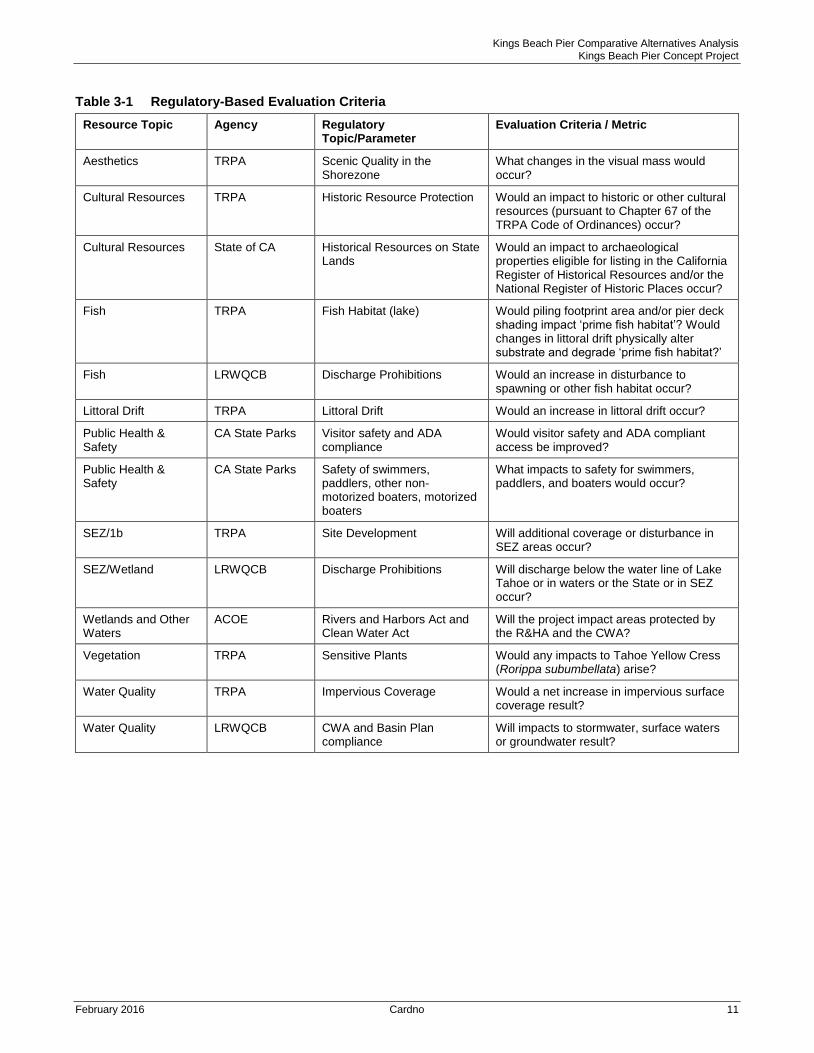
3.2 Evaluation Criteria
Evaluation criteria were developed that include qualitative and quantitative metrics related to the Project goals
and objectives, regulatory requirements, and other considerations. These criteria have been used to: guide
selection of the possible east pier location; develop an updated concept design for both location options; assess
the feasibility of the east pier location; and to compare the two proposed pier locations.
A summary of key regulatory-based screening criteria related to the issues considered critical for assessment of
feasibility, organized by resource topics and regulatory agency, is provided in Table 3-1 and discussed further
within the applicable analysis sections (Section 6). Criteria focused on goals and objectives are included in the
design guidelines and assumptions and those that may differentiate between location options, as described in
Section 5, below.
Kings Beach Pier Comparative Alternatives Analysis Kings Beach Pier Concept Project
February 2016 Cardno 11
Table 3-1 Regulatory-Based Evaluation Criteria
Resource Topic Agency Regulatory Topic/Parameter
Evaluation Criteria / Metric
Aesthetics TRPA Scenic Quality in the Shorezone
What changes in the visual mass would occur?
Cultural Resources TRPA Historic Resource Protection Would an impact to historic or other cultural resources (pursuant to Chapter 67 of the TRPA Code of Ordinances) occur?
Cultural Resources State of CA Historical Resources on State Lands
Would an impact to archaeological properties eligible for listing in the California Register of Historical Resources and/or the National Register of Historic Places occur?
Fish TRPA Fish Habitat (lake) Would piling footprint area and/or pier deck shading impact ‘prime fish habitat’? Would changes in littoral drift physically alter substrate and degrade ‘prime fish habitat?’
Fish LRWQCB Discharge Prohibitions Would an increase in disturbance to spawning or other fish habitat occur?
Littoral Drift TRPA Littoral Drift Would an increase in littoral drift occur?
Public Health & Safety
CA State Parks Visitor safety and ADA compliance
Would visitor safety and ADA compliant access be improved?
Public Health & Safety
CA State Parks Safety of swimmers, paddlers, other non-motorized boaters, motorized boaters
What impacts to safety for swimmers, paddlers, and boaters would occur?
SEZ/1b TRPA Site Development Will additional coverage or disturbance in SEZ areas occur?
SEZ/Wetland LRWQCB Discharge Prohibitions Will discharge below the water line of Lake Tahoe or in waters or the State or in SEZ occur?
Wetlands and Other Waters
ACOE Rivers and Harbors Act and Clean Water Act
Will the project impact areas protected by the R&HA and the CWA?
Vegetation TRPA Sensitive Plants Would any impacts to Tahoe Yellow Cress (Rorippa subumbellata) arise?
Water Quality TRPA Impervious Coverage Would a net increase in impervious surface coverage result?
Water Quality LRWQCB CWA and Basin Plan compliance
Will impacts to stormwater, surface waters or groundwater result?
Kings Beach Pier Comparative Alternatives Analysis Kings Beach Pier Concept Project
February 2016 Cardno 12
4 Concept Design and Proposed Features
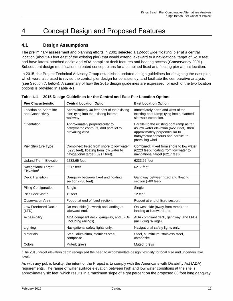
4.1 Design Assumptions
The preliminary assessment and planning efforts in 2001 selected a 12-foot wide ‘floating’ pier at a central
location (about 40 feet east of the existing pier) that would extend lakeward to a navigational target of 6218 feet
and have lateral attached docks and ADA compliant deck features and boating access (Conservancy 2001).
Subsequent design modifications created concept plans for a combined fixed and floating pier at that location.
In 2015, the Project Technical Advisory Group established updated design guidelines for designing the east pier,
which were also used to revise the central pier design for consistency, and facilitate the comparative analysis
(see Section 7, below). A summary of how the 2015 design guidelines are expressed for each of the two location
options is provided in Table 4-1.
Table 4-1 2015 Design Guidelines for the Central and East Pier Location Options
Pier Characteristic Central Location Option East Location Option
Location on Shoreline and Connectivity
Approximately 40 feet east of the existing pier; tying into the existing internal walkway.
Immediately north and west of the existing boat ramp; tying into a planned sidewalk extension.
Orientation Approximately perpendicular to bathymetric contours, and parallel to prevailing wind.
Parallel to the existing boat ramp as far as low water elevation (6223 feet), then approximately perpendicular to bathymetric contours and parallel to prevailing wind.
Pier Structure Type Combined: Fixed from shore to low water (6223 feet), floating from low water to navigational target (6217 feet).
Combined: Fixed from shore to low water (6223 feet), floating from low water to navigational target (6217 feet).
Upland Tie-In Elevation 6233.65 feet 6233.65 feet
Navigational Target Elevation1
6217 feet 6217 feet
Deck Transition Gangway between fixed and floating section (~80 feet)
Gangway between fixed and floating section (~80 feet)
Piling Configuration Single Single
Pier Deck Width 12 feet 12 feet
Observation Area Popout at end of fixed section. Popout at end of fixed section.
Low Freeboard Docks (LFD)
On east side (leeward) and landing at lakeward end.
On west side (away from ramp) and landing at lakeward end.
Accessibility ADA compliant deck, gangway, and LFDs (including railings).
ADA compliant deck, gangway, and LFDs (including railings).
Lighting Navigational safety lights only. Navigational safety lights only.
Materials Steel, aluminium, stainless steel, composite.
Steel, aluminium, stainless steel, composite.
Colors Muted; greys Muted; greys
1The 2015 target elevation depth recognized the need to accommodate design flexibility for boat size and uncertain lake
levels.
As with any public facility, the intent of the Project is to comply with the Americans with Disability Act (ADA)
requirements. The range of water surface elevation between high and low water conditions at the site is
approximately six feet, which results in a maximum slope of eight percent on the proposed 80 foot long gangway

Kings Beach Pier Comparative Alternatives Analysis Kings Beach Pier Concept Project
February 2016 Cardno 13
connecting the fixed and floating pier sections during low water conditions at either of the proposed locations.
While this slope exceeds the land-based ADA standards for maximum slope (five percent) and rise (three feet),
exceptions 3 and 4 outlined in Section 1003.2.1 (Federal Access Board, Recreational Boating Facilities) would
apply to the proposed design (pending approval from state agencies) due to the gangway length (80 feet) and
the total number of boat slips (fewer than 25). Alternative measures or designs are also possible to maintain
ADA compliance at low water conditions, such as a series landings or additional floating sections between
gangways.
The concept plans developed for both pier location options using the 2015 design guidelines are attached as
Appendix A. A quantitative summary of several key pier characteristics using the proposed concept designs at
the Central and East location options are listed in Table 4-2.
Table 4-2 Pier Characteristics for the Central and East Location Options
Pier Characteristic Units Central Pier Option East Pier Option
Total Length ft 601 488
Fixed Section Length ft 212 213
Floating Section Length ft 329 215
Floating Sections ft 10 7
Gangway Length ft 80 80
Low Freeboard Docks # 2 1
Fixed Pier Piles # 13 13
Floating Pier Piles # 20 14
Average Dock Width ft 12 12
Total Dock Surface Area ft2 9,904 8,121
Kings Beach Pier Comparative Alternatives Analysis Kings Beach Pier Concept Project
February 2016 Cardno 14
5 Technical Analyses
The following sub-sections provide updated information about the existing conditions, specific technical analyses related to the concept design development, potential environmental impacts, and comparison of the present pier and the two proposed location options related to several resource topics.
5.1 Winds, Wave, Littoral Drift, Location, Orientation, Dimensions
Purpose
The purpose of the wind-wave analysis is to assist in selection and screening of location and/or design options for the KBSRA pier reconstruction (relocation) Project. Each of the two pier locations would feature a similar concept design, with a shore-side fixed pier section connected to an outer, longer floating pontoon section via an aluminum gangway (Tables 4-1 and 4-2).
Under the TRPA Shorezone Application Criteria (within the Partial Shorezone Permitting program), the performance goal of the pier relocation should be to produce no increase in littoral drift. While the information available from historic data suggests that the beach area that could be affected by the pier is fairly stable, and on-off shore drift is greater than longshore drift (PIE 2001), regulatory requirements require additional analysis of the Pier Concept Project.
Regulatory Guidelines
The TRPA shorezone partial permitting program went into effect in 2011. Within the TRPA Code, eight shorezone tolerance districts are identified with varied stability and sensitivity to disturbances/development that dictate the applicable regulations and standards for activities. The KBSRA has areas with Tolerance Districts 6 and 7, which are considered less sensitive than District 1, but still subject to higher erosion based on slope and as controlled by varied exposure to different wave action conditions. The TRPA prescribed methods outlined in the BMP Handbook (TRPA 2014) were used in preliminary design and the backshore delineation shown on the Concept Plans (Appendix A).
Review of TRPA Code and the BMP Handbook, review of the 2012 EIS for the Edgewood pier/dock proposal
and discussions with senior TRPA staff, determined that there is no particular/preferred method for
wind/wave/littoral drift impact analysis and no general rule of thumb regarding potential impacts of floating piers
on littoral drift. Prior studies assumed that if the floating section is less than ½ of the wavelength, effects were
minor. The only other guidance in TRPA documents is that in Appendix H of the 2004 Shorezone EIS (Moory
2003), in which Moory concludes that a reduction of wave transmission of 30 percent or more would be adverse.
This conclusion is taken into account in Cardno’s quantitative analysis. Cardno coastal engineers provided
literature review, technical calculations, and wave modeling for the Project at the Conceptual Design level,
addressing both pier location options. The following discussion presents a summary of the analysis and
conclusions; see Appendix C for additional details.
Literature and Data Review
Many factors affect shorezone conditions and stability. The focus here is on the beach and littoral processes and characteristics that would influence the feasibility, design, cost, performance, and potential impacts of the two pier location options within KBSRA. We sought out documentation of more recent empirical data (wind and waves), as well as modeling of Lake Tahoe general circulation and nearshore circulation and processes. In addition, for the purpose of assessing shoreline and littoral process sensitivity, as well as for the future application in structural design, several other factors were considered, including: geology; beach/foreshore geomorphology; sediment sources and delivery; wave action; and, the nearshore and backshore conditions.
Updated wind data was downloaded and processed by Cardno in 2015 to obtain wind direction and speed data for comparison with the prior study. These data include Lake Tahoe buoy data for mid lake, and monthly, annual wind rose data for mean and max winds at South Lake Tahoe airport (the long fetch site); Homewood, Tahoe City (including the USCG), Tahoe Vista, and Incline Village. Comparison of the wind roses created using this more recent and longer term data to those in the Pacific International Engineering
Kings Beach Pier Comparative Alternatives Analysis Kings Beach Pier Concept Project
February 2016 Cardno 15
report prepared for the 2001 feasibility analysis (PIE 2001) showed that the magnitude and direction are similar to the data presented in the PIE 2001 report. It is, therefore, reasonable to conclude that wind patterns at that site have not changed significantly since the 2001 study.
Prior Analysis of Wind-Wave Attenuation
This section summarizes key elements of the coastal sediment transport analysis for the Project area conducted by Pacific International Engineering (PIE) in 2001.
Kings Beach is exposed to the longest fetch across Lake Tahoe (22 miles from the SW), and wind fields are diverse. It is located within Agate Bay on the north shore of Lake Tahoe, which has a large, roughly triangular shaped shallow shelf that is relatively flat (i.e. slopes to the south at an angle of about three (3) degrees).This beach configuration prevents immediate loss of beach sediment by modifying the incident wave field, thereby preventing deep water waves from reaching the shoreline during low lake stands. Additionally, the offshore bathymetry tends to bend the waves so their approach is nearly normal to shore over a substantial percent of time, which may contribute to the low volume of sediment transported laterally along the beach. Because of the configuration and bathymetry of the beach, the maximum potential for erosion at this location is at the onset of a storm, when combined with a high lake level. Historic data (1939 to 2001) indicates that Kings Beach had an annual average sediment loss of just 39 cubic yards (CY) of sediment, which is low compared to other beaches around the lake.
Wave and wind data were collected for several weeks in the fall of 2001 (PIE 2001). The wave model output was used to calculate longshore sediment transport in the study area on a scenario basis, but not in terms of annual time-series that describe net and gross transport details.
The 2001 analysis indicated that:
Sediments in the area are primarily medium sand, (median diameter D50 = 0.25 millimeter).
Breaking wave heights range from 0.8 to 8.2 feet.
Wave periods range from 4 to 6 seconds.
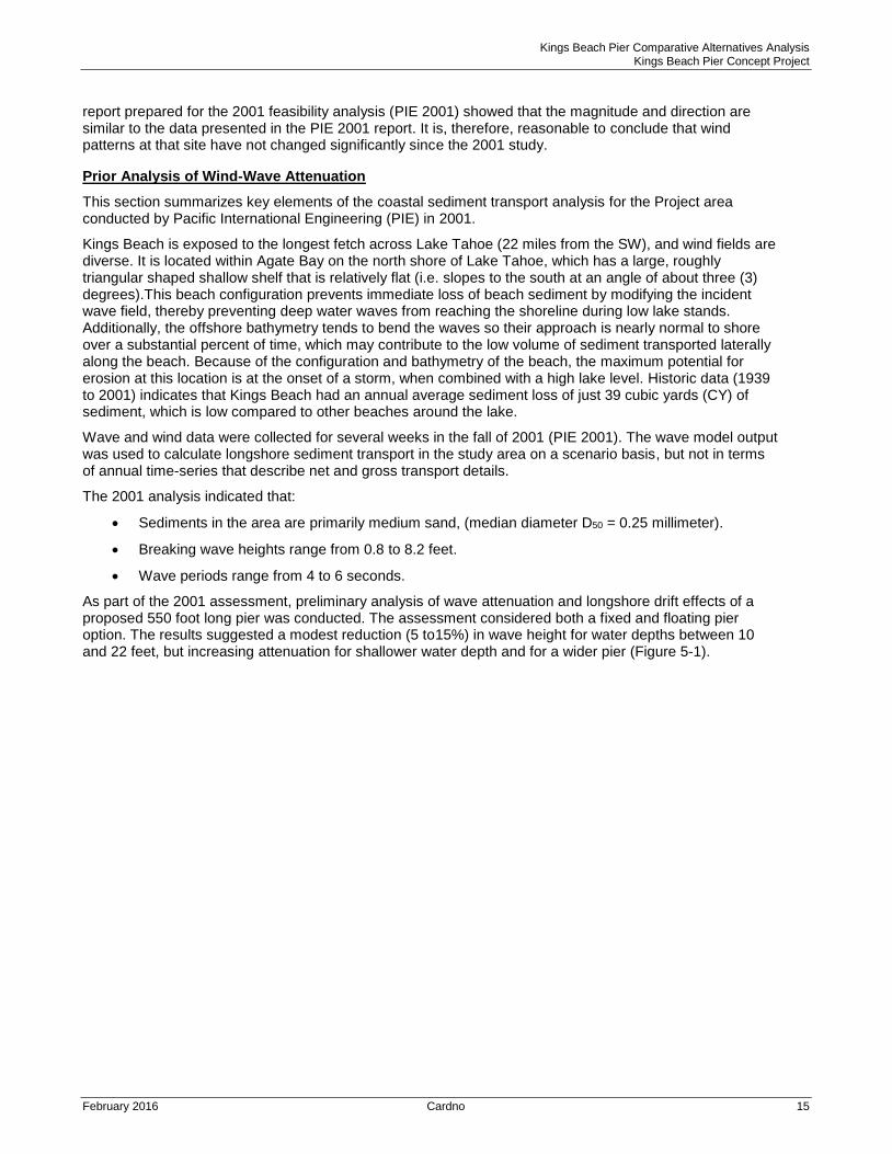
As part of the 2001 assessment, preliminary analysis of wave attenuation and longshore drift effects of a proposed 550 foot long pier was conducted. The assessment considered both a fixed and floating pier option. The results suggested a modest reduction (5 to15%) in wave height for water depths between 10 and 22 feet, but increasing attenuation for shallower water depth and for a wider pier (Figure 5-1).
Kings Beach Pier Comparative Alternatives Analysis Kings Beach Pier Concept Project
February 2016 Cardno 16
Figure 5-1 Wave Transmission Attenuation for Various Floating Pier Alternatives
Where the Coefficient of Transmission (Ct) = Height of the transmitted wave (Ht) as a percentage of the Height of the incident wave (Hi); and W = pier width, D = draft thickness
Source: Pacific International Engineering 2001.
2015 Analysis of Wave Transmission
Based on the present conceptual design (Table 5-1 and Appendix A), the potential wave attenuation produced by the pier design (having combined fixed and floating pontoon sections) has been estimated by Cardno using two separate numerical formulae. These are general transmission coefficients based on structural characteristics and do not differentiate between the two pier location options.
Cardno also estimated potential wave attenuation for the proposed floating pier design using the Macagno (1953) and Weigel (1960) formulae. The Weigel equation was used to provide an alternative assessment of the wave attenuation produced by the pier in terms of the basic pontoon cross sections and drafts for a range of water depths and wave periods. See Appendix C for detailed wave attenuation results. The results show that the piers produce only minimal wave attenuation for waves with a period 4 seconds or longer, which is a bit more variation with water depth than for the Macagno equation. For wave periods of 4 seconds or longer the wave attenuation ranges between 7 and 18 percent but more attenuation occurs in shallow water since the pier draft is a larger
Results from either of these attenuation equations are one dimensional. That is, they do not take into account the effect of waves diffracting around the ends of a pier, which depends upon the pier layout - including the length of the pier and the orientation of the pier to the incoming waves. Nor do they consider the projected length of each structure along the shoreline, which depends on the alignment of the floating pier sections and the direction of the dominant incident waves.
Consequently, the values presented in the tables in Appendix C are considered conservative, as the actual wave attenuation would be less than calculated (i.e., Ct ratio would be higher), since waves diffract around the outer ends of the floating sections, but there are fixed sections close to shore. At high water, the landward end of the floating pier is situated more than 250 feet from the shoreline. There will be less wave diffraction at low water, where the landward end of the floating pontoon sections is situated much closer to the shoreline.
Kings Beach Pier Comparative Alternatives Analysis Kings Beach Pier Concept Project
February 2016 Cardno 17
Wave Modelling
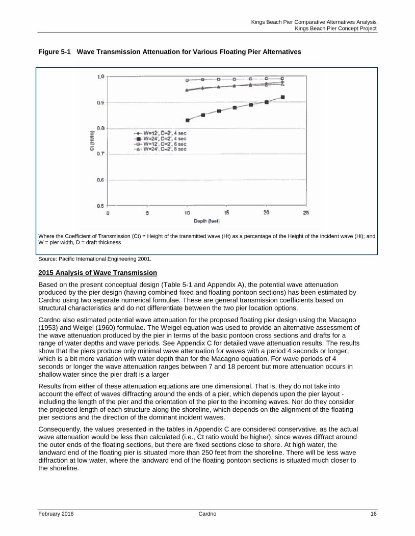
To assess the potential for wave diffraction around the floating sections of the proposed pier designs at the two location options, and to gain an understanding of the possible impact of the piers on the spatial distribution of wave energy, Cardno performed numerical modelling using the SWAN wave model.
The SWAN wave model was developed at the Delft University of Technology and includes wave refraction, shoaling, non-linear wave-wave interaction, a full directional spectral description of wave propagation, bed friction, white capping, currents and wave breaking. It is used internationally for wave propagation investigations. The wave model prepared for this assessment ensured that the model properly simulated the transformation of wave energy across near shore lake bed slopes, and through and around the floating sections of the two pier location options.
Wave modelling was conducted for three scenarios:
The existing condition (a baseline simulation);
The implementation of the concept design at the central pier location option; and,
The implementation of the concept design at the east pier location option.
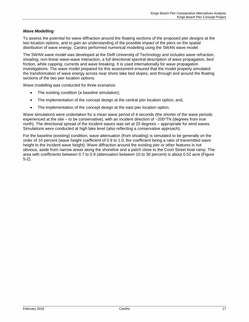
Wave simulations were undertaken for a mean wave period of 4 seconds (the shorter of the wave periods experienced at the site – to be conservative), with an incident direction of ~200oTN (degrees from true north). The directional spread of the incident waves was set at 20 degrees – appropriate for wind waves. Simulations were conducted at high lake level (also reflecting a conservative approach).
For the baseline (existing) condition, wave attenuation (from shoaling) is simulated to be generally on the order of 10 percent (wave height coefficient of 0.9 to 1.0, the coefficient being a ratio of transmitted wave height to the incident wave height). Wave diffraction around the existing pier or other features is not obvious, aside from narrow areas along the shoreline and a patch close to the Coon Street boat ramp. The area with coefficients between 0.7 to 0.9 (attenuation between 10 to 30 percent) is about 0.52 acre (Figure 5-2).
Kings Beach Pier Comparative Alternatives Analysis Kings Beach Pier Concept Project
February 2016 Cardno 18
Figure 5-2: Distribution of Wave Height Attenuation Coefficient at KBSRA under the Existing Conditions
Source: Cardno 2015
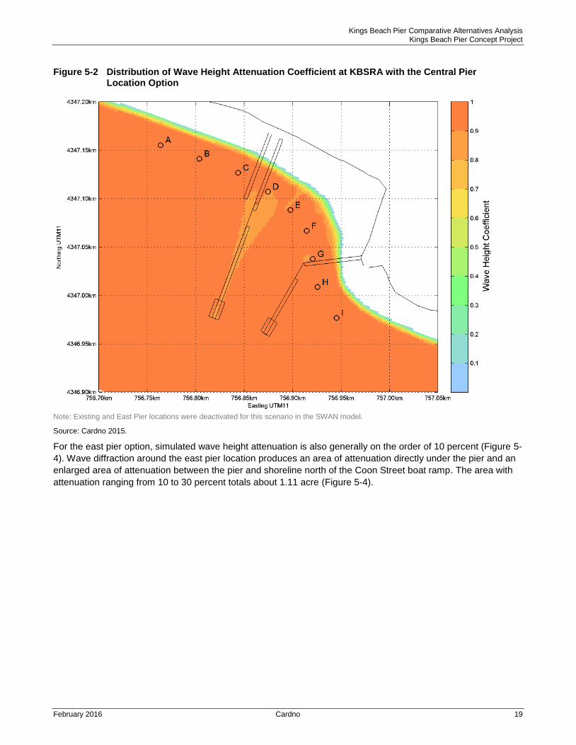
For the central pier location option, simulated wave height attenuation is also generally on the order of 10 percent (Figure 5-3). Wave diffraction around the central pier location produces an area of attenuation directly under the pier and between the pier and shoreline from the existing pier to slightly east of the proposed central pier. The area with attenuation ranging from 10 to 30 percent totals about 1.06 acre. (Figure 5-3).
Kings Beach Pier Comparative Alternatives Analysis Kings Beach Pier Concept Project
February 2016 Cardno 19
Figure 5-2 Distribution of Wave Height Attenuation Coefficient at KBSRA with the Central Pier Location Option
Note: Existing and East Pier locations were deactivated for this scenario in the SWAN model.
Source: Cardno 2015.
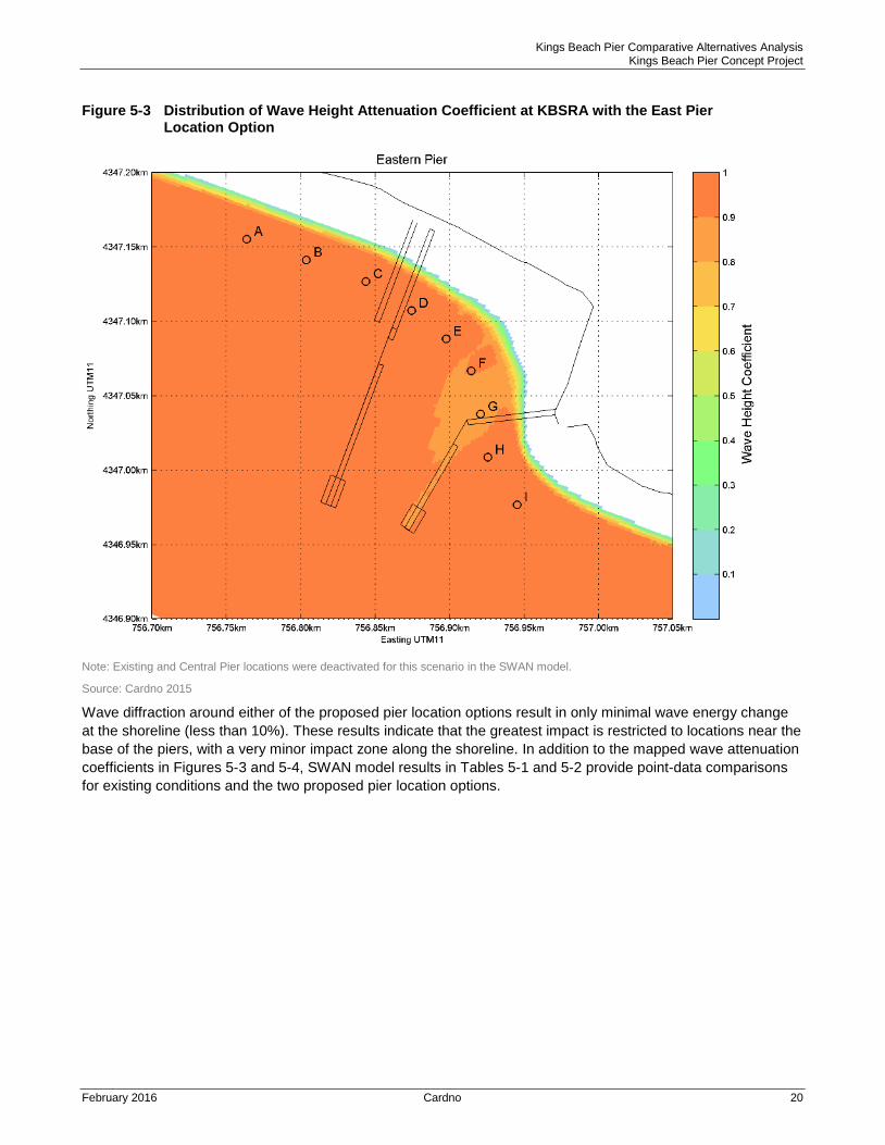
For the east pier option, simulated wave height attenuation is also generally on the order of 10 percent (Figure 5-
4). Wave diffraction around the east pier location produces an area of attenuation directly under the pier and an
enlarged area of attenuation between the pier and shoreline north of the Coon Street boat ramp. The area with
attenuation ranging from 10 to 30 percent totals about 1.11 acre (Figure 5-4).
Kings Beach Pier Comparative Alternatives Analysis Kings Beach Pier Concept Project
February 2016 Cardno 20
Figure 5-3 Distribution of Wave Height Attenuation Coefficient at KBSRA with the East Pier Location Option
Note: Existing and Central Pier locations were deactivated for this scenario in the SWAN model.
Source: Cardno 2015
Wave diffraction around either of the proposed pier location options result in only minimal wave energy change
at the shoreline (less than 10%). These results indicate that the greatest impact is restricted to locations near the
base of the piers, with a very minor impact zone along the shoreline. In addition to the mapped wave attenuation
coefficients in Figures 5-3 and 5-4, SWAN model results in Tables 5-1 and 5-2 provide point-data comparisons
for existing conditions and the two proposed pier location options.
Kings Beach Pier Comparative Alternatives Analysis Kings Beach Pier Concept Project
February 2016 Cardno 21
Table 5-1 SWAN Modelling Results – Impact of Pier Options on Wave Heights (in terms of wave coefficient) at the Shoreline
Output Location
Existing Pier East Pier Option Central Pier Option
Wave Coefficient Wave Coefficient Difference Wave Coefficient Difference
A 1.00 1.00 0.4% 1.00 0.4%
B 1.00 1.00 0.4% 1.00 -0.1%
C 1.00 1.00 0.5% 0.97 -2.6%
D 0.99 0.99 0.1% 0.90 -9.1%
E 0.97 0.96 -0.6% 0.94 -3.3%
F 0.94 0.91 -2.9% 0.94 0.4%
G 0.92 0.88 -4.2% 0.93 1.1%
H 1.00 1.01 0.7% 1.00 0.5%
I 1.00 1.01 1.0% 1.00 0.1%
Source: Cardno 2015
Table 5-2 SWAN Modelling Results – Impact of Pier Options on Wave Direction at the Shoreline
Output Location
Existing Condition East Pier Option Central Pier Option
Direction (oTN) Direction (oTN) Difference Direction (oTN) Difference
A 197.6 197.6 0.0% 197.5 -0.1%
B 198.0 197.9 0.0% 198.0 0.0%
C 201.7 201.7 0.0% 202.3 0.3%
D 207.6 207.6 0.0% 207.5 0.0%
E 215.5 215.8 0.1% 215.1 -0.2%
F 220.7 221.2 0.2% 221.2 0.2%
G 222.8 222.5 -0.2% 223.5 0.3%
H 224.3 224.8 0.2% 224.6 0.2%
I 211.4 211.8 0.2% 211.4 0.0%
Source: Cardno 2015
Likely Morphological Changes
Commonly, the implementation of pier and pontoon (floating) structures, the latter having significantly more wave attenuation character, are expected to have an impact at the shoreline. Because floating structures modify the energy of waves approaching the shoreline – by reflection, transmission, dissipation and end-diffraction, they can potentially cause the shoreline in the lee of the structure to realign to the modified wave climate and littoral drift regime. In most instances the result is the accretion of sediment in the leeward ‘shadow’ of the wave attenuation structure (the deposit is commonly called a salient) and corresponding shoreline recession in the region down-drift. Over the long term the formation of a salient allows the longshore transport to be restored. The shoreline shape change persists, but varies in time as wave conditions and water levels change. However, in areas where the magnitude of littoral drift is low, and the wave attenuation produced by the pontoon is relatively minor, then the impacts at the shoreline may be minimal.
Results of the wave transmission calculations and SWAN modelling indicate that the implementation of the proposed concept design at either pier location option for KBSRA would result in some modification of wave energy at the shoreline, but of a minor magnitude. As a result, only very minor changes would be expected at the shoreline in terms of erosion and accretion of sediment – manifested as very small changes in local shoreline alignment with a widening in the lee area (the salient).
Kings Beach Pier Comparative Alternatives Analysis Kings Beach Pier Concept Project
February 2016 Cardno 22
For the central pier option, it is likely that a small salient will form at the base of the structure, where the wave energy is most attenuated. The salient formation would occur gradually and imperceptibly, and would likely only consist of a shoreline progradation (i.e., beach building out lakeward) of a few yards. Some shoreline recession (i.e., beach retreat landward) can be expected down drift (to the west), likely of the same order as the accretion, or less.
For the east pier option, salient formation would likely occur to the north and west of the Coon Street boat ramp, but would be of the same order of magnitude as for the central pier location option.
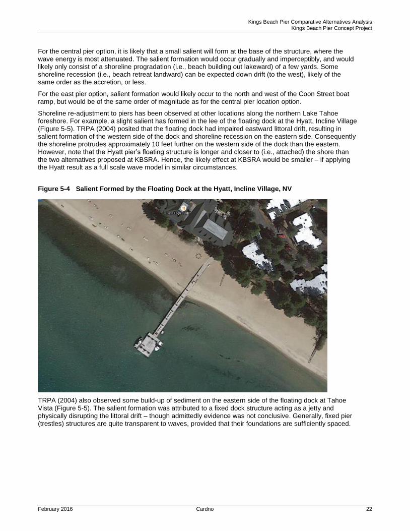
Shoreline re-adjustment to piers has been observed at other locations along the northern Lake Tahoe foreshore. For example, a slight salient has formed in the lee of the floating dock at the Hyatt, Incline Village (Figure 5-5). TRPA (2004) posited that the floating dock had impaired eastward littoral drift, resulting in salient formation of the western side of the dock and shoreline recession on the eastern side. Consequently the shoreline protrudes approximately 10 feet further on the western side of the dock than the eastern. However, note that the Hyatt pier’s floating structure is longer and closer to (i.e., attached) the shore than the two alternatives proposed at KBSRA. Hence, the likely effect at KBSRA would be smaller – if applying the Hyatt result as a full scale wave model in similar circumstances.
Figure 5-4 Salient Formed by the Floating Dock at the Hyatt, Incline Village, NV
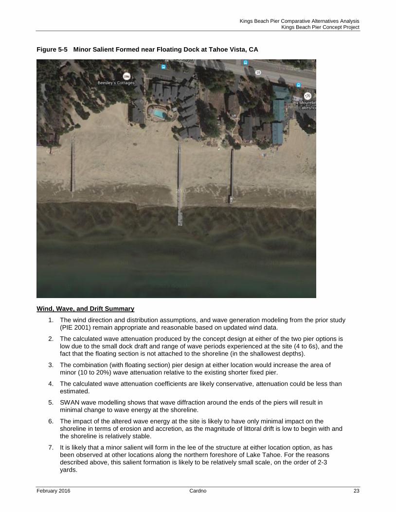
TRPA (2004) also observed some build-up of sediment on the eastern side of the floating dock at Tahoe Vista (Figure 5-5). The salient formation was attributed to a fixed dock structure acting as a jetty and physically disrupting the littoral drift – though admittedly evidence was not conclusive. Generally, fixed pier (trestles) structures are quite transparent to waves, provided that their foundations are sufficiently spaced.
Kings Beach Pier Comparative Alternatives Analysis Kings Beach Pier Concept Project
February 2016 Cardno 23
Figure 5-5 Minor Salient Formed near Floating Dock at Tahoe Vista, CA
Wind, Wave, and Drift Summary
1. The wind direction and distribution assumptions, and wave generation modeling from the prior study (PIE 2001) remain appropriate and reasonable based on updated wind data.
2. The calculated wave attenuation produced by the concept design at either of the two pier options is low due to the small dock draft and range of wave periods experienced at the site (4 to 6s), and the fact that the floating section is not attached to the shoreline (in the shallowest depths).
3. The combination (with floating section) pier design at either location would increase the area of minor (10 to 20%) wave attenuation relative to the existing shorter fixed pier.
4. The calculated wave attenuation coefficients are likely conservative, attenuation could be less than estimated.
5. SWAN wave modelling shows that wave diffraction around the ends of the piers will result in minimal change to wave energy at the shoreline.
6. The impact of the altered wave energy at the site is likely to have only minimal impact on the shoreline in terms of erosion and accretion, as the magnitude of littoral drift is low to begin with and the shoreline is relatively stable.
7. It is likely that a minor salient will form in the lee of the structure at either location option, as has been observed at other locations along the northern foreshore of Lake Tahoe. For the reasons described above, this salient formation is likely to be relatively small scale, on the order of 2-3 yards.
Kings Beach Pier Comparative Alternatives Analysis Kings Beach Pier Concept Project
February 2016 Cardno 24
5.2 Biologic Resources
The following information regarding biological resources focuses on updates for topics of particular concern
regarding potential distinctions between the pier location options. Additional general information about the
biological resources that applies equally to either location within the KBSRA is provided in the prior studies for
the project by Harding ESE (2001a).
Fish Habitat
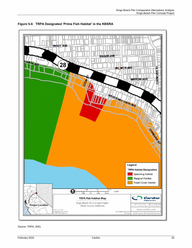
TRPA regulations (TRPA Code of Regulations 63.3.1) protect ‘prime fish habitat’ in the nearshore areas of Lake
Tahoe. Prime fish habitat, including spawning habitat and feed/cover habitat, is indicated in the project area on
the TRPA Prime Fish Habitat Map (Figure 6-7) (TRPA 2009). Prime fish habitat areas protected by TRPA
regulations consist of areas of gravel (2-64 mm), cobble (64-256 mm), and boulder (>256 mm) substrate used by
native fish species such as Lahontan redsides (Richardsonius egregius), Tui chub (Gila bicolor), Tahoe sucker
(Catostomus tahoensis), and Paiute sculpin (Cottus beldingi) for spawning, egg incubation, feeding, and cover.
TRPA regulations require that destruction or impairment of Prime Fish Habitat to be mitigated at a 1:1.5 ratio.
The Lahontan Regional Water Quality Control Board (LRWQCB) Basin Plan Discharge Prohibition #4 (Chapter
5.2) prohibits new pier construction in significant spawning habitats. An exemption to this prohibition is available
for relocation of disturbance by existing piers (exemption d).
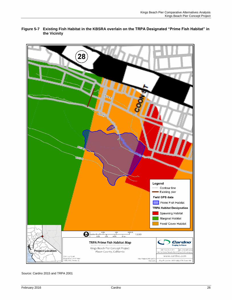
The 2001 study of the Project vicinity (Harding ESE 2001a) noted an area suitable for fish spawning near and
east of the boat launch facility. The 2001 report described the remainder of the study area as predominantly
sand and silt substrate (<2mm diameter) that is unsuitable for spawning. Fish habitat in the KBSRA was also
surveyed in detail by a Cardno fisheries biologist in 2015 (Cardno 2015 Appendix B). The 2015 field study
identified and mapped prime fish habitat in the KBSRA as a zone of gravel, cobble, and boulder substrate
reaching from locations directly offshore of the existing boat ramp and extending to and east of the eastern edge
of the KBSRA project area (Figure 5-8). To the west, this prime habitat zone is bordered by sand substrate
encompassing the existing pier and the remainder of the project area. Such areas of sand substrate are
considered ‘marginal’ fish habitat (TRPA 2009). Only the 4.64 acre portion with gravel or coarser substrate is
identified as ‘prime fish habitat’ (Figure 5-8) (i.e., the 2015 survey identifies more marginal habitat than in the
general map by TRPA). The majority of the prime habitat zone is considered ‘Feed/Cover’ habitat, while the
north-eastern edge of the prime habitat is considered ‘Spawning’ habitat (see Figures 5-7, Figure 5-8).
Actual utilization of the prime habitat zone for spawning, feeding, and cover varies with fish species, season, and
lake level (Beauchamp et al. 1994, Moyle 2002). In general, larger substrates such as cobble and boulder
present the best spaces for use as cover while gravels offer the best habitat for spawning and egg incubation
(Moyle 2002, Evans 1969). However, substrate embeddedness, which is the degree to which gravel and cobble
are ‘embedded’ in sand, also effects suitability as spawning habitat. Highly embedded substrates are less
suitable for the incubation of eggs (Moyle 2002). Based on 2015 field observations, the western portion of the
identified prime habitat zone is highly embedded and the degree of embeddedness decreases gradually
eastward (Figure 5-8). This also supports the conclusion that high quality spawning habitat is restricted to the
east edge of the site, along the KBSRA boundary.
Kings Beach Pier Comparative Alternatives Analysis Kings Beach Pier Concept Project
February 2016 Cardno 25
Figure 5-6 TRPA Designated ‘Prime Fish Habitat’ in the KBSRA
Source: TRPA, 2001
Kings Beach Pier Comparative Alternatives Analysis Kings Beach Pier Concept Project
February 2016 Cardno 26
Figure 5-7 Existing Fish Habitat in the KBSRA overlain on the TRPA Designated “Prime Fish Habitat” in the Vicinity
Source: Cardno 2015 and TRPA 2001
Kings Beach Pier Comparative Alternatives Analysis Kings Beach Pier Concept Project
February 2016 Cardno 27
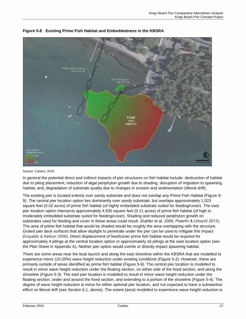
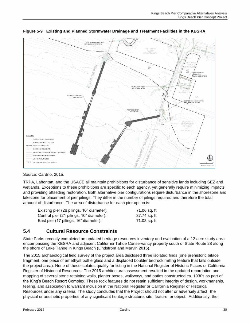
Figure 5-8 Existing Prime Fish Habitat and Embeddedness in the KBSRA
Source: Cardno, 2015
In general the potential direct and indirect impacts of pier structures on fish habitat include: destruction of habitat
due to piling placement; reduction of algal periphyton growth due to shading; disruption of migration to spawning
habitat; and, degradation of substrate quality due to changes in erosion and sedimentation (littoral drift).
The existing pier is located entirely over sandy substrate and does not overlap any Prime Fish Habitat (Figure 6-
9). The central pier location option lies dominantly over sandy substrate, but overlaps approximately 1,023
square feet (0.02 acres) of prime fish habitat (of highly embedded substrate suited for feeding/cover). The east
pier location option intersects approximately 4,930 square feet (0.11 acres) of prime fish habitat (of high to
moderately embedded substrate suited for feeding/cover). Shading and reduced periphyton growth on
substrates used for feeding and cover in these areas could result. (Kahler et al. 2000, Peterlin & Urbanič 2013).
The area of prime fish habitat that would be shaded would be roughly the area overlapping with the structure.
Grated pier deck surfaces that allow daylight to penetrate under the pier can be used to mitigate this impact
(Gayaldo & Nelson 2006). Direct displacement of feed/cover prime fish habitat would be required for
approximately 4 pilings at the central location option or approximately 16 pilings at the east location option (see
the Plan Sheet in Appendix A). Neither pier option would overlie or directly impact spawning habitat.
There are some areas near the boat launch and along the east shoreline within the KBSRA that are modelled to
experience minor (10-20%) wave height reduction under existing conditions (Figure 5-2). However, these are
primarily outside of areas identified as prime fish habitat (Figure 5-9). The central pier location is modelled to
result in minor wave height reduction under the floating section, on either side of the fixed section, and along the
shoreline (Figure 5-3). The east pier location is modelled to result in minor wave height reduction under the
floating section, under and around the fixed section, and extending to a portion of the shoreline (Figure 5-4). The
degree of wave height reduction is minor for either optional pier location, and not expected to have a substantive
effect on littoral drift (see Section 6.1, above). The extent (area) modelled to experience wave height reduction is
Kings Beach Pier Comparative Alternatives Analysis Kings Beach Pier Concept Project
February 2016 Cardno 28
about double that under existing conditions for either pier location option (see Figures 5-2, 5-3, and 5-4). But,
given the modelled magnitudes, neither of the proposed pier configurations would produce a substantial change
in wave energy or drift. Local modifications in sand and smaller substrate distributions could result, and be
expressed by a change in the shoreline configuration (see the discussion of ‘salient’ forms in the section above).
Therefore, the small effects on sand substrate would be expressed.
Under either location alternative, fish may utilize the proposed dock’s floating section as cover. Tahoe fishes
sometimes use overwater structures as cover, especially at high lake levels (Beauchamp et al. 1994). The
floating sections would provide greater cover than most existing overwater structures. It is unlikely this impact
would lead to any significant changes in local fish community. Juvenile fishes may also be attracted to pier
lighting at night (Kahler et al. 2000). These impacts would be similar for either location option and would not
affect or mitigate any other impacts to prime fish habitat. TRPA regulations do not address impacts that may
cause changes in fish behaviour.
Tahoe Yellow Cress
Tahoe yellow cress (Rorippa subumbellata) is a low-growing perennial herb unique to the sandy shoreline of
Lake Tahoe. It is found nowhere else (CDFW 2015). Tahoe yellow cress (TYC) is listed as an endangered plant
species under the provisions of the California Endangered Species Act (CESA) and is on the Nevada state list of
fully protected species of native flora, threatened with extinction. The US Fish and Wildlife Service recently
decided to remove the plant from the federal Endangered Species Act (ESA) candidate list (USFWS 2015).
TYC reproduces by both rhizomes and seed production. This combination allows TYC to persist along the
narrow band of dynamic sandy beaches and dunes on the margins of Lake Tahoe, even as lake levels fluctuate.
Generally, when lake levels are low and more beach area is exposed, conditions are favourable for TYC growth
and expansion. When lake levels are high, limited beach area exists and TYC populations decline. Competition
for this limited TYC beach habitat due to shoreline development, including structures that alter sediment erosion
and deposition patterns, and intense recreation use represent serious threats for the species.
Although potential habitat exists in the beach areas of KBSRA, no specimens were observed in the study area in
2001 (Harding ESE 2001a). In 2002, Dr. Bruce Pavlik, Dr. Dennis Murphy, and a Technical Advisory Group
(TAG) consisting of thirteen state, federal, local and non-profit organizations developed the “Conservation
Strategy for Tahoe Yellow Cress”. The strategy outlined six goals intended to guide the management of Tahoe
yellow cress and its habitat, and any updated strategy is expected to be adopted by all parties within the next
few months. The TAG became the Adaptive Management Working Group (AMWG) to implement the strategy.
Among other things, the AMWG conduct population surveys at known and potential population sites. The
species is concentrated on the south and west shores of the lake, with a few scattered occurrences on the north
and east shores. The species is most affected by recreational use of the beaches and development of marinas,
boat ramps, and piers, which result in trampling and degradation or loss of habitat (USFS 2015). The 2014
AMWG survey found large populations in previously established sites due to low lake levels. The KBSRA site is
not regularly surveyed for TYC by the AMWG due to lack of prior presence and heavy recreational use (Sedlock,
2015).
To assess the current condition, and in recognition of increased potential beach habitat due to the extremely low
lake levels, Conservancy staff surveyed the Project site on June 20, 2015. Staff specifically focused on newly
exposed sandy habitat near the boat ramp and the fenced off restoration areas near new drainage facilities. No
TYC were found (Sedlock, 2015).
Therefore, the analysis concludes that neither the existing pier nor a reconstructed, relocated pier in the KBSRA
would impact TYC.
5.3 Storm Drainage, Waters and Wetlands/SEZ
In 2001, three drainage outfalls existed along the beach; one located near the conference center, one just east
of the existing pier and one near the boat launch area (Harding ESE 2001). Each outfall (the portion above high
lake level, 6229.1 feet) was delineated as an "other water," as defined by the U.S. Army Corps of Engineers.
Kings Beach Pier Comparative Alternatives Analysis Kings Beach Pier Concept Project
February 2016 Cardno 29
Riparian vegetation surrounded each outfall. Given the strong association of hydric soils and vegetation, these
outfall areas were identified to be stream environment zones (SEZ) and mapped as Land Capability District 1b,
as defined by TRPA.
Numerous studies and improvements to the drainage systems within the commercial core area of Kings Beach
have been conducted since the prior feasibility study, including implementation of changes to the stormwater
features and stormwater hydrology within the KBSRA. The following summary of recent changes and existing
conditions within the KBSRA reflects Cardno’s knowledge from direct participation in various aspects of design
and implementation for public projects under contract to Placer County.
The Coon Street storm water outfall (located near the boat launch) was reconstructed and relocated
approximately 50 feet to the north by Placer County in 2010 as part of the Fox Clean Water Pipe Project (Figure
6-10). The pipe was day-lighted at the Lake Tahoe high water mark (6229 feet) and a riparian channel was
constructed in the backshore area. The pipe and riparian channel are designed and constructed to convey the
100-year design storm (at the time of design) for the contributing area in accordance with Placer County
Drainage Manual and the accepted watershed model (XPSWMM). The design flow for the pipe is summarized in
the Caltrans Hydraulic Design Report prepared by Cardno and also in the Fox Clean Water Pipe Drainage
Report (ENTRIX 2009).
As part of the Kings Beach Commercial Core Improvement Project (KBCCIP) the outfalls near the conference
center and existing pier have been reconstructed (Figure 5-10). These outfalls are also day-lighted at the Lake
Tahoe high water mark (6229 feet) with a riparian outfall channel in the backshore area. The pipe and riparian
channel are designed and constructed to convey the 25-year design storm (at the time of design) for the
contributing area in accordance with Caltrans requirements and the accepted watershed model (XPSWMM). The
water conveyed is all the water in the contributing watersheds, including upper watershed runoff that is
separated from the highway/urban runoff. As part of the KBCCIP, the highway/urban runoff is treated. The
XPSWMM results for these pipes described the design flows that would discharge at the pipe outlet. These flows
are summarized in the Caltrans Hydraulic Design Report prepared by Cardno (Cardno ENTRIX and Dokken
2011).
All three of the improvements were designed and constructed to minimize beach erosion and wave impacts to
the outfalls. The extents of their functionality is to be determined upon completion of the Commercial Core
Improvement Project.
As shown in Figure 5-10, the two pier location options create differing effects on these improvements. The East
pier location avoids conflict with all three outfalls. The Central pier alternative, located at the end of the existing
sidewalk as proposed in the 2001 pier analysis, would place the pier and associated pilings over the recently
reconstructed outfall associated with the KBCCIP near the existing pier. Potential effects of this location include
disturbance of newly established riparian/wetland vegetation and altering storm flow patterns at the outfall, and
the hydraulics and shading of a co-located pier would require reconstruction of the outfall with more resistant,
non-living materials. While pier design could be used to prevent any adverse hydraulics, adjusting the final
location and alignment to move laterally 10 to 20 feet would avoid the potential conflict.
Kings Beach Pier Comparative Alternatives Analysis Kings Beach Pier Concept Project
February 2016 Cardno 30
Figure 5-9 Existing and Planned Stormwater Drainage and Treatment Facilities in the KBSRA
Source: Cardno, 2015.
TRPA, Lahontan, and the USACE all maintain prohibitions for disturbance of sensitive lands including SEZ and
wetlands. Exceptions to these prohibitions are specific to each agency, yet generally require minimizing impacts
and providing offsetting restoration. Both alternative pier configurations require disturbance in the shorezone and
lakezone for placement of pier pilings. They differ in the number of pilings required and therefore the total
amount of disturbance. The area of disturbance for each pier option is:
Existing pier (26 pilings, 10” diameter): 71.06 sq. ft.
Central pier (21 pilings, 16” diameter): 87.74 sq. ft.
East pier (17 pilings, 16” diameter): 71.03 sq. ft.
5.4 Cultural Resource Constraints
State Parks recently completed an updated heritage resources inventory and evaluation of a 12 acre study area encompassing the KBSRA and adjacent California Tahoe Conservancy property south of State Route 28 along the shore of Lake Tahoe in Kings Beach (Lindstrom and Marvin 2015).
The 2015 archaeological field survey of the project area disclosed three isolated finds (one prehistoric biface
fragment, one piece of amethyst bottle glass and a displaced boulder bedrock milling feature that falls outside
the project area). None of these isolates qualify for listing in the National Register of Historic Places or California
Register of Historical Resources. The 2015 architectural assessment resulted in the updated recordation and
mapping of several stone retaining walls, planter boxes, walkways, and patios constructed ca. 1930s as part of
the King’s Beach Resort Complex. These rock features do not retain sufficient integrity of design, workmanship,
feeling, and association to warrant inclusion in the National Register or California Register of Historical
Resources under any criteria. The study concludes that the Project should not alter or adversely affect the
physical or aesthetic properties of any significant heritage structure, site, feature, or object. Additionally, the
Kings Beach Pier Comparative Alternatives Analysis Kings Beach Pier Concept Project
February 2016 Cardno 31
Project should not have the potential to cause a physical change that would affect unique ethnic cultural values
or restrict historic or prehistoric religious or sacred uses.
The Washoe Tribe of Nevada and California, the applicable tribal authority for lands encompassing the project area,
was notified and concurred with the 2015 study findings.
Either of the pier location options could affect previously unreported underwater cultural resources, and
appropriate mitigation measures would be required as part of project permitting for either of the locations.
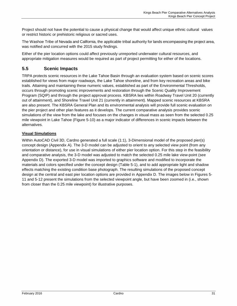
5.5 Scenic Impacts
TRPA protects scenic resources in the Lake Tahoe Basin through an evaluation system based on scenic scores
established for views from major roadways, the Lake Tahoe shoreline, and from key recreation areas and bike
trails. Attaining and maintaining these numeric values, established as part of the Environmental Thresholds,
occurs through promoting scenic improvements and restoration through the Scenic Quality Improvement
Program (SQIP) and through the project approval process. KBSRA lies within Roadway Travel Unit 20 (currently
out of attainment), and Shoreline Travel Unit 21 (currently in attainment). Mapped scenic resources at KBSRA
are also present. The KBSRA General Plan and its environmental analysis will provide full scenic evaluation on
the pier project and other plan features as it develops. The current comparative analysis provides scenic
simulations of the view from the lake and focuses on the changes in visual mass as seen from the selected 0.25
mile viewpoint in Lake Tahoe (Figure 5-10) as a major indicator of differences in scenic impacts between the
alternatives.
Visual Simulations
Within AutoCAD Civil 3D, Cardno generated a full scale (1:1), 3-Dimensional model of the proposed pier(s)
concept design (Appendix A). The 3-D model can be adjusted to orient to any selected view point (from any
orientation or distance), for use in visual simulations of either pier location option. For this step in the feasibility
and comparative analysis, the 3-D model was adjusted to match the selected 0.25 mile lake view-point (see
Appendix D). The exported 3-D model was imported to graphics software and modified to incorporate the
materials and colors specified under the concept design (Table 5-1), and to add appropriate light and shadow
effects matching the existing condition base photograph. The resulting simulations of the proposed concept
design at the central and east pier location options are provided in Appendix D. The images below in Figures 5-
11 and 5-12 present the simulations from the selected viewpoint angle, but have been zoomed in (i.e., shown
from closer than the 0.25 mile viewpoint) for illustrative purposes.
Kings Beach Pier Comparative Alternatives Analysis Kings Beach Pier Concept Project
February 2016 Cardno 32
Figure 5-10 Selected Photo Point with Lake View to KBSRA for Visual Simulations
Source: Cardno 2015
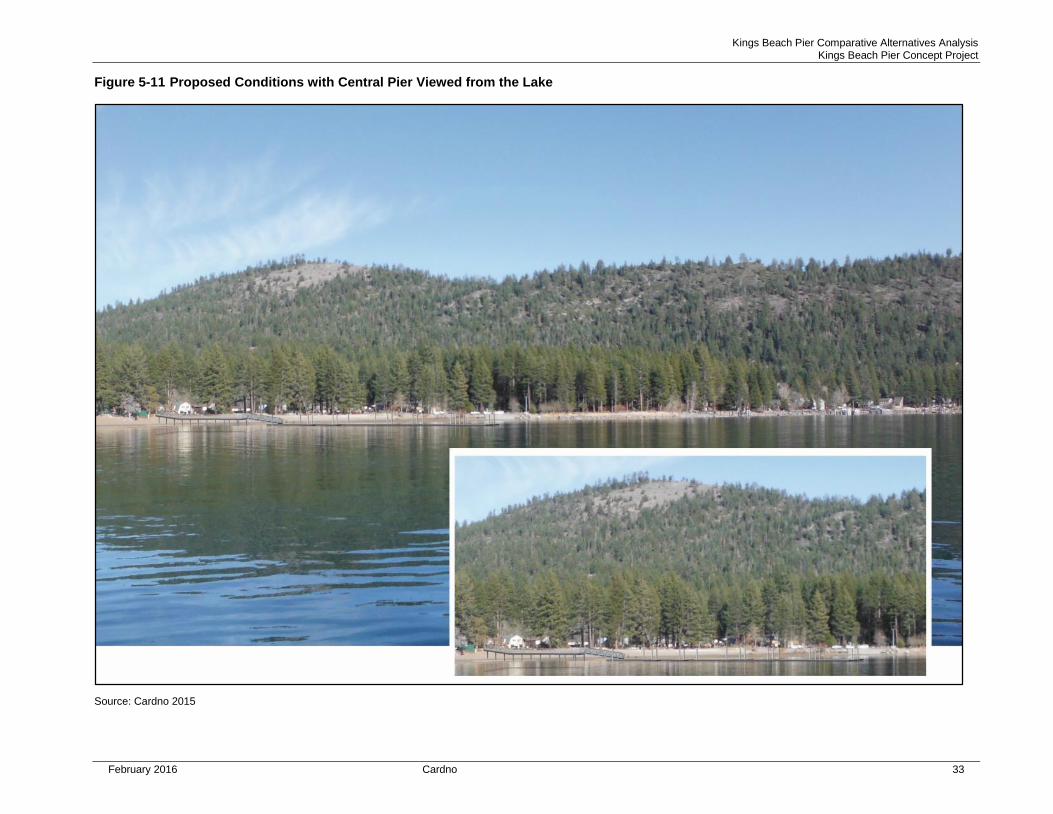
Kings Beach Pier Comparative Alternatives Analysis Kings Beach Pier Concept Project
February 2016 Cardno 33
Figure 5-11 Proposed Conditions with Central Pier Viewed from the Lake
Source: Cardno 2015
Kings Beach Pier Comparative Alternatives Analysis Kings Beach Pier Concept Project
February 2016 Cardno 34
Figure 5-12 Proposed Conditions with East Pier Viewed from the Lake
Source: Cardno 2015
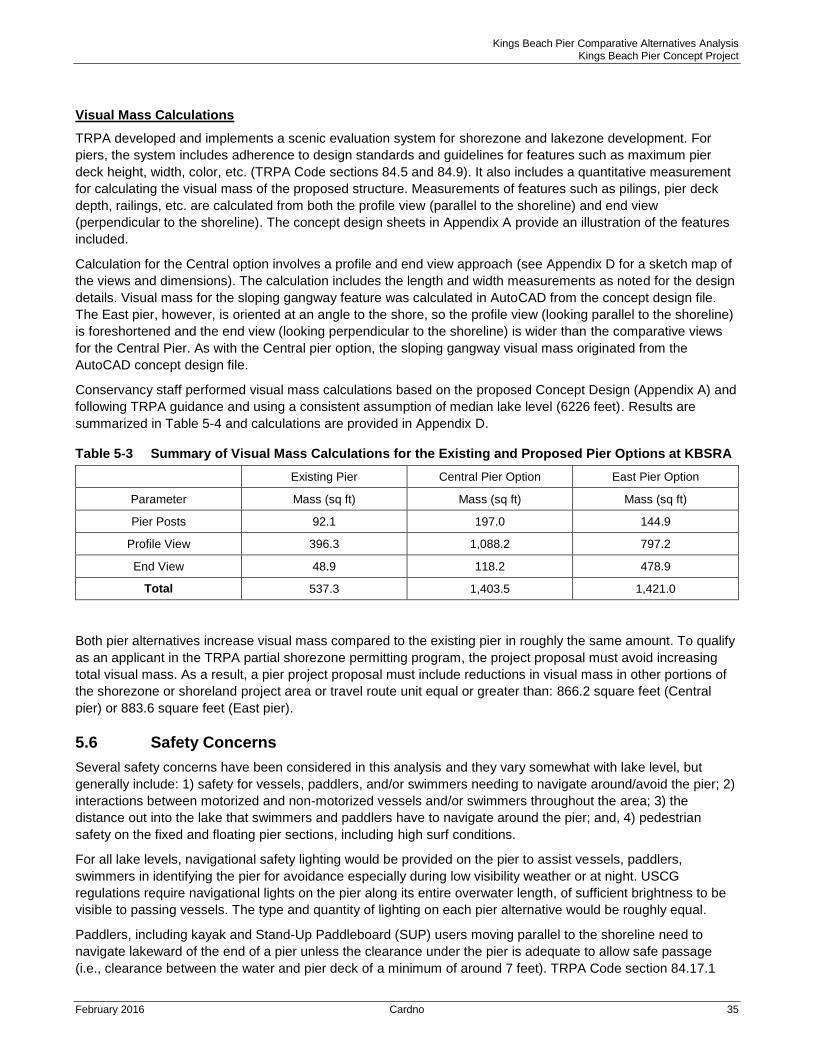
Kings Beach Pier Comparative Alternatives Analysis Kings Beach Pier Concept Project
February 2016 Cardno 35
Visual Mass Calculations
TRPA developed and implements a scenic evaluation system for shorezone and lakezone development. For
piers, the system includes adherence to design standards and guidelines for features such as maximum pier
deck height, width, color, etc. (TRPA Code sections 84.5 and 84.9). It also includes a quantitative measurement
for calculating the visual mass of the proposed structure. Measurements of features such as pilings, pier deck
depth, railings, etc. are calculated from both the profile view (parallel to the shoreline) and end view
(perpendicular to the shoreline). The concept design sheets in Appendix A provide an illustration of the features
included.
Calculation for the Central option involves a profile and end view approach (see Appendix D for a sketch map of
the views and dimensions). The calculation includes the length and width measurements as noted for the design
details. Visual mass for the sloping gangway feature was calculated in AutoCAD from the concept design file.
The East pier, however, is oriented at an angle to the shore, so the profile view (looking parallel to the shoreline)
is foreshortened and the end view (looking perpendicular to the shoreline) is wider than the comparative views
for the Central Pier. As with the Central pier option, the sloping gangway visual mass originated from the
AutoCAD concept design file.
Conservancy staff performed visual mass calculations based on the proposed Concept Design (Appendix A) and
following TRPA guidance and using a consistent assumption of median lake level (6226 feet). Results are
summarized in Table 5-4 and calculations are provided in Appendix D.
Table 5-3 Summary of Visual Mass Calculations for the Existing and Proposed Pier Options at KBSRA
Existing Pier Central Pier Option East Pier Option
Parameter Mass (sq ft) Mass (sq ft) Mass (sq ft)
Pier Posts 92.1 197.0 144.9
Profile View 396.3 1,088.2 797.2
End View 48.9 118.2 478.9
Total 537.3 1,403.5 1,421.0
Both pier alternatives increase visual mass compared to the existing pier in roughly the same amount. To qualify
as an applicant in the TRPA partial shorezone permitting program, the project proposal must avoid increasing
total visual mass. As a result, a pier project proposal must include reductions in visual mass in other portions of
the shorezone or shoreland project area or travel route unit equal or greater than: 866.2 square feet (Central
pier) or 883.6 square feet (East pier).
5.6 Safety Concerns
Several safety concerns have been considered in this analysis and they vary somewhat with lake level, but
generally include: 1) safety for vessels, paddlers, and/or swimmers needing to navigate around/avoid the pier; 2)
interactions between motorized and non-motorized vessels and/or swimmers throughout the area; 3) the
distance out into the lake that swimmers and paddlers have to navigate around the pier; and, 4) pedestrian
safety on the fixed and floating pier sections, including high surf conditions.
For all lake levels, navigational safety lighting would be provided on the pier to assist vessels, paddlers,
swimmers in identifying the pier for avoidance especially during low visibility weather or at night. USCG
regulations require navigational lights on the pier along its entire overwater length, of sufficient brightness to be
visible to passing vessels. The type and quantity of lighting on each pier alternative would be roughly equal.
Paddlers, including kayak and Stand-Up Paddleboard (SUP) users moving parallel to the shoreline need to
navigate lakeward of the end of a pier unless the clearance under the pier is adequate to allow safe passage
(i.e., clearance between the water and pier deck of a minimum of around 7 feet). TRPA Code section 84.17.1
Kings Beach Pier Comparative Alternatives Analysis Kings Beach Pier Concept Project
February 2016 Cardno 36
prohibits creating a boat wake or operating a motorized watercraft at speeds in excess of 5 mph within 600’ of
the waterline at Lake Tahoe. This “no wake zone” reduces safety concerns inherent in mixing motorized and
non-motorized water recreation users. Navigating around the end of a pier may put non-motorized users in
deeper water, farther from shore, and near the no wake zone for motorized vessels.
For the existing pier, passage under the fixed pier is not an option under most lake levels, but avoiding the pier
requires only a short detour away from the shoreline (approximately 200 feet at high lake levels). The existing
pier is approximately 400 feet inside the no wake zone (Figure 5-14), therefore, swimmers and paddlers
navigating around the end of the existing pier experience limited hazards from potential interactions with
motorized vessels and wakes.
For the proposed conceptual design with a combined fixed and floating pier, the need to navigate around the pier
end varies by lake level. During high lake levels, there would be little or no option for small boats, paddlers or
swimmers to safely go under the fixed pier; they must detour around the lakeward end of the pier. For lake levels
near median (~6226 feet), paddlers or swimmers could choose to go under the fixed pier’ sections, or go around
the lakeward end of the pier. At low lake levels, paddlers would need to navigate lakeward of the pier to move
parallel to the shore.
Under the central pier location option and at high lake level, paddlers would need to navigate about 600 feet
away from the shoreline to pass the pier. During peak use times, this distance could be greater to avoid
motorized boats tied up at the pier head. Therefore, during high water level lake conditions, this option places
non-motorized users near or past the boundary of the no wake zone (Figure 5-14) and would increase the
potential for safety conflicts between user groups. During low water conditions, ample space within the no wake
zone would allow non-motorized passage without increased safety conflicts.
Under the east pier location option and at high lake level, paddlers would need to navigate about 400 feet away
from the shoreline to pass the pier. Given the shoreline configuration, the east pier’s lakeward end would still be
about 200 feet inside of the existing no wake boundary (Figure 5-14), limiting the potential for interactions
between user types outside the no wake zone. It should be noted that under existing conditions, paddlers
traveling along the shoreline tend to move into deeper water to pass the rocky point east of boat ramp; many
paddle near this boundary point currently. At low water, the no wake boundary would lie approximately 600 feet
beyond the end of the pier in this location.
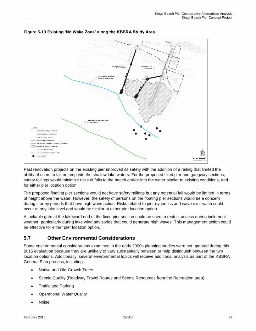
Kings Beach Pier Comparative Alternatives Analysis Kings Beach Pier Concept Project
February 2016 Cardno 37
Figure 5-13 Existing ‘No Wake Zone’ along the KBSRA Study Area
Past renovation projects on the existing pier improved its safety with the addition of a railing that limited the
ability of users to fall or jump into the shallow lake waters. For the proposed fixed pier and gangway sections,
safety railings would minimize risks of falls to the beach and/or into the water similar to existing conditions, and
for either pier location option.
The proposed floating pier sections would not have safety railings but any potential fall would be limited in terms
of height above the water. However, the safety of persons on the floating pier sections would be a concern
during stormy periods that have high wave action. Risks related to pier dynamics and wave over wash could
occur at any lake level and would be similar at either pier location option.
A lockable gate at the lakeward end of the fixed pier section could be used to restrict access during inclement
weather, particularly during lake wind advisories that could generate high waves. This management action could
be effective for either pier location option.
5.7 Other Environmental Considerations
Some environmental considerations examined in the early 2000s planning studies were not updated during this
2015 evaluation because they are unlikely to vary substantially between or help distinguish between the two
location options. Additionally, several environmental topics will receive additional analysis as part of the KBSRA
General Plan process, including:
Native and Old-Growth Trees
Scenic Quality (Roadway Travel Routes and Scenic Resources from the Recreation area)
Traffic and Parking
Operational Water Quality
Noise
Kings Beach Pier Comparative Alternatives Analysis Kings Beach Pier Concept Project
February 2016 Cardno 38
6 Comparison and Conclusions
Based on the technical analyses described above, Table 6-1 summarizes how implementing the proposed 2015
concept design at either the central or east pier location would affect each of the key regulatory criteria.
The analysis indicates that the two location options have different advantages and disadvantages relative to
potential impacts, mitigation requirements, and/or permits and approvals. Based on the Concept Design, the
potential issues and impacts for some topics are similar in magnitude and extent for both location options (e.g.,
littoral drift, visual mass, visitor safety on the floating pier). However, there are relatively large differences for a
few issue areas, some of which pose trade-offs for planning and design decisions. For example, the east pier
has a substantially larger footprint within prime fish habitat, but the central pier may result in more safety risks for
non-motorized water craft users.
None of the results herein are considered to be a ‘fatal flaw’ that would eliminate one or the other of the location
options at this Conceptual Design phase, particularly since specific regulations and requirements could change
prior to completion of the KBSRA General Plan update and final design of the selected pier project.
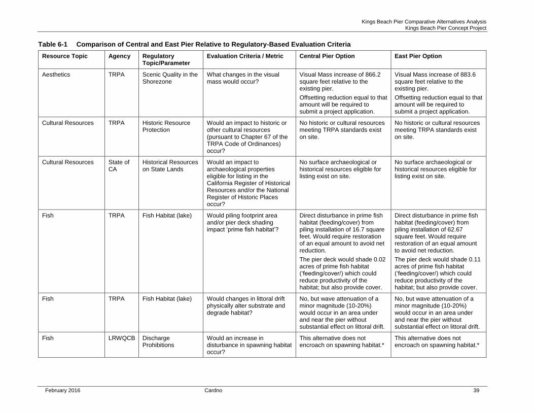
Kings Beach Pier Comparative Alternatives Analysis Kings Beach Pier Concept Project
February 2016 Cardno 39
Table 6-1 Comparison of Central and East Pier Relative to Regulatory-Based Evaluation Criteria
Resource Topic Agency Regulatory Topic/Parameter
Evaluation Criteria / Metric Central Pier Option East Pier Option
Aesthetics TRPA Scenic Quality in the Shorezone
What changes in the visual mass would occur?
Visual Mass increase of 866.2 square feet relative to the existing pier.
Offsetting reduction equal to that amount will be required to submit a project application.
Visual Mass increase of 883.6 square feet relative to the existing pier.
Offsetting reduction equal to that amount will be required to submit a project application.
Cultural Resources TRPA Historic Resource Protection
Would an impact to historic or other cultural resources (pursuant to Chapter 67 of the TRPA Code of Ordinances) occur?
No historic or cultural resources meeting TRPA standards exist on site.
No historic or cultural resources meeting TRPA standards exist on site.
Cultural Resources State of CA
Historical Resources on State Lands
Would an impact to archaeological properties eligible for listing in the California Register of Historical Resources and/or the National Register of Historic Places occur?
No surface archaeological or historical resources eligible for listing exist on site.
No surface archaeological or historical resources eligible for listing exist on site.
Fish TRPA Fish Habitat (lake) Would piling footprint area and/or pier deck shading impact ‘prime fish habitat’?
Direct disturbance in prime fish habitat (feeding/cover) from piling installation of 16.7 square feet. Would require restoration of an equal amount to avoid net reduction.
The pier deck would shade 0.02 acres of prime fish habitat (‘feeding/cover/) which could reduce productivity of the habitat; but also provide cover.
Direct disturbance in prime fish habitat (feeding/cover) from piling installation of 62.67 square feet. Would require restoration of an equal amount to avoid net reduction.
The pier deck would shade 0.11 acres of prime fish habitat (‘feeding/cover/) which could reduce productivity of the habitat; but also provide cover.
Fish TRPA Fish Habitat (lake) Would changes in littoral drift physically alter substrate and degrade habitat?
No, but wave attenuation of a minor magnitude (10-20%) would occur in an area under and near the pier without substantial effect on littoral drift.
No, but wave attenuation of a minor magnitude (10-20%) would occur in an area under and near the pier without substantial effect on littoral drift.
Fish LRWQCB Discharge Prohibitions
Would an increase in disturbance in spawning habitat occur?
This alternative does not encroach on spawning habitat.*
This alternative does not encroach on spawning habitat.*
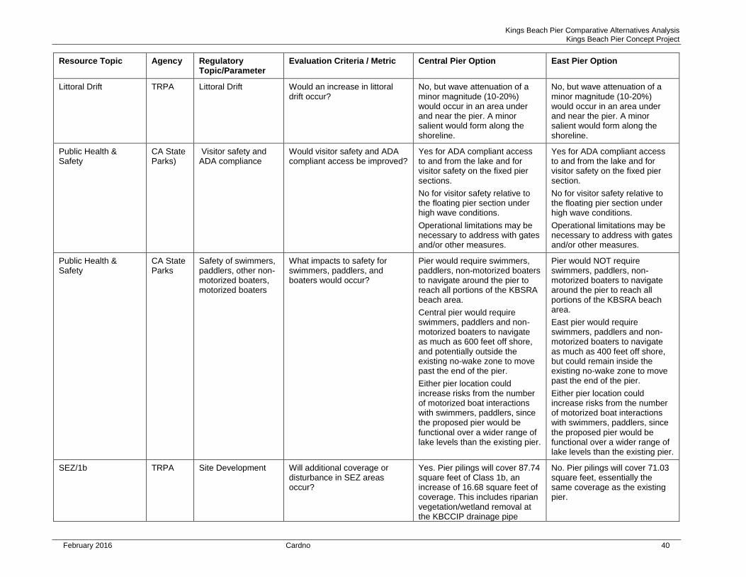
Kings Beach Pier Comparative Alternatives Analysis Kings Beach Pier Concept Project
February 2016 Cardno 40
Resource Topic Agency Regulatory Topic/Parameter
Evaluation Criteria / Metric Central Pier Option East Pier Option
Littoral Drift TRPA Littoral Drift Would an increase in littoral drift occur?
No, but wave attenuation of a minor magnitude (10-20%) would occur in an area under and near the pier. A minor salient would form along the shoreline.
No, but wave attenuation of a minor magnitude (10-20%) would occur in an area under and near the pier. A minor salient would form along the shoreline.
Public Health & Safety
CA State Parks)
Visitor safety and ADA compliance
Would visitor safety and ADA compliant access be improved?
Yes for ADA compliant access to and from the lake and for visitor safety on the fixed pier sections.
No for visitor safety relative to the floating pier section under high wave conditions.
Operational limitations may be necessary to address with gates and/or other measures.
Yes for ADA compliant access to and from the lake and for visitor safety on the fixed pier section.
No for visitor safety relative to the floating pier section under high wave conditions.
Operational limitations may be necessary to address with gates and/or other measures.
Public Health & Safety
CA State Parks
Safety of swimmers, paddlers, other non-motorized boaters, motorized boaters
What impacts to safety for swimmers, paddlers, and boaters would occur?
Pier would require swimmers, paddlers, non-motorized boaters to navigate around the pier to reach all portions of the KBSRA beach area.
Central pier would require swimmers, paddlers and non-motorized boaters to navigate as much as 600 feet off shore, and potentially outside the existing no-wake zone to move past the end of the pier.
Either pier location could increase risks from the number of motorized boat interactions with swimmers, paddlers, since the proposed pier would be functional over a wider range of lake levels than the existing pier.
Pier would NOT require swimmers, paddlers, non-motorized boaters to navigate around the pier to reach all portions of the KBSRA beach area.
East pier would require swimmers, paddlers and non-motorized boaters to navigate as much as 400 feet off shore, but could remain inside the existing no-wake zone to move past the end of the pier.
Either pier location could increase risks from the number of motorized boat interactions with swimmers, paddlers, since the proposed pier would be functional over a wider range of lake levels than the existing pier.
SEZ/1b TRPA Site Development Will additional coverage or disturbance in SEZ areas occur?
Yes. Pier pilings will cover 87.74 square feet of Class 1b, an increase of 16.68 square feet of coverage. This includes riparian vegetation/wetland removal at the KBCCIP drainage pipe
No. Pier pilings will cover 71.03 square feet, essentially the same coverage as the existing pier.
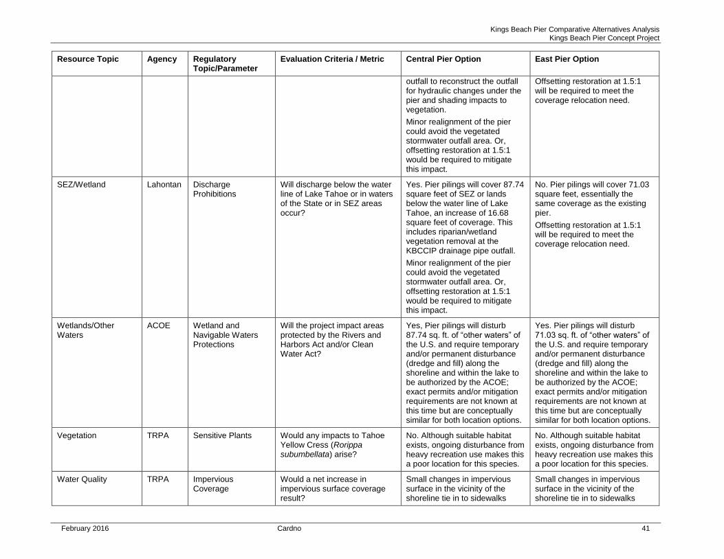
Kings Beach Pier Comparative Alternatives Analysis Kings Beach Pier Concept Project
February 2016 Cardno 41
Resource Topic Agency Regulatory Topic/Parameter
Evaluation Criteria / Metric Central Pier Option East Pier Option
outfall to reconstruct the outfall for hydraulic changes under the pier and shading impacts to vegetation.
Minor realignment of the pier could avoid the vegetated stormwater outfall area. Or, offsetting restoration at 1.5:1 would be required to mitigate this impact.
Offsetting restoration at 1.5:1 will be required to meet the coverage relocation need.
SEZ/Wetland Lahontan Discharge Prohibitions
Will discharge below the water line of Lake Tahoe or in waters of the State or in SEZ areas occur?
Yes. Pier pilings will cover 87.74 square feet of SEZ or lands below the water line of Lake Tahoe, an increase of 16.68 square feet of coverage. This includes riparian/wetland vegetation removal at the KBCCIP drainage pipe outfall.
Minor realignment of the pier could avoid the vegetated stormwater outfall area. Or, offsetting restoration at 1.5:1 would be required to mitigate this impact.
No. Pier pilings will cover 71.03 square feet, essentially the same coverage as the existing pier.
Offsetting restoration at 1.5:1 will be required to meet the coverage relocation need.
Wetlands/Other Waters
ACOE Wetland and Navigable Waters Protections
Will the project impact areas protected by the Rivers and Harbors Act and/or Clean Water Act?
Yes, Pier pilings will disturb 87.74 sq. ft. of “other waters” of the U.S. and require temporary and/or permanent disturbance (dredge and fill) along the shoreline and within the lake to be authorized by the ACOE; exact permits and/or mitigation requirements are not known at this time but are conceptually similar for both location options.
Yes. Pier pilings will disturb 71.03 sq. ft. of “other waters” of the U.S. and require temporary and/or permanent disturbance (dredge and fill) along the shoreline and within the lake to be authorized by the ACOE; exact permits and/or mitigation requirements are not known at this time but are conceptually similar for both location options.
Vegetation TRPA Sensitive Plants Would any impacts to Tahoe Yellow Cress (Rorippa subumbellata) arise?
No. Although suitable habitat exists, ongoing disturbance from heavy recreation use makes this a poor location for this species.
No. Although suitable habitat exists, ongoing disturbance from heavy recreation use makes this a poor location for this species.
Water Quality TRPA Impervious Coverage
Would a net increase in impervious surface coverage result?
Small changes in impervious surface in the vicinity of the shoreline tie in to sidewalks
Small changes in impervious surface in the vicinity of the shoreline tie in to sidewalks
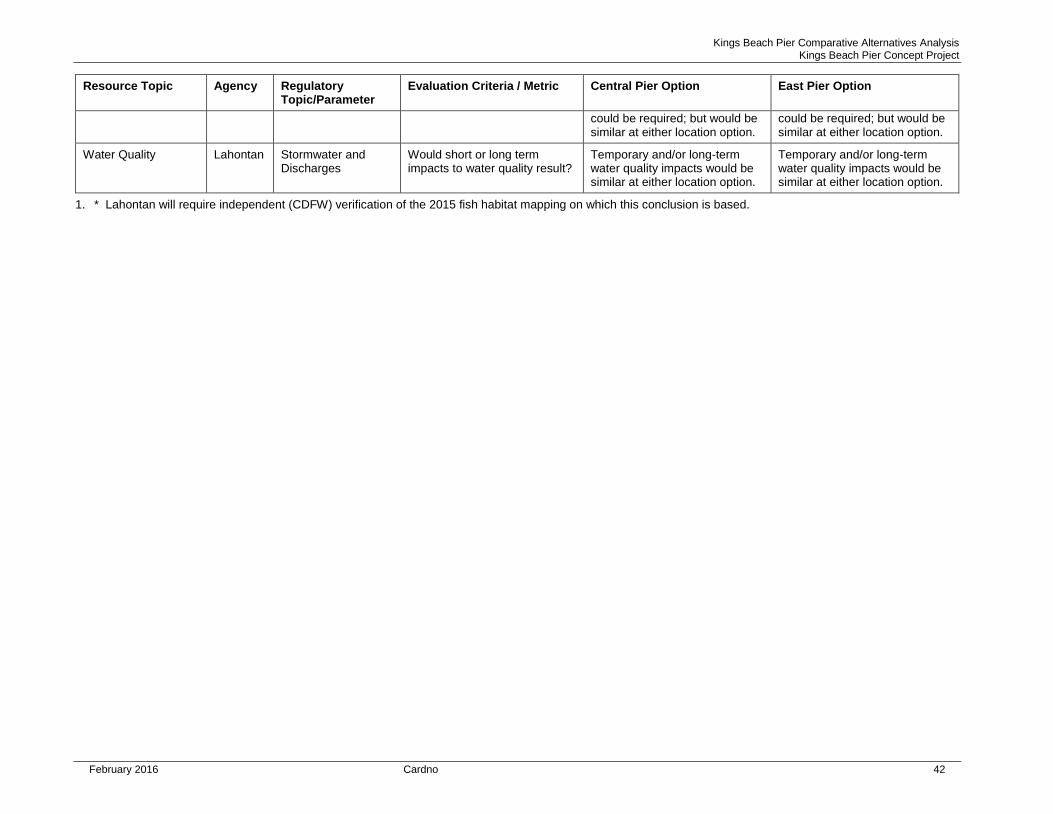
Kings Beach Pier Comparative Alternatives Analysis Kings Beach Pier Concept Project
February 2016 Cardno 42
Resource Topic Agency Regulatory Topic/Parameter
Evaluation Criteria / Metric Central Pier Option East Pier Option
could be required; but would be similar at either location option.
could be required; but would be similar at either location option.
Water Quality Lahontan Stormwater and Discharges
Would short or long term impacts to water quality result?
Temporary and/or long-term water quality impacts would be similar at either location option.
Temporary and/or long-term water quality impacts would be similar at either location option.
1. * Lahontan will require independent (CDFW) verification of the 2015 fish habitat mapping on which this conclusion is based.
Kings Beach Pier Comparative Alternatives Analysis Kings Beach Pier Concept Project
February 2016 Cardno 43
7 References Cited
Beauchamp, D. A., Byron, E. R., & Wurtsbaugh, W. A. 1994. Summer habitat use by littoral-zone fishes in Lake Tahoe and the effects of shoreline structures. North American Journal of Fisheries Management, 14(2), 385-394.
California Tahoe Conservancy (Conservancy) 2001. Proposed Kings Beach Pier Replacement Project Preliminary Assessment and Planning Summary Report. Prepared by Harding ESE, in association with Glanville & Associates; Pacific Built, Inc.; Kaufman Planning and Consulting; Pacific International Engineering, Kniep Planning and Environmental services, the Chambers group, LSC Transportation Consultants, and Transpac Marinas, Inc. (December 4, 2001).
California Department of Fish and Wildlife (CDFW) 2015. Tahoe Yellow Cress information page accessed at https://www.wildlife.ca.gov/Conservation/Plants/Endangered/Rorippa-subumbellata.
Cardno ENTRIX and Dokken Engineering 2011. Final Drainage Report for Kings Beach Commercial Core Improvement Project. Prepared for California Department of Transportation District 3 Hydraulics Branch (September 2011) by Paul Wisheropp and Stephen Peck.
Carr, J.H (1951) Mobile Breakwaters. Proceedings of the Second Conference on Coastal Engineering, pp 281-295.
ENTRIX 2009. Assumptions used in the Fox Clean Water Pipe Project Modeling. Memo to Dan LaPlante, Andy Darrow, Placer County Department of Public Works from Paul Wisheropp and Stephen Peck on September 25, 2009.
Evans, D. H. 1969. Life history studies of the Lahontan redside, Richardsonius egregius in Lake Tahoe. California Fish and Game, 55, 197-212.
Gayaldo, P. F., & Nelson, K. (2006). Preliminary results of light transmission under residential piers in Lake Washington, King County, Washington: A comparison between prisms and grating. Lake and Reservoir Management, 22(3), 245-249.
Harding ESE, November, 2001. Biological Resources Inventory Report.
Kahler, T., Grassley, M., & Beauchamp, D. (2000). A summary of the effects of bulkheads, piers, and other artificial structures and shorezone development on ESA-listed salmonids in lakes. Final Report prepared for the City of Bellevue.
Kniep (Jay Kniep Land Use Planning) 2002. Potential Kings Beach Pier Water Quality Issues. Letter report prepared for Harding ESE (draft 01/07/02) and e-transmitted to Virginia Esperanza at the Conservancy on January 9, 2002.
KSA, February 2001. Kings Beach Pier Feasibility Report, letter report.
Lindström, Susan and Judith Marvin 2015. Heritage Resources Inventory and Evaluation Report Kings Beach State Recreation Area Kings Beach, Lake Tahoe, Placer County California. Prepared for California Department of Parks and Recreation (May 2015).
Macagno, E.O (1954) Houles dans un Can Presentent un Passage en Charge. La Houille Blanche, Vol 9, No 1, pp 10-37.
Morey, B.J (1998). Floating Breakwaters: Predicting their Performance. Thesis Submitted to Faculty of Engineering & Applied Science. Memorial University of Newfoundland. January 1998.
Moyle, P. B. 2002.Inland fishes of California. Univ of California Press.
Kings Beach Pier Comparative Alternatives Analysis Kings Beach Pier Concept Project
February 2016 Cardno 44
Pacific International Engineering, November 15, 2001. Coastal and Sediment Transport Analysis for Proposed Pier Replacement at Kings Beach, CA. Draft
Peterlin, M., & Urbanič, G. (2013). A Lakeshore Modification Index and its association with benthic invertebrates in alpine lakes. Ecohydrology, 6(2), 297-311.
Placer County September 2013. Proposed Kings Beach Vision Plan. Prepared by Design workshop, LSC Transportation Consultants, Inc., Moon Design, and Sustainable Community Advocates.
Sedlock, Mark Staff Biologist California Tahoe Conservancy. Personal communications with Sue Rae Irelan September, 2015.
Transpac Marinas, Inc. May 2003. King’s Beach Pier Concept Only drawings (Plan & Profiles A and B, plus Sections; some sheets dated 2002).
TRPA. See Tahoe Regional Planning Agency.
Tahoe Regional Planning Agency (TRPA). (2012). Code of Ordinances. Chapters 80-86. Available at http://www.trpa.org/documents/reisc/5_Comment%20References/CA_Department%20of%20Justice_references/TRPA%20Code%20of%20Ordinances.pdf
Tahoe Regional Planning Agency (2004). Lake Tahoe Shorezone Ordinance Amendments Draft Environmental Impact Assessment.
Tahoe Regional Planning Agency (TRPA). 2009. Prime Fish Habitat Map. Available at www.trpa.org/wp-content/uploads/Fishhab_map.pdf
U.S. Fish & Wildlife Service (USFWS) 2015. Announcement regarding Tahoe yellow cress accessed at http://www.fws.gov/news/ShowNews.cfm?ref=successful-conservation-effort-keeps-tahoe-yellow-cress-off-endangered-&_ID=35265&Source=iframe
US Forest Service (USFS) 2015. Tahoe Yellow Cress Recovery accessed at http://www.fs.fed.us/wildflowers/Rare_Plants/conservation/success/rorippa_subumbellata_recovery.shtml
Weigel, R.L (1960) Transmission of Waves Past a Rigid Vertical Thin Barrier. Journal of Waterways and Harbours Division. American Society of Civil Engineers, pp. 1-12.
Kings Beach Pier Comparative Alternatives Analysis Kings Beach Pier Concept Project
February 2016 Cardno 45
8 Appendices
APPENDIX A KINGS BEACH PIER ALTERNATIVES 2015 CONCEPT PLANS
APPENDIX B KINGS BEACH STATE RECREATION AREA PRIME FISH HABITAT 2015 SURVEY MEMO
APPENDIX C WIND WAVE AND LITTORAL DRIFT ANALYSIS
APPENDIX D KINGS BEACH PIER ALTERNATIVE 2015 SCENIC ANALYSIS DATA