Embed Size (px)
Citation preview
8/8/2019 Koper Walls
http://slidepdf.com/reader/full/koper-walls 1/32
Discovering the Lost Remains of the Late-Antiquity Koper Inner City Walls
Darko Likar, University of Ljubljana, Faculty of Architecture, Sl - 1000, Zoisova 12, Ljubljana,
Slovenia.
e-mail: [email protected]
Translation: Aleksander Jankovi Potonik and Mateja Perpar
Summary
The aim of this research is to answer the question whether or not the remains of the Koper 1 city
walls that were discovered by means of measurement analysis are indeed the remains of the Late-
Antiquity city walls, which had been unsuccessfully sought after ever since Kendler in 1858
published his thesis about the triple Koper City walls.
To answer this question we first carried out three preliminary researches. Even though the
prevailing public opinion was that the outer city walls had been demolished in the 19th century,our first research showed that the walls have in great part been preserved within the present city
structure. The second research established the location of the inner city walls. It has been proved
by archival documents citing seven chapels constructed on the arches of the city gates. The third
investigation was focused on the indications of the existence of a passable towerlike fortification
within the city walls in the section of the walls between the two city gates. It was based on the
use of architectural records, measurement analysis and on the finding of two loopholes which
1 The city of Koper - Capodistria lies on the northern shore of the Adriatic Sea in the province of Istra (Istria). Until1920 this old capital of the Istrian province, called also "The Istrian Athens", was an island. The first to colonise itwere the Greeks. They called it Aegida. Aegida was conquered by the Romans in 177 BC and renamed Capris. In the6th century, during the Byzantine rule, the town was called Justinopolis in honour of the emperor Justinian II. In1210 the patriarch of Aquileia named the town Caput Histriae. Between 1279 and 1797 Koper was under Venetianadministration. Napoleon's rule (1805-1813) was followed by the administrations of the Austrian and later Austria-Hungary Empire until 1918, the kingdom of Italy until 1945 and Yugoslavia until 1991. Since 1991, Koper is a partof Slovenia.
8/8/2019 Koper Walls
http://slidepdf.com/reader/full/koper-walls 2/32
defined the location of the long sought-after city walls.
This was the starting point of the research of the southern face of Sabinijeva Street (Sabinijeva
ulica), where we found the characteristic cross-section of the city walls and its segment with
filled-in loopholes which now functions as a garden wall. As a result of a detailed examination of
the wall structure and previously inaccessible private surfaces of garden walls, we established a
timeline of specific forms of architectural structures, characteristic of the period of transition
from Late-Antiquity to the Middle Ages period. During the research we uncovered solid enough
pieces of evidence which, combined with the three initial researches, confirm the hypothesis of
the discovery of the Late-Antiquity city walls of the city of Koper.
The results of the preliminary research with the acquired material offer a good starting point for a
detailed multi-disciplinary research. The discovery of the ancient Koper City walls with different
development phases in the area between Nova vrata (The New Gate) and Pretorska vrata (The
Praetor Gate) is very significant, since it enables researchers to further uncover the so far rarely
preserved material evidence of the key historic developments during the period of great
migrations of peoples, and the manner in which the contemporary cities responded to the newlyoccurring threat, which the then residents had not yet realized was to become a permanent one.
Key words:
Ancient Koper City walls, uncovered material reminds, Late-Antiquity city walls
Foreword
The main reason for this study was the unexpected uncovering of the structures which positively
confirmed our hypothesis that Mediterranean cultures have, due to the restricted energy sources
and harsh conditions, in the areas of stone-built settlements, better preserved heritage architecture
than perceived by present-day experts due to their viewpoint based on changed social conditions.
In the city which considered its city walls to have been demolished, we have proved our
8/8/2019 Koper Walls
http://slidepdf.com/reader/full/koper-walls 3/32
hypothesis of rational spatial interventions of our ancestors, who would not carry out unnecessary
demolishing of healthy constructions but would rather incorporate them as an integral part of
changed objects. That is why archetypical designs have been preserved in old city structures up
until the modern period, the very time that is now erasing them unscrupulously. After
establishing the architectural methodology for an advanced perceiving of space and the
confirmation of usable applications at the uncovering of important vanishing heritage there
followed a chain of successful, interrelated researches that in turn opened new revelations and
researches related to them. As we started to verify the hypothesis of the preserved passable
fortification (tower) of the inner walls by the measuring of ruins in the field, we arrived, owing to
the measurement analysis, to an unexpected discovery of material remains of the missing walls.
This discovery was the main reason why the undertaking of this research became a priority.
While the passage between the two streets will probably endure, the remains of the old city walls
are to be consumed by the construction of a new object.
Summary
While researching the outer city walls in Koper we came across some indications of the existence
of the older inner city walls. Nothing had been known about these walls except Kendler'shypothesis from 1858, which states that there existed three city walls (itko, 2008, 119) and
Smole's version of this thesis from 1975 (Smole, 1957). In the translation of the Church
Chronicles by the Bishop Naldini of 1700 we found a description of churches built above the
arches of the old city gates. This historic source confirmed our indications and gave us reliable
initial evidence that the presumed remains of the three gates in the field were indeed ancient city
gates.
We continued by researching the seven Koper churches above the arches of the ancient city gates.
The remains of three churches can still be observed at the site as well as the remains of the old
Field city gates in Piran which are, of all the eleven such gates once existing in Istria and on the
Istrian Coast, the single one materially completely preserved. This research enabled us to prove
8/8/2019 Koper Walls
http://slidepdf.com/reader/full/koper-walls 4/32
the approximate location of the city walls between the seven city gates and to reconstruct in
rough contours their architectural appearance on the basis of analogy with the Field city gates in
Piran and some modest remains in Koper itself. Thus this research opened new possibilities of
searching for some hidden material remains of the fortifications at the site.
In the section between the Praetor Gate (Pretorska vrata) and New Gate (Nova vrata) there is a
passage with a ramp and a stairway connecting two streets at a different level and some remains
of a passable building demolished in 1965, through which the stairway used to pass.
Two depictions of the aforementioned passable building exist, one from 1906 and another from
1964, depicting two development phases of the object. In these depictions we recognized three
obvious elements of the fortified passage: the elevated entrance into the object, the access along
the ramp and the defensive character of the wooden balcony. These indications prompted us to
begin the research of the preserved remains by measurements in the field.
Two conclusions were drawn from the measurement analysis of architectural records: the remains
of garden walls above the street pavement are in fact the remains of the city wall breastworks andthe present garden scarp consists of the remains of the body of the city walls while the remnants
of the passable objects are in fact the remains of the former fortified pedestrian passage through
the ancient city walls. In this fortification three types of the wall structure can be recognized:
Gothic, Romanesque and an older, Pre-Romanesque one.
When connected to old Pre-Romanesque structure, the findings achieved through measurements
directed us into a more detailed research of the visible structures of buildings in Sabinijeva Street
and, after the finding of two loopholes, also into a more detailed research of the remnants of the
ancient city walls. The results of this research are presented in this text.
At the same time we concluded the research of the former passable fortification, which used to
8/8/2019 Koper Walls
http://slidepdf.com/reader/full/koper-walls 5/32
protrude from the line of the city walls as a defence tower.
Since they revealed some material remains of the ancient city walls that were so far unknown, the
two researches are extremely important as a starting point for further interdisciplinary researches.
They indicate a very plausible possibility that in Sabinijeva Street we came across a rare material
record of the history of the transitional period between the Late Antiquity and the Middle Ages -
or of the period of the great migration of peoples to the west into Padania.
Introduction
As recently as one year ago it was generally believed that the Koper City walls had been
demolished in the 19th century. This opinion was strengthened by early researchers such as
Caprin, who in 1905 wrote in the conclusion of his article about Levji grad (Lion¶s Castle) and
Koper City walls that after the disbanding of the Venetian Republic the city walls rapidly
deteriorated to the extent that in 1850 they were already virtually nonexistent, except for some
rare visible remains such as the Muda city gate. This opinion was resumed by all the authors that
were describing the city walls of Koper in the following periods (Caprin, 1905, 108).
On the basis of incidental findings during different construction interventions in the city space,
observed through a prolonged period of time, we came to the conclusion that the presumption the
city walls had been demolished was not correct. We formed a working hypothesis that the
prevailing quantity of the former city walls had been in different forms incorporated into the city
structure. We began to study the phenomenon of the city walls and on the basis of the topography
of different forms of remains we produced a map of the state of the preservation of the walls. The
result presented on the map confirms our working hypothesis about the preservation of the
prevailing portion of the outer walls.
Some intense interventions into the city space, which started a couple of years ago, confirmed our
presumptions. Findings in the field proved right our hypothetical forecasts about the location of
8/8/2019 Koper Walls
http://slidepdf.com/reader/full/koper-walls 6/32
the walls and its fortifications thus proving the hypothesis itself.
Last year we published the results of the findings of our research (Likar, 2009 B).
While researching the outer city walls we came across some remnants of the inner walls. As
opposed to the outer one, which was plentifully documented in the archival sources, only some
rare and vague hints were noted, but no solid archival evidence was available to confirm the
existence of the inner city walls.
In the field there exist some barely visible remains of the three city gates, which in reality existed
as late as at the beginning of the 19th century, as proved by the survey register of 1818 (DAT, 1)
and 1819 (DAT, 2). Also, on the oldest town map, made in 1619 by Fini, we can notice some
indications in symbolic form of seven city gates (ASV, 1). However, we had no archival sources
to confirm the thesis that these were indeed the remains of the city gates. So we were unable to
convincingly prove the existence of the inner city walls.
The progress was made by the acquisition of the translation of the book by Bishop Paolo Naldini,
Church Chronicles or a Description of the City and the Bishoprice of Justinopolis, commonlycalled Koper (Cerkveni krajepis ali opis mesta in kofije Justinopolis ljudsko Koper) from 1700.
In it there was a description of Koper churches, organised in a system of twelve city
neighbourhoods, named after twelve city gates, and a description of seven churches standing on
the arches of the old city gates (Naldini, 2001). We thus found a leverage point for the reliable
proof of the location of the older inner city walls along the edge of the terrace above the city
break.
Poljska vrata (The Field Gate) is the best-preserved piece of architecture of the city gate with the
former church built above the arch of the city gate in the entire Istria. By researching them we
8/8/2019 Koper Walls
http://slidepdf.com/reader/full/koper-walls 7/32
were able to prove the mode of transformation of the original form of the ancient city gate from
the passable tower into the city gate with church above them2.
The discovery of the rough layout of the forgotten city walls between the seven city gates
prompted us to begin with a systematic research of detailed indications at the city break and
check up anew the archival sources. Our attention was drawn to a graphics of a Gothic house
with a stairway passage connecting two parallel streets along the city break, dating from 1905
(Caprin, 1905, 282), and the last photograph of that house taken shortly before its partial
demolishing in 1964 (Bernik, 1968, 88). On the graphics three elements are discernible,
characteristic of fortification architecture (the passage on the city break, the elevated entrance to
the passage, the inclination leading to the entrance and a wooden balcony in defensive position
over the entrance). Since they are linked to two definite signs of the presence of the city walls (an
about 6m high ledge of the city break and the location between the two former city gates), we
considered it well-founded to start a preliminary research and measurements of the remains of the
house on the site.
After producing an architectural record and carrying out measurement analysis and after thecomparison with other fortification architecture in Istria, it became clear that we had discovered
the so far unsuccessfully searched-for remnants of the inner city walls and a fortified passage by
the former defence tower. On this basis we began to systematically examine and check up by
means of measurements all visible architecture of the city block, accessible from the public areas.
2 According to Caprin twelve churches above the city gates existed in Istria: two in Piran (Pirano) and in Izola(Isola), one in Labin and in Novi Grad and six in Koper (Caprin, 1905, 172). In our research "Arhitektura cerkvanad mestnimi vrati notranjega obzidja v Kopru in oratorija sv. Jakoba nad Poljskimi vrati v Piranu" (TheArchitecture of Churches Above City Gates of The Inner City Walls of Koper and St. Jakob's Oratory abovethe Field Gate in Piran)" we found evidence of the existence of yet another church above the city gate of Koper,which means that in Istria there were actually thirteen churches above the city gates (Likar, 2010). The results of thisresearch were handed in as an article at the end of last year and will be published in this year's issue of the scientificmagazine Annales.
8/8/2019 Koper Walls
http://slidepdf.com/reader/full/koper-walls 8/32
While examining the stonemasonry of the visible structure of the walls with measurements
correlating to the upper part of the founded city walls - breastwork 3, we found two walled-in and
hardly discernible loopholes, whose measurements correspond to the typology of the previously
found loopholes in the northern part of the city walls.
The research about the passable fortification on the ancient city walls was brought to the
concluding phase and is to be published soon. However, there is a topic that was left uncovered
by that research - the structure of the walls from different periods. While the Romanesque and
Gothic structure are clearly recognizable, the third and the oldest one remained unexplained4.
Since we discovered the profile of the old walls and two presumed loopholes, which still needed
to be proved, and undefinable construction structure of the pre-Romanesque period, we started to
systematically examine walls in the section of Sabinijeva Street between the so-called New Gates
(Nova vrata) and Praetor Gates (Pretorska vrata).
The preliminary research has definitely proved t he finding of t he inner city walls and confirmed
t he h ypot hesis of t he existence of t he fortification designed to control t he pedestrian passage
t hroug h t he city walls into t he city.
The question of the dating of both findings of the walls as well as of the passable fortification in
the earlier period of the development of fortifications still remains open.
While the finding of material remains of the previously unsuccessfully searched-for Late-
Antiquity city walls and the unexpected possibility of the discovery of the fortification from a
later period are very important themselves, they also indicate that the area of the walls between
3 The upper structure built on the wall crown to protect the defenders from enemy projectiles.4 The oldest walls with a structure different from others are preserved in the body of the walls and in the side walls of the passable fortifications protruding from the line of the walls, while the Romanesque and Gothic walls are to befound in the front wall of this fortification.
8/8/2019 Koper Walls
http://slidepdf.com/reader/full/koper-walls 9/32
the New Gate and the Praetor Gate is crucial for the understanding of the developments in the
area of Istria during the transition period between the Antiquity and the Middle Ages.
This presumption is based on the changes of the structure of the same wall of the city walls. The
structure is transformed from the older settled stonemasonry to an irregular improvised one and
again into an organized one which indicates a broader engagement of the community and a
complex structure of society. The presumption will be possible to either prove or dismiss only by
a sophisticated systematic and multidisciplinary research of the area and archeological probing in
the future.
The article continues with the presentation of the research and uncovering of the inner city walls
and passable fortification within these walls.
Material and Methods
In the chapter Materials we explained what we have done to answer the question posed in the
introduction ± whether or not we have really found the so far unknown location of the material
remains of the inner city walls of Koper and how we proved our hypothesis.
At the onset of the research there existed only our indications from previous researches and some
rare sources. Kandler (1858) speculates about the existence of three Koper walls (itko, 2008,
119), equally Smole, who even dates the existence of the second walls (Smole, 1957, 26); while
conservator M. Guek gives the city break as a most likely location of the presumed older city
walls (Guek, 2000, 24).
Smole and Guek also concluded that in case the inner city walls were found they would either be
Late-Antiquity or early Middle Ages walls (Smole, 1957, 26; Guek, 2000, 24).
In our two previous researches we proved the exact course of the outer walls (Likar, 2009 B) and
the orientational course of the inner walls along the seven city doors located in the field (Likar,
8/8/2019 Koper Walls
http://slidepdf.com/reader/full/koper-walls 10/32
2009 B; Likar, 2010). At the presumed location of the section of the walls between the New Gate
and the Praetor Gate there existed indications of two fortifications. While researching at the site
the passable fortification in 2009, we arrived, using measurement analysis, to the finding of the
city wall profile and began a new research.
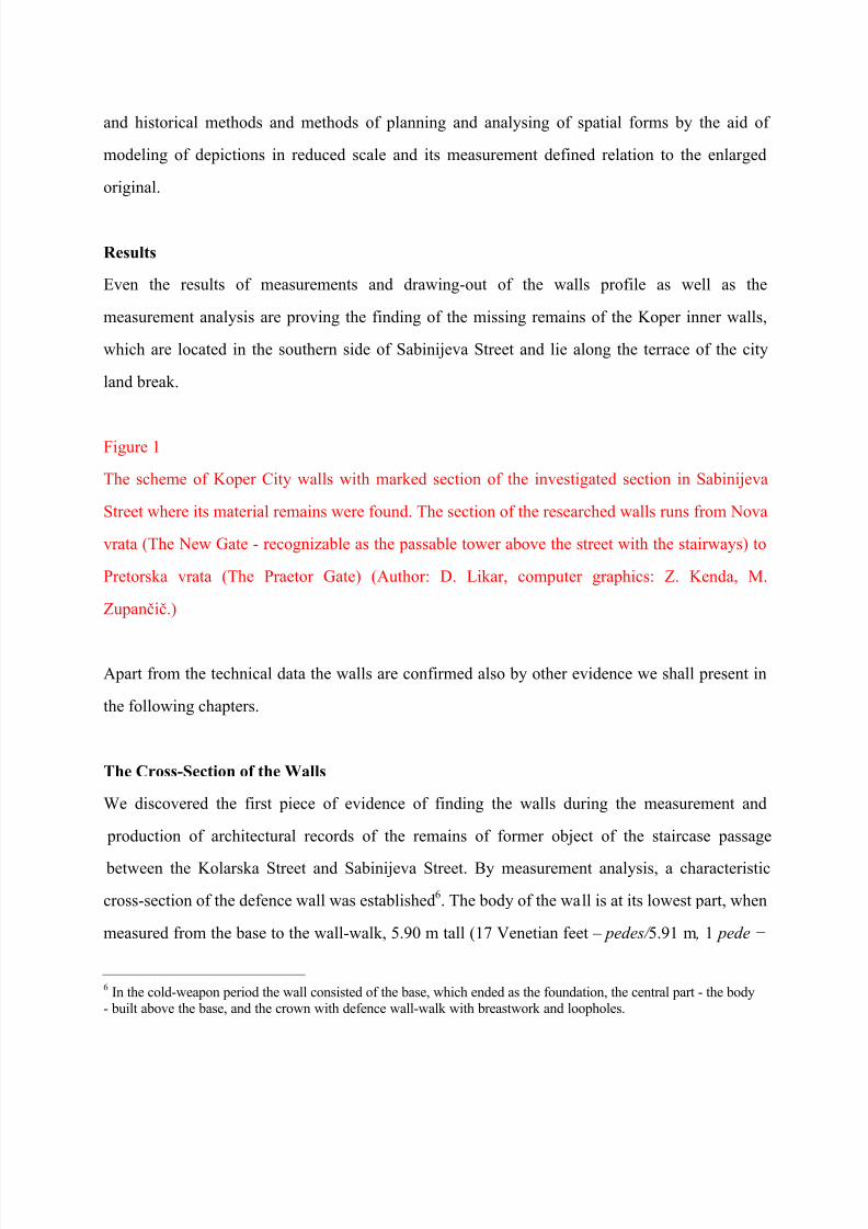
The discovered section of the walls is located between the two city gates (diagram. 1, 5), on the
city break. By the wall a passable fortification was found, located about 40m from the city gates
(the distance identical to the towers of the Piran City walls). In front of the walls Romanesque
houses were built, leaning onto the walls5. When Venice invaded Koper in 1278, these walls had
already been forgotten since they are not mentioned in any Venetian sources (the correspondence
between Venetian and Koper authorities regarding the outer city walls) during the entire five-
hundred-years period of Venetian dominance.
To search for evidence the architectural-conservationist method was used. Apart from the already
known procedures and technologies this method also includes the architectural ability to read old
depictions of the historical and existing built structures of the environment, acquired during the
processes of planning and renovation.
Based on thus-acquired experiences a special methodology and an instrument for improvement of
the perception capacities were produced, called APIS (Likar, 2009 A). APIS is based on the
observation and production of spatial models by drawing-out. These are in turn used as a basis to
extract the essential designed components of the space which are by means of supplementing and
improving drawn from measurements upgraded in the presentation of the state and
reconstruction. The architectural result of such modeling is additionally proved by the correlation
of facts with the aid of graphics and other sources.
5 In the Romanesque period the houses were built in front of the city walls on the city break in such a way that thewall itself was used as the back wall of the newly constructed house, with having either the roof erected directly over it or extending it for an additional floor, which proves that by then its defensive role had already been abandoned.
8/8/2019 Koper Walls
http://slidepdf.com/reader/full/koper-walls 11/32
For the needs of our research a cross-section of the profile of the walls with the defence corridor
was first measured and drawn. The southern façade of Sabinijeva Street was also measured and
drawn, including its most essential and for the research most relevant details (fig. 4). All the
phases of the research are lavishly documented with photographs, sketches, work drawings, scans
and test reconstructions.
According to the work plan the measurements and drawings of the street were followed by a
detailed analysis of the structure (carried out by the measurement method), of the construction
and of the architectural, spatial and designing concepts.
A detailed research of occurrences by the way of proofs, which represents the core of the article,
is presented in the chapter "Results and Discussion".
Methods
The basic method of this research is the architectural-conservationist descriptive method carried
out by observing, sketching, drawing and photographing of the existing state and by the
producing of reconstructions in the form of plans and spatial-design models of the past and present states.
The data for a descriptive study is collected by sketching, measurement, photographing and
drawing of architectural plans.
Another method is the historic method, comprising the collecting, critical analysis and study of
historic archival sources and documents from the architectural point of view, the study of the
remains of the past periods in the field and the organizing of findings according to chronological
sequences.
Architectural-conservationist methods of the research are based on a combination of descriptive
8/8/2019 Koper Walls
http://slidepdf.com/reader/full/koper-walls 12/32
and historical methods and methods of planning and analysing of spatial forms by the aid of
modeling of depictions in reduced scale and its measurement defined relation to the enlarged
original.
Results
Even the results of measurements and drawing-out of the walls profile as well as the
measurement analysis are proving the finding of the missing remains of the Koper inner walls,
which are located in the southern side of Sabinijeva Street and lie along the terrace of the city
land break.
Figure 1
The scheme of Koper City walls with marked section of the investigated section in Sabinijeva
Street where its material remains were found. The section of the researched walls runs from Nova
vrata (The New Gate - recognizable as the passable tower above the street with the stairways) to
Pretorska vrata (The Praetor Gate) (Author: D. Likar, computer graphics: Z. Kenda, M.
Zupani.)
Apart from the technical data the walls are confirmed also by other evidence we shall present in
the following chapters.
The Cross-Section of the Walls
We discovered the first piece of evidence of finding the walls during the measurement and
production of architectural records of the remains of former object of the staircase passage
between the Kolarska Street and Sabinijeva Street. By measurement analysis, a characteristic
cross-section of the defence wall was established6. The body of the wall is at its lowest part, when
measured from the base to the wall-walk, 5.90 m tall (17 Venetian feet ± pedes/ 5.91 m , 1 pede í
6 In the cold-weapon period the wall consisted of the base, which ended as the foundation, the central part - the body- built above the base, and the crown with defence wall-walk with breastwork and loopholes.
8/8/2019 Koper Walls
http://slidepdf.com/reader/full/koper-walls 13/32
0.3477 m). The lowest height of the breastwork above the wall-walk floor is 2.20 m, and a few
metres away 2.36 m. The breastwork is 50 cm thick (17 oncia ± 49,26 cm).
We can compare that to the Piran City wall where the body, from the base to the wall-walk floor,
is 4.90 m high (a little over 14 Venetian feet). The height of the breastwork above the wall-walk
floor is 2.43 m (7 Venetian feet), and the breastwork is 55 cm thick (19 Venetian inches ± 55 cm,
oncia 2.8978 cm).
The differences between the dimensions of the Piran and Koper City walls are surprisingly small
and can be attributed to changes of pavement heights through long periods of time.
Those minimal differences convinced us that we have found material remains of the city walls
and prompted us to conduct new researches related to the search of a certain wall in the southern
side of Sabinijeva Street.
The city walls found by measurement analysis depict a former shape of architecture. Today's
southern side of Sabinijeva Street was one wall breastwork, constructed above the wall itself,
which served for the protection of the defenders. In it there were built-in loopholes with axialdistance of 6.00 m ±7.00 m (4 Venetian paces, 6.95 m) between them. The present day Obzidna
ulica (Wall Street) served as a wall-walk. Today's Sabinijeva Street served as a wall-walk (the
defence corridor) as well. By the stairway passage, up to Kolarska Street it is 2.60 m wide.
Sabinijeva Street lies on the top of the ledge formed by the natural city break. If the breastwork is
built above the street pavement then the supporting wall under the street pavement level, which is
leaning on the front side of the city break terrace, represents the body of the wall. The base of the
wall blends into Kolarska Street.
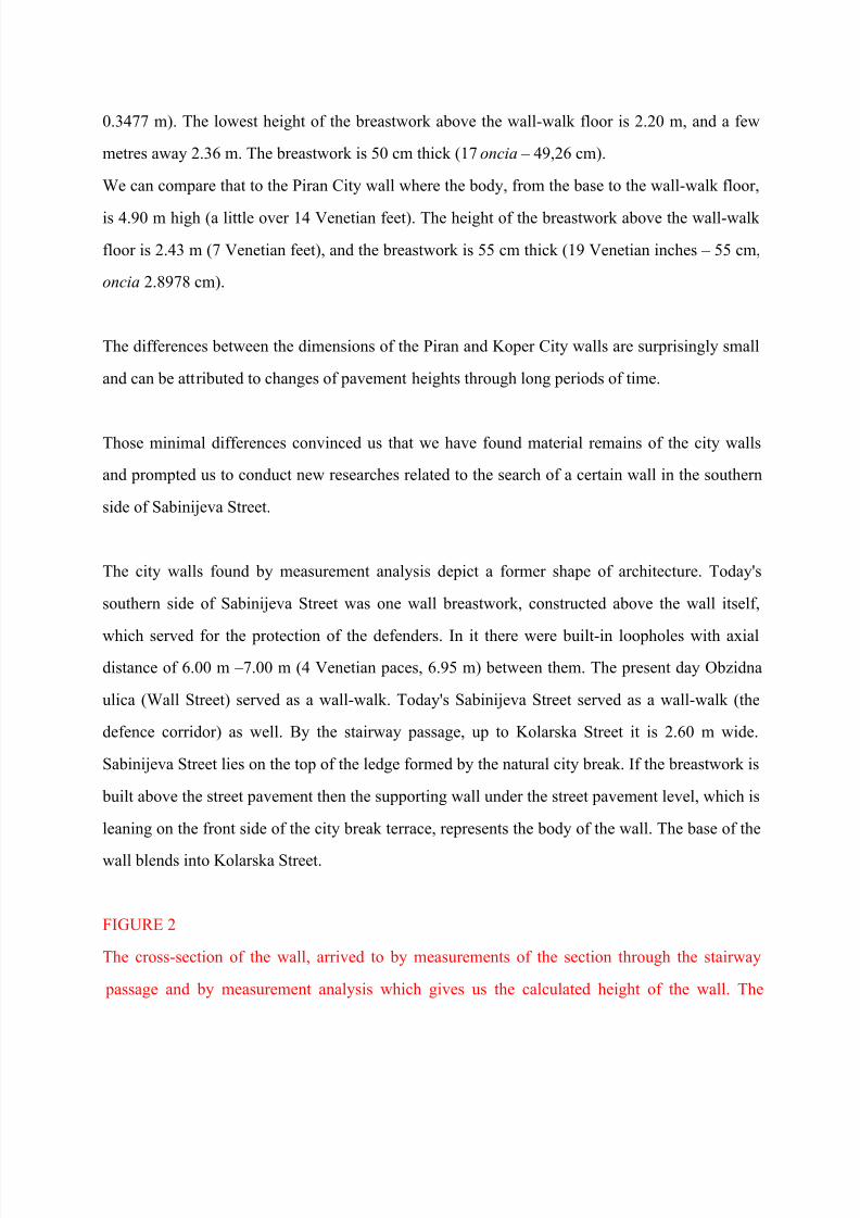
FIGURE 2
The cross-section of the wall, arrived to by measurements of the section through the stairway
passage and by measurement analysis which gives us the calculated height of the wall. The
8/8/2019 Koper Walls
http://slidepdf.com/reader/full/koper-walls 14/32
section shows the crown of the wall with the wall-walk (Obzidna ulica) and breastwork with
loopholes and the body of the wall with the base. (Author: D. Likar, computer graphics: M.
Zupani.)
The outer face of the walls which in the earlier periods opened into the public space is today
within privately owned gardens. Of the investigated part of the wall from these private gardens
only the upper part of the body and the crown of the wall (the breastwork) can be seen, while the
lower part and the base lie deep under the level of the gardens. From Sabinijeva Street only the
former crown of the wall can be seen. In it two filled-in loopholes were found.
Preservation of Walls with Visible Stonemasonry Structure
The entire face of Sabinijeva Street is 92.01 m long. The researched side of this street consists of
two houses with building extensions at the beginning, by the Ulica talcev Street in the length of
21.65 m, followed by garden walls, 2.84 m to 2.04 m high and 23.43 m long. These are followed
by a garden wall, 1.00 m high and 8.25 m long, which concludes at the entrance to the stairway
passage to Kolarska Street (1.50 m). Gardens fenced off by low concrete wall follow to the length
of 21.00 m. Sabinijeva Street is located at the junction with Gregorieva Street concluded bythree houses of the common length of 16.55 m, Sabinijeva Street 10, 10a and 12.
The houses on Sabinijeva Street 2, 4 (with an extension built later) and 12 (entire length of 29.27
m) have plastered façades. The visible stonemasonry structure of the street is 39.78 m long. Of
that there is a visible structure of the house 10 and 10a (length 14.43 m) and of the garden walls
in the length of 25.34 m.
For the preliminary research the façades with the visible structure in the length of 39.78 m were
the most important.
Wall Breastwork
8/8/2019 Koper Walls
http://slidepdf.com/reader/full/koper-walls 15/32
In its entire height the wall breastwork is preserved in the visible structure in the length of 17.09
m. A part of that wall, 2.43 long, was demolished and built up anew when a doorway in the
garden wall was made. There is also a 8.25 m long section of the wall with the breastwork
preserved to the height of 1.00 m. So 14.66 metres of the old city walls are preserved altogether,
with basically identical structure (opus incertum), with the exception of the portion which was
recently rebuilt by re-laying the stones in order to remove the protrusion that was threatening the
stability of the wall. The neighbouring parts of the walls have fuses mortared with the surplus
mortar left after this intervention while the rest of the described section remained intact7.
We have located the first, barely discernible loophole between the repaired and the mortared
wall, while the second one is in the intact part of the wall.
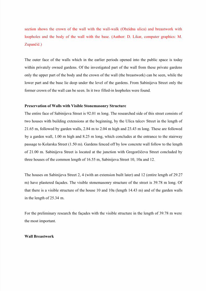
Photo 1: A view of the preserved breastwork as seen from Sabinijeva Street. (Photo: D. Likar)
The Walls
We established the height of the walls in Sabinijeva Street in Koper, 5.90 m (17 Venetian feet
í5.899 m), while measuring the cross-section of the remains of the former house of the stairway passage between Kolarska Street and Sabinijeva Street. The measurement enabled us to recognize
the unexpected wall structure8. The passage represents the lowest part of the walls. Together with
the breastwork the wall here was 8.1 m high9 (5 paces ± 8.69 m) from base to the top of the wall
crown10. The walls are part of private gardens on the inner side of these gardens so systematic
measurements were not possible. However, we were able to inspect the other, frontal side of the
wall with loopholes. Today the city wall on the garden side measures 3.82 m and, measured near
the second loophole, reaches 1.30 metre under the level of the street pavement. As a garden wall
it stands freely - without objects that would lean on it. At the foot of that wall there is a paved
7 The preserved part of the breastwork has been thoroughly repaired a couple of times throughout the centuries.8 The common characteristic of all the previous findings of the wall sections in Koper was a more or less regular wallstructure.9 The height was determined by calculation. The actual height should be determined by an archeological probe.10 Without including the roof top.
8/8/2019 Koper Walls
http://slidepdf.com/reader/full/koper-walls 16/32
floor of the garden yard.
The neighbouring atriums inside the gardens appear to be deeper 11.
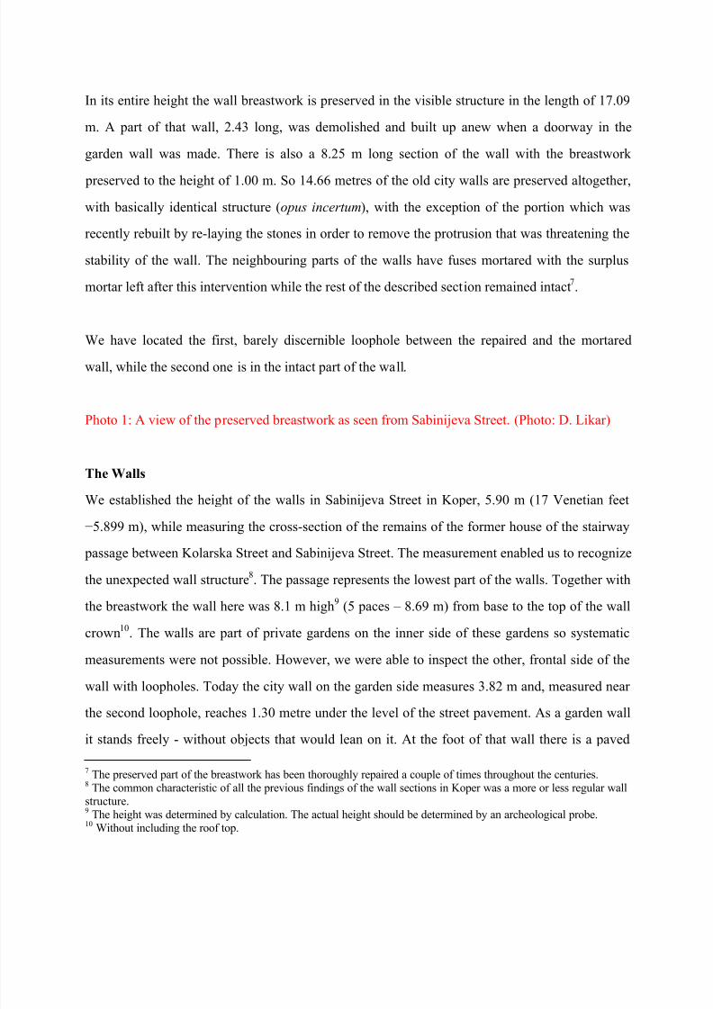
Photo 2: Today, the former outer - frontal side of the walls is inside private gardens along
Sabinijeva Street. The remains of the wall have often been repaired throughout centuries.
(Photo: D. Likar)
Found Loopholes
In the investigated part of the wall two walled-in loopholes were found12. Nevertheless even at
the outset some hints that these had indeed been loopholes were clear: they are located in the
vicinity of the old city gates on the city break and could have been easily rebuilt into cellar
windows during the centuries of abandonment of the inner city walls. A simple illustrative piece
of data about the presumption that the inner city walls have not been used for a long time: Venice
conquered Koper in 1278 and held it for five centuries, yet in the entire period of Venetian
domination not a single archive note was recorded about the inner walls. Even though the
majority of the archival sources about the correspondence between the Venetian Senate andKoper mayors occasionally mention the question of fortifications and the constant need to repair
the outer walls, Venetian sources lack any reference to the inner walls.
The distance between Ulica talcev Street, where the city gates used to be (Nova vrata - The New
Gate), and the first loophole is 26.27 m or 4.45 m from the additional building to Sabinijeva
Street 4.
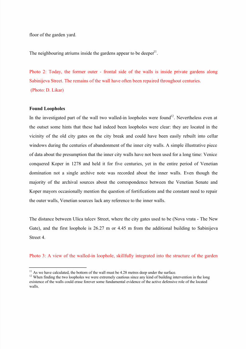
Photo 3: A view of the walled-in loophole, skillfully integrated into the structure of the garden
11 As we have calculated, the bottom of the wall must be 4.28 metres deep under the surface.12 When finding the two loopholes we were extremely cautious since any kind of building intervention in the longexistence of the walls could erase forever some fundamental evidence of the active defensive role of the locatedwalls.
8/8/2019 Koper Walls
http://slidepdf.com/reader/full/koper-walls 17/32
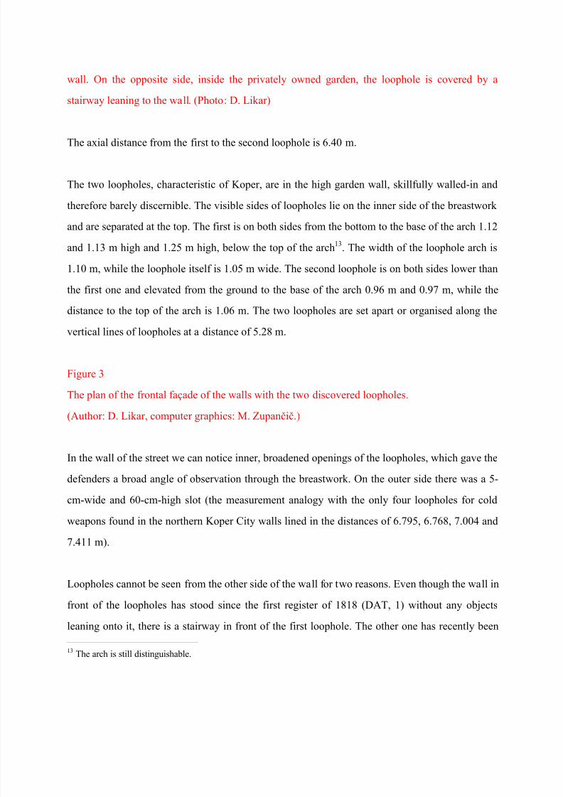
wall. On the opposite side, inside the privately owned garden, the loophole is covered by a
stairway leaning to the wall. (Photo: D. Likar)
The axial distance from the first to the second loophole is 6.40 m.
The two loopholes, characteristic of Koper, are in the high garden wall, skillfully walled-in and
therefore barely discernible. The visible sides of loopholes lie on the inner side of the breastwork
and are separated at the top. The first is on both sides from the bottom to the base of the arch 1.12
and 1.13 m high and 1.25 m high, below the top of the arch 13. The width of the loophole arch is
1.10 m, while the loophole itself is 1.05 m wide. The second loophole is on both sides lower than
the first one and elevated from the ground to the base of the arch 0.96 m and 0.97 m, while the
distance to the top of the arch is 1.06 m. The two loopholes are set apart or organised along the
vertical lines of loopholes at a distance of 5.28 m.
Figure 3
The plan of the frontal façade of the walls with the two discovered loopholes.
(Author: D. Likar, computer graphics: M. Zupani.)
In the wall of the street we can notice inner, broadened openings of the loopholes, which gave the
defenders a broad angle of observation through the breastwork. On the outer side there was a 5-
cm-wide and 60-cm-high slot (the measurement analogy with the only four loopholes for cold
weapons found in the northern Koper City walls lined in the distances of 6.795, 6.768, 7.004 and
7.411 m).
Loopholes cannot be seen from the other side of the wall for two reasons. Even though the wall in
front of the loopholes has stood since the first register of 1818 (DAT, 1) without any objects
leaning onto it, there is a stairway in front of the first loophole. The other one has recently been
13 The arch is still distinguishable.
8/8/2019 Koper Walls
http://slidepdf.com/reader/full/koper-walls 18/32
repaired in order to remove the deformation (bulging) of the wall, so only a portion of the vertical
edge can still be seen.
The last Venetian fortification inspector Polcenigo (Polcenigo, 1999, 269) says: "There are at
many places loopholes near the floor, almost everywhere at a proper distance from each other".
Owing to the discovery of the five successive loopholes in the wall in 2009 (four of them were
for cold weapons and one for a cannon), we have established what distance between the
loopholes was in the year 1700 considered "almost proper". Although Polcenigo talks about
loopholes in the outer city walls, our research shows that architectural elements of the inner
walls, planned for cold weapons, served as a model for the outer walls since the outer walls were
also built in the period of cold weapons, long before the Venetian occupation in 1278.
Low height of the loopholes can be partly attributed to changes of the level of pavement and also
to the direction of the field of view from the high position of the loophole in the walls towards the
outer ground below. However, Koper loopholes were lower also due to the short body
constitution of the former residents of Koper, something that can be deducted from both low-
laying windows and doors and from the so-far discovered loopholes in Koper and Piran.
Loopholes presented a challenge for us for quite some time because they were walled-in in the
structure of the wall and visible only to the most alert experts. Besides, they were accessible only
from the public area and subject to later reconstructions. Had they at any stage of their long
history been rebuilt in cellar openings it would have been impossible to prove their existence,
despite the fact that they are located on the city break between the two city gates (Pretorska vrata
± the Praetor Gate and Nova vrata ± the New Gate). We also wondered why were not able to
notice them earlier 14.
14 The locals did notice the arches, but were convinced that these were - despite their extremely low position - archesover former doors.
8/8/2019 Koper Walls
http://slidepdf.com/reader/full/koper-walls 19/32
Once we were able to inspect the walls from the other side there was no doubt that we had indeed
found loopholes, since there are no traces of the openings of the equal width on the outer side of
the wall that would indicate cellar windows, even though the outer shape of loopholes is no
longer clearly visible.
Systematical research of the found loopholes by probing and of the remaining wall section in
Sabinijeva Street, which is hidden under plaster or in the structure of the reshaped openings will
confirm the conclusion that the loopholes remained unchanged since the Pre-Romanesque times.
The fact that Romanesqe houses lean on the walls in this street confirms the idea that the inner
walls had by then already been abandoned as the main defence line 15. The role of the former
inner defence line was gradually taken over by the newly built garden walls of the houses built in
front of the former wall and later by built-up blocks.
The analysis of the visible wall structures of the southern facade of Sabinijeva Street
By systematical research of the street side where material remains of the old city walls were
found by observation and measurements we can obtain additional information useful for the
research of the old walls.
We begin with the analysis of the type of stonemasonry at the remains of the Nova vrata (The
New Gate) city doors in the Ulica talcev Street and follow it by the number order of the houses in
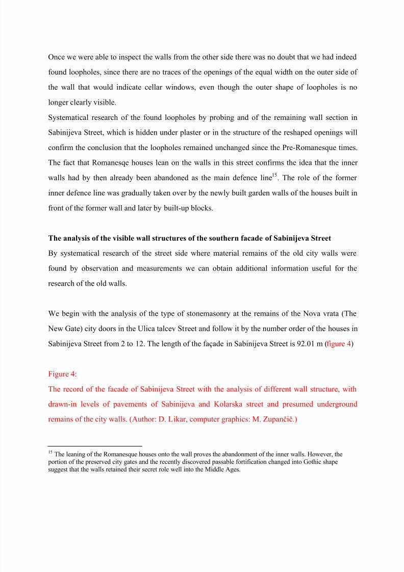
Sabinijeva Street from 2 to 12. The length of the façade in Sabinijeva Street is 92.01 m (figure 4)
Figure 4:
The record of the facade of Sabinijeva Street with the analysis of different wall structure, with
drawn-in levels of pavements of Sabinijeva and Kolarska street and presumed underground
remains of the city walls. (Author: D. Likar, computer graphics: M. Zupani.)
15 The leaning of the Romanesque houses onto the wall proves the abandonment of the inner walls. However, the portion of the preserved city gates and the recently discovered passable fortification changed into Gothic shapesuggest that the walls retained their secret role well into the Middle Ages.
8/8/2019 Koper Walls
http://slidepdf.com/reader/full/koper-walls 20/32
The ground plan of the New Gate is seen in the Franciscan cadastre of the year 1819 (DAT, 2),
while in the 1912 cadastre the gate is no longer registered (Kataster, 1912)16.
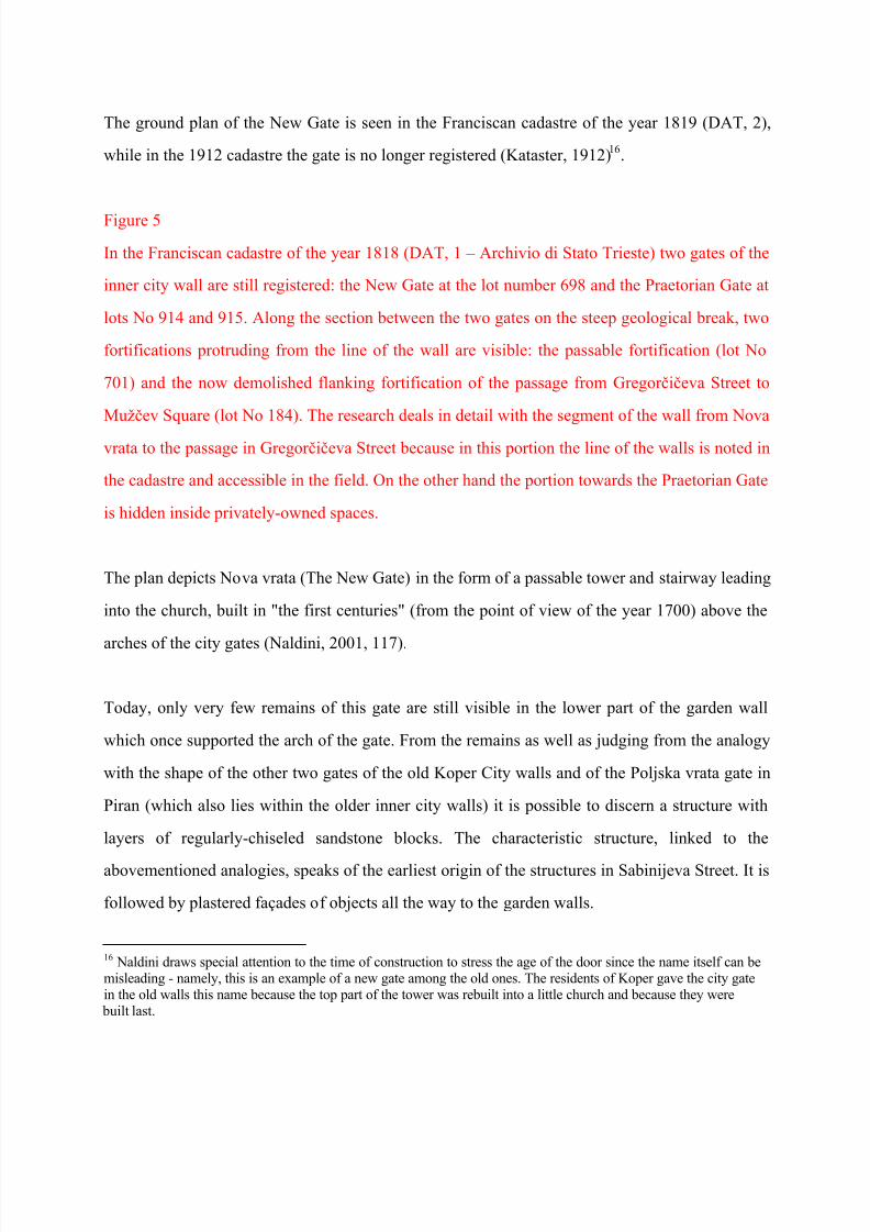
Figure 5
In the Franciscan cadastre of the year 1818 (DAT, 1 ± Archivio di Stato Trieste) two gates of the
inner city wall are still registered: the New Gate at the lot number 698 and the Praetorian Gate at
lots No 914 and 915. Along the section between the two gates on the steep geological break, two
fortifications protruding from the line of the wall are visible: the passable fortification (lot No
701) and the now demolished flanking fortification of the passage from Gregorieva Street to
Muev Square (lot No 184). The research deals in detail with the segment of the wall from Nova
vrata to the passage in Gregorieva Street because in this portion the line of the walls is noted in
the cadastre and accessible in the field. On the other hand the portion towards the Praetorian Gate
is hidden inside privately-owned spaces.
The plan depicts Nova vrata (The New Gate) in the form of a passable tower and stairway leading
into the church, built in "the first centuries" (from the point of view of the year 1700) above the
arches of the city gates (Naldini, 2001, 117).
Today, only very few remains of this gate are still visible in the lower part of the garden wall
which once supported the arch of the gate. From the remains as well as judging from the analogy
with the shape of the other two gates of the old Koper City walls and of the Poljska vrata gate in
Piran (which also lies within the older inner city walls) it is possible to discern a structure with
layers of regularly-chiseled sandstone blocks. The characteristic structure, linked to the
abovementioned analogies, speaks of the earliest origin of the structures in Sabinijeva Street. It is
followed by plastered façades of objects all the way to the garden walls.
16 Naldini draws special attention to the time of construction to stress the age of the door since the name itself can bemisleading - namely, this is an example of a new gate among the old ones. The residents of Koper gave the city gatein the old walls this name because the top part of the tower was rebuilt into a little church and because they were
built last.
8/8/2019 Koper Walls
http://slidepdf.com/reader/full/koper-walls 21/32
The first part of the garden wall in the length of 2.43 m was demolished when the gate, made of
an old stone frame brought from elsewhere, was built in the wall and the surrounding area was
filled with small stones of irregular shapes and bricks.
This is followed by a 8.04 m-long wall with no signs of newer interventions. It is built of bigger
irregular stone layers, has unidentifiable stone structures (once called opus incertum) with a
tendency to horizontal layering. The building technique and composition suggest improvisation
of a hastily built wall. Stones as the main building material are of different kind of sandstone
gathered from everywhere. We can notice some tiny " spolije" - recognizable remains of former
buildings of limestone and gray Istrian stone. Naturally this wall has later on been renovated
many times. It was here that the first loophole was found. Since it was built of elements that were
not carved in quarries but rather gathered from any sources available, the researchers of Koper
fortifications never recognized it as part of the city walls.
A small part of the described wall had fuses mortared-in, which changed it appearance, but the
structure on the other side of the wall without the mortar still displays a uniform appearance. The
other, formerly outer side of the wall resembles the appearance of the city walls, even though the
stones deteriorated due to time and erosion17
. The described part of the wall ends in slightlyconcave break of Sabinijeva Street.
The break is followed by a 6.62 m-long wall of equal height as the former one, but of different
appearance due to the recent renovation. The second loophole was found at the spot where the
wall bends. Although the structure of the wall surface is the same as the structure of the previous
part, the appearance has been altered by means of re-laying of the part that was bulging. Due to
this repair the described section of the wall is partially degraded18.
From the end of the wall we can see 8.25m long and 1 m high remains of the house at Sabinijeva
17 Exceptionally old walls that were preserved within the city structure until this day have been repaired many timesand in many ways. Because of this only detailed specialist research can determine the original parts.18 The actual grade of degradation could be established only by a specialist study.
8/8/2019 Koper Walls
http://slidepdf.com/reader/full/koper-walls 22/32
Street 6. Through the former house there was a perpendicularly oriented covered stairway
passage. Today some of the former rooms have been changed into vegetable gardens while the
stairway still serves its original purpose of connecting Sabinijeva with Kolarska Street, which lies
on the lower level. The structure of the remaining wall, which now serves as a garden fence, is
equal to the previous ones. In the first part of the wall by the street we can see a preserved
massive block (30 cm high and 1.837 long), which used to serve as a door post of the entrance
into the tower part of the house.
Two depictions of the southern façade of the former building at Sabinijeva Street 6 are preserved.
The first one is a graphic depiction from 1906 and the other a photograph of the same façade
from the year 1964 - a year before the demolition of the object. In these depictions of the Gothic
house we recognized three fortification elements: the elevated entrance, the access ramp and the
wooden balcony for the defence of the entrance, and began a detailed research of the remnants of
the former object by measuring the remains. While doing so we found, by means of the
measurement analysis, the city walls. This induced a new detailed preliminary research of the
hypothesis of the finding of the remains of the old Koper City walls, presented in this article.
The fencing wall - remnant of former Sabinijeva 6 house - ends in the passageway to the
stairway. The passageway is 1.50 m wide.
It is followed by a 21 m-long low concrete wall which fences off the gardens. On the site of
today's garden there used to be first a house, then the wall of the yard and finally another house.
We presume that the entire height of the city walls lies under the concrete wall since above the
wall there was only the wall crown or the breastwork. Today's gardens are a landfill of fertile soil
over the ruins of former houses.
The southern side of Sabinijeva Street ends with three houses: Sabinijeva 10 (9.61 m long), 10a
(4.83 m long) and 12 (7.71 m long).
8/8/2019 Koper Walls
http://slidepdf.com/reader/full/koper-walls 23/32
The first house is two storeys high. Due to highly dilapidated plaster some typical Romanesque
stonemasonry with remnants of Romanesque elements, partially hidden by the plaster, can be
noticed at the first glance. Careful analysis showed that the lower part of the house used to be a
part of the city walls, discernible by the wall edge protruding from the wall for a couple of
centimeters and continuing in the neighbouring object.
However, the building structure differs significantly from the previously described structures,
with the exception of the New Gate (Nova vrata). The building is built in grey Istrian sandstone
chiseled into regular blocks laid in regular layers.
Sabinijeva Street 10a house has a ground floor build in the same structure as the previous one. In
this wall there are also visible traces of Romanesque building elements such as parts of the
doorway frame. Romanesque structure on the ground floor is 3.53 m high. In the upper storey the
building structure is Gothic, built with narrow bricks and other Gothic elements. On the freeze we
can also see some interesting wall paintings.
Sabinijeva 12 is plastered and highly reconstructed, but in the upper storey some minute, but
high-quality stonemasonry remains of Venetian Gothic ± gotika fiorita can be seen. In the
northern façade we can discern a joint element of the Gothic window and in the southern one a
highly decorated window seal.
Diagram 1:
The diagram represents the ratios of the lengths of different wall structures of the façades of the
southern side of Sabinijeva Street. Combined with the façade of the street and the cross-section of
the wall it gives an overview of the so far still unresearched structures under plasters and
potential remains of the body of the city walls under the land-fill in front of it. (Author: D. Likar,
computer graphics: D. Kenda.)
8/8/2019 Koper Walls
http://slidepdf.com/reader/full/koper-walls 24/32
Summary of the Analysis of Visible Structures of the Walls of the Southern Sabinijeva
Street Façade.
At the beginning we were confused by different structures of the walls in the façades of
Sabinijeva Street within the presumed city walls belt, more so since we have in previous
researches established that the geometrically regular structure of the wall, made of regularly
shaped grey sandstone blocks, laid in leveled layers, is very old or can be recognized as typically
Romanesque and is, when compared to the first one, very late.
The outer Koper City walls are also built of regular stones. When observing the characteristic
structure in Sabinijeva Street an additional cause of confusion is the Gothic structure which can
take over the regular Romanesque build or has irregular build of irregularly quarried stones laid
in layers, or uses bricks in combination with the other two.
The research of the remains of the passable fortification of the former Sabinijeva Street 6, three basic structures were uncovered: a wall related to the city walls, two side walls protruding out of
the city walls and the wall of the stairway. The head wall was of regular build of Romanesque
origin, but with added irregular Gothic structure in front of it that would have been attributed to
later periods if the object had not been pulled down in 1965, in doubtlessly Gothic shape visible
on its last photo taken in 1964, shortly before the demolition19.
Sabinijeva Street has three structures as well: the regular older one, the irregular structure of the
old city walls and again a regular newer structure. The dilemma of the different build structures
of the street with the presumed city walls belt will be definitely cleared out only by means of
19 The old coating seen on the site in the preserved part of the wall proves that the ruin was not additionally coatedwith leveling wall.
8/8/2019 Koper Walls
http://slidepdf.com/reader/full/koper-walls 25/32
additional multidisciplinary research.
Dating of the Remains of the City Walls
Very little is known about the inner city walls of the city of Koper since we can only rely on
presumptions and extremely rare sources. Even rarer are sources speculating about the period in
which it was built. Even the time of construction of the outer walls is unknown, even though the
archive sources describing it are rather common.
E. Smole dates the move of the second inner city walls back to the year 555 and the construction
of the outer wall, which followed the coast of the rocky island, to the time of the rule of
Patriarchs of Aquileia over Koper (Smole, 1957, 26).
G. Caprin writes that Koper, when it was enslaved by the Patriarchs and the need for bigger space
arose, destroyed the sacred doors and the walls surrounding it from the time of the Byzantine rule
(Caprin, 1905, 99; Bernik, 1968, 16).
M. Guek reintroduces Smole's presumption of the location of the former Late-Antiquity or early
Middle Ages walls on the city break, but stresses that unfortunately up to this day no material
remains of that walls have been found (Guek, 2000, 23í24).
In our article we present, with the aid of new facts and discoveries, the finding of the very city
walls for which M. Guek claims that unfortunately no material remains were discovered.
The results confirm the working hypothesis and the presumption about the Late-Antiquity city
walls on the city break.
8/8/2019 Koper Walls
http://slidepdf.com/reader/full/koper-walls 26/32
Conclusion
Numerous arguments confirm that in Sabinijeva Street we have found the remains of the missing
inner Koper City walls.
Arguments serving as proofs are: the location between the old city gates, the supporting wall of
the city break, the wall by the passable fortification, loopholes on the breastwork, measurement
analysis (adequate heights of: the body of the walls up to the wall-walk and wall's crown and the
width of the breastwork, correct measures of the typical distances between the loopholes as well
as the loopholes themselves).
The age of the wall dating in Pre-Romanesque period is proved by Romanesque houses build in
front of the wall, which signal the abandoning of the fortification function of the wall itself. As an
additional proof we can cite the silence of all presently known sources and complete amnesia
about these walls after the Venetian occupation in 1278. Venetian sources would surely have
registered such an important asset as the inner city walls, unless it had already been abandoned
long before the time of the Venetian conquest.
We could not entirely rely on the historic data proving the safety of the city on the island after the
year 500 either. An example of such proof can be found in a report that two Patriarchs of
Aquileia found their refuge from Goths in the safety of the Koper island (Marcelin in the year
512 in Stephen around 520) or the extension of the city with new quarters towards the coast,
which was presumably reached in 528 (Naldini, 2001, 111).
In the presented characteristic of the built structures of the inner city walls we can recognize the
Late-Antiquity period.
The presumption is consistent with the generally-known historic developments in the area.
8/8/2019 Koper Walls
http://slidepdf.com/reader/full/koper-walls 27/32
Koper is located in the vicinity of the corridor used by the main flows of the great migrations of
peoples while traversing the Julian Alps on their way to Friuli Plain and Apennine Peninsula.
After the onslaught of Marcomanns and Quadi (the second half of the 2nd century AD) The
hundred-years-long ceasefire pax Romana was interrupted. After two centuries of peace and
undisturbed development some antique cities, especially those along the route of the onslaught,
for the first time again faced the dangers of war and frantically started some defensive
preparations, including the repair of fortifications. During the prolonged period of peace the
maintenance of old city walls was poor or non-existent while the development or upgrading of
the former defensive system was entirely abandoned. For this reason the old defensive systems
were in a state of disrepair. The outbreak of great migrations of peoples triggered a fast
restoration of city fortifications while the old fortification building skills were lost.
In 4th century AD prolonged danger resulted in the systematic construction of a defensive system
of fortifications comprised of forts, enclosures and castles from the borders of Panonia to Noric
which controlled the main migration route towards the Italian Peninsula. This fortifications have
soon evolved into a real limes with permanent military crew called Apium vallum, Claustra
Apium Iuliarum20
.
In 452 the northern part of the Italian Peninsula was ravished by Atila. After gathering a large
number of followers and moving from Danubian Noric to Friuli, Odoaker in 476 deposed the last
Roman emperor and took over the reign. The Eastern Roman emperor engaged Theodoric, the
ruler of Ostrogoths, to depose Odoaker. After the defeat of Odoaker in 489, Theodoric
established his own state. In 537 Theodoric's minister Kasiodor in his letters described Istria as a
happy land and the granary of the royal city of Ravenna. Eighteen years later eastern Emperor
Justinian restored the Byzantine rule in Istria. After Justinian's death in 565 the rule was taken
20 A good illustration of the imminent danger for the city of Koper during the great migrations is the vicinity of theLate-Antiquity limes at Hruica only 48 kilometres away. The limes above Rijeka was 56 km away.

8/8/2019 Koper Walls
http://slidepdf.com/reader/full/koper-walls 28/32
over by his son Justin II who ruled until 578. In this period Koper was renamed Justinopolis (or
Iustinopolis as is in a latinized version marked in Venetian archive sources, in the correspondence
between the senate and Koper's podestas)
According to Smole in 555 the oldest city walls were moved to the second wall. During the
ecclasiastical and secular rule of the Patriarchs of Aquileia over Koper, the conditions changed
notably. The growth of population due to the moving of local population to safety offered by the
city on the island resulted in overcrowding while the danger arising from great migrations of
peoples was persistent. All these forced the city to construct new city walls on the very edge of
the rocky island (Smole, 1957, 26).
The results of our research show that improvised renovation of the fortifications of the inner city
walls occurred in the early phase of the great migrations of peoples and confirm that the
construction of the new city walls at the edge of the island took place when the society began to
adapt to new conditions caused by the great migrations.
The preliminary research of the housing block in the area between Sabinijeva Street, KolarskaStreet, Ulica Talcev (where Nova vrata - the New Gate were) and Gregorieva Street showed
that this part of the city was much more important than had been assumed on the onset of the
research. In fact the research demonstrates that, if planned and carried out well, a systematic
research can uncover key information about the development which can in turn give answers
about the most important historic periods of the development of Koper, Piran and the entire Istria.
If we, due to some speculative construction development, forfeit the lucky circumstance that in a
relatively narrow space some exceptional remains from fundamental historic periods are
concentrated, a large amount of evidence, sought for by generations of researchers, will be lost
forever.
Acknowledgements
8/8/2019 Koper Walls
http://slidepdf.com/reader/full/koper-walls 29/32
I would like to thank the Novak family for enabling me to inspect the walls from the privately
owned side and the residents of Sabinijeva Street for their patience during the measurements of
the façades of their street.
Summary
During the research of the outer city walls of the city of Koper we have come across some
indications about the older inner walls. Nothing had been known about it except for Kandler's
hypothesis about three Koper City walls from the year 1858 (itko, 2008, 119) and Smole's
version of this thesis from 1957 (Smole, 1957).
In the translation of the Church Chronicles by Bishop Naldini from 1700 we found the
description of churches above the arches of the old city gates. This historic source confirmed our
indications and offered reliable enough set-out proof that the presumed remains of the three gates
in the field were indeed former city gates.
This was followed by the research of seven Koper churches above the arches of the old gates, of
which some remains of three can still be seen in the field and of old Field city gates of Piran that
are the only entirely materially preserved of the eleven once existing gates along the Coast.
This research enabled us to prove the rough location of the inner walls between the seven city
gates and reconstruct in rough contours their architectural appearance on the basis of analogy
with the Field Gates in Piran and modest remains in Koper.
The research opened new possibilities for tracing hidden material remains of fortifications in the
field.
8/8/2019 Koper Walls
http://slidepdf.com/reader/full/koper-walls 30/32
In the section between the Praetor Gate (Pretorska vrata) and the New Gate (Nova vrata) there is
a passage with the ramp and the stairway connecting two streets on the different levels and
remnants of the house demolished in 1965, through which the stairway used to run. Two
depictions of this passable building are preserved, from 1906 and 1964. Together they show two
phases of the development of the object. Three obvious elements of the fortified passage were
recognized in these depictions: an elevated entrance, access along the ramp and the defensive
design of the wooden balcony. These indications prompted us to begin the research of the
preserved remains by measurements in the field.
Measurement analysis of the architectural record gave two results: the remains of the garden
walls above the street pavements turned out to be remains of the breastwork and below the street
level the body of the city walls while the remains of the former passable object are former
fortified pedestrian passage through the old city walls.
In the fortification there are three recognizable structures of the walls: Gothic, Romanesque and
older Pre-Romanesque structure.
The finding of city walls through measurement analysis correlating with the old Pre-Romanesque
structure directed us into more detailed, systematical research of the visible structures of the walls
in Sabinijeva Street and after the finding of two loopholes also into a detailed research of the
remains of old city walls.
The results of our research are presented in this article.
At the same time we completed the research of the former passable fortification that was
protruding as a tower from the line of the walls.
Both researches are exceptionally important as the set-off point for further multi-disciplinary
8/8/2019 Koper Walls
http://slidepdf.com/reader/full/koper-walls 31/32
researches since they uncover material remains of the old Koper City walls that had been
unknown. They also indicate the presumption that in Sabinijeva Street we discovered a rare
material record of the history in the period of transition from Late Antiquity to early Middle Ages
- or in other words from the period of great migrations of peoples to the West, to Padania.
References
ASV, 1 ± ASV, Fondo »Senato Mar«, b. 223, dis. 1. Fino, G.: Nart Kopra (1619).
DAT, 1 ± Dravni arhiv v trstu (DAT). Franciscejski kataster (1818).
DAT, 2 ± DAT, Strada, L. (1819). Mapa della citta di Capodistria, kataster mesta.
Bernik, S. (1968): Koper Izola Piran, Organizem slovenskih obmorskih mest. Ljubljana,
Mladinska knjiga.
Bernik, S. (2000): U rbanizem v gotiki, Kopra, Izole in Pirana. V: Diocesis Justinopolitana.
Spomeniki gotske umetnosti na obmoju koprske kofije. Koper, Pokrajinski muzej, 38±51.
Budicin, M. (1998): Aspeti storico-urbani nell`Istia Veneta. Rovigno, Centro di ricerche storice,
N. 16.
Caprin, G. (1905): L´ Istria Nobilissima, Parte I. Trieste, SCHIMPFF Editrice.Guek, M. (2000): Anonimna ar hitektura v prenovi Kopra. Koper, Knjinica Annales Majora.
Kataster Kopra (1912): Katastrski nart mesta. Foto-poveava narta M 1:1000. Piran,
Medobinski zavod za spomeniko varstvo Piran.
Likar, D. (2009 A): Ar hitekturni postinformacijski sistem. Ljubljana, UVL, Fakulteta za
arhitekturo.
Likar, D. (2009 B): Ar hitektura in razvoj obeh koprskih obzidij. Koper, Annales, 19, 2009, 2.,
313±340.
Likar, D. (2010): Arhitektura cerkva nad mestnimi vrati notranjega koprskega obzidja in oratorij
sv. Jakoba nad Poljskimi vrati v Piranu. Koper, 20, Annales, 1, 2010.
Manzuoli, N. (1831): Nuova descrizione dell`Istria. AT, III, 168±208. V: Darovec, D. (1999):
Stari krajepisi Istre. Koper, Knjinica Annales Majora, 131.
8/8/2019 Koper Walls
http://slidepdf.com/reader/full/koper-walls 32/32
Margeti, L. (1993): Statut koprskega komuna iz leta 1423 z dodatki do leta 1668. Koper,
Pokrajinski arhiv Koper, Center za zgodovinske raziskave Rovinj.
Naldini, P. (1700): Corografija ecclesiastica ossia descrittione della cittá e della docesi di
Giustinopoli detto vulgarmente Capod`Istria. Venetia. V: Naldini, P. (2001): Cerkveni krajepis
ali opis mesta in kofije Justinopolis (urednik D. Darovec). Koper, Knjinica Annales Majora.
Naldini, P. (2001): Cerkveni krajepis ali opis mesta in kofije Justinopolis, L judsko Koper.
Uredil in prevedel D. Darovec). Koper, Zgodovinsko drutvo za juno primorsko ±
Znanstvenoraziskovalno sredie Koper ± kofija Koper.
Polcenigo, G. B. (1999): Poroilo z dne 22. oktobra 1701 o stanju in potrebah Kopra. V:
Darovec, D. (1999): Stari krajepisi Istre. Koper, Knjinica Annales Majora, 267±282.
Simi, S. S. (2002): Koper na robovih stoletij (Koprske razglednice). Koper, Sirart.
Smole, E. (1957): Koprsko obzidje, Mudina vrata in Levji grad . Ljubljana, Kronka asopis za
slovensko krajevno zgodovino V/1, 26±38.
tefanec, S. [et al.] (2000): Dioecesis Justinopolitana, Spomeniki gotske umetnosti na obmoju
koprske kofije. Koper, Pokrajinski muzej.
Venturini D. (1906): Guida storica di Capodistria. Capodistria, Editore Benedeto Lonzar.
itko, S. (1989): Koprski obzidni pas in mestni tloris na karti Giacoma Fina iz leta 1619.Ljubljana, Kronika asopisa za slovensko krajevno zgodovino 37, 37±45.
itko, S. (2000): Koprska kofija in njeno ozemlje ob koncu srednjega veka, V: Diocesis
Justinopolitana. Spomeniki gotske umetnosti na obmoju koprske kofije. Koper, Pokrajinski
muzej. 13-26.
itko, S. (2008): Pietro Kandler e le anticitá di Capodistria. V: ACTA HISTORICA
ADRIATICA II, L´Istria e Pietro Kandler: Storico, archeologo, erudito.Pirano. Societá di storici e
geografici Pirano, 115 ± 122.