Embed Size (px)
Citation preview

BookletChart™ Kuskokwim River – Kuskokwim Bay to Bethel NOAA Chart 16304
A reduced-scale NOAA nautical chart for small boaters When possible, use the full-size NOAA chart for navigation.
Included Area

2
Published by the National Oceanic and Atmospheric Administration
National Ocean Service Office of Coast Survey
www.NauticalCharts.NOAA.gov 888-990-NOAA
What are Nautical Charts?
Nautical charts are a fundamental tool of marine navigation. They show water depths, obstructions, buoys, other aids to navigation, and much more. The information is shown in a way that promotes safe and efficient navigation. Chart carriage is mandatory on the commercial ships that carry America’s commerce. They are also used on every Navy and Coast Guard ship, fishing and passenger vessels, and are widely carried by recreational boaters.
What is a BookletChart?
This BookletChart is made to help recreational boaters locate themselves on the water. It has been reduced in scale for convenience, but otherwise contains all the information of the full-scale nautical chart. The bar scales have also been reduced, and are accurate when used to measure distances in this BookletChart. See the Note at the bottom of page 5 for the reduction in scale applied to this chart.
Whenever possible, use the official, full scale NOAA nautical chart for navigation. Nautical chart sales agents are listed on the Internet at http://www.NauticalCharts.NOAA.gov.
This BookletChart does NOT fulfill chart carriage requirements for regulated commercial vessels under Titles 33 and 44 of the Code of Federal Regulations.
Notice to Mariners Correction Status
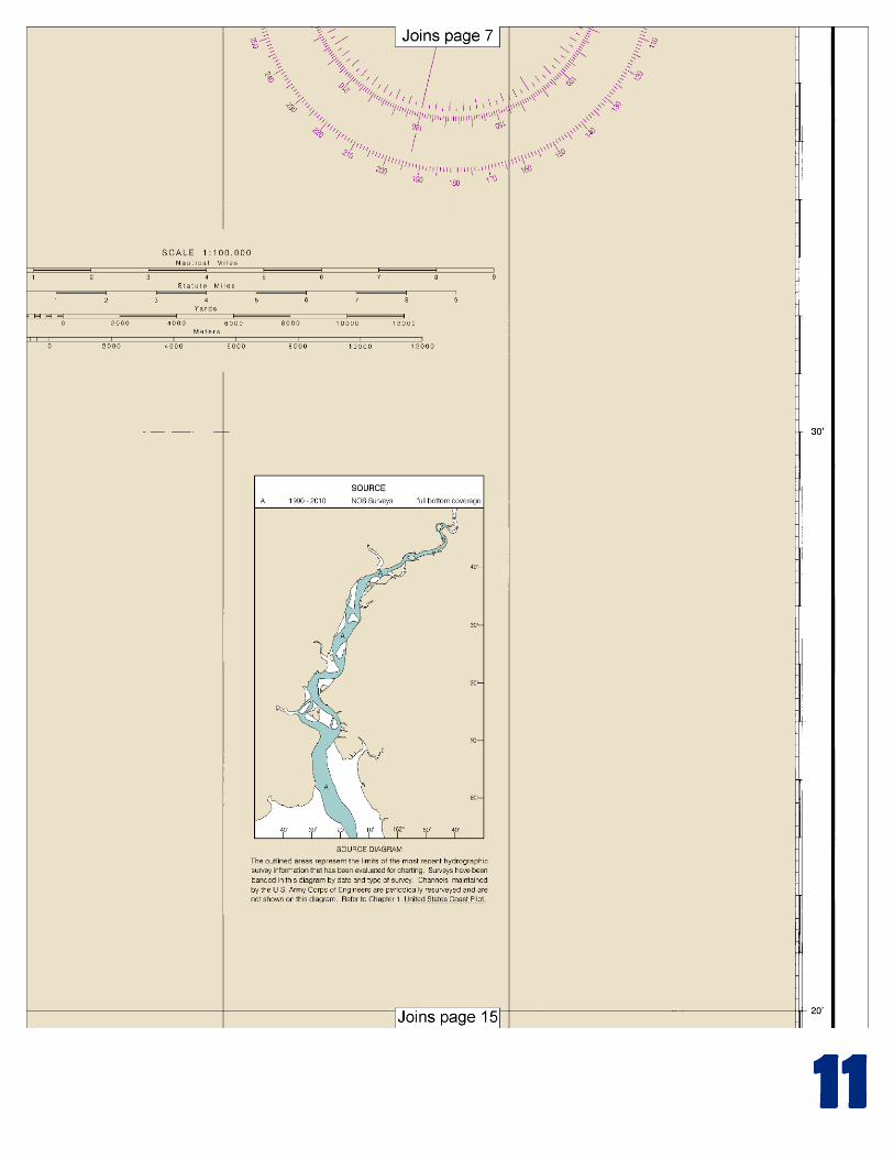
This BookletChart has been updated for chart corrections published in the U.S. Coast Guard Local Notice to Mariners, the National Geospatial Intelligence Agency Weekly Notice to Mariners, and, where applicable, the Canadian Coast Guard Notice to Mariners. Additional chart corrections have been made by NOAA in advance of their publication in a Notice to Mariners. The last Notices to Mariners applied to this chart are listed in the Note at the bottom of page 7. Coast Pilot excerpts are not being corrected.
For latest Coast Pilot excerpt visit the Office of Coast Survey website at http://www.nauticalcharts.noaa.gov/nsd/coastpilot_w.php?book=9.
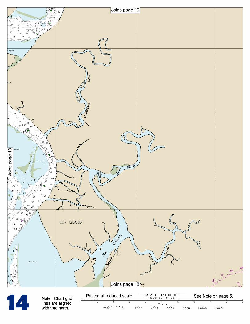
(Selected Excerpts from Coast Pilot) Kuskokwim Bay and Kuskokwim River open into the Bering Sea N of the entrance to Bristol Bay. The bay, filled with many flats, and hard steep-to shoals, is entered between Cape Newenham and Cape Avinof, 93 miles NW. The channels through the bay are not always apparent by the surface indications of the water. At times the channels will be smooth with rips on the shoals, and at other times the reverse will be true. The
edges of the channels are often marked by long lines of foam, but occasionally the foam extends across the channels; it is well to approach these lines with caution. Navigation is recommended only at low water, when the mudflats are visible, enabling the channels between them to
be followed. Because of the inequality of the tides, a vessel grounding at high water may not be refloated for several days. The 40-mile approach through Eek Channel to Kuskokwim River is a maze of shifting sandbars, both visible and covered, and blind channels. The channels in the bay and river undergo constant change from year to year, because of the action of the sea, currents, and ice; extreme caution and continuous soundings are necessary. The procedure usually followed is for a small pilot boat from Goodnews Bay to precede the vessel through these waters, constantly feeling out the channels and sounding. During S storms a heavy sea makes up the bay nearly to Eek Island, at the head of the bay, and vessels caught on a shoal are in danger of breaking up. The channel through Kuskokwim Bay and up Kuskokwim River to Bethel is marked by seasonal buoys. The markers above Kuskokwim River Buoy 12 are oil drums that are set to mark the best water. The deepest draft that should attempt to reach Bethel is about 15 feet. Caution.–In 1983, the Coast Guard reported that as a result of flooding in the area, about 20 ocean shipping containers were washed into the Kuskokwim River from the riverbank at the village of Napakiak, about 12 miles SW of Bethel. Reports indicate that several of the containers sank in the river near the village, and the remainder of the containers were carried downriver and sank. Mariners are advised to exercise caution in navigating Kuskokwim Bay and River. Cape Newenham is the landfall for this region, and can be approached close-to with deep water. It is the end of a peninsula formed by a series of rough sawtoothed mountains. These mountains terminate in a level plateau that forms the immediate cape. In S weather a heavy sea and tide rips occur off Cape Newenham. In 1981, during heavy N winds, the NOAA Ship MILLER FREEMAN found a good anchorage in a small cove on the S side of the cape about 0.4 mile offshore S of Jagged Mountain in 10 fathoms, sand and mud bottom. Satisfactory anchorage for S or E weather can be had in about 8 fathoms off the small cove on the N side of the cape and about 3.5 miles from its outer end. An aero radiobeacon (58°39.4'N., 162°04.4'W.) is shown from the N side about 3 miles E from the outer end of the cape. About 1.3 miles ESE of the aero radiobeacon is a parabolic antenna. Cape Newenham is an important resting area (haulout) for Pacific walrus and nesting area for seabirds. Operating a watercraft in a manner which results in disturbing, harassing, herding, hazing or driving of walrus is prohibited under provisions of the Marine Mammal Protection Act. To ensure that walrus are not disturbed, marine vessel operators are requested to avoid transiting or anchoring within 0.5 mile of the Cape Newenham walrus haulout. Security Cove, 9 miles ENE of Cape Newenham, is a good anchorage except with NW winds; the usual summer gales are SE. The bottom is even and shoals gradually. The best anchorage in 3½ fathoms, mud bottom, is about 0.8 mile NE of Castle Rock and on the range of Castle Rock and the first promontory SW. Water can be obtained from a stream which enters the cove. There is also good anchorage in 2 fathoms with good holding ground in the middle of the bight on the SW side of Castle Rock. This anchorage is less affected by the ground swell making along the coast from Cape Newenham than the anchorage in Security Cove.
U.S. Coast Guard Rescue Coordination Center 24 hour Regional Contact for Emergencies
RCC Juneau Commander 17th CG District (907) 463-2000 Juneau, Alaska

G
Lateral System As Seen Entering From Seaward on navigable waters except Western Rivers
PORT SIDE ODD NUMBERED AIDS
GREEN LIGHT ONLY FLASHING (2)
PREFERRED CHANNEL NO NUMBERS – MAY BE LETTERED
PREFERRED CHANNEL TO STARBOARD
TOPMOST BAND GREEN
PREFERRED CHANNEL NO NUMBERS – MAY BE LETTERED
PREFERRED CHANNEL TO PORT
TOPMOST BAND RED
STARBOARD SIDE EVEN NUMBERED AIDS
RED LIGHT ONLY FLASHING (2)
FLASHING FLASHING OCCULTING GREEN LIGHT ONLY RED LIGHT ONLY OCCULTING QUICK FLASHING QUICK FLASHING ISO COMPOSITE GROUP FLASHING (2+1) COMPOSITE GROUP FLASHING (2+1) ISO
"1"
Fl G 6s
G "9"
Fl G 4s
GR "A"
Fl (2+1) G 6s
RG "B"
Fl (2+1) R 6s
"2"
Fl R 6s
8
R "8" Fl R 4s
LIGHT
G
C "1"
LIGHTED BUOY
G "5"
GR "U"
GR
C "S"
RG
N "C"
RG "G"
LIGHT
6
R
N "6"
LIGHTED BUOY
R
"2"
CAN DAYBEACON
CAN NUN NUN
DAYBEACON
For more information on aids to navigation, including those on Western Rivers, please consult the latest USCG Light List for your area. These volumes are available online at http://www.navcen.uscg.gov
2
2
C U 5
1


VHF Marine Radio channels for use on the waterways:Channel 6 – Inter-ship safety communications.Channel 9 – Communications between boats and ship-to-coast.Channel 13 – Navigation purposes at bridges, locks, and harbors.Channel 16 – Emergency, distress and safety calls to Coast Guard and others, and to initiate calls to other
vessels. Contact the other vessel, agree to another channel, and then switch.Channel 22A – Calls between the Coast Guard and the public. Severe weather warnings, hazards to navigation and safety warnings are broadcast here.Channels 68, 69, 71, 72 and 78A – Recreational boat channels.
Getting and Giving Help — Signal other boaters using visual distress signals (flares, orange flag, lights, arm signals); whistles; horns; and on your VHF radio. You are required by law to help boaters in trouble. Respond to distress signals, but do not endanger yourself.
EMERGENCY INFORMATION
Distress Call Procedures
• Make sure radio is on.• Select Channel 16.• Press/Hold the transmit button.• Clearly say: “MAYDAY, MAYDAY, MAYDAY.”• Also give: Vessel Name and/or Description;Position and/or Location; Nature of Emergency; Number of People on Board.• Release transmit button.• Wait for 10 seconds — If no responseRepeat MAYDAY call.
HAVE ALL PERSONS PUT ON LIFE JACKETS!
This Booklet chart has been designed for duplex printing (printed on front and back of one sheet). If a duplex option is not available on your printer, you may print each sheet and arrange them back-to-back to allow for the proper layout when viewing.
QR
Quick ReferencesNautical chart related products and information - http://www.nauticalcharts.noaa.gov
Interactive chart catalog - http://www.charts.noaa.gov/InteractiveCatalog/nrnc.shtmlReport a chart discrepancy - http://ocsdata.ncd.noaa.gov/idrs/discrepancy.aspx
Chart and chart related inquiries and comments - http://ocsdata.ncd.noaa.gov/idrs/inquiry.aspx?frompage=ContactUs
Chart updates (LNM and NM corrections) - http://www.nauticalcharts.noaa.gov/mcd/updates/LNM_NM.html
Coast Pilot online - http://www.nauticalcharts.noaa.gov/nsd/cpdownload.htm
Tides and Currents - http://tidesandcurrents.noaa.gov
Marine Forecasts - http://www.nws.noaa.gov/om/marine/home.htm
National Data Buoy Center - http://www.ndbc.noaa.gov/
NowCoast web portal for coastal conditions - http://www.nowcoast.noaa.gov/
National Weather Service - http://www.weather.gov/
National Hurrican Center - http://www.nhc.noaa.gov/
Pacific Tsunami Warning Center - http://ptwc.weather.gov/
Contact Us - http://www.nauticalcharts.noaa.gov/staff/contact.htm
NOAA’s Office of Coast Survey The Nation’s Chartmaker
For the latest news from Coast Survey, follow @NOAAcharts
NOAA Weather Radio All Hazards (NWR) is a nationwide network of radio stations broadcasting continuous weather information directly from the nearest National Weather Service office. NWR broadcasts official Weather Service warnings, watches, forecasts and other hazard information 24 hours a day, 7 days a week. http://www.nws.noaa.gov/nwr/