Embed Size (px)
Citation preview

KYALAMI- MIDRAND STRENGTHENING PROJECT,COMPRISING A SUBSTATION AND THREE 400KVTRANSMISSION LINES OF APPROXIMATELY 13 KMBETWEEN EXISTING LULAMISA SUBSTATION ANDPROPOSED KYALAMI SUBSTATION, GAUTENG.
DRAFT BASIC ASSESSMENT REPORT
July 2014
DEA Reference: 14/12/16/3/3/1/1188
COMPILED BY:
Envirolution Consulting (Pty) Ltd
PO Box 1898
Sunninghill
2157
Tel: (0861) 44 44 99
Fax: (0861) 62 62 22
E-mail: [email protected]
Website: www.envirolution.co.za
PREPARED FOR:
Eskom Holdings SOC Ltd.
Eskom Transmission
P.O.Box 1091
Johannesburg
20001
Tel: (011) 800 2706
Fax: 086 662 2236
COPYRIGHT WARNING
With very few exceptions the copyright of all text and presented information is the exclusive property of Envirolution
Consulting (Pty) Ltd. It is a criminal offence to reproduce and/or use, without written consent, any information, technical
procedure and/or technique contained in this document. Criminal and civil proceedings will be taken as a matter of
strict routine against any person and/or institution infringing the copyright of Envirolution Consulting (Pty) Ltd.

BASIC ASSESSMENT REPORT
2
Date July 2014
ProjectKyalami- Midrand Strengthening Project, ComprisingA Substation And Three 400kv Transmission Lines OfApproximately 13 Km Between Existing LulamisaSubstation And Proposed Kyalami Substation,Gauteng.
Document Title Draft Basic Assessment Report
Author Dirk Prinsloo
Document Revision Draft
Reviewed by
Approved

BASIC ASSESSMENT REPORT
3
CONTENTS
SECTION A: ACTIVITY INFORMATION ................................................................................................. 81. PROJECT DESCRIPTION.............................................................................................................. 8
Project Background......................................................................................................................... 9LOCATION.................................................................................................................................... 10SPECIALIST STUDIES................................................................................................................. 11ROUTE SELECTION .................................................................................................................... 11SERVITUDE ................................................................................................................................. 13CONSTRUCTION PHASE............................................................................................................ 13Operational PHASE ...................................................................................................................... 14
2. FEASIBLE AND REASONABLE ALTERNATIVES ....................................................................... 163. PHYSICAL SIZE OF THE ACTIVITY ............................................................................................ 224. SITE ACCESS .............................................................................................................................. 235. LOCALITY MAP............................................................................................................................ 236. LAYOUT/ROUTE PLAN................................................................................................................ 247. SENSITIVITY MAP ....................................................................................................................... 248. SITE PHOTOGRAPHS ................................................................................................................. 249. FACILITY ILLUSTRATION............................................................................................................ 2410. ACTIVITY MOTIVATION............................................................................................................... 2511. APPLICABLE LEGISLATION, POLICIES AND/OR GUIDELINES................................................ 2912. WASTE, EFFLUENT, EMISSION AND NOISE MANAGEMENT .................................................. 3013. WATER USE................................................................................................................................. 3314. ENERGY EFFICIENCY ................................................................................................................ 33SECTION B: SITE/AREA/PROPERTY DESCRIPTION......................................................................... 351. GRADIENT OF THE SITE ............................................................................................................ 362. location in landscape .................................................................................................................... 363. GroundwateR, Soil and Geological stability of the site.................................................................. 374. Groundcover ................................................................................................................................. 385. SURFACE WATER....................................................................................................................... 396. Land use character of surrounding area ....................................................................................... 407. Cultural/Historical Features........................................................................................................... 428. SOCIO-ECONOMIC CHARACTER .............................................................................................. 43
Infrastructure ..................................................................................................................................... 43Basic Services................................................................................................................................... 43Tourism Sectors ................................................................................................................................ 44
9. Biodiversity.................................................................................................................................... 45Vegetation Types .......................................................................................................................... 47
SECTION C: PUBLIC PARTICIPATION................................................................................................ 491. ADVERTISEMENT and Notice ..................................................................................................... 492. Determination of appropriate measures........................................................................................ 493. Issues raised by interested and affected parties ........................................................................... 504. Comments and response report.................................................................................................... 505. AUTHORITY PARTICIPATION..................................................................................................... 506. CONSULTATION WITH OTHER STAKEHOLDERS .................................................................... 51SECTION D: IMPACT ASSESSMENT .................................................................................................. 52

BASIC ASSESSMENT REPORT
4
1. Impacts that may result fRom the planning and design, CONSTRUCTION, OPERATIONAL,DECOMMISSIONING AND CLOSURE phaseS AS WELL AS PROPOSED MANAGEMENT OFidentified IMPACTS AND PROPOSED mitigation measures................................................................. 522. Environmental impact statement................................................................................................... 56SECTION E: RECOMMENDATIONS OF PRACTITIONER................................................................... 59SECTION F: APPENDICES .................................................................................................................. 60
Appendix A: Maps ............................................................................................................................. 61Appendix B: Photographs.................................................................................................................. 62Appendix C: Facility illustration(s) ..................................................................................................... 63Appendix D: Specialist reports (including terms of reference)........................................................... 64Appendix D 1: Avifauna..................................................................................................................... 65Appendix D 2: Fauna & Flora ............................................................................................................ 66Appendix D 3: Geotechnical.............................................................................................................. 67Appendix D 4: Heritage ..................................................................................................................... 68Appendix D 5: Social ......................................................................................................................... 69Appendix D 5: Visual ......................................................................................................................... 70Appendix E: Public Participation........................................................................................................ 71Appendix F: Impact Assessment ....................................................................................................... 72Appendix G: Environmental Management Programme (EMPr) ......................................................... 73Appendix H: Details of EAP and expertise ........................................................................................ 74Appendix I: Specialist’s declaration of interest .................................................................................. 75Appendix J: Additional Information.................................................................................................... 76
ABREVIATIONS
BAR Basic Assessment ReportCEMPr Construction Environmental Management ProgrammeDEA Department of Environmental Affairs (previously Department of Environmental Affairs
and Tourism)DoE Department of EnergyEAP Environmental Assessment PractitionerEMPr Environmental Management ProgrammeEIA Environmental Impact AssessmentERA Electricity Regulation Act (No. 4 of 2006)GN Government Noticeha HectaresHIA Heritage Impact AssessmentI&AP’s Interested and Affected PartiesIPP Independent Power ProducerMW MegawattsNEMA National Environmental Management Act (No. 107 of 1998) (as amended)NHRA National Heritage Resources Act (No. 25 of 1999)NWA National Water Act (No 36 of 1998)OEMP Operational phase Environmental Management ProgrammeSAHRA South African Heritage Resources AgencySACNASP South African Council for Natural Scientific ProfessionsSDF Spatial Development Framework

BASIC ASSESSMENT REPORT
5

BASIC ASSESSMENT REPORT
6
(For official use only)File Reference Number:Application Number:Date Received:
Basic assessment report in terms of the Environmental Impact Assessment Regulations, 2010,promulgated in terms of the National Environmental Management Act, 1998 (Act No. 107 of 1998), asamended.
Kindly note that:
1. This basic assessment report is a standard report that may be required by a competent authorityin terms of the EIA Regulations, 2010 and is meant to streamline applications. Please make surethat it is the report used by the particular competent authority for the activity that is being appliedfor.
2. This report format is current as of 1 September 2012. It is the responsibility of the applicant toascertain whether subsequent versions of the form have been published or produced by thecompetent authority
3. The report must be typed within the spaces provided in the form. The size of the spaces providedis not necessarily indicative of the amount of information to be provided. The report is in the form ofa table that can extend itself as each space is filled with typing.
4. Where applicable tick the boxes that are applicable in the report.
5. An incomplete report may be returned to the applicant for revision.
6. The use of “not applicable” in the report must be done with circumspection because if it is used inrespect of material information that is required by the competent authority for assessing theapplication, it may result in the rejection of the application as provided for in the regulations.
7. This report must be handed in at offices of the relevant competent authority as determined by eachauthority.
8. No faxed or e-mailed reports will be accepted.
9. The signature of the EAP on the report must be an original signature.
10. The report must be compiled by an independent environmental assessment practitioner.
11. Unless protected by law, all information in the report will become public information on receipt bythe competent authority. Any interested and affected party should be provided with the informationcontained in this report on request, during any stage of the application process.
12. A competent authority may require that for specified types of activities in defined situations onlyparts of this report need to be completed.
13. Should a specialist report or report on a specialised process be submitted at any stage for any partof this application, the terms of reference for such report must also be submitted.

BASIC ASSESSMENT REPORT
7
14. Two (2) colour hard copies and one (1) electronic copy of the report must be submitted to thecompetent authority.
15. Shape files (.shp) for maps must be included on the electronic copy of the report submitted to thecompetent authority.

BASIC ASSESSMENT REPORT
8
SECTION A: ACTIVITY INFORMATION
Has a specialist been consulted to assist with the completion of this section? YES NO√If YES, please complete the form entitled “Details of specialist and declaration of interest” for thespecialist appointed and attach in Appendix I.
1. PROJECT DESCRIPTION
a) Describe the project associated with the listed activities applied for
Eskom Holdings SOC Ltd is proposing to construct three 400kV transmission power lines,approximately 13 km in length, between the existing Lulamisa substation and proposed Kyalamisubstation, Gauteng. The project aims to strengthen the Transmission network capacity as well as toimprove the quality of electricity supply in the region and the national electricity grid as a whole.
In terms of the NEMA EIA Regulations, 2010: GN544 promulgated under Chapter 5 of the NationalEnvironmental Management Act (Act 107 of 1998) (“NEMA”), and published in Government Gazette33306 on 18 June 2010; a Basic Assessment Report (BAR) is required for this project.
Eskom Holdings SOC Ltd has appointed Envirolution Consulting as independent environmentalconsultants, to undertake the Basic Assessment and EMPr process. The main objective of the BasicAssessment and EMPr is to identify and assess potential environmental impacts associated with theproposed project, and to compile appropriate mitigation measures. An application was submitted toDEA and acknowledgement of receipt was received on 19 February 2014. The following referencenumber was allocated;
DEA 14/12/16/3/3/2/659
Subsequent to a newspaper advert and site notices placed on 25 February 2014, which notified thepublic of the project, the Department of Environmental Affairs allocated the following referencenumber to the project:
DEA 14/12/16/3/3/1/1188,
The reference number was allocated as Eskom applied for exemption from certain provisions ofRegulations in terms of Regulation 50 as published in Government Notice No. R. 543 (GovernmentGazette No. 33306 of 18 June 2010). The DEA granted permission in terms of Regulation 20(4), toapply for a Basic Assessment Reporting Process, instead of a Scoping and Environmental ImpactReporting process. (See Appendix D6).
It is to be noted that a Scoping and EIA was previously conducted by Savannah Environmental andEnvironmental Authorisation (EA) was granted for the transmission lines and the substation, howeverthese authorisations lapsed on 16 March 2013 as Eskom was unable to commence with theconstruction process, due to delays in finalizing the land owner’s negotiation agreements. Therespective reference numbers are as follows:
Substation: 12/12/20/1091Transmission Line : 12/12/20/1092

BASIC ASSESSMENT REPORT
9
During the validity of the previous Authorisations, Eskom had undertaken land negotiations foraspects of the route and purchased land for the servitude. The delays resulted in the lapsing of theEA and in terms of NEMA, a new Environmental Impact Assessment (EIA) process must be carriedout.
The route alternative that received Environmental Authorisation in 2010 is the only feasible andreasonable alternative for this Basic Assessment. See Section 2 (a) Feasible And ReasonableAlternatives of this Basic Assessment Report.
PROJECT BACKGROUND
The Need For Additional Transmission Capacity In The Johannesburg North Area
The existing Transmission power lines in the Kyalami Midrand area, are becoming heavily loaded andare predicted to reach their full capacity soon. These Transmission power lines and substationcurrently cannot supply the increased demand in the Johannesburg North area. It is becoming verydifficult to manage with one power line out of service since the other power lines have to carry theentire load. This makes it difficult to carry out routine maintenance, the condition of the operating linescan deteriorate and this will result in poor line performance due to faults and outages.
Studies have shown a steady 3% per annum average load growth for the area fed from Lepini andLulamisa S/S, the main bulk supply substation to the Johannesburg North area. This is due to lightindustrialisation, commercialisation, urban growth and electrification. It is also a sign of goodeconomic growth in this area. The load forecasters predict that this load growth will continue - whichwill result in the need for additional power by the year 2013.
The Need To Optimise The Electrical Transmission System In Johannesburg And JohannesburgNorth Area
From above information, it can thus be seen that a fault on any of the lines serving the JohannesburgNorth area could have a detrimental effect on supply to customers once the new customer/s aresupplied from the existing network.
Eskom Transmission has taken measures to get the most out of the existing Transmission system sothat the construction of the new line will occur only when needed. These measures include:
Comprehensive checks on the existing lines to ensure that they are within the legal clearancefor overhead lines. Lines sag when placed under heavy load conditions, due to heating of theconductors.
Installation of line monitoring devices that measures the atmospheric conditions prevailing. Thisallows Eskom Transmission to decide whether the lines can cope with more loading (e.g. ona cold day the line can be loaded to more than usual levels since the lines cool down andthey do not sag as much.)
Installation of new infrastructure
Demand side management

BASIC ASSESSMENT REPORT
10
When reinforcement options were looked at, the best option was chosen to ensure that anoptimised mix of cost, technical benefit and environmental impact was achieved.
Energy Efficiency initiatives
It is clear that new Transmission power lines will be needed as all options for optimisation of theexisting infrastructure have already been studied and implemented. Connecting to another source ofsupply, i. e. Lulamisa and Lepini substation will also ensure a firm supply into the area at all times. Itis therefore necessary to secure the necessary servitudes timeously.
By increasing the supply into the Johannesburg North area, the foreseen load growth can beaddressed in a suitable and economical way. Optimisation of the current system is currentlyunderway, and would alleviate some problems in the system. The short to medium term loadrequirements can be addressed by the increased supply due to the new Transmission power lines.
In addition the upgrading and new Kyalami substation will improve the supply to the area.
LOCATION
The proposed transmission line is located. See Figure 1. Location.
Figure 1. Location

BASIC ASSESSMENT REPORT
11
SPECIALIST STUDIES
The specialists presented below (Table 1: Specialist Studies), have undertaken relevant specialiststudies to provide more detailed information on the environment that may be affected by theproposed project.
Table 1: Specialist Studies
Name Organisation InputMartin vd Walt Martin vd Walt Geology and Geotech Desktop StudyIngrid Snyman Batho Earth Social Impact AssessmentLourens du Plessis MetroGIS Visual Impact AssessmentProf Johann du Preez ECO Care Consultancy Ecological Assessment
ROUTE SELECTION
A route selection process was undertaken by Eskom in 2009 and five feasible alternatives (twosections, Northern and Southern) were identified. The route selection criteria to identify potentialroute alternatives usually includes assessing the following:
Cadastral Boundaries;Physical environment, including terrain, accessibility for construction and maintenance, natural
features;Land use, including identification of high potential agricultural land, existing buildings and
structures;Visible heritage resources such as graves; andExisting services such as electricity transmission and distribution lines and bulk services
infrastructure.
400KV TRANSMISSION LINE INFRASTRUCTURE
The three proposed 400kV Transmission power lines are to be constructed between the existingLulamisa and proposed Kyalami substations, a distance of approximately 13 km.
Towers that may be used for the 400kV Transmission power line include lattice structure) straintowers and self-supporting towers (( Figure 2 and Figure 3).

BASIC ASSESSMENT REPORT
12
Figure 2. Type 540 Tower
Figure 3. Type 523 Self Supporting Tower
It is expected that the towers forming part of the Transmission line are to be 36 m to 61 m in heightand will extend over a total footprint area of 80 m x 50 m, which is required for each tower. Theaverage span between two towers is 300-400 m. The land beneath the overhead lines can continueto be used, as normal, by the landowners. Eskom, however, will stipulate that no dwellings orvegetation/crops higher than 3 m be established within the servitude. No temporary or permanent

BASIC ASSESSMENT REPORT
13
structures may be constructed on the registered Eskom servitude. Some sections of the proposedtransmission line could be double circuit transmission lines and assessment criteria, such as heighthave been taken into consideration.
SERVITUDE
A 110m wide servitude will be required to accommodate the towers upon which the proposed 400kVtransmission lines will be strung. Due to current land use and development in the Kyalami area, verylittle open corridors remain that could be utilised to install major Transmission power lines with aservitude of 110 metres. New routes must however be secured to ensure servitudes for theexpansion of the network and to be able to meet the forecast increase in demand.
An 8 m-wide strip is generally cleared of all trees and shrubs down the centreline of a Transmissionline servitude for stringing purposes only. Any vegetation in other areas that could interfere with theoperation and/or reliability of the Transmission line must be trimmed or completely cleared. See theEskom Transmission Vegetation Management Guideline (2009) in Appendix J. Vegetation clearancefor the proposed 400kV Transmission power line will be minimal.
The Eskom Standard and specifications for bush clearance and invasive alien plant management fornew power line construction specifications have been incorporated into the EnvironmentalManagement Programme (EMPr), which will guide the construction, operational and maintenancephases of the project. See Appendix G .
CONSTRUCTION PHASE
The Eskom specification for The Transmission Line Towers and Line Construction (March 2001)guides the construction process (See Appendix J). The following steps are followed during theconstruction of Transmission lines:
Vegetation clearance and gate erection;Establishment of construction camp, pegging of structures;Construction of access roads (where required);Construction of foundationsAssembly and erection of structuresStringing of conductorsRehabilitation of disturbed area and protection of erosion sensitive areas
Services Required During Construction Phase
Access RoadsFor construction purposes most areas along the two routes are accessible via the existing
Storm Water ManagementStorm water will be managed according to the Eskom Guidelines for Erosion Control and VegetationManagement as well as the Environmental Management Programme (EMPr), which will be compiledfor the construction phase.
Construction Site CampsThe power line construction contractor would need to set up at least one site camp but this does not

BASIC ASSESSMENT REPORT
14
necessarily need to be near the power line route. The contractor may however prefer to use a fullyserviced site at another location. The contractor will be encouraged to utilised already disturbed areasfor construction camp purposes, in order to minimise cumulative impacts. It is likely that a number ofconstruction camps would need to be established for the construction period.
SewageA negligible sewage flow is anticipated for the duration of the construction period. Chemical toilets willbe utilised during construction, and the contactor will ensure regular treatment of these facilities. Thetoilets will be serviced regularly, as specified by the final site specific EMPr.
Solid Waste DisposalAll solid waste will be collected at a central location at each construction site and will be storedtemporarily until removal to an appropriately permitted landfill site in the vicinity of the constructionsite.
Concrete BatchingConcrete batching will be required for the foundations of the transmission line towers. The followingguidelines are contained in the Eskom specification For The Transmission Line Towers and LineConstruction:
a) The Contractor shall be responsible for negotiating the site of his batching plant (if required) andthe conditions under it may be established, with the landowner. The Contractor shall be responsiblefor the proper management of the batching plant.b) Upon completion of works, the ground of the batching plant area shall be rehabilitated and the sitecleaned and left as it was found and to the satisfaction of the Supervisor and landowner.c) The use of local water for concrete must first be negotiated with the landowner and the appropriateauthorities. Such water is to be analysed and accepted by the Project Managerbefore use
FoundationsThe excavations shall be kept covered or barricaded in a manner accepted by the Supervisor toprevent injury to people or livestock. Failure to maintain proper protection of excavations may result inthe suspension of excavation work until proper protection has been restored.
StringingOnce towers have been erected, cables will be strung between the towers.
Bird Flight DivertersIf required Bird flight deflectors will be fitted during the construction phase.
OPERATIONAL PHASE
Vegetation will be maintained by Eskom in the operational phase of the project.

BASIC ASSESSMENT REPORT
15
b) Provide a detailed description of the listed activities associated with the project asapplied for
Indicate thenumber and dateof the relevantnotice:
Activity No (s) (interms of therelevant notice) :
Describe each listed activity as per projectdescription1:
544, 18 June2010
Activity 10(i) ofListing notice 1 of2010
The 3 proposed 400kV transmission lines will beapproximately 13 km in length and located betweenthe Lulamisa substation and proposed Kyalamisubstation, Gauteng. The transmission lines will beboth inside and outside of the urban edge.
544, 18 June2010
Activity 11 (xi) ofListing notice 1 of2010
The proposed substation could be located within 32metres from a watercourse
544, 18 June2010
Activity 18 ofListing notice 1 of2010
The proposed towers could be located within awatercourse and during excavation of foundationsmore than 5 m² could be excavated of deposited.
544, 18 June2010
Activity 23: ofListing notice 1 of2010
An area of about 100m x100m (1hectare) is requiredto construct the proposed substation and Eskommay clear above 10000m2 for the purposes ofsubstation construction. The substation will belocated outside the urban edge.
545, 18 June2010
Activity 8: ofListing notice 2 of2010
The project will entail 3 x 400kV lines and will besituated both inside and outside of the urban edge
546, 18 June2010
Activity 3 (b) v ofListing notice 3 of2010
The proposed development would involve theinstallation of a telecommunication mast in an areaidentified as irreplaceable or important sites in theGauteng C Plan.
546, 18 June2010
Activity 4 (b) v ofListing notice 3 of2010
The proposed development would involveconstruction of roads to ensure the ease ofconstruction and maintenance of the proposedpower line. The project will be located in an areaidentified as irreplaceable or important sites in theGauteng C Plan. It is possible that roads, thattrigger the activity might be required.
546, 18 June2010
Activity 12 (a ofListing notice 3 of2010
The project is located in Egoli Granite Grassland(Gm 10) vegetation type, which is a listed threatenedecosystem and is further classified as endangered.In addition it is an area identified as irreplaceable orimportant sites in the Gauteng C Plan. An area inexcess of 10 000m² will be cleared
1 Please note that this description should not be a verbatim repetition of the listed activity as contained in the relevantGovernment Notice, but should be a brief description of activities to be undertaken as per the project description

BASIC ASSESSMENT REPORT
16
546, 18 June2010
Activity 13 (d) v ofListing notice 3 of2010
The project is located in an area identified asirreplaceable or important sites in the Gauteng CPlan. An area in excess of 10 000m² will be cleared
2. FEASIBLE AND REASONABLE ALTERNATIVES
“alternatives”, in relation to a proposed activity, means different means of meeting the generalpurpose and requirements of the activity, which may include alternatives to—
(a) the property on which or location where it is proposed to undertake the activity;(b) the type of activity to be undertaken;(c) the design or layout of the activity;(d) the technology to be used in the activity;(e) the operational aspects of the activity; and(f) the option of not implementing the activity.
Describe alternatives that are considered in this application as required by Regulation 22(2)(h) ofGN R.543. Alternatives should include a consideration of all possible means by which the purpose andneed of the proposed activity (NOT PROJECT) could be accomplished in the specific instance takingaccount of the interest of the applicant in the activity. The no-go alternative must in all cases beincluded in the assessment phase as the baseline against which the impacts of the other alternativesare assessed.
The determination of whether site or activity (including different processes, etc.) or both is appropriateneeds to be informed by the specific circumstances of the activity and its environment. After receipt ofthis report the, competent authority may also request the applicant to assess additional alternatives thatcould possibly accomplish the purpose and need of the proposed activity if it is clear that realisticalternatives have not been considered to a reasonable extent.
The identification of alternatives should be in line with the Integrated Environmental AssessmentGuideline Series 11, published by the DEA in 2004. Should the alternatives include different locationsand lay-outs, the co-ordinates of the different alternatives must be provided. The co-ordinates shouldbe in degrees, minutes and seconds. The projection that must be used in all cases is the WGS84spheroid in a national or local projection.
a) Site alternatives
Prior to Eskom’s 2009 decision to obtain Environmental Authorisation for the construction of theKyalami - Midrand Strengthening Project, various alternatives were assessed for satisfying the twofoldneed for additional electrical supply to the region and optimising the existing infrastructure. Theassessment of alternatives included:
THE DO NOTHING OPTIONTo maintain the status quo was considered the easy way out. By not taking any action, EskomTransmission, Eskom Distribution and City Power are currently in a situation of not being able to ensurefirm supply into the region. This would eventually lead to load shedding which can cause major

BASIC ASSESSMENT REPORT
17
disruptions of power supply to different areas at different times. This can have a major impact on theeconomics of the region, as no real economic growth can take place. New township and industrialdevelopments in the region in the near future will cause overloading of the existing Transmissionsystem, with resultant power failures. This option is therefore ruled out because it would neither supplythe projected demand for electricity nor optimise the existing infrastructure.
DEMAND SIDE MANAGEMENTDemand Side Management (DSM) can generally be defined as the activities performed by theelectricity supply utility, which are designed to produce the desired changes in the load shape throughinfluencing customer usage of electricity and to reduce overall demand by more efficient use. Theseefforts are intended to produce a flat load duration curve to ensure the most efficient use of installednetwork capacity.
By reducing peak demand and shifting load from high load to low load periods, reductions in capitalexpenditure (for network capacity expansion) and operating costs can be achieved. Some of the basictools are the price signals (such as time of use tariffs) given by the utility and direct load management.This option is practised to a certain extent, but is currently not considered feasible for expansion in thisparticular region.
Eskom Transmission is currently looking at various means to achieve a flatter load profile in this area.However, the large concentration of industrial and commercial users in this area makes this a verydifficult option to pursue.
NEW GENERATION SYSTEMSA new coal fired, gas, renewable or nuclear generation plant could be commissioned near to the loadcentre. This might have a more negative overall impact on the environment and would take at least fiveyears to implement; therefore this option was not investigated due to not being feasible.
UPGRADE EXISTING TRANSMISSION POWER LINES BY USING BIGGER CONDUCTORSThe physical load on the existing towers would increase substantially and the towers would beinadequate. Furthermore, it would not be possible to remove one Transmission power line from serviceto perform the upgrading work, as the remaining supply lines would not be able to supply the electricalloads in the region. This option would also not optimise the existing infrastructure.
CONSTRUCT A 400KV TRANSMISSION POWER LINE BETWEEN KUSILE, NEW KYALAMI ANDLULAMISA SUBSTATIONSThis option will sufficiently reinforce the present network, as it will form the new supply into theJohannesburg North. Power will flow via Kusile to proposed Kyalami substation and then to LulamisaS/S to feed some of the loads currently fed from Lulamisa and Lepini Substations. This is the optionmost favoured by Eskom Transmission as it is the most feasible and reasonable, which can beimplemented in the short term, apart from doing nothing,. The need for increased capacity and the needfor optimising existing infrastructure would be met.
The advantages with this option are as follows:
It overcomes the line overloading problems. It will create a more flexible network since it forms an interconnection between the loads fed
from Lulamisa and Lepini S/S. This will improve the overall reliability of the system, which willbe of benefit to both City Power and to all electricity users in the area.
It improves the reliability of supply to the Johannesburg Customer Load network which

BASIC ASSESSMENT REPORT
18
presently feeds Johannesburg North customers whose presence here affect the livelihoods ofthe people and the economy of the area.
It will be less costly than any other options that were considered.
The need for increased capacity and the need for optimising existing infrastructure will be metin this way, and this option was put forward as the most feasible option by Eskom Transmissionin 2008/9.
ALTERNATIVES ASSESSED IN 2008/9 EIA.
Figure 4. 2008 Route Alternatives
SubstationFrom the Scoping evaluation conducted by Savannah Environmental in 2008, it was concluded thatpotential impacts associated with Site C would be of unacceptably high significance and could not bemitigated. Therefore, this site was considered to be fatally flawed from an environmental perspectiveand was excluded from further investigation. Therefore, only Site A and Site B were investigated indetail in the EIA Report.
From the majority of the specialist studies undertaken, Substation Site A was nominated as thepreferred alternative substation site. This is largely due to the fact that the construction of the substationat this site would be associated with a shorter length of transmission power lines. However, asSubstation Site A is not located in close proximity to existing distribution lines, additional distributionlines would be required to be constructed from this site to the area around Substation Site B, resultingin more lines in the area.

BASIC ASSESSMENT REPORT
19
Therefore, when considering the project from a holistic perspective, by taking both the proposedsubstation and transmission power lines into consideration, as well as future distribution lines whichmay be required to integrate the new substation into the electricity distribution grid, substation Site Bwas nominated as the preferred alternative as the construction of the substation at this site would havea lower overall impact on the environment. Substation Site B received EnvironmentalAuthorisation.
Thus substation site alternatives are not considered to be feasible and reasonable for thisapplication for Environmental Authorisation and will not be assessed.
Substation Design:The 2008/9 EIA proposed that the new substation be constructed as either a GIS (gas insulatedsubstation) or a conventional, open air substation, depending on the site selected. An area of 100 m x100 m (for a GIS substation) and 400 m x 400 m (for a conventional, open air substation) will berequired for the establishment of the new transmission substation. The impacts of a conventionalsubstation were found to be significant, compared to a GIS. Environmental Authorisation (16 March2010) was granted for a Gas Insulated Substation (GIS).
Substation design alternatives are not considered feasible and reasonable for this applicationfor Environmental Authorisation and will not be assessed.
Transmission Line AlternativesFrom the Scoping evaluation by Savannah Environmental in 2008, it was concluded that the potentialenvironmental impacts associated with Alternative 3 would be of unacceptably high significance andcould not be mitigated. Therefore, this alternative corridor was considered to be fatally flawed from anenvironmental perspective and was excluded from further investigation. Therefore, only Alternatives1, 2, 4 and 5 were investigated in detail in the 2008/9 EIA Report.
During the public participation process in the scoping phase, alternative alignments to Alternative 4 andAlternative 5 were proposed by the Leeuwkop Golf Course management in order to potentially minimiseimpacts on the golf course. These alternatives were Alternatives 4a and 5a. Since impacts on thebiophysical environment associated with Alternative 4a and 5a would result in the irreplaceable loss ofresources, it was also considered not to be feasible.
Results of the floristic and faunal sensitivity analysis were combined in the 2008/9 EIA to present anoverview of the ecological sensitivity of the study area. Alternative 1 and Alternative 5 receivedEnvironmental Authorisation.
FEASIBLE AND REASONABLE ALTERNATIVES FOR THIS BASIC ASSESSMENT REPORT.
From the conclusions of all specialist studies undertaken in the 2008/9 EIA, Alternative 1 was thepreferred alternative power line development corridor for the northern section of the project study area.This would allow for the consolidation of infrastructure of a similar nature and will reduce impacts on'greenfields' areas in the study area. It was recommended that all three power lines be constructed onAlternative 1, by using a double circuit structure and one single line.
In the southern section of the study area, from a biophysical perspective, Alternative 5 was nominated

BASIC ASSESSMENT REPORT
20
as the preferred power line development corridor as it is considered to cross areas of lowest sensitivity.However, impacts of high significance were still expected to be associated with this alternative, butthese are considered to be more acceptable than the impacts associated with the other alternativesunder consideration.
Envirolution considered the alternatives that were assessed when the previous RoD wasapproved and concluded that the biophysical constraints identified during the 2008/9 EIA arestill applicable and not suitable and feasible. This was confirmed by updated specialist reports.The only suitable and feasible site alternatives are the alternatives that were grantedEnvironmental Authorisation. Alternative 1 and 5 of the 2008/2009 EIA are combined for thisBasic Assessment Report.
The Transmission line route into Lulamisa Substation and a section of approximately 2 kilometres at theproposed Kyalami substation (south eastern section of 400kV lines) were changed slightly, comparedto the 2008/9 route. The route alignments are Alternative 1 (Revision 20) and Alternative 2 (Revision19), and will incorporate mitigation measures proposed in the Social and Visual Impact Assessments.See Figure 5. Alternatives below.
Figure 5. Alternatives
Alternative 1Substation 26° 01’ 01.63” S 28° 04’15.45” E
Alternative 2

BASIC ASSESSMENT REPORT
21
Substation Lat (DDMMSS) Long (DDMMSS)
Alternative 3Substation Lat (DDMMSS) Long (DDMMSS)
In the case of linear activities:
Transmission Line Alternative: Latitude (S): Longitude (E):400kV Alternative 1 (Revision 20) (preferred)
Starting point of the activity -26.017151° 28.070952°
Middle/Additional point of the activity -25.993886° 28.049886°
End point of the activity -26.964532° 28.009761°
400kV Alternative 2 (Revision 19)
Starting point of the activity -26.017151° 28.070952°
Middle/Additional point of the activity -25.993886° 28.049886°
End point of the activity -26.964532° 28.009761°
Alternative S3
Starting point of the activity Middle/Additional point of the activity
End point of the activity
For route alternatives that are longer than 500m, please provide an addendum with co-ordinates takenevery 250 meters along the route for each alternative alignment.
In the case of an area being under application, please provide the co-ordinates of the corners of the siteas indicated on the lay-out map provided in Appendix A.
b) Lay-out alternatives
Alternative 1 (preferred alternative)Description Lat (DDMMSS) Long (DDMMSS)
Alternative 2Description Lat (DDMMSS) Long (DDMMSS)
Alternative 3Description Lat (DDMMSS) Long (DDMMSS)

BASIC ASSESSMENT REPORT
22
c) Technology alternatives
Alternative 1 (preferred alternative)
Alternative 2
d) Other alternatives (e.g. scheduling, demand, input, scale and design alternatives)
Alternative 1 (preferred alternative)
Alternative 2
Alternative 3
e) No-go alternative
The No-go option implies that the Project does not proceed, and Eskom does not go ahead with theconstruction of the 400kV power line. The implications of No-go alternative include:
The is no change to current landscape; Electricity supply to the area will be negatively affected; and Terms of National initiatives such as the SDP will not be met.
Paragraphs 3 – 13 below should be completed for each alternative.
3. PHYSICAL SIZE OF THE ACTIVITY
a) Indicate the physical size of the preferred activity/technology as well as alternativeactivities/technologies (footprints):
Substation Alternative: Size of the activity:Alternative A12 (preferred activity alternative) 10 000m2
Alternative A2 (Size not feasible) 160 000m2
Alternative A3 (if any) m2
or, for linear activities:Transmission Line Alternative: Length of the activity:Alternative 1 (Revision 20, Preferred) Approx 13 kmAlternative 2 (Revision 19) Approx 13 kmAlternative A3
2 “Alternative A..” refer to activity, process, technology or other alternatives.

BASIC ASSESSMENT REPORT
23
b) Indicate the size of the alternative sites or servitudes (within which the above footprintswill occur):
Alternative: Size of the site/servitude:Alternative 1 (Revision 20, Preferred) Distance x 110m
servitude1 430 000 m2
Alternative 2 (Revision 19) Distance x 110mservitude
1 430 000 m2
Alternative A3 Distance x m servitude m2
4. SITE ACCESS
Does ready access to the site exist? YES √ NO√If NO, what is the distance over which a new access road will be built m
Describe the type of access road planned:
The proposed transmission will be in close proximity to existing road, maintenance tracks and existingdistribution lines. However, a maintenance track will however be required for the line. Amaintenance track of approximately 5 kilometres will be required on Farm Rietfontein 2. Themaintenance track could trigger listing Notice 3, as large section of the transmission line are locatedin areas identified as Critical Biodiversity Areas and Ecological Support Areas in the Gauteng C-Plan3.3. The maintenance track will be a 8metre wide strip, which will also be used for stringingpurposes. No scalping, grading or bulldozing of the maintenance track will be allowed..
Include the position of the access road on the site plan and required map, as well as an indication of theroad in relation to the site.
5. LOCALITY MAP
An A3 locality map must be attached to the back of this document, as Appendix A. The scale of thelocality map must be relevant to the size of the development (at least 1:50 000. For linear activities ofmore than 25 kilometres, a smaller scale e.g. 1:250 000 can be used. The scale must be indicated onthe map.). The map must indicate the following:
an accurate indication of the project site position as well as the positions of the alternative sites, ifany;
indication of all the alternatives identified; closest town(s;) road access from all major roads in the area; road names or numbers of all major roads as well as the roads that provide access to the site(s); all roads within a 1km radius of the site or alternative sites; and a north arrow; a legend; and locality GPS co-ordinates (Indicate the position of the activity using the latitude and longitude of the
centre point of the site for each alternative site. The co-ordinates should be in degrees and decimal

BASIC ASSESSMENT REPORT
24
minutes. The minutes should have at least three decimals to ensure adequate accuracy. Theprojection that must be used in all cases is the WGS84 spheroid in a national or local projection).
6. LAYOUT/ROUTE PLAN
A detailed site or route plan(s) must be prepared for each alternative site or alternative activity. It mustbe attached as Appendix A to this document.
The site or route plans must indicate the following:
the property boundaries and numbers of all the properties within 50 metres of the site; the current land use as well as the land use zoning of the site; the current land use as well as the land use zoning each of the properties adjoining the site or sites; the exact position of each listed activity applied for (including alternatives); servitude(s) indicating the purpose of the servitude; a legend; and a north arrow.
7. SENSITIVITY MAP
The layout/route plan as indicated above must be overlain with a sensitivity map that indicates all thesensitive areas associated with the site, including, but not limited to:
watercourses; the 1:100 year flood line (where available or where it is required by DWA); ridges; cultural and historical features; areas with indigenous vegetation (even if it is degraded or infested with alien species); and critical biodiversity areas.
The sensitivity map must also cover areas within 100m of the site and must be attached in Appendix A.
8. SITE PHOTOGRAPHS
Colour photographs from the centre of the site must be taken in at least the eight major compassdirections with a description of each photograph. Photographs must be attached under Appendix B tothis report. It must be supplemented with additional photographs of relevant features on the site, ifapplicable.
9. FACILITY ILLUSTRATION
A detailed illustration of the activity must be provided at a scale of at least 1:200 as Appendix C foractivities that include structures. The illustrations must be to scale and must represent a realistic imageof the planned activity. The illustration must give a representative view of the activity.

BASIC ASSESSMENT REPORT
25
10. ACTIVITY MOTIVATION
Motivate and explain the need and desirability of the activity (including demand for the activity):
1. Is the activity permitted in terms of the property’s existingland use rights?
YES√ NO Please explain
The area is currently used for agricultural small holdings and institutional agriculture at LeeukopCorrectional Facility. Once constructed the area servitude will still be used for agriculture.
2. Will the activity be in line with the following?
(a) Provincial Spatial Development Framework (PSDF) YES √ NO Please explain
The infrastructure network of the Province is a strategic, socio-economic and bulk infrastructureinvestment and includes: transport and logistics (including roads, rail and air), Information andCommunication and e Technologies, schools, hospitals, clinics, libraries, universities (if applicable),electricity services (energy), water reticulation services, sewage and sanitation services, wastemanagement services, and so forth. Thus the provision of provision of electrical infrastructure is inline with SDF.
(b) Urban edge / Edge of Built environment for the area YES NO√ Please explain
The proposed transmission lines fall outside and inside the urban edge. However, electricitytransmission infrastructure is required for areas outside the urban edge. The project will strengthenthe electricity distribution network in the area, which is both inside and outside the urban edge.
(c) Integrated Development Plan (IDP) and SpatialDevelopment Framework (SDF) of the Local Municipality(e.g. would the approval of this application compromisethe integrity of the existing approved and crediblemunicipal IDP and SDF?).
YES NO√ Please explain
The SDF will not be compromised by the development. .
(d) Approved Structure Plan of the Municipality YES√ NO Please explain
The proposed project entails electricity infrastructure, which is compatible with Provincial and LocalMunicipality objectives.
(e) An Environmental Management Framework (EMF)adopted by the Department (e.g. Would the approval ofthis application compromise the integrity of the existingenvironmental management priorities for the area and ifso, can it be justified in terms of sustainabilityconsiderations?)
YES NO√ Please explain
No promulgated EMF for study area. AS per the NEMA EMF Regulations a legal process of adoptionand consideration of EMF’s is required. The September 2009 Regional Environmental ManagementFramework for South Western Tshwane And North Western Johannesburg was taken intoconsideration for this project. The project will not compromise the integrity of the environment
(f) Any other Plans (e.g. Guide Plan) YES NO√ Please explain
The proposed project entails electricity infrastructure, which is compatible with Provincial and LocalMunicipality objectives

BASIC ASSESSMENT REPORT
26
3. Is the land use (associated with the activity being applied for)considered within the timeframe intended by the existingapproved SDF agreed to by the relevant environmentalauthority (i.e. is the proposed development in line with theprojects and programmes identified as priorities within thecredible IDP)?
YES√ NO Please explain
The proposed development is in line with the National Development Plan, which related to theprovision of infrastructure such as electricity supply.
4. Does the community/area need the activity and the associatedland use concerned (is it a societal priority)? (This refers tothe strategic as well as local level (e.g. development is anational priority, but within a specific local context it could beinappropriate.)
YES√ NO Please explain
The area requires additional electricity capacity to provide a reliable electricity supply to existingcustomers and additional capacity for economic growth and creation of jobs.
5. Are the necessary services with adequate capacity currentlyavailable (at the time of application), or must additionalcapacity be created to cater for the development?(Confirmation by the relevant Municipality in this regard mustbe attached to the final Basic Assessment Report asAppendix I.)
YES√ NO Please explain
The proposed 400kV transmission line will not require any. The substation will require limited
services such as water and sanitation from relevant Municipalities. It will provide additional electricity
capacity to the Kyalami – Midrand area.
6. Is this development provided for in the infrastructureplanning of the municipality, and if not what will theimplication be on the infrastructure planning of themunicipality (priority and placement of services andopportunity costs)? (Comment by the relevant Municipality inthis regard must be attached to the final Basic AssessmentReport as Appendix I.)
YES NO√ Please explain
The proposed project is the construction of a 400kV transmission line. It will not require any capacity
for services such as water and sanitation from relevant Municipalities. It will however provide
additional electricity capacity to Kyalami – Midrand.
7. Is this project part of a national programme to address anissue of national concern or importance?
YES √ NO Please explain
The proposed development is in line with the National Development Plan, which related to theprovision of infrastructure such as electricity supply.

BASIC ASSESSMENT REPORT
27
8. Do location factors favour this land use (associated with theactivity applied for) at this place? (This relates to thecontextualisation of the proposed land use on this site withinits broader context.)
YES√ NO Please explain
The transmission line is in close proximity to existing power lines in the area. The servitude
underneath the proposed power line will still be used for farming and small holding agriculture
activities.
9. Is the development the best practicable environmental optionfor this land/site?
YES NO√ Please explain
The land use of a few non commercially viable small holdings might be affected, but financial
compensation has been paid. The proposed transmission lines will be located in an area used
primarily for agriculture and agricultural smallholdings. Once the construction phase of the proposed
transmission line is completed, the servitude area will continue to be used for agriculture
10. Will the benefits of the proposed land use/developmentoutweigh the negative impacts of it?
YES√ NO Please explain
The proposed 400kV transmission line will be beneficial to the local economy.
11. Will the proposed land use/development set a precedent forsimilar activities in the area (local municipality)?
YES NO√ Please explain
The preferred alternative is adjacent to the existing power lines. The servitude underneath the
proposed power line will still be used for commercial stock farming activities.
12. Will any person’s rights be negatively affected by theproposed activity/ies?
YES NO√ Please explain
The proposed transmission line will not negatively affect any persons rights. Servitude agreements
have been signed with most land owners post Environmental Authorisation in 2010.
13. Will the proposed activity/ies compromise the “urban edge”as defined by the local municipality?
YES NO√ Please explain
The project is the proposed construction of an electricity transmission line within and outside the
urban edge. Areas outside of the urban edge and rural areas do require electricity.

BASIC ASSESSMENT REPORT
28
14. Will the proposed activity/ies contribute to any of the 17Strategic Integrated Projects (SIPS)?
YES√ NO Please explain
The project will conform to the objectives of the following SIPS:
SIP 6: Integrated Municipal Infrastructure Project
Develop a national capacity to assist the 23 least resourced districts (17 million people) to address all
the maintenance backlogs and upgrades required in water, electricity and sanitation bulk
infrastructure.
SIP 10: Electricity Transmission and Distribution for all
Expand the transmission and distribution network to address historical imbalances, provide access to
electricity for all and support economic development. Align the 10-year transmission plan, the
services backlog, the national broadband roll-out and the freight rail line development to leverage off
regulatory approvals, supply chain and project development capacity.
15. What will the benefits be to society in general and to the localcommunities?
Please explain
The provision of a reliable electricity network and provision of capacity for new users.
16. Any other need and desirability considerations related to the proposedactivity?
Please explain
The proposed project will ensure that economic growth continues in the Region and existing customer
have a more reliable supply of electricity.

BASIC ASSESSMENT REPORT
29
17. How does the project fit into the National Development Plan for 2030? Please explain
The following NDP sections area relevant:
ELEMENTS OF A DECENT STANDARD OF LIVING
Electricity
WOMEN AND THE PLAN
Access to safe drinking water, electricity and quality early childhood education, for example, couldfree women from doing unpaid work and help them seek jobs
Due to a reduction in capital spending from effect, South Africa has missed a generation of capitalinvestment in roads, rail, ports, electricity, water, sanitation, public transport and housing. To growfaster and in a more inclusive manner, the country needs a higher level of capital spending.
Chapter 4:
ECONOMIC INFRASTRUCTURE
Objectives
The proportion of people with access to the electricity grid should rise to at least 90 percent by2030, with non-grid options available for the rest.
Actions
21. Revise national electrification plan and ensure 90 percent grid access by 2030 (with balancemet through off-grid technologies).
18. Please describe how the general objectives of Integrated Environmental Management asset out in section 23 of NEMA have been taken into account.
In order to comply with NEMA Section 23 (National Environmental Management Act) principles ofIntegrated Environmental Management a Basic Assessment Report was completed. A publicparticipation process (PPP) was undertaken for the proposed transmission line to investigate andassess any potential environmental impacts associated with the development prior to construction.As part of the BA process several specialist studies were conducted to evaluate potential impact thatthe proposed development could have on the study area.
19. Please describe how the principles of environmental management as set out in section 2of NEMA have been taken into account.
NEMA Section 2 (National Environmental Management Act) principles of environmental managementrequire that environmental management must place people and their needs at the forefront ofdevelopment and that development must be socially, environmentally and economically sustainable.These principles have been taken into account during the PPP in order to ensure that all Interestedand Affected Parties (I&APs) are given the opportunity to be involved in the process. I&AP’scomments are thus taken into consideration by the DEA when reviewing the application. Specialiststudies were conducted.
11. APPLICABLE LEGISLATION, POLICIES AND/OR GUIDELINES
List all legislation, policies and/or guidelines of any sphere of government that are applicable to theapplication as contemplated in the EIA regulations, if applicable:

BASIC ASSESSMENT REPORT
30
Title of legislation, policy orguideline
Applicability to the project Administeringauthority
Date
National EnvironmentalManagement Act, No. 107 of1998 (NEMA), as amended& NEMA EIA Regulations,2010: GN544, published inGovernment Gazette 33306on 18 June 2010
a Basic Assessment Report(BAR) is required for thisproject.
Department ofEnvironmental Affairs(DEA)
1998
National Water Act, No. 36 of1998
The proposed transmissionlines may trigger a section21(C and/or i) water use.
Department ofWater Affairs(DWA)
1998
National Heritage ResourcesAct (Act No 25 of 1999)
Resources could be identifiedduring construction phase
South African HeritageResourcesAgency
1999
12. WASTE, EFFLUENT, EMISSION AND NOISE MANAGEMENT
a) Solid waste management
Will the activity produce solid construction waste during the construction/initiationphase?
YES√ NO
If YES, what estimated quantity will be produced per month? +/- 6 m3
Small quantities of solid waste will be generated during the construction phase of the project. Thiswaste will be disposed at a licensed waste facility by the contractor..
How will the construction solid waste be disposed of (describe)?
Solid waste will be generated during the construction phase of the project will be disposed at alicensed waste facility by the contractor.
Where will the construction solid waste be disposed of (describe)?

BASIC ASSESSMENT REPORT
31
This waste will be disposed at a licensed waste facility by the contractor.. The Municipalities in the studyarea have existing waste facilities. As a mitigatory measure the contractor will be responsible for ensuringthat all waste is disposal at a licensed Waste facility .
Licensed facilities in the study area include:
Permit Number
WasteDisposalSite
Classification DateIssued
PermitHolder
POBox
Town Code
12/9/11/L53/3 EnnerdaleLandfill Site
G:M:B- 12/11/2009 PIKITUPJohannesburg(PTY)LTD
PrivateBagX74
Braamfontein 2017
B33/2/2010/5/P22 22 Robinson Deep G:L:B- 14/08/1992 City CouncilofJohannesburg
P. O.Box4323
Johannesburg 2000
B33/2/121/173/P1 1 Linbropark G:L:B- 25/04/1991 JohannesburgCity Council
P. O.Box4323
Johannesburg 2000
B33/2/1300S/P15 15 Goudkoppies G:L:B+ 12/08/1992 City CouncilofJohannesburg
P. O.Box4323
Johannesburg 2000
12/9/11/L500/3 Pikitup generaland hazardouswaste storage,shreding,grindingorbailing ofgeneral waste
H:H 27/01/2011 Pikitup HaylonHill
PrivateBag x74
Johannesburg 2017
Will the activity produce solid waste during its operational phase? YES NO √
If YES, what estimated quantity will be produced per month? m3
How will the solid waste be disposed of (describe)?
If the solid waste will be disposed of into a municipal waste stream, indicate which registered landfillsite will be used.
Where will the solid waste be disposed of if it does not feed into a municipal waste stream (describe)?
If the solid waste (construction or operational phases) will not be disposed of in a registered landfill siteor be taken up in a municipal waste stream, then the applicant should consult with the competentauthority to determine whether it is necessary to change to an application for scoping and EIA.
Can any part of the solid waste be classified as hazardous in terms of the NEM:WA? YES NO √
If YES, inform the competent authority and request a change to an application for scoping and EIA. Anapplication for a waste permit in terms of the NEM:WA must also be submitted with this application.

BASIC ASSESSMENT REPORT
32
Is the activity that is being applied for a solid waste handling or treatment facility? YES NO√If YES, then the applicant should consult with the competent authority to determine whether it isnecessary to change to an application for scoping and EIA. An application for a waste permit in termsof the NEM:WA must also be submitted with this application.
b) Liquid effluent
Will the activity produce effluent, other than normal sewage, that will be disposed ofin a municipal sewage system?
YES
√ NO
If YES, what estimated quantity will be produced per month? 1 m3
Will the activity produce any effluent that will be treated and/or disposed of on site? YES NO√If YES, the applicant should consult with the competent authority to determine whether it is necessaryto change to an application for scoping and EIA.
Will the activity produce effluent that will be treated and/or disposed of at anotherfacility?
YES NO√
If YES, provide the particulars of the facility:Facility name:Contactperson:Postaladdress:Postal code:Telephone: Cell:E-mail: Fax:
Describe the measures that will be taken to ensure the optimal reuse or recycling of waste water, if any:
The substation will have for a toilet which could be used occasionally during the operational phase.Dual flush toilet will be utilised
c) Emissions into the atmosphere
Will the activity release emissions into the atmosphere other that exhaust emissionsand dust associated with construction phase activities?
YES NO √
If YES, is it controlled by any legislation of any sphere of government? YES NO√If YES, the applicant must consult with the competent authority to determine whether it is necessary tochange to an application for scoping and EIA.If NO, describe the emissions in terms of type and concentration:During the construction phase, dust and vehicular emissions will be released as a result of vehiclemovements. However these emissions will have a short term impact on the immediate surroundingarea and thus no authorisation will be required for such emissions. Appropriate dust suppressionmeasures must be implemented (e.g. removal of vegetation in a phased manner and using recycledwater for spraying dust to reduce the impacts).
Dust generated during construction will not exceed limits proposed Notice 309 of 2011 NationalEnvironmental Management: Air Quality Act, 2004. (Act 39 0f 2004), Draft National Dust ControlRegulations

BASIC ASSESSMENT REPORT
33
d) Waste permit
Will any aspect of the activity produce waste that will require a waste permit in termsof the NEM:WA?
YES NO√
If YES, please submit evidence that an application for a waste permit has been submitted to thecompetent authority
e) Generation of noise
Will the activity generate noise? YES NO √If YES, is it controlled by any legislation of any sphere of government? YES NO√If YES, the applicant should consult with the competent authority to determine whether it is necessaryto change to an application for scoping and EIA.If NO, describe the noise in terms of type and level:A limited amount of noise would be generated during the construction phase by construction vehiclesand construction activities. It will however be short term, localised and will last during theconstruction phase. In order to minimise the impacts of noise during the construction phase,construction activities should be restricted to between 07H00 and 17H00 Monday to Friday. This isrequired in order to avoid noise and lighting disturbances outside of normal working hours. Allconstruction equipment must be maintained and kept in good working order to minimise associatednoise impacts. If required, adequate noise suppression measures (i.e. screens, etc) must be erectedaround the point source of construction and/or operational noise pollution to reduce noise to anacceptable level.
13. WATER USE
Please indicate the source(s) of water that will be used for the activity by ticking the appropriatebox(es):
Municipal√ Water board GroundwaterRiver, stream,dam or lake
OtherThe activity willnot use water
If water is to be extracted from groundwater, river, stream, dam, lake or any othernatural feature, please indicate the volume that will be extracted per month:
Zero litres
Does the activity require a water use authorisation (general authorisation or wateruse license) from the Department of Water Affairs?
YES NO√
If YES, please provide proof that the application has been submitted to the Department of WaterAffairs.
14. ENERGY EFFICIENCY
Describe the design measures, if any, that have been taken to ensure that the activity is energyefficient:

BASIC ASSESSMENT REPORT
34
The project is the construction of a transmission line and does not use energy. Eskom however hasintroduced and champions the 49m campaign which aims to reduce National energy usage by 10%,which would be as effective as the construction of a new power station, without the potential carbonemission or cost. .
Describe how alternative energy sources have been taken into account or been built into the design ofthe activity, if any:
The project is the construction of a transmission line and does not use energy. Eskom however hasintroduced and champions the 49m campaign which aims to reduce National energy usage by 10%,which would be as effective as the construction of a new power station, without the potential carbonemission or cost. .

BASIC ASSESSMENT REPORT
35
SECTION B: SITE/AREA/PROPERTY DESCRIPTION
Important notes:1. For linear activities (pipelines, etc) as well as activities that cover very large sites, it may be
necessary to complete this section for each part of the site that has a significantly differentenvironment. In such cases please complete copies of Section B and indicate the area, which iscovered by each copy No. on the Site Plan.
Section B Copy No. (e.g. A):
2. Paragraphs 1 - 6 below must be completed for each alternative.
3. Has a specialist been consulted to assist with the completion of this section? YES√ NO
If YES, please complete the form entitled “Details of specialist and declaration of interest” for eachspecialist thus appointed and attach it in Appendix I. All specialist reports must be contained inAppendix D.
Propertydescription/physical address:
Province GautengDistrictMunicipality
Johannesburg Metropolitan Municipality
Local Municipality Johannesburg Metropolitan MunicipalityWard Number(s) 93, 94 and 96Farm name andnumber
See Appendix E 5
Portion number See Appendix E 5SG Code See Appendix E 5
Where a large number of properties are involved (e.g. linear activities), pleaseattach a full list to this application including the same information as indicatedabove.See Appendix E 5
Current land-usezoning as perlocal municipalityIDP/records:
Agriculture, Agriculture holdings and State land.
In instances where there is more than one current land-use zoning, pleaseattach a list of current land use zonings that also indicate which portions eachuse pertains to, to this application.
Is a change of land-use or a consent use application required? YES NO√

BASIC ASSESSMENT REPORT
36
1. GRADIENT OF THE SITE
Indicate the general gradient of the site.
Alternative 1: Revision 20:Flat 1:50 – 1:20 1:20 – 1:15
√1:15 – 1:10 1:10 – 1:7,5 1:7,5 – 1:5
√Steeperthan 1:5
Alternative 2: Revision 19Flat 1:50 – 1:20 1:20 – 1:15
√1:15 – 1:10 1:10 – 1:7,5 1:7,5 – 1:5
√Steeperthan 1:5
Alternative 3:Flat 1:50 – 1:20 1:20 – 1:15 1:15 – 1:10 1:10 – 1:7,5 1:7,5 – 1:5 Steeper
than 1:5
2. LOCATION IN LANDSCAPE
Indicate the landform(s) that best describes the site:
2.1 Ridgeline 2.4 Closed valley 2.7 Undulating plain / low hills2.2 Plateau √ 2.5 Open valley √ 2.8 Dune
2.3 Side slope of hill/mountain √ 2.6 Plain √ 2.9 Seafront
BASIC ASSESSMENT REPORT
37
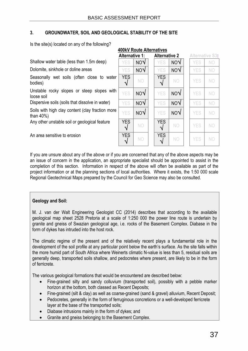
3. GROUNDWATER, SOIL AND GEOLOGICAL STABILITY OF THE SITE
Is the site(s) located on any of the following?400kV Route AlternativesAlternative 1: Alternative 2 Alternative S3:
Shallow water table (less than 1.5m deep) YES NO√ YES NO√ YES NO
Dolomite, sinkhole or doline areas YES NO√ YES NO√ YES NO
Seasonally wet soils (often close to waterbodies)
YES
√ NOYES
√ NO YES NO
Unstable rocky slopes or steep slopes withloose soil
YES NO√ YES NO√ YES NO
Dispersive soils (soils that dissolve in water) YES NO√ YES NO√ YES NO
Soils with high clay content (clay fraction morethan 40%)
YES NO√ YES NO√ YES NO
Any other unstable soil or geological feature YES
√ NOYES
√ NO YES NO
An area sensitive to erosion YES
√ NOYES
√ NO YES NO
If you are unsure about any of the above or if you are concerned that any of the above aspects may bean issue of concern in the application, an appropriate specialist should be appointed to assist in thecompletion of this section. Information in respect of the above will often be available as part of theproject information or at the planning sections of local authorities. Where it exists, the 1:50 000 scaleRegional Geotechnical Maps prepared by the Council for Geo Science may also be consulted.
Geology and Soil:
M. J. van der Walt Engineering Geologist CC (2014) describes that according to the availablegeological map sheet 2528 Pretoria at a scale of 1:250 000 the power line route is underlain bygranite and gneiss of Swazian geological age, i.e. rocks of the Basement Complex. Diabase in theform of dykes has intruded into the host rock.
The climatic regime of the present and of the relatively recent plays a fundamental role in thedevelopment of the soil profile at any particular point below the earth’s surface. As the site falls withinthe more humid part of South Africa where Weinerts climatic N-value is less than 5, residual soils aregenerally deep, transported soils shallow, and pedocretes where present, are likely to be in the formof ferricrete.
The various geological formations that would be encountered are described below: Fine-grained silty and sandy colluvium (transported soil), possibly with a pebble marker
horizon at the bottom, both classed as Recent Deposits; Fine-grained (silt & clay) as well as coarse-grained (sand & gravel) alluvium, Recent Deposit; Pedocretes, generally in the form of ferruginous concretions or a well-developed ferricrete
layer at the base of the transported soils; Diabase intrusions mainly in the form of dykes; and Granite and gneiss belonging to the Basement Complex.

BASIC ASSESSMENT REPORT
38
The residual soil generally contains a high percentage of montmorillonite and is therefore potentiallyexpansive with soil moisture fluctuations. Owing to the fact that diabase dykes and sills are oftenmore deeply decomposed than the country rock into which they are intrusive, these featurescommonly present problems in tunnelling or in open excavations. Differential settlement may occur iffoundations straddle the diabase/host rock boundary. The hazards associated with ”mudrushes” incompletely decomposed dykes, and ravelling from “running dykes” where the material may be lessdecomposed but highly jointed, are well known to tunnelling engineers. Stability of open excavationsthrough residual diabase is always problematic and the problem becomes critical particularly insituations where the residual diabase is squeezed out under the load of overlying strata. Whendiabase occurs in areas with a relatively shallow water table the practical problem with residualdiabase is not one of heaving but of settlement due to drying out of the soil during prolonged periodsof drought
4. GROUNDCOVER
Indicate the types of groundcover present on the site. The location of all identified rare or endangeredspecies or other elements should be accurately indicated on the site plan(s).Natural veld -good condition E
√
Natural veld withscattered aliens E
√
Natural veld withheavy alien
infestation √
Veld dominatedby alien speciesE
Gardens √
Sport field Cultivated land√ Paved surfaceBuilding or otherstructure
Bare soil√
If any of the boxes marked with an “E “is ticked, please consult an appropriate specialist to assist in thecompletion of this section if the environmental assessment practitioner doesn’t have the necessaryexpertise.
The study area falls within the Grassland Biome. The largest part of the power line route falls within theendangered Egoli Granite Grassland (Gm10). Prof. PJ du Preez identified the vegetation onridge/koppies as Gold Reef Mountain Bushveld (Svcb9).

BASIC ASSESSMENT REPORT
39
Figure 6. Vegetation
5. SURFACE WATER
Indicate the surface water present on and or adjacent to the site and alternative sites?
Perennial River YES√ NO UNSURE
Non-Perennial River YES NO√ UNSURE
Permanent Wetland YES√ NO UNSURE
Seasonal Wetland YES√ NO UNSURE
Artificial Wetland YES√ NO UNSURE
Estuarine / Lagoonal wetland YES NO √ UNSURE
If any of the boxes marked YES or UNSURE is ticked, please provide a description of the relevantwatercourse.
The proposed route traverses the Jukskei River. The National Freshwater Ecosystem Priority Areadata ( See Figure 7) indicates that many wetlands are to be found in the area. In addition the entirearea is located on Egoli Granite Grassland, which usually results in valley bottom wetlands withoutchannel, due to water not draining easily. These systems tend to be found in the upper catchmentareas, or at tributary junctions where the sediment from the tributary smothers the main drainage line.

BASIC ASSESSMENT REPORT
40
Figure 7. Surface Water
6. LAND USE CHARACTER OF SURROUNDING AREA
Indicate land uses and/or prominent features that currently occur within a 500m radius of the site andgive description of how this influences the application or may be impacted upon by the application:
Natural area √ Dam or reservoir √ Polo fields
Low density residential√ Hospital/medical centre Filling station H
Medium density residential √ School Landfill or waste treatment site
High density residential Tertiary education facility Plantation
Informal residential A Church √ Agriculture √Retail commercial & warehousing Old age home River, stream or wetland √Light industrial Sewage treatment plant A Nature conservation area
Medium industrial AN Train station or shunting yard N Mountain, koppie or ridge √Heavy industrialAN Railway line N MuseumPower station Major road (4 lanes or more) N Historical building
Office/consulting room √ Airport N Protected Area
Military or policebase/station/compound
Harbour Graveyard
Spoil heap or slimes damA Sport facilities √ Archaeological site
Quarry, sand or borrow pit √ Golf course √ Other land uses (describe)

BASIC ASSESSMENT REPORT
41
If any of the boxes marked with an “N “are ticked, how will this impact / be impacted upon by theproposed activity?
If any of the boxes marked with an "An" are ticked, how will this impact / be impacted upon by theproposed activity? Specify and explain:
If any of the boxes marked with an "H" are ticked, how will this impact / be impacted upon by theproposed activity? Specify and explain:
Does the proposed site (including any alternative sites) fall within any of the following:
Critical Biodiversity Area (as per provincial conservation plan) YES√ NO
Core area of a protected area? YES NO √Buffer area of a protected area? YES NO √Planned expansion area of an existing protected area? YES NO √Existing offset area associated with a previous Environmental Authorisation? YES NO √Buffer area of the SKA? YES NO √

BASIC ASSESSMENT REPORT
42
The proposed 400kV line is located within sites identifies and Important and irreplaceable as per theGauteng C-Plan 3.3 ( See Figure 8).
Figure 8. CBA area
If the answer to any of these questions was YES, a map indicating the affected area must be includedin Appendix A.
7. CULTURAL/HISTORICAL FEATURES
Are there any signs of culturally or historically significant elements, as defined insection 2 of the National Heritage Resources Act, 1999, (Act No. 25 of 1999),including Archaeological or paleontological sites, on or close (within 20m) to thesite? If YES, explain:
YES NO √
Uncertain
If uncertain, conduct a specialist investigation by a recognised specialist in the field (archaeology orpalaeontology) to establish whether there is such a feature(s) present on or close to the site. Brieflyexplain the findings of the specialist:The 2008/9 EIA determined that no heritage sites of significance were identified within the proposedpower line corridors or at the proposed substation sites and therefore the impacts on heritage sitesassociated with the proposed project are expected to be of low significance. The South AfricanHeritage Resources Agency (SAHRA), have confirmed this and have provided Section 38 statutorycomment.
Will any building or structure older than 60 years be affected in any way? YES NO √Is it necessary to apply for a permit in terms of the National Heritage ResourcesAct, 1999 (Act 25 of 1999)?
YES NO √

BASIC ASSESSMENT REPORT
43
If YES, please provide proof that this permit application has been submitted to SAHRA or the relevantprovincial authority.
8. SOCIO-ECONOMIC CHARACTER
a) Local Municipality
Please provide details on the socio-economic character of the local municipality in which the proposedsite(s) are situated.
Level of unemployment:
The 2011 Census data indicates the following:
Johannesburg WardsUNEMPLOYMENTRATE
YOUTHUNEMPLOYMENTRATE
Ward 93 29.7 % 37.2 %Ward 94 17.7 % 22.4 %Ward 96 19.2 % 22.7 %
In addition the Eastern Sub-Region of Region A, the general unemployment rate is very low at just6%. This figure compares favourably with the national unemployment rate of 24%. A large section ofthose that are employed are employed within the financial sector, followed by the retail sector. Theincome levels match the high employment rate as a large sector of the population within the EasternSub-Region falls within high income categories.
The nearby Diepsloot, area, however, is said to have an unemployment rate of over 50%, and 70% ofthat specific population is living below the poverty line. It was further stated that 70% of those living inthe Midrand area earned less than R2 500 per month, while 34% had no income.
Economic profile of local municipality:
Infrastructure
Due to the development explosion the roads in the study area are under tremendous pressure tohandle the increase in traffic, especially in the Kyalami, Midrand and Sunninghill areas. Furthermore,it should be noted that the public transport network within the Eastern Sub-Region is not up tostandard and would need to be addressed. As part of the Steyncity project some roads are beingupgraded in the western section of the study area which is focused on the William Nicol Drive (R511)and Erling Street interchange upgrades.
Basic Services
The majority of residents in the study area and the Eastern Sub-Region have access to piped waterThe Diepsloot area, however, is in serious need of proper water and sanitation services. Watercontamination created various problems in 2012. The complexity of the water and sanitation problem

BASIC ASSESSMENT REPORT
44
is vast and remains to require attention for upgrading. It should however, further be noted that theSteyncity project will make a significant contribution towards regional bulk services upgrading, as wellas municipal sewers and bulk water supply. These bulk upgradings will help to unlock services formany other developments in the sub-region including Diepsloot East, Tanganani, Riversands and theCity of Joburg (www.diepsloot.com).
Tourism Sectors
The conservation of the natural environment and equestrian feel of the area is thus of the utmostimportance to the residents living in the Kyalami Agricultural Holdings, the Glenferness AgriculturalHoldings, as well as the Treesbank and Kleve Agricultural Holdings. Some residents are also of theopinion that the equestrian industry would be negatively affected by the proposed power lines due tothe relocation of residents, as well as the visual impact on the tourism industry associated with theequestrian industry (e.g. impact on the sense of place of visitors to the equestrian shows andcompetitions hosted in the area). It should, however, be noted that the existing power lines traversingthe area could already impact on the sense of place with regards to the equestrian industry.
Level of education:
The education profiles within the District and Local Municipalities within the study area are as follows(2011 statistics):
WARDNO
SCHOOLINGWard 93 1.14%
Ward 94 1.57%
Ward 96 3.48%
The education levels of the population within the Eastern-Sub Region are higher than the nationalaverage which is an indication of the income levels in the area. Sixty percent of the residents havecompleted secondary school and 14% have achieved a higher education level. Merely 18% haveonly completed primary school (Maluleke, Luthuli and Associates, 2008).
b) Socio-economic value of the activity
What is the expected capital value of the activity on completion? R300,000,000.00What is the expected yearly income that will be generated by or as a result of theactivity?
Eskom fees
Will the activity contribute to service infrastructure? YES√ NO
Is the activity a public amenity? YES√ NO
How many new employment opportunities will be created in the development andconstruction phase of the activity/ies?
Unknown
What is the expected value of the employment opportunities during thedevelopment and construction phase?
R100,000,000.00
What percentage of this will accrue to previously disadvantaged individuals? +/- 70%

BASIC ASSESSMENT REPORT
45
How many permanent new employment opportunities will be created during theoperational phase of the activity?
None
What is the expected current value of the employment opportunities during thefirst 10 years?
None
What percentage of this will accrue to previously disadvantaged individuals? +/- 80%
Brian Dames (Business Day April 07 2014) discussed that the build programme (From 2005) has hadsignificant socioeconomic benefits — it is employing more than 35,000 people, of whom about 16,000are from the districts around the projects. More than 6,000 people have benefited from skills training,and an enormous R86bn, or 63% of Eskom’s procurement spend, has been spent on South Africangoods and services. In the 2013 financial year, R103bn of Eskom’s total procurement went to broad-based black economic empowerment entities, of which R26.5bn went to black-owned companies,R5.7bn to black women-owned companies and R1.2bn to black youth-owned companies.
9. BIODIVERSITY
Please note: The Department may request specialist input/studies depending on the nature of thebiodiversity occurring on the site and potential impact(s) of the proposed activity/ies. To assist with theidentification of the biodiversity occurring on site and the ecosystem status consult http://bgis.sanbi.orgor [email protected]. Information is also available on compact disc (cd) from the Biodiversity-GISUnit, Ph (021) 799 8698. This information may be updated from time to time and it is the applicant/EAP’s responsibility to ensure that the latest version is used. A map of the relevant biodiversityinformation (including an indication of the habitat conditions as per (b) below) and must be provided asan overlay map to the property/site plan as Appendix D to this report.
a) Indicate the applicable biodiversity planning categories of all areas on site and indicatethe reason(s) provided in the biodiversity plan for the selection of the specific area aspart of the specific category)
Systematic Biodiversity Planning CategoryIf CBA or ESA, indicate the reason(s) for itsselection in biodiversity plan
CriticalBiodiversityArea (CBA)
√
EcologicalSupport
Area
(ESA) √
OtherNaturalArea
(ONA)
No NaturalArea
Remaining(NNR)
CBA : Red and Orange Listed Plant Habitat,
Primary Vegetation, Red Listed Animal Habitat,
b) Indicate and describe the habitat condition on site
Habitat Condition
Percentage ofhabitat
conditionclass (addingup to 100%)
Description and additional Comments andObservations
(including additional insight into condition, e.g. poorland management practises, presence of quarries,
grazing, harvesting regimes etc).
Natural 20%Natural areas not transformed for agriculture of smallholding..

BASIC ASSESSMENT REPORT
46
Near Natural(includes areas with
low to moderate levelof alien invasive
plants)
0%
Degraded(includes areas
heavily invaded byalien plants)
20%
Bare soil and areas invested with exotic vegetation,including Kikuyu lawns.
Transformed(includes cultivation,
dams, urban,plantation, roads, etc)
60%
Areas transformed for agriculture and planting of crops
The SANBI National list of threatened terrestrial ecosystems for South Africa (2011) shows that theentire study is in an Endangered area. Egoli Granite grassland is a listed threatened ecosystem. SeeFigure 9 below. The Land Cover Atlas shows the area is mostly agriculture. See Figure 10
Figure 9. Ecosystem Status

BASIC ASSESSMENT REPORT
47
Figure 10. Landcover
c) Complete the table to indicate:(i) the type of vegetation, including its ecosystem status, present on the site; and(ii) whether an aquatic ecosystem is present on site.
Terrestrial Ecosystems Aquatic Ecosystems
Ecosystem threatstatus as per the
NationalEnvironmentalManagement:
Biodiversity Act (ActNo. 10 of 2004)
CriticalWetland (including rivers,
depressions, channelled andunchanneled wetlands, flats,
seeps pans, and artificialwetlands)
Estuary Coastline
Endangered
√Vulnerable
LeastThreatened YES√ NO UNSURE YES NO√ YES
NO
√
d) Please provide a description of the vegetation type and/or aquatic ecosystem present onsite, including any important biodiversity features/information identified on site (e.g. threatenedspecies and special habitats)
VEGETATION TYPES
The following vegetation types were identified in the study area (Mucina & Rutherford):
Egoli Granite Grassland (Gm 10)

BASIC ASSESSMENT REPORT
48
No Red Data listed plant species or protected species were found on particular sites. Large parts ofthese sites are relatively transformed due to human impacts such as roads, erosion, crop production,grazing especially by horses, golf driving ranges, etc. A number of exotic species occur in the grasslandas well as riparian plant community on the stream banks and streambeds. The streambank vegetationis degraded and it has a low conservation value and moderate ecosystem functioning.
Figure 11. NFEPA
In its present state the wetlands has a low-moderate ecosystem functioning or value. The results fromthe PES analysis indicate riparian vegetation to be in PES class C indicating that it is marginallymodified with some losses of natural habitats and ecosystem functions. The wetland area has anEcological Importance and Sensitivity (EIS) score of 1.5. The site therefore has a moderate EIS score.It is regarded as playing a moderate ecological role. It is has a low biodiversity and plays a moderaterole in moderating water quality and quantity.
.

BASIC ASSESSMENT REPORT
49
SECTION C: PUBLIC PARTICIPATION
1. ADVERTISEMENT AND NOTICE
Publication name The StarDate published 25 February 2014. Invitation to comment
Site notice position Latitude Longitude-26.017151° 28.070952°-25.993886° 28.049886°-26.964532° 28.009761°
Date placed 25 February 2013
Include proof of the placement of the relevant advertisements and notices in Appendix E1.
2. DETERMINATION OF APPROPRIATE MEASURES
Provide details of the measures taken to include all potential I&APs as required by Regulation 54(2)(e)and 54(7) of GN R.543.
Key stakeholders (other than organs of state) identified in terms of Regulation 54(2)(b) of GN R.543:
Title, Name andSurname
Affiliation/ key stakeholderstatus
Contact details (tel number or e-mailaddress)
Clr Annette Deppe Johannesburg Ward 93Councillor
Clr John Mendelsohn Johannesburg Ward 94Councillor
Clr Matome Mafokwane Johannesburg Ward 96Councillor
Include proof that the key stakeholder received written notification of the proposed activities asAppendix E2. This proof may include any of the following:

BASIC ASSESSMENT REPORT
50
e-mail delivery reports; registered mail receipts; courier waybills; signed acknowledgements of receipt; and/or or any other proof as agreed upon by the competent authority.
3. ISSUES RAISED BY INTERESTED AND AFFECTED PARTIESSee Appendix E7Summary of main issues raised by I&APs Summary of response from EAPKristin Kallesen. Greater Kyalami Conservancy(GECKO) -Please can you forward details of theEIA being done for the Kyalami Strengtheningproject as per the attached photo?Please can I request that a public meeting is heldfor Interested and Affected parties to understandthe application and give comment?I would also like a clear map of the proposedalignment for circulation.
Registered and BID sent. Clear map sent. PPPmeeting scheduled in April All I&AP’ will becontacted.
Johann Jordaan. Riversands Will you please alsoinclude our e-mail address to your list of"Interested and Affected Parties".
Registered and BID sent
Dina Mostert. Saddlebrook Estate -Please forwardme registration details, we have quite a fewquestions that we would like to raise
Registered and BID sent
4. COMMENTS AND RESPONSE REPORT
The practitioner must record all comments received from I&APs and respond to each comment beforethe Draft BAR is submitted. The comments and responses must be captured in a comments andresponse report as prescribed in the EIA regulations and be attached to the Final BAR as Appendix E3.
5. AUTHORITY PARTICIPATION
Authorities and organs of state identified as key stakeholders:
Authority/Organof State
Contactperson (Title,Name andSurname)
Tel No FaxNo
e-mail Postaladdress
Water Affairs J Maluleke 012 3921486 [email protected] K Khaka 011 3551704City ofJohannesburg
LPachaapha 011 5874257

BASIC ASSESSMENT REPORT
51
Include proof that the Authorities and Organs of State received written notification of the proposedactivities as appendix E4.
In the case of renewable energy projects, Eskom and the SKA Project Office must be included in the listof Organs of State.
6. CONSULTATION WITH OTHER STAKEHOLDERS
Note that, for any activities (linear or other) where deviation from the public participation requirementsmay be appropriate, the person conducting the public participation process may deviate from therequirements of that sub-regulation to the extent and in the manner as may be agreed to by thecompetent authority.
Proof of any such agreement must be provided, where applicable. Application for any deviation fromthe regulations relating to the public participation process must be submitted prior to thecommencement of the public participation process.
A list of registered I&APs must be included as appendix E5.
Copies of any correspondence and minutes of any meetings held must be included in Appendix E6.

BASIC ASSESSMENT REPORT
52
SECTION D: IMPACT ASSESSMENT
The assessment of impacts must adhere to the minimum requirements in the EIA Regulations, 2010,and should take applicable official guidelines into account. The issues raised by interested and affectedparties should also be addressed in the assessment of impacts.
1. IMPACTS THAT MAY RESULT FROM THE PLANNING AND DESIGN, CONSTRUCTION,OPERATIONAL, DECOMMISSIONING AND CLOSURE PHASES AS WELL AS PROPOSEDMANAGEMENT OF IDENTIFIED IMPACTS AND PROPOSED MITIGATION MEASURES
Provide a summary and anticipated significance of the potential direct, indirect and cumulative impactsthat are likely to occur as a result of the planning and design phase, construction phase, operationalphase, decommissioning and closure phase, including impacts relating to the choice ofsite/activity/technology alternatives as well as the mitigation measures that may eliminate or reduce thepotential impacts listed. This impact assessment must be applied to all the identified alternatives to theactivities identified in Section A(2) of this report.
Activity Impact summary Significance Proposed mitigationConstruction Phase
Transmission Lines and SubstationImpacts onAvifauna
Direct impacts: ElectrocutionCollision and habitat destruction
Low Strict control should bemaintained over all activitiesduring construction, inparticular heavy machinery andvehicle movements, and staff.Ensure that the constructionEnvironmental ManagementPlan is adhered to.
Indirect impacts: Potential impacton breeding raptors
Low Identification of high risk towerson existing line to ascertainwhere mitigation will be needed
Cumulative impacts: Preferredroute alternative is located awayfrom potential avifaunal habitat.No significant cumulative impactsanticipated
Low Identification of high risk towerson existing line to ascertainwhere mitigation will be needed
Impacts onAquaticHabitats
Direct impacts: No direct Impactsanticipated.
Low No infrastructure planned inaquatic habitats. Wetlands andriparian zones have beendelineated and anydevelopment must be at least32m away from the wetlands
Indirect impacts: Noneanticipated
Low No infrastructure planned inaquatic habitats
Cumulative impacts:None anticipated
Low No infrastructure planned inaquatic habitats

BASIC ASSESSMENT REPORT
53
Activity Impact summary Significance Proposed mitigationImpacts onFauna
Direct impacts: Potential Loss offauna
Low Ensure that no animals areharmed during constructionphase.
Indirect impacts: Low Ensure that no animals areharmed during constructionphase.
Cumulative impacts: Low Ensure that no animals areharmed during constructionphase.
Impacts onFlora
Direct impacts: Loss ofendangered and protected plants.Erosion, and spread of alieninvasive plants.
Medium It is recommended that bushclearing be kept to a minimum.Care must be taken not to clearthe total servitude area but onlydirectly under the conductors.In areas where the slopes ofhills create enough clearance,bush clearing would also notbe required.
Indirect impacts: Potential loss ofprotected species and associatedhabitat.
Medium As for Direct Impacts
Cumulative impacts: Potentialloss of protected species andassociated habitat.
Medium As for Direct Impacts
GeotechnicalImpacts
Direct impacts: None anticipated Low None anticipated
Indirect impacts: Noneanticipated
Low None anticipated
Cumulative impacts: Noneanticipated
Low None anticipated
SocialImpacts
Direct impacts: Inflow ofJobseekers, Impact on Daily Livingand Movement Patterns, Impacton land use and futuredevelopments, Impact on Sense ofPlace, Impact on Tourism
Low See detailed description inEMPr
Indirect impacts: Inflow ofJobseekers, Impact on Daily Livingand Movement Patterns, Impacton land use and futuredevelopments, Impact on Sense ofPlace, Impact on Tourism
Low See detailed description inEMPr
Cumulative impacts: Inflow ofJobseekers, Impact on Daily Livingand Movement Patterns, Impacton land use and futuredevelopments, Impact on Sense of
Low See detailed description inEMPr

BASIC ASSESSMENT REPORT
54
Activity Impact summary Significance Proposed mitigationPlace, Impact on Tourism
VisualImpacts
Direct impacts: Low See detailed description inEMPr
Indirect impacts: Low See detailed description inEMPr
Cumulative impacts: Low See detailed description inEMPr
Operational PhaseActivity Impact summary Significance Proposed mitigation
Impacts onAquaticHabitats
Direct impacts: No direct Impactsanticipated.
Low No infrastructure planned inaquatic habitats
Indirect impacts: Noneanticipated
Low No infrastructure planned inaquatic habitats
Cumulative impacts:None anticipated
Low No infrastructure planned inaquatic habitats
Impacts onFauna
Direct impacts: Potential Loss offauna
Low Ensure that no animals areharmed during constructionphase.
Indirect impacts: Low
Cumulative impacts: Low
Impacts onFlora
Direct impacts: Loss ofendangered and protected plants.Erosion, and spread of alieninvasive plants.
Medium Search and rescue of protectedplants where possible. A fewprotected species occur in thearea.
Indirect impacts: Potential loss ofprotected species and associatedhabitat.
As for Direct Impacts
Cumulative impacts: Potentialloss of protected species andassociated habitat.
As for Direct Impacts
GeotechnicalImpacts
Direct impacts: None anticipated Low None anticipated
Indirect impacts: Noneanticipated
Low None anticipated
Cumulative impacts: Noneanticipated
Low None anticipated
Impacts on Direct impacts: No heritage Low No heritage resources

BASIC ASSESSMENT REPORT
55
Activity Impact summary Significance Proposed mitigationHeritageResources
resources identified in proposedroute alternatives
identified. However if anyresources are found duringexcavations, the EMPrprovides guidance
Indirect impacts: No heritageresources identified in proposedroute alternatives
Low No heritage resourcesidentified. However if anyresources are found duringexcavations, the EMPrprovides guidance
Cumulative impacts: No heritageresources identified in proposedroute alternatives
Low No heritage resourcesidentified. However if anyresources are found duringexcavations, the EMPrprovides guidance
SocialImpacts
Direct impacts: Inflow ofJobseekers, Impact on Daily Livingand Movement Patterns, Impacton land use and futuredevelopments, Impact on Sense ofPlace, Impact on Tourism
Low See detailed description inEMPr
Indirect impacts: Inflow ofJobseekers, Impact on Daily Livingand Movement Patterns, Impacton land use and futuredevelopments, Impact on Sense ofPlace, Impact on Tourism
Low See detailed description inEMPr
Cumulative impacts: Inflow ofJobseekers, Impact on Daily Livingand Movement Patterns, Impacton land use and futuredevelopments, Impact on Sense ofPlace, Impact on Tourism
Low See detailed description inEMPr
VisualImpacts
Direct impacts: Low See detailed description inEMPr
Indirect impacts: Low See detailed description inEMPr
Cumulative impacts: Low See detailed description inEMPr
No-go optionDirect impacts: Theenvironmental status-quo willremain the same in the No-goscenarioThe No-go option will have anegative impact on the electricitysupply to the Region and willimpact negatively on economicgrowth
Low None

BASIC ASSESSMENT REPORT
56
Activity Impact summary Significance Proposed mitigationIndirect impacts: The No-gooption will have a negative impacton the electricity supply to theRegion and will impact negativelyon economic growth
Low None
Cumulative impacts: Theenvironmental status-quo willremain the same in the No-goscenarioThe No-go option will have anegative impact on the electricitysupply to the Region and willimpact negatively on economicgrowth
Low None
A complete impact assessment in terms of Regulation 22(2)(i) of GN R.543 must be included asAppendix F.
2. ENVIRONMENTAL IMPACT STATEMENT
Taking the assessment of potential impacts into account, please provide an environmental impactstatement that summarises the impact that the proposed activity and its alternatives may have on theenvironment after the management and mitigation of impacts have been taken into account, withspecific reference to types of impact, duration of impacts, likelihood of potential impacts actuallyoccurring and the significance of impacts.
Alternative 1 - Revision 20 (preferred alternative)
Specialist studies confirmed that the Northern Section (2009 Alternative 1) of the proposedtransmission line is the preferred option and no fatal flaws were identified. The specialiststudies conducted in 2013/2014 for this Basic Assessment Report confirmed the impacts areof low significance if all mitigation measures are implemented.
Ecology
The preferred alternative (Revision 20) on the Leeukop prison site will have the least impacts in termsof crossings of streams and rocky out crops.
Parts of the power line route is situated in the endangered Egoli Granite Grassland (Gm10). No RedData listed plant species or protected species were found on particular sites. Large parts of thesesites are relatively transformed due to human impacts such as roads, erosion, crop production,grazing especially by horses, golf driving ranges, etc. A number of exotic species occur in thegrassland as well as riparian plant community on the stream banks and streambeds. The streambankvegetation is degraded and it has a low conservation value and moderate ecosystem functioning. In

BASIC ASSESSMENT REPORT
57
its present state the wetlands has a low-moderate ecosystem functioning or value. The results fromthe PES analysis indicate riparian vegetation to be in PES class C indicating that it is marginallymodified with some losses of natural habitats and ecosystem functions. The wetland area has anEcological Importance and Sensitivity (EIS) score of 1.5. The site therefore has a moderate EISscore. It is regarded as playing a moderate ecological role. It is has a low biodiversity and plays amoderate role in moderating water quality and quantity.
Social ImpactIn respect of the above discussions, the following general conclusions can be drawn:
• The majority of the negative social impacts associated with the construction and operation ofthe proposed transmission lines and substation are expected to be responsive to mitigation.• The proposed project would not bring about significant nor sustainable direct benefits to thelocal communities, but would improve the Johannesburg North area’s electricity supply network.• The proposed project is expected to result in some positive impact on job opportunities,although these opportunities would be limited and of a temporary nature.• Indirect downstream economic impacts could occur.• The construction of transmission lines on private properties, especially the smallholdingswhich are limited in extent, could have significant negative impacts on the daily living and movementpatterns of the residents as it would potentially either render the property economically non-viable or itwould result in serious intrusions on the residential dwellings and activities undertaken on theseproperties.• Social impacts with the most negative impact on the residents and property owners are theimpact on their daily living patterns (quality of life) and sense of place. These are highly regarded andsentimental values are placed on these. Although these play a major role in the residents’ andproperty owners’ feeling of well-being it cannot be quantified and the negative impact of transmissionlines and a substation on their general well-being is extremely difficult to be portrayed in financial andpractical terms.• The impact on the “sense of place” does not readily lend itself to mitigation. Since the senseof place is non-economic and non-transferable, it cannot be mitigated through reimbursement orrelocation of individuals.• Relocation could in all instances be highly possible.
Visual ImpactThe results of the visual impact found that Alternative 1 corridor has a higher potential to consolidatethe transmission line infrastructure by placing the proposed lines adjacent to existing power lines.
Transmission line (2008/2009) Alternative 4 and 5 are both expected to have significant visualimpacts on both residents and road users within the region. Alternative 4 (significance rating average62) however would have greater potential to consolidate the visual impacts by aligning the power lineservitude adjacent to existing power lines. Alternative 5 (significance rating average 70) will increasethe visual impacts along major roads and spread the visual impact over larger tracts of land.Alternative 5 is therefore not preferred as a transmission line development corridor.
However from an Biophysical Impact perspective, Alternative 5 was found to be the preferredalternative as it crosses the areas of lowest sensitivity. Impacts of high significance are stillexpected to be associated with this alternative, but threes are considered to be moreacceptable than the impact associated with other alternatives that were considered.

BASIC ASSESSMENT REPORT
58
Alternative 2 - (Revision 19)Social ImpactIn respect of the above discussions, the following general conclusions can be drawn:
• The majority of the negative social impacts associated with the construction and operation ofthe proposed transmission lines and substation are expected to be responsive to mitigation.• The proposed project would not bring about significant nor sustainable direct benefits to thelocal communities, but would improve the Johannesburg North area’s electricity supply network.• The proposed project is expected to result in some positive impact on job opportunities,although these opportunities would be limited and of a temporary nature.• Indirect downstream economic impacts could occur.• The construction of transmission lines on private properties, especially the smallholdingswhich are limited in extent, could have significant negative impacts on the daily living and movementpatterns of the residents as it would potentially either render the property economically non-viable or itwould result in serious intrusions on the residential dwellings and activities undertaken on theseproperties.• Social impacts with the most negative impact on the residents and property owners are theimpact on their daily living patterns (quality of life) and sense of place. These are highly regarded andsentimental values are placed on these. Although these play a major role in the residents’ andproperty owners’ feeling of well-being it cannot be quantified and the negative impact of transmissionlines and a substation on their general well-being is extremely difficult to be portrayed in financial andpractical terms.• The impact on the “sense of place” does not readily lend itself to mitigation. Since the senseof place is non-economic and non-transferable, it cannot be mitigated through reimbursement orrelocation of individuals.• Relocation could in all instances be highly possible.
Visual ImpactThe results of the visual impact found that Alternative 1 corridor has a higher potential to consolidatethe transmission line infrastructure by placing the proposed lines adjacent to existing power lines.
Transmission line (2008/2009) Alternative 4 and 5 are both expected to have significant visualimpacts on both residents and road users within the region. Alternative 4 (significance rating average62) however would have greater potential to consolidate the visual impacts by aligning the power lineservitude adjacent to existing power lines. Alternative 5 (significance rating average 70) will increasethe visual impacts along major roads and spread the visual impact over larger tracts of land.Alternative 5 is therefore not preferred as a transmission line development corridor.
Alternative C
No-go alternative (compulsory)
The environmental status-quo will remain the same in the No-go scenario The No-go option will have a negative impact on the electricity supply to the Northern Cape
Region and will impact negatively on economic growth.

BASIC ASSESSMENT REPORT
59
SECTION E: RECOMMENDATIONS OF PRACTITIONER
Is the information contained in this report and the documentation attached heretosufficient to make a decision in respect of the activity applied for (in the view of theenvironmental assessment practitioner)?
YES√ NO
If “NO”, indicate the aspects that should be assessed further as part of a Scoping and EIA processbefore a decision can be made (list the aspects that require further assessment).
If “YES”, please list any recommended conditions, including mitigation measures that should beconsidered for inclusion in any authorisation that may be granted by the competent authority in respectof the application.See mitigation measures in impacts tables (Appendix F) and EMPr
Is an EMPr attached? YES√ NOThe EMPr must be attached as Appendix G.
The details of the EAP who compiled the BAR and the expertise of the EAP to perform the BasicAssessment process must be included as Appendix H.
If any specialist reports were used during the compilation of this BAR, please attach the declaration ofinterest for each specialist in Appendix I.
Any other information relevant to this application and not previously included must be attached inAppendix J.
___________D W Prinsloo___________________NAME OF EAP
________________________________________ ___04 July 2014______________SIGNATURE OF EAP DATE