Embed Size (px)
Citation preview

Kyleakin Fish Feed Factory
Marine Harvest
Environmental Impact Assessment - Volume 2 of 4: Main Report
Chapter 16: Navigation
Final
May 2017
Envir onmental Impac t Assessment - Volume 2 of 4: Mai n R eport
Marine Har ves t

Kyleakin Fish Feed Factory Environmental Statement
i
Contents
16. Navigation ............................................................................................................................................. 16-1
16.1 Introduction ............................................................................................................................................. 16-1
16.1.1 Structure of Chapter ............................................................................................................................... 16-1
16.2 Legislation, Policy and Guidance ........................................................................................................... 16-1
16.2.1 Key Legislation ....................................................................................................................................... 16-2
16.2.2 Key Policy ............................................................................................................................................... 16-2
16.2.3 Key Guidance ......................................................................................................................................... 16-2
16.3 Methodology ........................................................................................................................................... 16-3
16.3.1 Risk Assessment .................................................................................................................................... 16-3
16.3.2 Safety Assessment ................................................................................................................................. 16-4
16.3.3 Sensitivity ............................................................................................................................................... 16-4
16.3.4 Magnitude of Change ............................................................................................................................. 16-4
16.3.5 Significance ............................................................................................................................................ 16-5
16.4 Baseline Conditions ................................................................................................................................ 16-6
16.5 Predicted Impacts ................................................................................................................................... 16-6
16.5.1 Construction Phase Impacts .................................................................................................................. 16-7
16.5.2 Operational phase impacts ..................................................................................................................... 16-9
16.6 Mitigation Measures ............................................................................................................................. 16-10
16.6.1 Construction Phase .............................................................................................................................. 16-10
16.6.2 Operational Phase ................................................................................................................................ 16-11
16.7 Residual Impacts .................................................................................................................................. 16-12
16.8 Overview ............................................................................................................................................... 16-19
16.9 References ........................................................................................................................................... 16-20
Appendix 16.1: Navigational Risk Assessment for Kyleakin Feed Mill Pier, ABPmer 2016.

Kyleakin Fish Feed Factory Environmental Statement
16-1
16. Navigation
16.1 Introduction
This chapter of the ES provides an assessment of the potential effects to navigation in the vicinity of the
proposed Greenfield Salmon Feed Factory. Consideration is given to the construction of the marine works and
operation of the new pier.
As part of this work, a Navigational Risk Assessment (NRA) was carried out by Associated British Ports Marine
Environmental Research (ABPmer) to identify the existing vessel activity and navigational features in the
Development Area. This NRA constitutes Appendix 16.1 of this ES and should be referred to alongside this
chapter.
Appendix 16.1 has acknowledged all vessels navigating within the waters adjacent to the Proposed
Development, including recreational craft, commercial ferries, commercial traffic, commercial fishing vessels,
marine dredging vessels, military vessels and emergency response activities.
This chapter begins by outlining the legislation, policy and guidance relevant to this topic before explaining the
assessment methodology used. A summary is then provided of the baseline environment and the risk
assessment process carried out within Appendix 16.1. The assessment is in line with guidance identified
herein. Following the application of mitigation, an account of residual impacts is provided.
Although the content of this chapter, specifically the identification of potential impacts, is aligned with that
detailed in Appendix 16.1, as relevant, there have been some minor modifications to the original construction
methodology and design since the NRA was carried out in November 2016. It is now proposed that all dredged
material be unloaded at a temporary jetty during the construction phase and, during the operation phase, that
post-treatment process water be discharged directly into the marine environment though an outfall pipe. Details
on these changes are provided in Chapter 2: Project Description.
Specifically in relation to navigation, the Northern Lighthouse Board (NLB) was notified of these changes in
early March 2017. A formal letter was then sent out in March 2017 which detailed the changes and how they
differed from those originally considered. As requested by NLB (Steven Driver, pers.comm) consideration of
these minor changes is given within this chapter. Where there is a deviation and/or change from that previously
considered within Appendix 16.1 then this has been acknowledged (see section 16.5).
16.1.1 Structure of Chapter
The structure of this chapter follows the generalised approach of other marine technical chapters and covers:
Legislation, Policy and Guidance;
Methodology;
Baseline Conditions;
Predicted Impacts;
Mitigation Measures;
Residual Impacts; and
Overview.
16.2 Legislation, Policy and Guidance
This section outlines the legislation, policy and guidance relevant to the assessment of the potential impacts on
navigation. An overview of legislation, policy and guidance for the Proposed Development is provided in
Chapter 4: Planning Policy of this ES.

Kyleakin Fish Feed Factory Environmental Statement
16-2
16.2.1 Key Legislation
International protocols and conventions relating to safety, laws of the sea and pollution apply to shipping and
ports. The UK Government has a responsibility to ensure that measures are implemented in order to honour its
commitments to these protocols. Not least of these is the UK’s responsibility under Article 60(7) of the United
Nations Convention on the Law of the Sea (Ref 16-1). An NRA is one process by which the necessary
considerations of developments can be evaluated.
The UK Marine Policy Statement identifies that: “Marine plan authorities should take into account and seek to
minimise any negative impact on shipping activity, freedom of navigation and navigational safety and ensure
that their decisions are in compliance with international maritime law.” (Ref 16-2)
The majority of port operations are administered by a Statutory Harbour Authority (SHA). Every SHA is self-
governed, with specific legislation (normally Acts of Parliament) creating the SHA as an entity, with further
powers and amendments made over time in response to the changing scope and remit of the SHA.
Underpinning the powers of an SHA are a range of national legislations that place statutory responsibility on the
Harbour Master to ensure navigation and safety within the harbour limits; these include the Harbours, Docks
and Piers Clauses Act 1847 (Ref 16-3) and the British Transport Docks Act 1972 (Ref 16-4). Under such
legislation, the Harbour Master may issue general or specific directions to control movements of vessels within
their SHA in order to ensure safety.
The Proposed Development is located outwith an established SHA and therefore the competent authority with
respect to navigation is the Maritime and Coastguard Agency (MCA).
16.2.2 Key Policy
16.2.2.1 Scottish National Marine Plan
Scotland’s National Marine Plan (Ref 16-5) provides a comprehensive overarching framework for all marine
activity in Scottish waters. Its intention is to enable sustainable development and use of Scotland’s marine area
in a way which will protect and enhance the marine environment whilst promoting both existing and emerging
industries.
Chapter 13 of the Marine Plan identifies one of its objectives to be “safeguarded access to ports and harbours
and navigational safety.” It then sets out marine planning policies related to this objective:
TRANSPORT 1 states, “Navigational safety in relevant areas used by shipping now and in the future will be
protected, adhering to the rights of innocent passage and freedom of navigation contained in UN
Convention on the Law of the Sea (UNCLOS). The following factors will be taking into account when
reaching decisions regarding development and use:
- The extent to which the locational decision interfaces with existing or planned routes used by shipping,
access to ports and harbours and navigational safety. This includes commercial anchorages and
defined approaches to ports.
- Where interference is likely, where reasonable alternatives can be identified.
- Where there are no reasonable alternatives, whether mitigation through measures adopted in
accordance with the principles and procedures established by the International Maritime Organization
can be achieved at no significant cost to the shipping or ports sector.”
TRANSPORT 6 states, “Marine planners and decision makers and developers should ensure displacement
of shipping is avoided where possible to mitigate against potential increased journey lengths (and
associated fuel costs, emissions and impact on journey frequency) and potential impacts on other users
and ecologically sensitive areas.”
16.2.3 Key Guidance
The assessment has been undertaken in line with a number of key technical guidance documents. These
guidance documents are widely used across the UK and represent best practice for the assessment of various
Kyleakin Fish Feed Factory Environmental Statement
16-3
consenting regimes. The documents summarised below provide information regarding the issues that should
be taken into consideration when assessing the effect on navigational safety:
International Maritime Organization (IMO) Revised Guidelines for Formal Safety Assessment (FSA) for use
in the IMO rule making process (Ref 16-6);
Marine Guidance Note 543 (MGN 543 Merchant + Fishing)Safety of Navigation: Offshore Renewable
Energy Installations (OREIs) – Guidance on UK Navigational Practice, Safety and Emergency Response
(Ref 16-7);
Department for Transport (DfT) and MCA: Methodology for Assessing the Marine Navigational Safety and
Emergency Response Risks of Offshore Renewable Energy Installations (OREI) (Ref 16-8); and
DfT Port Marine Safety Code (Ref 16-9).
16.3 Methodology
16.3.1 Risk Assessment
For navigation, this assessment uses a different approach from the manner adopted in other ES topic chapters.
As required by maritime regulators, a risk-based assessment was carried out initially; this was managed through
consultation with the relevant regulators and is detailed within Appendix 16.1. The outcomes of a navigational
hazard identification workshop were then used to identify the level of risk for a number of hazard scenarios.
The aim of the workshop was to identify navigational safety concerns relative to the study’s scope. A total of 14
hazard scenarios were identified for the construction phase and 15 hazard scenarios for the operational phase.
From the 29 hazard scenarios identified, the attendees considered the possible hazard scenarios according to
their ‘Most Likely’ and ‘Worst Credible’ outcomes. The assessment of risk is based on the descriptions of these
outcomes to determine a likely frequency and outcome for each hazard occurring.
In making the assessment, the outcome of each hazard scenario on the receptors of ‘people, environment,
property, business’ was evaluated to give a baseline risk with no mitigation measures in place. Each of the 29
hazard scenarios were then considered in light of embedded risk controls which are available at, or can be
deployed at, Kyleakin pier in response to a marine emergency. It should be noted that embedded risk controls,
in the context of marine safety, relate to processes, practices and available safety resources that are in
existence irrespective of the project scheme. These might include (for example) International Regulations (such
as the International Regulations for Preventing Collisions at Sea 1972 (COLREGS) (Ref 16-10)) or training of
personnel (such as the International Standards of Training, Certification and Watchkeeping for Seafarers (Ref
16-11)).
After determining which risk controls were applicable to each hazard scenario, a risk score was calculated by
determining the ‘likelihood reduction’ and ‘consequence reduction’ for each risk control.
Additional controls were then identified by the Stakeholders and documented to ensure that risk levels were
maintained to ‘As Low As reasonably Practicable’. These additional controls are safety recommendations, which
were then assigned a likelihood and consequence reduction to allow the calculation of a final risk score.
The risk score associated with each of the 29 hazard scenarios were set on a numerical scale, as shown in
Table 16.1. Following the risk assessment, those hazard scenarios identified as ‘medium’ risk or above, once
the embedded risk controls were considered, were taken forward for a safety assessment.

Kyleakin Fish Feed Factory Environmental Statement
16-4
Table 16.1 : Classification of Risks by Risk Score
Classification Risk Score
High 6.00 – 8.99
Medium 4.00 – 5.99
Low 1.00 – 3.99
Negligible 0.01 – 0.99
16.3.2 Safety Assessment
This section outlines the methodologies developed to describe the baseline and to present and assess impacts
of the Proposed Development on marine vessels and navigation receptors. It outlines the methods and criteria
used to:
define the study area and identify topic receptors;
establish the environmental baseline for topic receptors;
determine the risk of hazard scenarios; and
identify the sensitivity of receptors, the magnitude of change and significance of impacts on safety.
The level of significance of an impact is determined based on the sensitivity attributed to the navigational impact
(Table 16.2) and the magnitude of change from the potential impact (Table 16.3) during either the construction
or operation phase. Where appropriate, mitigation measures are then provided and an assessment of any
residual impacts, following application of the measures, detailed.
16.3.3 Sensitivity
A vessel or navigation receptor can be sensitive only if there is a pathway through which an impact can be
transmitted between the source activity and the receptor. When a receptor is exposed to an impact, the overall
sensitivity of the receptor has been determined, guided by professional judgement.
The table below outlines the receptor sensitivity with their definitions and shows how these compare to those
within Appendix 16.1. A safety impact is classified as any impact that may influence the navigational safety of
the marine receptor.
Table 16.2 : Receptor Sensitivity
Sensitivity General Criteria Sensitivity (as
assigned by
ABPmer)
High High to very high level of safety impact for vessels and navigation receptors.
Limited ability to adapt to impact.
Very high / High
Medium Medium level of safety impact for vessels and navigation receptors.
Some ability to adapt to impact.
Medium
Low Low level of safety impact for vessels and navigation receptors.
Ability to adapt to majority of impact.
Low / Negligible
16.3.4 Magnitude of Change
The magnitude measures the scale or extent of the change from the baseline condition, irrespective of the

Kyleakin Fish Feed Factory Environmental Statement
16-5
sensitivity of the receptor affected. When assessing the magnitude of an impact, the geographical extent, the
duration and the frequency are considered. Determining the overall magnitude of navigational impacts also
incorporates a degree of subjectivity, as decisions are based on professional judgement in combination with
baseline data. Table 16.3 defines the magnitude criteria and provides a comparison with those used within
Appendix 16.1.
Table 16.3 : Magnitude of Change
Magnitude of
change
General Criteria Magnitude (as
assigned by
ABPmer)
Large Impact geographical area beyond the extent of marine works / operational area.
Impact present on a permanent basis throughout the operational phase.
Impact occurs very frequently to constantly / permanently.
Large
Medium Impact localised to geographical extent of marine works / operational area.
Impact present on a permanent basis throughout the operational phase.
Impact occurs frequently.
Medium
Small Impact localised to geographical extent of marine works / operational area.
Impact present on a temporary basis.
Impact relatively infrequent.
Small
Negligible No impact on vessels or navigational receptors. Neutral
16.3.5 Significance
In general terms, the assessment of significance is carried out by first determining the baseline conditions and
sensitivity of the receptor, followed by identifying the magnitude of change on the receptor; the significance is
the combination of these variables. To understand how significance has been assigned against these criteria in
this chapter a matrix is presented (see Table 16.4).
It should be acknowledged that the significance of an impact on navigational receptors has first considered the
adoption of tertiary mitigation measures (see Appendix 16.1). Following adoption of these measures, additional
mitigation is then proposed to reduce or maintain the significance assessed; consideration of this additional
mitigation results in the residual effect.
The identified residual impacts are provided in Section 16.7.
Table 16.4 : Matrix for Determination of Significance
Magnitude
Sensitivity Negligible Small Medium Large
High Negligible Minor/
Moderate
Moderate/
Major Major
Medium Negligible Minor Moderate Moderate/
Major
Low Negligible Negligible Minor Moderate

Kyleakin Fish Feed Factory Environmental Statement
16-6
Table 16.5 : Generic Impact Significance Definition
Impact Definition
Major Adverse Considerable detrimental or negative impact to an environmental resource or receptor impact (by extent,
duration or magnitude) of more than local significance or in breach of recognised acceptability,
legislation, policy or standards.
Moderate Adverse Limited detrimental or negative impact to an environmental resource or receptor (by extent, duration or
magnitude) which may be considered significant.
Minor Adverse Slight, very short or highly localised detrimental or negative impacts to an environmental resource or
receptor.
Negligible No significant impacts to an environmental resource or receptor.
Minor Beneficial Slight, very short or highly localised advantageous or positive impact to an environmental resource or
receptor.
Moderate Beneficial Limited advantageous or positive impact to an environmental resource or receptor (by extent, duration or
magnitude) which may be considered significant.
Major Beneficial Considerable advantageous or positive impact to an environmental resource or receptor (by extent,
duration or magnitude) of more than local significance.
Although professional judgement is the principal factor in determining which effects would be significant, the
assessment is guided by the methodology outlined above. Impacts described during the assessment should be
considered adverse unless stated otherwise.
16.4 Baseline Conditions
The Proposed Development is located at a former sand and gravel quarry and there is an existing pier that was
used as part of the quarry operation at the site. The Proposed Development is adjacent to the Kyleakin narrows
and the Syke Bridge crossing from the Scottish mainland. For the purposes of this assessment, the study area
includes Loch Alsh and Plockton at its eastern side, and extends to the Island of Scalpay at its western extent.
This includes a sea area immediately to the north of the Proposed Development which is termed the ‘Inner
Sound’. Figures illustrating the study area are provided in Appendix 16.1.
The baseline condition for commercial shipping and recreational navigation within the study area was reviewed
(see Appendix 16.1). The following elements were considered for the baseline:
navigational environment;
statutory responsibilities and management procedures;
recreational facilities;
aids to navigation;
anchoring;
emergency response;
marine incidents; and
metocean data.
For full details of baseline conditions, refer to Appendix 16.1.
16.5 Predicted Impacts
Following the establishment of baseline conditions and an understanding of the proposed development, it is
possible to assess the potential impacts of the Proposed Development on navigation. The assessment of
significance assumes that tertiary mitigation measures are in place. These tertiary mitigation measures include
Kyleakin Fish Feed Factory Environmental Statement
16-7
actions that would be carried out to meet other existing legislative requirements, or actions that are considered
to be standard practices used to manage navigational effects.
As previously mentioned, the impacts considered are based on those identified as ‘medium’ risk or above during
the hazard identification workshop (see Appendix 16.1). The impacts are assessed for the construction of the
marine facilities and the operational phase of the Proposed Development.
However, since the NRA was carried out minor modifications to the marine elements of the Proposed
Development have resulted in some changes to that previously assessed. In the construction phase the
requirement for backhoe dredging has removed the need for pumping ashore. Material will be taken from the
backhoe to a temporary jetty by barge, before unloading (see Figure 2.2, Chapter 2). As a consequence, there
will be a slight increase in vessel movements during the construction phase; however, these movements will
occur in the immediate proximity of the Proposed Development and over a very short distance (~100m).
As there is no longer a requirement for the dredge pipeline and buoy during the construction phase the impact
‘allision of recreational/fishing vessel with dredge pipeline/buoy’ is no longer relevant. However, the requirement
for a temporary jetty, albeit much shorter in length than the originally proposed pipe, presents a navigation risk.
As advised by NLB, coordinates of the temporary jetty have been sent to the consultees and it is anticipated
that lighting of the jetty will be requested during the consultation phase of the Marine Licence Application.
Towards the end of the construction phase a small diameter outfall pipe (<200mm) will be laid along the seabed
from MHWS for a total length of approximately 380m seaward. As advised by NLB, coordinates of the outfall
pipe have been sent to the consultees as it will be necessary to mark the pipe on navigation charts. It is also
anticipated that an adequately lit marker buoy denoting the end of the outfall will be required.
Consideration of the above has resulted in the following changes to those potential impacts considered within
Appendix 16.1:
Removal of the potential impact ‘allision of recreational/fishing vessel with dredge pipeline/buoy’ in the
construction phase.
Addition of the potential impact ‘allision of recreational/fishing vessel with temporary jetty’ in the
construction phase.
Consideration of additional vessel movements in construction phase within the identified impact ‘allision of
dredge/construction plant with marine works’
Addition of the potential impact ‘allision with outfall marker buoy’ in the operation phase.
Adopting a conservative approach all potential impacts not previously identified in Appendix 16.1 have been
assigned as ‘medium risk’.
It is anticipated that, once operational, the following vessel movements will take place at the pier:
bulk vessels delivering raw materials at the side berth: 2 per week;
cargo carriers being loaded with fish feed at the outer berth: 2 per week;
tankers delivering vegetable oils at the outer berth: 1 per week;
LNG vessels delivering to the plant at the outer berth: 0.5 per week; and
one landing craft visit to the slipway to collect fish feed: 1 per week.
During the operational phase, a total of 676 vessel movements are anticipated per year, as a direct
consequence of the Propose Development.
16.5.1 Construction Phase Impacts
The following potential impacts were identified for the construction period of the marine facilities. Although the
detail largely reflects that provided within Appendix 16.1 several changes have been made to reflect the minor
Kyleakin Fish Feed Factory Environmental Statement
16-8
modifications (see section 16.5). The significance assessed within Appendix 16.1 may differ to match the
generic assessment methodology used throughout this ES.
16.5.1.1 Allision - Recreational or fishing vessel allision with temporary jetty
This potential impact would have a medium level of sensitivity as vessels have some ability to adapt to the
situation through the application of their engines to manoeuvre or use of anchors to avoid an allision. The
potential impact from an allision will be localised to the immediate extent of the marine construction area. The
impact has the potential to occur throughout the construction phase whilst the jetty is in place (during the
dredging works) leading to a magnitude of medium and an overall ranking of ‘moderate adverse’.
16.5.1.2 Allision - Dredge/construction plant impact with marine works during construction phase
This potential impact would have a medium level of sensitivity as vessels have some ability to adapt to the
situation through the application of their engines, anchors or adjusting moorings. In addition, it is likely that
dredge and construction vessels would be moving at a slow speed whilst working making any allision a
controlled outcome if avoidance action is taken. The potential impact from an allision will be localised to the
immediate extent of the marine construction area. The impact has the potential to occur throughout the
construction phase whilst vessels are manoeuvring leading to a magnitude of medium and an overall ranking of
‘moderate adverse’.
16.5.1.3 Collision - Caissons temporarily anchored in study area presenting a risk of collision
This potential impact will have a high level of impact due to the proximity to the main navigation channel, the
temporary nature of the anchored caissons, meaning that the vessel Masters and navigators may not be aware
of the collision risk, especially at times of reduced visibility or at night. During these times (night or reduced
visibility) vessels will have limited time to react to the situation and take appropriate action to avoid collision.
This impact could occur throughout the passage or whilst the caissons are at anchor. The impact is present on
a temporary basis. This gives a magnitude of small resulting in an overall ranking of ‘minor/moderate adverse’.
16.5.1.4 Fire/Explosion - Dredge/construction plant on-board fire
This potential impact would have a medium level of sensitivity due to the type of work being carried out by
construction craft (such as hot works) and the range of vessels engaged with the marine works. The potential
impacts will be localised to the extent of the marine construction area and will be present for the construction
phase only. A fire or explosion has the potential to occur throughout the construction phase, but is an
infrequent risk, which leads to an assessed magnitude of small and an overall ranking of ‘minor adverse’.
16.5.1.5 Grounding - Dredger grounding whilst engaged in operations
The potential impact would have a high level of sensitivity due to the limited time and ability for the vessel crew
to react to the situation. The potential impact will be localised to the extent of the marine construction area and
will be present for the construction phase only. The impact has the potential to occur throughout the
construction phase, and has the potential to occur frequently which leads to an assessed magnitude of medium
and an overall ranking of ‘moderate/major adverse’.
16.5.1.6 Hazardous substance accidents - Accidental spill during marine works
Depending on the weather conditions, the potential impact will be either spread into the Inner Sound if the wind
direction is easterly or under the Skye Bridge and into Loch Alsh if the wind direction is westerly leading to a
high level of sensitivity. The impact has the potential to occur infrequently throughout the period; however, the
volume of a spill is likely to be small scale due to the volume which could be spilled at any one time through
construction activity. This leads to an assessed magnitude of small and an overall ranking of ‘minor/moderate
adverse’.
Kyleakin Fish Feed Factory Environmental Statement
16-9
16.5.1.7 Machinery related accidents - Heavy lift failure, or failure of lifting gear
The potential impact would have a high level of safety impact for vessels and crew, with limited ability to adapt
to a quickly developing incident. The sensitivity is therefore assessed as high. The potential impact would be
localised to the extent of the study area and will be present for the construction phase only. However, the
impact has the potential to occur infrequently throughout the period of the construction, which leads to an
assessed magnitude of small and an overall ranking of ‘minor/moderate adverse’.
16.5.1.8 Other - Vessel damage due to weather conditions
This potential impact will have a medium sensitivity due to the ability to react to building swell condition and the
time available to move to a more sheltered location. The potential impact will be localised to the extent of the
study area and will be present for the construction phase only. However, the impact has the potential to occur
frequently throughout the period of the construction, which leads to an assessed magnitude of medium and an
overall ranking of ‘moderate adverse’.
16.5.2 Operational phase impacts
The following impacts were identified for the operational phase of the Proposed Development.
16.5.2.1 Allision – with pier structure
Any allision has the potential to cause damage to a vessel which may lead to a pollution event and injuries to
personnel. This risk will diminish with time as crew become familiar with the new berthing locations and the
effects of wind and tidal flow at this location. This potential impact would have a medium level of sensitivity due
to the strong tidal flow and shallow water. However, the low speed at which an approach to the berth is made
means that there is adequate time to react to an allision situation by use of the vessel’s engines, rudder and
bow thruster. In addition, the potential impact is localised to the area of the marine facilities and will occur
throughout the operational phase leading to a magnitude of medium and an overall ranking of ‘moderate
adverse’.
16.5.2.2 Allision – with navigational buoy
This potential impact would have a medium level of sensitivity due to the strong tidal flow in the area meaning
vessels have reduced ability to adapt to the situation. In addition, the potential impact is localised to the
approaches to the pier and will occur throughout the operational phase leading to a magnitude of medium and
an overall ranking of ‘moderate adverse’.
16.5.2.3 Allision – with outfall marker buoy
This potential impact would have a medium level of sensitivity due to the strong tidal flow in the area meaning
vessels have reduced ability to adapt to the situation. In addition, the potential impact is localised to the
approaches to the pier and will occur throughout the operational phase leading to a magnitude of medium and
an overall ranking of ‘moderate adverse’.
16.5.2.4 Allision – with Skye Bridge
This potential impact would have a high level of sensitivity due to the strong tidal flow in this area and the limited
time available to correct any manoeuvre by use of the vessel’s engines, rudder and bow thruster. In addition,
the potential impact is localised to the area of the marine facilities and will occur throughout the operational
phase leading to a magnitude of medium and an overall ranking of ‘moderate/major adverse’.
16.5.2.5 Grounding – Vessel on approaches
This potential impact will have a high level of sensitivity due to the safety implications of hull damage and injury
associated with a grounding event. A vessel approaching the Side Berth will have limited ability to adapt to the
situation as the slow speed required for berthing means that the vessel will quickly drift as the result of a
Kyleakin Fish Feed Factory Environmental Statement
16-10
miscalculation of wind and tide. The potential impact is localised to the area of the marine facilities and will
occur throughout the operational phase leading to a magnitude of medium and an overall ranking of
‘moderate/major adverse’.
16.5.2.6 Ranging – Adverse weather conditions affecting moored vessels
This potential impact will have a high sensitivity due to the limited ability to react to adverse weather conditions;
a vessel has limited ability to reduce the risk of mooring failure. The potential impact will be localised to the
harbour area and will be present on a permanent basis. The impact also has the potential to occur frequently
throughout the operational phase, which leads to an assessed magnitude of medium and an overall ranking of
‘moderate/major adverse’.
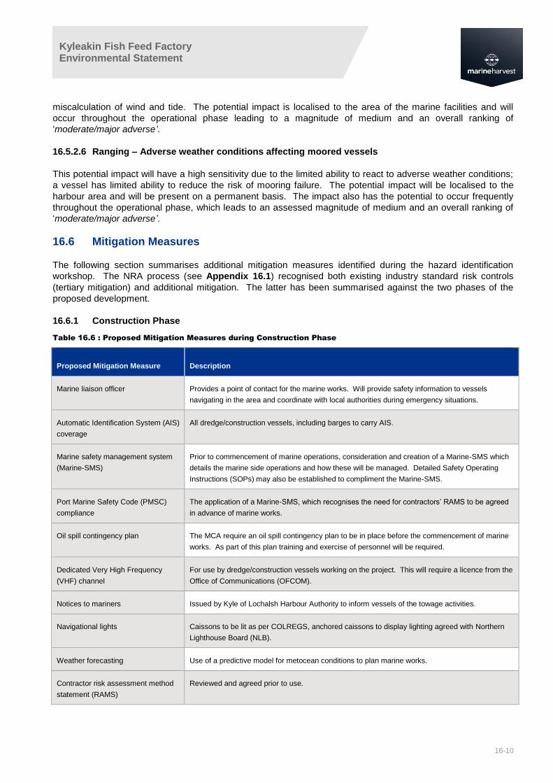
16.6 Mitigation Measures
The following section summarises additional mitigation measures identified during the hazard identification
workshop. The NRA process (see Appendix 16.1) recognised both existing industry standard risk controls
(tertiary mitigation) and additional mitigation. The latter has been summarised against the two phases of the
proposed development.
16.6.1 Construction Phase
Table 16.6 : Proposed Mitigation Measures during Construction Phase
Proposed Mitigation Measure Description
Marine liaison officer Provides a point of contact for the marine works. Will provide safety information to vessels
navigating in the area and coordinate with local authorities during emergency situations.
Automatic Identification System (AIS)
coverage
All dredge/construction vessels, including barges to carry AIS.
Marine safety management system
(Marine-SMS)
Prior to commencement of marine operations, consideration and creation of a Marine-SMS which
details the marine side operations and how these will be managed. Detailed Safety Operating
Instructions (SOPs) may also be established to compliment the Marine-SMS.
Port Marine Safety Code (PMSC)
compliance
The application of a Marine-SMS, which recognises the need for contractors’ RAMS to be agreed
in advance of marine works.
Oil spill contingency plan The MCA require an oil spill contingency plan to be in place before the commencement of marine
works. As part of this plan training and exercise of personnel will be required.
Dedicated Very High Frequency
(VHF) channel
For use by dredge/construction vessels working on the project. This will require a licence from the
Office of Communications (OFCOM).
Notices to mariners Issued by Kyle of Lochalsh Harbour Authority to inform vessels of the towage activities.
Navigational lights Caissons to be lit as per COLREGS, anchored caissons to display lighting agreed with Northern
Lighthouse Board (NLB).
Weather forecasting Use of a predictive model for metocean conditions to plan marine works.
Contractor risk assessment method
statement (RAMS)
Reviewed and agreed prior to use.

Kyleakin Fish Feed Factory Environmental Statement
16-11
16.6.2 Operational Phase
Table 16.7 : Proposed Mitigation Measures for Operational Phase
Proposed Mitigation Measure Description
Availability of latest hydrographic
information
Results of the hydrographic surveys should be provided to the UK Hydrographic Office (UKHO) so
that navigational charts for the area can be updated.
Dedicated VHF channel To prevent over use of the main navigational channels, will require a licence from OFCOM.
Dredging programme The approaches to the berths will be dredged as part of the construction phase. Surveying
completed during the operational phase will determine the need for maintenance dredging
Hydrographic surveying Scheduled surveys should be completed in line with PMSC requirements.
Marine liaison officer / pier master Will promulgate safety information to vessels navigating in the area. They will be the Kyleakin Pier
point of contact during an emergency situation.
Marine safety management system The MSMS should detail the procedures for promulgating weather information and requirements of
marine personnel.
Oil spill contingency plans To detail the response to any marine pollution event.
PMSC compliance Ensures all risk is reduced to as low as reasonably practicable by risk assessment and
subsequent mitigation.
Port emergency plan Will detail responses to emergency situations, along with contact details for local authorities.
Sectored light This should be used for vessels approaching the side berth. A sectored light consists of at least 2
lights, red and white. When the vessel is in the white sector of the light the navigator can be
confident that they are in safe water. If the vessel is in the red sector of the light, it indicates that
the vessel should change its course and is outside of the dredged approach area to the berth.
Any Aid to Navigation lighting is subject to approval of the NLB prior to installation.
Tidal flow atlas Provision of a tidal atlas for use on-board vessels, which provides tidal flow speed and direction
through each hour of the tidal cycle.

Kyleakin Fish Feed Factory Environmental Statement
16-12
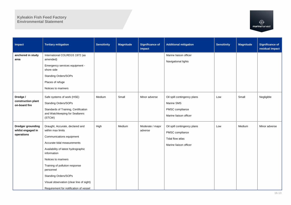
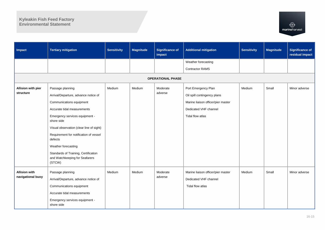
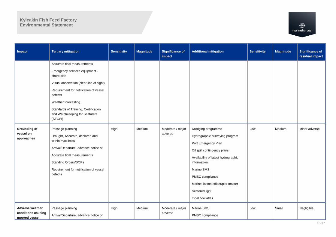
16.7 Residual Impacts
Table 16.8 summarises those impacts what were initially ranked as having a ‘medium’ risk or above during the hazard identification workshop. An assessment is provided of
the impacts, once tertiary mitigation has been applied. Subsequent to the application of tertiary mitigation, consideration is then given to ‘additional mitigation’ before
providing an assessment of the residual effect.
Table 16.8: Summary of Residual Impacts
Impact Tertiary mitigation Sensitivity Magnitude Significance of
impact
Additional mitigation Sensitivity Magnitude Significance of
residual impact
CONSTRUCTION PHASE
Recreational /
fishing vessel
allision with
temporary jetty
Visual observation (clear line of sight) Medium Medium Moderate
adverse
Oil spill contingency plans
Marine SMS
PMSC compliance
Marine liaison officer
AIS coverage
Dedicated VHF channel
Low Medium Minor adverse
Dredge /
construction plant
allision with marine
works
Communications equipment
Safe systems of work (HSE)
Standing Orders/SOPs
Visual observation (clear line of sight)
Standards of Training, Certification
and Watchkeeping for Seafarers
(STCW)
Medium Medium Moderate
adverse
Oil spill contingency plans
Marine SMS
PMSC compliance
Marine liaison officer
Dedicated VHF channel
AIS coverage
Low Medium Minor adverse
Collision as a result
of caissons
temporarily
Passage planning
Weather forecasting
High Small Minor / moderate
adverse
AIS coverage
Notices to mariners
Low Small Negligible
Kyleakin Fish Feed Factory Environmental Statement
16-13
Impact Tertiary mitigation Sensitivity Magnitude Significance of
impact
Additional mitigation Sensitivity Magnitude Significance of
residual impact
anchored in study
area
International COLREGS 1972 (as
amended)
Emergency services equipment -
shore side
Standing Orders/SOPs
Places of refuge
Notices to mariners
Marine liaison officer
Navigational lights
Dredge /
construction plant
on-board fire
Safe systems of work (HSE)
Standing Orders/SOPs
Standards of Training, Certification
and Watchkeeping for Seafarers
(STCW)
Medium Small Minor adverse Oil spill contingency plans
Marine SMS
PMSC compliance
Marine liaison officer
Low Small Negligible
Dredger grounding
whilst engaged in
operations
Draught, Accurate, declared and
within max limits
Communications equipment
Accurate tidal measurements
Availability of latest hydrographic
information
Notices to mariners
Training of pollution response
personnel
Standing Orders/SOPs
Visual observation (clear line of sight)
Requirement for notification of vessel
High Medium Moderate / major
adverse
Oil spill contingency plans
PMSC compliance
Tidal flow atlas
Marine liaison officer
Low Medium Minor adverse

Kyleakin Fish Feed Factory Environmental Statement
16-14
Impact Tertiary mitigation Sensitivity Magnitude Significance of
impact
Additional mitigation Sensitivity Magnitude Significance of
residual impact
defects
Standards of Training, Certification
and Watchkeeping for Seafarers
(STCW)
Accidental spillage
of hazardous
substance
Oil spill contingency plans
Contingency plan exercises
Availability of pollution response
equipment
Training of pollution response
personnel
Standards of Training, Certification
and Watchkeeping for Seafarers
(STCW)
High Small Minor / moderate
adverse
Oil spill contingency plans
Marine liaison officer
Low Small Negligible
Heavy lift failure, or
failure of lifting
gear
Communications equipment
Safe systems of work (HSE)
Emergency services equipment -
shore side
Standing Orders/SOPs
Weather forecasting
High Small Minor / moderate
adverse
Oil spill contingency plans
Marine liaison officer
Weather forecasting
Contractor RAMS
Low Negligible Negligible
Vessel damage due
to weather
conditions
Weather forecasting Medium Medium Moderate
adverse
Marine SMS
PMSC compliance
Oil spill contingency plans
Marine liaison officer
Medium Small Minor adverse
Kyleakin Fish Feed Factory Environmental Statement
16-15
Impact Tertiary mitigation Sensitivity Magnitude Significance of
impact
Additional mitigation Sensitivity Magnitude Significance of
residual impact
Weather forecasting
Contractor RAMS
OPERATIONAL PHASE
Allision with pier
structure
Passage planning
Arrival/Departure, advance notice of
Communications equipment
Accurate tidal measurements
Emergency services equipment -
shore side
Visual observation (clear line of sight)
Requirement for notification of vessel
defects
Weather forecasting
Standards of Training, Certification
and Watchkeeping for Seafarers
(STCW)
Medium Medium Moderate
adverse
Port Emergency Plan
Oil spill contingency plans
Marine liaison officer/pier master
Dedicated VHF channel
Tidal flow atlas
Medium Small Minor adverse
Allision with
navigational buoy
Passage planning
Arrival/Departure, advance notice of
Communications equipment
Accurate tidal measurements
Emergency services equipment -
shore side
Medium Medium Moderate
adverse
Marine liaison officer/pier master
Dedicated VHF channel
Tidal flow atlas
Medium Small Minor adverse

Kyleakin Fish Feed Factory Environmental Statement
16-16
Impact Tertiary mitigation Sensitivity Magnitude Significance of
impact
Additional mitigation Sensitivity Magnitude Significance of
residual impact
Visual observation (clear line of sight)
Requirement for notification of vessel
defects
Weather forecasting
Standards of Training, Certification
and Watchkeeping for Seafarers
(STCW)
Allision with outfall
marker buoy
Passage planning
Arrival/Departure, advance notice of
Communications equipment
Accurate tidal measurements
Emergency services equipment -
shore side
Visual observation (clear line of sight)
Requirement for notification of vessel
defects
Weather forecasting
Standards of Training, Certification
and Watchkeeping for Seafarers
(STCW)
Medium Medium Moderate
adverse
Marine liaison officer/pier master
Dedicated VHF channel
Tidal flow atlas
Medium Small Minor adverse
Allision with Skye
Bridge
Passage planning
Arrival/Departure, advance notice of
Communications equipment
High Medium Moderate / major
adverse
Marine liaison officer/pier master
Dedicated VHF channel
Tidal flow atlas
High Small Minor /
moderate
adverse
Kyleakin Fish Feed Factory Environmental Statement
16-17
Impact Tertiary mitigation Sensitivity Magnitude Significance of
impact
Additional mitigation Sensitivity Magnitude Significance of
residual impact
Accurate tidal measurements
Emergency services equipment -
shore side
Visual observation (clear line of sight)
Requirement for notification of vessel
defects
Weather forecasting
Standards of Training, Certification
and Watchkeeping for Seafarers
(STCW)
Grounding of
vessel on
approaches
Passage planning
Draught, Accurate, declared and
within max limits
Arrival/Departure, advance notice of
Accurate tidal measurements
Standing Orders/SOPs
Requirement for notification of vessel
defects
High Medium Moderate / major
adverse
Dredging programme
Hydrographic surveying program
Port Emergency Plan
Oil spill contingency plans
Availability of latest hydrographic
information
Marine SMS
PMSC compliance
Marine liaison officer/pier master
Sectored light
Tidal flow atlas
Low Medium Minor adverse
Adverse weather
conditions causing
moored vessel
Passage planning
Arrival/Departure, advance notice of
High Medium Moderate / major
adverse
Marine SMS
PMSC compliance
Low Small Negligible

Kyleakin Fish Feed Factory Environmental Statement
16-18
Impact Tertiary mitigation Sensitivity Magnitude Significance of
impact
Additional mitigation Sensitivity Magnitude Significance of
residual impact
ranging Weather forecasting Marine liaison officer/pier master
Kyleakin Fish Feed Factory Environmental Statement
16-19
16.8 Overview
This chapter has assessed the potential effects of the Proposed Development on navigation in the study area.
The navigation baseline was established through desk-based research and consultation with relevant
Stakeholders.
During the construction phase of the project, a number of residual impacts have been identified as having a
minor adverse impact, following implementation of tertiary and additional mitigation measures. These were:
allision of recreational/fishing vessel with dredge pipeline/buoy;
allision of dredge/construction plant with marine works;
dredger grounding whilst engaged in operations; and
vessel damage due to weather conditions.
No impacts were identified as moderate or major adverse after implementation of additional mitigation.
During the operational phase of the project, the potential minor adverse residual impacts are likely to include the
following:
allision with pier structure;
allision with navigational buoy;
allision with Skye Bridge; and
grounding of vessel on approaches.
Potential allision with Skye Bridge was identified as minor to moderate adverse impact on navigation, following
the implementation of additional mitigation.
Following consultation with NLB in early March 2017, consideration has also been given to the minor
modifications to the Proposed Development which have occurred since the NRA (Appendix 16.1) was carried
out.

Kyleakin Fish Feed Factory Environmental Statement
16-20
16.9 References
Ref 16-1 United Nations, 1982. United Nations Convention on the Law of the Sea. [Accessed 21.11.16]
Available from: http://www.un.org/depts/los/convention_agreements/texts/unclos/unclos_e.pdf
Ref 16-2: HM Government, 2011. UK Marine Policy Statement (MPS). London: The Stationery Office.
Ref 16-3: UK Government, 1847. Harbours, Docks and Piers Clauses Act 1847. [Accessed 21.11.2016]
Available from: http://www.legislation.gov.uk/ukpga/1847/27/pdfs/ukpga_18470027_en.pdf
Ref 16-4: UK Government, 1972. British Transport Docks Act 1972.
Ref 16-5: The Scottish Government, 2015. Scotland's National Marine Plan. Edinburgh: The Scottish
Government. 99-99.
Ref 16-6: International Maritime Organization, 2013. Revised Guidelines for Formal Safety Assessment (FSA)
for use in the IMO rule making process. [Accessed 21.11.16], Available from:
http://research.dnv.com/skj/IMO/MSC-
MEPC%202_Circ%2012%20FSA%20Guidelines%20Rev%20III.pdf
Ref 16-7: Maritime and Coastguard Agency, 2016. Marine Guidance Note 543 (MGN 543 Merchant + Fishing)
Safety of Navigation: Offshore Renewable Energy Installations (OREIs) – Guidance on UK
Navigational Practice, Safety and Emergency Response. [Accessed 21.11.16] Available from:
https://www.gov.uk/government/uploads/system/uploads/attachment_data/file/502021/MGN_543.pdf
Ref 16-8: Department for Transport (DfT) and MCA. 2013. Methodology for Assessing the Marine Navigational
Safety and Emergency Response Risks of Offshore Renewable Energy Installations (OREI). London:
The Stationery Office.
Ref 16-9: Department for Transport (DfT). 2016. Port Marine Safety Code, November 2016. London: The
Stationery Office.
Ref 16-10: International Maritime Organization, 1972. COLREGS – International Regulations for Preventing
Collisions at Sea. [Accessed 21.11.16] Available from: http://www.mar.ist.utl.pt/mventura/Projecto-
Navios-I/IMO-Conventions%20(copies)/COLREG-1972.pdf
Ref 16-11: International Maritime Organization, 1978. International Convention on Standards of Training,
Certification and Watchkeeping for Seafarers. [Accessed: 21.11.16] Available from:
http://www.imo.org/en/About/conventions/listofconventions/pages/international-convention-on-
standards-of-training,-certification-and-watchkeeping-for-seafarers-(stcw).aspx

Kyleakin Fish Feed Factory Environmental Statement
16-21
Glossary of Technical Terms
Abbreviation Term
ABPmer Associated British Ports Marine
Environmental Research
AIS Automatic Identification System
COLREGS International Regulations for Preventing Collisions at Sea
DfT Department for Transport
EIA Environmental Impact Assessment
ES Environmental Statement
HSE Health and Safety Executive
IMO International Maritime Organization
LPS Local Port Services
Marine-SMS Marine Safety Management System
MCA Maritime and Coastguard Agency
NLB Northern Lighthouse Board
NRA Navigational Risk Assessment
OFCOM Office of Communications
OREI Offshore Renewable Energy Installations
PMSC Port Marine Safety Code
RAMS Risk Assessment Method Statement
SHA Statutory Harbour Authority
SOP Standard Operating Procedure
UKHO United Kingdom Hydrographic Office
UNCLOS United Nations Convention on the Law of the Sea
VHF Very High Frequency