Embed Size (px)
Citation preview
SECTION 5 - EAST END BRIDGE OVER OHIO RIVER
KYTC ITEM NO. 5-745.00
SECTION 4 SCOUR ANALYSIS (Supplement to Section 5 Hydraulics Report)
OCTOBER 31, 2011
Prepared by: WILBUR SMITH ASSOCIATES
Prepared for:
PB AMERICAS, INC.
LSIORB – East End Bridge Over Ohio River Scour Analysis Report KYTC Item No. 5-118.00 October 31,2011
Page 1
TABLE OF CONTENTS
1.0 INTRODUCTION .................................................................................................. 2
2.0 DATA COLLECTION ........................................................................................... 2
2.1 General ................................................................................................................. 2
2.2 Soil Particle Sizes ................................................................................................. 2
3.0 SCOUR ANALYSIS ............................................................................................. 5
3.1 Methodology ......................................................................................................... 6
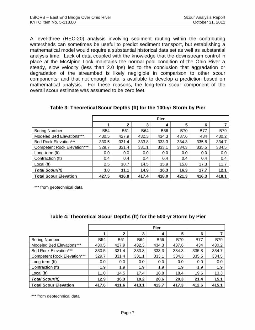
3.2 Theoretical Predicted Scour ................................................................................. 6
4.0 REFERENCES AND DATA SOURCES ............................................................. 10
APPENDICES
APPENDIX A: Bridge and Approach Drawings APPENDIX B: Geotechnical Data APPENDIX C: Detailed Scour Computations
TABLE OF TABLES Table 1: Grain Size Summaries at Proposed Bridge Crossing ....................................... 2 Table 2: Summary of Maximum Velocities and Corresponding Flow Depths ................. 4 Table 3: Theoretical Scour Depths (Ft) for the 100-Yr Storm by Pier ............................ 7 Table 4: Theoretical Scour Depths (Ft) for the 500-Yr Storm by Pier ............................ 7
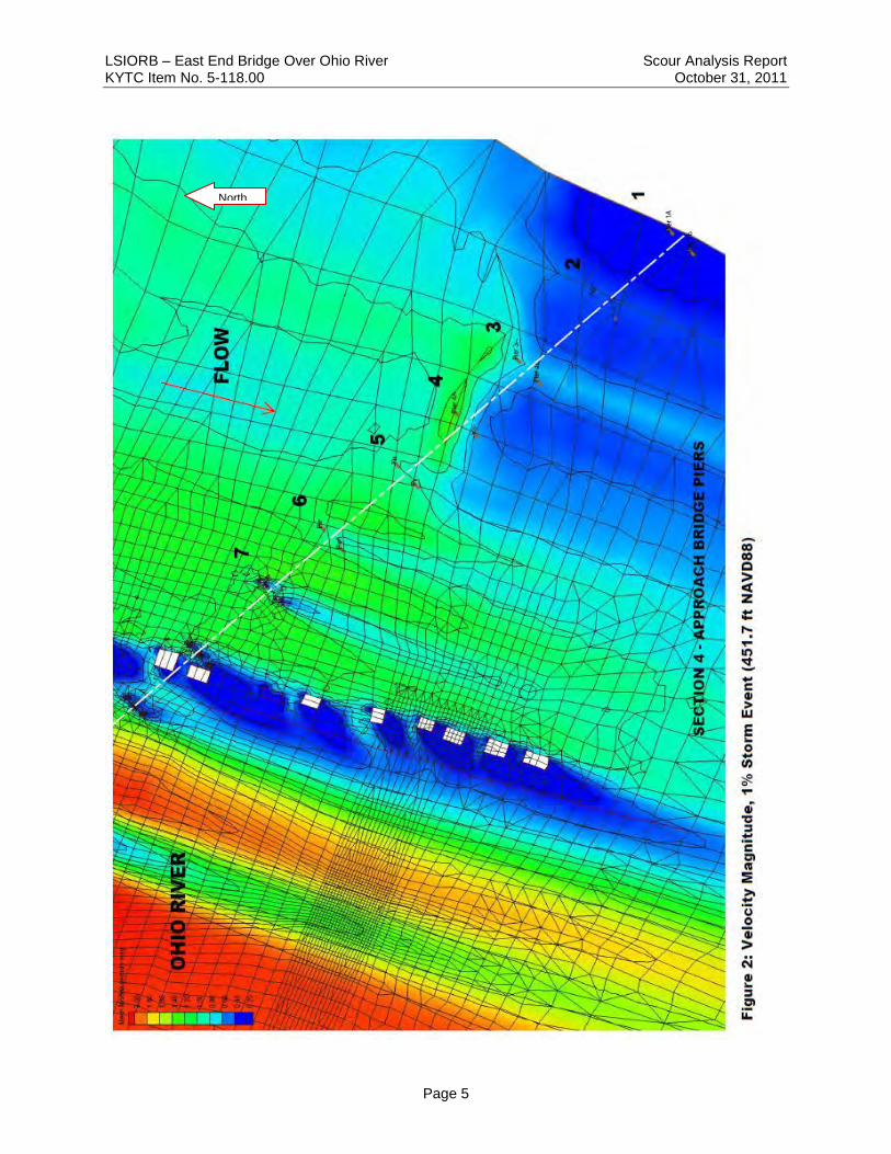
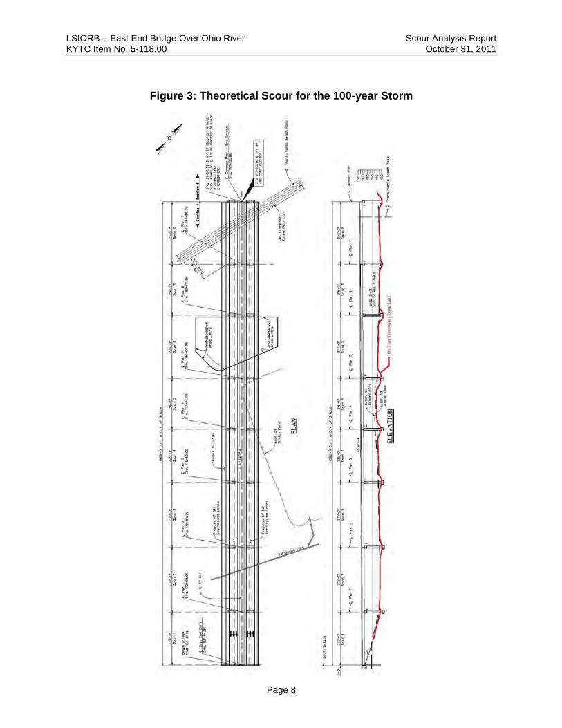
TABLE OF FIGURES Figure 1: General Soil Boring Locations ......................................................................... 3 Figure 2: Velocity Magnitude, 1% Storm Event (451.7 Ft NAVD88) ............................... 5 Figure 3: Theoretical Scour for the 100-year Storm ....................................................... 8
LSIORB – East End Bridge Over Ohio River Scour Analysis Report KYTC Item No. 5-118.00 October 31, 2011
Page 2
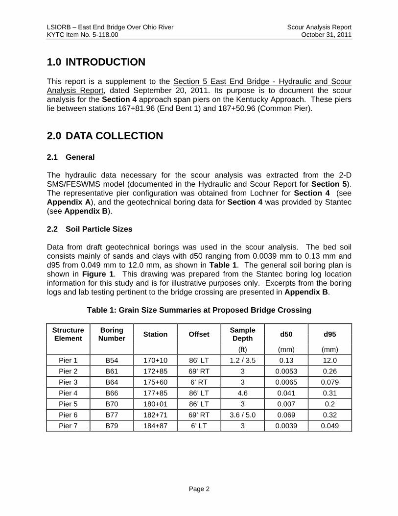
1.0 INTRODUCTION This report is a supplement to the Section 5 East End Bridge - Hydraulic and Scour Analysis Report, dated September 20, 2011. Its purpose is to document the scour analysis for the Section 4 approach span piers on the Kentucky Approach. These piers lie between stations 167+81.96 (End Bent 1) and 187+50.96 (Common Pier).
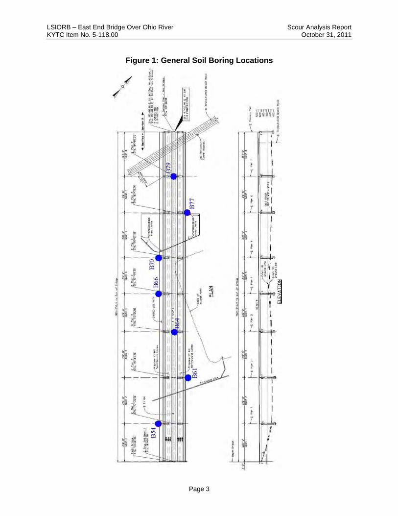
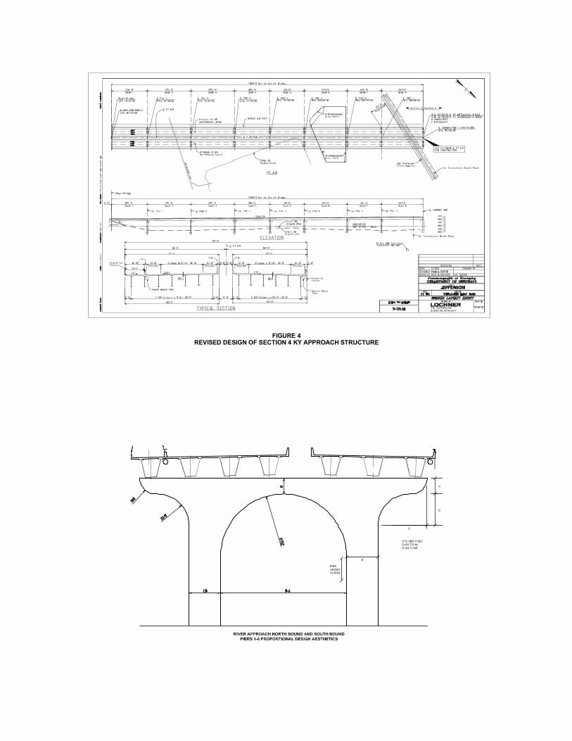
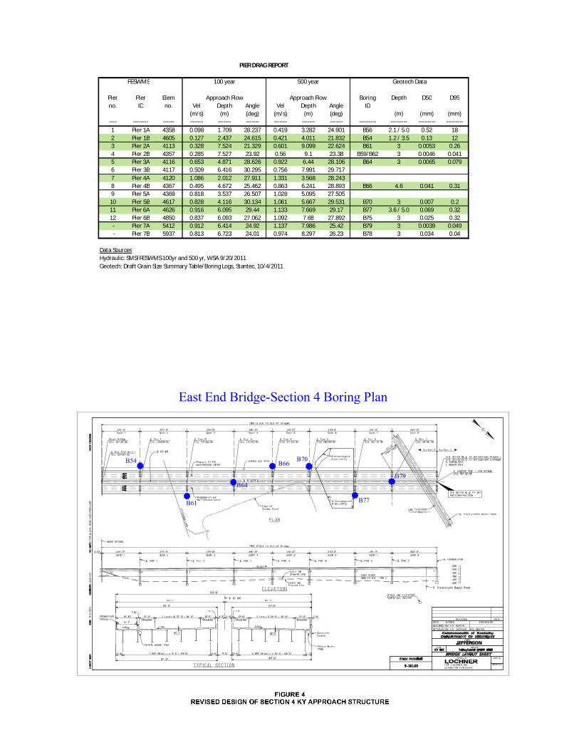
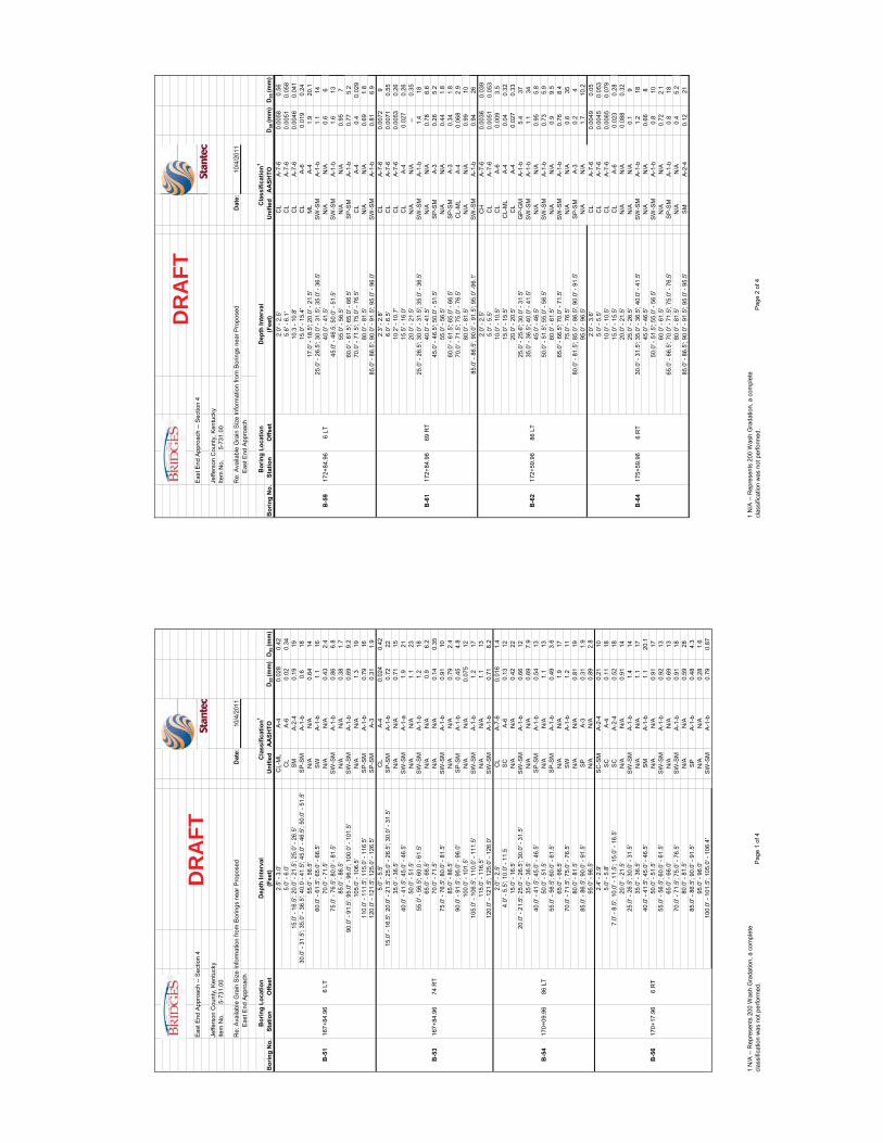
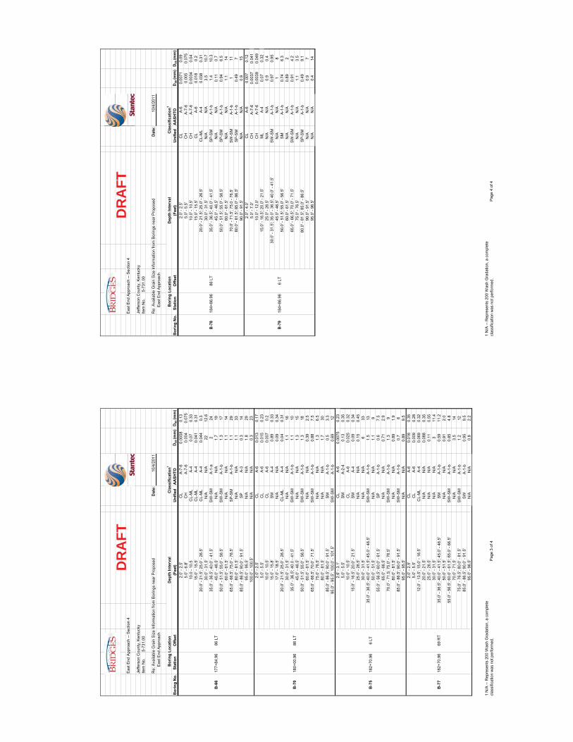
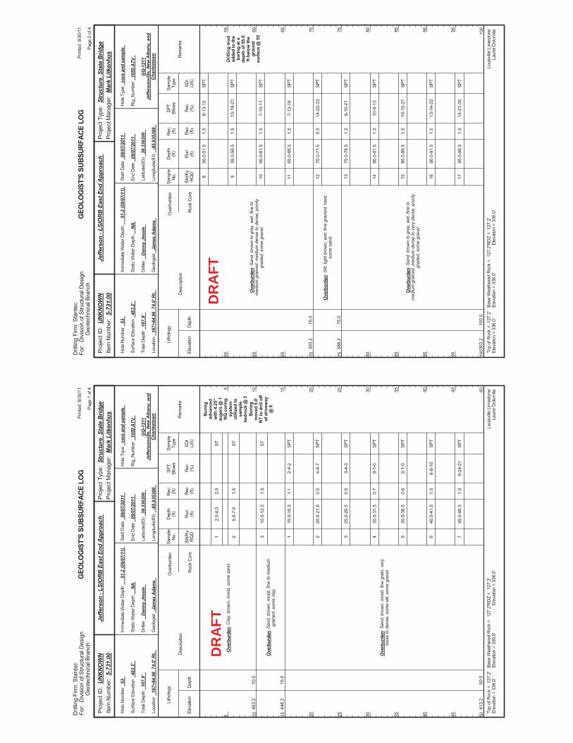
2.0 DATA COLLECTION 2.1 General The hydraulic data necessary for the scour analysis was extracted from the 2-D SMS/FESWMS model (documented in the Hydraulic and Scour Report for Section 5). The representative pier configuration was obtained from Lochner for Section 4 (see Appendix A), and the geotechnical boring data for Section 4 was provided by Stantec (see Appendix B). 2.2 Soil Particle Sizes Data from draft geotechnical borings was used in the scour analysis. The bed soil consists mainly of sands and clays with d50 ranging from 0.0039 mm to 0.13 mm and d95 from 0.049 mm to 12.0 mm, as shown in Table 1. The general soil boring plan is shown in Figure 1. This drawing was prepared from the Stantec boring log location information for this study and is for illustrative purposes only. Excerpts from the boring logs and lab testing pertinent to the bridge crossing are presented in Appendix B.
Table 1: Grain Size Summaries at Proposed Bridge Crossing
Structure Element
Boring Number
Station Offset Sample Depth
d50 d95
(ft) (mm) (mm)
Pier 1 B54 170+10 86’ LT 1.2 / 3.5 0.13 12.0
Pier 2 B61 172+85 69’ RT 3 0.0053 0.26
Pier 3 B64 175+60 6’ RT 3 0.0065 0.079
Pier 4 B66 177+85 86’ LT 4.6 0.041 0.31
Pier 5 B70 180+01 86’ LT 3 0.007 0.2
Pier 6 B77 182+71 69’ RT 3.6 / 5.0 0.069 0.32
Pier 7 B79 184+87 6’ LT 3 0.0039 0.049
LSIORB – East End Bridge Over Ohio River Scour Analysis Report KYTC Item No. 5-118.00 October 31, 2011
Page 3
Figure 1: General Soil Boring Locations
LSIORB – East End Bridge Over Ohio River Scour Analysis Report KYTC Item No. 5-118.00 October 31, 2011
Page 4
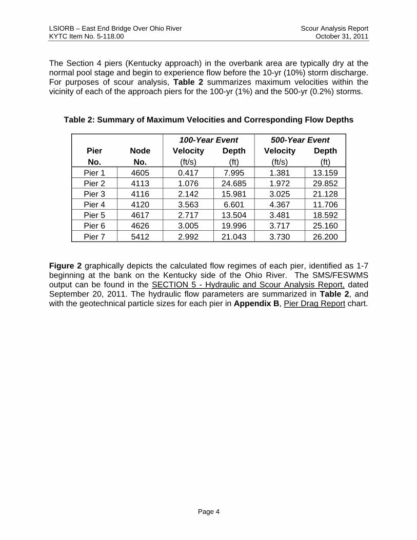
The Section 4 piers (Kentucky approach) in the overbank area are typically dry at the normal pool stage and begin to experience flow before the 10-yr (10%) storm discharge. For purposes of scour analysis, Table 2 summarizes maximum velocities within the vicinity of each of the approach piers for the 100-yr (1%) and the 500-yr (0.2%) storms.
Table 2: Summary of Maximum Velocities and Corresponding Flow Depths
100-Year Event 500-Year Event Pier Node Velocity Depth Velocity Depth No. No. (ft/s) (ft) (ft/s) (ft)
Pier 1 4605 0.417 7.995 1.381 13.159 Pier 2 4113 1.076 24.685 1.972 29.852 Pier 3 4116 2.142 15.981 3.025 21.128 Pier 4 4120 3.563 6.601 4.367 11.706 Pier 5 4617 2.717 13.504 3.481 18.592 Pier 6 4626 3.005 19.996 3.717 25.160 Pier 7 5412 2.992 21.043 3.730 26.200
Figure 2 graphically depicts the calculated flow regimes of each pier, identified as 1-7 beginning at the bank on the Kentucky side of the Ohio River. The SMS/FESWMS output can be found in the SECTION 5 - Hydraulic and Scour Analysis Report, dated September 20, 2011. The hydraulic flow parameters are summarized in Table 2, and with the geotechnical particle sizes for each pier in Appendix B, Pier Drag Report chart.
LSIORB – East End Bridge Over Ohio River Scour Analysis Report KYTC Item No. 5-118.00 October 31, 2011
Page 5
North
LSIORB – East End Bridge Over Ohio River Scour Analysis Report KYTC Item No. 5-118.00 October 31, 2011
Page 6
3.0 SCOUR ANALYSIS 3.1 Methodology The scour analysis was performed in accordance with the methodology outlined in the Federal Highway Administration (FHWA) Hydraulic Engineering Circular (HEC) No. 18. These methods were used to develop predictions of long-term, contraction, and local scour at piers and abutments. In accordance with general practice, the 100-yr (1%) storm was used as the scour analysis design event. For this supplemental report, scour analysis was only performed for the Section 4 (Kentucky Approach) piers. Hydraulic parameters necessary to complete the scour analysis were taken from the SMS/FESWMS model results. The FESWMS node numbers used to perform the scour analysis are shown in Appendix C in the Total Scour Inputs (from FESWMS) table. 3.2 Theoretical Predicted Scour Total scour depths shown in Tables 3 and 4 are composed of three scour components: long-term, contraction, and local (which is composed of the pier scour). The total scour depths for the 100-year event are shown graphically in the scour plot in Figure 3. The detailed scour calculations are provided in Appendix C. 3.2.1 Long-term Scour Component The USACE Louisville, Kentucky District was contacted to obtain available historical data documenting changes to streambed geometry and elevations over time. Both the Water Management Section of the Engineering Division and the Navigation Information Section of the Operations Division were consulted. Both offices indicated that historical streambed data is only available for a few specific sections of the Ohio River in the vicinity of the locks and dams where scour problems have occurred, and that none of those data sets would be applicable to the river reach requested. A review of area mapping indicates that the nearest existing bridge crossing is the I-65 JFK Memorial Bridge at River Station 602.9. Due to the proximity of the I-65 bridge to the McAlpine dam and any influences caused by the dam structure, and since this crossing is 7.4 miles downstream, historical streambed surveys and inspection reports for that structure cannot be relied upon to provide a conclusion regarding streambed variations over time at the proposed bridge location. The nearest highway crossing upstream from the study site is in Trimble County which is much too far upstream to be used for guidance in making assumptions.
LSIORB – East End Bridge Over Ohio River Scour Analysis Report KYTC Item No. 5-118.00 October 31, 2011
Page 7
A level-three (HEC-20) analysis involving sediment routing within the contributing watersheds can sometimes be useful to predict sediment transport, but establishing a mathematical model would require a substantial historical data set as well as substantial analysis time. Lack of data coupled with the knowledge that the downstream control in place at the McAlpine Lock maintains the normal pool condition of the Ohio River a steady, slow velocity (less than 2.0 fps) led to the conclusion that aggradation or degradation of the streambed is likely negligible in comparison to other scour components, and that not enough data is available to develop a prediction based on mathematical analysis. For these reasons, the long-term scour component of the overall scour estimate was assumed to be zero feet.
Table 3: Theoretical Scour Depths (ft) for the 100-yr Storm by Pier
Pier
1 2 3 4 5 6 7
Boring Number B54 B61 B64 B66 B70 B77 B79
Modeled Bed Elevations*** 430.5 427.9 432.3 434.3 437.6 434 430.2
Bed Rock Elevation*** 330.5 331.4 333.8 333.3 334.3 335.8 334.7
Competent Rock Elevation*** 329.7 331.4 331.1 333.1 334.3 335.5 334.5
Long-term (ft) 0.0 0.0 0.0 0.0 0.0 0.0 0.0
Contraction (ft) 0.4 0.4 0.4 0.4 0.4 0.4 0.4
Local (ft) 2.5 10.7 14.5 15.9 15.8 17.3 11.7
Total Scour(ft) 3.0 11.1 14.9 16.3 16.3 17.7 12.1
Total Scour Elevation 427.5 416.8 417.4 418.0 421.3 416.3 418.1
*** from geotechnical data
Table 4: Theoretical Scour Depths (ft) for the 500-yr Storm by Pier
Pier
1 2 3 4 5 6 7
Boring Number B54 B61 B64 B66 B70 B77 B79
Modeled Bed Elevations*** 430.5 427.9 432.3 434.3 437.6 434 430.2
Bed Rock Elevation*** 330.5 331.4 333.8 333.3 334.3 335.8 334.7
Competent Rock Elevation*** 329.7 331.4 331.1 333.1 334.3 335.5 334.5
Long-term (ft) 0.0 0.0 0.0 0.0 0.0 0.0 0.0
Contraction (ft) 1.9 1.9 1.9 1.9 1.9 1.9 1.9
Local (ft) 11.0 14.5 17.4 18.8 18.4 19.6 13.3
Total Scour(ft) 12.9 16.3 19.2 20.6 20.3 21.4 15.1
Total Scour Elevation 417.6 411.6 413.1 413.7 417.3 412.6 415.1
*** from geotechnical data
LSIORB – East End Bridge Over Ohio River Scour Analysis Report KYTC Item No. 5-118.00 October 31, 2011
Page 8
Figure 3: Theoretical Scour for the 100-year Storm
LSIORB – East End Bridge Over Ohio River Scour Analysis Report KYTC Item No. 5-118.00 October 31, 2011
Page 9
3.2.2 Contraction Scour Component Contraction scour was computed by spreadsheet using Laursen’s equations as recommended in HEC-18. Initially, critical velocity was completed using hydraulic properties for the bridge and approach sections from HEC-RAS output to determine whether the live-bed or clear-water scour equation was appropriate. The live-bed scour equation was determined to be applicable for the left overbank (Piers 1 - 7). The proposed bridge configuration spans the entire 100-yr floodplain and therefore does not contain abutment fills, so local abutment scour was not considered separately.
3.2.3 Local Scour Component For the East End Bridge, local pier scour is clearly the controlling scour mechanism. Piers 1 - 7 each consist of two elliptical columns founded on drilled shafts to bedrock. For this reason, these piers were modeled as “simple” piers under the HEC-18 methodology.
The local pier scour equation recommended by HEC-18 contains correction factors for pier nose shape, angle of attack of flow, bed condition and armoring. The angle of attack for the piers was reported as resultant vectors in the two-dimensional FESWMS model relative to the centerline of the piers (see Pier Drag Report in Appendix B). Depending on the distance from the vector to the pier, the measured angle of attack varied from approximately 21 to 31 degrees.
The correction factor for bed condition (K3) accounts for the fact that maximum scour may be 10 to 30 percent greater than computed by the local pier scour equation. The K3 factor was set to 1.1, which corresponds to the most typical condition of plane-bed through small dunes (up to 9 m high).
HEC-18 recommends that new bridge piers and foundations be designed to accommodate the predicted scour, rather than attempt to protect the piers with scour countermeasures.
LSIORB – East End Bridge Over Ohio River Scour Analysis Report KYTC Item No. 5-118.00 October 31, 2011
Page 10
4.0 REFERENCES AND DATA SOURCES 1. Wilbur Smith Associates, Section 5 East End Bridge - Hydraulic and Scour Analysis
Report, September 20,2011. 2. U.S. Department of Transportation, Federal Highway Administration, Evaluating
Scour at Bridges, Hydraulic Engineering Circular No. 18, 4th Edition, March 2001. 3. Stantec, Draft Summary Particle Sizes and Boring Logs, October 4, 2011. 4. U.S. Department of Transportation, Federal Highway Administration, User’s Manual
for FESWMS FST2DH, Publication No. FHWA-RD-03-053, September 2002.
5. HEC-RAS, US Army Corps of Engineers, Version 4.1.0, 2010. 6. Surfacewater Modeling System, Environmental Modeling Systems Incorporated,
Version 9.2, 2007. 7. Finite Element Surface-Water Modeling System: Two-Dimensional Flow in a
Horizontal Plane, U.S. Federal Highways Administration, Version 3.2.2. 8. U.S. Department of Transportation, Federal Highway Administration, River
Engineering for Highway Encroachments – Highways in the River Environment, Hydraulic Design Series Number 6, Publication no. FHWA NHI 10-004, December 2001.

LSIORB – East End Bridge Over Ohio River Scour Analysis Report KYTC Item No. 5-118.00 October 31,2011
Page A-1
APPENDIX A: BRIDGE AND APPROACH DRAWINGS

LSIORB – East End Bridge Over Ohio River Scour Analysis Report KYTC Item No. 5-118.00 October 31,2011
Page B-1
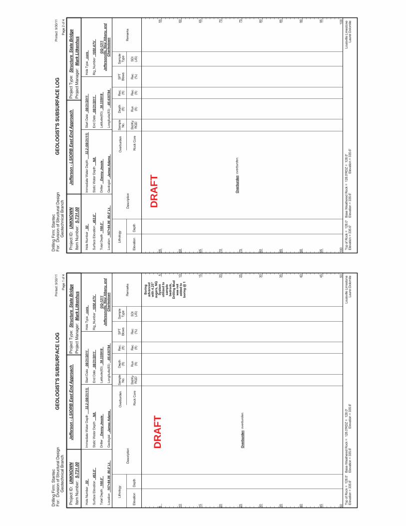
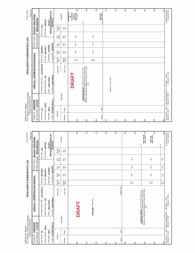
APPENDIX B: GEOTECHNICAL DATA
PIER DRAG REPORT
FESWMS
Pier Pier Elem Boring Depth D50 D95no. ID no. Vel Depth Angle Vel Depth Angle ID
(m/s) (m) (deg) (m/s) (m) (deg) (m) (mm) (mm)---- -------- ------ ------- ------- ------- ------- ------- ------- --------- --------- --------- ---------1 Pier 1A 4358 0.098 1.709 28.237 0.419 3.282 24.901 B56 2.1 / 5.0 0.52 182 Pier 1B 4605 0.127 2.437 24.615 0.421 4.011 21.832 B54 1.2 / 3.5 0.13 123 Pier 2A 4113 0.328 7.524 21.329 0.601 9.099 22.624 B61 3 0.0053 0.264 Pier 2B 4357 0.285 7.527 23.92 0.56 9.1 23.38 B59/B62 3 0.0046 0.0415 Pier 3A 4116 0.653 4.871 28.626 0.922 6.44 28.106 B64 3 0.0065 0.0796 Pier 3B 4117 0.509 6.416 30.295 0.756 7.991 29.7177 Pier 4A 4120 1.086 2.012 27.911 1.331 3.568 28.2438 Pier 4B 4367 0.495 4.672 25.462 0.863 6.241 28.893 B66 4.6 0.041 0.319 Pier 5A 4369 0.818 3.537 26.507 1.028 5.095 27.50510 Pier 5B 4617 0.828 4.116 30.134 1.061 5.667 29.531 B70 3 0.007 0.211 Pier 6A 4626 0.916 6.095 29.44 1.133 7.669 29.17 B77 3.6 / 5.0 0.069 0.3212 Pier 6B 4850 0.837 6.093 27.062 1.092 7.68 27.892 B75 3 0.025 0.32 - Pier 7A 5412 0.912 6.414 24.92 1.137 7.986 25.42 B79 3 0.0039 0.049 - Pier 7B 5937 0.813 6.723 24.01 0.974 8.297 26.23 B78 3 0.034 0.04
Data SourcesHydraulic: SMS/FESWMS 100yr and 500 yr, WSA 9/20/2011Geotech: Draft Grain Size Summary Table/Boring Logs, Stantec, 10/4/2011
Approach Flow Approach Flow
100 year 500 year Geotech Data
B54
B61
B64
B66 B70
B77
B79
East End Bridge-Section 4 Boring Plan
������
������ ������� ������
����������������������� ��
���������
�!"#�$$
%�&�'��(�)(��*�������+��������
���������
��,����-�������.
������
�����
#$/�/0$##
������������
������ �
���� ���
������
����
������
�����
�����
�������
����
�1�21
��
$�$03
$��0
�1
�4
$�$0
$�"�
�2
�0��
$�#5
#5�.��2
�#�)
$�4
#3�/
�/
$�4�
#��6
�#�)
#�#
#4�/
�/
$��"
0��
�6��2
�#�)
$�34
4�3
�/
�/
$�"3
#�!
�6��2
�#�)
$�45
5�0
�/
�/
#�"
#5�.��2
�#�)
$�!5
#4�.��2
�"
$�"#
#�5
�1
��
$�$0�
$��0
�.��2
�#�)
$�!0
00�/
�/
$�!#
# �6��2
�#��
#�5
0#�/
�/
#�#
0"�6��2
�#�)
#�0
#3�/
�/
$�5
4�0
�/
�/
$�#�
$�"
�6��2
�#�)
$�5#
#$�/
�/
$�!5
0��
�.��2
�#�)
$��
��3
�/
�/
$�$!
#0�6��2
�#�)
#�0
#!�/
�/
#�#
#"�6��2
�#�)
$�!#
3�0
�1
�!�4
$�$#4
#��
��
�4
$�#"
#0�/
�/
$��0
00�6��2
�#�)
$�44
#0�/
�/
$�45
!�5
�.��2
�#�)
$� �
#"�/
�/
#�#
#"�.��2
�#�)
$��5
"�4
�/
�/
#�5
#!�6
�#�)
#�0
##�/
�/
$�3#
#5�.
�"
$�"#
#�5
�/
�/
$�35
0�3
����2
�0��
$�0#
#$��
��
$�##
#3��
�0��
$� 0
#3�/
�/
$�5#
#��6��2
�#�)
#��
#��/
�/
#�#
#!�2
�#�)
#�#
0$�#
�/
�/
$�5#
#!�6��2
�#�)
$�50
#"�/
�/
$�45
#"�6��2
�#�)
$�5#
#3�/
�/
$� 5
03�.
�#�)
$��3
��"
�/
�/
$�03
#�4
�6��2
�#�)
$�!5
$�3!
!$�$7���!#� 78�! �$7���!4� 7
4 �$7���44� 7
3$�$7���3#� 7
5 �$7���54� 7
�$�$7����#� 78�� �$7����4� 7
0$�$7���0#� 7
$�$7��� #� 7
�$�$7����#� 78�� �$7����4� 7
�$7��� 4� 78�4$�$7���4#� 7
!$�$7���!#� 78�! �$7���!4� 7
3 �$7���34� 78�5$�$7���5#� 7
���
#!$9
$5�54
34�1:
0�$7���0� 7
" �$7���"4� 7
# �$7���#4� 7
! �$7���!4� 78�3$�$7���3#� 7
5$�$7���5#� 78�5 �$7���54�$78�#$$�$7���#$#� 7
#$ �$7���#$4� 7
##$�$7���###� 78�## �$7���##4� 7
" �$7���"4� 7
�$�$7����#� 78�� �$7����4� 7
�$7��� 4� 78�4$�$���4
#� 7
! �$7���!4� 78�3$�$7���3#� 7
!"����#���
�$��%
�& '�
��(�"
���� )�
#���
��*����
���$
#4!9
3��54
4�1:
0� 7���"�$7
!$�$7���!#� 7
3 �$7���34� 7
#0$�$7���#0#� 78�#0 �$7���#04� 7
�$7��� 4� 7
"$�$7���"#� 78�" �$7���"4� 78��$�$����#� 78�� �$7����4� 78� $�$7��� #� 7
4$�$7���4#� 78�4 �$7���44� 7
���+
#4!9
3��54
!��%:
�$7��� � 7
$�$7��� #� 7
4 �$7���44� 7
!$�$7���!#� 7
3 �$7���34� 7
#$$�$7���#$#� 7
#0$�$7���#0#� 78�#0 �$7���#04�$7
���,
#!$9
#!�54
4�%:
0��7���0�57
" �$7���"4� 7
$�$7��� #� 7
4 �$7���44�$7
3$�$7���3#� 7
#$$�$7���#$#� 78�#$ �$7���#$4��7
0 �$7���04� 78�"$�$7���"#� 7
3 �$7���34� 78�5$�$7���5#� 7
5 �$7���54�$7
�$7��� 4� 78�4$�$7���4#� 7
# �$7���#4� 78�0$�$7���0#� 78�0 �$7���04� 7
�$7���4�$7
# �$7���#4� 78�0$�$7���0#� 78�0 �$7���04� 78�"$�$7���"#� 7
!�$7���3� 78�#$�$7���##� 78�# �$7���#4� 7
�$7��� �37
��$7��� � 78�#$�$7���##�
5$�$7���5#� 78�5 �$7���54�$7
#$ �$7���#$4� 78�##$�$7���###� 7
## �$7���##4� 7
0$�$7���0#� 78�0 �$7���04� 78�"$�$7���"#� 7
#��/����%���������0$$�6����*������������ ��
(���
(������ ������;�������������
���
.�-��#�����
DR
AFT
������
������ ������� ������
����������������������� ��
���������
�!"#�$$
%�&�'��(�)(��*�������+��������
���������
��,����-�������.
������
�����
#$/�/0$##
������������
������ �
���� ���
������
����
������
�����
�����
�������
����
!"����#���
�$��%
�& '�
��(�"
���� )�
#���
��*����
�1
�!�4
$�$$ 3
$� 4
�1
�!�4
$�$$ #
$�$ 3
�1
�!�4
$�$$�4
$�$�#
�1
�4
$�$#5
$�0�
21
��
#�5
0$�#
�6��2
�#�)
#�#
#��/
�/
$�4
4�6��2
�#�)
#�4
#"�/
�/
$�5
!�.��2
�#�)
$�!!
�0
�1
��
$��
$�$05
�/
�/
$�45
#�3
�6��2
�#�)
$�3#
4�5
�1
�!�4
$�$$!0
5�1
�!�4
$�$$!#
$�
�1
�!�4
$�$$ "
$�04
�1
��
$�$0!
$�04
�/
�/
��$�"
�6��2
�#�)
#��
#3�/
�/
$�!3
4�4
�.��2
�"
$�04
�0
�/
�/
$���
#�3
�.��2
�"
$�"�
#�3
�1�21
��
$�$43
0�5
�/
�/
$�55
#$�6��2
�#�)
$�5�
04�<
�!�4
$�$$"4
$�$"5
�1
�!�4
$�$$ #
$�$ "
�1
�4
$�$$5
"�
�1�21
��
$�$�
$�"0
�1
��
$�$0!
$�""
*.�*2
�#�)
��
"!�6��2
�#�)
#�#
"��/
�/
$�5
�3
�6��2
�#�)
$�!"
�5
�/
�/
$�5
5�
�6��2
�#�)
$�!4
3��
�/
�/
$�4
" �.��2
�"
$�0
��/
�/
#�!
#$�0
�1
�!�4
$�$$�5
$�$
�1
�!�4
$�$$�
$�$ "
�1
�!�4
$�$$4
$�$!5
�1
�4
$�$0"
$�03
�/
�/
$�$33
$�"0
�/
�/
$�#
5�6��2
�#�)
#�0
#3�/
�/
$�44
3�6��2
�#�)
$�3
#$�/
�/
$�!0
0�#
�.��2
�#�)
$�3
#3�/
�/
$��
�0
�2
�0��
$�#0
0#
3$�$7���3#� 78�3 �$7���34� 78�5$�$7���5#� 7
4 �$7���44� 78�!$�$7���!#� 7
#$�$7���#$� 7
"$�$7���"#� 78�" �$7���"4� 78��$�$7����#� 7
0$�$7���0#� 7
4�%:
�$�$7����#� 7
� �$7����4� 8� $�$7��� #� 7
4$�$7���4#� 78�4 �$7���44� 7
!$�$7���!#� 78�! �$7���!4� 7
3$�$7���3#� 7
0�$7���0� 7
�$7��� 4� 7
0 �$7���0 �478�"$�$7���"#� 7
0 �$7���04� 7
� �$7����4� 7
$�$7��� #� 78� �$7��� 4� 7
�$7��� � 7
# �$7���# � 7
#!09
3��54
4�1:
3 �$7���34� 78�5$�$7���5#� 78�5 �$7���54�$7
3$�$7���3#� 7
#!�$7���#3� 78�0$�$7���0#� 7
�47���4�#7
0 �$7���04� 78�"$�$7���"#� 78�" �$7���"4� 7
0 �$7���04� 78�"$�$7���"#� 78�" �$7���"4� 7
4$�$7���4#� 7
3$�$7���3#� 7
4 �$7���44� 78�!$�$7���!#� 78�! �$7���!4� 7
3 �$7���34� 78�5$�$7���5#� 78�5 �$7���5 � 7
0�$7���0� 7
#$�$7���#$� 7
# �$7���# � 7
�$7��� � 7
0�$7���"�47
� �$7����4� 7
0$�$7���0$� 7
4$�$7���4#� 7
! �$7���!4� 7
5 �$7���54� 7
" �$7���"4� 78��$�$7����#� 7
0�"7���0�37
�$�$7����#� 7
�$7��� 4� 7
3 �$7���34� 78�5$�$7���5#� 78�5 �$7��54�#7
$�$7��� #� 78� �$7��� 4� 7
����
��,$
��,-
� �$7����4� 78� $�$7��� #� 7
4$�$7���4#� 78�4 �$7���44� 7
45�%:
34�1:
!$�$7���!#� 78�! �$7���!4� 7
#!09
3��54
#!09
5�54
��,
#! 9
5�54
#$�"���#$�37
# �$7���# ��7
0$�$7���0#� 7
4�$7���4� 7
#$�07���#$�!7
# � 7���#4�$7
#��/����%���������0$$�6����*������������ ��
(���
(������ ������;�������������
���
.�-��0�����
DR
AFT
������
������ ������� ������
����������������������� ��
���������
�!"#�$$
%�&�'��(�)(��*�������+��������
���������
��,����-�������.
������
�����
#$/�/0$##
������������
������ �
���� ���
������
����
������
�����
�����
�������
����
!"����#���
�$��%
�& '�
��(�"
���� )�
#���
��*����
�1
�!�4
$�$$ 3
$�#"
�<
�!�4
$�$$�
$�$!
�1�21
��
$�$!
$�""
�1�21
��
$�$�#
$�"#
�1�21
��
$�$��
$�"
�/
�/
00#0�4
�6��2
�#��
00�
�/
�/
#�!
#5�6��2
�#�)
#�"
#!�/
�/
#�#
#��.��2
�#�)
#�#
05�/
�/
#�#
""�.
�"
$�"
#��/
�/
#�3
05�/
�/
$�"
0"�1
�4
$�$#"
$�#!
�1
�4
$�$#
$�0"
�1
�4
$�$$!
$�0
�2
��
$�35
$�""
�/
�/
$�$5
$�"�
�1�21
��
$�$�
$�"#
�/
�/
#�#
#4�6��2
�#�)
#�#
#$�/
�/
#�"
# �6��2
�#�)
#�"
#3�/
�/
$�"5
0�
�6��2
�#�)
$�33
!�
�/
�/
#�"
4�
�/
�/
#�!
"$�2
�#�)
$�
"�"
�6��2
�#�)
$�45
#0�1
�4
$�$$!
$�0"
�2
�0��
$�#"
$�"
�1
�4
$�$0
$�"0
�2
��
$�$5
$�"�
�/
�/
$�#
$��
�/
�/
4""
�6��2
�#�)
#�
#"�/
�/
#�#
5�.
�#�)
$�4
!�
�/
�/
$�!#
0�5
�6��2
�#�)
#�"
5�/
�/
$�35
#�5
�6��2
�#�)
$�!
4�/
�/
$�35
5�
�1
�4
$�$#4
$�"
�1
�4
$�$$5
$�03
�1�21
��
$�$45
$�"0
�/
�/
$�$33
$�"
�/
�/
$�##
$�
�/
�/
"##��
�2
�#�)
$� 5
##�0
�/
�/
$�5#
0�$
�6��2
�#�)
$�3
��3
�/
�/
"�
#��6��2
�#�)
#�0
#0�6
�#�)
$�5
5�
�/
�/
$�3
0�0
"$�$7���"#� 7
5 �$7���5 � 78�#$$�$7���#$#� 7
� �$7����4� 7
4$�$7���4#� 7
3$�$7���3#� 7
0�$7���0� 7
�$7���4�37
5 �$7���5 � 7
#$$�$7���#$$� 7
#!�$7���#3� 7
" �$7���"4� 78��$�$7����#� 7
#$�$7���#$� 7
# �$7���# �37
#$�$���#$�
3 �$7���34� 78�5$�$7���5#� 7
# �$7���# � 7
4 �$7���44� 78�! �$7���!4� 7
$�$7��� #� 78� �$7��� 4� 7
0$�$7���0#� 78�0 �$7���04� 7
"$�$7���"#� 7
� �$7����4� 7
0�$7���0� 7
3 �$7���34� 78�5$�$7���5#� 7
0�47���"�#7
4$�$7���4#� 7
! �$7���!4� 7
3$�$7���3#� 7
0$�$7���0#� 78�0 �$7���04� 7
�$7��� � 7
" �$7���"4� 78��$�$7����#� 78�� �$7����4� 7
! �$7���!4� 78�3$�$7���3#� 7
4 �$7���44� 7
# �$7���#4� 78�0$�$7���0#� 7
0 �$7���04� 7
!$�$7���!#� 7
5 �$7���54� 7
"$�$7���"#� 7
$�$7��� #� 7
0 �$7���04� 7
"$�$7���"#� 7
3 �$7���34� 78�5$�$7���5#� 7
�$7��� 4� 78�4$�$7���4#� 78�4 �$7���44� 7
" �$7���"4� 78��$�$����
#� 7
4 �$7���44� 78�!$�$7���!#� 7
#0�$7���#"� 78�# �$7���#4� 7
5 �$7���5 � 7
" �$7���"4� 78��$�$7����#� 78�� �$7����4� 7
!$�$7���!#� 8�! �$7���!4� 7
$�$7��� #� 78� �$7��� 4� 7
�$7��� 4� 78�4$�$7���4#� 7
#$�$7���#$� 7
�$7��� � 7
0�$7���0� 7
�$7��� � 7
3 �$7���34� 78�5$�$7���5#� 7
0$�$7���0#� 7
$�$7��� #� 7
3$�$7���3#� 7
��,,
34�1:
��.�
��.�
��..
#!!9
3��54
#3$9
$$�54
34�1:
#309
!$�54
4�1:
#309
!$�54
45�%:
#��/����%���������0$$�6����*������������ ��
(���
(������ ������;�������������
���
.�-��"�����
DR
AFT
������
������ ������� ������
����������������������� ��
���������
�!"#�$$
%�&�'��(�)(��*�������+��������
���������
��,����-�������.
������
�����
#$/�/0$##
������������
������ �
���� ���
������
����
������
�����
�����
�������
����
!"����#���
�$��%
�& '�
��(�"
���� )�
#���
��*����
�1
�4
$�$$!#
$�$5
�<
�!�4
$�$$
$�$!
�<
�!�4
$�$$"�
$�$�
�1
�4
$�$#3
$�0
�1�21
��
$�$"3
$�"#
�/
�/
"�
#$�!
�.��2
�#�)
#��
#$�"
�/
�/
$�##
$�!
�.��2
�#�)
$�5�
4�
�/
�/
#�#
#��6��2
�#�)
###
�.��2
�#�)
$��5
!�/
�/
$�5
# �1
�4
$�$$!
$�#0
�<
�!�4
$�$$"!
$�$�#
�<
�!�4
$�$$"5
$�$�5
21
��
$�$!
$�"0
�/
�/
$�5
$��
�6��2
�#�)
$�5!
$�5
�/
�/
#3
�2
�#�)
$�!�
4�"
�/
�/
$�35
0�6��2
�#�)
$�5#
��0
�/
�/
#�#
"�
�.��2
�#�)
$��5
5�#
�/
�/
$�5
!�/
�/
$��
#�5$�$7���5#� 7
"$�$7���"#� 7
� �$7����4� 7
4$�$7���4#� 7
$�$7��� #� 78� �$7��� 4� 7
� �$7����4� 7
4$�$7���4#� 7
3$�$7���3#� 78�3 �$7���34� 7
# �$7���# � 7
" �$7���"4� 78��$�$7����#� 7
0$�$7���0#� 78�0 �$7���04� 7
!$�$7���!#� 78�! �$���!
4� 7
#$�$7���#$� 7
�$7��� � 7
5 �$7���54� 7
5$�$7���5#� 7
0�$7���0� 7
��./
��.�
#3�9
34�54
4�1:
#3�9
34�54
34�1:
0 �$7���04� 7
# �$7���#4� 78�0$�$7���0#� 7
3$�$7���3#� 78�3 �$7���34� 7�
#$�$7���#0�$7
�$7���!�$7
$�$7��� #� 78� �$7��� 4� 7
4 �$7���44� 78�!$�$7���!#� 7
"$�$7���"#� 78�" �$7���"4� 78��$�$7����#� 7
! �$7���!4� 7
0�$7�����$7
#��/����%���������0$$�6����*������������ ��
(���
(������ ������;�������������
���
.�-��������
DR
AFT
Bor
ing
adva
nced
with
4.2
5"au
gers
, NQ
Syst
emut
ilize
d to
sam
ple
bedr
ock,
Dril
ling
Mud
was
not
adde
d to
borin
g @
1
Ove
rbur
den:
ove
rbur
den.
Elev
atio
nD
epth
Std/
KyR
QD
Lith
olog
y
5 10 15 20 25 30 35 40 45 50
5 10 15 20 25 30 35 40 45 50
Dep
th(ft
)SP
TBl
ows
Sam
ple
Type
Rec (ft)
Geo
logi
st
Jam
es A
dam
s
Hol
e Ty
pe
core
Rec (%
)
Rec
.(ft
)Sa
mpl
eN
o.
Run (ft)
Des
crip
tion
Ove
rbur
den
Roc
k C
ore
SDI
(JS)
Rem
arks
Rig
_Num
ber
1050
ATV
Hol
e N
umbe
r 50
Surfa
ce E
leva
tion
463.
6'
Tota
l Dep
th
168.
0'
End
Dat
e 08
/31/
2011
Latit
ude(
83)
38.3
3591
8
Long
itude
(83)
-8
5.63
5784
Star
t Dat
e 08
/31/
2011
Dril
ler
Dan
ny J
essi
e
GEO
LOG
IST'
S SU
BSUR
FACE
LO
G
GQ
-121
1Je
ffers
onvi
lle, N
ew A
lban
y, a
ndC
harle
stow
n
Stat
ic W
ater
Dep
th
NA
Loui
sville
Lim
esto
neLa
urel
Dol
omite
Imm
edia
te W
ater
Dep
th
32.2
(08/
31/1
1)
Loca
tion
167+
84.9
6 8
6.0'
Lt.
Base
Wea
ther
ed R
ock
= 1
28.0
'El
evat
ion
= 33
5.6'
Top
ofR
ock
= 1
28.0
'El
evat
ion
= 33
5.6'
RD
Z =
128
.0'
Elev
atio
n =
335.
6'
Prin
ted:
9/3
0/11
Page
1 o
f 4
Dril
ling
Firm
: Sta
ntec
For:
Div
isio
n of
Stru
ctur
al D
esig
nG
eote
chni
cal B
ranc
h
Proj
ect T
ype:
Str
uctu
re S
tate
Brid
gePr
ojec
t Man
ager
: M
ark
Litk
enhu
sPr
ojec
t ID
: U
NK
NO
WN
Item
Num
ber:
5-7
31.0
0Je
ffers
on -
LSIO
RB
Eas
t End
App
roac
h
DR
AFT
Ove
rbur
den:
ove
rbur
den.
Elev
atio
nD
epth
Std/
KyR
QD
Lith
olog
y
55 60 65 70 75 80 85 90 95 100
55 60 65 70 75 80 85 90 95 100
Dep
th(ft
)SP
TBl
ows
Sam
ple
Type
Rec (ft)
Geo
logi
st
Jam
es A
dam
s
Hol
e Ty
pe
core
Rec (%
)
Rec
.(ft
)Sa
mpl
eN
o.
Run (ft)
Des
crip
tion
Ove
rbur
den
Roc
k C
ore
SDI
(JS)
Rem
arks
Rig
_Num
ber
1050
ATV
Hol
e N
umbe
r 50
Surfa
ce E
leva
tion
463.
6'
Tota
l Dep
th
168.
0'
End
Dat
e 08
/31/
2011
Latit
ude(
83)
38.3
3591
8
Long
itude
(83)
-8
5.63
5784
Star
t Dat
e 08
/31/
2011
Dril
ler
Dan
ny J
essi
e
GEO
LOG
IST'
S SU
BSUR
FACE
LO
G
GQ
-121
1Je
ffers
onvi
lle, N
ew A
lban
y, a
ndC
harle
stow
n
Stat
ic W
ater
Dep
th
NA
Loui
sville
Lim
esto
neLa
urel
Dol
omite
Imm
edia
te W
ater
Dep
th
32.2
(08/
31/1
1)
Loca
tion
167+
84.9
6 8
6.0'
Lt.
Base
Wea
ther
ed R
ock
= 1
28.0
'El
evat
ion
= 33
5.6'
Top
ofR
ock
= 1
28.0
'El
evat
ion
= 33
5.6'
RD
Z =
128
.0'
Elev
atio
n =
335.
6'
Prin
ted:
9/3
0/11
Page
2 o
f 4
Dril
ling
Firm
: Sta
ntec
For:
Div
isio
n of
Stru
ctur
al D
esig
nG
eote
chni
cal B
ranc
h
Proj
ect T
ype:
Str
uctu
re S
tate
Brid
gePr
ojec
t Man
ager
: M
ark
Litk
enhu
sPr
ojec
t ID
: U
NK
NO
WN
Item
Num
ber:
5-7
31.0
0Je
ffers
on -
LSIO
RB
Eas
t End
App
roac
h
DR
AFT
138.
0
148.
0
10.0
10.0
10.0
100
100
100
soft
zone
@13
9.1-
139.
7
RC
S-1
@14
2.8-
143.
6
335.
612
8.0
Ove
rbur
den:
ove
rbur
den.
Lim
esto
ne &
Sha
le: L
imes
tone
(70%
), gr
ay, f
ine
grai
ned,
har
d, th
in to
med
ium
bed
ded,
sha
le s
treak
s,st
ringe
rs a
nd p
artin
gs, f
ossi
lifer
ous.
Sha
le (3
0%),
gray
,si
lty.
(Beg
in C
ore)
20 /
20 61 /
58 57 /
50
10.0
10.0
10.0
Elev
atio
nD
epth
Std/
KyR
QD
Lith
olog
y
105
110
115
120
125
130
135
140
145
150
105
110
115
120
125
130
135
140
145
150
Dep
th(ft
)SP
TBl
ows
Sam
ple
Type
Rec (ft)
Geo
logi
st
Jam
es A
dam
s
Hol
e Ty
pe
core
Rec (%
)
Rec
.(ft
)Sa
mpl
eN
o.
Run (ft)
Des
crip
tion
Ove
rbur
den
Roc
k C
ore
SDI
(JS)
Rem
arks
Rig
_Num
ber
1050
ATV
Hol
e N
umbe
r 50
Surfa
ce E
leva
tion
463.
6'
Tota
l Dep
th
168.
0'
End
Dat
e 08
/31/
2011
Latit
ude(
83)
38.3
3591
8
Long
itude
(83)
-8
5.63
5784
Star
t Dat
e 08
/31/
2011
Dril
ler
Dan
ny J
essi
e
GEO
LOG
IST'
S SU
BSUR
FACE
LO
G
GQ
-121
1Je
ffers
onvi
lle, N
ew A
lban
y, a
ndC
harle
stow
n
Stat
ic W
ater
Dep
th
NA
Loui
sville
Lim
esto
neLa
urel
Dol
omite
Imm
edia
te W
ater
Dep
th
32.2
(08/
31/1
1)
Loca
tion
167+
84.9
6 8
6.0'
Lt.
Base
Wea
ther
ed R
ock
= 1
28.0
'El
evat
ion
= 33
5.6'
Top
ofR
ock
= 1
28.0
'El
evat
ion
= 33
5.6'
RD
Z =
128
.0'
Elev
atio
n =
335.
6'
Prin
ted:
9/3
0/11
Page
3 o
f 4
Dril
ling
Firm
: Sta
ntec
For:
Div
isio
n of
Stru
ctur
al D
esig
nG
eote
chni
cal B
ranc
h
Proj
ect T
ype:
Str
uctu
re S
tate
Brid
gePr
ojec
t Man
ager
: M
ark
Litk
enhu
sPr
ojec
t ID
: U
NK
NO
WN
Item
Num
ber:
5-7
31.0
0Je
ffers
on -
LSIO
RB
Eas
t End
App
roac
h
DR
AFT
158.
0
168.
0
10.0
10.0
100
100
foss
ilife
rous
@15
0.3-
150.
6ve
rtic
alfr
actu
re @
151-
151.
6
RC
S-2
@16
6.7-
167.
729
5.6
168.
0
Lim
esto
ne &
Sha
le: L
imes
tone
(70%
), gr
ay, f
ine
grai
ned,
har
d, th
in to
med
ium
bed
ded,
sha
le s
treak
s,st
ringe
rs a
nd p
artin
gs, f
ossi
lifer
ous.
Sha
le (3
0%),
gray
,si
lty.
57 /
50 96 /
96
(Bot
tom
of H
ole
168.
0')
10.0
10.0
Elev
atio
nD
epth
Std/
KyR
QD
Lith
olog
y
155
160
165
170
175
180
185
190
195
200
155
160
165
170
175
180
185
190
195
200
Dep
th(ft
)SP
TBl
ows
Sam
ple
Type
Rec (ft)
Geo
logi
st
Jam
es A
dam
s
Hol
e Ty
pe
core
Rec (%
)
Rec
.(ft
)Sa
mpl
eN
o.
Run (ft)
Des
crip
tion
Ove
rbur
den
Roc
k C
ore
SDI
(JS)
Rem
arks
Rig
_Num
ber
1050
ATV
Hol
e N
umbe
r 50
Surfa
ce E
leva
tion
463.
6'
Tota
l Dep
th
168.
0'
End
Dat
e 08
/31/
2011
Latit
ude(
83)
38.3
3591
8
Long
itude
(83)
-8
5.63
5784
Star
t Dat
e 08
/31/
2011
Dril
ler
Dan
ny J
essi
e
GEO
LOG
IST'
S SU
BSUR
FACE
LO
G
GQ
-121
1Je
ffers
onvi
lle, N
ew A
lban
y, a
ndC
harle
stow
n
Stat
ic W
ater
Dep
th
NA
Loui
sville
Lim
esto
neLa
urel
Dol
omite
Imm
edia
te W
ater
Dep
th
32.2
(08/
31/1
1)
Loca
tion
167+
84.9
6 8
6.0'
Lt.
Base
Wea
ther
ed R
ock
= 1
28.0
'El
evat
ion
= 33
5.6'
Top
ofR
ock
= 1
28.0
'El
evat
ion
= 33
5.6'
RD
Z =
128
.0'
Elev
atio
n =
335.
6'
Prin
ted:
9/3
0/11
Page
4 o
f 4
Dril
ling
Firm
: Sta
ntec
For:
Div
isio
n of
Stru
ctur
al D
esig
nG
eote
chni
cal B
ranc
h
Proj
ect T
ype:
Str
uctu
re S
tate
Brid
gePr
ojec
t Man
ager
: M
ark
Litk
enhu
sPr
ojec
t ID
: U
NK
NO
WN
Item
Num
ber:
5-7
31.0
0Je
ffers
on -
LSIO
RB
Eas
t End
App
roac
h
DR
AFT
2.0-
4.0
5.0-
7.0
10.0
-12.
0
15.0
-16.
5
20.0
-21.
5
25.0
-26.
5
30.0
-31.
5
35.0
-36.
5
40.0
-41.
5
45.0
-46.
5
3-3-
1
1-2-
1
2-3-
3
3-3-
2
1-2-
1
0-0-
0
1-2-
4
Bor
ing
adva
nced
with
4.2
5"au
gers
@ 1
NQ
cor
ing
syst
emut
ilize
d to
sam
ple
bedr
ock
@ 3
Dril
ling
mud
adde
d to
the
borin
g at
ade
pth
of 3
5.0
ft be
low
the
grou
ndsu
rface
@ 3
5
455.
4
450.
4
10.0
15.0
Ove
rbur
den:
Cla
y, b
row
n, m
oist
, som
e sa
nd.
Ove
rbur
den:
San
d, li
ght b
row
n, m
oist
, fin
e gr
aine
d.
Ove
rbur
den:
San
d, b
row
n, m
oist
, fin
e gr
aine
d, v
ery
loos
e to
den
se, s
ome
silt,
som
e gr
avel
.
1 2 3 1 2 3 4 5 6 7
2.0
2.0
2.0
1.2
0.6
0.6
0.6
0.1
0.1
1.0
Elev
atio
nD
epth
Std/
KyR
QD
Lith
olog
y
5 10 15 20 25 30 35 40 45 50
5 10 15 20 25 30 35 40 45 50
Dep
th(ft
)SP
TBl
ows
Sam
ple
Type
Rec (ft)
Geo
logi
st
Jam
es A
dam
s
Hol
e Ty
pe
core
and
sam
ple
Rec (%
)
Rec
.(ft
)Sa
mpl
eN
o.
Run (ft)
Des
crip
tion
Ove
rbur
den
Roc
k C
ore
SDI
(JS)
Rem
arks
Rig
_Num
ber
1050
ATV
Hol
e N
umbe
r 51
Surfa
ce E
leva
tion
465.
4'
Tota
l Dep
th
158.
7'
End
Dat
e 09
/05/
2011
Latit
ude(
83)
38.3
3601
1
Long
itude
(83)
-8
5.63
5526
Star
t Dat
e 09
/01/
2011
Dril
ler
Dan
ny J
essi
e
GEO
LOG
IST'
S SU
BSUR
FACE
LO
G
GQ
-121
1Je
ffers
onvi
lle, N
ew A
lban
y, a
ndC
harle
stow
n
Stat
ic W
ater
Dep
th
NA
Loui
sville
Lim
esto
neLa
urel
Dol
omite
Imm
edia
te W
ater
Dep
th
31.2
(09/
05/1
1)
Loca
tion
167+
84.9
6 6
.0' L
t.
Base
Wea
ther
ed R
ock
= 1
28.7
'El
evat
ion
= 33
6.7'
Top
ofR
ock
= 1
28.7
'El
evat
ion
= 33
6.7'
RD
Z =
128
.7'
Elev
atio
n =
336.
7'
Prin
ted:
9/3
0/11
Page
1 o
f 4
Dril
ling
Firm
: Sta
ntec
For:
Div
isio
n of
Stru
ctur
al D
esig
nG
eote
chni
cal B
ranc
h
Proj
ect T
ype:
Str
uctu
re S
tate
Brid
gePr
ojec
t Man
ager
: M
ark
Litk
enhu
sPr
ojec
t ID
: U
NK
NO
WN
Item
Num
ber:
5-7
31.0
0Je
ffers
on -
LSIO
RB
Eas
t End
App
roac
h
ST ST ST SPT
SPT
SPT
SPT
SPT
SPT
SPT
DR
AFT
50.0
-51.
5
55.0
-56.
5
60.0
-61.
5
65.0
-66.
5
70.0
-71.
5
75.0
-76.
5
80.0
-81.
5
85.0
-86.
5
90.0
-91.
5
95.0
-96.
5
0-1-
3
5-4-
9
6-7-
12
8-8-
13
8-13
-24
14-1
7-22
8-9-
12
6-10
-17
15-1
3-15
9-10
-10
410.
455
.0
Ove
rbur
den:
San
d, b
row
n, m
oist
, fin
e gr
aine
d, v
ery
loos
e to
den
se, s
ome
silt,
som
e gr
avel
.
Ove
rbur
den:
San
d, b
row
n to
gra
y, w
et, f
ine
tom
ediu
m g
rain
ed, m
ediu
m d
ense
to d
ense
, poo
rlygr
aded
, som
e gr
avel
.
8 9 10 11 12 13 14 15 16 17
1.5
1.2
1.5
1.5
1.5
1.5
1.2
1.5
1.5
1.5
Elev
atio
nD
epth
Std/
KyR
QD
Lith
olog
y
55 60 65 70 75 80 85 90 95 100
55 60 65 70 75 80 85 90 95 100
Dep
th(ft
)SP
TBl
ows
Sam
ple
Type
Rec (ft)
Geo
logi
st
Jam
es A
dam
s
Hol
e Ty
pe
core
and
sam
ple
Rec (%
)
Rec
.(ft
)Sa
mpl
eN
o.
Run (ft)
Des
crip
tion
Ove
rbur
den
Roc
k C
ore
SDI
(JS)
Rem
arks
Rig
_Num
ber
1050
ATV
Hol
e N
umbe
r 51
Surfa
ce E
leva
tion
465.
4'
Tota
l Dep
th
158.
7'
End
Dat
e 09
/05/
2011
Latit
ude(
83)
38.3
3601
1
Long
itude
(83)
-8
5.63
5526
Star
t Dat
e 09
/01/
2011
Dril
ler
Dan
ny J
essi
e
GEO
LOG
IST'
S SU
BSUR
FACE
LO
G
GQ
-121
1Je
ffers
onvi
lle, N
ew A
lban
y, a
ndC
harle
stow
n
Stat
ic W
ater
Dep
th
NA
Loui
sville
Lim
esto
neLa
urel
Dol
omite
Imm
edia
te W
ater
Dep
th
31.2
(09/
05/1
1)
Loca
tion
167+
84.9
6 6
.0' L
t.
Base
Wea
ther
ed R
ock
= 1
28.7
'El
evat
ion
= 33
6.7'
Top
ofR
ock
= 1
28.7
'El
evat
ion
= 33
6.7'
RD
Z =
128
.7'
Elev
atio
n =
336.
7'
Prin
ted:
9/3
0/11
Page
2 o
f 4
Dril
ling
Firm
: Sta
ntec
For:
Div
isio
n of
Stru
ctur
al D
esig
nG
eote
chni
cal B
ranc
h
Proj
ect T
ype:
Str
uctu
re S
tate
Brid
gePr
ojec
t Man
ager
: M
ark
Litk
enhu
sPr
ojec
t ID
: U
NK
NO
WN
Item
Num
ber:
5-7
31.0
0Je
ffers
on -
LSIO
RB
Eas
t End
App
roac
h
SPT
SPT
SPT
SPT
SPT
SPT
SPT
SPT
SPT
SPT
DR
AFT
138.
7
148.
7
100.
0-10
0.3
105.
0-10
6.5
110.
0-11
1.5
115.
0-11
6.5
120.
0-12
1.5
125.
0-12
6.5
10.0
10.0
10.0
50/0
.30'
24-1
3-12
50-3
5-34
/0.5
0'
21-2
4-25
8-7-
8
32-4
5-50
/0.5
0'
81 86 100
Vert
ical
Frac
ture
@12
9.3-
129.
7
RC
S-1
@14
5.4-
146.
2
336.
712
8.7
Ove
rbur
den:
San
d, b
row
n to
gra
y, w
et, f
ine
tom
ediu
m g
rain
ed, m
ediu
m d
ense
to d
ense
, poo
rlygr
aded
, som
e gr
avel
.
Lim
esto
ne &
Sha
le: L
imes
tone
(70%
), gr
ay, f
ine
grai
ned,
har
d, th
in to
med
ium
bed
ded,
sha
le s
treak
s,st
ringe
rs a
nd p
artin
gs, f
ossi
lifer
ous.
Sha
le (3
0%),
gray
,si
lty.
(Beg
in C
ore)
18 19 20 21 22 23 36 /
36 52 /
52 68 /
0.3
0.8
1.5
1.5
1.5
1.5
8.1
8.6
10.0
Elev
atio
nD
epth
Std/
KyR
QD
Lith
olog
y
105
110
115
120
125
130
135
140
145
150
105
110
115
120
125
130
135
140
145
150
Dep
th(ft
)SP
TBl
ows
Sam
ple
Type
Rec (ft)
Geo
logi
st
Jam
es A
dam
s
Hol
e Ty
pe
core
and
sam
ple
Rec (%
)
Rec
.(ft
)Sa
mpl
eN
o.
Run (ft)
Des
crip
tion
Ove
rbur
den
Roc
k C
ore
SDI
(JS)
Rem
arks
Rig
_Num
ber
1050
ATV
Hol
e N
umbe
r 51
Surfa
ce E
leva
tion
465.
4'
Tota
l Dep
th
158.
7'
End
Dat
e 09
/05/
2011
Latit
ude(
83)
38.3
3601
1
Long
itude
(83)
-8
5.63
5526
Star
t Dat
e 09
/01/
2011
Dril
ler
Dan
ny J
essi
e
GEO
LOG
IST'
S SU
BSUR
FACE
LO
G
GQ
-121
1Je
ffers
onvi
lle, N
ew A
lban
y, a
ndC
harle
stow
n
Stat
ic W
ater
Dep
th
NA
Loui
sville
Lim
esto
neLa
urel
Dol
omite
Imm
edia
te W
ater
Dep
th
31.2
(09/
05/1
1)
Loca
tion
167+
84.9
6 6
.0' L
t.
Base
Wea
ther
ed R
ock
= 1
28.7
'El
evat
ion
= 33
6.7'
Top
ofR
ock
= 1
28.7
'El
evat
ion
= 33
6.7'
RD
Z =
128
.7'
Elev
atio
n =
336.
7'
Prin
ted:
9/3
0/11
Page
3 o
f 4
Dril
ling
Firm
: Sta
ntec
For:
Div
isio
n of
Stru
ctur
al D
esig
nG
eote
chni
cal B
ranc
h
Proj
ect T
ype:
Str
uctu
re S
tate
Brid
gePr
ojec
t Man
ager
: M
ark
Litk
enhu
sPr
ojec
t ID
: U
NK
NO
WN
Item
Num
ber:
5-7
31.0
0Je
ffers
on -
LSIO
RB
Eas
t End
App
roac
h
SPT
SPT
SPT
SPT
SPT
SPT
DR
AFT
158.
7
10.0
100
RC
S-2
@15
3.9-
154.
8
306.
715
8.7
Lim
esto
ne &
Sha
le: L
imes
tone
(70%
), gr
ay, f
ine
grai
ned,
har
d, th
in to
med
ium
bed
ded,
sha
le s
treak
s,st
ringe
rs a
nd p
artin
gs, f
ossi
lifer
ous.
Sha
le (3
0%),
gray
,si
lty.
68 68 /
68
(Bot
tom
of H
ole
158.
7')
10.0
Elev
atio
nD
epth
Std/
KyR
QD
Lith
olog
y
155
160
165
170
175
180
185
190
195
200
155
160
165
170
175
180
185
190
195
200
Dep
th(ft
)SP
TBl
ows
Sam
ple
Type
Rec (ft)
Geo
logi
st
Jam
es A
dam
s
Hol
e Ty
pe
core
and
sam
ple
Rec (%
)
Rec
.(ft
)Sa
mpl
eN
o.
Run (ft)
Des
crip
tion
Ove
rbur
den
Roc
k C
ore
SDI
(JS)
Rem
arks
Rig
_Num
ber
1050
ATV
Hol
e N
umbe
r 51
Surfa
ce E
leva
tion
465.
4'
Tota
l Dep
th
158.
7'
End
Dat
e 09
/05/
2011
Latit
ude(
83)
38.3
3601
1
Long
itude
(83)
-8
5.63
5526
Star
t Dat
e 09
/01/
2011
Dril
ler
Dan
ny J
essi
e
GEO
LOG
IST'
S SU
BSUR
FACE
LO
G
GQ
-121
1Je
ffers
onvi
lle, N
ew A
lban
y, a
ndC
harle
stow
n
Stat
ic W
ater
Dep
th
NA
Loui
sville
Lim
esto
neLa
urel
Dol
omite
Imm
edia
te W
ater
Dep
th
31.2
(09/
05/1
1)
Loca
tion
167+
84.9
6 6
.0' L
t.
Base
Wea
ther
ed R
ock
= 1
28.7
'El
evat
ion
= 33
6.7'
Top
ofR
ock
= 1
28.7
'El
evat
ion
= 33
6.7'
RD
Z =
128
.7'
Elev
atio
n =
336.
7'
Prin
ted:
9/3
0/11
Page
4 o
f 4
Dril
ling
Firm
: Sta
ntec
For:
Div
isio
n of
Stru
ctur
al D
esig
nG
eote
chni
cal B
ranc
h
Proj
ect T
ype:
Str
uctu
re S
tate
Brid
gePr
ojec
t Man
ager
: M
ark
Litk
enhu
sPr
ojec
t ID
: U
NK
NO
WN
Item
Num
ber:
5-7
31.0
0Je
ffers
on -
LSIO
RB
Eas
t End
App
roac
h
DR
AFT
Bor
ing
adva
nced
with
4.2
5"au
gers
@ 1
NQ
cor
ing
syst
emut
ilize
d to
sam
ple
bedr
ock
@ 3
Dril
ling
mud
adde
d to
the
borin
g at
ade
pth
of 4
0.0
ft be
low
the
grou
ndsu
rface
@ 4
0
Ove
rbur
den:
ove
rbur
den.
Elev
atio
nD
epth
Std/
KyR
QD
Lith
olog
y
5 10 15 20 25 30 35 40 45 50
5 10 15 20 25 30 35 40 45 50
Dep
th(ft
)SP
TBl
ows
Sam
ple
Type
Rec (ft)
Geo
logi
st
Jam
es A
dam
s
Hol
e Ty
pe
core
Rec (%
)
Rec
.(ft
)Sa
mpl
eN
o.
Run (ft)
Des
crip
tion
Ove
rbur
den
Roc
k C
ore
SDI
(JS)
Rem
arks
Rig
_Num
ber
1050
ATV
Hol
e N
umbe
r 52
Surfa
ce E
leva
tion
465.
5'
Tota
l Dep
th
159.
3'
End
Dat
e 09
/07/
2011
Latit
ude(
83)
38.3
3606
0
Long
itude
(83)
-8
5.63
5503
Star
t Dat
e 09
/06/
2011
Dril
ler
Dan
ny J
essi
e
GEO
LOG
IST'
S SU
BSUR
FACE
LO
G
GQ
-121
1Je
ffers
onvi
lle, N
ew A
lban
y, a
ndC
harle
stow
n
Stat
ic W
ater
Dep
th
NA
Loui
sville
Lim
esto
neLa
urel
Dol
omite
Imm
edia
te W
ater
Dep
th
35.6
(09/
07/1
1)
Loca
tion
167+
84.9
6 6
.0' R
t.
Base
Wea
ther
ed R
ock
= 1
31.2
'El
evat
ion
= 33
4.3'
Top
ofR
ock
= 1
28.6
'El
evat
ion
= 33
6.9'
RD
Z =
131
.2'
Elev
atio
n =
334.
3'
Prin
ted:
9/3
0/11
Page
1 o
f 4
Dril
ling
Firm
: Sta
ntec
For:
Div
isio
n of
Stru
ctur
al D
esig
nG
eote
chni
cal B
ranc
h
Proj
ect T
ype:
Str
uctu
re S
tate
Brid
gePr
ojec
t Man
ager
: M
ark
Litk
enhu
sPr
ojec
t ID
: U
NK
NO
WN
Item
Num
ber:
5-7
31.0
0Je
ffers
on -
LSIO
RB
Eas
t End
App
roac
h
DR
AFT
Ove
rbur
den:
ove
rbur
den.
Elev
atio
nD
epth
Std/
KyR
QD
Lith
olog
y
55 60 65 70 75 80 85 90 95 100
55 60 65 70 75 80 85 90 95 100
Dep
th(ft
)SP
TBl
ows
Sam
ple
Type
Rec (ft)
Geo
logi
st
Jam
es A
dam
s
Hol
e Ty
pe
core
Rec (%
)
Rec
.(ft
)Sa
mpl
eN
o.
Run (ft)
Des
crip
tion
Ove
rbur
den
Roc
k C
ore
SDI
(JS)
Rem
arks
Rig
_Num
ber
1050
ATV
Hol
e N
umbe
r 52
Surfa
ce E
leva
tion
465.
5'
Tota
l Dep
th
159.
3'
End
Dat
e 09
/07/
2011
Latit
ude(
83)
38.3
3606
0
Long
itude
(83)
-8
5.63
5503
Star
t Dat
e 09
/06/
2011
Dril
ler
Dan
ny J
essi
e
GEO
LOG
IST'
S SU
BSUR
FACE
LO
G
GQ
-121
1Je
ffers
onvi
lle, N
ew A
lban
y, a
ndC
harle
stow
n
Stat
ic W
ater
Dep
th
NA
Loui
sville
Lim
esto
neLa
urel
Dol
omite
Imm
edia
te W
ater
Dep
th
35.6
(09/
07/1
1)
Loca
tion
167+
84.9
6 6
.0' R
t.
Base
Wea
ther
ed R
ock
= 1
31.2
'El
evat
ion
= 33
4.3'
Top
ofR
ock
= 1
28.6
'El
evat
ion
= 33
6.9'
RD
Z =
131
.2'
Elev
atio
n =
334.
3'
Prin
ted:
9/3
0/11
Page
2 o
f 4
Dril
ling
Firm
: Sta
ntec
For:
Div
isio
n of
Stru
ctur
al D
esig
nG
eote
chni
cal B
ranc
h
Proj
ect T
ype:
Str
uctu
re S
tate
Brid
gePr
ojec
t Man
ager
: M
ark
Litk
enhu
sPr
ojec
t ID
: U
NK
NO
WN
Item
Num
ber:
5-7
31.0
0Je
ffers
on -
LSIO
RB
Eas
t End
App
roac
h
DR
AFT
138.
0
148.
0
9.4
10.0
11.3
90 100
100
RC
S-1
@14
6.1-
146.
7
336.
912
8.6
Ove
rbur
den:
ove
rbur
den.
Lim
esto
ne &
Sha
le: L
imes
tone
(60%
), gr
ay, f
ine
grai
ned,
har
d, th
in to
med
ium
bed
ded,
sha
le s
treak
s,st
ringe
rs a
nd p
artin
gs, f
ossi
lifer
ous.
Sha
le (4
0%),
gray
,si
lty.
(Beg
in C
ore)
12 /
12 42 /
35 46 /
46
8.5
10.0
11.3
Elev
atio
nD
epth
Std/
KyR
QD
Lith
olog
y
105
110
115
120
125
130
135
140
145
150
105
110
115
120
125
130
135
140
145
150
Dep
th(ft
)SP
TBl
ows
Sam
ple
Type
Rec (ft)
Geo
logi
st
Jam
es A
dam
s
Hol
e Ty
pe
core
Rec (%
)
Rec
.(ft
)Sa
mpl
eN
o.
Run (ft)
Des
crip
tion
Ove
rbur
den
Roc
k C
ore
SDI
(JS)
Rem
arks
Rig
_Num
ber
1050
ATV
Hol
e N
umbe
r 52
Surfa
ce E
leva
tion
465.
5'
Tota
l Dep
th
159.
3'
End
Dat
e 09
/07/
2011
Latit
ude(
83)
38.3
3606
0
Long
itude
(83)
-8
5.63
5503
Star
t Dat
e 09
/06/
2011
Dril
ler
Dan
ny J
essi
e
GEO
LOG
IST'
S SU
BSUR
FACE
LO
G
GQ
-121
1Je
ffers
onvi
lle, N
ew A
lban
y, a
ndC
harle
stow
n
Stat
ic W
ater
Dep
th
NA
Loui
sville
Lim
esto
neLa
urel
Dol
omite
Imm
edia
te W
ater
Dep
th
35.6
(09/
07/1
1)
Loca
tion
167+
84.9
6 6
.0' R
t.
Base
Wea
ther
ed R
ock
= 1
31.2
'El
evat
ion
= 33
4.3'
Top
ofR
ock
= 1
28.6
'El
evat
ion
= 33
6.9'
RD
Z =
131
.2'
Elev
atio
n =
334.
3'
Prin
ted:
9/3
0/11
Page
3 o
f 4
Dril
ling
Firm
: Sta
ntec
For:
Div
isio
n of
Stru
ctur
al D
esig
nG
eote
chni
cal B
ranc
h
Proj
ect T
ype:
Str
uctu
re S
tate
Brid
gePr
ojec
t Man
ager
: M
ark
Litk
enhu
sPr
ojec
t ID
: U
NK
NO
WN
Item
Num
ber:
5-7
31.0
0Je
ffers
on -
LSIO
RB
Eas
t End
App
roac
h
DR
AFT
159.
3
11.3
100
RC
S-2
@15
3.2-
154.
2
306.
215
9.3
Lim
esto
ne &
Sha
le: L
imes
tone
(60%
), gr
ay, f
ine
grai
ned,
har
d, th
in to
med
ium
bed
ded,
sha
le s
treak
s,st
ringe
rs a
nd p
artin
gs, f
ossi
lifer
ous.
Sha
le (4
0%),
gray
,si
lty.
46 /
46
(Bot
tom
of H
ole
159.
3')
11.3
Elev
atio
nD
epth
Std/
KyR
QD
Lith
olog
y
155
160
165
170
175
180
185
190
195
200
155
160
165
170
175
180
185
190
195
200
Dep
th(ft
)SP
TBl
ows
Sam
ple
Type
Rec (ft)
Geo
logi
st
Jam
es A
dam
s
Hol
e Ty
pe
core
Rec (%
)
Rec
.(ft
)Sa
mpl
eN
o.
Run (ft)
Des
crip
tion
Ove
rbur
den
Roc
k C
ore
SDI
(JS)
Rem
arks
Rig
_Num
ber
1050
ATV
Hol
e N
umbe
r 52
Surfa
ce E
leva
tion
465.
5'
Tota
l Dep
th
159.
3'
End
Dat
e 09
/07/
2011
Latit
ude(
83)
38.3
3606
0
Long
itude
(83)
-8
5.63
5503
Star
t Dat
e 09
/06/
2011
Dril
ler
Dan
ny J
essi
e
GEO
LOG
IST'
S SU
BSUR
FACE
LO
G
GQ
-121
1Je
ffers
onvi
lle, N
ew A
lban
y, a
ndC
harle
stow
n
Stat
ic W
ater
Dep
th
NA
Loui
sville
Lim
esto
neLa
urel
Dol
omite
Imm
edia
te W
ater
Dep
th
35.6
(09/
07/1
1)
Loca
tion
167+
84.9
6 6
.0' R
t.
Base
Wea
ther
ed R
ock
= 1
31.2
'El
evat
ion
= 33
4.3'
Top
ofR
ock
= 1
28.6
'El
evat
ion
= 33
6.9'
RD
Z =
131
.2'
Elev
atio
n =
334.
3'
Prin
ted:
9/3
0/11
Page
4 o
f 4
Dril
ling
Firm
: Sta
ntec
For:
Div
isio
n of
Stru
ctur
al D
esig
nG
eote
chni
cal B
ranc
h
Proj
ect T
ype:
Str
uctu
re S
tate
Brid
gePr
ojec
t Man
ager
: M
ark
Litk
enhu
sPr
ojec
t ID
: U
NK
NO
WN
Item
Num
ber:
5-7
31.0
0Je
ffers
on -
LSIO
RB
Eas
t End
App
roac
h
DR
AFT
2.0-
4.0
5.0-
7.0
10.0
-12.
0
15.0
-16.
5
20.0
-21.
5
25.0
-26.
5
30.0
-31.
5
35.0
-36.
5
40.0
-41.
5
45.0
-46.
5
2-4-
2
4-6-
7
3-4-
3
0-1-
0
0-1-
0
6-8-
10
9-24
-21
Bor
ing
adva
nced
with
4.2
5"au
gers
@ 1
NQ
cor
ing
syst
emut
ilize
d to
sam
ple
bedr
ock
@ 3
Bor
ing
mov
ed 5
.0'
RT
to d
rill o
ffof
driv
eway
@ 9
453.
2
448.
2
413.
2
10.0
15.0
50.0
Ove
rbur
den:
Cla
y, b
row
n, m
oist
, som
e sa
nd.
Ove
rbur
den:
San
d, b
row
n, m
oist
, fin
e to
med
ium
grai
ned,
som
e cl
ay.
Ove
rbur
den:
San
d, b
row
n, m
oist
, fin
e gr
ain,
ver
ylo
ose
to d
ense
, som
e si
lt, s
ome
grav
el.
1 2 3 1 2 3 4 5 6 7
2.0
1.5
1.5
1.1
0.5
0.5
0.7
0.6
1.0
1.0
Elev
atio
nD
epth
Std/
KyR
QD
Lith
olog
y
5 10 15 20 25 30 35 40 45 50
5 10 15 20 25 30 35 40 45 50
Dep
th(ft
)SP
TBl
ows
Sam
ple
Type
Rec (ft)
Geo
logi
st
Jam
es A
dam
s
Hol
e Ty
pe
core
and
sam
ple
Rec (%
)
Rec
.(ft
)Sa
mpl
eN
o.
Run (ft)
Des
crip
tion
Ove
rbur
den
Roc
k C
ore
SDI
(JS)
Rem
arks
Rig
_Num
ber
1050
ATV
Hol
e N
umbe
r 53
Surfa
ce E
leva
tion
463.
2'
Tota
l Dep
th
167.
9'
End
Dat
e 09
/07/
2011
Latit
ude(
83)
38.3
3620
6
Long
itude
(83)
-8
5.63
5386
Star
t Dat
e 09
/07/
2011
Dril
ler
Dan
ny J
essi
e
GEO
LOG
IST'
S SU
BSUR
FACE
LO
G
GQ
-121
1Je
ffers
onvi
lle, N
ew A
lban
y, a
ndC
harle
stow
n
Stat
ic W
ater
Dep
th
NA
Loui
sville
Lim
esto
neLa
urel
Dol
omite
Imm
edia
te W
ater
Dep
th
51.2
(09/
07/1
1)
Loca
tion
167+
84.9
6 7
4.0'
Rt.
Base
Wea
ther
ed R
ock
= 1
27.2
'El
evat
ion
= 33
6.0'
Top
ofR
ock
= 1
27.2
'El
evat
ion
= 33
6.0'
RD
Z =
127
.2'
Elev
atio
n =
336.
0'
Prin
ted:
9/3
0/11
Page
1 o
f 4
Dril
ling
Firm
: Sta
ntec
For:
Div
isio
n of
Stru
ctur
al D
esig
nG
eote
chni
cal B
ranc
h
Proj
ect T
ype:
Str
uctu
re S
tate
Brid
gePr
ojec
t Man
ager
: M
ark
Litk
enhu
sPr
ojec
t ID
: U
NK
NO
WN
Item
Num
ber:
5-7
31.0
0Je
ffers
on -
LSIO
RB
Eas
t End
App
roac
h
ST ST ST SPT
SPT
SPT
SPT
SPT
SPT
SPT
DR
AFT
50.0
-51.
5
55.0
-56.
5
60.0
-61.
5
65.0
-66.
5
70.0
-71.
5
75.0
-76.
5
80.0
-81.
5
85.0
-86.
5
90.0
-91.
5
95.0
-96.
5
8-13
-15
13-1
9-21
7-10
-11
7-13
-18
14-2
2-33
6-10
-21
10-9
-13
10-1
5-21
13-1
4-22
14-2
1-30
Dril
ling
mud
adde
d to
the
borin
g at
ade
pth
of 5
5.0
ft be
low
the
grou
ndsu
rface
@ 5
5
393.
2
388.
2
363.
2
70.0
75.0
100.
0
Ove
rbur
den:
San
d, b
row
n to
gra
y, w
et, f
ine
tom
ediu
m g
rain
ed, m
ediu
m d
ense
to d
ense
, poo
rlygr
aded
, som
e gr
avel
.
Ove
rbur
den:
Silt
, lig
ht b
row
n, w
et, f
ine
grai
ned,
har
d,so
me
sand
.
Ove
rbur
den:
San
d, b
row
n to
gra
y, w
et, f
ine
tom
ediu
m g
rain
ed, m
ediu
m d
ense
to v
ery
dens
e, p
oorly
grad
ed, s
ome
grav
el.
8 9 10 11 12 13 14 15 16 17
1.5
1.5
1.5
1.5
0.5
1.2
1.5
1.5
1.5
1.5
Elev
atio
nD
epth
Std/
KyR
QD
Lith
olog
y
55 60 65 70 75 80 85 90 95 100
55 60 65 70 75 80 85 90 95 100
Dep
th(ft
)SP
TBl
ows
Sam
ple
Type
Rec (ft)
Geo
logi
st
Jam
es A
dam
s
Hol
e Ty
pe
core
and
sam
ple
Rec (%
)
Rec
.(ft
)Sa
mpl
eN
o.
Run (ft)
Des
crip
tion
Ove
rbur
den
Roc
k C
ore
SDI
(JS)
Rem
arks
Rig
_Num
ber
1050
ATV
Hol
e N
umbe
r 53
Surfa
ce E
leva
tion
463.
2'
Tota
l Dep
th
167.
9'
End
Dat
e 09
/07/
2011
Latit
ude(
83)
38.3
3620
6
Long
itude
(83)
-8
5.63
5386
Star
t Dat
e 09
/07/
2011
Dril
ler
Dan
ny J
essi
e
GEO
LOG
IST'
S SU
BSUR
FACE
LO
G
GQ
-121
1Je
ffers
onvi
lle, N
ew A
lban
y, a
ndC
harle
stow
n
Stat
ic W
ater
Dep
th
NA
Loui
sville
Lim
esto
neLa
urel
Dol
omite
Imm
edia
te W
ater
Dep
th
51.2
(09/
07/1
1)
Loca
tion
167+
84.9
6 7
4.0'
Rt.
Base
Wea
ther
ed R
ock
= 1
27.2
'El
evat
ion
= 33
6.0'
Top
ofR
ock
= 1
27.2
'El
evat
ion
= 33
6.0'
RD
Z =
127
.2'
Elev
atio
n =
336.
0'
Prin
ted:
9/3
0/11
Page
2 o
f 4
Dril
ling
Firm
: Sta
ntec
For:
Div
isio
n of
Stru
ctur
al D
esig
nG
eote
chni
cal B
ranc
h
Proj
ect T
ype:
Str
uctu
re S
tate
Brid
gePr
ojec
t Man
ager
: M
ark
Litk
enhu
sPr
ojec
t ID
: U
NK
NO
WN
Item
Num
ber:
5-7
31.0
0Je
ffers
on -
LSIO
RB
Eas
t End
App
roac
h
SPT
SPT
SPT
SPT
SPT
SPT
SPT
SPT
SPT
SPT
DR
AFT
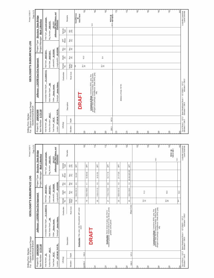
138.
5
148.
5
100.
0-10
1.5
105.
0-10
6.5
110.
0-11
1.5
115.
0-11
6.5
120.
0-12
1.5
125.
0-12
6.5
11.3
10.0
10.0
10-3
-8
12-3
0-42
9-12
-19
13-1
1-16
21-1
7-20
43-3
6-32
/0.5
0'
RC
S-1
@14
5.5-
146.
1
358.
2
336.
0
105.
0
127.
2
Ove
rbur
den:
Cla
y, g
ray,
wet
, fin
e gr
aine
d, s
tiff,
som
esa
nd.
Ove
rbur
den:
San
d, b
row
n to
gra
y, w
et, f
ine
tom
ediu
m g
rain
ed, m
ediu
m d
ense
to v
ery
dens
e, p
oorly
grad
ed, s
ome
grav
el.
Lim
esto
ne &
Sha
le: L
imes
tone
(60%
), gr
ay, f
ine
grai
ned,
har
d, th
in to
med
ium
bed
ded,
sha
le s
treak
s,st
ringe
rs a
nd p
artin
gs, f
ossi
lifer
ous.
Sha
le (4
0%),
gray
,si
lty.
(Beg
in C
ore)
18 19 20 21 22 23 15 /
15 34 /
28 24 /
0.5
1.1
1.5
0.6
1.5
1.5
Elev
atio
nD
epth
Std/
KyR
QD
Lith
olog
y
105
110
115
120
125
130
135
140
145
150
105
110
115
120
125
130
135
140
145
150
Dep
th(ft
)SP
TBl
ows
Sam
ple
Type
Rec (ft)
Geo
logi
st
Jam
es A
dam
s
Hol
e Ty
pe
core
and
sam
ple
Rec (%
)
Rec
.(ft
)Sa
mpl
eN
o.
Run (ft)
Des
crip
tion
Ove
rbur
den
Roc
k C
ore
SDI
(JS)
Rem
arks
Rig
_Num
ber
1050
ATV
Hol
e N
umbe
r 53
Surfa
ce E
leva
tion
463.
2'
Tota
l Dep
th
167.
9'
End
Dat
e 09
/07/
2011
Latit
ude(
83)
38.3
3620
6
Long
itude
(83)
-8
5.63
5386
Star
t Dat
e 09
/07/
2011
Dril
ler
Dan
ny J
essi
e
GEO
LOG
IST'
S SU
BSUR
FACE
LO
G
GQ
-121
1Je
ffers
onvi
lle, N
ew A
lban
y, a
ndC
harle
stow
n
Stat
ic W
ater
Dep
th
NA
Loui
sville
Lim
esto
neLa
urel
Dol
omite
Imm
edia
te W
ater
Dep
th
51.2
(09/
07/1
1)
Loca
tion
167+
84.9
6 7
4.0'
Rt.
Base
Wea
ther
ed R
ock
= 1
27.2
'El
evat
ion
= 33
6.0'
Top
ofR
ock
= 1
27.2
'El
evat
ion
= 33
6.0'
RD
Z =
127
.2'
Elev
atio
n =
336.
0'
Prin
ted:
9/3
0/11
Page
3 o
f 4
Dril
ling
Firm
: Sta
ntec
For:
Div
isio
n of
Stru
ctur
al D
esig
nG
eote
chni
cal B
ranc
h
Proj
ect T
ype:
Str
uctu
re S
tate
Brid
gePr
ojec
t Man
ager
: M
ark
Litk
enhu
sPr
ojec
t ID
: U
NK
NO
WN
Item
Num
ber:
5-7
31.0
0Je
ffers
on -
LSIO
RB
Eas
t End
App
roac
h
SPT
SPT
SPT
SPT
SPT
SPT
DR
AFT
158.
5
167.
9
10.0
9.4
foss
ilife
rous
@15
0.6-
150.
9
RC
S-2
@16
7-16
7.6
295.
316
7.9
Lim
esto
ne &
Sha
le: L
imes
tone
(60%
), gr
ay, f
ine
grai
ned,
har
d, th
in to
med
ium
bed
ded,
sha
le s
treak
s,st
ringe
rs a
nd p
artin
gs, f
ossi
lifer
ous.
Sha
le (4
0%),
gray
,si
lty.
20 24 /
20 32 /
32
(Bot
tom
of H
ole
167.
9')
Elev
atio
nD
epth
Std/
KyR
QD
Lith
olog
y
155
160
165
170
175
180
185
190
195
200
155
160
165
170
175
180
185
190
195
200
Dep
th(ft
)SP
TBl
ows
Sam
ple
Type
Rec (ft)
Geo
logi
st
Jam
es A
dam
s
Hol
e Ty
pe
core
and
sam
ple
Rec (%
)
Rec
.(ft
)Sa
mpl
eN
o.
Run (ft)
Des
crip
tion
Ove
rbur
den
Roc
k C
ore
SDI
(JS)
Rem
arks
Rig
_Num
ber
1050
ATV
Hol
e N
umbe
r 53
Surfa
ce E
leva
tion
463.
2'
Tota
l Dep
th
167.
9'
End
Dat
e 09
/07/
2011
Latit
ude(
83)
38.3
3620
6
Long
itude
(83)
-8
5.63
5386
Star
t Dat
e 09
/07/
2011
Dril
ler
Dan
ny J
essi
e
GEO
LOG
IST'
S SU
BSUR
FACE
LO
G
GQ
-121
1Je
ffers
onvi
lle, N
ew A
lban
y, a
ndC
harle
stow
n
Stat
ic W
ater
Dep
th
NA
Loui
sville
Lim
esto
neLa
urel
Dol
omite
Imm
edia
te W
ater
Dep
th
51.2
(09/
07/1
1)
Loca
tion
167+
84.9
6 7
4.0'
Rt.
Base
Wea
ther
ed R
ock
= 1
27.2
'El
evat
ion
= 33
6.0'
Top
ofR
ock
= 1
27.2
'El
evat
ion
= 33
6.0'
RD
Z =
127
.2'
Elev
atio
n =
336.
0'
Prin
ted:
9/3
0/11
Page
4 o
f 4
Dril
ling
Firm
: Sta
ntec
For:
Div
isio
n of
Stru
ctur
al D
esig
nG
eote
chni
cal B
ranc
h
Proj
ect T
ype:
Str
uctu
re S
tate
Brid
gePr
ojec
t Man
ager
: M
ark
Litk
enhu
sPr
ojec
t ID
: U
NK
NO
WN
Item
Num
ber:
5-7
31.0
0Je
ffers
on -
LSIO
RB
Eas
t End
App
roac
h
DR
AFT
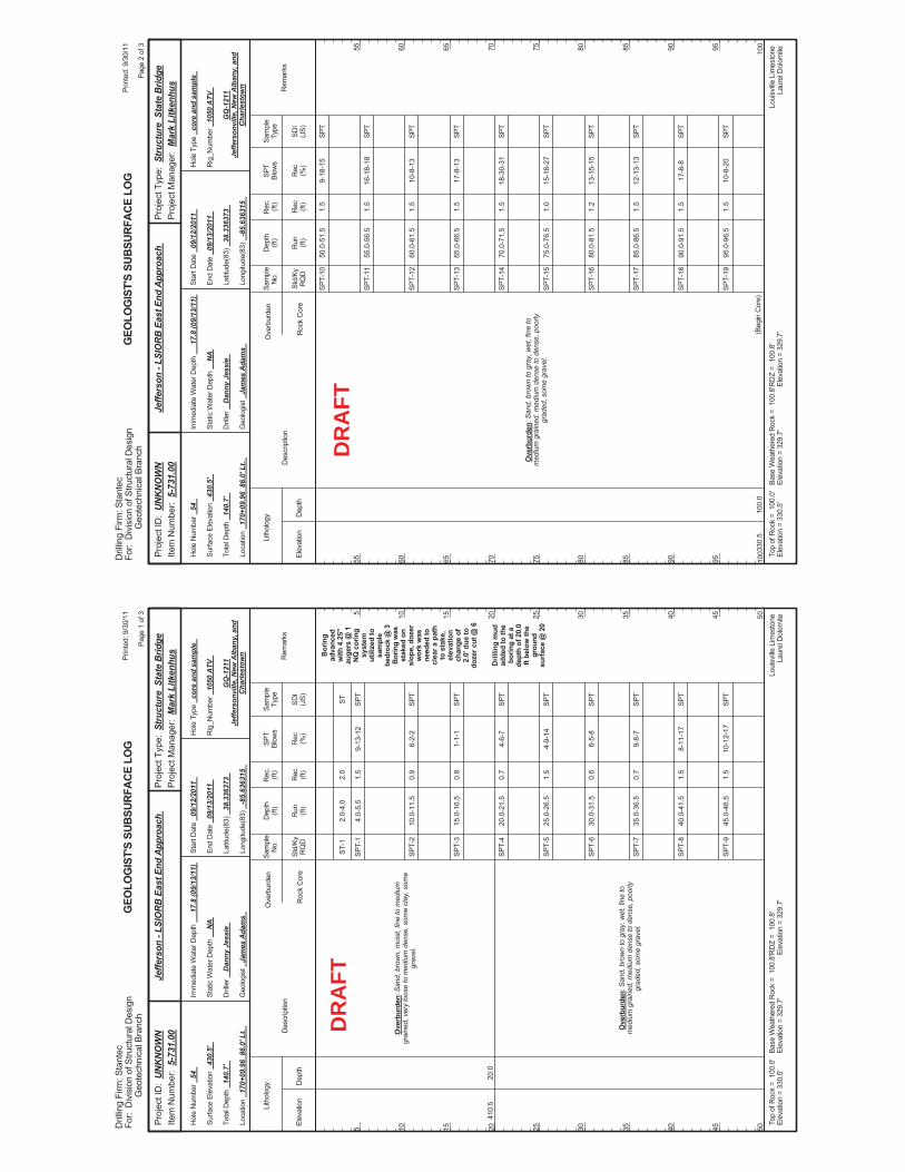
2.0-
4.0
4.0-
5.5
10.0
-11.
5
15.0
-16.
5
20.0
-21.
5
25.0
-26.
5
30.0
-31.
5
35.0
-36.
5
40.0
-41.
5
45.0
-46.
5
9-13
-12
6-2-
2
1-1-
1
4-6-
7
4-9-
14
6-5-
8
9-8-
7
8-11
-17
10-1
2-17
Bor
ing
adva
nced
with
4.2
5"au
gers
@ 1
NQ
cor
ing
syst
emut
ilize
d to
sam
ple
bedr
ock
@ 3
Bor
ing
was
stak
ed o
nsl
ope,
doz
erw
ork
was
need
ed to
clea
r a p
ath
to s
take
,el
evat
ion
chan
ge o
f2.
0' d
ue to
doze
r cut
@ 6
Dril
ling
mud
adde
d to
the
borin
g at
ade
pth
of 2
0.0
ft be
low
the
grou
ndsu
rface
@ 2
0
410.
520
.0
Ove
rbur
den:
San
d, b
row
n, m
oist
, fin
e to
med
ium
grai
ned,
ver
y lo
ose
to m
ediu
m d
ense
, som
e cl
ay, s
ome
grav
el.
Ove
rbur
den:
San
d, b
row
n to
gra
y, w
et, f
ine
tom
ediu
m g
rain
ed, m
ediu
m d
ense
to d
ense
, poo
rlygr
aded
, som
e gr
avel
.
ST-1
SPT-
1
SPT-
2
SPT-
3
SPT-
4
SPT-
5
SPT-
6
SPT-
7
SPT-
8
SPT-
9
2.0
1.5
0.9
0.8
0.7
1.5
0.6
0.7
1.5
1.5
Elev
atio
nD
epth
Std/
KyR
QD
Lith
olog
y
5 10 15 20 25 30 35 40 45 50
5 10 15 20 25 30 35 40 45 50
Dep
th(ft
)SP
TBl
ows
Sam
ple
Type
Rec (ft)
Geo
logi
st
Jam
es A
dam
s
Hol
e Ty
pe
core
and
sam
ple
Rec (%
)
Rec
.(ft
)Sa
mpl
eN
o.
Run (ft)
Des
crip
tion
Ove
rbur
den
Roc
k C
ore
SDI
(JS)
Rem
arks
Rig
_Num
ber
1050
ATV
Hol
e N
umbe
r 54
Surfa
ce E
leva
tion
430.
5'
Tota
l Dep
th
140.
7'
End
Dat
e 09
/13/
2011
Latit
ude(
83)
38.3
3637
3
Long
itude
(83)
-8
5.63
6315
Star
t Dat
e 09
/12/
2011
Dril
ler
Dan
ny J
essi
e
GEO
LOG
IST'
S SU
BSUR
FACE
LO
G
GQ
-121
1Je
ffers
onvi
lle, N
ew A
lban
y, a
ndC
harle
stow
n
Stat
ic W
ater
Dep
th
NA
Loui
sville
Lim
esto
neLa
urel
Dol
omite
Imm
edia
te W
ater
Dep
th
17.8
(09/
13/1
1)
Loca
tion
170+
09.9
6 8
6.0'
Lt.
Base
Wea
ther
ed R
ock
= 1
00.8
'El
evat
ion
= 32
9.7'
Top
ofR
ock
= 1
00.0
'El
evat
ion
= 33
0.5'
RD
Z =
100
.8'
Elev
atio
n =
329.
7'
Prin
ted:
9/3
0/11
Page
1 o
f 3
Dril
ling
Firm
: Sta
ntec
For:
Div
isio
n of
Stru
ctur
al D
esig
nG
eote
chni
cal B
ranc
h
Proj
ect T
ype:
Str
uctu
re S
tate
Brid
gePr
ojec
t Man
ager
: M
ark
Litk
enhu
sPr
ojec
t ID
: U
NK
NO
WN
Item
Num
ber:
5-7
31.0
0Je
ffers
on -
LSIO
RB
Eas
t End
App
roac
h
ST SPT
SPT
SPT
SPT
SPT
SPT
SPT
SPT
SPT
DR
AFT
50.0
-51.
5
55.0
-56.
5
60.0
-61.
5
65.0
-66.
5
70.0
-71.
5
75.0
-76.
5
80.0
-81.
5
85.0
-86.
5
90.0
-91.
5
95.0
-96.
5
9-18
-15
16-1
8-18
10-8
-13
17-8
-13
18-3
0-31
15-1
8-27
13-1
5-15
12-1
3-13
17-8
-8
10-8
-20
330.
510
0.0
Ove
rbur
den:
San
d, b
row
n to
gra
y, w
et, f
ine
tom
ediu
m g
rain
ed, m
ediu
m d
ense
to d
ense
, poo
rlygr
aded
, som
e gr
avel
.
(Beg
in C
ore)
SPT-
10
SPT-
11
SPT-
12
SPT-
13
SPT-
14
SPT-
15
SPT-
16
SPT-
17
SPT-
18
SPT-
19
1.5
1.5
1.5
1.5
1.5
1.0
1.2
1.5
1.5
1.5
Elev
atio
nD
epth
Std/
KyR
QD
Lith
olog
y
55 60 65 70 75 80 85 90 95 100
55 60 65 70 75 80 85 90 95 100
Dep
th(ft
)SP
TBl
ows
Sam
ple
Type
Rec (ft)
Geo
logi
st
Jam
es A
dam
s
Hol
e Ty
pe
core
and
sam
ple
Rec (%
)
Rec
.(ft
)Sa
mpl
eN
o.
Run (ft)
Des
crip
tion
Ove
rbur
den
Roc
k C
ore
SDI
(JS)
Rem
arks
Rig
_Num
ber
1050
ATV
Hol
e N
umbe
r 54
Surfa
ce E
leva
tion
430.
5'
Tota
l Dep
th
140.
7'
End
Dat
e 09
/13/
2011
Latit
ude(
83)
38.3
3637
3
Long
itude
(83)
-8
5.63
6315
Star
t Dat
e 09
/12/
2011
Dril
ler
Dan
ny J
essi
e
GEO
LOG
IST'
S SU
BSUR
FACE
LO
G
GQ
-121
1Je
ffers
onvi
lle, N
ew A
lban
y, a
ndC
harle
stow
n
Stat
ic W
ater
Dep
th
NA
Loui
sville
Lim
esto
neLa
urel
Dol
omite
Imm
edia
te W
ater
Dep
th
17.8
(09/
13/1
1)
Loca
tion
170+
09.9
6 8
6.0'
Lt.
Base
Wea
ther
ed R
ock
= 1
00.8
'El
evat
ion
= 32
9.7'
Top
ofR
ock
= 1
00.0
'El
evat
ion
= 33
0.5'
RD
Z =
100
.8'
Elev
atio
n =
329.
7'
Prin
ted:
9/3
0/11
Page
2 o
f 3
Dril
ling
Firm
: Sta
ntec
For:
Div
isio
n of
Stru
ctur
al D
esig
nG
eote
chni
cal B
ranc
h
Proj
ect T
ype:
Str
uctu
re S
tate
Brid
gePr
ojec
t Man
ager
: M
ark
Litk
enhu
sPr
ojec
t ID
: U
NK
NO
WN
Item
Num
ber:
5-7
31.0
0Je
ffers
on -
LSIO
RB
Eas
t End
App
roac
h
SPT
SPT
SPT
SPT
SPT
SPT
SPT
SPT
SPT
SPT
DR
AFT
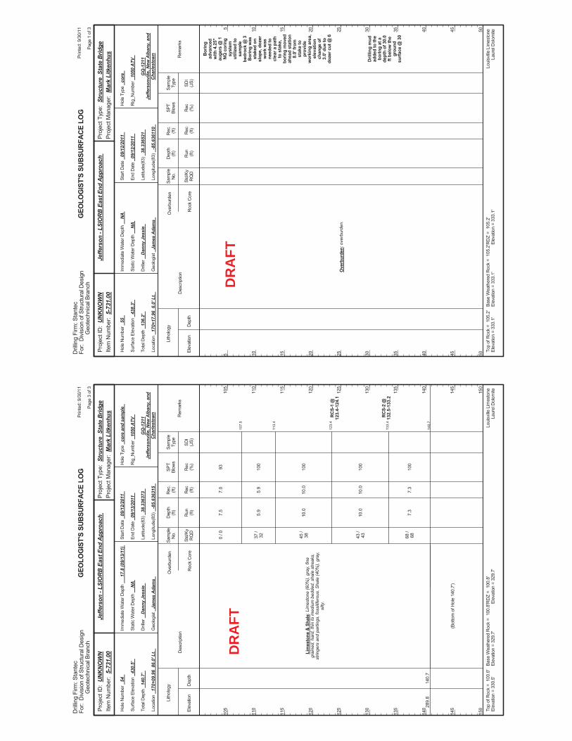
107.
5
113.
4
123.
4
133.
4
140.
7
7.5
5.9
10.0
10.0
7.3
93 100
100
100
100
RC
S-1
@12
3.4-
124.
1
RC
S-2
@13
2.5-
133.
2
289.
814
0.7
Lim
esto
ne &
Sha
le: L
imes
tone
(60%
), gr
ay, f
ine
grai
ned,
har
d, th
in to
med
ium
bed
ded,
sha
le s
treak
s,st
ringe
rs a
nd p
artin
gs, f
ossi
lifer
ous.
Sha
le (4
0%),
gray
,si
lty.
0 / 0
37 /
32 45 /
38 43 /
43 68 /
68
(Bot
tom
of H
ole
140.
7')
7.0
5.9
10.0
10.0
7.3
Elev
atio
nD
epth
Std/
KyR
QD
Lith
olog
y
105
110
115
120
125
130
135
140
145
150
105
110
115
120
125
130
135
140
145
150
Dep
th(ft
)SP
TBl
ows
Sam
ple
Type
Rec (ft)
Geo
logi
st
Jam
es A
dam
s
Hol
e Ty
pe
core
and
sam
ple
Rec (%
)
Rec
.(ft
)Sa
mpl
eN
o.
Run (ft)
Des
crip
tion
Ove
rbur
den
Roc
k C
ore
SDI
(JS)
Rem
arks
Rig
_Num
ber
1050
ATV
Hol
e N
umbe
r 54
Surfa
ce E
leva
tion
430.
5'
Tota
l Dep
th
140.
7'
End
Dat
e 09
/13/
2011
Latit
ude(
83)
38.3
3637
3
Long
itude
(83)
-8
5.63
6315
Star
t Dat
e 09
/12/
2011
Dril
ler
Dan
ny J
essi
e
GEO
LOG
IST'
S SU
BSUR
FACE
LO
G
GQ
-121
1Je
ffers
onvi
lle, N
ew A
lban
y, a
ndC
harle
stow
n
Stat
ic W
ater
Dep
th
NA
Loui
sville
Lim
esto
neLa
urel
Dol
omite
Imm
edia
te W
ater
Dep
th
17.8
(09/
13/1
1)
Loca
tion
170+
09.9
6 8
6.0'
Lt.
Base
Wea
ther
ed R
ock
= 1
00.8
'El
evat
ion
= 32
9.7'
Top
ofR
ock
= 1
00.0
'El
evat
ion
= 33
0.5'
RD
Z =
100
.8'
Elev
atio
n =
329.
7'
Prin
ted:
9/3
0/11
Page
3 o
f 3
Dril
ling
Firm
: Sta
ntec
For:
Div
isio
n of
Stru
ctur
al D
esig
nG
eote
chni
cal B
ranc
h
Proj
ect T
ype:
Str
uctu
re S
tate
Brid
gePr
ojec
t Man
ager
: M
ark
Litk
enhu
sPr
ojec
t ID
: U
NK
NO
WN
Item
Num
ber:
5-7
31.0
0Je
ffers
on -
LSIO
RB
Eas
t End
App
roac
h
DR
AFT
Bor
ing
adva
nced
with
4.2
5"au
gers
@ 1
NQ
cor
ing
syst
emut
ilize
d to
sam
ple
bedr
ock
@ 3
Bor
ing
was
stak
ed o
nsl
ope,
doz
erw
ork
was
need
ed to
clea
r a p
ath
to s
take
,bo
ring
mov
edah
ead
stat
ion
8.0'
from
stak
e to
prov
ide
wor
king
are
a,el
evat
ion
chan
ge o
f3.
0' d
ue to
doze
r cut
@ 6
Dril
ling
mud
adde
d to
the
borin
g at
ade
pth
of 3
0.0
ft be
low
the
grou
ndsu
rface
@ 3
0
Ove
rbur
den:
ove
rbur
den.
Elev
atio
nD
epth
Std/
KyR
QD
Lith
olog
y
5 10 15 20 25 30 35 40 45 50
5 10 15 20 25 30 35 40 45 50
Dep
th(ft
)SP
TBl
ows
Sam
ple
Type
Rec (ft)
Geo
logi
st
Jam
es A
dam
s
Hol
e Ty
pe
core
Rec (%
)
Rec
.(ft
)Sa
mpl
eN
o.
Run (ft)
Des
crip
tion
Ove
rbur
den
Roc
k C
ore
SDI
(JS)
Rem
arks
Rig
_Num
ber
1050
ATV
Hol
e N
umbe
r 55
Surfa
ce E
leva
tion
438.
3'
Tota
l Dep
th
136.
2'
End
Dat
e 09
/12/
2011
Latit
ude(
83)
38.3
3652
1
Long
itude
(83)
-8
5.63
6110
Star
t Dat
e 09
/12/
2011
Dril
ler
Dan
ny J
essi
e
GEO
LOG
IST'
S SU
BSUR
FACE
LO
G
GQ
-121
1Je
ffers
onvi
lle, N
ew A
lban
y, a
ndC
harle
stow
n
Stat
ic W
ater
Dep
th
NA
Loui
sville
Lim
esto
neLa
urel
Dol
omite
Imm
edia
te W
ater
Dep
th
NA
Loca
tion
170+
17.9
6 6
.0' L
t.
Base
Wea
ther
ed R
ock
= 1
05.2
'El
evat
ion
= 33
3.1'
Top
ofR
ock
= 1
05.2
'El
evat
ion
= 33
3.1'
RD
Z =
105
.2'
Elev
atio
n =
333.
1'
Prin
ted:
9/3
0/11
Page
1 o
f 3
Dril
ling
Firm
: Sta
ntec
For:
Div
isio
n of
Stru
ctur
al D
esig
nG
eote
chni
cal B
ranc
h
Proj
ect T
ype:
Str
uctu
re S
tate
Brid
gePr
ojec
t Man
ager
: M
ark
Litk
enhu
sPr
ojec
t ID
: U
NK
NO
WN
Item
Num
ber:
5-7
31.0
0Je
ffers
on -
LSIO
RB
Eas
t End
App
roac
h
DR
AFT
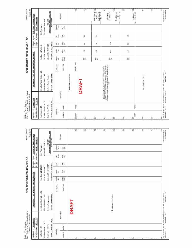
Ove
rbur
den:
ove
rbur
den.
Elev
atio
nD
epth
Std/
KyR
QD
Lith
olog
y
55 60 65 70 75 80 85 90 95 100
55 60 65 70 75 80 85 90 95 100
Dep
th(ft
)SP
TBl
ows
Sam
ple
Type
Rec (ft)
Geo
logi
st
Jam
es A
dam
s
Hol
e Ty
pe
core
Rec (%
)
Rec
.(ft
)Sa
mpl
eN
o.
Run (ft)
Des
crip
tion
Ove
rbur
den
Roc
k C
ore
SDI
(JS)
Rem
arks
Rig
_Num
ber
1050
ATV
Hol
e N
umbe
r 55
Surfa
ce E
leva
tion
438.
3'
Tota
l Dep
th
136.
2'
End
Dat
e 09
/12/
2011
Latit
ude(
83)
38.3
3652
1
Long
itude
(83)
-8
5.63
6110
Star
t Dat
e 09
/12/
2011
Dril
ler
Dan
ny J
essi
e
GEO
LOG
IST'
S SU
BSUR
FACE
LO
G
GQ
-121
1Je
ffers
onvi
lle, N
ew A
lban
y, a
ndC
harle
stow
n
Stat
ic W
ater
Dep
th
NA
Loui
sville
Lim
esto
neLa
urel
Dol
omite
Imm
edia
te W
ater
Dep
th
NA
Loca
tion
170+
17.9
6 6
.0' L
t.
Base
Wea
ther
ed R
ock
= 1
05.2
'El
evat
ion
= 33
3.1'
Top
ofR
ock
= 1
05.2
'El
evat
ion
= 33
3.1'
RD
Z =
105
.2'
Elev
atio
n =
333.
1'
Prin
ted:
9/3
0/11
Page
2 o
f 3
Dril
ling
Firm
: Sta
ntec
For:
Div
isio
n of
Stru
ctur
al D
esig
nG
eote
chni
cal B
ranc
h
Proj
ect T
ype:
Str
uctu
re S
tate
Brid
gePr
ojec
t Man
ager
: M
ark
Litk
enhu
sPr
ojec
t ID
: U
NK
NO
WN
Item
Num
ber:
5-7
31.0
0Je
ffers
on -
LSIO
RB
Eas
t End
App
roac
h
DR
AFT
113.
0
118.
0
128.
0
136.
2
7.8
5.0
10.0
8.2
95 100
100
100
Soft
Zone
@11
4.6-
115.
2
Soft
Zone
@11
6.9-
117.
1
RC
S-1
@12
1.4-
122.
1
foss
ilife
rous
@12
5.8-
126.
2
RC
S-2
@13
4.9-
135.
8
333.
1
302.
1
105.
2
136.
2
Ove
rbur
den:
ove
rbur
den.
Lim
esto
ne &
Sha
le: L
imes
tone
(70%
), gr
ay, f
ine
grai
ned,
har
d, th
in to
med
ium
bed
ded,
sha
le s
treak
s,st
ringe
rs a
nd p
artin
gs, f
ossi
lifer
ous.
Sha
le (3
0%),
gray
,si
lty.
(Beg
in C
ore)
38 /
38 30 /
25 39 /
31 59 /
59
(Bot
tom
of H
ole
136.
2')
7.4
5.0
10.0
8.2
Elev
atio
nD
epth
Std/
KyR
QD
Lith
olog
y
105
110
115
120
125
130
135
140
145
150
105
110
115
120
125
130
135
140
145
150
Dep
th(ft
)SP
TBl
ows
Sam
ple
Type
Rec (ft)
Geo
logi
st
Jam
es A
dam
s
Hol
e Ty
pe
core
Rec (%
)
Rec
.(ft
)Sa
mpl
eN
o.
Run (ft)
Des
crip
tion
Ove
rbur
den
Roc
k C
ore
SDI
(JS)
Rem
arks
Rig
_Num
ber
1050
ATV
Hol
e N
umbe
r 55
Surfa
ce E
leva
tion
438.
3'
Tota
l Dep
th
136.
2'
End
Dat
e 09
/12/
2011
Latit
ude(
83)
38.3
3652
1
Long
itude
(83)
-8
5.63
6110
Star
t Dat
e 09
/12/
2011
Dril
ler
Dan
ny J
essi
e
GEO
LOG
IST'
S SU
BSUR
FACE
LO
G
GQ
-121
1Je
ffers
onvi
lle, N
ew A
lban
y, a
ndC
harle
stow
n
Stat
ic W
ater
Dep
th
NA
Loui
sville
Lim
esto
neLa
urel
Dol
omite
Imm
edia
te W
ater
Dep
th
NA
Loca
tion
170+
17.9
6 6
.0' L
t.
Base
Wea
ther
ed R
ock
= 1
05.2
'El
evat
ion
= 33
3.1'
Top
ofR
ock
= 1
05.2
'El
evat
ion
= 33
3.1'
RD
Z =
105
.2'
Elev
atio
n =
333.
1'
Prin
ted:
9/3
0/11
Page
3 o
f 3
Dril
ling
Firm
: Sta
ntec
For:
Div
isio
n of
Stru
ctur
al D
esig
nG
eote
chni
cal B
ranc
h
Proj
ect T
ype:
Str
uctu
re S
tate
Brid
gePr
ojec
t Man
ager
: M
ark
Litk
enhu
sPr
ojec
t ID
: U
NK
NO
WN
Item
Num
ber:
5-7
31.0
0Je
ffers
on -
LSIO
RB
Eas
t End
App
roac
h
DR
AFT
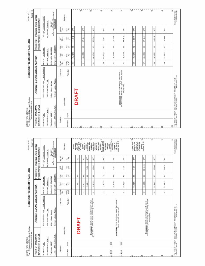
2.0-
4.0
5.0-
7.0
7.0-
8.5
10.0
-11.
5
15.0
-16.
5
20.0
-21.
5
25.0
-26.
5
30.0
-31.
5
35.0
-36.
5
40.0
-41.
5
45.0
-46.
5
7-6-
6
12-8
-1
3-2-
5
4-2-
2
4-5-
5
7-5-
7
13-1
0-10
10-6
-8
10-9
-10
Bor
ing
adva
nced
with
4.2
5"au
gers
@ 1
NQ
cor
ing
syst
emut
ilize
d to
sam
ple
bedr
ock
@ 3
Bor
ing
was
stak
ed o
nsl
ope,
doz
erw
ork
was
need
ed to
clea
r a p
ath
to s
take
,bo
ring
mov
edah
ead
stat
ion
8.0'
from
stak
e to
prov
ide
wor
king
are
a,el
evat
ion
chan
ge o
f3.
3' d
ue to
doze
r cut
@ 6
Dril
ling
mud
adde
d to
the
borin
g at
ade
pth
of 3
0.0
ft be
low
the
grou
ndsu
rface
@ 3
0
419.
1
414.
1
20.0
25.0
Ove
rbur
den:
San
d, b
row
n, m
oist
, fin
e to
med
ium
grai
n, lo
ose
to m
ediu
m d
ense
, som
e cl
ay, s
ome
grav
el.
Ove
rbur
den:
San
d, li
ght b
row
n, m
oist
, fin
e gr
aine
d,lo
ose,
som
e si
lt, s
ome
grav
el.
Ove
rbur
den:
San
d, b
row
n to
gra
y, w
et, f
ine
tom
ediu
m g
rain
ed, l
oose
to v
ery
dens
e, p
oorly
gra
ded,
som
e gr
avel
.
1 2 1 2 3 4 5 6 7 8 9
1.5
1.0
1.0
1.0
0.5
1.0
1.2
1.5
1.5
1.5
1.5
Elev
atio
nD
epth
Std/
KyR
QD
Lith
olog
y
5 10 15 20 25 30 35 40 45 50
5 10 15 20 25 30 35 40 45 50
Dep
th(ft
)SP
TBl
ows
Sam
ple
Type
Rec (ft)
Geo
logi
st
Jam
es A
dam
s
Hol
e Ty
pe
core
and
sam
ple
Rec (%
)
Rec
.(ft
)Sa
mpl
eN
o.
Run (ft)
Des
crip
tion
Ove
rbur
den
Roc
k C
ore
SDI
(JS)
Rem
arks
Rig
_Num
ber
1050
ATV
Hol
e N
umbe
r 56
Surfa
ce E
leva
tion
439.
1'
Tota
l Dep
th
136.
7'
End
Dat
e 09
/08/
2011
Latit
ude(
83)
38.3
3654
4
Long
itude
(83)
-8
5.63
6079
Star
t Dat
e 09
/08/
2011
Dril
ler
Dan
ny J
essi
e
GEO
LOG
IST'
S SU
BSUR
FACE
LO
G
GQ
-121
1Je
ffers
onvi
lle, N
ew A
lban
y, a
ndC
harle
stow
n
Stat
ic W
ater
Dep
th
NA
Loui
sville
Lim
esto
neLa
urel
Dol
omite
Imm
edia
te W
ater
Dep
th
26.0
(09/
09/1
1)
Loca
tion
170+
17.9
6 6
.0' R
t.
Base
Wea
ther
ed R
ock
= 1
06.2
'El
evat
ion
= 33
2.9'
Top
ofR
ock
= 1
06.2
'El
evat
ion
= 33
2.9'
RD
Z =
106
.2'
Elev
atio
n =
332.
9'
Prin
ted:
9/3
0/11
Page
1 o
f 3
Dril
ling
Firm
: Sta
ntec
For:
Div
isio
n of
Stru
ctur
al D
esig
nG
eote
chni
cal B
ranc
h
Proj
ect T
ype:
Str
uctu
re S
tate
Brid
gePr
ojec
t Man
ager
: M
ark
Litk
enhu
sPr
ojec
t ID
: U
NK
NO
WN
Item
Num
ber:
5-7
31.0
0Je
ffers
on -
LSIO
RB
Eas
t End
App
roac
h
ST ST SPT
SPT
SPT
SPT
SPT
SPT
SPT
SPT
SPT
DR
AFT
50.0
-51.
5
55.0
-56.
5
60.0
-61.
5
65.0
-66.
5
70.0
-71.
5
75.0
-76.
5
80.0
-81.
5
85.0
-86.
5
90.0
-91.
5
95.0
-96.
5
11-9
-10
17-1
0-10
28-2
7-24
6-7-
11
15-1
3-8
14-1
8-22
9-10
-11
17-1
8-22
8-11
-12
17-8
-5
Ove
rbur
den:
San
d, b
row
n to
gra
y, w
et, f
ine
tom
ediu
m g
rain
ed, l
oose
to v
ery
dens
e, p
oorly
gra
ded,
som
e gr
avel
.
10 11 12 13 14 15 16 17 18 19
1.5
1.5
1.5
1.5
1.5
1.5
1.2
1.5
1.0
1.5
Elev
atio
nD
epth
Std/
KyR
QD
Lith
olog
y
55 60 65 70 75 80 85 90 95 100
55 60 65 70 75 80 85 90 95 100
Dep
th(ft
)SP
TBl
ows
Sam
ple
Type
Rec (ft)
Geo
logi
st
Jam
es A
dam
s
Hol
e Ty
pe
core
and
sam
ple
Rec (%
)
Rec
.(ft
)Sa
mpl
eN
o.
Run (ft)
Des
crip
tion
Ove
rbur
den
Roc
k C
ore
SDI
(JS)
Rem
arks
Rig
_Num
ber
1050
ATV
Hol
e N
umbe
r 56
Surfa
ce E
leva
tion
439.
1'
Tota
l Dep
th
136.
7'
End
Dat
e 09
/08/
2011
Latit
ude(
83)
38.3
3654
4
Long
itude
(83)
-8
5.63
6079
Star
t Dat
e 09
/08/
2011
Dril
ler
Dan
ny J
essi
e
GEO
LOG
IST'
S SU
BSUR
FACE
LO
G
GQ
-121
1Je
ffers
onvi
lle, N
ew A
lban
y, a
ndC
harle
stow
n
Stat
ic W
ater
Dep
th
NA
Loui
sville
Lim
esto
neLa
urel
Dol
omite
Imm
edia
te W
ater
Dep
th
26.0
(09/
09/1
1)
Loca
tion
170+
17.9
6 6
.0' R
t.
Base
Wea
ther
ed R
ock
= 1
06.2
'El
evat
ion
= 33
2.9'
Top
ofR
ock
= 1
06.2
'El
evat
ion
= 33
2.9'
RD
Z =
106
.2'
Elev
atio
n =
332.
9'
Prin
ted:
9/3
0/11
Page
2 o
f 3
Dril
ling
Firm
: Sta
ntec
For:
Div
isio
n of
Stru
ctur
al D
esig
nG
eote
chni
cal B
ranc
h
Proj
ect T
ype:
Str
uctu
re S
tate
Brid
gePr
ojec
t Man
ager
: M
ark
Litk
enhu
sPr
ojec
t ID
: U
NK
NO
WN
Item
Num
ber:
5-7
31.0
0Je
ffers
on -
LSIO
RB
Eas
t End
App
roac
h
SPT
SPT
SPT
SPT
SPT
SPT
SPT
SPT
SPT
SPT
DR
AFT
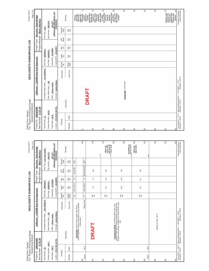
113.
5
118.
5
128.
5
136.
7
100.
0-10
1.5
105.
0-10
6.2
7.3
5.0
10.0
8.2
26-2
3-28
28-3
2-50
/0.2
0'
100
100
100
100
RC
S-1
@11
5.8-
116.
6so
ft zo
ne @
116.
6-11
6.8
foss
ilife
rous
@ 1
27-1
27.3
RC
S-2
@12
9.6-
130.
3
332.
9
302.
4
106.
2
136.
7
Ove
rbur
den:
San
d, b
row
n to
gra
y, w
et, f
ine
tom
ediu
m g
rain
ed, l
oose
to v
ery
dens
e, p
oorly
gra
ded,
som
e gr
avel
.
Lim
esto
ne &
Sha
le: L
imes
tone
(60%
), gr
ay, f
ine
grai
ned,
har
d, th
in to
med
ium
bed
ded,
sha
le s
treak
s,st
ringe
rs a
nd p
artin
gs, f
ossi
lifer
ous.
Sha
le (4
0%),
gray
,si
lty.
(Beg
in C
ore)
20 21 40 /
40 50 /
47 50 /
46 64 /
64
(Bot
tom
of H
ole
136.
7')
1.5
1.2
7.3
5.0
10.0
8.2
Elev
atio
nD
epth
Std/
KyR
QD
Lith
olog
y
105
110
115
120
125
130
135
140
145
150
105
110
115
120
125
130
135
140
145
150
Dep
th(ft
)SP
TBl
ows
Sam
ple
Type
Rec (ft)
Geo
logi
st
Jam
es A
dam
s
Hol
e Ty
pe
core
and
sam
ple
Rec (%
)
Rec
.(ft
)Sa
mpl
eN
o.
Run (ft)
Des
crip
tion
Ove
rbur
den
Roc
k C
ore
SDI
(JS)
Rem
arks
Rig
_Num
ber
1050
ATV
Hol
e N
umbe
r 56
Surfa
ce E
leva
tion
439.
1'
Tota
l Dep
th
136.
7'
End
Dat
e 09
/08/
2011
Latit
ude(
83)
38.3
3654
4
Long
itude
(83)
-8
5.63
6079
Star
t Dat
e 09
/08/
2011
Dril
ler
Dan
ny J
essi
e
GEO
LOG
IST'
S SU
BSUR
FACE
LO
G
GQ
-121
1Je
ffers
onvi
lle, N
ew A
lban
y, a
ndC
harle
stow
n
Stat
ic W
ater
Dep
th
NA
Loui
sville
Lim
esto
neLa
urel
Dol
omite
Imm
edia
te W
ater
Dep
th
26.0
(09/
09/1
1)
Loca
tion
170+
17.9
6 6
.0' R
t.
Base
Wea
ther
ed R
ock
= 1
06.2
'El
evat
ion
= 33
2.9'
Top
ofR
ock
= 1
06.2
'El
evat
ion
= 33
2.9'
RD
Z =
106
.2'
Elev
atio
n =
332.
9'
Prin
ted:
9/3
0/11
Page
3 o
f 3
Dril
ling
Firm
: Sta
ntec
For:
Div
isio
n of
Stru
ctur
al D
esig
nG
eote
chni
cal B
ranc
h
Proj
ect T
ype:
Str
uctu
re S
tate
Brid
gePr
ojec
t Man
ager
: M
ark
Litk
enhu
sPr
ojec
t ID
: U
NK
NO
WN
Item
Num
ber:
5-7
31.0
0Je
ffers
on -
LSIO
RB
Eas
t End
App
roac
h
SPT
SPT
DR
AFT
Bor
ing
adva
nced
with
4.2
5"au
gers
@ 1
NQ
cor
ing
syst
emut
ilize
d to
sam
ple
bedr
ock
@ 3
Bor
ing
was
drill
ed o
nsl
ope,
doz
erw
ork
was
need
ed to
clea
r a p
ath
to s
take
,bo
ring
offs
et8.
5' fr
omst
ake
topr
ovid
ew
orki
ng a
rea,
elev
atio
nch
ange
3.0
'du
e to
doz
ercu
t @ 6
Dril
ling
mud
adde
d to
the
borin
g at
ade
pth
of 4
5.0
ft be
low
the
grou
nd
Ove
rbur
den:
ove
rbur
den.
Elev
atio
nD
epth
Std/
KyR
QD
Lith
olog
y
5 10 15 20 25 30 35 40 45 50
5 10 15 20 25 30 35 40 45 50
Dep
th(ft
)SP
TBl
ows
Sam
ple
Type
Rec (ft)
Geo
logi
st
Jam
es A
dam
s
Hol
e Ty
pe
core
Rec (%
)
Rec
.(ft
)Sa
mpl
eN
o.
Run (ft)
Des
crip
tion
Ove
rbur
den
Roc
k C
ore
SDI
(JS)
Rem
arks
Rig
_Num
ber
1050
ATV
Hol
e N
umbe
r 57
Surfa
ce E
leva
tion
443.
9'
Tota
l Dep
th
152.
0'
End
Dat
e 09
/08/
2011
Latit
ude(
83)
38.3
3666
1
Long
itude
(83)
-8
5.63
5917
Star
t Dat
e 09
/08/
2011
Dril
ler
Dan
ny J
essi
e
GEO
LOG
IST'
S SU
BSUR
FACE
LO
G
GQ
-121
1Je
ffers
onvi
lle, N
ew A
lban
y, a
ndC
harle
stow
n
Stat
ic W
ater
Dep
th
NA
Loui
sville
Lim
esto
neLa
urel
Dol
omite
Imm
edia
te W
ater
Dep
th
43.2
(09/
08/1
1)
Loca
tion
170+
18.4
6 6
9.0'
Rt.
Base
Wea
ther
ed R
ock
= 1
12.1
'El
evat
ion
= 33
1.8'
Top
ofR
ock
= 1
11.3
'El
evat
ion
= 33
2.6'
RD
Z =
112
.1'
Elev
atio
n =
331.
8'
Prin
ted:
9/3
0/11
Page
1 o
f 4
Dril
ling
Firm
: Sta
ntec
For:
Div
isio
n of
Stru
ctur
al D
esig
nG
eote
chni
cal B
ranc
h
Proj
ect T
ype:
Str
uctu
re S
tate
Brid
gePr
ojec
t Man
ager
: M
ark
Litk
enhu
sPr
ojec
t ID
: U
NK
NO
WN
Item
Num
ber:
5-7
31.0
0Je
ffers
on -
LSIO
RB
Eas
t End
App
roac
h
DR
AFT
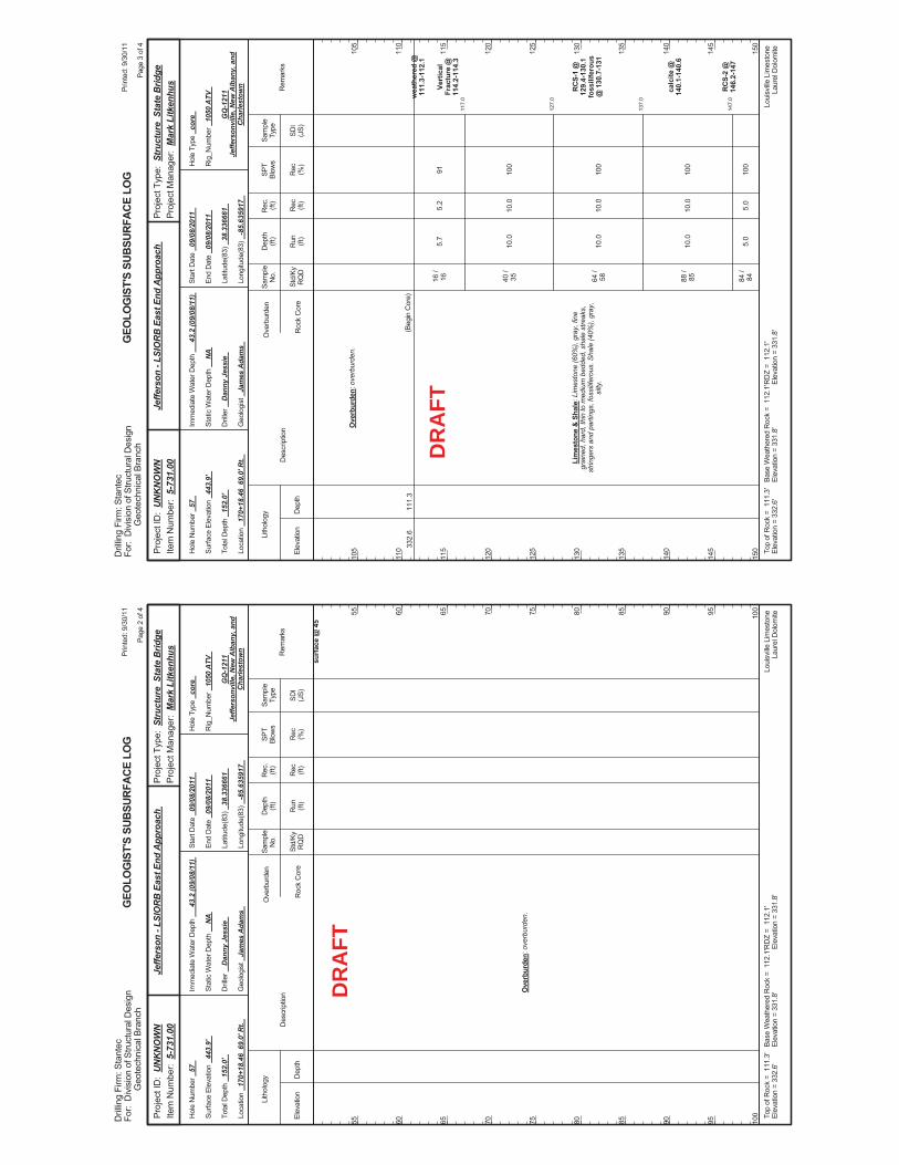
surfa
ce @
45
Ove
rbur
den:
ove
rbur
den.
Elev
atio
nD
epth
Std/
KyR
QD
Lith
olog
y
55 60 65 70 75 80 85 90 95 100
55 60 65 70 75 80 85 90 95 100
Dep
th(ft
)SP
TBl
ows
Sam
ple
Type
Rec (ft)
Geo
logi
st
Jam
es A
dam
s
Hol
e Ty
pe
core
Rec (%
)
Rec
.(ft
)Sa
mpl
eN
o.
Run (ft)
Des
crip
tion
Ove
rbur
den
Roc
k C
ore
SDI
(JS)
Rem
arks
Rig
_Num
ber
1050
ATV
Hol
e N
umbe
r 57
Surfa
ce E
leva
tion
443.
9'
Tota
l Dep
th
152.
0'
End
Dat
e 09
/08/
2011
Latit
ude(
83)
38.3
3666
1
Long
itude
(83)
-8
5.63
5917
Star
t Dat
e 09
/08/
2011
Dril
ler
Dan
ny J
essi
e
GEO
LOG
IST'
S SU
BSUR
FACE
LO
G
GQ
-121
1Je
ffers
onvi
lle, N
ew A
lban
y, a
ndC
harle
stow
n
Stat
ic W
ater
Dep
th
NA
Loui
sville
Lim
esto
neLa
urel
Dol
omite
Imm
edia
te W
ater
Dep
th
43.2
(09/
08/1
1)
Loca
tion
170+
18.4
6 6
9.0'
Rt.
Base
Wea
ther
ed R
ock
= 1
12.1
'El
evat
ion
= 33
1.8'
Top
ofR
ock
= 1
11.3
'El
evat
ion
= 33
2.6'
RD
Z =
112
.1'
Elev
atio
n =
331.
8'
Prin
ted:
9/3
0/11
Page
2 o
f 4
Dril
ling
Firm
: Sta
ntec
For:
Div
isio
n of
Stru
ctur
al D
esig
nG
eote
chni
cal B
ranc
h
Proj
ect T
ype:
Str
uctu
re S
tate
Brid
gePr
ojec
t Man
ager
: M
ark
Litk
enhu
sPr
ojec
t ID
: U
NK
NO
WN
Item
Num
ber:
5-7
31.0
0Je
ffers
on -
LSIO
RB
Eas
t End
App
roac
h
DR
AFT
117.
0
127.
0
137.
0
147.
0
5.7
10.0
10.0
10.0
5.0
91 100
100
100
100
wea
ther
ed @
111.
3-11
2.1
Vert
ical
Frac
ture
@11
4.2-
114.
3
RC
S-1
@12
9.4-
130.
1fo
ssili
fero
us@
130
.7-1
31
calc
ite @
140.
1-14
0.6
RC
S-2
@14
6.2-
147
332.
611
1.3
Ove
rbur
den:
ove
rbur
den.
Lim
esto
ne &
Sha
le: L
imes
tone
(60%
), gr
ay, f
ine
grai
ned,
har
d, th
in to
med
ium
bed
ded,
sha
le s
treak
s,st
ringe
rs a
nd p
artin
gs, f
ossi
lifer
ous.
Sha
le (4
0%),
gray
,si
lty.
(Beg
in C
ore)
16 /
16 40 /
35 64 /
58 88 /
85 84 /
84
5.2
10.0
10.0
10.0
5.0
Elev
atio
nD
epth
Std/
KyR
QD
Lith
olog
y
105
110
115
120
125
130
135
140
145
150
105
110
115
120
125
130
135
140
145
150
Dep
th(ft
)SP
TBl
ows
Sam
ple
Type
Rec (ft)
Geo
logi
st
Jam
es A
dam
s
Hol
e Ty
pe
core
Rec (%
)
Rec
.(ft
)Sa
mpl
eN
o.
Run (ft)
Des
crip
tion
Ove
rbur
den
Roc
k C
ore
SDI
(JS)
Rem
arks
Rig
_Num
ber
1050
ATV
Hol
e N
umbe
r 57
Surfa
ce E
leva
tion
443.
9'
Tota
l Dep
th
152.
0'
End
Dat
e 09
/08/
2011
Latit
ude(
83)
38.3
3666
1
Long
itude
(83)
-8
5.63
5917
Star
t Dat
e 09
/08/
2011
Dril
ler
Dan
ny J
essi
e
GEO
LOG
IST'
S SU
BSUR
FACE
LO
G
GQ
-121
1Je
ffers
onvi
lle, N
ew A
lban
y, a
ndC
harle
stow
n
Stat
ic W
ater
Dep
th
NA
Loui
sville
Lim
esto
neLa
urel
Dol
omite
Imm
edia
te W
ater
Dep
th
43.2
(09/
08/1
1)
Loca
tion
170+
18.4
6 6
9.0'
Rt.
Base
Wea
ther
ed R
ock
= 1
12.1
'El
evat
ion
= 33
1.8'
Top
ofR
ock
= 1
11.3
'El
evat
ion
= 33
2.6'
RD
Z =
112
.1'
Elev
atio
n =
331.
8'
Prin
ted:
9/3
0/11
Page
3 o
f 4
Dril
ling
Firm
: Sta
ntec
For:
Div
isio
n of
Stru
ctur
al D
esig
nG
eote
chni
cal B
ranc
h
Proj
ect T
ype:
Str
uctu
re S
tate
Brid
gePr
ojec
t Man
ager
: M
ark
Litk
enhu
sPr
ojec
t ID
: U
NK
NO
WN
Item
Num
ber:
5-7
31.0
0Je
ffers
on -
LSIO
RB
Eas
t End
App
roac
h
DR
AFT
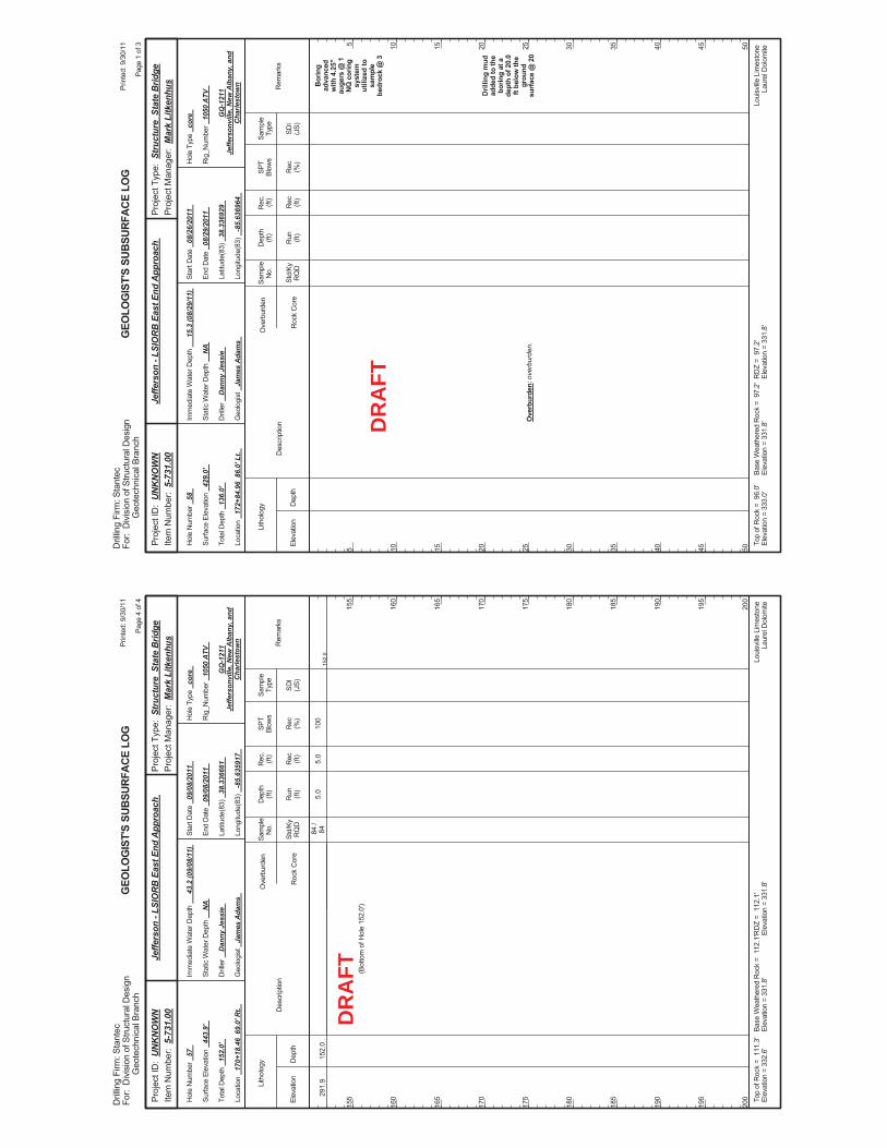
152.
05.
010
029
1.9
152.
084
/84
(Bot
tom
of H
ole
152.
0')
5.0
Elev
atio
nD
epth
Std/
KyR
QD
Lith
olog
y
155
160
165
170
175
180
185
190
195
200
155
160
165
170
175
180
185
190
195
200
Dep
th(ft
)SP
TBl
ows
Sam
ple
Type
Rec (ft)
Geo
logi
st
Jam
es A
dam
s
Hol
e Ty
pe
core
Rec (%
)
Rec
.(ft
)Sa
mpl
eN
o.
Run (ft)
Des
crip
tion
Ove
rbur
den
Roc
k C
ore
SDI
(JS)
Rem
arks
Rig
_Num
ber
1050
ATV
Hol
e N
umbe
r 57
Surfa
ce E
leva
tion
443.
9'
Tota
l Dep
th
152.
0'
End
Dat
e 09
/08/
2011
Latit
ude(
83)
38.3
3666
1
Long
itude
(83)
-8
5.63
5917
Star
t Dat
e 09
/08/
2011
Dril
ler
Dan
ny J
essi
e
GEO
LOG
IST'
S SU
BSUR
FACE
LO
G
GQ
-121
1Je
ffers
onvi
lle, N
ew A
lban
y, a
ndC
harle
stow
n
Stat
ic W
ater
Dep
th
NA
Loui
sville
Lim
esto
neLa
urel
Dol
omite
Imm
edia
te W
ater
Dep
th
43.2
(09/
08/1
1)
Loca
tion
170+
18.4
6 6
9.0'
Rt.
Base
Wea
ther
ed R
ock
= 1
12.1
'El
evat
ion
= 33
1.8'
Top
ofR
ock
= 1
11.3
'El
evat
ion
= 33
2.6'
RD
Z =
112
.1'
Elev
atio
n =
331.
8'
Prin
ted:
9/3
0/11
Page
4 o
f 4
Dril
ling
Firm
: Sta
ntec
For:
Div
isio
n of
Stru
ctur
al D
esig
nG
eote
chni
cal B
ranc
h
Proj
ect T
ype:
Str
uctu
re S
tate
Brid
gePr
ojec
t Man
ager
: M
ark
Litk
enhu
sPr
ojec
t ID
: U
NK
NO
WN
Item
Num
ber:
5-7
31.0
0Je
ffers
on -
LSIO
RB
Eas
t End
App
roac
h
DR
AFT
Bor
ing
adva
nced
with
4.2
5"au
gers
@ 1
NQ
cor
ing
syst
emut
ilize
d to
sam
ple
bedr
ock
@ 3
Dril
ling
mud
adde
d to
the
borin
g at
ade
pth
of 2
0.0
ft be
low
the
grou
ndsu
rface
@ 2
0O
verb
urde
n: o
verb
urde
n.
Elev
atio
nD
epth
Std/
KyR
QD
Lith
olog
y
5 10 15 20 25 30 35 40 45 50
5 10 15 20 25 30 35 40 45 50
Dep
th(ft
)SP
TBl
ows
Sam
ple
Type
Rec (ft)
Geo
logi
st
Jam
es A
dam
s
Hol
e Ty
pe
core
Rec (%
)
Rec
.(ft
)Sa
mpl
eN
o.
Run (ft)
Des
crip
tion
Ove
rbur
den
Roc
k C
ore
SDI
(JS)
Rem
arks
Rig
_Num
ber
1050
ATV
Hol
e N
umbe
r 58
Surfa
ce E
leva
tion
429.
0'
Tota
l Dep
th
136.
0'
End
Dat
e 08
/29/
2011
Latit
ude(
83)
38.3
3692
9
Long
itude
(83)
-8
5.63
6964
Star
t Dat
e 08
/26/
2011
Dril
ler
Dan
ny J
essi
e
GEO
LOG
IST'
S SU
BSUR
FACE
LO
G
GQ
-121
1Je
ffers
onvi
lle, N
ew A
lban
y, a
ndC
harle
stow
n
Stat
ic W
ater
Dep
th
NA
Loui
sville
Lim
esto
neLa
urel
Dol
omite
Imm
edia
te W
ater
Dep
th
15.3
(08/
29/1
1)
Loca
tion
172+
84.9
6 8
6.0'
Lt.
Base
Wea
ther
ed R
ock
= 9
7.2'
Elev
atio
n =
331.
8'To
p of
Roc
k =
96.
0'El
evat
ion
= 33
3.0'
RD
Z =
97.
2'El
evat
ion
= 33
1.8'
Prin
ted:
9/3
0/11
Page
1 o
f 3
Dril
ling
Firm
: Sta
ntec
For:
Div
isio
n of
Stru
ctur
al D
esig
nG
eote
chni
cal B
ranc
h
Proj
ect T
ype:
Str
uctu
re S
tate
Brid
gePr
ojec
t Man
ager
: M
ark
Litk
enhu
sPr
ojec
t ID
: U
NK
NO
WN
Item
Num
ber:
5-7
31.0
0Je
ffers
on -
LSIO
RB
Eas
t End
App
roac
h
DR
AFT
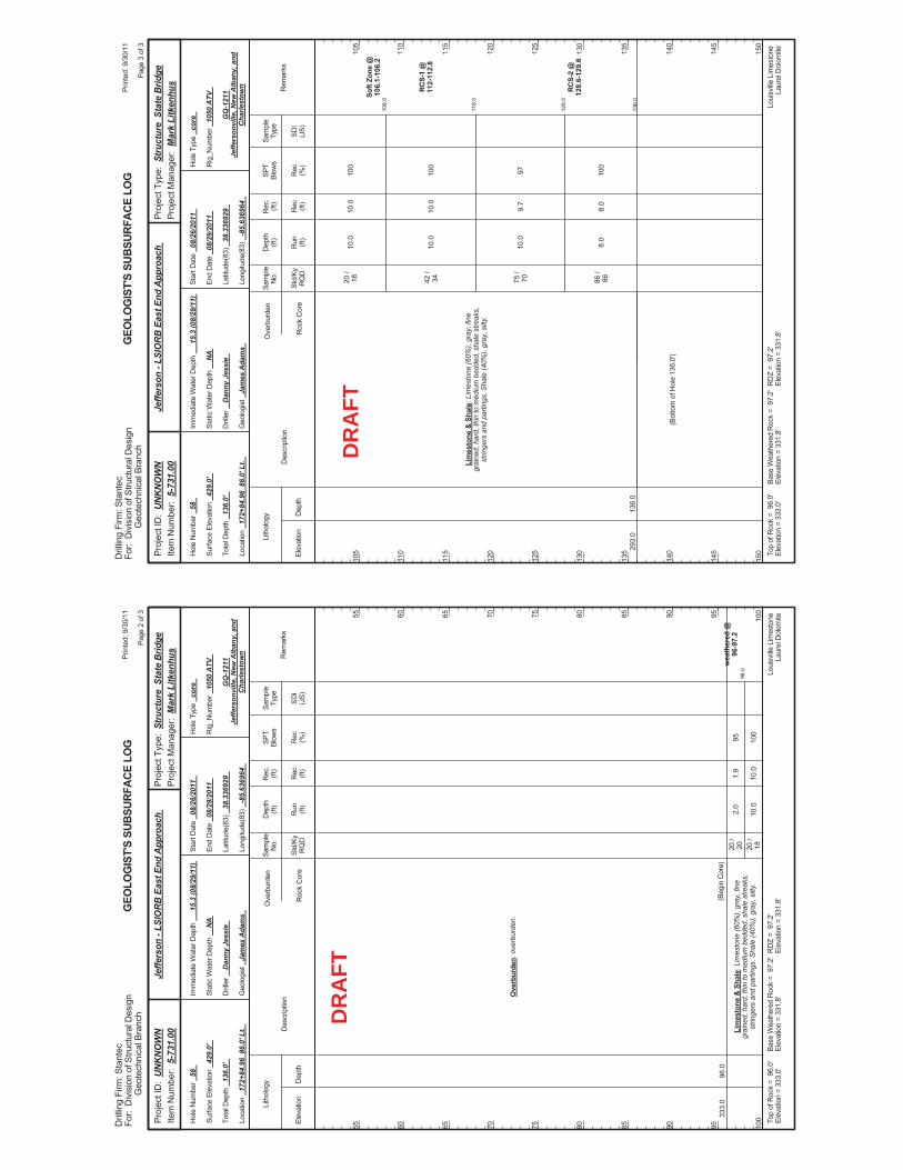
98.0
2.0
10.0
95 100
wea
ther
ed @
96-9
7.2
333.
096
.0
Ove
rbur
den:
ove
rbur
den.
Lim
esto
ne &
Sha
le: L
imes
tone
(60%
), gr
ay, f
ine
grai
ned,
har
d, th
in to
med
ium
bed
ded,
sha
le s
treak
s,st
ringe
rs a
nd p
artin
gs. S
hale
(40%
), gr
ay, s
ilty.
(Beg
in C
ore)
20 /
20 20 /
18
1.9
10.0
Elev
atio
nD
epth
Std/
KyR
QD
Lith
olog
y
55 60 65 70 75 80 85 90 95 100
55 60 65 70 75 80 85 90 95 100
Dep
th(ft
)SP
TBl
ows
Sam
ple
Type
Rec (ft)
Geo
logi
st
Jam
es A
dam
s
Hol
e Ty
pe
core
Rec (%
)
Rec
.(ft
)Sa
mpl
eN
o.
Run (ft)
Des
crip
tion
Ove
rbur
den
Roc
k C
ore
SDI
(JS)
Rem
arks
Rig
_Num
ber
1050
ATV
Hol
e N
umbe
r 58
Surfa
ce E
leva
tion
429.
0'
Tota
l Dep
th
136.
0'
End
Dat
e 08
/29/
2011
Latit
ude(
83)
38.3
3692
9
Long
itude
(83)
-8
5.63
6964
Star
t Dat
e 08
/26/
2011
Dril
ler
Dan
ny J
essi
e
GEO
LOG
IST'
S SU
BSUR
FACE
LO
G
GQ
-121
1Je
ffers
onvi
lle, N
ew A
lban
y, a
ndC
harle
stow
n
Stat
ic W
ater
Dep
th
NA
Loui
sville
Lim
esto
neLa
urel
Dol
omite
Imm
edia
te W
ater
Dep
th
15.3
(08/
29/1
1)
Loca
tion
172+
84.9
6 8
6.0'
Lt.
Base
Wea
ther
ed R
ock
= 9
7.2'
Elev
atio
n =
331.
8'To
p of
Roc
k =
96.
0'El
evat
ion
= 33
3.0'
RD
Z =
97.
2'El
evat
ion
= 33
1.8'
Prin
ted:
9/3
0/11
Page
2 o
f 3
Dril
ling
Firm
: Sta
ntec
For:
Div
isio
n of
Stru
ctur
al D
esig
nG
eote
chni
cal B
ranc
h
Proj
ect T
ype:
Str
uctu
re S
tate
Brid
gePr
ojec
t Man
ager
: M
ark
Litk
enhu
sPr
ojec
t ID
: U
NK
NO
WN
Item
Num
ber:
5-7
31.0
0Je
ffers
on -
LSIO
RB
Eas
t End
App
roac
h
DR
AFT
108.
0
118.
0
128.
0
136.
0
10.0
10.0
10.0
8.0
100
100
97 100
Soft
Zone
@10
6.1-
106.
2
RC
S-1
@11
2-11
2.8
RC
S-2
@12
8.6-
129.
6
293.
013
6.0
Lim
esto
ne &
Sha
le: L
imes
tone
(60%
), gr
ay, f
ine
grai
ned,
har
d, th
in to
med
ium
bed
ded,
sha
le s
treak
s,st
ringe
rs a
nd p
artin
gs. S
hale
(40%
), gr
ay, s
ilty.
20 /
18 42 /
34 75 /
70 86 /
86
(Bot
tom
of H
ole
136.
0')
10.0
10.0
9.7
8.0
Elev
atio
nD
epth
Std/
KyR
QD
Lith
olog
y
105
110
115
120
125
130
135
140
145
150
105
110
115
120
125
130
135
140
145
150
Dep
th(ft
)SP
TBl
ows
Sam
ple
Type
Rec (ft)
Geo
logi
st
Jam
es A
dam
s
Hol
e Ty
pe
core
Rec (%
)
Rec
.(ft
)Sa
mpl
eN
o.
Run (ft)
Des
crip
tion
Ove
rbur
den
Roc
k C
ore
SDI
(JS)
Rem
arks
Rig
_Num
ber
1050
ATV
Hol
e N
umbe
r 58
Surfa
ce E
leva
tion
429.
0'
Tota
l Dep
th
136.
0'
End
Dat
e 08
/29/
2011
Latit
ude(
83)
38.3
3692
9
Long
itude
(83)
-8
5.63
6964
Star
t Dat
e 08
/26/
2011
Dril
ler
Dan
ny J
essi
e
GEO
LOG
IST'
S SU
BSUR
FACE
LO
G
GQ
-121
1Je
ffers
onvi
lle, N
ew A
lban
y, a
ndC
harle
stow
n
Stat
ic W
ater
Dep
th
NA
Loui
sville
Lim
esto
neLa
urel
Dol
omite
Imm
edia
te W
ater
Dep
th
15.3
(08/
29/1
1)
Loca
tion
172+
84.9
6 8
6.0'
Lt.
Base
Wea
ther
ed R
ock
= 9
7.2'
Elev
atio
n =
331.
8'To
p of
Roc
k =
96.
0'El
evat
ion
= 33
3.0'
RD
Z =
97.
2'El
evat
ion
= 33
1.8'
Prin
ted:
9/3
0/11
Page
3 o
f 3
Dril
ling
Firm
: Sta
ntec
For:
Div
isio
n of
Stru
ctur
al D
esig
nG
eote
chni
cal B
ranc
h
Proj
ect T
ype:
Str
uctu
re S
tate
Brid
gePr
ojec
t Man
ager
: M
ark
Litk
enhu
sPr
ojec
t ID
: U
NK
NO
WN
Item
Num
ber:
5-7
31.0
0Je
ffers
on -
LSIO
RB
Eas
t End
App
roac
h
DR
AFT
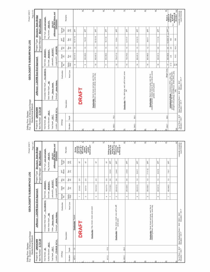
2.0-
4.0
5.0-
7.0
10.0
-12.
0
15.0
-17.
0
17.0
-18.
5
20.0
-21.
5
25.0
-26.
5
30.0
-31.
5
35.0
-36.
5
40.0
-41.
5
45.0
-46.
5
0-0-
0
2-4-
6
2-5-
9
5-9-
11
7-11
-12
6-8-
10
7-5-
7
Bor
ing
adva
nced
with
4.2
5"au
gers
@ 1
NQ
cor
ing
syst
emut
ilize
d to
sam
ple
bedr
ock
@ 3
Dril
ling
mud
adde
d to
the
borin
g at
ade
pth
of 1
7.0
ft be
low
the
grou
ndsu
rface
@ 1
7
427.
3
411.
3
403.
3
1.0
17.0
25.0
Ove
rbur
den:
Top
soil.
Ove
rbur
den:
Cla
y, b
row
n, m
oist
, som
e sa
nd.
Ove
rbur
den:
Cla
y, b
row
n, m
oist
, ver
y so
ft to
stif
f,so
me
sand
.
Ove
rbur
den:
San
d, b
row
n an
d gr
ay, w
et, f
ine
tom
ediu
m g
rain
ed, v
ery
loos
e to
den
se, s
ome
clay
.
1 2 3 4 1 2 3 4 5 6 7
2.0
2.0
2.0
0.5
0.6
0.8
0.8
1.0
1.5
1.5
1.5
Elev
atio
nD
epth
Std/
KyR
QD
Lith
olog
y
5 10 15 20 25 30 35 40 45 50
5 10 15 20 25 30 35 40 45 50
Dep
th(ft
)SP
TBl
ows
Sam
ple
Type
Rec (ft)
Geo
logi
st
Jam
es A
dam
s
Hol
e Ty
pe
core
and
sam
ple
Rec (%
)
Rec
.(ft
)Sa
mpl
eN
o.
Run (ft)
Des
crip
tion
Ove
rbur
den
Roc
k C
ore
SDI
(JS)
Rem
arks
Rig
_Num
ber
1050
ATV
Hol
e N
umbe
r 59
Surfa
ce E
leva
tion
428.
3'
Tota
l Dep
th
125.
7'
End
Dat
e 08
/30/
2011
Latit
ude(
83)
38.3
3707
7
Long
itude
(83)
-8
5.63
6758
Star
t Dat
e 08
/29/
2011
Dril
ler
Dan
ny J
essi
e
GEO
LOG
IST'
S SU
BSUR
FACE
LO
G
GQ
-121
1Je
ffers
onvi
lle, N
ew A
lban
y, a
ndC
harle
stow
n
Stat
ic W
ater
Dep
th
NA
Loui
sville
Lim
esto
neLa
urel
Dol
omite
Imm
edia
te W
ater
Dep
th
15.2
(08/
29/1
1)
Loca
tion
172+
84.9
6 6
.0' L
t.
Base
Wea
ther
ed R
ock
= 9
6.6'
Elev
atio
n =
331.
7'To
p of
Roc
k =
95.
6'El
evat
ion
= 33
2.7'
RD
Z =
96.
6'El
evat
ion
= 33
1.7'
Prin
ted:
9/3
0/11
Page
1 o
f 3
Dril
ling
Firm
: Sta
ntec
For:
Div
isio
n of
Stru
ctur
al D
esig
nG
eote
chni
cal B
ranc
h
Proj
ect T
ype:
Str
uctu
re S
tate
Brid
gePr
ojec
t Man
ager
: M
ark
Litk
enhu
sPr
ojec
t ID
: U
NK
NO
WN
Item
Num
ber:
5-7
31.0
0Je
ffers
on -
LSIO
RB
Eas
t End
App
roac
h
ST ST ST ST SPT
SPT
SPT
SPT
SPT
SPT
SPT
DR
AFT
98.2
50.0
-51.
5
55.0
-56.
5
60.0
-61.
5
65.0
-66.
5
70.0
-71.
5
75.0
-76.
5
80.0
-81.
5
85.0
-86.
5
90.0
-91.
5
95.0
-95.
6
2.6
10.0
10-1
7-15
7-8-
10
15-1
3-14
16-1
1-8
0-0-
4
5-17
-17
8-12
-13
8-8-
11
7-11
-19
15-5
0/0.
10'
100
100
Roc
k in
botto
m o
fsp
lit-s
poon
@ 9
5-96
wea
ther
ed @
95.6
-96.
6
358.
3
348.
3
332.
7
70.0
80.0
95.6
Ove
rbur
den:
San
d, b
row
n an
d gr
ay, w
et, f
ine
tom
ediu
m g
rain
ed, v
ery
loos
e to
den
se, s
ome
clay
.
Ove
rbur
den:
Cla
y, d
ark
gray
, wet
, sof
t to
hard
, som
esi
lt.
Ove
rbur
den:
San
d, b
row
n to
gra
y, w
et, f
ine
tom
ediu
m g
rain
ed, m
ediu
m d
ense
to v
ery
dens
e, p
oorly
grad
ed, s
ome
grav
el.
Lim
esto
ne &
Sha
le: L
imes
tone
(60%
), gr
ay, f
ine
grai
ned,
har
d, th
in to
med
ium
bed
ded,
sha
le s
treak
s,st
ringe
rs a
nd p
artin
gs, f
ossi
lifer
ous.
Sha
le (4
0%),
gray
,si
lty.
(Beg
in C
ore)
8 9 10 11 12 13 14 15 16 17 0 / 0
24 /
22
1.5
1.5
1.5
1.5
1.5
1.5
1.5
1.2
0.8
0.6
2.6
10.0
Elev
atio
nD
epth
Std/
KyR
QD
Lith
olog
y
55 60 65 70 75 80 85 90 95 100
55 60 65 70 75 80 85 90 95 100
Dep
th(ft
)SP
TBl
ows
Sam
ple
Type
Rec (ft)
Geo
logi
st
Jam
es A
dam
s
Hol
e Ty
pe
core
and
sam
ple
Rec (%
)
Rec
.(ft
)Sa
mpl
eN
o.
Run (ft)
Des
crip
tion
Ove
rbur
den
Roc
k C
ore
SDI
(JS)
Rem
arks
Rig
_Num
ber
1050
ATV
Hol
e N
umbe
r 59
Surfa
ce E
leva
tion
428.
3'
Tota
l Dep
th
125.
7'
End
Dat
e 08
/30/
2011
Latit
ude(
83)
38.3
3707
7
Long
itude
(83)
-8
5.63
6758
Star
t Dat
e 08
/29/
2011
Dril
ler
Dan
ny J
essi
e
GEO
LOG
IST'
S SU
BSUR
FACE
LO
G
GQ
-121
1Je
ffers
onvi
lle, N
ew A
lban
y, a
ndC
harle
stow
n
Stat
ic W
ater
Dep
th
NA
Loui
sville
Lim
esto
neLa
urel
Dol
omite
Imm
edia
te W
ater
Dep
th
15.2
(08/
29/1
1)
Loca
tion
172+
84.9
6 6
.0' L
t.
Base
Wea
ther
ed R
ock
= 9
6.6'
Elev
atio
n =
331.
7'To
p of
Roc
k =
95.
6'El
evat
ion
= 33
2.7'
RD
Z =
96.
6'El
evat
ion
= 33
1.7'
Prin
ted:
9/3
0/11
Page
2 o
f 3
Dril
ling
Firm
: Sta
ntec
For:
Div
isio
n of
Stru
ctur
al D
esig
nG
eote
chni
cal B
ranc
h
Proj
ect T
ype:
Str
uctu
re S
tate
Brid
gePr
ojec
t Man
ager
: M
ark
Litk
enhu
sPr
ojec
t ID
: U
NK
NO
WN
Item
Num
ber:
5-7
31.0
0Je
ffers
on -
LSIO
RB
Eas
t End
App
roac
h
SPT
SPT
SPT
SPT
SPT
SPT
SPT
SPT
SPT
SPT
DR
AFT
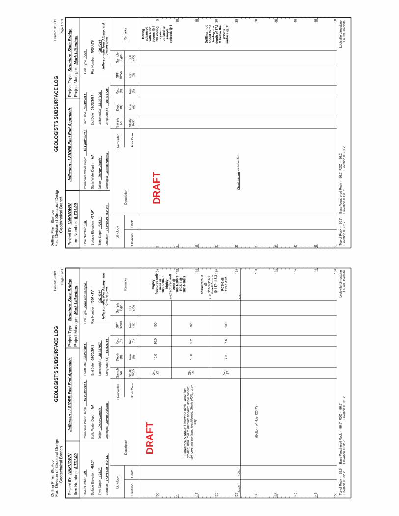
108.
2
118.
2
125.
7
10.0
10.0
7.5
100
92 100
high
lyfr
actu
red
soft
zone
@10
3.5-
104.
5hi
ghly
frac
ture
d so
ftzo
ne @
106.
1-10
6.9
RC
S-1
@10
7.4-
108.
2
foss
ilife
rous
@11
5.9-
116.
2fo
ssili
fero
us@
117
-117
.3
RC
S-2
@12
1.1-
122
302.
612
5.7
Lim
esto
ne &
Sha
le: L
imes
tone
(60%
), gr
ay, f
ine
grai
ned,
har
d, th
in to
med
ium
bed
ded,
sha
le s
treak
s,st
ringe
rs a
nd p
artin
gs, f
ossi
lifer
ous.
Sha
le (4
0%),
gray
,si
lty.
24 /
22 29 /
29 57 /
57
(Bot
tom
of H
ole
125.
7')
10.0
9.2
7.5
Elev
atio
nD
epth
Std/
KyR
QD
Lith
olog
y
105
110
115
120
125
130
135
140
145
150
105
110
115
120
125
130
135
140
145
150
Dep
th(ft
)SP
TBl
ows
Sam
ple
Type
Rec (ft)
Geo
logi
st
Jam
es A
dam
s
Hol
e Ty
pe
core
and
sam
ple
Rec (%
)
Rec
.(ft
)Sa
mpl
eN
o.
Run (ft)
Des
crip
tion
Ove
rbur
den
Roc
k C
ore
SDI
(JS)
Rem
arks
Rig
_Num
ber
1050
ATV
Hol
e N
umbe
r 59
Surfa
ce E
leva
tion
428.
3'
Tota
l Dep
th
125.
7'
End
Dat
e 08
/30/
2011
Latit
ude(
83)
38.3
3707
7
Long
itude
(83)
-8
5.63
6758
Star
t Dat
e 08
/29/
2011
Dril
ler
Dan
ny J
essi
e
GEO
LOG
IST'
S SU
BSUR
FACE
LO
G
GQ
-121
1Je
ffers
onvi
lle, N
ew A
lban
y, a
ndC
harle
stow
n
Stat
ic W
ater
Dep
th
NA
Loui
sville
Lim
esto
neLa
urel
Dol
omite
Imm
edia
te W
ater
Dep
th
15.2
(08/
29/1
1)
Loca
tion
172+
84.9
6 6
.0' L
t.
Base
Wea
ther
ed R
ock
= 9
6.6'
Elev
atio
n =
331.
7'To
p of
Roc
k =
95.
6'El
evat
ion
= 33
2.7'
RD
Z =
96.
6'El
evat
ion
= 33
1.7'
Prin
ted:
9/3
0/11
Page
3 o
f 3
Dril
ling
Firm
: Sta
ntec
For:
Div
isio
n of
Stru
ctur
al D
esig
nG
eote
chni
cal B
ranc
h
Proj
ect T
ype:
Str
uctu
re S
tate
Brid
gePr
ojec
t Man
ager
: M
ark
Litk
enhu
sPr
ojec
t ID
: U
NK
NO
WN
Item
Num
ber:
5-7
31.0
0Je
ffers
on -
LSIO
RB
Eas
t End
App
roac
h
DR
AFT
Bor
ing
adva
nced
with
4.2
5"au
gers
@ 1
NQ
cor
ing
syst
emut
ilize
d to
sam
ple
bedr
ock
@ 3
Dril
ling
mud
adde
d to
the
borin
g at
ade
pth
of 1
7.0
ft be
low
the
grou
ndsu
rface
@ 1
7
Ove
rbur
den:
ove
rbur
den.
Elev
atio
nD
epth
Std/
KyR
QD
Lith
olog
y
5 10 15 20 25 30 35 40 45 50
5 10 15 20 25 30 35 40 45 50
Dep
th(ft
)SP
TBl
ows
Sam
ple
Type
Rec (ft)
Geo
logi
st
Jam
es A
dam
s
Hol
e Ty
pe
core
Rec (%
)
Rec
.(ft
)Sa
mpl
eN
o.
Run (ft)
Des
crip
tion
Ove
rbur
den
Roc
k C
ore
SDI
(JS)
Rem
arks
Rig
_Num
ber
1050
ATV
Hol
e N
umbe
r 60
Surfa
ce E
leva
tion
427.
9'
Tota
l Dep
th
125.
6'
End
Dat
e 08
/30/
2011
Latit
ude(
83)
38.3
3710
0
Long
itude
(83)
-8
5.63
6728
Star
t Dat
e 08
/30/
2011
Dril
ler
Dan
ny J
essi
e
GEO
LOG
IST'
S SU
BSUR
FACE
LO
G
GQ
-121
1Je
ffers
onvi
lle, N
ew A
lban
y, a
ndC
harle
stow
n
Stat
ic W
ater
Dep
th
NA
Loui
sville
Lim
esto
neLa
urel
Dol
omite
Imm
edia
te W
ater
Dep
th
16.4
(08/
30/1
1)
Loca
tion
172+
84.9
6 6
.0' R
t.
Base
Wea
ther
ed R
ock
= 9
6.2'
Elev
atio
n =
331.
7'To
p of
Roc
k =
95.
2'El
evat
ion
= 33
2.7'
RD
Z =
96.
2'El
evat
ion
= 33
1.7'
Prin
ted:
9/3
0/11
Page
1 o
f 3
Dril
ling
Firm
: Sta
ntec
For:
Div
isio
n of
Stru
ctur
al D
esig
nG
eote
chni
cal B
ranc
h
Proj
ect T
ype:
Str
uctu
re S
tate
Brid
gePr
ojec
t Man
ager
: M
ark
Litk
enhu
sPr
ojec
t ID
: U
NK
NO
WN
Item
Num
ber:
5-7
31.0
0Je
ffers
on -
LSIO
RB
Eas
t End
App
roac
h
DR
AFT
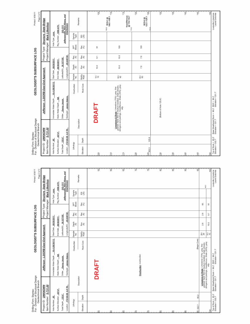
98.0
2.8
10.0
93 91
332.
795
.2
Ove
rbur
den:
ove
rbur
den.
Lim
esto
ne &
Sha
le: L
imes
tone
(70%
), gr
ay, f
ine
grai
ned,
har
d, th
in to
med
ium
bed
ded,
sha
le s
treak
s,st
ringe
rs a
nd p
artin
gs, f
ossi
lifer
ous.
Sha
le (3
0%),
gray
,si
lty.
(Beg
in C
ore)
29 /
29 10 /
10
2.6
9.1
Elev
atio
nD
epth
Std/
KyR
QD
Lith
olog
y
55 60 65 70 75 80 85 90 95 100
55 60 65 70 75 80 85 90 95 100
Dep
th(ft
)SP
TBl
ows
Sam
ple
Type
Rec (ft)
Geo
logi
st
Jam
es A
dam
s
Hol
e Ty
pe
core
Rec (%
)
Rec
.(ft
)Sa
mpl
eN
o.
Run (ft)
Des
crip
tion
Ove
rbur
den
Roc
k C
ore
SDI
(JS)
Rem
arks
Rig
_Num
ber
1050
ATV
Hol
e N
umbe
r 60
Surfa
ce E
leva
tion
427.
9'
Tota
l Dep
th
125.
6'
End
Dat
e 08
/30/
2011
Latit
ude(
83)
38.3
3710
0
Long
itude
(83)
-8
5.63
6728
Star
t Dat
e 08
/30/
2011
Dril
ler
Dan
ny J
essi
e
GEO
LOG
IST'
S SU
BSUR
FACE
LO
G
GQ
-121
1Je
ffers
onvi
lle, N
ew A
lban
y, a
ndC
harle
stow
n
Stat
ic W
ater
Dep
th
NA
Loui
sville
Lim
esto
neLa
urel
Dol
omite
Imm
edia
te W
ater
Dep
th
16.4
(08/
30/1
1)
Loca
tion
172+
84.9
6 6
.0' R
t.
Base
Wea
ther
ed R
ock
= 9
6.2'
Elev
atio
n =
331.
7'To
p of
Roc
k =
95.
2'El
evat
ion
= 33
2.7'
RD
Z =
96.
2'El
evat
ion
= 33
1.7'
Prin
ted:
9/3
0/11
Page
2 o
f 3
Dril
ling
Firm
: Sta
ntec
For:
Div
isio
n of
Stru
ctur
al D
esig
nG
eote
chni
cal B
ranc
h
Proj
ect T
ype:
Str
uctu
re S
tate
Brid
gePr
ojec
t Man
ager
: M
ark
Litk
enhu
sPr
ojec
t ID
: U
NK
NO
WN
Item
Num
ber:
5-7
31.0
0Je
ffers
on -
LSIO
RB
Eas
t End
App
roac
h
DR
AFT
108.
0
118.
0
125.
6
10.0
10.0
7.6
91 100
100
RC
S-1
@10
8.1-
109.
1
foss
ilife
rous
@ 1
16-1
16.7
RC
S-2
@12
3.1-
124.
130
2.3
125.
6
Lim
esto
ne &
Sha
le: L
imes
tone
(70%
), gr
ay, f
ine
grai
ned,
har
d, th
in to
med
ium
bed
ded,
sha
le s
treak
s,st
ringe
rs a
nd p
artin
gs, f
ossi
lifer
ous.
Sha
le (3
0%),
gray
,si
lty.
10 /
10 50 /
45 83 /
83
(Bot
tom
of H
ole
125.
6')
9.1
10.0
7.6
Elev
atio
nD
epth
Std/
KyR
QD
Lith
olog
y
105
110
115
120
125
130
135
140
145
150
105
110
115
120
125
130
135
140
145
150
Dep
th(ft
)SP
TBl
ows
Sam
ple
Type
Rec (ft)
Geo
logi
st
Jam
es A
dam
s
Hol
e Ty
pe
core
Rec (%
)
Rec
.(ft
)Sa
mpl
eN
o.
Run (ft)
Des
crip
tion
Ove
rbur
den
Roc
k C
ore
SDI
(JS)
Rem
arks
Rig
_Num
ber
1050
ATV
Hol
e N
umbe
r 60
Surfa
ce E
leva
tion
427.
9'
Tota
l Dep
th
125.
6'
End
Dat
e 08
/30/
2011
Latit
ude(
83)
38.3
3710
0
Long
itude
(83)
-8
5.63
6728
Star
t Dat
e 08
/30/
2011
Dril
ler
Dan
ny J
essi
e
GEO
LOG
IST'
S SU
BSUR
FACE
LO
G
GQ
-121
1Je
ffers
onvi
lle, N
ew A
lban
y, a
ndC
harle
stow
n
Stat
ic W
ater
Dep
th
NA
Loui
sville
Lim
esto
neLa
urel
Dol
omite
Imm
edia
te W
ater
Dep
th
16.4
(08/
30/1
1)
Loca
tion
172+
84.9
6 6
.0' R
t.
Base
Wea
ther
ed R
ock
= 9
6.2'
Elev
atio
n =
331.
7'To
p of
Roc
k =
95.
2'El
evat
ion
= 33
2.7'
RD
Z =
96.
2'El
evat
ion
= 33
1.7'
Prin
ted:
9/3
0/11
Page
3 o
f 3
Dril
ling
Firm
: Sta
ntec
For:
Div
isio
n of
Stru
ctur
al D
esig
nG
eote
chni
cal B
ranc
h
Proj
ect T
ype:
Str
uctu
re S
tate
Brid
gePr
ojec
t Man
ager
: M
ark
Litk
enhu
sPr
ojec
t ID
: U
NK
NO
WN
Item
Num
ber:
5-7
31.0
0Je
ffers
on -
LSIO
RB
Eas
t End
App
roac
h
DR
AFT
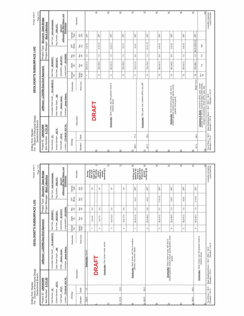
2.0-
4.0
5.0-
7.0
10.0
-12.
0
15.0
-17.
0
20.0
-21.
5
25.0
-26.
5
30.0
-31.
5
35.0
-36.
5
40.0
-41.
5
45.0
-46.
5
0-0-
1
4-5-
7
7-10
-12
5-6-
7
4-5-
8
5-10
-8
Bor
ing
adva
nced
with
4.2
5"au
gers
@ 1
NQ
cor
ing
syst
emut
ilize
d to
sam
ple
bedr
ock
@ 3
Dril
ling
mud
adde
d to
the
borin
g at
ade
pth
of 2
0.0
ft be
low
the
grou
ndsu
rface
@ 2
0
426.
9
412.
9
402.
9
382.
9
1.0
15.0
25.0
45.0
Ove
rbur
den:
tops
oil.
Ove
rbur
den:
Cla
y, b
row
n, m
oist
, san
dy.
Ove
rbur
den:
San
d, b
row
n, w
et, f
ine
to m
ediu
mgr
aine
d, v
ery
loos
e, c
laye
y.
Ove
rbur
den:
San
d, b
row
n to
gra
y, w
et, f
ine
tom
ediu
m g
rain
ed, m
ediu
m d
ense
, poo
rly g
rade
d, s
ome
grav
el.
Ove
rbur
den:
San
d, b
row
n, w
et, f
ine
grai
ned,
loos
e to
med
ium
den
se.
1 2 3 4 1 2 3 4 5 6
2.0
2.0
2.0
0.5
0.7
0.8
0.7
1.3
1.5
1.5
Elev
atio
nD
epth
Std/
KyR
QD
Lith
olog
y
5 10 15 20 25 30 35 40 45 50
5 10 15 20 25 30 35 40 45 50
Dep
th(ft
)SP
TBl
ows
Sam
ple
Type
Rec (ft)
Geo
logi
st
Jam
es A
dam
s
Hol
e Ty
pe
core
and
sam
ple
Rec (%
)
Rec
.(ft
)Sa
mpl
eN
o.
Run (ft)
Des
crip
tion
Ove
rbur
den
Roc
k C
ore
SDI
(JS)
Rem
arks
Rig
_Num
ber
1050
ATV
Hol
e N
umbe
r 61
Surfa
ce E
leva
tion
427.
9'
Tota
l Dep
th
137.
0'
End
Dat
e 08
/31/
2011
Latit
ude(
83)
38.3
3721
7
Long
itude
(83)
-8
5.63
6566
Star
t Dat
e 08
/30/
2011
Dril
ler
Dan
ny J
essi
e
GEO
LOG
IST'
S SU
BSUR
FACE
LO
G
GQ
-121
1Je
ffers
onvi
lle, N
ew A
lban
y, a
ndC
harle
stow
n
Stat
ic W
ater
Dep
th
NA
Loui
sville
Lim
esto
neLa
urel
Dol
omite
Imm
edia
te W
ater
Dep
th
18.3
(08/
30/1
1)
Loca
tion
172+
84.9
6 6
9.0'
Rt.
Base
Wea
ther
ed R
ock
= 9
6.5'
Elev
atio
n =
331.
4'To
p of
Roc
k =
96.
5'El
evat
ion
= 33
1.4'
RD
Z =
96.
5'El
evat
ion
= 33
1.4'
Prin
ted:
9/3
0/11
Page
1 o
f 3
Dril
ling
Firm
: Sta
ntec
For:
Div
isio
n of
Stru
ctur
al D
esig
nG
eote
chni
cal B
ranc
h
Proj
ect T
ype:
Str
uctu
re S
tate
Brid
gePr
ojec
t Man
ager
: M
ark
Litk
enhu
sPr
ojec
t ID
: U
NK
NO
WN
Item
Num
ber:
5-7
31.0
0Je
ffers
on -
LSIO
RB
Eas
t End
App
roac
h
ST ST ST ST SPT
SPT
SPT
SPT
SPT
SPT
DR
AFT
50.0
-51.
5
55.0
-56.
5
60.0
-61.
5
65.0
-66.
5
70.0
-71.
5
75.0
-76.
5
80.0
-81.
5
85.0
-86.
5
90.0
-91.
5
95.0
-96.
1
7.5
3-5-
10
3-10
-12
12-9
-17
10-7
-4
4-2-
4
10-1
1-17
4-8-
12
3-5-
10
0-8-
10
26-3
1-50
/0.1
0'
100
356.
7
351.
7
331.
4
71.2
76.2
96.5
Ove
rbur
den:
San
d, b
row
n, w
et, f
ine
grai
ned,
loos
e to
med
ium
den
se.
Ove
rbur
den:
Cla
y, g
ray,
wet
, med
ium
stif
f to
very
stif
f.
Ove
rbur
den:
San
d, b
row
n to
gra
y, w
et, f
ine
tom
ediu
m g
rain
ed, m
ediu
m d
ense
to d
ense
, poo
rlygr
aded
, som
e gr
avel
.
Lim
esto
ne &
Sha
le: L
imes
tone
(60%
), gr
ay, c
oars
egr
aine
d, h
ard,
thin
to m
ediu
m b
edde
d, s
hale
stre
aks,
strin
gers
and
par
tings
. Sha
le (4
0%),
gray
, silt
y.
(Beg
in C
ore)
7 8 9 10 11 12 13 14 15 16 64 /
64
1.5
1.5
1.5
1.5
0.6
1.5
0.8
0.9
1.5
1.0
7.5
Elev
atio
nD
epth
Std/
KyR
QD
Lith
olog
y
55 60 65 70 75 80 85 90 95 100
55 60 65 70 75 80 85 90 95 100
Dep
th(ft
)SP
TBl
ows
Sam
ple
Type
Rec (ft)
Geo
logi
st
Jam
es A
dam
s
Hol
e Ty
pe
core
and
sam
ple
Rec (%
)
Rec
.(ft
)Sa
mpl
eN
o.
Run (ft)
Des
crip
tion
Ove
rbur
den
Roc
k C
ore
SDI
(JS)
Rem
arks
Rig
_Num
ber
1050
ATV
Hol
e N
umbe
r 61
Surfa
ce E
leva
tion
427.
9'
Tota
l Dep
th
137.
0'
End
Dat
e 08
/31/
2011
Latit
ude(
83)
38.3
3721
7
Long
itude
(83)
-8
5.63
6566
Star
t Dat
e 08
/30/
2011
Dril
ler
Dan
ny J
essi
e
GEO
LOG
IST'
S SU
BSUR
FACE
LO
G
GQ
-121
1Je
ffers
onvi
lle, N
ew A
lban
y, a
ndC
harle
stow
n
Stat
ic W
ater
Dep
th
NA
Loui
sville
Lim
esto
neLa
urel
Dol
omite
Imm
edia
te W
ater
Dep
th
18.3
(08/
30/1
1)
Loca
tion
172+
84.9
6 6
9.0'
Rt.
Base
Wea
ther
ed R
ock
= 9
6.5'
Elev
atio
n =
331.
4'To
p of
Roc
k =
96.
5'El
evat
ion
= 33
1.4'
RD
Z =
96.
5'El
evat
ion
= 33
1.4'
Prin
ted:
9/3
0/11
Page
2 o
f 3
Dril
ling
Firm
: Sta
ntec
For:
Div
isio
n of
Stru
ctur
al D
esig
nG
eote
chni
cal B
ranc
h
Proj
ect T
ype:
Str
uctu
re S
tate
Brid
gePr
ojec
t Man
ager
: M
ark
Litk
enhu
sPr
ojec
t ID
: U
NK
NO
WN
Item
Num
ber:
5-7
31.0
0Je
ffers
on -
LSIO
RB
Eas
t End
App
roac
h
SPT
SPT
SPT
SPT
SPT
SPT
SPT
SPT
SPT
SPT
DR
AFT
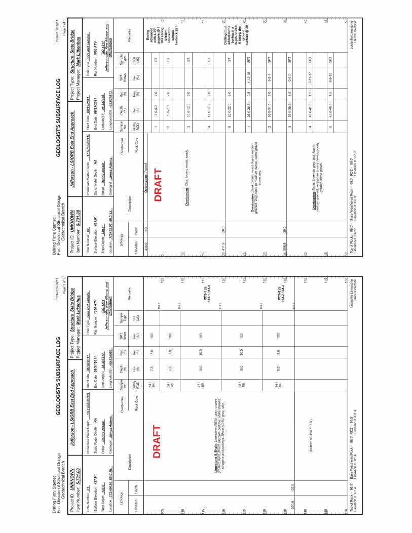
104.
0
109.
0
119.
0
129.
0
137.
0
7.5
5.0
10.0
10.0
8.0
100
100
100
100
100
RC
S-1
@11
5.1-
115.
9
RC
S-2
@13
3.2-
134.
2
290.
913
7.0
Lim
esto
ne &
Sha
le: L
imes
tone
(60%
), gr
ay, c
oars
egr
aine
d, h
ard,
thin
to m
ediu
m b
edde
d, s
hale
stre
aks,
strin
gers
and
par
tings
. Sha
le (4
0%),
gray
, silt
y.
64 /
64 54 /
48 77 /
69 93 /
89 84 /
84
(Bot
tom
of H
ole
137.
0')
7.5
5.0
10.0
10.0
8.0
Elev
atio
nD
epth
Std/
KyR
QD
Lith
olog
y
105
110
115
120
125
130
135
140
145
150
105
110
115
120
125
130
135
140
145
150
Dep
th(ft
)SP
TBl
ows
Sam
ple
Type
Rec (ft)
Geo
logi
st
Jam
es A
dam
s
Hol
e Ty
pe
core
and
sam
ple
Rec (%
)
Rec
.(ft
)Sa
mpl
eN
o.
Run (ft)
Des
crip
tion
Ove
rbur
den
Roc
k C
ore
SDI
(JS)
Rem
arks
Rig
_Num
ber
1050
ATV
Hol
e N
umbe
r 61
Surfa
ce E
leva
tion
427.
9'
Tota
l Dep
th
137.
0'
End
Dat
e 08
/31/
2011
Latit
ude(
83)
38.3
3721
7
Long
itude
(83)
-8
5.63
6566
Star
t Dat
e 08
/30/
2011
Dril
ler
Dan
ny J
essi
e
GEO
LOG
IST'
S SU
BSUR
FACE
LO
G
GQ
-121
1Je
ffers
onvi
lle, N
ew A
lban
y, a
ndC
harle
stow
n
Stat
ic W
ater
Dep
th
NA
Loui
sville
Lim
esto
neLa
urel
Dol
omite
Imm
edia
te W
ater
Dep
th
18.3
(08/
30/1
1)
Loca
tion
172+
84.9
6 6
9.0'
Rt.
Base
Wea
ther
ed R
ock
= 9
6.5'
Elev
atio
n =
331.
4'To
p of
Roc
k =
96.
5'El
evat
ion
= 33
1.4'
RD
Z =
96.
5'El
evat
ion
= 33
1.4'
Prin
ted:
9/3
0/11
Page
3 o
f 3
Dril
ling
Firm
: Sta
ntec
For:
Div
isio
n of
Stru
ctur
al D
esig
nG
eote
chni
cal B
ranc
h
Proj
ect T
ype:
Str
uctu
re S
tate
Brid
gePr
ojec
t Man
ager
: M
ark
Litk
enhu
sPr
ojec
t ID
: U
NK
NO
WN
Item
Num
ber:
5-7
31.0
0Je
ffers
on -
LSIO
RB
Eas
t End
App
roac
h
DR
AFT
2.0-
4.0
5.0-
7.0
10.0
-12.
0
15.0
-17.
0
20.0
-22.
0
25.0
-26.
5
30.0
-31.
5
35.0
-36.
5
40.0
-41.
5
45.0
-46.
5
4-12
-18
3-2-
1
0-0-
0
7-11
-17
8-9-
15
Bor
ing
adva
nced
with
4.2
5"au
gers
@ 1
NQ
cor
ing
syst
emut
ilize
d to
sam
ple
bedr
ock
@ 3
Dril
ling
mud
adde
d to
the
borin
g at
ade
pth
of 2
0.0
ft be
low
the
grou
ndsu
rface
@ 2
0
430.
9
411.
9
396.
9
1.0
20.0
35.0
Ove
rbur
den:
Top
soil.
Ove
rbur
den:
Cla
y, b
row
n, m
oist
, san
dy.
Ove
rbur
den:
San
d, b
row
n, m
oist
, fin
e to
med
ium
grai
ned,
ver
y lo
ose
to m
ediu
m d
ense
, som
e gr
avel
,so
me
clay
.
Ove
rbur
den:
San
d, b
row
n to
gra
y, w
et, f
ine
tom
ediu
m g
rain
ed, v
ery
loos
e to
ver
y de
nse,
poo
rlygr
aded
, som
e gr
avel
.
1 2 3 4 5 1 2 3 4 5
2.0
2.0
2.0
2.0
2.0
0.8
1.0
1.5
1.5
1.5
Elev
atio
nD
epth
Std/
KyR
QD
Lith
olog
y
5 10 15 20 25 30 35 40 45 50
5 10 15 20 25 30 35 40 45 50
Dep
th(ft
)SP
TBl
ows
Sam
ple
Type
Rec (ft)
Geo
logi
st
Jam
es A
dam
s
Hol
e Ty
pe
core
and
sam
ple
Rec (%
)
Rec
.(ft
)Sa
mpl
eN
o.
Run (ft)
Des
crip
tion
Ove
rbur
den
Roc
k C
ore
SDI
(JS)
Rem
arks
Rig
_Num
ber
1050
ATV
Hol
e N
umbe
r 62
Surfa
ce E
leva
tion
431.
9'
Tota
l Dep
th
139.
8'
End
Dat
e 08
/22/
2011
Latit
ude(
83)
38.3
3748
5
Long
itude
(83)
-8
5.63
7613
Star
t Dat
e 08
/19/
2011
Dril
ler
Dan
ny J
essi
e
GEO
LOG
IST'
S SU
BSUR
FACE
LO
G
GQ
-121
1Je
ffers
onvi
lle, N
ew A
lban
y, a
ndC
harle
stow
n
Stat
ic W
ater
Dep
th
NA
Loui
sville
Lim
esto
neLa
urel
Dol
omite
Imm
edia
te W
ater
Dep
th
17.5
(08/
23/1
1)
Loca
tion
175+
59.9
6 8
6.0'
Lt.
Base
Wea
ther
ed R
ock
= 9
9.0'
Elev
atio
n =
332.
9'To
p of
Roc
k =
99.
0'El
evat
ion
= 33
2.9'
RD
Z =
99.
0'El
evat
ion
= 33
2.9'
Prin
ted:
9/3
0/11
Page
1 o
f 3
Dril
ling
Firm
: Sta
ntec
For:
Div
isio
n of
Stru
ctur
al D
esig
nG
eote
chni
cal B
ranc
h
Proj
ect T
ype:
Str
uctu
re S
tate
Brid
gePr
ojec
t Man
ager
: M
ark
Litk
enhu
sPr
ojec
t ID
: U
NK
NO
WN
Item
Num
ber:
5-7
31.0
0Je
ffers
on -
LSIO
RB
Eas
t End
App
roac
h
ST ST ST ST ST SPT
SPT
SPT
SPT
SPT
DR
AFT
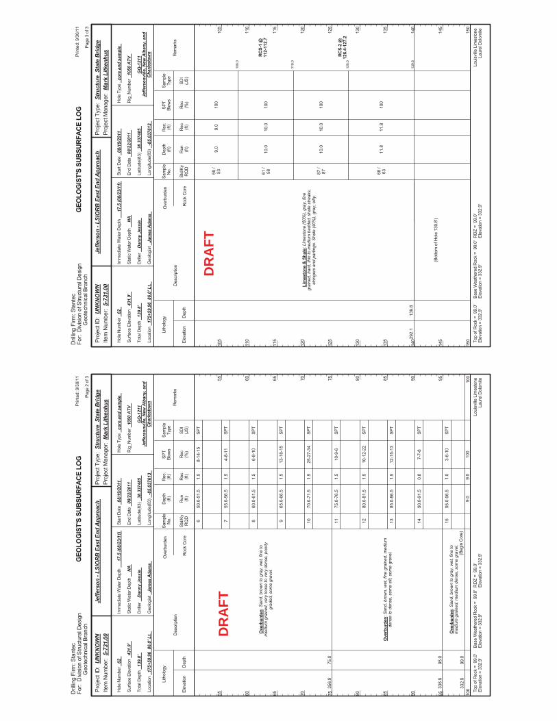
50.0
-51.
5
55.0
-56.
5
60.0
-61.
5
65.0
-66.
5
70.0
-71.
5
75.0
-76.
5
80.0
-81.
5
85.0
-86.
5
90.0
-91.
5
95.0
-96.
5
9.0
8-14
-15
4-8-
11
6-8-
10
13-1
8-15
25-2
7-34
10-9
-6
10-1
2-22
12-1
5-13
7-7-
8
3-6-
10
100
356.
9
336.
9
332.
9
75.0
95.0
99.0
Ove
rbur
den:
San
d, b
row
n to
gra
y, w
et, f
ine
tom
ediu
m g
rain
ed, v
ery
loos
e to
ver
y de
nse,
poo
rlygr
aded
, som
e gr
avel
.
Ove
rbur
den:
San
d, b
row
n, w
et, f
ine
grai
ned,
med
ium
dens
e to
den
se, s
ome
silt,
som
e gr
avel
.
Ove
rbur
den:
San
d, b
row
n to
gra
y, w
et, f
ine
tom
ediu
m g
rain
ed, m
ediu
m d
ense
, som
e gr
avel
.(B
egin
Cor
e)
6 7 8 9 10 11 12 13 14 15
1.5
1.5
1.5
1.5
1.5
1.5
1.5
1.5
0.8
1.0
9.0
Elev
atio
nD
epth
Std/
KyR
QD
Lith
olog
y
55 60 65 70 75 80 85 90 95 100
55 60 65 70 75 80 85 90 95 100
Dep
th(ft
)SP
TBl
ows
Sam
ple
Type
Rec (ft)
Geo
logi
st
Jam
es A
dam
s
Hol
e Ty
pe
core
and
sam
ple
Rec (%
)
Rec
.(ft
)Sa
mpl
eN
o.
Run (ft)
Des
crip
tion
Ove
rbur
den
Roc
k C
ore
SDI
(JS)
Rem
arks
Rig
_Num
ber
1050
ATV
Hol
e N
umbe
r 62
Surfa
ce E
leva
tion
431.
9'
Tota
l Dep
th
139.
8'
End
Dat
e 08
/22/
2011
Latit
ude(
83)
38.3
3748
5
Long
itude
(83)
-8
5.63
7613
Star
t Dat
e 08
/19/
2011
Dril
ler
Dan
ny J
essi
e
GEO
LOG
IST'
S SU
BSUR
FACE
LO
G
GQ
-121
1Je
ffers
onvi
lle, N
ew A
lban
y, a
ndC
harle
stow
n
Stat
ic W
ater
Dep
th
NA
Loui
sville
Lim
esto
neLa
urel
Dol
omite
Imm
edia
te W
ater
Dep
th
17.5
(08/
23/1
1)
Loca
tion
175+
59.9
6 8
6.0'
Lt.
Base
Wea
ther
ed R
ock
= 9
9.0'
Elev
atio
n =
332.
9'To
p of
Roc
k =
99.
0'El
evat
ion
= 33
2.9'
RD
Z =
99.
0'El
evat
ion
= 33
2.9'
Prin
ted:
9/3
0/11
Page
2 o
f 3
Dril
ling
Firm
: Sta
ntec
For:
Div
isio
n of
Stru
ctur
al D
esig
nG
eote
chni
cal B
ranc
h
Proj
ect T
ype:
Str
uctu
re S
tate
Brid
gePr
ojec
t Man
ager
: M
ark
Litk
enhu
sPr
ojec
t ID
: U
NK
NO
WN
Item
Num
ber:
5-7
31.0
0Je
ffers
on -
LSIO
RB
Eas
t End
App
roac
h
SPT
SPT
SPT
SPT
SPT
SPT
SPT
SPT
SPT
SPT
DR
AFT
108.
0
118.
0
128.
0
139.
8
9.0
10.0
10.0
11.8
100
100
100
100
RC
S-1
@11
2-11
2.7
RC
S-2
@12
6.4-
127.
2
292.
113
9.8
Lim
esto
ne &
Sha
le: L
imes
tone
(60%
), gr
ay, f
ine
grai
ned,
har
d, th
in to
med
ium
bed
ded,
sha
le s
treak
s,st
ringe
rs a
nd p
artin
gs. S
hale
(40%
), gr
ay, s
ilty.
59 /
53 61 /
58 87 /
87 68 /
63
(Bot
tom
of H
ole
139.
8')
9.0
10.0
10.0
11.8
Elev
atio
nD
epth
Std/
KyR
QD
Lith
olog
y
105
110
115
120
125
130
135
140
145
150
105
110
115
120
125
130
135
140
145
150
Dep
th(ft
)SP
TBl
ows
Sam
ple
Type
Rec (ft)
Geo
logi
st
Jam
es A
dam
s
Hol
e Ty
pe
core
and
sam
ple
Rec (%
)
Rec
.(ft
)Sa
mpl
eN
o.
Run (ft)
Des
crip
tion
Ove
rbur
den
Roc
k C
ore
SDI
(JS)
Rem
arks
Rig
_Num
ber
1050
ATV
Hol
e N
umbe
r 62
Surfa
ce E
leva
tion
431.
9'
Tota
l Dep
th
139.
8'
End
Dat
e 08
/22/
2011
Latit
ude(
83)
38.3
3748
5
Long
itude
(83)
-8
5.63
7613
Star
t Dat
e 08
/19/
2011
Dril
ler
Dan
ny J
essi
e
GEO
LOG
IST'
S SU
BSUR
FACE
LO
G
GQ
-121
1Je
ffers
onvi
lle, N
ew A
lban
y, a
ndC
harle
stow
n
Stat
ic W
ater
Dep
th
NA
Loui
sville
Lim
esto
neLa
urel
Dol
omite
Imm
edia
te W
ater
Dep
th
17.5
(08/
23/1
1)
Loca
tion
175+
59.9
6 8
6.0'
Lt.
Base
Wea
ther
ed R
ock
= 9
9.0'
Elev
atio
n =
332.
9'To
p of
Roc
k =
99.
0'El
evat
ion
= 33
2.9'
RD
Z =
99.
0'El
evat
ion
= 33
2.9'
Prin
ted:
9/3
0/11
Page
3 o
f 3
Dril
ling
Firm
: Sta
ntec
For:
Div
isio
n of
Stru
ctur
al D
esig
nG
eote
chni
cal B
ranc
h
Proj
ect T
ype:
Str
uctu
re S
tate
Brid
gePr
ojec
t Man
ager
: M
ark
Litk
enhu
sPr
ojec
t ID
: U
NK
NO
WN
Item
Num
ber:
5-7
31.0
0Je
ffers
on -
LSIO
RB
Eas
t End
App
roac
h
DR
AFT
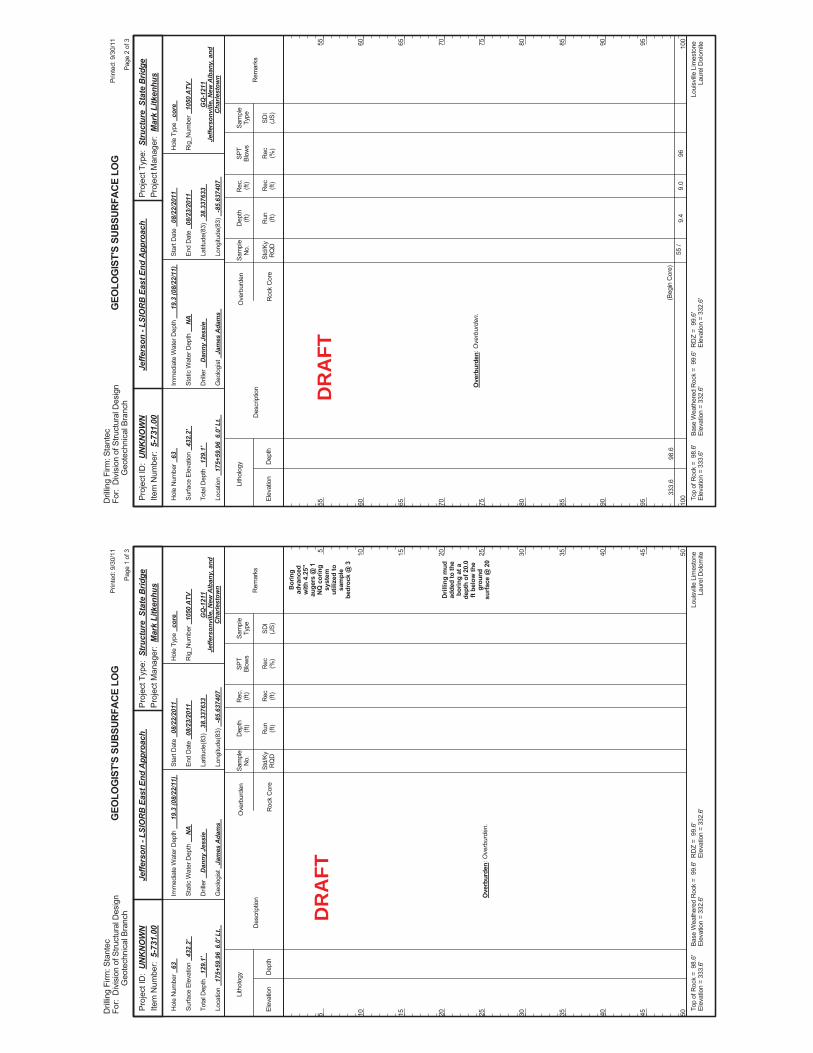
Bor
ing
adva
nced
with
4.2
5"au
gers
@ 1
NQ
cor
ing
syst
emut
ilize
d to
sam
ple
bedr
ock
@ 3
Dril
ling
mud
adde
d to
the
borin
g at
ade
pth
of 2
0.0
ft be
low
the
grou
ndsu
rface
@ 2
0O
verb
urde
n: O
verb
urde
n.
Elev
atio
nD
epth
Std/
KyR
QD
Lith
olog
y
5 10 15 20 25 30 35 40 45 50
5 10 15 20 25 30 35 40 45 50
Dep
th(ft
)SP
TBl
ows
Sam
ple
Type
Rec (ft)
Geo
logi
st
Jam
es A
dam
s
Hol
e Ty
pe
core
Rec (%
)
Rec
.(ft
)Sa
mpl
eN
o.
Run (ft)
Des
crip
tion
Ove
rbur
den
Roc
k C
ore
SDI
(JS)
Rem
arks
Rig
_Num
ber
1050
ATV
Hol
e N
umbe
r 63
Surfa
ce E
leva
tion
432.
2'
Tota
l Dep
th
129.
1'
End
Dat
e 08
/23/
2011
Latit
ude(
83)
38.3
3763
3
Long
itude
(83)
-8
5.63
7407
Star
t Dat
e 08
/22/
2011
Dril
ler
Dan
ny J
essi
e
GEO
LOG
IST'
S SU
BSUR
FACE
LO
G
GQ
-121
1Je
ffers
onvi
lle, N
ew A
lban
y, a
ndC
harle
stow
n
Stat
ic W
ater
Dep
th
NA
Loui
sville
Lim
esto
neLa
urel
Dol
omite
Imm
edia
te W
ater
Dep
th
19.3
(08/
22/1
1)
Loca
tion
175+
59.9
6 6
.0' L
t.
Base
Wea
ther
ed R
ock
= 9
9.6'
Elev
atio
n =
332.
6'To
p of
Roc
k =
98.
6'El
evat
ion
= 33
3.6'
RD
Z =
99.
6'El
evat
ion
= 33
2.6'
Prin
ted:
9/3
0/11
Page
1 o
f 3
Dril
ling
Firm
: Sta
ntec
For:
Div
isio
n of
Stru
ctur
al D
esig
nG
eote
chni
cal B
ranc
h
Proj
ect T
ype:
Str
uctu
re S
tate
Brid
gePr
ojec
t Man
ager
: M
ark
Litk
enhu
sPr
ojec
t ID
: U
NK
NO
WN
Item
Num
ber:
5-7
31.0
0Je
ffers
on -
LSIO
RB
Eas
t End
App
roac
h
DR
AFT
9.4
9633
3.6
98.6
Ove
rbur
den:
Ove
rbur
den.
(Beg
in C
ore)
55 /
9.0
Elev
atio
nD
epth
Std/
KyR
QD
Lith
olog
y
55 60 65 70 75 80 85 90 95 100
55 60 65 70 75 80 85 90 95 100
Dep
th(ft
)SP
TBl
ows
Sam
ple
Type
Rec (ft)
Geo
logi
st
Jam
es A
dam
s
Hol
e Ty
pe
core
Rec (%
)
Rec
.(ft
)Sa
mpl
eN
o.
Run (ft)
Des
crip
tion
Ove
rbur
den
Roc
k C
ore
SDI
(JS)
Rem
arks
Rig
_Num
ber
1050
ATV
Hol
e N
umbe
r 63
Surfa
ce E
leva
tion
432.
2'
Tota
l Dep
th
129.
1'
End
Dat
e 08
/23/
2011
Latit
ude(
83)
38.3
3763
3
Long
itude
(83)
-8
5.63
7407
Star
t Dat
e 08
/22/
2011
Dril
ler
Dan
ny J
essi
e
GEO
LOG
IST'
S SU
BSUR
FACE
LO
G
GQ
-121
1Je
ffers
onvi
lle, N
ew A
lban
y, a
ndC
harle
stow
n
Stat
ic W
ater
Dep
th
NA
Loui
sville
Lim
esto
neLa
urel
Dol
omite
Imm
edia
te W
ater
Dep
th
19.3
(08/
22/1
1)
Loca
tion
175+
59.9
6 6
.0' L
t.
Base
Wea
ther
ed R
ock
= 9
9.6'
Elev
atio
n =
332.
6'To
p of
Roc
k =
98.
6'El
evat
ion
= 33
3.6'
RD
Z =
99.
6'El
evat
ion
= 33
2.6'
Prin
ted:
9/3
0/11
Page
2 o
f 3
Dril
ling
Firm
: Sta
ntec
For:
Div
isio
n of
Stru
ctur
al D
esig
nG
eote
chni
cal B
ranc
h
Proj
ect T
ype:
Str
uctu
re S
tate
Brid
gePr
ojec
t Man
ager
: M
ark
Litk
enhu
sPr
ojec
t ID
: U
NK
NO
WN
Item
Num
ber:
5-7
31.0
0Je
ffers
on -
LSIO
RB
Eas
t End
App
roac
h
DR
AFT
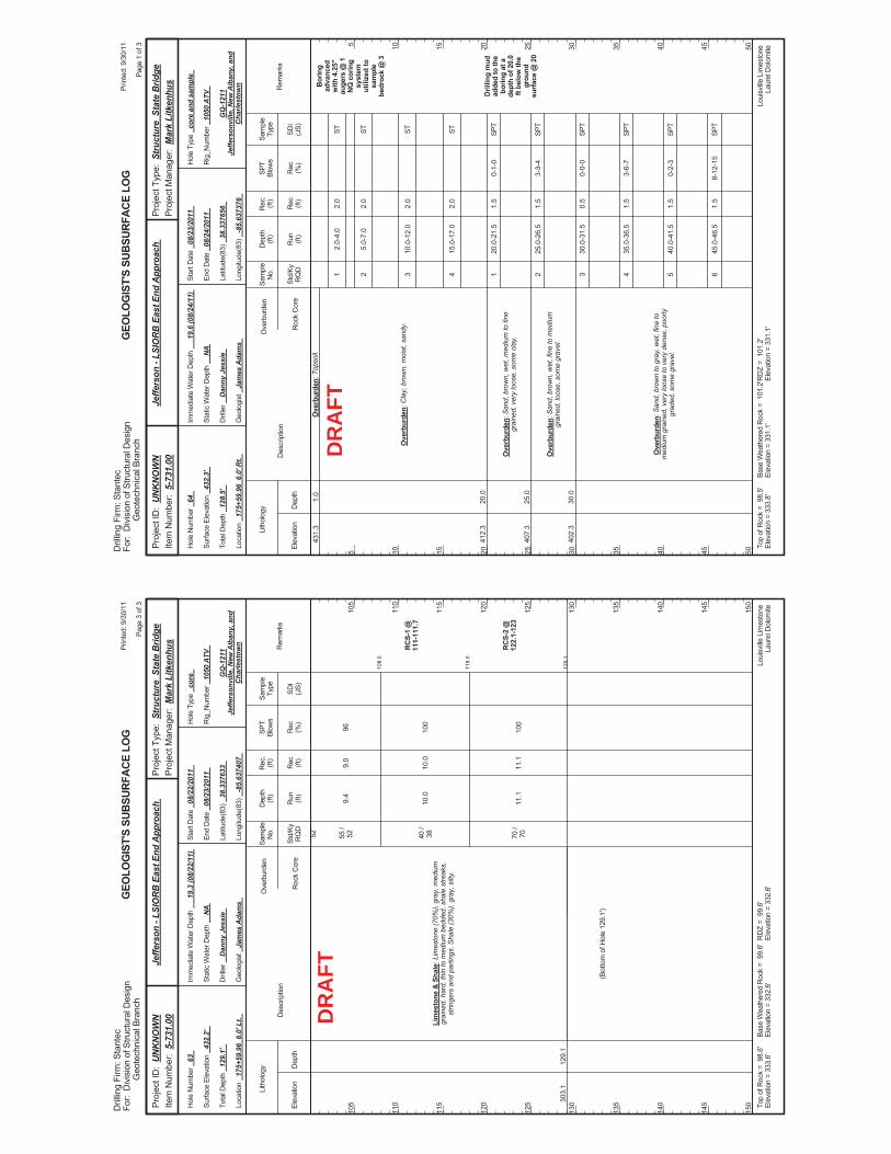
108.
0
118.
0
129.
1
9.4
10.0
11.1
96 100
100
RC
S-1
@11
1-11
1.7
RC
S-2
@12
2.1-
123
303.
112
9.1
Lim
esto
ne &
Sha
le: L
imes
tone
(70%
), gr
ay, m
ediu
mgr
aine
d, h
ard,
thin
to m
ediu
m b
edde
d, s
hale
stre
aks,
strin
gers
and
par
tings
. Sha
le (3
0%),
gray
, silt
y.
52 55 /
52 40 /
38 70 /
70
(Bot
tom
of H
ole
129.
1')
9.0
10.0
11.1
Elev
atio
nD
epth
Std/
KyR
QD
Lith
olog
y
105
110
115
120
125
130
135
140
145
150
105
110
115
120
125
130
135
140
145
150
Dep
th(ft
)SP
TBl
ows
Sam
ple
Type
Rec (ft)
Geo
logi
st
Jam
es A
dam
s
Hol
e Ty
pe
core
Rec (%
)
Rec
.(ft
)Sa
mpl
eN
o.
Run (ft)
Des
crip
tion
Ove
rbur
den
Roc
k C
ore
SDI
(JS)
Rem
arks
Rig
_Num
ber
1050
ATV
Hol
e N
umbe
r 63
Surfa
ce E
leva
tion
432.
2'
Tota
l Dep
th
129.
1'
End
Dat
e 08
/23/
2011
Latit
ude(
83)
38.3
3763
3
Long
itude
(83)
-8
5.63
7407
Star
t Dat
e 08
/22/
2011
Dril
ler
Dan
ny J
essi
e
GEO
LOG
IST'
S SU
BSUR
FACE
LO
G
GQ
-121
1Je
ffers
onvi
lle, N
ew A
lban
y, a
ndC
harle
stow
n
Stat
ic W
ater
Dep
th
NA
Loui
sville
Lim
esto
neLa
urel
Dol
omite
Imm
edia
te W
ater
Dep
th
19.3
(08/
22/1
1)
Loca
tion
175+
59.9
6 6
.0' L
t.
Base
Wea
ther
ed R
ock
= 9
9.6'
Elev
atio
n =
332.
6'To
p of
Roc
k =
98.
6'El
evat
ion
= 33
3.6'
RD
Z =
99.
6'El
evat
ion
= 33
2.6'
Prin
ted:
9/3
0/11
Page
3 o
f 3
Dril
ling
Firm
: Sta
ntec
For:
Div
isio
n of
Stru
ctur
al D
esig
nG
eote
chni
cal B
ranc
h
Proj
ect T
ype:
Str
uctu
re S
tate
Brid
gePr
ojec
t Man
ager
: M
ark
Litk
enhu
sPr
ojec
t ID
: U
NK
NO
WN
Item
Num
ber:
5-7
31.0
0Je
ffers
on -
LSIO
RB
Eas
t End
App
roac
h
DR
AFT
2.0-
4.0
5.0-
7.0
10.0
-12.
0
15.0
-17.
0
20.0
-21.
5
25.0
-26.
5
30.0
-31.
5
35.0
-36.
5
40.0
-41.
5
45.0
-46.
5
0-1-
0
3-3-
4
0-0-
0
3-6-
7
0-2-
3
8-12
-15
Bor
ing
adva
nced
with
4.2
5"au
gers
@ 1
NQ
cor
ing
syst
emut
ilize
d to
sam
ple
bedr
ock
@ 3
Dril
ling
mud
adde
d to
the
borin
g at
ade
pth
of 2
0.0
ft be
low
the
grou
ndsu
rface
@ 2
0
431.
3
412.
3
407.
3
402.
3
1.0
20.0
25.0
30.0
Ove
rbur
den:
Top
soil.
Ove
rbur
den:
Cla
y, b
row
n, m
oist
, san
dy.
Ove
rbur
den:
San
d, b
row
n, w
et, m
ediu
m to
fine
grai
ned,
ver
y lo
ose,
som
e cl
ay.
Ove
rbur
den:
San
d, b
row
n, w
et, f
ine
to m
ediu
mgr
aine
d, lo
ose,
som
e gr
avel
.
Ove
rbur
den:
San
d, b
row
n to
gra
y, w
et, f
ine
tom
ediu
m g
rain
ed, v
ery
loos
e to
ver
y de
nse,
poo
rlygr
aded
, som
e gr
avel
.
1 2 3 4 1 2 3 4 5 6
2.0
2.0
2.0
2.0
1.5
1.5
0.5
1.5
1.5
1.5
Elev
atio
nD
epth
Std/
KyR
QD
Lith
olog
y
5 10 15 20 25 30 35 40 45 50
5 10 15 20 25 30 35 40 45 50
Dep
th(ft
)SP
TBl
ows
Sam
ple
Type
Rec (ft)
Geo
logi
st
Jam
es A
dam
s
Hol
e Ty
pe
core
and
sam
ple
Rec (%
)
Rec
.(ft
)Sa
mpl
eN
o.
Run (ft)
Des
crip
tion
Ove
rbur
den
Roc
k C
ore
SDI
(JS)
Rem
arks
Rig
_Num
ber
1050
ATV
Hol
e N
umbe
r 64
Surfa
ce E
leva
tion
432.
3'
Tota
l Dep
th
128.
5'
End
Dat
e 08
/24/
2011
Latit
ude(
83)
38.3
3765
6
Long
itude
(83)
-8
5.63
7376
Star
t Dat
e 08
/23/
2011
Dril
ler
Dan
ny J
essi
e
GEO
LOG
IST'
S SU
BSUR
FACE
LO
G
GQ
-121
1Je
ffers
onvi
lle, N
ew A
lban
y, a
ndC
harle
stow
n
Stat
ic W
ater
Dep
th
NA
Loui
sville
Lim
esto
neLa
urel
Dol
omite
Imm
edia
te W
ater
Dep
th
19.6
(08/
24/1
1)
Loca
tion
175+
59.9
6 6
.0' R
t.
Base
Wea
ther
ed R
ock
= 1
01.2
'El
evat
ion
= 33
1.1'
Top
ofR
ock
= 9
8.5'
Elev
atio
n =
333.
8'R
DZ
= 1
01.2
'El
evat
ion
= 33
1.1'
Prin
ted:
9/3
0/11
Page
1 o
f 3
Dril
ling
Firm
: Sta
ntec
For:
Div
isio
n of
Stru
ctur
al D
esig
nG
eote
chni
cal B
ranc
h
Proj
ect T
ype:
Str
uctu
re S
tate
Brid
gePr
ojec
t Man
ager
: M
ark
Litk
enhu
sPr
ojec
t ID
: U
NK
NO
WN
Item
Num
ber:
5-7
31.0
0Je
ffers
on -
LSIO
RB
Eas
t End
App
roac
h
ST ST ST ST SPT
SPT
SPT
SPT
SPT
SPT
DR
AFT
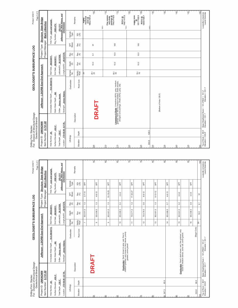
50.0
-51.
5
55.0
-56.
5
60.0
-61.
5
65.0
-66.
5
70.0
-71.
5
75.0
-76.
5
80.0
-81.
5
85.0
-86.
5
90.0
-91.
5
95.0
-96.
5
10.0
3-7-
14
4-6-
12
10-1
8-25
4-4-
4
17-3
0-27
8-9-
12
6-10
-12
4-6-
13
0-0-
0
3-3-
5
91
347.
3
333.
8
85.0
98.5
Ove
rbur
den:
San
d, b
row
n to
gra
y, w
et, f
ine
tom
ediu
m g
rain
ed, v
ery
loos
e to
ver
y de
nse,
poo
rlygr
aded
, som
e gr
avel
.
Ove
rbur
den:
San
d, d
ark
brow
n, w
et, f
ine
grai
ned,
ver
ylo
ose
to m
ediu
m d
ense
, som
e si
lt, s
ome
grav
el.
(Beg
in C
ore)
7 8 9 10 11 12 13 14 15 16 26 /
1.5
1.5
1.5
0.4
1.0
0.6
1.0
0.7
0.2
0.8
9.1
Elev
atio
nD
epth
Std/
KyR
QD
Lith
olog
y
55 60 65 70 75 80 85 90 95 100
55 60 65 70 75 80 85 90 95 100
Dep
th(ft
)SP
TBl
ows
Sam
ple
Type
Rec (ft)
Geo
logi
st
Jam
es A
dam
s
Hol
e Ty
pe
core
and
sam
ple
Rec (%
)
Rec
.(ft
)Sa
mpl
eN
o.
Run (ft)
Des
crip
tion
Ove
rbur
den
Roc
k C
ore
SDI
(JS)
Rem
arks
Rig
_Num
ber
1050
ATV
Hol
e N
umbe
r 64
Surfa
ce E
leva
tion
432.
3'
Tota
l Dep
th
128.
5'
End
Dat
e 08
/24/
2011
Latit
ude(
83)
38.3
3765
6
Long
itude
(83)
-8
5.63
7376
Star
t Dat
e 08
/23/
2011
Dril
ler
Dan
ny J
essi
e
GEO
LOG
IST'
S SU
BSUR
FACE
LO
G
GQ
-121
1Je
ffers
onvi
lle, N
ew A
lban
y, a
ndC
harle
stow
n
Stat
ic W
ater
Dep
th
NA
Loui
sville
Lim
esto
neLa
urel
Dol
omite
Imm
edia
te W
ater
Dep
th
19.6
(08/
24/1
1)
Loca
tion
175+
59.9
6 6
.0' R
t.
Base
Wea
ther
ed R
ock
= 1
01.2
'El
evat
ion
= 33
1.1'
Top
ofR
ock
= 9
8.5'
Elev
atio
n =
333.
8'R
DZ
= 1
01.2
'El
evat
ion
= 33
1.1'
Prin
ted:
9/3
0/11
Page
2 o
f 3
Dril
ling
Firm
: Sta
ntec
For:
Div
isio
n of
Stru
ctur
al D
esig
nG
eote
chni
cal B
ranc
h
Proj
ect T
ype:
Str
uctu
re S
tate
Brid
gePr
ojec
t Man
ager
: M
ark
Litk
enhu
sPr
ojec
t ID
: U
NK
NO
WN
Item
Num
ber:
5-7
31.0
0Je
ffers
on -
LSIO
RB
Eas
t End
App
roac
h
SPT
SPT
SPT
SPT
SPT
SPT
SPT
SPT
SPT
SPT
DR
AFT
108.
5
118.
5
128.
5
10.0
10.0
10.0
91 100
100
high
lyfr
actu
red
zone
@10
0.2-
101.
2
Cla
y se
ams
and
shal
epa
rtin
gs @
110.
3-11
2.8
RC
S-1
@11
6.7-
117.
5
vugg
y zo
ne@
121.
7-12
2.5
RC
S-2
@12
4.9-
125.
7
303.
812
8.5
Lim
esto
ne &
Sha
le: L
imes
tone
(60%
), gr
ay, m
ediu
mgr
aine
d, h
ard,
thin
to m
ediu
m b
edde
d, s
hale
stre
aks,
strin
gers
and
par
tings
. Sha
le (4
0%),
gray
, silt
y.
20 26 /
20 56 /
45 78 /
76
(Bot
tom
of H
ole
128.
5')
9.1
10.0
10.0
Elev
atio
nD
epth
Std/
KyR
QD
Lith
olog
y
105
110
115
120
125
130
135
140
145
150
105
110
115
120
125
130
135
140
145
150
Dep
th(ft
)SP
TBl
ows
Sam
ple
Type
Rec (ft)
Geo
logi
st
Jam
es A
dam
s
Hol
e Ty
pe
core
and
sam
ple
Rec (%
)
Rec
.(ft
)Sa
mpl
eN
o.
Run (ft)
Des
crip
tion
Ove
rbur
den
Roc
k C
ore
SDI
(JS)
Rem
arks
Rig
_Num
ber
1050
ATV
Hol
e N
umbe
r 64
Surfa
ce E
leva
tion
432.
3'
Tota
l Dep
th
128.
5'
End
Dat
e 08
/24/
2011
Latit
ude(
83)
38.3
3765
6
Long
itude
(83)
-8
5.63
7376
Star
t Dat
e 08
/23/
2011
Dril
ler
Dan
ny J
essi
e
GEO
LOG
IST'
S SU
BSUR
FACE
LO
G
GQ
-121
1Je
ffers
onvi
lle, N
ew A
lban
y, a
ndC
harle
stow
n
Stat
ic W
ater
Dep
th
NA
Loui
sville
Lim
esto
neLa
urel
Dol
omite
Imm
edia
te W
ater
Dep
th
19.6
(08/
24/1
1)
Loca
tion
175+
59.9
6 6
.0' R
t.
Base
Wea
ther
ed R
ock
= 1
01.2
'El
evat
ion
= 33
1.1'
Top
ofR
ock
= 9
8.5'
Elev
atio
n =
333.
8'R
DZ
= 1
01.2
'El
evat
ion
= 33
1.1'
Prin
ted:
9/3
0/11
Page
3 o
f 3
Dril
ling
Firm
: Sta
ntec
For:
Div
isio
n of
Stru
ctur
al D
esig
nG
eote
chni
cal B
ranc
h
Proj
ect T
ype:
Str
uctu
re S
tate
Brid
gePr
ojec
t Man
ager
: M
ark
Litk
enhu
sPr
ojec
t ID
: U
NK
NO
WN
Item
Num
ber:
5-7
31.0
0Je
ffers
on -
LSIO
RB
Eas
t End
App
roac
h
DR
AFT
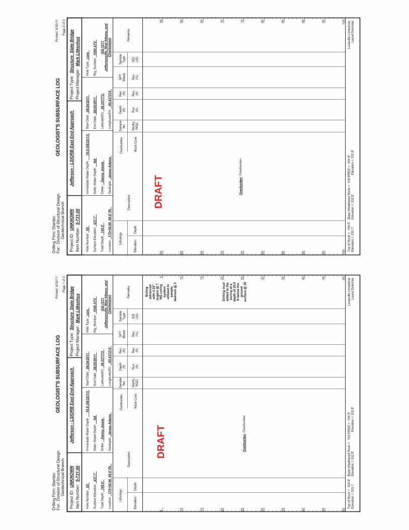
Bor
ing
adva
nced
with
4.2
5"au
gers
@ 1
NQ
cor
ing
syst
emut
ilize
d to
sam
ple
bedr
ock
@ 3
Dril
ling
mud
adde
d to
the
borin
g at
ade
pth
of 2
0.0
ft be
low
the
grou
ndsu
rface
@ 2
0O
verb
urde
n: O
verb
urde
n.
Elev
atio
nD
epth
Std/
KyR
QD
Lith
olog
y
5 10 15 20 25 30 35 40 45 50
5 10 15 20 25 30 35 40 45 50
Dep
th(ft
)SP
TBl
ows
Sam
ple
Type
Rec (ft)
Geo
logi
st
Jam
es A
dam
s
Hol
e Ty
pe
core
Rec (%
)
Rec
.(ft
)Sa
mpl
eN
o.
Run (ft)
Des
crip
tion
Ove
rbur
den
Roc
k C
ore
SDI
(JS)
Rem
arks
Rig
_Num
ber
1050
ATV
Hol
e N
umbe
r 65
Surfa
ce E
leva
tion
437.
7'
Tota
l Dep
th
145.
6'
End
Dat
e 08
/25/
2011
Latit
ude(
83)
38.3
3777
3
Long
itude
(83)
-8
5.63
7215
Star
t Dat
e 08
/24/
2011
Dril
ler
Dan
ny J
essi
e
GEO
LOG
IST'
S SU
BSUR
FACE
LO
G
GQ
-121
1Je
ffers
onvi
lle, N
ew A
lban
y, a
ndC
harle
stow
n
Stat
ic W
ater
Dep
th
NA
Loui
sville
Lim
esto
neLa
urel
Dol
omite
Imm
edia
te W
ater
Dep
th
19.8
(08/
25/1
1)
Loca
tion
175+
59.9
6 6
9.0'
Rt.
Base
Wea
ther
ed R
ock
= 1
04.9
'El
evat
ion
= 33
2.8'
Top
ofR
ock
= 1
04.6
'El
evat
ion
= 33
3.1'
RD
Z =
104
.9'
Elev
atio
n =
332.
8'
Prin
ted:
9/3
0/11
Page
1 o
f 3
Dril
ling
Firm
: Sta
ntec
For:
Div
isio
n of
Stru
ctur
al D
esig
nG
eote
chni
cal B
ranc
h
Proj
ect T
ype:
Str
uctu
re S
tate
Brid
gePr
ojec
t Man
ager
: M
ark
Litk
enhu
sPr
ojec
t ID
: U
NK
NO
WN
Item
Num
ber:
5-7
31.0
0Je
ffers
on -
LSIO
RB
Eas
t End
App
roac
h
DR
AFT
Ove
rbur
den:
Ove
rbur
den.
Elev
atio
nD
epth
Std/
KyR
QD
Lith
olog
y
55 60 65 70 75 80 85 90 95 100
55 60 65 70 75 80 85 90 95 100
Dep
th(ft
)SP
TBl
ows
Sam
ple
Type
Rec (ft)
Geo
logi
st
Jam
es A
dam
s
Hol
e Ty
pe
core
Rec (%
)
Rec
.(ft
)Sa
mpl
eN
o.
Run (ft)
Des
crip
tion
Ove
rbur
den
Roc
k C
ore
SDI
(JS)
Rem
arks
Rig
_Num
ber
1050
ATV
Hol
e N
umbe
r 65
Surfa
ce E
leva
tion
437.
7'
Tota
l Dep
th
145.
6'
End
Dat
e 08
/25/
2011
Latit
ude(
83)
38.3
3777
3
Long
itude
(83)
-8
5.63
7215
Star
t Dat
e 08
/24/
2011
Dril
ler
Dan
ny J
essi
e
GEO
LOG
IST'
S SU
BSUR
FACE
LO
G
GQ
-121
1Je
ffers
onvi
lle, N
ew A
lban
y, a
ndC
harle
stow
n
Stat
ic W
ater
Dep
th
NA
Loui
sville
Lim
esto
neLa
urel
Dol
omite
Imm
edia
te W
ater
Dep
th
19.8
(08/
25/1
1)
Loca
tion
175+
59.9
6 6
9.0'
Rt.
Base
Wea
ther
ed R
ock
= 1
04.9
'El
evat
ion
= 33
2.8'
Top
ofR
ock
= 1
04.6
'El
evat
ion
= 33
3.1'
RD
Z =
104
.9'
Elev
atio
n =
332.
8'
Prin
ted:
9/3
0/11
Page
2 o
f 3
Dril
ling
Firm
: Sta
ntec
For:
Div
isio
n of
Stru
ctur
al D
esig
nG
eote
chni
cal B
ranc
h
Proj
ect T
ype:
Str
uctu
re S
tate
Brid
gePr
ojec
t Man
ager
: M
ark
Litk
enhu
sPr
ojec
t ID
: U
NK
NO
WN
Item
Num
ber:
5-7
31.0
0Je
ffers
on -
LSIO
RB
Eas
t End
App
roac
h
DR
AFT
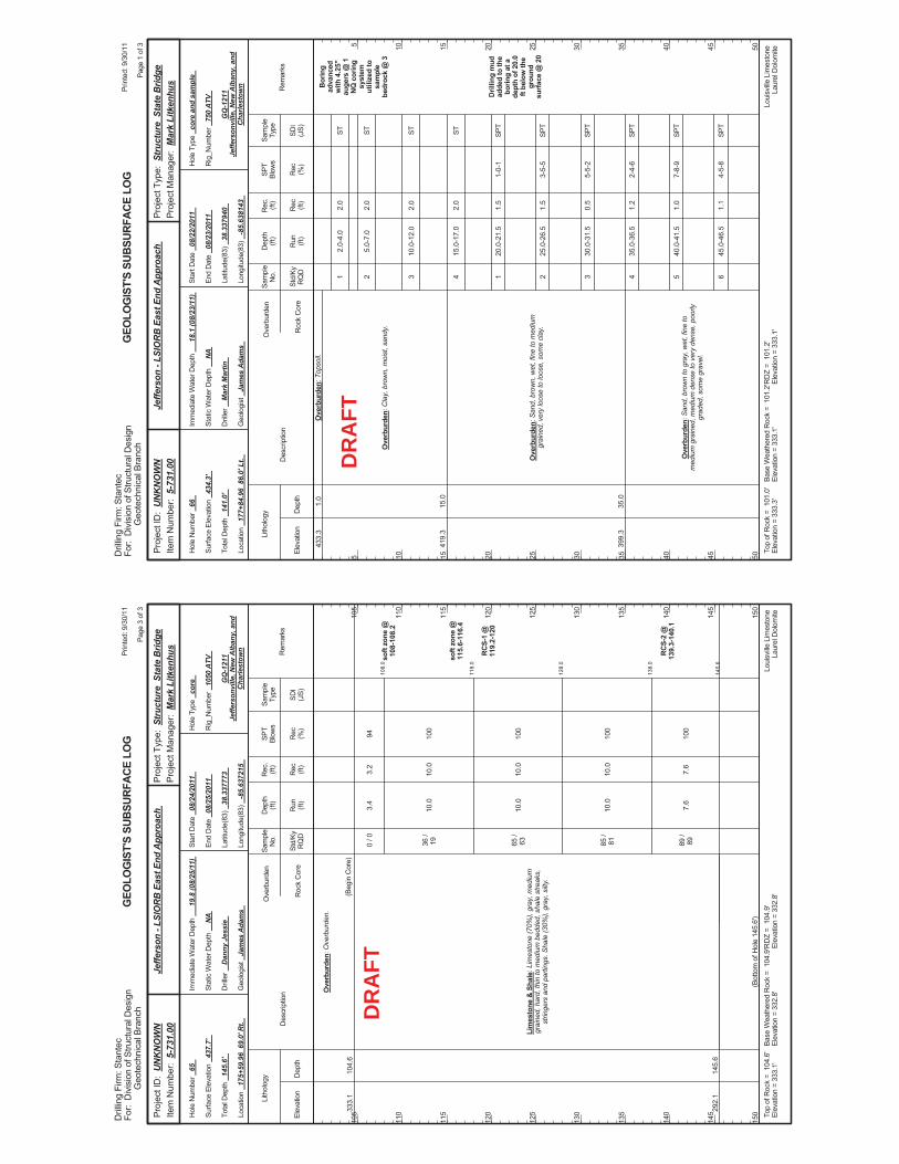
108.
0
118.
0
128.
0
138.
0
145.
6
3.4
10.0
10.0
10.0
7.6
94 100
100
100
100
soft
zone
@10
8-10
8.2
soft
zone
@11
5.6-
116.
4
RC
S-1
@11
9.2-
120
RC
S-2
@13
9.3-
140.
1
333.
1
292.
1
104.
6
145.
6
Ove
rbur
den:
Ove
rbur
den.
Lim
esto
ne &
Sha
le: L
imes
tone
(70%
), gr
ay, m
ediu
mgr
aine
d, h
ard,
thin
to m
ediu
m b
edde
d, s
hale
stre
aks,
strin
gers
and
par
tings
. Sha
le (3
0%),
gray
, silt
y.
(Beg
in C
ore)
0 / 0
36 /
19 65 /
63 85 /
81 89 /
89
(Bot
tom
of H
ole
145.
6')
3.2
10.0
10.0
10.0
7.6
Elev
atio
nD
epth
Std/
KyR
QD
Lith
olog
y
105
110
115
120
125
130
135
140
145
150
105
110
115
120
125
130
135
140
145
150
Dep
th(ft
)SP
TBl
ows
Sam
ple
Type
Rec (ft)
Geo
logi
st
Jam
es A
dam
s
Hol
e Ty
pe
core
Rec (%
)
Rec
.(ft
)Sa
mpl
eN
o.
Run (ft)
Des
crip
tion
Ove
rbur
den
Roc
k C
ore
SDI
(JS)
Rem
arks
Rig
_Num
ber
1050
ATV
Hol
e N
umbe
r 65
Surfa
ce E
leva
tion
437.
7'
Tota
l Dep
th
145.
6'
End
Dat
e 08
/25/
2011
Latit
ude(
83)
38.3
3777
3
Long
itude
(83)
-8
5.63
7215
Star
t Dat
e 08
/24/
2011
Dril
ler
Dan
ny J
essi
e
GEO
LOG
IST'
S SU
BSUR
FACE
LO
G
GQ
-121
1Je
ffers
onvi
lle, N
ew A
lban
y, a
ndC
harle
stow
n
Stat
ic W
ater
Dep
th
NA
Loui
sville
Lim
esto
neLa
urel
Dol
omite
Imm
edia
te W
ater
Dep
th
19.8
(08/
25/1
1)
Loca
tion
175+
59.9
6 6
9.0'
Rt.
Base
Wea
ther
ed R
ock
= 1
04.9
'El
evat
ion
= 33
2.8'
Top
ofR
ock
= 1
04.6
'El
evat
ion
= 33
3.1'
RD
Z =
104
.9'
Elev
atio
n =
332.
8'
Prin
ted:
9/3
0/11
Page
3 o
f 3
Dril
ling
Firm
: Sta
ntec
For:
Div
isio
n of
Stru
ctur
al D
esig
nG
eote
chni
cal B
ranc
h
Proj
ect T
ype:
Str
uctu
re S
tate
Brid
gePr
ojec
t Man
ager
: M
ark
Litk
enhu
sPr
ojec
t ID
: U
NK
NO
WN
Item
Num
ber:
5-7
31.0
0Je
ffers
on -
LSIO
RB
Eas
t End
App
roac
h
DR
AFT
2.0-
4.0
5.0-
7.0
10.0
-12.
0
15.0
-17.
0
20.0
-21.
5
25.0
-26.
5
30.0
-31.
5
35.0
-36.
5
40.0
-41.
5
45.0
-46.
5
1-0-
1
3-5-
5
5-5-
2
2-4-
6
7-8-
9
4-5-
8
Bor
ing
adva
nced
with
4.2
5"au
gers
@ 1
NQ
cor
ing
syst
emut
ilize
d to
sam
ple
bedr
ock
@ 3
Dril
ling
mud
adde
d to
the
borin
g at
ade
pth
of 2
0.0
ft be
low
the
grou
ndsu
rface
@ 2
0
433.
3
419.
3
399.
3
1.0
15.0
35.0
Ove
rbur
den:
Top
soil.
Ove
rbur
den:
Cla
y, b
row
n, m
oist
, san
dy.
Ove
rbur
den:
San
d, b
row
n, w
et, f
ine
to m
ediu
mgr
aine
d, v
ery
loos
e to
loos
e, s
ome
clay
.
Ove
rbur
den:
San
d, b
row
n to
gra
y, w
et, f
ine
tom
ediu
m g
rain
ed, m
ediu
m d
ense
to v
ery
dens
e, p
oorly
grad
ed, s
ome
grav
el.
1 2 3 4 1 2 3 4 5 6
2.0
2.0
2.0
2.0
1.5
1.5
0.5
1.2
1.0
1.1
Elev
atio
nD
epth
Std/
KyR
QD
Lith
olog
y
5 10 15 20 25 30 35 40 45 50
5 10 15 20 25 30 35 40 45 50
Dep
th(ft
)SP
TBl
ows
Sam
ple
Type
Rec (ft)
Geo
logi
st
Jam
es A
dam
s
Hol
e Ty
pe
core
and
sam
ple
Rec (%
)
Rec
.(ft
)Sa
mpl
eN
o.
Run (ft)
Des
crip
tion
Ove
rbur
den
Roc
k C
ore
SDI
(JS)
Rem
arks
Rig
_Num
ber
750
ATV
Hol
e N
umbe
r 66
Surfa
ce E
leva
tion
434.
3'
Tota
l Dep
th
141.
0'
End
Dat
e 08
/23/
2011
Latit
ude(
83)
38.3
3794
0
Long
itude
(83)
-8
5.63
8143
Star
t Dat
e 08
/22/
2011
Dril
ler
Mar
k M
artin
GEO
LOG
IST'
S SU
BSUR
FACE
LO
G
GQ
-121
1Je
ffers
onvi
lle, N
ew A
lban
y, a
ndC
harle
stow
n
Stat
ic W
ater
Dep
th
NA
Loui
sville
Lim
esto
neLa
urel
Dol
omite
Imm
edia
te W
ater
Dep
th
18.1
(08/
23/1
1)
Loca
tion
177+
84.9
6 8
6.0'
Lt.
Base
Wea
ther
ed R
ock
= 1
01.2
'El
evat
ion
= 33
3.1'
Top
ofR
ock
= 1
01.0
'El
evat
ion
= 33
3.3'
RD
Z =
101
.2'
Elev
atio
n =
333.
1'
Prin
ted:
9/3
0/11
Page
1 o
f 3
Dril
ling
Firm
: Sta
ntec
For:
Div
isio
n of
Stru
ctur
al D
esig
nG
eote
chni
cal B
ranc
h
Proj
ect T
ype:
Str
uctu
re S
tate
Brid
gePr
ojec
t Man
ager
: M
ark
Litk
enhu
sPr
ojec
t ID
: U
NK
NO
WN
Item
Num
ber:
5-7
31.0
0Je
ffers
on -
LSIO
RB
Eas
t End
App
roac
h
ST ST ST ST SPT
SPT
SPT
SPT
SPT
SPT
DR
AFT
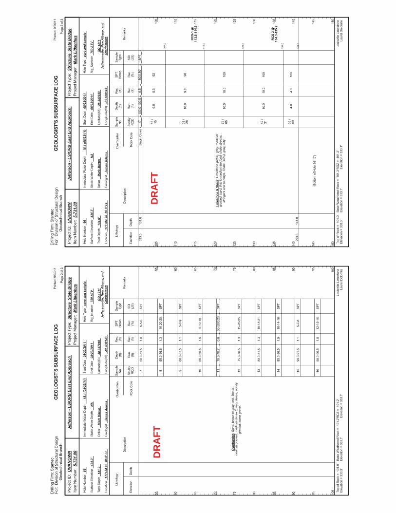
50.0
-51.
5
55.0
-56.
5
60.0
-61.
5
65.0
-66.
5
70.0
-70.
7
75.0
-76.
5
80.0
-81.
5
85.0
-86.
5
90.0
-91.
5
95.0
-96.
5
5-5-
6
10-2
0-20
5-7-
9
5-10
-10
30-5
0/0.
20'
15-2
0-25
10-1
8-21
10-1
4-16
5-7-
8
12-1
5-16
Ove
rbur
den:
San
d, b
row
n to
gra
y, w
et, f
ine
tom
ediu
m g
rain
ed, m
ediu
m d
ense
to v
ery
dens
e, p
oorly
grad
ed, s
ome
grav
el.
7 8 9 10 11 12 13 14 15 16
1.0
1.3
1.1
1.5
0.0
1.3
1.3
1.5
1.1
1.0
Elev
atio
nD
epth
Std/
KyR
QD
Lith
olog
y
55 60 65 70 75 80 85 90 95 100
55 60 65 70 75 80 85 90 95 100
Dep
th(ft
)SP
TBl
ows
Sam
ple
Type
Rec (ft)
Geo
logi
st
Jam
es A
dam
s
Hol
e Ty
pe
core
and
sam
ple
Rec (%
)
Rec
.(ft
)Sa
mpl
eN
o.
Run (ft)
Des
crip
tion
Ove
rbur
den
Roc
k C
ore
SDI
(JS)
Rem
arks
Rig
_Num
ber
750
ATV
Hol
e N
umbe
r 66
Surfa
ce E
leva
tion
434.
3'
Tota
l Dep
th
141.
0'
End
Dat
e 08
/23/
2011
Latit
ude(
83)
38.3
3794
0
Long
itude
(83)
-8
5.63
8143
Star
t Dat
e 08
/22/
2011
Dril
ler
Mar
k M
artin
GEO
LOG
IST'
S SU
BSUR
FACE
LO
G
GQ
-121
1Je
ffers
onvi
lle, N
ew A
lban
y, a
ndC
harle
stow
n
Stat
ic W
ater
Dep
th
NA
Loui
sville
Lim
esto
neLa
urel
Dol
omite
Imm
edia
te W
ater
Dep
th
18.1
(08/
23/1
1)
Loca
tion
177+
84.9
6 8
6.0'
Lt.
Base
Wea
ther
ed R
ock
= 1
01.2
'El
evat
ion
= 33
3.1'
Top
ofR
ock
= 1
01.0
'El
evat
ion
= 33
3.3'
RD
Z =
101
.2'
Elev
atio
n =
333.
1'
Prin
ted:
9/3
0/11
Page
2 o
f 3
Dril
ling
Firm
: Sta
ntec
For:
Div
isio
n of
Stru
ctur
al D
esig
nG
eote
chni
cal B
ranc
h
Proj
ect T
ype:
Str
uctu
re S
tate
Brid
gePr
ojec
t Man
ager
: M
ark
Litk
enhu
sPr
ojec
t ID
: U
NK
NO
WN
Item
Num
ber:
5-7
31.0
0Je
ffers
on -
LSIO
RB
Eas
t End
App
roac
h
SPT
SPT
SPT
SPT
SPT
SPT
SPT
SPT
SPT
SPT
DR
AFT
107.
0
117.
0
127.
0
137.
0
141.
0
100.
0-10
0.5
6.0
10.0
10.0
10.0
4.0
50/0
.50'
92 98 100
100
100
RC
S-1
@11
3.8-
114.
6
RC
S-2
@13
4.3-
135.
2
333.
3
293.
3
101.
0
141.
0
Lim
esto
ne &
Sha
le: L
imes
tone
(60%
), gr
ay, m
ediu
mgr
aine
d, h
ard,
thin
to m
ediu
m b
edde
d, s
hale
stre
aks,
strin
gers
and
par
tings
. Sha
le (4
0%),
gray
, silt
y.
(Beg
in C
ore)
17 15 /
15 32 /
28 72 /
65 42 /
31 68 /
59
(Bot
tom
of H
ole
141.
0')
0.5
5.5
9.8
10.0
10.0
4.0
Elev
atio
nD
epth
Std/
KyR
QD
Lith
olog
y
105
110
115
120
125
130
135
140
145
150
105
110
115
120
125
130
135
140
145
150
Dep
th(ft
)SP
TBl
ows
Sam
ple
Type
Rec (ft)
Geo
logi
st
Jam
es A
dam
s
Hol
e Ty
pe
core
and
sam
ple
Rec (%
)
Rec
.(ft
)Sa
mpl
eN
o.
Run (ft)
Des
crip
tion
Ove
rbur
den
Roc
k C
ore
SDI
(JS)
Rem
arks
Rig
_Num
ber
750
ATV
Hol
e N
umbe
r 66
Surfa
ce E
leva
tion
434.
3'
Tota
l Dep
th
141.
0'
End
Dat
e 08
/23/
2011
Latit
ude(
83)
38.3
3794
0
Long
itude
(83)
-8
5.63
8143
Star
t Dat
e 08
/22/
2011
Dril
ler
Mar
k M
artin
GEO
LOG
IST'
S SU
BSUR
FACE
LO
G
GQ
-121
1Je
ffers
onvi
lle, N
ew A
lban
y, a
ndC
harle
stow
n
Stat
ic W
ater
Dep
th
NA
Loui
sville
Lim
esto
neLa
urel
Dol
omite
Imm
edia
te W
ater
Dep
th
18.1
(08/
23/1
1)
Loca
tion
177+
84.9
6 8
6.0'
Lt.
Base
Wea
ther
ed R
ock
= 1
01.2
'El
evat
ion
= 33
3.1'
Top
ofR
ock
= 1
01.0
'El
evat
ion
= 33
3.3'
RD
Z =
101
.2'
Elev
atio
n =
333.
1'
Prin
ted:
9/3
0/11
Page
3 o
f 3
Dril
ling
Firm
: Sta
ntec
For:
Div
isio
n of
Stru
ctur
al D
esig
nG
eote
chni
cal B
ranc
h
Proj
ect T
ype:
Str
uctu
re S
tate
Brid
gePr
ojec
t Man
ager
: M
ark
Litk
enhu
sPr
ojec
t ID
: U
NK
NO
WN
Item
Num
ber:
5-7
31.0
0Je
ffers
on -
LSIO
RB
Eas
t End
App
roac
h
SPT
DR
AFT
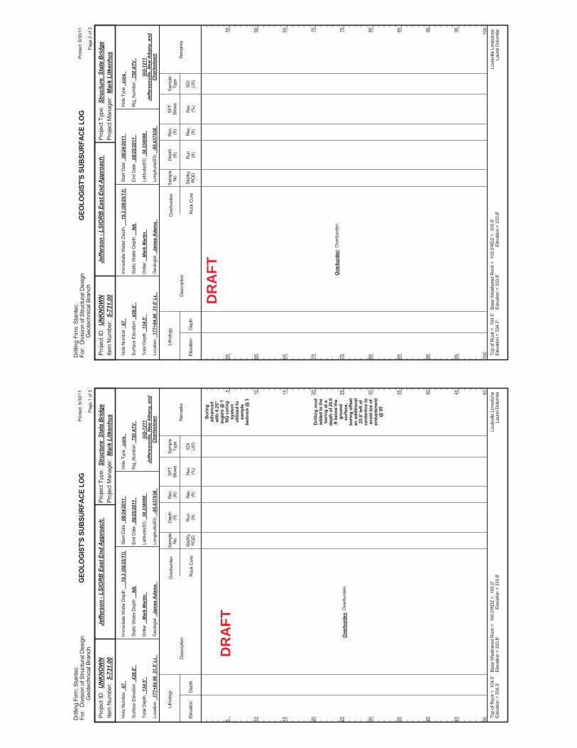
Bor
ing
adva
nced
with
4.2
5"au
gers
@ 1
NQ
cor
ing
syst
emut
ilize
d to
sam
ple
bedr
ock
@ 3
Dril
ling
mud
adde
d to
the
borin
g at
ade
pth
of 2
0.0
ft be
low
the
grou
ndsu
rfac
e,bo
ring
offs
etan
add
ition
al25
.0' l
eft o
fce
nter
line
toav
oid
toe
ofem
bank
men
t@
20
Ove
rbur
den:
Ove
rbur
den.
Elev
atio
nD
epth
Std/
KyR
QD
Lith
olog
y
5 10 15 20 25 30 35 40 45 50
5 10 15 20 25 30 35 40 45 50
Dep
th(ft
)SP
TBl
ows
Sam
ple
Type
Rec (ft)
Geo
logi
st
Jam
es A
dam
s
Hol
e Ty
pe
core
Rec (%
)
Rec
.(ft
)Sa
mpl
eN
o.
Run (ft)
Des
crip
tion
Ove
rbur
den
Roc
k C
ore
SDI
(JS)
Rem
arks
Rig
_Num
ber
750
ATV
Hol
e N
umbe
r 67
Surfa
ce E
leva
tion
438.
8'
Tota
l Dep
th
134.
5'
End
Dat
e 08
/25/
2011
Latit
ude(
83)
38.3
3808
8
Long
itude
(83)
-8
5.63
7938
Star
t Dat
e 08
/24/
2011
Dril
ler
Mar
k M
artin
GEO
LOG
IST'
S SU
BSUR
FACE
LO
G
GQ
-121
1Je
ffers
onvi
lle, N
ew A
lban
y, a
ndC
harle
stow
n
Stat
ic W
ater
Dep
th
NA
Loui
sville
Lim
esto
neLa
urel
Dol
omite
Imm
edia
te W
ater
Dep
th
19.3
(08/
25/1
1)
Loca
tion
177+
84.9
6 3
1.0'
Lt.
Base
Wea
ther
ed R
ock
= 1
05.0
'El
evat
ion
= 33
3.8'
Top
ofR
ock
= 1
04.5
'El
evat
ion
= 33
4.3'
RD
Z =
105
.0'
Elev
atio
n =
333.
8'
Prin
ted:
9/3
0/11
Page
1 o
f 3
Dril
ling
Firm
: Sta
ntec
For:
Div
isio
n of
Stru
ctur
al D
esig
nG
eote
chni
cal B
ranc
h
Proj
ect T
ype:
Str
uctu
re S
tate
Brid
gePr
ojec
t Man
ager
: M
ark
Litk
enhu
sPr
ojec
t ID
: U
NK
NO
WN
Item
Num
ber:
5-7
31.0
0Je
ffers
on -
LSIO
RB
Eas
t End
App
roac
h
DR
AFT
Ove
rbur
den:
Ove
rbur
den.
Elev
atio
nD
epth
Std/
KyR
QD
Lith
olog
y
55 60 65 70 75 80 85 90 95 100
55 60 65 70 75 80 85 90 95 100
Dep
th(ft
)SP
TBl
ows
Sam
ple
Type
Rec (ft)
Geo
logi
st
Jam
es A
dam
s
Hol
e Ty
pe
core
Rec (%
)
Rec
.(ft
)Sa
mpl
eN
o.
Run (ft)
Des
crip
tion
Ove
rbur
den
Roc
k C
ore
SDI
(JS)
Rem
arks
Rig
_Num
ber
750
ATV
Hol
e N
umbe
r 67
Surfa
ce E
leva
tion
438.
8'
Tota
l Dep
th
134.
5'
End
Dat
e 08
/25/
2011
Latit
ude(
83)
38.3
3808
8
Long
itude
(83)
-8
5.63
7938
Star
t Dat
e 08
/24/
2011
Dril
ler
Mar
k M
artin
GEO
LOG
IST'
S SU
BSUR
FACE
LO
G
GQ
-121
1Je
ffers
onvi
lle, N
ew A
lban
y, a
ndC
harle
stow
n
Stat
ic W
ater
Dep
th
NA
Loui
sville
Lim
esto
neLa
urel
Dol
omite
Imm
edia
te W
ater
Dep
th
19.3
(08/
25/1
1)
Loca
tion
177+
84.9
6 3
1.0'
Lt.
Base
Wea
ther
ed R
ock
= 1
05.0
'El
evat
ion
= 33
3.8'
Top
ofR
ock
= 1
04.5
'El
evat
ion
= 33
4.3'
RD
Z =
105
.0'
Elev
atio
n =
333.
8'
Prin
ted:
9/3
0/11
Page
2 o
f 3
Dril
ling
Firm
: Sta
ntec
For:
Div
isio
n of
Stru
ctur
al D
esig
nG
eote
chni
cal B
ranc
h
Proj
ect T
ype:
Str
uctu
re S
tate
Brid
gePr
ojec
t Man
ager
: M
ark
Litk
enhu
sPr
ojec
t ID
: U
NK
NO
WN
Item
Num
ber:
5-7
31.0
0Je
ffers
on -
LSIO
RB
Eas
t End
App
roac
h
DR
AFT
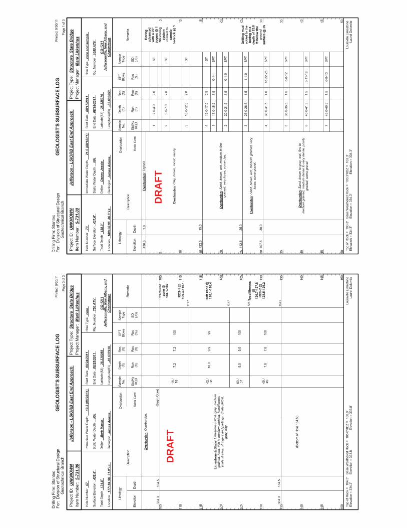
111.
7
121.
7
126.
7
134.
5
7.2
10.0
5.0
7.8
100
99 100
100
frac
ture
dzo
ne @
104.
5-10
7
RC
S-1
@10
9.3-
110.
1
soft
zone
@11
6.1-
116.
4
foss
ilife
rous
@12
6.7-
127.
8R
CS-
2 @
128.
5-12
9.2
334.
3
304.
3
104.
5
134.
5
Ove
rbur
den:
Ove
rbur
den.
Lim
esto
ne &
Sha
le: L
imes
tone
(60%
), gr
ay, m
ediu
mgr
aine
d, h
ard,
thin
to m
ediu
m b
edde
d, fo
ssilif
erou
s,sh
ale
stre
aks,
stri
nger
s an
d pa
rting
s. S
hale
(40%
),gr
ay, s
ilty.
(Beg
in C
ore)
18 /
18 42 /
38 60 /
57 49 /
49
(Bot
tom
of H
ole
134.
5')
7.2
9.9
5.0
7.8
Elev
atio
nD
epth
Std/
KyR
QD
Lith
olog
y
105
110
115
120
125
130
135
140
145
150
105
110
115
120
125
130
135
140
145
150
Dep
th(ft
)SP
TBl
ows
Sam
ple
Type
Rec (ft)
Geo
logi
st
Jam
es A
dam
s
Hol
e Ty
pe
core
Rec (%
)
Rec
.(ft
)Sa
mpl
eN
o.
Run (ft)
Des
crip
tion
Ove
rbur
den
Roc
k C
ore
SDI
(JS)
Rem
arks
Rig
_Num
ber
750
ATV
Hol
e N
umbe
r 67
Surfa
ce E
leva
tion
438.
8'
Tota
l Dep
th
134.
5'
End
Dat
e 08
/25/
2011
Latit
ude(
83)
38.3
3808
8
Long
itude
(83)
-8
5.63
7938
Star
t Dat
e 08
/24/
2011
Dril
ler
Mar
k M
artin
GEO
LOG
IST'
S SU
BSUR
FACE
LO
G
GQ
-121
1Je
ffers
onvi
lle, N
ew A
lban
y, a
ndC
harle
stow
n
Stat
ic W
ater
Dep
th
NA
Loui
sville
Lim
esto
neLa
urel
Dol
omite
Imm
edia
te W
ater
Dep
th
19.3
(08/
25/1
1)
Loca
tion
177+
84.9
6 3
1.0'
Lt.
Base
Wea
ther
ed R
ock
= 1
05.0
'El
evat
ion
= 33
3.8'
Top
ofR
ock
= 1
04.5
'El
evat
ion
= 33
4.3'
RD
Z =
105
.0'
Elev
atio
n =
333.
8'
Prin
ted:
9/3
0/11
Page
3 o
f 3
Dril
ling
Firm
: Sta
ntec
For:
Div
isio
n of
Stru
ctur
al D
esig
nG
eote
chni
cal B
ranc
h
Proj
ect T
ype:
Str
uctu
re S
tate
Brid
gePr
ojec
t Man
ager
: M
ark
Litk
enhu
sPr
ojec
t ID
: U
NK
NO
WN
Item
Num
ber:
5-7
31.0
0Je
ffers
on -
LSIO
RB
Eas
t End
App
roac
h
DR
AFT
2.0-
4.0
5.0-
7.0
10.0
-12.
0
15.0
-17.
0
17.0
-18.
5
20.0
-21.
5
25.0
-26.
5
30.0
-31.
5
35.0
-36.
5
40.0
-41.
5
45.0
-46.
5
0-1-
1
0-1-
0
1-1-
0
18-2
2-28
5-8-
12
5-11
-18
6-8-
13
Bor
ing
adva
nced
with
4.2
5"au
gers
@ 1
NQ
cor
ing
syst
emut
ilize
d to
sam
ple
bedr
ock
@ 3
Dril
ling
mud
adde
d to
the
borin
g at
ade
pth
of 2
5.0
ft be
low
the
grou
ndsu
rface
@ 2
5
436.
6
422.
6
412.
6
407.
6
1.0
15.0
25.0
30.0
Ove
rbur
den:
Top
soil.
Ove
rbur
den:
Cla
y, b
row
n, m
oist
, san
dy.
Ove
rbur
den:
San
d, b
row
n, w
et, m
ediu
m to
fine
grai
ned,
ver
y lo
ose,
som
e cl
ay.
Ove
rbur
den:
San
d, b
row
n, w
et, m
ediu
m g
rain
ed, v
ery
loos
e, s
ome
grav
el.
Ove
rbur
den:
San
d, b
row
n to
gra
y, w
et, f
ine
tom
ediu
m g
rain
ed, m
ediu
m d
ense
to v
ery
dens
e, p
oorly
grad
ed, s
ome
grav
el.
1 2 3 4 1 2 3 4 5 6 7
2.0
2.0
2.0
0.5
1.5
1.5
1.5
1.0
1.5
1.5
1.5
Elev
atio
nD
epth
Std/
KyR
QD
Lith
olog
y
5 10 15 20 25 30 35 40 45 50
5 10 15 20 25 30 35 40 45 50
Dep
th(ft
)SP
TBl
ows
Sam
ple
Type
Rec (ft)
Geo
logi
st
Jam
es A
dam
s
Hol
e Ty
pe
core
and
sam
ple
Rec (%
)
Rec
.(ft
)Sa
mpl
eN
o.
Run (ft)
Des
crip
tion
Ove
rbur
den
Roc
k C
ore
SDI
(JS)
Rem
arks
Rig
_Num
ber
1050
ATV
Hol
e N
umbe
r 70
Surfa
ce E
leva
tion
437.
6'
Tota
l Dep
th
138.
0'
End
Dat
e 08
/18/
2011
Latit
ude(
83)
38.3
3837
6
Long
itude
(83)
-8
5.63
8653
Star
t Dat
e 08
/17/
2011
Dril
ler
Dan
ny J
essi
e
GEO
LOG
IST'
S SU
BSUR
FACE
LO
G
GQ
-121
1Je
ffers
onvi
lle, N
ew A
lban
y, a
ndC
harle
stow
n
Stat
ic W
ater
Dep
th
NA
Loui
sville
Lim
esto
neLa
urel
Dol
omite
Imm
edia
te W
ater
Dep
th
21.0
(08/
18/1
1)
Loca
tion
180+
00.9
6 8
6.0'
Lt.
Base
Wea
ther
ed R
ock
= 1
03.3
'El
evat
ion
= 33
4.3'
Top
ofR
ock
= 1
03.3
'El
evat
ion
= 33
4.3'
RD
Z =
103
.3'
Elev
atio
n =
334.
3'
Prin
ted:
9/3
0/11
Page
1 o
f 3
Dril
ling
Firm
: Sta
ntec
For:
Div
isio
n of
Stru
ctur
al D
esig
nG
eote
chni
cal B
ranc
h
Proj
ect T
ype:
Str
uctu
re S
tate
Brid
gePr
ojec
t Man
ager
: M
ark
Litk
enhu
sPr
ojec
t ID
: U
NK
NO
WN
Item
Num
ber:
5-7
31.0
0Je
ffers
on -
LSIO
RB
Eas
t End
App
roac
h
ST ST ST ST SPT
SPT
SPT
SPT
SPT
SPT
SPT
DR
AFT
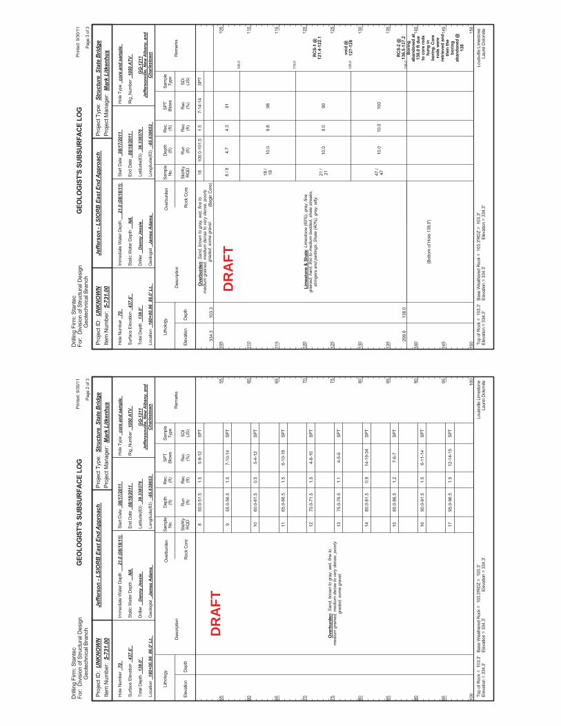
50.0
-51.
5
55.0
-56.
5
60.0
-61.
5
65.0
-66.
5
70.0
-71.
5
75.0
-76.
5
80.0
-81.
5
85.0
-86.
5
90.0
-91.
5
95.0
-96.
5
5-9-
12
7-10
-14
5-4-
12
6-10
-18
4-8-
10
4-5-
9
14-1
9-34
7-6-
7
6-11
-14
12-1
4-15
Ove
rbur
den:
San
d, b
row
n to
gra
y, w
et, f
ine
tom
ediu
m g
rain
ed, m
ediu
m d
ense
to v
ery
dens
e, p
oorly
grad
ed, s
ome
grav
el.
8 9 10 11 12 13 14 15 16 17
1.5
1.5
0.5
1.5
1.5
1.1
0.9
1.2
1.5
1.5
Elev
atio
nD
epth
Std/
KyR
QD
Lith
olog
y
55 60 65 70 75 80 85 90 95 100
55 60 65 70 75 80 85 90 95 100
Dep
th(ft
)SP
TBl
ows
Sam
ple
Type
Rec (ft)
Geo
logi
st
Jam
es A
dam
s
Hol
e Ty
pe
core
and
sam
ple
Rec (%
)
Rec
.(ft
)Sa
mpl
eN
o.
Run (ft)
Des
crip
tion
Ove
rbur
den
Roc
k C
ore
SDI
(JS)
Rem
arks
Rig
_Num
ber
1050
ATV
Hol
e N
umbe
r 70
Surfa
ce E
leva
tion
437.
6'
Tota
l Dep
th
138.
0'
End
Dat
e 08
/18/
2011
Latit
ude(
83)
38.3
3837
6
Long
itude
(83)
-8
5.63
8653
Star
t Dat
e 08
/17/
2011
Dril
ler
Dan
ny J
essi
e
GEO
LOG
IST'
S SU
BSUR
FACE
LO
G
GQ
-121
1Je
ffers
onvi
lle, N
ew A
lban
y, a
ndC
harle
stow
n
Stat
ic W
ater
Dep
th
NA
Loui
sville
Lim
esto
neLa
urel
Dol
omite
Imm
edia
te W
ater
Dep
th
21.0
(08/
18/1
1)
Loca
tion
180+
00.9
6 8
6.0'
Lt.
Base
Wea
ther
ed R
ock
= 1
03.3
'El
evat
ion
= 33
4.3'
Top
ofR
ock
= 1
03.3
'El
evat
ion
= 33
4.3'
RD
Z =
103
.3'
Elev
atio
n =
334.
3'
Prin
ted:
9/3
0/11
Page
2 o
f 3
Dril
ling
Firm
: Sta
ntec
For:
Div
isio
n of
Stru
ctur
al D
esig
nG
eote
chni
cal B
ranc
h
Proj
ect T
ype:
Str
uctu
re S
tate
Brid
gePr
ojec
t Man
ager
: M
ark
Litk
enhu
sPr
ojec
t ID
: U
NK
NO
WN
Item
Num
ber:
5-7
31.0
0Je
ffers
on -
LSIO
RB
Eas
t End
App
roac
h
SPT
SPT
SPT
SPT
SPT
SPT
SPT
SPT
SPT
SPT
DR
AFT
108.
0
118.
0
128.
0
138.
0
100.
0-10
1.5
4.7
10.0
10.0
10.0
7-14
-14
91 98 90 100
RC
S-1
@12
1.4-
122.
1
void
@12
7-12
8
RC
S-2
@13
6.5-
137.
2B
orin
gab
ando
ned
at13
8.0
ft du
eto
cor
e ro
dshu
ng in
borin
g. C
ore
rods
wer
ere
trie
ved
and
then
the
borin
gab
ando
ned
@13
8
334.
3
299.
6
103.
3
138.
0
Ove
rbur
den:
San
d, b
row
n to
gra
y, w
et, f
ine
tom
ediu
m g
rain
ed, m
ediu
m d
ense
to v
ery
dens
e, p
oorly
grad
ed, s
ome
grav
el.
Lim
esto
ne &
Sha
le: L
imes
tone
(60%
), gr
ay, f
ine
grai
ned,
har
d, th
in to
med
ium
bed
ded,
sha
le s
treak
s,st
ringe
rs a
nd p
artin
gs. S
hale
(40%
), gr
ay, s
ilty.
(Beg
in C
ore)
18 8 / 8
18 /
18 21 /
21 47 /
47
(Bot
tom
of H
ole
138.
0')
1.5
4.3
9.8
9.0
10.0
Elev
atio
nD
epth
Std/
KyR
QD
Lith
olog
y
105
110
115
120
125
130
135
140
145
150
105
110
115
120
125
130
135
140
145
150
Dep
th(ft
)SP
TBl
ows
Sam
ple
Type
Rec (ft)
Geo
logi
st
Jam
es A
dam
s
Hol
e Ty
pe
core
and
sam
ple
Rec (%
)
Rec
.(ft
)Sa
mpl
eN
o.
Run (ft)
Des
crip
tion
Ove
rbur
den
Roc
k C
ore
SDI
(JS)
Rem
arks
Rig
_Num
ber
1050
ATV
Hol
e N
umbe
r 70
Surfa
ce E
leva
tion
437.
6'
Tota
l Dep
th
138.
0'
End
Dat
e 08
/18/
2011
Latit
ude(
83)
38.3
3837
6
Long
itude
(83)
-8
5.63
8653
Star
t Dat
e 08
/17/
2011
Dril
ler
Dan
ny J
essi
e
GEO
LOG
IST'
S SU
BSUR
FACE
LO
G
GQ
-121
1Je
ffers
onvi
lle, N
ew A
lban
y, a
ndC
harle
stow
n
Stat
ic W
ater
Dep
th
NA
Loui
sville
Lim
esto
neLa
urel
Dol
omite
Imm
edia
te W
ater
Dep
th
21.0
(08/
18/1
1)
Loca
tion
180+
00.9
6 8
6.0'
Lt.
Base
Wea
ther
ed R
ock
= 1
03.3
'El
evat
ion
= 33
4.3'
Top
ofR
ock
= 1
03.3
'El
evat
ion
= 33
4.3'
RD
Z =
103
.3'
Elev
atio
n =
334.
3'
Prin
ted:
9/3
0/11
Page
3 o
f 3
Dril
ling
Firm
: Sta
ntec
For:
Div
isio
n of
Stru
ctur
al D
esig
nG
eote
chni
cal B
ranc
h
Proj
ect T
ype:
Str
uctu
re S
tate
Brid
gePr
ojec
t Man
ager
: M
ark
Litk
enhu
sPr
ojec
t ID
: U
NK
NO
WN
Item
Num
ber:
5-7
31.0
0Je
ffers
on -
LSIO
RB
Eas
t End
App
roac
h
SPT
DR
AFT
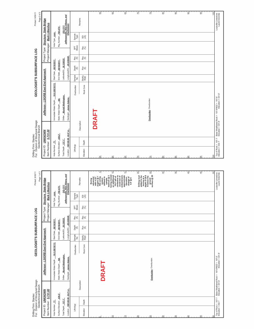
Bor
ing
adva
nced
with
4.2
5"au
gers
@ 1
NQ
cor
ing
syst
emut
ilize
d to
sam
ple
bedr
ock
@ 3
borin
g m
oved
an a
dditi
onal
18.0
' lef
t of
cent
erlin
e to
avoi
d to
e of
emba
nkm
ent,
appr
oxim
ate
elev
atio
nch
ange
of
5.0'
@ 6
Dril
ling
mud
adde
d to
the
borin
g at
ade
pth
of 2
0.0
ft be
low
the
grou
ndsu
rface
@ 2
0O
verb
urde
n: O
verb
urde
n.
Elev
atio
nD
epth
Std/
KyR
QD
Lith
olog
y
5 10 15 20 25 30 35 40 45 50
5 10 15 20 25 30 35 40 45 50
Dep
th(ft
)SP
TBl
ows
Sam
ple
Type
Rec (ft)
Geo
logi
st
Jam
es A
dam
s
Hol
e Ty
pe
core
Rec (%
)
Rec
.(ft
)Sa
mpl
eN
o.
Run (ft)
Des
crip
tion
Ove
rbur
den
Roc
k C
ore
SDI
(JS)
Rem
arks
Rig
_Num
ber
750
ATV
Hol
e N
umbe
r 71
Surfa
ce E
leva
tion
439.
2'
Tota
l Dep
th
137.
1'
End
Dat
e 08
/18/
2011
Latit
ude(
83)
38.3
3852
5
Long
itude
(83)
-8
5.63
8448
Star
t Dat
e 08
/18/
2011
Dril
ler
Mur
iell
Wet
hing
ton
GEO
LOG
IST'
S SU
BSUR
FACE
LO
G
GQ
-121
1Je
ffers
onvi
lle, N
ew A
lban
y, a
ndC
harle
stow
n
Stat
ic W
ater
Dep
th
NA
Loui
sville
Lim
esto
neLa
urel
Dol
omite
Imm
edia
te W
ater
Dep
th
18.0
(08/
18/1
1)
Loca
tion
180+
00.9
6 2
4.0'
Lt.
Base
Wea
ther
ed R
ock
= 1
07.6
'El
evat
ion
= 33
1.6'
Top
ofR
ock
= 1
07.1
'El
evat
ion
= 33
2.1'
RD
Z =
107
.6'
Elev
atio
n =
331.
6'
Prin
ted:
9/3
0/11
Page
1 o
f 3
Dril
ling
Firm
: Sta
ntec
For:
Div
isio
n of
Stru
ctur
al D
esig
nG
eote
chni
cal B
ranc
h
Proj
ect T
ype:
Str
uctu
re S
tate
Brid
gePr
ojec
t Man
ager
: M
ark
Litk
enhu
sPr
ojec
t ID
: U
NK
NO
WN
Item
Num
ber:
5-7
31.0
0Je
ffers
on -
LSIO
RB
Eas
t End
App
roac
h
DR
AFT
Ove
rbur
den:
Ove
rbur
den.
Elev
atio
nD
epth
Std/
KyR
QD
Lith
olog
y
55 60 65 70 75 80 85 90 95 100
55 60 65 70 75 80 85 90 95 100
Dep
th(ft
)SP
TBl
ows
Sam
ple
Type
Rec (ft)
Geo
logi
st
Jam
es A
dam
s
Hol
e Ty
pe
core
Rec (%
)
Rec
.(ft
)Sa
mpl
eN
o.
Run (ft)
Des
crip
tion
Ove
rbur
den
Roc
k C
ore
SDI
(JS)
Rem
arks
Rig
_Num
ber
750
ATV
Hol
e N
umbe
r 71
Surfa
ce E
leva
tion
439.
2'
Tota
l Dep
th
137.
1'
End
Dat
e 08
/18/
2011
Latit
ude(
83)
38.3
3852
5
Long
itude
(83)
-8
5.63
8448
Star
t Dat
e 08
/18/
2011
Dril
ler
Mur
iell
Wet
hing
ton
GEO
LOG
IST'
S SU
BSUR
FACE
LO
G
GQ
-121
1Je
ffers
onvi
lle, N
ew A
lban
y, a
ndC
harle
stow
n
Stat
ic W
ater
Dep
th
NA
Loui
sville
Lim
esto
neLa
urel
Dol
omite
Imm
edia
te W
ater
Dep
th
18.0
(08/
18/1
1)
Loca
tion
180+
00.9
6 2
4.0'
Lt.
Base
Wea
ther
ed R
ock
= 1
07.6
'El
evat
ion
= 33
1.6'
Top
ofR
ock
= 1
07.1
'El
evat
ion
= 33
2.1'
RD
Z =
107
.6'
Elev
atio
n =
331.
6'
Prin
ted:
9/3
0/11
Page
2 o
f 3
Dril
ling
Firm
: Sta
ntec
For:
Div
isio
n of
Stru
ctur
al D
esig
nG
eote
chni
cal B
ranc
h
Proj
ect T
ype:
Str
uctu
re S
tate
Brid
gePr
ojec
t Man
ager
: M
ark
Litk
enhu
sPr
ojec
t ID
: U
NK
NO
WN
Item
Num
ber:
5-7
31.0
0Je
ffers
on -
LSIO
RB
Eas
t End
App
roac
h
DR
AFT
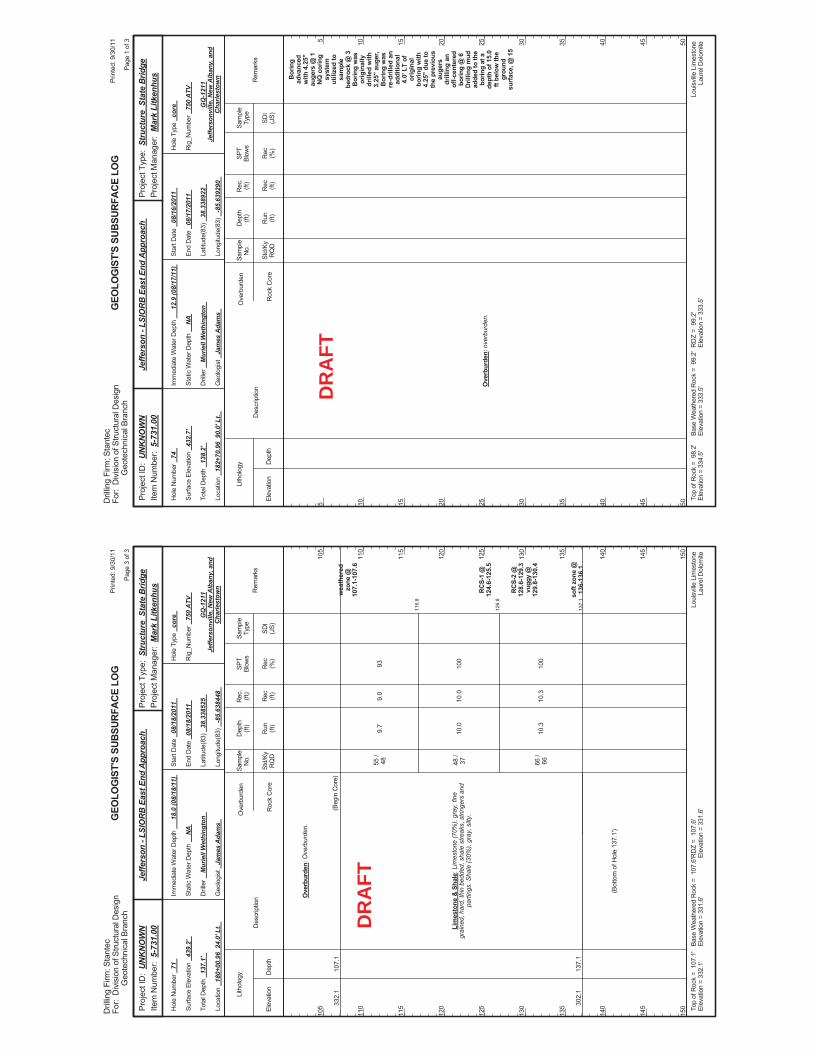
116.
8
126.
8
137.
1
9.7
10.0
10.3
93 100
100
wea
ther
edzo
ne @
107.
1-10
7.6
RC
S-1
@12
4.6-
125.
5
RC
S-2
@12
8.6-
129.
3vu
ggy
@12
9.8-
130.
4
soft
zone
@13
6-13
6.1
332.
1
302.
1
107.
1
137.
1
Ove
rbur
den:
Ove
rbur
den.
Lim
esto
ne &
Sha
le: L
imes
tone
(70%
), gr
ay, f
ine
grai
ned,
har
d, th
in b
edde
d, s
hale
stre
aks,
stri
nger
s an
dpa
rting
s. S
hale
(30%
), gr
ay, s
ilty.
(Beg
in C
ore)
55 /
48 48 /
37 66 /
66
(Bot
tom
of H
ole
137.
1')
9.0
10.0
10.3
Elev
atio
nD
epth
Std/
KyR
QD
Lith
olog
y
105
110
115
120
125
130
135
140
145
150
105
110
115
120
125
130
135
140
145
150
Dep
th(ft
)SP
TBl
ows
Sam
ple
Type
Rec (ft)
Geo
logi
st
Jam
es A
dam
s
Hol
e Ty
pe
core
Rec (%
)
Rec
.(ft
)Sa
mpl
eN
o.
Run (ft)
Des
crip
tion
Ove
rbur
den
Roc
k C
ore
SDI
(JS)
Rem
arks
Rig
_Num
ber
750
ATV
Hol
e N
umbe
r 71
Surfa
ce E
leva
tion
439.
2'
Tota
l Dep
th
137.
1'
End
Dat
e 08
/18/
2011
Latit
ude(
83)
38.3
3852
5
Long
itude
(83)
-8
5.63
8448
Star
t Dat
e 08
/18/
2011
Dril
ler
Mur
iell
Wet
hing
ton
GEO
LOG
IST'
S SU
BSUR
FACE
LO
G
GQ
-121
1Je
ffers
onvi
lle, N
ew A
lban
y, a
ndC
harle
stow
n
Stat
ic W
ater
Dep
th
NA
Loui
sville
Lim
esto
neLa
urel
Dol
omite
Imm
edia
te W
ater
Dep
th
18.0
(08/
18/1
1)
Loca
tion
180+
00.9
6 2
4.0'
Lt.
Base
Wea
ther
ed R
ock
= 1
07.6
'El
evat
ion
= 33
1.6'
Top
ofR
ock
= 1
07.1
'El
evat
ion
= 33
2.1'
RD
Z =
107
.6'
Elev
atio
n =
331.
6'
Prin
ted:
9/3
0/11
Page
3 o
f 3
Dril
ling
Firm
: Sta
ntec
For:
Div
isio
n of
Stru
ctur
al D
esig
nG
eote
chni
cal B
ranc
h
Proj
ect T
ype:
Str
uctu
re S
tate
Brid
gePr
ojec
t Man
ager
: M
ark
Litk
enhu
sPr
ojec
t ID
: U
NK
NO
WN
Item
Num
ber:
5-7
31.0
0Je
ffers
on -
LSIO
RB
Eas
t End
App
roac
h
DR
AFT
Bor
ing
adva
nced
with
4.2
5"au
gers
@ 1
NQ
cor
ing
syst
emut
ilize
d to
sam
ple
bedr
ock
@ 3
Bor
ing
was
orig
inal
lydr
illed
with
3.25
" au
ger,
Bor
ing
was
re-d
rille
d an
addi
tiona
l4.
0' L
T of
orig
inal
borin
g w
ith4.
25"
due
toth
e pr
evio
usau
gers
drill
ing
anof
f-cen
tere
dbo
ring
@ 6
Dril
ling
mud
adde
d to
the
borin
g at
ade
pth
of 1
5.0
ft be
low
the
grou
ndsu
rfac
e, @
15
Ove
rbur
den:
ove
rbur
den.
Elev
atio
nD
epth
Std/
KyR
QD
Lith
olog
y
5 10 15 20 25 30 35 40 45 50
5 10 15 20 25 30 35 40 45 50
Dep
th(ft
)SP
TBl
ows
Sam
ple
Type
Rec (ft)
Geo
logi
st
Jam
es A
dam
s
Hol
e Ty
pe
core
Rec (%
)
Rec
.(ft
)Sa
mpl
eN
o.
Run (ft)
Des
crip
tion
Ove
rbur
den
Roc
k C
ore
SDI
(JS)
Rem
arks
Rig
_Num
ber
750
ATV
Hol
e N
umbe
r 74
Surfa
ce E
leva
tion
432.
7'
Tota
l Dep
th
138.
2'
End
Dat
e 08
/17/
2011
Latit
ude(
83)
38.3
3892
2
Long
itude
(83)
-8
5.63
9290
Star
t Dat
e 08
/16/
2011
Dril
ler
Mur
iell
Wet
hing
ton
GEO
LOG
IST'
S SU
BSUR
FACE
LO
G
GQ
-121
1Je
ffers
onvi
lle, N
ew A
lban
y, a
ndC
harle
stow
n
Stat
ic W
ater
Dep
th
NA
Loui
sville
Lim
esto
neLa
urel
Dol
omite
Imm
edia
te W
ater
Dep
th
12.9
(08/
17/1
1)
Loca
tion
182+
70.9
6 9
0.0'
Lt.
Base
Wea
ther
ed R
ock
= 9
9.2'
Elev
atio
n =
333.
5'To
p of
Roc
k =
98.
2'El
evat
ion
= 33
4.5'
RD
Z =
99.
2'El
evat
ion
= 33
3.5'
Prin
ted:
9/3
0/11
Page
1 o
f 3
Dril
ling
Firm
: Sta
ntec
For:
Div
isio
n of
Stru
ctur
al D
esig
nG
eote
chni
cal B
ranc
h
Proj
ect T
ype:
Str
uctu
re S
tate
Brid
gePr
ojec
t Man
ager
: M
ark
Litk
enhu
sPr
ojec
t ID
: U
NK
NO
WN
Item
Num
ber:
5-7
31.0
0Je
ffers
on -
LSIO
RB
Eas
t End
App
roac
h
DR
AFT
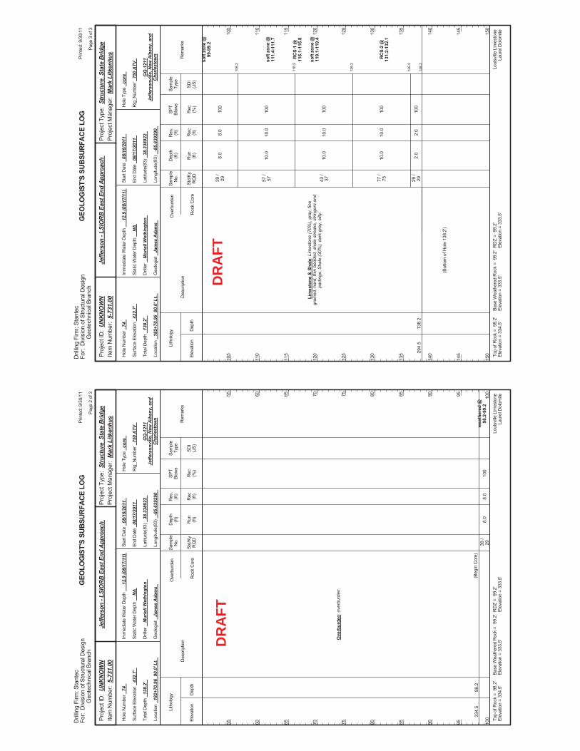
8.0
100
wea
ther
ed @
98.2
-99.
233
4.5
98.2
Ove
rbur
den:
ove
rbur
den.
(Beg
in C
ore)
39 /
298.
0
Elev
atio
nD
epth
Std/
KyR
QD
Lith
olog
y
55 60 65 70 75 80 85 90 95 100
55 60 65 70 75 80 85 90 95 100
Dep
th(ft
)SP
TBl
ows
Sam
ple
Type
Rec (ft)
Geo
logi
st
Jam
es A
dam
s
Hol
e Ty
pe
core
Rec (%
)
Rec
.(ft
)Sa
mpl
eN
o.
Run (ft)
Des
crip
tion
Ove
rbur
den
Roc
k C
ore
SDI
(JS)
Rem
arks
Rig
_Num
ber
750
ATV
Hol
e N
umbe
r 74
Surfa
ce E
leva
tion
432.
7'
Tota
l Dep
th
138.
2'
End
Dat
e 08
/17/
2011
Latit
ude(
83)
38.3
3892
2
Long
itude
(83)
-8
5.63
9290
Star
t Dat
e 08
/16/
2011
Dril
ler
Mur
iell
Wet
hing
ton
GEO
LOG
IST'
S SU
BSUR
FACE
LO
G
GQ
-121
1Je
ffers
onvi
lle, N
ew A
lban
y, a
ndC
harle
stow
n
Stat
ic W
ater
Dep
th
NA
Loui
sville
Lim
esto
neLa
urel
Dol
omite
Imm
edia
te W
ater
Dep
th
12.9
(08/
17/1
1)
Loca
tion
182+
70.9
6 9
0.0'
Lt.
Base
Wea
ther
ed R
ock
= 9
9.2'
Elev
atio
n =
333.
5'To
p of
Roc
k =
98.
2'El
evat
ion
= 33
4.5'
RD
Z =
99.
2'El
evat
ion
= 33
3.5'
Prin
ted:
9/3
0/11
Page
2 o
f 3
Dril
ling
Firm
: Sta
ntec
For:
Div
isio
n of
Stru
ctur
al D
esig
nG
eote
chni
cal B
ranc
h
Proj
ect T
ype:
Str
uctu
re S
tate
Brid
gePr
ojec
t Man
ager
: M
ark
Litk
enhu
sPr
ojec
t ID
: U
NK
NO
WN
Item
Num
ber:
5-7
31.0
0Je
ffers
on -
LSIO
RB
Eas
t End
App
roac
h
DR
AFT
106.
2
116.
2
126.
2
136.
2
138.
2
8.0
10.0
10.0
10.0
2.0
100
100
100
100
100
soft
zone
@99
-99.
2
soft
zone
@11
1.4-
111.
7
RC
S-1
@11
6.1-
116.
8
soft
zone
@11
9.1-
119.
4
RC
S-2
@13
1.2-
132.
1
294.
513
8.2
Lim
esto
ne &
Sha
le: L
imes
tone
(70%
), gr
ay, f
ine
grai
ned,
har
d, th
in b
edde
d, s
hale
stre
aks,
stri
nger
s an
dpa
rting
s. S
hale
(30%
), da
rk g
ray,
silt
y.
39 /
29 57 /
57 43 /
37 77 /
75 29 /
29
(Bot
tom
of H
ole
138.
2')
8.0
10.0
10.0
10.0
2.0
Elev
atio
nD
epth
Std/
KyR
QD
Lith
olog
y
105
110
115
120
125
130
135
140
145
150
105
110
115
120
125
130
135
140
145
150
Dep
th(ft
)SP
TBl
ows
Sam
ple
Type
Rec (ft)
Geo
logi
st
Jam
es A
dam
s
Hol
e Ty
pe
core
Rec (%
)
Rec
.(ft
)Sa
mpl
eN
o.
Run (ft)
Des
crip
tion
Ove
rbur
den
Roc
k C
ore
SDI
(JS)
Rem
arks
Rig
_Num
ber
750
ATV
Hol
e N
umbe
r 74
Surfa
ce E
leva
tion
432.
7'
Tota
l Dep
th
138.
2'
End
Dat
e 08
/17/
2011
Latit
ude(
83)
38.3
3892
2
Long
itude
(83)
-8
5.63
9290
Star
t Dat
e 08
/16/
2011
Dril
ler
Mur
iell
Wet
hing
ton
GEO
LOG
IST'
S SU
BSUR
FACE
LO
G
GQ
-121
1Je
ffers
onvi
lle, N
ew A
lban
y, a
ndC
harle
stow
n
Stat
ic W
ater
Dep
th
NA
Loui
sville
Lim
esto
neLa
urel
Dol
omite
Imm
edia
te W
ater
Dep
th
12.9
(08/
17/1
1)
Loca
tion
182+
70.9
6 9
0.0'
Lt.
Base
Wea
ther
ed R
ock
= 9
9.2'
Elev
atio
n =
333.
5'To
p of
Roc
k =
98.
2'El
evat
ion
= 33
4.5'
RD
Z =
99.
2'El
evat
ion
= 33
3.5'
Prin
ted:
9/3
0/11
Page
3 o
f 3
Dril
ling
Firm
: Sta
ntec
For:
Div
isio
n of
Stru
ctur
al D
esig
nG
eote
chni
cal B
ranc
h
Proj
ect T
ype:
Str
uctu
re S
tate
Brid
gePr
ojec
t Man
ager
: M
ark
Litk
enhu
sPr
ojec
t ID
: U
NK
NO
WN
Item
Num
ber:
5-7
31.0
0Je
ffers
on -
LSIO
RB
Eas
t End
App
roac
h
DR
AFT
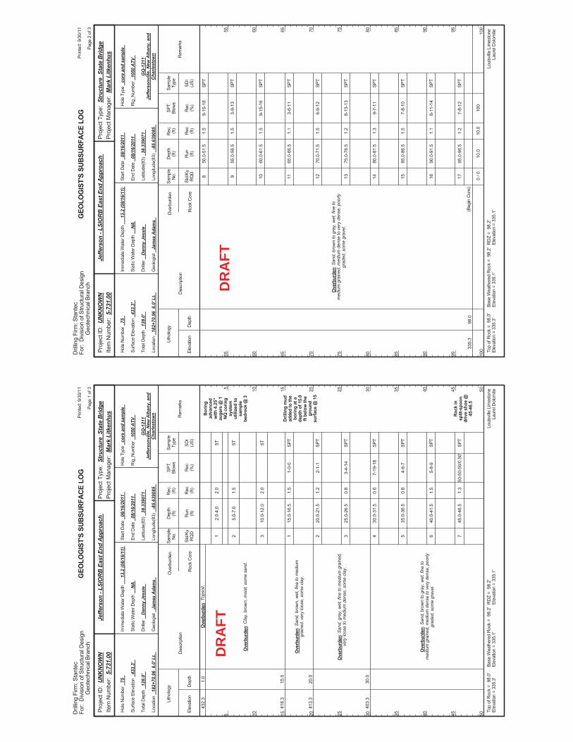
2.0-
4.0
5.0-
7.0
10.0
-12.
0
15.0
-16.
5
20.0
-21.
5
25.0
-26.
5
30.0
-31.
5
35.0
-36.
5
40.0
-41.
5
45.0
-46.
5
1-0-
0
2-1-
1
3-4-
14
7-19
-18
4-6-
7
5-8-
9
50-5
0-50
/0.5
0'
Bor
ing
adva
nced
with
4.2
5"au
gers
@ 1
NQ
cor
ing
syst
emut
ilize
d to
sam
ple
bedr
ock
@ 3
Dril
ling
mud
adde
d to
the
borin
g at
ade
pth
of 1
5.0
ft be
low
the
grou
ndsu
rface
@ 1
5
Roc
k in
split
-spo
ondr
ive
shoe
@45
-46.
5
432.
3
418.
3
413.
3
403.
3
1.0
15.0
20.0
30.0
Ove
rbur
den:
Top
soil.
Ove
rbur
den:
Cla
y, b
row
n, m
oist
, som
e sa
nd.
Ove
rbur
den:
San
d, b
row
n, w
et, f
ine
to m
ediu
mgr
aine
d, v
ery
loos
e, s
ome
clay
.
Ove
rbur
den:
San
d, g
ray,
wet
, fin
e to
med
ium
gra
ined
,ve
ry lo
ose
to m
ediu
m d
ense
, som
e cl
ay.
Ove
rbur
den:
San
d, b
row
n to
gra
y, w
et, f
ine
tom
ediu
m g
rain
ed, m
ediu
m d
ense
to v
ery
dens
e, p
oorly
grad
ed, s
ome
grav
el.
1 2 3 1 2 3 4 5 6 7
2.0
1.5
2.0
1.5
1.2
0.8
0.6
0.8
1.5
1.3
Elev
atio
nD
epth
Std/
KyR
QD
Lith
olog
y
5 10 15 20 25 30 35 40 45 50
5 10 15 20 25 30 35 40 45 50
Dep
th(ft
)SP
TBl
ows
Sam
ple
Type
Rec (ft)
Geo
logi
st
Jam
es A
dam
s
Hol
e Ty
pe
core
and
sam
ple
Rec (%
)
Rec
.(ft
)Sa
mpl
eN
o.
Run (ft)
Des
crip
tion
Ove
rbur
den
Roc
k C
ore
SDI
(JS)
Rem
arks
Rig
_Num
ber
1050
ATV
Hol
e N
umbe
r 75
Surfa
ce E
leva
tion
433.
3'
Tota
l Dep
th
128.
0'
End
Dat
e 08
/16/
2011
Latit
ude(
83)
38.3
3907
1
Long
itude
(83)
-8
5.63
9085
Star
t Dat
e 08
/16/
2011
Dril
ler
Dan
ny J
essi
e
GEO
LOG
IST'
S SU
BSUR
FACE
LO
G
GQ
-121
1Je
ffers
onvi
lle, N
ew A
lban
y, a
ndC
harle
stow
n
Stat
ic W
ater
Dep
th
NA
Loui
sville
Lim
esto
neLa
urel
Dol
omite
Imm
edia
te W
ater
Dep
th
13.2
(08/
16/1
1)
Loca
tion
182+
70.9
6 6
.0' L
t.
Base
Wea
ther
ed R
ock
= 9
8.2'
Elev
atio
n =
335.
1'To
p of
Roc
k =
98.
0'El
evat
ion
= 33
5.3'
RD
Z =
98.
2'El
evat
ion
= 33
5.1'
Prin
ted:
9/3
0/11
Page
1 o
f 3
Dril
ling
Firm
: Sta
ntec
For:
Div
isio
n of
Stru
ctur
al D
esig
nG
eote
chni
cal B
ranc
h
Proj
ect T
ype:
Str
uctu
re S
tate
Brid
gePr
ojec
t Man
ager
: M
ark
Litk
enhu
sPr
ojec
t ID
: U
NK
NO
WN
Item
Num
ber:
5-7
31.0
0Je
ffers
on -
LSIO
RB
Eas
t End
App
roac
h
ST ST ST SPT
SPT
SPT
SPT
SPT
SPT
SPT
DR
AFT
50.0
-51.
5
55.0
-56.
5
60.0
-61.
5
65.0
-66.
5
70.0
-71.
5
75.0
-76.
5
80.0
-81.
5
85.0
-86.
5
90.0
-91.
5
95.0
-96.
5
10.0
9-15
-18
3-9-
13
9-15
-16
3-6-
11
6-9-
12
8-13
-13
9-7-
11
7-8-
10
8-11
-14
7-8-
12
100
335.
398
.0
Ove
rbur
den:
San
d, b
row
n to
gra
y, w
et, f
ine
tom
ediu
m g
rain
ed, m
ediu
m d
ense
to v
ery
dens
e, p
oorly
grad
ed, s
ome
grav
el.
(Beg
in C
ore)
8 9 10 11 12 13 14 15 16 17 0 / 0
1.5
1.5
1.5
1.1
1.5
1.2
1.3
1.5
1.1
1.2
10.0
Elev
atio
nD
epth
Std/
KyR
QD
Lith
olog
y
55 60 65 70 75 80 85 90 95 100
55 60 65 70 75 80 85 90 95 100
Dep
th(ft
)SP
TBl
ows
Sam
ple
Type
Rec (ft)
Geo
logi
st
Jam
es A
dam
s
Hol
e Ty
pe
core
and
sam
ple
Rec (%
)
Rec
.(ft
)Sa
mpl
eN
o.
Run (ft)
Des
crip
tion
Ove
rbur
den
Roc
k C
ore
SDI
(JS)
Rem
arks
Rig
_Num
ber
1050
ATV
Hol
e N
umbe
r 75
Surfa
ce E
leva
tion
433.
3'
Tota
l Dep
th
128.
0'
End
Dat
e 08
/16/
2011
Latit
ude(
83)
38.3
3907
1
Long
itude
(83)
-8
5.63
9085
Star
t Dat
e 08
/16/
2011
Dril
ler
Dan
ny J
essi
e
GEO
LOG
IST'
S SU
BSUR
FACE
LO
G
GQ
-121
1Je
ffers
onvi
lle, N
ew A
lban
y, a
ndC
harle
stow
n
Stat
ic W
ater
Dep
th
NA
Loui
sville
Lim
esto
neLa
urel
Dol
omite
Imm
edia
te W
ater
Dep
th
13.2
(08/
16/1
1)
Loca
tion
182+
70.9
6 6
.0' L
t.
Base
Wea
ther
ed R
ock
= 9
8.2'
Elev
atio
n =
335.
1'To
p of
Roc
k =
98.
0'El
evat
ion
= 33
5.3'
RD
Z =
98.
2'El
evat
ion
= 33
5.1'
Prin
ted:
9/3
0/11
Page
2 o
f 3
Dril
ling
Firm
: Sta
ntec
For:
Div
isio
n of
Stru
ctur
al D
esig
nG
eote
chni
cal B
ranc
h
Proj
ect T
ype:
Str
uctu
re S
tate
Brid
gePr
ojec
t Man
ager
: M
ark
Litk
enhu
sPr
ojec
t ID
: U
NK
NO
WN
Item
Num
ber:
5-7
31.0
0Je
ffers
on -
LSIO
RB
Eas
t End
App
roac
h
SPT
SPT
SPT
SPT
SPT
SPT
SPT
SPT
SPT
SPT
DR
AFT
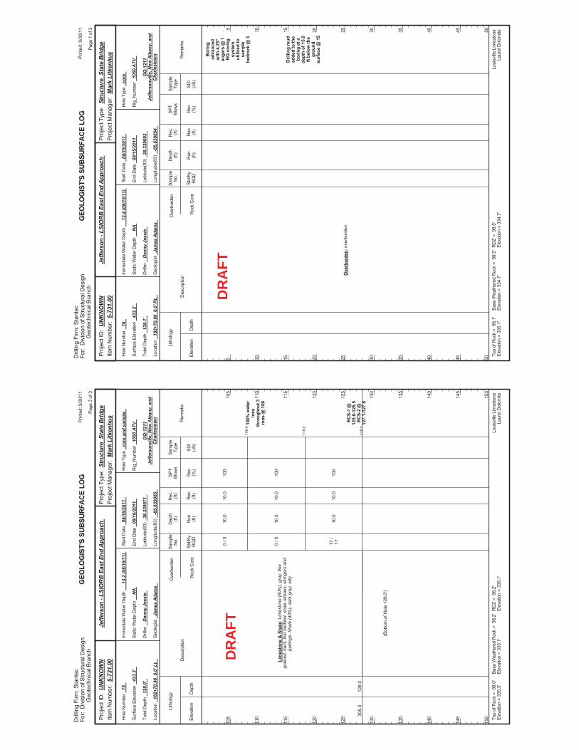
108.
0
118.
0
128.
0
10.0
10.0
10.0
100
100
100
100%
wat
erlo
ssth
roug
hout
3ru
ns @
108
RC
S-1
@12
5.6-
126.
5R
CS-
2 @
127.
1-12
7.8
305.
312
8.0
Lim
esto
ne &
Sha
le: L
imes
tone
(60%
), gr
ay, f
ine
grai
ned,
har
d, th
in b
edde
d, s
hale
stre
aks,
stri
nger
s an
dpa
rting
s. S
hale
(40%
), da
rk g
ray,
silt
y.
0 / 0
0 / 0
17 /
17
(Bot
tom
of H
ole
128.
0')
10.0
10.0
10.0
Elev
atio
nD
epth
Std/
KyR
QD
Lith
olog
y
105
110
115
120
125
130
135
140
145
150
105
110
115
120
125
130
135
140
145
150
Dep
th(ft
)SP
TBl
ows
Sam
ple
Type
Rec (ft)
Geo
logi
st
Jam
es A
dam
s
Hol
e Ty
pe
core
and
sam
ple
Rec (%
)
Rec
.(ft
)Sa
mpl
eN
o.
Run (ft)
Des
crip
tion
Ove
rbur
den
Roc
k C
ore
SDI
(JS)
Rem
arks
Rig
_Num
ber
1050
ATV
Hol
e N
umbe
r 75
Surfa
ce E
leva
tion
433.
3'
Tota
l Dep
th
128.
0'
End
Dat
e 08
/16/
2011
Latit
ude(
83)
38.3
3907
1
Long
itude
(83)
-8
5.63
9085
Star
t Dat
e 08
/16/
2011
Dril
ler
Dan
ny J
essi
e
GEO
LOG
IST'
S SU
BSUR
FACE
LO
G
GQ
-121
1Je
ffers
onvi
lle, N
ew A
lban
y, a
ndC
harle
stow
n
Stat
ic W
ater
Dep
th
NA
Loui
sville
Lim
esto
neLa
urel
Dol
omite
Imm
edia
te W
ater
Dep
th
13.2
(08/
16/1
1)
Loca
tion
182+
70.9
6 6
.0' L
t.
Base
Wea
ther
ed R
ock
= 9
8.2'
Elev
atio
n =
335.
1'To
p of
Roc
k =
98.
0'El
evat
ion
= 33
5.3'
RD
Z =
98.
2'El
evat
ion
= 33
5.1'
Prin
ted:
9/3
0/11
Page
3 o
f 3
Dril
ling
Firm
: Sta
ntec
For:
Div
isio
n of
Stru
ctur
al D
esig
nG
eote
chni
cal B
ranc
h
Proj
ect T
ype:
Str
uctu
re S
tate
Brid
gePr
ojec
t Man
ager
: M
ark
Litk
enhu
sPr
ojec
t ID
: U
NK
NO
WN
Item
Num
ber:
5-7
31.0
0Je
ffers
on -
LSIO
RB
Eas
t End
App
roac
h
DR
AFT
Bor
ing
adva
nced
with
4.2
5"au
gers
@ 1
NQ
cor
ing
syst
emut
ilize
d to
sam
ple
bedr
ock
@ 3
Dril
ling
mud
adde
d to
the
borin
g at
ade
pth
of 1
5.0
ft be
low
the
grou
ndsu
rface
@ 1
5
Ove
rbur
den:
ove
rbur
den.
Elev
atio
nD
epth
Std/
KyR
QD
Lith
olog
y
5 10 15 20 25 30 35 40 45 50
5 10 15 20 25 30 35 40 45 50
Dep
th(ft
)SP
TBl
ows
Sam
ple
Type
Rec (ft)
Geo
logi
st
Jam
es A
dam
s
Hol
e Ty
pe
core
Rec (%
)
Rec
.(ft
)Sa
mpl
eN
o.
Run (ft)
Des
crip
tion
Ove
rbur
den
Roc
k C
ore
SDI
(JS)
Rem
arks
Rig
_Num
ber
1050
ATV
Hol
e N
umbe
r 76
Surfa
ce E
leva
tion
433.
2'
Tota
l Dep
th
128.
1'
End
Dat
e 08
/15/
2011
Latit
ude(
83)
38.3
3909
3
Long
itude
(83)
-8
5.63
9054
Star
t Dat
e 08
/15/
2011
Dril
ler
Dan
ny J
essi
e
GEO
LOG
IST'
S SU
BSUR
FACE
LO
G
GQ
-121
1Je
ffers
onvi
lle, N
ew A
lban
y, a
ndC
harle
stow
n
Stat
ic W
ater
Dep
th
NA
Loui
sville
Lim
esto
neLa
urel
Dol
omite
Imm
edia
te W
ater
Dep
th
12.4
(08/
15/1
1)
Loca
tion
182+
70.9
6 6
.0' R
t.
Base
Wea
ther
ed R
ock
= 9
8.5'
Elev
atio
n =
334.
7'To
p of
Roc
k =
98.
1'El
evat
ion
= 33
5.1'
RD
Z =
98.
5'El
evat
ion
= 33
4.7'
Prin
ted:
9/3
0/11
Page
1 o
f 3
Dril
ling
Firm
: Sta
ntec
For:
Div
isio
n of
Stru
ctur
al D
esig
nG
eote
chni
cal B
ranc
h
Proj
ect T
ype:
Str
uctu
re S
tate
Brid
gePr
ojec
t Man
ager
: M
ark
Litk
enhu
sPr
ojec
t ID
: U
NK
NO
WN
Item
Num
ber:
5-7
31.0
0Je
ffers
on -
LSIO
RB
Eas
t End
App
roac
h
DR
AFT
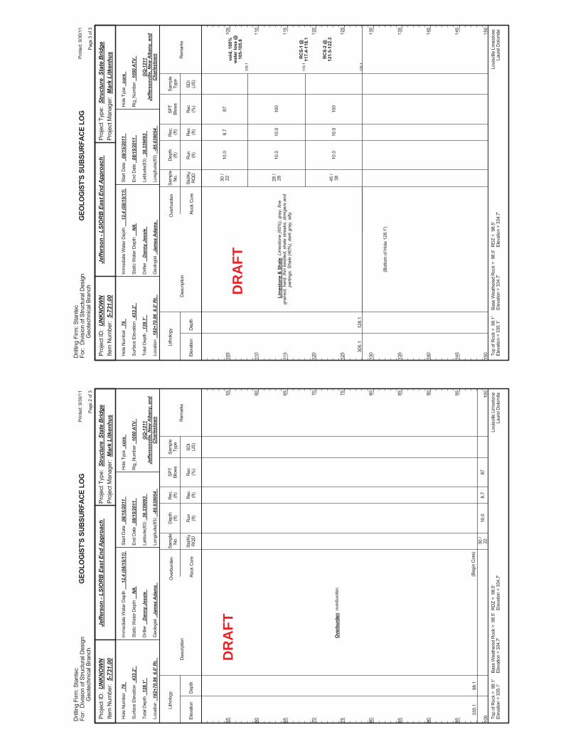
10.0
87
335.
198
.1
Ove
rbur
den:
ove
rbur
den.
(Beg
in C
ore)
30 /
228.
7
Elev
atio
nD
epth
Std/
KyR
QD
Lith
olog
y
55 60 65 70 75 80 85 90 95 100
55 60 65 70 75 80 85 90 95 100
Dep
th(ft
)SP
TBl
ows
Sam
ple
Type
Rec (ft)
Geo
logi
st
Jam
es A
dam
s
Hol
e Ty
pe
core
Rec (%
)
Rec
.(ft
)Sa
mpl
eN
o.
Run (ft)
Des
crip
tion
Ove
rbur
den
Roc
k C
ore
SDI
(JS)
Rem
arks
Rig
_Num
ber
1050
ATV
Hol
e N
umbe
r 76
Surfa
ce E
leva
tion
433.
2'
Tota
l Dep
th
128.
1'
End
Dat
e 08
/15/
2011
Latit
ude(
83)
38.3
3909
3
Long
itude
(83)
-8
5.63
9054
Star
t Dat
e 08
/15/
2011
Dril
ler
Dan
ny J
essi
e
GEO
LOG
IST'
S SU
BSUR
FACE
LO
G
GQ
-121
1Je
ffers
onvi
lle, N
ew A
lban
y, a
ndC
harle
stow
n
Stat
ic W
ater
Dep
th
NA
Loui
sville
Lim
esto
neLa
urel
Dol
omite
Imm
edia
te W
ater
Dep
th
12.4
(08/
15/1
1)
Loca
tion
182+
70.9
6 6
.0' R
t.
Base
Wea
ther
ed R
ock
= 9
8.5'
Elev
atio
n =
334.
7'To
p of
Roc
k =
98.
1'El
evat
ion
= 33
5.1'
RD
Z =
98.
5'El
evat
ion
= 33
4.7'
Prin
ted:
9/3
0/11
Page
2 o
f 3
Dril
ling
Firm
: Sta
ntec
For:
Div
isio
n of
Stru
ctur
al D
esig
nG
eote
chni
cal B
ranc
h
Proj
ect T
ype:
Str
uctu
re S
tate
Brid
gePr
ojec
t Man
ager
: M
ark
Litk
enhu
sPr
ojec
t ID
: U
NK
NO
WN
Item
Num
ber:
5-7
31.0
0Je
ffers
on -
LSIO
RB
Eas
t End
App
roac
h
DR
AFT
108.
1
118.
1
128.
1
10.0
10.0
10.0
87 100
100
void
, 100
%w
ater
loss
@10
5-10
5.8
RC
S-1
@11
7.4-
118.
1
RC
S-2
@12
1.5-
122.
3
305.
112
8.1
Lim
esto
ne &
Sha
le: L
imes
tone
(60%
), gr
ay, f
ine
grai
ned,
har
d, th
in b
edde
d, s
hale
stre
aks,
stri
nger
s an
dpa
rting
s. S
hale
(40%
), da
rk g
ray,
silt
y.
30 /
22 28 /
28 45 /
38
(Bot
tom
of H
ole
128.
1')
8.7
10.0
10.0
Elev
atio
nD
epth
Std/
KyR
QD
Lith
olog
y
105
110
115
120
125
130
135
140
145
150
105
110
115
120
125
130
135
140
145
150
Dep
th(ft
)SP
TBl
ows
Sam
ple
Type
Rec (ft)
Geo
logi
st
Jam
es A
dam
s
Hol
e Ty
pe
core
Rec (%
)
Rec
.(ft
)Sa
mpl
eN
o.
Run (ft)
Des
crip
tion
Ove
rbur
den
Roc
k C
ore
SDI
(JS)
Rem
arks
Rig
_Num
ber
1050
ATV
Hol
e N
umbe
r 76
Surfa
ce E
leva
tion
433.
2'
Tota
l Dep
th
128.
1'
End
Dat
e 08
/15/
2011
Latit
ude(
83)
38.3
3909
3
Long
itude
(83)
-8
5.63
9054
Star
t Dat
e 08
/15/
2011
Dril
ler
Dan
ny J
essi
e
GEO
LOG
IST'
S SU
BSUR
FACE
LO
G
GQ
-121
1Je
ffers
onvi
lle, N
ew A
lban
y, a
ndC
harle
stow
n
Stat
ic W
ater
Dep
th
NA
Loui
sville
Lim
esto
neLa
urel
Dol
omite
Imm
edia
te W
ater
Dep
th
12.4
(08/
15/1
1)
Loca
tion
182+
70.9
6 6
.0' R
t.
Base
Wea
ther
ed R
ock
= 9
8.5'
Elev
atio
n =
334.
7'To
p of
Roc
k =
98.
1'El
evat
ion
= 33
5.1'
RD
Z =
98.
5'El
evat
ion
= 33
4.7'
Prin
ted:
9/3
0/11
Page
3 o
f 3
Dril
ling
Firm
: Sta
ntec
For:
Div
isio
n of
Stru
ctur
al D
esig
nG
eote
chni
cal B
ranc
h
Proj
ect T
ype:
Str
uctu
re S
tate
Brid
gePr
ojec
t Man
ager
: M
ark
Litk
enhu
sPr
ojec
t ID
: U
NK
NO
WN
Item
Num
ber:
5-7
31.0
0Je
ffers
on -
LSIO
RB
Eas
t End
App
roac
h
DR
AFT
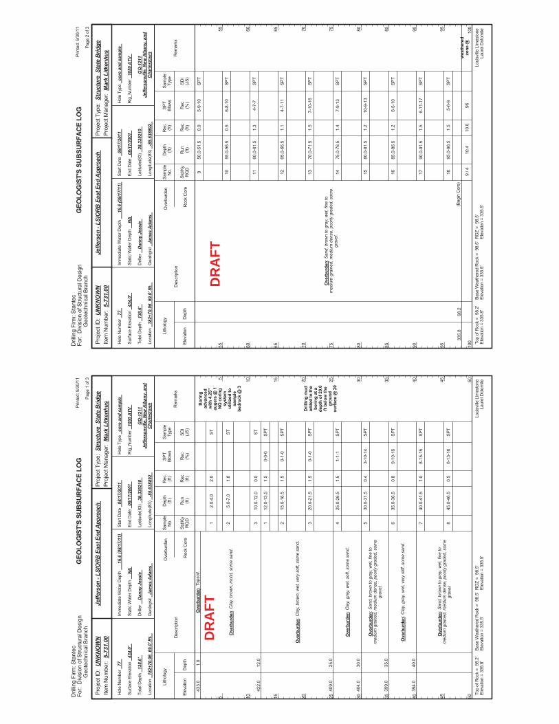
2.0-
4.0
5.0-
7.0
10.0
-12.
0
12.0
-13.
5
15.0
-16.
5
20.0
-21.
5
25.0
-26.
5
30.0
-31.
5
35.0
-36.
5
40.0
-41.
5
45.0
-46.
5
0-0-
0
0-1-
0
0-1-
0
1-1-
1
3-10
-14
9-10
-15
8-15
-15
6-13
-16
Bor
ing
adva
nced
with
4.2
5"au
gers
@ 1
NQ
cor
ing
syst
emut
ilize
d to
sam
ple
bedr
ock
@ 3
Dril
ling
mud
adde
d to
the
borin
g at
ade
pth
of 2
0.0
ft be
low
the
grou
ndsu
rface
@ 2
0
433.
0
422.
0
409.
0
404.
0
399.
0
394.
0
1.0
12.0
25.0
30.0
35.0
40.0
Ove
rbur
den:
Top
soil.
Ove
rbur
den:
Cla
y, b
row
n, m
oist
, som
e sa
nd.
Ove
rbur
den:
Cla
y, b
row
n, w
et, v
ery
soft,
som
e sa
nd.
Ove
rbur
den:
Cla
y, g
ray,
wet
, sof
t, so
me
sand
.
Ove
rbur
den:
San
d, b
row
n to
gra
y, w
et, f
ine
tom
ediu
m g
rain
ed, m
ediu
m d
ense
, poo
rly g
rade
d, s
ome
grav
el.
Ove
rbur
den:
Cla
y, g
ray,
wet
, ver
y st
iff, s
ome
sand
.
Ove
rbur
den:
San
d, b
row
n to
gra
y, w
et, f
ine
tom
ediu
m g
rain
ed, m
ediu
m d
ense
, poo
rly g
rade
d, s
ome
grav
el.
1 2 3 1 2 3 4 5 6 7 8
2.0
1.8
0.0
1.5
1.5
1.5
1.5
0.4
0.8
1.0
0.5
Elev
atio
nD
epth
Std/
KyR
QD
Lith
olog
y
5 10 15 20 25 30 35 40 45 50
5 10 15 20 25 30 35 40 45 50
Dep
th(ft
)SP
TBl
ows
Sam
ple
Type
Rec (ft)
Geo
logi
st
Jam
es A
dam
s
Hol
e Ty
pe
core
and
sam
ple
Rec (%
)
Rec
.(ft
)Sa
mpl
eN
o.
Run (ft)
Des
crip
tion
Ove
rbur
den
Roc
k C
ore
SDI
(JS)
Rem
arks
Rig
_Num
ber
1050
ATV
Hol
e N
umbe
r 77
Surfa
ce E
leva
tion
434.
0'
Tota
l Dep
th
138.
6'
End
Dat
e 08
/17/
2001
Latit
ude(
83)
38.3
3921
0
Long
itude
(83)
-8
5.63
8892
Star
t Dat
e 08
/17/
2011
Dril
ler
Dan
ny J
essi
e
GEO
LOG
IST'
S SU
BSUR
FACE
LO
G
GQ
-121
1Je
ffers
onvi
lle, N
ew A
lban
y, a
ndC
harle
stow
n
Stat
ic W
ater
Dep
th
NA
Loui
sville
Lim
esto
neLa
urel
Dol
omite
Imm
edia
te W
ater
Dep
th
16.6
(08/
17/1
1)
Loca
tion
182+
70.9
6 6
9.0'
Rt.
Base
Wea
ther
ed R
ock
= 9
8.5'
Elev
atio
n =
335.
5'To
p of
Roc
k =
98.
2'El
evat
ion
= 33
5.8'
RD
Z =
98.
5'El
evat
ion
= 33
5.5'
Prin
ted:
9/3
0/11
Page
1 o
f 3
Dril
ling
Firm
: Sta
ntec
For:
Div
isio
n of
Stru
ctur
al D
esig
nG
eote
chni
cal B
ranc
h
Proj
ect T
ype:
Str
uctu
re S
tate
Brid
gePr
ojec
t Man
ager
: M
ark
Litk
enhu
sPr
ojec
t ID
: U
NK
NO
WN
Item
Num
ber:
5-7
31.0
0Je
ffers
on -
LSIO
RB
Eas
t End
App
roac
h
ST ST ST SPT
SPT
SPT
SPT
SPT
SPT
SPT
SPT
DR
AFT
50.0
-51.
5
55.0
-56.
5
60.0
-61.
5
65.0
-66.
5
70.0
-71.
5
75.0
-76.
5
80.0
-81.
5
85.0
-86.
5
90.0
-91.
5
95.0
-96.
5
10.4
5-9-
10
6-8-
10
4-7-
7
4-7-
11
7-10
-16
7-9-
13
10-9
-13
6-5-
10
6-11
-17
5-6-
9
96w
eath
ered
zone
@33
5.8
98.2
Ove
rbur
den:
San
d, b
row
n to
gra
y, w
et, f
ine
tom
ediu
m g
rain
ed, m
ediu
m d
ense
, poo
rly g
rade
d, s
ome
grav
el.
(Beg
in C
ore)
9 10 11 12 13 14 15 16 17 18 9 / 4
0.9
0.5
1.3
1.1
1.5
1.4
1.2
1.2
1.5
1.5
10.0
Elev
atio
nD
epth
Std/
KyR
QD
Lith
olog
y
55 60 65 70 75 80 85 90 95 100
55 60 65 70 75 80 85 90 95 100
Dep
th(ft
)SP
TBl
ows
Sam
ple
Type
Rec (ft)
Geo
logi
st
Jam
es A
dam
s
Hol
e Ty
pe
core
and
sam
ple
Rec (%
)
Rec
.(ft
)Sa
mpl
eN
o.
Run (ft)
Des
crip
tion
Ove
rbur
den
Roc
k C
ore
SDI
(JS)
Rem
arks
Rig
_Num
ber
1050
ATV
Hol
e N
umbe
r 77
Surfa
ce E
leva
tion
434.
0'
Tota
l Dep
th
138.
6'
End
Dat
e 08
/17/
2001
Latit
ude(
83)
38.3
3921
0
Long
itude
(83)
-8
5.63
8892
Star
t Dat
e 08
/17/
2011
Dril
ler
Dan
ny J
essi
e
GEO
LOG
IST'
S SU
BSUR
FACE
LO
G
GQ
-121
1Je
ffers
onvi
lle, N
ew A
lban
y, a
ndC
harle
stow
n
Stat
ic W
ater
Dep
th
NA
Loui
sville
Lim
esto
neLa
urel
Dol
omite
Imm
edia
te W
ater
Dep
th
16.6
(08/
17/1
1)
Loca
tion
182+
70.9
6 6
9.0'
Rt.
Base
Wea
ther
ed R
ock
= 9
8.5'
Elev
atio
n =
335.
5'To
p of
Roc
k =
98.
2'El
evat
ion
= 33
5.8'
RD
Z =
98.
5'El
evat
ion
= 33
5.5'
Prin
ted:
9/3
0/11
Page
2 o
f 3
Dril
ling
Firm
: Sta
ntec
For:
Div
isio
n of
Stru
ctur
al D
esig
nG
eote
chni
cal B
ranc
h
Proj
ect T
ype:
Str
uctu
re S
tate
Brid
gePr
ojec
t Man
ager
: M
ark
Litk
enhu
sPr
ojec
t ID
: U
NK
NO
WN
Item
Num
ber:
5-7
31.0
0Je
ffers
on -
LSIO
RB
Eas
t End
App
roac
h
SPT
SPT
SPT
SPT
SPT
SPT
SPT
SPT
SPT
SPT
DR
AFT
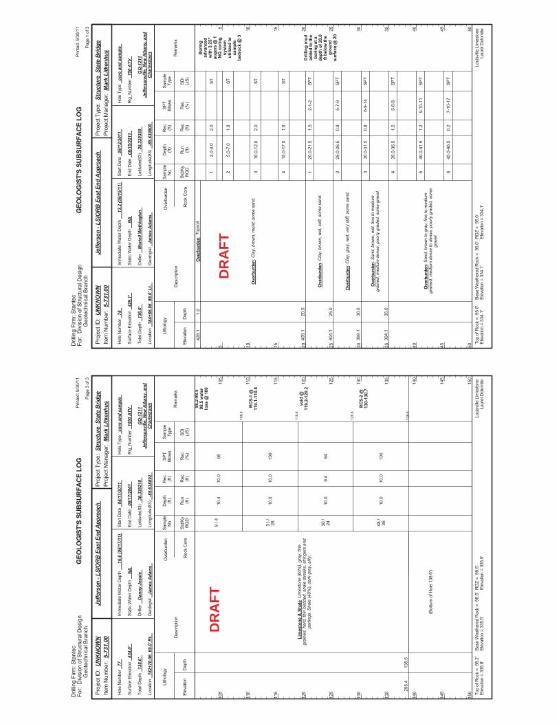
108.
6
118.
6
128.
6
138.
6
10.4
10.0
10.0
10.0
96 100
94 100
98.2
-98.
598
.5 w
ater
loss
@ 1
00
RC
S-1
@11
0.1-
110.
8
void
@11
9.2-
120.
2
RC
S-2
@13
0-13
0.7
295.
413
8.6
Lim
esto
ne &
Sha
le: L
imes
tone
(60%
), gr
ay, f
ine
grai
ned,
har
d, th
in b
edde
d, s
hale
stre
aks,
stri
nger
s an
dpa
rting
s. S
hale
(40%
), da
rk g
ray,
silt
y.
9 / 4
31 /
28 30 /
24 48 /
36
(Bot
tom
of H
ole
138.
6')
10.0
10.0
9.4
10.0
Elev
atio
nD
epth
Std/
KyR
QD
Lith
olog
y
105
110
115
120
125
130
135
140
145
150
105
110
115
120
125
130
135
140
145
150
Dep
th(ft
)SP
TBl
ows
Sam
ple
Type
Rec (ft)
Geo
logi
st
Jam
es A
dam
s
Hol
e Ty
pe
core
and
sam
ple
Rec (%
)
Rec
.(ft
)Sa
mpl
eN
o.
Run (ft)
Des
crip
tion
Ove
rbur
den
Roc
k C
ore
SDI
(JS)
Rem
arks
Rig
_Num
ber
1050
ATV
Hol
e N
umbe
r 77
Surfa
ce E
leva
tion
434.
0'
Tota
l Dep
th
138.
6'
End
Dat
e 08
/17/
2001
Latit
ude(
83)
38.3
3921
0
Long
itude
(83)
-8
5.63
8892
Star
t Dat
e 08
/17/
2011
Dril
ler
Dan
ny J
essi
e
GEO
LOG
IST'
S SU
BSUR
FACE
LO
G
GQ
-121
1Je
ffers
onvi
lle, N
ew A
lban
y, a
ndC
harle
stow
n
Stat
ic W
ater
Dep
th
NA
Loui
sville
Lim
esto
neLa
urel
Dol
omite
Imm
edia
te W
ater
Dep
th
16.6
(08/
17/1
1)
Loca
tion
182+
70.9
6 6
9.0'
Rt.
Base
Wea
ther
ed R
ock
= 9
8.5'
Elev
atio
n =
335.
5'To
p of
Roc
k =
98.
2'El
evat
ion
= 33
5.8'
RD
Z =
98.
5'El
evat
ion
= 33
5.5'
Prin
ted:
9/3
0/11
Page
3 o
f 3
Dril
ling
Firm
: Sta
ntec
For:
Div
isio
n of
Stru
ctur
al D
esig
nG
eote
chni
cal B
ranc
h
Proj
ect T
ype:
Str
uctu
re S
tate
Brid
gePr
ojec
t Man
ager
: M
ark
Litk
enhu
sPr
ojec
t ID
: U
NK
NO
WN
Item
Num
ber:
5-7
31.0
0Je
ffers
on -
LSIO
RB
Eas
t End
App
roac
h
DR
AFT
2.0-
4.0
5.0-
7.0
10.0
-12.
0
15.0
-17.
0
20.0
-21.
5
25.0
-26.
5
30.0
-31.
5
35.0
-36.
5
40.0
-41.
5
45.0
-46.
5
2-1-
2
5-7-
9
6-9-
14
5-6-
8
9-10
-11
7-10
-17
Bor
ing
adva
nced
with
3.2
5"au
gers
@ 1
NQ
cor
ing
syst
emut
ilize
d to
sam
ple
bedr
ock
@ 3
Dril
ling
mud
adde
d to
the
borin
g at
ade
pth
of 2
0.0
ft be
low
the
grou
ndsu
rface
@ 2
0
428.
1
409.
1
404.
1
399.
1
394.
1
1.0
20.0
25.0
30.0
35.0
Ove
rbur
den:
Top
soil.
Ove
rbur
den:
Cla
y, b
row
n, m
oist
, som
e sa
nd.
Ove
rbur
den:
Cla
y, b
row
n, w
et, s
oft,
som
e sa
nd.
Ove
rbur
den:
Cla
y, g
ray,
wet
, ver
y st
iff, s
ome
sand
.
Ove
rbur
den:
San
d, b
row
n, w
et, f
ine
to m
ediu
mgr
aine
d, m
ediu
m d
ense
, poo
rly g
rade
d, s
ome
grav
el.
Ove
rbur
den:
San
d, b
row
n to
gra
y, fi
ne to
med
ium
grai
ned,
med
ium
den
se to
den
se, p
oorly
gra
ded,
som
egr
avel
.
1 2 3 4 1 2 3 4 5 6
2.0
1.8
2.0
1.8
1.5
0.8
0.8
1.5
1.2
0.2
Elev
atio
nD
epth
Std/
KyR
QD
Lith
olog
y
5 10 15 20 25 30 35 40 45 50
5 10 15 20 25 30 35 40 45 50
Dep
th(ft
)SP
TBl
ows
Sam
ple
Type
Rec (ft)
Geo
logi
st
Jam
es A
dam
s
Hol
e Ty
pe
core
and
sam
ple
Rec (%
)
Rec
.(ft
)Sa
mpl
eN
o.
Run (ft)
Des
crip
tion
Ove
rbur
den
Roc
k C
ore
SDI
(JS)
Rem
arks
Rig
_Num
ber
750
ATV
Hol
e N
umbe
r 78
Surfa
ce E
leva
tion
429.
1'
Tota
l Dep
th
136.
0'
End
Dat
e 08
/15/
2011
Latit
ude(
83)
38.3
3935
9
Long
itude
(83)
-8
5.63
9800
Star
t Dat
e 08
/12/
2011
Dril
ler
Mur
iell
Wet
hing
ton
GEO
LOG
IST'
S SU
BSUR
FACE
LO
G
GQ
-121
1Je
ffers
onvi
lle, N
ew A
lban
y, a
ndC
harle
stow
n
Stat
ic W
ater
Dep
th
NA
Loui
sville
Lim
esto
neLa
urel
Dol
omite
Imm
edia
te W
ater
Dep
th
13.2
(08/
15/1
1)
Loca
tion
184+
86.9
6 8
6.0'
Lt.
Base
Wea
ther
ed R
ock
= 9
5.0'
Elev
atio
n =
334.
1'To
p of
Roc
k =
95.
0'El
evat
ion
= 33
4.1'
RD
Z =
95.
0'El
evat
ion
= 33
4.1'
Prin
ted:
9/3
0/11
Page
1 o
f 3
Dril
ling
Firm
: Sta
ntec
For:
Div
isio
n of
Stru
ctur
al D
esig
nG
eote
chni
cal B
ranc
h
Proj
ect T
ype:
Str
uctu
re S
tate
Brid
gePr
ojec
t Man
ager
: M
ark
Litk
enhu
sPr
ojec
t ID
: U
NK
NO
WN
Item
Num
ber:
5-7
31.0
0Je
ffers
on -
LSIO
RB
Eas
t End
App
roac
h
ST ST ST ST SPT
SPT
SPT
SPT
SPT
SPT
DR
AFT
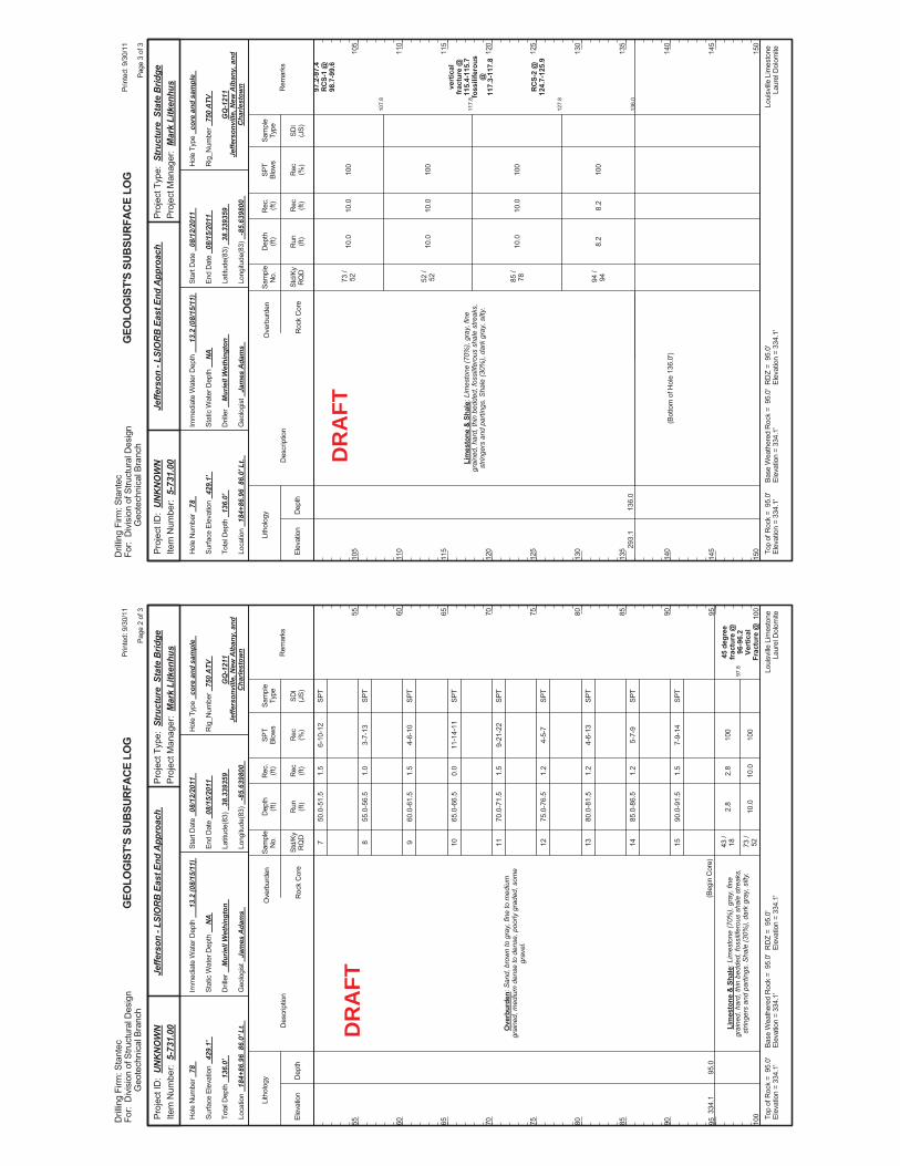
97.8
50.0
-51.
5
55.0
-56.
5
60.0
-61.
5
65.0
-66.
5
70.0
-71.
5
75.0
-76.
5
80.0
-81.
5
85.0
-86.
5
90.0
-91.
5
2.8
10.0
6-10
-12
3-7-
13
4-6-
10
11-1
4-11
9-21
-22
4-5-
7
4-6-
13
5-7-
9
7-9-
14
100
100
45 d
egre
efr
actu
re @
96-9
6.2
Vert
ical
Frac
ture
@
334.
195
.0
Ove
rbur
den:
San
d, b
row
n to
gra
y, fi
ne to
med
ium
grai
ned,
med
ium
den
se to
den
se, p
oorly
gra
ded,
som
egr
avel
.
Lim
esto
ne &
Sha
le: L
imes
tone
(70%
), gr
ay, f
ine
grai
ned,
har
d, th
in b
edde
d, fo
ssilif
erou
s sh
ale
stre
aks,
strin
gers
and
par
tings
. Sha
le (3
0%),
dark
gra
y, s
ilty.
(Beg
in C
ore)
7 8 9 10 11 12 13 14 15 43 /
18 73 /
52
1.5
1.0
1.5
0.0
1.5
1.2
1.2
1.2
1.5
2.8
10.0
Elev
atio
nD
epth
Std/
KyR
QD
Lith
olog
y
55 60 65 70 75 80 85 90 95 100
55 60 65 70 75 80 85 90 95 100
Dep
th(ft
)SP
TBl
ows
Sam
ple
Type
Rec (ft)
Geo
logi
st
Jam
es A
dam
s
Hol
e Ty
pe
core
and
sam
ple
Rec (%
)
Rec
.(ft
)Sa
mpl
eN
o.
Run (ft)
Des
crip
tion
Ove
rbur
den
Roc
k C
ore
SDI
(JS)
Rem
arks
Rig
_Num
ber
750
ATV
Hol
e N
umbe
r 78
Surfa
ce E
leva
tion
429.
1'
Tota
l Dep
th
136.
0'
End
Dat
e 08
/15/
2011
Latit
ude(
83)
38.3
3935
9
Long
itude
(83)
-8
5.63
9800
Star
t Dat
e 08
/12/
2011
Dril
ler
Mur
iell
Wet
hing
ton
GEO
LOG
IST'
S SU
BSUR
FACE
LO
G
GQ
-121
1Je
ffers
onvi
lle, N
ew A
lban
y, a
ndC
harle
stow
n
Stat
ic W
ater
Dep
th
NA
Loui
sville
Lim
esto
neLa
urel
Dol
omite
Imm
edia
te W
ater
Dep
th
13.2
(08/
15/1
1)
Loca
tion
184+
86.9
6 8
6.0'
Lt.
Base
Wea
ther
ed R
ock
= 9
5.0'
Elev
atio
n =
334.
1'To
p of
Roc
k =
95.
0'El
evat
ion
= 33
4.1'
RD
Z =
95.
0'El
evat
ion
= 33
4.1'
Prin
ted:
9/3
0/11
Page
2 o
f 3
Dril
ling
Firm
: Sta
ntec
For:
Div
isio
n of
Stru
ctur
al D
esig
nG
eote
chni
cal B
ranc
h
Proj
ect T
ype:
Str
uctu
re S
tate
Brid
gePr
ojec
t Man
ager
: M
ark
Litk
enhu
sPr
ojec
t ID
: U
NK
NO
WN
Item
Num
ber:
5-7
31.0
0Je
ffers
on -
LSIO
RB
Eas
t End
App
roac
h
SPT
SPT
SPT
SPT
SPT
SPT
SPT
SPT
SPT
DR
AFT
107.
8
117.
8
127.
8
136.
0
10.0
10.0
10.0
8.2
100
100
100
100
97.2
-97.
4R
CS-
1 @
98.7
-99.
6
vert
ical
frac
ture
@11
5.4-
115.
7fo
ssili
fero
us@
117.
3-11
7.8
RC
S-2
@12
4.7-
125.
9
293.
113
6.0
Lim
esto
ne &
Sha
le: L
imes
tone
(70%
), gr
ay, f
ine
grai
ned,
har
d, th
in b
edde
d, fo
ssilif
erou
s sh
ale
stre
aks,
strin
gers
and
par
tings
. Sha
le (3
0%),
dark
gra
y, s
ilty.
73 /
52 52 /
52 85 /
78 94 /
94
(Bot
tom
of H
ole
136.
0')
10.0
10.0
10.0
8.2
Elev
atio
nD
epth
Std/
KyR
QD
Lith
olog
y
105
110
115
120
125
130
135
140
145
150
105
110
115
120
125
130
135
140
145
150
Dep
th(ft
)SP
TBl
ows
Sam
ple
Type
Rec (ft)
Geo
logi
st
Jam
es A
dam
s
Hol
e Ty
pe
core
and
sam
ple
Rec (%
)
Rec
.(ft
)Sa
mpl
eN
o.
Run (ft)
Des
crip
tion
Ove
rbur
den
Roc
k C
ore
SDI
(JS)
Rem
arks
Rig
_Num
ber
750
ATV
Hol
e N
umbe
r 78
Surfa
ce E
leva
tion
429.
1'
Tota
l Dep
th
136.
0'
End
Dat
e 08
/15/
2011
Latit
ude(
83)
38.3
3935
9
Long
itude
(83)
-8
5.63
9800
Star
t Dat
e 08
/12/
2011
Dril
ler
Mur
iell
Wet
hing
ton
GEO
LOG
IST'
S SU
BSUR
FACE
LO
G
GQ
-121
1Je
ffers
onvi
lle, N
ew A
lban
y, a
ndC
harle
stow
n
Stat
ic W
ater
Dep
th
NA
Loui
sville
Lim
esto
neLa
urel
Dol
omite
Imm
edia
te W
ater
Dep
th
13.2
(08/
15/1
1)
Loca
tion
184+
86.9
6 8
6.0'
Lt.
Base
Wea
ther
ed R
ock
= 9
5.0'
Elev
atio
n =
334.
1'To
p of
Roc
k =
95.
0'El
evat
ion
= 33
4.1'
RD
Z =
95.
0'El
evat
ion
= 33
4.1'
Prin
ted:
9/3
0/11
Page
3 o
f 3
Dril
ling
Firm
: Sta
ntec
For:
Div
isio
n of
Stru
ctur
al D
esig
nG
eote
chni
cal B
ranc
h
Proj
ect T
ype:
Str
uctu
re S
tate
Brid
gePr
ojec
t Man
ager
: M
ark
Litk
enhu
sPr
ojec
t ID
: U
NK
NO
WN
Item
Num
ber:
5-7
31.0
0Je
ffers
on -
LSIO
RB
Eas
t End
App
roac
h
DR
AFT
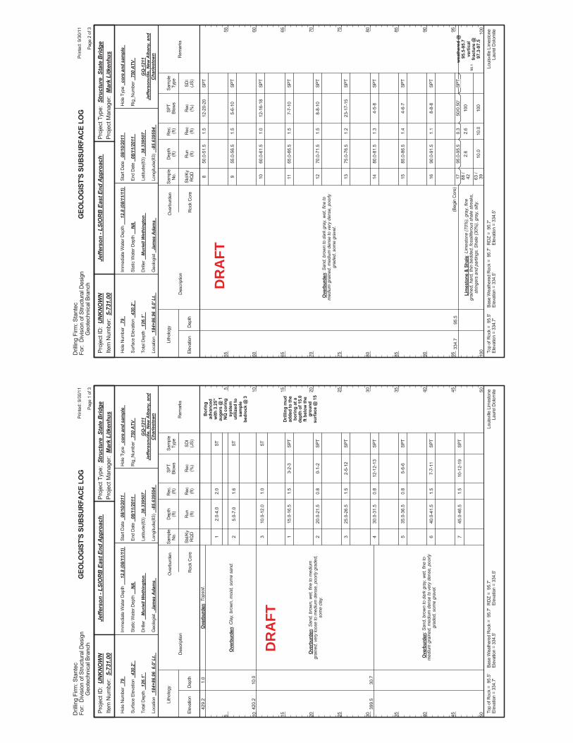
2.0-
4.0
5.0-
7.0
10.0
-12.
0
15.0
-16.
5
20.0
-21.
5
25.0
-26.
5
30.0
-31.
5
35.0
-36.
5
40.0
-41.
5
45.0
-46.
5
3-2-
3
0-1-
2
2-5-
12
12-1
2-13
5-6-
6
7-7-
11
10-1
2-19
Bor
ing
adva
nced
with
3.2
5"au
gers
@ 1
NQ
cor
ing
syst
emut
ilize
d to
sam
ple
bedr
ock
@ 3
Dril
ling
mud
adde
d to
the
borin
g at
ade
pth
of 1
5.0
ft be
low
the
grou
ndsu
rface
@ 1
5
429.
2
420.
2
399.
5
1.0
10.0
30.7
Ove
rbur
den:
Top
soil.
Ove
rbur
den:
Cla
y, b
row
n, m
oist
, som
e sa
nd.
Ove
rbur
den:
San
d, b
row
n, w
et, f
ine
to m
ediu
mgr
aine
d, v
ery
loos
e to
med
ium
den
se, p
oorly
gra
ded,
som
e cl
ay.
Ove
rbur
den:
San
d, b
row
n to
dar
k gr
ay, w
et, f
ine
tom
ediu
m g
rain
ed, m
ediu
m d
ense
to v
ery
dens
e, p
oorly
grad
ed, s
ome
grav
el.
1 2 3 1 2 3 4 5 6 7
2.0
1.6
1.0
1.5
0.8
1.5
0.8
0.8
1.5
1.5
Elev
atio
nD
epth
Std/
KyR
QD
Lith
olog
y
5 10 15 20 25 30 35 40 45 50
5 10 15 20 25 30 35 40 45 50
Dep
th(ft
)SP
TBl
ows
Sam
ple
Type
Rec (ft)
Geo
logi
st
Jam
es A
dam
s
Hol
e Ty
pe
core
and
sam
ple
Rec (%
)
Rec
.(ft
)Sa
mpl
eN
o.
Run (ft)
Des
crip
tion
Ove
rbur
den
Roc
k C
ore
SDI
(JS)
Rem
arks
Rig
_Num
ber
750
ATV
Hol
e N
umbe
r 79
Surfa
ce E
leva
tion
430.
2'
Tota
l Dep
th
126.
1'
End
Dat
e 08
/11/
2011
Latit
ude(
83)
38.3
3950
7
Long
itude
(83)
-8
5.63
9594
Star
t Dat
e 08
/10/
2011
Dril
ler
Mur
iell
Wet
hing
ton
GEO
LOG
IST'
S SU
BSUR
FACE
LO
G
GQ
-121
1Je
ffers
onvi
lle, N
ew A
lban
y, a
ndC
harle
stow
n
Stat
ic W
ater
Dep
th
NA
Loui
sville
Lim
esto
neLa
urel
Dol
omite
Imm
edia
te W
ater
Dep
th
12.8
(08/
11/1
1)
Loca
tion
184+
86.9
6 6
.0' L
t.
Base
Wea
ther
ed R
ock
= 9
5.7'
Elev
atio
n =
334.
5'To
p of
Roc
k =
95.
5'El
evat
ion
= 33
4.7'
RD
Z =
95.
7'El
evat
ion
= 33
4.5'
Prin
ted:
9/3
0/11
Page
1 o
f 3
Dril
ling
Firm
: Sta
ntec
For:
Div
isio
n of
Stru
ctur
al D
esig
nG
eote
chni
cal B
ranc
h
Proj
ect T
ype:
Str
uctu
re S
tate
Brid
gePr
ojec
t Man
ager
: M
ark
Litk
enhu
sPr
ojec
t ID
: U
NK
NO
WN
Item
Num
ber:
5-7
31.0
0Je
ffers
on -
LSIO
RB
Eas
t End
App
roac
h
ST ST ST SPT
SPT
SPT
SPT
SPT
SPT
SPT
DR
AFT
98.1
50.0
-51.
5
55.0
-56.
5
60.0
-61.
5
65.0
-66.
5
70.0
-71.
5
75.0
-76.
5
80.0
-81.
5
85.0
-86.
5
90.0
-91.
5
95.0
-95.
52.
6
10.0
12-2
0-20
5-6-
10
12-1
6-18
7-7-
10
8-8-
10
23-1
7-15
4-5-
8
4-6-
7
8-8-
8
50/0
.50'
100
100
wea
ther
ed @
95.5
-95.
7ve
rtic
alfr
actu
re @
97.3
-97.
5
334.
795
.5
Ove
rbur
den:
San
d, b
row
n to
dar
k gr
ay, w
et, f
ine
tom
ediu
m g
rain
ed, m
ediu
m d
ense
to v
ery
dens
e, p
oorly
grad
ed, s
ome
grav
el.
Lim
esto
ne &
Sha
le: L
imes
tone
(70%
), gr
ay, f
ine
grai
ned,
har
d, th
in b
edde
d, fo
ssilif
erou
s sh
ale
stre
aks,
strin
gers
and
par
tings
. Sha
le (3
0%),
gray
, silt
y.
(Beg
in C
ore)
8 9 10 11 12 13 14 15 16 17 88 /
42 63 /
39
1.5
1.5
1.0
1.5
1.5
1.2
1.3
1.4
1.1
0.3
2.6
10.0
Elev
atio
nD
epth
Std/
KyR
QD
Lith
olog
y
55 60 65 70 75 80 85 90 95 100
55 60 65 70 75 80 85 90 95 100
Dep
th(ft
)SP
TBl
ows
Sam
ple
Type
Rec (ft)
Geo
logi
st
Jam
es A
dam
s
Hol
e Ty
pe
core
and
sam
ple
Rec (%
)
Rec
.(ft
)Sa
mpl
eN
o.
Run (ft)
Des
crip
tion
Ove
rbur
den
Roc
k C
ore
SDI
(JS)
Rem
arks
Rig
_Num
ber
750
ATV
Hol
e N
umbe
r 79
Surfa
ce E
leva
tion
430.
2'
Tota
l Dep
th
126.
1'
End
Dat
e 08
/11/
2011
Latit
ude(
83)
38.3
3950
7
Long
itude
(83)
-8
5.63
9594
Star
t Dat
e 08
/10/
2011
Dril
ler
Mur
iell
Wet
hing
ton
GEO
LOG
IST'
S SU
BSUR
FACE
LO
G
GQ
-121
1Je
ffers
onvi
lle, N
ew A
lban
y, a
ndC
harle
stow
n
Stat
ic W
ater
Dep
th
NA
Loui
sville
Lim
esto
neLa
urel
Dol
omite
Imm
edia
te W
ater
Dep
th
12.8
(08/
11/1
1)
Loca
tion
184+
86.9
6 6
.0' L
t.
Base
Wea
ther
ed R
ock
= 9
5.7'
Elev
atio
n =
334.
5'To
p of
Roc
k =
95.
5'El
evat
ion
= 33
4.7'
RD
Z =
95.
7'El
evat
ion
= 33
4.5'
Prin
ted:
9/3
0/11
Page
2 o
f 3
Dril
ling
Firm
: Sta
ntec
For:
Div
isio
n of
Stru
ctur
al D
esig
nG
eote
chni
cal B
ranc
h
Proj
ect T
ype:
Str
uctu
re S
tate
Brid
gePr
ojec
t Man
ager
: M
ark
Litk
enhu
sPr
ojec
t ID
: U
NK
NO
WN
Item
Num
ber:
5-7
31.0
0Je
ffers
on -
LSIO
RB
Eas
t End
App
roac
h
SPT
SPT
SPT
SPT
SPT
SPT
SPT
SPT
SPT
SPT
DR
AFT
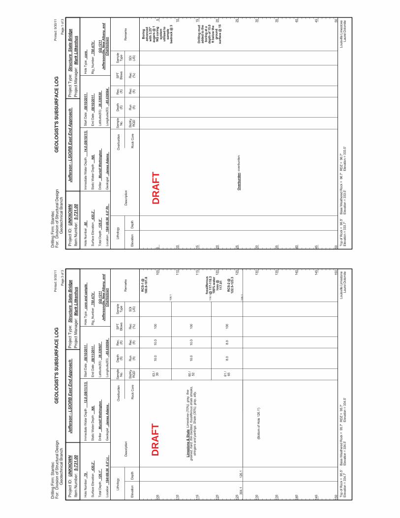
108.
1
118.
1
126.
1
10.0
10.0
8.0
100
100
100
RC
S-1
@10
0.8-
101.
8
foss
ilfer
ous
@ 1
17-1
18.3
100%
wat
erlo
ss @
117.
01
RC
S-2
@12
2.5-
123.
3
304.
112
6.1
Lim
esto
ne &
Sha
le: L
imes
tone
(70%
), gr
ay, f
ine
grai
ned,
har
d, th
in b
edde
d, fo
ssilif
erou
s sh
ale
stre
aks,
strin
gers
and
par
tings
. Sha
le (3
0%),
gray
, silt
y.
63 /
39 60 /
52 61 /
65
(Bot
tom
of H
ole
126.
1')
10.0
10.0
8.0
Elev
atio
nD
epth
Std/
KyR
QD
Lith
olog
y
105
110
115
120
125
130
135
140
145
150
105
110
115
120
125
130
135
140
145
150
Dep
th(ft
)SP
TBl
ows
Sam
ple
Type
Rec (ft)
Geo
logi
st
Jam
es A
dam
s
Hol
e Ty
pe
core
and
sam
ple
Rec (%
)
Rec
.(ft
)Sa
mpl
eN
o.
Run (ft)
Des
crip
tion
Ove
rbur
den
Roc
k C
ore
SDI
(JS)
Rem
arks
Rig
_Num
ber
750
ATV
Hol
e N
umbe
r 79
Surfa
ce E
leva
tion
430.
2'
Tota
l Dep
th
126.
1'
End
Dat
e 08
/11/
2011
Latit
ude(
83)
38.3
3950
7
Long
itude
(83)
-8
5.63
9594
Star
t Dat
e 08
/10/
2011
Dril
ler
Mur
iell
Wet
hing
ton
GEO
LOG
IST'
S SU
BSUR
FACE
LO
G
GQ
-121
1Je
ffers
onvi
lle, N
ew A
lban
y, a
ndC
harle
stow
n
Stat
ic W
ater
Dep
th
NA
Loui
sville
Lim
esto
neLa
urel
Dol
omite
Imm
edia
te W
ater
Dep
th
12.8
(08/
11/1
1)
Loca
tion
184+
86.9
6 6
.0' L
t.
Base
Wea
ther
ed R
ock
= 9
5.7'
Elev
atio
n =
334.
5'To
p of
Roc
k =
95.
5'El
evat
ion
= 33
4.7'
RD
Z =
95.
7'El
evat
ion
= 33
4.5'
Prin
ted:
9/3
0/11
Page
3 o
f 3
Dril
ling
Firm
: Sta
ntec
For:
Div
isio
n of
Stru
ctur
al D
esig
nG
eote
chni
cal B
ranc
h
Proj
ect T
ype:
Str
uctu
re S
tate
Brid
gePr
ojec
t Man
ager
: M
ark
Litk
enhu
sPr
ojec
t ID
: U
NK
NO
WN
Item
Num
ber:
5-7
31.0
0Je
ffers
on -
LSIO
RB
Eas
t End
App
roac
h
DR
AFT
Bor
ing
adva
nced
with
3.2
5"au
gers
@ 1
NQ
cor
ing
syst
emut
ilize
d to
sam
ple
bedr
ock
@ 3
Dril
ling
mud
adde
d to
the
borin
g at
ade
pth
of 1
5.0
ft be
low
the
grou
ndsu
rface
@ 1
5
Ove
rbur
den:
ove
rbur
den.
Elev
atio
nD
epth
Std/
KyR
QD
Lith
olog
y
5 10 15 20 25 30 35 40 45 50
5 10 15 20 25 30 35 40 45 50
Dep
th(ft
)SP
TBl
ows
Sam
ple
Type
Rec (ft)
Geo
logi
st
Jam
es A
dam
s
Hol
e Ty
pe
core
Rec (%
)
Rec
.(ft
)Sa
mpl
eN
o.
Run (ft)
Des
crip
tion
Ove
rbur
den
Roc
k C
ore
SDI
(JS)
Rem
arks
Rig
_Num
ber
750
ATV
Hol
e N
umbe
r 80
Surfa
ce E
leva
tion
430.
2'
Tota
l Dep
th
125.
9'
End
Dat
e 08
/10/
2011
Latit
ude(
83)
38.3
3953
0
Long
itude
(83)
-8
5.63
9564
Star
t Dat
e 08
/10/
2011
Dril
ler
Mur
iell
Wet
hing
ton
GEO
LOG
IST'
S SU
BSUR
FACE
LO
G
GQ
-121
1Je
ffers
onvi
lle, N
ew A
lban
y, a
ndC
harle
stow
n
Stat
ic W
ater
Dep
th
NA
Loui
sville
Lim
esto
neLa
urel
Dol
omite
Imm
edia
te W
ater
Dep
th
14.0
(08/
10/1
1)
Loca
tion
184+
86.9
6 6
.0' R
t.
Base
Wea
ther
ed R
ock
= 9
6.7'
Elev
atio
n =
333.
5'To
p of
Roc
k =
96.
5'El
evat
ion
= 33
3.7'
RD
Z =
96.
7'El
evat
ion
= 33
3.5'
Prin
ted:
9/3
0/11
Page
1 o
f 3
Dril
ling
Firm
: Sta
ntec
For:
Div
isio
n of
Stru
ctur
al D
esig
nG
eote
chni
cal B
ranc
h
Proj
ect T
ype:
Str
uctu
re S
tate
Brid
gePr
ojec
t Man
ager
: M
ark
Litk
enhu
sPr
ojec
t ID
: U
NK
NO
WN
Item
Num
ber:
5-7
31.0
0Je
ffers
on -
LSIO
RB
Eas
t End
App
roac
h
DR
AFT
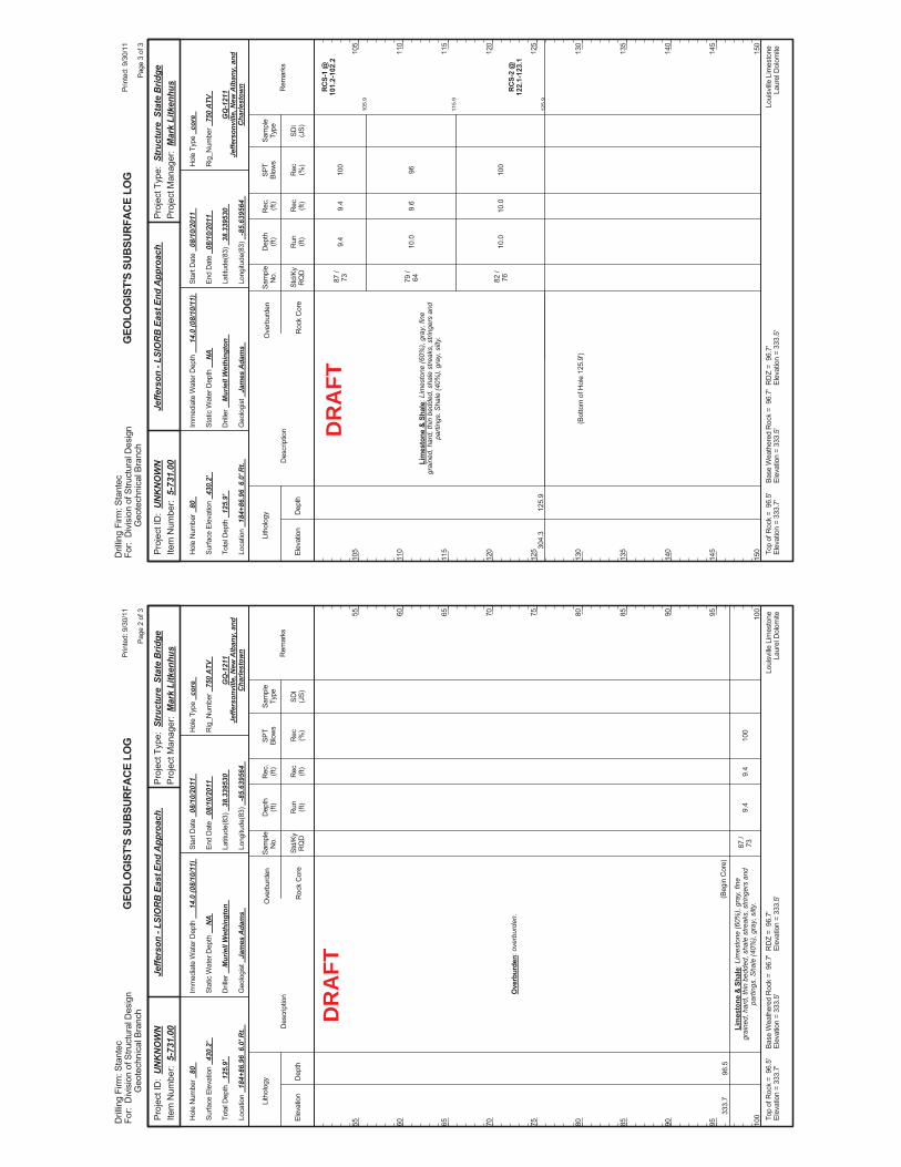
9.4
100
333.
796
.5
Ove
rbur
den:
ove
rbur
den.
Lim
esto
ne &
Sha
le: L
imes
tone
(60%
), gr
ay, f
ine
grai
ned,
har
d, th
in b
edde
d, s
hale
stre
aks,
stri
nger
s an
dpa
rting
s. S
hale
(40%
), gr
ay, s
ilty.
(Beg
in C
ore)
87 /
739.
4
Elev
atio
nD
epth
Std/
KyR
QD
Lith
olog
y
55 60 65 70 75 80 85 90 95 100
55 60 65 70 75 80 85 90 95 100
Dep
th(ft
)SP
TBl
ows
Sam
ple
Type
Rec (ft)
Geo
logi
st
Jam
es A
dam
s
Hol
e Ty
pe
core
Rec (%
)
Rec
.(ft
)Sa
mpl
eN
o.
Run (ft)
Des
crip
tion
Ove
rbur
den
Roc
k C
ore
SDI
(JS)
Rem
arks
Rig
_Num
ber
750
ATV
Hol
e N
umbe
r 80
Surfa
ce E
leva
tion
430.
2'
Tota
l Dep
th
125.
9'
End
Dat
e 08
/10/
2011
Latit
ude(
83)
38.3
3953
0
Long
itude
(83)
-8
5.63
9564
Star
t Dat
e 08
/10/
2011
Dril
ler
Mur
iell
Wet
hing
ton
GEO
LOG
IST'
S SU
BSUR
FACE
LO
G
GQ
-121
1Je
ffers
onvi
lle, N
ew A
lban
y, a
ndC
harle
stow
n
Stat
ic W
ater
Dep
th
NA
Loui
sville
Lim
esto
neLa
urel
Dol
omite
Imm
edia
te W
ater
Dep
th
14.0
(08/
10/1
1)
Loca
tion
184+
86.9
6 6
.0' R
t.
Base
Wea
ther
ed R
ock
= 9
6.7'
Elev
atio
n =
333.
5'To
p of
Roc
k =
96.
5'El
evat
ion
= 33
3.7'
RD
Z =
96.
7'El
evat
ion
= 33
3.5'
Prin
ted:
9/3
0/11
Page
2 o
f 3
Dril
ling
Firm
: Sta
ntec
For:
Div
isio
n of
Stru
ctur
al D
esig
nG
eote
chni
cal B
ranc
h
Proj
ect T
ype:
Str
uctu
re S
tate
Brid
gePr
ojec
t Man
ager
: M
ark
Litk
enhu
sPr
ojec
t ID
: U
NK
NO
WN
Item
Num
ber:
5-7
31.0
0Je
ffers
on -
LSIO
RB
Eas
t End
App
roac
h
DR
AFT
105.
9
115.
9
125.
9
9.4
10.0
10.0
100
96 100
RC
S-1
@10
1.2-
102.
2
RC
S-2
@12
2.1-
123.
1
304.
312
5.9
Lim
esto
ne &
Sha
le: L
imes
tone
(60%
), gr
ay, f
ine
grai
ned,
har
d, th
in b
edde
d, s
hale
stre
aks,
stri
nger
s an
dpa
rting
s. S
hale
(40%
), gr
ay, s
ilty.
87 /
73 79 /
64 82 /
76
(Bot
tom
of H
ole
125.
9')
9.4
9.6
10.0
Elev
atio
nD
epth
Std/
KyR
QD
Lith
olog
y
105
110
115
120
125
130
135
140
145
150
105
110
115
120
125
130
135
140
145
150
Dep
th(ft
)SP
TBl
ows
Sam
ple
Type
Rec (ft)
Geo
logi
st
Jam
es A
dam
s
Hol
e Ty
pe
core
Rec (%
)
Rec
.(ft
)Sa
mpl
eN
o.
Run (ft)
Des
crip
tion
Ove
rbur
den
Roc
k C
ore
SDI
(JS)
Rem
arks
Rig
_Num
ber
750
ATV
Hol
e N
umbe
r 80
Surfa
ce E
leva
tion
430.
2'
Tota
l Dep
th
125.
9'
End
Dat
e 08
/10/
2011
Latit
ude(
83)
38.3
3953
0
Long
itude
(83)
-8
5.63
9564
Star
t Dat
e 08
/10/
2011
Dril
ler
Mur
iell
Wet
hing
ton
GEO
LOG
IST'
S SU
BSUR
FACE
LO
G
GQ
-121
1Je
ffers
onvi
lle, N
ew A
lban
y, a
ndC
harle
stow
n
Stat
ic W
ater
Dep
th
NA
Loui
sville
Lim
esto
neLa
urel
Dol
omite
Imm
edia
te W
ater
Dep
th
14.0
(08/
10/1
1)
Loca
tion
184+
86.9
6 6
.0' R
t.
Base
Wea
ther
ed R
ock
= 9
6.7'
Elev
atio
n =
333.
5'To
p of
Roc
k =
96.
5'El
evat
ion
= 33
3.7'
RD
Z =
96.
7'El
evat
ion
= 33
3.5'
Prin
ted:
9/3
0/11
Page
3 o
f 3
Dril
ling
Firm
: Sta
ntec
For:
Div
isio
n of
Stru
ctur
al D
esig
nG
eote
chni
cal B
ranc
h
Proj
ect T
ype:
Str
uctu
re S
tate
Brid
gePr
ojec
t Man
ager
: M
ark
Litk
enhu
sPr
ojec
t ID
: U
NK
NO
WN
Item
Num
ber:
5-7
31.0
0Je
ffers
on -
LSIO
RB
Eas
t End
App
roac
h
DR
AFT
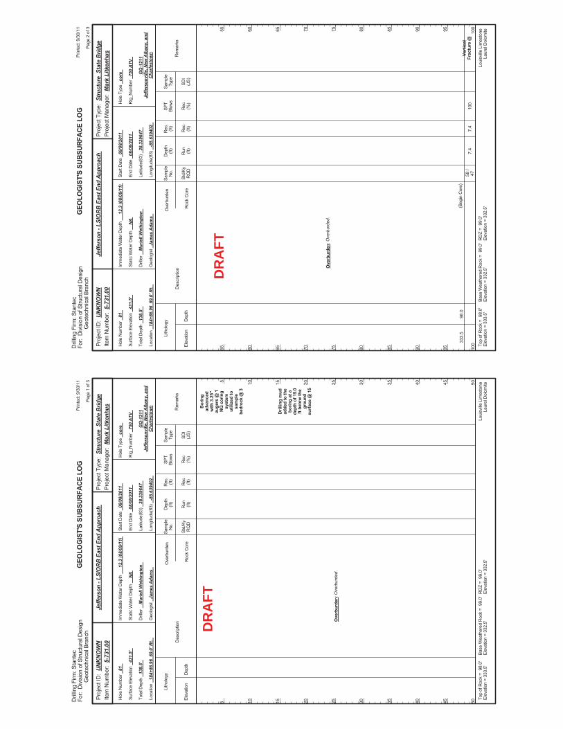
Bor
ing
adva
nced
with
3.2
5"au
gers
@ 1
NQ
cor
ing
syst
emut
ilize
d to
sam
ple
bedr
ock
@ 3
Dril
ling
mud
adde
d to
the
borin
g at
ade
pth
of 1
5.0
ft be
low
the
grou
ndsu
rface
@ 1
5
Ove
rbur
den:
Ove
rbur
ded.
Elev
atio
nD
epth
Std/
KyR
QD
Lith
olog
y
5 10 15 20 25 30 35 40 45 50
5 10 15 20 25 30 35 40 45 50
Dep
th(ft
)SP
TBl
ows
Sam
ple
Type
Rec (ft)
Geo
logi
st
Jam
es A
dam
s
Hol
e Ty
pe
core
Rec (%
)
Rec
.(ft
)Sa
mpl
eN
o.
Run (ft)
Des
crip
tion
Ove
rbur
den
Roc
k C
ore
SDI
(JS)
Rem
arks
Rig
_Num
ber
750
ATV
Hol
e N
umbe
r 81
Surfa
ce E
leva
tion
431.
5'
Tota
l Dep
th
138.
5'
End
Dat
e 08
/08/
2011
Latit
ude(
83)
38.3
3964
7
Long
itude
(83)
-8
5.63
9402
Star
t Dat
e 08
/08/
2011
Dril
ler
Mur
iell
Wet
hing
ton
GEO
LOG
IST'
S SU
BSUR
FACE
LO
G
GQ
-121
1Je
ffers
onvi
lle, N
ew A
lban
y, a
ndC
harle
stow
n
Stat
ic W
ater
Dep
th
NA
Loui
sville
Lim
esto
neLa
urel
Dol
omite
Imm
edia
te W
ater
Dep
th
12.3
(08/
09/1
1)
Loca
tion
184+
86.9
6 6
9.0'
Rt.
Base
Wea
ther
ed R
ock
= 9
9.0'
Elev
atio
n =
332.
5'To
p of
Roc
k =
98.
0'El
evat
ion
= 33
3.5'
RD
Z =
99.
0'El
evat
ion
= 33
2.5'
Prin
ted:
9/3
0/11
Page
1 o
f 3
Dril
ling
Firm
: Sta
ntec
For:
Div
isio
n of
Stru
ctur
al D
esig
nG
eote
chni
cal B
ranc
h
Proj
ect T
ype:
Str
uctu
re S
tate
Brid
gePr
ojec
t Man
ager
: M
ark
Litk
enhu
sPr
ojec
t ID
: U
NK
NO
WN
Item
Num
ber:
5-7
31.0
0Je
ffers
on -
LSIO
RB
Eas
t End
App
roac
h
DR
AFT
7.4
100
Vert
ical
Frac
ture
@33
3.5
98.0
Ove
rbur
den:
Ove
rbur
ded.
(Beg
in C
ore)
58 /
477.
4
Elev
atio
nD
epth
Std/
KyR
QD
Lith
olog
y
55 60 65 70 75 80 85 90 95 100
55 60 65 70 75 80 85 90 95 100
Dep
th(ft
)SP
TBl
ows
Sam
ple
Type
Rec (ft)
Geo
logi
st
Jam
es A
dam
s
Hol
e Ty
pe
core
Rec (%
)
Rec
.(ft
)Sa
mpl
eN
o.
Run (ft)
Des
crip
tion
Ove
rbur
den
Roc
k C
ore
SDI
(JS)
Rem
arks
Rig
_Num
ber
750
ATV
Hol
e N
umbe
r 81
Surfa
ce E
leva
tion
431.
5'
Tota
l Dep
th
138.
5'
End
Dat
e 08
/08/
2011
Latit
ude(
83)
38.3
3964
7
Long
itude
(83)
-8
5.63
9402
Star
t Dat
e 08
/08/
2011
Dril
ler
Mur
iell
Wet
hing
ton
GEO
LOG
IST'
S SU
BSUR
FACE
LO
G
GQ
-121
1Je
ffers
onvi
lle, N
ew A
lban
y, a
ndC
harle
stow
n
Stat
ic W
ater
Dep
th
NA
Loui
sville
Lim
esto
neLa
urel
Dol
omite
Imm
edia
te W
ater
Dep
th
12.3
(08/
09/1
1)
Loca
tion
184+
86.9
6 6
9.0'
Rt.
Base
Wea
ther
ed R
ock
= 9
9.0'
Elev
atio
n =
332.
5'To
p of
Roc
k =
98.
0'El
evat
ion
= 33
3.5'
RD
Z =
99.
0'El
evat
ion
= 33
2.5'
Prin
ted:
9/3
0/11
Page
2 o
f 3
Dril
ling
Firm
: Sta
ntec
For:
Div
isio
n of
Stru
ctur
al D
esig
nG
eote
chni
cal B
ranc
h
Proj
ect T
ype:
Str
uctu
re S
tate
Brid
gePr
ojec
t Man
ager
: M
ark
Litk
enhu
sPr
ojec
t ID
: U
NK
NO
WN
Item
Num
ber:
5-7
31.0
0Je
ffers
on -
LSIO
RB
Eas
t End
App
roac
h
DR
AFT
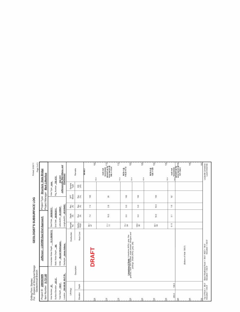
105.
4
115.
4
120.
4
125.
4
135.
4
138.
5
7.4
10.0
5.0
5.0
10.0
3.1
100
28 100
100
100
52
98-9
8.3
rock
not
reco
vere
d,gr
ound
up
byco
re b
arre
l @10
8.1-
115.
4
RC
S-1
@11
6.8-
117.
5
RC
S-2
@12
8.1-
129
rock
not
reco
vere
d,gr
ound
up
byco
re b
arre
l @13
7-13
8.5
293.
013
8.5
Lim
esto
ne &
Sha
le: L
imes
tone
(60%
), gr
ay, f
ine
grai
ned,
har
d, th
in b
edde
d, s
hale
stre
aks,
stri
nger
s an
dpa
rting
s. S
hale
(40%
), gr
ay, s
ilty.
58 /
47 11 /
11 73 /
64 100
/90 92
/84 0 / 0
(Bot
tom
of H
ole
138.
5')
7.4
2.8
5.0
5.0
10.0
1.6
Elev
atio
nD
epth
Std/
KyR
QD
Lith
olog
y
105
110
115
120
125
130
135
140
145
150
105
110
115
120
125
130
135
140
145
150
Dep
th(ft
)SP
TBl
ows
Sam
ple
Type
Rec (ft)
Geo
logi
st
Jam
es A
dam
s
Hol
e Ty
pe
core
Rec (%
)
Rec
.(ft
)Sa
mpl
eN
o.
Run (ft)
Des
crip
tion
Ove
rbur
den
Roc
k C
ore
SDI
(JS)
Rem
arks
Rig
_Num
ber
750
ATV
Hol
e N
umbe
r 81
Surfa
ce E
leva
tion
431.
5'
Tota
l Dep
th
138.
5'
End
Dat
e 08
/08/
2011
Latit
ude(
83)
38.3
3964
7
Long
itude
(83)
-8
5.63
9402
Star
t Dat
e 08
/08/
2011
Dril
ler
Mur
iell
Wet
hing
ton
GEO
LOG
IST'
S SU
BSUR
FACE
LO
G
GQ
-121
1Je
ffers
onvi
lle, N
ew A
lban
y, a
ndC
harle
stow
n
Stat
ic W
ater
Dep
th
NA
Loui
sville
Lim
esto
neLa
urel
Dol
omite
Imm
edia
te W
ater
Dep
th
12.3
(08/
09/1
1)
Loca
tion
184+
86.9
6 6
9.0'
Rt.
Base
Wea
ther
ed R
ock
= 9
9.0'
Elev
atio
n =
332.
5'To
p of
Roc
k =
98.
0'El
evat
ion
= 33
3.5'
RD
Z =
99.
0'El
evat
ion
= 33
2.5'
Prin
ted:
9/3
0/11
Page
3 o
f 3
Dril
ling
Firm
: Sta
ntec
For:
Div
isio
n of
Stru
ctur
al D
esig
nG
eote
chni
cal B
ranc
h
Proj
ect T
ype:
Str
uctu
re S
tate
Brid
gePr
ojec
t Man
ager
: M
ark
Litk
enhu
sPr
ojec
t ID
: U
NK
NO
WN
Item
Num
ber:
5-7
31.0
0Je
ffers
on -
LSIO
RB
Eas
t End
App
roac
h
DR
AFT
LSIORB – East End Bridge Over Ohio River Scour Analysis Report KYTC Item No. 5-118.00 October 31,2011
Page C-1
APPENDIX C: DETAILED SCOUR CALCULATIONS

Final
9/20/2011 100
LMW Chkd by: PXVG Steady
Methodology: HEC-18, 4th Edition, Section 6.1 7
Simple English
Variable Pier 1 Pier 2 Pier 3 Pier 4 Pier 5 Pier 6 Pier 7 Unit
D50 4.27E-04 1.74E-05 2.13E-05 1.35E-04 2.30E-05 2.26E-04 1.28E-05 ft
D95 3.94E-02 8.53E-04 2.59E-04 1.02E-03 6.56E-04 1.05E-03 1.61E-04 ft
BC small dunes small dunes small dunes small dunes small dunes small dunes small dunes
Variable Pier 1 Pier 2 Pier 3 Pier 4 Pier 5 Pier 6 Pier 7 Unit
θ 25.0 21.0 29.0 28.0 30.0 29.0 25.0 degrees
y1 8.0 24.7 16.0 6.6 13.5 20.0 21.0 ft
V1 0.42 1.08 2.14 3.56 2.72 3.01 2.99 ft / s
g 32.2 32.2 32.2 32.2 32.2 32.2 32.2 ft / s^2
Variable Pier 1 Pier 2 Pier 3 Pier 4 Pier 5 Pier 6 Pier 7 Unit
PS Group Group Group Group Group Group Group
ap 8.0 8.0 8.0 8.0 8.0 8.0 8.0 ft
Lp 16.0 16.0 16.0 16.0 16.0 16.0 8.0 ft
C 2.0 2.0 2.0 2.0 2.0 2.0 3.0
S 80.0 80.0 80.0 80.0 80.0 80.0 40.0
Variable Pier 1 Pier 2 Pier 3 Pier 4 Pier 5 Pier 6 Pier 7 Unit
Fr1 0.03 0.04 0.09 0.24 0.13 0.12 0.11
K1 1.00 1.00 1.00 1.00 1.00 1.00 1.00
K2 1.44 1.38 1.49 1.48 1.50 1.49 1.20
K3 1.10 1.10 1.10 1.10 1.10 1.10 1.10
K4 0.40 1.00 1.00 1.00 1.00 1.00 1.00
VR 1.00 1.00 28.27 19.64 1.00 6.99 42.49
VicD50 0.46 0.16 0.16 0.28 0.16 0.42 0.14 ft / s
VicD95 2.62 0.72 0.42 0.62 0.59 0.75 0.37 ft / s
VcD50 1.19 0.49 0.49 0.78 0.49 1.12 0.43 ft / s
VcD90 5.37 1.81 1.13 1.54 1.50 1.87 1.01 ft / s
Velocity ratio required to calculate K4
Froude number directly upstream of the pier
PIER DATA
SIMPLE PIER SCOUR CALCULATIONS
Pier shape (Square, Round, Cylindrical, Group, Sharp)
Description
Correction factor for pier nose shape from Table 6.1
Mean velocity of flow directly upstream of the pier
Acceleration of gravity
Pier stem width
100 YEAR SIMPLE PIER SCOUR COMPUTATIONS
Description
A simple pier is a single shaft, column, or multiple columns exposed to the flow. The pier itself is socketed into rock, and no footing is needed.
Date:
No. of Piers:
Angle of attack
Return Period (yrs):
Flow Type:
BED CONDITIONS
Description
Critical velocity for incipient motion of the D50
Diameter at which 50% of the soil grains pass
Units:
Diameter at which 95% of the soil grains pass
Bed Condition (clear-water, plane bed, small dunes, medium dunes, large dunes)
FLOW DATA
Scour Case:
Flow depth directly upstream of the pier
Correction factor for angle of attack of flow
Correction factor for bed condition from Table 6.3
Description
Length of pier stem
Number of columns per bent
Column spacing
Critical velocity for incipient motion of the D95
Approach velocity required to initiate scour of the D50 at the pier
Project: Louisville Southern Indiana Ohio River East End Bridge
Configuration:
Prepared by:
Correction factor for armoring by bed material size
Approach velocity required to initiate scour of the D95 at the pier
Page 1 Sec 4 East End Final_100YR-Scour_10-2011.xls
Kw 1.00 1.00 1.00 1.00 1.00 1.00 1.00
Ku 11.17 11.17 11.17 11.17 11.17 11.17 11.17
ys 2.1 8.9 12.1 13.3 13.2 14.4 11.7 ft
ysm1 2.5 10.7 14.5 15.9 15.8 17.3 N/A
ysm2 N/A N/A N/A N/A N/A N/A N/A
ysm3 N/A N/A N/A N/A N/A N/A N/A
ysm 2.5 10.7 14.5 15.9 15.8 17.3 N/A ft
Table 6.1. Correction (K1) for Pier Nose Shape Table 6.3. Increase in Equilibrium Pier Scour Depths (K3) for Bed Condition
Pier Nose Shape K1 Height
1.1 Bed Condition (m) K3
1.0 N/A 1.1
1.0 N/A 1.1
1.0 3 >H >=0.6 1.1
0.9 9 >H >=3 1.2
H >=9 1.3
Multiple Column Pier Scour
Single Column Pier Scour
Multiple Column Pier Scour - Raudkivi MethodMultiple Column Pier Scour - Equivalent Pier MethodMultiple Column Pier Scour - K 2 Method
Units correction factor for calculating VcD50
Square
TABLES
Correction factor for very wide piers
Sharp Medium Dunes
Large Dunes
Cylindrical Plane Bed
Group Small Dunes
Round Clear-Water
EQUATIONS
( )gy
VFr
1
11 =
43.01
65.0
1432112 Fr
ya
KKKKKyy pws
=
( ) 0Vwhere4.0 R1 5.0
4 >= RVK 09550
501 >−
−=
icDcD
icDR VV
VVV
3/150
6/115 0
DyKV ucD = ( ) 1V
Vfor58.250cD
165.01
34.0
1 <
= Fr
ayK
pw
( ) 1for250
125.01
13.01 >=
=
cDw V
VFrayK
5050
0 53.0
5 0645.0 cDp
icD VaDV
=
ssm yyds
2.1,5If:MethodRaudkivi
1 =
>
CosaCaaK
FryaKKKKKyy
ds
ppm
mwsm
+==
=
<
sinand1where
2
,5If:MethodP ierEquivalent
2
43.01
65.0
1432112
65.02
43.01
65.0
1432113
2
)sin(where
2
,5If:MethodK
CCosK
Frya
KKKKKyy
ds
pwsm
+=
=
<
( ) 12L/awhere
)sinCos(
max
65.02
=
+=
aL
K
Page 2 Sec 4 East End Final_100YR-Scour_10-2011.xls
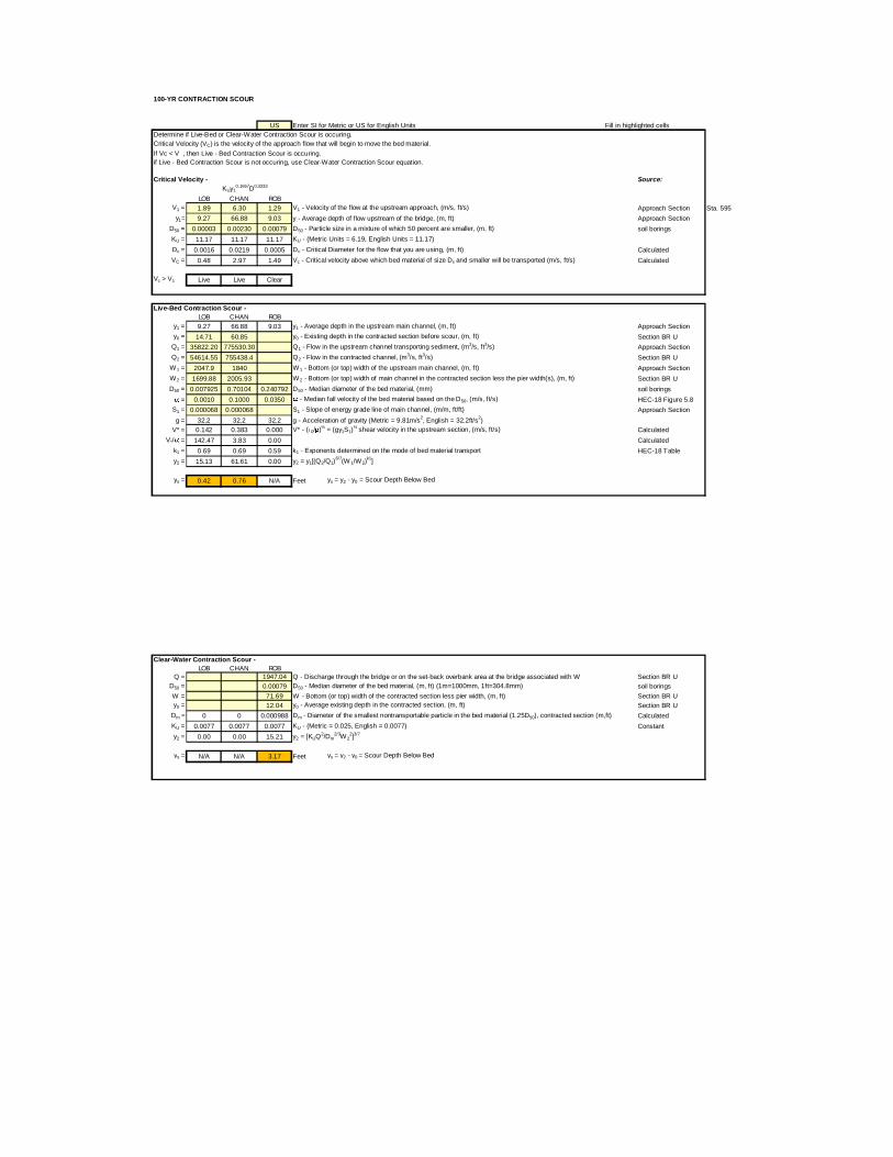
100-YR CONTRACTION SCOUR
US Enter SI for Metric or US for English Units Fill in highlighted cells
Determine if Live-Bed or Clear-Water Contraction Scour is occuring.
Critical Velocity (VC) is the velocity of the approach flow that will begin to move the bed material.
If Vc < V , then Live - Bed Contraction Scour is occuring.
if Live - Bed Contraction Scour is not occuring, use Clear-Water Contraction Scour equation.
Critical Velocity - Source:KUy1
0.1667D
0.3333
LOB CHAN ROBV1 = 1.89 6.30 1.29 V1 - Velocity of the flow at the upstream approach, (m/s, ft/s) Approach Section Sta. 595
y1= 9.27 66.88 9.03 y - Average depth of flow upstream of the bridge, (m, ft) Approach Section
D50 = 0.00003 0.00230 0.00079 D50 - Particle size in a mixture of which 50 percent are smaller, (m, ft) soil borings
KU = 11.17 11.17 11.17 KU - (Metric Units = 6.19, English Units = 11.17)
Dc = 0.0016 0.0219 0.0005 Dc - Critical Diameter for the flow that you are using, (m, ft) Calculated
VC = 0.48 2.97 1.49 Vc - Critical velocity above which bed material of size Dx and smaller will be transported (m/s, ft/s) Calculated
Vc > V1 Live Live Clear
Live-Bed Contraction Scour -
LOB CHAN ROBy1 = 9.27 66.88 9.03 y1 - Average depth in the upstream main channel, (m, ft) Approach Section
y0 = 14.71 60.85 y0 - Existing depth in the contracted section before scour, (m, ft) Section BR U
Q1 = 35822.20 775530.30 Q1 - Flow in the upstream channel transporting sediment, (m3/s, ft
3/s) Approach Section
Q2 = 54614.55 755438.4 Q2 - Flow in the contracted channel, (m3/s, ft
3/s) Section BR U
W1 = 2047.9 1840 W1 - Bottom (or top) width of the upstream main channel, (m, ft) Approach Section
W2 = 1699.88 2005.93 W2 - Bottom (or top) width of main channel in the contracted section less the pier width(s), (m, ft) Section BR U
D50 = 0.007925 0.70104 0.240792 D50 - Median diameter of the bed material, (mm) soil borings
= 0.0010 0.1000 0.0350 - Median fall velocity of the bed material based on the D50, (m/s, ft/s) HEC-18 Figure 5.8
S1 = 0.000068 0.000068 S1 - Slope of energy grade line of main channel, (m/m, ft/ft) Approach Section
g = 32.2 32.2 32.2 g - Acceleration of gravity (Metric = 9.81m/s2, English = 32.2ft/s
2)
V* = 0.142 0.383 0.000 V* - ( 0/ )½
= (gy1S1)½
shear velocity in the upstream section, (m/s, ft/s) Calculated
V*/ = 142.47 3.83 0.00 Calculated
k1 = 0.69 0.69 0.59 k1 - Exponents determined on the mode of bed material transport HEC-18 Table
y2 = 15.13 61.61 0.00 y2 = y1[(Q2/Q1)6/7
(W 1/W2)k1
]
ys = 0.42 0.76 N/A Feet ys = y2 - y0 = Scour Depth Below Bed
Clear-Water Contraction Scour -
LOB CHAN ROBQ = 1947.04 Q - Discharge through the bridge or on the set-back overbank area at the bridge associated with W Section BR U
D50 = 0.00079 D50 - Median diameter of the bed material, (m, ft) (1m=1000mm, 1ft=304.8mm) soil borings
W = 71.69 W - Bottom (or top) width of the contracted section less pier width, (m, ft) Section BR U
y0 = 12.04 y0 - Average existing depth in the contracted section, (m, ft) Section BR U
Dm = 0 0 0.000988 Dm - Diameter of the smallest nontransportable particle in the bed material (1.25D50), contracted section (m,ft) Calculated
KU = 0.0077 0.0077 0.0077 KU - (Metric = 0.025, English = 0.0077) Constant
y2 = 0.00 0.00 15.21 y2 = [KUQ2/Dm
2/3W2
2]3/7
ys = N/A N/A 3.17 Feet ys = y2 - y0 = Scour Depth Below Bed
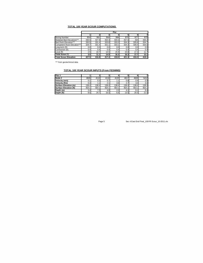
1 2 3 4 5 6 7
Boring Number B54 B61 B64 B66 B70 B77 B79
Modeled Bed Elevations*** 430.5 427.9 432.3 434.3 437.6 434 430.2
Bed Rock Elevation*** 330.5 331.4 333.8 333.3 334.3 335.8 334.7
Competent Rock Elevation*** 329.7 331.4 331.1 333.1 334.3 335.5 334.5
Long-term (ft) 0.0 0.0 0.0 0.0 0.0 0.0 0.0
Contraction (ft) 0.4 0.4 0.4 0.4 0.4 0.4 0.4Local (ft) 2.5 10.7 14.5 15.9 15.8 17.3 11.7
Total Scour (ft) 3.0 11.1 14.9 16.3 16.3 17.7 12.1
Total Scour Elevation 427.5 416.8 417.4 418.0 421.3 416.3 418.1
*** from geotechnical data
Pier # 1 2 3 4 5 6 7
Node # 4605 4113 4116 4120 4617 4626 5412
Velocity (m/s) 0.1 0.3 0.7 1.1 0.8 0.9 0.9
Velocity (ft/s) 0.4 1.1 2.1 3.6 2.7 3.0 3.0
Surface Elevation (m) 138.4 138.4 138.4 138.4 138.4 138.4 138.4
Surface Elevation (ft) 454.1 454.1 454.1 454.1 454.1 454.1 454.1
Depth (m) 2.4 7.5 4.9 2.0 4.1 6.1 6.4
Depth (ft) 8.0 24.7 16.0 6.6 13.5 20.0 21.0
TOTAL 100 YEAR SCOUR COMPUTATIONS
TOTAL 100 YEAR SCOUR INPUTS (From FESWMS)
Pier
Page 5 Sec 4 East End Final_100YR-Scour_10-2011.xls
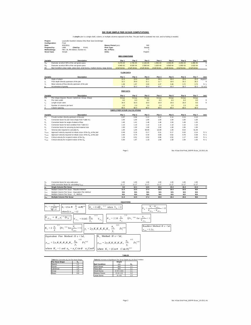
Final
9/20/2011 500
LMW Chkd by: PXVG Steady
Methodology: HEC-18, 4th Edition, Section 6.1 7
Simple English
Variable Pier 1 Pier 2 Pier 3 Pier 4 Pier 5 Pier 6 Pier 7 Unit
D50 4.27E-04 1.74E-05 2.13E-05 1.35E-04 2.30E-05 2.26E-04 1.28E-05 ft
D95 3.94E-02 8.53E-04 2.59E-04 1.02E-03 6.56E-04 1.05E-03 1.61E-04 ft
BC small dunes small dunes small dunes small dunes small dunes small dunes small dunes
Variable Pier 1 Pier 2 Pier 3 Pier 4 Pier 5 Pier 6 Pier 7 Unit
θ 22.0 23.0 28.0 28.0 30.0 29.0 25.0 degrees
y1 13.2 29.9 21.1 11.7 18.6 25.2 26.2 ft
V1 1.38 1.97 3.02 4.37 3.48 3.72 3.73 ft / s
g 32.2 32.2 32.2 32.2 32.2 32.2 32.2 ft / s^2
Variable Pier 1 Pier 2 Pier 3 Pier 4 Pier 5 Pier 6 Pier 7 Unit
PS Group Group Group Group Group Group Group
ap 8.0 8.0 8.0 8.0 8.0 8.0 8.0 ft
Lp 16.0 16.0 16.0 16.0 16.0 16.0 8.0 ft
C 2.0 2.0 2.0 2.0 2.0 2.0 3.0
S 80.0 80.0 80.0 80.0 80.0 80.0 40.0
Variable Pier 1 Pier 2 Pier 3 Pier 4 Pier 5 Pier 6 Pier 7 Unit
Fr1 0.07 0.06 0.12 0.22 0.14 0.13 0.13
K1 1.00 1.00 1.00 1.00 1.00 1.00 1.00
K2 1.40 1.41 1.48 1.48 1.50 1.49 1.20
K3 1.10 1.10 1.10 1.10 1.10 1.10 1.10
K4 1.00 1.00 1.00 1.00 1.00 1.00 1.00
VR 1.00 1.00 38.90 22.08 1.00 8.54 51.49
VicD50 0.49 0.16 0.17 0.31 0.17 0.43 0.14 ft / s
VicD95 2.84 0.74 0.44 0.68 0.62 0.78 0.38 ft / s
VcD50 1.29 0.51 0.52 0.86 0.52 1.17 0.45 ft / s
VcD90 5.84 1.87 1.18 1.69 1.58 1.94 1.05 ft / s
Project: Louisville Southern Indiana Ohio River East End Bridge
Configuration:
Prepared by:
Correction factor for armoring by bed material size
Approach velocity required to initiate scour of the D95 at the pier
Correction factor for bed condition from Table 6.3
Description
Length of pier stem
Number of columns per bent
Column spacing
Critical velocity for incipient motion of the D95
Approach velocity required to initiate scour of the D50 at the pier
Critical velocity for incipient motion of the D50
Diameter at which 50% of the soil grains pass
Units:
Diameter at which 95% of the soil grains pass
Bed Condition (clear-water, plane bed, small dunes, medium dunes, large dunes)
FLOW DATA
Scour Case:
Flow depth directly upstream of the pier
Correction factor for angle of attack of flow
500 YEAR SIMPLE PIER SCOUR COMPUTATIONS
Description
A simple pier is a single shaft, column, or multiple columns exposed to the flow. The pier itself is socketed into rock, and no footing is needed.
Date:
No. of Piers:
Angle of attack
Return Period (yrs):
Flow Type:
BED CONDITIONS
Description
PIER DATA
SIMPLE PIER SCOUR CALCULATIONS
Pier shape (Square, Round, Cylindrical, Group, Sharp)
Description
Correction factor for pier nose shape from Table 6.1
Mean velocity of flow directly upstream of the pier
Acceleration of gravity
Pier stem width
Velocity ratio required to calculate K4
Froude number directly upstream of the pier
Page 1 Sec 4 East End Final_500YR-Scour_10-2011.xls
Kw 1.00 1.00 1.00 1.00 1.00 1.00 1.00
Ku 11.17 11.17 11.17 11.17 11.17 11.17 11.17
ys 9.2 12.1 14.5 15.6 15.3 16.3 13.3 ft
ysm1 11.0 14.5 17.4 18.8 18.4 19.6 N/A
ysm2 N/A N/A N/A N/A N/A N/A N/A
ysm3 N/A N/A N/A N/A N/A N/A N/A
ysm 11.0 14.5 17.4 18.8 18.4 19.6 N/A ft
Table 6.1. Correction (K1) for Pier Nose Shape Table 6.3. Increase in Equilibrium Pier Scour Depths (K3) for Bed Condition
Pier Nose Shape K1 Height
1.1 Bed Condition (m) K3
1.0 N/A 1.1
1.0 N/A 1.1
1.0 3 >H >=0.6 1.1
0.9 9 >H >=3 1.2
H >=9 1.3
Round Clear-Water
EQUATIONS
Sharp Medium Dunes
Large Dunes
Cylindrical Plane Bed
Group Small Dunes
Square
TABLES
Correction factor for very wide piers
Multiple Column Pier Scour
Single Column Pier Scour
Multiple Column Pier Scour - Raudkivi MethodMultiple Column Pier Scour - Equivalent Pier MethodMultiple Column Pier Scour - K 2 Method
Units correction factor for calculating VcD50
( )gy
VFr
1
11 =
43.01
65.0
1432112 Fr
ya
KKKKKyy pws
=
( ) 0Vwhere4.0 R1 5.0
4 >= RVK 09550
501 >−
−=
icDcD
icDR VV
VVV
3/150
6/115 0
DyKV ucD = ( ) 1V
Vfor58.250cD
165.01
34.0
1 <
= Fr
ayK
pw
( ) 1for250
125.01
13.01 >=
=
cDw V
VFrayK
5050
0 53.0
5 0645.0 cDp
icD VaDV
=
ssm yyds
2.1,5If:MethodRaudkivi
1 =
>
CosaCaaK
FryaKKKKKyy
ds
ppm
mwsm
+==
=
<
sinand1where
2
,5If:MethodP ierEquivalent
2
43.01
65.0
1432112
65.02
43.01
65.0
1432113
2
)sin(where
2
,5If:MethodK
CCosK
Frya
KKKKKyy
ds
pwsm
+=
=
<
( ) 12L/awhere
)sinCos(
max
65.02
=
+=
aL
K
Page 2 Sec 4 East End Final_500YR-Scour_10-2011.xls

500-YR CONTRACTION SCOUR
US Enter SI for Metric or US for English Units Fill in highlighted cells
Determine if Live-Bed or Clear-Water Contraction Scour is occuring.
Critical Velocity (VC) is the velocity of the approach flow that will begin to move the bed material.
If Vc < V , then Live - Bed Contraction Scour is occuring.
if Live - Bed Contraction Scour is not occuring, use Clear-Water Contraction Scour equation.
Critical Velocity - Source:KUy1
0.1667D
0.3333
LOB CHAN ROBV1 = 2.13 6.69 1.54 V1 - Velocity of the flow at the upstream approach, (m/s, ft/s) Approach Section Sta. 595
y1= 14.41 72.11 11.64 y - Average depth of flow upstream of the bridge, (m, ft) Approach Section
D50 = 0.00003 0.00230 0.00079 D50 - Particle size in a mixture of which 50 percent are smaller, (m, ft) soil borings
KU = 11.17 11.17 11.17 KU - (Metric Units = 6.19, English Units = 11.17)
Dc = 0.0018 0.0253 0.0008 Dc - Critical Diameter for the flow that you are using, (m, ft) Calculated
VC = 0.52 3.01 1.55 Vc - Critical velocity above which bed material of size Dx and smaller will be transported (m/s, ft/s) Calculated
Vc > V1 Live Live Clear
Live-Bed Contraction Scour -
LOB CHAN ROBy1 = 14.41 72.11 11.64 y1 - Average depth in the upstream main channel, (m, ft) Approach Section
y0 = 19.84 66.07 y0 - Existing depth in the contracted section before scour, (m, ft) Section BR U
Q1 = 63387.94 887324.20 Q1 - Flow in the upstream channel transporting sediment, (m3/s, ft
3/s) Approach Section
Q2 = 87910.19 860702.3 Q2 - Flow in the contracted channel, (m3/s, ft
3/s) Section BR U
W1 = 2064.56 1840 W1 - Bottom (or top) width of the upstream main channel, (m, ft) Approach Section
W2 = 1710.62 2006.5 W2 - Bottom (or top) width of main channel in the contracted section less the pier width(s), (m, ft) Section BR U
D50 = 0.007925 0.70104 0.240792 D50 - Median diameter of the bed material, (mm) soil borings
= 0.0010 0.1000 0.0350 - Median fall velocity of the bed material based on the D50, (m/s, ft/s) HEC-18 Figure 5.8
S1 = 0.00007 0.00007 S1 - Slope of energy grade line of main channel, (m/m, ft/ft) Approach Section
g = 32.2 32.2 32.2 g - Acceleration of gravity (Metric = 9.81m/s2, English = 32.2ft/s
2)
V* = 0.180 0.403 0.000 V* - ( 0/ )½
= (gy1S1)½
shear velocity in the upstream section, (m/s, ft/s) Calculated
V*/ = 180.22 4.03 0.00 Calculated
k1 = 0.69 0.69 0.59 k1 - Exponents determined on the mode of bed material transport HEC-18 Table
y2 = 21.71 66.18 0.00 y2 = y1[(Q2/Q1)6/7
(W 1/W2)k1
]
ys = 1.87 0.11 N/A Feet ys = y2 - y0 = Scour Depth Below Bed
Clear-Water Contraction Scour -
LOB CHAN ROBQ = 3387.47 Q - Discharge through the bridge or on the set-back overbank area at the bridge associated with W Section BR U
D50 = 0.00079 D50 - Median diameter of the bed material, (m, ft) (1m=1000mm, 1ft=304.8mm) soil borings
W = 80.56 W - Bottom (or top) width of the contracted section less pier width, (m, ft) Section BR U
y0 = 15.66 y0 - Average existing depth in the contracted section, (m, ft) Section BR U
Dm = 0 0 0.000988 Dm - Diameter of the smallest nontransportable particle in the bed material (1.25D50), contracted section (m,ft) Calculated
KU = 0.0077 0.0077 0.0077 KU - (Metric = 0.025, English = 0.0077) Constant
y2 = 0.00 0.00 22.12 y2 = [KUQ2/Dm
2/3W2
2]3/7
ys = N/A N/A 6.46 Feet ys = y2 - y0 = Scour Depth Below Bed
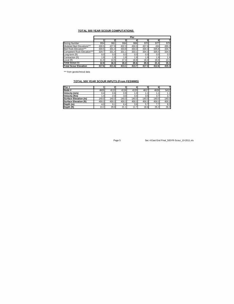
1 2 3 4 5 6 7
Boring Number B54 B61 B64 B66 B70 B77 B79
Modeled Bed Elevations*** 430.5 427.9 432.3 434.3 437.6 434 430.2
Bed Rock Elevation*** 330.5 331.4 333.8 333.3 334.3 335.8 334.7
Competent Rock Elevation*** 329.7 331.4 331.1 333.1 334.3 335.5 334.5
Long-term (ft) 0.0 0.0 0.0 0.0 0.0 0.0 0.0
Contraction (ft) 1.9 1.9 1.9 1.9 1.9 1.9 1.9Local (ft) 11.0 14.5 17.4 18.8 18.4 19.6 13.3
Total Scour (ft) 12.9 16.3 19.2 20.6 20.3 21.4 15.1
Total Scour Elevation 417.6 411.6 413.1 413.7 417.3 412.6 415.1
*** from geotechnical data
Pier # 1 2 3 4 5 6 7
Node # 4605 4113 4116 4120 4617 4626 5412
Velocity (m/s) 0.4 0.6 0.9 1.3 1.1 1.1 1.1
Velocity (ft/s) 1.4 2.0 3.0 4.4 3.5 3.7 3.7
Surface Elevation (m) 140.0 140.0 140.0 140.0 140.0 140.0 140.0
Surface Elevation (ft) 459.3 459.3 459.3 459.3 459.3 459.3 459.3
Depth (m) 4.0 9.1 6.4 3.6 5.7 7.7 8.0
Depth (ft) 13.2 29.9 21.1 11.7 18.6 25.2 26.2
TOTAL 500 YEAR SCOUR COMPUTATIONS
TOTAL 500 YEAR SCOUR INPUTS (From FESWMS)
Pier
Page 5 Sec 4 East End Final_500YR-Scour_10-2011.xls