Embed Size (px)
Citation preview

Lab 7 – Structural GeologyChapter 10
Turn In:Lab 6
Pre-Lab 7
EC 2
Handouts:Quiz 6
Lab 7
Pre-Lab 8

STRESS - direct pressure on the rock. Compressive = shorten Tensional = extension
STRAIN – when rock is stressed to the point of failure = permanent deformation.
http://www.tulane.edu/~sanelson/images/deformmeta.gif
Deformation

Beds are said to be dipping if they are oriented more than 0o from horizontal. (A cross-section sort of thing.)
Dip direction is the compass direction a marble would roll down the top of the individual bed. (Not the topography…)
(A map view sort of thing.)Which compass direction do these beds
appear to be dipping?(view looking approximately south)
W

Dip angle is the angle between horizontal and the flat face of the bed. (A cross-section sort of thing.)
How much do these beds appear to be dipping?
~35o
W
(view looking approximately south)

Strike is the compass direction 90o from the dip direction, and is one direction in which beds are laterally continuous.
(A map view sort of thing.)
Approximately which compass direction do these beds appear to be striking?
~35o
W
(view looking approximately south)
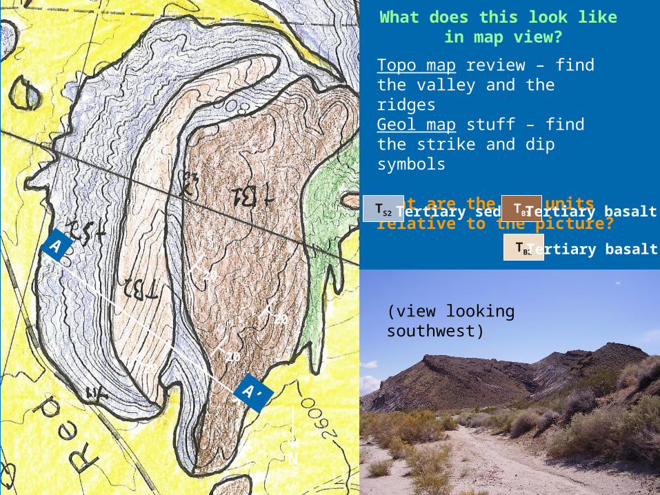
What does this look like in map view?
(view looking southwest)
Topo map review – find the valley and the ridgesGeol map stuff – find the strike and dip symbols
What are the map units relative to the picture?
TS2 Tertiary seds TB1
TB2
Tertiary basalt 1
Tertiary basalt 2
20
N
2020
20
*
*
A
A’

What does this look like in cross-section?A A’
(view looking southwest)
20
N
2020
20
Sketch only – NOT TO SCALE.
TS2 Tertiary seds TB1
TB2
Tertiary basalt 1
Tertiary basalt 2*
*
A
A’

Quick Review: Identify the approximate dip direction, dip angle, and strike in the close outcrop.
~??o

The name of a landform is determined by how the beds dip…A side effect is the relations of older and younger beds…

Folds and Block Diagrams
Anticline = oldest rocks exposed in the center.
Syncline = youngest rocks exposed in the center

Which directions are these beds dipping?What are the relations of older and younger beds?
What are the names of the landforms?

www.geology.wisc.edu/courses/g112
Which way are the beds dipping?
What are thelandforms?
CFW ‘07

web.uct.ac.za/depts/geolsci/dlr/laingsburg
www.geology.wisc.edu/courses/g112
Which feature has on overturned limb?Which way is up on each limb?

Economic Look
Folds in alternating permeable and impermeable layers = traps. Can trap water, oil, etc…
http://www.emporia.edu/earthsci/amber/students/shirley/anticlinetrap.gif

Mt. Withrow
As the Rocky Mountains formed, the strata (rock
layers) of the Earth's crust were subjected to stress which resulted in strain
(folding).
Ridges = resistant sandstoneValley = much less resistant
shale.
http://gsc.nrcan.gc.ca/natmap/cf/intro_e.php
Which way are the beds dipping?
Where is the nose?What is the name of the
structure? Which way is it plunging?

Stress Types and Faults Compressive Stress: causes shortening of the
body on which it acts Reverse or Thrust Fault: one rock gets
pushed up over another.

Tensional Stress: Causes lengthening of the body on which it acts Normal Fault: One rock slides down and away
from another
Stress Types and Faults

Shear Stress: Causes shearing/tearing of the body on which it acts. Strike-Slip Fault: One rock slides past another
horizontally.
Stress Types and Faults

Quick Review of Map Views –In each picture:
Which units are oldest/youngest?Which way are the beds dipping?What structures are present?

Seismic Interpretation Offshore Netherlands “F3” dataset courtesy of Paul deGroot of dGB Open-source seismic software from OpendTect.org

Seismic Interpretation Lab 1) Strike and Dip
Put at least 10 strike-and-dip symbols on the horizontal section, consulting the vertical section as needed.
Identify and label a dome. Identify and label a basin. For the dome and basin you interpreted, explain the observations that
support your interpretations. Point out the observations noted on your sections:
Offshore Netherlands “F3” dataset courtesy of Paul deGroot of dGB Open-source seismic software from OpendTect.org

Seismic Interpretation Lab Ex. 1 horizontal section

Seismic Interpretation Lab Ex. 1 vertical section

2) Plunging Fold On the east side of the horizontal section is a plunging fold.
Mark some strikes and dips around it, referring to the vertical sections.
Interpret whether the fold is an anticline or syncline:
Interpret which direction the fold is plunging:
Label the fold on the horizontal section with the proper symbol at its axis.
Describe how your observations support your interpretations:

Seismic Interpretation Lab Ex. 2, 3 horizontal section

Seismic Interpretation Lab Ex. 2-5 vertical section Inline 102

Seismic Interpretation Lab Ex. 2-5 vertical section Inline 190

Seismic Interpretation Lab Ex. 2-5 vertical section Inline 290

Seismic Interpretation Lab Ex. 2-5 vertical section Inline 390

Seismic Interpretation Lab Ex. 2-5 vertical section Inline 490

3) Fault Tracing On the east side of the horizontal section is a prominent fault. Mark
the fault on the horizontal section.
Mark the same fault on each of the vertical sections, if it appears on that section.
What is the average strike direction of the fault? Average dip and direction?
What is the sense of offset on the fault: horizontal; or vertical?
What type of fault is it: reverse; thrust; normal; or strike-slip?
Complete the labeling of the fault on the horizontal section with the proper symbol.
Mark where the fault terminates on the horizontal section.
Discuss whether you can rule out that this fault has oblique slip. Could it be a mixture of types?

4) Unconformities On the east side near the middle of each vertical section there are
several unconformities (originating in a hiatus of sedimentation between deposition of delta lobes). These are evident as terminations of one bed (reflection) against another. Go through the 5 vertical sections and mark at least 5 terminations on each, with a short arrow pointing along a bed to its termination.
Mark one unconformity across all 5 vertical sections with the wiggly line symbol.
5) Reservoirs Reservoirs of fluid (oil, gas, water, steam) trapped in the rock pore
spaces tend to make seismic bright spots. Circle a few bright spots on the Inline vertical sections 102 and 190.
Discuss whether these potential oil reservoirs may be associated with any of the other features you have interpreted.