Embed Size (px)
Citation preview
P C R
L A M P
Land Administration and Management Project
PROJECT COMPLETION REPORT VOLUME 1
December 2004
Lead Executing Agency Department of Environment and Natural Resources Partner Agencies Department of Justice/Land Registration Authority Department of Agrarian Reform Funding Agencies The Australian Agency for International Development The World Bank
LAND ADMINISTRATION AND MANAGEMENT PROJECT
PROJECT COMPLETION REPORT Volume 1
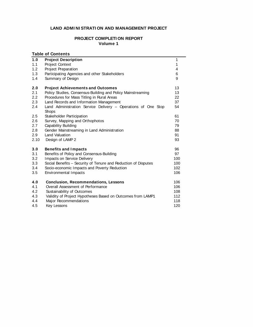
Table of Contents 1.0 Project Description 1 1.1 Project Context 1 1.2 Project Preparation 4 1.3 Participating Agencies and other Stakeholders 6 1.4 Summary of Design 9 2.0 Project Achievements and Outcomes 13 2.1 Policy Studies, Consensus-Building and Policy Mainstreaming 13 2.2 Procedures for Mass Titling in Rural Areas 22 2.3 Land Records and Information Management 37 2.4 Land Administration Service Delivery – Operations of One Stop
Shops 54
2.5 Stakeholder Participation 61 2.6 Survey, Mapping and Orthophotos 70 2.7 Capability Building 79 2.8 Gender Mainstreaming in Land Administration 88 2.9 Land Valuation 91 2.10 Design of LAMP 2 93 3.0 Benefits and Impacts 96 3.1 Benefits of Policy and Consensus-Building 97 3.2 Impacts on Service Delivery 100 3.3 Social Benefits – Security of Tenure and Reduction of Disputes 100 3.4 Socio-economic Impacts and Poverty Reduction 102 3.5 Environmental Impacts 106 4.0 Conclusion, Recommendations, Lessons 106 4.1 Overall Assessment of Performance 106 4.2 Sustainability of Outcomes 108 4.3 Validity of Project Hypotheses Based on Outcomes from LAMP1 112 4.4 Major Recommendations 118 4.5 Key Lessons 120

LIST OF ANNEXES Annex A List of Major Project Reports and Documents Annex B Unified Logical Framework Annex C Revised Unified Logical Framework Annex D Comparison of two logical frameworks Annex E Summary of findings and recommendations of the first four policy studies Annex F List of Studies Completed Annex G List of Training Events Annex H Summary of performance ratings
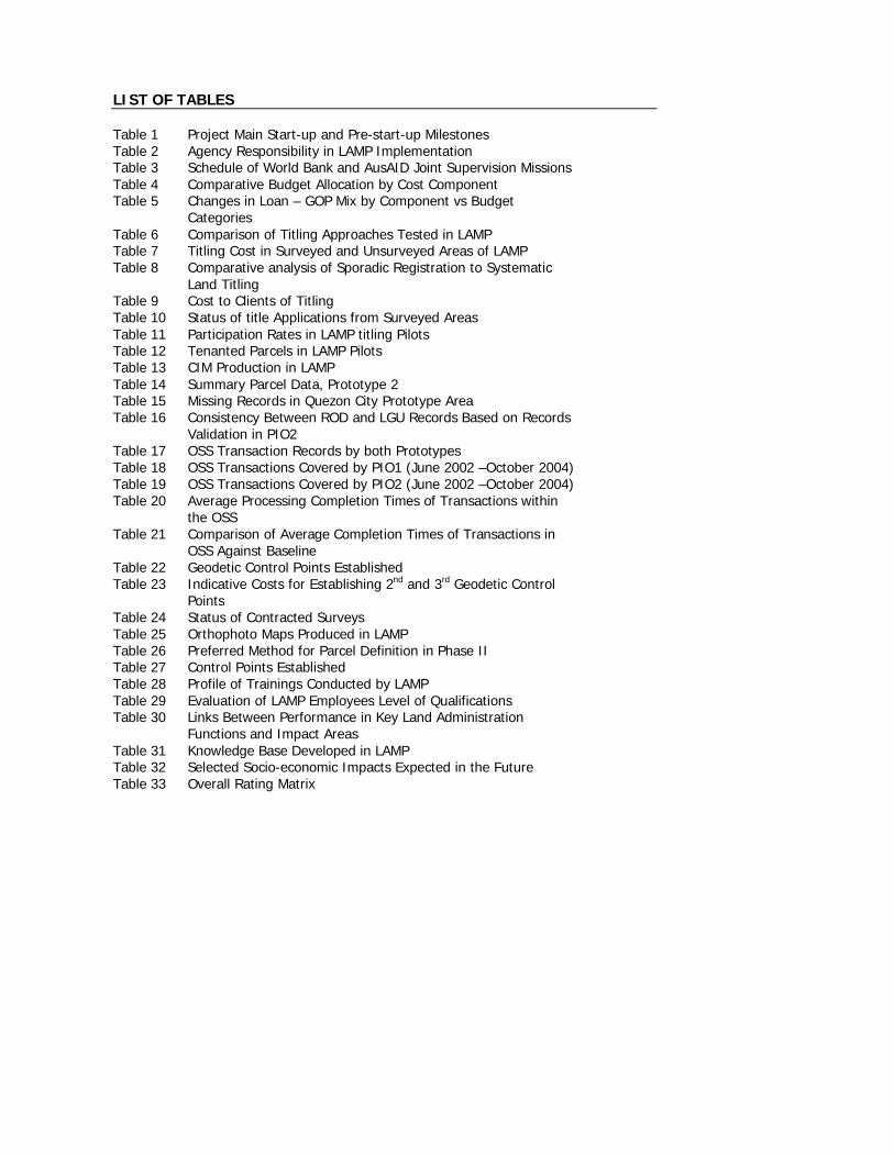
LIST OF TABLES Table 1 Project Main Start-up and Pre-start-up Milestones Table 2 Agency Responsibility in LAMP Implementation Table 3 Schedule of World Bank and AusAID Joint Supervision Missions Table 4 Comparative Budget Allocation by Cost Component Table 5 Changes in Loan – GOP Mix by Component vs Budget
Categories
Table 6 Comparison of Titling Approaches Tested in LAMP Table 7 Titling Cost in Surveyed and Unsurveyed Areas of LAMP Table 8 Comparative analysis of Sporadic Registration to Systematic
Land Titling
Table 9 Cost to Clients of Titling Table 10 Status of title Applications from Surveyed Areas Table 11 Participation Rates in LAMP titling Pilots Table 12 Tenanted Parcels in LAMP Pilots Table 13 CIM Production in LAMP Table 14 Summary Parcel Data, Prototype 2 Table 15 Missing Records in Quezon City Prototype Area Table 16 Consistency Between ROD and LGU Records Based on Records
Validation in PIO2
Table 17 OSS Transaction Records by both Prototypes Table 18 OSS Transactions Covered by PIO1 (June 2002 –October 2004) Table 19 OSS Transactions Covered by PIO2 (June 2002 –October 2004) Table 20 Average Processing Completion Times of Transactions within
the OSS
Table 21 Comparison of Average Completion Times of Transactions in OSS Against Baseline
Table 22 Geodetic Control Points Established Table 23 Indicative Costs for Establishing 2nd and 3rd Geodetic Control
Points
Table 24 Status of Contracted Surveys Table 25 Orthophoto Maps Produced in LAMP Table 26 Preferred Method for Parcel Definition in Phase II Table 27 Control Points Established Table 28 Profile of Trainings Conducted by LAMP Table 29 Evaluation of LAMP Employees Level of Qualifications Table 30 Links Between Performance in Key Land Administration
Functions and Impact Areas
Table 31 Knowledge Base Developed in LAMP Table 32 Selected Socio-economic Impacts Expected in the Future Table 33 Overall Rating Matrix
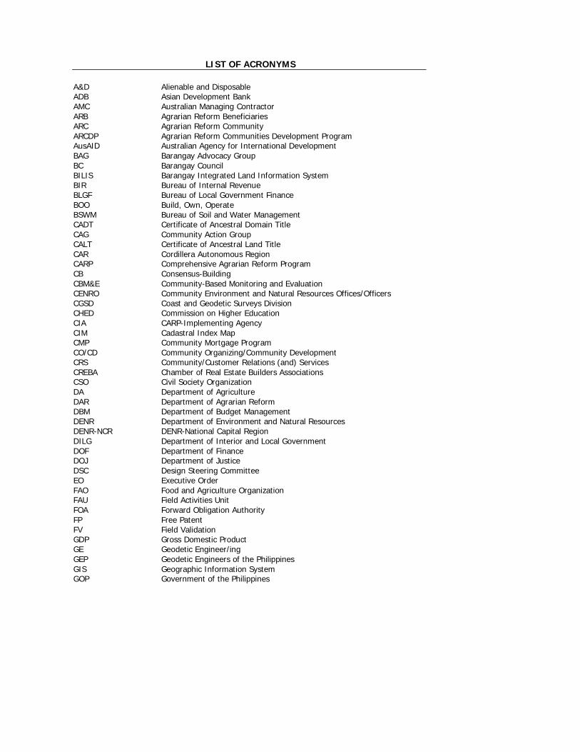
LIST OF ACRONYMS A&D Alienable and Disposable ADB Asian Development Bank AMC Australian Managing Contractor ARB Agrarian Reform Beneficiaries ARC Agrarian Reform Community ARCDP Agrarian Reform Communities Development Program AusAID Australian Agency for International Development BAG Barangay Advocacy Group BC Barangay Council BILIS Barangay Integrated Land Information System BIR Bureau of Internal Revenue BLGF Bureau of Local Government Finance BOO Build, Own, Operate BSWM Bureau of Soil and Water Management CADT Certificate of Ancestral Domain Title CAG Community Action Group CALT Certificate of Ancestral Land Title CAR Cordillera Autonomous Region CARP Comprehensive Agrarian Reform Program CB Consensus-Building CBM&E Community-Based Monitoring and Evaluation CENRO Community Environment and Natural Resources Offices/Officers CGSD Coast and Geodetic Surveys Division CHED Commission on Higher Education CIA CARP-Implementing Agency CIM Cadastral Index Map CMP Community Mortgage Program CO/CD Community Organizing/Community Development CRS Community/Customer Relations (and) Services CREBA Chamber of Real Estate Builders Associations CSO Civil Society Organization DA Department of Agriculture DAR Department of Agrarian Reform DBM Department of Budget Management DENR Department of Environment and Natural Resources DENR-NCR DENR-National Capital Region DILG Department of Interior and Local Government DOF Department of Finance DOJ Department of Justice DSC Design Steering Committee EO Executive Order FAO Food and Agriculture Organization FAU Field Activities Unit FOA Forward Obligation Authority FP Free Patent FV Field Validation GDP Gross Domestic Product GE Geodetic Engineer/ing GEP Geodetic Engineers of the Philippines GIS Geographic Information System GOP Government of the Philippines
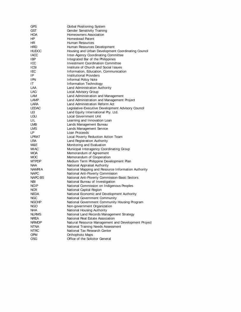
GPS Global Positioning System GST Gender Sensitivity Training HOA Homeowners Association HP Homestead Patent HR Human Resources HRD Human Resources Development HUDCC Housing and Urban Development Coordinating Council IACC Inter-Agency Coordinating Committee IBP Integrated Bar of the Philippines ICC Investment Coordination Committee ICSI Institute of Church and Social Issues IEC Information, Education, Communication IP Institutional Providers IPN Informal Policy Note IT Information Technology LAA Land Administration Authority LAG Local Advisory Group LAM Land Administration and Management LAMP Land Administration and Management Project LARA Land Administration Reform Act LEDAC Legislative-Executive Development Advisory Council LEI Land Equity International Pty. Ltd. LGU Local Government Unit LIL Learning and Innovation Loan LMB Lands Management Bureau LMS Lands Management Service LP Loan Proceeds LPRAT Local Poverty Reduction Action Team LRA Land Registration Authority M&E Monitoring and Evaluation MIAC Municipal Interagency Coordinating Group MOA Memorandum of Agreement MOC Memorandum of Cooperation MTPDP Medium Term Philippine Development Plan NAA National Appraisal Authority NAMRIA National Mapping and Resource Information Authority NAPC National Anti-Poverty Commission NAPC-BS National Anti-Poverty Commission-Basic Sectors NBI National Bureau of Investigation NCIP National Commission on Indigenous Peoples NCR National Capital Region NEDA National Economic and Development Authority NGC National Government Community NGCHP National Government Community Housing Program NGO Non-government Organization NHA National Housing Authority NLRMS National Land Records Management Strategy NREA National Real Estate Association NRMDP Natural Resource Management and Development Project NTNA National Training Needs Assessment NTRC National Tax Research Center OPM Orthophoto Maps OSG Office of the Solicitor General
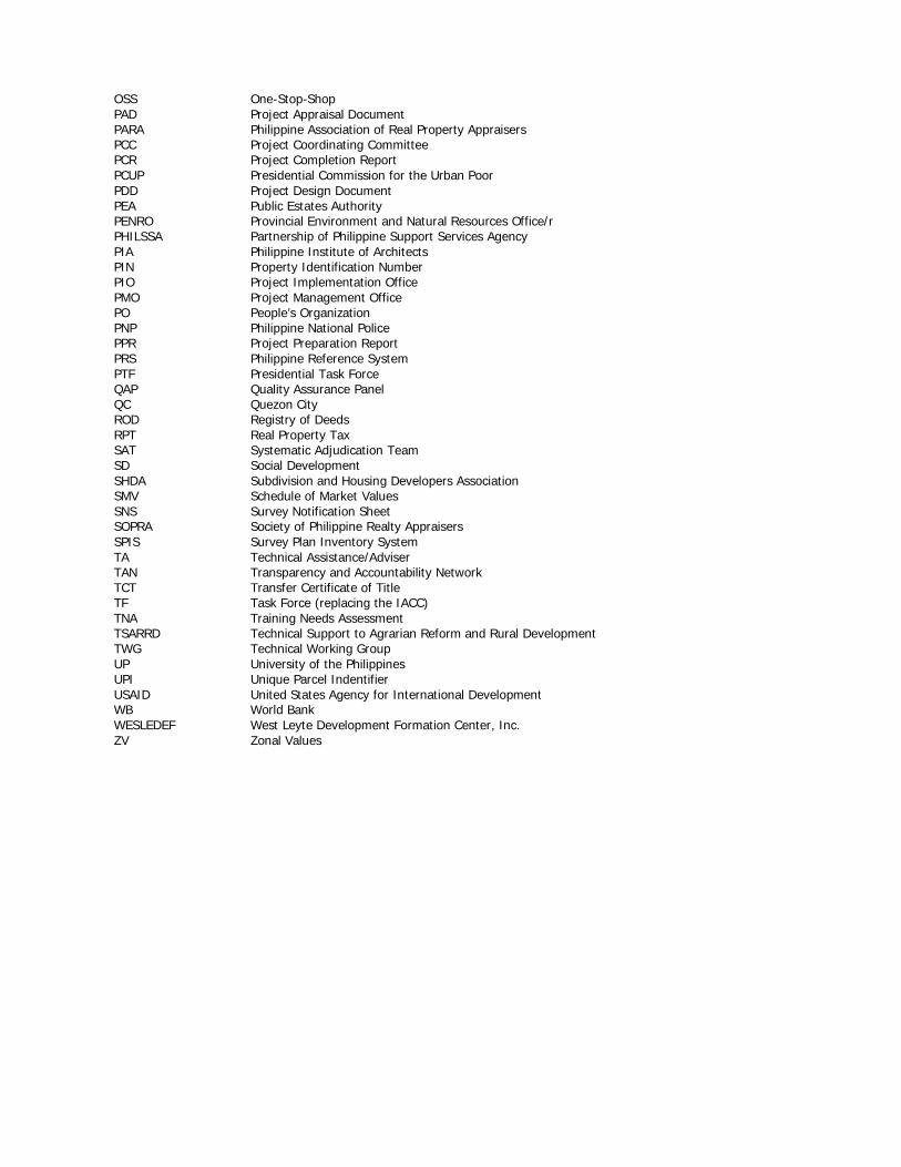
OSS One-Stop-Shop PAD Project Appraisal Document PARA Philippine Association of Real Property Appraisers PCC Project Coordinating Committee PCR Project Completion Report PCUP Presidential Commission for the Urban Poor PDD Project Design Document PEA Public Estates Authority PENRO Provincial Environment and Natural Resources Office/r PHILSSA Partnership of Philippine Support Services Agency PIA Philippine Institute of Architects PIN Property Identification Number PIO Project Implementation Office PMO Project Management Office PO People’s Organization PNP Philippine National Police PPR Project Preparation Report PRS Philippine Reference System PTF Presidential Task Force QAP Quality Assurance Panel QC Quezon City ROD Registry of Deeds RPT Real Property Tax SAT Systematic Adjudication Team SD Social Development SHDA Subdivision and Housing Developers Association SMV Schedule of Market Values SNS Survey Notification Sheet SOPRA Society of Philippine Realty Appraisers SPIS Survey Plan Inventory System TA Technical Assistance/Adviser TAN Transparency and Accountability Network TCT Transfer Certificate of Title TF Task Force (replacing the IACC) TNA Training Needs Assessment TSARRD Technical Support to Agrarian Reform and Rural Development TWG Technical Working Group UP University of the Philippines UPI Unique Parcel Indentifier USAID United States Agency for International Development WB World Bank WESLEDEF West Leyte Development Formation Center, Inc. ZV Zonal Values
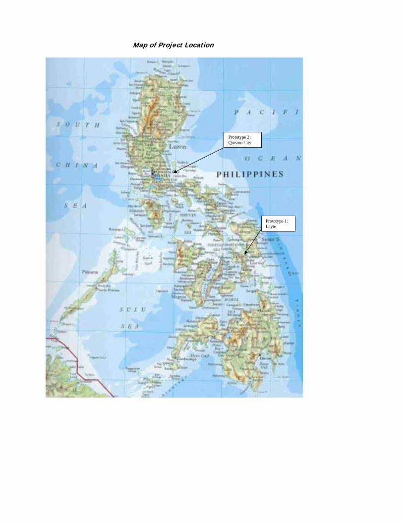
Map of Project Location
Prototype 2: Quezon City
Prototype 1: Leyte
EXECUTIVE SUMMARY Project Description
THE LAND Administration and Management Project (LAMP) is an inter-agency project of the Government of the Philippines through the Department of Environment and Natural Resources (DENR) and its partner agencies, the Department of Justice (DOJ)/Land Registration Authority (LRA) and the Department of Agrarian Reform (DAR). LAMP is the first step towards the implementation of a proposed long-term Land Administration and Management Program (LAM Program). The goal of the long-term program is to alleviate poverty and enhance economic growth by improving the security of land tenure and efficiency of land markets through the development of an efficient system of land titling and administration that is based on clear and consistent policies and laws, gender-responsive and supported by an appropriate institutional structure. In the initial studies conducted by a fact-finding Mission from the World Bank and the Government of the Philippines (GOP), the Philippines’ current land administration system was found to have the following structural defects:
• conflict among laws regulating the system and its administration; • two processes for titling land (administrative and judicial processes); • multiplicity in forms of ownership rights in land; • multiplicity of property taxes and related disincentives to formalization of land
transactions; • multiplicity in land valuation methods; and • duplication and overlap in the roles, functions and activities of land administration
agencies. LAMP was designed to identify and test possible improvements to land administration in the country and develop new directions in policy and laws to reform land administration services. The scope of the problems in the sector and the status of the current policy, legal and institutional framework are such that a large-scale project could not be implemented without further investigation. The Project was initially set as a 30 to 36-month Learning and Innovation (LIL) Project scheduled to end in September 2003. Funding was sourced from a loan with the World Bank and technical assistance grant from the Australian Agency for International Development (AusAID). An additional 15-month extension phase was implemented from October 2003 to December 2004 to pursue critical policy development activities and test more procedures in land titling and records management. The following were the five project components: Component 1 (Land Policy and Key Issues Studies), which sought to formulate policy and regulatory changes needed to support the implementation of land administration and management reform, and advocate for the adoption of these changes by government and key stakeholders. Component 2 (Prototype on Land Titling and Administration-Prototype 1), which aimed to develop and test approaches for large-scale registration and associated institutional and administrative arrangements. Its implementation was led by the DENR in six municipalities in Leyte (Palo, Alang-alang, San Miguel, Santa Fe, Pastrana and Dagami).
Component 3 (Prototype on Land Records Management and Information-Prototype 2), which was designed to develop and test systems, procedures and associated institutional and administrative arrangements for improved land information management that will allow access to land records information and services. Its implementation is led by the LRA in five barangays in Quezon City (Holy Spirit, Commonwealth, Bagong Silangan, Holy Spirit and Payatas). Component 4 (Institutional Development Component), which set up project management, education and training, and monitoring and evaluation systems for the effective implementation of the LAM Program.
Component 5 (Preparation for the Next Phase), which prepared the design for the longer-term LAM Program using project outcomes and experiences.
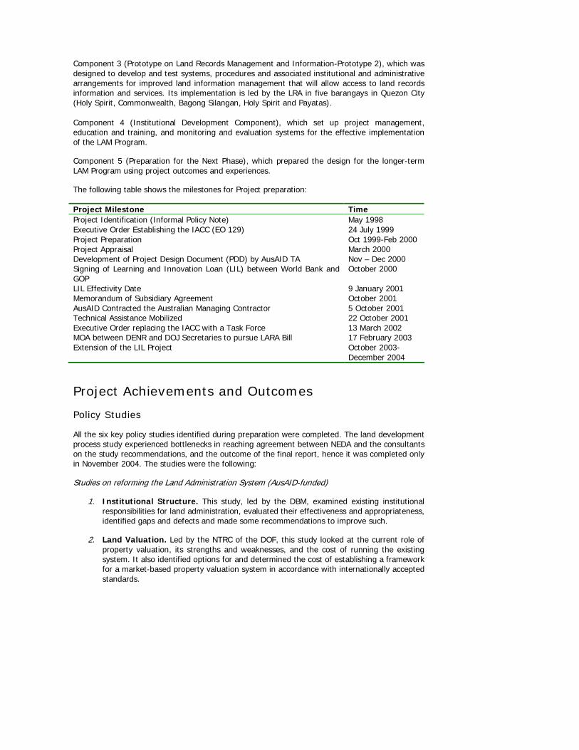
The following table shows the milestones for Project preparation:
Project Milestone Time Project Identification (Informal Policy Note) May 1998 Executive Order Establishing the IACC (EO 129) 24 July 1999 Project Preparation Oct 1999-Feb 2000 Project Appraisal March 2000 Development of Project Design Document (PDD) by AusAID TA Nov – Dec 2000 Signing of Learning and Innovation Loan (LIL) between World Bank and GOP
October 2000
LIL Effectivity Date 9 January 2001 Memorandum of Subsidiary Agreement October 2001 AusAID Contracted the Australian Managing Contractor 5 October 2001 Technical Assistance Mobilized 22 October 2001 Executive Order replacing the IACC with a Task Force 13 March 2002 MOA between DENR and DOJ Secretaries to pursue LARA Bill 17 February 2003 Extension of the LIL Project October 2003-
December 2004
Project Achievements and Outcomes Policy Studies
All the six key policy studies identified during preparation were completed. The land development process study experienced bottlenecks in reaching agreement between NEDA and the consultants on the study recommendations, and the outcome of the final report, hence it was completed only in November 2004. The studies were the following:
Studies on reforming the Land Administration System (AusAID-funded)
1. Institutional Structure. This study, led by the DBM, examined existing institutional responsibilities for land administration, evaluated their effectiveness and appropriateness, identified gaps and defects and made some recommendations to improve such.
2. Land Valuation. Led by the NTRC of the DOF, this study looked at the current role of property valuation, its strengths and weaknesses, and the cost of running the existing system. It also identified options for and determined the cost of establishing a framework for a market-based property valuation system in accordance with internationally accepted standards.
3. Finance and Fee Structure. Also led by the NTRC, this study reviewed the current tax and fee structure to validate the perception that high fees and taxes are a disincentive for both initial and subsequent land registration.
4. Fragmented land laws and regulations. Led by the DOJ, the study reviewed and built upon the previous work undertaken on laws and regulations in the areas of public land disposition, land titling and registration.
Studies on Improving Land Management (World Bank-funded)
5. Forest Boundary Delineation. The study, led by the DENR, developed a system for the development of a database for the general characteristics of various land uses in the uplands that will serve as a tool for planning and decision-making with regard to current and future land use.
6. Land Development Process. Led by the NEDA, this study reviewed the existing system of land allocation and utilization so as to effect the highest and best use of land for present and future generations.
The results the first four land administration studies were consolidated into an integrated policy report, from which the following fourteen (14) strategic directions for reforming the Philippine land administration system was developed:
Institutional Arrangements 1. Strengthen leadership and management of reform. 2. Remove duplication and overlap in delivery of land administration services. 3. Improve the efficiency, responsiveness, transparency and accountability of land
administration services. 4. Consolidate and coordinate the production of, and access to land information.
Land Laws
5. Abolish judicial processes for issue and registration of titles in favor of simple administrative processes.
6. Reform and consolidate land administration laws and regulations. 7. Clarify the rights of persons occupying land to obtain titles. 8. Progressively extend the Torrens Title register to become a comprehensive record of all
land in the Philippines recording all rights relating to land. Finance and Fee Structure
9. Devolve responsibility for taxation of real property ownership and transfers to local government.
10. Streamline land transfers and remove disincentives to their formal registration by the Registry of Deeds.
11. Progress towards cost recovery for land administration services. Land Valuation
12. Remove local government political intervention in processes for the assessment of property values.
13. Adopt a single valuation basis for all real property taxation. 14. Develop, implement and enforce uniform, best-practice, valuation standards within
government. Upon the formulation of the 14-point Reform Agenda, LAMP set out to push for the study recommendations where possible under existing government policy. The initial strategy
undertaken was consensus-building with stakeholders, which aimed at generating multi-stakeholder inputs to and agreements with the reform agenda. While the Project initially hoped that all 14 recommendations could be subjected for consensus-building as one reform package, it turned out that only a number of the recommendations were possible given the policy environment at that point. Thus, an incremental approach to push for the reform proposals was identified, tackling first the recommendations that had strong potential for government support. Among those identified as priority reform agenda were the recommendations by the Institutional Arrangements Study and the Land Valuation Study.
Consensus-building
The Project undertook a consensus-building process that identified the most critical stakeholder groups that needed to be consulted, while considering their potential as possible advocates of the reform proposals. In the second quarter of 2002, a consensus-building strategy was developed so that the reform agenda could be subjected to a more participatory consultation process with different stakeholders. In 2002-2003, the Reform Agenda were subjected to wide stakeholder consultation, which provided opportunities for further enhancing the recommendations so that these become more relevant to supporting the goal of poverty alleviation – a concern that was specifically raised by the basic sector representatives of the NAPC.
The major groups identified were: • Basic sector representatives (farmers, fisher folk, NGOs, women groups, urban poor,
workers in the informal sector, indigenous peoples,) of the NAPC; • Local government units and their umbrella leagues (Leagues of Provinces, Cities and
Municipalities); • Agencies that stand to be affected by the reform proposals (the DOJ’s LRA/ ROD, and
the DENR’s NAMRIA and LMB); • Other national government agencies (DAR, NHA and HUDCC, etc.); and • The private sector (real estate brokers, banks, appraisers, developers); and professional
organizations/academe (geodetic engineers, planners, lawyers, etc). The consensus-building and advocacy activities conducted by LAMP resulted in a general appreciation and ownership among relevant stakeholders and government of the reform proposals. The CB process has firstly exposed a range of interest groups to the mystery of the land administration sector, to appreciate its shortcomings, and to realize that a range of proven solutions is available. After this process it is clear that clients of the government’s land services are not satisfied, land tenure security and confidence is not high, and there is a growing demand for change. To illustrate, stakeholders positively influenced the development of the policy study recommendations (reform agenda); the development of the LARA Bill, the Free Patent Bill and the Property Valuation Bill; and the development of new procedures.
Stakeholder initiatives were most clearly demonstrated in the activities initiated by the NAPC-Basic Sectors (NAPC-BS) to pursue the reform agenda after entering into partnership with LAMP, and by the DENR top management in their strong advocacy for the reforms in various high-level engagements. The same can be said of the leaders of DOF and their partner LGUs, as they have consistently shown support to the valuation activities being undertaken. Likewise, the private sector, especially the Geodetic Engineers of the Philippines, research institutions and brokers and appraisers, have initiated efforts towards making land administration a special area of interest in research and the academic curriculum.
The nationwide ground working activities conducted by the NAPC-BS went beyond what was stipulated in the MOC with LAMP. Their establishment of regional Task Force structures and information dissemination activities, while primarily activities done in partnership with LAMP,
were made part of their advocacy agenda independent of LAMP. This resulted in a sustained discussion of land administration issues in most Basic Sector gatherings, with speakers coming from among them and funding coming from their own resources. To date, land administration remains a priority agenda of the basic sectors, as manifested by their continual advocacy for the LARA Bill in their regular en banc meeting with the President. Such activities have, time and again, provided the opportunity for the reform agenda to be presented to the President, and in the process developing a common sense of responsibility between her Office and the NAPC to implement the reform measures.
Within the DENR, consensus-building activities have led to the reorientation of concerned officials and personnel on the problems affecting the lands sector and the direction that can be taken for reforming it. Top management support to the reform agenda was successfully turned over with the change in leadership in August 2004, partly due to the existence of career executive advocates from within the bureaucracy. This does not discount the fact that opposing ideas about the reform agenda exist within the department (especially from among the concerned bureaus and agencies), but these opposing ideas only point towards a more important development: that there is already a growing interest in reforming the sector, LAMP-defined or otherwise. With the mainstreaming activities initiated in 2004 to stir land administration reform interest of field offices, the Project and the reform agenda can already look forward to tapping a more interested bureaucracy in the future.
The consensus-building activities for other concerned agencies (e.g., the LRA) have resulted in the identification of various directions for pushing for reforms in the medium-term. This includes the identification of the need for the creation of more opportunities to involve agency staff that stand to be affected by the reforms deeper in policy development and advocacy. While there had indeed been difficulty in getting their support for the LARA Bill itself because of its potential to displace employees, they have not expressed direct opposition to the very idea of reforming the land administration system. The consensus-building activities have achieved one of its objectives as far as the affected agencies are concerned, that is, the creation of an awareness of the system and what is wrong with it. It will be a matter for the long-term LAM program to push for the proposed solutions in a manner that is clear and fair to all concerned agencies and employees.
Indirectly, other project activities have yielded more allies in the call for change. For example, the Institute for Church and Social Issues (ICSI) in Manila and an academic consortium in Leyte have provided oversight to the conduct of some 22 research grants issued under the AusAID-funded TA. A growing capacity in research in the sector is emerging where there was none before. Further, the Geodetic Engineering curriculum development course for government and private sector practitioners provided technology transfer on competency-based design of curriculum and on modern surveying, and also raised awareness of the overall need for change in the sector. These developments are all seen to contribute to the larger policy environment, and should help capacitate other sectors to ultimately contribute to the reform process.
Procedures for Mass Titling in Rural Areas
The objective of the land titling component was to develop improved methodologies for large-scale land registration and associated institutional arrangements that are simple, streamlined, cost-effective and community-accepted. The project undertook various pilot activities in order to develop its recommended methodology for Phase II.
Existing approaches for titling were tested for suitability as an option for mass titling. Two major approaches to titling were fully tested: the Cadastral Proceeding or Compulsory Judicial Titling under the judicial process and Free Patent under the administrative process. Homestead Patent and Miscellaneous Sales Patents were partially tested. The Homestead Patent was introduced in unsurveyed areas (agricultural) in two barangays. Judicial titling was undertaken in surveyed
areas (agricultural and residential) and lately in a barangay earlier covered by the Homestead Patent applications. Finally, the Free Patent was tested in surveyed and unsurveyed areas in nine other barangays.
Based on the results of the tests, available mass titling procedures under existing laws are restrictive and inefficient. The Free Patent is so far the best option for mass titling because it is much faster and more flexible but has its own limitations. The Free Patent framework has the potential to overcome many of the inefficiencies evidenced in judicial titling and that administrative improvements can be introduced to streamline the procedures and reduce the time to issue titles. On the other hand, the judicial processes are more complex and inflexible. Key proposals that have been identified to improve the use of Free patent as an acceptable instrument are: (i) allow it to be used for titling of residential, industrial and commercial lands; (ii) remove the five year restriction on transfers and mortgages; (iii) shorten the period of proof from 30 to 10 years; (iv) allow it to reflect encumbrances such as mortgages or leases entered into before the patent is issued; (v) recognize existing tenants; (vi) remove all associated costs/fess; and (vii) adopt a low-cost surveying technology.
The methodologies developed in titling were all documented into the following Manuals for use in LAMP2:
• Judicial Titling Operations and Training Manual • Lessons and Methodology Report • Project Start-up Guidebook • Field Operations Manual • Field Operations Training Guide
The Project tested the systematic approach to titling to demonstrate the effectiveness and efficiency of the mass based approach to titling compared to the current sporadic method. This was the principle behind the testing of all the approaches cited above. Overall, the systematic titling procedures proved to be superior to the sporadic titling program currently undertaken for a number of reasons: (i) it brought the services closer to the community through the base camps; (ii) the CRS promoted increased mobilization of claimants for titling, thus enabling a more participatory, organized and informed approach to registration; (iii) it reduced potential for disputes; (iv) it reduced the time and cost to clients to issue titles, (v) it provided for a more transparent process involving members of the community; and (vi) it promoted gender equity. While the process was trialed using the free patent methodology, the procedure can generally be used for all titling options. The project operated in 91 barangays and issued 790 titles as of December 31, 2004. As of that date, an additional 367 completed applications had been transmitted to ROD for registration pending the payment of registration fees by the claimants. These titles were generated using the Free Patent (FP) process. The judicial titling applications did not result in the issuance of a single title. An order for the issuance of 33 titles was made by the Dagami Municipal Trial Court in May 2004 but these still remain the subject of an appeal made by the Solicitor General. The Project covered 80 barangays under Free Patent titling, of which 31 were surveyed and processed for titling. The remaining 49 barangays still need to have their survey plans approved before titles can be issued. It is anticipated that an additional 594 titles will be issued soon for areas surveyed prior to LAMP as soon as the applications are processed by the CENRO, PENRO and ROD. In total, some 4199 titles are expected to be issued through LAMP as soon as all pending applications in the pipeline are finally registered.
Comment:
The experience from the tests enabled the Project to consolidate all issues requiring policy action so that a suitable legal framework for mass titling in the next phase can be developed. In general terms, the recommendation is a legislative structure that combines all the identified strengths of judicial titling and free patent titling – one form of titling applying to all land types, issued without restrictions on the transfer and mortgage of the title, without confusion as to procedures where the parcel exceeds 5 hectares and without depending on legal constructions such as constructive occupation. Most of the proposals having to do with the Free Patent law have been incorporated in the proposed amendment to the law. A draft Bill is ready for consultation with stakeholders and is expected to be sponsored soon by legislators. Land Records and Information Management The Project introduced procedures that would improve the integrity of land records through identification of spurious or duplicate titles/plans and setting up of systems to avoid the issuance of such records in the future. These procedures were tested both in Quezon City and Leyte, and were designed to address the fundamental weaknesses in the land administration system, which are largely a result of the absence of: (i) a complete and up-to-date picture of all existing land parcels; (ii) a mechanism for the ready exchange of land information between land related agencies; and (iii) a single point of contact for the public to transact on land titles. Procedures Developed Development of Cadastral Index Maps
Three different methods of CIM production were tested: (i) hand drawn; (ii) use of information technology (IT); and (iii) use of orthophoto maps. Evaluation of these methods showed that automated mapping is more efficient, although this would require the use of equipment and the employment of skilled staff. In the rural areas, this could be supported by the use of orthophoto maps in determining the accuracy of the digitized CIM, in updating the major features on the map and in showing a more realistic picture of the parcel itself. With this, access to land information will be facilitated and data sharing and integration to different offices will also be maximized.
A total of 497 CIMs were produced, covering 73,291 parcels in both prototypes. In PIO1, only four municipalities were covered since the surveys for the municipalities of Pastrana and Sta Fe have not been completed. For Quezon City, all the five barangays were covered. All the procedures were documented and transformed into a competency-based Training Manual for LAMP2. Land Records Database Development The development of CIMs was supported by a database designed to contain comprehensive information on all parcels such as owners, location, status of applications, titles issued, and other interests on the property. In Leyte, it was used initially for the validation of claimants by the Community Relations Services (CRS) and systematic adjudication teams. Once fully developed, it was to be integrated into the systems of the DENR and the ROD so that automatic updates could be made, and the public provided with quick access to land information. At the end of LAMP1, the database was already lodged at the OSS and used by the front desk for queries on status, ownership and other vital land information. During its development, it has proven useful in terms of identifying inconsistencies in records that require further investigation and appropriate action.
Office Validation and Field Validation of Records
Two stages of records validation were performed under the Quezon City Prototype: office validation and field validation. Office validation linked all records to the CIM. It verified that each title was supported by an approved subdivision plan, and that the survey records and title are linked with the appropriate tax declaration records at the LGU.
Meanwhile, the Project introduced field validation as a strategy to: (i) expedite resolution of conflicting or out of date land information; (ii) assist in the location of records which are missing from the ROD; (iii) establish a more proactive approach to reconstitution of titles; and (iv) elicit community participation in records validation. The approach involved the preparation of a questionnaire to validate the records held by the prototype based on information available (or not available) on the parcel. The basis was the CIM, and/or the title records held by the Project. If the records were not available with the ROD, then specific instructions were made to inform the respondent of the need to have their titles reconstituted. The slow process of reconstitution and the lack of awareness on the part of titleholders that their title records were missing from the ROD lead to increased risks of duplicate and overlapping titles. The following presents the results of FV work in Holy Spirit:
• 1472 titles found in the possession of property owners • 676 of the Transfer Certificates of Title (TCTs) located did not have matching records in
the Assessor’s Office • 134 had different TCT numbers to those held by the Assessor’s Office • 784 of the TCTs located did not have a TCT record at the cross index • 578 parcels with informal settlements (20% of Barangay Holy Spirit)
Survey Plan Inventory System (SPIS) The SPIS was developed to hold information about a plan, including the barangay location, approval information, parent TCT, parcels and parcel area. For CIM plotting, the system provides classification as to which CIM number(s) a survey plan belongs. It also provides for tracking of survey plan relationships (i.e., mother plan–child plan). With this, it was possible to easily identify where a particular survey plan emanated from as well as the survey plan(s) which resulted from this particular survey plan. Thus, SPIS enabled fast and efficient recording, searching, querying and reporting of survey plan information. It facilitated the inventory of survey plans and the sorting of plans per barangay for easy access. The system was linked to digital copies of plans. It thus provided easy access to survey plan information, improved records preservation, thereby improving records security. Training and orientation for DENR was conducted, and its staff has completed the testing of the system ready for its adoption. The system currently holds 1025 DENR and 758 LRA survey plans. The DENR-National Capital Region (DENR-NCR) has committed to updating of the SPIS as new survey plans are approved. Orientation materials and a Procedures Manual exist for SPIS. Barangay Integrated Land Information System The BILIS was an initiative introduced into the barangays to assist the public in their search for the latest information for a parcel. The relevant records from the cross index as well as the corresponding CIM, were installed in barangays Holy Spirit, Batasan Hills, Commonwealth and Baong Silangan. The system proved useful as it allowed the community to validate records in their possession.
The BILIS worked as a two way process: (i) to provide information to interested members of the public; and (ii) to involve the community in providing information to update the LAMP records in situations where there are gaps in the CIM and database. With the introduction of BILIS into Holy Spirit and Batasan Hills, the land owners can check if their details are correct and potential land purchases can ensure that the person they are dealing with is the owner of the land. Prevention and Detection of Fake and Overlapping Titles and Survey Plans
The following steps were carried out in the Project’s efforts on the prevention and detection of fake titles: i) Establishment of an interagency Technical Working Group (TWG) on Fake Titles; (ii) Development of Manual of Fake Titles; and (iii) Development of Database of Overlapping Titles and Training on Fake Title Detection. These have resulted in increased efforts not just by the TWG agencies but also by private sector stakeholders to pursue the matter more vigorously. To date, the prospect is high for a private sector-initiated publication and distribution of the manual especially to banks and appraisers. Development of National Land Records Management Strategy (NLRMS) A study on the state of management of land records was carried out in 2003 to perform a strategic level analysis of the land administration records management and its institutional and policy environment. The recommended strategy which resulted from the study was supposed to serve as a springboard to implement long-term and short-term solutions to land records management issues. Outcomes of Activities in Land Records and Information Management The following are the initial outcomes of the Project’s efforts in land records and information management:
• Improved access by the public and other government agencies to reliable land records • Potential for Increased LGU Revenues • Reduced community conflict on the status of land • Reduced activities of syndicates • Improved Activity of the Land Market • Increased Mortgage Value of Land • Assistance to Land Distribution and Housing Programs • Strengthened Linkages with Formal Subdivisions • Assistance in Resolution of barangay boundary conflicts • Improved interagency coordination
Land Administration Service Delivery: Operations of the One-Stop Shops
As designed, the Project established a One-Stop Shop (OSS) in each prototype site. The objective was to test institutional collaboration in the provision of land administration services by providing a one-stop service for all land related transactions in a manner that is transparent, cost-effective and convenient to its customers. Currently, these transactions are performed by a number of agencies and local government units such that clients have to go through different offices to lodge these. Similarly, land records are dispersed in many agencies making it difficult for clients to have easy access to accurate records and other land-related information.
The two prototypes used different models for the OSS. In prototype 1, entire offices of the ROD, CENRO and the PIO1 were co-located in a single building to provide their own service to the public, thus providing for a physical one-stop shop for land services. In Quezon City, agency representatives performing such transactions were co-located in a single office to provide
integrated services to the public by linking and streamlining related services and automating processes and vital information.
In PIO1, the OSS improved service delivery in the following ways: (i) the presence of front desk officer where queries can be made and advice provided on processes and requirements involving different land related services; (ii) reliable information on processes and fees to be paid are available and clearly posted at the front lobby, thus improving public education and promoting transparency; (iii) single point of inquiry for CENRO, ROD and PIO1 on information about LGU, BIR and DAR; (iv) single point of collection of fees enabling greater transparency; (v) approval of cadastral and isolated survey using the streamlined process; (vi) the use of CIM and land records database to support all OSS transactions. The establishment and operating efficiency of OSS in the two prototypes were affected by different sets of issues. In Prototype 1, the difficulty of negotiating procedural improvements with the agencies has constrained the introduction of additional streamlining or integration of agency processes within the OSS. Thus, while all the offices are co-located in a single building, each agency undertakes its own processes independent of the procedures of the other agencies. The underlying causes of this are the general resistance to reforms by staff and officials of agency partners, the absence of an agreed common vision and framework for OSS operations, and the lack of customer or service orientation of the agencies. In the Quezon City prototype, the cooperation from the agency partners has been excellent. From the beginning, there was strong interest and active participation in the development of the OSS model and transactions Manual, including the set up and the work flow within the OSS. Agency representatives provided inputs to the kinds of transactions that would be undertaken in the OSS, the staff requirements, and the relationships among the procedures of the agencies. The operation of the OSS, however, was delayed by the shift in the location of the original site within the premises of the Quezon City ROD at the LGU compound in 2001, after the bidding process was completed. It took a while for the LRA to identify a new location after which there were subsequent delays in the procurement for the office renovation and purchase of equipment. Based on the Project’s experience, it is recommended that for LAMP2, a national policy, possibly emanating from the Office of the President, be issued to provide sufficient authority for the operations of the OSS, and exact the required cooperation in the introduction of necessary improvements. It would also be important to develop the OSS vision and management plan, and ensure agreements among the parties involved in the implementation of such a plan. Stakeholder Participation Stakeholder participation at the national level was observed in two key areas: Project implementation (for government stakeholders) and policy development/consensus-building (for government stakeholders, civil society and the private sector). Project implementation relied on the participation of other agencies in almost all components. Three strategies were implemented: (i) assignment of regular staff from key agencies such as LRA, DENR, DAR, LGU to perform key management functions in the project; (ii) leadership of key agencies in the conduct of six policy studies; (iii) agency representation in the IACC/TF and the TWG under it; (iv) agency representation in the interagency Design Steering Committee (DSC) for LAMP2.
The leadership of concerned agencies and the participation of other agencies in the policy studies helped develop further awareness and appreciation of the sector situation, and the need to work together to resolve the issues. For the lead agencies in particular, their role enabled the studies to be bestowed with the needed guidance, thus ensuring that the reform proposals which resulted from the studies were aligned with national priorities and relevant to current socio-
economic and political realities of the Philippines. The inter-agency DSC for LAMP 2 was also found important in that it provided the needed guidance on the direction, framework and strategy for the design. The involvement of the relevant partners in the design process ensured full ownership and commitment of the GOP. On policy reform, the consensus-building activities essentially entailed the engagement of civil society and private sector stakeholders in the discussion of the policy proposals and cementing partnerships to support the reform agenda. The strategies and outcomes from these activities were fully discussed under the subsection on Consensus-building. At the prototype level, the participation of agencies was facilitated through interagency Local Advisory Groups (LAGs), which served as the mechanism for resolving coordination issues and other important policy concerns in both prototypes. Likewise, the design made provisions for the conduct of Customer/Community Relations Service as a strategy to promote community participation in titling. Various modes of CRS and Community Organizing/Community Development (CO/CD) strategies were tested in both prototypes, many of them involving stakeholders. The most notable of these were the LGU-led and NGO-led CRS and CO pilots in PIO 1, and the BAG-led CO-CD and NGO-led field validation in PIO 2. Partnerships were also developed with the academe especially in the conduct of relevant research and curriculum development.
The rationale behind stakeholder participation in LAMP was to broaden the base of support to policy reform, project management and implementation, and inputs to the work of the prototypes so that the procedures introduced are relevant to community needs.
At the level of policy, the issues that remain pertain to the support of the agencies affected by the reform proposals and the completion of the policy development process such that they actually result in legislative proposals to provide the building blocks for the next phase and the long-term program. These would necessitate further work at ensuring that the political process associated with the deliberations of the proposed Bills is managed and adequately supported. On institutional coordination, it is recommended that for the next phase, and in the absence of the LAA, there needs to be stronger mechanisms for exacting cooperation from agency partners in the field. This has to be coupled with sound choices of sites such that the openness of officials of agencies at the local level becomes a major criterion for selecting the prototype locations. Stakeholder participation strategies with communities and local level governments have been well developed by LAMP. What remains is continued review and improvement of such strategies such that these are modified to suit the unique social situations in new sites; and to the emerging concerns from implementation. For the next phase, a more in-depth social investigation would be required prior to start-up, so that more relevant participation strategies can be customized. Partnerships with NGOs, the academe and the private sector have been initiated by LAMP, albeit on a limited scale. For the next phase and the long-term, a more pronounced strategy for getting the involvement of these sectors more actively as partners in implementation need to be defined and implemented. Training conducted and skills acquired by staff and partners A key element to ensure the successful implementation of the anticipated reforms in the sector is the assurance of a competent pool of workers to be involved in the eventual production and delivery of the sector’s upgraded services. The Project’s human resource development function was thus conceived, developed and implemented based on this assumption. It focused on
enabling project personnel to respond or contribute to the attainment of the project’s three-fold objective: (i) identify possible improvements to land administration in the country; (ii) test these improvements; and (iii) develop new directions in policies and laws aimed at reforming the government’s land administration services. In the course of Project implementation, the need to extend the reach of the function to other key stakeholders emerged, thus the necessary adjustments were made. At the end of the Project, LAMP has produced a core group competent staff who can serve as the nucleus upon which to develop capacity of other staff for the next phase to perform the following functions:
• Systematic adjudication • Management of one stop shops • Records management • Cadastral surveys using different technologies • Cadastral index map production • Management of cadastral survey contracts • Base camp operations • Planning of integrated technical and support programs for titling and records
management • Monitoring and evaluation of land administration projects • Community relations/community organizing/social development for land administration
As a strategic investment in developing capacity in the sector, the Project embarked on a Curriculum Development Program for Surveying Education and Training. This was an in-country higher level training for priority areas directed at providing the Project with a larger number of personnel with appropriate level of technical competencies at the same time developing the capacity of Philippine educational institutions to deliver the program in the future. It was attended by representatives from both private and public higher educational institution, private and public practitioners, professional associations, industry sectors, and related government agencies. Training Manuals were written to supplement Operating Manuals and guidebooks earlier developed by LAMP. At the end of LAMP1, the following training manuals were developed:
• Training Manual on One– Stop Shop • Training Manual on Systematic Adjudication • Training Manual on Survey • Training Manual on Social Development • Training Manual on OSS Tracking and Cross Index • Training Manual on Records and Field Validation • Training Manual on Cadastral Index Mapping • Training Manual on Human Resource Development
For the next phase and the long-term program, support would be required for an integrated HRM and D functions for LAMP to cater to the organizational and institutional building needs of the project and the program. Competency-based standards would have to be the mode for recruitment and performance evaluation so that skills gaps can be sufficiently identified and responded to. To address the short supply and low levels of capacity in the sector, a comprehensive program designed at improving the quality of LAM professionals would have to be in place. Investments in capacity building would have to take account of the evolving needs of the sector as the LAA is approved, and the attendant institutional development needs are identified.
Gender Mainstreaming in Land Administration Gender Mainstreaming in land administration refers to the strategy of making the pursuit for gender equity and equality a core part of land administration policies and an integral operational principle of land administration systems and procedures. In mainstreaming gender, LAMP pursued the following objectives:
Integration of gender concerns in the proposed Land Administration Reform Act; Development and testing of procedures for land titling and land records management that are equally accessible and equitably beneficial to women and men; Creation of mechanisms for the active participation of both women and men in LAMP implementation (i.e. policy reform agenda formulation, land titling, land records management improvement and project management); and Development of project management systems that ensured gender mainstreaming in all components of the Project.
Guided by the these objectives, LAMP accomplished the following:
• Establishment of the Organizational Foundations of Gender Mainstreaming • Advocacy for Gender Equity in Policy Reform Agenda • Involvement of women and men in LAMP Implementation • Development of a LAMP Gender Mainstreaming Guidebook
Based on the lessons of LAMP 1 not only on the effective integration of gender in the land titling and land records improvement procedures but also in the project management system, a LAMP Gender Mainstreaming Guidebook was developed. This Guidebook will be used to ensure the continuation of the gender mainstreaming work in LAMP 2. The efforts of LAMP at mainstreaming gender earned for itself recognition by the World Bank as the one of the most gender-responsive projects after a review of Bank-assisted projects in the Philippines. Land Valuation
Land valuation support was provided to the NTRC and BLGF (the key implementing partners under the Department of Finance), following from work conducted as part of land valuation policy studies completed in 2002 and 2003. The overall objective of this activity was to raise the quality of Government and private sector property appraisal through the development of valuation standards and promotion of institutional and legislative reform. This was to be commenced through the development of draft valuation standards, the drafting of legislative amendments and a bill for the establishment of a National Appraisal Authority, and the implementation of a simulation study to assess impacts of new standards for LGUs. While all of these have been achieved, further work would continue under the subsequent phase of the LAM Program.
Further work would be required to put in place the required reforms to establish a sound valuation policy and institutional framework that supports the objectives of the LAM program. Key measures would include:
• Consensus building and passage of the Draft Bill establishing the National Valuation Authority;
• Consensus building and putting into force the National Valuation Standards. • Development of a formal valuation curriculum, capability building of assessors and
appraisers and enforcement of ethical standards and sanctions governing valuation practice.
• Further simulation studies in additional representative LGUs to demonstrate the impacts of the proposed valuation standards on the property market, revenue collection, and on different stakeholder groups.
The valuation reforms are seen to provide financial savings and revenue improvements for government at all levels by removing duplication of effort and by providing benefits from a wider taxation base which should lead to improved tax collections and greater equity for taxpayers. The priority requirement for successful reform would be the transfer of powers to a statutory officer thereby removing political influence. The independence of a professional valuation and assessment service would be essential as it would provide equity and fairness in the tax system. The development of valuation education and training programs together with the licensing for assessors and appraisers, and the creation of a national database of real property transaction and costs, all support the proposed valuation reforms and should be supported under the next phase of the LAM Program.
Design of LAMP2
The design of the Project’s second phase (LAMP2) was set in motion after the Project Preparation Mission in February 2003. During that Mission, the GOP, through the LAMP Task Force, the World Bank and AusAID agreed to proceed with the design of LAMP2. The prime considerations were: (i) the availability of enough lessons and experiences upon which to draw the configuration of the next phase; (ii) the need to ensure a seamless transition from LAMP I to LAMP II; and (iii) to sustain the momentum achieved through the wide consensus already reached on the reform proposals.
The following studies were carried out to provide inputs to the design: (i) National Training Needs Assessment, completed in September 2003; (ii) Land Markets Study, completed in March 2004; and (iii) Land Tenure Study, completed in November 2004.
GOP Approval of LAMP2, Appraisal by Development Partners and funding commitments
Based on lessons from LAMP I, it was decided that the best way forward was to prepare LAMP I based on GOP priorities and the framework set by the long term program and the country program perspectives of the World Bank and AusAID. A Design Team Leader was fielded in July 2003, and the rest of the design consultants were mobilized only in October 2003. The design followed a consultative process. To ensure that LAMP remains relevant to the priorities of the government, an interagency Design Steering Committee (DSC) was established and convened regularly to coordinate GOP inputs to the design process and make major decisions about the direction and scope of LAMP2. The DSC was composed of the DENR as chair, with DOJ, LRA, DOF and DAR as members.
The PDD was prepared in December 2003. A Pre-Appraisal mission was conducted in November 2003. Separate Aide Memoires reflecting the AusAID and World Bank positions on the draft LAMP II strategy and implementation plan were tabled for consideration of the DSC in its final deliberations on the project design. The document was submitted to NEDA in mid-February and got ICC-Technical Board approval in June 2004. Technical discussions leading to project appraisal were conducted with World Bank and AusAID in August 2004. LAMP2 Design was approved by the ICC-Cabinet Committee in December 2004. To date, the Project is closely working with NEDA in finalizing financial and management details for LAMP 2 before loan negotiations and grant assistance are sought from the donors.
Overall Assessment of Performance
Despite the challenges it faced, the overall performance of the Project was satisfactory. Its strength lies in the support and commitment of a number of high-level officials in government and the strong support of other stakeholders, particularly the members of civil society. The fact that fully committed professionals who share the vision of a reformed LAM in the Philippines staffed the project helped a lot in the achievement of its goals and objectives. The objectives were satisfactorily achieved, given the working environment of the Project. The policies and reform proposals were identified, and an overall reform agenda was generally developed with strong ownership by relevant stakeholders. Replicable procedures for titling and records management were also developed, providing the opportunity to gain additional improvement in the next phase and as changes are introduced in the policy and institutions. Weak achievements were noted in the areas of One-Stop Shop operations and mainstreaming of improved procedures in the agencies. Despite demonstration of the cost-effectiveness and administrative feasibility of these innovations and suggestions, the general resistance to reforms, the lack of customer orientation, and the absence of a culture of performance and accountability all have compounded the difficulties in the adoption of proposed mechanisms and procedures. Moreover, the inherent structure and fragmentation of responsibilities proved to be obstacles to the achievement of these objectives. Overall, the management of the project was satisfactory, despite its weaknesses in procurement and financial management. Likewise, challenges were encountered in the initial stages associated with coordinating an interagency undertaking, managing differing bureaucratic cultures, and improving capacity for project management in a sector that did not benefit from project support in the past few decades. These odds were overcome with the strong support of the partner agencies, donors and other stakeholders. In hindsight, while the management arrangements were not the most ideal, it proved effective in being able to demonstrate the neutrality and independence of the Project Management Office and in getting the support of different stakeholder groups and partner agencies. As the first phase of the long-term program, LAMP’s overall sustainability remains weak. The outcomes of LIL are proposed procedures and laws that need to be implemented and allocated for with resources. Unless the reforms are fully in place, the technical and administrative improvements would provide limited benefits and would not be sustainable. The next phase should therefore continue with the policy reform program and ensure that these are fully in place before massive replication takes place. The roadmap for a long-term program, nonetheless, has been developed and sufficient lessons have been generated to help through the implementation of LAMP2 and the long-term program. Volume 2 of the PCR (the Activity Completion Report) presents in more detail the project’s performance in key areas. The reader is referred to the document for more comprehensive discussion of the ratings, and the major considerations for the ratings given in the different performance areas.
Recommendations 1. The World Bank and AusAID have proven strength in complex project development and
complement each other. This donor partnership with GOP should be retained for the LAM Program. It is recommended there be a seamless transition between LAMP and the next phase so that the momentum is not lost.
2. The introduction and sustainability of long-term reform in land administration demands integration of functions within a single land administration agency. Before this occurs, streamlined processes from LAMP1 should continue to be implemented and improved.
3. Under a single land administration agency, land titles offices providing one-stop shop services should be opened and formed from the merger of local DENR land services and ROD offices. Ahead of this, the LAM Program should open OSSs in selected locations where there is sincere cooperation among local agencies. An Executive Order can provide the framework for cooperation agreement, performance evaluation and accountability mechanisms.
4. With the clear identification of what will work and what will not and with the conclusion of all policy studies and completion of all project documentation, the GOP and LAM stakeholders should now undertake a long-term LAM program.
5. Management of a major sectoral reform program requires a degree of complexity, leadership and independence well beyond normal project management, and a suitable organization structure, such as PMO of LAMP1, is essential.
6. Stakeholder involvement in the reform is essential to balance the institutional resistance and to ensure that reforms benefit the public. Strategic partnerships are recommended as means to accelerate consensus-building using existing networks in civil society.
7. The design of the project allowed for both policy development and procedural testing to operate in parallel.
8. With the drafting of three Department Administrative Orders on survey and mapping, it is recommended that DENR mainstream these new processes in selected regions.
9. Removal of local politics from the setting of valuation schedule of cities and municipalities, ready access to land market transactions, along with capacity-building and the promulgation of valuation standards—are high priority tasks that would sustain major improvements in the performance of property-based taxation, the performance of the 23 government agencies using valuation data, and the private sector.
10. DENR should process the draft DAO on mass titling by systematic adjudication, and advocate for the passage of the Free Patent Bill amendment which would make titling more efficient, lower cost, and more usable.
11. The land titling registration and property valuation services are important national assets, as their processes and records provide the legal and fiscal infrastructure for many essential financial, economic and social systems. The lack of national standards on information, access to and sharing of information, and performance/service levels is crippling the sector. It is recommended that an EO or AO be issued to bring about standardization of the land records information infrastructure.
12. Significant cost savings in titling and registration could be achieved by methods identified in the land document registration report and in the report on land survey pilots. It is recommended that the GOP vigorously pursue these cost-savings methods.
13. A multi-dimensional approach to human resource development is recommended, involving various interventions in tertiary education, research capacity, professional development, and competency based training.
Key Lessons from LAMP The Project produced an Integrated Lessons Report which documented the experience and the results of the tests made in key aspects of LAMP. It also summarized the major lessons from LAMP implementation as well as their implications for the design and implementation of the next phase and the long-term LAMP. The following are the key lessons per major activity area: Policy Formulation
The success of policy reform initiatives hinges largely on the commitment of top-level stakeholders. There is, therefore, a continuing challenge to generate their support and ownership to the policy recommendations through effective communication and advocacy.
Consensus-building and Policy Reform
When proposing changes to land administration institutions and legislation, it needs to be recognized that these will take considerable time, require wide consultation and the engagement of key stakeholders. The consensus-building effort between LAMP and civil society (the NAPC Basic Sectors) has been a valuable exercise in terms of ensuring support for the LAMP policy framework.
Policy Integration Policy studies need to be effectively integrated so that lessons can be drawn and applied in relation to legislation, institutional and organizational reform, capacity-building and future policy development.
Valuation
The reform of the valuation system requires a definite commitment to change and the creation of a National Appraisal Authority to implement reform. The priorities are the removal of political influence by the separation of the valuation and tax function and capacity-building across all functions and at all levels of the valuation activity.
Land Titling
Mass titling is superior to sporadic titling and the system should be greatly improved by the abolition of the Judicial processes associated with the issue and registration of title to land in favor of simple Administrative processes.
Achievement of Socio-Economic Objectives
Tenure security through titling must be linked to broader development programs for the envisioned social, economic and financial outcomes to be fully realized. An emphasis on post-titling activities is needed to facilitate linkages between government LAM agencies to exploit the benefits of titling and offer the beneficiaries access to services and finances to develop the land.
Land Records Management
Little improvement can be achieved in land records quality, security and access efficiency without the strong support of all agencies acting within the framework of a national strategy for the management of spatial data.
Technical Activities
Practitioners must be educated in modern cadastral survey and mapping techniques and trained in the application of modern technology. Likewise, industry economic viability must be strengthened to allow investment in modern technology and methods.
Service Delivery
Without wide ranging reforms in policy and institutions any technical and administrative will only provide limited benefits and are not sustainable
Institutional Reform
Interagency coordination will generate a certain degree of efficiency; however, this will be achieved at great cost and effort. The creation of a single agency is expected to provide the better option to enable government to respond to public service demands.
Project Management
In engaging the participation of different agencies in project management, the project should take account of the following: differing bureaucratic cultures; enough lead time for all implementers to level-off on project objectives, strategy and work norms and processes; development of an incentive structure to maintain the participation of agency partners; equal

chances of promotion for detailed staff in their mother agencies; adequate preparation for their roles in the project.
Design of the Next Phase In designing the next phase of LAMP, project documentation made during preparation will need to be guided for consistency with the information required by GOP and all donors to ensure timely appraisal by both parties. It is important for project appraisers to fully understand the project and program to avoid delays in the review process.
EXPLANATORY NOTE Towards the end of the Land Administration and Management Project (LAMP), it prepared three reports representing final documentation of lessons, achievements and evaluation of performance. These are:
o The Integrated Lessons Report o Project Completion Report Volume 1 o Project Completion Report Volume 2
The Lessons Report summarized the experiences and lessons from LAMP implementation, and their implications for LAMP2 and the long term program. In presenting the lessons; the context, and the implementation experience were aptly described so that the lessons generated are better appreciated and understood. Specifically, the lessons report aimed to: (i) Describe the current situation in the Philippines with regard to titling of untitled Alienable and
Disposable (A&D) lands (and associated processes); land records management; institutional coordination to serve the public; existing laws, policies and institutional arrangements; condition of the land markets, and capacity for land administration;
(ii) Document the overall design for testing and the methods trialed; including the outcomes of testing based on various evaluations made;
(iv) Summarize the recommendations identified to further improve the methodologies and the different processes, the methods that have the potential to be further tested (but were not tested in LAMP1 for various reasons); and recommendations for LAMP2 and the long term program; and
(v) Summarize the lessons identified during LAMP1, and their implications for the design and implementation of the next phase and the long term program.
The Project prepared a two part Composite Project Completion Report (PCR) to stakeholders. This report represents Volume 1 of the PCR. It was designed to summarize the achievements and outcomes of the project and present the benefits and emerging impacts of a reformed Land Administration and Management (LAM) system. Some important sections of the Lessons Report and PCR Volume 2 were incorporated in this report to enable the reader to have a good overview of the Project at completion. Volume 2 on the other hand, analyzed the project performance in key areas: management and contracting, achievement of objectives, likelihood of development impact and impact upon poverty, cost benefit analysis, value for money, monitoring and risk management. It also examined the effectiveness of technical assistance, procurement arrangements, financial management, and activity management. As a project which involved many agencies and stakeholders, their performance in terms of fulfillment of roles and responsibilities in implementation were likewise rated, the Australian Managing Contractor (AMC) and the involvement of beneficiaries included. Sustainability was examined and issues related to financial, technical and institutional sustainability of benefits in the project’s key areas were identified. Conclusions on the assessment were presented, and recommendations for the Australian Agency for International Development (AusAID) and key stakeholders on moving forward were offered. Finally, major lessons were discussed, as they may be useful for the design and implementation of the subsequent phases of the program. A workshop with stakeholders was organized in September to jointly prepare the initial ratings, which formed the basis for preparation of the report by the Project Management Office (PMO). Needless to say, the readers are encouraged to refer to all these three documents so that a comprehensive picture of LAMP by the end of December 2004 can be appreciated. The lessons report focused on experiences, PCR Volume 1 focused on results and outcomes, while PCR Volume 2 focused on performance evaluation. In essence, the Lessons Report and PCR Volume 1 set the rationale for the performance ratings presented in Volume 2, while the Lessons Report explained the circumstance for the quality and levels of achievements presented in Volume 1.
1
1.0 PROJECT DESCRIPTION 1.1 Project Context 1.1.1 Institutional, Economic and Social Context Land Administration in the Philippines is governed by an uncertain and inconsistent framework of policies, laws, regulations and institutional arrangements. The present system has been studied for more than a decade and there is overwhelming consensus on the main problems and the urgent need for an integrated program of reform. There is a multiplicity of agencies involved in land administration with no appropriate mechanisms for coordination. Moreover, there is no over-all institutional mechanism to resolve outstanding issues. As a result, many issues have remained unresolved for a long time. While taking account of interactions with other functions and agencies relating to land, the primary focus of the LAMP has been upon institutional arrangements for land classification, mapping and survey, land titling, issuance and registration of titles, and land information. At the present time the key Government of the Philippines (GOP) agencies performing these functions are:
• the Lands Management Bureau (LMB) and Regional Offices of the Department of Environment of Natural Resources (DENR);
• the National Mapping and Resource Information Authority (NAMRIA), an attached Agency of DENR;
• the Land Registration Authority (LRA) including the Register of Deeds (ROD), within the Department of Justice (DOJ), and the Courts;
• the Department of Agrarian Reform (DAR); and • the National Commission on Indigenous Peoples (NCIP), in relation to lands of the
Ancestral Domain. The present land administration system is highly inefficient. This is because the structure of the system has major defects and the system is administered poorly. The major structural defects of the present system are:
• conflict between laws regulating the system and its administration; • two procedures for titling land (administrative and judicial procedures); • multiple forms of ownership rights in land; • multiple land valuation methods; • counter-productive interaction between procedures for real property taxation and title
registration. These structural defects in turn give rise to significant duplication and overlap in the roles, functions and activities of the key land administration agencies. The major administrative defects of the present system are:
• poor segregation of functions and, related to this, a lack of focus on the delivery of good service to users of the land administration system (other government agencies and members of the public);
• cumbersome decision-making structures; • excessive ‘corporate overhead’ and staffing of ‘support’ functions, including that resulting
from the number of agencies involved; • a lack of formal incentives and penalties related to performance; • widespread perceptions/allegations of conflicts of interest and corruption.
A key issue in land policy has been a land classification system that is rigid and unresponsive to the evolving needs of agricultural and urban development. Neither has it been effective in promoting sound management of natural resources. Several forest, agrarian and urban land
2
programs have been imposed on this fairly static land classification system by different government agencies in recent years, leading to problems with overlapping mandates and multiple land management and administrative processes. This has added to the difficulty of changing the classification system to respond to the need for economic growth and poverty reduction. There have been procedural barriers to the flow of land from agriculture to non-agricultural use in response to relative economic returns, particularly in urban fringe areas. There is a need to review land conversion policy and procedures in order to respond to the growing demand for urban development without compromising the effective implementation of the Comprehensive Agrarian Reform Program (CARP).
An inefficient and ineffective land administration system, combined with fragmentation of institutional responsibilities and inconsistent and outdated land policies, has resulted in inefficient land markets. The land market in the Philippines is seriously threatened by a growing lack of confidence, largely arising from the level of fraudulent titles in the land registration system. Access to land records is difficult and the high transaction cost further discourages formal registration – adding to the spiral of informality and erosion of confidence. A land markets study1 estimates that approximately 60% of the real property market is informal and this represents a significant unrealized revenue value. The high cost of urban land has driven many people to invade public and private lands to establish informal settlements. The CARP, which is achieving some success in promoting social equity through the transfer of land to landless farmers, has, nonetheless, had an adverse effect on formal rural land markets. The CARP law has restrictions on the buying and selling of agricultural land under the program. In addition, many untitled privately claimed A&D lands are outside the formal rural land market. This phenomenon and the CARP law restrictions are the main cause of stagnation in formal rural land markets. The current property valuation system was seen as one of four main weaknesses underlying the core problems contributing to an inefficient and inequitable land market, that has in turn constrained economic development, reduced opportunities for the poor and has discouraged sustainable management of resources. Major structural change is needed to provide a sound foundation for moving forward for the delivery of valuations that have the confidence and support of the public and commercial sector. Finally, the Land Administration system faces significant capacity issues in both the public and private sector. Both sectors acknowledge the overlapping functions amongst its personnel with many staff performing outside their distinct area of competence. Both sectors lack industry experience and the private sector in particular lacks relevant training. With more than 50% of the private sector operating as single proprietors there is an economic barrier to investment in modern equipment. Furthermore, although there are several colleges and universities offering undergraduate degrees in geodetic engineering (GE) only a handful can be considered as quality institutions. Likewise, Philippine institutions offer no formal education in land valuation. 1.1.2 Previous and related development partner support/GOP programs
The Government has made several attempts over the past few decades to address issues in the lands sector, but has had limited success. Past government programs, policies and projects relating to land management and administration were mainly under the DENR, DOJ/LRA, the DAR, and Department of Agriculture (DA)/Bureau of Soil and Water Management (BSWM).
In 1979, the United States Agency for International Development (USAID) funded the Land Mapping, Titling and Registration Project, which reviewed land survey, titling, and registration in pilot areas. Two pilot projects tested data gathering and automation, and land titling by judicial
1 Land Markets Study of the LAMP – Final Report, May, 2004.
3
process (cadastral proceeding) of the whole town of Calabanga, Camarines Sur. The inter-agency pilot projects, involving the then Bureau of Lands (now LMB), Land Registration Commission (now LRA), Ministry of Agrarian Reform (now DAR), the courts and the Local Government Unit (LGU), were deemed to be successful but were not followed up due to differing agency priorities.
Although not key implementers of land administration and management projects, other agencies with related programs are the Housing and Urban Development and Coordinating Council (HUDCC) and attached offices, the Public Estates Authority (PEA), LGUs, the Bureau of Local Government Finance (BLGF) and Bureau of Internal Revenue (BIR) of the Department of Finance (DOF). The HUDCC coordinates the implementation of housing policies mainly for low-income groups through acquisition of properties for housing projects. The PEA, on the other hand, is responsible for managing reclamation activities and the subsequent development and management of such areas. The National Housing Authority (NHA), which has vast landholdings for low-income housing projects, and the Central Bank, which deals with regulating institutional credit against mortgage security, were likewise involved. One of the more important of these programs is the Community Mortgage Program (CMP), which benefits informal settlers in providing title to land through a soft loan. The issue commonly surfacing is the delays and confusion that even the Government agencies face is trying to identify the real land owner, get subdivision surveys approved and process transfers of title. All these agencies depend on a sound land administration system to effectively implement their programs and projects.
The DENR implemented the AusAID-funded Natural Resources Management and Development Project (NRMDP) from 1989 to 1994. This project completed a geodetic survey of the entire country which included the installation of 474 (primary and secondary) geodetic network points. The project also conducted institutional strengthening in the areas of resource use planning, information education and communication (IEC), land records management, surveys and valuation covering three pilot regions. A land administration component included technology transfer in titling, surveys and valuation. A computerized land registration system at Santo Tomas, Pampanga was initiated. Altogether some 20 downstream projects, including a Land Records Management and a Valuation Education Project, were designed. These downstream projects were not pursued for lack of interest from other donors, except for the Human Resources Development (HRD) strengthening project within DENR. The land administration proposals in particular were not followed up until LAMP started in 2000.
The DENR’s Lands Management Bureau and Land Management Service (LMS) implemented the Food and Agriculture Organization (FAO)-sponsored Technical Support to Agrarian Reform and Rural Development (TSARRD) Project in the 1980s. The project designed a Land Records Management Information System and was supposed to be expanded to become a national land information system. The project ended in 1991 and produced manuals on the conduct of a nationwide inventory of records, among others. A long-term program was developed and proposed for funding agencies but failed to get support because of the large amount needed to finance the program. In 1993, DENR commissioned a local consulting group to prepare a Land Resource Management Master Plan. The intention was to prepare a comprehensive plan for all A&D lands in the Philippines. The plan was completed and presented to DENR in 1995 but little action was taken for its implementation due to problems associated with final payments for consultants.
DAR implemented a project supported by Swedesurvey on Cadastral Support to CARP aimed at accelerating land distribution and rationalizing land use planning for various Agrarian Reform Communities (ARCs) nationwide. The project provided a tool in the form of a Geographic Information System (GIS) for monitoring and planning rural development. The project transferred technology in the use of modern survey equipment to support CARP surveys using a cadastral map produced by the DENR as spatial reference. The data was captured in digital format using total stations and then input to GIS. One of the major issues was DENR’s apprehension in accepting the products produced by the system developed by the project.
4
The GOP secured a loan from the Asian Development Bank (ADB), the World Bank (WB) and other donors through the DAR, to finance the Agrarian Reform Communities Development Program (ARCDP). The program aims to address rural poverty in ARCs and key constraints for agricultural production through demand-driven integrated area development in collaboration with concerned CARP-Implementing Agencies (CIAs). The project was founded on the need to supplement tenure security with support services provision for land to be used effectively to increase incomes of the rural poor. Thus, ARCDP was focused on areas which have large concentrations of agrarian reform beneficiaries (ARBs). Impact studies reveal increased income levels of ARBs who were recipients of ARCDP support. The program did not cover newly titled public A&D lands but focused on private agricultural lands which were distributed to farmer-beneficiaries of CARP.
Just prior to the start of LAMP, the government initiated the DOJ-LRA project to computerize the operations of the LRA and all land registries across the country under a Build-Own-Operate (BOO) scheme pursuant to the provisions of the BOT Law (RA 7718). The project started in 2000 and was expected to have all ROD offices computerized within 3 years. The first 3 pilot offices were to start within six months. As at September 2004, no offices have started. The project appears to have no institutional and law reform component and no prior activity on records validation, which are the root causes of the poor registration system.
Since the passage of the IPRA law, there have been activities to issue tenurial instruments in the form of Certificates of Ancestral Domain Titles (CADTs) and Certificates of Ancestral Land Titles (CALTs) under the National Commission on Indigenous Peoples. The NCIP carries out its own surveys and processing and registration of CADTs and CALTs.
The DOF through the BLGF supports a program by local government units to record the occupation of all land for tax purposes with the aim of covering all taxable land in the Philippines. Over the years the Government has invested heavily on tax mapping by the LGUs, especially on the cities in Luzon and the other larger cities that have invested in computerized management systems, and in some cases GIS and Real Property Tax (RPT) systems. The weak links in these systems have been threefold: (i) the cost of creating tax maps and keeping them up to date is high; (ii) the valuation schedule that forms the base for the RPT is greatly distorted; and (iii) the current system does not provide for cross-matching of tax records with title records, suggesting weak and incomplete capture of records essential in building up a sound basis for tax collection.
A key lesson from these foregoing projects was that each one of them addressed critical problems of the sector but focused on parts of the problem in isolation. There has been no attempt to analyze the fundamental constraints in the land administration system. Addressing these constraints would have provided the benefit of developing a sound platform upon which all the related programs could be effectively implemented. Moreover, the agencies putting forward the proposals failed to gain a critical mass of support within the government and from multilateral and bilateral donors. 1.2 Project Preparation
The idea for the Land Administration and Management Program started with the submission of DENR through the National Economic and Development Authority (NEDA) of a project proposal to the World Bank. The World Bank responded by sending a fact-finding mission to carry out a review of the main issues involved in the Philippines’ land administration and management system. A joint report in the form of an Informal Policy Note (IPN) was prepared by the World Bank and the GOP outlining the main findings of the mission. The report included a framework of an action plan to address the priority issues in the short, medium and long term.
The GOP, as part of accelerating its key program thrust at that time of growth with equity, showed a strong commitment to confront these land issues. With the IPN providing the impetus, a program concept for a long-term Land Administration and Management Program (LAM Program) including a Project Concept Document were prepared in late 1998 identifying the
5
phasing of Program implementation. The strategy was for the Program to start with the first phase with a 2 ½ to 3-year Project primarily aimed at setting up the foundation for expanded activities supported by substantial investments in the subsequent phases of the 15-20 year Program.
An Inter-Agency Coordinating Committee (IACC) was established and mandated through the issuance of Executive Order (EO) No. 129 dated July 24, 1999 to coordinate and monitor all government actions in the preparation and implementation of the LAM Program. The IACC, supported by a Technical Working Group (TWG), was composed of high-level government officials from land sector agencies (DENR, DAR, DOJ, DOF, NEDA, Department of Budget and Management (DBM), Department of Interior and Local Government (DILG), PEA, Leagues of Provinces, Cities, Municipalities) and who actively participated in the resolution of issues and problems brought before it for deliberation. A study tour was organized with AusAID support to the Thailand Land Titling Project in March 1999 for the IACC and TWG members from relevant participating agencies to observe and learn from the experiences of a similar program.
In July 1999, the World Bank and AusAID commissioned a Project Preparation Team to assist GOP spell out the details of the LAM Program and Project. By December 1999, the GOP through the NEDA Board confirmed the Investment Coordination Committee’s (ICC), approval of the Project including the policy statement to guide Program implementation.
The Government requested the World Bank to provide a Learning and Innovation Loan (LIL) to finance the Project. The LIL was deemed appropriate for this Project as it allows for the experimentation and piloting of possible development activities prior to implementation of scaled-up programs. The LIL agreement was signed for an amount of US$4.79 million in September 2000.
AusAID was also requested to support the Project. AusAID performed a project design with a team of consultants in-country in November 2000. After the usual procurement process, AusAID signed a contract with the successful bidder, Land Equity International (LEI), on 5 October 2001 to provide technical support to the Project for a period of 3 years in the amount of Aus$10.7M.
Both World Bank and AusAID are known for their experience in the lands sector and have worked together in 3 major land projects in the Region (Thailand, Indonesia and Laos) and were in a position to support a fresh initiative of the GOP. They bring with them excellent expertise in dealing with a wide array of land administration issues and international perspective, including best practices and insights to start a long term program in partnership with government.
The Project formally started in January 2001 when the loan became effective. In the meantime that AusAID inputs were still being negotiated and finalized, bridging Technical Assistance (TA) from March 2001 to October 2001 was provided by AusAID.
The main start-up and pre-start-up milestones are shown in the table below:
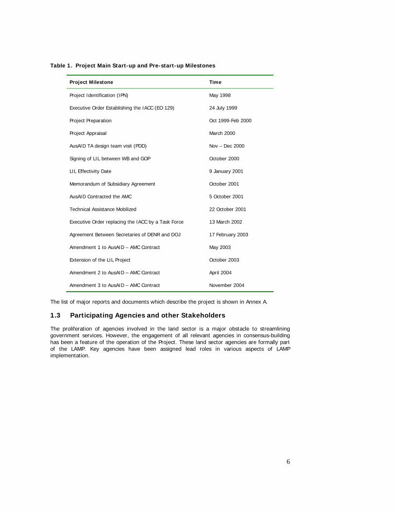
6
Table 1. Project Main Start-up and Pre-start-up Milestones
Project Milestone Time
Project Identification (IPN) May 1998
Executive Order Establishing the IACC (EO 129) 24 July 1999
Project Preparation Oct 1999-Feb 2000
Project Appraisal March 2000
AusAID TA design team visit (PDD) Nov – Dec 2000
Signing of LIL between WB and GOP October 2000
LIL Effectivity Date 9 January 2001
Memorandum of Subsidiary Agreement October 2001
AusAID Contracted the AMC 5 October 2001
Technical Assistance Mobilized 22 October 2001
Executive Order replacing the IACC by a Task Force 13 March 2002
Agreement Between Secretaries of DENR and DOJ 17 February 2003
Amendment 1 to AusAID – AMC Contract May 2003
Extension of the LIL Project October 2003
Amendment 2 to AusAID – AMC Contract April 2004
Amendment 3 to AusAID – AMC Contract November 2004
The list of major reports and documents which describe the project is shown in Annex A.
1.3 Participating Agencies and other Stakeholders
The proliferation of agencies involved in the land sector is a major obstacle to streamlining government services. However, the engagement of all relevant agencies in consensus-building has been a feature of the operation of the Project. These land sector agencies are formally part of the LAMP. Key agencies have been assigned lead roles in various aspects of LAMP implementation.
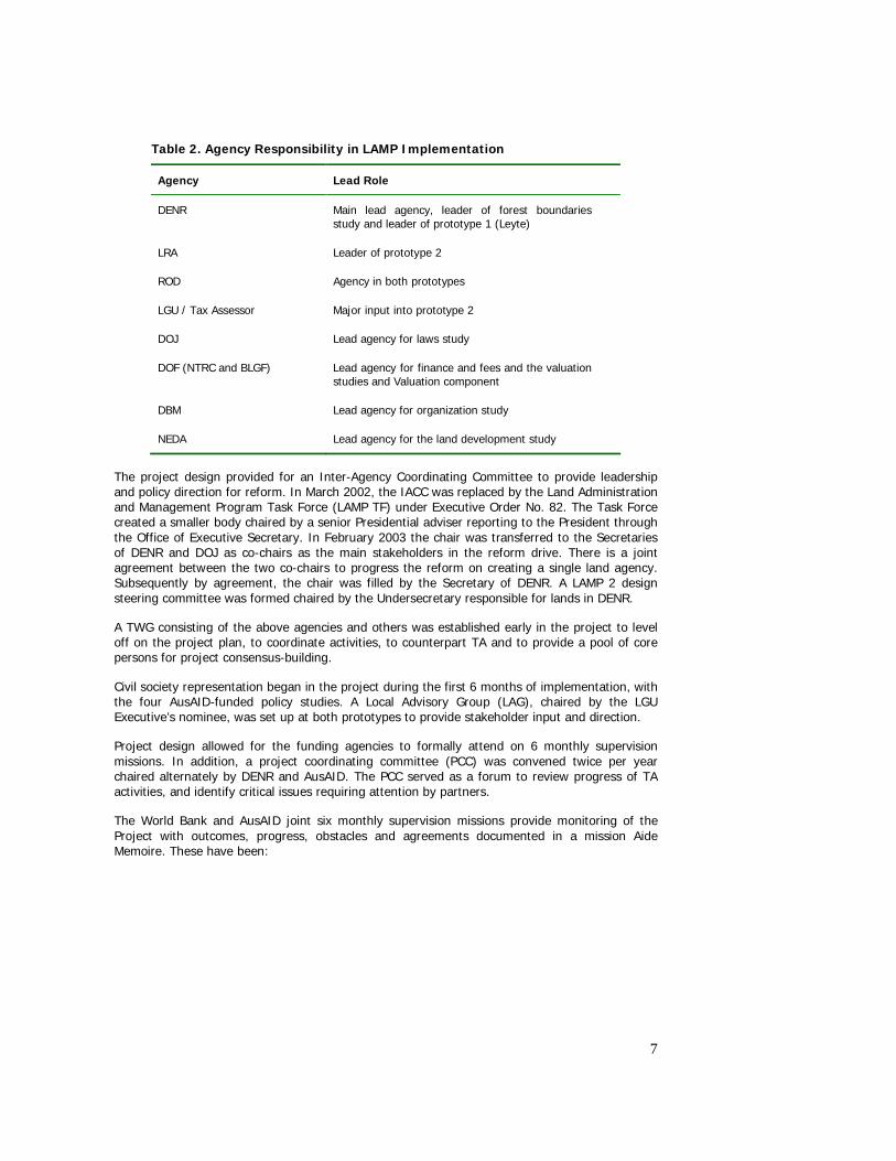
7
Table 2. Agency Responsibility in LAMP Implementation
Agency Lead Role
DENR Main lead agency, leader of forest boundaries study and leader of prototype 1 (Leyte)
LRA Leader of prototype 2
ROD Agency in both prototypes
LGU / Tax Assessor Major input into prototype 2
DOJ Lead agency for laws study
DOF (NTRC and BLGF) Lead agency for finance and fees and the valuation studies and Valuation component
DBM Lead agency for organization study
NEDA Lead agency for the land development study
The project design provided for an Inter-Agency Coordinating Committee to provide leadership and policy direction for reform. In March 2002, the IACC was replaced by the Land Administration and Management Program Task Force (LAMP TF) under Executive Order No. 82. The Task Force created a smaller body chaired by a senior Presidential adviser reporting to the President through the Office of Executive Secretary. In February 2003 the chair was transferred to the Secretaries of DENR and DOJ as co-chairs as the main stakeholders in the reform drive. There is a joint agreement between the two co-chairs to progress the reform on creating a single land agency. Subsequently by agreement, the chair was filled by the Secretary of DENR. A LAMP 2 design steering committee was formed chaired by the Undersecretary responsible for lands in DENR.
A TWG consisting of the above agencies and others was established early in the project to level off on the project plan, to coordinate activities, to counterpart TA and to provide a pool of core persons for project consensus-building.
Civil society representation began in the project during the first 6 months of implementation, with the four AusAID-funded policy studies. A Local Advisory Group (LAG), chaired by the LGU Executive’s nominee, was set up at both prototypes to provide stakeholder input and direction.
Project design allowed for the funding agencies to formally attend on 6 monthly supervision missions. In addition, a project coordinating committee (PCC) was convened twice per year chaired alternately by DENR and AusAID. The PCC served as a forum to review progress of TA activities, and identify critical issues requiring attention by partners.
The World Bank and AusAID joint six monthly supervision missions provide monitoring of the Project with outcomes, progress, obstacles and agreements documented in a mission Aide Memoire. These have been:
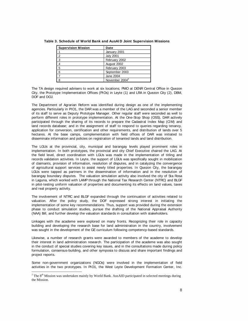
8
Table 3. Schedule of World Bank and AusAID Joint Supervision Missions
Supervision Mission Date 1 January 2001 2 July 2001 3 February 2002 4 August 2002 5 February 2003 6 September 2003 7 June 2004 8 November 20042
The TA design required advisers to work at six locations; PMO at DENR Central Office in Quezon City, the Prototype Implementation Offices (PIOs) in Leyte (1) and LRA in Quezon City (2), DBM, DOF and DOJ.
The Department of Agrarian Reform was identified during design as one of the implementing agencies. Particularly in PIO1, the DAR was a member of the LAG and seconded a senior member of its staff to serve as Deputy Prototype Manager. Other regular staff were seconded as well to perform different roles in prototype implementation. At the One-Stop Shop (OSS), DAR actively participated through the sharing of its records to prepare the Cadastral Index Map (CIM) and land records database; and in the assignment of staff to respond to queries regarding tenancy, application for conversion, certification and other requirements, and distribution of lands over 5 hectares. At the base camps, complementation with field offices of DAR was initiated to disseminate information and policies on registration of tenanted lands and land distribution.
The LGUs at the provincial, city, municipal and barangay levels played prominent roles in implementation. In both prototypes, the provincial and city Chief Executive chaired the LAG. At the field level, direct coordination with LGUs was made in the implementation of titling and records validation activities. In Leyte, the support of LGUs was specifically sought in mobilization of claimants, provision of information, resolution of disputes, and in catalyzing the convergence of agricultural support services to assist newly titled properties. In Quezon City, the barangay LGUs were tapped as partners in the dissemination of information and in the resolution of barangay boundary disputes. The valuation simulation activity also involved the city of Sta Rosa in Laguna, which worked with LAMP through the National Tax Research Center (NTRC) and BLGF in pilot-testing uniform valuation of properties and documenting its effects on land values, taxes and real property activity.
The involvement of NTRC and BLGF expanded through the continuation of activities related to valuation. After the policy study, the DOF expressed strong interest in initiating the implementation of some key recommendations. Thus, support was provided during the extension phase to conduct simulation studies, pursue the drafting of the National Appraisal Authority (NAA) Bill, and further develop the valuation standards in consultation with stakeholders.
Linkages with the academe were explored on many fronts. Recognizing their role in capacity building and developing the research base for land administration in the country, involvement was sought in the development of the GE curriculum following competency-based standards.
Likewise, a number of research grants were awarded to members of the academe to develop their interest in land administration research. The participation of the academe was also sought in the conduct of special studies covering key issues, and in the consultations made during policy formulation, consensus-building, and other symposia to discuss and share important findings and project reports.
Some non-government organizations (NGOs) were involved in the implementation of field activities in the two prototypes. In PIO1, the West Leyte Development Formation Center, Inc. 2 The 8th Mission was undertaken mainly by World Bank. AusAID participated in selected meetings during the Mission.
9
(WESLEDEF), an NGO, was engaged to pilot the NGO-led community organizing approaches of the project. In PIO2, the Partnership of Philippine Support Services Agency (PHILSSA), which has a network of local NGOs in the prototype area, was engaged to conduct field validation and Community Relations Services (CRS) in the four barangays of the project. Moreover, some NGO/People’s Organization (PO) members participated in the conduct of research studies funded through the TA Component and during specific community mobilization activities.
The basic sectors were involved very actively in consensus-building activities for land administration reform. A formal partnership arrangement was established between the seven basic sectors of the National Anti-Poverty Commission (NAPC) and LAMP to work together to advocate for the reform proposals specifically for the immediate passage of the Land Administration Reform Act (LARA). These are: the farmers, urban poor, fisherfolk, women, workers in the informal sector, indigenous peoples, and NGOs. Following their own networks and existing mechanisms, the NAPC-Basic Sectors (NAPC-BS) conducted their own advocacy for the proposed legislations, created advocacy groups in 7 regional centers and secured the support of the Philippine President.
1.4 Summary of Design
The Land Administration and Management Project, Phase 1 (LAMP 1) was an inter-agency project of the GOP through the DENR and its partner agencies: the DOJ/LRA and the DAR. The project was conceived as the first step towards the implementation of a proposed long-term LAM Program. The goal of this long-term program was:
To alleviate poverty and enhance economic growth by improving the security of land tenure and efficiency of land markets through the development of an efficient system of land titling and administration that is based on clear and consistent policies and laws, gender-responsive and supported by an appropriate institutional structure.
1.4.1 Design Logic and Strategy
LAMP 1 was designed to promote reform in land administration though the development of an improved policy, legislative and institutional framework, and to develop and test procedural improvements in systematic land titling, and records and information management. The project was supported by a LIL from the World Bank coupled with a technical assistance grant from the AusAID. It was envisaged that the proposed reforms, its tested systems and procedures, and its recommendations and lessons would provide the foundations for the longer-term LAM Program.
The World Bank LIL provided the flexibility for the project to develop and test improved land titling and administration procedures under existing policies, legislation and institutional arrangements before recommending their broader adoption under the long-term program. At the same time, LAMP 1 aimed to identify the required reforms to address fundamental problems facing land administration in the Philippines:
• duplication and overlap in the roles, functions and activities of land administration agencies;
• inconsistency in the legislation regulating the land administration;
• two competing processes for titling land (administrative and judicial processes);
• multiplicity in forms of ownership rights in land;
• multiplicity of property taxes and related disincentives to formalization of land transactions;
• multiplicity in land valuation methods.
The AusAID-funded Technical Assistance (TA) was designed to support implementation of the LIL project and promote sector reform.
10
The strategy for reform rested on progressive engagement of a wide range of stakeholders building understanding and trust of stakeholders to promote continuity of stakeholder interest in the push for reform.
LAMP 1 support for the development of improved systematic land titling procedures was built on a strategy to provide security of tenure for land holders, thereby enabling greater access to credit and increased investment in land, ultimately resulting in increased land productivity and incomes.
The strategy for land records and information management was to provide complete and up-to-date information on land parcels in pilot areas, to develop mechanisms for exchange of land information among key agencies, and to improve access for the public for land transactions and land information. The combined outcomes of these improvements would remove confusion and conflicting information on the status of land; facilitate land transactions, stimulate the land market, and improve government collection of land related revenues.
1.4.2 Goal, purpose and objectives
An early step in LAMP 1 was the construction of a unified logical framework (logframe) incorporating outputs and activities from both the AusAID Project Design Document (PDD) and the World Bank Project Appraisal Document (PAD). The two logframes and schedules described in the PDD and Project Preparation Report (PPR) had been a source of confusion and complication. The unified logframe was developed through an active process of consultation in workshops with PIO 1, PIO 2 and PMO.
LAMP 1 Higher-level Goal: Reduced poverty and enhanced economic growth by improving the security of land tenure and fostering efficient land markets in urban and rural areas.
LAMP1 Goal: Improved system of land administration and titling effectively serving the needs of the clients/users which is based on clear, coherent, consistent and gender-responsive policies and laws, and is supported by an appropriate institutional structure.
Purpose: Government adopting agreed policy, regulatory and institutional framework required for long term LAM Program; and communities/clients within the Prototype areas have access to cost effective solutions designed to improve the protection of rights to land, and early detection, prevention of fake, double, overlapping and identification of missing titles developed through testing of alternative approaches.
LAMP 1 was comprised of five components:
(i) Component 1 (Land Policy and Key Issues Studies)
Objective: To formulate and approve policy and regulatory changes needed to support implementation of the subsequent phase of the LAM Program.
This component was led by LAMP Project Management Office based in DENR.
(ii) Component 2 (Prototype on Land Titling and Administration-PIO 1)
Objective: To develop improved approaches for large-scale land registration and associated institutional and administrative arrangements that are simplified, streamlined, cost-effective and acceptable to the community.
This component was led by the DENR in six municipalities in Leyte.
(iii) Component 3 (Prototype on Land Records Management and Information-PIO 2)
Objective: To develop and test alternative approaches for land record management and associated institutional and administrative arrangements that will improve the protection of rights to land and public confidence in the system.
11
This component was led by the LRA in five barangays in Quezon City.
(iv) Component 4 (Institutional Development Component)
Objective: To ensure efficient and effective management, implementation, monitoring and evaluation of the project.
(v) Component 5 (Preparation for the Next Phase)
Objective: To design the next phase of the longer-term LAM Program using project outcomes and experiences.
1.4.3 Changes to design during implementation During implementation, several modifications on the objectives, duration and financing mix of the Project were made. These changes were introduced in order to respond to the implementation realities of those periods.
Unification of Logframes
In early 2002, the project found it necessary to unify the Logframes as defined in the AusAID PDD and the World Bank PAD. This was to ensure that there is consistency in the levels of objectives and indicators of performance. These had to be clarified in the revised Logframe so that project planners, implementers and those involved in monitoring and evaluation (M and E) were properly guided. The unified Logframe was completed in March 2002 (Annex B).
Revision of Logframe
During the formulation of the proposal for Project extension in May 2003, the Project saw the need to clarify the relationship of the LAMP LIL with the overall program objectives and define this as the higher-level goal, rather than the immediate goal of the LAMP LIL. This was also made consistent with the clarification provided to civil society groups that LAMP will not directly contribute to poverty reduction, but is an essential element of poverty reduction that should go along with other programs (i.e., asset reform, rural development, livelihood provision, capacity-building, etc.). Further, the Logframe was enhanced through the integration of gender variables among the indicators. The Logframe as revised in May 2003 appears as Annex C. Annex D presents the comparison of the March 2002 Logframe with the May 2003 Logframe.
Extension of TA Support and Support to Valuation
After the minor modifications made in the integration of the World Bank and AusAID logframes, only a few more were made on the design during implementation. The important exception was the inclusion of TA support to strengthen land valuation. This new land valuation ‘component’ was included in the extension phase of AusAID assistance provided from October 2003 to December 2004.
TA assistance was provided to the NTRC and BLGF as the key implementing partners under the DOF. The overall objectives of this component were broadly to raise the quality of Government and private sector property appraisal through the development of valuation standards and promotion of institutional and legislative reform. This was to be commenced through the development of draft valuation standards; the drafting of legislative amendments and a bill for the establishment of an NAA; and the implementation of a simulation study to assess impacts of new standards for LGUs. It was expected that this work would continue under the subsequent phase of the LAM Program.
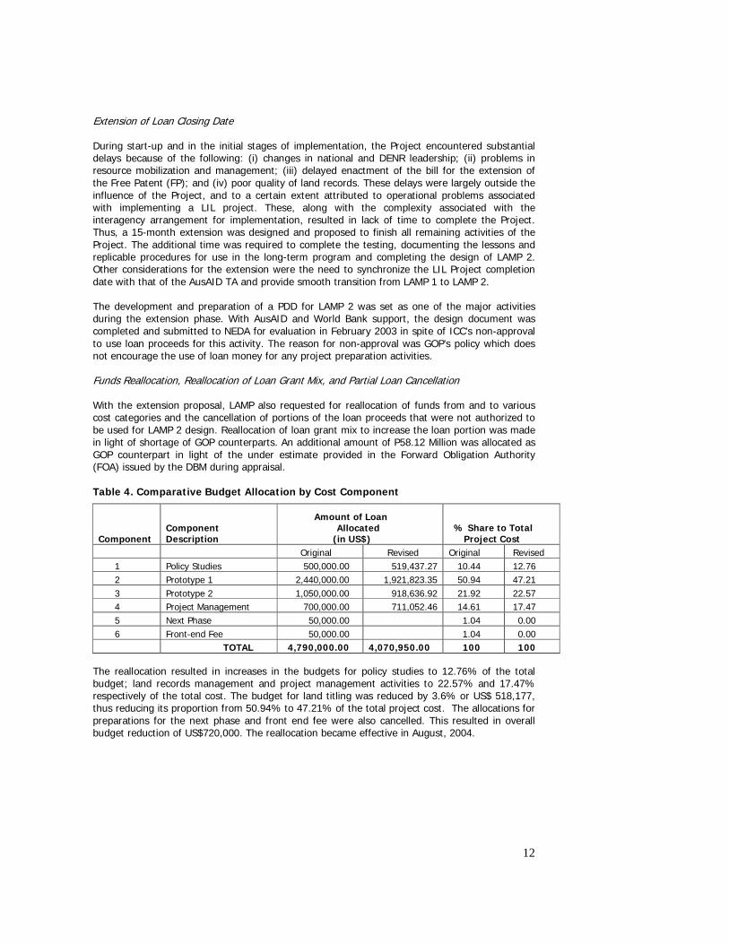
12
Extension of Loan Closing Date During start-up and in the initial stages of implementation, the Project encountered substantial delays because of the following: (i) changes in national and DENR leadership; (ii) problems in resource mobilization and management; (iii) delayed enactment of the bill for the extension of the Free Patent (FP); and (iv) poor quality of land records. These delays were largely outside the influence of the Project, and to a certain extent attributed to operational problems associated with implementing a LIL project. These, along with the complexity associated with the interagency arrangement for implementation, resulted in lack of time to complete the Project. Thus, a 15-month extension was designed and proposed to finish all remaining activities of the Project. The additional time was required to complete the testing, documenting the lessons and replicable procedures for use in the long-term program and completing the design of LAMP 2. Other considerations for the extension were the need to synchronize the LIL Project completion date with that of the AusAID TA and provide smooth transition from LAMP 1 to LAMP 2. The development and preparation of a PDD for LAMP 2 was set as one of the major activities during the extension phase. With AusAID and World Bank support, the design document was completed and submitted to NEDA for evaluation in February 2003 in spite of ICC’s non-approval to use loan proceeds for this activity. The reason for non-approval was GOP’s policy which does not encourage the use of loan money for any project preparation activities. Funds Reallocation, Reallocation of Loan Grant Mix, and Partial Loan Cancellation With the extension proposal, LAMP also requested for reallocation of funds from and to various cost categories and the cancellation of portions of the loan proceeds that were not authorized to be used for LAMP 2 design. Reallocation of loan grant mix to increase the loan portion was made in light of shortage of GOP counterparts. An additional amount of P58.12 Million was allocated as GOP counterpart in light of the under estimate provided in the Forward Obligation Authority (FOA) issued by the DBM during appraisal. Table 4. Comparative Budget Allocation by Cost Component
Component
Component Description
Amount of Loan Allocated
(in US$) % Share to Total
Project Cost Original Revised Original Revised
1 Policy Studies 500,000.00 519,437.27 10.44 12.76 2 Prototype 1 2,440,000.00 1,921,823.35 50.94 47.21 3 Prototype 2 1,050,000.00 918,636.92 21.92 22.57 4 Project Management 700,000.00 711,052.46 14.61 17.47 5 Next Phase 50,000.00 1.04 0.00 6 Front-end Fee 50,000.00 1.04 0.00
TOTAL 4,790,000.00 4,070,950.00 100 100
The reallocation resulted in increases in the budgets for policy studies to 12.76% of the total budget; land records management and project management activities to 22.57% and 17.47% respectively of the total cost. The budget for land titling was reduced by 3.6% or US$ 518,177, thus reducing its proportion from 50.94% to 47.21% of the total project cost. The allocations for preparations for the next phase and front end fee were also cancelled. This resulted in overall budget reduction of US$720,000. The reallocation became effective in August, 2004.
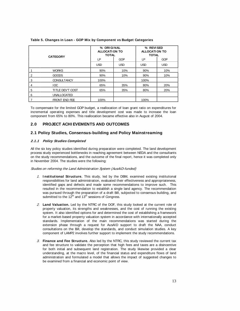
13
Table 5. Changes in Loan - GOP Mix by Component vs Budget Categories
% ORIGINAL ALLOCATION TO
TOTAL
% REVISED ALLOCATION TO
TOTAL LP GOP LP GOP
CATEGORY
USD USD USD USD
1 WORKS 90% 10% 90% 10%
2 GOODS 90% 10% 90% 10%
3 CONSULTANCY 100% 100%
4 IOC 65% 35% 80% 20%
5 TITLE DEV'T COST 65% 35% 80% 20%
6 UNALLOCATED
7 FRONT END FEE 100% 100%
To compensate for the limited GOP budget, a reallocation of loan grant ratio on expenditures for incremental operating expenses and title development cost was made to increase the loan component from 65% to 80%. This reallocation became effective also in August of 2004.
2.0 PROJECT ACHIEVEMENTS AND OUTCOMES
2.1 Policy Studies, Consensus-building and Policy Mainstreaming
2.1.1 Policy Studies Completed
All the six key policy studies identified during preparation were completed. The land development process study experienced bottlenecks in reaching agreement between NEDA and the consultants on the study recommendations, and the outcome of the final report, hence it was completed only in November 2004. The studies were the following:
Studies on reforming the Land Administration System (AusAID-funded)
1. Institutional Structure. This study, led by the DBM, examined existing institutional responsibilities for land administration, evaluated their effectiveness and appropriateness, identified gaps and defects and made some recommendations to improve such. This resulted in the recommendation to establish a single land agency. The recommendation was pursued through the preparation of a draft Bill, subjected to consensus building, and submitted to the 12th and 13th sessions of Congress.
2. Land Valuation. Led by the NTRC of the DOF, this study looked at the current role of property valuation, its strengths and weaknesses, and the cost of running the existing system. It also identified options for and determined the cost of establishing a framework for a market-based property valuation system in accordance with internationally accepted standards. Implementation of the main recommendations was started during the extension phase through a request for AusAID support to draft the NAA, conduct consultations on the Bill, develop the standards, and conduct simulation studies. A key component of LAMP2 involves further support to implement the study recommendations.
3. Finance and Fee Structure. Also led by the NTRC, this study reviewed the current tax and fee structure to validate the perception that high fees and taxes are a disincentive for both initial and subsequent land registration. The study likewise provided a clear understanding, at the macro level, of the financial status and expenditure flows of land administration and formulated a model that allows the impact of suggested changes to be examined from a financial and economic point of view.
14
4. Fragmented land laws and regulations. Led by the DOJ, the study reviewed and built upon the previous work undertaken on laws and regulations in the areas of public land disposition, land titling and registration. It also examined and updated the relevance of these, and determined implications for implementation.
Studies on Improving Land Management (World Bank-funded)
5. Forest Boundary Delineation. The study, led by the DENR, developed a system for the development of a database for the general characteristics of various land uses in the uplands that will serve as a tool for planning and decision-making with regard to current and future land use. It also developed a policy framework on what to do with areas that do not conform with their existing classification. The Study provided a more practical approach to delineating forest boundaries using an integrated set of social, economic and biophysical criteria. Further policy studies were designed to address policy gaps in the policy framework. The top management of DENR indicated strong support to the recommendations of the study. LAMP2 includes support to delineation of forest lands in provinces based on the criteria developed by the study.
6. Land Development Process. Led by the NEDA, this study reviewed the existing system of land allocation and utilization so as to effect the highest and best use of land for present and future generations. The study also proposed improvements to the existing systems and to the present efforts of the government in addressing the major issues. It is expected that the study results will provide directions on how to put in place reforms in land management, particularly on land use planning, land conversion and site development procedures and processes.
The results of the first four land administration studies were consolidated into an integrated policy report, from which the following fourteen (14) strategic directions for reforming the Philippine land administration system was developed (see Annex E for a summary of findings and recommendations of the first four policy studies):
Strategic Directions for Reform (The Land Administration Reform Agenda)
Institutional Arrangements
1. Strengthen leadership and management of reform.
2. Remove duplication and overlap in delivery of land administration services.
3. Improve the efficiency, responsiveness, transparency and accountability of land administration services.
4. Consolidate and coordinate the production of, and access to land information
Land Laws
5. Abolish judicial processes for issue and registration of titles in favor of simple administrative processes.
6. Reform and consolidate land administration laws and regulations.
7. Clarify the rights of persons occupying land to obtain titles.
8. Progressively extend the Torrens Title register to become a comprehensive record of all land in the Philippines recording all rights relating to land.
Finance and Fee Structure
9. Devolve responsibility for taxation of real property ownership and transfers to local government.
10. Streamline land transfers and remove disincentives to their formal registration by the Registry of Deeds.
15
11. Progress towards cost recovery for land administration services.
Land Valuation
12. Remove local government political intervention in processes for the assessment of property values.
13. Adopt a single valuation basis for all real property taxation.
14. Develop, implement and enforce uniform, best-practice, valuation standards within government.
2.1.2 Actions on Study Recommendations
Upon the formulation of the 14-point Reform Agenda, LAMP set out to push for the study recommendations where possible under existing government policy. The initial strategy undertaken was consensus-building with stakeholders, which aimed at generating multi-stakeholder inputs to and agreements with the reform agenda. In August 2002, the reform agenda was presented to the Executive Secretary, members of the LAMP Task Force (LAMP TF) and other members of the Cabinet. The adoption of the 14 strategic directions by the Executive Branch during that meeting paved the way for the Project to initiate a rigorous consensus-building process among the stakeholders. While the Project initially hoped that all 14 recommendations could be subjected for consensus-building as one reform package, it turned out that only a number of the recommendations were possible given the policy environment at that point. Thus, an incremental approach to push for the reform proposals was identified, tackling first the recommendations that had strong potential for government support. Among those identified as priority reform agenda were the recommendations by the Institutional Arrangements Study and the Land Valuation Study.
Institutional Arrangements
The institutional reform recommendations received initial support from the Executive Secretary and the LAMP Task Force, which led to the exploration of the possibility of creating the proposed Land Administration Authority (LAA) through an Executive Order. This, however, did not materialize, as the Project was advised to pursue the agency’s creation through legislation. Thus, the longer but more binding legislative process was pursued along with building stakeholder consensus and partnerships to push for the reform (discussed in detail in the next section).
Land Valuation and Finance and Fees
The extension of LAMP 1 from October 2003 to December 2004 enabled the Project to continue working on the reform recommendations of the Land Valuation and Finance and Fees studies. Following the completion of the Valuation study in June 2002, the DOF considered the recommendations in parallel with those of the finance and fees study, for which a management plan was prepared in early 2003. The DOF subsequently requested assistance to start the implementation of valuation standards development and pilot testing.
By mid-2004, the NTRC had pursued the drafting of a Bill initiating reforms in the land valuation system, central to which is the creation of a regulatory agency called the National Appraisal Authority. One issue encountered in pursuing this measure is the recognition of the advances LGUs have made in valuation capacity since the enactment of the Local Government Code in 1991, and the subsequent downgrading of BLGF capacity and efforts in valuation. Hence, the recommendation of forming a national valuation regulator is being studied to correctly focus on a regional structure, with just a small central office. It is expected that by the end of the Project, refinements and further modifications would have been made on the Bill and the draft valuation standards as a result of consultations with stakeholders.
Also, activities were pursued to develop uniform valuation standards for private and government use, and a draft was developed for this purpose. Simulation studies were conducted in the City of Sta. Rosa, Laguna beginning April 2004. Reports show that even in this efficient LGU, there is
16
significant room for improvement in removing distortions in the valuation base by establishing market-based values, keeping it up to date, and sharing the valuation base with the BIR.
Land Laws
The findings of the land laws policy study, combined with the lessons and experiences on systematic land titling in the Leyte Prototype, paved the way for the development of a proposal to amend specific provisions of Commonwealth Act No. 141, otherwise known as the Public Land Act of 1936, among others. A draft bill was developed from 2003 to 2004, and enhancements were made based on initial consultations with the basic sectors and results of the studies on mortgage, tenancy and participation. It is expected that through this proposed legislation, all disincentives in the application of free patents would be removed, and for the law to cover all types of lands under the public domain. The amendment also aims to make processing more efficient, responsive and less costly. Consultations on, and the subsequent filing of the Bill, however, were deferred to LAMP 2 because of the need for some administrative clarifications from the DENR and the prioritization of advocacy activities for the LARA Bill.
Meanwhile, consensus-building for and implementation of other recommendations made under the Land Laws Study were deferred to future efforts mainly because of the need to establish first the Land Administration Authority, which is seen to shepherd the reform proposals in the long-term (instead of a Project such as LAMP). The codification of all existing land administration laws, for example, require more time and resources that would need more thorough efforts beyond LAMP 1’s objectives and targets.
Forest Boundary Delineation
The recommendations of the Forest Boundary Study were officially accepted by the DENR in 2003. The study now remains with DENR policymakers for future implementation, with the recommendation on marking a definite forest line foremost among the reform proposals.
2.1.3 Consensus-building Activities
Consensus-Building Strategy
Consistent with the incremental approach to policy reform, the Project undertook a consensus-building process that identified the most critical stakeholder groups that needed to be consulted, while considering their potential as possible advocates of the reform proposals. In the second quarter of 2002, a consensus-building strategy was developed so that the reform agenda could be subjected to a more participatory consultation process with different stakeholders. In 2002-2003, the Reform Agenda were subjected to wide stakeholder consultation, which provided opportunities for further enhancing the recommendations so that these become more relevant to supporting the goal of poverty alleviation – a concern that was specifically raised by the basic sector representatives of the NAPC.
The major groups identified were:
(i) Basic sector representatives (farmers, fisher folk, NGOs, women groups, urban poor, workers in the informal sector, indigenous peoples,) of the NAPC;
(ii) Local government units and their umbrella leagues (Leagues of Provinces, Cities and Municipalities);
(iii) Agencies that stand to be affected by the reform proposals (the DOJ’s LRA/ ROD, and the DENR’s NAMRIA and LMB);
(iv) Other national government agencies (DAR, NHA and HUDCC, etc.); and
(v) The private sector (real estate brokers, banks, appraisers, developers); and professional organizations/academe (geodetic engineers, planners, lawyers, etc).
17
As consensus-building activities progressed, the Project initiated the formulation of a draft bill for the creation of the LAA. This effort was strengthened in February 2003 with the signing of a Memorandum of Agreement (MOA) by the DENR and DOJ Secretaries for the two agencies to work together in developing a draft bill creating a single agency for land administration. The draft bill, prepared by a TWG of both agencies, was endorsed by both agencies and became the subject of consultation with critical stakeholders (consensus-building activities are discussed further in the next section).
At that point initial consensus had been reached with the organized Basic Sectors (farmers, fisherfolk, urban poor, indigenous peoples, workers in the informal sector, women and NGOs) under the NAPC on the 14 Strategic Directions. The draft LAA Bill was presented to the group and was re-drafted using their perspective as end-users of the system. The bill was then renamed as Land Administration Reform Act to highlight its significance as a reform measure. This was the version that was subsequently endorsed by the LAMP Task Force for filing in Congress.
Also in conjunction with the incremental approach to push for the reform proposals, the Project pursued initial efforts towards building partnerships with, and launching a communication campaign for stakeholder groups that have signified support to the reform agenda and/or the LARA Bill. This was particularly true with the NAPC Basic Sectors as, in June 2003, they entered into a Memorandum of Cooperation (MOC) with LAMP to advocate for the Bill and the reform agenda. The partnerships mechanism undertaken was resource-sharing, with the Basic Sectors creating Task Force LARA, a core group composed of a national coordinator and one member each from the seven basic sectors, to lead the advocacy efforts. LAMP, on the other hand, provided counterpart logistical funding and staff support to TF LARA’s activities. Fund management was made possible through a conduit NGO, PILIPINA, Inc.
The implementation mechanism undertaken for the partnership was a combination of grassroots advocacy and executive-legislative lobbying. Through the partnership with the basic sectors, the LARA Bill reached the attention of the President through the NAPC en banc meetings chaired by the President herself. The President has expressed full support to the reform proposal and agreed to make the LARA Bill a priority legislative measure. Also with TF LARA, advocacy campaigns were intensified in both houses of Congress, thereby manifesting stakeholder interest and presence during public hearings. Further, the basic sectors were able to link with other civil society organizations (CSOs) and assisted the Project in organizing regional centers of advocacy groups composed mainly of the basic sectors in seven key regions. In July 2004, the LARA was formally included in the legislative agenda of the NAPC Sectoral Council, as presented to and affirmed by the Philippine President.
On the other hand, consultations were conducted with the agencies that stand to be affected by the reform proposals, such as the LMB, LRA/ROD and NAMRIA. While apprehensions on some of the recommendations were expressed as expected, general support on most of the recommendations was achieved. Among the major concerns raised by these groups were: (i) how the proposed legislation seeks to address the possible displacement of employees as a result of the merger; and (ii) who among the affected agencies would serve as lead agency in implementing the reforms. These concerns were subsequently addressed during the Congressional hearings in 2003, from which final agreements are expected to be made. While official support was not expressed by the agency leaders in particular, top officials of their home departments (i.e., the DENR and DOJ) reiterated their support to the creation of the LAA.
As of October 2004, the consensus-building activities for the reform agenda had generated significant stakeholder support as manifested by the following:
1. Endorsement by civil society (NAPC Basic Sectors) of the Policy Reform Agenda with priority given to the passage of the LARA Bill;
2. Manifesto of support from the private sector and professional associations, specifically the Chamber of Real Estate Builders Associations (CREBA), Subdivision and Housing Developers Association (SHDA), National Real Estate Association (NREA), Philippine

18
Institute of Architects (PIA), Integrated Bar of the Philippines (IBP), and the Geodetic Engineers of the Philippines (GEP), Transparency and Accountability Network (TAN), Society of Philippine Realty Appraisers (SOPRA), and Philippine Association of Real Property Appraisers (PARA).
3. Expressions of support from the Leagues of Barangays, Cities, Municipalities and Provinces and select LGUs.
From March-July 2004, LAMP conducted LAM reform mainstreaming activities into DENR operations. Orientation-workshops were conducted for the middle managers in the central office and key personnel in regional offices nationwide. A LAM Reform Coordinating Committee was established in the Department composed of different middle managers, which was mandated by the Secretary to coordinate the adoption and implementation of the reform recommendations in the various offices of the DENR. The regional workshops resulted in the creation of action plans as to how the different offices could mainstream LAM reform activities within their existing budget allocation.
A total of 148 Consensus-building workshop-type events (183 days) were implemented by LAMP from 2001-August 2004, involving some 5,029 participants (62% men, 38% women) nationwide.
Policy Advocacy and IEC for the LARA Bill
With the change of management in both the DENR and DOJ, a MOA was forged in year 2002, between the two agencies to work on the drafting of a legislative measure to merge the roles and functions of key agencies mandated to perform land administration functions. This gave birth to the drafting and consequent filing of the LARA bill in both houses of Congress.
As many as 10 key legislators from the House of Representatives and three in the Senate filed their own versions of the Bill in mid-2003, all meant to establish the LAA. By December 2003, the House Committee on Natural Resources had conducted a total of seven committee hearings. It subsequently drafted a unified version of the LARA, drawing from the official positions submitted by key stakeholders and concerned agencies, and referred the Bill to the Committee on Appropriations. In the Senate, the Bills were referred to the Committee on Justice and Human Rights. No Committee hearings were conducted because of scheduling problems.
Advocacy efforts for the passage of the LARA were likewise severely affected by the closing of the 12th Congress and the May 2004 elections. For this period, the Project and its stakeholders did preparatory work for the opening of the new Congress in July 2004 and continue working on the consensus-building process. This included nationwide ground working in partnership with the NAPC basic sectors to establish regional Task Force structures and disseminate information on and mobilize support for the LARA at the grassroots level. Multi-sectoral fora were conducted in six areas: Cordillera Administrative Region (CAR), Butuan, Cebu, Davao, Palawan and Bacolod. A total of 440 sectoral leaders attended the activities, most of whom expressed strong support for the LARA Bill and the establishment of regional advocacy structures.
A number of legislators re-filed the LARA in both houses of the new Congress as early as July 2004. To date, the Bill has been filed by 16 House representatives in the Committees on Natural Resources and Government Reorganization, and 3 in the Senate Committee on Justice and Human Rights. In the House of Representatives, efforts are being undertaken to unify all the Bills under one single Committee, and to work towards building support in the Committee on Appropriations. On the other hand, efforts are targeted in the Senate towards having the Bill referred to both the Committees on Justice & Human Rights and Natural Resources as joint committees.
A Policy Forum was organized in November 2004 to consolidate all of LAMPs policy research outputs into a stakeholder enhanced reform agenda. During the Forum, the House Speaker,
19
together with three other Congressmen sponsors of the Bill, expressed support and committed to have it passed in Congress by the first quarter of 2005.
Meanwhile, the Legislative-Executive Development Advisory Council (LEDAC) once again identified the LARA as a priority administration measure in July 2004. This came about as a result of the manifestations made by the DENR Secretary and NAPC leaders, and was presented as part of the Social Justice and Basic Needs Package by the NEDA Secretary. The first Congressional hearings on the LARA was scheduled in November 2004.
LAMP 2 and LARA were recently included in the Medium Term Philippine Development Plan (MTPDP), giving the reform efforts a renewed mandate and a stronger claim at legitimacy.
To support all policy advocacy activities, the Project prepared a complementary communication plan that identified and made corresponding strategies for specific stakeholder groups. The Project also produced and distributed flyers and brochures on the Reform Agenda to key stakeholders. An audio-visual production was also aired (free of charge) on several local channels, along with an increased number of news and feature articles on land administration in various broadsheets. The LAMP website was revised and updated with new features and documents. A video production on the LARA was produced and launched for legislators and the media in November 2004. These IEC activities were all directed towards creating and sustaining public awareness on land administration issues and the need for reform.
2.1.4 Outcomes of Consensus-building
The consensus-building and advocacy activities conducted by LAMP resulted in a general appreciation and ownership among relevant stakeholders and government of the reform proposals. The CB process has firstly exposed a range of interest groups to the mystery of the land administration sector, to appreciate its shortcomings, and to realize that a range of proven solutions is available. After this process it is clear that clients of the government’s land services are not satisfied, land tenure security and confidence is not high, and there is a growing demand for change. To illustrate, stakeholders positively influenced the development of the policy study recommendations (reform agenda); the development of the LARA Bill, the Free Patent Bill and the Property Valuation Bill; and the development of new procedures.
Stakeholder initiatives were most clearly demonstrated in the activities initiated by the NAPC-BS to pursue the reform agenda after entering into partnership with LAMP, and by the DENR top management in their strong advocacy for the reforms in various high-level engagements. The same can be said of the leaders of DOF and their partner LGUs, as they have consistently shown support to the valuation activities being undertaken. Likewise, the private sector, especially the Geodetic Engineers of the Philippines, research institutions and brokers and appraisers, have initiated efforts towards making land administration a special area of interest in research and the academic curriculum.
The nationwide ground working activities conducted by the NAPC-BS went beyond what was stipulated in the MOC with LAMP. Their establishment of regional Task Force structures and information dissemination activities, while primarily activities done in partnership with LAMP, were made part of their advocacy agenda independent of LAMP. This resulted in a sustained discussion of land administration issues in most Basic Sector gatherings, with speakers coming from among them and funding coming from their own resources. To date, land administration remains a priority agenda of the basic sectors, as manifested by their continual advocacy for the LARA Bill in their regular en banc meeting with the President. Such activities have, time and again, provided the opportunity for the reform agenda to be presented to the President, and in the process developing a common sense of responsibility between her Office and the NAPC to implement the reform measures.
Within the DENR, consensus-building activities have led to the reorientation of concerned officials and personnel on the problems affecting the lands sector and the direction that can be taken for reforming it. Top management support to the reform agenda was successfully turned
20
over with the change in leadership in August 2004, partly due to the existence of career executive advocates from within the bureaucracy. This does not discount the fact that opposing ideas about the reform agenda exist within the department (especially from among the concerned bureaus and agencies), but these opposing ideas only point towards a more important development: that there is already a growing interest in reforming the sector, LAMP-defined or otherwise. With the mainstreaming activities initiated in 2004 to stir land administration reform interest of field offices, the Project and the reform agenda can already look forward to tapping a more interested bureaucracy in the future.
The consensus-building activities for other concerned agencies (e.g., the LRA) have resulted in the identification of various directions for pushing for reforms in the medium-term. This includes the identification of the need for the creation of more opportunities to involve agency staff that stand to be affected by the reforms deeper in policy development and advocacy. While there had indeed been difficulty in getting their support for the LARA Bill itself because of its potential to displace employees, they have not expressed direct opposition to the very idea of reforming the land administration system. The consensus-building activities have achieved one of its objectives as far as the affected agencies are concerned, that is, the creation of an awareness of the system and what is wrong with it. It will be a matter for the long-term LAM program to push for the proposed solutions in a manner that is clear and fair to all concerned agencies and employees.
Indirectly, other project activities have yielded more allies in the call for change. For example, the Institute for Church and Social Issues (ICSI) in Manila and an academic consortium in Leyte have provided oversight to the conduct of some 22 research grants issued under the AusAID-funded TA. A growing capacity in research in the sector is emerging where there was none before. Further, the Geodetic Engineering curriculum development course for government and private sector practitioners provided technology transfer on competency-based design of curriculum and on modern surveying, and also raised awareness of the overall need for change in the sector. These developments are all seen to contribute to the larger policy environment, and should help capacitate other sectors to ultimately contribute to the reform process.
2.1.5 Issues and Recommendations
Continued Support is Required
The consensus-building activities have stirred a considerable level of stakeholder awareness of the issues and the alternatives for reform in the land administration system. Further, the proposals are in line with recent national government priority given to streamlining the bureaucracy, reducing government expenditures, and improving governance. However, there needs to be continued financial support for the reforms to be enacted by legislation and fully implemented. Once the bill creating the LAA is approved, support is required to carry out the merging of agencies and setting up the structure, development of systems and operating procedures for the new agency. To date, the Bill’s advocates in Congress are already looking for options to finance the set-up of the new agency should it get legislated. This is aside from the need for the DENR and DBM to continue providing support to the proposed Phase 2 of LAMP by allocating the amount necessary for the required GOP counterpart. This consideration even becomes more challenging at this point when, even as the donors have expressed full support to funding LAMP II, the GOP remains in fiscal crisis.
In the case of valuation, while there is clear national government support for changing the property assessment system, financial support will be required to conduct further consensus-building with other important stakeholders such as LGUs and the legislative branch of government and implement the actions recommended (i.e., the development of national valuation standards and creation of the National Appraisal Authority). Activities under the valuation component will continue to be supported under the proposed Phase 2 of LAMP. These include adoption of uniform and consistent valuation standards, enforcement of licensing regulations and professionalizing appraisal practice, valuation education and training, further simulation and testing of valuation standards in selected LGUs, and the adoption of standard
21
assessment procedures. There is strong commitment from the lead agency, the DOF, to establish a unit within its BLGF to implement valuation activities, and provide support to Phase 2. There is a need however, to prepare BLGF for this implementation role to ensure a smooth transition from the NTRC, the agency currently managing the valuation component.
Weak Support from Agencies Affected by LARA
The consensus-building process, however, has failed to convince many senior staff of concerned agencies to fully embrace the reform. This is best manifested by the filing of the LRA of another version of the LARA Bill even as the LAMP Task Force decided to push only for a single version. The version of the Bill being pushed by the LRA requires that affected DENR staff shall transfer under the leadership of the LRA, rather than creating an independent agency that shall have fresh mandates, and reform-oriented and stakeholder-driven activities. LAMP-LRA relations were also affected by differences over the implementation of LAMP Prototype 2 and LRA’s ambivalence in mainstreaming LAMP-developed improved procedures to their operations. Further, joint activities conducted with the LRA such as the development of a national land records management strategy have seen little interest because of its potential to run counter with LRA’s ongoing computerization project. Thus, there had been reduced opportunity to demonstrate LAMP benefits and to build relationships in LRA.
Weak support was also observed even in the DENR agencies, LMB and NAMRIA, where there had been occasional opposing positions made by the agency heads despite the fact that the reforms were fully endorsed by DENR top management. Nonetheless, a good number of key staff from these agencies individually support the reform and believe that it is long overdue. Other activities conducted with NAMRIA have had mixed results. While there were joint activities conducted such as development of Orthophoto Maps (OPM), trainings, and workshops on improved survey systems that were well-attended by NAMRIA, the agency had not performed according to expectations. The project’s assessment of NAMRIA’s capacity for orthophoto mapping based on the services delivered by NAMRIA over a 12-month period, was not well received by NAMRIA and has affected its engagement on the broader reform agenda.
Initial Loss of Credibility due to Changes in Strategy
Earlier attempts to obtain an Executive Order from the President on the reform and on land administration program integration eventually failed after a period of expectation that it would be endorsed. This was unfortunate as the funding partners in their February 2002 mission set LAMP the target of having an integrated policy reform agenda within 6 months, based on the signals that an EO would follow. Accordingly, the project worked strenuously for the next 6 months on the four AusAID funded policy studies and the integration of those studies. In this process the amount of consensus-building was limited by the time frame. The project lost some early credibility. In hindsight it would have been better to have taken about 18 months to develop the policy agenda and LARA Bill.
Limited Resources for Consensus Building
The process has been limited by resources both financial and people, and one of the main constraints has been the very limited number of possible speakers on the reform agenda. In an environment where affected agencies are not strongly supportive and resources are limited, it is also critical to have speakers from within the agencies to dispel the belief that only LAMP (and DENR) people are pushing for the reforms with an agenda to put DENR on the helm. To tackle the shortage of speakers LAMP designed and implemented a training course, called the Speakers Bureau training, for key staff of land administration agencies. Its objective was to develop a pool of speakers from within the agencies to advocate for the reform in their own agencies instead of just relying on speakers from the DENR Central Office and LAMP. Courses like this are recommended to be implemented further in the future to fully mainstream the reform efforts to all land administration agencies.
22
It is worth noting that the consensus-building process proved to be essential as more people were educated on the issues and problems confronting the sector and they were able to relate the whole reform agenda in support to their specific advocacy and interests. The lessons and experience of the Project during the consensus-building process with the basic sectors were documented and such experience will serve as a guide for future reference and related activities. More consensus-building activities remain to be done with the private sector, as there arises a need for a more consolidated stance by specific groups on the reform proposals. This may be done by way of tapping umbrella organizations representative of the sector, as it was with the NAPC-BS as representative of civil society.
2.2 Procedures for Mass Titling in Rural Areas
The objective of the land titling component was to develop an improved methodology for large-scale land registration and associated institutional arrangements that are simple, streamlined, cost-effective and community-accepted. The project undertook various pilot activities in order to develop its recommended methodology for Phase II.
2.2.1 Titling procedures tested and Manuals developed
Existing approaches for titling were tested for suitability as an option for mass titling. Two major approaches to titling were fully tested: the Cadastral Proceeding or Compulsory Judicial Titling under the judicial process and Free Patent under the administrative process. Homestead Patent and Miscellaneous Sales Patents were partially tested. The Homestead Patent was introduced in unsurveyed areas (agricultural) in two barangays. Judicial titling was undertaken in surveyed areas (agricultural and residential) and lately in a barangay earlier covered by the Homestead Patent applications.3 Finally, the Free Patent was tested in surveyed and unsurveyed areas in nine other barangays.
Based on the results of the tests, available mass titling procedures under existing laws are restrictive and inefficient. The Free Patent is so far the best option for mass titling because it is much faster and more flexible but has its own limitations. The Free Patent framework has the potential to overcome many of the inefficiencies evidenced in judicial titling and that administrative improvements can be introduced to streamline the procedures and reduce the time to issue titles. On the other hand, the judicial processes are more complex and inflexible. Key proposals that have been identified to improve the use of Free patent as an acceptable instrument are: (i) allow it to be used for titling of residential, industrial and commercial lands; (ii) remove the five year restriction on transfers and mortgages; (iii) shorten the period of proof from 30 to 10 years; (iv) allow it to reflect encumbrances such as mortgages or leases entered into before the patent is issued; (v) recognize existing tenants; (vi) remove all associated costs/fess; and (vii) adopt a low-cost surveying technology.
Table 6 presents the comparison of the titling approaches tested under the Project.
The methodologies developed in titling were all documented into the following Manuals for use of LAMP2: Judicial Titling Operations and Training Manual – documented the procedures in judicial titling in 2002, including the improvements negotiated with the Courts. This would be useful for LAMP2 in the medium term, for use in titling residential lands until the Free Patent law is amended to extend it to residential land.
Lessons and Methodology Report – aimed to provide: an appreciation of the extensive research undertaken in PIO1 during LAMP I; an understanding of the context [social, economic, institutional, technical etc] in which LAMP 1 operates; raw material from the pilot findings,
3 Only Macalpi-ay, previously a Homestead Patent Pilot, was converted to judicial titling. The court recently rejected the petition initiating cadastral proceedings and so the site has now been converted to a Free Patent pilot.
Comment:
23
capable of further study and analysis; an initial analysis of pilot outcomes and lessons relevant in shaping the Phase II methodology; and the recommended Phase II methodology. Project Start-up Guidebook – setting out the management functions for future LAMP activities. The Manual describes in Volume 1: Startup of LAMP operations in a new location, including all aspects of LAMP operations to be initiated and controlled by the project manager: the formation of the management team; establishing the One Stop Shop; preliminary research in the new province and prioritization of municipalities; preliminary survey work and planning and implementation of the first systematic adjudication. The preliminary survey work activities to be included in the first month of activity in a new location include: densification of the control network; review of political boundaries; installation and survey of monuments etc; the validation of existing approved surveys and procurement of orthophotos. Volume 2 contains guidelines for all management operations. Field Operations Manual – described the methodology to be applied in land titling operations in future LAMP activities. This Manual essentially focused on the activities in the field associated with systematic adjudication managed from the base camp by the Systematic Adjudication and Titling (SAT) Leader. These activities include initial planning and research, prioritization of barangays, collection of data, initial negotiations with the municipality and barangay, community entry, establishment of the base camp, community mobilization, preparation of LGU’s for post adjudication development strategies, adjudication, sketching, the resolution of disputes, processing of patent applications, approval and registration etc. Field Operations Training Guide was developed in 2004. It contains all field positions, job descriptions, competencies, performance criteria, training programs and material and assessment criteria.
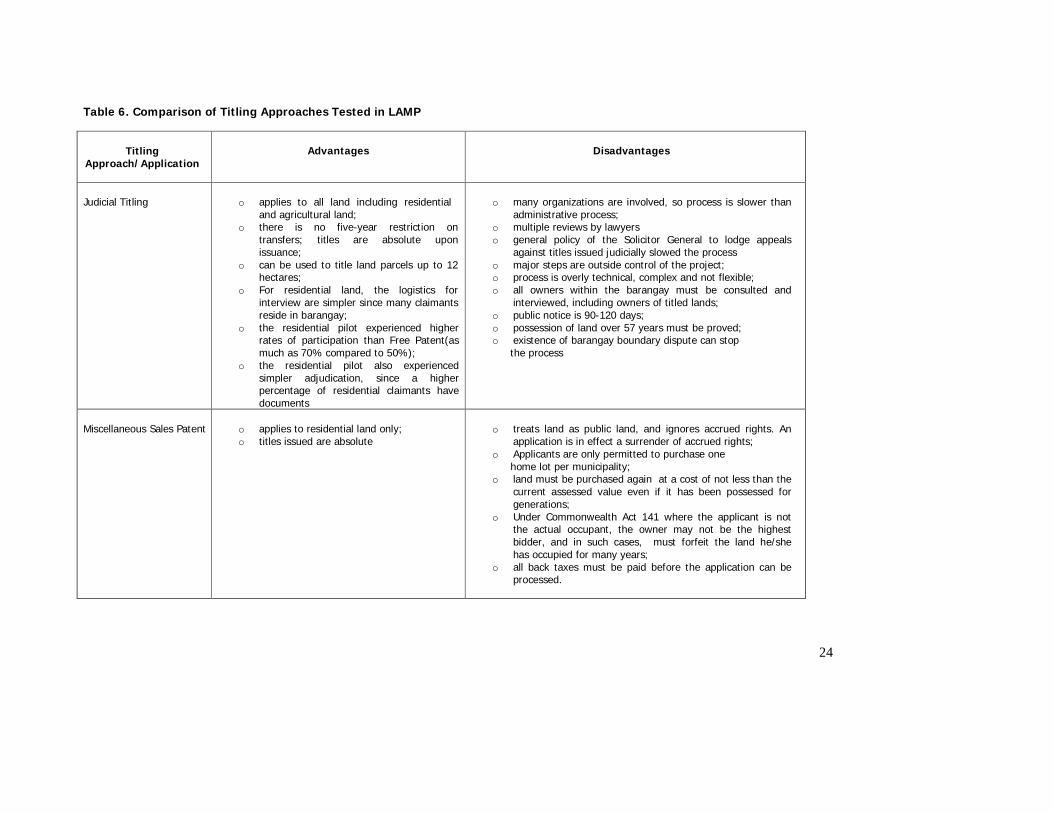
24
Table 6. Comparison of Titling Approaches Tested in LAMP
Titling Approach/Application
Advantages Disadvantages
Judicial Titling
o applies to all land including residential
and agricultural land; o there is no five-year restriction on
transfers; titles are absolute upon issuance;
o can be used to title land parcels up to 12 hectares;
o For residential land, the logistics for interview are simpler since many claimants reside in barangay;
o the residential pilot experienced higher rates of participation than Free Patent(as much as 70% compared to 50%);
o the residential pilot also experienced simpler adjudication, since a higher percentage of residential claimants have documents
o many organizations are involved, so process is slower than
administrative process; o multiple reviews by lawyers o general policy of the Solicitor General to lodge appeals
against titles issued judicially slowed the process o major steps are outside control of the project; o process is overly technical, complex and not flexible; o all owners within the barangay must be consulted and
interviewed, including owners of titled lands; o public notice is 90-120 days; o possession of land over 57 years must be proved; o existence of barangay boundary dispute can stop
the process
Miscellaneous Sales Patent
o applies to residential land only; o titles issued are absolute
o treats land as public land, and ignores accrued rights. An
application is in effect a surrender of accrued rights; o Applicants are only permitted to purchase one
home lot per municipality; o land must be purchased again at a cost of not less than the
current assessed value even if it has been possessed for generations;
o Under Commonwealth Act 141 where the applicant is not the actual occupant, the owner may not be the highest bidder, and in such cases, must forfeit the land he/she has occupied for many years;
o all back taxes must be paid before the application can be processed.
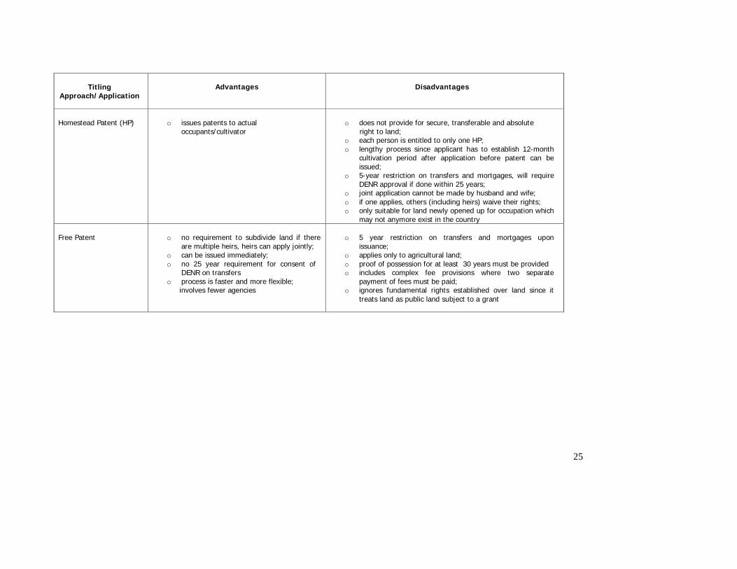
25
Titling Approach/Application
Advantages Disadvantages
Homestead Patent (HP)
o issues patents to actual
occupants/cultivator
o does not provide for secure, transferable and absolute
right to land; o each person is entitled to only one HP; o lengthy process since applicant has to establish 12-month
cultivation period after application before patent can be issued;
o 5-year restriction on transfers and mortgages, will require DENR approval if done within 25 years;
o joint application cannot be made by husband and wife; o if one applies, others (including heirs) waive their rights; o only suitable for land newly opened up for occupation which
may not anymore exist in the country Free Patent
o no requirement to subdivide land if there
are multiple heirs, heirs can apply jointly; o can be issued immediately; o no 25 year requirement for consent of
DENR on transfers o process is faster and more flexible;
involves fewer agencies
o 5 year restriction on transfers and mortgages upon
issuance; o applies only to agricultural land; o proof of possession for at least 30 years must be provided o includes complex fee provisions where two separate
payment of fees must be paid; o ignores fundamental rights established over land since it
treats land as public land subject to a grant

27
2.2.2 Efficiency and Effectiveness of Systematic Titling Procedures The Project tested the systematic approach to titling to demonstrate the effectiveness and efficiency of the mass based approach to titling compared to the current sporadic method. This was the principle behind the testing of all the approaches cited above. In 2004, this was further tested in the municipal wide pilots using the Free Patent following the initial test in Barangay Lukay, San Miguel in March, 2003. This involved integration of all field processes, affording a more streamlined approach to titling. Overall, the systematic titling procedures proved to be superior to the sporadic titling program currently undertaken for a number of reasons: (i) it brought the services closer to the community through the base camps; (ii) the CRS promoted increased mobilization of claimants for titling, thus enabling a more participatory, organized and informed approach to registration; (iii) it reduced potential for disputes; (iv) it reduced the time and cost to clients to issue titles, (v) it provided for a more transparent process involving members of the community; and (vi) it promoted gender equality. While the process was trialed using the free patent methodology, the procedure can generally be used for all titling options. Base Camp Operations The systematic adjudication process provides for titling services at the base camps, located in the municipality where titling activities are on going. Field staff involved in education, mobilization and community organizing (CO), adjudication, and surveys are located in the base camps where applicants can have their titles processed. The LAMP pilots had successfully decentralized all field operations to the base camps, so that processing of titles all take place in these field offices. These camps provide a one-stop shop service for all applicants and other parties where they can follow up all their applications for titling, essentially reducing the cost on the part of the claimant instead of visiting some centrally located offices in the region. The operations of the base camps made the titling services more accessible to the community, as the mobile teams move from one barangay to the next in conducting adjudication work. Participatory, Organized and Informed Approach to Registration The CRS Strategies and CO approaches trialed by the project involved massive mobilization of claimants through barangay assemblies, community meetings, and house-to-house visits to provide information to beneficiaries and other stakeholders in the community of the titling activities. Other local leaders as well as the LGUs were also organized to take part in the titling activity by providing support to the process. Compared to the sporadic process wherein applications start upon the initiative of the applicant, the systematic titling process generates as many applications as possible for all untitled parcels in the barangay through extensive community and LGU mobilization strategies. Reduced Potential for Disputes There are at least three ways by which disputes are minimized in systematic titling. First, the survey verification and validation process enabled the detection and correction of any errors found in the past cadastral surveys. In a study conducted in the LAMP areas, this was identified as one of the leading causes of disputes.4 Second, the participatory process introduced through the use of Survey Notification Sheets (SNS) wherein adjacent owners, witnessed by other members of the community, sign on the sketch of the parcel during the conduct of survey enabled the resolution of any potential boundary conflict that may arise – identified as the leading cause of disputes in the LAMP areas. The SNS is expected to substantially reduce, if not totally eliminate this kind of dispute before titles are issued in unsurveyed areas. Third, the work of the OSS in consolidating and validating land records in support of titling were all meant to result in titles that are based on updated and validated records from different agencies, thus minimizing the potential to issue double, overlapping or spurious titles.
4 Ariaso, D. 2004. A Review on the Existing Mechanisms and Structures in the Resolution of Land Related Disputes in Rural Areas. PA-LAMP Research Grants.
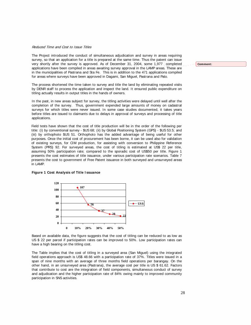
28
Reduced Time and Cost to Issue Titles The Project introduced the conduct of simultaneous adjudication and survey in areas requiring survey, so that an application for a title is prepared at the same time. Thus the patent can issue very shortly after the survey is approved. As of December 31, 2004, some 1,977 completed applications have been compiled in areas awaiting survey approval in the LAMP areas. These are in the municipalities of Pastrana and Sta Fe. This is in addition to the 471 applications compiled for areas where surveys have been approved in Dagami, San Miguel, Pastrana and Palo.
The process shortened the time taken to survey and title the land by eliminating repeated visits by DENR staff to process the application and inspect the land. It ensured public expenditure on titling actually results in output titles in the hands of owners.
In the past, in new areas subject for survey, the titling activities were delayed until well after the completion of the survey. Thus, government expended large amounts of money on cadastral surveys for which titles were never issued. In some case studies documented, it takes years before titles are issued to claimants due to delays in approval of surveys and processing of title applications.
Field tests have shown that the cost of title production will be in the order of the following per title: (i) by conventional survey - $US 68; (ii) by Global Positioning System (GPS) - $US 53.5; and (iii) by orthophoto $US 51. Orthophoto has the added advantage of being useful for other purposes. Once the initial cost of procurement has been borne, it can be used also for validation of existing surveys, for CIM production, for assisting with conversion to Philippine Reference System (PRS) 92. For surveyed areas, the cost of titling is estimated at US$ 22 per title, assuming 50% participation rate; compared to the sporadic cost of US$50 per title. Figure 1 presents the cost estimates of title issuance, under various participation rate scenarios. Table 7 presents the cost to government of Free Patent issuance in both surveyed and unsurveyed areas in LAMP. Figure 1 Cost Analysis of Title Issuance Based on available data, the figure suggests that the cost of titling can be reduced to as low as US $ 22 per parcel if participation rates can be improved to 50%. Low participation rates can have a high bearing on the titling cost. The Table implies that the cost of titling in a surveyed area (San Miguel) using the integrated field operations approach is US$ 48.66 with a participation rate of 37%. Titles were issued in a span of nine months with an average of three months field operations per barangay. On the other hand, in an unsurveyed area (Pastrana), the average cost per title is US $ 61.62. Factors that contribute to cost are the integration of field components, simultaneous conduct of survey and adjudication and the higher participation rate of 84% owing mainly to improved community participation in SNS activities.
107
56
3728 22
0
20
40
60
80
100
120
0 10% 20% 30% 40% 50%
US$
Comment:
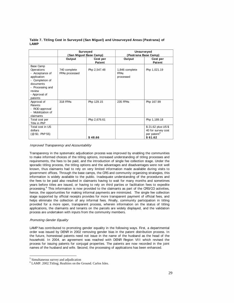
29
Table 7. Titling Cost in Surveyed (San Miguel) and Unsurveyed Areas (Pastrana) of LAMP
Surveyed (San Miguel Base Camp)
Unsurveyed (Pastrana Base Camp)
Output Cost per Patent
Output Cost per Patent
Base Camp Operations - Acceptance of application - Completion of documents - Processing and review - Approval of patents
740 complete FPAs processed
Php 2,547.48
1,846 complete FPAs processed
Php 1,021.19
Approval of Patents - ROD approval - Mobilization of claimants
318 FPAs Php 129.15 235 FPAs Php 167.99
Total cost per Title in PhP
Php 2,676.61 Php 1,189.18
Total cost in US dollars (@ $1: PhP 55)
$ 48.66
$ 21.62 plus US $ 40 for survey cost per patent5 $ 61.62
Improved Transparency and Accountability Transparency in the systematic adjudication process was improved by enabling the communities to make informed choices of the titling options, increased understanding of titling processes and requirements, the fees to be paid, and the introduction of single fee collection stage. Under the sporadic titling process, the titling options and the advantages and disadvantages were not well known, thus claimants had to rely on very limited information made available during visits to government offices. Through the base camps, the CRS and community organizing strategies, this information is widely available to the public. Inadequate understanding of the procedures and the fees to be paid also resulted in claimants having to wait for many months and sometimes years before titles are issued, or having to rely on third parties or facilitation fees to expedite processing.6 This information is now provided to the claimants as part of the CRS/CO activities, hence, the opportunities for making informal payments are minimized. The single fee collection stage supported by official receipts provides for more transparent payment of official fees, and helps eliminate the collection of any informal fees. Finally, community participation in titling provided for a more open, transparent process, wherein information on the status of titling applications, the claimants and tenants on the parcels are widely displayed, and the validation process are undertaken with inputs from the community members. Promoting Gender Equality LAMP has contributed to promoting gender equality in the following ways. First, a departmental order was issued by DENR in 2002 removing gender bias in the patent distribution process. In the future, homestead patents need not issue in the name of the husband as the head of the household. In 2004, an agreement was reached with DENR Region VIII which revised the process for issuing patents for conjugal properties. The patents are now recorded in the joint names of the husband and wife. Second, the processing of applications has been enhanced.
5 Simultaneous survey and adjudication 6 LAMP. 2002.Titling; Realities on the Ground. Carlos Isles.
30
Before, the DENR requires an application by a married woman to be corroborated by the husband but not vice versa. This has been clarified. If the application is for conjugal property then corroboration is not required. If however the claim is for individual ownership then the adjudicator needs to be satisfied that the claim is accurate regardless of the gender of the claimant. Streamlining Free Patent Procedures In addition to the above innovations in the systematic registration processes, the municipal-wide pilots in 2004 enabled the Project to introduce administrative streamlining to the Free Patent processes. These tests resulted in the following: (i) reduced time to issue titles; (ii) clarification of all ambiguities, particularly in the documentation required to support an application, resulting in reduced documentation requirements; (iii) reduced cost to clients; (iv) clearer, transparent procedures; (v) streamlined decentralized processes and simplified requirements. Reduced Time to Issue Titles The 2004 pilots proved that titles can be issued in 12-16 weeks compared to an average of 39 months under the sporadic Free Patent process.7 Table 8 provides details of the comparison between the sporadic and systematic titling procedures, and the results of the Free Patent Baseline Study.
Table 8: Comparative Analysis of the sporadic registration to systematic land titling
Title Registration Process
Average Processing Time Average Processing Cost
Sporadic Registration 39 months US$ 50.60 (Php 2,782.50)
Systematic Registration Surveyed area
12 to 16 weeks (3 to 4 months) US$ 30 (37% participation rate)
Unsurveyed area 16 months for survey approval 6 weeks patent processing to registration and distribution total= 17.5 months
US$ 65 (US$40 for survey activities, US$ 25 for patent processing, assuming 45%-47% participation rate)
Clarification of ambiguities in registration The experience of the prototypes, supported by extensive research in the LAMP communities and the provisions of existing laws, have facilitated the identification of issues and through negotiations with appropriate authorities, clarified the following ambiguities in the titling process: One, the issue of whether back taxes need to be paid before the ROD issues titles has been clarified through by LRA in March 2004. Since then, all patent applications whose tax certificates are not in the name of the patentee can be issued titles. Second, the ROD has clarified in August 2004, that it can register titles in the name of applicants whose properties exceed five hectares. Third, through a study conducted in June 2004, recommendations were made to clarify the issuance of titles to tenanted properties, and to seek DAR support in the registration of leaseholds in affected areas.8 Fourth, another study led to recommendations to annotate on the title, all mortgages incurred before the issuance of the titles.9
7 LAMP, 2003. Free Patent Baseline Study. 8 LAMP, 2004. Review of Laws, Policies and Institutional Set up on Tenancy in the Philippines.
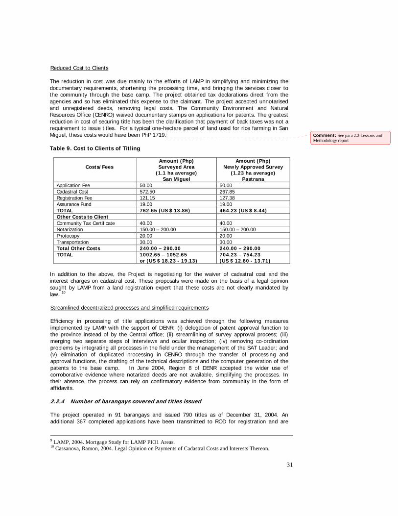
31
Reduced Cost to Clients The reduction in cost was due mainly to the efforts of LAMP in simplifying and minimizing the documentary requirements, shortening the processing time, and bringing the services closer to the community through the base camp. The project obtained tax declarations direct from the agencies and so has eliminated this expense to the claimant. The project accepted unnotarised and unregistered deeds, removing legal costs. The Community Environment and Natural Resources Office (CENRO) waived documentary stamps on applications for patents. The greatest reduction in cost of securing title has been the clarification that payment of back taxes was not a requirement to issue titles. For a typical one-hectare parcel of land used for rice farming in San Miguel, these costs would have been PhP 1719. Table 9. Cost to Clients of Titling
Costs/Fees
Amount (Php) Surveyed Area
(1.1 ha average) San Miguel
Amount (Php) Newly Approved Survey
(1.23 ha average) Pastrana
Application Fee 50.00 50.00 Cadastral Cost 572.50 267.85 Registration Fee 121.15 127.38 Assurance Fund 19.00 19.00 TOTAL 762.65 (US $ 13.86) 464.23 (US $ 8.44) Other Costs to Client Community Tax Certificate 40.00 40.00 Notarization 150.00 – 200.00 150.00 – 200.00 Photocopy 20.00 20.00 Transportation 30.00 30.00 Total Other Costs 240.00 – 290.00 240.00 – 290.00 TOTAL 1002.65 – 1052.65
or (US $ 18.23 - 19.13) 704.23 – 754.23 (US $ 12.80 - 13.71)
In addition to the above, the Project is negotiating for the waiver of cadastral cost and the interest charges on cadastral cost. These proposals were made on the basis of a legal opinion sought by LAMP from a land registration expert that these costs are not clearly mandated by law. 10 Streamlined decentralized processes and simplified requirements Efficiency in processing of title applications was achieved through the following measures implemented by LAMP with the support of DENR: (i) delegation of patent approval function to the province instead of by the Central office; (ii) streamlining of survey approval process; (iii) merging two separate steps of interviews and ocular inspection; (iv) removing co-ordination problems by integrating all processes in the field under the management of the SAT Leader; and (v) elimination of duplicated processing in CENRO through the transfer of processing and approval functions, the drafting of the technical descriptions and the computer generation of the patents to the base camp. In June 2004, Region 8 of DENR accepted the wider use of corroborative evidence where notarized deeds are not available, simplifying the processes. In their absence, the process can rely on confirmatory evidence from community in the form of affidavits. 2.2.4 Number of barangays covered and titles issued
The project operated in 91 barangays and issued 790 titles as of December 31, 2004. An additional 367 completed applications have been transmitted to ROD for registration and are
9 LAMP, 2004. Mortgage Study for LAMP PIO1 Areas. 10 Cassanova, Ramon, 2004. Legal Opinion on Payments of Cadastral Costs and Interests Thereon.
Comment: See para 2.2 Lessons and Methodology report
32
awaiting payment of the registration fees by the claimants. These titles were generated using the FP process. The judicial titling applications did not result in the issuance of a single title. An order for the issue of 33 titles was made by the Dagami Municipal Trial Court in May 2004 but these are currently the subject of an appeal by the Solicitor General. Moreover, in other barangays, where homestead and miscellaneous sales patents were introduced, not a single complete application was generated due to lack of interest in these patents on the part of the eligible applicants.11 The project covered 80 barangays under the Free Patent process, out of which 31 have been surveyed, and therefore ready for titling. The remaining 49 barangays need to have the survey plans approved before titles can be issued. Of the 790 titles issued by end of December 2004, 192 were issued in barangays surveyed during LAMP 1 while 598 were issued in areas surveyed prior to LAMP. It is anticipated that an additional 594 titles will eventually be issued for land in San Miguel surveyed before LAMP as soon as the applications are fully processed at the CENRO, Provincial Environment and Natural Resources Office (PENRO), and ROD. In total, some 4,199 titles are expected to be issued by LAMP as soon as all applications in the pipeline are registered.
11 In the 2001 pilots in Libertad and Macalpi-ay, MSC were offered but no application was received. Again, in San Miguel in 2004,MSC were offered for residential lands, but nobody came forward with an application.
Comment: In the 2001 pilots in Libertad and Macalpi-ay, MSC were offered but no applications. Again in San Miguel in 2004, MSC were offered for residential land but no applications
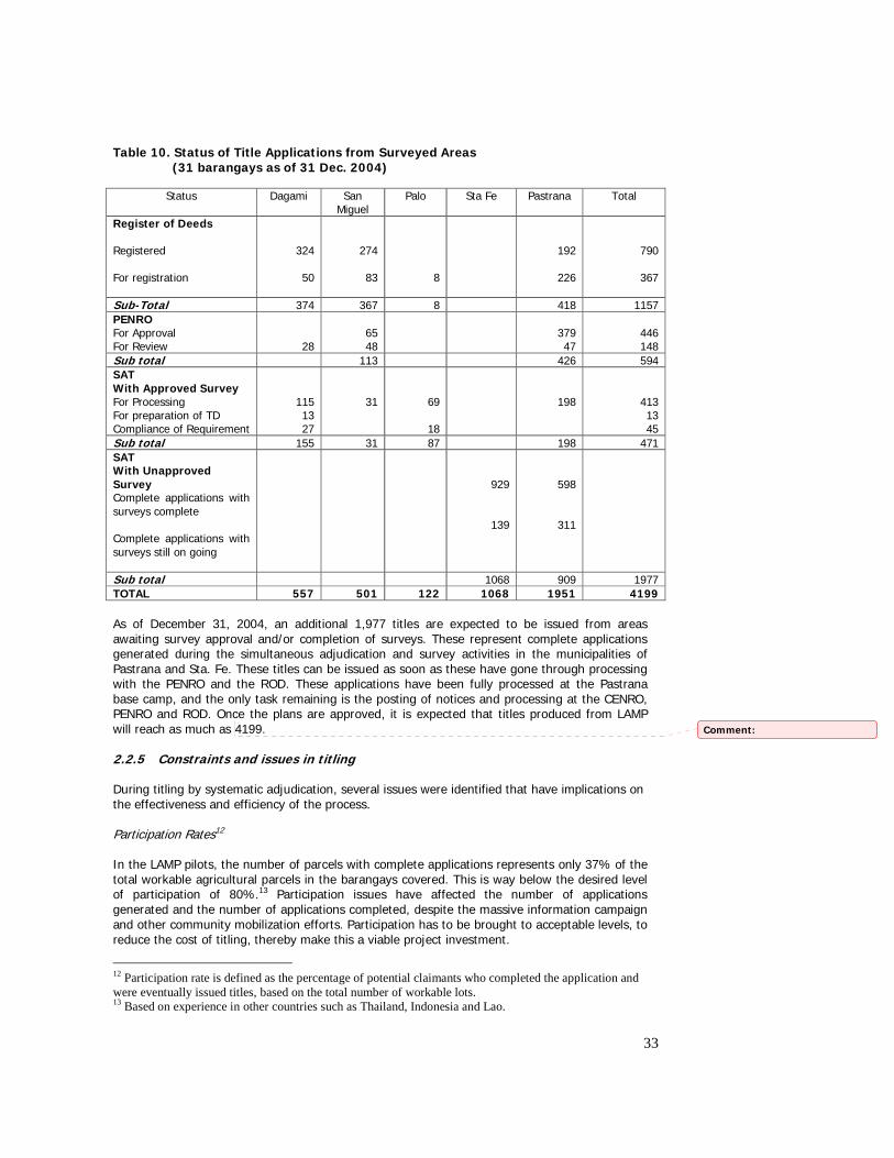
33
Table 10. Status of Title Applications from Surveyed Areas (31 barangays as of 31 Dec. 2004)
Status Dagami San
Miguel Palo Sta Fe
Pastrana Total
Register of Deeds Registered For registration
324
50
274
83
8
192
226
790
367
Sub-Total 374 367 8 418 1157 PENRO For Approval For Review
28
65 48
379 47
446 148
Sub total 113 426 594 SAT With Approved Survey For Processing For preparation of TD Compliance of Requirement
115 13 27
31
69
18
198
413 13 45
Sub total 155 31 87 198 471 SAT With Unapproved Survey Complete applications with surveys complete Complete applications with surveys still on going
929
139
598
311
Sub total 1068 909 1977 TOTAL 557 501 122 1068 1951 4199 As of December 31, 2004, an additional 1,977 titles are expected to be issued from areas awaiting survey approval and/or completion of surveys. These represent complete applications generated during the simultaneous adjudication and survey activities in the municipalities of Pastrana and Sta. Fe. These titles can be issued as soon as these have gone through processing with the PENRO and the ROD. These applications have been fully processed at the Pastrana base camp, and the only task remaining is the posting of notices and processing at the CENRO, PENRO and ROD. Once the plans are approved, it is expected that titles produced from LAMP will reach as much as 4199. 2.2.5 Constraints and issues in titling During titling by systematic adjudication, several issues were identified that have implications on the effectiveness and efficiency of the process. Participation Rates12 In the LAMP pilots, the number of parcels with complete applications represents only 37% of the total workable agricultural parcels in the barangays covered. This is way below the desired level of participation of 80%.13 Participation issues have affected the number of applications generated and the number of applications completed, despite the massive information campaign and other community mobilization efforts. Participation has to be brought to acceptable levels, to reduce the cost of titling, thereby make this a viable project investment.
12 Participation rate is defined as the percentage of potential claimants who completed the application and were eventually issued titles, based on the total number of workable lots. 13 Based on experience in other countries such as Thailand, Indonesia and Lao.
Comment:
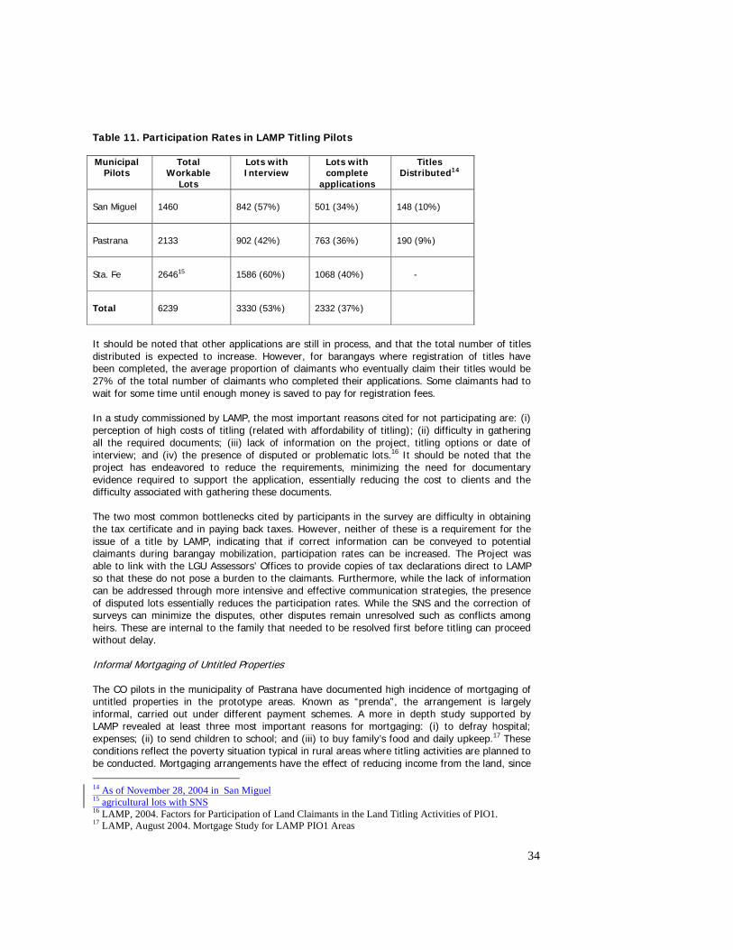
34
Table 11. Participation Rates in LAMP Titling Pilots Municipal
Pilots Total
Workable Lots
Lots with Interview
Lots with complete
applications
Titles Distributed14
San Miguel
1460
842 (57%)
501 (34%)
148 (10%)
Pastrana
2133
902 (42%)
763 (36%)
190 (9%)
Sta. Fe
264615
1586 (60%)
1068 (40%)
-
Total
6239
3330 (53%)
2332 (37%)
It should be noted that other applications are still in process, and that the total number of titles distributed is expected to increase. However, for barangays where registration of titles have been completed, the average proportion of claimants who eventually claim their titles would be 27% of the total number of claimants who completed their applications. Some claimants had to wait for some time until enough money is saved to pay for registration fees. In a study commissioned by LAMP, the most important reasons cited for not participating are: (i) perception of high costs of titling (related with affordability of titling); (ii) difficulty in gathering all the required documents; (iii) lack of information on the project, titling options or date of interview; and (iv) the presence of disputed or problematic lots.16 It should be noted that the project has endeavored to reduce the requirements, minimizing the need for documentary evidence required to support the application, essentially reducing the cost to clients and the difficulty associated with gathering these documents. The two most common bottlenecks cited by participants in the survey are difficulty in obtaining the tax certificate and in paying back taxes. However, neither of these is a requirement for the issue of a title by LAMP, indicating that if correct information can be conveyed to potential claimants during barangay mobilization, participation rates can be increased. The Project was able to link with the LGU Assessors’ Offices to provide copies of tax declarations direct to LAMP so that these do not pose a burden to the claimants. Furthermore, while the lack of information can be addressed through more intensive and effective communication strategies, the presence of disputed lots essentially reduces the participation rates. While the SNS and the correction of surveys can minimize the disputes, other disputes remain unresolved such as conflicts among heirs. These are internal to the family that needed to be resolved first before titling can proceed without delay. Informal Mortgaging of Untitled Properties The CO pilots in the municipality of Pastrana have documented high incidence of mortgaging of untitled properties in the prototype areas. Known as “prenda”, the arrangement is largely informal, carried out under different payment schemes. A more in depth study supported by LAMP revealed at least three most important reasons for mortgaging: (i) to defray hospital; expenses; (ii) to send children to school; and (iii) to buy family’s food and daily upkeep.17 These conditions reflect the poverty situation typical in rural areas where titling activities are planned to be conducted. Mortgaging arrangements have the effect of reducing income from the land, since 14 As of November 28, 2004 in San Miguel 15 agricultural lots with SNS 16 LAMP, 2004. Factors for Participation of Land Claimants in the Land Titling Activities of PIO1. 17 LAMP, August 2004. Mortgage Study for LAMP PIO1 Areas
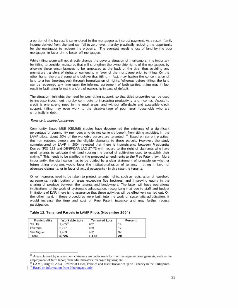
35
a portion of the harvest is surrendered to the mortgagee as interest payment. As a result, family income derived from the land can fall to zero level, thereby practically reducing the opportunity for the mortgagor to redeem the property. The eventual result is loss of land by the poor mortgagor, in favor of the better off-mortgagee. While titling alone will not directly change the poverty situation of mortgagors, it is important for titling to consider measures that will strengthen the ownership rights of the mortgagors by allowing these encumbrances to be annotated at the back of the title, thus avoiding any premature transfers of rights or ownership in favor of the mortgagee prior to titling. On the other hand, there are some who believe that titling in fact, may hasten the concentration of land to a few (mortgagees) through formalization of rights. Whereas before titling, the land can be redeemed any time upon the informal agreement of both parties, titling may in fact result in facilitating formal transfers of ownership in case of default. The situation highlights the need for post-titling support, so that titled properties can be used to increase investment thereby contribute to increasing productivity and incomes. Access to credit is one strong need in the rural areas, and without affordable and accessible credit support, titling may even work to the disadvantage of poor rural households who are chronically in debt. Tenancy in untitled properties Community Based M&E (CBM&E) studies have documented the existence of a significant percentage of community members who do not currently benefit from titling activities. In the LAMP pilots, about 20% of the workable parcels are tenanted. 18 Based on current practice, the non resident owners are the eligible claimants to these parcels. However, the study commissioned by LAMP in 2004 revealed that there is inconsistency between Presidential Decree (PD) 152 and DENR/DAR LAO 27-73 with regard to the right of claimants who have used tenants to cultivate their land (during the period of cultivation used to establish their claim).19 This needs to be clarified in the proposed amendments to the Free Patent law. More importantly, the clarification has to be guided by a clear statement of principle on whether future titling programs would favor the institutionalization of tenancy – titling in favor of absentee claimants; or in favor of actual occupants - in this case the tenants. Other measures need to be taken to protect tenants’ rights, such as registration of leasehold agreements; redistribution of areas exceeding five hectares, and improving equity in the sharing of produce between the tenants and landowners. The latter will have operational implications to the work of systematic adjudication, recognizing that due to staff and budget limitations of DAR, there is no assurance that these activities will be effectively carried out. On the other hand, if these procedures were built into the work of systematic adjudication, it would increase the time and cost of Free Patent issuance and may further reduce participation. Table 12. Tenanted Parcels in LAMP Pilots (November 2004)
Municipality Workable Lots Tenanted Lots Percent Sta. Fe 1,46520 207 14 Pastrana 2,777 469 17 San Miguel 1,463 462 32 Total 5,725 1,138 20
18 Areas claimed by non resident claimants are under some form of management arrangements, such as the employment of farm labor; farm administrators; managed by kins; etc. 19 LAMP, August, 2004. Review of Laws, Policies and Institutional Set up on Tenancy in the Philippines 20 Based on information from 9 barangays only
36
2.2.6 Policy proposals identified – proposed legal framework for mass titling in LAMP2 The experience from the tests enabled the Project to consolidate all issues requiring policy action so that a suitable legal framework for mass titling in the next phase can be developed. In general terms, the recommendation is a legislative structure that combines all the identified strengths of judicial titling and free patent titling – one form of titling applying to all land types, issued without restrictions on the transfer and mortgage of the title, without confusion as to procedures where the parcel exceeds 5 hectares and without depending on legal constructions such as constructive occupation. The specific changes suggested are the following: • Permit one form of certificate of title, replacing the various forms of title and patent now in
use; • Eliminate issuance of Transfer Certificates of Titles and simply endorse transactions in the
OCT; • Permit the use of alternative, cost effective technology in the preparation and drafting of
titles; • Amend the survey regulations to allow greater flexibility in parcel definition, such as the
use of orthophotos in defining parcels in agricultural areas, and the use of GPS in appropriate locations;
• Amend the provisions relating to the imposition of interest on cadastral costs so that claimants do not pay interest for the period preceding the issue of the patent. The preferred approach is to eliminate the cadastral fee and simply to have one single flat fee for the issue of a patent;
• Short-term amendments to the free patent provisions to: (i) eliminate the five-year restriction on transfers and mortgages; (ii) apply free patents to residential, industrial and commercial land; (iii) permit the patent to contain a graphic technical description rather than the prose technical description; (iv) permitting the original title to be used to record subsequent transactions with the land; (v) change the period of proof from 30 years to 10 years; (vi) remove the requirement for occupation and cultivation and replace it with the concept of possession; (vii) preserve encumbrances such as mortgages or leases entered into before the patent is issued; (viii) give the Secretary of DENR rather than the President the power to delegate the signing of patents; (ix) remove the 20-year limitation on the life of the free patent law; (x) remove any confusion as to the right of DENR to issue patents where the occupation commenced before 12 June 1945; (xi) remove the right of repurchase where the patentee sells the land; (xii) permit provisional patents to issue where the claimant has only 5 years’ possession, with the title maturing into a full title five years after the issue of the patent; and (xiii) permit the government at all levels by its public corporations and instrumentalities to apply for free patents for land that has been used for government purposes for 10 years before the law becomes operational;
• Longer-term amendments to establish one administrative titling method for all land and to replace multiple patent types with the concept of a grant of land to the qualified applicant, with the grant issuing to a person who can establish ownership over 10 years, community support for the claim and the absence of disputes or competing claims;
• Introduce an implementing regulation/ administrative order for systematic adjudication, setting out processes and evidence to be provided. This should strengthen the initiatives to integrate all operations in the field at the base camp and will also reflect major agreements reached in LAMP to confirm the acceptability of affidavits supporting the claim where notarized deeds can’t be furnished. It will recognize the delegation of Inspector powers to adjudicators and should delegate to SAT Leaders the right to sign patents;
• Revise laws and regulations to ensure patents for land parcels and aggregates up to 12 hectares can be issued and registered. DAR should be consulted as per procedures in LAMP 1;
• Clarify the provisions of PD 152 and DENR/DAR LAO 2773 with regard to the rights of claimants who have used tenants to cultivate their land and establish their claim; and
37
• Permit mortgages entered into by claimants before the issuance of patent to be encumbered on the title.
Most of the proposals having to do with the Free Patent law have been incorporated in the proposed amendment to the law. A draft Bill is ready for consultation with stakeholders and for consideration of legislators. 2.3 Land Records and Information Management The Project introduced procedures that would improve integrity of records through identification of spurious, double or overlapping titles/plans, and set up systems to avoid the issuance of such records in the future. These procedures were tested both in Quezon City and Leyte. In Quezon City there were many fake, spurious and overlapping titles, conflicting information in the records of the land related agencies and confused situation with the status of land and how to obtain secure title. In Leyte on the other hand, these procedures were developed mainly to improve the integrity of titling activities by ensuring that double or overlapping titles are not issued over the same parcel. These procedures were designed to address the fundamental weaknesses in the land administration system – largely a result of the absence of (i) a complete and up to date picture of all existing land parcels; (ii) a mechanism for the ready exchange of land information between land related agencies; and (iii) a single point of contact for the public to transact on land titles. 2.3.1 Procedures Developed A number of procedures were developed by the Project to improve the integrity of land records: Development of Cadastral Index Maps The CIM is a tool that was introduced by the Project to provide a spatial reference for all title records. Without it, it would be extremely difficult to ensure that a new title does not overlap or duplicate a title already issued over the same land area either by the same agency, or other agencies responsible for processing or issuing tenure instrument, such as the DAR, DENR, and LRA through the Courts. The CIM process involves consolidating the records of all agencies and the development of maps using a single map-projection system. The CIM were supported by a database that was designed to contain comprehensive information on all parcels, such as owners, location, titles issued, status of applications, and other interests on the property.
Three different methods of CIM production were tested: (i) hand drawn; (ii) use of information technology (IT); and (iii) use of orthophoto maps. Evaluation of these methods showed that automated mapping is more efficient, although this would require the use of equipment, and the employment of skilled staff. In the rural areas, this could be supported by the use of orthophoto maps in determining the accuracy of the digitized CIM, in updating the major features on the map and in showing a more realistic picture of the parcel itself.21 With this, access to land information will be facilitated and data sharing and integration to different offices will also be maximized.
A total of 497 CIMs were produced, covering 73,291 parcels in both prototypes. In PIO1, only four municipalities were covered since the surveys for the municipalities of Pastrana and Sta Fe have not been completed. For Quezon City, all the five barangays have been covered with CIM.
21 In urban areas, Advisers have recommended the use of aerial photography instead of orthophotos. These are cheaper and provide a suitable substitute in creating the CIMs.
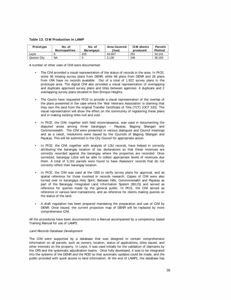
38
Table 13. CIM Production in LAMP
Prototype No. of Municipalities
No. of Barangays
Area Covered (has)
CIM sheets produced
Parcels Plotted
Leyte 6 225 44,667 251 34,141 Quezon City NA 5 2,130 246 39,150
A number of other uses of CIM were documented:
• The CIM provided a visual representation of the status of records in the area. In PIO2, some 36 missing survey plans from DENR, while 68 plans from DENR and 26 plans from LRA have no records available. Out of a total of 1,922 survey plans in the prototype area. The digital CIM also provided a visual representation of overlapping and duplicate approved survey plans and titles between agencies: 4 duplicate and 2 overlapping survey plans situated in Don Enrique Heights.
• The Courts have requested PIO2 to provide a visual representation of the overlap of the plans presented in the case where the ‘War Veterans Association’ is claiming that they own the land from the original Transfer Certificate of Title (TCT) (OCT 333). The visual representation will show the effect on the community of registering these plans and in making existing titles null and void.
• In PIO2, the CIM, together with field reconnaissance, was used in documenting the disputed areas among three barangays – Payatas, Bagong Silangan and Commonwealth. The CIM were presented in various dialogues and Council meetings and as a result, resolutions were issued by the Councils of Bagong Silangan and Payatas. This will be submitted to the City Council for appropriate action.
• In PIO2, the CIM, together with analysis of LGU records, have helped in correctly attributing the barangay location of tax declarations so that these revenues are correctly recorded against the barangay where the properties are recorded. Once corrected, barangay LGUs will be able to collect appropriate levels of revenues due them. A total of 3,161 parcels were found to have Assessors’ records that do not correctly reflect their barangay location.
• In PIO2, the CIM was used at the OSS to verify survey plans for approval, and as spatial reference for those involved in records research. Copies of CIM were also turned over to barangays Holy Spirit, Batasan Hills, Commonwealth and Payatas as part of the Barangay Integrated Land Information System (BILIS) and served as reference for queries made by the general public. In PIO1, the CIM served as reference in various land transactions, and as reference for clients making queries on the status of the land.
• A draft regulation has been prepared mandating the preparation and use of CIM by
DENR. Once issued, the current projection map of DENR will be replaced by more comprehensive CIM.
All the procedures have been documented into a Manual accompanied by a competency based Training Manual for use of LAMP2. Land Records Database Development The CIM were supported by a database that was designed to contain comprehensive information on all parcels, such as owners, location, status of applications, titles issued, and other interests on the property. In Leyte, it was used initially for the validation of claimants by the CRS and the systematic adjudication teams. Once fully developed, it was to be integrated into the systems of the DENR and the ROD so that automatic updates could be made, and the public provided with quick access to land information. At the end of LAMP1, the database has
39
been lodged at the OSS and is used by the front desk when there are queries on status, ownership, and other vital land information. During its development, it has proven useful in terms of identifying inconsistencies in records which require further investigation and appropriate action. Examples of these are:
• Inconsistency in the records of agencies on the area and survey plan number for the same parcel;
• Title records in ROD without supporting lot and block numbers; • Titled lots in subdivisions without approved survey plans; and • Different title numbers in the same parcel.
Office Validation of Records Central to improving the confidence of the public in the registry is to ensure integrity in the records system. This can be achieved by integrating the fragmented land information among different agencies. An important procedure that was introduced mainly in Quezon City is the validation of records. This was designed to identify any inconsistencies in the title records between the Assessor’s Office, and the Registry of Deeds thereby detecting anomalies such as overlapping records, properties that have multiple tax payers, unauthorized reconstitution, and double titles. The validation process also enabled the prototype to gather additional records which otherwise do not exist either in the ROD or the Assessor’s Office thereby helping complete the missing records – an important feature of ensuring integrity especially relevant in the prototype area where the ROD records were destroyed through fire. Presently there is no single, uniform system by which the public can have direct access to reliable land parcel information such as title, owner, location of the property, and the status of the title. Similarly, there is no way for agencies such as the LGU Assessor’s Office, the ROD and DENR/LRA to compare their own records with those existing in other agencies and ensure there is consistency among these records. A sound land administration system should enable the sharing of this vital information, and make sure that there is consistency of survey and title information on every parcel. A good match would ensure that the Assessor’s Office should be able to comprehensively assess taxes for all land parcels based on updated and correct information on title owners. The office validation process was carried out through the development of the cross index. The cross index is able to provide information on the following:
• Ownership • Survey plan information • TCT • Duplicate titles • Location of properties • Tax information (property identification number (PIN), assessed value, tax declaration
number)
Without the cross index, information on property location is difficult to access even with the survey plan. This is now possible through cross reference to the CIM. Similarly, getting a copy of the TCT was difficult without a copy of the tax declaration. Ownership information on the other hand, was only available from the title. This information can now be generated if the lot and block number are available, or if the location of the property can be pinpointed on the CIM. The CIM and the database therefore created a link in all these information and allowed different means of accessing land information.
There were two stages of records validation performed under PIO2 –office validation and field validation. Office validation linked all records to the CIM. It verified that each title was supported by an approved subdivision plan, and that the survey records and title are linked with the appropriate tax declaration records at the LGU.
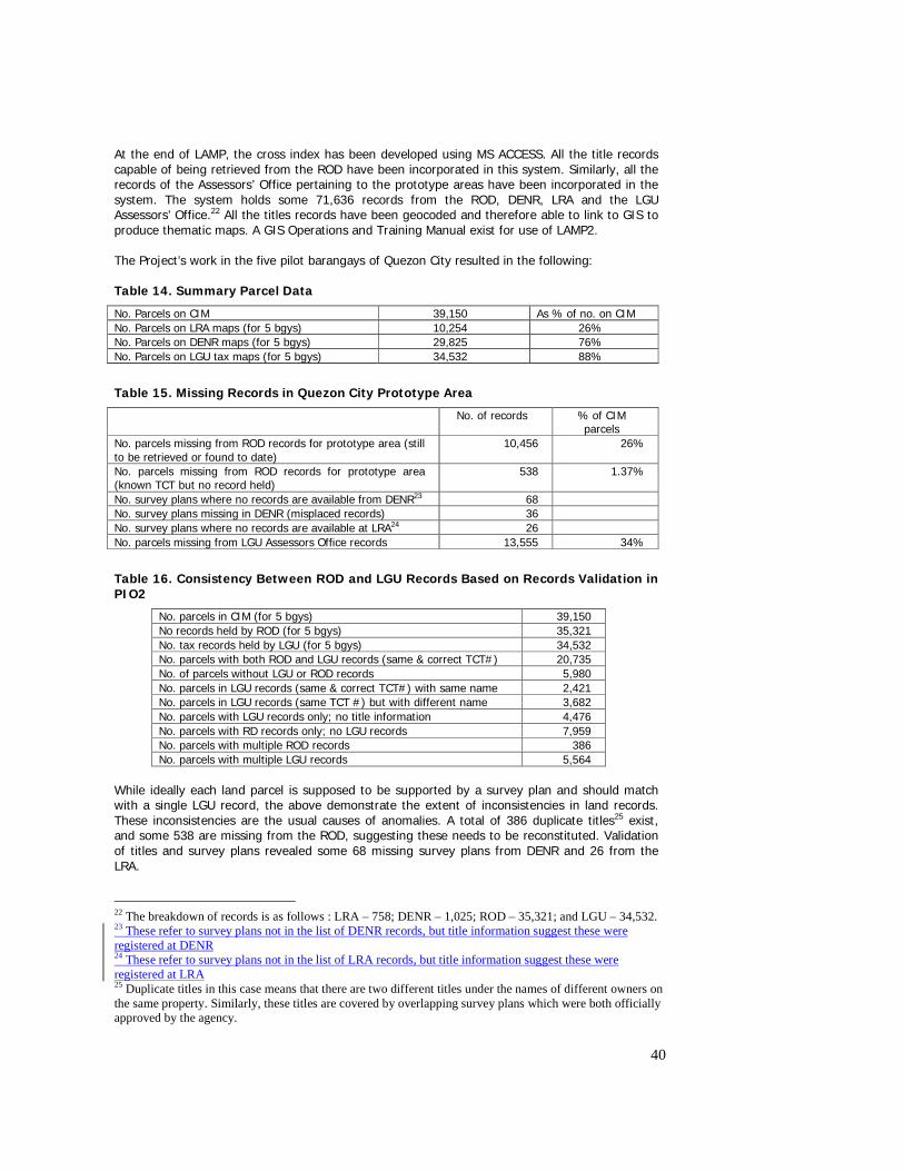
40
At the end of LAMP, the cross index has been developed using MS ACCESS. All the title records capable of being retrieved from the ROD have been incorporated in this system. Similarly, all the records of the Assessors’ Office pertaining to the prototype areas have been incorporated in the system. The system holds some 71,636 records from the ROD, DENR, LRA and the LGU Assessors’ Office.22 All the titles records have been geocoded and therefore able to link to GIS to produce thematic maps. A GIS Operations and Training Manual exist for use of LAMP2. The Project’s work in the five pilot barangays of Quezon City resulted in the following: Table 14. Summary Parcel Data
No. Parcels on CIM 39,150 As % of no. on CIM No. Parcels on LRA maps (for 5 bgys) 10,254 26% No. Parcels on DENR maps (for 5 bgys) 29,825 76% No. Parcels on LGU tax maps (for 5 bgys) 34,532 88%
Table 15. Missing Records in Quezon City Prototype Area
No. of records % of CIM parcels
No. parcels missing from ROD records for prototype area (still to be retrieved or found to date)
10,456
26%
No. parcels missing from ROD records for prototype area (known TCT but no record held)
538 1.37%
No. survey plans where no records are available from DENR23 68 No. survey plans missing in DENR (misplaced records) 36 No. survey plans where no records are available at LRA24 26 No. parcels missing from LGU Assessors Office records 13,555 34%
Table 16. Consistency Between ROD and LGU Records Based on Records Validation in PIO2
No. parcels in CIM (for 5 bgys) 39,150 No records held by ROD (for 5 bgys) 35,321 No. tax records held by LGU (for 5 bgys) 34,532 No. parcels with both ROD and LGU records (same & correct TCT#) 20,735 No. of parcels without LGU or ROD records 5,980 No. parcels in LGU records (same & correct TCT#) with same name 2,421 No. parcels in LGU records (same TCT #) but with different name 3,682 No. parcels with LGU records only; no title information 4,476 No. parcels with RD records only; no LGU records 7,959 No. parcels with multiple ROD records 386 No. parcels with multiple LGU records 5,564
While ideally each land parcel is supposed to be supported by a survey plan and should match with a single LGU record, the above demonstrate the extent of inconsistencies in land records. These inconsistencies are the usual causes of anomalies. A total of 386 duplicate titles25 exist, and some 538 are missing from the ROD, suggesting these needs to be reconstituted. Validation of titles and survey plans revealed some 68 missing survey plans from DENR and 26 from the LRA.
22 The breakdown of records is as follows : LRA – 758; DENR – 1,025; ROD – 35,321; and LGU – 34,532. 23 These refer to survey plans not in the list of DENR records, but title information suggest these were registered at DENR 24 These refer to survey plans not in the list of LRA records, but title information suggest these were registered at LRA 25 Duplicate titles in this case means that there are two different titles under the names of different owners on the same property. Similarly, these titles are covered by overlapping survey plans which were both officially approved by the agency.
41
Based on the total number of parcels, the LGU only has records of 88% of the parcels26. Of these, only 60% of the records match with those of the ROD. Between the ROD and LGU records, only about 52% of the total number of parcels have complete match. Of the records held at the ROD, some 789 parcels or 2% of total number of parcels (2.23% of ROD records) do not have corresponding records at the LGU. On the other hand, the Project only has 90% ROD records of the parcels, suggesting that the rest cannot be retrieved for lack of knowledge of their TCT numbers. Some 11% of the total number of parcels have records with the LGU but for which ROD has no record; while some 20% of parcels have records only with the ROD, and the LGU have no records of. There are 5,564 parcels with multiple LGU records often resulting from the Assessor’s holding tax records for all years. However, a small portion have been a result of allowing individuals to pay land tax on properties that they do not own (often a precursor of fake titling). Some 386 parcels have multiple ROD records. About 15% of the total number of parcels have no record either at the ROD nor at the LGU. These data suggest the following: (i) Unless the missing titles are reconstituted, transactions on these properties will be difficult. The owners have to be informed that they have to undergo the process of administrative reconstitution, if they have copies of their own titles. Otherwise, the owners have to go through judicial reconstitution, at their expense. While administrative reconstitution is free, it takes at least two months to complete, while judicial reconstitution would cost the owner about P 10,000 to P 40,000, taking at least 6 months to complete. (ii) Unless the missing survey plans are reconstructed or found, there will be delays in the review and approval of new survey plans over the same properties. Based on experience, delays like these can take up to 2 months. This would entail reconstruction of survey plans or tracing on old projection maps (iii) The extent of tax records on parcels not available with the LGU represents the extent of revenues lost by the LGUs. If there are no LGU records, then there are no tax payments made on these properties. Some 34.6% (13,555) of the parcels are affected in this case.27 (iv) Without title numbers, it would be impossible to retrieve copies of titles at the ROD. For people wishing to transact on these properties therefore, it would be difficult to do so. This represents some 26.7% of total number of parcels (10,456 parcels). These are those records at the ROD for which LGU do not have records of, including the number of parcels where neither the ROD nor the LGU has no records. Proper matching of records will enable the LGU to update their record, thereby improve their ability to raise revenues, and also enable the public to transact more easily on these properties. Field Validation (FV) of Records The second stage of records validation is field validation. The prototype introduced field validation as a strategy to: (i) expedite resolution of conflicting or out of date land information; (ii) assist in the location of records which are missing from the ROD; (iii) establish a more proactive approach to reconstitution of titles; and (iv) elicit community participation in records validation. The approach involved the preparation of a questionnaire to validate the records held by the prototype based on information available (or not available) on the parcel. The basis was the CIM, and/or the title records held by the PIO2. If the records were not available with the ROD, then specific instructions were made to inform the respondent of the need to have their titles reconstituted. The slow process of reconstitution and the lack of awareness on the part of
26 The Project cannot be certain that the LGU has all records in their database. Figures are based on what has been supplied as converted by the LGU. 27 This was derived by adding the number of parcels with LGU records and the parcels with multiple records and subtracting the sum from the total number of parcels.
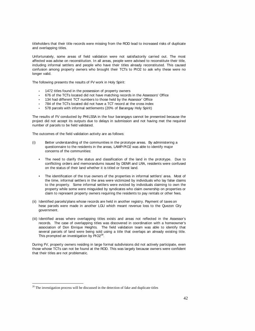
42
titleholders that their title records were missing from the ROD lead to increased risks of duplicate and overlapping titles. Unfortunately, some areas of field validation were not satisfactorily carried out. The most affected was advise on reconstitution. In all areas, people were advised to reconstitute their title, including informal settlers and people who have their titles already reconstituted. This caused confusion among property owners who brought their TCTs to PIO2 to ask why these were no longer valid. The following presents the results of FV work in Holy Spirit:
• 1472 titles found in the possession of property owners • 676 of the TCTs located did not have matching records in the Assessors’ Office • 134 had different TCT numbers to those held by the Assessor’ Office • 784 of the TCTs located did not have a TCT record at the cross index • 578 parcels with informal settlements (20% of Barangay Holy Spirit)
The results of FV conducted by PHILSSA in the four barangays cannot be presented because the project did not accept its outputs due to delays in submission and not having met the required number of parcels to be field validated. The outcomes of the field validation activity are as follows: (i) Better understanding of the communities in the prototype areas. By administering a
questionnaire to the residents in the areas, LAMP-PIO2 was able to identify major concerns of the communities:
• The need to clarify the status and classification of the land in the prototype. Due to conflicting orders and memorandums issued by DENR and LRA, residents were confused on the status of their land whether it is titled or forest land.
• The identification of the true owners of the properties in informal settlers’ area. Most of the time, informal settlers in the area were victimized by individuals who lay false claims to the property. Some informal settlers were evicted by individuals claiming to own the property while some were misguided by syndicates who claim ownership on properties or claim to represent property owners requiring the residents to pay rentals or other fees.
(ii) Identified parcels/plans whose records are held in another registry. Payment of taxes on hese parcels were made in another LGU which meant revenue loss to the Quezon City government.
(iii) Identified areas where overlapping titles exists and areas not reflected in the Assessor’s
records. The case of overlapping titles was discovered in coordination with a homeowner’s association of Don Enrique Heights. The field validation team was able to identify that several parcels of land were being sold using a title that overlaps an already existing title. This prompted an investigation by PIO228.
During FV, property owners residing in large formal subdivisions did not actively participate, even those whose TCTs can not be found at the ROD. This was largely because owners were confident that their titles are not problematic.
28 The investigation process will be discussed in the detection of fake and duplicate titles
43
Thematic Map Development Thematic mapping was done by the prototype using Mapinfo software. Specifically, geocoding was used to link the CIM with the database. The objective was to aid the Quezon City LGU in sound land use planning and facilitate analysis of data. The following thematic maps were made:
o Extent of informal settlements o Concentration of NGC/CMP areas o Market values of properties (based on Assessor Office records) o Ownership of parcels by type
The following recommendations were made based on the maps:
o The Assessor’s Office needs to update its records as some parcels have changed their use from residential to commercial use;
o Portions of Holy Spirit will require formalization of settlements (Villar Maloles). It can either avail of CMP or NGCHP depending on the status of land;
o There are limited spaces in Holy Spirit. Spaces for recreational purposes should be set aside so that residents can have venue to interact.
Survey Plan Inventory System (SPIS) The SPIS was developed to hold information about a plan, including the barangay location, approval information, parent TCT, parcels and parcel area. For CIM plotting, the system provides classification as to which CIM number(s) a survey plan belongs. It also provides for tracking of survey plan relationships (mother plan – child plan). With this, it was possible to easily identify where a particular survey plan emanated from as well as the survey plan(s) which resulted from this particular survey plan. Thus, SPIS enabled fast and efficient recording, searching, querying and reporting of survey plan information. It facilitated the inventory of survey plans and the sorting of plans per barangay for easy access. The system was linked to digital copies of plans. It thus provided easy access to survey plan information, improved records preservation, thereby improving records security. Training and orientation for DENR was conducted, and its staff has completed the testing of the system ready for its adoption. The system currently holds 1025 DENR and 758 LRA survey plans. The DENR-National Capital Region (DENR-NCR) has committed to updating of the SPIS as new survey plans are approved. Orientation materials and a Procedures Manual exist for SPIS. Barangay Integrated Land Information System The BILIS was an initiative introduced into the barangays to assist the public in their search for the latest information for a parcel. The relevant records from the cross index as well as the corresponding CIM, were installed in barangays Holy Spirit, Batasan Hills, Commonwealth and Baong Silangan. The system proved useful as it allowed the community to validate records in their possession. Although the experience is very limited (9 months in Holy Spirit, 3 months in Batasan Hills, one month in Bagong Silangan and 2 months in Commonwealth), a total of 97 transactions were already recorded. In Batasan Hills, the transaction volume is higher due to the volume of CMP processes currently underway. Monitoring reports showed that queries registered or made by community members covered location search, title search, title verification and validation and verification of tax declaration. The reasons given for the queries include the following:
• Interested in the CMP process • Interested in buying property • There is a land claimant and demolition order • Interested in securing TCT
44
• Interested in securing fencing permit • Interested in securing information about land titles
The BILIS worked as a two way process: (i) to provide information to interested members of the public; and (ii) to involve the community in providing information to update the LAMP records in situations where there are gaps in the CIM and database.
With the introduction of BILIS into Holy Spirit and Batasan Hills, the land owners can check their details are correct and potential land purchases can ensure that the person they are dealing with is the owner of the land. By supplying this type of detail many of the problems that occurred with syndicates and unscrupulous individuals who have taken advantage of many people in the past can be avoided. In this way the more confidence in the system that is generated the more people will use the formal market.
In Barangay Holy Spirit, most of the queries had the following objectives: • Identification of lot owner due to interest in CMP process • Identification of parcel location • Status of TCT • Request for building construction permit • Authenticity of TCT • Parcel location • Survey plan verification
Majority of the inquiries dealt with parcel location and lot owner as the customers signified their interest in acquiring properties through the CMP. Others were land owners who inquired about the exact location of their parcels, as these now proved difficult to locate on the ground because of the presence of many structures and informal settlers. Other clients were interested in securing documents. In Holy Spirit, a clear evidence of the value of BILIS was a documented case of one resident in barangay Holy Spirit where a pending demolition was prevented when, after having verified the records with the BILIS, it was found out that the subject property is located somewhere else. In the same barangay, the Council decided to use the BILIS as basis for the issuance of building permit, as a way of verifying the parcel and the property owner. This ensures that the applicant is or has the permission of the property owner to build any structure on the parcel.
In Batasan Hills, a total of 89 transactions have been recorded for a period of one month. Most of the transactions dealt with verification of ownership as most of the customers were interested to buy properties through the CMP process. Most of the customers are Homeowners’ Association (HOA) Officers who acted in behalf of their co members. Most of the clients were women.
In the case of Commonwealth, a total of 7 transactions have been lodged after a few weeks of operation. These were mostly concerning:
• Verification of status of TCT • Research on property owner • Inquiries on the validity of NGCHP
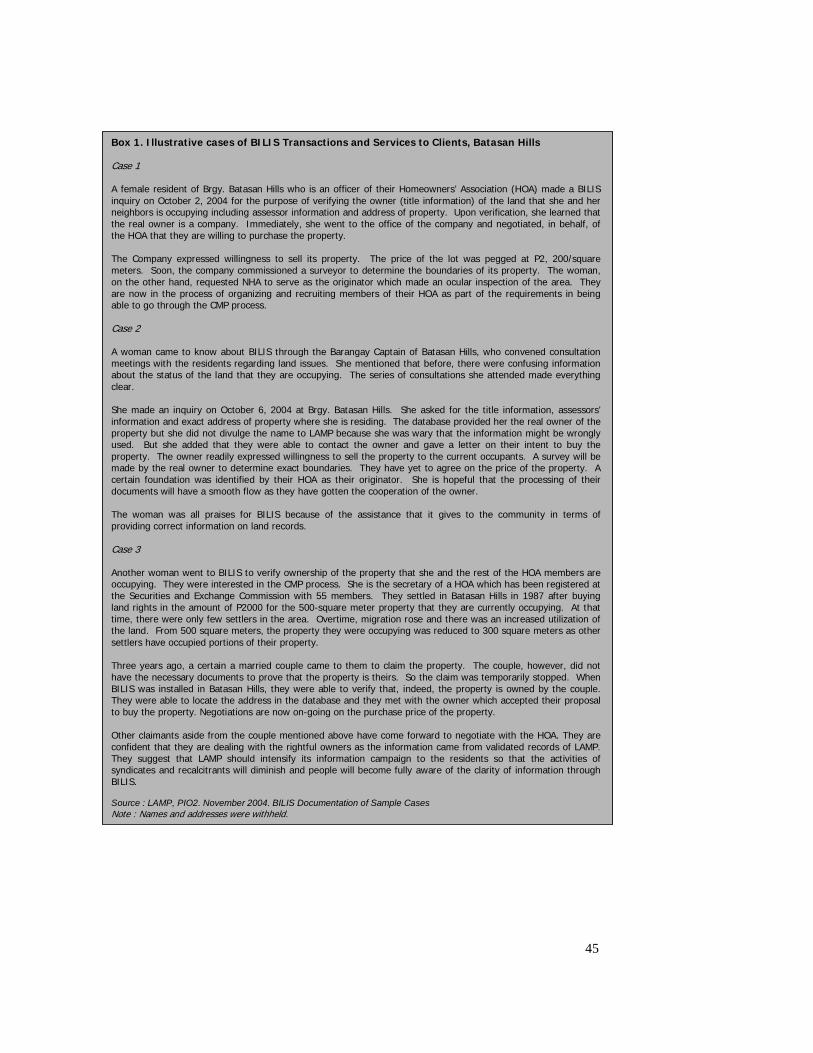
45
Box 1. Illustrative cases of BILIS Transactions and Services to Clients, Batasan Hills Case 1 A female resident of Brgy. Batasan Hills who is an officer of their Homeowners’ Association (HOA) made a BILIS inquiry on October 2, 2004 for the purpose of verifying the owner (title information) of the land that she and her neighbors is occupying including assessor information and address of property. Upon verification, she learned that the real owner is a company. Immediately, she went to the office of the company and negotiated, in behalf, of the HOA that they are willing to purchase the property. The Company expressed willingness to sell its property. The price of the lot was pegged at P2, 200/square meters. Soon, the company commissioned a surveyor to determine the boundaries of its property. The woman, on the other hand, requested NHA to serve as the originator which made an ocular inspection of the area. They are now in the process of organizing and recruiting members of their HOA as part of the requirements in being able to go through the CMP process. Case 2 A woman came to know about BILIS through the Barangay Captain of Batasan Hills, who convened consultation meetings with the residents regarding land issues. She mentioned that before, there were confusing information about the status of the land that they are occupying. The series of consultations she attended made everything clear. She made an inquiry on October 6, 2004 at Brgy. Batasan Hills. She asked for the title information, assessors’ information and exact address of property where she is residing. The database provided her the real owner of the property but she did not divulge the name to LAMP because she was wary that the information might be wrongly used. But she added that they were able to contact the owner and gave a letter on their intent to buy the property. The owner readily expressed willingness to sell the property to the current occupants. A survey will be made by the real owner to determine exact boundaries. They have yet to agree on the price of the property. A certain foundation was identified by their HOA as their originator. She is hopeful that the processing of their documents will have a smooth flow as they have gotten the cooperation of the owner. The woman was all praises for BILIS because of the assistance that it gives to the community in terms of providing correct information on land records. Case 3 Another woman went to BILIS to verify ownership of the property that she and the rest of the HOA members are occupying. They were interested in the CMP process. She is the secretary of a HOA which has been registered at the Securities and Exchange Commission with 55 members. They settled in Batasan Hills in 1987 after buying land rights in the amount of P2000 for the 500-square meter property that they are currently occupying. At that time, there were only few settlers in the area. Overtime, migration rose and there was an increased utilization of the land. From 500 square meters, the property they were occupying was reduced to 300 square meters as other settlers have occupied portions of their property. Three years ago, a certain a married couple came to them to claim the property. The couple, however, did not have the necessary documents to prove that the property is theirs. So the claim was temporarily stopped. When BILIS was installed in Batasan Hills, they were able to verify that, indeed, the property is owned by the couple. They were able to locate the address in the database and they met with the owner which accepted their proposal to buy the property. Negotiations are now on-going on the purchase price of the property. Other claimants aside from the couple mentioned above have come forward to negotiate with the HOA. They are confident that they are dealing with the rightful owners as the information came from validated records of LAMP. They suggest that LAMP should intensify its information campaign to the residents so that the activities of syndicates and recalcitrants will diminish and people will become fully aware of the clarity of information through BILIS. Source : LAMP, PIO2. November 2004. BILIS Documentation of Sample Cases Note : Names and addresses were withheld.
46
2.3.2 Prevention and Detection of Fake and Overlapping Titles and Survey Plans
The CIM and records validation procedures were all meant to detect fraudulent, overlapping and duplicate titles within the system. These processes led to the detection of double titles in Don Enrique Heights and Barstow subdivision in the prototype areas of Quezon City. In the conduct of field validation in Don Enrique, 86 were found to be overlapping with titles already existing. In an investigation conducted by LAMP, it was determined that the title belonging to a different owner was reconstituted in a court in Rizal, a different province that has no jurisdiction in Quezon City. This led to the approval of a new subdivision plans in the area that resulted in the issuance of succeeding titles that were fraudulent in nature. At the end of LAMP, court proceedings were on going to cancel the overlapping titles. No action has been taken by the project in the resolution of this issue since it is mainly legal in nature. In Barstow, on the other hand, a title was reconstituted, after which a new survey plan was approved and titles issued, only to find out that the property belongs to government. Establishment of TWG on Fake Titles Outside the system, fake titles (i.e., mainly those forged by individuals or syndicates) still proliferate. An Interagency TWG was established with LRA and chaired by the Deputy Administrator of LRA to develop and implement actions to curb the proliferation of fake titles. The TWG was composed of representatives of ROD, DENR, LMB, DOJ, National Bureau Investigation (NBI), Philippine National Police (PNP), Office of the Solicitor General (OSG), with members from the private sector (banks, realtors, GEs) and selected community leaders. The TWG developed an Action Plan for fake title detection, segregation and disposition, which include among others, improved education for the public, sharing of database, integration of efforts, strengthening of laws and penalties for violators, and adoption of LAMP procedures by the agencies. Development of Manual of Fake Titles Through the support of LAMP, the TWG was able to document procedures to detect, to segregate, and to dispose of fake and fraudulent titles. The Manual also contained procedures on the use of the CIM and the cross-index by the courts and government agencies to prevent further issuance of fraudulent titles. The completed manuals are currently utilized as guides in cases of fake and fraudulent titles by member organizations of the TWG. The database is currently with LAMP, but discussions are in progress for LRA to manage its updating and access to the wider stakeholders. To further address the issue on the prevalence of fake and fraudulent titles, members of the group who has developed the manual agreed to form a Task Force that will fast track the detection and resolution of fake and fraudulent titles. The group’s activities included coordinating with Task Force Payatas to detect and resolve fake and fraudulent titles existing in Payatas, one of LAMP-PIO2’s prototype areas. Development of Database of Overlapping Titles and Training on Fake Title Detection Another concrete effort of the TWG was the development of a database of fake titles. These were compiled based on the existing databases of the agencies, as well as those from the banks. However, the completion of the database was discontinued because this was also being done by the Task Force Titulong Malinis. Instead, the Project prepared a database of double titles in the prototype area. It contains the 86 double titles of Don Enrique Heights. The database is linked to the cross index, and if the cross index user encodes another title with the same property as any of those in the database, he/she will be informed of the title’s status. This should prevent potential buyers from purchasing properties covered by double titles. Training was conducted for key leaders of the prototype community on fake title detection. This was aimed at educating the public so that they will not continue to be victimized by perpetrators, and their investments protected.
47
2.3.3 Development of National Land Records Management Strategy (NLRMS) A study on the state of management of land records was carried out in 2003 to perform a strategic level analysis of the land administration records management and its institutional and policy environment. The recommended strategy which resulted from the study was supposed to serve as a springboard to implement long term and short term solutions to land records management issues. The strategy was developed in two phases. The first phase involved the development and discussion of options for change with ‘core stakeholders’. The second phase completed the consultation process and enabled the documentation of a composite shared view of the future and implementation of change. Key stakeholders who participated in these processes were: (i) representatives of agencies that are holders (custodians) of important land records and data sets; and (ii) customers and wider community groups who wish to have land titles, ownership and related queries answered promptly and correctly. In developing the overall strategy, a description of the issues affecting management of land records was made. These are presented below. (i) Government credibility in the sector is seriously eroded by the widespread perception that the entire system of land administration is so weak that a considerable portion of land transactions involve fake titles. (ii) Many records were lost in the Second World War and many more have been lost in Registry fires. (iii) Inventories, if performed, do not result in the replacement, repair or conservation of essential records. Without the funding support for storage and conservation of records, they are left to rot. Staff are not trained in repairing and conserving records. And in the absence of training and resources, torn and disintegrating titles may simply be taped and/or stapled together. (iv) There are no serious record retention/destruction policies in place. Funding for records storage and maintenance has been low to non existent over many years due to budgetary constraints and the low priority assigned to the maintenance of land records. (v) There is no overall common approach applied when indexing or referencing the land records. The different records are catalogued using a variety of keys and there does not appear to be a unique parcel identifier (UPI) applied across all records and maps. (vi) Most agencies concerned with land registration require the same documents to be presented for examination and each demands separate certified copies of those documents. The uncoordinated demands f the physically separated agencies forces the public to travel between agencies and expend time and money unnecessarily. (vii) There is generally a lack of confidence in the integrity of land records in the Philippines and many people will search all transactions that have affected a title, back to the original registration to ensure that a complete and accurate chain of title is in place. This makes the registration system a little more than a deeds office. Efforts should be made to clean out the problems in the system and to introduce a workable assurance fund to back up the registration process. (viii) While some agencies have introduced some computerization initiatives, there are no agreed data standards or information sharing agreements in place nor have the means of interfacing these various initiatives been established. Computerization of records has proceeded without major reengineering of business rules and processes.
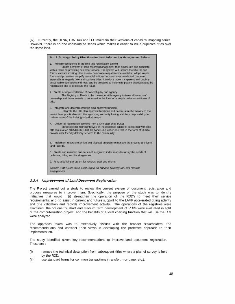
48
(ix) Currently, the DENR, LRA DAR and LGU maintain their versions of cadastral mapping series. However, there is no one consolidated series which makes it easier to issue duplicate titles over the same land. 2.3.4 Improvement of Land Document Registration The Project carried out a study to review the current system of document registration and propose measures to improve them. Specifically, the purpose of the study was to identify initiatives that would : (i) strengthen the operation of the ROD’s to meet their service requirements; and (ii) assist in current and future support to the LAMP accelerated titling activity and title validation and records improvement activity. The operations of the registries were examined; the options for short and medium term development of RODs were evaluated in light of the computerization project; and the benefits of a local charting function that will use the CIM were analyzed. The approach taken was to extensively discuss with the broader stakeholders, the recommendations and consider their views in developing the preferred approach to their implementation. The study identified seven key recommendations to improve land document registration. These are : (i) remove the technical description from subsequent titles where a plan of survey is held
by the ROD; (ii) use standard forms for common transactions (transfer, mortgage, etc.);
Box 2. Strategic Policy Directions for Land Information Management Reform 1. Increase confidence in the land title registration system Create a system of land records management that is accurate and complete with a focus on providing customer service. The system will: secure the title file and forms; validate existing titles as new composite maps become available; adopt simple forms and processes; simplify remedial actions; focus on user needs and concerns especially as regards fake and spurious titles; introduce more transparent and publicly accountable operations and fees; and be prepared to indemnify people disadvantaged by registration and to prosecute the fraud. 2. Create a simple certificate of ownership by one agency The Registry of Deeds to be the responsible agency to issue all awards of ownership and those awards to be issued in the form of a simple uniform certificate of title. 3. Integrate and decentralized the plan approval function Integrate the title plan approval functions and decentralize the activity to the lowest level practicable with the approving authority having statutory responsibility for maintenance of the index (projection) maps. 4. Deliver all registration services from a One Stop Shop (OSS) Bring together representatives of the dispersed agencies concerned with land title registration (LRA DENR, ROD, BIR and LGU) under one roof in the form of OSS to provide user friendly delivery services to the community. 5. Implement records retention and disposal program to manage the growing archive of land records. 6. Create and maintain one series of integrated index maps to satisfy the needs of cadastral, titling and fiscal agencies. 7. Fund a building program for records, staff and clients. Source: LAMP, June 2003. Final Report on National Strategy for Land Records Management
49
(iii) redraft format of the OCT and dispense with TCTs to enable the endorsement of changes of ownership on the OCT;
(iv) all land registration matters currently required to be dealt with by the Courts should be dealt with by simple administrative processes in the first instance;
(v) improve efficiency of the RODs; (vi) locate all plans of survey and cadastral maps within the RODs; and (vii) improve records management by culling unnecessary documents, and returning
original documents to applicants at time of registration. Of the above recommendations, only two would require legislative amendment (namely recommendations 3 and 4) while the rest can be implemented by administrative measures on the part of LRA. While there was general positive feedback from stakeholders on the above recommendations, these remain un acted at the end of the Project. 2.3.5 Access to Land Information in Government Access to land information has been a major issue in LAMP. This was true not only in the work of PIO2 and its difficulty in getting access to the LARES-LTCP data, but also for PIO1, where access to land records from agencies has been a bottleneck in completing the CIM, and generating the database. A study was commissioned towards the end of LAMP completion to review the government policy on access to land information in government29. The objective of the study was to define an overall policy for sharing of land information/data among government agencies and for the access of land information by the public. Specifically, the study : (i) reviewed government policy and practice on access to land information; (ii) reviewed international best practices in computerization and access to land information; and (iii) recommended options and concrete actions for better sharing of land information/data. In a broad sense, the main motivations for the study were : an informed market is an efficient market; an efficient land information system results in efficient land markets and effective land management. The study defined an efficient land information system as : (i) complete and up to date information about the land owner, geographic description; (ii) integrity of information; (iii) accessibility by interested parties; and (iv) low transaction cost – user fees that are reasonable and affordable. Improving access was deemed important because markets are information intensive – they become efficient with good and accessible information. On the other hand restricting access leads to inefficient decisions and works in favor of the wealthy – it is anti poor. The major finding of the study was that there is no overarching policy governing access to and sharing of land information in government. The reasons for lack of accessibility to land information are :
o Structural defects – for example - absence of unique parcel identifier applied across titles, maps and plans, and the variety of keys used to catalogue records.
o Incentive problem among land agencies or lack of willingness to share information.
o Lack of institutional framework for sharing integrated land information : who is in
charge? What sanctions are there for failure to share or provide information?
29 LAMP, 2004. Policy Study on Access to Land Information in Government.
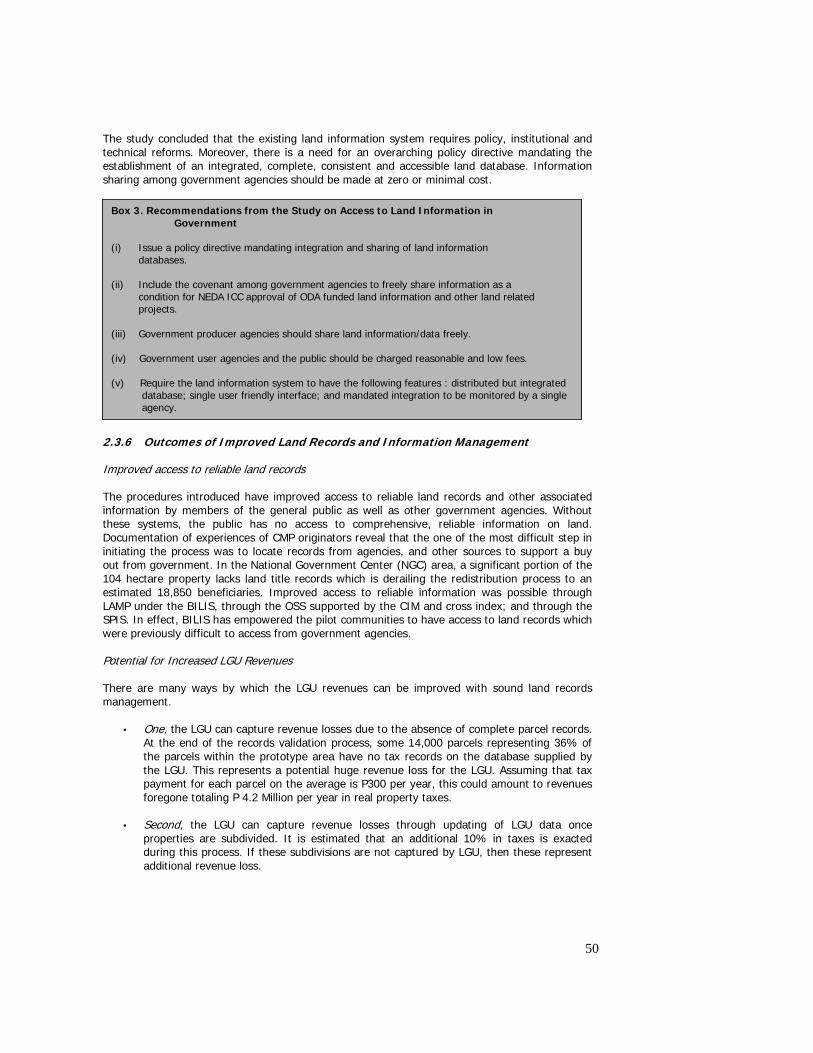
50
The study concluded that the existing land information system requires policy, institutional and technical reforms. Moreover, there is a need for an overarching policy directive mandating the establishment of an integrated, complete, consistent and accessible land database. Information sharing among government agencies should be made at zero or minimal cost.
2.3.6 Outcomes of Improved Land Records and Information Management Improved access to reliable land records The procedures introduced have improved access to reliable land records and other associated information by members of the general public as well as other government agencies. Without these systems, the public has no access to comprehensive, reliable information on land. Documentation of experiences of CMP originators reveal that the one of the most difficult step in initiating the process was to locate records from agencies, and other sources to support a buy out from government. In the National Government Center (NGC) area, a significant portion of the 104 hectare property lacks land title records which is derailing the redistribution process to an estimated 18,850 beneficiaries. Improved access to reliable information was possible through LAMP under the BILIS, through the OSS supported by the CIM and cross index; and through the SPIS. In effect, BILIS has empowered the pilot communities to have access to land records which were previously difficult to access from government agencies. Potential for Increased LGU Revenues There are many ways by which the LGU revenues can be improved with sound land records management.
• One, the LGU can capture revenue losses due to the absence of complete parcel records. At the end of the records validation process, some 14,000 parcels representing 36% of the parcels within the prototype area have no tax records on the database supplied by the LGU. This represents a potential huge revenue loss for the LGU. Assuming that tax payment for each parcel on the average is P300 per year, this could amount to revenues foregone totaling P 4.2 Million per year in real property taxes.
• Second, the LGU can capture revenue losses through updating of LGU data once
properties are subdivided. It is estimated that an additional 10% in taxes is exacted during this process. If these subdivisions are not captured by LGU, then these represent additional revenue loss.
Box 3. Recommendations from the Study on Access to Land Information in Government (i) Issue a policy directive mandating integration and sharing of land information databases. (ii) Include the covenant among government agencies to freely share information as a condition for NEDA ICC approval of ODA funded land information and other land related projects. (iii) Government producer agencies should share land information/data freely. (iv) Government user agencies and the public should be charged reasonable and low fees. (v) Require the land information system to have the following features : distributed but integrated
database; single user friendly interface; and mandated integration to be monitored by a single agency.
51
• Third, additional revenue potential is associated with increases in land market activity. Bringing some 60% of informally occupied areas into the formal system is expected to translate into added revenues for the government.
• Fourth, the LGU can improve revenue collection if they can auction off properties where
no tax payments were made. Equipped with information on the 5,980 properties not accounted for (no Assessor records), the LGU can now target these to determine if they are lands with unpaid taxes. Once determined, the LGU can hold land sales to sell them off and get back the unpaid land taxes.
Reduced community conflict on the status of land The efforts of LAMP at enhancing interagency coordination, supported by community feedback through the CRS, has resulted in the LRA and DENR issuing a joint resolution putting to rest the ambiguity in the status of lands in most parts of Quezon City. For many years, the uncertainty and the conflicting policy issuances and actions of these two agencies have created havoc in the communities. For one, many syndicates have capitalized on the uncertainty of the land status to exact money from residents in exchange for some illegal instruments to “protect” their tenure over the properties. Also, many have refused to participate in the CMP nor pay their amortizations to CMP on the belief that the area is government land. Community feedback after the policy issue has been resolved reported the conversion or reduction of recalcitrants, thereby contributing to the smooth processing of individual titles in the CMP areas.30 Together with better access to reliable land records, the land related conflicts in the prototype barangays is expected to be reduced. While no data are available, the information provided by BILIS to prospective beneficiaries of the CMP are expected to clarify ownership status of all parcels where the Project has records of, thereby eliminating the long and tedious process of conducting research, payment of legal fees and other facilitation fees, to locate records and establish the ownership of parcels of interest. Reduced activities of syndicates The prototype area has a history of land conflict and uncertain tenure, particularly for an estimated 60% of the informal settlements in the area. Payments for protection of land syndicates are common, in exchange for some spurious document, or protection against eviction. In these areas, there is constant threat of eviction or demolition, due to lack of knowledge of the land administration processes, and lack of access to reliable records. A number of people have laid claims to vast properties, and a significant number of them have pending cases in Courts. A study supported by LAMP has documented the activities of some syndicates, and indicated that these activities flourish under a regime of conflicting documents from the agencies, difficult to access information on land ownership and status; and lack of mechanism for establishing and officially issuing legitimate ownership over certain properties.31 Observations made by some community members in Holy Spirit reveal that the activities of syndicates have decreased, owing to (i) better information about land transactions and processes through LAMP’s CRS activities; (ii) access to services of land related agencies; and (iii) information provided by LAM on ownership and other validated land records.32
30 LAMP, 2003. CBM and E Report in Holy Spirit. 31 Genzola, Ma. Cecilia. October 2003. Squatting Syndicates: From the Viewpoint of Informal Settlers. A PA-LAMP supported Research Grant. 32 LAMP, 2003. CBM and E Report in Holy Spirit.
52
Improved Activity of the Land Market A study supported by LAMP documented the active informal selling and buying of rights in informally occupied areas.33 With 60% of the prototype areas under informal occupation, this represents dead capital of some P 19.17 Billion based on the minimum assessed value of land in the prototype area.34 Assuming that some 0.72%% of the value of these properties are captured by the government as fees and taxes, an estimated P 138 Million represents losses in revenues by government.35 The transactions in these properties can be brought to the formal property market, if there will be better access to records. Feedback from community discussions indicate that some informal settlers are willing to pay to buy the property they occupy – the only constraint being the difficulty of locating the legitimate owners of the property.36 A case in point is a resident in Veterans Village, Quezon City, who attempted to negotiate with at least three owners already, only to find out that these are not the true owners of the property. It was only after the Field Validation was she able to validate the owner, and negotiate for the sale. Increased Mortgage Value of Land Increased confidence in the records of the registry can influence the banks to increase the mortgage value of properties in areas where the ROD has been burned, and which are predominantly occupied by informal settlers. In the case of a large commercial bank, the following internal policies are in force:
o “real estate properties in Quezon City whose certificates of title have been administratively reconstituted under the provisions of RA 26 may be accepted as Secured B collateral. Such properties may be given a maximum loan value of 60% of their appraised value.
o real estate properties which are not acceptable – properties with squatter families or affected by squatter colonies.”
Insecure tenure also lowers the value of housing units. This was based on a study on Land Markets, which, based on literature review, reveal that in Manila, the risk of eviction associated with not having secure tenure lowers the value of the housing units by 25%. Assistance to Land Distribution and Housing Programs A number of CMP projects has been facilitated as a result of community dialogues and installation of BILIS. Also, the experienced difficulty of non-title holders in accessing land information were addressed by these improvements. A case in point is the processing of subdivision plans for a number of CMP projects and preparation of individual titles at the OSS. By first week of January 2005, an estimated 2,000 titles will be issued by the OSS from an ongoing process of survey plan verification. If these will continue for the next three to five years, an estimated 40,000 or more beneficiaries of CMP and National Government Community Housing Program (NGCHP) will enjoy the facilitating effect of integrated land information accessible even at the barangay level. Consequently, confidence of the lending institutions and prospective buyers and investors on the properties being mortgaged and sold in the prototype areas will be restored. The LGU however
33 Mas, Dennis. September 2004. Case Study on Land Transfers by Informal Settlers in Purok 4, Luzon Avenue, Quezon City. PA-LAMP supported Research Grant. de la Cuz, Leland. September 2004. Social and Institutional Dynamics of Settlement in Informal Settler Communities. PA-LAMP supported Research Grant. 34 The total land area of the prototype is 21,304,000 sq.m.. About 60% of these are estimated to be occupied by informal settlers, roughly about 12,782,400 sq.m. At minimum land value of P1,500 per sq meter, the total value of land outside the formal property market would be P19,173,600,000. Note that the market value of properties in the prototype ranges from P5,000 to P7,500 per sq. meter, more than three or four times the assumed value for purposes of estimation. 35 LAMP, May, 2004. Land Markets Study for LAMP. The study assumed the share of land related taxes and fees to total land value is 0.72%. 36 Mas, Dennis. September 2004. Case Study on Land Transfers by Informal Settlers in Purok 4, Luzon Ave., Quezon City. PA-LAMP supported Research Grant. LAMP, 2003 CBM and E Report in Holy Spirit.
53
will need to closely monitor compliance with and promptness of real estate tax payment to ensure that this will translate into better revenue collection. Strengthened Linkages with Formal Subdivisions Formal subdivisions were also party to BILIS. Through the CIM and database, they had access to land records information covering their villages. A case in point is the HOA of Northview Don Jose Heights Subdivision in Bagong Silangan and Commonwealth. They were able to verify ownership of properties of non HOA members. The Project also asked them to assist in supplying gaps in land records and other information being consolidated by PIO2. Assistance in Resolution of barangay boundary conflict Through the use of CIM, supported by field validation and community relations work, the Project was able to document and map out the metes and bounds of barangay Payatas, which is currently not defined. The areas where there are overlapping claims with barangay Bagong Silangan and Commonwealth were also documented and shown on the maps. After making a presentation to the respective Councils, barangay Bagong Silangan issued a resolution to define their boundary with Payatas. The resolution of Commonwealth is still being awaited after developing options for resolving the overlapping claimed areas through the aid of CIM. Improved interagency coordination The project catalyzed the records sharing between agencies working in the prototype area. Through the LAG and the various TWGs, the relations have strengthened through better recognition of the problems and limitations in the sector, the internal agency processes and policies which affect cooperation and records sharing, and streamlining of land administration services. In addition to enabling the Project to carry out its activities, the cooperation already established at the operational level has gained momentum and has resulted in the following: (i) establishment of a common database of fake titles from the records and data of agencies and the private sector; (ii) creation of a CIM TWG to look into the establishment of a single projection map between LRA and DENR, including defining responsibilities for adjusting to PRS 92 and updating of CIMs; (iii) sharing of records with NGCHP – critical to supporting timely implementation of housing programs for the urban poor; (iv) establishment of Fake Titles TWG to discuss ways to integrate efforts to address the issue; (v) establishment of National Land Records Management Strategy TWG to look at ways of implementing some of the short term recommendations from the study; (vi) OSS Interagency TWG to develop the OSS concept and model, and facilitate the setting up of mechanisms for the establishment and operation of the OSS; and (vii) establishment of linkage with the Presidential Commission for the Urban Poor (PCUP) and Task Force Payatas to intensify the campaign on fake title detection. The cooperation at the working level, supplemented by the records validation work of the Project, helped clarified the relationships and linkages of land records across agencies. There is now a better understanding of the gaps, mismatches and the anomalies resulting from the lack of records sharing, the absence of links in processes as in the case between the ROD and the LGU; and the absence of a central control system for updating of records, validation of records, and a facility for ensuring the public have access to these vital records and information to support the activities of other sectors. One of the significant effects of the inter-agency collaboration in land administration is the resolution among the agencies on the conflicting policy in OCT 333. The agencies were able to establish a unified stand on the classification of land within the prototype area. This resolution was accepted by a large number of groups in the community. It has provided clarity to the legitimacy of the land classification being disputed.
54
2.3.6 Issues and recommendations While the benefits of improved land records management have been largely demonstrated, the Project’s achievements in this area have been undermined by a combination of management and institutional coordination problems. The management of the Quezon City prototype has been inadequate, largely resulting from the lack of full time, suitably qualified Manager. The support of the lead agency, LRA has been insufficient at the start to overcome its difficulties associated with getting the support of operational units needed to initiate the processes of records validation. Institutional coordination had been difficult at the start, mainly a product of lack of history of cooperation and records sharing, though these were overcome towards the end of implementation. Contracting and relational problems affected the performance of PHILSSA, the NGO contracted to conduct CRS and field validation in the four barangays in Quezon City. Thus, field validation in these areas was not completed and results cannot be fully analyzed. Finally, the lack of access to the LARES- LTCP records and the absence of complementation with this initiative over the life of the project substantially delayed retrieval and validation of records and resulted in duplication of work. As a testing project, the benefits were evidenced through case studies, community and client feedback, and documentation of their potential impacts. A follow on program to implement the procedures tested and proven to work would be required to make sure the actual impacts will benefit the target groups. While substantial confidence has been gained at the community level, the lack of support to continue the work of LAMP in these areas will seriously affect the credibility of government to put in place lasting solutions to their land related problems. Support for the continuation of work in Quezon City is recommended, either through the initiative of the LGU or LRA, or a follow on to LAMP supported by development partners. The procedures developed needed mainstreaming and adoption, either through their use by the field offices of the agencies involved in the Quezon City prototype, or through policy statements by the agencies concerned mandating the adoption of the methodologies introduced by the Project. While this action can be taken in the short term, the changes that can be introduced will be limited, if the main agencies will continue to operate without a common land records management strategy, and complementary policy and institutional reforms. Future land records management initiative would have to consider revisiting the policy on public and government access to records held by the LARES-LTCP, and resolving the potential overlaps and inconsistency if this project will continue along the direction it has originally defined. Improvements in land records management and land document registration have been identified, but these need to be acted upon by the LRA, the agency concerned for implementing the key recommendations. Finally, the study on access to land information in government has identified a huge gap in policy – these need to be filled in the next phase of LAMP. 2.4 Land Administration Service Delivery – Operations of the One- Stop Shops 2.4.1 OSS Models developed and manuals prepared
As designed, the Project established an OSS in each prototype site. The objective was to test institutional collaboration in the provision of land administration services by providing a single stop service for all land related transactions in a manner that is transparent, cost effective and convenient to its customers. Currently, these transactions are performed by a number of agencies and local government units such that clients have to go through different offices to lodge these. Similarly, land records are dispersed in many agencies making it difficult for clients to have easy access to accurate records and other land related information.
55
The two prototypes used different models for the OSS. In prototype 1, entire offices of the ROD, CENRO and the PIO1 were co located in a single building to provide their own service to the public, thus providing for a physical one stop shop for land services. In Quezon City on the other hand, agency representatives performing such transactions were co-located in a single office to provide integrated services to the public by linking and streamlining of related services and automation of processes and vital information.
At the end of LAMP, the Leyte OSS has been in operation for 2 years and five months; while the Quezon City prototype has been operating for six months. The Leyte prototype tested two systems for OSS operations: the referral system and the single lodgment and inquiry counter. The former involved the setting up of a referral system through the front desk wherein clients were assisted in addressing their queries with the different agencies. The merged counter operation on the other hand, was instituted, where all CENRO and ROD transactions, as well as inquiries concerning other OSS agencies were only lodged at the front counter. ROD, CENRO and BIR representatives held offices at the front counter. A computerized tracking system was installed at the Front Desk to record receipt and completion of transactions. In both models, each office involved processed their transactions independent of each other. At Project completion, the CIM and land records database were available at the OSS as reference for inquiry on land use status and status of applications. During the last three months of the Project, an OSS Vision and Management Plan were prepared for the Leyte OSS. The process was designed to engender agency stakeholder ownership of the Vision and Mission, thus improving their commitment to introducing major changes in agency process and overall service delivery. The Management Plan needs to be translated into an operational plan, implemented, and monitored.
The Quezon City prototype on the other hand, was developed around the model of integrating the operations of the agencies under one system at the OSS. Linking of agency processes was thus paramount, especially in such transactions as transfer of titles wherein many agencies were involved. Thus, while the agency representatives essentially follow their own procedures and adhere to their agency requirements in processing, the staff worked together as documents were passed on from one agency to the next within the OSS. A common map base is available at the OSS, supported by a cross index which housed the land records database. These systems were
Box 4 – OSS Vision, Mission and Main Services – PIO1 Vision – A land administration and management institutional collaboration of participating agencies which provides accessible, transparent, cost effective, gender sensitive and client oriented services through simplified, streamlined and automated systems and procedures. Mission – The One Stop Shop integrates the following services in a single location:
o Land titling and registration services, streamlined survey approval and land tax administration;
o Effective land records management information system; o Access to land records; o Streamlined land and document registration system and procedures to
minimize cost to the client o Linkages between and among partner agencies to improve delivery of
services to the public; o Assist LGUs in identifying and implementing post titling activities; and o Serve as a training and research center for land related studies.
Source : PIO1 OSS Vision and Mission. November 2004.
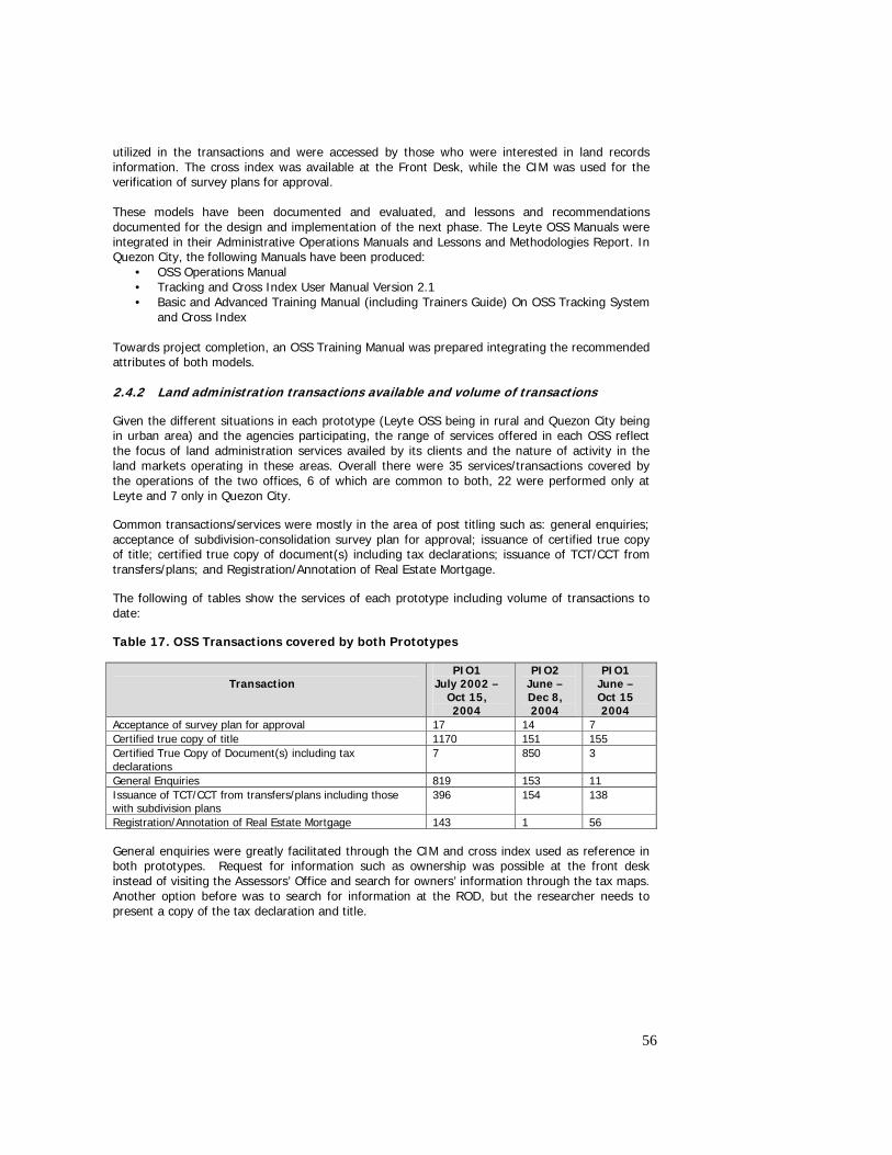
56
utilized in the transactions and were accessed by those who were interested in land records information. The cross index was available at the Front Desk, while the CIM was used for the verification of survey plans for approval.
These models have been documented and evaluated, and lessons and recommendations documented for the design and implementation of the next phase. The Leyte OSS Manuals were integrated in their Administrative Operations Manuals and Lessons and Methodologies Report. In Quezon City, the following Manuals have been produced:
• OSS Operations Manual • Tracking and Cross Index User Manual Version 2.1 • Basic and Advanced Training Manual (including Trainers Guide) On OSS Tracking System
and Cross Index Towards project completion, an OSS Training Manual was prepared integrating the recommended attributes of both models. 2.4.2 Land administration transactions available and volume of transactions
Given the different situations in each prototype (Leyte OSS being in rural and Quezon City being in urban area) and the agencies participating, the range of services offered in each OSS reflect the focus of land administration services availed by its clients and the nature of activity in the land markets operating in these areas. Overall there were 35 services/transactions covered by the operations of the two offices, 6 of which are common to both, 22 were performed only at Leyte and 7 only in Quezon City.
Common transactions/services were mostly in the area of post titling such as: general enquiries; acceptance of subdivision-consolidation survey plan for approval; issuance of certified true copy of title; certified true copy of document(s) including tax declarations; issuance of TCT/CCT from transfers/plans; and Registration/Annotation of Real Estate Mortgage.
The following of tables show the services of each prototype including volume of transactions to date:
Table 17. OSS Transactions covered by both Prototypes
Transaction
PIO1 July 2002 –
Oct 15, 2004
PIO2 June – Dec 8, 2004
PIO1 June – Oct 15 2004
Acceptance of survey plan for approval 17 14 7 Certified true copy of title 1170 151 155 Certified True Copy of Document(s) including tax declarations
7 850 3
General Enquiries 819 153 11 Issuance of TCT/CCT from transfers/plans including those with subdivision plans
396 154 138
Registration/Annotation of Real Estate Mortgage 143 1 56
General enquiries were greatly facilitated through the CIM and cross index used as reference in both prototypes. Request for information such as ownership was possible at the front desk instead of visiting the Assessors’ Office and search for owners’ information through the tax maps. Another option before was to search for information at the ROD, but the researcher needs to present a copy of the tax declaration and title.
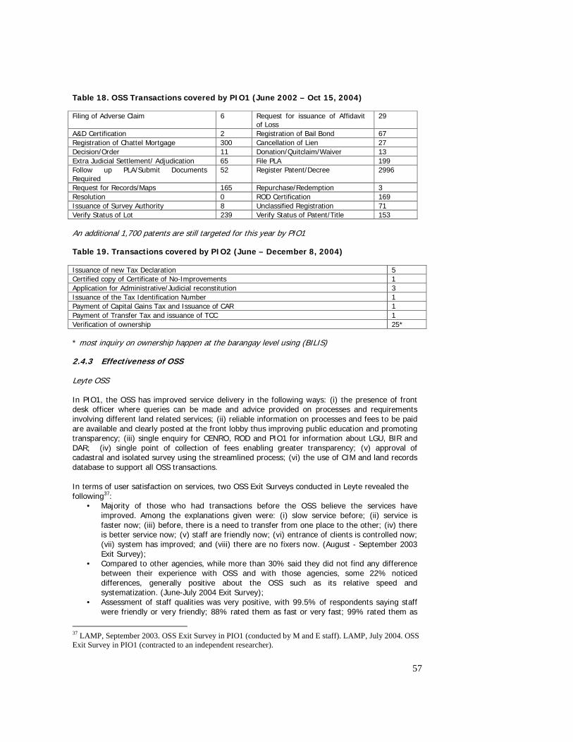
57
Table 18. OSS Transactions covered by PIO1 (June 2002 – Oct 15, 2004)
Filing of Adverse Claim 6 Request for issuance of Affidavit of Loss
29
A&D Certification 2 Registration of Bail Bond 67 Registration of Chattel Mortgage 300 Cancellation of Lien 27 Decision/Order 11 Donation/Quitclaim/Waiver 13 Extra Judicial Settlement/ Adjudication 65 File PLA 199 Follow up PLA/Submit Documents Required
52 Register Patent/Decree 2996
Request for Records/Maps 165 Repurchase/Redemption 3 Resolution 0 ROD Certification 169 Issuance of Survey Authority 8 Unclassified Registration 71 Verify Status of Lot 239 Verify Status of Patent/Title 153
An additional 1,700 patents are still targeted for this year by PIO1
Table 19. Transactions covered by PIO2 (June – December 8, 2004)
Issuance of new Tax Declaration 5 Certified copy of Certificate of No-Improvements 1 Application for Administrative/Judicial reconstitution 3 Issuance of the Tax Identification Number 1 Payment of Capital Gains Tax and Issuance of CAR 1 Payment of Transfer Tax and issuance of TCC 1 Verification of ownership 25*
* most inquiry on ownership happen at the barangay level using (BILIS)
2.4.3 Effectiveness of OSS Leyte OSS In PIO1, the OSS has improved service delivery in the following ways: (i) the presence of front desk officer where queries can be made and advice provided on processes and requirements involving different land related services; (ii) reliable information on processes and fees to be paid are available and clearly posted at the front lobby thus improving public education and promoting transparency; (iii) single enquiry for CENRO, ROD and PIO1 for information about LGU, BIR and DAR; (iv) single point of collection of fees enabling greater transparency; (v) approval of cadastral and isolated survey using the streamlined process; (vi) the use of CIM and land records database to support all OSS transactions. In terms of user satisfaction on services, two OSS Exit Surveys conducted in Leyte revealed the following37:
• Majority of those who had transactions before the OSS believe the services have improved. Among the explanations given were: (i) slow service before; (ii) service is faster now; (iii) before, there is a need to transfer from one place to the other; (iv) there is better service now; (v) staff are friendly now; (vi) entrance of clients is controlled now; (vii) system has improved; and (viii) there are no fixers now. (August - September 2003 Exit Survey);
• Compared to other agencies, while more than 30% said they did not find any difference between their experience with OSS and with those agencies, some 22% noticed differences, generally positive about the OSS such as its relative speed and systematization. (June-July 2004 Exit Survey);
• Assessment of staff qualities was very positive, with 99.5% of respondents saying staff were friendly or very friendly; 88% rated them as fast or very fast; 99% rated them as
37 LAMP, September 2003. OSS Exit Survey in PIO1 (conducted by M and E staff). LAMP, July 2004. OSS Exit Survey in PIO1 (contracted to an independent researcher).
58
knowledgeable or very knowledgeable; and 94.5% rated staff as honest or very honest. June-July 2004 Exit Survey);
• Generally, the services were rated as satisfactory, with 60% of respondents saying so, while almost 15% rated the services as outstanding (June-July 2004 Exit Survey).
The OSS Exit Surveys provided excellent avenues for monitoring performance of the OSS and getting client feedback. In both surveys, payments without official receipts were noted; and reasons for non completion of transactions were identified. These were mainly due to : (i) lacking documents; and (ii) absence of staff involved. The survey results have been used as basis for discussion with the agencies on measures to improve the services and promote transparency in transactions. These monitoring mechanisms were never instituted before, and agencies had no way of getting feedback from clients on the quality of service delivery. Data from the OSS tracking system provide improved efficiency in the provision of services. The following are the major uses of the tracking system:
• Details of transactions lodged at the front desk are tracked (queries made by transaction, date, name, municipality, agency, mixed queries, status of transaction and gender)
• Provides management information on how many transactions per month, location and what type, status of transaction, etc.
The table that follows provides details of completion times of transactions in the OSS.
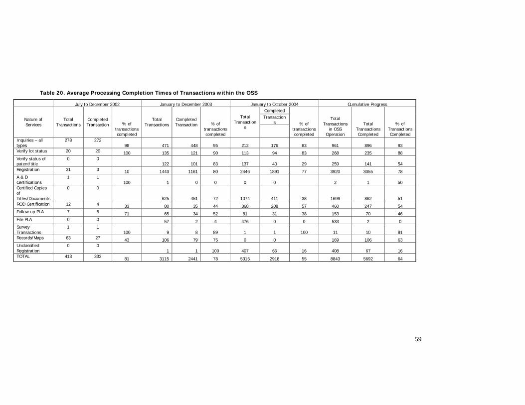
59
Table 20. Average Processing Completion Times of Transactions within the OSS
July to December 2002 January to December 2003 January to October 2004 Cumulative Progress Completed Transaction
s Nature of Services
Total Transactions
Completed Transaction % of
transactions completed
Total Transactions
Completed Transaction % of
transactions completed
Total Transaction
s
% of transactions completed
Total Transactions
in OSS Operation
Total Transactions Completed
% of Transactions Completed
Inquiries – all types
278 272 98 471 448 95 212 176 83 961 896 93
Verify lot status 20 20 100 135 121 90 113 94 83 268 235 88 Verify status of patent/title
0 0 122 101 83 137 40 29 259 141 54
Registration 31 3 10 1443 1161 80 2446 1891 77 3920 3055 78 A & D Certifications
1 1 100 1 0 0 0 0 2 1 50
Certified Copies of Titles/Documents
0 0
625 451 72 1074 411 38 1699 862 51 ROD Certification 12 4 33 80 35 44 368 208 57 460 247 54 Follow up PLA 7 5 71 65 34 52 81 31 38 153 70 46 File PLA 0 0 57 2 4 476 0 0 533 2 0 Survey Transactions
1 1 100 9 8 89 1 1 100 11 10 91
Records/Maps 63 27 43 106 79 75 0 0 169 106 63 Unclassified Registration
0 0 1 1 100 407 66 16 408 67 16
TOTAL 413 333 81 3115 2441 78 5315 2918 55 8843 5692 64
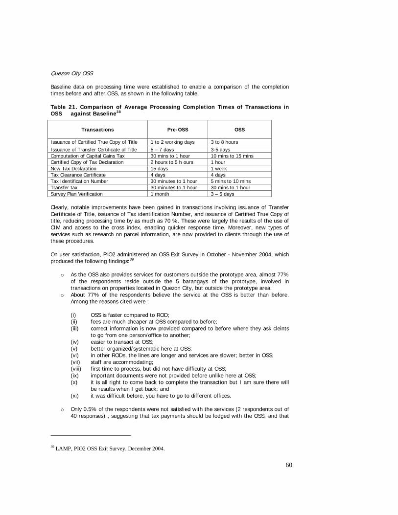
60
Quezon City OSS Baseline data on processing time were established to enable a comparison of the completion times before and after OSS, as shown in the following table. Table 21. Comparison of Average Processing Completion Times of Transactions in OSS against Baseline38
Transactions
Pre-OSS
OSS
Issuance of Certified True Copy of Title 1 to 2 working days 3 to 8 hours Issuance of Transfer Certificate of Title 5 – 7 days 3-5 days Computation of Capital Gains Tax 30 mins to 1 hour 10 mins to 15 mins Certified Copy of Tax Declaration 2 hours to 5 h ours 1 hour New Tax Declaration 15 days 1 week Tax Clearance Certificate 4 days 4 days Tax Identification Number 30 minutes to 1 hour 5 mins to 10 mins Transfer tax 30 minutes to 1 hour 30 mins to 1 hour Survey Plan Verification 1 month 3 – 5 days Clearly, notable improvements have been gained in transactions involving issuance of Transfer Certificate of Title, issuance of Tax identification Number, and issuance of Certified True Copy of title, reducing processing time by as much as 70 %. These were largely the results of the use of CIM and access to the cross index, enabling quicker response time. Moreover, new types of services such as research on parcel information, are now provided to clients through the use of these procedures. On user satisfaction, PIO2 administered an OSS Exit Survey in October - November 2004, which produced the following findings:39
o As the OSS also provides services for customers outside the prototype area, almost 77% of the respondents reside outside the 5 barangays of the prototype, involved in transactions on properties located in Quezon City, but outside the prototype area.
o About 77% of the respondents believe the service at the OSS is better than before. Among the reasons cited were :
(i) OSS is faster compared to ROD; (ii) fees are much cheaper at OSS compared to before; (iii) correct information is now provided compared to before where they ask cleints
to go from one person/office to another; (iv) easier to transact at OSS; (v) better organized/systematic here at OSS; (vi) in other RODs, the lines are longer and services are slower; better in OSS; (vii) staff are accommodating; (viii) first time to process, but did not have difficulty at OSS; (ix) important documents were not provided before unlike here at OSS; (x) it is all right to come back to complete the transaction but I am sure there will
be results when I get back; and (xi) it was difficult before, you have to go to different offices.
o Only 0.5% of the respondents were not satisfied with the services (2 respondents out of
40 responses) , suggesting that tax payments should be lodged with the OSS; and that
39 LAMP, PIO2 OSS Exit Survey. December 2004.
61
authentication should only take one day, instead of three days. The rest of the respondents (17.5%) rated the quality of service as the same as before.
2.4.4 Issues and Recommendations The establishment and operating efficiency of OSS in the two prototypes were affected by different sets of issues. In Prototype 1, the difficulty of negotiating procedural improvements with the agencies has constrained the introduction of additional streamlining or integration of agency processes within the OSS. Thus, while all the offices are co located in a single building, each agency undertakes its own processes independent of the procedures of the other agencies. The underlying causes of this are the general resistance to reforms by staff and officials of agency partners, the absence of an agreed common vision and framework for OSS operations, and the lack of customer or service orientation of the agencies. For the next phase of LAMP, it is imperative to issue a national policy, possibly emanating from the Office of the President, to provide sufficient authority for the operations of the OSS, and exact the required cooperation in the introduction of necessary improvements. It would also be important to develop the OSS vision and management plan, and ensure agreements among the parties involved in the implementation of such plan. In the Quezon City prototype, the cooperation from the agency partners has been excellent. From the beginning, there was strong interest and active participation in the development of the OSS model and transactions Manual, including the set up and the work flow within the OSS. Agency representatives provided inputs to the kinds of transactions that will be undertaken in the OSS, the staff requirements, and the relationships among the procedures of the agencies. The study tour provided the agencies the benchmark upon which the Quezon City OSS model will be established. The operation of the OSS has been delayed by the shift in the location of the original site within the premises of the Quezon City ROD at the LGU compound in 2001, after the bidding process has been completed. It took a while for the LRA to identify a new location after which there were subsequent delays in the procurement for the office renovation and purchase of equipment. For the next phase, it is necessary to continue the gains already made through the initial operations of OSS in Quezon City. Support will therefore be required so that its operations can be sustained. The agencies have expressed willingness to maintain their assigned staff within the OSS provided there is sufficient provision for recurrent costs and the continuous updating and maintenance of the CIM and database which support it. Further, consideration should also be made of expansion of OSS services beyond the prototype barangays, as demand increases. Finally, future operations of the OSS have to consider how the LARES-LTCP operations will impact on its effectiveness and efficiency. 2.5 Stakeholder participation 2.5.1 Rationale for Stakeholder Participation Prior to LAMP, stakeholders had very minimal opportunities to participate in land administration activities. In land titling, the sporadic approach relies on the initiative of the claimant to file for public land application through limited information campaign conducted by DENR. Because the process involved the individual approach, other members of the community are not part of the process, particularly in the validation of claimants and in the cadastral survey and monumenting. In land records management, the processes are known to only the agency staff, plus a few agents or professionals who are familiar, by virtue of their business or experience to transact with land related agencies. It is normal to pay for the services of a third party to facilitate processing of transactions on behalf of the owner because of the complexity and opaqueness of the procedures. The situation has left many vulnerable to misrepresentation by some. There was no opportunity for users to provide feedback on the quality of land administration services delivery in the absence of standards and performance monitoring on the levels of agency’s
62
service delivery. In terms of policy, very little change was introduced over the last decade, and there was minimal stakeholder consultation to assess the potential impacts of such changes on different groups, nor enable their inputs to be heard. Stakeholder participation was thus central to LAMP in the design of replicable titling and records and information management procedures and policy development. The pilots were part of the broader LAMP Social Program Plan participative model of stakeholder involvement. The core focus of this approach was the direct link between policy, the two prototypes and the community development/engagement approach. This interlinked approach was designed to ensure that a technically efficient land administration system was developed and that this was transparent and respected by community users, and supports the realization of development and poverty alleviation outcomes. In PIO1, stakeholder engagement (both women and men) in mass titling was needed to ensure improved quality and optimum levels of participation as well as enhance results and sustainability of desired outcomes, i.e., that titles convert to social capital and promote productivity. PIO2 sought the participation of its stakeholders (both women and men) in improving land information management system for the following reasons: • The support and participation of land owners and occupants (both formal and informal
settlers) as well as of the barangay local government units was necessary in validating land information and in reconstituting problematic land records;
• The cooperation of the municipal/city local government unit and of the various land administration agencies was necessary in unifying the land records in the municipality/city;
• The coordination and synergy of the various stakeholders was necessary in ensuring public access to land records and in using these land records for the resolution of land issues, such as boundary conflicts, conflicting claims, land use determination including the identification of resettlement areas within the municipality/city for informal settlers and others who may be affected.
2.5.2 LAMP Stakeholders Stakeholders of Titling Activities The range of stakeholders included those negatively or positively affected by the outcome or those who could affect the outcomes of mass titling and land tenure improvement. At the institutional level, stakeholders were agencies and groups who were involved in land titling activities. These are : (i) the DENR, whose main responsibilities involve issuance of Free Patent over untitled A and D lands; (ii) the ROD, which issues titles once the patents have been processed at the DENR; it is also involved in the delivery of key land registration services in the prototype area; (iii) the DAR, which provides assistance to tenants and mainly responsible for the registration of leasehold agreements between landholders and tenants; (iv) the LGUs involved in tax assessment of real properties and provides basic services to rural communities subject to titling; (v) the BIR, which collects taxes on real property and other land related transactions; (vi) other agencies who have an interest in improving their records through sharing with other agencies such as DA, NIA, DPWH, etc; (vi) NGO groups who have rural development activities; and (viii) academe who were keen in improving their research work and academic curriculum to respond to the demands of LAMP. The intended key stakeholders for mass titling were women and men-land claimants who composed only about half of the rural households in pilot municipalities. Thus, PIO1’s scope was expanded from titling to land tenure improvement to adjust to a relatively narrow band of target beneficiaries and to address perceived negative effects on non-landholders (e.g. tenants, informal settlers).
63
To ensure maximum participation and sustainability through conversion of titles to social capital, another major group of stakeholders were local government units. LGUs stood to benefit from titling through taxation and access to database for comprehensive development planning. They were also in a position to mobilize community participation and to activate convergence mechanisms for local development. LAMP was sensitive to the concerns of vulnerable groups including those of non-land claimants who feared being adversely affected by titling. The Department of Agrarian Reform was a key partner in tenure improvement. Convergence for development involved civil society including NGOs, state colleges and universities and national and other development agencies. Stakeholders of Land Records and Information Management Activities The stakeholders of land records improvement in the five prototype barangays of PIO2 in Quezon City were the: a) land titleholders whose interest is to protect their land rights through proper land registration; b) informal settlers whose interest is to identify the landowners of their occupied lands so as to be protected from syndicates posing as landowners and also to have a chance to negotiate for land tenure security through direct purchase of the land at affordable cost or through inclusion in the CMP; c) LGUs which need clear land records as basis for land taxation; d) land administration agencies, such as the LRA, ROD, DENR, BIR, HUDCC and NHA which seek for the improvement of their land administration services; and e) civil society organizations with land related programs in the five barangays. Both women and men-members of these groups were considered as key stakeholders Stakeholders of Policy Reform Program in the Lands Sector The general public is the broader group of stakeholders in policy development. It stands to benefit from the reform measures that will be instituted through the support of LAMP. Several groups can be identified as primary stakeholders: (i) civil society groups composed of urban poor, farmers, NGOs, women and other groups who will be directly impacted by the reform; (ii) professional groups such as geodetic engineers, planners, appraisers, real estate brokers, whose practices depends on the efficiency of service delivery by the agencies, the standards that will be imposed and the rules that will govern their practices; (iii) private sector groups such as the banks and other groups who depend much on the integrity of registration system, and whose activity will depend on the robustness of the property market as a result of more efficient land administration; (iv) LGUs who depend to a certain degree on real property taxes and fees as a source of income, and who will benefit from improvements in the system; (v) affected agencies such as LRA, NAMRIA and LMB whose responsibilities were proposed to be merged under a single organization, and whose employees are concerned about their fate in the reorganization process; and (vi) the legislators and agency executives responsible for pushing the reform these are mainly represented in the Presidential task Force. 2.5.3 Effectiveness of Stakeholder participation strategies developed and tested Strategies for Stakeholder Participation in Titling Activities At the prototype level, the participation of agencies was facilitated through the Local Advisory Group (LAG) which served as the mechanism for resolving coordination issues and other important policy concerns. The LAG was chaired by the Provincial Assessor on behalf of the Governor, with members from the DENR, ROD, BIR, DAR, PNP, DA, the Director of LAMP/Academe partnership, and the Mayors of the six prototype municipalities. A number of resolutions were issued by the LAG in support of LAMP, foremost of which include clarification of back taxes as a requirement for patent issuance, support for the LAA, and the amendment of the Free Patent law.
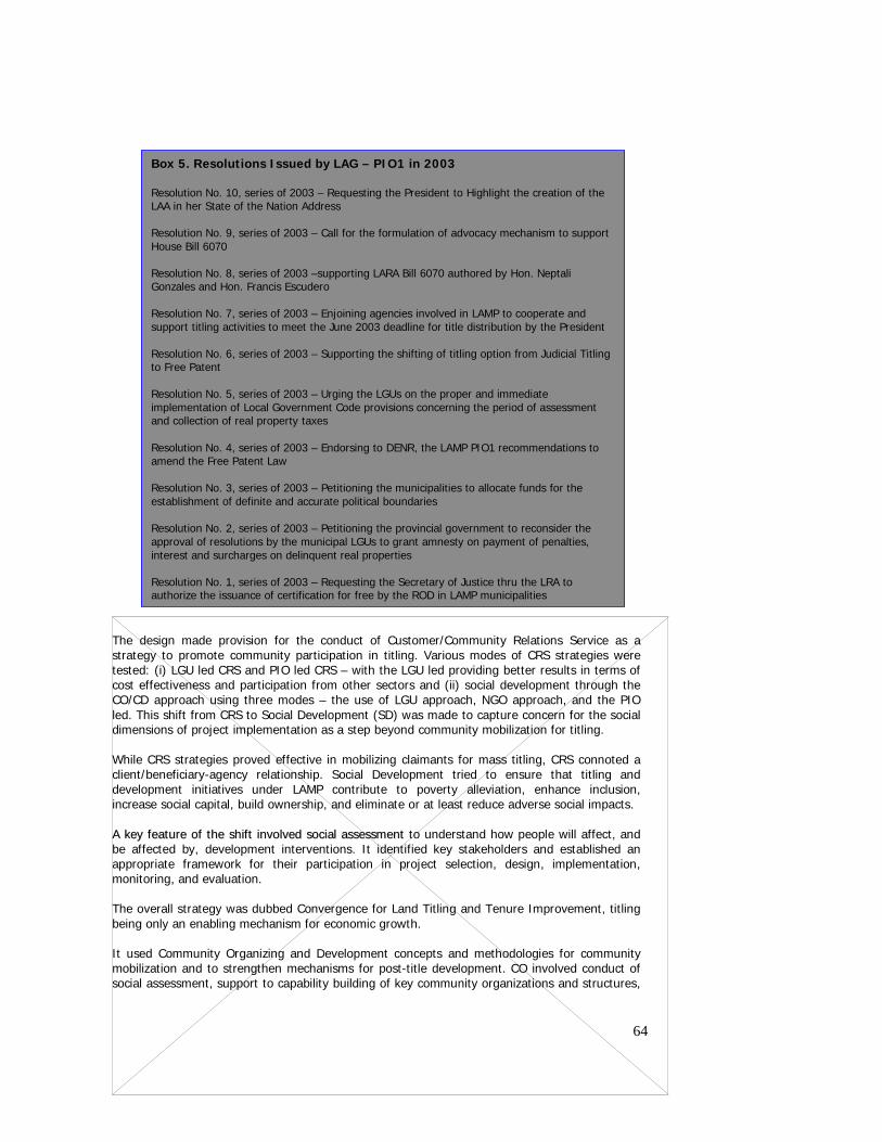
64
The design made provision for the conduct of Customer/Community Relations Service as a strategy to promote community participation in titling. Various modes of CRS strategies were tested: (i) LGU led CRS and PIO led CRS – with the LGU led providing better results in terms of cost effectiveness and participation from other sectors and (ii) social development through the CO/CD approach using three modes – the use of LGU approach, NGO approach, and the PIO led. This shift from CRS to Social Development (SD) was made to capture concern for the social dimensions of project implementation as a step beyond community mobilization for titling.
While CRS strategies proved effective in mobilizing claimants for mass titling, CRS connoted a client/beneficiary-agency relationship. Social Development tried to ensure that titling and development initiatives under LAMP contribute to poverty alleviation, enhance inclusion, increase social capital, build ownership, and eliminate or at least reduce adverse social impacts. AA kkeeyy ffeeaattuurree ooff tthhee sshhiifftt iinnvvoollvveedd ssoocciiaall aasssseessssmmeenntt to understand how people will affect, and be affected by, development interventions. It identified key stakeholders and established an appropriate framework for their participation in project selection, design, implementation, monitoring, and evaluation. The overall strategy was dubbed Convergence for Land Titling and Tenure Improvement, titling being only an enabling mechanism for economic growth. It used Community Organizing and Development concepts and methodologies for community mobilization and to strengthen mechanisms for post-title development. CO involved conduct of social assessment, support to capability building of key community organizations and structures,
Box 5. Resolutions Issued by LAG – PIO1 in 2003 Resolution No. 10, series of 2003 – Requesting the President to Highlight the creation of the LAA in her State of the Nation Address Resolution No. 9, series of 2003 – Call for the formulation of advocacy mechanism to support House Bill 6070 Resolution No. 8, series of 2003 –supporting LARA Bill 6070 authored by Hon. Neptali Gonzales and Hon. Francis Escudero Resolution No. 7, series of 2003 – Enjoining agencies involved in LAMP to cooperate and support titling activities to meet the June 2003 deadline for title distribution by the President Resolution No. 6, series of 2003 – Supporting the shifting of titling option from Judicial Titling to Free Patent Resolution No. 5, series of 2003 – Urging the LGUs on the proper and immediate implementation of Local Government Code provisions concerning the period of assessment and collection of real property taxes Resolution No. 4, series of 2003 – Endorsing to DENR, the LAMP PIO1 recommendations to amend the Free Patent Law Resolution No. 3, series of 2003 – Petitioning the municipalities to allocate funds for the establishment of definite and accurate political boundaries Resolution No. 2, series of 2003 – Petitioning the provincial government to reconsider the approval of resolutions by the municipal LGUs to grant amnesty on payment of penalties, interest and surcharges on delinquent real properties Resolution No. 1, series of 2003 – Requesting the Secretary of Justice thru the LRA to authorize the issuance of certification for free by the ROD in LAMP municipalities
65
information and education campaign, People’s Organizing (e.g. Community Action Group (CAG)) and partnership-building. It also involved tenure improvement initiatives for non-landholders such as tenants and land occupants. At the village level, efforts towards post-title development were initiated through comprehensive Barangay Development Planning and activation. At the municipal level, activation of convergence structures such as the Municipal Interagency Coordinating group (MIAC) and Local Poverty Reduction Action Teams (LPRAT) encouraged more vibrant networking for local development. Procedures for Free Patent titling were designed and tested to be socially responsive, gender sensitive, socially acceptable and community development-driven. Another significant contribution of pilot testing resulted in the characterization of the social structure in rural poor areas as well as of land claimants and other affected sectors as these might affect efficiency, impact, relevance and effectiveness of mass titling/strategies, thus the factors that need to be considered in mainstreaming. The pilot produced lessons on organizational requirements and partnership strategies and structures to implement SD concepts and procedures. There were areas where the SD strategy contributed to the effectiveness of mass titling : level and quality of participation in titling and attainment of desired effect of titling and land tenure improvement processes. These corresponded to titling and post-title components. Results based on parameters for effectiveness show that: tested procedures improved reach of target participants. These include non-resident and resident land claimants as well as vulnerable groups and affected non-land claimants such as tenants. Participation levels increased for various stages, time frames were shortened for certain steps of the community mobilization process thereby reducing costs. Improved quality of participation could be noted from land claimants and other partners such as the LGU. Structures and mechanisms were established that would support continuing initiatives for local development at the barangay and municipal levels. Multi-tasking and social/gender sensitivity tended to improve productivity and quality of outputs resulting in cost savings and timeliness of inputs. LGUs bought in on their critical role in the titling process as well as in post-title development. Using the municipal-wide approach, results indicate the benefits of convergence and positive prospects for mobilizing local government not only in land tenure improvement but also in strengthening mechanisms for development and delivery of social services. Developed procedures underscore areas where CO principles and techniques can address specific problems encountered in community mobilization, in raising participation levels and in addressing social issues in titling. Furthermore, the process identified the socio-economic, attitudinal and other factors that tend to affect quality and level of stakeholder participation. Despite a viable methodology, social assessment indicates structural and poverty-related constraints in reaching desired 80% participation in mass titling, or in converting titles to social capital. Some factors are extraneous. These include sustained championship on land tenure improvement and development by LGU partners and social issues that do not lend themselves to effective control within the titling period (e.g. disparity in land sizes and benefits, high incidence of idle lands, fragmented shared lands, mortgaged and tenanted lands, non-residency of land claimants, etc.) or that require the infusion of so much more resources (e.g. community development interventions with longer time frame for CO) in order to make titled land productive.
66
These indicate further issues that need to be confronted and that have implications on rollout criteria for site selection and on scope and nature of post-title agenda. Stakeholder Participation Strategies in Land Records and Information Management At the prototype level, the participation of agencies was facilitated through the LAG and the various TWGs established to work on specific concerns. The LAG served as the oversight committee of PIO2 and as a mechanism for joint advocacy and for coordination of efforts among the agencies involved in the land records management reform process as well as the LGUs (both at the city and barangay levels). It is composed of representatives from the DENR-NCR, LRA/ROD, BIR, Quezon City LGU and barangay LGUs. To focus the work of LAG, three thematic committees were formed, to work on specific issues namely: a) barangay boundary delineation; b) advocacy; and c) national land records management. In addition to the LAG, a TWG for the Detection, Segregation and Disposition of fake and Fraudulent Titles was formed, consisting of government, private sector, and community representatives. Through these stakeholder participation structures, PIO2 was able to achieve among others the following:
• Issuance of DENR Memorandum Circular on 7 January 2003 declaring OCT 333 as valid and that the Payatas Estate, contrary to the claim that it was an unclassified public forest land, was a titled alienable and disposable land. This put to rest conflicts brought about by the uncertain status of OCT 333, which is the source of much of the activities of syndicates and social unrest within the affected communities; and conflicts between informal settlers who claim the properties are untitled, and the legitimate title holders of such properties.
• Resolution of DENR-NCR to adopt the SPIS, a PIO2 product, for the computerization of their inventory of survey plans;
• Resolution of DENR-NCR, LRA and the Quezon City LGU to use the CIM as a common base map.
• A Manual on Fake Titles Detection was prepared. This manual has been endorsed by the members of the TWG and stakeholder groups to their constituents for widespread use.
• Identified areas where the LAMP and the government housing programs - CMP and NGCHP can complement to resolve issues related to access to reliable records which constrain the speedy implementation of lot acquisition for urban poor housing.
• Agreement between LRA and DENR for the reconstruction of all survey plans. • Facilitation of the resolution of barangay conflicts, through the use of PIO2 orthophoto
maps, supported by its community relations work, in Payatas and Commonwealth. • Provision by the Quezon City government of P1.5 Million for the equipment of the
LAMP-OSS. • LAG resolution supporting the expansion of the operations of PIO2 to other barangays
of Quezon City and to secure funding from outside sources to implement this resolution.
At the barangay level, the Project employed a modified form of the community organizing-community development (CO-CD) approach. Among the activities done under this approach were: social integration, conduct of community assemblies and area-based community dialogues, community mobilization for field validation of problematic land records, and the conduct of a participatory resource appraisal for the expansion of community organizing to community development concerns. Through modified CO-CD, the Project formed the Barangay Advocacy Groups (BAGs) composed of Presidents of HOAs in the barangays, initially in Holy Spirit and later in Batasan Hills. The BAGs served as the key partner of the prototype in disseminating information and in mobilizing community participation in LAMP activities. Another partner was the Barangay Council (BC). The partnership with the community through the BAG and BC essentially paved the way for the forging of relationship with the community and served as conduits for LAMP community entry.
67
This was proven effective in areas where there are no formed networks, and communicating with hundreds of different HOAs would be next to impossible. In other barangays, the work of PHILSSA and its networking with local established federations proved effective in securing community participation in LAMP activities. Aside from serving as communication channels and facilitating LAMP activities, these mechanisms effectively served in generating community feedback and in identifying pertinent issues that can be addressed by LAMP. These inputs were documented, and key issues were strategically addressed through LAMP’s established working relationship with the agencies. Through partnership with the BAGs and the BCs, the Project was able to:
• Facilitate the raising of awareness on the relevance of land records management improvement and the active participation in LAMP activities of the residents in the prototype barangays through BAG’s network of HOAs and the Council activities;
• Field validate problematic land records (i.e. land records were gathered from the field); • Install the BILIS in the four barangays, so that community members have access to the
Project’s database and CIM. Through the BILIS, the Barangay Council of Holy Spirit was able to resolve numerous land records-related conflicts in the barangay; and
• Reduce the activities of land syndicates in the barangays. The field validation enabled the community members to directly participate in land records management improvement. Field validation results in Holy Spirit showed less desirable levels of participation from the established subdivisions. This could be attributed to the perception that their land records have such high integrity that need not be validated. The activity generated support mainly from the informal settlers, who have strong interest in finding out the registered owners of the properties they occupy. This is essential to facilitate the direct purchases to have the titles transferred in their name, thus improving their tenure security. The majority have interest in having the land covered under the government’s housing programs for the urban poor, which cannot be facilitated without accurate records. As of the date of writing this report, the Quezon City prototype did not accept the field validation report submitted by PHILSSA due to delayed submission and not having adequately met the required number of parcels to be field validated. Stakeholder Participation Strategies at the national level Formal mechanisms to establish coordination arrangements with the agencies at the national level was facilitated through the establishment of such high level bodies as the IACC, later transformed into Presidential Task Force (TF). The membership and functions of the IACC/TF and the IATWG which supports it are described in section 1.0. In addition to its inherent role as facilitating interagency coordination, providing oversight and direction to reforms, a number of tangible results from the working of the IACC/TF have been achieved. One of the most important was the decision by the TF on the version of the draft LARA Bill that will be submitted to Congress. Discussions were made on the concerns of LRA on the draft Bill and after careful deliberations, most of these were incorporated in the submitted proposal to Congress. Project implementation relied on the participation of other agencies in almost all aspects of the Project. Three strategies were implemented: (i) assignment of regular staff from key agencies such as LRA, DENR, DAR, LGU to perform key management functions in the project; (ii) leadership of key agencies in the conduct of six policy studies; (iii) agency representation in the IACC/TF and the IATWG which supports it; (iv) agency representation in the interagency Design Steering Committee (DSC) for LAMP2. The direct involvement of regular staff from agencies helped enhance their experience and skills and enabled the Project to maintain close linkages with their mother agencies, thus facilitating dialogues and resolution of critical issues. Though not in positions of influence, these staff provided the project the perspective of the current practices, procedures, and culture of the agencies, which enabled the project to design the testing of improved procedures around these realities. Through their participation, the Project was able to better understand the situation in
68
the sector, as well as the dynamics and relationships that exist among agencies involved in land administration. In a way the agencies also benefited from better understanding of the nner by which other agencies work, including their procedures, and how these relate with the performance of their own mandates.
The leadership of concerned agencies and the participation of other agencies in the policy studies helped developed further awareness and appreciation of the sector situation, and the need to work together to resolve the issues. For the lead agencies in particular, their role enabled the studies to be bestowed with the needed guidance, thus ensuring that the reform proposals which resulted from the studies were aligned with national priorities and relevant to current socio economic and political realities of the Philippines.
The inter-agency DSC for LAMP 2 was also found important in that it provided the needed guidance on the direction, framework and strategy for the design. The involvement of the relevant partners in the design process ensured full ownership and commitment of the GOP. It also served as an excellent venue for the partners to discuss critical issues during design. Issues resolved were those relevant to: (i) overall design strategy; (ii) the size and scale of LAMP2; (iii) the relative weights of the components; and (iv) budget strategy. On policy reform, the consensus building activities essentially entailed the engagement of stakeholders in the discussion of the policy proposals and cementing partnerships to support the reform agenda. The strategies and outcomes from these activities were discussed in section 2.1. 2.5.4 Partnerships with academe, NGOs, LGUs and other groups in project implementation The project sought to engage strategic partnerships with key groups to mobilize other sectors as well in LAMP. The objective was to broaden the breadth of capacity building efforts by engaging the academe, LGUs and NGOs in the implementation of specific aspects of the project. By making them part of the implementation team, knowledge and exposure to LAMP was likewise enhanced in sectors outside of government agencies directly involved in implementation. Partnership with Academe The Leyte prototype initiated the establishment of partnership with a consortium of academic institutions in Leyte to: (i) share expertise and complement resources between LAMP and the academe; (ii) develop human capital in land administration and management; (iii) foster innovations and influence policy makers; and (iv) document best practices and processes. The results of such partnership were:
• development of BS Geodetic and Geomatics Engineering Curriculum at the Leyte State University and the Leyte Institute of technology, with LAMP providing support in training school representatives on competency based approach to curriculum development;
• participation of academe in the conduct of LAMP evaluation and surveys : (i) Listenership Survey of the LAMP radio Program; and (ii) Social Assessment II part 1;
• on the job training in LAMP areas by trainees of Leyte Institute of technology in 2003 and 2004; on site visits to OSS in Leyte; and
• management of the PA LAMP research grants facility jointly by LAMP and academe consortium representatives.
The research grants facility was set up to develop interest on the part of academe and NGOs to engage in LAMP related research in order to build the knowledge base in the sector, and stimulate students, researchers and professors to pursue LAM as a key area needing further research. Similarly, a research grants facility was set up in Quezon City, managed by an NGO attached to an academic institution, the ICSI. At the end of LAMP, a total of 22 research grants were completed on various issues. The studies provide a wealth of knowledge on critical aspects
69
of land administration on land titling and records management. The list of studies completed from the facility is attached as Annex F. At the national level, partnership with selected academic institutions and agencies involved in higher education was established to improve the geodetic engineers’ curriculum. This activity is discussed in more detail in section 2.7. Partnership with LGUs The participation of LGUs was deemed crucial in the implementation of prototype activities. With the Project operating mainly within the ambit of political territories, their participation was actively sought to ensure cooperation at the local level, and establish links between LAMP initiatives and LGU programs. In the two prototypes, LGU representatives served as chair of the LAG. In addition to their roles in the LAG, LGU leaders were likewise actively involved in the implementation of field activities, particularly on the following:
• mobilization, validation of claimants and CRS/CO activities in titling activities; • facilitating community participation in SNS; • providing support to titling programs by activating the LPRAT, integrating community
plans in the barangay development plans, and linkaging with other LGU programs; • management and operation of BILIS in Quezon City prototype; • participation in resolution of conflicts related to titling and land records management in
both prototypes; • mobilization of communities and participation in field validation in Quezon City; • participation in resolution of land related issues and political boundary disputes.
Undoubtedly, the participation of LGUs has enhanced LAMP implementation and enabled the establishment of strong partnerships to help address land related issues affecting the communities where LAMP is operating. At the same time, it has strongly defined the role of LGUs in land administration and improved their support to their constituents. Partnership with NGOs Unlike LGUs and the academe where the terms of engagement were based on clear partnership arrangements, NGOs participated in some aspects of implementation by undertaking selected activities through contracts. In PIO1, WESLEDEF implemented the NGO-CO pilots and documented results and outcomes to serve as basis for the formulation of a desirable CO strategy for titling. In PIO2 on the other hand, the PHILSSA was engaged to carry out CRS and field validation in four barangays of the prototype. Both engagements produced mixed results. While the WESLEDEF was able to implement the activities at the community, there was weak documentation of results. On the other hand, relational problems with PHILSSA and contractual management issues prevented the successful completion of all activities stipulated under the contract. Despite these experiences, the participation of NGOs is still believed to be crucial if effective partnership with stakeholders is to be achieved. Their expertise in community organizing work, advocacy and other aspects of policy and development work needs to be fully tapped for the next phase. 2.5.5 Issues and Recommendations The rationale behind stakeholder participation in LAMP was to broaden the base of support to policy reform, project management and implementation, and inputs to the work of the prototypes so that the procedures introduced are relevant to community needs. At the level of policy, the issues that remain pertain to the support of the agencies affected by the reform proposals and the completion of the policy development process such that they actually result in legislative proposals to provide the building blocks for the next phase and the
70
long term program. These would necessitate further work at ensuring that the political process associated with the deliberations of the proposed Bills are managed and adequately supported. More than ever, this would require stronger commitments from the Executive branch than demonstrated before, continued work with civil society and other partners so that they pursue their own advocacy, and maintaining strong links with the leaders and sponsors of the Bills in Congress. On institutional coordination, contrary to expectations that the Interagency Task Force with senior members of agencies participating in the project would provide the impetus for the field staff to support the program and honor agency commitments, the experience has been that minor agreements had to be negotiated at each level, and in almost all cases, need confirmation from higher authorities. Securing cooperation was thus difficult, both at the policy level, and at the prototype levels, where technical and administrative improvements were introduced. For the next phase, and in the absence of the LAA, there needs to be stronger mechanisms for exacting cooperation from agency partners in the field. This has to be coupled with sound choices of sites such that the openness of officials of agencies at the local level becomes a major criteria for selecting the prototype locations. Stakeholder participation strategies with communities and local level governments have been well developed by LAMP. What remains is continued review and improvement of such strategies such that these are modified to suit the unique social situations in new sites; and to the emerging concerns from implementation. For the next phase, a more in depth social investigation would be required prior to start up, so that more relevant participation strategies can be customized. Such assessment would be required of the local institutions, and the communities as well. Partnerships with NGOs, the academe and the private sector have been initiated by LAMP, albeit on a limited scale. For the next phase and the long term, a more pronounced strategy for getting the involvement of these sectors more actively as partners in implementation need to be defined and implemented. It is recognized that these sectors have a lot of potential to contribute to the development of the sector, and in introducing change by virtue of their independence, wide constituency, and expertise. These need to be pursued for the succeeding phase. 2.6 Survey, mapping, and orthophotos
2.6.1 Situationer on Survey Plan Approval, Capacity and Technology Applications
Pilot activities in cadastral surveying highlighted the lack of capacity in the government surveying sector to carry out and manage large scale cadastral surveying projects. Within the pilot areas, review of approved survey plans revealed that some 30% were defective and needed resurvey. In other areas, some surveys needed to be validated before titling activities can proceed. As of July 31, 2004, a total of 72 municipalities remains unsurveyed, 289 municipalities and cities partially surveyed, 337 municipalities and cities with on-going survey and only 916 municipalities and cities have approved surveys.40
Surveying activities were managed by DENR through detailed regulations governing field activities of private surveyors. Over time these became technical, detailed, onerous and restrictive, slowing the implementation of technology options that could reduce survey costs. The regulations did not allow for the application of modern processes that might have a lesser degree of accuracy but would provide a cheaper alternative for low value agricultural land.
DENR maintained a variety of survey control methods and attempts to move to a single national survey control standard known as PRS 92 were incomplete. Completion of PRS stations and transformation of old surveys to PRS has been extended until 2010 as amended by EO 321. The
40 LMB data (Status of Cadastral Survey in the Philippines as of December 2003).
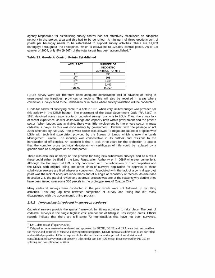
71
agency responsible for establishing survey control had not effectively established an adequate network in the project area and this had to be densified. A minimum of three geodetic control points per barangay needs to be established to support survey activities. There are 41,953 barangays throughout the Philippines, which is equivalent to 125,859 control points. As of 1st quarter of 2004, only 8% (9,867) of the total target has been accomplished.41
Table 22. Geodetic Control Points Established
ACCURACY NUMBER OF GEODETIC
CONTROL POINTS 1ST 330 2ND 305 3RD 2,769 4TH 6,463
TOTAL 9,867
Future survey work will therefore need adequate densification well in advance of titling in unsurveyed municipalities, provinces or regions. This will also be required in areas where correction surveys need to be undertaken or in areas where survey validation will be conducted.
Funds for cadastral surveying came to a halt in 1991 when very limited budget was provided for this activity in the DENR budget. The enactment of the Local Government Code (RA 7160) in 1991 devolved some responsibility of cadastral survey functions to LGUs. Thus, there was lack of recent experience, as well as knowledge and capacity both within government and the private sector. When budget was available, there was little involvement by the private sector in mass cadastral surveys, as this was done mainly by government. However, with the passage of Act 2989 amended by Act 3327, the private sector was allowed to negotiate cadastral projects with LGUs with technical supervision provided by the Bureau of Lands, which is now the Lands Management Bureau. The industry was conservative in its outlook and resistant to the introduction of efficiencies. An example is that it took three years for the profession to accept that the complex prose technical description on certificates of title could be replaced by a graphic such as a diagram of the land parcel.
There was also lack of clarity on the process for filing new subdivision surveys, and as a result these could either be filed in the Land Registration Authority or in DENR wherever convenient. Although the law says that LRA is only concerned with the subdivision of titled properties and the DENR, with original titling and other kinds of surveys; application for approval of these subdivision surveys are filed wherever convenient. Associated with the lack of a central approval point was the lack of adequate index maps and of a single or repository of records. As discussed in section 2.3, the parallel review and approval process was one of the reasons why double titles have been issued over some 386 parcels in the prototype area of Quezon City.42
Many cadastral surveys were conducted in the past which were not followed up by titling activities. This long lag time between completion of survey and titling has left many disappointed with the government’s titling program.
2.6.2 Innovations introduced in survey procedures
Cadastral surveys provide the spatial framework for titling activities to take place. The cost of cadastral surveys is the single highest cost component of titling in unsurveyed areas. Official records indicate that there are still some 72 municipalities that have not been surveyed. 41 LMB data (as of 1st quarter 2004). 42 Original surveys were to be reviewed and approved by DENR; DENR and LRA were both responsible for review and approval of surveys covering titled properties. DENR approves subdivision plans for titled and untitled properties. LRA is responsible for the verification and approval of subdivision and consolidation of survey plans of property titles under Act No. 496 except those covered by PD 957 on splitting and consolidation of titles.
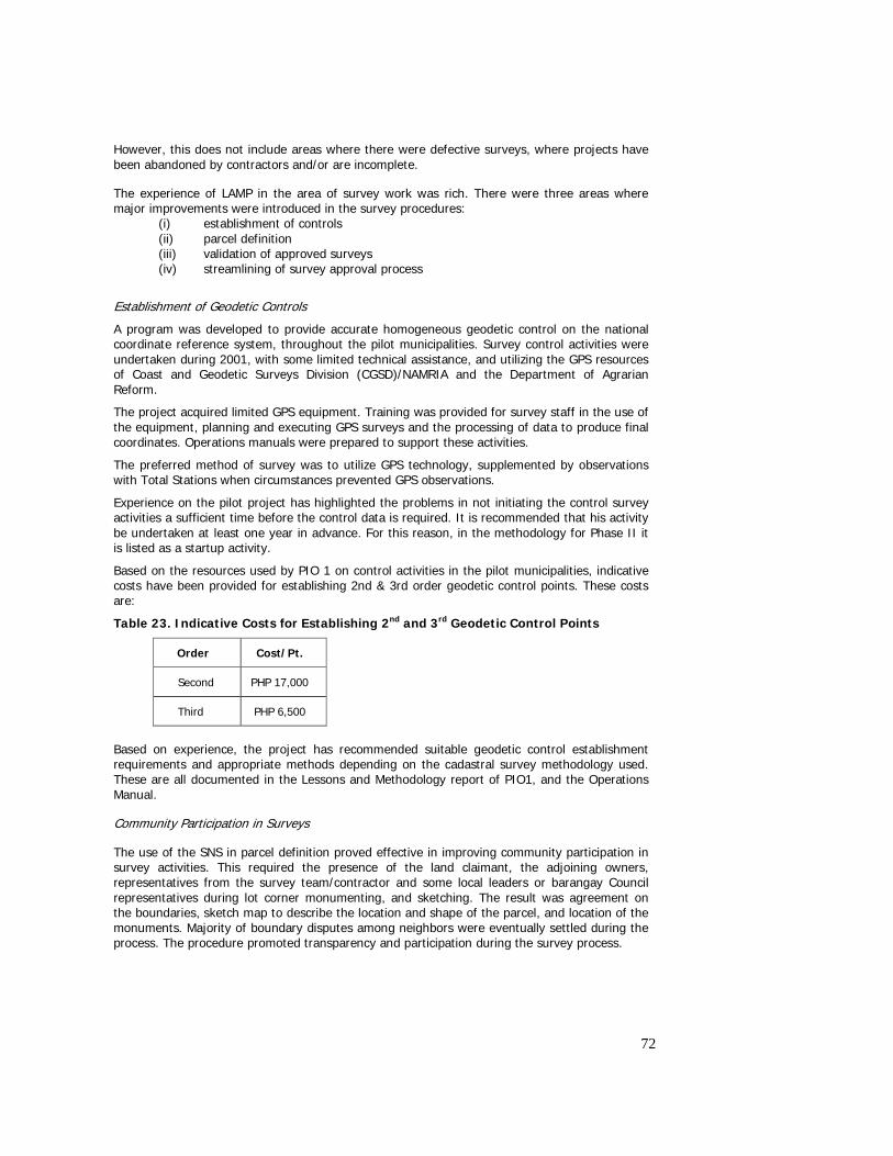
72
However, this does not include areas where there were defective surveys, where projects have been abandoned by contractors and/or are incomplete.
The experience of LAMP in the area of survey work was rich. There were three areas where major improvements were introduced in the survey procedures:
(i) establishment of controls (ii) parcel definition (iii) validation of approved surveys (iv) streamlining of survey approval process
Establishment of Geodetic Controls
A program was developed to provide accurate homogeneous geodetic control on the national coordinate reference system, throughout the pilot municipalities. Survey control activities were undertaken during 2001, with some limited technical assistance, and utilizing the GPS resources of Coast and Geodetic Surveys Division (CGSD)/NAMRIA and the Department of Agrarian Reform.
The project acquired limited GPS equipment. Training was provided for survey staff in the use of the equipment, planning and executing GPS surveys and the processing of data to produce final coordinates. Operations manuals were prepared to support these activities.
The preferred method of survey was to utilize GPS technology, supplemented by observations with Total Stations when circumstances prevented GPS observations.
Experience on the pilot project has highlighted the problems in not initiating the control survey activities a sufficient time before the control data is required. It is recommended that his activity be undertaken at least one year in advance. For this reason, in the methodology for Phase II it is listed as a startup activity.
Based on the resources used by PIO 1 on control activities in the pilot municipalities, indicative costs have been provided for establishing 2nd & 3rd order geodetic control points. These costs are:
Table 23. Indicative Costs for Establishing 2nd and 3rd Geodetic Control Points
Order Cost/Pt.
Second PHP 17,000
Third PHP 6,500
Based on experience, the project has recommended suitable geodetic control establishment requirements and appropriate methods depending on the cadastral survey methodology used. These are all documented in the Lessons and Methodology report of PIO1, and the Operations Manual.
Community Participation in Surveys
The use of the SNS in parcel definition proved effective in improving community participation in survey activities. This required the presence of the land claimant, the adjoining owners, representatives from the survey team/contractor and some local leaders or barangay Council representatives during lot corner monumenting, and sketching. The result was agreement on the boundaries, sketch map to describe the location and shape of the parcel, and location of the monuments. Majority of boundary disputes among neighbors were eventually settled during the process. The procedure promoted transparency and participation during the survey process.
73
Application of various Technologies in Parcel Definition
To find cost effective methods of conducting surveys, various technologies were tested in parcel definition. These were: the use of orthophoto maps and GPS, then compared with the traditional method of using conventional surveys. The result yield the use of OPM to provide the least cost but least accurate, the use of GPS entail modest cost and accuracy, while the use of conventional survey, is the most expensive, but the most accurate. All these technologies were tested in combination with the use of SNS in parcel definition. Future applications of GPS and OPM would depend on how the survey regulations would accept low accuracy surveys in low value agricultural areas; and the capacity of DENR to review survey returns using these technologies.
Validation of Approved Surveys
The Project deemed it important to introduce a procedure to validate approved surveys prior to adjudication. This is based on the findings that in the prototype area, at least 30% of approved surveys are defective and not ready for adjudication. Different methods were employed in the validation of approved surveys. The OPM and GPS were tested with the recommendation to use GPS in areas where the technology would allow its use (i.e., in areas less than 50% canopy cover) in the absence of OPM. In areas which would not allow the use of GPS, the use of compass and tape was recommended.
Streamlining of Survey Approval Process
Where a new cadastral survey is required, streamlined field verification of the outputs of the Geodetic Engineer and survey approval processes were tested to ensure that efficiencies gained in the field survey practices using new methods are not lost due to delays and inefficiencies in the survey approval process within DENR. Field and office verification was done at the same time as the field survey and survey return preparation stages, to minimize error. Correction of errors was found out to be one great source of delay in the survey review and approval process, as this would require the contractor to re mobilize the survey team and rectify errors in the field and/or in the computations. This involved some reallocation of staff and work priority to support timely survey approval and consequent title preparation. The target time from survey return lodgment to survey approval is 4 weeks. Project experience is that this process is completed between 4 – 8 weeks Simultaneous Survey and Adjudication To ensure there is minimum lag time between completion of surveys and issuance of titles, the project tested the conduct of simultaneous survey and adjudication in unsurveyed areas. The recommendation is to change existing practice and make this a standard operating procedure in future titling activities. Titling was effectively streamlined, as these can be effectively issued as soon as the survey returns are approved.
2.6.3 Streamlining of survey approval
To facilitate the verification, processing and approval of cadastral survey projects, LAMP negotiated for the issuance of a DENR Regional Memorandum Order No. 2004-002 by the Regional Office of Region VIII. It contains instructions and guidelines on: i) field verification and sketching on SNS, survey notification and sketching, establishment of project controls and political boundaries and lot boundary surveys; ii) supervision and monitoring in the preparation of survey returns; and iii) responsibilities of LAMP-PIO1 and the DENR Regional Office Surveys Division. The order effectively mainstreamed the new procedures developed by LAMP in the region, and clarified the role of both parties in surveying.
74
2.6.4 Conduct of cadastral surveys
The Prototype tested the conduct of surveys by contract (private sector) and by administration (government) to determine the cost-effectiveness of the approach and the level of capacity of the implementers. These were tested alongside the conduct of SNS in unsurveyed areas.
Cadastral Survey by Administration
The Project tested the capacity of its own staff, including regular staff from DENR regional office, in the conduct of surveys in Barangay Libertad, Palo consisting of an estimated 700 lots. Existing equipment were used, survey work was carried out, and survey returns were processed and approved by the DENR regional office. It took the project 2 years and eight months to complete the work (June 2001 to February 2004). This represents a delay of two years and two months per original estimates.
Delays were mainly caused by delays in the cancellation of the original contract for the module (it took one year for the DENR to cancel the contract); lack of capability of DENR staff in survey planning, management and supervision of survey team; lack of familiarity and capability in the use of total station; delayed approval of survey controls. It took more than a year for DENR to approve the survey plans after submission due to the numerous errors that need to be corrected in the survey returns.
Cadastral Survey by Private Contractors
The first cadastral survey by contract was undertaken in Barangay Macalpi-ay, Pastrana in 2001 covering 172 lots including political boundary surveys and connected to PRS 92. The survey was completed in 9 months.
Due to the lack of personnel and equipment, the Project proceeded with the bidding and procurement of private contractors to do the remaining survey works in the prototype. It must be stressed that Prototype prepared improved procedures prior to the start up of these cadastral survey modules. These procedures were the conduct of SNS, improved monitoring and supervision, and simultaneous survey verification.
Below is the status and coverage of cadastral survey contracts by municipality:
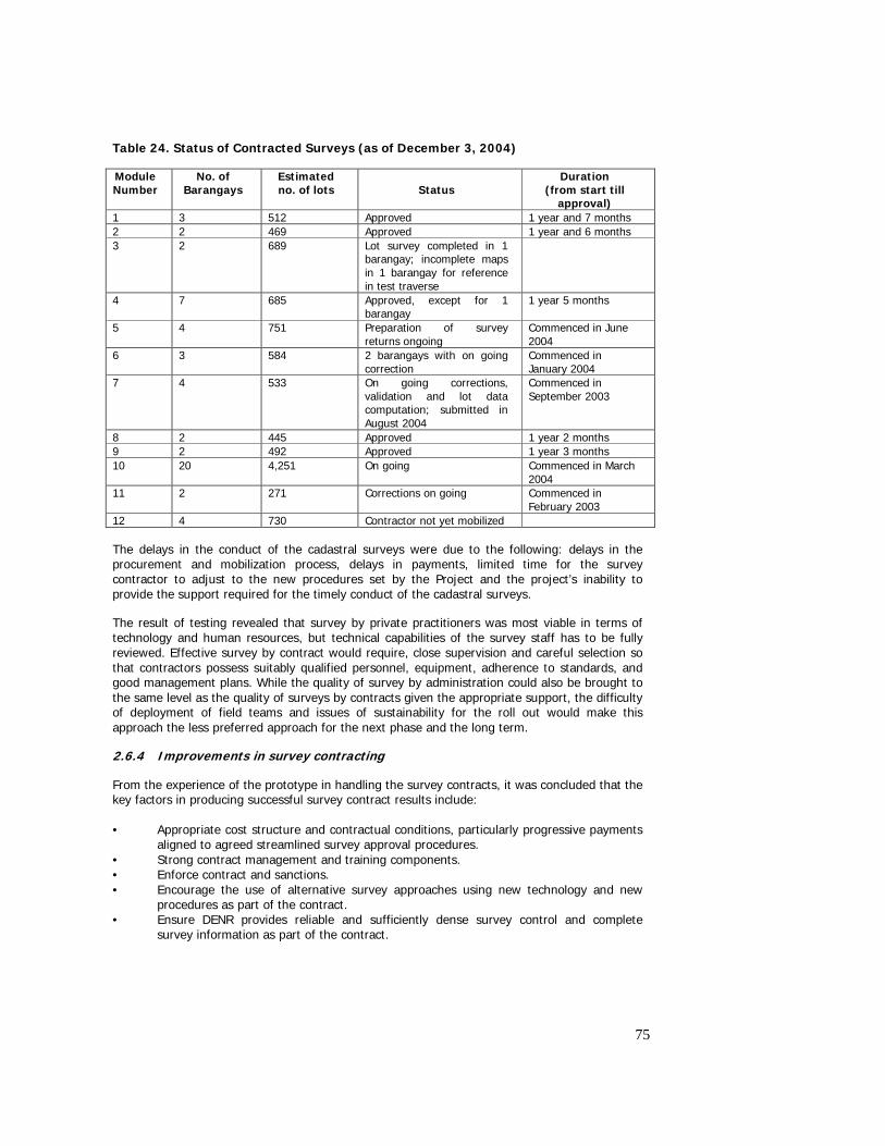
75
Table 24. Status of Contracted Surveys (as of December 3, 2004)
Module Number
No. of Barangays
Estimated no. of lots
Status
Duration (from start till
approval) 1 3 512 Approved 1 year and 7 months 2 2 469 Approved 1 year and 6 months 3 2 689 Lot survey completed in 1
barangay; incomplete maps in 1 barangay for reference in test traverse
4 7 685 Approved, except for 1 barangay
1 year 5 months
5 4 751 Preparation of survey returns ongoing
Commenced in June 2004
6 3 584 2 barangays with on going correction
Commenced in January 2004
7 4 533 On going corrections, validation and lot data computation; submitted in August 2004
Commenced in September 2003
8 2 445 Approved 1 year 2 months 9 2 492 Approved 1 year 3 months 10 20 4,251 On going Commenced in March
2004 11 2 271 Corrections on going Commenced in
February 2003 12 4 730 Contractor not yet mobilized
The delays in the conduct of the cadastral surveys were due to the following: delays in the procurement and mobilization process, delays in payments, limited time for the survey contractor to adjust to the new procedures set by the Project and the project’s inability to provide the support required for the timely conduct of the cadastral surveys.
The result of testing revealed that survey by private practitioners was most viable in terms of technology and human resources, but technical capabilities of the survey staff has to be fully reviewed. Effective survey by contract would require, close supervision and careful selection so that contractors possess suitably qualified personnel, equipment, adherence to standards, and good management plans. While the quality of survey by administration could also be brought to the same level as the quality of surveys by contracts given the appropriate support, the difficulty of deployment of field teams and issues of sustainability for the roll out would make this approach the less preferred approach for the next phase and the long term.
2.6.4 Improvements in survey contracting
From the experience of the prototype in handling the survey contracts, it was concluded that the key factors in producing successful survey contract results include: • Appropriate cost structure and contractual conditions, particularly progressive payments
aligned to agreed streamlined survey approval procedures. • Strong contract management and training components. • Enforce contract and sanctions. • Encourage the use of alternative survey approaches using new technology and new
procedures as part of the contract. • Ensure DENR provides reliable and sufficiently dense survey control and complete
survey information as part of the contract.
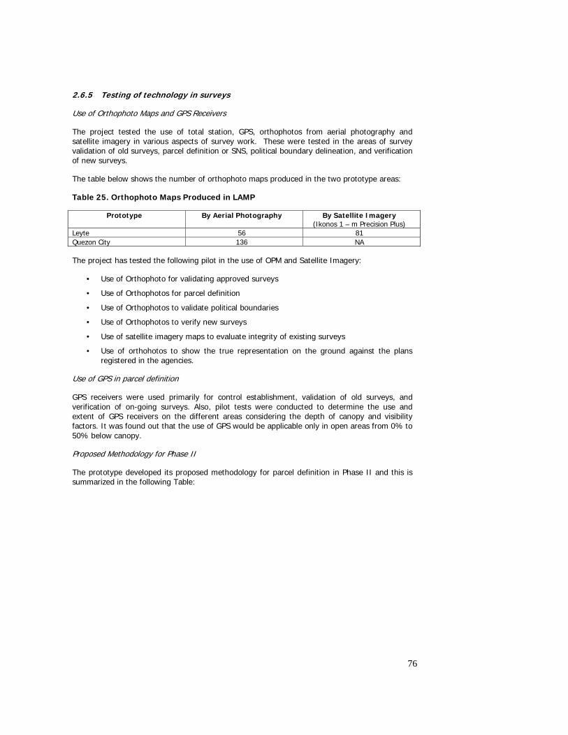
76
2.6.5 Testing of technology in surveys
Use of Orthophoto Maps and GPS Receivers
The project tested the use of total station, GPS, orthophotos from aerial photography and satellite imagery in various aspects of survey work. These were tested in the areas of survey validation of old surveys, parcel definition or SNS, political boundary delineation, and verification of new surveys.
The table below shows the number of orthophoto maps produced in the two prototype areas:
Table 25. Orthophoto Maps Produced in LAMP
Prototype By Aerial Photography By Satellite Imagery (Ikonos 1 – m Precision Plus)
Leyte 56 81 Quezon City 136 NA
The project has tested the following pilot in the use of OPM and Satellite Imagery:
• Use of Orthophoto for validating approved surveys
• Use of Orthophotos for parcel definition
• Use of Orthophotos to validate political boundaries
• Use of Orthophotos to verify new surveys
• Use of satellite imagery maps to evaluate integrity of existing surveys
• Use of orthohotos to show the true representation on the ground against the plans registered in the agencies.
Use of GPS in parcel definition
GPS receivers were used primarily for control establishment, validation of old surveys, and verification of on-going surveys. Also, pilot tests were conducted to determine the use and extent of GPS receivers on the different areas considering the depth of canopy and visibility factors. It was found out that the use of GPS would be applicable only in open areas from 0% to 50% below canopy.
Proposed Methodology for Phase II
The prototype developed its proposed methodology for parcel definition in Phase II and this is summarized in the following Table:
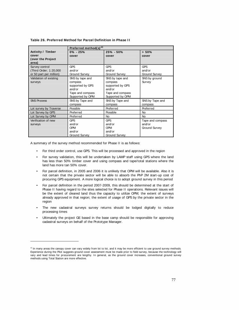
77
Table 26. Preferred Method for Parcel Definition in Phase II
Preferred method(s)43 Activity / Timber cover (over the Project area)
0% - 25% cover
25% - 50% cover
> 50% cover
Survey control (Third Order; 1:20,000 or 50 part per million)
GPS and/or Ground Survey
GPS and/or Ground Survey
GPS and/or Ground Survey
Validation of existing surveys
SNS by tape and compass supported by GPS and/or Tape and compass Supported by OPM
SNS by tape and compass supported by GPS and/or Tape and compass Supported by OPM
SNS by ground Survey
SNS Process
SNS by Tape and compass
SNS by Tape and compass
SNS by Tape and compass
Lot survey by Traverse Possible Preferred Preferred Lot Survey by GPS Preferred Possible No Lot Survey by OPM Preferred No No Verification of new surveys
GPS and/or OPM and/or Ground Survey
GPS and/or OPM and/or Ground Survey
Tape and compass and/or Ground Survey
A summary of the survey method recommended for Phase II is as follows:
• For third order control, use GPS. This will be processed and approved in the region
• For survey validation, this will be undertaken by LAMP staff using GPS where the land has less than 50% timber cover and using compass and tape/total stations where the land has more tan 50% cover.
• For parcel definition, in 2005 and 2006 it is unlikely that OPM will be available. Also it is not certain that the private sector will be able to absorb the PhP 2M start-up cost of procuring GPS equipment. A more logical choice is to adopt ground survey in this period
• For parcel definition in the period 2007-2009, this should be determined at the start of Phase II having regard to the sites selected for Phase II operations. Relevant issues will be the extent of cleared land thus the capacity to utilize OPM; the extent of surveys already approved in that region; the extent of usage of GPS by the private sector in the region
• The new cadastral surveys survey returns should be lodged digitally to reduce processing times
• Ultimately the project GE based in the base camp should be responsible for approving cadastral surveys on behalf of the Prototype Manager.
43 In many areas the canopy cover can vary widely from lot to lot, and it may be more efficient to use ground survey methods. Experience during the Pilot suggests ground cover assessment must be made prior to field survey, because the technology will vary and lead times for procurement are lengthy. In general, as the ground cover increases, conventional ground survey methods using Total Station are more effective.
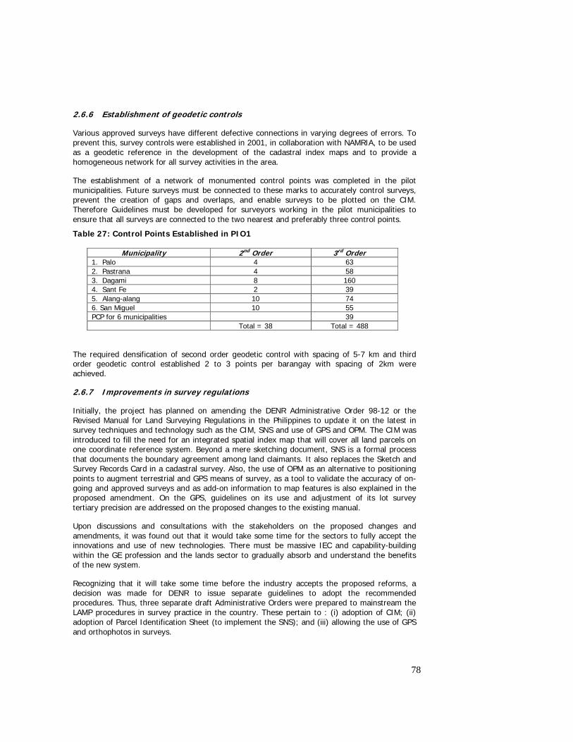
78
2.6.6 Establishment of geodetic controls
Various approved surveys have different defective connections in varying degrees of errors. To prevent this, survey controls were established in 2001, in collaboration with NAMRIA, to be used as a geodetic reference in the development of the cadastral index maps and to provide a homogeneous network for all survey activities in the area.
The establishment of a network of monumented control points was completed in the pilot municipalities. Future surveys must be connected to these marks to accurately control surveys, prevent the creation of gaps and overlaps, and enable surveys to be plotted on the CIM. Therefore Guidelines must be developed for surveyors working in the pilot municipalities to ensure that all surveys are connected to the two nearest and preferably three control points.
Table 27: Control Points Established in PIO1
Municipality 2nd Order 3rd Order 1. Palo 4 63 2. Pastrana 4 58 3. Dagami 8 160 4. Sant Fe 2 39 5. Alang-alang 10 74 6. San Miguel 10 55 PCP for 6 municipalities 39 Total = 38 Total = 488
The required densification of second order geodetic control with spacing of 5-7 km and third order geodetic control established 2 to 3 points per barangay with spacing of 2km were achieved.
2.6.7 Improvements in survey regulations
Initially, the project has planned on amending the DENR Administrative Order 98-12 or the Revised Manual for Land Surveying Regulations in the Philippines to update it on the latest in survey techniques and technology such as the CIM, SNS and use of GPS and OPM. The CIM was introduced to fill the need for an integrated spatial index map that will cover all land parcels on one coordinate reference system. Beyond a mere sketching document, SNS is a formal process that documents the boundary agreement among land claimants. It also replaces the Sketch and Survey Records Card in a cadastral survey. Also, the use of OPM as an alternative to positioning points to augment terrestrial and GPS means of survey, as a tool to validate the accuracy of on-going and approved surveys and as add-on information to map features is also explained in the proposed amendment. On the GPS, guidelines on its use and adjustment of its lot survey tertiary precision are addressed on the proposed changes to the existing manual.
Upon discussions and consultations with the stakeholders on the proposed changes and amendments, it was found out that it would take some time for the sectors to fully accept the innovations and use of new technologies. There must be massive IEC and capability-building within the GE profession and the lands sector to gradually absorb and understand the benefits of the new system.
Recognizing that it will take some time before the industry accepts the proposed reforms, a decision was made for DENR to issue separate guidelines to adopt the recommended procedures. Thus, three separate draft Administrative Orders were prepared to mainstream the LAMP procedures in survey practice in the country. These pertain to : (i) adoption of CIM; (ii) adoption of Parcel Identification Sheet (to implement the SNS); and (iii) allowing the use of GPS and orthophotos in surveys.
79
2.6.8 Issues and recommendations
The experience of the Leyte prototype has unlocked a number of issues associated with surveys:
o There is very limited capacity both within government and the private sector to undertake surveys, moreso with the use of recent technology in survey work;
o Approved surveys are defective – estimated to be in the range of 30% - such that survey validation is required prior to their use for adjudication;
o The geodetic controls are not densified enough to undertake appropriate survey work;
o The survey approval process is quite lengthy, and should be improved to provide for the use of GPS and other technology in surveys;
o The current regulations are outdated and too conservative to encourage the use of cost effective technologies and other methods to improve the quality of survey work; and
o The proliferation of incomplete surveys, abandoned contracts, and surveys completed but not supported with titling activities have left many members of the community dissatisfied with the titling program of government.
A number of recommendations have been put forward to ensure titling activities in LAMP 2 and the long term program proceed much more effectively and efficiently:
o A strong program to build the capacity of survey professionals need to be in place to support the requirements of the next phase and the long term program;
o The survey review and approval process within DENR have to be streamlined to reduce the time to issue approvals, integrate validation process in survey work, and allow the acceptance of survey returns using cost effective technologies;
o Planning and implementation of titling activities in surveyed areas have to make budget and staff provisions for survey validation to correct errors and defects and improve the efficiency and effectiveness of titling;
o Titling programs have to be supported by a program for the establishment of geodetic controls in the selected sites, well in advance of ground activities;
o The current survey regulations have to be amended to provide for flexibility and establish adequate standards for surveys; and
o Future surveys should not be conducted unless in conjunction with adjudication for titling.
2.7 Capability Building
2.7.1 Training conducted and improved and new skills acquired by staff and partners A key element to ensure the successful implementation of the anticipated reforms in the sector is the assurance of a competent pool of workers to be involved in the eventual production and delivery of the sector’s upgraded services. The Project’s human resource development function was thus conceived, developed and implemented based on this assumption. It focused on enabling project personnel to respond or contribute to the attainment of the project’s three fold objective : (i) identify possible improvements to land administration in the country; (ii) test these improvements; and (iii) develop new directions in policies and laws aimed at reforming
80
the government’s land administration services. In the course of Project implementation, the need to extend the reach of the function to other key stakeholders emerged, thus the necessary adjustments were made. The project implemented an integrated training program that drew from AusAid and World Bank GOP/LIL funds. Its scope cuts across the institutional, technical and community training needs that used two-fold approach; in-country “structured” training using competency based approach and action (experiential) learning where on-the-job training scenarios using support/mentoring techniques was a core part of capability and capacity development. Competency or standard based approach was used and enabled the Project to clearly identify training needs for specific jobs. Some difficulty were experienced in applying competency based approach at the start, but this was mainly due to the absence of established standards for both managerial and technical aspects of operations. A Training Strategy and Plan was developed and served as a tool and guide in implementing the identified capability building activities. Considering the need for innovative and modern delivery mechanism and methodologies that can accelerate learning process, the plan identified eight elements or programs that enable project staff and key stakeholders to respond or contribute to the attainment of the Project’s objectives. These elements/programs involved: (i) workshops and seminars; (ii) short courses (iii) research study scholarships; and (iv) field demonstrations, site visits, and collaborative learning environments to build the foundation skills, followed by action learning applications to produce sustainable and practical outcomes. These elements are categorized into:
1. Study Tours and Work Experience/Attachment 2. Overseas Scholarships 3. In – Country Higher Qualification Training 4. Research Scholarships 5. Training and Consultative Workshop for Policy Studies and Other National Seminars 6. Quality Assessment Panel Facilitated National Seminars 7. Process Evaluation and Training Workshops 8. Planned Training Events from the TNA Process and TA Input
As of November 15, 2004, a total of 537 training and non-training events have been organized, managed, delivered and evaluated by the HRD and Training Team. These events were attended by 16,080 participants, 9,312 or 58% of whom are male and 6,718 or 42 % are female. A total of 1,062 training days were spent. Details of these events are in Annex G.
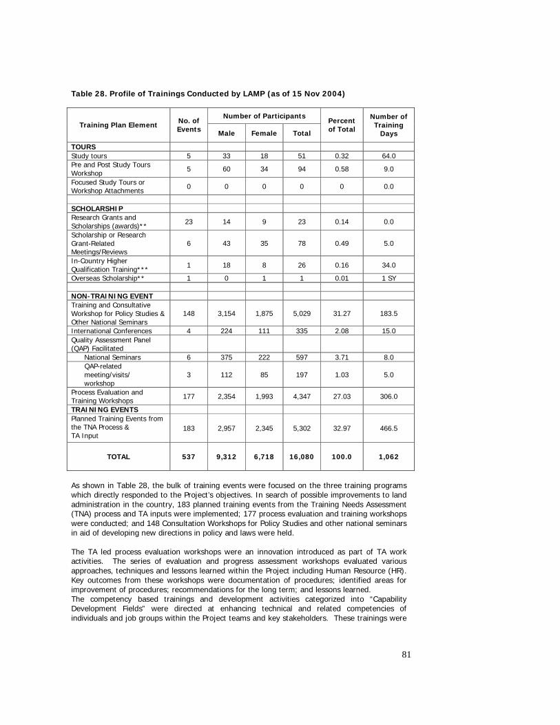
81
Table 28. Profile of Trainings Conducted by LAMP (as of 15 Nov 2004)
Number of Participants Training Plan Element No. of
Events Male Female Total
Percent of Total
Number of Training
Days
TOURS Study tours 5 33 18 51 0.32 64.0 Pre and Post Study Tours Workshop 5 60 34 94 0.58 9.0
Focused Study Tours or Workshop Attachments 0 0 0 0 0 0.0
SCHOLARSHIP Research Grants and Scholarships (awards)** 23 14 9 23 0.14 0.0
Scholarship or Research Grant-Related Meetings/Reviews
6 43 35 78 0.49 5.0
In-Country Higher Qualification Training*** 1 18 8 26 0.16 34.0
Overseas Scholarship** 1 0 1 1 0.01 1 SY NON-TRAINING EVENT Training and Consultative Workshop for Policy Studies & Other National Seminars
148 3,154 1,875 5,029 31.27 183.5
International Conferences 4 224 111 335 2.08 15.0 Quality Assessment Panel (QAP) Facilitated
National Seminars 6 375 222 597 3.71 8.0 QAP-related meeting/visits/ workshop
3 112 85 197 1.03 5.0
Process Evaluation and Training Workshops 177 2,354 1,993 4,347 27.03 306.0
TRAINING EVENTS Planned Training Events from the TNA Process & TA Input
183 2,957 2,345 5,302 32.97 466.5
TOTAL 537 9,312 6,718 16,080 100.0 1,062
As shown in Table 28, the bulk of training events were focused on the three training programs which directly responded to the Project’s objectives. In search of possible improvements to land administration in the country, 183 planned training events from the Training Needs Assessment (TNA) process and TA inputs were implemented; 177 process evaluation and training workshops were conducted; and 148 Consultation Workshops for Policy Studies and other national seminars in aid of developing new directions in policy and laws were held. The TA led process evaluation workshops were an innovation introduced as part of TA work activities. The series of evaluation and progress assessment workshops evaluated various approaches, techniques and lessons learned within the Project including Human Resource (HR). Key outcomes from these workshops were documentation of procedures; identified areas for improvement of procedures; recommendations for the long term; and lessons learned. The competency based trainings and development activities categorized into “Capability Development Fields” were directed at enhancing technical and related competencies of individuals and job groups within the Project teams and key stakeholders. These trainings were
82
aimed at providing project staff with the needed skills and knowledge to organize, plan, implement and evaluate the various tests undertaken under the Project The Quality Assessment Panel (QAP) facilitated National Seminars, provided opportunities for benchmarking key land administration and management issues. Such seminars provided a rich briefing on international benchmarks and indications for possible adaptation into the Philippine reform initiatives. In addition, it provided opportunities for stakeholders to improve their awareness of key land administration issues and how these were dealt in other countries given similar situations. The QAP symposia covered topics such as : (i) total quality management; (ii) land economics; (iii) sustainable partnerships; (iv) land administration systems and trends in land administration. Focused study tours designed for Project stakeholders and other key personnel at the strategic, managerial and operational levels were organized with specific outcomes aimed at laying important foundations for the long term LAM Program. The Comparative Study Tours for Taskforce Members, Technical Working Group, Systematic Adjudication, One-Stop-Shop operation and Valuation have proven successful in terms of establishing benchmarks against which to compare the Philippine situation with other systems in the region. It presented various insights, lessons and recommendations for long and short term LAM Program. Specific findings and recommendations also influenced the development of procedures in the prototypes. These are discussed in more detailed in section 2.7.5. Participation of key project personnel and sector decision-makers in two international conferences has been very helpful and beneficial in showcasing benchmark systems and procedures for which lessons were drawn for possible implementation in the Philippines. The International Conference on Reform in Land Administration Systems hosted by the Project was attended by key decision makers and program developers of various Asian countries land administration sector. It provided a forum for key stakeholders to gain appreciation of options to reform LAM and build stakeholder support for proposed changes. A National Policy Forum conducted in November 2004 helped galvanize policy recommendations for Congressional action prior to Committee hearings on the proposed LARA Bill. It was attended by senior policy makers from the executive and legislative branches of government. Preliminary Impacts of Capability Building A review of the impact of the HRD strategy and training plan on institutional strengthening and capacity building was conducted in 2003. In terms of progress against the capability building model, the competencies required of Project personnel to satisfy the ‘institutional’ (meaning the Project) needs had been adequately identified and placed in appropriate categories in the capability building model. Training events of one kind or another have addressed most of the listed components within each capacity field, although the depth and breadth the Project’s response to these requirements could not be studied in full in the absence of complete documentation and evaluation of these programs. Other stakeholder groups that were later identified as target groups were not clearly identifiable until various other outputs for the Project (such as the Policy Studies) were undertaken or completed. Nevertheless, their capability requirements were easily accommodated into the model. To a large extent, people in these latter groups have been catered for in what have been generally termed ‘non training events’ such as international conference and policy forum, QAP facilitated seminars and symposia, consensus building workshops. community development and advocacy activities and the range of formal and less formal workshops conducted during the four policy studies. A quick analysis of the training conducted showed that most programs conducted fall under the professional and technical capabilities area and that the cultural, project management and sustainability areas have not been given as much attention. This is due to the mainly to the
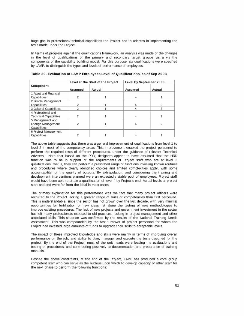
83
huge gap in professional/technical capabilities the Project has to address in implementing the tests made under the Project. In terms of progress against the qualifications framework, an analysis was made of the changes in the level of qualifications of the primary and secondary target groups vis a vis the components of the capability building model. For this purpose, six qualifications were specified by LAMP, to distinguish the types and levels of performance of employees. Table 29. Evaluation of LAMP Employees Level of Qualifications, as of Sep 2003
Level at the Start of the Project Level By September 2003 Component
Assumed
Actual
Assumed
Actual
1 Asset and Financial Capabilities
2
1
4
1
2 People Management Capabilities
2
1
4
2
3 Cultural Capabilities 2 1 4 3 4 Professional and Technical Capabilities
2
1
4
2
5 Management and Change Management Capabilities
2
1
4
2
6 Project Management Capabilities
2
1
4
1
The above table suggests that there was a general improvement of qualifications from level 1 to level 2 in most of the competency areas. This improvement enabled the project personnel to perform the required tests of different procedures, under the guidance of relevant Technical Advisers. Note that based on the PDD, designers appear to have assumed that the HRD function was to be in support of the requirements of Project staff who are at level 2 qualifications, that is, they can perform a prescribed range of functions involving known routines and procedures where clearly identified choices and limited complexities apply, with some accountability for the quality of outputs. By extrapolation, and considering the training and development interventions planned were an expectedly stable pool of employees, Project staff would have been able to attain a qualification of level 4 by Project’s end. Actual levels at project start and end were far from the ideal in most cases. The primary explanation for this performance was the fact that many project officers were recruited to the Project lacking a greater range of skills or competencies than first perceived. This is understandable, since the sector has not grown over the last decade, with very minimal opportunities for fertilization of new ideas, let alone the testing of new methodologies to improve existing procedures. The lack of new projects and government investment in the sector has left many professionals exposed to old practices, lacking in project management and other associated skills. This situation was confirmed by the results of the National Training Needs Assessment. This was compounded by the fast turnover of project personnel for whom the Project had invested large amounts of funds to upgrade their skills to acceptable levels. The impact of these improved knowledge and skills were mainly in terms of improving overall performance on the job, and ability to plan, manage, and execute the tests designed for the project. By the end of the Project, most of the unit heads were leading the evaluations and testing of procedures, and contributing positively to documentation and preparation of training manuals. Despite the above constraints, at the end of the Project, LAMP has produced a core group competent staff who can serve as the nucleus upon which to develop capacity of other staff for the next phase to perform the following functions:
84
• Systematic adjudication • Management of one stop shops • Records management • Cadastral surveys using different technologies • Cadastral index map production • Management of cadastral survey contracts • Base camp operations • Planning of integrated technical and support programs for titling and records
management • Monitoring and evaluation of land administration projects • Community relations/community organizing/social development for land administration
2.7.2 Establishment of baseline in country capacity A study was conducted in 2003 to better understand the state of capacity in the sector and the prospects as well of estimating the levels and quality of professional that can be supplied to satisfy the requirements of the long term LAM. The National Training Needs Assessment (NTNA) was carried out to systematically assess the training needs of entities and human resources in the demand side as well as the capabilities of the entities comprising the supply side of the LAM sector in providing the education and training needs of the demand side. The current levels of skills or competencies in the sector were assessed with particular attention to five priority occupations : (i) Appraiser/Assessor; (ii) Adjudicator; (iii) Cartographer; (iv) Land Records Officer; and (v) Surveyor. In essence, the study points out the lack of (a) appropriate qualifications in the country not only in surveying education but in other key occupations needed by the reformed LAM sector; and (b) capacity of educational institutions to develop such qualifications. The important findings are outlined below.
Box 6 Key Findings from the NTNA45
There are more than 200 occupational titles for the LAM sector, 65 of which were identified for the reformed LAM system. However, only about 10 of the critical occupational titles found its match with corresponding significant number of personnel. Among the critical occupational titles without corresponding match from the existing occupational skills include geodesist, GIS/LIS expert, cadastral engineer, remote sensing specialist.
Both public and private sectors acknowledge the overlapping functions among its personnel, i.e., some LAM personnel are performing functions outside of their distinct area of competence. Consequently, some of the personnel who are performing LAM related functions do not have LAM related positions and those with Lam related positions do not perform LAM related functions.
There are at least 9,981 LAM related personnel in the country today, 6691 of which or almost 2/3 are in the public sector while the rest are in the private sector. IPs can supply the estimated demand for additional GEs in the next 3 years. However, should the downward trend of GE examinees in 2003 continue for the next 3 years, there is a danger that the supply side would be able to meet the demand.
For other LAM related courses, IP could possibly satisfy some of the projected demand for personnel but not the 65 critical occupational titles for the reformed LAM program. This is due to the fact that most of these are either not included in the curriculum of IPs or that some are just developed in the workplace and through higher specialized training program, rather than school. Examples include survey aide, tax mapper, records officer, agrarian reform program technologist, land investigator, examiner, etc.
Although IPs were aware of the basic technical functions of the LAM sector, most of them do not have course/program offerings that are relevant to these basic technical functions. This is an indication of the need to embark on education and information on the reforms under the new LAM system. Although the sector has enough numbers of the traditional LAM related human resources, it lacks human resources for the specialized LAM functions like geodesist, GIS/LIS expert, etc. Except for UP Diliman, the supply side lacks the capability to produce the specialized LAM occupational titles due to outdated curriculum and courseware,
85
2.7.3 Improvement of GE curriculum As a strategic investment in developing capacity in the sector, the Project embarked on a Curriculum Development Program for Surveying Education and Training. This was an in-country higher level training for priority areas directed at providing the Project with a larger number of
outmoded and insufficient equipment and facilities, and antiquated faculty members. While some graduates have trainings on modern technology in surveying and mapping, they could not apply these due to the absence of appropriate modern equipment.
The public sector needs more training than the private sector since LAM related personnel in the public sector indicated lower competency levels than their counterparts in private sector. Aside from training on the basic technical functions of LAM sector, existing LAM personnel have to be prepared to cope with LAM reformed activities that may be assigned to them. Coping mechanism could include: (i) orientation on the requirements of the job and supplemented by formal special short term training courses; (ii) in service training tailored to the requirements of the job and supplemented by formal special short term courses; and (iii) setting up and strictly enforcing qualification standards for Lam related functions as well as hiring of specialists if such are not available within the agencies that will be merged to form the LAA. The absence of reliable and updated database prevents adequate projection of the universe of LAM related personnel; nor the number and address of geodetic engineers despite the existence of the geodetic Engineers Association of the Philippines. There is a downward trend in projected demand for additional LAM related human resources, probably due to uncertainties of actual need for additional manpower as the projection period goes longer. For 2004, the total demand for additional LAM related human resources is projected at 1,845 with the private sector accounting for a higher share of 1,059. However, only 703 of them pertain to occupational titles that have functions directly related to the occupational titles closely considered in the study. The existing institutional providers (IPs) could possibly satisfy some of the projected demand for LAM related personnel but not the 65 critical occupational titles. This is due to the fact that almost all IPs except UP Diliman have no capability yet to produce the highly specialized occupational titles. Both public and private sectors rank educational attainment as number 1 qualification in hiring LAM related personnel, experience in public/private sector as number 2 or 3, and relevant training as either number 3 or 4. Both sectors lack industry experience. Private sector lacks relevant training. This could be an indication that both sectors may not actually be practicing the said recruitment for one reason or another. In hiring personnel for some occupational titles, such as geodetic engineers, survey aide and engineers in the private sector, there is gender bias against women. This finding indicates the need to raise the awareness of the land administration sector, especially those in the private sector, on the effects of gender inequitable views and practices. Most LAM related personnel are receiving relatively low basic salary particularly in the private sector. The adaptation of the private sector to the difficulties in the real estate industry could result in personnel performing functions outside of their distinct area of competence while the practice of sub contracting may result in lower budgets for projects thereby resulting in substandard quality of the project. There are 67 existing institutional providers in the supply side of the LAM sector, 47 of which are schools, 39 are offering GE courses while 8 are offering courses with land use planning subjects. GE schools are disproportionately all over the country such that the less developed regions like the CAR and Region II have 6 GE schools each, while urbanized regions like NCR, VII, and XI have only 1 r 2 GE schools each. Consistent with CHED’s assessment, most of what are being taught in many schools offering GE are obsolete since only a handful of them are revising their curriculum regularly. Although there are several colleges and universities offering undergraduate degrees in geodetic engineering, only a handful may be considered as quality institutions on performance in GE licensure examinations, teaching resources (facilities and equipment), and quality of faculty members.
86
personnel with appropriate level of technical competencies at the same time developing the capacity of Philippine educational institutions to deliver the program in the future. It was attended by representatives from both private and public higher educational institution, private and public practitioners, professional associations, industry sectors, and related government agencies. The training resulted in the development of competency standards for professional GEs stage 1, and GE technician levels 3 and 4 including proposed revised curricula using competency or standard based approach. This has been a very intensive project and the aims were ambitious, considering the extent of influence of Commission on Higher Education (CHED) on curriculum (except for the University of the Philippines (UP)) and the role of Professional Regulations Commission (PRC)/Professional Regulatory Board (PRB) in quality control of practicing professionals. There were many lessons learned during this project : (i) the complexities of navigating the project through the boards of the educational institutions; (ii) the consistently poor outcomes for college graduates getting through the PRC examinations; (iii) the relationship between capital costs of current technology and labor costs in the Philippines; and (iv) availability of resources (teaching staff, equipment and references) to fully develop the curriculum to desired levels. On the education side, effort of CHEd’s technical panel to unify the outputs (Competency Standard) of the two activities (LAMP’s Curriculum Development Program and CHEd’s curriculum review program) was put on hold due to other priority activities of the Commission. This however, did not restrict the UP from adopting the necessary changes and went ahead and revised its curriculum. The new curriculum covered revision of existing courses and introduction of new ones, which are vital not only to the LAM sector’s reform needs but the industry’s requirements as well. Exploratory talks have also started to transform UP’s Center for Applied Geodesy and Photogrammetry into a Training Center for Land Administration. The proposed Center would offer courses on land laws, land economics and other technical courses like Spatial Data Infrastructure. Other IPs have implemented only minor changes and are still awaiting CHeD guidance. However, even if CHeD pushes for the adoption of a standard curriculum, most IPs still face the lack of resources (human, equipment and references) to implement the changes. 2.7.4 Competency standards and training manuals developed for land administration functions At the end of testing, competency standards were developed for the following key functions in LAMP: Project Planning, M&E; SD/ CRS; Systematic Adjudication; CIM; Survey; Field Validation and Records Management; OSS; HRD; PSSU; Supplementary job descriptions were also prepared based on the developed competency standard to guide recruitment and selection of staff for the various LAM functions for LAMP. Job descriptions were prepared for a total of 111 positions for the next phase and the long term LAM. These were guided by the competency standards defined for the LAM functions. Training Manuals were written to supplement Operating Manuals and guidebooks earlier developed by LAMP. Training of Trainers was also conducted and participated by HRD Team and selected unit heads as part of the long-term support to sustain the reform. At the end of LAMP1, the following training manuals are available:
1. Training Manual on One – Stop – Shop 2. Training Manual on Systematic Adjudication 3. Training Manual on Survey 4. Training Manual on Social Development 5. Training Manual on OSS Tracking and Cross Index 6. Training Manual on Records and Field Validation
87
7. Training Manual on Cadastral Index Mapping 8. Training Manual on Human Resource Development
2.7.5 Establishment of cross country benchmarks in OSS, Valuation, Titling, Records Management A total of five study tours were conducted:
o 1st Comparative Study Tour to Thailand for the LAMP Task Force Members o 2nd Comparative Study Tour to Thailand and Lao PDR for the LAMP Technical Working
Group o 3rd Comparative Study Tour to Thailand and Lao PDR for the Systematic Adjudication
Team o 4th Comparative Study Tour to Thailand and Australia for the One – Stop – Shop o 5th Comparative Study Tour to Malaysia and Australia on Valuation and Land Revenues
The reports and recommendations from the study tours strengthened the support to the reforms being pursued by LAMP. Notable among the policy recommendations from the tours were:
o simplify land administration laws and regulations; o assign a single agency to implement land administration functions and services; o implement systematic titling in the Philippines with strong community participation; o establish one valuation office responsible for setting the rules and policies on land
valuation for taxation purposes, and separate land valuation process from the political issue of taxation; and
o decentralize land administration functions and activities to LGUs. At the technical level, the findings and recommendations mainly found their way in the testing of alternative procedures to support the activities of the prototypes. Other measures to streamline and decentralize approval authorities in systematic registration and survey approval have been pursued and adopted in the prototypes. The study tour for agencies involved in One Stop Shop establishment gained insights on how these types of centers operate in other countries, and served as a benchmark upon which the direction of the emerging Philippine OSS model was developed. Particularly in PIO2, the OSS study tour enhanced the design in development at the time of the tour, and strongly influenced the preparation of the OSS vision and operating manual. The participants to these tours served as Resource Persons and advocates of change in land administration. Particularly for the technical staff, many served as the prime movers for introducing changes in the way procedures were tested and improved, while for the senior policy participants, the tours catalyzed the support for reforms in land administration at the higher level. 2.7.6 Issues and Recommendations The design of the Project’s HRD was initially limited to supporting the capacity of Project staff to carry out the tests required under the Project. This concept was modified after a recognition of the need to extend capacity building support to other stakeholders, so that they become active partners in the change program supported by LAMP. Moreover, support was limited to HRD and did not include the broader HRM functions that were later recognized as important to maintain a sound organization capable of supporting the requirements of project implementation, managing the reform proposals included. For the next phase and the long term program, support would be required for an integrated HRM and D functions for LAMP to cater to the organizational and institutional building needs of the project and the program. Competency based standards would have to be the mode for recruitment and performance evaluation so that skills gaps can be sufficiently identified and
88
responded to. To address the short supply and low levels of capacity in the sector, a comprehensive program designed at improving the quality of LAM professionals would have to be in place. Investments in capacity building would have to take account of the evolving needs of the sector as the LAA is approved, and the attendant institutional development needs are identified. Training geared at increasing middle and senior management competencies have to take a new form and should be prioritized at the start of LAMP2. Sending them all the same time to attend week long training proved impractical. The issue of scheduling has been the greatest impediment. Specific actions which are necessary to build upon the work of LAMP in the sector include the following:
• LAMP support the creation of a working party to explore potential solutions to the problem of lack of technical equipment for educating GE’s. This working group should include representatives from CHED, the institutions and industry
• The GEP be encouraged to champion the launching of a project to develop a comprehensive set of competency standards for geodetic engineers, using methodologies based on Job Analysis or Functional Analysis.
• LAMP support initiatives to source appropriate educational materials for the BSGE which are affordable, comprehensive, and which match the needs of industry.
2.8 Gender Mainstreaming in Land Administration Gender Mainstreaming in Land Administration refers to the strategy of making the pursuit for gender equity and equality a core part of land administration policies and an integral operational principle of land administration systems and procedures. To mainstream gender, LAMP pursued the following objectives: • Integration of gender concerns in the proposed Land Administration Reform Act; • Development and testing of procedures for land titling and land records management that
are equally accessible and equitably beneficial to women and men; • Creation of mechanisms for the active participation of both women and men in LAMP
implementation (i.e. policy reform agenda formulation, land titling, land records management improvement and project management); and
• Development of project management systems that ensured gender mainstreaming in all components of the Project.
The efforts of LAMP at mainstreaming gender earned for itself a recognition by the Bank as the most gender responsive project after a review of its portfolio of Bank assisted projects in the Philippines. Guided by the above gender mainstreaming objectives, LAMP 1 led by its Gender Focal Team accomplished the following: 2.8.1 Established the Organizational Foundations of Gender Mainstreaming in LAMP The Gender Mainstreaming work in LAMP started with the raising of the awareness of the LAMP workforce on gender issues and on the principles and approaches of Gender and Development. Majority of the staff of all work units of LAMP, including the Support Services Unit, underwent Gender Sensitivity Training (GST) workshops. In these workshops, the roles of all work units in gender mainstreaming were defined. Each unit also developed their targeted gender outputs and activities, as well as indicators to measure the extent of the integration of gender in their
89
work and accomplishment reports. To coordinate and supervise the gender mainstreaming work of all units, a Gender Focal Team was formed in July 2003. The Logical Framework was also gender sensitized when it was revisited in time for the preparation of the request for project extension. Hence, when LAMP entered its extension period on October 2003, the adopted gender sensitized Logical Framework became the basis of the operations. 2.8.2 Advocacy for Gender Equity in Policy Reform Agenda
In June 2002 through the initiative of the Project Management Office of LAMP, DENR issued DAO No. 13 (series of 2002) removing gender bias in the acceptance and processing of homestead patent applications and other public land applications. This repealed paragraph 8 of Lands Administrative Order 7-1, as amended, entitled “Rules and Regulations Governing the Filing and Disposition of Applications of Alienable Lands of the Public Domain or for Real Properties of the Commonwealth of the Philippines” dated April 30, 1936. With this DAO, women, regardless of civil status, shall enjoy equal rights as men in the filing, acceptance, processing and approval of public land applications. Moreover, the promotion of gender equity was included among the key principles of the proposed LARA. In the proposed Stakeholders’ Advisory Committee of the LAA, LAMP and representatives of the basic sectors resolved to ensure women’s representation by proposing the allocation of two seats for the Women’s Sectoral Council of the NAPC. 2.8.3 Involvement of women and men in LAMP Implementation In the area of policy reform advocacy, the proportion of women and men who attended the national and regional (i.e. Luzon, Visayas and Mindanao) consensus building workshops with CSOs was in the range of 30-70 percent in favor of men. This proportion was below the standard set by LAMP (i.e. 60-40% distribution, where women or men can compose the majority but should not be more than 60 percent or the minority but should not be less than 40 percent). Nonetheless, with the presence of gender advocates from the NAPC, especially its Women Sectoral Council, gender issues and concerns were integrated in the proposed LARA. In the prototype areas, activities at the municipal/city level (e.g. activities of the Local Advisory Groups of both prototypes) tended to be dominated by men. In the activities at the barangays, on the other hand, more women participated in the focus group discussions about the Project as well as in partnership structures formed, such as the BAGs and the CAGs. The above gender distribution of participants of LAMP activities was despite efforts of LAMP to disseminate information and invitations to both women and men stakeholders. Gender sensitized PIO1 land titling procedures Key interventions undertaken to ensure that both women and men had equal access to and equitable benefit from the land titling procedures of PIO1 were the following: • In involving the Barangay Council in surveying of the lands of claimants in their respective
barangays as well as in identifying, interviewing and in mobilizing land claimants to participate in the Project, PIO1 was able to mobilize the participation of both women and men.
• Identifying conjugal, paraphernal and capital properties during the social investigation and interview phases;
• Coordinating with the CENRO and the ROD in placing free patents for: a) conjugal property in the names of both spouses; b) capital land property in the name of the husband; and c) paraphernal land property in the name of the wife. Such coordination, however, still has to be institutionalized through the issuance of a corresponding policy;
• Maintaining a sex-disaggregated database on the beneficiaries; and
90
• Inclusion in the PIO1 Field Operations Manual of a set of guidelines on how to ensure equal access and benefits of women and women in the adjudication process.
Gender sensitized PIO2 land records management procedures Through the development of a sex-disaggregated land records management system, an analysis of the presence or extent of gender gap in land ownership can easily be done. This gender analysis is critical to the development of gender-related interventions. In view of this, PIO2 added a field on the sex of a land titleholder in the database system. With this, the land recording system of PIO2 is now able to produce gender data on registered land titleholders in different formats such as tables, graphs, and maps. A difficulty was faced, however, on the identification of conjugal properties in the name of the husband or wife or of both spouses as the present structure of titles does not provide data on this gender concern. 2.8.4 Formed Multi-stakeholders Groups for Gender Mainstreaming in LAMP To ensure the continuity of the initiatives of LAMP in mainstreaming gender in land administration policies and procedures, LAMP conducted Forums with its stakeholders at the national and prototype levels, including the staff of the municipal LGU and agencies involved in the operations of the OSS, on gender mainstreaming. In these forums, the stakeholders discussed and reached consensus on gender issues in land administration, on their desired situation, on the strategies to address the issues and on areas for collaboration. To ensure that these agreements will be realized and also to create a venue for continuous sharing and coordination of gender mainstreaming work, the participants agreed on the mechanism or structure that will sustain the process. 2.8.5 Developed a LAMP Gender Mainstreaming Guidebook Based on the lessons of LAMP 1 not only on the effective integration of gender in the land titling and land records improvement procedures but also in the project management system, a LAMP Gender Mainstreaming Guidebook was developed. This Guidebook will be used to ensure the continuation of the gender mainstreaming work in LAMP 2. 2.8.6 Expected Gender Impacts If the initiatives of LAMP 1 will be sustained in LAMP 2, if the identified barriers to gender equity in land administration will be addressed, and if the necessary coordination with the CENRO, ROD, LRA and other agencies for gender mainstreaming will be institutionalized, then LAMP is geared towards achieving the following gender impacts: • The easy determination of the presence and extent of gender gap in land ownership
through a sex- and gender-disaggregated land records management system will lead to a more efficient and effective development of national and local interventions for the attainment of gender equity in land administration.
• The employment of a land titling/registration procedure that ensures women and men’s equal access to and benefit from land ownership and land use will lead to the maximization of the potentials of both women and men to contribute to land development. Land development is expected to contribute to the activation of the land market.
• If access to credit and production facilities will also be made gender equitable, then women and men will have equal opportunity to earn from land resources, and therefore, participate in economic development.
• The use of gender sensitive procedures for operating the One-Stop-Shop will encourage both women and men to transact business related to land with the government and to support the formalization of land rights.
In general, gender equity in land ownership and land use is expected to lead to land development, and land development is expected to lead to economic development. This
91
assertion is also consistent with a research finding of The World Bank, which showed a positive correlation between gender equity and economic development. 2.8.7 Issues and Recommendations
The mainstreaming of gender is new to the land administration sector. The effort started by LAMP only represents the first steps feasible under the current policy and institutional environment. To ensure sustainable outcomes on gender mainstreaming, continued support would be required to undertake parallel efforts at sensitization of the policies, and the subsequent implementing rules and regulations that will be enacted. In the same vein, there is a need to improve gender sensitivity of future professionals who will be working in the next phase and the long term LAM program.
2.9 Land valuation
Land valuation support was provided to the NTRC and BLGF (the key implementing partners under the Department of Finance), following from work conducted as part of land valuation policy studies completed in 2002 and 2003. The overall objectives of this activity were to raise the quality of Government and private sector property appraisal through the development of valuation standards and promotion of institutional and legislative reform. This was to be commenced through the development of draft valuation standards; the drafting of legislative amendments and a bill for the establishment of a National Appraisal Authority; and the implementation of a simulation study to assess impacts of new standards for LGUs. It was expected that this work would continue under the subsequent phase of the LAM Program.
The valuation reforms will provide financial savings and revenue improvements for government at all levels by removing duplication of effort and by providing benefits from a wider taxation base which will lead to improved tax collections and greater equity for taxpayers. The priority requirement for successful reform will be the transfer of powers to a statutory officer thereby removing political influence. The independence of a professional valuation and assessment service is essential as it provides equity and fairness in the tax system. The development of valuation education and training programs together with the licensing for assessors and appraisers, and the creation of a national database of real property transaction and costs, all support the proposed valuation reforms and should be supported under the next phase of the LAM Program.
2.9.1 Draft National Appraisal Authority Bill
A bill for the establishment of the NAA was drafted by the staff of the NTRC with input and assistance from Valuation Advisers. The draft legislation, while inconsistent with the freeze on creation of new government agencies, nevertheless supported government objectives of tax equity, and efficiency in tax collection. Subsequent drafts may be required to stress appraisal and assessment reform rather than organizational reform. Notwithstanding, the NAA Bill has addressed appraisal efficiency in government agencies and aims to improve revenue collections from real property held by the Government.
The NAA Bill as it stood at the end of LAMP 1, established the powers and functions of the new authority, and repealed sections of the Local Government Code concerning valuation standards and appraisal practice. The Bill’s Implementing Rules & Regulations were not completed.
Consultative workshops were conducted and generally the LGU Assessors were supportive of the Bill. However, the local executives and the BLGF had reservations concerning the transfer of certain powers and functions; principally the appointment of assessors by the NAA and the transfer of appraisal and assessment functions from the BLGF to the NAA.
92
2.9.2 The Development of the Philippine Valuation Standards
Draft Philippine Valuation Standards to conform to international best practice were developed and presented to stakeholders in a series of workshops. While the draft standards were principally developed for taxation purposes, in most cases they have also met the needs of private sector. Private sector appraiser supported both the draft valuation standards developed for taxation purposes, and the proposed regulatory environment.
All workshops conducted involved LGU assessors and private sector appraisers. A common definition of Market Value was agreed - a universal international definition which had been adopted by ASEAN countries. Subsequent workshops adopted a draft Code of Ethics. A paper on the General Valuation Concepts & Principals was also adopted. A draft Valuation Standard on Mass Appraisal was drafted but not finalized. Equity and fairness were addressed with the adoption of the Market Value Standard as well as a Code of Ethics Standard.
At the time of writing, further work was required to finalize the Draft Standards, complete a review procedure and carryout amendments to the draft Assessors Manual complete with advisory notes.
A study tour was conducted for six senior officials (from DOF, NTRC, BLGF and Santa Rosa Municipality) to examine valuation standards, appraisal and property tax systems, and valuation education in Malaysia and Australia.
2.9.3 The Valuation Simulation Study
A simulation study was conducted in Santa Rosa Municipality to assess the impact of the proposed valuation standards on statutory values and tax revenues. The study was based on a sample of sales data, asking prices, reported sale prices, rentals and cost information. These data were analyzed to determine proxy market values for a wide cross section of property types in Santa Rosa and used as reference properties for comparison with the existing values used for taxation purposes. The data collected have been used to simulate resultant variations in revenue for both the LGU and BIR property taxes in Santa Rosa.
Key findings included44:
o Property values determined have been significantly influenced by political direction limiting the increases in the Schedule of Market Values (SMV) to the extent that existing SMV and Zonal Values (ZV) do not reflect market value. LGU and BIR property values were substantially below market value. Simulation revealed that the market value is about three times higher thank the LGU schedule of market values (SMV) for residential lands, while for commercial properties, the MV is about ten times higher than the SMV. The results indicate an inequity in the treatment of the different sectors for real property tax (RPT) purposes. In respect to residential land, even with the same property group, there are discrepancies in equity with large variations evident.
o Access to accurate sales and rental transaction data was extremely restricted. Sales registered and recorded by the ROD could not be relied upon. Zonal Value was often used as a substitute for the sale prices reported.
o The study indicated that following the valuation reforms, market values for RPT purposes would increase significantly. In order not to impose an excessive burden on taxpayers, assessment levels and/or tax rates should be adjusted to offset the increases in value.
o Significant inequity was clearly evident. The proposed valuation reforms would re-establish the equity between and among the various property types and locations by utilizing actual market value as a base.
44 LAMP, December 2004. Valuation Simulation Study – Further Analysis.
93
o For property values to be a fair and equitable basis for the collection of tax revenue, political interference must be removed from the appraisal process. The approval of the SMV should be a technical consideration and undertaken by a regulatory body free from political pressure.
2.9.4 Real Property Data Base
Preliminary work was undertaken in identifying the requirements for a store of transaction and cost information for use by all LGU Assessors.
A workshop with IT Managers and Assessors from three LGU’s was convened by the BLGF to consider a survey proposal to obtain necessary information on the various LGU computer systems. It was estimated that there were at least 14 different LGU computer systems around the country with no understanding on how these systems could be coordinated.
2.9.5 Education of Appraisers & Assessors
Early discussions were held with the Dean and representatives of the National College of Public Administration & Governance at the University of the Philippines to discuss various proposals for developing a degree course in real property appraisal. A discussion draft on the study areas involved was presented as well as a proposed course outline. A postgraduate certificate course in appraisal was also considered. It has been proposed that a business case be developed to determine possible student numbers, estimated costs, and the future market for graduates.
2.9.6 Issues and Recommendations
Further work would be required to put in place the required reforms to establish a sound valuation policy and institutional framework that supports the objectives of the LAM program. Key measures would include:
o Consensus building and passage of the Draft Bill establishing the National Valuation Authority;
o Consensus building and putting into force the National Valuation Standards.
o Development of a formal valuation curriculum, capability building of assessors and appraisers and enforcement of ethical standards and sanctions governing valuation practice.
o Further simulation studies in additional representative LGUs to demonstrate the impacts of the proposed valuation standards on the property market, revenue collection, and on different stakeholder groups.
Clearly, work on valuation has just started and what would be required would be sustained support to improve the valuation practice in the country to satisfy the desired economic, financial and social objectives.
2. 10 Design of LAMP2
The design of the Project’s second phase (LAMP2) was set in motion after the Project Preparation Mission in February 2003. During that Mission, the GOP, through the LAMP Task Force, the World Bank and AusAID agreed to proceed with the design of LAMP2. The prime considerations were : (i) the availability of enough lessons and experiences upon which to draw the configuration of the next phase; (ii) the need to ensure a seamless transition from LAMP I to LAMP II; and (iii) to sustain the momentum achieved through the wide consensus already reached on the reform proposals.
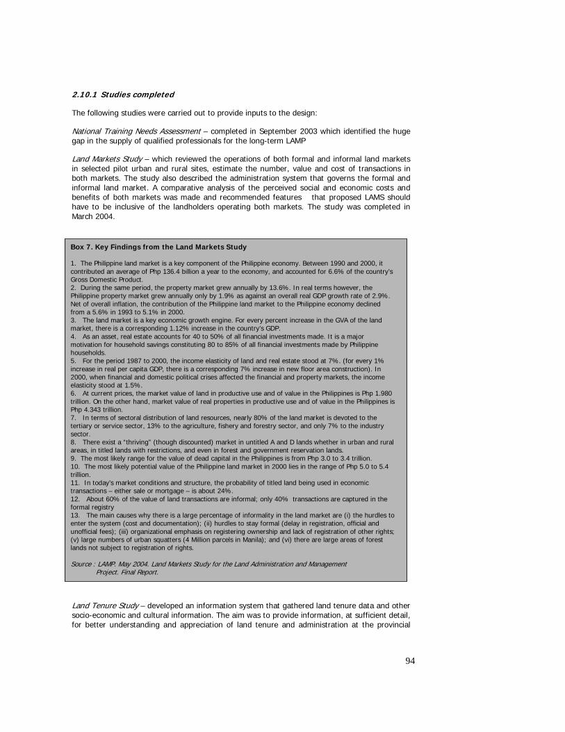
94
2.10.1 Studies completed
The following studies were carried out to provide inputs to the design:
National Training Needs Assessment – completed in September 2003 which identified the huge gap in the supply of qualified professionals for the long-term LAMP
Land Markets Study – which reviewed the operations of both formal and informal land markets in selected pilot urban and rural sites, estimate the number, value and cost of transactions in both markets. The study also described the administration system that governs the formal and informal land market. A comparative analysis of the perceived social and economic costs and benefits of both markets was made and recommended features that proposed LAMS should have to be inclusive of the landholders operating both markets. The study was completed in March 2004.
Land Tenure Study – developed an information system that gathered land tenure data and other socio-economic and cultural information. The aim was to provide information, at sufficient detail, for better understanding and appreciation of land tenure and administration at the provincial
Box 7. Key Findings from the Land Markets Study 1. The Philippine land market is a key component of the Philippine economy. Between 1990 and 2000, it contributed an average of Php 136.4 billion a year to the economy, and accounted for 6.6% of the country’s Gross Domestic Product. 2. During the same period, the property market grew annually by 13.6%. In real terms however, the Philippine property market grew annually only by 1.9% as against an overall real GDP growth rate of 2.9%. Net of overall inflation, the contribution of the Philippine land market to the Philippine economy declined from a 5.6% in 1993 to 5.1% in 2000. 3. The land market is a key economic growth engine. For every percent increase in the GVA of the land market, there is a corresponding 1.12% increase in the country’s GDP. 4. As an asset, real estate accounts for 40 to 50% of all financial investments made. It is a major motivation for household savings constituting 80 to 85% of all financial investments made by Philippine households. 5. For the period 1987 to 2000, the income elasticity of land and real estate stood at 7%. (for every 1% increase in real per capita GDP, there is a corresponding 7% increase in new floor area construction). In 2000, when financial and domestic political crises affected the financial and property markets, the income elasticity stood at 1.5%. 6. At current prices, the market value of land in productive use and of value in the Philippines is Php 1.980 trillion. On the other hand, market value of real properties in productive use and of value in the Philippines is Php 4.343 trillion. 7. In terms of sectoral distribution of land resources, nearly 80% of the land market is devoted to the tertiary or service sector, 13% to the agriculture, fishery and forestry sector, and only 7% to the industry sector. 8. There exist a “thriving” (though discounted) market in untitled A and D lands whether in urban and rural areas, in titled lands with restrictions, and even in forest and government reservation lands. 9. The most likely range for the value of dead capital in the Philippines is from Php 3.0 to 3.4 trillion. 10. The most likely potential value of the Philippine land market in 2000 lies in the range of Php 5.0 to 5.4 trillion. 11. In today’s market conditions and structure, the probability of titled land being used in economic transactions – either sale or mortgage – is about 24%. 12. About 60% of the value of land transactions are informal; only 40% transactions are captured in the formal registry 13. The main causes why there is a large percentage of informality in the land market are (i) the hurdles to enter the system (cost and documentation); (ii) hurdles to stay formal (delay in registration, official and unofficial fees); (iii) organizational emphasis on registering ownership and lack of registration of other rights; (v) large numbers of urban squatters (4 Million parcels in Manila); and (vi) there are large areas of forest lands not subject to registration of rights. Source : LAMP. May 2004. Land Markets Study for the Land Administration and Management Project. Final Report.
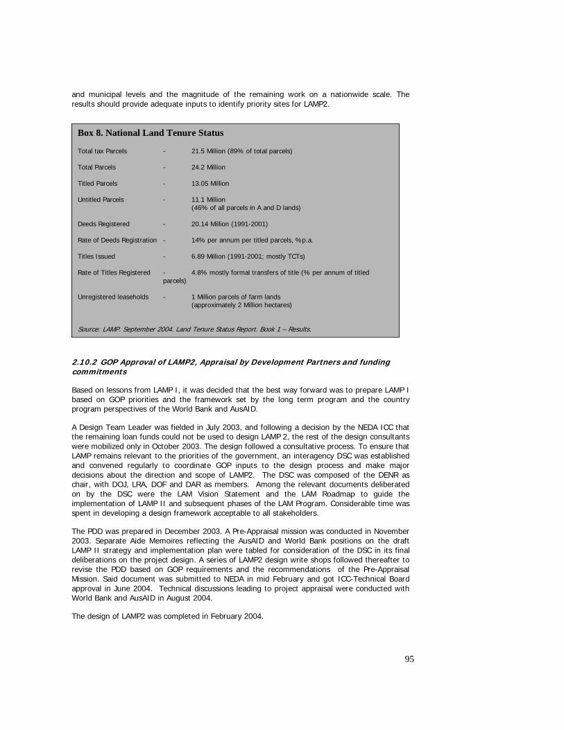
95
and municipal levels and the magnitude of the remaining work on a nationwide scale. The results should provide adequate inputs to identify priority sites for LAMP2.
2.10.2 GOP Approval of LAMP2, Appraisal by Development Partners and funding commitments
Based on lessons from LAMP I, it was decided that the best way forward was to prepare LAMP I based on GOP priorities and the framework set by the long term program and the country program perspectives of the World Bank and AusAID.
A Design Team Leader was fielded in July 2003, and following a decision by the NEDA ICC that the remaining loan funds could not be used to design LAMP 2, the rest of the design consultants were mobilized only in October 2003. The design followed a consultative process. To ensure that LAMP remains relevant to the priorities of the government, an interagency DSC was established and convened regularly to coordinate GOP inputs to the design process and make major decisions about the direction and scope of LAMP2. The DSC was composed of the DENR as chair, with DOJ, LRA, DOF and DAR as members. Among the relevant documents deliberated on by the DSC were the LAM Vision Statement and the LAM Roadmap to guide the implementation of LAMP II and subsequent phases of the LAM Program. Considerable time was spent in developing a design framework acceptable to all stakeholders.
The PDD was prepared in December 2003. A Pre-Appraisal mission was conducted in November 2003. Separate Aide Memoires reflecting the AusAID and World Bank positions on the draft LAMP II strategy and implementation plan were tabled for consideration of the DSC in its final deliberations on the project design. A series of LAMP2 design write shops followed thereafter to revise the PDD based on GOP requirements and the recommendations of the Pre-Appraisal Mission. Said document was submitted to NEDA in mid February and got ICC-Technical Board approval in June 2004. Technical discussions leading to project appraisal were conducted with World Bank and AusAID in August 2004.
The design of LAMP2 was completed in February 2004.
Box 8. National Land Tenure Status Total tax Parcels - 21.5 Million (89% of total parcels) Total Parcels - 24.2 Million Titled Parcels - 13.05 Million Untitled Parcels - 11.1 Million (46% of all parcels in A and D lands) Deeds Registered - 20.14 Million (1991-2001) Rate of Deeds Registration - 14% per annum per titled parcels, %p.a. Titles Issued - 6.89 Million (1991-2001; mostly TCTs) Rate of Titles Registered - 4.8% mostly formal transfers of title (% per annum of titled
parcels) Unregistered leaseholds - 1 Million parcels of farm lands
(approximately 2 Million hectares) Source: LAMP. September 2004. Land Tenure Status Report. Book 1 – Results.
96
2.10.3 Issues and recommendations
The design of LAMP2 followed a protracted process that begun in July 2003 and ended in February 2004. The review and approval process was also delayed, with the favorable endorsement of the proposed LAMP2 secured only in mid December2004.
A number of factors contributed to these delays in preparation:
First, contrary to the Project Appraisal Document and specifications in the Loan Agreement, NEDA did not agree to the use of loan money to finance parts of project preparation. Thus, GOP had to request AusAID for additional support so that experts can be fielded for the design. Similarly, World Bank had to mobilize additional grant funding to deploy other experts required to contribute to preparation.
Second, there was a delay by the NEDA Technical Secretariat in the review of the draft PDD. It took NEDA four months before the proposal was finally endorsed to the ICC Technical Board in June, 2004. One of the contentious issues was the establishment of a unified PMO (UPMO) following the policy issued by DBM governing the management of all foreign assisted projects.
Third, government endorsement by the Cabinet Committee has been delayed till mid December 2004, four months after it was favorably endorsed by the Technical Committee due to delays in the issuance of appropriate budget cover by DBM to secure the five year budget allocation for the project. The concern stems from the tight budget situation in the DENR over the calendar years 2005 and 2006 which, together with planned simultaneous start up date with three other new projects would pose a serious funding gap given the fixed budget cap of the Department. On hindsight, this could have been avoided had the issue been flagged during the design stage, so that the resulting proposal was tailored to fit with the medium term budget program of the Department. This is also an indication of the need for DENR to prioritize its investment program for the medium term so that only those projects which are considered as priority are given secure allocations within the next five years. These considerations should have been available at design stage for all projects.
It is recommended that the DENR urgently work out clear program priorities so that appropriate guidance can be provided to the project regarding the transition/handover requirements after LAMP. It is important that implementation gap be avoided at all costs so that the capacity already built will not be lost, and momentum already gained will not dissipate. 3.0 BENEFITS AND IMPACTS This section will present the benefits of the testing phase and discuss the potential socio economic impacts once the reforms are adopted. The main benefits expected from the pilot project are two fold : (i) ownership and broad support for the reform agenda through better understanding of its rationale and long term benefits; and (ii) access by the clients and communities within the prototype areas of cost effective titling approaches and improved land records management procedures. The extent to which a program such as LAMP will contribute to the achievement of the long term goal of reducing poverty and enhance economic growth will likewise be discussed in light of the Project’s limited experience and the findings from the various studies. In a sense, this is indicative of the Project’s major contribution of providing the base upon which to test the validity of the hypotheses of the long term program given the peculiar situation of the country’s rural areas subject to titling, the political and administrative environment of the reform and the urban setting of land records and information management interventions.
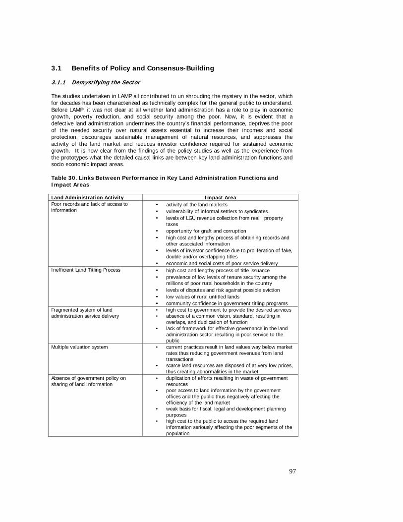
97
3.1 Benefits of Policy and Consensus-Building 3.1.1 Demystifying the Sector The studies undertaken in LAMP all contributed to un shrouding the mystery in the sector, which for decades has been characterized as technically complex for the general public to understand. Before LAMP, it was not clear at all whether land administration has a role to play in economic growth, poverty reduction, and social security among the poor. Now, it is evident that a defective land administration undermines the country’s financial performance, deprives the poor of the needed security over natural assets essential to increase their incomes and social protection, discourages sustainable management of natural resources, and suppresses the activity of the land market and reduces investor confidence required for sustained economic growth. It is now clear from the findings of the policy studies as well as the experience from the prototypes what the detailed causal links are between key land administration functions and socio economic impact areas. Table 30. Links Between Performance in Key Land Administration Functions and Impact Areas Land Administration Activity Impact Area Poor records and lack of access to information
• activity of the land markets • vulnerability of informal settlers to syndicates • levels of LGU revenue collection from real property
taxes • opportunity for graft and corruption • high cost and lengthy process of obtaining records and
other associated information • levels of investor confidence due to proliferation of fake,
double and/or overlapping titles • economic and social costs of poor service delivery
Inefficient Land Titling Process • high cost and lengthy process of title issuance • prevalence of low levels of tenure security among the
millions of poor rural households in the country • levels of disputes and risk against possible eviction • low values of rural untitled lands • community confidence in government titling programs
Fragmented system of land administration service delivery
• high cost to government to provide the desired services • absence of a common vision, standard, resulting in
overlaps, and duplication of function • lack of framework for effective governance in the land
administration sector resulting in poor service to the public
Multiple valuation system • current practices result in land values way below market rates thus reducing government revenues from land transactions
• scarce land resources are disposed of at very low prices, thus creating abnormalities in the market
Absence of government policy on sharing of land Information
• duplication of efforts resulting in waste of government resources
• poor access to land information by the government offices and the public thus negatively affecting the efficiency of the land market
• weak basis for fiscal, legal and development planning purposes
• high cost to the public to access the required land information seriously affecting the poor segments of the population
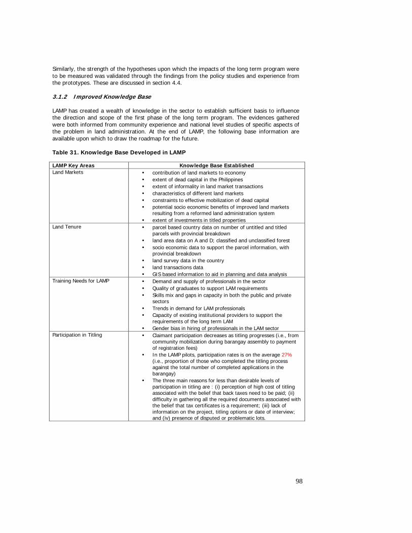
98
Similarly, the strength of the hypotheses upon which the impacts of the long term program were to be measured was validated through the findings from the policy studies and experience from the prototypes. These are discussed in section 4.4. 3.1.2 Improved Knowledge Base LAMP has created a wealth of knowledge in the sector to establish sufficient basis to influence the direction and scope of the first phase of the long term program. The evidences gathered were both informed from community experience and national level studies of specific aspects of the problem in land administration. At the end of LAMP, the following base information are available upon which to draw the roadmap for the future. Table 31. Knowledge Base Developed in LAMP LAMP Key Areas Knowledge Base Established Land Markets • contribution of land markets to economy
• extent of dead capital in the Philippines • extent of informality in land market transactions • characteristics of different land markets • constraints to effective mobilization of dead capital • potential socio economic benefits of improved land markets
resulting from a reformed land administration system • extent of investments in titled properties
Land Tenure • parcel based country data on number of untitled and titled parcels with provincial breakdown
• land area data on A and D; classified and unclassified forest • socio economic data to support the parcel information, with
provincial breakdown • land survey data in the country • land transactions data • GIS based information to aid in planning and data analysis
Training Needs for LAMP
• Demand and supply of professionals in the sector • Quality of graduates to support LAM requirements • Skills mix and gaps in capacity in both the public and private
sectors • Trends in demand for LAM professionals • Capacity of existing institutional providers to support the
requirements of the long term LAM • Gender bias in hiring of professionals in the LAM sector
Participation in Titling • Claimant participation decreases as titling progresses (i.e., from community mobilization during barangay assembly to payment of registration fees)
• In the LAMP pilots, participation rates is on the average 27% (i.e., proportion of those who completed the titling process against the total number of completed applications in the barangay)
• The three main reasons for less than desirable levels of participation in titling are : (i) perception of high cost of titling associated with the belief that back taxes need to be paid; (ii) difficulty in gathering all the required documents associated with the belief that tax certificates is a requirement; (iii) lack of information on the project, titling options or date of interview; and (iv) presence of disputed or problematic lots.
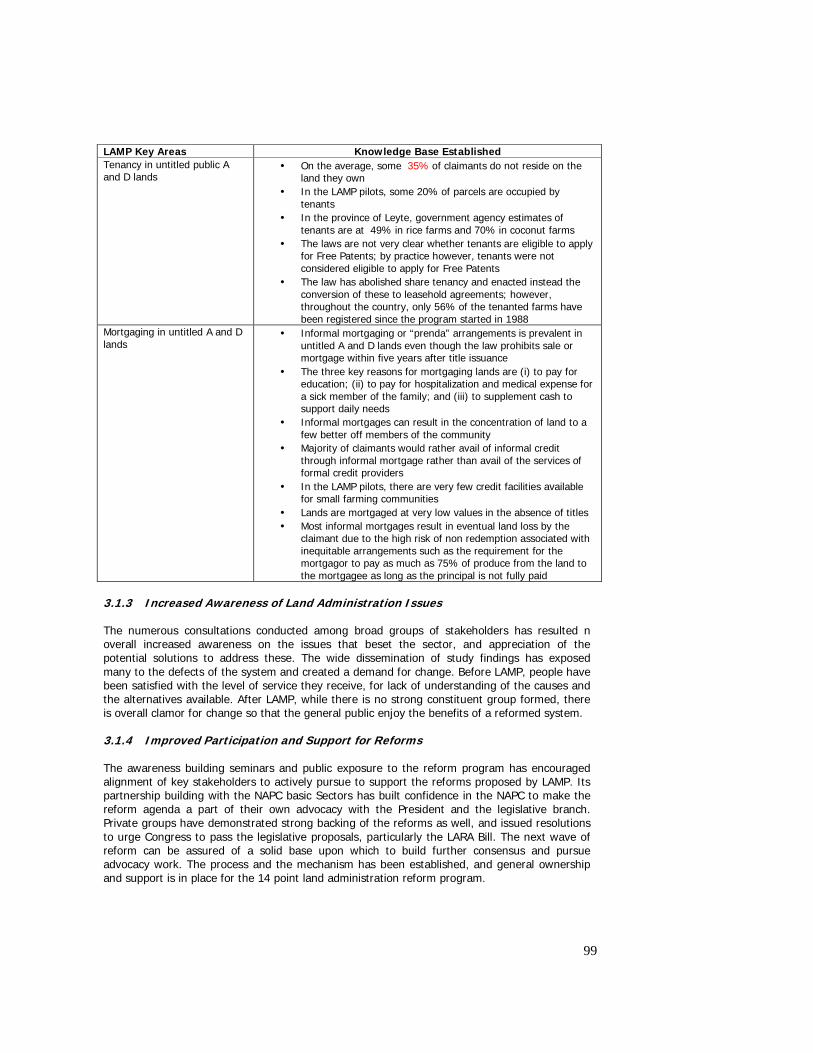
99
LAMP Key Areas Knowledge Base Established Tenancy in untitled public A and D lands
• On the average, some 35% of claimants do not reside on the land they own
• In the LAMP pilots, some 20% of parcels are occupied by tenants
• In the province of Leyte, government agency estimates of tenants are at 49% in rice farms and 70% in coconut farms
• The laws are not very clear whether tenants are eligible to apply for Free Patents; by practice however, tenants were not considered eligible to apply for Free Patents
• The law has abolished share tenancy and enacted instead the conversion of these to leasehold agreements; however, throughout the country, only 56% of the tenanted farms have been registered since the program started in 1988
Mortgaging in untitled A and D lands
• Informal mortgaging or “prenda” arrangements is prevalent in untitled A and D lands even though the law prohibits sale or mortgage within five years after title issuance
• The three key reasons for mortgaging lands are (i) to pay for education; (ii) to pay for hospitalization and medical expense for a sick member of the family; and (iii) to supplement cash to support daily needs
• Informal mortgages can result in the concentration of land to a few better off members of the community
• Majority of claimants would rather avail of informal credit through informal mortgage rather than avail of the services of formal credit providers
• In the LAMP pilots, there are very few credit facilities available for small farming communities
• Lands are mortgaged at very low values in the absence of titles • Most informal mortgages result in eventual land loss by the
claimant due to the high risk of non redemption associated with inequitable arrangements such as the requirement for the mortgagor to pay as much as 75% of produce from the land to the mortgagee as long as the principal is not fully paid
3.1.3 Increased Awareness of Land Administration Issues The numerous consultations conducted among broad groups of stakeholders has resulted n overall increased awareness on the issues that beset the sector, and appreciation of the potential solutions to address these. The wide dissemination of study findings has exposed many to the defects of the system and created a demand for change. Before LAMP, people have been satisfied with the level of service they receive, for lack of understanding of the causes and the alternatives available. After LAMP, while there is no strong constituent group formed, there is overall clamor for change so that the general public enjoy the benefits of a reformed system. 3.1.4 Improved Participation and Support for Reforms The awareness building seminars and public exposure to the reform program has encouraged alignment of key stakeholders to actively pursue to support the reforms proposed by LAMP. Its partnership building with the NAPC basic Sectors has built confidence in the NAPC to make the reform agenda a part of their own advocacy with the President and the legislative branch. Private groups have demonstrated strong backing of the reforms as well, and issued resolutions to urge Congress to pass the legislative proposals, particularly the LARA Bill. The next wave of reform can be assured of a solid base upon which to build further consensus and pursue advocacy work. The process and the mechanism has been established, and general ownership and support is in place for the 14 point land administration reform program.
100
3.1.5 Breaking Barriers Among Land Agencies and Established Partnerships with Stakeholders
While not entirely successful in getting the required level of cooperation from agencies, the project has effectively broken barriers among the agencies through understanding of bureaucratic cultures, limitations in capacity, the implications of duplicative or overlapping tasks, records management policies and the constraints imposed by the separation of responsibilities and independence in operations. While there is general resistance from some, on balance there is better appreciation of the importance of records sharing, of having unified projection maps, of integrated databases, application of cost effective methods, of the need to improve capacity, and the value of providing better service to the public. The experience of working together uncovered long entrenched values of some who were not given the opportunity to work in an interagency environment. Those who are open to change have been identified, as well as those who, regardless of the amount of capacity building and advocacy effort, will not change their opinions of the system. The motives for resisting change are better understood, and will be useful for the subsequent strategy to pursue the reform proposals, both the current ones and those that will be laid out for the next phase and the long term program. Before LAMP, there was limited participation of stakeholders in the policy development process, and opportunities for providing feedback on agency performance were rare. The interest groups who have shown strong positive potentials to be harnessed for the next phase and the long term program have grown, with the catalytic support provided by LAMP. The members of the academe and NGO groups have found alliance with LAMP to make clear statements about the issues affecting the communities and a government program which will provide the avenue for the concerns of the basic sectors to be heard, and for changes to be made. 3.2 Impacts on Service Delivery The One Stop Shops have demonstrated that service delivery can be improved by co locating the services of land related agencies in a single location such as One Stop Shops. The impact areas were : (i) reduced cost to the public; (ii) shorter processing times – as demonstrated in PIO2; and (iii) improved quality of service to the public – as evidenced from the Exit Surveys. Additional benefits were greater transparency due to the installation of monitoring and evaluation procedures; and better flow of information to the public on the procedures and fees to be paid. Critical to realizing these benefits would be strong cooperation from the agencies, establishment of baseline standards of performance and institution of suitable monitoring and evaluation mechanisms, and continuous review of agency processes so that appropriate improvements can be made in service delivery. Support would be required in setting up agency data linkages, establishment of uniform and comprehensive sets of cadastral maps, database support, and improvement in land records. 3.3 Social benefits – security of tenure and reduction of disputes
The issue of an official government-backed certificate of title for land has a range of benefits for landholders, including security of tenure for the landholder. Research in the project area established a variety of reasons for wanting to apply for a certificate of title for the land. These included wanting proof of ownership [33%], providing an asset that is capable of inheritance by children [10%], to facilitate access to credit from the bank [4%], to facilitate subdivision [3%]. However, the main motivating factor was to obtain security of tenure [46%]45.
These figures can be compared with those from an independent study46 which indicated that motivations for obtain a land title are: Land title provides security 45%; proof of ownership
45 See Report on Mortgage Study in LAMP PIO1 Areas. June 2004 46 Land Market Study for the LAM Project, January 2004
101
23%; to avoid land-related conflicts 7%; to protect the asset from land grabbers 5%; to use the land as collateral 3%.
Although not a feature separately identified in the report, it is a given that the existence of a formal title for the land will simplify land market operations such as sales and mortgages. This is because the buyer/ lender does not need extensive research to prove the ownership of the land by the seller/ borrower.47 However, two factors also mitigate against this. First is the fact that the documentation evidencing the sale or mortgage of registered land has not yet been simplified to standard format transfer and mortgage forms used in other jurisdictions. Deeds prepared or witnessed by notaries are still almost exclusively used, bringing with them the probability of a major fee payable to the notary. Secondly is the situation where revenue for transaction taxes is more effectively collected for transactions with registered land. High transaction costs [formal and informal] are not necessarily reduced by the issue of a formal title. This additional reform can be addressed in Phase II to extend the benefits to land market operations.
Although there is a degree of benefit in avoiding transaction fees in the informal market, research established that there is also recognition of the advantages of transacting within the formal system. These include simplified legal proof 36%; obtaining secure rights to land 16%; clean, clear documentation of ownership 13%; use of the asset as collateral 5%.2
The issue of a formal title resolves conclusively the existing confusion of whether untitled land is in fact private land or remains land of the state.
There was anecdotal evidence of a perception in the community that the issue of a title would increase land values. In other words, the sale price would be increased if the seller could conclusively establish a clear and unencumbered title to the land. Since land is a major basis for wealth in society, improving the value of this asset in the hands of a poor landholder who could not otherwise afford to apply for a title brings a significant benefit.
The project established that there is a perception among cultivators that the issue of a title to the landlord could weaken their leasehold tenure and lead to eviction from the land. Therefore the project established a procedure with DAR for the formalization of leasehold arrangements for land where the cultivator is not the claimant. This arrangement did not work perfectly due to lack of budget and manpower on the part of DAR to support the titling process. This arrangement needs to be strengthened in the next phase.
A further social benefit is that the issue of a formal title empowers the landholder to resist unfair acquisition of the land. This risk is higher in peri-urban areas, where the pressure to convert agricultural land is much more common and can bring significant profits to the entrepreneur. The protection of vulnerable landholders from more powerful or savvy groups will be an increasingly significant benefit from an expanded land titling program.
A long-term benefit that seems to be misunderstood in the project area is the benefit of formal land titling on the tax collections process. Claimants fear that the issue of a title will increase their exposure to real estate taxes; however, the likely impact is that the collection of more extensive and accurate records of land ownership and enhancement of the tax maps will expand the tax base and this in turn should result in the more equitable distribution of the tax burden
Another apparent social benefit of LAMP is that increased attention has been given to the status of women in land titling. The benefit here is increased protection from unfair practices. The collection and evaluation of statistics on the distribution of land ownership will ensure
47 Traditionally land has not been perceived as a commodity that can be freely traded ???
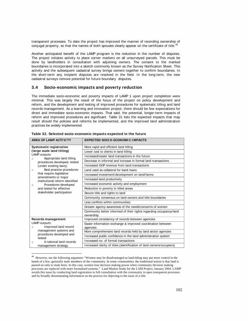
102
transparent processes. To date the project has improved the manner of recording ownership of conjugal property, so that the names of both spouses clearly appear on the certificate of title.48
Another anticipated benefit of the LAMP program is the reduction in the number of disputes. The project initiates activity to place corner markers on all unsurveyed parcels. This must be done by landholders in consultation with adjoining owners. The consent to the marked boundaries is incorporated into a sketch commonly known as the Survey Notification Sheet. This activity and the subsequent cadastral survey brings owners together to confirm boundaries. In the short-term any incipient disputes are resolved in the field. In the long-term, the new cadastral surveys remove potential for future boundary disputes.
3.4 Socio-economic impacts and poverty reduction The immediate socio-economic and poverty impacts of LAMP 1 upon project completion were minimal. This was largely the result of the focus of the project on policy development and reform, and the development and testing of improved procedures for systematic titling and land records management. As a learning and innovation project, there should be few expectations for direct and immediate socio-economic impacts. That said, the potential, longer-term impacts of reform and improved procedures are significant. Table 31 lists the expected impacts that may result should the policies and reforms be implemented, and the improved land administration practices be widely implemented. Table 32. Selected socio-economic impacts expected in the future
AREA OF LAMP ACTIVITY EXPECTED SOCIO-ECONOMIC IMPACTS
More rapid and efficient land titling Lower cost to clients in land titling Increased/easier land transactions in the future Decrease in informal and increase in formal land transactions Increased GOP revenue from land transactions Land used as collateral for bank loans Increased investment/development on land/farms Increased land productivity Increased economic activity and employment Reduction in poverty in titled areas Secure title and rights to land Community consensus on land owners and title boundaries Less conflicts within communities Greater agency awareness of the needs/concerns of women
Systematic registration (large scale land titling) LAMP outputs: o Appropriate land titling
procedures developed, tested (under existing laws);
o Best-practice procedures that require legislative amendments or major institutional reform identified
o Procedures developed and tested for effective stakeholder participation
Community better informed of their rights regarding occupancy/land ownership Improved consistency of records between agencies Easier information exchange & improved coordination between agencies More comprehensive land records held by land sector agencies Increased public confidence in the land administration system Increased no. of formal transactions
Records management LAMP outputs: o Improved land record
management systems and procedures developed and tested
o A national land records management strategy Increased clarity of titles (identification of land owners/occupiers)
48 However, see the following argument: “Women may be disadvantaged as land titling may put more control in the hands of a few, generally male members of the community. In some communities, the traditional notion is that land is passed on only to male heirs. In this case, women lose decision making power when community decision making processes are replaced with more formalized systems.” Land Market Study for the LAM Project, January 2004. LAMP avoids this issue by conducting land registration in full consultation with the community in open transparent processes and by broadly disseminating information on the process for objecting to the issue of a title

103
Easier identification of true owners by informal settlers (for negotiation and for Community Mortgage Program) Increased security of titles/ownership More efficient administration of records Easier transactions for agencies and customers Less resources required for records management More accurate titles, records & boundaries etc Increased and more equitable GOP property taxes and revenue from land transactions Less opportunity for fraud, graft & corruption Easier detection and reduced numbers of fake, duplicate & missing titles Land market stimulated Increased land development, investment and economic activity Increased employment and reduction in poverty Increased market value of property Reduced litigation (eventual) Improved access to information for community and GOP agencies
formulated
Community better informed of their rights regarding occupancy/land ownership Better access to information and services for customers Time and cost savings for customers (easier and faster transactions) Simpler billing and payments for transactions High level of public confidence in the system Land market stimulated Increased land development, investment and economic activity Increased market value of property Increased employment and reduction in poverty More efficient practices for agencies including admin of records Less resources required for records management/transactions Improved information exchange & coordination amongst agencies Improved customer service and satisfaction More accountable/transparent transactions Agencies have increased customer focus and customer friendly procedures and practices
One-Stop Shops LAMP outputs: o Two OSS offices
constructed and equipped o Systems and institutional
arrangements developed and tested for streamlined, efficient and cost-effective delivery of land transaction services and associated information in an improved customer oriented environment
Greater agency/project understanding of the perceptions/needs of female customers/users, and gender appropriate strategies Transparent valuations and valuation procedures for property owners Reduced graft and corruption in valuation More predictable valuation-based revenue generation
Valuation LAMP outputs: o Draft valuation
standards; o Draft legislative
amendments and a bill for the establishment of a National Appraisal Authority (NAA);
o Simulation study to assess impacts of new standards for LGUs.
More equitable valuation-based taxation (owners of more valuable properties would be less able to avoid/reduce their tax liability)
Many of the above socio-economic impacts are based on assumptions built into the project design logic. Furthermore, many are difficult to measure let alone attribute to LAMP activities. Some impacts are very indirect and will be heavily influenced by factors external to the project – particularly those related to investment, economic and land market activity, employment and poverty. Four key areas merit further discussion:
104
3.6.1 Tenure security Increased security of tenure is expected to arise from both first-time land registration procedures as developed in Prototype 1, and the improved records management procedures developed in Prototype 2. The relative importance of LAMP activities in land titling compared with records management for tenure security is debatable. The surveys of landholders in Leyte Province indicate that tenure security is one of the principle reasons they are seeking formal land titles. Nevertheless, the relatively low participation in land titling (often less than 50% of targeted claimants), and the minimal tangible benefits of titles (given the limited access for smallholders to formal credit) suggest that security of tenure may not necessarily be a large benefit for all landholders. This is particularly the case in rural areas where land rights are undisputed, and an informal system for land transfers and informal mortgages has been in place for many years. In urban areas, the benefits of secure tenure, clear land titles and consistent land records can be very important. This is especially true where land ownership is confused; land records are in disarray; records are missing or inconsistent among land agencies; there are occasional fake and duplicate titles; and there are sizeable populations of informal settlers. In such circumstances, improving the quality, accuracy, completeness, and consistency of land records is expected to eventually improve tenure security for residents and commercial enterprises alike. 3.6.2 Reduction of poverty While LAMP 1 contributed to poverty reduction, the project was not alone sufficient to have a significant impact on the poor. Analysis of the significance of LAMP 1 to poverty reduction must consider three important questions:
• Has LAMP 1 activities targeted the rural and urban poor? • What are the key drivers of poverty reduction in rural and urban areas? • How valid are the causal linkages between LAMP activities and poverty reduction that
are implicit in the project design? Firstly, the project was primarily concerned with policy development and development and testing of procedures, and did not directly aim to impact on poverty in the short-term. Moreover, the pilot procedures did not directly target the poor. Studies of rural residents in Leyte indicated that the many of poorest households were tenant farmers and as such were not considered eligible to claim land titles. Moreover, staff and resource constraints within DAR prevented the registration of tenancies as an adjunct to the titling process. Therefore LAMP did not impact on the security of tenure for tenants. In urban areas such as Quezon City, the poor are commonly informal settlers. These have not been directly targeted by LAMP activities. However, improved land records and ownership information has provided informal settlers and housing programs with better information to negotiate ownership and implement their programs. Similarly, improved and accessible land information assisted informal settlers to resist the exploitative activities of land syndicates. Many other factors, unrelated to LAMP activities, contribute to poverty reduction in both rural and urban areas. Some of these factors have an immediate and direct impact on poverty reduction. These include government services in health, education and agricultural extension; targeted poverty-oriented programs (e.g. housing programs for informal settlers, and land reform); and investment in transport and social infrastructure. Macroeconomic conditions influencing general economic activity (in particular, employment, prices of commodities and staples, wages, foreign direct investment, and interest rates) are other factors. In this context, security of tenure is not alone sufficient to reduce levels of poverty. Finally, the design assumptions and project logic must be examined to assess the validity of causal linkages:
105
o between land titles and poverty reduction and, o between improved land records and information management and poverty reduction Studies conducted under LAMP 1 indicated that formal credit was not readily available to rural smallholders. Moreover, most smallholder households were not prepared to risk using their land as collateral for investment purposes. Land was mortgaged (under informal prendas) only in times of family emergencies. Without access and use of credit for investment purposes, land productivity and farm incomes are unlikely to improve. Thus there is expected to be only marginal impact on poverty. Other factors conspired to limit the poverty impacts of rural land titling: o Opportunities for agricultural development were limited due to the small size of rural
holdings. o Titles in the name of the heirs of an earlier landholder (around 50% of all titles issued) will
either lead to further land fragmentation in the future, or make investment more difficult given the multiple households involved.
o Infrastructure for transport and irrigation were constraints in some areas. o There were limited agricultural extension activities and farmer skills. o Non-resident landowners and tenanted lands acted to discourage investment.49 3.6.3 Stimulation of the land market and increased land development activity Land titling programs argue that there needs to be a clear system of land registration and associated land records management to make it easier to gain agreements on rights to transfer, invest in and use land. LAMP 1 has developed and tested land administration procedures in which rights to land are determined and are recorded in a system which allows them to be traded in a secure and transparent manner. More effective land administration promotes an efficient land market and encourages greater investment. However, the impacts of LAMP 1 on land markets and land development are limited by the extent of adoption of these procedures - both within and beyond the prototype areas. Other factors will also influence the benefits to land market efficiency and land development: o Investors and the general public must be confident in the registration system before
improved land administration will result in increased land market activity and land development.
o There must be easy access to land information. o There must be no serious disincentives to the registration of subsequent land transactions.50 o There must be a sufficient number of titles issued in rural areas – so that titled properties
are not the exception. o In urban areas, the areas of informal settlement must be addressed through targeted
government programs. o There must be consistent and transparent valuation that does not distort property
investment decisions. o There must be supportive legislation including the amendment of the five year restriction on
transfer of free patent titles. o The public and investors alike must be educated in the land registration and administration
system.
49 Data on the parcels in three project municipalities in Leyte Province indicated that 35% of parcels were tenanted. One study estimated up to 70% of parcels were tenanted in some project barangays. In these cases, the gains from landowner investment must be shared with tenants, similarly tenants will not invest on land they do not own. 50 The high Capital Gains Tax (in effect a stamp duty on real property transfer - 7% of assessed value not capital gains) and the requirement to pay accumulated arrears in real property tax on subsequent transfers, are a disincentive for some to register subsequent transfers.
106
3.6.4 Increased GOP revenues and reduced GOP costs LAMP 1 land administration procedures are expected to have a significant positive impact on GoP revenues. Similarly, the proposed institutional and legislative reforms if fully implemented will generate considerable long-term cost savings through a variety of efficiency gains. The key areas for prospective revenue gains are: o More comprehensive and accurate LGU assessors’ records (as the result improved land
records and use of the CIM and cross-index) - these will generate significantly more revenue from annual real property taxes.51
o Increases in formal land transactions (resulting from land titling, better services to the public, and stimulation of the land market) will generate increased fees and taxes.
o Increases in the value of land resulting from formal titles and from greater land market activity will increase the amount of fees and taxes levied.
o Improvement in valuation through the use of transparent, equitable and consistent valuation standards has the potential to increase LGU and BIR revenue.
3.5 Environmental impacts
LAMP 1 has had no direct and significant impacts on the environment, either positive or negative. However, if the improved land administration procedures associated with titling and records management are widely implemented, there may be some indirect environmental consequences.
Land surveys and titling provides better information to government, LGUs and communities to plan and manage their land and water resources, and to invest in infrastructure. This includes the siting of easements, the planning of roads and drainage, and the management of state lands, forests and watersheds. More directly, the orthophotos produced under LAMP 1 will have important benefits for many agencies associated with development and resource planning and management.
Accurate and comprehensive cadastral and land ownership records/information are fundamental for many areas of government activity – particularly urban, LGU and regional planning.
The survey and titling of land facilitates zoning, land classification and land use planning. At the level of an individual owner, a formal land title makes it easier to apply for an alternative land use, or for land subdivision or consolidation. To the limited extent that LAMP I results in increased land subdivision there are a range of potential environmental impacts associated with higher density populations and more intensive land use.
Other indirect environmental impacts of LAMP 1 may be considered in the context of the project’s impact on land market activity, property development, and farm investment. As stated elsewhere in this report, these are longer-term and indirect impacts of LAMP 1 that are influenced by a variety of factors.
4.0 CONCLUSIONS, RECOMMENDATIONS AND LESSONS 4.1 Overall Assessment of Performance Volume 2 of the PCR presents in more detail the project’s performance in key areas. The reader is referred to the document for more comprehensive discussion of the ratings, and the major considerations for the ratings given in the different performance areas. Attached as Annex H is the summary of performance ratings for 30 performance areas discussed in Volume 2.
51 Data from Quezon City have indicated that the assessors records were missing x% of land parcels.
107
Despite the challenges it faced, the overall performance of the Project was satisfactory. Its strength lies in the support and commitment of a number of high-level officials in government and the strong support of other stakeholders, particularly the members of civil society. From all fronts, the Project was confronted by adversities – in its policy and consensus-building work, implementation of the prototypes, training and project management, and design of LAMP2. However, it remained steadfast and continued with its zeal to meet its objectives. True to its purpose, it has documented all the experience and generated essential lessons so that the next phase will be better guided in terms of the overall strategy, scope, focus, and direction. It helped that the project was staffed by fully committed professionals who share the vision of a reformed LAM in the Philippines. The LIL proved to be a suitable instrument in starting development assistance for government’s stated long-term program in a sector which is less understood, where the issues are very complex, and the existing institutions and policies are judged to be not adequate to make the returns on investments sustainable. Combining investment support with strong technical assistance was the best way of developing cost effective technical and socially responsive solutions, while at the same time, assist the government embark on a phased reform process to establish appropriate foundation for the implementation of the long-term program. As a pilot phase, the role of technical assistance, training and capacity building support was strongly recognized as critical to the success of the Project. The technical assistance broadened the perspective of analysis in the sector, and provided sufficient inputs upon which to analyze the options for addressing the constraints in the LAM sector. The objectives were satisfactorily achieved, given the working environment of the Project. The policies and reform proposals were identified, and an overall reform agenda generally developed with strong ownership by relevant stakeholders. Replicable procedures for titling and records management were also developed, providing the opportunity to gain additional improvement in the next phase and as changes are introduced in the policy and institutions. Weak achievements were noted in the areas of One-Stop Shop operations and mainstreaming of improved procedures in the agencies. Despite demonstration of the cost-effectiveness and administrative feasibility of these innovations and suggestions, the general resistance to reforms, the lack of customer orientation, and the absence of a culture of performance and accountability all have compounded the difficulties in the adoption of proposed mechanisms and procedures. Moreover, the inherent structure and fragmentation of responsibilities proved to be obstacles to the achievement of these objectives. The management arrangements were deemed suitable for the LIL nature of the project, with sufficient coordination achieved between the development partners namely, World Bank and AusAID on joint supervision and design/appraisal. As can be expected from a LIL project, the performance in terms of likelihood of achievement of development impacts and contribution to poverty reduction were not rated as satisfactory at this time. It was strongly acknowledged that the main purpose of the LIL was to identify the constraints and issues, understand better the situation so that cost effective solutions can be brought to bear in the design and implementation of the next phase. There is an expectation that a follow on program would be required, so that the outcomes from the current phase will result in the implementation of a sustainable long term program. Moreover, unless implementation of the recommended actions are made, there is very little prospect for the development impacts to be felt by the intended beneficiary groups. The report highlighted urgency of supporting the next phase, so that the constraints to the achievement of the potential impacts can be removed. Community feedback and detailed social investigations unearthed important issues associated with the reform program, and served as opportunities to validate the critical hypotheses of LAM. The findings from the field taught the Project to be more realistic in its expectations on the benefits, at the same time, developing new strategies to improve the likelihood of achieving the anticipated impacts on the target beneficiaries and other vulnerable groups.
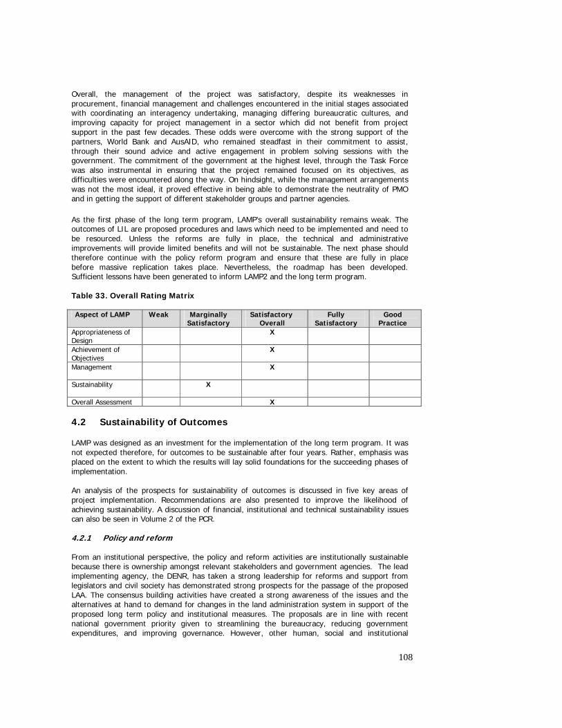
108
Overall, the management of the project was satisfactory, despite its weaknesses in procurement, financial management and challenges encountered in the initial stages associated with coordinating an interagency undertaking, managing differing bureaucratic cultures, and improving capacity for project management in a sector which did not benefit from project support in the past few decades. These odds were overcome with the strong support of the partners, World Bank and AusAID, who remained steadfast in their commitment to assist, through their sound advice and active engagement in problem solving sessions with the government. The commitment of the government at the highest level, through the Task Force was also instrumental in ensuring that the project remained focused on its objectives, as difficulties were encountered along the way. On hindsight, while the management arrangements was not the most ideal, it proved effective in being able to demonstrate the neutrality of PMO and in getting the support of different stakeholder groups and partner agencies. As the first phase of the long term program, LAMP’s overall sustainability remains weak. The outcomes of LIL are proposed procedures and laws which need to be implemented and need to be resourced. Unless the reforms are fully in place, the technical and administrative improvements will provide limited benefits and will not be sustainable. The next phase should therefore continue with the policy reform program and ensure that these are fully in place before massive replication takes place. Nevertheless, the roadmap has been developed. Sufficient lessons have been generated to inform LAMP2 and the long term program. Table 33. Overall Rating Matrix Aspect of LAMP Weak Marginally
Satisfactory Satisfactory
Overall Fully
Satisfactory Good
Practice Appropriateness of Design
X
Achievement of Objectives
X
Management
X
Sustainability
X
Overall Assessment X 4.2 Sustainability of Outcomes LAMP was designed as an investment for the implementation of the long term program. It was not expected therefore, for outcomes to be sustainable after four years. Rather, emphasis was placed on the extent to which the results will lay solid foundations for the succeeding phases of implementation. An analysis of the prospects for sustainability of outcomes is discussed in five key areas of project implementation. Recommendations are also presented to improve the likelihood of achieving sustainability. A discussion of financial, institutional and technical sustainability issues can also be seen in Volume 2 of the PCR. 4.2.1 Policy and reform From an institutional perspective, the policy and reform activities are institutionally sustainable because there is ownership amongst relevant stakeholders and government agencies. The lead implementing agency, the DENR, has taken a strong leadership for reforms and support from legislators and civil society has demonstrated strong prospects for the passage of the proposed LAA. The consensus building activities have created a strong awareness of the issues and the alternatives at hand to demand for changes in the land administration system in support of the proposed long term policy and institutional measures. The proposals are in line with recent national government priority given to streamlining the bureaucracy, reducing government expenditures, and improving governance. However, other human, social and institutional
109
structures are not sufficient to promote and sustain the policy reform agenda. Responsibilities for policy and reform are also not fully defined and assigned and participation among relevant stakeholders is not fully in place. At the end of LAMP, there still remain turf protection issues among some of the affected agencies which can derail the consensus building process. What is essential is not to lose momentum and support the efforts of stakeholders who have demonstrated strong commitment to pursue the reform agenda so that these can bring fruition. However, there needs to be continued financial support for reforms to be finally enacted by legislation. Once the LAA is approved, support would required to carry out the merging of agencies and setting up the structure, development of systems, and operating procedures for the new agency. In the case of valuation, while there is clear national government support for changing the property assessment system, financial support will be required to conduct further consensus building with other important stakeholders such as LGUs, and the legislative branch of government and implement the actions recommended. Built into these proposals are considerations of cost recovery in services, and increase in revenues by widening the tax base so that the reforms will be financially sustainable in the long term. The Project created awareness, interest and commitment from civil society, which was never there before. Prior to LAMP, the sector was shrouded in technical complexities. The challenge of maintaining this participation is important for the reform, otherwise the Government agencies will dictate the service levels on their own. With exceptions, government agencies generally find civil society participation in land administration unnecessary. Institutional structures and performance measurement programs are needed to ensure customers are not “locked out” of the sector. Until the LAA is created, with its stakeholder policy advisory committee and other measures, the LAMP2 will be needed to sustain this vital input. The changes planned for the LAM Program over the next 15-20 years will require significant human resource development. The skills and knowledge, the education and professional development courses are significantly insufficient. It is clear that capacity building will be required o go hand in hand with the application of new technologies, structures, relationships and work methods. 4.2.2 Systematic titling Systematic titling procedures were introduced by LAMP as an alternative to the existing sporadic titling approach. These procedures were proven effective in reducing the cost of titling to clients, improve participation, and improve the quality of titles. The capacity to continue these procedures have not been transferred to government staff, nor the agency procedures amended to adopt these methods. However, operations and training manuals exist to enable the DENR to adopt these procedures as part of their regular program. Unless there is development assistance, the implementation of systematic titling approach will be difficult to sustain given the current funding levels of DENR and partner agencies. Moreover, other procedures such as the development of cadastral index maps, development of an integrated records database, conduct of CRS, and systematic adjudication procedures will be difficult to sustain after the project without changes in agency procedures mandating the adoption of these systems, improvement of agency capacities to carry these out, and continued agency commitment to share records and implement the changes introduced. Other technical and administrative improvements however, have been introduced in the operations of the DENR, through the proposed amendments to the survey procedures. These will have implications to changing the survey practice in the Philippines once adopted. In preparation for LAMP2, LAMP has completely laid out the procedures for mass titling in replication areas. The best procedures have been documented and tested; the steps to be taken in a new location for the first 12 months defined in the Operations manual; training materials to simplify the process of recruitment and training in a new location have been completed; and a core of experienced staff is available as a platform on which Phase II can be built. The staff includes skilled field staff and trainers. The agreed procedures for Phase II depend in the main
110
on the use of contract staff, leaving the task of regular supervision and approvals to the government staff. This should prevent any unnecessary expansion of the bureaucracy as contracts can be terminated once the task of systematic titling is completed in an area. 4.2.3 Land records and information management The records management procedures developed under the Project would necessitate the use of equipment, access and consolidation of records, and the availability of trained staff to perform these activities in the agencies. Without further support from the project, there is the potential for these activities to be not sustained. Some agencies have shown strong interest in specific activities (such as the Survey Plan Inventory System in DENR) so that for the remaining period of the project’s implementation, plans for sustaining these can be implemented. Majority of the activities in records management however, would require changes in the internal procedures of the agencies, but without the willingness, availability of budgets in the agencies; and additional time to prepare the agencies, these will not likely to be sustained. The mainstreaming of most of the procedures would likewise require drastic modifications in the records management practices of the agencies, something which the agencies are not prepared to do at the moment. Moreover, these would require additional investments in equipment, records inventory, and training of staff so that these can be continued after the project. Without support from the next phase, the advances in land records management are expected to be taken up by the LAA when it is formed. Innovations like the CIM, cross index, SPIS and even the BILIS can be maintained by the agency. However, there will be a gap between the end of Phase I and the setting up of the LAA. PIO2 recognized this as a potential problem and have tied the sustainability of the land records management processes in Quezon City to the sustainability of the OSS. A program was undertaken to have the LRA and DENR adopt the CIM as their projection map, as well as the LGU adopting it for their tax map. At this stage, the DENR responded favorably, while the LRA and LGU are yet to commit. Irrespective, the CIM will continue to be updated in the OSS by the agency staff employed there. The SPIS has also been presented to LRA and DENR, it had a much higher acceptance, with some modifications, mainly adding the ability to capture the area of parcels created on the plan. The Cross Index will be maintained by the OSS staff, however BILIS requires qualified staff to deliver the monthly updates to the Barangays. should the LAA not be approved, or delays in its approval, or there will be a gap between the end of Phase 1 and the setting up of the LAA. A further proposal, backed by the LAG, was prepared for the Mayor’s consideration to fund the expansion of the CIM, Cross Index and BILIS into the rest of Quezon City. At the time of writing this report, there are no strong indications yet that funding will be provided to ensure a roll out of the land records management procedures in other areas of Quezon City. Without this funding, prospects for sustaining land records management activities in Quezon City are nil. From a technical standpoint, the procedures developed in land records management were made in consideration of the appropriateness of technology in database development which was used in linking and cross referencing of records, and in ensuring the records are validated before these are stored and made part of the system. This spells the difference between LAMP and the LARES-LTCP project, although both are involved in computerization of records. Primary consideration was made with regard to improving public access to records, so that the uninformed and/or uneducated are not unduly disadvantaged in dealing with government agencies on land matters. The procedures which have been documented in Operations Manuals and Training manuals are available for use by staff/agencies who may want to adopt them. However, without changes in the internal records management procedures of agencies and commitment to records sharing, the activities introduced will not be sustainable. For Phase2, innovations in land records management will be continued as part of the integrated operations in selected areas. Operations and training manuals have been developed to guide the staff of the next phase in implementation. A core of trained staff and trainers are available to share their expertise with the implementers of the next phase. However, measures should be
111
taken to ensure that this expertise is not lost in case the trained staff are not assured of employment in the next phase. 4.2.4 Operation of One-Stop Shops There are indications that at least for the Quezon City OSS, the LRA will be providing the services of a Manager, including some key staff. Other agencies have also expressed support in continuing the presence of their staff in the office so that OSS services can continue. However, it is still uncertain whether there will be budget available to cover the operational costs and whether agencies would be willing to assume these. A well defined co management agreement would need to be in place to ensure the financial obligations of running the OSS would be covered. In PIO1, on the other hand, discussions are under way for the agencies to assume responsibility for the operations and maintenance costs of the OSS. However, continuation of the support systems, such as continuous updating of the CIM and the database would require additional resources not currently budgeted in the participating agencies. The technical sustainability of the OSS would hinge strongly on the commitment of agencies to the vision of the OSS, a belief in the value of providing improved services to clients, agreement to introduce streamlining in their own internal processes, and in the continued use and updating of the CIM and cross index which are vital to ensuring the integrity of records issued and kept at the OSS. The institutional issues far outweigh the others in terms of importance. The prognosis is better in Quezon City where there is stronger cooperation of the agencies. The CIM and the records databases, however were developed with adequate consideration of their appropriateness to the current capacity and technology available in the country. Alternative methodologies have been developed to allow for flexibility, should there be provision for equipment, trained staff as well. The OSS was envisaged as an ad hoc institutional mechanism to provide more efficient delivery of land administration services to the public. While OSS can operate without the legislation to merge the agencies, the bureaucratic culture that vary greatly and the absence of a common vision and leadership to introduce changes and command compliance all contribute to the low likelihood of institutional sustainability. The continuation of OSS operations will therefore depend greatly on the goodwill and commitment of the agencies after LAMP with support from a suitable institutional mechanism for interagency collaboration, and a strong policy mandate from the government. 4.2.5 Valuation Activities under the valuation component will continue to be supported under Phase2 of LAMP. These include, adoption of uniform and consistent valuation standards, enforcement of licensing regulations and professionalization of appraisal practice, valuation education and training, further simulation and testing of valuation standards in selected LGUs, and the adoption of standard assessment procedures. There is strong commitment from the lead agency, the DOF, to establish a unit within its BLGF to implement valuation activities, and provide support to Phase 2. There is a need however, to prepare BLGF for this implementation role, to ensure a smooth transition from the NTRC, the agency currently managing the valuation component. The question of whether the GOP and DoF are able and willing to finance the continuation of valuation activities commenced under LAMP1 will depend on the availability of resources in 2005 and the extent of deficit by that time. However, valuation component has been included in the design of LAM2, and DoF has committed to provide the required budget from within its ceiling. Aside from favorable endorsement of DOF higher authorities, the valuation component under LAMP will contribute to the overall development strategy of raising revenues. One issue that may influence the financial sustainability of LAMP’s valuation initiatives is the setting up of the NAA. This proposal may have to be reconsidered in view of government’s position and its intention to streamline the bureaucracy, rather than create new organizations.
112
The valuation standards have been developed but not yet fully implemented to warrant an objective judgment about its technical sustainability. Experience from implementation will provide information on further work that may be required to develop more suitable standards. However, the prognosis for technical sustainability is good as the issues are seen as not too complex. These can be more addressed once the policy and institutional issues are addressed. The proposed valuation standards were properly documented and subjected to extensive consultation with stakeholders. However, other manuals and guidelines will still be required in the future, and additional work will be required after LAMP. Sufficient training has been provided to the staff of NTRC and BLGF who will be involved in the technical valuation procedures in the future and implement the valuation reforms. However, more training will be needed to improve the present valuation system. In terms of institutional support, there is a strong DOF family backing the initiatives. While NTRC is leading the valuation activities during extension phase, BLGF sits as an active member in the TWG and participates in the conduct of activities. There is also strong support for LAMP2 within DOF. Within the agency, available human, social and institutional resources are sufficient to promote and sustain the valuation activities and reforms, through the participation of the NTRC and the BLGF. However, a bigger core group has to be organized to sustain its momentum and expand the reforms. In terms of ownership among relevant stakeholders, the consultation processes already conducted provide evidence that stakeholders are generally supportive of the valuation recommendations. On a more long term perspective, the proposed NAA is envisioned to clearly define the institutional responsibility for sustaining the valuation activities and implement further reforms, including the creation of a regulatory function, removed from day to day operations. 4.3 Validity of Project Hypotheses based on outcomes from LAMP152 This section will make overall observations on areas where the project can contribute to existing body of knowledge in land administration and management. First, the strength of the assumption regarding the feasibility of introducing technical and administrative improvements in existing procedures without reforming the fundamental laws and institutions governing the system will be examined. Second, the rationale for the overall approach to providing support to the government’s long term program will be validated. Third, lessons related to the logic behind typical land titling and land records management projects will be presented, in light of the emerging effects, community expectations, and perceptions. 4.3.1 Feasibility of Testing during the LIL The Project was carried out as a small, pilot activity to introduce technical improvements in titling and land information and records management, recognizing that a large scale project will not make much of a difference because of the fundamental defects in the system that need to first be corrected. Experience proved that while it was possible to test new approaches and demonstrate their superiority over existing procedures, the structural and policy constraints inherent in the current land administration system limited the latitude of testing, and scope of the potential benefits of reform. If not addressed, these will narrow the potential for wide scale adoption of improved procedures to enhance operational efficiency of agencies and the overall benefits to the general public. Experience showed that some immediate reforms are possible by administrative process, however the attitude of some agencies sets a barrier to starting the improvement in the provision of services in the LAM sector. What is required is change in the values and attitude of key agency officials and a strong mandate to adopt a more client focus orientation. This has to be matched with performance standards, established in accordance with capacity for progressive improvements over time; supported by adequate budgets and action plans. These targets should be based on an analysis of the baseline levels of service delivery. The communities and the stakeholders in general should be able to participate through vigilance
52 This section was reproduced from a section of the Integrated Lessons Report
113
and continued demand for change such that agencies perform to satisfy the needs and expectations of the users of the system. 4.3.2 LIL as Precursor to LAM Program The development partners namely; the World Bank and AusAID came out with a deliberately planned support for the GOP’s long term program; starting out with a Learning and Innovation Loan. There could be no better approach at the time of the design given the complexity of the issues, the many institutions involved, and the wide scope of the problems to be addressed. The LIL gave the government the opportunity to prioritize the areas where intervention would be most strategic, the impact would be greatest and the costs and risks minimal. While implementation has been difficult, the prototypes have demonstrated the huge potential for social, economic and financial benefits to be realized if the recommended procedures are adopted. These have raised the awareness of the public, improved their understanding of the gravity of the situation, and established some degree of expectations from the providers of LAM services.
Given similar situations therefore, for projects which had to address wide ranging issues, and where the institutions and policies are judged to be not conducive to encourage sustainable impacts, the LIL is the best option to pursue in support of a stated long term program of government. In a LIL, it is essential to combine the elements of demonstration projects to show case potential benefits and impacts of what could be possible under a reformed environment, while at the same time support policy and reform measures designed to address the structural problems in the sector. The duration of the LIL, however, should consider the time required to produce demonstrable results and create a strong constituent to support long term reforms; or put in place the required changes prior to embarking on a full scale investment project.
There is a strong role for technical assistance to introduce best practice standards and provide quality support to effectively demonstrate, assess the situation, establish linkages, develop the knowledge base, support constituency building, and develop a strategic plan for capacity building for the sector. Future requirements for TA support would depend on the level of in country capacity for replication and the pace of up-scaling that will be decided in the succeeding phases of implementation of the program. This is consistent with lessons in the implementation of other land administration and management projects in other countries. 4.3.3 Design Logic of Typical Land Titling Projects
Projects involved in mass scale registration are targeted at providing a range of social, economic and financial benefits. A study undertaken by AusAID53 presents information on the development logic of titling projects. The implicit assumptions for each development logic step are as follows:
• A title gives landholders formal rights and security to their land
• Security of title reduces land disputes
• For rural land holders, more/better credit allows rural land holders to purchase more farm inputs which raises productivity and household income. This in turn, enables the land holder to practice sustainable land use in the interests of long term productivity.
• For urban landholders, more/better credit allows better investments in housing or industry, provides more employment, increases household income, etc.
• Greater household income raises living standards (some will be raised above the poverty level) and contributes to sustainable development
114
• Landholders and families whose income has increased will eventually pay more tax and hence government income increases
• A rise in land trading increases government income through fees on the increased number of transactions
• Some of the additional government revenues will be returned to the local area to increase services and infrastructure
• All the above contribute to economic growth
Community perception studies have confirmed the social value of titling in terms of providing security of tenure to claimants of untitled properties. Through a transparent adjudication process supported by consolidated and validated records across agencies, ownership rights are confirmed through the issuance of Free Patents over claimed parcels. Another social benefit expected from the Project is the reduction of disputes over land rights. In the Leyte prototype, community participation in surveys and boundary establishment has averted any possible conflicts over adjoining parcels. The participation of the Barangay Council Committee in charge of hearing and settling disputes/conflicts has also been actively sought to settle disputes among claimants. Adjudication is facilitated by the fact that the Free patent allows the government to confirm ownership over A and D lands that have been possessed for at least 30 years by the claimant. From the LAMP experience however, there are a number of legal, social, and operational constraints for the development logic to materialize, thereby limiting the opportunity of titling activities to produce the desired social, economic and financial benefits. These are summarized in the following sections. In terms of providing social benefits to communities given titles, there are some limitations of the Free Patent as a title instrument in a situation where:
• Claimants of untitled lands already enjoy some degree of tenure security through community recognition of their rights; most lands are freely traded and used as security for loans even without titling; there has been no case of forced eviction and widespread conflict due to the absence of title.
• At least 35% of claimant beneficiaries do not reside on the land, instead cultivated by tenants, agricultural workers, relatives, or other members of the community. The occupants of these parcels, who are the poorer segments of the community, are, by practice, not eligible for titling and will therefore not be directly benefited by the project.
• It only applies to agricultural lands, and therefore, excludes community members who are claimants of residential lands.
• Titles to a host of unnamed multiple heirs, thereby providing for ambiguity in ownership among heirs. The long period of possession that need to be proved has resulted in many deceased original claimants, leaving the ownership among heirs still unresolved.
• The cost of titling has made it unaffordable to a large proportion of low income farmers and other claimants.
• For low income families, the low priority afforded to titling among their hierarchy of needs has discouraged desirable levels of participation. Together with titling costs, and the complex process and evidence required, low levels of participation drives up the cost of mass titling.
• The restriction to sell or transfer free patent within five years of issuance does not provide for an exclusive right over the land.
• In areas where there is inadequate support for agricultural development, poor farmers are heavily indebted to a few well off members of the community, using untitled land as
115
prenda or collateral. These lands are at great risk of not being redeemed due to the inequitable payment arrangements between the borrowers and the mortgagees.
The expectation that titling will encourage beneficiaries to have greater access to credit to provide additional investments for improved agricultural productivity, is not likely to happen in a situation where:
• Title holders are risk averse when it comes to the use of titles as collaterals under the formal credit market, and for purposes of securing capital for agricultural improvement; rather, preference is on the use of land to secure loans to cover emergency requirements such as hospitalization, and to respond to education, and daily needs;
• Title holders put premium on the inheritance and social value of titles;
• Many parcels subject to titling are already covered by informal mortgages or prendas, and payment arrangements will make it difficult for borrowers to make additional investments in these lands to further improve productivity;
• Majority of the parcels issued titles have back taxes equivalent to at least 5 years that need to be paid to government;
• Banks and other credit providers have limited operations in the poor rural communities;
• Informal sources of mortgages and prendas provide easy alternatives to securing formal loans for farmers who have low levels of education, provide sufficient flexibility on lending rates, repayment and redemption schedule, and quick response time;
• As much as 50% of titles issued are under the names of unnamed multiple heirs which will make mortgaging even more difficult, and less attractive for the banks;
• Titles can only be used to secure credits from government banks, at much reduced loan values;
• The absence of agricultural support services in poor farming communities increases the cost and risks of agricultural investment in individual farms;
• The institution of tenancies and absentee landlords is a disincentive for investment for both landlords and tenants alike.
The expectation that titling will eventually increase the volume of formal land transactions and therefore contribute to revitalizing the land market, will not be encouraged in the immediate future in a situation where:
• There are legal restrictions on sale or transfer of free patents within five years upon issuance;
• Free patents can be issued under the names of unnamed multiple heirs which will make decisions on sale or transfers difficult;
• Tenanted lands will require negotiation for compensation or secure agreement with the tenants to have the land sold or transferred;
• Most lands have back taxes equivalent to at least 5 years that need to be paid;
• There is very little incentive to register formal transactions, or formalize re registration of lands in the absence of appropriate information, low confidence in the registry, the inefficient systems of registration, and the costly and complex processes that need to be undertaken; and
• Commercial banks currently have biased policies on the use of free patents as mortgage instruments by providing lower loan values.
To improve the prospects of achieving the desired benefits from titling, the following considerations need to be made:
116
• The approach needs to be inclusive to provide tenure security and benefits to all
members of the community (i.e., landless agricultural workers, tenants; residents of residential lands and other untitled properties).
• A clear policy on securing land rights of tenants based on existing public policy should be made. In cases where landlords have been adjudicated as the appropriate titleholders, registration of tenancies with DAR should be made.
• Adequate baseline studies or profiling of social, economic and tenure arrangements should be conducted in targeted areas so that appropriate strategies can be developed to improve tenure security.
• The restriction on transfers should be removed to provide for exclusive rights immediately to make the title a tradable instrument after issuance;
• Participation levels have to be increased through reduction in costs to the clients, simplification of the procedures, and selecting areas where the value attached to titling is higher.
• The potential land loss or land concentration to a few as a result of titling in light of non redemption of mortgages or prendas need to be carefully monitored; the possibility of registering these arrangements on the title should be explored to protect the rights of borrowers.
• Areas near peri urban areas and high prospects for rapid land development would be good candidates versus areas which are rural, where people have very low incomes, and there is little support for agricultural development which can complement titling.
• Titling programs need to be linked with existing initiatives to stimulate investments in agriculture, such as credit, extension, technology, and skills development.
• Parallel efforts have to be made to improve the system of registration and overall provision of services in land administration, including raising awareness of the value of remaining in the formal system.
• Adequate post titling surveys should be made to confirm evidence of social and economic benefits; and identify other associated issues.
4.3.4 Design Logic of Land Records and Information Management Projects In the case of LAMP, the land records and information management prototype was designed to address the low level of confidence in the land administration system. Addressing these issues would produce social and economic benefits for the community, private sector and the government. The anticipated benefits of better records management are as follows:
• Agencies involved in housing programs and community mortgage programs would have
better information to facilitate land acquisition for low income informal settlers;
• Local government units would have better access to up to date information for planning and provision of support services to communities;
• LGUs and agencies would have improved basis for revenue collection based on comprehensive and consistent set of land records;
• Improved activity of the property market due to improved efficiency in transactions as a result of accurate records, thereby benefiting investors and other players in real estate;
• Social protection for informal settlers so that other unscrupulous individuals or groups do not take advantage of poor records to extract unofficial payments in exchange for promised ‘protection’ against eviction;
117
• Improved volume of land transactions and increased activity of the land market as ownership is clarified, thereby enabling these properties to be acquired either by government, commercial enterprises and private purchases (including the informal sector);
• Reduced opportunities for graft and corruption as the public has better access to reliable records of agencies;
• Improved efficiency in administration of land related services as records are consistent, validated and more reliable.
Experience proved that there is indeed potential for sound land records management to generate the above impacts over time. However, implementation delays have prevented the full demonstration of these benefits. Operational issues, management problems, and interagency coordination concerns, difficulties of securing access to up to date records from agencies have largely been responsible for these setbacks. Lessons from existing body of knowledge has confirmed that these benefits, largely referred to as second stage of benefits, would particularly lend themselves well in areas where most of the lands have been titled, particularly in areas where lands have high values, but otherwise locked away from the formal market because of uncertainty in land rights and unreliability of records. Based on initial analysis of records in one barangay, at least 35% of LGU tax records are not updated implying that in these parcels, the government is not able to collect a large proportion of real property taxes due on the land. Multiple assessments over individual parcels also mean that the government is not properly assessing properties based on the prescribed levels. In the five barangays where the project is operating, a significant proportion of area is occupied by informal settlers, meaning these properties remain outside the formal land market as buyers and banks prefer not to transact these properties due to the potential social conflicts that may arise from the presence of such settlers. Clarification of ownership, public access to these records will facilitate the release of these properties in the market. Commercial banks also have standing policies not to accept titles as collaterals or impose low levels of assessment in areas where the registries have been destroyed, in properties where titles have been reconstituted, and in areas known to have duplicate or overlapping titles. Improved records management will be of most benefit to LGUs where there is real potential to generate additional revenues to finance local development plans. Their participation in this endeavor should be actively pursued, based on a sound demonstration of results. The commitment of agencies to share records, resources and skills to design and implement records management and validation, should be ensured to make sure that the investments would generate the desired impacts. 4.3.5 Relevance of Integrating the Reform Element in the Project There are two common approaches in dealing with policy and institutional changes in the lands sector.54 The first option is to include the changes as part of an existing land titling project. In this case, the benefit is that the project can use the credibility gained in operational titling as lever to address the more delicate policy issues. Implementation experiences also help better inform policy reform design. The disadvantage lies in the fact that any difficulties encountered in the policy area might spill over to the titling production activities. Another difficulty is that the scope may be too wide, which could dissipate management effort and focus. This may impose on the capacity of the project to handle both concerns particularly with very limited staff to support both activities. The second option is to keep major policy and institutional change as separate project. While land titling should proceed smoothly, an examination of necessary conditions may indicate the operational aspects cannot proceed until major policy/legal/institutional changes are in place. Other drawbacks would be that this will inhibit the
118
exchange of ideas and experiences; and that it may introduce too many administrative overheads. In the case of LAMP, the first option was pursued in light of the recognition of the limited opportunity to realize the full benefits of land titling and other core land administration interventions. This decision is proving to be correct as clearly demonstrated in the difficulties encountered by the project in the introduction of improvements. These impediments have been identified as caused largely by the imperfect policy and institutional support to launch a massive titling and records management program. These constraints are also evident in the area of valuation, where the simulation studies clearly demonstrated the rationale for the policy proposals to generate the required levels of revenues, and reduce disincentives to the proper functioning of the property market. The project experience though, validates established drawbacks of the approach – that is, the work has been more challenging and demanding, and to a great extent, tested to the limits the capacity of the project to deliver on both outcomes. At some point, the project had to revise its organizational structure to meet the demands of both functions. An important recommendation from this experience is that for the long term Program where it is anticipated that more wide scale reforms will be pursued in parallel with replication of titling and records management programs, it would be prudent to devise alternative implementation arrangements so that equal attention is given to both supporting and managing the reform process and providing oversight to the administrative and technical operations of project implementation. 4.3.6 Feasibility of Improved Service Delivery through Institutional Collaboration Worldwide experience has attributed the success of many land titling projects to the presence of a single agency that handles all related functions. In the Philippines, the feasibility of improving service delivery through mere institutional collaboration among the agencies was tested. The results showed that in the absence of a common vision, framework, operating systems; and the existence of inconsistent policies, overlapping functions, and lack of customer orientation, the potential for substantial improvements in service delivery is limited. Despite the goodwill and real commitment of some agencies, barriers still exist, and the cost of cooperation has been high. The experience supports documented evidence in other countries that a single agency responsible for most land administration functions would address inefficiencies, and help develop a bureaucracy that better serves the interest of the public. 4.4 Major Recommendations Presented herewith are the main recommendations from LAMP as they appear in Volume 2 of the PCR. Specific recommendations on different aspects of the project were discussed in the relevant sections of section 2, this report. 1. The World Bank and AusAID have proven strength in complex project development and complement each other. This donor partnership with GOP should be retained for the LAM Program. It is recommended there be a seamless transition between LAMP and the next phase so that the momentum is not lost. This is important for both the reform and the titling operations, which like a pipeline cannot be shut off without leaving much work in progress. 2. The introduction and sustainability of long term reform in land administration demands integration of functions within a single land administration agency. Before this occurs, streamlined processes from LAMP1 should continue to be implemented and improved. The successful passage of legislation to replace the existing inefficient titling and registration laws would be virtually impossible given the resistance to change of the existing two main agencies, LMB and LRA. Hence, it is recommended that major land administration law reform follows the creation of the single land agency.
119
3. Under a single land administration agency, land titles offices providing one stop shop services should be opened and be formed from merging of local DENR land services and ROD offices. Ahead of this, the LAM Program should open OSS in selected locations where there is sincere cooperation between the local agencies. An Executive Order should provide a framework for the cooperation agreement and performance evaluation and accountability. 4. With the dispassionate identification of what will work and what will not, with the conclusion of all policy studies and completion of all project documentation, the GOP should now undertake a long term program plan involving stakeholders. 5. Management of a major sectoral reform program requires a degree of complexity, leadership and independence well beyond normal project management, and a suitable organization structure, such as PMO of LAMP1, is essential. 6. Stakeholder involvement in the reform is essential to balance the institutional resistance and to ensure the reforms benefit the public. Strategic partnerships are recommended as a means to accelerate the consensus building using existing networks in civil society. 7. The design of the project allowed for both policy development and procedural testing to operate in parallel. This resulted in significant benefits to both types of activities, ensuring policy was relevant to the real situation on the ground, and road blocks to new streamlined procedures could be cleared by a new policy or at least in new legislation or new agency clarifications. A similar structure is recommended for the next phase. 8. In policy development, due to the cross over nature of land administration with finance, economic and social policy, it is necessary that new policy proposals are leveled off with each other and with existing policy, so that conflicts are resolved during the policy formulation stage. 9. With the drafting of three Department Administrative Orders on survey and mapping, it is recommended that DENR mainstream these new processes in selected regions. 10. Removal of local politics from the setting of valuation schedule of cities and municipalities, ready access to land market transactions, together with capacity building and the promulgation of valuation standards are high priority tasks, in order to sustain major improvement in the performance of property based taxation, the performance of 23 government agencies using valuation data, and the private sector. 11. DENR should process the draft DAO on mass titling by systematic adjudication, and advocate for the passage of the Free Patent Bill amendment which would make titling more efficient, lower cost, and more usable. 12. In rural land titling, the involvement of the LGU is essential from the start and linkages to post titling support programs are important to maximize the impact of titling. 13. The land titling registration and property valuation services are important national assets, as their processes and records provide the legal and fiscal infrastructure for many essential finance, economic and social systems. Like a rail network across the country with different rail gauge in each province, the lack of national standards on information, access and sharing information and performance/service levels is crippling the sector. It is recommended that an EO or AO be issued to bring about standardization of the land records information infrastructure. 14. Significant cost savings in titling and registration could be achieved by methods identified in the land document registration report and in the report on land survey pilots. It is recommended that the GOP vigorously pursue these cost savings methods.
120
15. A multi-dimensional approach to human resource development is recommended, involving various interventions in tertiary education, research capacity, professional development, and competency based training. This HRD package should be responsive to attracting new personnel and also the existing sector characteristics, including public sector age and education profiles as well as their distribution throughout the country, private sector’s limited role in the past in land administration, and education sector’s resource constraints. The NTNA should be supplemented by inputs from international experts. 4.5. Key lessons from LAMP The Project produced an Integrated Lessons Report which documented the experience and the results of the tests made in key aspects of LAMP. It also summarized the major lessons from LAMP implementation as well as their implications for the design and implementation of the next phase and the long term LAMP. The following presents the Executive Summary of the Report. The reader is encouraged to refer to the document for more details on the Project’s experience and lessons. 4.5.1 The Land Policy Environment Land administration particularly in societies with a diverse population is difficult. The LIL appreciated the difficulties and included policy studies in the six key areas of Institutional Arrangements, Land Laws and Regulations, Finance and Fees, Valuation, Forest Boundary Demarcation, and the Land Development Process (the last study was being finalized at the time of writing). The policy formulation process thus involved a range of approaches across a range of agency interests The strategy adopted was to involve different agencies in leading the policy formulation to ensure ownership of both the process and the resulting recommendations. Key agencies such as NEDA, DOJ, DBM, DOF and DENR Policy Group were directly involved in all stages of the studies and in the review of the recommendations. The importance of involving, and generating the commitment and support of, senior officials of concerned agencies is major factor in facilitating (as far as possible within the prevailing institutional environment) a sense of ownership and mainstreaming of policy recommendations Key Policy Formulation Lesson
The success of policy reform initiatives hinges largely on the commitment of top level stakeholders. There is, therefore, a continuing challenge to generate their support and ownership to the policy recommendations through effective communication and advocacy.
The consensus building process however extends beyond concerned agencies. Indeed the key objective of the consensus building process is to ensure the target beneficiaries realize the importance of the proposed reforms to their cause. Experience showed that the lack of clear advocacy group on land administration and the weak demand for change made initial breakthroughs in reform difficult. This was brought about by insufficient understanding of the possible improvements in the system and how improvements can improve the economy, the fiscal situation, and the social well being of the marginalized sectors. Feedback from the policy consultations revealed that while the public is not satisfied with the system, there was lack of understanding of possible alternatives, and how their situation compares with other developing countries. LAMP was able to introduce such alternatives, and the experience in other countries, and helped to improve people’s understanding of the benefits that a better land administration system can bring. Already this awareness is translating in a demand for change or reforms in the system. The important lesson here is that once this demand for change is demonstrated, there is strong potential for wide support, even for the more fundamental and drastic reforms.
121
Key Policy Consultation Lesson When proposing changes to land administration institutions and legislation, it needs to be recognized that these will take considerable time, require wide consultation and the engagement of key stakeholders.
Ideally policy formulation should be a continuous and iterative process – formulating and refining policy instruments through continuous consultation with stakeholders. In this process of introducing wide scale reforms, the support of beneficiaries is of paramount importance. If the cause remains relevant and central to the concerns of those who are conceived to be the target of reforms, it would not be difficult to get their support in moving the agenda forward. With this support, what seemed to be a very difficult process proved to be a relatively easy task. Though it is still too early to fully gauge the results, the speed by which the LAA was forwarded to Congress and the high level attention it got from the President, are indications of the fruits of these partnerships. This was manifested in the way the partnership bloomed when an understanding was reached on the relevance of the LAMP proposals to poverty alleviation. This was made possible through an in-depth understanding of the common interests of the stakeholders in general, as well as of the particular interests of each sector. Moreover, this means that the process for consensus building calls for the identification and reconciliation of the differing interests of the stakeholders, and effective management of the conflicting and irreconcilable interests. Key Policy Reform Lesson
The consensus building effort between LAMP and the NAPC Basic Sectors has been a valuable exercise in terms of ensuring support for the LAMP policy framework.
Introducing reforms in the land sector has proven to be a very challenging mandate. Experience is telling us that one needs to be flexible, and be alert for opportunities to pursue the crusade, as they become available. The bottlenecks which have come along the way have taught the Project not to rely too much on a single strategy, but to pursue all avenues as they become available. Strategic alliances are also important, especially with the civil society sector, in an institutional environment where the administrators of the system are themselves hesitant to pursue the proposals put forward by the Project. Investments in awareness, consensus building, and advocacy, proved fruitful as the partners rallied themselves in support of the reform process. For the second wave of reforms, it would be important to identify who can be relied upon to support the proposals and engage in partnership arrangements with these groups. A sound stakeholders’ analysis would be necessary to adequately prepare a consensus building and communications plan for future reform proposals. Adequate budget should be provided to enable these participatory processes to be carried out. Key Policy Integration Lesson
Policy studies need to be effectively integrated so that lessons can be drawn and applied in relation to legislation, institutional and organizational reform, capacity building and future policy development
4.5.2 The Property Market and Valuation Environment Doubtful and contested land valuations have an adverse impact on the efficiency of land markets and land administration. Within government agencies, several systems for the valuation of real properties operate and are used for different purposes. The multiplicity of systems and methods has often produced doubtful valuations whose contestation in court has, at times, caused long delays in the implementation of government programs. Below-market valuation prevents the efficient allocation of lands to their best use and leads to a relatively low tax burden which encourages land speculation and undermines the generation of revenues from land ownership. The absence of national standards and methods of valuation provide a loophole for the overvaluation of real property and underestimation of a property-
122
related lending risk. This undermines the integrity of financial transactions and the stability of the financial system. Although initially designed as one of the key policy studies, property valuation has emerged as a priority function in the LAMP Program of reform. The lessons revolve around the achievement of equity and fairness in the property tax system through the adoption of standards which are backed by a central regulatory body. Key Valuation Lesson
The reform of the valuation system requires a definite commitment to change and the creation of a National Appraisal Authority to implement reform. The priorities are the removal of political influence by the separation of the valuation and tax function and capacity building across all functions and at all levels of the valuation activity.
4.5.3 The Land Tiling and Land Information Environment Many common lessons emerge from the separate Prototypes. For example, there is a common theme concerning the technical production and application of Cadastral Index Maps; the failings of the top-down CRS approach and the institutional hurdles on the path to the establishment of the One Stop Shops. Currently, there is an abundance of laws governing the administration of land. In general much of the law is outdated and supports processes and procedures that are not in keeping with international best practice. In particular, the laws and processes to provide secure title to persons in long term possession and occupation of land have not served the community well. The laws are administered by different agencies. Many of the laws have been introduced over a long period of time without consideration of consequential amendments that their introduction will have on existing legislation. Operating an efficient and equitable land administration system under this framework has been difficult and has resulted in long delays in registration and in considerable jurisdictional overlap and duplication of functions. There has been a much greater emphasis on the use of the overloaded Court system for land registration matters than in many other countries. There is an urgent need to simplify the laws and processes, not only to facilitate the issue of titles to land and subsequent transactions with land, but also to reduce the opportunities for “informal fees” currently associated with such processes. The emphasis in the Land Titling Prototype has been on an appropriate framework of laws and regulations to implement the mass systematic titling which underpins the achievement of the goal of tenure security. The general conclusion was that the mass titling procedures available under existing laws were restrictive and inefficient. Two of the currently available approaches to titling were fully tested: Judicial Titling and the administrative process using the Free Patent instrument. The Free Patent process offered the more advantages and, with modifications based on the lessons learned, would be suitable for the large scale systematic titling envisioned in the LAM Program. Key Land Titling Lesson
Mass titling is superior to sporadic titling and the system should be greatly improved by the abolition of the Judicial processes associated with the issue and registration of title to land in favor of simple Administrative processes;
The experiences in both Prototypes underscore the complexities in predicting the beneficiaries of land titling and determining the economic motivations of the various land claimants. Poverty reduction can only be realized if titling results in increased land productivity and in the use of titled lands as capital in a stable land market. Without social preparation and support services the capacity to function in the land market may even be inimical to the interest of small and tenant farmers who are often chronically in debt. Therefore it is important that titling activities are not simply driven by targets and considerations of production efficiency. Capacity building and empowerment of the beneficiary must also take place. An emphasis on post-titling activities
123
is needed to facilitate linkages between government LAM agencies to exploit the benefits of titling and to offer the beneficiaries access to services and finances to develop the land. Also there is a need to build capacity at the Local Government Unit level for economic development to occur that can benefit entire communities. Under this approach the stakeholders are the entire LGU population and they will benefit from secure tenure, increased government revenue from formal land transactions, improved LGU governance, local development plans that respond to identified community needs, and improved access to other social and infrastructure supports provided by government agencies and donor programs. In this way LAMP GOP subsidization of systematic adjudication provides benefits to all citizens and builds the advocacy base needed to shift to a demand-driven mode. Key Socio-Economic Lesson
Tenure security through titling must be linked to broader development programs for the envisioned social, economic and financial outcomes to be fully realized. An emphasis on post-titling activities is needed to facilitate linkages between government LAM agencies to exploit the benefits of titling and to offer the beneficiaries access to services and finances to develop the land.
Land records management can be improved leading to better detection and prevention of fake, double, overlapping and fake/spurious titles through the introduction of new systems. These are: the cadastral index map; the cross index of records, and the record validation procedures, all designed to improve records integrity and detect inconsistencies, gaps, and missing records. The community relations aspect of the land records Prototype, on the other hand, was meant to continuously educate the general public of the procedures and policies relating to land in an effort to rebuild trust in the system and to counter the work of syndicates who have taken advantage of the imperfections in the records system and the lack of understanding by the public. When introduced as part of the land administration system, these methods will have added value of providing more accurate land records information to the general public, other government agencies, and to the private sector or business community in facilitating investments in land. Improved land records management has enormous potential for improving LGU revenue collection, and stimulating activity in the land market. LGUs should play a significant role in supporting and sustaining these initiatives and support should be provided to build LGU capacity, and to promote best practices in records management. For the long term, development of land records databases should be guided by a national strategy, and a full understanding of key agency requirements. An appropriate data management system will be required for a more extensive development. The equipment and structures will need to be fully specified, as well as work carried out on transaction rates, file sizes, etc., to determine the database capacity required. Key Land Records Lesson
Little improvement in can be achieved in land records quality, security and access efficiency without the strong support of all agencies acting within the framework of a national strategy for the management of spatial data.
In the design of the LIL the technical capacity of all sectors concerned with the LAMP was over estimated. The availability, access to and capacity to apply, modern technology was similarly over-estimated. For example the cadastral survey system is heavily reliant on traditional and expensive methods which are ground measurement intensive. The GOP sought 100 years ago to shift from a deeds system to a parcel-based system based on government guaranteed certificates of title. To date only about 50% (this figure is open to dispute) of land has been surveyed and about 20% has successfully been registered. The clear lesson is that reforms in the technical environment are needed to overcome this severe backlog. To further exacerbate the problem there are severe quality problems in the existing surveys and the high cost of new cadastral surveys. The latter is undoubtedly due to the field measurement
124
intensive methods employed and the failure to adopt the alternate techniques tested in the Prototypes emerges as a real barrier to the LAM Program. Key Technical Lessons
A proper balance between accuracy and efficacy is essential and alternate approaches, which offer significant potential for efficiency without compromising the adequacy of boundary definition and CIM production, must be introduced; Practitioners must be educated in modern cadastral survey and mapping techniques and trained in the application of modern technology; and Industry economic viability must be strengthened to allow investment in modern technology and methods.
4.5.4 The Institutional Environment From the outset it was recognized that LAM in Philippines functioned in a complex institutional setting. There is a multiplicity of agencies involved in land administration with no appropriate mechanisms for coordination. Moreover, there is no over-all institutional mechanism to resolve outstanding issues. As a result, many issues have remained unresolved for a long time. For example, a primary focus upon land titling, registration of transactions and the related activities of land classification, surveying and mapping involves core agencies such as the LMB and Regional Offices of DENR; NAMRIA, an attached agency of DENR; the LRA and ROD within DOJ; the DAR; and the NCIP. The institutional arrangements for land valuation and land management functions add further to this list. While initiatives such as the One Stop Shops can be introduced to improve services to clients of the present land administration system, the institutional inefficiencies inherent in the current system cannot be substantively addressed without legal and institutional reforms of the system itself. Attempts to amend the formal roles and functions of agencies as specified by the Administrative Code, or to take ‘scrap and build’ institutional restructuring initiatives, will have relatively little impact unless undertaken as part of a broader reform plan for the land administration system as a whole. To give an obvious example, so long as the GOP maintains both judicial and administrative processes for original land titling it will require two sets of (overlapping) procedures to administer them. There may be efficiency gains from co-locating or merging the LMB/LRA administrators of these procedures within a single organization, for example by providing the managerial means to actively coordinate and integrate land information and records. However, the direct efficiency gains from this action alone are likely to be small relative to those potentially available from abolishing one or other form of titling procedure Key Service Delivery Lesson
Without wide ranging reforms in policy and institutions any technical and administrative will only provide limited benefits and are not sustainable
Based on a set of structural and operational principles the LAMP has recommended the establishment of an autonomous Land Administration Authority to undertake all of the relevant functions. The LAA will be established by legislation and, while progress is evident, this is realistically a strategic rather than immediate solution. In the interim alternate means of coordination, modeled on the One Stop Shop, must be continued and there are lessons which can be applied to facilitate this. In continuing down this path the lack of cooperation from key provincial leaders of stakeholder agencies can have severe impact on the smooth implementation of the OSS. Recognizing the absence of legislative power to command unity, the partnerships with the key agencies will need to be strengthened and possibly expanded for LAMP II. At the same time it must be recognized
125
that successful partnerships depend less on the letter of the MOA, and more on the spirit of the partners themselves. Key Institutional Reform Lesson
Interagency coordination will generate a certain degree of efficiency however this will be achieved at great cost and effort. Consistent with other successful models the creation of a single agency is expected to provide the better option to enable government to respond to public service demands.
4.5.5 Project Management Arrangements
The Project was managed by an independent PMO staffed by personnel from the participating agencies to perform both managerial and technical roles. The Project encountered difficulties in the quality and levels of inputs from detailed staff from agencies. Despite the experience, it is recommended that for the next phase and the long term LAM, and in the absence of the LAA, involving detailed staff in implementation is still desirable from the point of view of sustainability. However, the project should take account of:
• Differing bureaucratic cultures; • Lead time to level off on project objectives, strategy and work norms and processes; • Incentive structure to maintain their participation; • Equal chances of promotion in their mother agencies; • Adequate preparation for their roles in the project.
LAMP has highlighted the lack of sufficient number and quality of staff in the sector to satisfy the competencies required to implement the long term program. Unavoidably, implementation of the next phase would require capacity building on a massive scale both for those who are already in government and in the private sector. To make effective use of contract staff, consideration should be given to adequate incentives and training targeted at making them capable of carrying out their responsibilities under the Project. Particularly for a project which makes investments in capability building, it is essential that their tenure be made co terminus to the Project to ensure that training support is appropriately used for effective project implementation. The next phase of LAMP is expected to carry forward the policy work to put in place the required environment for sustainable long term Program. In implementing a major reform program such as LAMP, it is important for the Project Manager not only to possess adequate management skills, but he/she should have bureaucratic clout as well to effectively deal with partners from partner agencies, and political savvy, to ensure the reform agenda is sufficiently discussed and given attention at both the executive and legislative levels of government. The merits of having a professional manager to ensure quality implementation of a major government program need to be considered in the absence of a suitably qualified key official from government. Management and coordination of donor inputs has been a challenge for LAMP, given the support of AusAID and the World Bank, each governed by separate policies and procedures, with inputs packaged under separate project documents and specification of results and deliverables.
To be more effective and maximize inputs from assisting donors;
• Project inputs and frameworks need to be synchronized. Desired outputs within a certain timeframe will be achieved without delay by having common start up dates for all inputs;
• Having a single project document will be desirable to facilitate implementation. If this is not possible, the logical frameworks should be unified, in order to provide a clearer direction to the project by clarifying the interests of different project stakeholders.
126
• During implementation, it is essential to integrate deliverables of all parties so that the project can move in a single direction, and inputs from all project actors as well as timing of preparation can be planned to ensure the project, and not just a part of it, assumes responsibility for producing all the required deliverables.
4.5.6 Design of LAMP2 The design of LAMP2 was made jointly by AusAID and the World bank in recognition of one very important lesson at the beginning of LAMP – that there needs to be a single design and logframe to clarify project deliverables and measurements of performance. Project preparation proceeded with additional assistance from the donors in light of disapproval to use loan funds for design activities, as envisaged in the Project Appraisal Document. After the preparation of the Project Design Document (PDD), the PMO spent additional time revising the document to meet the requirements of NEDA.
Two key lessons emerge from this experience: (i) In designing the next phase of LAMP, project documentation made during preparation will need to be guided for consistency with the information required by GOP and all donors to ensure timely appraisal by both parties. (ii) It is important for project appraisers to fully understand the project and program to avoid delays in the review process. It took several months for NEDA to complete its appraisal due to various questions and clarifications relating to project understanding and appreciation. Adequate engagement by staff responsible for appraisal in the form of regular visits to project sites, supplemented by regular submission by PMO of reports and sufficient coordination will enhance project appreciation, thereby enabling a well informed and substantive review of the merits of the proposal.
Timely approval of project can be ensured if the following considerations are made:
o Adequate lead time for project preparation so that there is seamless transition from one phase to the next. In consideration of LAMP1 experience, design should ideally start two years before target commencement of the next phase, to take account of the review process in GOP and partner governments/organizations.
o There should be an agreement early on, among key stakeholders, i.e., government and
donors on the overall design framework, strategy and scope for the subsequent phase. In this regard, it may be necessary to have an options paper ready for consideration before full blown project preparation commences. This is particularly important in a multi donor project, where there is a strong need to satisfy country assistance frameworks and strategies and approaches to implementation, with the requirements of the Project.
o There should be an assurance of funding for the design of the next phase. Commitments
should be secured early on so that the design team can do its work and prepare the required documentation for timely review. In the case of LAMP, before preparation could start, additional funding had to be sought from WB and AusAID due to the project’s inability to use the loan funds to finance project preparation activities, in keeping with government’s policy on the matter. This is despite the provision in the Loan Agreement that a key component to be financed is the design for next phase.
o The Government should make assurances of the levels of funding it can provide to the
Project over the medium term program. This should be considered together with the funding requirements of other programs programmed for implementation in the pipeline. Project approval suffered major setbacks due to the difficulty by DENR to respond to the requirement of providing sufficient budget cover for the proposed LAMP2 as designed due to budgetary constraints. It would help if this information is made available to the designers at the start. As a result, several adjustments in targets and funding levels of the project had to be made between the time the design was completed and the project was approved by the NEDA Board.
127
REFERENCES Land market Study of the LAMP – Draft Final Report - Urbis Philippines Inc January 2004 Ariaso, D. 2004. A Review on the Existing Mechanisms and Structures in the Resolution of Land Related Disputes in Rural Areas. PA-LAMP Research Grants LAMP, 2004. Land Tenure Study. LAMP 2002.Titling; Realities on the Ground. Carlos Isles. LAMP, 2003. Free Patent Baseline Study. LAMP, 2004. Review of Laws, Policies and Institutional Set-up on Tenancy in the Philippines. LAMP, 2004. Mortgage Study for LAMP PIO1 Areas Cassanova, Ramon. 2004. Legal Opinion on Payments of Cadastral Costs and Interests Thereon. LAMP, 2004. Factors for Participation of Land Claimants in the Land Titling Activities of PIO1 Mortgage Study for LAMP PIO1 Areas LAMP, 2003. CBM and E Report in Holy Spirit. Genzola, Ma. Cecilia. October 2003. Squatting Syndicates: From the Viewpoint of Informal Settlers. A PA-LAMP supported Research Grant. LAMP, 2003. CBM and E Report in Holy Spirit. Mas, Dennis. September 2004. Case Study on Land Transfers by Informal Settlers in Purok 4, Luzon Avenue, Quezon City. PA-LAMP supported Research Grant. de la Cuz, Leland. September 2004. Social and Institutional Dynamics of Settlement in Informal Settler Communities. PA-LAMP supported Research Grant. LAMP, 2003. CBM and E Report in Holy Spirit. LAMP, June 2003. Final Report on National Strategy for Land Records Management. LAMP, 2003. Final Report on National Strategy for Land Records Management. LAMP, 2003. OSS Exit Survey in PIO1. LAMP, 2003. National Training Assessment Study for LAMP. LAMP, 2004. PIO2 OSS Exit Survey. LAMP, 2004. BILIS Documentation of Sample Cases. LAMP, 2004. Policy Studies on Access to Land Information in Government.