Embed Size (px)
Citation preview

LAND NAVIGATION WITH A COMPASS
By Terry Haider
Can you find yourself on a map with a compass, or without, by looking at a map?
The goal of orientation is to determine that precise point on the surface of the earth were you stand.
Finding out exactly where you are is usually a relatively simple affair. It's done by looking around and
comparing what you see with what is on a map. In our map class we covered color and contour lines. By
color we know the vegetation that were in, (trees, brush, or a meadow, or at the Rivers edge.) And
contour lines tell us whether were in a valley or on a mountain. Another way is by using a compass in
finding where you're at on a map.
Three types of compass:
A) Base plate compass
B) fixed Dial compass
C) magnetic card compass
A base plate compass has many features; 1) Needle
2) Direction of travel line
3) Transparent base plate
4) Rotating case, or as azimuth,
with the graduated dial.
5) Rear sight
6) Front sight
7) Orienting arrow
Fixed Dial compass; 1) Needle
2) Dial
3) Pivot
Magnetic- card compass; 1) the needle and Dial are
joined on a card to operate as
one.
Orientating your compass:
Base plate compass or inundated to magnetic north, all readings are in degrees magnetic. Base plate
compasses orientate to geographical North in a place (e.g. San Diego in 1994) with the declination is 14°
East. In a place (e.g. New York City in 1994) where it is 14° West. In both cases, all readings are true or
map degrees.
Bearings
A bearing is a direction of one object from another, measured as a horizontal angle from a fixed
baseline. The baseline is either true North or magnetic North, in our case. When taking a bearing with a
fixed plate compass or a fixed Dial compass, always hold it straight in front of you; looking at it from the
side does not give you a correct reading. They compass with an optional direction of travel arrow, this
memory aid to Mark the desired bearing on the dial.
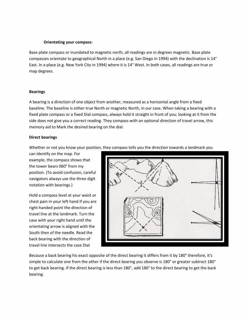
Direct bearings
Whether or not you know your position, they compass tells you the direction towards a landmark you
can identify on the map. For
example, the compass shows that
the tower bears 060° from my
position. (To avoid confusion, careful
navigators always use the three digit
notation with bearings.)
Hold a compass level at your waist or
chest pain in your left hand if you are
right-handed point the direction of
travel line at the landmark. Turn the
case with your right hand until the
orientating arrow is aligned with the
South then of the needle. Read the
back bearing with the direction of
travel line intersects the case Dial
Because a back bearing his exact opposite of the direct bearing it differs from it by 180° therefore, it's
simple to calculate one from the other if the direct bearing you observe is 180° or greater subtract 180°
to get back bearing. If the direct bearing is less than 180°, add 180° to the direct bearing to get the back
bearing.
“Navigation and use”
Let’s recap
No one has an innate sense of direction. So don't trust yours, trust they compass instead.
You are not capable of walking in a straight line over a long distance without the aid of an
external clue.
Most of the directional guidance found in nature is unreliable on their own; they need
legitimate maps and compass work to reinforce them.
A compass and a map cannot get you there or back without skill and effort.
You cannot start navigating when you feel lost; it must be ongoing from the start.
When lost there is no assurance that others will find you. Do what you can to avoid getting lost.
If it happens, do what you can to help others find you.
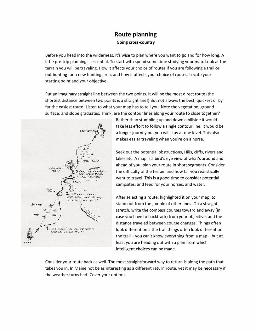
Route planning Going cross-country
Before you head into the wilderness, it's wise to plan where you want to go and for how long. A
little pre-trip planning is essential. To start with spend some time studying your map. Look at the
terrain you will be traveling. How it affects your choice of routes if you are following a trail or
out hunting for a new hunting area, and how it affects your choice of routes. Locate your
starting point and your objective.
Put an imaginary straight line between the two points. It will be the most direct route (the
shortest distance between two points is a straight line!) But not always the best, quickest or by
far the easiest route! Listen to what your map has to tell you. Note the vegetation, ground
surface, and slope graduates. Think; are the contour lines along your route to close together?
Rather than stumbling up and down a hillside it would
take less effort to follow a single contour line. It would be
a longer journey but you will stay at one level. This also
makes easier traveling when you're on a horse.
Seek out the potential obstructions, Hills, cliffs, rivers and
lakes etc. A map is a bird’s eye view of what's around and
ahead of you; plan your route in short segments. Consider
the difficulty of the terrain and how far you realistically
want to travel. This is a good time to consider potential
campsites, and feed for your horses, and water.
After selecting a route, highlighted it on your map, to
stand out from the jumble of other lines. On a straight
stretch, write the compass courses toward and away (in
case you have to backtrack) from your objective, and the
distance traveled between course changes. Things often
look different on a the trail things often look different on
the trail – you can't know everything from a map – but at
least you are heading out with a plan from which
intelligent choices can be made.
Consider your route back as well. The most straightforward way to return is along the path that
takes you in. In Maine not be as interesting as a different return route, yet it may be necessary if
the weather turns bad! Cover your options.
“The practice of navigations”
Navigation is more a state of mind than a set of procedures.
Effective navigation requires imagination he takes all
your skills! Utilizing the mind as well as the senses. By
all means hone your map and compass abilities, but
never stray from the rules of basic wayfaring. Look at
your surroundings as if you were looking down from
an airplane compare what you see with your map.
Most important watch where you are going and
practice total awareness of the indicators around you.
Always orientate your map with the landscape and
compass before referring to it. The map may be upside
down or at an angle, but it is easier to correlate what you see with what's on the map. It helps you
choose the correct fork at a junction where the correct direction on a mountain dissent. Know where
you are on a map at all times, and the direction in which you are heading. Don't wait until you get an
uneasy feeling that you are not 100% sure. In reality it is rare to know precisely where you are at every
moment.
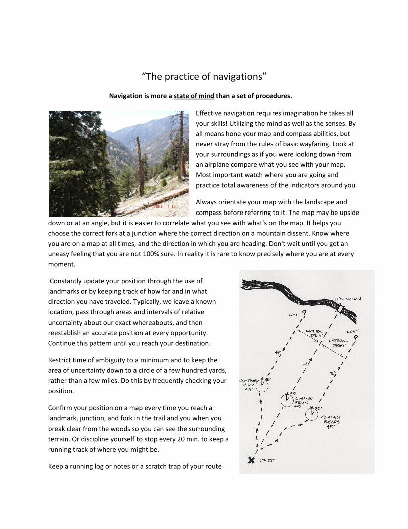
Constantly update your position through the use of
landmarks or by keeping track of how far and in what
direction you have traveled. Typically, we leave a known
location, pass through areas and intervals of relative
uncertainty about our exact whereabouts, and then
reestablish an accurate position at every opportunity.
Continue this pattern until you reach your destination.
Restrict time of ambiguity to a minimum and to keep the
area of uncertainty down to a circle of a few hundred yards,
rather than a few miles. Do this by frequently checking your
position.
Confirm your position on a map every time you reach a
landmark, junction, and fork in the trail and you when you
break clear from the woods so you can see the surrounding
terrain. Or discipline yourself to stop every 20 min. to keep a
running track of where you might be.
Keep a running log or notes or a scratch trap of your route
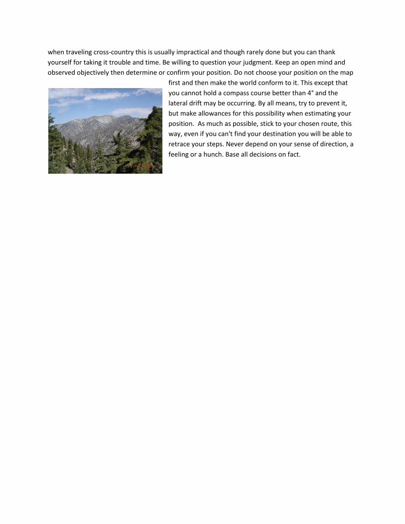
when traveling cross-country this is usually impractical and though rarely done but you can thank
yourself for taking it trouble and time. Be willing to question your judgment. Keep an open mind and
observed objectively then determine or confirm your position. Do not choose your position on the map
first and then make the world conform to it. This except that
you cannot hold a compass course better than 4° and the
lateral drift may be occurring. By all means, try to prevent it,
but make allowances for this possibility when estimating your
position. As much as possible, stick to your chosen route, this
way, even if you can't find your destination you will be able to
retrace your steps. Never depend on your sense of direction, a
feeling or a hunch. Base all decisions on fact.