Embed Size (px)
Citation preview

Howard County Department of Planning and Zoning – March 2021
AssessmentLand Use and Urban Design

Route 1 Land Use and Urban Design Assessment
1 | P a g e Howard County Department of Planning and Zoning
RT 1 LAND USE AND URBAN DESIGN I. INTRODUCTION
The county stands at an important juncture to help
facilitate continued revitalization of the Route 1
Corridor. Three Route 1 assessment papers will be
incorporated as resources for the next general plan
update, HoCo By Design. These assessments are
based on work produced by RKG and its consultant
team during the Route 1 corridor planning effort
(2017-2019), input by the general plan consultants
and DPZ staff.
Two recently released assessments, covering
Markets and Economic Trends and Transportation
and Transit respectively, provide a baseline of
information for targeting locations on the corridor
for redevelopment. The purpose of this Land Use
and Urban Design Assessment is to provide detailed
context for six possible Candidate Investment Areas
(during the Route 1 corridor planning process were
called “Character Areas”) as originally proposed by
RKG where redevelopment and infrastructure could
be targeted.
These assessments together will outline a
revitalization strategy for the Route 1 corridor with
a system of well-designed, market-based nodes
where development and redevelopment can be
focused. Each assessment poses a series of
questions regarding the most effective
redevelopment strategies to implement the vision
for Route 1 in the updated general plan.
II. URBAN DESIGN CONTEXT
In Section V of this assessment, which looks at
Corridor-Wide Land Use and Urban Design issues,
Route 1 is roughly divided into the South, Central,
and North Areas by Route 32 to the south and Route
100 to the north. The Route 1 corridor is distinct in
character from areas located west of I-95, while
connected to these areas by transportation routes.
The area’s existing urban design context is defined
by the historic character of its communities—for
example, the historic core and main street
character of Elkridge, and Savage’s neighborhood
character and adaptively reused structures (i.e.,
Savage Mill), with the development of both
communities dating back to the 18th century. In
addition, given that the area was historically zoned
for both industrial and commercial uses, the Route
1 corridor includes legacy land uses established
during other development periods, including
automobile-related sales, junk yards and motels.
Historic Savage and Elkridge anchor Route 1’s
southern and north ends, respectively, at the
County’s borders. Outside of those areas, the
corridor is dominated by industrial or warehouse
uses, some of which abuts both existing and newer
residential neighborhoods with minimal land use
“buffers” or transitions. Within the corridor’s blend
of industrial and residential areas, streams meander
throughout the Route 1 area and provide some
visual relief from the otherwise suburban pattern of
commercial and industrial development.
There are many new and ongoing development
projects along Route 1, including in the Central
corridor area and adjoining the Laurel Park
racetrack. While new mixed-use areas are generally
providing better streetscape conditions than are
found in the older sections of the corridor, RKG
noted that many areas appear to experience
difficulty occupying ground floor retail/commercial.
III. RELEVANT HOWARD COUNTY POLICY
Since 2001, a series of studies have been performed
to assess Route 1 and its redevelopment. Several of
these studies have included relevant analysis and
recommendations regarding land use, urban design
and corridor nodes, centers or focus areas.
Figure 1: Ashbury Apartments and Streetscape

Route 1 Land Use and Urban Design Assessment
2 | P a g e Howard County Department of Planning and Zoning
This Assessment builds upon these prior Route 1
studies, plans and initiatives including the following:
Corridor Revitalization Study Phase 1 (2001)
• This phase included a detailed chapter on
enhancing the Route 1 appearance, with design
approaches and prototypes for streetscape
improvements.
• The study also identified land uses with
negative images and problems with a lack of
property maintenance.
• A key goal included the need to identify new
land for development and establish guidelines
for mixed use centers, particularly around
MARC stations, interchanges and major
intersections.
• The plan also identified the need for
environmental conservation and restoration by
protecting the natural environment and
restoring environmentally degraded areas.
Corridor Revitalization Study Phase 2 (2002)
• This phase included extensive analysis of land
use patterns and trends and recommended
new zoning categories including Corridor
Activity Center (CAC), Corridor Employment
(CE) and Transit Oriented development (TOD).
While it included specific goals for these
districts, some incentives such as for land
assemblage or financial were recommended to
compliment the zoning.
• The study included the recommendation for
design guidelines to help carry out the County’s
expectations for site, streetscape and building
design.
• This study also proposed community gateway
signs in key locations in the corridor.
• This effort also promoted a prototypical activity
center though a North Laurel Concept Plan.
Five gateway areas were identified for potential
activity centers.
SHA Corridor Improvement Strategy (2008)
• The document recommended enhanced
aesthetics and urban design for a pedestrian
scale in key locations.
• It anticipated that the new CAC zoning would
generate many small nodes of activity with
pedestrian, bicycle and transit travel demand.
However, the document stopped short of
identifying specific activity areas.
Route 1 Manual (2009)
• This manual provides cohesive and corridor-
level technical guidance for new Route 1 zoning
categories, subdivisions and site development
plans and streetscape/urban design
requirements.
• It follows the Zoning Regulations and Corridor
Districts recommended by Phase 2 of the
Revitalization Study specifically for the corridor-
specific zoning districts are: CE District, TOD
District, and CAC District.
Market Analysis & Strategic Implementation
Analysis: US Route 1 (2011)
• This effort did not result in any urban design
references, instead the focus was on land use
and markets.
• It contains a wide variety of specific property,
land use and zoning category
recommendations. Several modifications were
suggested relating to the specialized Route 1
zoning categories.
• It also proposed Route 1 “segments” and land
use “opportunities” based on market data.
PlanHoward 2030
• As the General Plan for Howard County,
PlanHoward 2030 contains a series of high-level
policy statements and recommendations for
the Route 1 Corridor including the following:
o Accommodate residential development
in key nodes in the Route 1 Corridor so
that it does not erode opportunities to
preserve or redevelop employment and
industrial areas.
o Clarify residential and nonresidential
land use goals as a framework for
evaluating future proposals.
o Develop plans for key opportunity
areas that allow for significant future

Route 1 Land Use and Urban Design Assessment
3 | P a g e Howard County Department of Planning and Zoning
intensification, while maximizing
current and intermediate development
potential and protecting industrially
zoned land.
o Adopt land use policies and regulations
to promote compact development
patterns that support transit demand
through sufficient densities and
interconnected street and pedestrian
networks.
North-Laurel Savage Sustainable Community
Application/Action Plan (2013)
• This provides an action plan for the southern
part of the Route 1 corridor and allows for state
funding for revitalization projects.
• No specific urban design references are
included.
• In the Local Planning and Land Use section the
following recommendations were included:
o Address land use issues raised by the
North Laurel-Savage workgroup
including; character, quality of
development, and neighborhood infill
projects (consistency/compatibility
with established neighborhood
patterns) through the General Plan
update.
o Facilitate Land use redevelopment
along Route 1 through the Route 1
Corridor Master Plan (now Route 1
Corridor Assessments) by identifying
suitable redevelopment opportunity
areas, implementing funding
mechanisms for redevelopment and
planning transportation and
infrastructure improvements to
support redevelopment as needed.
Route 1 Tax Credit Program (2014)
• The tax credit program encourages
revitalization along the Route 1 corridor, and
eligible properties within a specified expanded
boundary in Elkridge, by creating a financial
incentive for commercial and industrial
property owners to renovate, rehabilitate and
upgrade properties through a property tax
credit of up to $100,000.
• The tax credit was recently reauthorized
through CB 52-2020 just prior to the completion
of these assessments. Some minor changes
were made to the program including increasing
the maximum property size, inclusion of soft
costs for eligible expenses, length of eligibility
and the annual program cap was reduced from
$500,000 to $250,000.
US 1 Safety Evaluation (2017)
• This evaluation recommended that posted
speed limits and vehicle operating speeds
present a danger to pedestrian safety, and that
geometric changes, streetscape/urban design
changes or traffic calming measures.
• This evaluation notes several multi-modal
safety issues related to the varied land uses
found on the corridor.
• The study recommends incorporating findings
into the US 1 Land Use Study (now Route 1
Corridor Assessments and HoCo By Design).
Howard County Development Regulations
Assessment (2018)
• The assessment included Land Use and Zoning
recommendations related to Route 1 corridor
zoning:
o Recommended that CE Corridor
Employment District be eliminated, and
that the Route 1 corridor instead be
addressed through a non-residential
employment base district as well as the
various mixed-use districts discussed
above (perhaps with Route-1-specific
development standards).
o Recommended that CLI Continuing Light
Industrial Overlay be eliminated
Nonconforming uses and structures along
Route 1 should be addressed through
more flexible low-, medium-, and high-
intensity mixed use districts and more
flexible nonconformities regulations, not
through separate overlay or base district.
o Recommended replacing CAC Corridor
Activity Center with a high-intensity
mixed use district (with Route-1-specific
development standards). Many

Route 1 Land Use and Urban Design Assessment
4 | P a g e Howard County Department of Planning and Zoning
stakeholders noted that the requirement
for 50 percent of the first floor to be retail
or service uses was problematic, in light
of the retail market along the corridor.
o Noted that there are significant overlaps
between the contents of the Route 1
Manual and the requirements of the
Zoning Regulations and Subdivision and
Land Development Regulations. Along
with changes to the specific Route 1
zoning, the recommendations include
reconciling how manual streetscape
standards relate to public works
standards and how building location and
parking area location in Chapter 4 relate
to (potentially inconsistent) bulk and
dimensional standards in the Zoning
Regulations.
IV. VISION AND GUIDING PRINCIPLES
Considering foundational plans, reports, studies
and community engagement, the following vision
for the corridor has been established:
The Route 1 Corridor in Howard County will be
enhanced as a significant employment corridor with
a series of vibrant, livable, walkable activity centers
with a mix of uses characterized by improved
pedestrian, bicycling, and transit mobility. The
corridor will successfully blend needed community
services with a sustainable industrial base.
Key land use and urban design goals:
• Redevelop the Corridor with a system of well-
designed corridor nodes (now “Candidate
Investment Areas”) that promote infill and
protect existing neighborhoods
• Build on the economic success of the non-
residential land uses along the Route 1
Corridor, specifically industrial, warehousing
and distribution facilities.
• Protect, improve and enhance the existing
environmental network of forested areas and
stream corridors that exist in the corridor.
• Preserve landmarks and historical buildings in
the corridor.
• Augment open spaces and recreation
opportunities by constructing new open
spaces, sidewalks, trails in support of Route 1
residents and businesses.
• Revise zoning to conform with Route 1
Corridor land use goals.
V. CORRIDOR-WIDE LAND USE AND
URBAN DESIGN ASSESSMENT
This assessment uses a framework for analysis
based on three overarching “themes” - what
targeted areas are prime to redevelop, what
investment areas can we connect and where can we
look to preserve historic and natural resources in
the corridor.
In addition to the corridor wide analysis provided by
this framework in this section, Section IV of this
assessment identifies the potential for six candidate
investment areas (Map 1, Page 5).
REDEVLOP
Industrial uses: Industrial zoning is primarily placed
on the eastern side of Route 1. Smaller scale flex
warehouses and business parks are clustered in the
Southern and Northern Areas near Savage and
Elkridge. Larger scale industry, which includes
regional distribution hubs such as the Maryland
Food Center, are clustered in the Central Area
between Route 1 and Dorsey Run Road.
Interspersed between small business parks and
larger warehouse centers are auto repair uses and
scrap yards. These typically have frontage along
Route 1 and can sometimes cover multiple parcels.
Figure 2: Rennovated Elkridge Library with Paths

Route 1 Land Use and Urban Design Assessment
5 | P a g e Howard County Department of Planning and Zoning
Map 1

Route 1 Land Use and Urban Design Assessment
6 | P a g e Howard County Department of Planning and Zoning
Commercial uses: Commercial development along
the corridor is generally limited to small scale strip
commercial or small- scale ground floor retail in
newer mixed-use developments. These
developments are typically set back from the Route
1 roadway by surface parking lots.
Many of the commercial uses are filled with varied
service industries, such as auto repair businesses,
telecommunication stores, and nail and hair salons.
There are limited larger scale commercial centers
along the corridor. These are generally clustered
near Savage, Elkridge, or Route 175.
Located along Route 1 as part of new multi-family
subdivisions, such as Bluestream and Mission Place,
are commercial pad sites awaiting future
development. Many of these sites appear to be
strategically placed at primary Route 1
intersections, yet commercial development is slow
to arrive. Older motels are also interspersed along
the corridor, with larger concentrations between
Laurel and Savage and around Route 175.
Housing: Most single-family residential
developments are not located directly on Route 1
but rather set back from the roadway on secondary
streets instead. The single-family housing stock that
is closest to the roadway varies in age and style.
Older, pre-war housing is clustered around Historic
Savage and Historic Elkridge. Houses in these areas
tend to be modestly sized and placed on gridded
streets.
Single-family houses built on the corridor since
1980 are typically infill, include large curb cuts with
frontload- ed two-car garages and driveways. These
homes also tend to be much larger in scale than are
the pre-war built homes. Most new single-family
subdivisions along the corridor are in the Central
Area or are clustered on the outskirts of Elkridge.
These subdivisions are not interconnected and
typically include numerous cul-de-sacs.
Most multifamily housing built before 2000 along
the corridor are in the form of semi-detached
townhouses and garden apartments. This type of
housing is mostly clustered closer to Savage and
Elkridge and are designed with surface parking in
front of the units.
Multi-family housing built after 2000 is more varied.
Townhouses tend to be larger and include ground
floor garages with rear entrances. Multifamily
apartments are clustered primarily along Route 1
and are clustered closer to Laurel or in the Central
Area near Route 175.
The largest and most recent multifamily
developments include Mission Place, Howard
Square and Bluestream. While many of these
developments are placed on street grids and
include structured and screened parking, the
developments are rarely interconnected or include
enough bicycle or pedestrian infrastructure to
encourage biking or walking.
Newer mixed-use developments that have included
ground floor retail struggle with high commercial
vacancy rates.
Three of the original Mobile Home Parks remain
along Route 1. They typically front the roadway,
adjoin more industrial land uses, and have units that
are densely placed.
CONNECT
The streetscape existing conditions along Route 1
are described according to geography: South,
Central, and North Areas. The boundaries of these
areas are illustrated in Map 2 on page 7.
Figure 3: Streetscape along Route 1 fronting Weis and Carmax

Route 1 Land Use and Urban Design Assessment
7 | P a g e Howard County Department of Planning and Zoning
South Area: A bridge span, which is typical of most
roadways entering Howard County that cross a
waterway, over the Patuxent River demarcates the
entrance to Route 1 in Howard County from the City
of Laurel (see Figure 4 on bottom right). In contrast
to Route 1 further south in Laurel, which is lined
with narrow brick sidewalks and ornamental street
lighting, this south area of Route 1 is more auto-
oriented. Howard County’s streetscape in this area
is comprised of turn lanes and utility pole cobra
head lighting.
Similar to Laurel, Howard County’s Route 1 is
divided for five blocks. Beyond Davis Avenue, the
roadway merges into a single travel way. The South
Area has few complete streetscape segments with
buffered sidewalks. A notable complete streetscape
is at the Ashbury Apartments and serves only the
west side of Route 1.
The most consistent streetscape in the South Area
is on the west side of Route 1 near the CarMax and
Toyota properties. This streetscape is heavily
landscaped with a tree-lined panel and a generous
landscaped area beyond the sidewalk to screen
views of adjoining parking lots. This streetscape is
successful because it is in scale with Route 1 as a
vehicular corridor with its broad setback, canopy
trees, and simple hedge. This streetscape is
viewable at high speeds and pleasant to walk along.
Most motels and auto service businesses along
Route 1 have off-street surface parking as a setback
between the curb and building facades, which is
rarely screened from the roadway. Auto service
businesses lack front curbs and store vehicles along
the roadway edge when possible.
Route 1 has a limited number of street trees and
tree canopy in the South Area. Most “green” areas
along the roadway are typically confined to stream
corridors. A utility right-of-way and maintenance
path crosses Route 1 south of Jailbreak Brewing
Company. The maintenance path is not marked by
either signage or pavement markings. Despite some
pedestrian usage along the path, it has no crosswalk
at Route 1.
Map 2: Connections Boundary Map
Figure 4: South Area: Entering the Howard County from the City of Laurel

Route 1 Land Use and Urban Design Assessment
8 | P a g e Howard County Department of Planning and Zoning
Central Area: The streetscape character is
consistent with the South Area’s, especially
between Route 32 and Patuxent Range Road. North
of Patuxent Range Road, Route 1’s roadway widens
and lacks consistent sidewalks. Larger industrial
parcels and access along secondary routes minimize
curb cuts in the streetscape. This paired with the
natural tree screening of industrial uses, make the
Central feel more suburban than the North and
South Area.
Except at several of the new developments, such as
Mission Place, Verde at Howard Square, Lorien
Health Systems, and Meadow Ridge Business Park,
there are few portions of Route 1 with sidewalks.
The most complete streetscapes in the Central Area
are at Mission Place and Verde. The Route 1
streetscapes at both developments include
landscape panels with street trees and well-
maintained shrubbery.
The streetscape along the Verde at Howard Square
development provides an excellent streetscape
example along Route 1 with no surface parking
between the sidewalk and a building façade. The
development’s ground floor façade meets the
streetscape at the build-to line, provides more
visual interest for pedestrians, and is raised above
the sidewalk to avoid direct views into apartments.
Although the Verde’s Route 1 streetscape
treatment is better than most, the streetscape is
diminished by limited building access points, metal
fencing, and window security bars which discourage
walkability and feelings of safety and security for
pedestrians.
Jessup Plaza is one of the most active places in the
Central Area due to its concentration of well-
utilized shops and restaurants. However,
pedestrian access is constrained due to deficient
streetscapes and property fences. Upon
observation, a hole has been made in the fence
separating Jessup Plaza and the Verde to facilitate
pedestrian connections.
Mom’s Organic Market is the only full-service
grocery store in the Central Area, with a central
location at the intersection of Route 1 and Route
175. Pedestrian access to Mom’s is limited due to
the incomplete streetscapes in this area. While
lined with sidewalks on its property edges, Mom’s
public sidewalks are narrow and thus places people
close to fast moving traffic (see Figure 5).
Informal pedestrian pathways have been made
where sidewalks are missing along Route 1. In
addition, a lack of formal gathering spaces along
Route 1 lead people to gather on underutilized lots
near the corridor’s industrial areas.
There is a strong food truck and mobile food vendor
culture along the Route 1 corridor, especially near
Dorsey Run Road. Trucks can often be found in the
parking lots near the Elkridge Volunteer Fire
Department.
Figure 5: Central Area: Sidewalks adjacent to roadway at Mom’s Organic Market at MD- 175 intersection

Route 1 Land Use and Urban Design Assessment
9 | P a g e Howard County Department of Planning and Zoning
North Area: Relative to the Central Area, the Route
1 streetscape in the North Area is distinctly better.
Sidewalks line the west side of Route 1 between
Troy Hill Drive and Montgomery Road. Most of
these sidewalks include ADA compliant crossings,
and occasionally have landscaped buffers.
Building context relative to Route 1 changes north
of the Howard County Library Elkridge branch.
Buildings are positioned closer to the roadway and
closer to each other. Despite fewer sidewalks and
more curb cuts, pedestrian activity near Green
Valley Marketplace and Daniels Restaurant is
significant. This activity begins to humanize the
roadway and indirectly slows traffic.
Route 1’s North Area configuration does not vary
significantly from the South and Central Areas. Yet,
its streetscape is more distinctive because there is
less visible surface parking and an increased
number of areas with denser tree canopy. Route 1
bends as it bypasses Old Washington Road. This
unique bend, paired with a heavier tree canopy,
functions as a gateway into historic Elkridge from
the south (See Figure 6).
Historic Elkridge is a special part of the Route 1
corridor. Currently, this segment has a lack of
sidewalks, awkward front parking lots, and narrow
rights-of-way due to existing utility locations and a
railway overpass. Above-ground utilities
consistently line the east side of Route 1 throughout
the North Area and present additional visual clutter
in this area.
PRESERVE
The Preserve section below describes the Corridor’s
landmarks, destinations, historic assets, gateway
communities, and natural resource areas. There are
several landmarks and destinations along the Route
1 corridor (See Map 3 on page 11). They help to
create a sense of place and provide lasting
memories that bring residents and visitors back to
these destinations. They include:
Thomas Viaduct: The Thomas Viaduct, spanning the
Patapsco River, is a historical masterpiece and a
National Historic Landmark.
Meadowridge Memorial Park: While many of the
parks within the study area provide great
recreational amenities, the Meadowridge Memorial
Park, with its significant architecture and well-
maintained green spaces, creates a beautiful
natural setting along Route 1.
Historic Savage Mill: Historic Savage Mill is a great
resource that is hidden from Route 1. The adaptive
reuse of the historic cotton mill into a cluster of
shopping and dining along Little Patuxent River has
not been able to realize its full potential to date.
With revitalization of Route 1, additional
opportunities for this facility will hopefully become
apparent.
Laurel Racetrack: Located one block from Route 1,
this thoroughbred racetrack is one of the largest
destinations along Route 1. Significant new
development is planned around this area, both in
Howard County and Anne Arundel County.
Figure 6: North Area: Route 1 Elkridge
North Area: Route 1 leaving Elkridge

Route 1 Land Use and Urban Design Assessment
10 | P a g e Howard County Department of Planning and Zoning
North Laurel Community Center: As one of the latest
community centers, the facility, located off Whiskey
Bottom Road, provides indoor recreation and social
activities for the residential communities and
neighborhoods in the north Laurel area.
Preserving the gateway communities of Elkridge
and North Laurel is important. In Elkridge, there is
a juxtaposition of different transportation corridors
representing different technology and different
periods of time including rail, secondary roads and
interstates. The main street of Elkridge is located at
the northern end of the corridor while Laurel’s Main
Street and the historic Savage Mill are located on
the southern side of the corridor. Their historic
character provides a gateway opportunity to the
corridor and differentiates these communities from
the rest of the land use character along Route 1.
The Route 1 corridor in Howard County is located
within and near robust natural resource areas.
Bookended by the major stream corridors of the
Patapsco River at the northern boundary and the
Patuxent River to the south, the 12-mile corridor
crosses numerous other stream corridors which
flows perpendicular to the alignment of Route 1.
These natural areas boast creeks and streams;
wooded and forested areas along the stream
valleys; as well as numerous wetlands, lakes, ponds
and related hydrological features. Together they
create a rich tapestry of natural resources along the
“environmental corridors” of the stream valleys
(see Figures 8 and 9).
These environmental corridors create natural
breaks along the Route 1 corridor. Visually, they
establish strong features that provide relief to the
otherwise suburban corridor character such as;
shopping centers, motels, and multi-family uses
with off-street parking lots along Route 1. While the
access to the stream valleys is very limited from
Route 1, access to trails and parks along the major
river corridors exist, specifically to Patapsco Valley
State Park and Little Patuxent River via the Savage
Mill trail.
Several parks located along the corridor provide a
diversity of outdoor recreational amenities for the
neighboring residential communities. They include
the recreational area around Patapsco Valley State
Park, historic Savage Mill, Meadowridge Memorial
Park, and Troy Park.
Figure 8: Patapsco Valley State Park provides outdoor recreational opportunities at the northern end of the Route 1 corridor.
Figure 9: Corridors create a distinct feel and create boundary thresholds that separate built-form on either side of the stream corrdiors.

Route 1 Land Use and Urban Design Assessment
11 | P a g e Howard County Department of Planning and Zoning
Map 3: Landmarks/Historical Assets

Route 1 Land Use and Urban Design Assessment
12 | P a g e Howard County Department of Planning and Zoning
CANDIDATE INVESTMENT AREAS
Candidate Investment Areas are specific geographic
areas identified along the Route 1 Corridor that
present the opportunity for redevelopment into
higher quality nodes or activity centers to better
serve the surrounding communities, increase the
county tax base and revitalize blighted and
underutilized properties.
While these areas have the potential to be
redeveloped into unique, separate “neighborhood
nodes” through development, redevelopment,
preservation, and/or other enhancements, they do
not preclude investment elsewhere along the
corridor They primarily serve as prototypes for
other areas along the corridor.
A diverse range of factors were considered as
selection criteria in locating and designating
Candidate Investment Areas. These broad criteria
are grouped based into the three overarching
“themes” of redevelop, connect and preserve (see
table on next page). These criteria find their origin
in the work of preceding studies, existing county
policies, the community engagement process and
consultant analysis.
In addition to these selection criteria, a combination
of methods was used to identify key parcels within
the corridor that have high potential for
redevelopment including; site visits, Google
Map/Streetview study, and an analysis of
MdProperty View property assessment data.
Targeted properties grouped into the following
categories (See Map 4: Redevelopment Parcels by
use-types on page 14). A combination of methods
was used to identify key parcels within the corridor
that have high potential for redevelopment
including; site visits, Google Map/Streetview study,
and an analysis of MdProperty View property
assessment data. Targeted properties grouped into
the following categories:
Underutilized Properties:
• Vacant or undeveloped properties,
• Larger properties with small or ancillary
buildings
• Publicly-owned land and buildings,
• Existing land uses that under value the
highest and best use of the property (i.e.,
auto sales, truck terminals, older motels,
etc.).
Blighted Uses:
• Junkyards,
• Auto storage yards,
• Vacant and abandoned properties,
• Properties used for general storage of
materials, equipment, etc., and
• Properties with extensive deferred
maintenance; those that visually
impact the corridor or would
discourage reinvestment in adjacent
properties.
While some of the redevelopment parcels
contained operating business, most did not.
Properties that could potentially deter
redevelopment on adjacent properties were
included for consideration. In some instances,
existing businesses might have to be renovated or
relocated to other suitable business locations in
order to achieve a higher and better use of the
Route 1 corridor’s frontage lots.
Map 5 (page 15) illustrates the proposed candidate
investment areas and conceptual land use/market
approach and natural areas (“environmental
corridors”) along the Route 1 Corridor. Each
proposed candidate investment area along Route 1
promotes a distinct identity through its proposed
redevelopment framework: the built form,
enhanced walkable connections, natural resource
areas, and preservation and improvement of the
individual qualities that define each.

Route 1 Land Use and Urban Design Assessment
13 | P a g e Howard County Department of Planning and Zoning
Route 1 CANDIDATE INVESTMENT AREAS SELECTION CRITERIA
REDEVLOP CONNECT PRESERVE Development Nodes: Create nodes that relate to their adjoining communities, each with a unique character, through the development of context-compatible residential, commercial and industrial land uses.
Adjoining existing development/ communities: Utilize the activities generated by existing developments, landmarks or destinations and build around successful places. Connect new nodes with existing neighborhoods.
Natural resource areas: Celebrate, expand and connect the county’s Green Infrastructure Network, parks, and recreation areas, floodplains, steep slopes, wetlands, and wooded/ forested areas.
Neighborhoods: Promote higher-quality development along Route 1 and build character nodes that create distinct neighborhoods on both sides of Route 1.
Both sides of Route 1: Create uniform and cohesive connections on Route 1 through streetscape enhancements and redevelopment on both sides.
Areas adjacent to natural areas/green spaces and Parks: Promote connectivity to nature-based opportunities and parks.
Cluster of parcels: Redevelop via consolidation of a range of adjacent parcels.
Extension of the existing street grid: Build on existing infrastructure to maximize investments already in-place.
Environmental Corridors along Route 1: Provide appropriate landscaped transitions adjacent to the Candidate Investment Areas.
Vacant and underutilized parcels: Encourage higher and better use, supported by adequate public infrastructure and preferably with context-compatible densities.
Multimodal connections: Promote safe multimodal connections and diverse transportation modes for a variety of users.
Existing business uses and residential communities: Protect and enhance the character of existing business uses and residential neighborhoods, while expanding their linkages to meaningful Route 1 facilities.
Route 1 frontage: Emphasize both visual and functional impacts along Route 1.
Transform: implement complete streets and multimodal transportation infrastructure to enhance mobility and access to diverse transportation options.
Quality of life: Enforce existing regulatory tools to create a safe and visually attractive built environment.
Proximity to new public/private investment: Use catalytic opportunity sites to maximize opportunities for adjacent developments.
Transit Readiness: Target public transit services to better serve existing users and provide enhanced transit services as future ridership demands.
Historic Character: Use context sensitive design for redevelopment adjacent to historic communities.
Table 1:

Route 1 Land Use and Urban Design Assessment
14 | P a g e Howard County Department of Planning and Zoning
Map 4: Redevelopment Parcels by use-types
Route 1 Land Use and Urban Design Assessment
15 | P a g e Howard County Department of Planning and Zoning
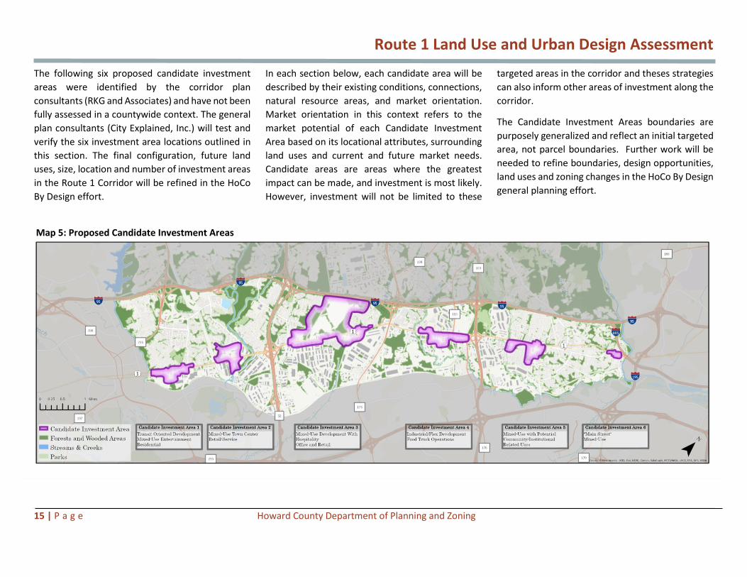
The following six proposed candidate investment
areas were identified by the corridor plan
consultants (RKG and Associates) and have not been
fully assessed in a countywide context. The general
plan consultants (City Explained, Inc.) will test and
verify the six investment area locations outlined in
this section. The final configuration, future land
uses, size, location and number of investment areas
in the Route 1 Corridor will be refined in the HoCo
By Design effort.
In each section below, each candidate area will be
described by their existing conditions, connections,
natural resource areas, and market orientation.
Market orientation in this context refers to the
market potential of each Candidate Investment
Area based on its locational attributes, surrounding
land uses and current and future market needs.
Candidate areas are areas where the greatest
impact can be made, and investment is most likely.
However, investment will not be limited to these
targeted areas in the corridor and theses strategies
can also inform other areas of investment along the
corridor.
The Candidate Investment Areas boundaries are
purposely generalized and reflect an initial targeted
area, not parcel boundaries. Further work will be
needed to refine boundaries, design opportunities,
land uses and zoning changes in the HoCo By Design
general planning effort.
Map 5: Proposed Candidate Investment Areas

Route 1 Land Use and Urban Design Assessment
16 | P a g e Howard County Department of Planning and Zoning
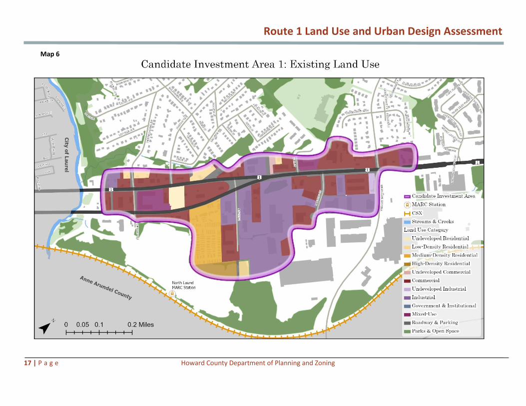
Candidate Investment Area 1
Existing Conditions
Character and Destination
Located at the southwestern edge of Howard
County, this area defines the entry point to the
County from the south along Route 1 as it crosses
over the Patuxent River (see Map 6 on page 17).The
area reflects a suburban character on both sides of
Route 1 in contrast to the urban nature of the City
of Laurel, the adjacent community to the south. Like
other areas along Route 1, the east side of
Candidate Investment Area 1 consists of primarily
industrial uses while strip commercial centers,
multifamily and single-family neighborhoods line
the west side. Regional and local destinations such
as the Laurel Park (horse racing venue), the Laurel
MARC Station, and the North Laurel Community
Center provide tourism, recreation and community
amenities. This area includes large food distribution
centers, a mobile home park, and a new multifamily
building, the Ashbury Courts Apartments.
Connectivity
Route 1 in this area is bifurcated into two separate
roads – southbound Washington Boulevard and
northbound North 2nd Street. These streets merge
near Davis Avenue and continue northbound as one
roadway through the rest of the County. While
there is a lack of continuous pedestrian and bicycle
connectivity along Route 1 within this area, new
sidewalks have been constructed, specifically in
conjunction with new developments; for example,
the Ashbury Courts Apartments (see Figures 10 and
11). However, gaps in the area’s sidewalk network
remain.
Natural Resource Areas
Route 1 crosses numerous environmental features
– stream valleys including creeks and streams, as
well as wooded and forested areas. These
environmental features provide a natural
complement to the suburban character of this area.
The Patuxent River is one of the stream valleys in
this area and has been the focus of preservation and
revitalization efforts that celebrate the river as a
community and regional asset—for example, the
City of Laurel’s Riverfront Park, which integrates
recreational facilities and scenic wetlands with the
ruins of the city’s historic dam.
Market Orientation
Located four miles from I-95 and nine miles from Ft.
Meade, Candidate Investment Area 1 offers the
potential for additional high density mixed-use and
residential development. New residential
development in this area is suitable and would
potentially increase public transit demand for the
Laurel MARC station. This use would primarily
consist of apartment living with some on-site
amenities. Potential exists to create a smaller retail
and dining setting along North 2nd Street, anchored
by dining and family entertainment uses that would
complement the Paddock Pointe development.
Across Route 1 is a continuous line of narrow
parcels that are currently commercial in nature and
are recommended to remain commercial (See Map
7 on page 18). However, redevelopment would be
facilitated if current uses (i.e., tax services, barber,
dry cleaner, convenience store, etc.) are renovated
or converted into more pedestrian focused shops,
restaurants and business.
Figure 10: Second Street looking North, Ashbury Apartments Figure 11: Character of Route 1 Near Whiskey Bottom Road
Second Street looking North, Ashbury Apartments Character of Route 1 Near Whiskey Bottom Road
Route 1 Land Use and Urban Design Assessment
17 | P a g e Howard County Department of Planning and Zoning
Map 6

Route 1 Land Use and Urban Design Assessment
18 | P a g e Howard County Department of Planning and Zoning
Map 7

Route 1 Land Use and Urban Design Assessment
19 | P a g e Howard County Department of Planning and Zoning
Candidate Investment Area 1 Considerations
Candidate Investment Area 1 could be envisioned as
a transit-oriented, mixed-use entertainment node
with improved streetscape and buildings along
street frontage (see Map 8 on next page). The
character should build on the Paddock Pointe
(Laurel Park Station) development and its proximity
to the MARC station. Additional commercial and
medium to high density residential is proposed to
compliment the area’s planned TOD development.
The area would benefit from enhanced streetscape,
gateway features and wayfinding signage.
Candidate Investment Area 1, as proposed, is just
under 140 acres in size. The parcels on the north
side of Route 1 are quite shallow with lot depth
averaging around 300 feet. Current land use is
predominantly commercial (32 percent) and
industrial (30 percent) with residential (14 percent)
and mixed use (6 percent) also present. The current
zoning is largely CE-CLI (45 percent), CAC-CLI (32
percent), and TOD (18 percent). The conceptual
land use and urban design features are detailed in
the Potential Future Land Uses map on page 20.
The acreages given are approximate and reflect the
investment area generalized shape, not parcel
boundaries. Further work will be needed to identify
boundaries, design opportunities, land uses and
zoning changes in the HoCo By Design general
planning effort. The effort should consider the
following:
Redevelop
• How can the area build on the Paddock Pointe
mixed-use development to stimulate additional
compatible change in this area? Will it create
opportunities for mixed-use and entertainment
anchors at the gateway node of North 2nd
Street?
• What zoning or other changes would be needed
to allow for medium to high density residential
uses along North 2nd Street/Route 1 with a
transition to medium density residential as it
gets closer to the single-family development at
Paddock Pointe?
• What are the market aspirations for the
properties on the north side of Rt 1? How does
assemblage factor in and what zoning changes
are recommended to create a transition to
adjacent uses?
• What elements are needed to support
commercial/retail/mixed-use redevelopment
along Route 1 between Wilbert Lane and the
area around the intersection of Route 1 and
Whiskey Bottom Road?
• What gateway features should be considered
for this the entry point into County? Such
gateway features might include public art,
signage, gateway buildings and landscaping to
evoke a sense of arrival and celebrate river
crossing/stream channel.
Connect
• How can the redevelopment plan utilize and
extend Paddock Pointe’s planned street grid of
streets into adjacent redevelopment areas?
• What are the design elements needed for
pedestrian and bicycle connections to connect
residential neighborhoods to Route 1 area
destinations including North Laurel
Community Center and the Laurel MARC
Station?
• Where could trail connections to connections
to access natural resource areas and
environmental corridors?
Preserve
• If this area is targeted as an investment area,
what actions can help to preserve the
character of the existing surrounding single-
family neighborhoods?
• What unifying visual elements could be
incorporated at the Patuxent River crossing
along with the improved streetscape and
gateway elements on Route 1? Such
features might include bridge elements and
extended riparian landscape.

Route 1 Land Use and Urban Design Assessment
20 | P a g e Howard County Department of Planning and Zoning
Map 8
M

Route 1 Land Use and Urban Design Assessment
21 | P a g e Howard County Department of Planning and Zoning
Candidate Investment Area 2
Existing Conditions
Character and Destination
Candidate Investment Area 2 is located north of the
Baltimore Gas and Electric (BGE) right-of-way and
south of MD Route 32 (see Map 9 on page 22). This
area is anchored by the Weis Food Market and
CarMax located on the west side of Route 1, an
industrial uses line the east side. Large surface
parking lots servicing the grocery, car dealership
and industrial sites dominate the character of this
area. Area attractions include Historic Savage Mill, a
historic cotton mill adaptively reused for shopping
and dining along Little Patuxent River (See Figure
12). A variety of recreational areas, such as Terrapin
Adventures area, the Savage Mill Trail, Savage Park
etc. provide outdoor amenities to the residents of
the Savage area as well as to regional tourists.
Connectivity
Because of its proximity to Route 32, this area has
strong access to the region via I-95 and Baltimore-
Washington Parkway. On the west side of Route 1,
there is a consistent tree-lined streetscape along
the Weis and CarMax sites, providing enhanced
pedestrian connectivity from the residential
neighborhoods to destinations in this area. The
streetscape and bus stop in this location also
improve access and connectivity to the Weis
grocery store.
Natural Resource Areas
The area is located between the riparian corridors
of the Little Patuxent River and Hammond Branch
stream valleys. The Savage Mill Trail connects this
area to Historic Savage Mill, the community of
Savage, and to a network of area trails along the
Little Patuxent River.
Market Orientation
Market orientation for Candidate Investment Area
2 is partially based on its centralized location within
the Route 1 Corridor, which lends itself to a variety
of corridor serving needs. Candidate Investment
Area 2 lends itself to the development of a large,
horizontal, mixed-use, town center development
with commercial anchor stores to better serve the
corridor. The land in this area is largely flat and has
good access to Route 1 and MD-32. Vertical mixed-
use featuring residential uses above storefronts can
support a town center development by creating
more local demand to support new stores. The
viability of vertical mixed use has been met with
some skepticism from developers who do not
believe it works well along the Route 1 Corridor.
Vertical mixed-use development can be successful
in an urban context, such as Arlington, Virginia, or a
town center development where elements of an
urban environment can be created to encourage
pedestrians to walk and explore shops and
restaurants in an amenity rich environment.
Candidate Investment Area 2 should create a
context off the corridor where a new pedestrian-
centered environment or “Main Street” can be
created, which complements, not competes with
Historic Savage and is safe and not directly fronting
the corridor.
The eastern portion of Area 2 could also support
large industrial uses to enhance the corridor’s tax
base and employment. The Allied Trailer property
is underutilizing a site with large commercial
frontage, not taking advantage of its potential
economic and taxable value. Much of the area
within Freestate Drive and Gorman Road loop could
include the town center development, which is
approximately 37 acres. If the CarMax site were to
come on the market, the development could
expand to over 75 acres, and be better integrated
into the surrounding neighborhoods.
Figure 12: Savage Mill

Route 1 Land Use and Urban Design Assessment
22 | P a g e Howard County Department of Planning and Zoning
Map 9

Route 1 Land Use and Urban Design Assessment
23 | P a g e Howard County Department of Planning and Zoning
Map 10

Route 1 Land Use and Urban Design Assessment
24 | P a g e Howard County Department of Planning and Zoning
Candidate Investment Area 2 Considerations
The vision for Candidate Investment Area 2 has
been organized around the redevelopment of Weis
Food Market as a grocery-anchor for a
neighborhood-focused town center node. Mixed-
use activity areas along Route 1 would connect this
area to existing residential neighborhoods via a grid
of streets and network of trails.
Candidate investment area 2 is over 160 acres. Its
current land use is split between Commercial use
(45 percent) Industrial (26 percent), Parks and Open
Space (18 percent). Current zoning includes B-2 (32
percent), CE-CLI (27 percent) and M-1 (27 percent).
The conceptual land use and urban design features
are detailed in the Proposed Land Use map on page
25. The acreages given are approximate and reflect
the investment area shape, not parcel boundaries.
Further work will be needed to identify boundaries,
design opportunities, land uses and zoning changes
in the HoCo By Design general planning effort. The
effort should consider the following:
Redevelop
• Can this area support retail in the new Town
Center concept and the existing destination
retail in Historic Savage Mill? How can the
two destinations complement and not
compete with one another?
• What tools or incentives can foster light
industrial development in the areas east of
Route 1 similar in the scale of existing
establishments? Can an investment area
ensure safe and adequate access to the
industrial areas while providing landscaped
and higher-quality architectural buffers
between Route 1 streetscape and adjacent
residential communities?
• With Savage Mill and Savage nearby, would
this area benefit from an attractive visible
gateway feature at the intersection of
Route 1 and Gorman Road, preferably on
the western side of Route 1 in proximity to
the potential Town Center?
• What form would a mixed-use
development take in Area 2? What is the
ideal scale for a Town Center at this
location, based on land area and market
demand?
Connect
• Should the roadway network be
strengthened in this area? Could walkable
blocks be added to the internal grid of
streets on the west side of Route 1, along
with the creation of redevelopment areas
or land bays in this area?
• How can the area expand on existing
streetscape amenities on the west side of
Route 1 to better connect to the existing
residential neighborhoods of Savage? Are
there options to continue canopy
trees/regular plantings that match the scale
of streets?
• Is this a feasible location to promote safe
pedestrian and bicycle crossing along Route
1 at major street intersections? How could
this area better connect neighborhoods
and destinations with new trails and
improved sidewalks, and link with the
existing trail network? Identify potential
constructability issues.
Preserve
• If this area is targeted for redevelopment,
what tools should be considered to
preserve the neighborhood character of
Savage and adjoining residential
neighborhoods? Based on feedback
provided by the community, design
guidelines or a community character code
could help with this as well as pursuing an
historic designation for the area in and
around Historic Savage Mill.
• To strengthen access to historic and natural
resources in the area, what pedestrian and
bicycle connections to recreational areas in
and around Historic Savage Mill (i.e., plan to
extend the Savage Mill Trail to Route 1
along Gorman Road)?
• What are ways to acknowledge the
presence of historic Savage out to Route 1?

Route 1 Land Use and Urban Design Assessment
25 | P a g e Howard County Department of Planning and Zoning
Map 11

Route 1 Land Use and Urban Design Assessment
26 | P a g e Howard County Department of Planning and Zoning
Candidate Investment Area 3
Existing Conditions
Character and Destinations
The existing character of this area, the largest of the
Candidate Investment Areas along Route 1, is
dominated by a green edge on the west side -- the
Savage Stone quarry site (see Map 12 on page 27).
Industrial uses are present on both sides of Route 1,
while single-family residential, mobile home parks
and storage sites dot the east side of Route 1. A new
residential and mixed-use community – Mission
Place – provides an anchor of new investment and
marks the northern edge of Area 3.
High School #13 is planned on the west side of the
existing railroad right of way. This will serve to the
growing residential communities in this area.
Connectivity
Similar to Candidate Investment Area 2, this area
has strong regional connections given its location
near Route 32, which provides access to I-95 to the
north and Baltimore Washington Parkway to the
south.
Natural Resource Areas
Several stream valleys, including Dorsey Run, frame
Area 3 and provide opportunities for alternative
pedestrian and bicycle connections between
residential communities and Route 1.
Market Orientation
Candidate Investment Area 3 has a much longer-
term redevelopment (20-25 years) potential
because redevelopment is dependent on
redevelopment of the Savage Stone quarry. The
site is flat in some areas which might make it
suitable for a next-generation, large scale business
park consisting of Class A offices, hospitality uses
and retail with an emphasis on design as a mixed-
use center.
The quarry could become a unique central natural
feature or water feature, either as part of a larger
public amenity space or a business park amenity
available to the public in a mixed-use setting.
This area has great transportation connections to
MD-32 and MD-175, which connect to Baltimore-
Washington Parkway, Fort Meade and I-95 (Exit 38)
and has visibility from the Interstate highway. This
is considered the premier location along this stretch
of Route 1. Contemporary hotels and restaurants
would be suitable for this location. Green buffer
areas around the quarry, specifically near Route 1
on either side of the existing railroad track may be
developable before the quarry use is complete.
The area across Route 1 from the quarry is not as
well positioned due the existing land uses, which
could be candidates for relocation. These properties
are largely underutilized. This area could support
businesses that are complementary to a large
business park, including a small conference center,
hotels, restaurants and other supportive
commercial uses. This area could also support
modest residential development with natural
amenity areas (green buffers, stream and trails) in
the rear.
Figure 13: Savage Stone Quarry Figure 14: Mission Place mixed-use development along Route 1

Route 1 Land Use and Urban Design Assessment
27 | P a g e Howard County Department of Planning and Zoning
Map 12
3:

Route 1 Land Use and Urban Design Assessment
28 | P a g e Howard County Department of Planning and Zoning
Map 13

Route 1 Land Use and Urban Design Assessment
29 | P a g e Howard County Department of Planning and Zoning
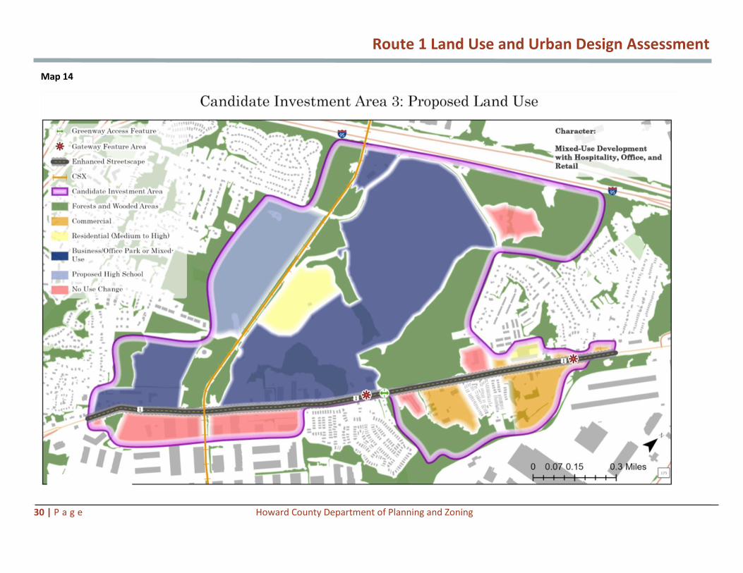
Candidate Investment Area 3 Considerations
The long-term vision for this area is driven by the
creation of a mixed-use business/office park on the
Savage Stone site subsequent to completion of
quarry operations. As the model for successful
business parks continues to evolve this would likely
need to include a residential component and
include elements for activities beyond the workday.
It is envisioned that this business park could be of
sufficient size to support a conference center and
related hospitality uses along with reorganized
mixed-use/commercial facilities along Route 1.
Candidate investment area 3 is the largest proposed
Candidate Investment Area at over 740 acres.
Current land uses are predominately Industrial – as
indicated by the existing quarry use (57 percent),
with the other major land uses being Government
and Institutional (21 percent) and Commercial (8
percent). The current zoning is mostly M-1-MXD-3
(49 percent), CE-CLI (25 percent) and R-SC-MXD-3
(11 percent) – with the MXD zones applied to the
quarry property.
The conceptual land use and urban design features
are detailed in the Potential Land Use Map on page
30. The acreages given are approximate and reflect
the investment area shape, not parcel boundaries.
Further work will be needed to identify boundaries,
design opportunities, land uses and zoning changes
in the HoCo By Design general planning effort. The
effort should consider the following:
Redevelop
• Are there components of redevelopment in
this candidate investment area that could
precede the reuse of the active quarry site?
Are the areas southwest of the quarry
operations along Route 1 potential near-
term opportunities for business/office park
or mixed-use redevelopments?
• Is there sufficient market demand to
support a sizeable hospitality core, with
multiple hotel sites, conference centers,
retail and restaurants on the east side of
Route 1?
Connect
• Should this area redevelop, how should
phased streetscape improvements extend
past the Mission Place development on
either side of Route 1 to better connect the
area destinations?
• How should the county consider future
redevelopment in the area adjacent to the
existing railroad right-of-way? This ROW
may be positioned for future rapid transit
or trail connections to connect Route 1 with
the proposed High School #13 site, future
quarry redevelopment and
Columbia/Gateway connections to the
north.
Preserve
• Is it feasible to provide trail connections in
this area from Route 1 to proposed
redevelopment areas via the riparian
corridors of Dorsey Run and related stream
valleys?
• Can reclaimed quarry sites be utilized to
create lakes/waterbodies, as an amenity for
the possible redevelopment area?
Route 1 Land Use and Urban Design Assessment
30 | P a g e Howard County Department of Planning and Zoning
Map 14

Route 1 Land Use and Urban Design Assessment
31 | P a g e Howard County Department of Planning and Zoning
Candidate Investment Area 4
Existing Conditions
Character and Destinations
This Candidate Investment Area is at the heart of
the corridor’s light and heavy industrial areas,
marked by flex uses and warehousing facilities. At
the same time, the new residential communities of
Howard Square and Blue Stream are helping to
transition the character of this area. Food trucks
and small outdoor markets dot the underutilized
surface parking lots along Route 1. The area
includes the Washington Boulevard Marketplace
with its diverse ethnic offerings. The nearby Dorsey
MARC station is currently under consideration for a
Transit Oriented Development (TOD) by the State of
Maryland (see Map 15 on page 32).
Connectivity
Area 4 is located close to both Route 175 and Route
100, which provide excellent access to I-95 and
regional highways.
Natural Resource Areas
Existing development just outside Area 4 is framed
by the Deep Run and its tributary streams. The
rolling nature of topography in this area provides
opportunities for vistas and changing viewpoints.
Market Orientation
Candidate Investment Area 4 is better suited for
small industrial users and industrial flex space for
smaller end users. The area has seen an organic
cluster of food trucks that serves the employee
population in the area. Other small-scale,
convenience-oriented commercial development
could be located here as well.
This area is not ideally suited for new residential
development on the eastern side of Route 1
because of close proximity to stable industrial
development. However, to the eastern edge of the
Candidate Investment Area near Route 100, several
hundred units of new multifamily development
have been proposed.
Businesses in this area are easily serviced by Dorsey
Run Road for truck deliveries coming off I-95.
Figure 15: Light Industrial character Figure 16: Route 1 character near MD-100

Route 1 Land Use and Urban Design Assessment
32 | P a g e Howard County Department of Planning and Zoning
Map 15

Route 1 Land Use and Urban Design Assessment
33 | P a g e Howard County Department of Planning and Zoning
Map 16

Route 1 Land Use and Urban Design Assessment
34 | P a g e Howard County Department of Planning and Zoning
Candidate Investment Area 4 Considerations
Building on the industrial nature of this Candidate
Investment Area, RKG targeted this area to create
higher quality flex industrial uses with a
consolidated food truck cluster on both sides of
Route 1.
The proposed Candidate Investment Area 4 is
approximately 164 acres. Current land uses are
mostly Industrial (27 percent), commercial (25
percent with some mixed use (12 percent). The
existing zoning is CE-CLI (62 percent), CAC-CLI (11
percent), and TOD (17 percent).
The conceptual land use and urban design features
are detailed in the Potential Future Land Uses Map
on page 35. The acreages given are approximate
and reflect the investment area shape, not parcel
boundaries. Further work will be needed to identify
boundaries, design opportunities, land uses and
zoning changes in the HoCo By Design general
planning effort. The effort should consider the
following:
Redevelop
• Is it feasible to redevelop here with a
market focus on higher quality flex office
spaces and warehousing with showroom
retail facilities?
• What are some concepts for integrating
public gathering spaces and plazas within
the targeted redeveloped areas? Would
formalizing a food truck and outdoor
market cluster along Route 1 work here?
What would that look like?
• How can existing industrial sites near this
node maximize compatibility with new and
proposed multifamily residential
developments in this area?
• Can this area celebrate the corridor’s
industrial (distribution) character through
thematic wayfinding, signage and public art
along Route 1?
Connect
• Can Dorsey Run Road continue to be further
planned to provide alternative connections
to the large industrial areas to the east of
Route 1, thereby reducing truck traffic
along Route 1?
• What standards/incentives are needed for
a walkable grid of streets within the new
flex office space and light industrial use
areas?
• Can a new trail network be created along
Dorsey Run to provide alternative
connections from new residential
neighborhoods to the proposed
destinations on both sides of Route 1, as
well as to the Dorsey MARC station on the
east side of Route 1?
• Is there a need and optimal location for
safer pedestrian and bicycle crossings
across Route 1 at this candidate investment
area?
Preserve
• Is it feasible to preserve and improve the
character of the long-standing light
industrial uses of Route 1 in this area via
adaptive reuse, context-compatible new
buildings, interpretive signage, sustainable
landscape treatments and wayfinding?
• Where should trail connections be
prioritized from Route 1 to proposed
redevelopment areas along the riparian
corridors of Deep Run and its related
stream valleys?

Route 1 Land Use and Urban Design Assessment
35 | P a g e Howard County Department of Planning and Zoning
Map 17

Route 1 Land Use and Urban Design Assessment
36 | P a g e Howard County Department of Planning and Zoning
Candidate Investment Area 5
Existing Conditions
Character and Destinations
This Candidate Investment Area is anchored by the
new Howard County Library campus on the west
side of Route 1 (see Map 18 on page 37). The new
building and redeveloped site have revitalized this
area with indoor and outdoor activity areas, as well
as higher quality built-form.
The Library acts as a focal point for the community
and has potential as a catalyst for redevelopment
for several adjoining parcels. The character of
development on the east side of Route 1 is primarily
industrial in nature, with wide setbacks, and
established single-family neighborhoods wedged
between the setback industrial areas and the
stream corridor to the west.
Connectivity
While there are roadway linkages to existing
residential neighborhoods on the west side of
Route 1, a limited network exists on the east side.
Harwood Park is the exception as it has a true grid
of streets. Similarly, continuous sidewalks exist on
the west side of Route 1, while there is a distinct
lack of pedestrian connectivity on the east side.
Natural Resource Areas
Several stream valleys frame this area and provide
opportunities for natural resource connection from
the residential neighborhoods and
existing/potential destination areas. The Library
includes a well-designed stormwater pond and
trails to the adjacent neighborhoods.
Market Orientation
If the town center development in Character 2
cannot happen, Candidate Investment Area 5 offers
a possible alternative location. This location of
mostly smaller industrial and flex users could be
redeveloped as a mixed-use node with new
amenities to support the residents of Elkridge and
other nearby neighborhoods that are underserved.
This area is currently serving a number of smaller
light industrial businesses, as well as a UPS
Worldwide Express Freight Center. Deeper in the
Candidate Investment Area are a loose collection of
trucking and automotive uses that represent a low-
level of land utilization. Residential uses abut these
uses and the area includes some riparian corridors
on the eastern side of Route 1. There is an
opportunity for reinvestment in the Harwood Park
neighborhood behind the auto junk yard between
Ivy Terrace and Loudoun Avenue.
A new residential development has been approved
as a future use of the Roberts Property fronting on
Route 1, formerly an auto junkyard. The Belmont
Station development will bring 204 apartments and
114 single-family homes to the edge of Area 5 and
a small shopping center development is proposed
near this area. The mixed-use development could
incorporate complementary civic or community
related uses as well as connections to the Howard
County Library.
Figure 17: Lack of pedestrian connections, wide setback areas Figure 18: Elkridge Library’s adjacent stormwater area with trails

Route 1 Land Use and Urban Design Assessment
37 | P a g e Howard County Department of Planning and Zoning
Map 18

Route 1 Land Use and Urban Design Assessment
38 | P a g e Howard County Department of Planning and Zoning
Map 19

Route 1 Land Use and Urban Design Assessment
39 | P a g e Howard County Department of Planning and Zoning
Candidate Investment Area 5 Considerations
This area’s vision is to become a mixed-use node
with the potential to integrate civic or recreational
amenities and uses organized around public plazas
and green spaces on the east side Route 1.
Candidate Investment Area 5 is just over 150 acres
in size. Current land use reflects the corridor
industrial base with Industrial (55 percent),
commercial (7 percent), residential (9 percent) and
Government (3 percent). Zoning is divided between
CE-CLI (47 percent), M-1 (16 percent), CAC-CLI (14
percent), R-12 (14 percent and B-1 (7 percent).
The conceptual land use and urban design features
are detailed in the Potential Future Land Uses Map
on page 40. The acreages given are approximate
and reflect the investment area shape, not parcel
boundaries. Further work will be needed to identify
boundaries, design opportunities, land uses and
zoning changes in the HoCo By Design general
planning effort. The effort should consider the
following:
Redevelop
• What tools can act as a catalyst in this
candidate investment area for a walkable,
mixed-use node with community or
institutional uses to complement the
existing Howard County Library?
• How should redevelopment be organized
and linked to the newly renovated Elkridge
Library?
• Should a gateway feature or signature
building be added at the intersection of
Route 1 and Rowanberry Drive on the east
side of Route 1, to include public art,
signage and wayfinding, and creative uses
of lighting to activate the area during
evening hours?
Connect
• Using Harwood Park as a precedent in the
area, does it make sense to create a
walkable grid of streets that connect the
mixed-use development and supporting
mixed-use to the adjacent residential
neighborhoods and the Library site?
• Should alternative connections from
residential neighborhoods to the mixed-use
node be provided via trails along green
spaces and natural resource areas as well as
multi-use paths along Route 1?
• Should enhanced streetscape connections
along Route 1 with continuous tree-lined
sidewalks and bicycle facilities be promoted
here? Is this a feasible location to promote
safe pedestrian and bicycle crossings across
Route 1 at street intersections, specifically
at Rowanberry Drive? Identify potential
constructability issues.
Preserve
• What approaches can help preserve the
character of the older single-family
neighborhoods adjacent to this targeted
area?
• What types of new infill development
standards can guide the design of new
buildings to be sensitive to its context and
fits within the character of the
neighborhood?
• Which natural resource areas and stream
corridors should be prioritized here for
protection or preservation if they are
targeted for alternative connections to
neighborhoods and to existing and future
green/open spaces?
• Will redevelopment here provide useable
open spaces that are well-placed with the
right edges to create “places”?

Route 1 Land Use and Urban Design Assessment
40 | P a g e Howard County Department of Planning and Zoning
Map 20

Route 1 Land Use and Urban Design Assessment
41 | P a g e Howard County Department of Planning and Zoning
Candidate Investment Area 6
Existing Conditions
Character and Destinations
The community of Elkridge defines the character of
this area with its historic core, Main Street, and
traditional buildings. This area also defines the
entry point of Howard County along Route 1 from
the north as it crosses over the Patapsco River.
Landmarks include the Patapsco Valley State Park,
Thomas Viaduct, and the Elkridge Furnace Inn. The
area already features a landscaped gateway feature
with an “Elkridge” monument sign. The Rathskeller
bar and restaurant and coffee bar represents recent
“Main Street“ investments (see Map 21 on page
42).
Connectivity
A fine-grained and walkable street grid system
exists in the historic core of Main Street Elkridge.
Main Street is dominated by overhead utilities. The
road is interrupted by the CSX abutment and its
connectivity is fragmented north to south. The
Route 1 ROW is severely constrained as it passes
under the CSX train bridge – there is very limited
road shoulder here and no opportunity for
sidewalks or bike path connections.
The Baltimore Metropolitan Council (as of
December 2020) is finalizing a Preliminary Trail
Design for the Elkridge to Guinness segment of the
Patapsco Regional Greenway. The trail would travel
down Main Street and connect to the Patapsco
State Park via Levering Avenue.
Natural Resource Areas
The northern edge of Howard County is defined by
the Patapsco River and the adjoining Patapsco State
Park. It provides an opportunity for outdoor
recreation amenities, connected via Park Entrance
Road.
Market Orientation
Main Street Elkridge needs to create a more
cohesive setting to attract small shops and
retail/service businesses. Several larger parcels
may lend themselves to redevelopment to
introduce new multifamily residential with
commercial development. A restaurant/bar could
be attracted to this location in the right setting with
a defined streetscape and pedestrian amenities.
There is currently strong local public and private
interest to attract investment to this area.
Extending Main Street or Sustainable Communities
designation to Elkridge would provide additional
support for enhancing the area’s physical character
while providing an opportunity to pursue additional
state/federal resources for these improvements.
The area could create a context for a mixed-use
development pattern by combining locally operated
small-scale businesses, restaurants, and some
residential redevelopment.
Figure 19: Restaurant along Route 1 Figure 20: Elkridge Main Street area

Route 1 Land Use and Urban Design Assessment
42 | P a g e Howard County Department of Planning and Zoning
Map 21

Route 1 Land Use and Urban Design Assessment
43 | P a g e Howard County Department of Planning and Zoning
Map 22

Route 1 Land Use and Urban Design Assessment
44 | P a g e Howard County Department of Planning and Zoning
Candidate Investment Area 6 Considerations
The long-term vision for this area is to create a
“Main Street” character and gateway node by
building on the historic Main Street Elkridge and the
Patapsco Valley State Park’s green gateway edge.
Candidate Investment Area 6 is the smallest at
under 25 acres. Current land uses include low
density residential (28 percent) commercial (26
percent), parks and open space (7 percent). Due in
part to the small size of this area, roadway and
transportation uses are significant (33 percent).
Existing zoning is mostly CAC-CLI (55 percent), B-1
(26 percent) and R-ED (8 percent).
The conceptual land use and urban design features
are detailed in the Potential Future Land Uses Map
on page 45. The acreages given are approximate
and reflect the investment area shape, not parcel
boundaries. Further work will be needed to identify
boundaries, design opportunities, land uses and
zoning changes in the HoCo By Design general
planning effort. The effort should consider the
following:
Redevelop
• Is the Main Street and Route 1 candidate
investment area of Elkridge too small to be
considered as an investment area? Does
the Elkridge scale and market have enough
density to attract the level of investment
needed?
• Instead of an investment area, should the
Elkridge be considered for a Sustainable
Community designation through the
Maryland’s Department of Housing and
Community Development (DHCD)?
• Should the County also explore a State
“Main Street” designation for the historic
core of Elkridge?
Connect
• Are there opportunities to expand the
walkable grid of streets here that connects
to surrounding residential neighborhoods?
• How could the typical elements of a “main
street” character be further enhanced
along the existing Elkridge Main Street?
• How should the County leverage the
planned Patapsco Regional Greenway Trail
(approximately 2 miles in length) that will
provide a connection from Historic Elkridge
to the Guinness Open Gate Brewery and
Patapsco Valley State Park.
Preserve
• How can the County best preserve the
historic character of Elkridge?
• Are there additional natural resource areas
and stream corridors in need of
preservation in the area that would also
provide alternative connections to
neighborhoods?

Route 1 Land Use and Urban Design Assessment
45 | P a g e Howard County Department of Planning and Zoning
Map 23

Route 1 Land Use and Urban Design Assessment
46 | P a g e Howard County Department of Planning and Zoning
IMPLICATIONS FOR IMPLEMENTATION
Aided by the vision of the Route 1 Corridor in Howard County, this assessment report has provided a framework for candidate “investment areas” and identifies where concentrated development could be supported in the future. The advantage of these investment areas is the benefit of making an impact with a critical mass of investment, rather than spreading out investment over the long stretch of the corridor. The general plan update, HoCo By Design, will review and model the variables in this assessment and will provide a county-wide perspective on where development in the Route 1 Corridor could be supported in the future.
The following are the land use urban design considerations and questions that should be explored in the general plan update.
Consideration 1:
Redevelop the Corridor with a system of well-
designed corridor nodes that target infill and
protect existing neighborhoods.
a. Which locations are most feasible to
promote pedestrian-friendly streetscape
amenities? Such amenities could include
tree-lined sidewalks with landscaping,
benches, trash cans, wayfinding signage,
pedestrian lighting, etc.
b. How should the County implement
pedestrian-oriented and transit-oriented
mixed use residential at designated
investment areas? What tools are needed
to include affordable housing options?
c. What elements should be used to create
attractive and welcoming gateways at the
County line on either end of the Route 1
Corridor? These spaces could include
enhanced river crossings (Patuxent River
and Patapsco River), and a combination of
a landscaped streetscape, plantings, public
art including gateway signage, and high-
quality, distinctive gateway buildings.
Consideration 2.
Build on the economic success of the non-
residential land uses along the Route 1 Corridor, to
support industrial, warehousing and distribution
facilities.
a. What tools should the County use to promote the continued development of industrial areas? What best practices in placemaking, aesthetics, and scale of streetscape design are needed to create attractive environments that incentivize new businesses to co-locate at existing industrial sites along Route 1?
b. Is it feasible to allocate additional transition and landscaped buffers between non-
residential properties and existing/new residential properties?
Consideration 3.
Protect, improve and enhance the existing
environmental network of forested areas and
stream corridors that exist in the corridor.
a. What development best practices in
investment areas would protect, enhance,
and celebrate the existing environmental
network of forested areas, stream
corridors, walking paths and open spaces
that exist in the Route 1 study area?
b. Where should the trailheads be promoted and celebrated in the corridor? What characteristics of each investment area (or nearby areas) will inform trailheads and public space design?
c. What trailhead features such as interpretive signage, landscaped plaza areas or public art would be appropriate for the Route. 1 environment?
Consideration 4.
Preserve landmarks and historical buildings in the
corridor.
a. Are Elkridge and Savage possible
candidates for historic area designations?

Route 1 Land Use and Urban Design Assessment
47 | P a g e Howard County Department of Planning and Zoning
b. How can historic resources, not visible from
Route 1, have more of a presence along the
roadway?
c. How can the redevelopment of investment
areas be leveraged to promote the repair,
maintenance, revitalization and adaptive
reuse for historic properties within the
Corridor?
d. Would designations such as a Maryland
Sustainable Community or National Main
Street be more suitable for Candidate
Investment Area 6?
Consideration 5
Augment open spaces and recreation
opportunities by constructing new open spaces,
sidewalks, trails in support of Route 1 residents
and businesses.
a. What’s the appropriate balance between
corridor-wide construction of new
parks/open space and other public facilities
and a targeted approach involving the
candidate investment areas?
b. What type of streetscape improvements in
candidate investment areas would provide
usable open space for gathering and
promote a sense of place?
c. Does the Route 1 Corridor have parks and
recreation deficiencies? Where should the
investment areas provide land for green
spaces/parks and connections to
trails/multi-use paths along the stream
corridors to create a network of accessible
trails?
Consideration 6:
Revise zoning to conform with Route 1 Corridor
land use goals.
a. What zoning reforms would be needed to
facilitate compact, mixed-use
redevelopment as envisioned within the
identified Candidate Investment Areas and
allow for the desired land uses and
amenities?
b. How can the County attract a higher-
density, mix of uses around existing
landmarks and destinations including
Laurel Racetrack MARC Station, Howard
County Library, Weis Food Market, etc.?
Additional Questions for the General Plan Update to Answer
Among the key questions to be further answered as
part of the general plan update are:
1. Considering a countywide infill and
redevelopment strategy, should the County
retain the six candidate areas identified in this
assessment? Factors to consider include:
a. What is the appropriate geographic scale
and density for the Candidate Investment
Areas?
b. For Candidate Investment Areas where
the redevelopment timeline is long-term,
what interim/short-term investments can
be made to strengthen the corridor?
Should the Candidate Investment Areas
be refined based on their probable
redevelopment timeline? The majority of
Candidate Investment Area 3 has a long-
term redevelopment timeline and it is
unlikely to redevelop for another 25 years
when the quarry operation closes down.
c. What is the appropriate scale of setbacks
and streetscape treatments for these
investment areas? There is a lot of
emphasis on pedestrian scale but
recognizing this as a significant
automobile corridor, should appropriate
scale be referenced accordingly?
2. Are there other successful examples from
around the country that can be used as
potential templates for targeted investment
nodes along a job-dense corridor?
3. What incentives and protections should be
considered to maintain the industrial and
manufacturing base on Route 1?
4. What opportunities and incentives could be
utilized to enhance existing commercial and

Route 1 Land Use and Urban Design Assessment
48 | P a g e Howard County Department of Planning and Zoning
businesses uses in areas that may take longer to
redevelop?
5. Should additional residential be explored in the
corridor and where should it be targeted?
6. What other zoning changes are necessary to
realize the corridor’s redevelopment vision?
7. What partnerships and organizational changes
should be explored to help realize a revitalized
future for Route 1?
8. Should a broader discussion be had about
beneficial landscapes along the corridor beyond
protecting and enhancing stream corridors? Are
there opportunities to introduce tree canopies
and meadows in places like setback areas in
industrial and business parks? Can woodland or
meadows be expanded in these areas where
many sits include a mowed lawn and offer little
value?
9. Should more strategies be provided on how
spaces/places can be developed throughout the
corridor to be able to accommodate food
trucks, but not designed so that they are
dependent upon food trucks? An office or
industrial area, with limited access to
restaurants, should be able to accommodate
pop up food truck venues during the week at
lunch and right after work. Are there retail
areas that could be enhanced and activated by
occasional food truck events?
10. Should the entire corridor be enhanced with a
unique and identifiable gateway feature as both
north and south gateway into Howard County
involves a stream/river crossing.
11. How can the corridor strengthen and build
upon the historic attributes of Elkridge and
Savage?