Embed Size (px)
Citation preview
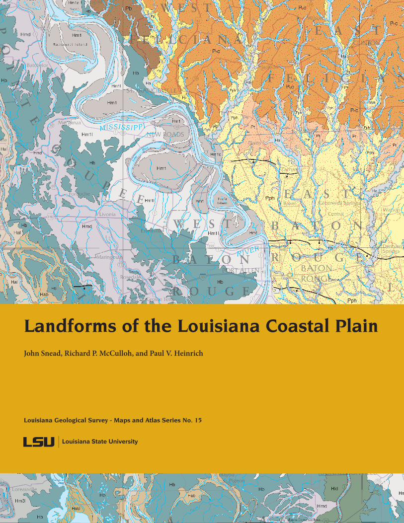
Landforms of the Louisiana Coastal PlainJohn Snead, Richard P. McCulloh, and Paul V. Heinrich
Louisiana Geological Survey - Maps and Atlas Series No. 15

Landforms of the Louisiana Coastal Plain 1
Landforms of the Louisiana Coastal Plain
John Snead, Richard P. McCulloh, and Paul V. Heinrich
geographic information systems by
R. Hampton Peele and Robert Paulsell
cartography by
John Snead, Robert Paulsell, and Lisa Pond
Louisiana state university
Louisiana Geological Survey
Baton Rouge2019
2 Landforms of the Louisiana Coastal Plain
©2019 Louisiana State University
Louisiana Geological SurveyLouisiana State University
Baton Rouge, LA 70803
website
lgs.lsu.edu
office
Room 3079Energy, Coast & Environment Building
phone
225/578-5320
Landforms of the Louisiana Coastal Plain 3
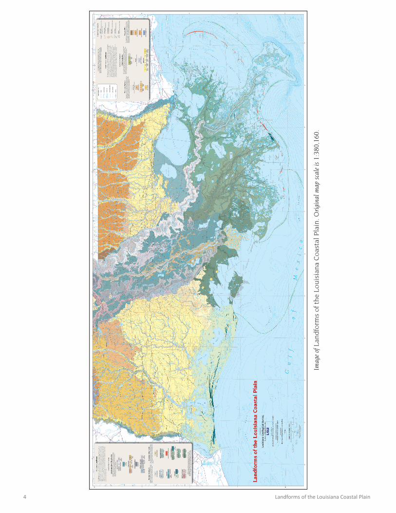
Introduction The geology of Louisiana is very recent, at least at
the surface. While older hard rock can be found in northwest Louisiana, the geologic units of the Louisiana coastal plain consist of poorly consolidated sedimentary deposits of varying age, compaction, sediment type, and origin.
Most of the surface deposits are alluvial, having been eroded, reworked by water in some fashion and accu-mulated in distinct sequences by a variety of riverine depositional processes, some of which are still ongoing. Other depositional units are coastal deposits of shells and alluvial sediment reshaped by shallow marine pro-cesses into headland beaches, barrier islands, and shoals. Most sediments in coastal Louisiana are widely varying combinations of gravel, sand, silt, and clay with occa-sional lenses of shell and peat. The composition of these deposits alone is rarely diagnostic so traditional geologic maps tend to group them together as recent unconsoli-dated Quaternary deposits.
Fortunately, the processes that deposited these sedi-ments, along with the later erosional processes acting upon them, have produced sometimes subtle, but dis-tinctive landforms that compose the coastal landscape. This map is an effort to better define these landforms, especially for non-geoscientists working in coastal resto-ration and environmental disciplines and for the inter-ested and informed Louisiana citizen.
Louisiana’s coastal plain is the suite of flat and low- lying tablelands, prairies, river valleys, natural levees, and coastal marshes that lie between the inland hill country and the Gulf of Mexico. The inland hill country of north Louisiana is composed of the eroded remnants of much older coastal plains, now removed by elevation and distance from Louisiana’s modern coastal geology issues that include land loss, hurricane storm surge, subsid-ence, delta dynamics, and sea-level rise.
The older coastal plain landforms, now elevated above the modern floodplains, show distinctive geologic traits that are analogous to the newer sediments presently being deposited and eroded on the coastal plain. The older landforms can provide insight into the evolution of modern coastal systems including the processes of faulting, coastal subsidence, inland uplift, delta develop-ment, and the marine advances and retreats associated with sea level change.
Conversely, the dynamic processes that shaped recent coastal landforms offer insight into the similar processes that formed older, inland deposits where the original landforms themselves have long since eroded away or have been consolidated into rock.
Landforms exert tremendous influence and control on soil development, drainage, natural vegetation patterns, wildlife habitats and the occupation patterns of indige-nous peoples. They affect subsequent human develop-ments such as agriculture, forest management, highway patterns, and the suburban sprawl into wetlands. Land-form awareness is essential to the research and engi-neering efforts that help manage Louisiana’s coastline and rivers.
The mapped landforms help define Louisiana’s ex-tensive riverine and coastal floodplains, areas that are subject to episodic stream flooding and hurricane storm surges. They also offer insight into the increased flood-ing potential of very flat upland regions that retain such low gradients that they can still flood during extreme rain events. Many of these regions include urban areas.
Although based on geologic map units of the Louisi-ana Geological Survey series of geologic quadrangles at 1:100,000 scale, the landforms mapped here have been extensively refined, extended, and reinterpreted based on high-resolution lidar topographic imagery that was unavailable when many of the geologic maps were developed. One-foot elevation data resolves stunningly detailed features not identifiable on the 5- and 10-foot contours of yesterday’s topographic mapping.
Many landforms have a direct relationship with a tradi-tional geologic formation described by deposition, sed-iment type, and stratigraphy. The landforms described here are based upon the shape of their surfaces, their position in the topography, the processes that created and shaped them, and the ecosystems they support. Some geologic formations have been grouped together into a single landform, while others have had several landform elements broken out within them.
4 Landforms of the Louisiana Coastal Plain
Imag
e of
Lan
dfo
rms
of
the
Lo
uis
ian
a C
oas
tal
Pla
in. O
rigi
nal m
ap s
cale
is 1
:380
,160
.
Landforms of the Louisiana Coastal Plain 5
Geology is an earth science concerned with the plan-et, the rocks from which it is made, and the processes by which they change over time. Geologically young sedimentary deposits that accumulated in river, delta, beach, estuary, lake, swamp, and marsh settings charac-terize the Louisiana Coastal Plain. The older, higher land-scapes consist of Neogene and Pleistocene sediment, while the lower areas along the coastline are the sites of Holocene deposition in these same environments that continues to the present.
GeographyCoastal Louisiana is located on the North American
continent between 29° and 31° north latitude, a third of the way from the equator to the North Pole. North of the Tropic of Cancer (23.5° N), it possesses a humid subtropical climate greatly influenced by its position on the Gulf of Mexico, a relatively warm body of ocean.
Physical ProvincesLouisiana includes portions of three significant North
America physical provinces:
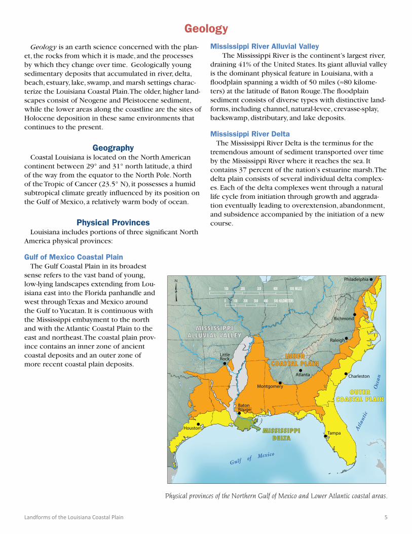
Gulf of Mexico Coastal PlainThe Gulf Coastal Plain in its broadest
sense refers to the vast band of young, low-lying landscapes extending from Lou-isiana east into the Florida panhandle and west through Texas and Mexico around the Gulf to Yucatan. It is continuous with the Mississippi embayment to the north and with the Atlantic Coastal Plain to the east and northeast. The coastal plain prov-ince contains an inner zone of ancient coastal deposits and an outer zone of more recent coastal plain deposits.
Mississippi River Alluvial ValleyThe Mississippi River is the continent’s largest river,
draining 41% of the United States. Its giant alluvial valley is the dominant physical feature in Louisiana, with a floodplain spanning a width of 50 miles (≈80 kilome-ters) at the latitude of Baton Rouge. The floodplain sediment consists of diverse types with distinctive land-forms, including channel, natural-levee, crevasse-splay, backswamp, distributary, and lake deposits.
Mississippi River Delta The Mississippi River Delta is the terminus for the
tremendous amount of sediment transported over time by the Mississippi River where it reaches the sea. It contains 37 percent of the nation’s estuarine marsh. The delta plain consists of several individual delta complex-es. Each of the delta complexes went through a natural life cycle from initiation through growth and aggrada-tion eventually leading to overextension, abandonment, and subsidence accompanied by the initiation of a new course.
Geology
Physical provinces of the Northern Gulf of Mexico and Lower Atlantic coastal areas.
�
Gulf of Mexico
Atl
anti
c
Oce
an
•Houston
•BatonRouge
•LittleRock
•Montgomery
•Tampa
•Charleston•Atlanta
•Raleigh
•Richmond
•Philadelphia
0 300100 500 MILES400200
500 KILOMETERS2000 400100 300
MISSISSIPPIALLUVIAL VALLEY
INNERCOASTAL PLAIN
OUTERCOASTAL PLAIN
MISSISSIPPIDELTA
6 Landforms of the Louisiana Coastal Plain
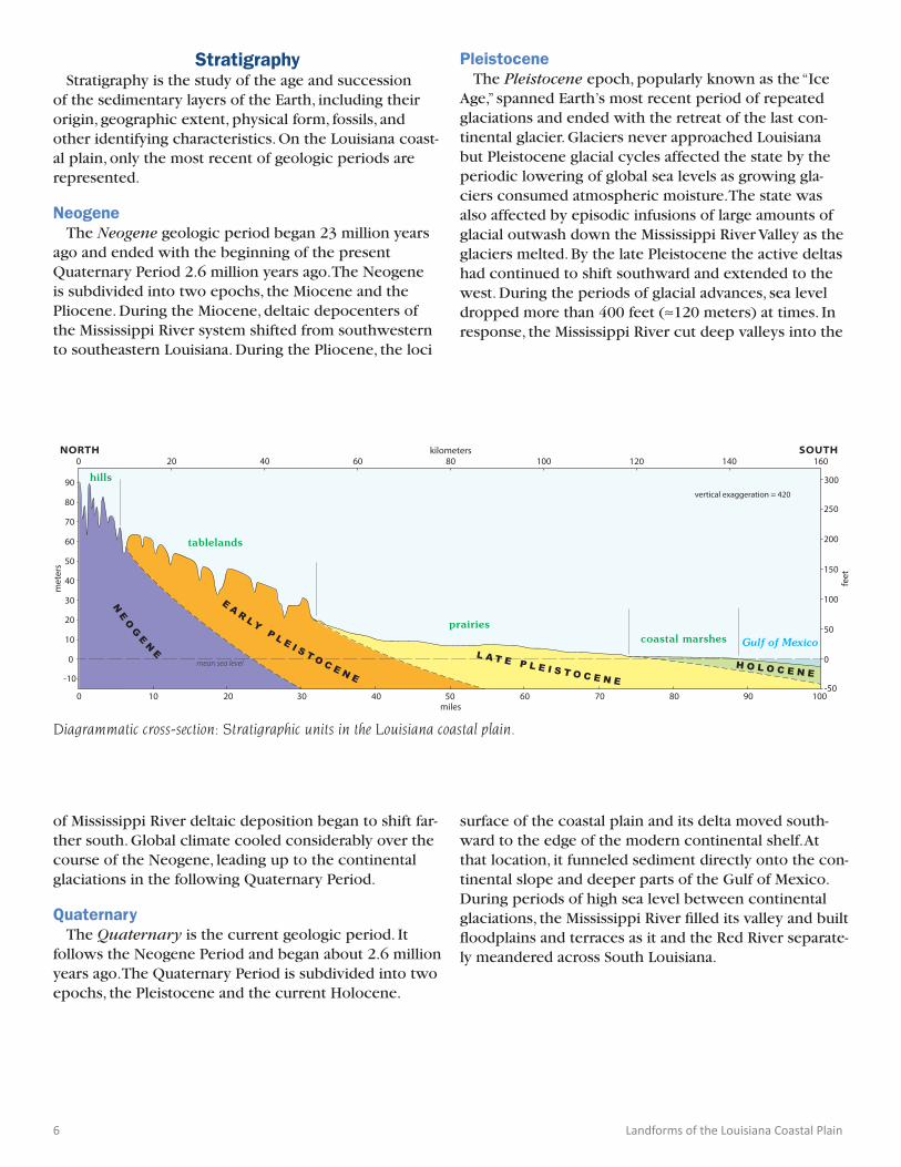
Stratigraphy Stratigraphy is the study of the age and succession
of the sedimentary layers of the Earth, including their origin, geographic extent, physical form, fossils, and other identifying characteristics. On the Louisiana coast-al plain, only the most recent of geologic periods are represented.
NeogeneThe Neogene geologic period began 23 million years
ago and ended with the beginning of the present Quaternary Period 2.6 million years ago. The Neogene is subdivided into two epochs, the Miocene and the Pliocene. During the Miocene, deltaic depocenters of the Mississippi River system shifted from southwestern to southeastern Louisiana. During the Pliocene, the loci
of Mississippi River deltaic deposition began to shift far-ther south. Global climate cooled considerably over the course of the Neogene, leading up to the continental glaciations in the following Quaternary Period.
QuaternaryThe Quaternary is the current geologic period. It
follows the Neogene Period and began about 2.6 million years ago. The Quaternary Period is subdivided into two epochs, the Pleistocene and the current Holocene.
Diagrammatic cross-section: Stratigraphic units in the Louisiana coastal plain.
0
10
-10
20
30
40
50
60
70
80
90
50
-50
0
100
150
200
250
300
met
ers
feet
0 10 20 30 40 50 60 70 80 90 100miles
0 20 40 60 80 100 160140120kilometersNORTH SOUTH
mean sea level
NE
OG
EN
E
E A R L Y P L E I S T O C E N E
L A T E P L E I S T O C E N EH O L O C E N E
hills
tablelands
prairiescoastal marshes Gulf of Mexico
vertical exaggeration = 420
PleistoceneThe Pleistocene epoch, popularly known as the “Ice
Age,” spanned Earth’s most recent period of repeated glaciations and ended with the retreat of the last con-tinental glacier. Glaciers never approached Louisiana but Pleistocene glacial cycles affected the state by the periodic lowering of global sea levels as growing gla-ciers consumed atmospheric moisture. The state was also affected by episodic infusions of large amounts of glacial outwash down the Mississippi River Valley as the glaciers melted. By the late Pleistocene the active deltas had continued to shift southward and extended to the west. During the periods of glacial advances, sea level dropped more than 400 feet (≈120 meters) at times. In response, the Mississippi River cut deep valleys into the
surface of the coastal plain and its delta moved south-ward to the edge of the modern continental shelf. At that location, it funneled sediment directly onto the con-tinental slope and deeper parts of the Gulf of Mexico. During periods of high sea level between continental glaciations, the Mississippi River filled its valley and built floodplains and terraces as it and the Red River separate-ly meandered across South Louisiana.
Landforms of the Louisiana Coastal Plain 7
HoloceneThe Holocene is the current geological epoch, some-
times referred to as the “Recent.” In the late Pleistocene, sea level had started rising about 20,000 years ago fol-lowing the maximum extent of the continental glaciers. The Holocene began about 11,700 years ago as the last continental glaciers were melting and retreating north-ward resulting in sea level rise. As sea level rose, the Gulf of Mexico inundated the previously exposed continen-tal shelf. The Holocene encompasses the growth and impacts of the human species worldwide, including all its written history and development of major civiliza-tions. In Louisiana, landforms developed on Holocene deposits have relatively low elevations with low gradi-ents and can be subject to stream flooding or hurricane storm surges.
TectonicsTectonics is the study of processes that move and
deform Earth’s crust. On a grand scale it can refer to the movement of continents, mountain formation, volcanic zones, and seismic activity such as earthquakes. In the Louisiana coastal plain tectonic activity is primarily expressed in faulting, subsidence and uplift, and the creation of salt domes.
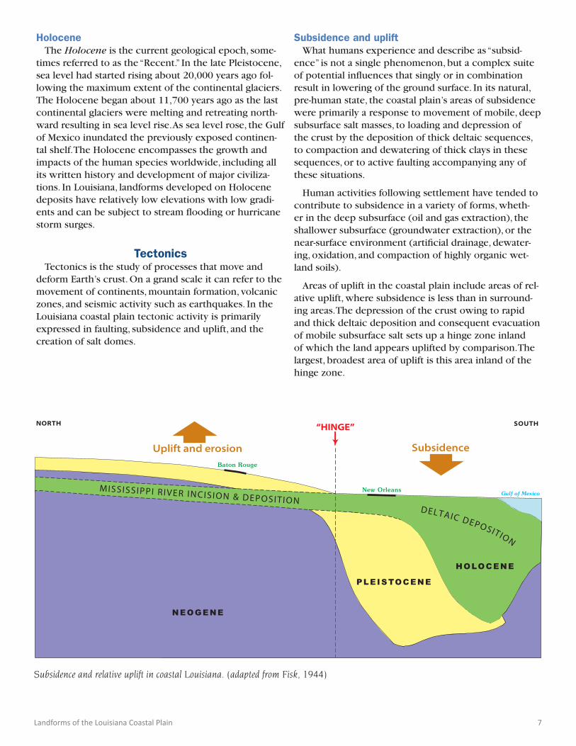
Subsidence and upliftWhat humans experience and describe as “subsid-
ence” is not a single phenomenon, but a complex suite of potential influences that singly or in combination result in lowering of the ground surface. In its natural, pre-human state, the coastal plain’s areas of subsidence were primarily a response to movement of mobile, deep subsurface salt masses, to loading and depression of the crust by the deposition of thick deltaic sequences, to compaction and dewatering of thick clays in these sequences, or to active faulting accompanying any of these situations.
Human activities following settlement have tended to contribute to subsidence in a variety of forms, wheth-er in the deep subsurface (oil and gas extraction), the shallower subsurface (groundwater extraction), or the near-surface environment (artificial drainage, dewater-ing, oxidation, and compaction of highly organic wet-land soils).
Areas of uplift in the coastal plain include areas of rel-ative uplift, where subsidence is less than in surround-ing areas. The depression of the crust owing to rapid and thick deltaic deposition and consequent evacuation of mobile subsurface salt sets up a hinge zone inland of which the land appears uplifted by comparison. The largest, broadest area of uplift is this area inland of the hinge zone.
Subsidence and relative uplift in coastal Louisiana. (adapted from Fisk, 1944)
PLEISTOCENE
MISSISSIPPI R IVER INCISION & DEPOSITION New Orleans
Baton Rouge
Uplift and erosion Subsidence
NORTH SOUTH“HINGE”
NEOGENE
HOLOCENE
DELTAIC DEPOSITION
Gulf of Mexico
8 Landforms of the Louisiana Coastal Plain
FaultingFaults in the Louisiana coastal plain are the surface
expressions of old subsurface fault zones that had gone dormant tens of millions of years ago and were reactivated relatively recently beginning in the early Pleistocene. Where the surface faults traverse Pleisto-cene landscapes they create scarps, distinctive embank-ments with noteworthy relief in places, over 20 feet (≈7 meters) along the Baton Rouge fault, and over 40 feet (≈12 meters) along the De Quincy fault. Movement along these active faults occurs as a process of gradual creep. Human activities following European settlement, including engineered surface drainage and groundwa-ter withdrawal, have led to dewatering of the surface and shallow subsurface. This has accelerated the rates of movement along faults, which now range from 1 to 4 inches (≈2.5 to 10 cm) per decade. Potential fault-re-lated hazards mainly consist of foundation damage to human structures. Flooding of the lower ground on the downthrown side is also a risk in places along some faults.
Surface faults are also known in the Holocene but their escarpments have small displacements, easily masked by water, soft sediment, and marsh vegetation. Some can be recognized at the surface by linear land/water interfaces, linear vegetation changes, and marsh breakup on the dropped side.
Salt domes
Additional local areas of uplift are associated with salt domes, natural mounds cored by salt fed from a deep-subsurface bed of Jurassic age. The pinnacles of salt coring these mounds may always have been near their present elevations, and maintained them over time as the Gulf basin floor subsided and was buried by ever thicker sedimentary deposits, while the deepening Jurassic layer fed them mobile salt through increasingly long conduits. This mobile behavior of thick salt is a re-sult of unique material properties that enable it to flow plastically at temperatures and pressures that exist in the deep subsurface.
Depositional EnvironmentsWherever sediment deposition occurs, the setting and
formative processes influence the nature of the sedi-ment that accumulates. In the Louisiana coastal plain, the main depositional environments are those dominat-ed by rivers and streams, winds, deltas, and coastal-ma-rine activity.
AlluvialProcesses that result in accumulation of river or
stream deposits (alluvium) are termed alluvial. The deposits may be relatively coarse (sand and gravel, as in point-bar deposits of the meander belt), relatively fine (clay and organic matter, as in backswamps), or interme-diate in texture (natural levee, sandier near the channel and finer with distance from it, formed by overtopping banks during flood stages).
AeolianWhere wind is the main agent of transportation and
deposition of sediment, the environment and processes are termed aeolian. The most extensive aeolian deposits in the coastal plain consist of silt deposited by winds during the Pleistocene and referred to as loess. This silt is thickest near the Mississippi River floodplain, where it may exceed 30 feet (≈9 meters) in places, and thins to the east and west. This layer is more extensive on the east side of the river. Other aeolian deposits are generally minor, and include thin veneers of light sand of Holocene age capping hills in parts of southwestern Louisiana.
DeltaicWhere rivers and streams are of sufficient size and
capacity to dominate marine processes and create an outbuilding of the coastline with their transported sediment, the result is a region commonly with a shape resembling the Greek letter delta (∆). Major deltas are composed of several depositional centers called delta complexes, which result from the switching of the main river channel from one depositional site to another. Each major course of the Mississippi River during the Holocene is associated with a delta complex.
Each delta complex may be divided into distribu-tary courses, which branch toward the coast, and the shallow interdistributary plain (marshland and bays) between them. The distributary channels form low ridges with narrow flanking natural levees. The interd-istributary plains consist of the low-lying intervening flood basins occupied by coastal marsh and estuaries, which accumulate finer and more organic-rich sediment.
Landforms of the Louisiana Coastal Plain 9
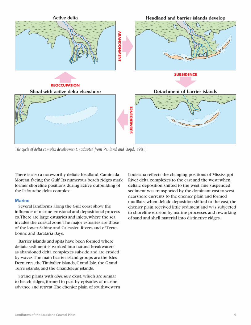
There is also a noteworthy deltaic headland, Caminada–Moreau, facing the Gulf. Its numerous beach ridges mark former shoreline positions during active outbuilding of the Lafourche delta complex.
MarineSeveral landforms along the Gulf coast show the
influence of marine erosional and depositional process-es. There are large estuaries and inlets, where the sea invades the coastal zone. The major estuaries are those of the lower Sabine and Calcasieu Rivers and of Terre-bonne and Barataria Bays.
Barrier islands and spits have been formed where deltaic sediment is worked into natural breakwaters as abandoned delta complexes subside and are eroded by waves. The main barrier island groups are the Isles Dernieres, the Timbalier islands, Grand Isle, the Grand Terre islands, and the Chandeleur islands.
Strand plains with cheniers exist, which are similar to beach ridges, formed in part by episodes of marine advance and retreat. The chenier plain of southwestern
The cycle of delta complex development. (adapted from Penland and Boyd, 1981)
Active delta Headland and barrier islands develop
Detachment of barrier islandsShoal with active delta elsewhere
distributary channel delta plain marshnatural levee beaches and barrier islands submerged shoals
ABANDONMEN
T
SUBSIDENCE
REOCCUPATION
SUBMER
GEN
CE
Louisiana reflects the changing positions of Mississippi River delta complexes to the east and the west: when deltaic deposition shifted to the west, fine suspended sediment was transported by the dominant east-to-west nearshore currents to the chenier plain and formed mudflats; when deltaic deposition shifted to the east, the chenier plain received little sediment and was subjected to shoreline erosion by marine processes and reworking of sand and shell material into distinctive ridges.
10 Landforms of the Louisiana Coastal Plain
LithologyLithology is the physical character of a sediment or
rock described in terms of its particle size, color, mineral composition, and structure.
Sediment typesMaterial transported over time by the Mississippi River
system and by smaller rivers and streams dominates sed-iment in the coastal plain.It consists largely of clay, sand, and gravel in varying combinations and proportions, with significant organic matter in the wetland areas. Gravel is generally absent in Neogene outcrops, but con-stitutes an important component of the Pliocene and Pleistocene deposits occurring on the highest landscape positions in south Louisiana. The gravels were probably deposited by braided streams or in alluvial fans.
Large particles of gravel and sand are common in channel deposits while fine sediments of silt and clay are common in backswamps. The intervening natural levees range from coarser sands near the channel to finer sands, clays, and silts near the backswamp. Thick and thin lenses of any of these kinds of sediment can be found in many deposits. Organic matter forms layers of peat in the coastal swamps and marshes, while marine processes can create beach deposits of sand and marine shells. Fine silts can be deposited by both wind and water.
Soil developmentBecause of differences in parent material, relief, slope
and age, soils exhibit a wide range of physical proper-ties. Within the southern Louisiana coastal plain, the parent materials vary from unconsolidated, redeposited sands and clays to silty sediments of aeolian and alluvial origin. Very young peats, mucks, and clays are parent materials of deltaic marshes and alluvial swamps. In areas of highest relief in the older dissected terraces, the soils are aerated, oxidized, and well drained where they lie well above the influences of the ground water table. These soils often are brown, red, and yellow in color un-like the grayish, poorly drained soils of flood and deltaic plains and flatter, low relief surfaces.
The oldest soils of the coastal plain are typically ex-tremely weathered, leached of nutrients, disturbed by burrowing animals and roots, and oxidized with strongly developed horizons. In contrast, the soils of very young organic deposits and clayey sediments of the flood and deltaic plains have not had time to develop distinct horizons.
Landforms of the Louisiana Coastal Plain 11
Geomorphology is an earth science concerned with the origin and evolution of topographic and bathymet-ric landforms shaped by physical processes operating at the earth’s surface. The geomorphology of the Louisiana Coastal Plain is characterized by distinct landforms that were created by a combination of riverine, coastal, and marine processes. Most Holocene landforms such as natural levees, distributary complexes and beach ridges reflect constructional processes, whereas topographic features of older landforms have been significantly mod-ified by erosion and tectonics with only some localized preservation.
Erosional and Shaping ProcessesPhysical processes associated with landform devel-
opment have varied over time. As a result, many of the landforms in south Louisiana reflect the cumulative effect of repeated changes of climate, sea level, or other factors.
FluvialThe rivers and streams of south Louisiana include
tributaries and distributaries of the Mississippi River and many smaller rivers that drain into the Lake Pontchar-train Basin or directly to the Gulf of Mexico. During the Holocene, the Mississippi River meander belt and delta have shifted at least five times. Shifting of the Mississip-pi River course also occurred during the Pleistocene and significantly influenced the deposition of alluvium and loess along the ancestral channels of the lower valley. The shifting courses of other major and minor steams also have influenced sediment accumulation and landform development in the Louisiana coastal plain. Shifting streams produce geomorphic features such as abandoned channels, scroll topography, relict flood plains, and oxbow lakes.
AeolianDeposits produced by wind occur in south Lou-
isiana in the form of broad blankets of loess that cap Pleistocene deposits near the Mississippi River valley. This wind-blown fine silt can be as much as 9 meters in thickness and can produce blufflands where deep stream entrenchment occurs. These slopes naturally weather to vertical walls, unique among Louisiana land-forms. Aeolian processes can also form sand dunes on headland beaches and barrier islands.
Hill slope Topographic relief is relatively low in coastal Louisi-
ana. The highest relief is found on the oldest surfaces, along escarpments flanking the Mississippi River alluvial valley, at some contacts between deposits of different ages, and where faults and salt dome intrusions displace overlying strata. Where relief exists, gravity itself has the potential to erode a landform. Commonly this reshaping manifests itself as mass movements such as landslides, mudflows, and slump blocks on hill slopes. Rainwash and small rills transport finer sediment downslope even in the absence of a small stream channel. Geomorphic features produced by these hill-slope processes include fans and aprons of sediment and debris.
MarineShoreline development along abandoned deltas is a
product of relative sea level rise and erosional shoreface retreat. After delta abandonment, subsidence produces a relative rise of sea level in which marine processes transform a once-active delta into an erosional headland followed by the development of a barrier island arc sys-tem and eventually an inundated shoal. The nature of the shoreline thus reflects the relative age of the abandoned delta complex. Geomorphic features of an erosional headland include active beaches, beach dunes, flanking barrier islands and strand plain complexes composed of relict beach ridges.
The chenier plain is composed of alternating or coalescing chenier ridges formed by the advance of the sea and mudflat and marsh deposits formed by the retreat of the sea. The majority of these shore-parallel ridges are formed by coastal reshaping and are similar in form to beach ridges. The lakes of the chenier plain are typically rounded and some may be relicts of unfilled estuaries that were isolated from the sea by the build-ing of mudflats and beach ridges across their mouths. Geomorphic features of the chenier plain include the long and narrow chenier ridges, perched beaches, and overwash deposits.
GlacialSea-level changes related to glacial cycles have long
been recognized as important influences on landscape development in coastal Louisiana. Sea level affects the position of the shoreline and the character of drainage basins, and these in turn may influence river gradients, patterns, and courses as well as terrace development.
Geomorphology
12 Landforms of the Louisiana Coastal Plain
TectonicStructural and tectonic influences in south Louisi-
ana include salt dome intrusion, faulting, and regional structures that are subsiding or being uplifted. Nine salt domes in south Louisiana have surface expression as surface mounds, with maximum relief approaching 160 feet (≈50 meters) on Avery Island. Faults that have surface expression in the form of linear escarpments in places have likely contributed to bends in stream cours-es and alignment of stream patterns. Regional effects have tilted terrace slopes in south Louisiana as rapid deposition and loading of the deltaic sediments have resulted in increased subsidence Gulfward.
HumanEnvironmental engineering has become an important
aspect of landform development in coastal Louisiana. Potential geologic problems and hazards exist includ-ing annual river flooding, hurricane storm surge, and subsidence. To reduce threats of certain natural events, humans have modified the landscape. The Old River Control Structures were built to prevent the Mississippi River from changing its course to flow into the Atchafa-laya basin. An extensive artificial levee system has been built along the major rivers in south Louisiana to reduce the risk of flooding. Numerous engineering structures have been built to improve drainage, and reduce coastal or riverbank erosion. They include giant flood diversion structures like the Morganza and Bonnet Carre Spill-ways. Artificial lakes and huge navigation channels have been created. These drainage modifications have often affected landforms and ecosystems.
Municipal landfills and giant spoil mounds of indus-trial plant by-products (mostly gypsum) now exist as human-made geomorphic features. They form some of the tallest hills in the coastal plain. Many surface and near-surface salt domes have been excavated for salt mining and for petroleum storage resulting in the acci-dental collapses of salt dome caverns and in some cases the creation of sinkholes.
Landscapes Hills and blufflands
There is no mountainous terrain in coastal Louisiana, but there is hilly country associated with the older Neo-gene and Pleistocene deposits, now uplifted and eroded by streams. It is a landscape of low, rolling hills with rare escarpments. Blufflands flank parts of the Mississippi River Valley where thick loess has naturally eroded into vertical faces rather than a slope. Thick loess can erode into heavily dissected badlands with even the smallest streams excavating deep ravines. Some towering cliffs exist on stream cut banks.
Terraces and tablelandsA terrace is a step-like landform. It consists of a flat or
gently sloping surface that is typically bounded on both sides by a steeper slope called a scarp. Fluvial terraces are remnants of the former floodplain of a stream or river. They are formed by the downcutting of a river or stream channel into its now abandoned floodplain. Ta-blelands are older coastal plains featuring relatively flat-topped ridges standing above their stream bottoms and are a broader, coastwise equivalent of the river terraces. Pleistocene deposits of intermediate age, they naturally harbor a flatwoods ecosystem and stand topographically above the grassland Prairie landforms and have not yet been dissected by streams and weathered into the hills characteristic of older deposits to the north.
Prairies and savannahs A prairie is a natural grassland. In coastal Louisiana,
the term is also used for the landforms on which these grasslands occur. In southwest Louisiana the fluvial and flat, broad coastwise surfaces deposited in late Pleis-tocene time were described as prairies by the earliest settlers, attracted by land standing higher than the wet bottomlands and already clear of forests. In eastern Louisiana, the equivalent flat coastwise landform har-bored a longleaf pine savannah, a mixed forest/grassland ecosystem characterized by the trees being sufficiently widely spaced so that the canopy does not close, allow-ing grassland to exist among the trees.
Natural levees and distributary ridgesNatural levees are long low ridges that are formed
by floodwater sedimentation immediately adjacent to the riverbank and can be narrow or broad. When a river floods, larger material is deposited closest to the riverbank. Smaller material is deposited further away and leads to the formation of gently sloping sides of the levees. Many large and small crevasse splays occur along the natural levee and help shape it. These fan-shaped
Landforms of the Louisiana Coastal Plain 13
geomorphic features are created by sediment issuing from a breach in a natural levee during flood stage and often extend beyond the limits of the natural levee.
A stream that develops large natural levees generally also aggrades its channel bed, which can be almost as high as, or higher than, the surface of the adjacent flood plain. Such a stream flows on top of a low ridge, which is common on the delta distributaries of the Louisiana coastal plain.
SwampsA swamp is a frequently flooded forested wetland
occupying low-lying areas. Backswamps are swamps located along large rivers and lakes in the lowest part of the floodplain, where they are critically dependent upon natural water level fluctuations. They are typically located some distance away from the stream channel on the floodplain. When water spills over onto the floodplain, the heaviest material drops out first to create natural levees and the finest material is carried a greater distance into the backswamp. The fine-grained alluvium holds much water and drains rather slowly creating wet-land areas where lakes are common.
MarshesA marsh is a coastal wetland that is usually flooded
and dominated by grasses, rushes, and reeds. If woody plants are present they tend to be scattered low-grow-ing shrubs. In the chenier plain and the delta plain of coastal Louisiana, broad areas of coastal marsh separate other landforms from one another. Various marsh types exist including saltwater marshes, brackish tidal marsh-es, and freshwater marshes, differing mainly by salinity level and each harboring its own ecosystem.
Barrier islands and erosional headlandsBarrier islands are landforms that form parallel to
the coast by wave and tidal action. They usually occur in chains, consisting of anything from a few islands to more than a dozen. Over time, they can migrate and change size and shape. They are subject to overwash and breaching during storms but absorb marine wave energy and protect the back-barrier coastlines creating protected waters where wetlands may flourish.
In the Louisiana delta plain, an abandoned delta no longer able to build seaward with sediment is reshaped by marine processes into an erosional headland flanked by barrier islands and eventually into a chain of de-tached barrier islands. Linear active beaches and beach dunes characterize barrier islands and headlands. Some are significant wildlife habitats, particularly for coastal birds, and are protected from human development by their relative remoteness and inaccessibility.
Cheniers and beach ridgesThese are similar landscapes characterized by long,
narrow parallel and coalescing ridges standing above the coastal marsh, often harboring live oak trees. Che-niers are common in southwest Louisiana, while beach ridges prevail in southeast Louisiana. They differ in their manner of origin.
Beach ridges reflect former shoreline positions of a retreating sea marked only by differences of sediment supply. Older relict beach ridges also can be found on Late Pleistocene landforms.
Cheniers are wooded sandy or shelly ridges separated by narrow strips of intervening mud flats with marsh vegetation. Similar in form to beach ridges, cheniers are associated with muddy shorelines with low wave energy formed by the periodic accretion and erosion of coastal mudflats.
14 Landforms of the Louisiana Coastal Plain
SeascapesIn many places on earth, rocky shorelines are well
defined and relatively stable in position. In coastal Louisiana, a dynamic shoreline is in many places quite difficult to identify and changes shape continually. The transition zone from land to sea is very gradual in many places due to the very flat nature of the coastal marshes and a very shallow seafloor. The Mississippi and other coastal rivers are constantly delivering new sediments yet subsidence and sea level rise continue to cause land loss. Meanwhile marine wave processes and storm surges both erode and deposit sediment as they reshape coastal landforms. Several important geomorphological features characterize coastal landforms.
EstuariesAn estuary is a partially enclosed coastal body
of brackish water with freshwater streams flowing into it, and with a free connection to the open sea. Estuaries are subject both to marine influences—tides, waves, and the influx of saline water—and to riverine influenc-es—fresh water and sediment. The inflows of both sea water and fresh water provide high levels of nutrients both in the water column and in sediment, making estuaries among the most productive natural habitats in the world. In coastal Louisiana, estuaries are widespread along the coast and can be found in the chenier plain and delta plain as well as the Pontchartrain Basin.
Coastal bays and lakesA bay is a wide, recessed, coastal body of water that
directly connects to a larger main body of water, the Gulf of Mexico in the case of coastal Louisiana. Large and small coastal bays are common in many delta plain marsh landforms. Many Louisiana bays are also estuaries and include many inlets, lagoons, interconnected lakes, and waterways in a marsh setting. Barrier island arcs protect some bays.
Large and small inland lakes also abound in the transi-tional shoreline zone, mostly very shallow. A large part of coastal land loss in Louisiana comes from the widening of these coastal lakes rather than the retreat of shore-lines. Lake Pontchartrain is unique in Louisiana, not only due to its large size but also to its origin as the evolving Mississippi River Delta extended across a former bay.
Shoals and reefsThe deposits of the Mississippi River Delta are not
just the land now exposed at the surface but much of the shallow seafloor extending onto the continental shelf. Many delta complexes have been created, aban-doned, and buried by subsequent complexes or gradual-ly submerged by sea level rise. Remnants of former delta complex and barrier landforms can still be discerned as arcuate shoals off the Louisiana coast.
Intertidal shell reefs are deposits of living or dead mollusks, mostly oysters or Rangia clams, in estuarine environments. The living assemblage exists on top of a dead shell reef base. The reefs also absorb marine ener-gy and create protected waters. They may or may not be exposed at low tides. Intermittently exposed reefs are used by shorebirds for feeding, while permanently exposed reefs are used as nesting sites.
Extensive shell dredging in the past has badly dam-aged many historic shell reefs, particularly in Lake Pon-tchartrain. Shell dredging is no longer permitted.
Landforms of the Louisiana Coastal Plain 15
Ecology is the scientific study of interactions among organisms and their environment. An interdisciplinary field, it includes both life sciences and earth sciences. The ecosystems of the Louisiana Coastal Plain are in many ways closely tied to the landforms on which they reside.
Natural vegetation The natural vegetation of coastal Louisiana is known
from the distribution of existing remnants and from much historical documentation. The historic natural vegetation of the Louisiana coastal plain encompassed a wide diversity of habitat types, from rich upland hard-wood forests flanking the Mississippi River Valley, open piney woodlands across the hills, to grassy prairies and savannahs in the flat Prairie landforms, to dense wet hardwood forests and cypress-tupelo swamps along stream bottoms, to marshes and cheniers near the coast. All of these were distinctly tied to the unique landforms where they were found.
In prehistoric times, indigenous peoples lived lightly on the land yet transformed the natural ecology of southern Louisiana in ways that are both subtle and not so subtle. Their widespread use of fire profoundly influ-enced the forests, woodlands, savannahs and prairies of the area. Within the deltaic plain, the planned and un-planned accumulation of shells and camp debris created mounded middens that became locations that are still important environmental components of the modern marsh ecology.
With the permanent settlement of Europeans in Louisiana about 300 years ago, humans began to dramat-ically change the natural vegetation patterns by clearing primeval forests and introducing agriculture. The wide-spread introduction of non-native plants and animals has dramatically changed the natural ecosystems. The native forests have mostly been dramatically reduced by logging and replaced with a domesticated landscape composed of pine tree farms, agricultural land, and resi-dential development. The historical tallgrass prairies of southwest Louisiana are reduced to scattered remnants.
Forests Louisiana’s semitropical climate is conducive to for-
ests. Most of the landforms of coastal Louisiana naturally harbored forests of different types.
The well-drained hilly upland landforms of eastern Louisiana were covered naturally with a beech-magno-lia-holly upland hardwood forest unique to Louisiana in the blufflands flanking the Mississippi River valley.
Mixed shortleaf pine-oak-hickory forests were found in the rolling central area, and open longleaf pine wood-lands in the sandier hills to the east. Longleaf woodlands were essentially pure pine with few hardwoods except along slopes and permanent streams. They supported a very rich diversity of native herbaceous plants growing in the grassland under their open canopies. Both long-leaf woodlands and shortleaf-oak-hickory forests were maintained by frequent fire originating from lightning and indigenous peoples.
The rolling hill country of southwestern Louisiana supported primarily longleaf pine woodlands similar in structure and composition to the longleaf woodlands of the east, but also sustained hardwood dominated upland forests in less fire prone places, such as highly dissected areas and on steep slopes leading down to large stream bottoms. As in the east, frequent fire was a major force that perpetuated longleaf pine woodlands.
The western Louisiana tablelands naturally support-ed an open longleaf pine flatwoods, also maintained by wildfires, and quite similar to the flatwoods in eastern Louisiana. Its understory consisted of bluestem grasses and other herbaceous species. Minor patches of mixed pine-hardwood forests were also present.
The floodplains of streams, including the Mississippi and Atchafalaya Rivers, supported a complex variety of bottomland hardwood forest types, with variation in composition mainly driven by elevation and length of inundation. Hardwood species found along smaller, high-er gradient streams are oak, sweetgum, red maple, and beech, which are dryer-phase bottomland hardwoods that are tolerant of occasional flooding. The lowest part of floodplains of larger streams support wetter-phase bottomland hardwood swamps dominated by bald cypress and tupelo gum, more tolerant of sustained inundation.
The chenier and beach ridges along the coast can harbor groves of live oak and hackberry and some other hardwoods.
Ecology
16 Landforms of the Louisiana Coastal Plain
GrasslandsThe Beaumont and Avoyelles Prairie landforms of
western Louisiana sustained natural treeless tallgrass prairies, occasionally interrupted by narrow “gallery forests” along small streams. These prairies contained an abundance of grasses and other herbaceous species typified by bluestem, switchgrass and Indian grass. In prehistoric times, prairie grasslands covered about 2.5 million acres in Louisiana. Today less than 500 acres remain. Much of the natural prairie grasslands have been lost as a result of conversion to rice, sugarcane, and for-age crops, and for permanent pastures for cattle grazing.
The flat plains of the Hammond landform of eastern Louisiana naturally harbored rich grasslands under longleaf pines. A savannah is an open forest where pines are very scattered, and the ground is covered with a broad diversity of grasses, sedges, and specialized plants, including carnivorous pitcher plants. The natural savan-nah grassland was maintained by wildfires and is rapidly encroached by invasive plants in its absence.
WetlandsPerennial freshwater wetlands can support grassy
marshes in some places rather than swamp bottomland forests. Cane, rushes and grasses can be found. Water lily, cattails, and duckweed occupy open and still water.
Grassy marshlands dominate the delta and chenier plains along the coast. Their ecosystems support a range of freshwater to saltwater marsh vegetation that con-tains a diversity of grasses, sedges, and rushes. Saline marshes of marshhay, cordgrass, Olney bulrush and saltgrass grade through brackish marshes, with smooth cordgrass and black needlerush into freshwater marshes containing alligator weed, spike rush, maidencane, cut-grass, and bulltongue.
Wildlife habitatsCoastal landforms and the ecosystems they support
directly affect wildlife habitats through a variety of phys-ical factors such as soil, moisture, and habitat structure. They have a direct bearing on the types and availabil-ity of foods and potentially the presence or absence of predators. Every organism has certain habitat needs for the conditions in which it will thrive, but some are tolerant of wide variations while others are very specif-ic in their requirements and prefer habitats associated with particular landforms.
TerrestrialCoastal Louisiana is the home of a wide variety of
native animal life in terrestrial habitats. Most of the com-mon mammals, birds, and reptiles of southeastern North America can be found in abundance. Many millions of
migratory birds transit through the area semiannually and 6 million waterfowl winter in the Louisiana coastal marshes. Human encroachments into their former habi-tats and extensive agricultural and forestry deforestation have changed the natural patterns, but most species have adapted. Invasive species such as the fire ant and the nutria are permanent residents now and occupy their own favored ecosystems.
Many species have recently become extinct, such as the ivory bill woodpecker. Others, including the bison, no longer range into Louisiana. Many local species are endangered, such as the whooping crane, but a few others have made impressive comebacks, including the alligator and the bald eagle. Isolated barrier islands and distributary ridges provide nesting areas for seabirds and shorebirds including the Brown Pelican, the state bird.
AquaticCoastal Louisiana has a deep coastal zone with exten-
sive marshlands, numerous streams, and large estuaries in interaction with the sea. It has enabled an abundant amount of aquatic life in a variety of landform-related habitats, inshore, offshore, and on the shoreline. Shallow coastal waters and marshland lakes are home to many aquatic mammals as well as abundant fish and crusta-ceans. Estuarine areas protected by barrier islands and distributary ridges provide spawning areas for many ma-rine species of the Gulf of Mexico. Intertidal shell reefs provide habitat and shelter for many species of small fish and invertebrates. There has been overfishing of cer-tain species by humans, but the fishery is managed.
Landforms of the Louisiana Coastal Plain 17
Human impactsIndigenous peoples
People native to coastal Louisiana preferred certain landforms for their villages, often the better drained areas near abundant food sources in the wetlands. The artifacts of indigenous people are found commonly on bluffs near small interior streams, natural levees in the river valleys and on distributary ridges in the delta. Alluvial terraces situated above the annual floods were another preferred landform. Archaeological evidence can help date delta-complex shifting because the com-plexes form, are abandoned and later subside, leading to shifting human populations. In many places they constructed artificial hills at great effort. Over 700 of these mounds remain in Louisiana. Indigenous peoples, although part of the natural system, did clear land and alter ecosystems. They added significant features—mounds and debris middens—to the landscape.
AgricultureTechnologically advanced immigrants from Europe
after the 15th century dramatically impacted natural eco-systems, mainly through clearing of forests to produce croplands and for fuel. In the last century managed for-estry practices have transformed much of the remaining forests into single-species tree farms, often with non-na-tive species. Ditches and canals for drainage or for irrigation are often associated with agriculture. Forested natural levees in the alluvial valleys and distributary ridges in the marshlands have been mostly cleared for agriculture. Alluvial terrace and prairie grasslands have also been transformed for agricultural development.
Urban developmentHuman development in areas of wetland soils inevita-
bly leads to subsidence effects at the surface resulting from drainage and compaction, even in small coastal communities. In the New Orleans area, where previous-ly avoided wetlands were developed beginning in the 20th century, revised building codes required new struc-tures to be supported on pilings. In many places this led to the detachment and lowering of once-attached driveways from buildings, as the surrounding ground subsided relative to the foundations fixed in place by the pilings. Hurricane-protection levees at New Orleans and Golden Meadow now enclose developed land lying below sea level due to subsidence. Seaports below sea level are at constant risk of flooding.
Ditching and the draining of wetlandsHuman attempts to drain wetlands to produce dry
land have changed the landscape with very mixed results. Artificial drainage projects greatly accelerate the dewatering, compaction, and oxidation of thick clay and
peat beds in shallow wetland areas. As a result, where new development occupies former wetlands, subsid-ence of 3 feet (≈1 meter) may take place in as little as 25 years.
River managementEngineers have long endeavored to manage the rivers,
especially the Mississippi River system. Giant flood con-trol structures, extensive levees and floodways, chan-neling, and the widespread use of concrete revetments haved changed the natural flood patterns and inhibited the meandering paths of many rivers. This has affected the natural evolution of the landforms associated with them, especially delta switching and accretion.
Canals and spoil banksCanals created for drainage, navigation, oil field access,
or pipeline construction evacuate water previously held in the soil column and expose draining peat beds to the atmosphere, leading to oxidation and dramatic volume loss. Along with their associated spoil banks, they also disrupt the preexisting natural drainage, becoming barri-ers in some areas and forming new or shortcut connec-tions in others, and can contribute to land loss.
Levees and poldersLevees, as massive earthworks, ultimately lead to com-
paction of the underlying soil column and periodically must be raised with additional material just to maintain their design elevations. Past agricultural ventures in some wetland areas led to their enclosure by levees with artificial drainage, creating polders. These im-poundments ultimately experienced substantial surface subsidence in the range of 3 to 8+ feet (≈1 to 3 meters), after which some became permanently flooded.
Alteration of natural fire regimesMany of the ecosystems of the Coastal Plain, including
upland longleaf and shortleaf pine woodlands, piney flatwoods, and prairie grasslands and savannahs were created by frequent fire and actually depend on fire for perpetuation. Modern society in general does not recog-nize this and considers all wildfires a danger. Agricultural and urban/commercial development along with asso-ciated landscape alterations have dramatically changed when, where, and how fire works in these ecosystems. Even where remnants of fire-adapted natural habitats persist, fire is today highly constrained by societal demands and misconceptions. Lack of environmentally appropriate fire has directly led to severe habitat and species depletion, and significant degradation of rem-nant natural areas.

18 Landforms of the Louisiana Coastal Plain
Landforms of the Louisiana Coastal Plain 19
The mapped landforms are grouped into six geomor-phic divisions based on their related characteristics, formative processes, and age. Units in each division are listed in relative age from youngest to oldest.
Modern FloodplainsAs a Geomorphic Division for this map, Modern
Floodplains includes active Holocene alluvial flood-plains and coastal marshes, exclusive of the alluvial and deltaic floodplains associated with the Mississippi River. These are landforms developed and still developing along modern streams and coastlines. Low in elevation with a very shallow gradient, this is where floodwaters naturally overflow and accumulate.
An alluvial floodplain is the land occupied by a stream that stretches between its enclosing valley walls and experiences flooding during periods of high water. All floodplains are subject to periodic flooding from swollen rivers. Coastal wetlands are low-lying coastal marshes, commonly in estuarine basins. Tidewaters can submerge some portions of coastal wetlands and all of it is subject to inundation from episodic hurricane storm surges.
Small stream bottomsThese are low-lying flat alluvial bottomlands filling small val-leys of upland creeks and smaller coastal rivers incised into older deposits. They are in many places wetlands. Highly fer-tile, but poorly drained soils form in mixed deposits of silt, sand, and in some places gravel. In wetland bottoms, natural vegetation is a bottomland hardwood forest, typically cypress and tupelo gum. In smaller, higher gradient bottoms ash, wa-ter oak, beech, magnolia, red maple, and occasional loblolly pine are found.
Meander belts of coastal riversMeander belts in the Pearl River and Sabine River valleys form uneven ridge-and-swale topography. This is the area within which migration of a meandering channel occurs, leav-ing coarse deposits of gravel and sand. Geomorphic features flanking the sinuous stream channels include: point bars, cut banks, abandoned meanders, meander scrolls, and oxbow lakes. Active meander points are capped with sand bars that tend to lack vegetation, while inactive meander areas harbor swamp vegetation, narrow ponds, and dryer-phase bottom-land hardwood forests.
Natural levees of coastal riversNatural levees are elongate low ridges mainly consisting of mud and sandy silt that naturally form on river floodplains immediately adjacent to active or relict channels. The depos-its of fine sand, silt and mud drop out of suspension during stream overbank flooding building up the ridge through re-peated floods, producing high ground along the meander channels. Commonly the highest ground in a river basin, nat-ural levees are better drained landscapes than the adjacent meander belts and backswamps and naturally support mixed hardwood forests.
Alluvial backswampsBackswamps occupy the lowest elevations of an alluvial floodplain and lie in basins beyond the natural levees. The finest silts and clays that take a long time to drop out of sus-pension are deposited in the backswamps during high water. Organic matter accumulates in them between such episodes. These areas are very poorly drained wetlands, seasonally inundated and typically home to perennial and intermittent lakes. Natural vegetation consists primarily of bald cypress–tupelo swamps in the lowest areas and wetter-phase bottom-land hardwoods in higher positions.
Coastal swampsCoastal swamps are similar in nature to alluvial backswamps but are commonly more extensive and consist of fine silt and clay deposits in basins around large coastal lakes and la-goons rather than within river basins. They support wetland ecosystems including bottomland hardwoods, bald cypress–tupelo swamps, and occasional fresh marshes.
CheniersCheniers are relict coast-parallel ridges of sand and shell separated by intervening mud-flat deposits supporting marshes that are part of a region called the Chenier Plain. The narrow cheniers stand above the marshes of the Chenier Plain, typically 3 to 18 feet (≈1 to 5 meters) high, tens of miles long, hundreds of yards wide, and generally support live oak and hackberry groves (the name is derived from the French chêne, oak). Cheniers provide the only high ground for trees or human settlements in the Chenier Plain but still can be exposed to damaging hurricane winds and storm surge.
Landform Map Descriptions
Hm
Hl
Hb
Hcs
Hch
Ha
20 Landforms of the Louisiana Coastal Plain
Coastal marshlandsCoastal marshlands of the Chenier Plain form on deposits associated with the longshore marine transport of fine mud-dy sediments westward from the Mississippi River Delta. The marshes formed behind and between the chenier ridges and are partly protected by the cheniers from storm surges. They form a relatively thin veneer over shallow buried Pleistocene deposits and do not suffer as badly from subsidence and storm surge as do the tidal marshes of the Mississippi Riv-er Delta to the east. The Chenier Plain marshes are inter-spersed with small streams and extensive estuaries with a series of large coastal lakes. These marshlands are a major wildlife habitat supporting a critical ecosystem that includes the endangered whooping crane. It is a major stopover for many species of migratory birds bound to and from Yucat-an. Six million other migratory birds winter in the Louisiana coastal plain alongside perennial seabirds and shorebirds.
Red River meander beltThe Red River is the second largest river in the state. It is unique among Louisiana rivers in that it once flowed directly to the sea in Pleistocene time, has been a direct tributary of the Mississippi River in the Holocene, and in historic times has become a tributary of the Atchafalaya River. The Red car-ries a large amount of sediment in a fairly narrow alluvial val-ley that is characterized by repeated meander-belt switching and almost wall-to-wall natural levees. In the map area, the Red River meander belts have spread out over a wide area as the river has shifted and created a broad, low transitional area as it adjusts to meet the evolving courses of the Missis-sippi River Alluvial Valley. Meander belts in the Red River val-ley form uneven ridge-and-swale topography where the chan-nel has migrated, leaving coarse deposits of gravel and sand. Geomorphic features flanking stream channels include: point bars, cut banks, meander scrolls, and oxbow lakes. Active meander points are capped with sand bars that tend to lack vegetation, while inactive meander areas support swamp vegetation, narrow ponds, and bottomland hardwood forests.
Red River natural leveeRed River natural levees are low ridges of mud and silt that flank the sides of active or relict meander belts. The depos-its of fine sand, silt and mud drop out of suspension during stream flooding building up the ridge through repeated floods, producing high ground along the active and former channels. All deposits of the Red River have the distinctive red coloring of its sediment source area in the Permian red beds of the southern Great Plains. The natural levees are better drained than the adjacent meander belts and backswamps and natu-rally support dryer-phase bottomland hardwood forests.
Mississippi River Alluvial ValleyAs a Geomorphic Division for this map, Mississippi
River Alluvial Valley includes the alluvial floodplains and meander belts of the Mississippi River, its tributaries and its basin distributaries. These are landforms devel-oped and still developing along the present and former courses of the Mississippi River. Deltaic distributaries are covered in the Mississippi River Delta division.
These landforms are all part of the alluvial floodplain of the Mississippi, Red and Atchafalaya Rivers and nat-urally subject to periodic flooding. The better-drained natural levee landforms develop very fertile soils and have been extensively cleared and frequently leveled for agricultural purposes. The basins form some of Ameri-ca’s most extensive wetlands.
Mississippi River meander belt (course 1)
Course 1 of the Mississippi River is the present course, cur-rently hugging the east valley wall of the floodplain. A classic meandering river, it has deposited large amounts of sand and gravel in its active and abandoned meanders. Fine clay sed-iment eventually fills abandoned oxbow lakes. As it encoun-ters increasingly stiff fine deposits in the lower valley, the river, while still sinuous, stops developing loops and cutoffs. False River is the southernmost oxbow lake in the course. The meandering of the great river produces distinct scroll to-pography of arcuate ridges and swales with narrow lakes and some large sand bars and towhead islands. The landform supports a variety of bottomland hardwood forest types. Low ridges of natural levee overlie older portions of the meander belt as well as flank it. Much of the meander belt is subject to annual flooding.
Mississippi River natural levee(course 1)
Course 1 of the Mississippi River has developed broad nat-ural levees flanking its channels. These elongate low ridges consisting mainly of mud and silt naturally form on river flood-plains immediately adjacent to the active channel or relict cut banks. Many thin lenses of levee sediment also overlie older portions of the meander belt. The deposits of fine sand, silt and mud drop out of suspension during stream overbank flooding building up the ridge through repeated floods, pro-ducing high ground along the meander belts. Geomorphic features grouped in the natural levee landforms include many crevasse splays and small basin distributaries. Better drained than the adjacent meander belt and backswamp landforms, the natural levees naturally supported a mixed bottomland hardwood forest often dominated by live oak. These land-
Hcm
Hrm
Hrl
Hm1
Hm1l
Landforms of the Louisiana Coastal Plain 21
forms are the highest ground in the floodplain and refuges for wildlife and humans during backwater flooding and site locations for human settlements. Possessing rich soils, the natural levees have been extensively cleared for agriculture.
Mississippi River basin distributaryThe Mississippi River has developed several large basin dis-tributary complexes associated with its meander belts. From time to time during a flood event when flooding has breached the natural levee, a major crevasse can form creating a splay of sediment. On occasion, such a crevasse is so placed as to create a deep channel diverting a significant portion of a riv-er’s flow into the lower-elevation adjacent basin backswamp. These basin distributary channels can extend a great dis-tance into the basin, bifurcating many times and distributing fine sediments over a wide area. The landform produced by these distributaries is a complex of low, connected ridges similar to natural levees that are topped by an active or aban-doned distributary channel. With slightly higher elevations than the backswamp surrounding it, this landform supports dryer-phase bottomland hardwood forests. On rare occasion, a distributary channel can develop the size and capacity to capture the main course of the river and start a new river course.
Alluvial backswampBackswamps form in the lower elevations of the Mississippi River floodplain and usually lie in basins beyond the higher natural levees. The finest silts and clays that take a long time to drop out of suspension are deposited in the backswamp during high water events. These areas are very poorly drained wetlands, periodically inundated and typically home to peren-nial and intermittent bayous and lakes. Natural vegetation on this landform consists of bald cypress–tupelo swamps and wetter-phase bottomland hardwood forests. Alluvial basins filled with backswamp deposits can be very large and exten-sive in the Mississippi River Valley. The Atchafalaya Basin is the nation’s largest river basin swamp, about 70 percent forested and 30 percent open water.
Atchafalaya River meander belt The Atchafalaya River is a relatively new stream in the Mis-sissippi River Alluvial Valley. It formed as a small river drain-ing the large, low alluvial basin lying between major courses 1 and 3 of the Mississippi River. The Atchafalaya extended itself headward where it eventually captured a basin distrib-utary of the Mississippi River at Old River. It gained an im-mediate and large source of water and sediment. When the main channel of the Mississippi River cut off that loop, the
Atchafalaya benefited again. The Old River oxbow contained the confluence between the Red River and the Mississippi. When the Atchafalaya undercut and captured the Old River oxbow, it also captured the entire flow of the Red River and a tremendous amount of sediment. Its channel deposits and meander belt landform are relatively narrow, having not had enough time to meander far and widen substantially. Provid-ing a steeper gradient and shortcut to the sea, the Atchafala-ya River remains an active distributary of the Mississippi Riv-er at Old River, its flow now controlled by human engineering to delay the probable future capture of the Mississippi River itself. Meanwhile, it is filling its basin and interdistributary lakes with sediment.
Atchafalaya River natural levee The Atchafalaya River has produced natural levees, again less extensive and lower than those of the Mississippi Riv-er due to its young age. These elongate low ridges formed mainly of mud and silt naturally form on the river floodplain immediately adjacent to the active channel. Geomorphic fea-tures included in the natural levee landforms include many crevasse splays and small basin distributaries. The depos-its of fine sand, silt and mud drop out of suspension during stream overbank flooding building up the ridge through re-peated floods, producing higher ground along the meander belt. Higher ground is better drained than the adjacent me-ander belt and backswamp. Natural levees naturally support mixed hardwood forests.
Atchafalaya River basin distributaryThe Atchafalaya River has developed a few large basin dis-tributary complexes as it spreads its sediment out in the low basin. Many small splays and distributaries along the river have been included with the natural levees, but this land-form consists of major distributary complexes. These basin distributary channels extend a great distance into the basin, bifurcating many times and distributing fine sediments over a wide area. These distributaries consist of low, connected ridges with natural levees that flank an active or abandoned stream channel. With slightly higher elevations than the back-swamp surrounding them, distributary ridges are occupied by vegetation and habitats that require dryer conditions.
Hmd
Hb
Ham
Hal
Hab
22 Landforms of the Louisiana Coastal Plain
Atchafalaya River lacustrine deltaAs the long-occupied courses 1 and 3 of the Mississippi River raised and broadened themselves with overbank de-posits, the intervening low basin became filled with exten-sive swampland and some very large, shallow interdistribu-tary lakes. The distributaries of the Atchafalaya River have been actively infilling these lakes for more than a century through the process of lacustrine delta development. Quiet water deposition of fine clays with silt lenses is characteris-tic of this environment and landform. Lacustrine deltas are perennial wetlands of extremely low-lying soft mudflats and shallow braided distributary channels. The delta-building pro-cess is dynamically depositing sediment, constantly bifurcat-ing, shifting channels and infilling the lakes. Newly formed lacustrine deltas can support dense swamp vegetation and eventually a bottomland hardwood forest.
Mississippi River meander belt (course 2)
An older, now abandoned route of the Mississippi River, course 2, is the most extensive abandoned course in the Lower Mississippi Valley, but only a small portion remains in the map area. It merged with course 3 just to the north of the map area and also with course 1 in the upper part of the map area where it left meander belt deposits. Though it is nearly identical to course 1 in meander size, sediment, and geomorphic characteristics, crosscutting relationships with courses 1 and 3 reveal course 2’s sequence.
Bayou Teche meander belt (Mississippi River course 3)
Still older, course 3 of the Mississippi River built a large me-ander belt ridge along the west side of the Mississippi River alluvial valley. Geologic investigation has revealed that two separate Mississippi River occupations of this course have occurred producing two distinctive meander belt landforms. The Bayou Teche occupation is the most recent. With a mean-der size comparable with the modern course 1 meander belt, Bayou Teche meander belt exhibits similar but more weath-ered scroll topography, oxbow bends, and point bar deposits. After abandonment by the Mississippi, its channel was later occupied by the Red River and even later by modern Bayou Teche. Subsequent higher natural levee deposits now cover many areas of this meander belt. It naturally supported a bottomland hardwood forest.
Bayou Portage meander belt (Mississippi River course 3)
The earliest discernable course of the Mississippi River in the map area once occupied course 3. The later occupation of course 3 that produced the Bayou Teche meander belt sim-ply reoccupied and expanded the older course in some areas but it also cut across it in other areas leaving remnants of the earlier meander belt preserved in the landscape. With slightly smaller meanders, this older meander belt carried less water volume than the later Teche meander belt. Perhaps rainfall was less in during period or possibly the meander belt shared distribution with another course 2 channel on the other side of the valley. A major remnant of the old channel position is now occupied by Bayou Portage. Much of the Bayou Portage meander belt landform is buried by later Teche meander belt natural levees. Lower portions have become mantled by thin backswamp deposits that obscure meander belt features. Bayou Portage meander belt naturally supported bottomland hardwood forest and cypress swamps
Mississippi River levee (course 3)
Course 3 of the Mississippi River has developed broad nat-ural levees flanking its meander belt in both occupations. These low ridges of fine sand, mud and silt naturally formed immediately adjacent to the active channels as the sedi-ments dropped out of suspension during stream overbank flooding. Both occupations contributed to the broad natural levees, producing high ground along the meander belts. Most levees are from the latest and longer Bayou Teche occupa-tion but the landform includes some remnant Bayou Portage levees. Better drained than the adjacent backswamp, natural levees naturally support dryer-phase bottomland hardwood dominated by live oak. These natural levees possess the highest ground in the floodplain and have long been refuges for wildlife and humans during backwater flooding and site locations for human settlements. Possessing rich soils, the natural levees of course 3 have been extensively cleared for agriculture.
Hald
Hm2
Hm3p
Hm3t
Hm3l
Landforms of the Louisiana Coastal Plain 23
Mississippi River DeltaWithin the map area, the shifting meander belts and
alluvial floodplains of the lower Mississippi River Alluvi-al Valley transform into the shifting and dynamic delta complexes of the Mississippi River Delta. When a river of great discharge and sediment capacity meets the sea, the increasing loss of gradient and current cause sedi-ment to be deposited and land to be created. This causes a river to constantly shift its channel and build delta complexes as the river finds its way the sea.
A river will ultimately reach the sea and nature will always attempt to engineer this efficiently by seeking steeper gradients and shorter paths to the ocean. Al-ready the Mississippi is attracted to a course switch at Old River that would build a new delta complex at the base of the invitingly low Atchafalaya Basin, long starved of a river occupation. Human engineering is staunchly attempting to prevent this but the river is patient, has gravity on its side, and requires no funding to accom-plish its task.
Atchafalaya delta plainThe Atchafalaya River now carries about 30 percent of the flow of the Mississippi River and 100 percent of the flow of the Red River to the sea. The Lower Atchafalaya and Wax Lake outlet channels move large amounts of water into Atch-afalaya Bay. Overbank flow has deposited a layer of Atchafa-laya sediment over the underlying Teche delta complex near the Atchafalaya River and Wax Lake Outlet and emergent, dynamic delta complexes are building at the mouths of both channels in the shallow Atchafalaya Bay. Traditionally the Red River carried far more sediment to the Atchafalaya than the Mississippi River water that reaches the Atchafalaya through control structures. However the recent five dams on the Red River Waterway in north Louisiana and Texas have captured much of the thick sediment that gave the Red its name and require constant dredging. These dams have deprived the Atchafalaya River of most of its former sediment load. The Mississippi River is also deprived of sediment retained by hundreds of up-valley dams, especially on the Missouri River system. This situation has slowed land building in the Atch-afalaya and Wax Lake deltas. These emerging deltas sup-port brackish-to-saline marshes on extremely low-lying silty mudflats and shallow braided distributary channels. The del-ta-building process is dynamically depositing sediment, con-stantly bifurcating, shifting channels and building the newest delta complex in coastal Louisiana.
Plaquemines delta plainThe Plaquemines delta complex is the currently active main Mississippi River delta. It is relatively new and an offshoot of a recent reoccupation of the St. Bernard delta complex by course 1 of the Mississippi River following the completion of the Lafourche delta complex. Sometimes known as the “Balize” delta, this complex is composed of deltaic distribu-taries radiating from a main channel, producing a delta plain of fine sediments fed from those distributaries. Unlike its broad, fan-shaped neighboring delta complexes, the Plaque-mines delta plain is narrow and ends in a distinctive “birds-foot” shape. The other delta complexes built themselves in shallow water upon the buried remnants of older, subsided delta complexes. However, course 1 of the Mississippi River has extended itself through the Plaquemines Delta across the shallow continental shelf to the nearby deep ocean of the continental slope. Instead of building a broad, bifurcating delta fan, it has created several major channels that deposit sediment into deep water creating a much smaller footprint. The Plaquemines delta is a low-lying perennial wetland sup-porting a saline marsh. It is currently undergoing land loss despite active deltaic deposition.
Plaquemines distributary ridgesThe distributary channels of the Plaquemines delta complex begin radiating at its apex near English Turn, bifurcating and distributing sediment to the adjacent Plaquemines delta plain. The deposits produced by these distributaries form a complex of narrow and low connected ridges similar to natu-ral levees that are topped by an active or abandoned stream channel. With slightly higher elevations than the marshes of the delta plain surrounding them, the distributary ridges can support natural vegetation and habitats that require dryer conditions. Now cut off by the lengthening of the Mississip-pi River main channel and the subsequent addition of hu-man-built levees, the distributary channels no longer carry sediment. Overbank deposits south of the levees contribute some Mississippi River sediment to the lower delta plain while artificial sediment diversions through the levees en-deavor to restore some sediment to subsiding marshes.
Had
Hp
Hpd
24 Landforms of the Louisiana Coastal Plain
Barrier Islands and headland beachesWhen an entire delta complex is abandoned by the river and deprived of fresh water and the sediment it carries, marine processes begin to erode and reshape the remaining delta plain that can no longer build land or even maintain it. The ocean brings tides, wave action, wind, and storm surges to bear against the soft muddy marshes of the long-abandoned St. Bernard and Lafourche delta complexes. The edges of the fan-shaped delta plains retreated and have become shaped into straighter and more stable sandy and shelly beach com-plexes that create headlands protecting the marshes of the delta plains, now subsiding under their own weight. In time this subsidence creates estuarine lagoons and bays and eventually open water leaving the former headland beach-es to reform into barrier islands. Although more stable than the retreating delta plain, the islands are not static. They change shape and position as affected by marine erosional and depositional processes. They can rotate and retreat over time and can be breached and broken into a string of islets. Distinctive arcuate shoals on the shallow submerged Teche delta plain are likely remnants of the former barrier islands of the oldest delta complex exposed at the surface. Barrier Islands are characterized by beaches, sand dunes and beach ridge complexes with some areas of mudflats and lagoonal sediments on the landward sides. Natural vegetation con-sists of salt tolerant beach grasses facing the Gulf with man-grove shrubs and saline marsh grasses on the lagoon side. Grand Isle is a unique exception naturally supporting a mixed hardwood forest dominated by live oaks. With a few excep-tions, most barrier islands are uninhabited areas subject to extreme weather events.
Lafourche delta plainThe Lafourche delta complex is the extensive remnant of the previously active main Mississippi River delta. It built a large and mature, fan shaped delta plain before course 1 of the Mississippi River switched back to reoccupy the older St. Ber-nard delta complex, leaving Bayou Lafourche in its old channel as a seasonal distributary. This delta complex is composed of deltaic distributaries radiating from the main channel and distributing fine sediments to form a broad delta plain. The delta plain is a low-lying perennial wetland supporting marsh vegetation that ranges seaward from fresh to brackish to sa-line. The Lafourche delta plain is currently undergoing signif-icant land loss due to subsidence and sediment deprivation. A number of identified faults may contribute to subsidence in the Lafourche delta complex.
Lafourche distributary ridgesThe distributary channels of the Lafourche delta complex begin at the confluence of Bayou Lafourche with the Missis-sippi River at Donaldsonville. Smaller distributaries radiate from the main channel near Thibodaux, bifurcating and dis-tributing sediment to the adjacent Lafourche delta plain. The distributary channels are flanked by natural levees that are broader in the upper delta and become narrower seaward. The deposits produced by these distributaries form a com-plex of low connected ridges that are topped by an active or abandoned stream channel. With slightly higher elevations than the marshes of the delta plain surrounding them, the distributary ridges of the Lafourche delta supported a bot-tomland hardwood forest typically dominated by live oak. They form the highest ground in the delta complex and have long been a refuge for wildlife and prime locations for human settlements. Possessing rich soils, these broad distributary ridges have been extensively cleared for agriculture in the upper delta complex.
Relict beach ridgesA series of abandoned strand plain beach ridges are rem-nants of shoreline positions during marine regressions on the Caminada–Moreau headland near Grand Isle. Sometimes known as the “Chenier Caminada,” the sandy and shelly ridges once supported live oak groves standing several feet above the surrounding marsh and lagoons of the Lafourche delta plain.
St. Bernard delta plainThe St. Bernard delta complex is the remnant of an aban-doned Mississippi River delta. The river built a large and ma-ture delta plain here before course 1 of the Mississippi River was captured by one of its distributaries and created the La-fourche delta complex. The St. Bernard delta complex is com-posed of deltaic distributaries radiating from the main chan-nel and distributing fine sediments to a broad delta plain. The old delta complex is much eroded and has retreated from its former extent seaward of the Chandeleur chain of barrier islands. This delta plain is a low-lying perennial wetland sup-porting marsh vegetation that ranges seaward from brackish to saline. The St Bernard delta plain is currently undergoing significant land loss due to subsidence and sediment depri-vation. Land loss has been greatly aggravated by the human creation of the Mississippi River Gulf Outlet navigation canal, which became a path for storm surges into the heart of the delta plain.
Hbi
Hl
Hld
Hrb
Hs
Landforms of the Louisiana Coastal Plain 25
St. Bernard distributary ridgesThe distributary channels of the St Bernard delta complex radiate from the Mississippi River near New Orleans, bifur-cating and distributing sediment to the adjacent St. Bernard delta plain. The deposits produced by these distributaries form a complex of low connected ridges that are topped by an active or abandoned stream channel. To seaward, sub-sidence has lowered these distributaries below sea level where they can be discerned by broad tidal channels marking their former paths. With slightly higher elevations than the eroding marshes of the delta plain surrounding them, distrib-utary ridges can support a bottomland hardwood forest to landward but subside into marsh to seaward. These ridges possess the highest ground in the delta complex and are a refuge for wildlife and humans during hurricanes.
Teche delta plainThe Teche delta complex is the remnant of the oldest Missis-sippi River delta that still exists at the surface. It built a large and mature delta plain atop earlier delta complexes before abandonment. The Teche delta complex is composed of del-taic distributaries originating from Mississippi River course 3 and distributing fine sediments to a broad delta plain. The old delta complex is much eroded and has retreated from its former extent seaward of Ship and Trinity Shoals, which may represent remnants of its former barrier islands. The Teche delta plain is a low-lying perennial wetland supporting marsh vegetation that ranges seaward from brackish to saline. Its coastline is characterized by aptly named Marsh Island and several prominent bays, one of which is now being refilled by new delta complexes at the mouths of the Atchafalaya River and Wax Lake Outlets. The Teche delta plain has undergone much land loss due to sediment deprivation but suffers less from subsidence than its neighbors to the east.
Teche distributary ridgesThe distributary channels of the Teche delta complex originat-ed from Mississippi River course 3, bifurcating and distribut-ing sediment to the adjacent Teche delta plain. The deposits produced by these distributaries form a series of low ridges that flank an active or abandoned stream channel. To sea-ward, subsidence has lowered these distributaries to marsh level where they can be discerned by the absence of cross-ing streams. With slightly higher elevations than the eroding marshes of the delta plain surrounding them, higher portions of this landform support bottomland hardwood forests typi-cally dominated by live oak.
Hsd
Ht
Htd
26 Landforms of the Louisiana Coastal Plain
Relict FloodplainsAs a Geomorphic Division for this map, Relict Flood-
plains are landforms developed on Late Pleistocene deposits that include relict alluvial floodplains, now elevated above their Holocene counterparts, in some places forming terrace levels along river valleys or co-alesced into broad, flat coastwise prairies and savannahs of the coastal plain. The surface of these relict alluvial floodplains exhibits preserved ancient river courses and meander ridge-and-swale topography.
Isolated beach ridge complexes associated with former sea level high stands can be identified as well as relict channels of Pleistocene coastal streams and rivers including the ancestral Mississippi River. In some areas, the valley walls and floodplains of paleovalleys incised into these very flat surfaces can be seen. Near the Holocene Mississippi River floodplain, the surfaces of these landforms are mantled with a varying thickness of loess—windblown silt from the glacial Mississippi River Valley, at that time filled with silty alluvial braid belts of glacial outwash.
Deweyville terrace (undifferentiated)The youngest Pleistocene deposits in the map area consist of the fluvial terraces first defined in Deweyville, Texas. These terraces stand above the modern Holocene floodplains and tributaries of the Sabine, Pearl, and Calcasieu Rivers but are topographically lower than the more extensive Prairie surfac-es. The Deweyville is characterized everywhere by oversized meander scrolls on its surface indicating that streams at the time of deposition were carrying a much higher discharge of water than the present. Deweyville is undifferentiated along the Calcasieu and Bogue Chitto Rivers but multiple terrace levels may exist. Three terrace levels are mapped along the Sabine River and two along the Pearl River. Very flat and poor-ly drained, the Deweyville terrace supports cypress swamps, narrow ponds, and bottomland hardwood forests. Lower lev-els are subject to periodic river flooding.
Deweyville terrace 1 (lowest)The most recently formed and the lowest terrace level is Dew-eyville terrace 1. This level is only slightly higher than the modern Holocene floodplain. Down valley the surface trends even lower and can be found at the level of the modern flood-plain. In some places, terrace 1 lies below the level of the Holocene floodplain, which overlaps onto it and mantles it with backswamp deposits. Its existence can be determined by the oversized arcuate bights and scroll topography visible in lidar imagery despite the recent overlay of Holocene silt.
Deweyville terrace 2 (mid level)The middle level is Deweyville terrace 2. This terraced plat-form stands topographically above the lower terrace 1 and below the highest terrace 3. Very flat and poorly drained, the landform supports bottomland hardwood forests.
Deweyville terrace 3 (highest)The highest level is Deweyville terrace 3. This terrace stands topographically above the terrace 2 surface. Very flat and poorly drained, the landform supports bottomland hardwood forests.
Big Cane Church terraceThe recently recognized Big Cane Church terrace stands only slightly above the Holocene floodplain which onlaps it in plac-es and stands well below the topographically higher Prairie Group landforms. Because of its low position against the west valley wall of the Mississippi River and its wetland na-ture it had previously been mapped as Holocene backswamp. But the terrace is mantled by 10 to 16 feet (≈3 to 5 meters) of loess, which dates it as a late Pleistocene deposit. Li-dar imagery reveals meander scrolls on a portion of it but most is relatively featureless Pleistocene Mississippi River backswamp or natural levee areas. Flat and poorly drained, the terrace supports bottomland hardwood forests. Big Cane Church terrace may correlate temporally with the up-valley Pleistocene Mississippi River braid belts of Maçon Ridge.
Pd3
Pd2
Pd1
Pbc
Pd
Landforms of the Louisiana Coastal Plain 27
The Prairie GroupThe regionally significant and distinctive Prairie
Group of related landforms can be found terraced along every alluvial valley of the Louisiana coastal plain. These fluvial terraces trend into broad coastwise prairies and savannahs of a Pleistocene coastal plain that exhibits numerous relict fluvial channels. The extensive Prairie landforms apparently were deposited over a large span of time in two separate phases recording significant sea level changes. The Prairie Group landforms share cer-tain distinctive characteristics in geology, morphology, and natural vegetation. In most places these plains and terraces are flat, were primarily natural grasslands, and were named prairies by the early European settlers.
Prairie terraces (undifferentiated)Prairie fluvial terraces are remnants of the former Pleisto-cene floodplains of coastal plain rivers and their tributaries. They were formed by Holocene downcutting of the stream, which created a new lower floodplain position. Sometimes called the “second bottom,” Prairie terraces are distinctive and recognizable wherever they occur. Several terraced levels exist in many alluvial valleys but are not differentiated at this scale. Very flat, the Prairie terraces can support mixed pine–hardwood forests or grassy flatwoods.
Avoyelles prairieThe Avoyelles prairie is the Prairie Group landform created by the Pleistocene Mississippi River. Distinctive and charac-teristic Mississippi River-size meander scrolls are evident on its surface, which is slightly lower than and cut into the ad-jacent Beaumont Prairie. The Avoyelles prairie only appears along the west valley wall of the Pleistocene Mississippi River valley. It stands above the Holocene floodplain and the Big Cane Church terrace and is not extensively dissected by mod-ern streams that have downcut into it. Fairly flat and poor-ly drained, the Avoyelles Prairie mainly supports a natural grassland with mixed pine-hardwood forest or savannah in some areas.
Beaumont prairieThe Beaumont prairie is the youngest Pleistocene coastal plain. It stretches westward from the Mississippi alluvial val-ley through Texas to the Rio Grande valley. Lying above the Holocene floodplains to landward, remnants of marine trans-gressive beach ridges reveal the position of a high sea level stand. To seaward, the Beaumont coastal plain is onlapped
Pp
Ppb
Ppa
by the Holocene chenier and delta plain marshes. It contains relict channel and deltaic features that extend further out on the seafloor of the continental shelf revealing a low sea level stand. The Beaumont prairie is composed of many coalesc-ing Pleistocene coastal rivers and streams that have left be-hind remnants of abandoned channels forming low ridges, which is a distinguishing characteristic of Prairie Group land-forms. It encompasses a remnant beach ridge complex and it is uplifted in places to form mounds atop salt dome pinna-cles. Fairly flat and in some areas poorly drained, most of the Beaumont Prairie was natural treeless grassland interrupted in places by narrow gallery forests along streams. Along its northern edge the grassland trended into longleaf pine flat-woods. Areas of low gradient can be subject to flooding in extreme weather events. Its flat surface and relatively imper-meable clay surface sediment have enabled the Beaumont to become a rice-producing agricultural region. It is mantled with 10 to 16 feet (≈3 to 5 meters) of loess near the Mississippi River Alluvial Valley.
Hammond savannahEast of the Mississippi River Alluvial valley, the correlative coastal plain to the Beaumont Prairie is the Hammond Sa-vannah. The Hammond is composed of many coalescing Pleistocene coastal rivers and streams that have left behind remnants of former channels forming low ridges across the Pleistocene coastal plain. It is mantled with 10 to 30 feet (≈3 to 9 meters) near the Mississippi River Alluvial Valley. The landform is generally flat with a slight slope to the south. This landform contains a remnant beach ridge complex and is not extensively dissected by Holocene streams downcut-ting into it. Areas of low gradient can be subject to flooding in extreme rain events. The Hammond is in many places poorly drained, supporting a variety of natural wetland types. The wetter flat plains of the eastern Hammond surface harbored rich grasslands under longleaf pines. The Hammond trended into dryer longleaf pine flatwoods to the east with hardwoods in wetter areas. Savannahs and flatwoods are maintained by wildfire, which permits grassland to exist beneath widely spaced pines.
Relict beach ridgeDistinctive coast-parallel relict beach-ridge complexes are exhibited in both the Beaumont Prairie and the Hammond savannah. They mark the high sea-level stand of the late Pleistocene Prairie depositional episode. This relict beach complex stands as a low ridge above the adjacent surface of the Hammond and Beaumont landforms and mostly supports a mixed pine forest. Lidar imagery reveals multiple parallel beach ridges in places.
Pph
Ppr
28 Landforms of the Louisiana Coastal Plain
Pleistocene UplandsPleistocene uplands are landforms developed on
earlier Pleistocene coastal plains, now uplifted to land-ward. There are two major upland landforms west of the Mississippi River Alluvial Valley. They are uplifted, weath-ered, and more dissected by modern streams than the younger Prairie surfaces that they stand well above. Few preserved relict alluvial features can be discerned. The low ridges are relatively flat-topped but well drained. Some smaller fluvial and coastwise terraces occur among the major upland landforms and extend east-ward from the Mississippi River Alluvial Valley. The flat ridges and rolling hills of the uplands near the Holocene Mississippi River floodplain are mantled with a varying thickness of loess—windblown silt from the post-glacial Mississippi River Valley, at that time filled with silty allu-vial braid belts of glacial outwash.
Oakdale tablelandsThe Oakdale tablelands is the younger of the two major up-land landforms west of the Mississippi. The Oakdale cuts an arcuate bight into the adjacent and higher Lissie landform where an escarpment exists. The Oakdale does not extend westward, so its position arcing inland is probably related to the proximity of the ancestral Mississippi River. It stands above the Prairie Group surfaces, usually separated by an es-carpment but smoothly onlapped in some areas. Relict chan-nels are still discernable on its low, flat-topped ridges in a few places, but only rarely. Well-drained longleaf pine flatwoods characterized by mature, widely spaced trees, naturally occu-pied the Oakdale surface.
Upland terrace (undifferentiated)Upland terraces occur, separated by escarpments, between the Oakdale and the Lissie levels in West Louisiana and be-tween the Citronelle (Pliocene) and the Prairie landforms in East Louisiana. The terrace surfaces are slightly dissected by modern streams and are relatively flat. These upland ter-races are uncorrelated and undifferentiated. In West Louisi-ana these terraces naturally supported a dry longleaf pine flatwoods similar to the adjacent Oakdale and Lissie table-lands. In East Louisiana it supported a mixed longleaf pine and hardwood forest similar to the adjacent Citronelle hills.
Upland terrace 1 (lower)The lower-level fluvial terrace is Upland terrace 1, found in some coastal river valleys. This terrace stands topographical-ly above the Prairie terrace and below Upland terrace 2, sep-arated from both by escarpments. Narrow and well drained, the fluvial terrace landform naturally supports mixed forests. Both terrace levels may correlate temporally with the undiffer-entiated upland terrace landforms
Upland terrace 2 (higher)The higher-level fluvial terrace is Upland terrace 2, found in some coastal river valleys. This terrace stands topographical-ly above the lower terrace 1 and below the Lissie tablelands. Narrow and well drained, the fluvial terrace landform naturally supports mixed forests.
Lissie tablelandsThe Lissie tablelands is the older of the two primary up-land landforms west of the Mississippi. It is a significant mid-Pleistocene coastal plain that stretches westward across Texas parallel with the coast. Created by coalescing coastal streams, the Lissie includes sediment deposited into mean-der belt, crevasse-splay and fine-grained backswamp envi-ronments. The Lissie creates a fairly flat coastal plain, now raised to landward and entrenched as much as 20 feet (≈6 meters) by streams. It stands above the Oakdale tablelands and the Prairie Group, separated by escarpments. The land-form supported a complex mosaic primarily of longleaf pine flatwoods on the highest parts of the landscape. Well-drained longleaf pine woodlands occupied the gentle slopes grading down from the high flats toward stream bottoms. This eco-system was maintained by frequent natural and man-caused fire.
Po
Pt
Pt2
Pt1
Pl
Landforms of the Louisiana Coastal Plain 29
Neogene HillsFurthest inland on the map are the Pliocene and
Miocene formations deposited during the Neogene Period. Older and more consolidated than deposits of the subsequent Pleistocene Epoch, they are eroded remnants of an ancient Neogene coastal plain overlain by later Pleistocene deposits to seaward. Long carved by modern streams, these landforms are well dissected and form rounded hills with elevations approaching 400 (≈120 meters). Near the Holocene Mississippi River floodplain, surfaces are mantled with a varying thickness of loess—windblown silt from the post-glacial Mississip-pi River Valley, at that time filled with silty alluvial braid belts of glacial outwash.
Tunica blufflandsThe blufflands of the Tunica Hills is a distinctive landform of rolling hills created by the erosion of a thick 30-foot (≈9 meter) layer of Late Pleistocene Peoria loess that had been deposited atop the Citronelle Formation along a narrow strip adjacent to the eastern valley wall of the Mississippi River. The loess mantle thins rapidly eastward. Thick loess weath-ers into vertical standing walls enabling this region to pos-sess some towering bluffs along its streams. Even the small-est tributaries entrench themselves into deep ravines making cross-country travel almost impossible. The blufflands sup-port a mixed upland hardwood forest with dense undergrowth.
Pliocene Willis FormationThe Willis Formation is the major coastwise remnant of a Plio-cene coastal plain, extending from wider and thick deposits in southern Texas to narrower and thinner deposits in west-ern Louisiana. With sediment sources in the southern Great Plains and the Ouachita Mountains, the Willis contains much gravel with coarser sand than younger units, is cemented with red iron oxide, and is the source of much of the alluvial gravel in younger stream-valley deposits in western Louisiana. The highly weathered Willis stands topographically higher than
the younger Pleistocene sediments to seaward. It produces a landscape characterized by well-drained rolling hills that nat-urally supported primarily longleaf pine woodlands.
Pliocene Citronelle FormationThe Citronelle Formation is the eastern Louisiana correlative to the Willis Formation across the Mississippi River Alluvial Valley. A remnant Pliocene coastal plain, it extends eastward through Mississippi and Alabama. With sediment sources in the southern Appalachian Mountains, the Citronelle contains much gravel with coarser sand than younger units, is cement-ed with red iron oxide, and is the source of much of the allu-vial gravel in younger stream-valley deposits in eastern Loui-siana. The highly weathered Citronelle stands topographically higher than the younger Pleistocene sediments to seaward. It produces a landscape of well-drained, rolling-hills that sup-port a mixed southern pine-hardwood forest.
Miocene Fleming GroupThe Miocene Fleming group is a remnant of a Miocene sed-imentary coastal plain. More consolidated than the younger units overlying it, the Fleming is a series of alternating sand and mudstone formations with some sandstone. Mature dissection by streams is exposing Fleming strata formerly covered by Pliocene deposits. Remnant Pliocene Willis basal gravels cap hilltops in the Miocene Fleming outcrops in por-tions of the map area. The Willis Formation overlies it com-pletely to seaward. Highly weathered, the Fleming produces well drained, rolling hills that supported a primarily longleaf pine forest and are virtually identical to those of the adjacent Willis Formation.
P°c
Mf
P°w
Pb
30 Landforms of the Louisiana Coastal Plain
Geomorphic features
Peoria loessThe Peoria loess is the youngest loess deposit in Louisiana and part of the largest contiguous loess sheet in the United States. The wind-blown deposit mantles Pleistocene and old-er landforms, as thick as 30 feet (≈9 meters) near the Missis-sippi River and thinning rapidly to east and west. Its source is fine glacial silt brought down from the Midwest and Upper Great Plains by the Mississippi River via braided streams and easily lifted by wind whenever a shifting braidbelt was deprived of active streams and during seasonal dry periods. Loess naturally weathers into vertical faces rather than a slope so landforms mantled by loess may exhibit small bluffs at the top of natural slopes. Thick loess can weather into heavily ravined badlands. Soil formed in loess or alluvium weathered from it is very rich. Areas mantled in thick loess typically support hardwood forests and dense vegetation.
Sicily Island loessThe Sicily Island loess is the oldest loess in Louisiana and the lowermost of two loess layers where the two overlap and are stacked. The wind-blown deposit mantles most Pleisto-cene and older landforms but does not appear on younger Prairie Group landforms in the map area. Its source is fine glacial silt brought down from the Midwest and Upper Great Plains by the Mississippi River via braided streams. Loess naturally weathers into vertical faces rather than a slope. Soil formed in loess or alluvium weathered from it is very rich. Areas mantled in thick loess typically support hardwood forests and dense vegetation.
Fault-line scarpsA fault-line scarp is a step or offset in the ground surface where one side of a surface geological fault has moved ver-tically with respect to the other. The relief of such scarps may amount to only a few centimeters (an inch or less) or as much as 40 feet (≈12 meters). Surface faults in the Lou-isiana coastal plain are generally coast-parallel. Most (but not all) have fault planes that dip toward the Gulf with the block nearest the Gulf downthrown. Clearly defined scarps are symbolized with a solid line. Surface fault positions that are inferred from stream and other surface alignments in the absence of a scarp have dashed lines. Surface faults that are associated with lineaments or land loss patterns but concealed by alluvium are dotted. Faults concealed by Lake Pontchartrain displace the causeways crossing them.
Relict river channelsLidar imagery reveals many Pleistocene river courses that have left channel scars on the landscape, typically flanked by low ridges created by their overbank sediments. Most of these are found on Prairie Group landforms but a rare few also occur on older landforms. Early geologists first recog-nized some of these courses by the sinuous nature of narrow forest groves taking advantage of the better-drained low fluvi-al ridges in the natural grassland of the Prairie Group. There also exist many relict Holocene river channels, but these are not mapped here because most are still occupied by smaller streams that are evident on the base map.
Relict meander belts The Pleistocene Mississippi River left relict channels along with ridges and swales (known as scroll topography) on the landscape, marking its former meander belt on the Avoyelles Prairie surface. A meander belt of smaller dimension is mapped on a portion of the Big Cane Church terrace, as well. The scroll areas of the Avoyelles Prairie have created a very deranged drainage and this area can be subject to flooding during extreme rain events. There also exist many abandoned and active Holocene meander belt scrolls, but these are not mapped for clarity and because they are easily discernable on aerial and satellite photography.
Natural moundsHachures indicate natural mounds on the Beaumont Prai-rie created by the relative uplift above a salt dome that has surface expression. Collapse features and a solution lake often accompany such domes as is seen at the Vinton and Jefferson Island domes. Most of the mound of the Jefferson Island dome has collapsed into the lake except for a small re-maining spine. The other “Five Islands” salt domes are also mounded above the coastal plain and are delineated on the map by uplifted Prairie deposits, now surrounded by subse-quent Holocene delta plain sediments that they stand above.
Landforms of the Louisiana Coastal Plain 31
Impact structureThe Brushy Creek structure in St. Helena Parish is the rem-nant of a meteor impact crater that is now masked by subse-quent erosion and partially buried. The visible and topograph-ic expression of a crater is no longer obvious at the surface, but circular low scarps, a rebound feature revealed by lidar, and shocked quartz crystals in Citronelle sediment collected at the location reveal that it is the site of a terrestrial meteor impact. There are likely other terrestrial impacts that have occurred in the map area, but if such is the case, no evidence of them has yet been found. It is the fate of soft-sediment craters in areas of high rainfall to be relentlessly eroded away by natural processes.
Historic shell reefsShell reefs are deposits of living or dead oysters or clams in estuarine environments. They may or may not be exposed at low tides. Shell reefs provide habitat and shelter for many species of small fish and invertebrates. Exposed reefs are used by shorebirds for nesting sites and feeding areas. Many historic shell reefs have suffered from extensive shell dredg-ing that is no longer permitted. Additional shell reefs exist-ed in coastal bays and estuaries but historic maps are not available.

32 Landforms of the Louisiana Coastal Plain
Landforms of the Louisiana Coastal Plain 33
Autin W.J., Burns S.F., Miller B.J., Saucier R.T., Snead J.I., 1991, Quaternary Geology of the Lower Missis-sippi Valley, in Quaternary Non-Glacial Geology of the Conterminous United States, ed. R.B. Mor-rison: Boulder, CO, Geological Society of Amer-ica, Decade of North American Geology series, vol. K-2, p. 547–582.
Blum, M.D., Morton R.A., and Durbin J., 1995, “Dew-eyville” Terraces and Deposits of the Texas Gulf Coastal Plain: Transactions of the Gulf Coast Association of Geological Societies 45, p. 53-60.
Blum, M.D., Roberts H.H., 2012. The Mississippi Delta Region–Past, Present, and Future: Annual Review of Earth and Planetary Sciences, 40, p. 655–683.
Chapman, S.S., Kleiss, B.A., Omernik, J.M., Foti, T.L., and Murray, E.O., 2004, Ecoregions of the Mississippi Alluvial Plain: Reston, Virginia, U.S. Geological Survey, scale 1:1,150,000.
Daigle, J.J., Griffith, G.E., Omernik, J.M., Faulkner, P.L., McCulloh, R.P., Handley, L.R., Smith, L.M., and Chapman, S.S., 2006, Ecoregions of Louisiana: Reston, Virginia, U.S. Geological Survey, scale 1:1,000,000.
Frazier, D.E., 1967, Recent Deltaic Deposits of the Missis-sippi River – Their Development and Chronolo-gy: Transactions of the Gulf Coast Association of Geological Societies, 17, p. 287-315.
Gagliano, S. M., Kemp, E.B., Wicker, K.M., and Wilten-muth, K.S., 2003, Active geological faults and land change in southeastern Louisiana–A study of the contribution of faulting to relative sub-sidence rates, land loss, and resulting effects of flood control, navigation, hurricane protection and coastal restoration projects: Report submit-ted to U.S. Army Corps of Engineers, New Orle-ans District, New Orleans, LA, Coastal Environ-ments, Inc., Baton Rouge, LA.
Heinrich, P. V., 2003, Origin of a Circular Depression and Associated Fractured and Shocked Quartz, St. Helena Parish, LA: Gulf Coast Association of Geo-logical Societies Transactions, v. 53, p. 313-322.
Heinrich, P. V., 2005a, Distribution and Origin of Fault-Line Scarps of Southwest Louisiana, USA: Gulf Coast Association of Geological Societies Trans-actions, v. 55, p. 284-293.
Heinrich, P.V., 2005b, Port Arthur 30 x 60 minute geolog-ic quadrangle: Baton Rouge, LA, Louisiana Geo-logical Survey, scale 1:100,000.
Heinrich, P.V., 2006, White Lake 30 x 60 minute geologic quadrangle: Baton Rouge, LA, Louisiana Geologi-cal Survey, scale 1:100,000.
Heinrich, P.V., 2014a, Black Bay 30 x 60 Minute Geologic Quadrangle: Baton Rouge, LA, Louisiana Geologi-cal Survey, scale 1:100,000.
Heinrich, P.V, 2014b, Mississippi River Delta 30 x 60 Minute Geologic Quadrangle: Baton Rouge, LA, Louisiana Geological Survey, scale 1:100,000.
Heinrich, P.V., and Autin W.J., 2000, Baton Rouge 30 x 60 minute geologic quadrangle: Baton Rouge, LA, Louisiana Geological Survey, scale 1:100,000.
Heinrich, P.V., Milner R., Snead J., Peele H., and Paulsell R., 2011a, Quaternary Geology of the Louisiana Coastal Plain & Continental Shelf: Baton Rouge, LA, Louisiana Geological Survey, for Office of Coastal Protection and Restoration. 48 p.
Heinrich, P.V., and McCulloh, R.P., 2004, Gulfport 30 x 60 minute geologic quadrangle: Baton Rouge, LA, Louisiana Geological Survey, scale 1:100,000.
Heinrich, P.V., and McCulloh, R.P., 2007, Bogalusa 30 x 60 minute geologic quadrangle: Baton Rouge, LA, Louisiana Geological Survey, scale 1:100,000.
Heinrich, P. V., and McCulloh, R.P. (compilers), 2007, New Roads, LA 30 × 60 minute geologic quadrangle: Baton Rouge, LA, Open-File Map 2007–04, Louisi-ana Geological Survey, scale 1:100,000.
Heinrich, P.V., and McCulloh, R.P., 2011, New Orleans 30 x 60 Minute Geologic Quadrangle Louisiana Geological Survey, scale 1:100,000.
Heinrich, P.V., Paulsell.R., Milner, R., Snead, J., and Peele, R.P., 2015, Investigation and GIS development of the buried Holocene-Pleistocene surface in the Louisiana coastal plain: Baton Rouge, LA, Coastal Protection and Restoration Authority of Louisi-ana, 140 p., 3 pls. , scale 1:380,160.
Heinrich, P.V., and Snead, J., 2012, Atchafalaya Bay 30 x 60 Minute Geologic Quadrangle Louisiana Geo-logical Survey, scale 1:100,000.
Heinrich, P., M. Miner, R. Paulsell, R. McCulloh, and R. Mil-ner, 2015, Late Quaternary stratigraphic evolu-tion of the southwest Louisiana inner continen-tal shelf–Paleolandscape preservation potential and implications for offshore sand resources: Gulf Coast Association of Geological Societies Transactions, v. 65, p. 633.
Sources
34 Landforms of the Louisiana Coastal Plain
Heinrich, P.V., Snead J., and McCulloh R.P., 2003, Crow-ley 30 x 60 minute Geologic Quadrangle: Baton Rouge, LA, Louisiana Geological Survey, scale 1:100,000.
Kesel, R.H., 2008, A revised Holocene geochronology for the lower Mississippi valley: Geomorphology 101, p. 78–89.
Kidder, T.R., 2000, “Making the City Inevitable: Native Americans and the Geography of New Orleans,” in Transforming New Orleans and Its Environs: Centuries of Change, ed. C. Colten: Pittsburgh, p. 9–21.
Kuecher, G.J., Roberts H.H, Thompson M.D., and Mat-thews I., 2001, Evidence for active growth faulting in the Terrebonne delta plain, south Louisiana–Implications for wetland loss and the vertical migration of petroleum: Environmental Geosciences 8-2, p. 77-94.
Louisiana Department of Wildlife and Fisheries, 2009, The Natural Communities of Louisiana, Louisiana Department of Wildlife and Fisheries, Louisiana Heritage Program, Baton Rouge, LA, 46p.
Louisiana Oil Spill Coordinator’s Office, 2000-2015, Louisiana Statewide Lidar Project: prepared in conjunction with the Federal Emergency Man-agement Agency (FEMA) National Flood Insur-ance Program, dataset distributed by “Atlas: The Louisiana Statewide GIS”, LSU Department of Geography and Anthropology, Baton Rouge, LA, atlas.lsu.edu
McCulloh, R. P., Heinrich, P.V., and Good, B., 2006, Geol-ogy and hurricane-protection strategies in the Greater New Orleans Area: Louisiana Geological Survey, Public information series no. 11, 30 p.
McCulloh, R.P., Heinrich P.V., and Snead J., 2003, Poncha-toula 30 x 60 minute geologic quadrangle: Baton Rouge, LA: Louisiana Geological Survey, scale 1:100,000.
McCulloh, R. P., Heinrich, P.V., and Snead, J., 2009: Am-ite 30 x 60 minute geologic quadrangle: Baton Rouge, LA, Louisiana Geological Survey, scale 1:100,000.
McCulloh, R. P., Heinrich, P.V., 2010: Terrebonne Bay 30 x 60 minute geologic quadrangle: Baton Rouge, LA, Louisiana Geological Survey, scale 1:100,000.
McIntire, W. G., 1971, Methods of correlating cultural remains with stages of coastal development, in Steers, J. A., Introduction to coastline devel-opment: Cambridge, MIT Press, Chapter 8, p. 188–203
Mossa, J., 1991, Geomorphology of South Louisiana, in An Introduction to Gulf Coast Geology, New Orleans Geological Society, p. 123-134.
Mossa, J., and Autin W.J., 1989, Quaternary Geomorphol-ogy and Stratigraphy of the Florida Parishes, Southeastern Louisiana–A Field Trip: Baton Rouge, LA: Louisiana Geological Survey, Guide-book Series 5, 98 p.
Newton, M.B., 1987: Louisiana – A geographical portrait: Geoforensics, Baton Rouge, LA, 325 p.
N.O.G.S. Surface Fault Atlas Project Working Group, [2018], [Surface faults in southeastern Louisi-ana]: New Orleans Geological Society, draft GIS data.
Penland, P. S., 2000, Barrier island evolution, delta plain development, and chenier plain formation in Louisiana: Ph.D. dissertation, Louisiana State Uni-versity, Baton Rouge, LA, 210 p.
Penland, P. S., and Boyd, R., 1981, Shoreline changes on the Louisiana barrier coast: IEEE Oceans, v. 81, p. 209-219.
Penland, S., Boyd, R., and Suter, J.R., 1988, Transgressive depositional systems of the Mississippi Delta plain; a model for barrier shoreline and shelf sand development, Journal of Sedimentary Petrolo-gy, v. 58, no. 6, p. 932-949.
Peterson, S.N., 2014, Failed agricultural impoundments: An interdisciplinary assessment of community structure and social resilience: M.S. thesis, Louisi-ana State University, Baton Rouge, 69 p.
Rittenour, T.M., Blum M.D., Goble R.J., 2007, Fluvial evolution of the lower Mississippi River valley during the last 100 kyr glacial cycle–response to glaciation and sea-level change: Boulder, CO, Geological Society of America, Bulletin 119, p. 586–608
Roberts, H.H., Coleman J.M., 1996, Holocene evolution of the deltaic plain–A perspective-from Fisk to present: Engineering Geology 45, p. 113–38.
Saucier, R.T., 1994, Geomorphology and Quaternary Geologic History of the Lower Mississippi Valley: Vicksburg, MS, US Army Corps of Engineers.
Landforms of the Louisiana Coastal Plain 35
Saucier, R.T., and Snead, J., 1989, Quaternary geology of the Lower Mississippi Valley, in Quaternary non-glacial geology of the conterminous Unit-ed States, 1991, ed. R.B. Morrison: Boulder, CO, Geological Society of America, Decade of North American Geology series, vol K-2, plate 6, scale 1:1,100,000.
Saucier, R. T., and Snowden, J. O., 1995, Engineering geology of the New Orleans area, in Guidebook of geological excursions, C. J. John and W. J. Autin, eds.: Geological Society of America annual meeting, New Orleans, Louisiana, November 6–9, 1995, p. 131–154.
Snead, J., and Heinrich P.V., 2012. Morgan City 30 x 60 minute geologic quadrangle: Baton Rouge, LA, Louisiana Geological Survey, scale 1:100,000.
Snead, J., Heinrich P.V., and McCulloh R.P., 2002a, Ville Platte 30 x 60 minute geologic quadrangle: Ba-ton Rouge, LA, Louisiana Geological Survey, scale 1:100,000.
Snead, J., Heinrich P.V., and McCulloh R.P., 2002b, Lake Charles 30 x 60 minute geologic quadrangle: Baton Rouge, LA, Louisiana Geological Survey, scale 1:100,000.
Snead, J., Heinrich P.V., and McCulloh R.P., 2003, De Rid-der 30 x 60 minute geologic quadrangle: Baton Rouge, LA, Louisiana Geological Survey, scale 1:100,000.
Snead, J., and McCulloh R.P., 1984, Geologic Map of Lou-isiana 1984: Baton Rouge, LA, Louisiana Geologi-cal Survey, scale 1:500,000.
Snead J., Millet E.B., Paulsell R.L., Pond L.G., Peele R.H., Koch E., 2000, Official Map of Louisiana 2000: Baton Rouge, LA, Louisiana Department of Trans-portation and Development, scale 1:380,160.
Snead, J., Peele, R.H., and Binselam, S.A., 2007, Louisiana Shoreline Change 1937–2000: Baton Rouge, LA, LSU Center for the Health Impacts of Hurri-canes, scale 1:380,160
Snowden, J. O., Ward, W. C., and J. Studlick, R. J., 1980, Ge-ology of Greater New Orleans: its relationship to land subsidence and flooding: New Orleans, LA, New Orleans Geological Society, 32 p.
Spearing, D., 2007, Roadside Geology of Louisiana (revised edition): Missoula MT, Mountain Press Publishing Co., 240 p.
Törnqvist, T.E., Gonzalez J.L., Newsom, L.A., van der Borg, K., de Jong, A.F.M., and Kurnik W.K., 2004, Deciphering Holocene sea-level history on the U.S. Gulf Coast–a high-resolution record from the Mississippi Delta: Boulder, CO, Geological Society of America Bulletin 116, p. 1026–1039.
Williams, S.J., Penland, S., and Sallenger, A.H., editors; cartography by J. Snead, et al., 1992, Atlas of Shoreline Changes in Louisiana from 1853 to 1989: U.S. Geological Survey Miscellaneous Investigations I-2150-A, scale 1:100,000, 18 x 24” lithographs, 106 plates.
Winker, C.D., 1991, Quaternary Geology, Northwestern Gulf Coast, in Quaternary Non-Glacial Geology of the Conterminous United States, ed. R.B. Mor-rison: Boulder, CO, Geological Society of Amer-ica, Decade of North American Geology series, vol. K-2, plate 8, scale 1:2,000,000.
Woodbury, H. O., Murray, I. B., Jr., Pickford, P. J., and Akers, W. H., 1973, Pliocene and Pleistocene depocen-ters, outer continental shelf, Louisiana and Texas: American Association of Petroleum Geologists Bulletin, v. 57, no. 12, p. 2428–2439.
Yodis, E.G., and Colten, C.E., 2007, Geography of Louisi-ana: Boston, MA, McGraw Hill., 234 p.
36 Landforms of the Louisiana Coastal Plain
Notes1. While every effort has been taken to make the map
accurate and complete, no map can be perfect. Many of the landforms and feature decisions on this map are interpretations and are always subject to new information and revision. Some very small areas and fine details have been generalized to properly depict the landforms at this scale. The coastline is that of the year 2000 and may have retreated slightly in places.
2. Thousands of miles of human-made agricultural ditches, drainage canals, navigation channels, oil and gas well access canals, and pipeline canals normally represented by single lines on maps at this scale have been removed to de-clutter and accentuate the natural drainage patterns. Major human-made navi-gation channels and waterways have been retained along with a few major pipeline canals, those large enough to be represented by open water at this scale. These artificial courses have become high-use waterways and are important landmarks in the large-ly roadless and featureless coastal marshlands.
Suggested citationSnead, John, McCulloh, Richard P. and Heinrich Paul V.,
2018, Landforms of the Louisiana Coastal Plain: Ba-ton Rouge, LA, Louisiana Geological Survey, map and atlas series #15, scale 1:380,160, booklet 40 p.
AcknowledgmentsThe authors would like to express their appreciation
for the helpful reviews provided by Harry Roberts, Latimore Smith, and John Lopez. The illustrations were graciously prepared by Lisa Pond.
We are grateful to Louisiana Geological Survey direc-tors Chacko John and Chip Groat who provided consid-erable support and encouragement to the project.

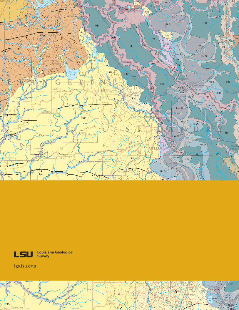
lgs.lsu.edu