Embed Size (px)
Citation preview
June 2017
Jill Bullen Senior Landscape Specialist
jillbullencyfoethnaturiolcymrugovuk
0300 065 4706
(Please note this is an information document and not a training presentation)
LANDMAP Methodology
Overview
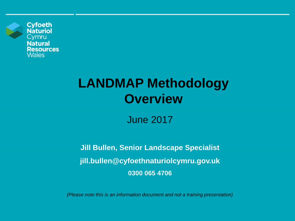
LANDMAPbull An all-Wales landscape resource where landscape
characteristics qualities and influences on the landscape are
recorded and evaluated in a nationally consistent data set
bull A whole landscape approach that covers all landscapes
designated and non-designated it covers natural rural peri-
urban and urban areas (excluding the Cities of Cardiff and
Swansea) and it includes inland waters and coastal areas to the
low water mark
bull Captures information about landscapes in a digital based
resource providing easily accessible landscape information
bull LANDMAP
ndash Maps and classifies landscapes
ndash Describes their characteristics qualities and components
ndash Evaluates their importance from a national to local scale
records their condition amp trend
ndash Recommends locally appropriate management guidelines
bull Collected in a structured consistent and rigorous way that is
defined by the LANDMAP methodology chapters (accessible from
httpnaturalresourceswalesLandmap)
2
How is LANDMAP data heldbull LANDMAP is managed as a spatial dataset
bull Spatial data consists of observations (surveys in
LANDMAP) with locations (mapped geographic areas)
bull Geographical Information System (GIS) software records
and displays this spatial data
What does LANDMAP look likeLANDMAP divides Wales into discrete geographical areas
known as aspect areas (polygons in GIS)
bull Each aspect area is identified by its own landscape
characteristics and qualities these will be different from
adjacent aspect areas
bull For each aspect area there is a survey record of
landscape information
bull There are 5 LANDMAP datasets consisting of aspect area
maps and surveys unique to each perspective
LANDMAP aspect areas are shown here by
the red boundaries with an OS or aerial
photo base map3
LANDMAP the landscape baseline for Wales
bull The five LANDMAP spatial datasets are called the Geological Landscape Landscape Habitats
Visual amp Sensory Historic Landscape and Cultural Landscape
bull The thumbnail map images below illustrate the unique perspective captured by the five layers and the
diversity between them including the approximate number of surveys per dataset
Geological Landscape Visual amp Historic Cultural
Landscape Habitats Sensory Landscape Landscape
2670 2738 1940 2538 906 surveys
bull Collectively 10000+ detailed surveys provide landscape information capturing the interrelationships
between people places and resources ndash the DNA of landscapes in Wales
4
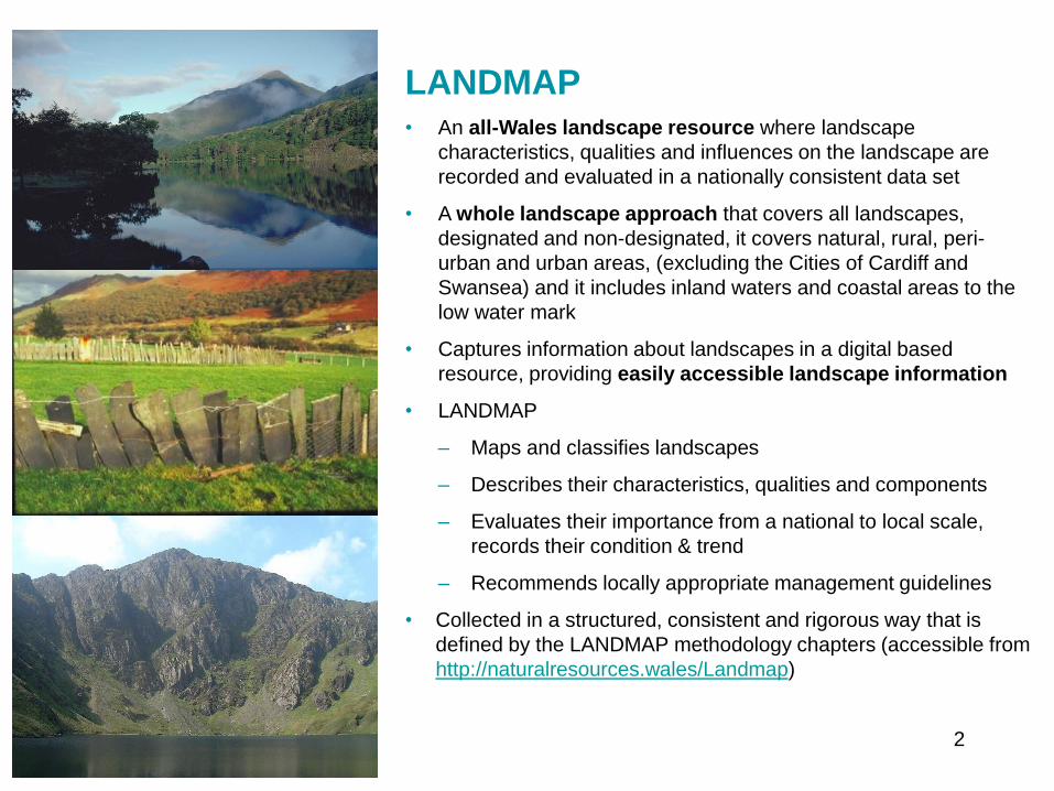
LANDMAPbull Champions many of the principles of the
European Landscape Convention
bull Is recognised as an important information
resource in Planning Policy Wales 9 (2016
section 5313)
bull Evidence is consistent transparent and Quality
Assured
bull Provides seamless landscape information at
local and National Park planning authority
boundaries
bull lsquoNatural beautyrsquo includes flora fauna
geological and landscape features as does
LANDMAP in the 5 layers
bull Provides a comprehensive baseline of
environmental cultural and heritage
information to assist with sustainable decision-
making at a range of levels from local to
national scale whilst ensuring transparency in
decision-making
bull Is used to monitoring landscape change amp
trends using remote sensing and professional
interpretation
bull Builds landscape knowledge and supports
capacity of small teams and limited resources
bull Training and guidance encourages users to be
proportionate selective and focus effort on what
matters
bull By being publicly available it gives everyone an
opportunity to take landscape into account when
making decisions
5
LANDMAP Key usesThe 2016 LANDMAP planning authority survey showed
the following planning authorities (2325 responses) use
intend to use LANDMAP in
LDP 23
SPGDevelopment Management 20
Public Inquiries 19
Special Landscape Areas 17
Renewable Energy Studies 16
Forward Planning 16
Local Landscape Character Assessments 15
Strategic Environmental Assessment 15
EIA 13
Design Guidance 11
Countryside strategies Green Infrastructure 6
or natural resource plans
bull Most LPAs are yet to use LANDMAP in relation to the
creation of their Wellbeing plans (5 LPAs dointend to)
bull All National Parks and those respondents with AONBs
use LANDMAP to inform their Designated Landscape
Management Plans
bull LANDMAP in 2016 is very well established in LPAs as
an evidence base of landscape information
LANDMAP is also used in the State of
Natural Resources Reporting (SoNaRR)
for example
Over 50 of Wales is nationally valued for
its scenic quality and character
many Welsh landscapes are iconic with a
clear sense of place and recognisable
identity
46 has a negligible level of night time light
pollution in 2015 Substantial night time light
pollution (501 km2) contributes to a low
landscape evaluation (SoNaRR 2016)
6
LANDMAP Geological Landscape
bull Considers the physical primarily geological
influences that have shaped the contemporary
landscape
bull Identifies those intrinsic landscape qualities which are
linked to the control or influence exerted by bedrock
surface processes landforms and hydrology
bull Emphasis is on the strongest influence in landscape
generation through erosion (eg glacial cirques) or
deposition (eg river floodplains) or a combination
bull Examples of information recorded includes
characteristic components (features) geological and
topographical character current processes
educational value rarity (rock typesfossils) mineral
extraction and designations7
LANDMAP Landscape Habitats
bull Focuses on recording habitat features
characteristics and their spatial relationships within
the context of the wider landscape
bull Aspect Areas defined may encompass whole
valleys dominant habitats or a mosaic of habitats
within an agricultural environment
bull Examples of information recorded includes
identifying key Phase 1 habitats present habitat
features (veteran trees caves ponds) protected
areas special sites or locally important sites
species threat species significance fragmentation
8
LANDMAP Visual amp Sensory
bull Maps landscape characteristics and qualities as
perceived through our senses primarily visually
bull The physical attributes of landform and land cover
their visible patterns and their interrelationship
bull Examples of information recorded includes
Landscape elements and features aesthetic
presence of water and seasonality important
qualities boundary type scale enclosure diversity
colour sense of place night time light building
materials views scenic quality rarity integrity and
character
9
LANDMAP Historic Landscape
bull Landscape characteristics that depend on key
historic land uses patterns and features
bull Identifies only those classes of historic land uses
patterns and features that are prominent and
contribute to the overall historic character of the
present landscape
bull Examples of information recorded includes historic
pattern and elements designations traditional
boundary types vernacular building style features
of archaeological interest in a landscape context
eg standing stones in a prehistoric environment
CPAT
10
LANDMAP Cultural Landscape
bull Describes the links between landscape and people
from the way in which cultural or human activity
shapes the landscape to the way in which culture
shapes the way we respond to landscape
bull Focus is on mapping the landscape where it has
been or is being shaped by a particular cultural
activity or process or where it has been directly
represented depicted or described in art literature
or folklore ndash the contemporary cultural essence
bull Examples of information recorded and linked to the
landscape includes cultural context character
influences associations artistic work famous
peopleinstitutions folklore events traditions
scientific discoveries significant place names 11
LANDMAP classification
bull All of Wales is mapped and classified
into geographically discrete areas
bull Thematic maps can be created
showcasing how the landscape is
classified in each dataset
bull Maps can illustrate patterns diversity
distribution rarity and commonplace
bull The higher the level in the hierarchical
classification (described in the
methodology) the more detailed the
classes
bull The example (right) shows the Historic
Landscape classification zoomed in at
Level 3
bull Slide 13 compares the same dataset but
mapped at Level 2 and then at Level 3
12
LANDMAP Classification at Level 2 (left) amp Level 3 (right)Example shown for Historic Landscape
13
LANDMAP evaluation
bull All of Wales is evaluated from a local to a national
scale of landscape importance The terms used
include
bull Outstanding nationally important
bull High regional or county importance
bull Moderate local importance
bull Low little or no importance
bull Evaluation criteria specific to each LANDMAP
dataset underpin the evaluation process
bull The evaluation criteria in each dataset inform the
overall evaluation for each aspect area The
process is explained in the methodology chapters on
our website httpnaturalresourceswalesLandmap
bull Thematic maps can be created to give an all-Wales
or local perspective The example shows the Visual
amp Sensory overall evaluation at an all Wales level
14
Interpreting LANDMAP Visual amp Sensory data
bull Analysing LANDMAP Information offers all-Wales and local perspectives and insights Examples from
the statistical analysis of the Visual amp Sensory data are included in slides 15-17
The LANDMAP Visual amp Sensory Wales - predominantly a rural landscape
bull 58 of Wales is categorised as an Upland landscape 37 Lowland landscape
bull Almost 5 is Development (excluding the urban areas of Cardiff and Swansea)
bull 60 of the landcover is defined as Field PatternMosaic 20 is categorised as Open Land
bull 44 is identified as Scattered RuralFarm 27 is categorised as having No Settlements at all
Level 1 and 2 classification (Whole of Wales) Settlement pattern (Whole of Wales) 15
Interpreting LANDMAP Visual amp Sensory data
Highly valued landscapes
bull 11 is evaluated as Outstanding 40 is evaluated High (together this is more than half of Wales)
bull Most of the areas evaluated as Outstanding are Upland
Level 1 classification by overall evaluation (Whole of Wales)
16
Interpreting LANDMAP Visual amp Sensory data
bull 46 (lt half the total land area) is classified as having a Negligible level of night-time light pollution
bull Construction materials used in 69 of the land area are Generally Appropriate this is important in
maintaining a sense of place and character 18 is associated with Generally Inappropriate or
Inappropriate materials
17
Monitoring the landscape evidence baseWhy
bull LANDMAP must be updated to maintain effectiveness and users confidence in the landscape baseline
bull To deliver on indicators that include landscape
bull To contribute to reports and plans such as lsquoState of Designated Landscapesrsquo SoNaRR and natural
resource plans
How
bull A robust and repeatable landscape monitoring methodology has been developed
bull Consistency in LANDMAP data through the benchmark methodology (introduced in 2003 now dated
2016) enables comparisons to be made across Wales and historically
bull Monitoring identifies areas where significant landscape change has been identified for example between
2003 and 2016
bull Multiple resources are used to identify analyse and interpret change
bull Changes are interpreted from the perspective of each LANDMAP dataset
bull Change detection work identifies exactly which aspect areas should be amended and in what way for
example the survey content boundaries or both
bull All LANDMAP information including monitoring updates is quality assured
What has been monitored so far What is yet to be monitored
Visual amp Sensory Cultural Landscape (initiate 2017)
Landscape Habitats Geological landscape (plan for 2018)
Historic Landscape (in process 2017)18
Evidence to inform landscape monitoring
Baseline and reporting units
bull LANDMAP relevant spatial dataset
For information and context
bull Ordnance Survey 150000 and 125000
bull True colour aerial photography - assessment of land cover change
bull Wales Tranquil Areas Map
bull Phase 1 Habitat of Wales amp Seasonal Change map of landscapes influenced by habitat change
bull Consented and Operational Wind farms
bull Additional information sourced relevant to each dataset
bull Professional and local knowledge from local authority input and specialists
For comparison over two time periods
bull OS MasterMap Roads and Buildings - changes in artificial structures and surfaces
bull Satellite imagery (eg Landsat 5 7 Spot 2003)
ndash Normalised Difference Vegetation Index (NDVI) - changes in living and non-living surfaces
ndash Complexity Maps (Segment Density) - morelesssame landscape complexity
bull Mega Change Map - highlights the most significant changes
19
Landscape monitoring example map 1Mega change map
Highlights the most significant changes in RoadsBuildings and NDVIsurface productivity
20
Landscape monitoring example map 2Complexity map
Highlights morelesssame landscape complexity from textural change
21
Interpreting monitoring
Key influences on landscape change 2003-2015
include
Built environment
bull Expansion of settlements commercial and industrial
development expansion of quarries road
improvements onshore wind-farms and turbines
recreational related developments
Natural environment
bull Replacement of conifers with broad-leaved trees
woodland expansion changes in bracken cover
reduced habitat diversity in places reduced bog
some improvements in upland vegetation
bull Mapping landscape change is important and
informative However care is required during
interpretation The example here shows change in
the Visual amp Sensory dataset note the following
‒ Changes may be to aspect area boundaries or
survey information
‒ The scale of change may be substantial or
limited in area
‒ Some changes detected were not sufficient to
justify a change in the LANDMAP
22
A Landscape Indicator based on LANDMAP
The quality and diversity of the natural and historic character of our landscape and seascape is
maintained and enhanced
bull Using LANDMAP monitoring work we can we calculate the extent to which landscape character
diversity and quality has been significantly changed from the baseline established
bull This could translate as lsquothe percentage of Walesrsquo landscape evaluated as outstanding or high should
be maintained or increasedrsquo or even a target of a 10 increase in the highest evaluations over 10
years
bull In time an assessment could be made of the extent to which a landscape has moved away from or
towards agreed visions for an area for example as part of Area Statements or wellbeing
assessments
We can do this by calculating
bull character and diversity using the and area (ha) of each classification
bull quality using the and area (ha) of each evaluation (outstandinghighmoderatelow)
We could report this by
bull National Park Area of Outstanding Natural Beauty Local Planning Authority National Landscape
Character Area Registered Historic Landscape Public Service Boards by Area Statement or at an
all Wales level
23
Accessing LANDMAP spatial datasets
bull To access the LANDMAP interactive map to view aspect area maps and surveys
httplandmap-mapsnaturalresourceswales
bull To download LANDMAP maps and surveys to use in a GIS environment
httpllewalesgovukCataloguelang=enamptext=landmap
24
Further Informationbull Information guidance notes and methodology chapters are available from
httplandmap-mapsnaturalresourceswales
LANDMAP Methodology Chapters
bull LANDMAP Methodology Overview (2017)
bull LANDMAP Methodology Geological Landscape (2016)
bull LANDMAP Methodology Landscape Habitats (2016)
bull LANDMAP Methodology Visual and Sensory (2016)
bull LANDMAP Methodology Historic Landscape (2016)
bull LANDMAP Methodology Cultural Landscape (2016)
bull LANDMAP Methodology Monitoring (2017)
Guidance Notes (GN)
bull GN1 LANDMAP amp Special Landscape Areas (2017) (correction of evaluation criteria text)
bull GN2 Accessing LANDMAP Information (2017)
bull GN3 LANDMAP amp LVIA for onshore windfarms (2017)
bull GN4 LANDMAP amp the Cultural Landscape (2016)
bull GN5 LANDMAP amp the Geological Landscape (2016)
25
LANDMAPbull An all-Wales landscape resource where landscape
characteristics qualities and influences on the landscape are
recorded and evaluated in a nationally consistent data set
bull A whole landscape approach that covers all landscapes
designated and non-designated it covers natural rural peri-
urban and urban areas (excluding the Cities of Cardiff and
Swansea) and it includes inland waters and coastal areas to the
low water mark
bull Captures information about landscapes in a digital based
resource providing easily accessible landscape information
bull LANDMAP
ndash Maps and classifies landscapes
ndash Describes their characteristics qualities and components
ndash Evaluates their importance from a national to local scale
records their condition amp trend
ndash Recommends locally appropriate management guidelines
bull Collected in a structured consistent and rigorous way that is
defined by the LANDMAP methodology chapters (accessible from
httpnaturalresourceswalesLandmap)
2
How is LANDMAP data heldbull LANDMAP is managed as a spatial dataset
bull Spatial data consists of observations (surveys in
LANDMAP) with locations (mapped geographic areas)
bull Geographical Information System (GIS) software records
and displays this spatial data
What does LANDMAP look likeLANDMAP divides Wales into discrete geographical areas
known as aspect areas (polygons in GIS)
bull Each aspect area is identified by its own landscape
characteristics and qualities these will be different from
adjacent aspect areas
bull For each aspect area there is a survey record of
landscape information
bull There are 5 LANDMAP datasets consisting of aspect area
maps and surveys unique to each perspective
LANDMAP aspect areas are shown here by
the red boundaries with an OS or aerial
photo base map3
LANDMAP the landscape baseline for Wales
bull The five LANDMAP spatial datasets are called the Geological Landscape Landscape Habitats
Visual amp Sensory Historic Landscape and Cultural Landscape
bull The thumbnail map images below illustrate the unique perspective captured by the five layers and the
diversity between them including the approximate number of surveys per dataset
Geological Landscape Visual amp Historic Cultural
Landscape Habitats Sensory Landscape Landscape
2670 2738 1940 2538 906 surveys
bull Collectively 10000+ detailed surveys provide landscape information capturing the interrelationships
between people places and resources ndash the DNA of landscapes in Wales
4
LANDMAPbull Champions many of the principles of the
European Landscape Convention
bull Is recognised as an important information
resource in Planning Policy Wales 9 (2016
section 5313)
bull Evidence is consistent transparent and Quality
Assured
bull Provides seamless landscape information at
local and National Park planning authority
boundaries
bull lsquoNatural beautyrsquo includes flora fauna
geological and landscape features as does
LANDMAP in the 5 layers
bull Provides a comprehensive baseline of
environmental cultural and heritage
information to assist with sustainable decision-
making at a range of levels from local to
national scale whilst ensuring transparency in
decision-making
bull Is used to monitoring landscape change amp
trends using remote sensing and professional
interpretation
bull Builds landscape knowledge and supports
capacity of small teams and limited resources
bull Training and guidance encourages users to be
proportionate selective and focus effort on what
matters
bull By being publicly available it gives everyone an
opportunity to take landscape into account when
making decisions
5
LANDMAP Key usesThe 2016 LANDMAP planning authority survey showed
the following planning authorities (2325 responses) use
intend to use LANDMAP in
LDP 23
SPGDevelopment Management 20
Public Inquiries 19
Special Landscape Areas 17
Renewable Energy Studies 16
Forward Planning 16
Local Landscape Character Assessments 15
Strategic Environmental Assessment 15
EIA 13
Design Guidance 11
Countryside strategies Green Infrastructure 6
or natural resource plans
bull Most LPAs are yet to use LANDMAP in relation to the
creation of their Wellbeing plans (5 LPAs dointend to)
bull All National Parks and those respondents with AONBs
use LANDMAP to inform their Designated Landscape
Management Plans
bull LANDMAP in 2016 is very well established in LPAs as
an evidence base of landscape information
LANDMAP is also used in the State of
Natural Resources Reporting (SoNaRR)
for example
Over 50 of Wales is nationally valued for
its scenic quality and character
many Welsh landscapes are iconic with a
clear sense of place and recognisable
identity
46 has a negligible level of night time light
pollution in 2015 Substantial night time light
pollution (501 km2) contributes to a low
landscape evaluation (SoNaRR 2016)
6
LANDMAP Geological Landscape
bull Considers the physical primarily geological
influences that have shaped the contemporary
landscape
bull Identifies those intrinsic landscape qualities which are
linked to the control or influence exerted by bedrock
surface processes landforms and hydrology
bull Emphasis is on the strongest influence in landscape
generation through erosion (eg glacial cirques) or
deposition (eg river floodplains) or a combination
bull Examples of information recorded includes
characteristic components (features) geological and
topographical character current processes
educational value rarity (rock typesfossils) mineral
extraction and designations7
LANDMAP Landscape Habitats
bull Focuses on recording habitat features
characteristics and their spatial relationships within
the context of the wider landscape
bull Aspect Areas defined may encompass whole
valleys dominant habitats or a mosaic of habitats
within an agricultural environment
bull Examples of information recorded includes
identifying key Phase 1 habitats present habitat
features (veteran trees caves ponds) protected
areas special sites or locally important sites
species threat species significance fragmentation
8
LANDMAP Visual amp Sensory
bull Maps landscape characteristics and qualities as
perceived through our senses primarily visually
bull The physical attributes of landform and land cover
their visible patterns and their interrelationship
bull Examples of information recorded includes
Landscape elements and features aesthetic
presence of water and seasonality important
qualities boundary type scale enclosure diversity
colour sense of place night time light building
materials views scenic quality rarity integrity and
character
9
LANDMAP Historic Landscape
bull Landscape characteristics that depend on key
historic land uses patterns and features
bull Identifies only those classes of historic land uses
patterns and features that are prominent and
contribute to the overall historic character of the
present landscape
bull Examples of information recorded includes historic
pattern and elements designations traditional
boundary types vernacular building style features
of archaeological interest in a landscape context
eg standing stones in a prehistoric environment
CPAT
10
LANDMAP Cultural Landscape
bull Describes the links between landscape and people
from the way in which cultural or human activity
shapes the landscape to the way in which culture
shapes the way we respond to landscape
bull Focus is on mapping the landscape where it has
been or is being shaped by a particular cultural
activity or process or where it has been directly
represented depicted or described in art literature
or folklore ndash the contemporary cultural essence
bull Examples of information recorded and linked to the
landscape includes cultural context character
influences associations artistic work famous
peopleinstitutions folklore events traditions
scientific discoveries significant place names 11
LANDMAP classification
bull All of Wales is mapped and classified
into geographically discrete areas
bull Thematic maps can be created
showcasing how the landscape is
classified in each dataset
bull Maps can illustrate patterns diversity
distribution rarity and commonplace
bull The higher the level in the hierarchical
classification (described in the
methodology) the more detailed the
classes
bull The example (right) shows the Historic
Landscape classification zoomed in at
Level 3
bull Slide 13 compares the same dataset but
mapped at Level 2 and then at Level 3
12
LANDMAP Classification at Level 2 (left) amp Level 3 (right)Example shown for Historic Landscape
13
LANDMAP evaluation
bull All of Wales is evaluated from a local to a national
scale of landscape importance The terms used
include
bull Outstanding nationally important
bull High regional or county importance
bull Moderate local importance
bull Low little or no importance
bull Evaluation criteria specific to each LANDMAP
dataset underpin the evaluation process
bull The evaluation criteria in each dataset inform the
overall evaluation for each aspect area The
process is explained in the methodology chapters on
our website httpnaturalresourceswalesLandmap
bull Thematic maps can be created to give an all-Wales
or local perspective The example shows the Visual
amp Sensory overall evaluation at an all Wales level
14
Interpreting LANDMAP Visual amp Sensory data
bull Analysing LANDMAP Information offers all-Wales and local perspectives and insights Examples from
the statistical analysis of the Visual amp Sensory data are included in slides 15-17
The LANDMAP Visual amp Sensory Wales - predominantly a rural landscape
bull 58 of Wales is categorised as an Upland landscape 37 Lowland landscape
bull Almost 5 is Development (excluding the urban areas of Cardiff and Swansea)
bull 60 of the landcover is defined as Field PatternMosaic 20 is categorised as Open Land
bull 44 is identified as Scattered RuralFarm 27 is categorised as having No Settlements at all
Level 1 and 2 classification (Whole of Wales) Settlement pattern (Whole of Wales) 15
Interpreting LANDMAP Visual amp Sensory data
Highly valued landscapes
bull 11 is evaluated as Outstanding 40 is evaluated High (together this is more than half of Wales)
bull Most of the areas evaluated as Outstanding are Upland
Level 1 classification by overall evaluation (Whole of Wales)
16
Interpreting LANDMAP Visual amp Sensory data
bull 46 (lt half the total land area) is classified as having a Negligible level of night-time light pollution
bull Construction materials used in 69 of the land area are Generally Appropriate this is important in
maintaining a sense of place and character 18 is associated with Generally Inappropriate or
Inappropriate materials
17
Monitoring the landscape evidence baseWhy
bull LANDMAP must be updated to maintain effectiveness and users confidence in the landscape baseline
bull To deliver on indicators that include landscape
bull To contribute to reports and plans such as lsquoState of Designated Landscapesrsquo SoNaRR and natural
resource plans
How
bull A robust and repeatable landscape monitoring methodology has been developed
bull Consistency in LANDMAP data through the benchmark methodology (introduced in 2003 now dated
2016) enables comparisons to be made across Wales and historically
bull Monitoring identifies areas where significant landscape change has been identified for example between
2003 and 2016
bull Multiple resources are used to identify analyse and interpret change
bull Changes are interpreted from the perspective of each LANDMAP dataset
bull Change detection work identifies exactly which aspect areas should be amended and in what way for
example the survey content boundaries or both
bull All LANDMAP information including monitoring updates is quality assured
What has been monitored so far What is yet to be monitored
Visual amp Sensory Cultural Landscape (initiate 2017)
Landscape Habitats Geological landscape (plan for 2018)
Historic Landscape (in process 2017)18
Evidence to inform landscape monitoring
Baseline and reporting units
bull LANDMAP relevant spatial dataset
For information and context
bull Ordnance Survey 150000 and 125000
bull True colour aerial photography - assessment of land cover change
bull Wales Tranquil Areas Map
bull Phase 1 Habitat of Wales amp Seasonal Change map of landscapes influenced by habitat change
bull Consented and Operational Wind farms
bull Additional information sourced relevant to each dataset
bull Professional and local knowledge from local authority input and specialists
For comparison over two time periods
bull OS MasterMap Roads and Buildings - changes in artificial structures and surfaces
bull Satellite imagery (eg Landsat 5 7 Spot 2003)
ndash Normalised Difference Vegetation Index (NDVI) - changes in living and non-living surfaces
ndash Complexity Maps (Segment Density) - morelesssame landscape complexity
bull Mega Change Map - highlights the most significant changes
19
Landscape monitoring example map 1Mega change map
Highlights the most significant changes in RoadsBuildings and NDVIsurface productivity
20
Landscape monitoring example map 2Complexity map
Highlights morelesssame landscape complexity from textural change
21
Interpreting monitoring
Key influences on landscape change 2003-2015
include
Built environment
bull Expansion of settlements commercial and industrial
development expansion of quarries road
improvements onshore wind-farms and turbines
recreational related developments
Natural environment
bull Replacement of conifers with broad-leaved trees
woodland expansion changes in bracken cover
reduced habitat diversity in places reduced bog
some improvements in upland vegetation
bull Mapping landscape change is important and
informative However care is required during
interpretation The example here shows change in
the Visual amp Sensory dataset note the following
‒ Changes may be to aspect area boundaries or
survey information
‒ The scale of change may be substantial or
limited in area
‒ Some changes detected were not sufficient to
justify a change in the LANDMAP
22
A Landscape Indicator based on LANDMAP
The quality and diversity of the natural and historic character of our landscape and seascape is
maintained and enhanced
bull Using LANDMAP monitoring work we can we calculate the extent to which landscape character
diversity and quality has been significantly changed from the baseline established
bull This could translate as lsquothe percentage of Walesrsquo landscape evaluated as outstanding or high should
be maintained or increasedrsquo or even a target of a 10 increase in the highest evaluations over 10
years
bull In time an assessment could be made of the extent to which a landscape has moved away from or
towards agreed visions for an area for example as part of Area Statements or wellbeing
assessments
We can do this by calculating
bull character and diversity using the and area (ha) of each classification
bull quality using the and area (ha) of each evaluation (outstandinghighmoderatelow)
We could report this by
bull National Park Area of Outstanding Natural Beauty Local Planning Authority National Landscape
Character Area Registered Historic Landscape Public Service Boards by Area Statement or at an
all Wales level
23
Accessing LANDMAP spatial datasets
bull To access the LANDMAP interactive map to view aspect area maps and surveys
httplandmap-mapsnaturalresourceswales
bull To download LANDMAP maps and surveys to use in a GIS environment
httpllewalesgovukCataloguelang=enamptext=landmap
24
Further Informationbull Information guidance notes and methodology chapters are available from
httplandmap-mapsnaturalresourceswales
LANDMAP Methodology Chapters
bull LANDMAP Methodology Overview (2017)
bull LANDMAP Methodology Geological Landscape (2016)
bull LANDMAP Methodology Landscape Habitats (2016)
bull LANDMAP Methodology Visual and Sensory (2016)
bull LANDMAP Methodology Historic Landscape (2016)
bull LANDMAP Methodology Cultural Landscape (2016)
bull LANDMAP Methodology Monitoring (2017)
Guidance Notes (GN)
bull GN1 LANDMAP amp Special Landscape Areas (2017) (correction of evaluation criteria text)
bull GN2 Accessing LANDMAP Information (2017)
bull GN3 LANDMAP amp LVIA for onshore windfarms (2017)
bull GN4 LANDMAP amp the Cultural Landscape (2016)
bull GN5 LANDMAP amp the Geological Landscape (2016)
25
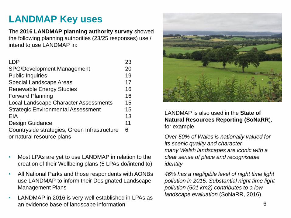
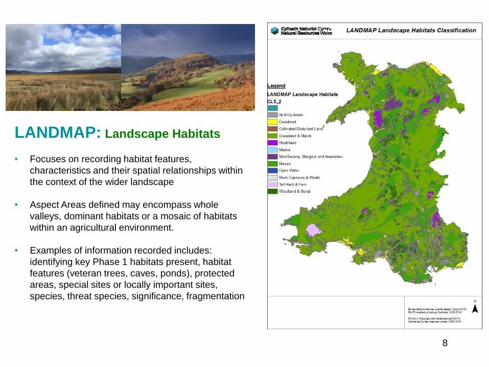
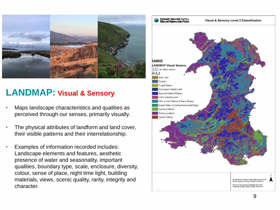
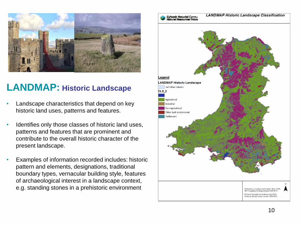
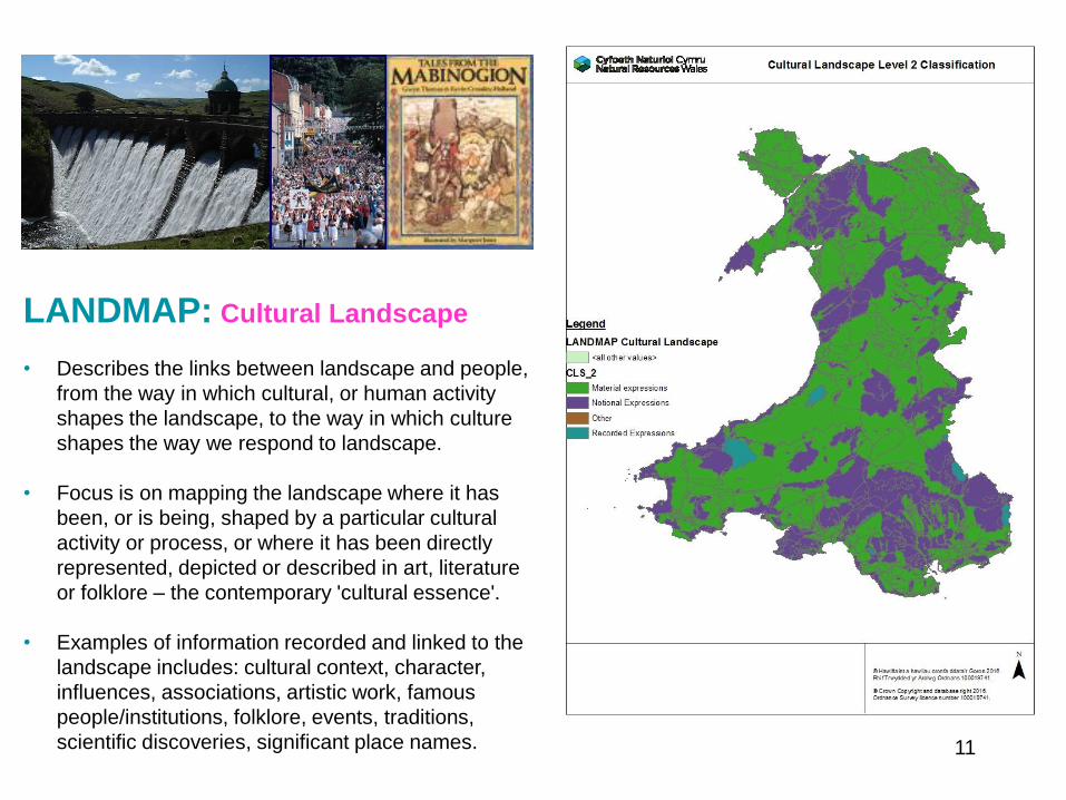
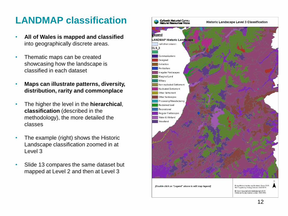
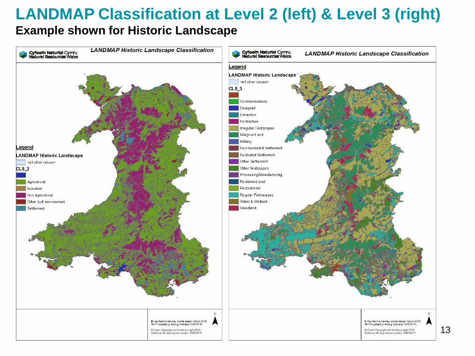
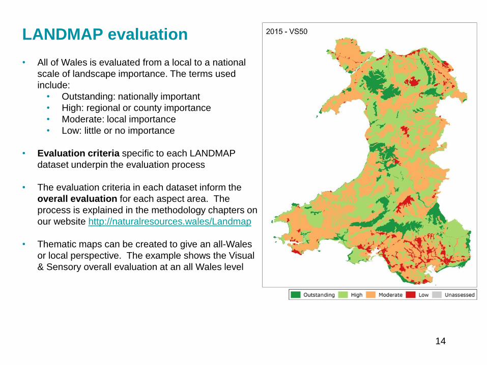
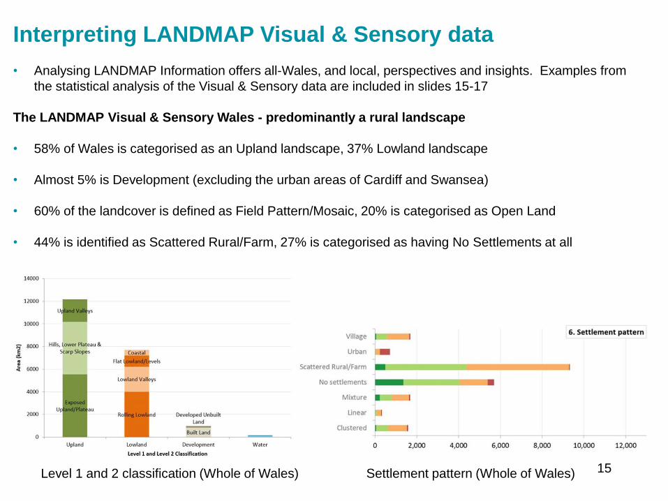
Interpreting LANDMAP Visual amp Sensory data
bull Analysing LANDMAP Information offers all-Wales and local perspectives and insights Examples from
the statistical analysis of the Visual amp Sensory data are included in slides 15-17
The LANDMAP Visual amp Sensory Wales - predominantly a rural landscape
bull 58 of Wales is categorised as an Upland landscape 37 Lowland landscape
bull Almost 5 is Development (excluding the urban areas of Cardiff and Swansea)
bull 60 of the landcover is defined as Field PatternMosaic 20 is categorised as Open Land
bull 44 is identified as Scattered RuralFarm 27 is categorised as having No Settlements at all
Level 1 and 2 classification (Whole of Wales) Settlement pattern (Whole of Wales) 15
Interpreting LANDMAP Visual amp Sensory data
Highly valued landscapes
bull 11 is evaluated as Outstanding 40 is evaluated High (together this is more than half of Wales)
bull Most of the areas evaluated as Outstanding are Upland
Level 1 classification by overall evaluation (Whole of Wales)
16
Interpreting LANDMAP Visual amp Sensory data
bull 46 (lt half the total land area) is classified as having a Negligible level of night-time light pollution
bull Construction materials used in 69 of the land area are Generally Appropriate this is important in
maintaining a sense of place and character 18 is associated with Generally Inappropriate or
Inappropriate materials
17
Monitoring the landscape evidence baseWhy
bull LANDMAP must be updated to maintain effectiveness and users confidence in the landscape baseline
bull To deliver on indicators that include landscape
bull To contribute to reports and plans such as lsquoState of Designated Landscapesrsquo SoNaRR and natural
resource plans
How
bull A robust and repeatable landscape monitoring methodology has been developed
bull Consistency in LANDMAP data through the benchmark methodology (introduced in 2003 now dated
2016) enables comparisons to be made across Wales and historically
bull Monitoring identifies areas where significant landscape change has been identified for example between
2003 and 2016
bull Multiple resources are used to identify analyse and interpret change
bull Changes are interpreted from the perspective of each LANDMAP dataset
bull Change detection work identifies exactly which aspect areas should be amended and in what way for
example the survey content boundaries or both
bull All LANDMAP information including monitoring updates is quality assured
What has been monitored so far What is yet to be monitored
Visual amp Sensory Cultural Landscape (initiate 2017)
Landscape Habitats Geological landscape (plan for 2018)
Historic Landscape (in process 2017)18
Evidence to inform landscape monitoring
Baseline and reporting units
bull LANDMAP relevant spatial dataset
For information and context
bull Ordnance Survey 150000 and 125000
bull True colour aerial photography - assessment of land cover change
bull Wales Tranquil Areas Map
bull Phase 1 Habitat of Wales amp Seasonal Change map of landscapes influenced by habitat change
bull Consented and Operational Wind farms
bull Additional information sourced relevant to each dataset
bull Professional and local knowledge from local authority input and specialists
For comparison over two time periods
bull OS MasterMap Roads and Buildings - changes in artificial structures and surfaces
bull Satellite imagery (eg Landsat 5 7 Spot 2003)
ndash Normalised Difference Vegetation Index (NDVI) - changes in living and non-living surfaces
ndash Complexity Maps (Segment Density) - morelesssame landscape complexity
bull Mega Change Map - highlights the most significant changes
19
Landscape monitoring example map 1Mega change map
Highlights the most significant changes in RoadsBuildings and NDVIsurface productivity
20
Landscape monitoring example map 2Complexity map
Highlights morelesssame landscape complexity from textural change
21
Interpreting monitoring
Key influences on landscape change 2003-2015
include
Built environment
bull Expansion of settlements commercial and industrial
development expansion of quarries road
improvements onshore wind-farms and turbines
recreational related developments
Natural environment
bull Replacement of conifers with broad-leaved trees
woodland expansion changes in bracken cover
reduced habitat diversity in places reduced bog
some improvements in upland vegetation
bull Mapping landscape change is important and
informative However care is required during
interpretation The example here shows change in
the Visual amp Sensory dataset note the following
‒ Changes may be to aspect area boundaries or
survey information
‒ The scale of change may be substantial or
limited in area
‒ Some changes detected were not sufficient to
justify a change in the LANDMAP
22
A Landscape Indicator based on LANDMAP
The quality and diversity of the natural and historic character of our landscape and seascape is
maintained and enhanced
bull Using LANDMAP monitoring work we can we calculate the extent to which landscape character
diversity and quality has been significantly changed from the baseline established
bull This could translate as lsquothe percentage of Walesrsquo landscape evaluated as outstanding or high should
be maintained or increasedrsquo or even a target of a 10 increase in the highest evaluations over 10
years
bull In time an assessment could be made of the extent to which a landscape has moved away from or
towards agreed visions for an area for example as part of Area Statements or wellbeing
assessments
We can do this by calculating
bull character and diversity using the and area (ha) of each classification
bull quality using the and area (ha) of each evaluation (outstandinghighmoderatelow)
We could report this by
bull National Park Area of Outstanding Natural Beauty Local Planning Authority National Landscape
Character Area Registered Historic Landscape Public Service Boards by Area Statement or at an
all Wales level
23
Accessing LANDMAP spatial datasets
bull To access the LANDMAP interactive map to view aspect area maps and surveys
httplandmap-mapsnaturalresourceswales
bull To download LANDMAP maps and surveys to use in a GIS environment
httpllewalesgovukCataloguelang=enamptext=landmap
24
Further Informationbull Information guidance notes and methodology chapters are available from
httplandmap-mapsnaturalresourceswales
LANDMAP Methodology Chapters
bull LANDMAP Methodology Overview (2017)
bull LANDMAP Methodology Geological Landscape (2016)
bull LANDMAP Methodology Landscape Habitats (2016)
bull LANDMAP Methodology Visual and Sensory (2016)
bull LANDMAP Methodology Historic Landscape (2016)
bull LANDMAP Methodology Cultural Landscape (2016)
bull LANDMAP Methodology Monitoring (2017)
Guidance Notes (GN)
bull GN1 LANDMAP amp Special Landscape Areas (2017) (correction of evaluation criteria text)
bull GN2 Accessing LANDMAP Information (2017)
bull GN3 LANDMAP amp LVIA for onshore windfarms (2017)
bull GN4 LANDMAP amp the Cultural Landscape (2016)
bull GN5 LANDMAP amp the Geological Landscape (2016)
25
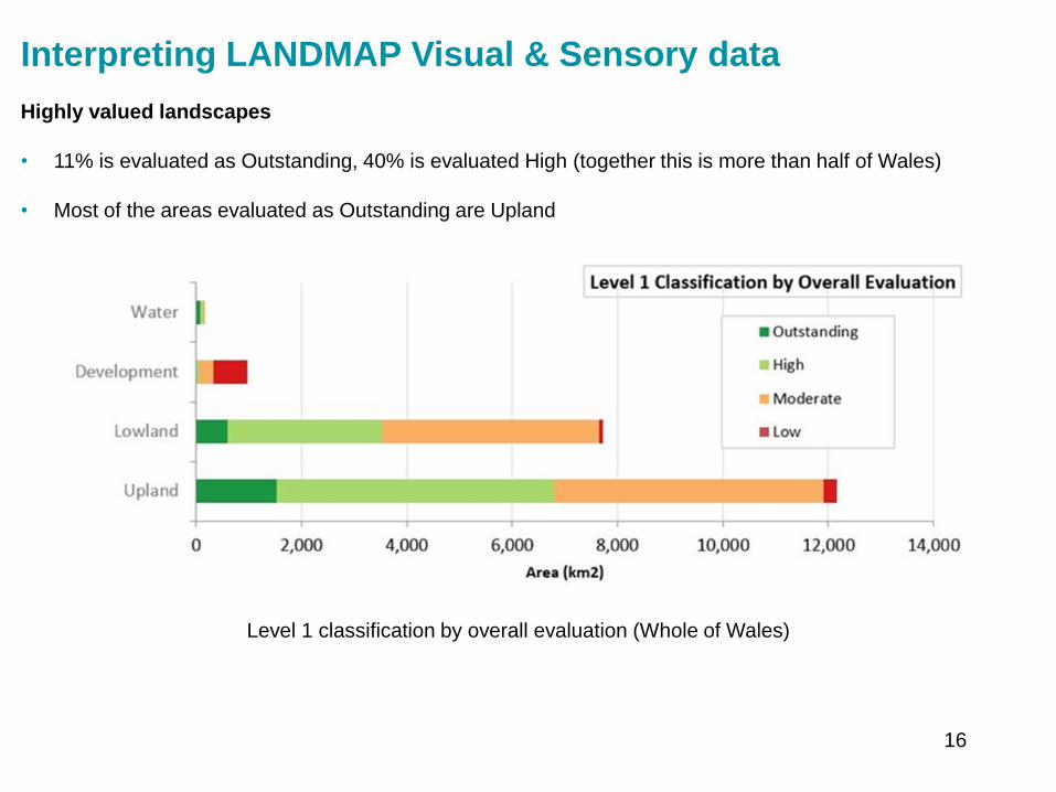
Interpreting LANDMAP Visual amp Sensory data
Highly valued landscapes
bull 11 is evaluated as Outstanding 40 is evaluated High (together this is more than half of Wales)
bull Most of the areas evaluated as Outstanding are Upland
Level 1 classification by overall evaluation (Whole of Wales)
16
Interpreting LANDMAP Visual amp Sensory data
bull 46 (lt half the total land area) is classified as having a Negligible level of night-time light pollution
bull Construction materials used in 69 of the land area are Generally Appropriate this is important in
maintaining a sense of place and character 18 is associated with Generally Inappropriate or
Inappropriate materials
17
Monitoring the landscape evidence baseWhy
bull LANDMAP must be updated to maintain effectiveness and users confidence in the landscape baseline
bull To deliver on indicators that include landscape
bull To contribute to reports and plans such as lsquoState of Designated Landscapesrsquo SoNaRR and natural
resource plans
How
bull A robust and repeatable landscape monitoring methodology has been developed
bull Consistency in LANDMAP data through the benchmark methodology (introduced in 2003 now dated
2016) enables comparisons to be made across Wales and historically
bull Monitoring identifies areas where significant landscape change has been identified for example between
2003 and 2016
bull Multiple resources are used to identify analyse and interpret change
bull Changes are interpreted from the perspective of each LANDMAP dataset
bull Change detection work identifies exactly which aspect areas should be amended and in what way for
example the survey content boundaries or both
bull All LANDMAP information including monitoring updates is quality assured
What has been monitored so far What is yet to be monitored
Visual amp Sensory Cultural Landscape (initiate 2017)
Landscape Habitats Geological landscape (plan for 2018)
Historic Landscape (in process 2017)18
Evidence to inform landscape monitoring
Baseline and reporting units
bull LANDMAP relevant spatial dataset
For information and context
bull Ordnance Survey 150000 and 125000
bull True colour aerial photography - assessment of land cover change
bull Wales Tranquil Areas Map
bull Phase 1 Habitat of Wales amp Seasonal Change map of landscapes influenced by habitat change
bull Consented and Operational Wind farms
bull Additional information sourced relevant to each dataset
bull Professional and local knowledge from local authority input and specialists
For comparison over two time periods
bull OS MasterMap Roads and Buildings - changes in artificial structures and surfaces
bull Satellite imagery (eg Landsat 5 7 Spot 2003)
ndash Normalised Difference Vegetation Index (NDVI) - changes in living and non-living surfaces
ndash Complexity Maps (Segment Density) - morelesssame landscape complexity
bull Mega Change Map - highlights the most significant changes
19
Landscape monitoring example map 1Mega change map
Highlights the most significant changes in RoadsBuildings and NDVIsurface productivity
20
Landscape monitoring example map 2Complexity map
Highlights morelesssame landscape complexity from textural change
21
Interpreting monitoring
Key influences on landscape change 2003-2015
include
Built environment
bull Expansion of settlements commercial and industrial
development expansion of quarries road
improvements onshore wind-farms and turbines
recreational related developments
Natural environment
bull Replacement of conifers with broad-leaved trees
woodland expansion changes in bracken cover
reduced habitat diversity in places reduced bog
some improvements in upland vegetation
bull Mapping landscape change is important and
informative However care is required during
interpretation The example here shows change in
the Visual amp Sensory dataset note the following
‒ Changes may be to aspect area boundaries or
survey information
‒ The scale of change may be substantial or
limited in area
‒ Some changes detected were not sufficient to
justify a change in the LANDMAP
22
A Landscape Indicator based on LANDMAP
The quality and diversity of the natural and historic character of our landscape and seascape is
maintained and enhanced
bull Using LANDMAP monitoring work we can we calculate the extent to which landscape character
diversity and quality has been significantly changed from the baseline established
bull This could translate as lsquothe percentage of Walesrsquo landscape evaluated as outstanding or high should
be maintained or increasedrsquo or even a target of a 10 increase in the highest evaluations over 10
years
bull In time an assessment could be made of the extent to which a landscape has moved away from or
towards agreed visions for an area for example as part of Area Statements or wellbeing
assessments
We can do this by calculating
bull character and diversity using the and area (ha) of each classification
bull quality using the and area (ha) of each evaluation (outstandinghighmoderatelow)
We could report this by
bull National Park Area of Outstanding Natural Beauty Local Planning Authority National Landscape
Character Area Registered Historic Landscape Public Service Boards by Area Statement or at an
all Wales level
23
Accessing LANDMAP spatial datasets
bull To access the LANDMAP interactive map to view aspect area maps and surveys
httplandmap-mapsnaturalresourceswales
bull To download LANDMAP maps and surveys to use in a GIS environment
httpllewalesgovukCataloguelang=enamptext=landmap
24
Further Informationbull Information guidance notes and methodology chapters are available from
httplandmap-mapsnaturalresourceswales
LANDMAP Methodology Chapters
bull LANDMAP Methodology Overview (2017)
bull LANDMAP Methodology Geological Landscape (2016)
bull LANDMAP Methodology Landscape Habitats (2016)
bull LANDMAP Methodology Visual and Sensory (2016)
bull LANDMAP Methodology Historic Landscape (2016)
bull LANDMAP Methodology Cultural Landscape (2016)
bull LANDMAP Methodology Monitoring (2017)
Guidance Notes (GN)
bull GN1 LANDMAP amp Special Landscape Areas (2017) (correction of evaluation criteria text)
bull GN2 Accessing LANDMAP Information (2017)
bull GN3 LANDMAP amp LVIA for onshore windfarms (2017)
bull GN4 LANDMAP amp the Cultural Landscape (2016)
bull GN5 LANDMAP amp the Geological Landscape (2016)
25
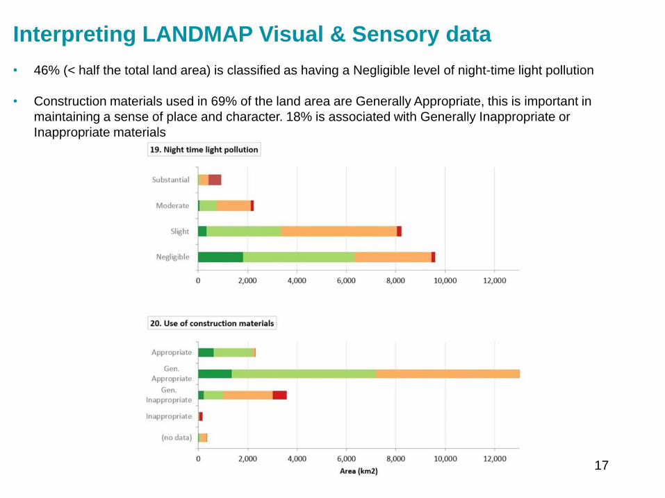
Interpreting LANDMAP Visual amp Sensory data
bull 46 (lt half the total land area) is classified as having a Negligible level of night-time light pollution
bull Construction materials used in 69 of the land area are Generally Appropriate this is important in
maintaining a sense of place and character 18 is associated with Generally Inappropriate or
Inappropriate materials
17
Monitoring the landscape evidence baseWhy
bull LANDMAP must be updated to maintain effectiveness and users confidence in the landscape baseline
bull To deliver on indicators that include landscape
bull To contribute to reports and plans such as lsquoState of Designated Landscapesrsquo SoNaRR and natural
resource plans
How
bull A robust and repeatable landscape monitoring methodology has been developed
bull Consistency in LANDMAP data through the benchmark methodology (introduced in 2003 now dated
2016) enables comparisons to be made across Wales and historically
bull Monitoring identifies areas where significant landscape change has been identified for example between
2003 and 2016
bull Multiple resources are used to identify analyse and interpret change
bull Changes are interpreted from the perspective of each LANDMAP dataset
bull Change detection work identifies exactly which aspect areas should be amended and in what way for
example the survey content boundaries or both
bull All LANDMAP information including monitoring updates is quality assured
What has been monitored so far What is yet to be monitored
Visual amp Sensory Cultural Landscape (initiate 2017)
Landscape Habitats Geological landscape (plan for 2018)
Historic Landscape (in process 2017)18
Evidence to inform landscape monitoring
Baseline and reporting units
bull LANDMAP relevant spatial dataset
For information and context
bull Ordnance Survey 150000 and 125000
bull True colour aerial photography - assessment of land cover change
bull Wales Tranquil Areas Map
bull Phase 1 Habitat of Wales amp Seasonal Change map of landscapes influenced by habitat change
bull Consented and Operational Wind farms
bull Additional information sourced relevant to each dataset
bull Professional and local knowledge from local authority input and specialists
For comparison over two time periods
bull OS MasterMap Roads and Buildings - changes in artificial structures and surfaces
bull Satellite imagery (eg Landsat 5 7 Spot 2003)
ndash Normalised Difference Vegetation Index (NDVI) - changes in living and non-living surfaces
ndash Complexity Maps (Segment Density) - morelesssame landscape complexity
bull Mega Change Map - highlights the most significant changes
19
Landscape monitoring example map 1Mega change map
Highlights the most significant changes in RoadsBuildings and NDVIsurface productivity
20
Landscape monitoring example map 2Complexity map
Highlights morelesssame landscape complexity from textural change
21
Interpreting monitoring
Key influences on landscape change 2003-2015
include
Built environment
bull Expansion of settlements commercial and industrial
development expansion of quarries road
improvements onshore wind-farms and turbines
recreational related developments
Natural environment
bull Replacement of conifers with broad-leaved trees
woodland expansion changes in bracken cover
reduced habitat diversity in places reduced bog
some improvements in upland vegetation
bull Mapping landscape change is important and
informative However care is required during
interpretation The example here shows change in
the Visual amp Sensory dataset note the following
‒ Changes may be to aspect area boundaries or
survey information
‒ The scale of change may be substantial or
limited in area
‒ Some changes detected were not sufficient to
justify a change in the LANDMAP
22
A Landscape Indicator based on LANDMAP
The quality and diversity of the natural and historic character of our landscape and seascape is
maintained and enhanced
bull Using LANDMAP monitoring work we can we calculate the extent to which landscape character
diversity and quality has been significantly changed from the baseline established
bull This could translate as lsquothe percentage of Walesrsquo landscape evaluated as outstanding or high should
be maintained or increasedrsquo or even a target of a 10 increase in the highest evaluations over 10
years
bull In time an assessment could be made of the extent to which a landscape has moved away from or
towards agreed visions for an area for example as part of Area Statements or wellbeing
assessments
We can do this by calculating
bull character and diversity using the and area (ha) of each classification
bull quality using the and area (ha) of each evaluation (outstandinghighmoderatelow)
We could report this by
bull National Park Area of Outstanding Natural Beauty Local Planning Authority National Landscape
Character Area Registered Historic Landscape Public Service Boards by Area Statement or at an
all Wales level
23
Accessing LANDMAP spatial datasets
bull To access the LANDMAP interactive map to view aspect area maps and surveys
httplandmap-mapsnaturalresourceswales
bull To download LANDMAP maps and surveys to use in a GIS environment
httpllewalesgovukCataloguelang=enamptext=landmap
24
Further Informationbull Information guidance notes and methodology chapters are available from
httplandmap-mapsnaturalresourceswales
LANDMAP Methodology Chapters
bull LANDMAP Methodology Overview (2017)
bull LANDMAP Methodology Geological Landscape (2016)
bull LANDMAP Methodology Landscape Habitats (2016)
bull LANDMAP Methodology Visual and Sensory (2016)
bull LANDMAP Methodology Historic Landscape (2016)
bull LANDMAP Methodology Cultural Landscape (2016)
bull LANDMAP Methodology Monitoring (2017)
Guidance Notes (GN)
bull GN1 LANDMAP amp Special Landscape Areas (2017) (correction of evaluation criteria text)
bull GN2 Accessing LANDMAP Information (2017)
bull GN3 LANDMAP amp LVIA for onshore windfarms (2017)
bull GN4 LANDMAP amp the Cultural Landscape (2016)
bull GN5 LANDMAP amp the Geological Landscape (2016)
25
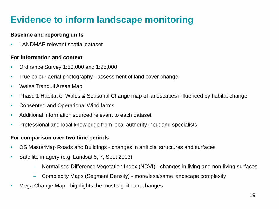
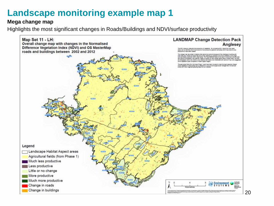
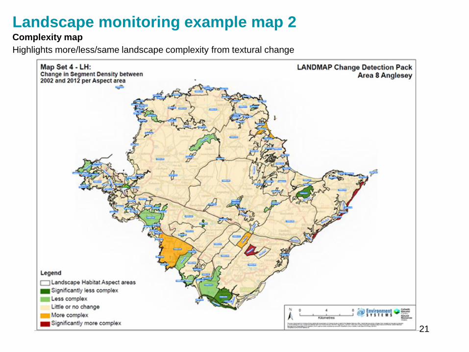