Embed Size (px)
Citation preview

LANDSCAPES OF AGRICULTURAL SPECIALISATIONA FORGOTTEN THEME IN HISTORIC LANDSCAPE
RESEARCH AND MANAGEMENT
Hans RENES
Faculty of Geosciences Utrecht UniversityPO Box 80115, 3508 TC Utrecht, the Netherlands
Faculty of Arts, VU University, Amsterdam, e-mail: [email protected]
Keywords: cultural landscape, history, agriculture, Europe
Summary: Some of the most characteristic landscapes in Europe are the result of specialised types of agriculture. Although these landscapes are often cherished by the local population, they tend to be overlooked by most regional landscape classifications. This article, extending on the results of the EucaLand project, focuses on the historic landscapes of agricultural specialisation. It presents the history (main periods, life cycles) as well as the geography of these landscapes.
Introduction
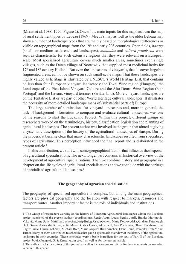
The cover of the 1970 edition of the Shell guide to England and Wales shows a rather unexpected image. This time no Tower of London, Cornwall coast or Lake District, but an oast-house in the south-eastern county of Kent (Figure 1).
It is part of a landscape that was shaped between the 17th and 19th centuries, when parts of Central Kent developed into the largest centre of hop-growing in the United Kingdom. There are more examples of such characteristic landscapes. The bulb fields in the Netherlands, with hundreds of hectares of tulips, daisies and other flowers in bloom during a short period in spring, belong to the largest tourist attractions in the country. The same is true of landscapes of fruit trees, such as the Altes Land near Hamburg in Germany, that attract thousands of tourist in the blossom and harvest periods.
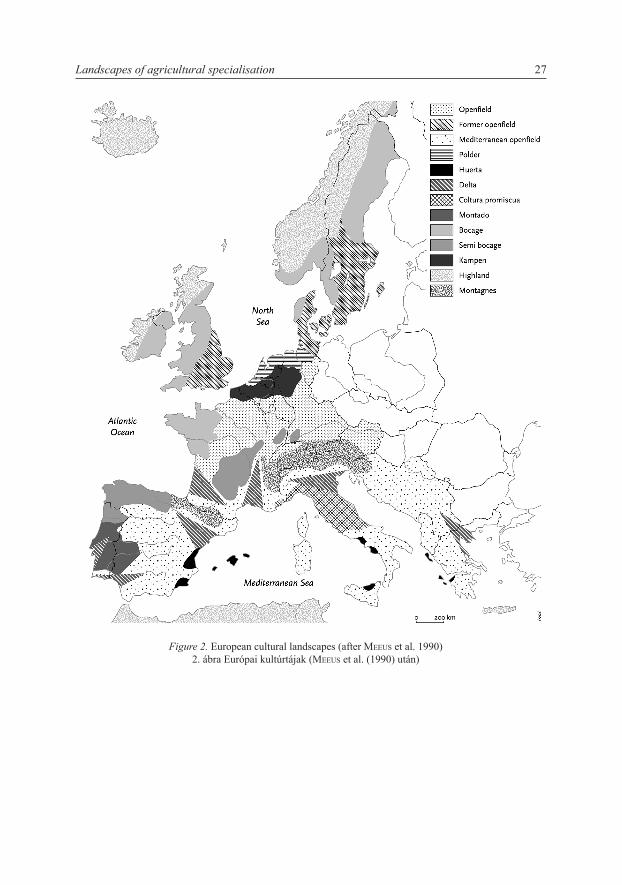
These and other specialised landscapes belong to the most characteristic views in Europe. They are, however, rarely represented in landscape classifications and in landscape politics. In recent years, the best-known maps of European agricultural landscape are those by the Dutch landscape architect Johan Meeus. In 1988 he published a map of landscapes in Western Europe
Tájökológiai Lapok Special Issue: 25–42. (2010)25
Figure 1. Cover of the Shell guide to England, ed. 1970.
1. ábra A Shell Anglia Utikalauzának borítója (1970)
(Meeus et al. 1988, 1990; Figure 2). One of the main inputs for this map has been the map of rural settlement types by Lebeau (1969). Meeus’s map as well as the older Lebeau map show a number of landscape types that are mainly based on morphological differences as visible on topographical maps from the 19th and early 20th centuries. Open fields, bocage (small- or medium-scale enclosed landscapes), montados and coltura promiscua were seen as characteristic for such extensive regions that they were relevant on a European scale. Most specialised agriculture covers much smaller areas, sometimes even single villages, such as the Dutch village of Noordwijk that supplied most medicinal herbs for 17th and 18th century Holland. But even the landscapes of vineyards, that do cover large but fragmented areas, cannot be shown on such small-scale maps. That these landscapes are highly valued as heritage is illustrated by UNESCO’s World Heritage List, that contains no less than four European vineyard landscapes: the Tokaj Wine region (Hungary), the Landscape of the Pico Island Vineyard Culture and the Alto Douro Wine Region (both Portugal) and the Lavaux vineyard terraces (Switzerland). More vineyard landscapes are on the Tentative List or are part of other World Heritage cultural landscapes. It illustrates the necessity of more detailed landscape maps of (substantial parts of) Europe.
The large number of nominations for vineyard landscapes and, more in general, the lack of background information to compare and evaluate cultural landscapes, was one of the reasons to start the EucaLand Project. Within this project, different groups of researchers worked on the terminology, history, classification, legislation and planning of agricultural landscapes. The present author was involved in the group that aimed at giving a systematic description of the history of the agricultural landscapes of Europe. During the process, it became clear that many characteristic landscapes resulted from specialised types of agriculture. This perception influenced the final report and is elaborated in the present article.1
In this contribution, we start with some geographical factors that influence the dispersal of agricultural specialisations. The next, longer part contains an historical overview of the development of agricultural specialisations. Then we combine history and geography in a chapter on the life cycles of agricultural specialisations and we conclude with the heritage of specialised agricultural landscapes.2
The geography of agrarian specialisation
The geography of specialised agriculture is complex, but among the main geographical factors are physical geography and the location with respect to markets, resources and transport routes. Another important factor is the role of individuals and institutions.
1 The Group of researchers working on the history of European Agricultural landscapes within the Eucaland project consisted of the present author (coordination), Renée Aoun, Lucia Benito Jordá, Branka Martinović-Vuković, Mirna Bojić, Matthias Buchecker, Josip Bulog, Csaba Centeri, Marta Dobrovodska, Graham Fairclough, Dick Grove, Alexandra Kruse, Zofia Mavar, Gábor Ónodi, Ákos Pető, Anu Printsman, Oliver Rackham, Erna Raguz Lucic, Cinzia Robbiati, Michael Roth, Maria Angeles Ruiz Sánchez, Elena Toma, Veronika Tóth & Sam Turner. Many of them contributed to schedules that gave a systematic overview of the history of the agricultural landscape in their countries. These schedules were a basic ingredient for the text of Part II of the Eucaland project book (Pungetti, G. & Kruse, A., in prep.) as well as for the present article. 2 The author thanks the editors of this journal as well as the anonymous referee for their comments on an earlier version of this paper.
H. Renes26
Landscapes of agricultural specialisation 27
Figure 2. European cultural landscapes (after Meeus et al. 1990)2. ábra Európai kultúrtájak (Meeus et al. (1990) után)
Physical geographyMany crops flourish best under very specific conditions of climate, soil conditions (not always the best soils: asparagus for example, thrives on extremely poor soils where it is less vulnerable to diseases and competing plants), insolation (grapes on south-looking slopes) or moisture. These factors are relevant on different scales.
However, physical geography is mainly important as a limiting factor. On a continental scale, for example, the traditional northern limit of wine-growing runs from east to west through France and Central Europe. But such limits are never absolute: north of this line, wine could be produced and in fact has been produced. The farther north of the line, the larger the percentage of failed harvests and the more problematic the quality of the wine. The line is not stable either, being dependent upon the farmers’ perceptions and their willingness to take risk as well as on fluctuations in climate. Furthermore, new varieties of grapes can push the limit northwards, as has been shown in recent years when wine-growing returned successfully to the Netherlands and England.
On a local scale, micro-climate, geomorphology (for example steep slopes that cause erosion problems), soil quality and hydrology can limit the success of specific crops.
Often specialisations occurred based on the use of different resources within a region, that were themselves influenced by physical geography. High mountains are difficult regions for arable farming and many of these regions have specialised in animal husbandry, especially dairy farming (cheese) and the breeding of young animals. Sometimes the connections between agricultural landscapes take a very concrete form, when farmers with their animals move on a seasonal basis from one landscape to another, thereby making optimal use of different circumstances. Particularly between mountains and lowlands, such ‘transhumance’ systems have existed all over Europe. The history of these systems is often unclear. They can be thousands of years old, but have undergone many fluctuations. During the last century, most transhumance systems have disappeared.
The relation to marketsThe second set of factors includes the relation to markets. All specialised agriculture worked for supra-local, often national or even European markets. A good starting point for illustrating this process is the model designed by the German landowner and economist Johann-Heinrich von Thünen (1783–1850) in his book Der isolierte Staat (‘the isolated state’). The model is based on transport costs, in relation to the weight, value and perishability of goods. According to the model, perishable products such as fruit, milk and vegetables will be produced close to an urban centre. A second zone is reserved for wood, which is necessary but also heavy and with too little value to bear the costs of long-distance transport. Still further away, grain will be produced and the outer zone of the hinterland will produce meat (stock that can be herded to the town and therefore entailing relatively low transport costs). As water transport was much cheaper, towns that were situated on deep water had a much larger hinterland.
Relation to resources and transport routesNatural resources such as soil and water were not the only group of resources. Other inputs, such as manure and fodder could also give locational advantages to certain regions. Before the spread of artificial fertilisers, regions near towns or harbours, and well
H. Renes28
connected to those, had access to urban waste and, especially during the 19th and early 20th centuries, to imported manure such as Chile saltpetre.
A good example of resource-based development is industrialised animal husbandry, particularly the breeding of pigs, calves and poultry for meat, within the European Union during the final decades of the 20th century. This development has been based on a combination of a growing internal market and the use of imported foodstuffs. These sectors were not subsidised or protected, although much stimulated by the fact that grain substitutes for animal fodder (soy beans, tapioca) were exempt from import tariffs. Industrialised animal husbandry became a survival strategy for small farmers close to deep-sea harbours. The resulting landscapes in East Yorkshire, Brittany and parts of the Netherlands are seen as problematic in terms of environment, landscape aesthetics and animal welfare, but are nonetheless a good example of a new specialised landscape.
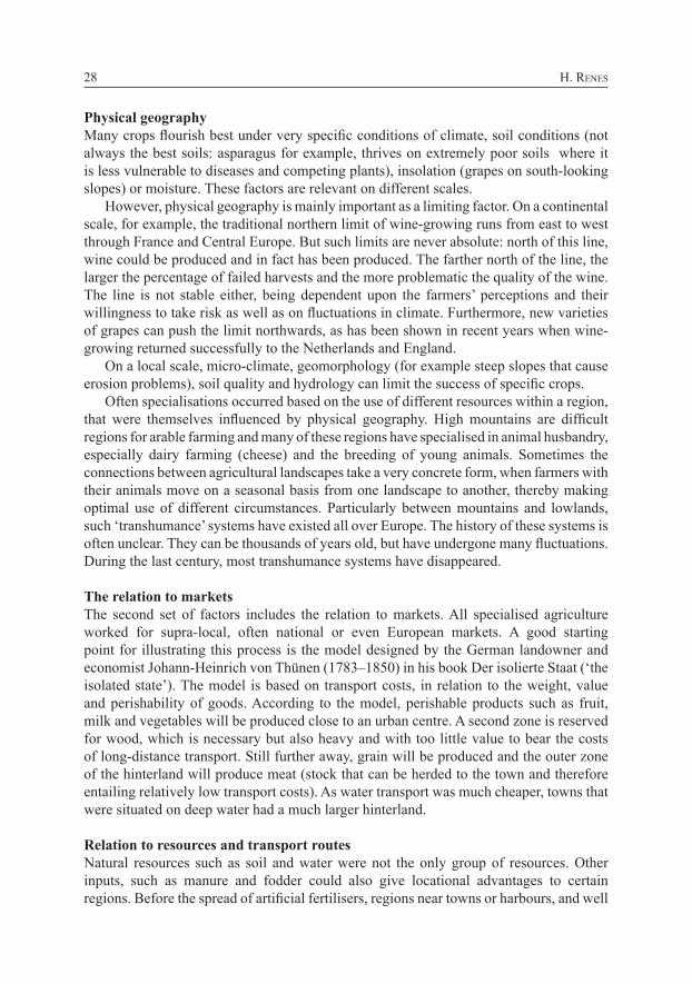
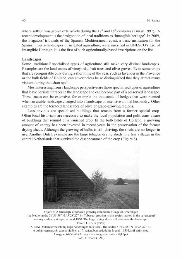
The role of individuals and institutions Institutions and legal frameworks can act as forces of stability, but local leaders and groups can also stimulate new activities. Local and regional structures explain much of the unique answers with which different regions respond to forces of globalisation. Even political developments, may be responsible for some agricultural developments, for example in relation to forced migrations (Figure 3).
Figure 3. A landscape of individual terraces on Lesbos. This very labour-intensive landscape only developed after the population exchange of 1923 that followed after the war between Greece
and Turkey. Many of those evicted from Turkey settled on the easternmost Greek islands, within sight of the Turkish coast. To employ all these people, intensive olive growing replaced an earlier,
less intensive farming system. Photo: J. Renes (2004)3. ábra Egyedülálló teraszok Leszbosz szigetén. Ez a nagyon munkaigényes táj az 1923-as népesség-
változás után fejlődött ki, amely a Görögország és Törökország közötti háború után volt jellemző. A Törökországból kilakoltatottak a legkeletibb görög szigeteken telepedtek le, ahonnan látszanak
a török partok. A lakosság foglalkoztatásának érdekében intenzív oliva-ültetvényekre cserélték a korábbi, kevésbé intenzív gazdálkodási rendszert. Fotó: J. Renes (2004)
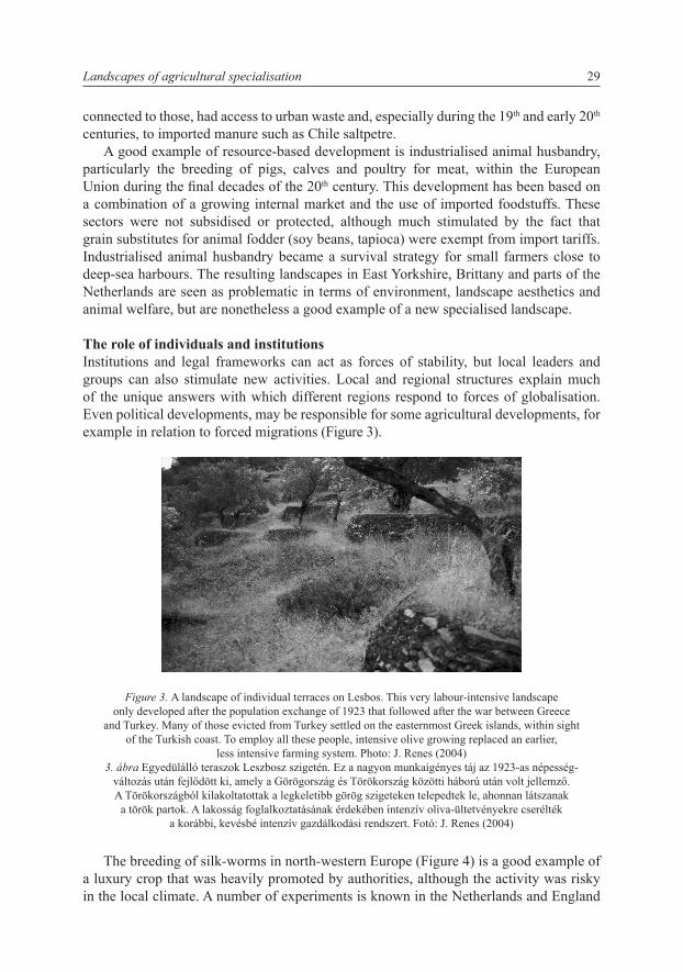
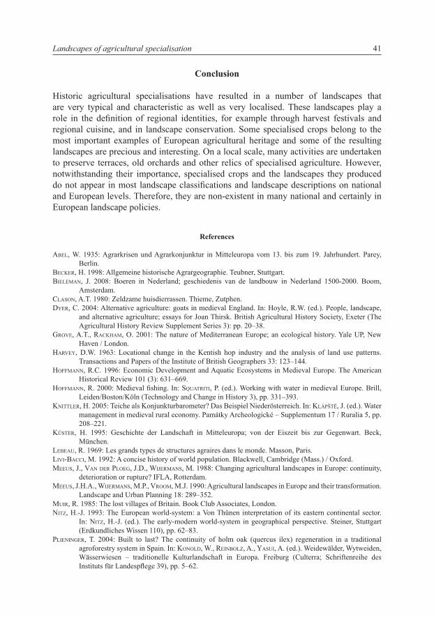
The breeding of silk-worms in north-western Europe (Figure 4) is a good example of a luxury crop that was heavily promoted by authorities, although the activity was risky in the local climate. A number of experiments is known in the Netherlands and England
Landscapes of agricultural specialisation 29
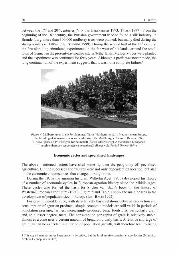
between the 17th and 20th centuries (Van den eeRenbeeMt 1993; tHiRsk 1997). From the beginning of the 18th century, the Prussian government tried to found a silk industry. In Brandenburg, more than 300.000 mulberry trees were planted, but many died during the strong winters of 1785–1787 (scHMidt 1999). During the second half of the 18th century, the Prussian king stimulated experiments in the far west of his lands, around the small town of Gennep in the present-day south-eastern Netherlands. Mulberry trees were planted and the experiment was continued for forty years. Although a profit was never made, the long continuation of the experiment suggests that it was not a complete failure.3
Figure 4. Mulberry trees in the Po-plain, near Turin (Northern Italy). In Mediterranean Europe, the breeding of silk-worms was successful since the Middle Ages. Photo: J. Renes (1994)
4. ábra Eperfák a Pó-síkságon Torino mellett (Észak-Olaszország). A mediterrán Európában a selyemhernyók tenyésztése a középkortól sikeres volt. Fotó: J. Renes (1994)
Economic cycles and specialised landscapes
The above-mentioned factors have shed some light on the geography of specialised agriculture. But the successes and failures were not only dependent on location, but also on the economic circumstances that changed through time.
During the 1930s the agrarian historian Wilhelm Abel (1935) developed his theory of a number of economic cycles in European agrarian history since the Middle Ages. These cycles also formed the basis for Slicher van Bath’s book on the history of Western-European agriculture (1960). Figure 5 and Table 1 show the main phases in the development of population size in Europe (LiVi-bacci 1992).
For pre-industrial Europe, with its relatively basic relations between production and consumption of agrarian products, simple economic models are still valid. In periods of population pressure, farmers increasingly produced basic foodstuffs, particularly grain and, to a lesser degree, meat. The consumption per capita of grain is relatively stable: almost everyone uses a certain amount of bread on a daily basis. A relative shortage of grain, as can be expected in a period of population growth, will therefore lead to rising
H. Renes30
3 This experiment has never been properly described, but the local archive contains a large dossier (Municipal Archive Gennep, inv. nr 425).
prices. In such a period, grain farmers could become rich. Many other crops and animals were relegated to marginal lands and poorer sections of society (dyeR 2004).
On the other hand, in periods of population decline the demand for grain will decline and prices will drop. As lower prices will not lead to a substantial higher consumption per capita, the price falls can be very steep. This is different for other products, such as meat, fish or wine. With falling prices, the consumption of these products will grow, resulting in a soft landing of the price-levels (see for wine: unwin 1991). Therefore, during such periods, many farmers will move away from grain and turn to alternative products. The English agrarian historian Joan Thirsk (1997) concentrated on those periods and presented them as periods of agrarian innovations, in which farmers experimented with alternative crops.
Figure 5. Phases in the development of population and agriculture in Europe. European population according to LiVi-bacci, 1992.
5. ábra Az európai népesség és mezőgazdaság fejlődésének szakaszai. Az európai lakosság LiVi-bacci (1992) alapján
High medieval specialised landscapes: emphasis on grain-producing open fields The period from the 10th to the early 14th century was characterised by population growth and, increasingly, population pressure. One of the effects of a rising demand for food for the fast-growing population was the growing emphasis on grain-products, such as bread and porridge (baRtLett 1994). Grain became the staple crop and the most efficient system for producing grain consisted of open fields, large arable fields without hedges, on which the farmers from a village often cooperated in ploughing, harvesting, management of the common lands and in using the arable as common pasture after the harvest. These open fields, in most cases used in a three-field system, were the most characteristic landscape of this period, at least in lowland central Europe. Their development started somewhere around the 9th century and after a few centuries they formed an almost continuous east-west band through Europe, from central England via the Paris Basin through central Europe, with outlying regions in southern Scandinavia and the Mediterranean – a region wherein the best soils of the subcontinent were found.
Landscapes of agricultural specialisation 31
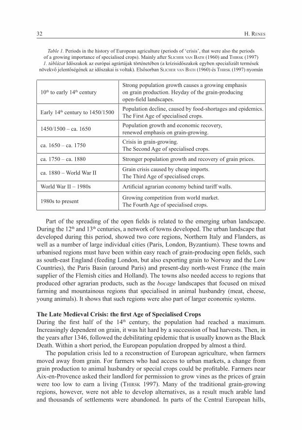
Table 1. Periods in the history of European agriculture (periods of ‘crisis’, that were also the periods of a growing importance of specialised crops). Mainly after sLicHeR Van batH (1960) and tHiRsk (1997)1. táblázat Időszakok az európai agrártájak történetében (a krízisidőszakok egyben specializált termések
növekvő jelentőségének az időszakai is voltak). Elsősorban sLicHeR Van batH (1960) és tHiRsk (1997) nyomán
10th to early 14th century Strong population growth causes a growing emphasis on grain production. Heyday of the grain-producing open-field landscapes.
Early 14th century to 1450/1500 Population decline, caused by food-shortages and epidemics. The First Age of specialised crops.
1450/1500 – ca. 1650 Population growth and economic recovery, renewed emphasis on grain-growing.
ca. 1650 – ca. 1750 Crisis in grain-growing. The Second Age of specialised crops.
ca. 1750 – ca. 1880 Stronger population growth and recovery of grain prices.
ca. 1880 – World War II Grain crisis caused by cheap imports. The Third Age of specialised crops.
World War II – 1980s Artificial agrarian economy behind tariff walls.
1980s to present Growing competition from world market. The Fourth Age of specialised crops.
Part of the spreading of the open fields is related to the emerging urban landscape. During the 12th and 13th centuries, a network of towns developed. The urban landscape that developed during this period, showed two core regions, Northern Italy and Flanders, as well as a number of large individual cities (Paris, London, Byzantium). These towns and urbanised regions must have been within easy reach of grain-producing open fields, such as south-east England (feeding London, but also exporting grain to Norway and the Low Countries), the Paris Basin (around Paris) and present-day north-west France (the main supplier of the Flemish cities and Holland). The towns also needed access to regions that produced other agrarian products, such as the bocage landscapes that focused on mixed farming and mountainous regions that specialised in animal husbandry (meat, cheese, young animals). It shows that such regions were also part of larger economic systems.
The Late Medieval Crisis: the first Age of Specialised CropsDuring the first half of the 14th century, the population had reached a maximum. Increasingly dependent on grain, it was hit hard by a succession of bad harvests. Then, in the years after 1346, followed the debilitating epidemic that is usually known as the Black Death. Within a short period, the European population dropped by almost a third.
The population crisis led to a reconstruction of European agriculture, when farmers moved away from grain. For farmers who had access to urban markets, a change from grain production to animal husbandry or special crops could be profitable. Farmers near Aix-en-Provence asked their landlord for permission to grow vines as the prices of grain were too low to earn a living (tHiRsk 1997). Many of the traditional grain-growing regions, however, were not able to develop alternatives, as a result much arable land and thousands of settlements were abandoned. In parts of the Central European hills,
H. Renes32
agriculture never recovered; in later centuries, forestry (often based on demand from mining) became the most prominent type of agriculture.
An example of a successful conversion can be found in the Dutch fenlands, where subsidence of the peat soil made arable farming increasingly difficult and where, on the other hand, the expanding towns created a demand for dairy products and meat. The farmers in this region became dairy farmers and developed cheese production that survived until the present day. In Central England, a long process of change from an open-field grain-producing region to a sheep-farming region started during this period. It was made possible by the growing industrial demand for wool. With the change from arable to pasture, some of the open fields with their fragmented landownership were transformed into an enclosed landscape of dispersed farms.
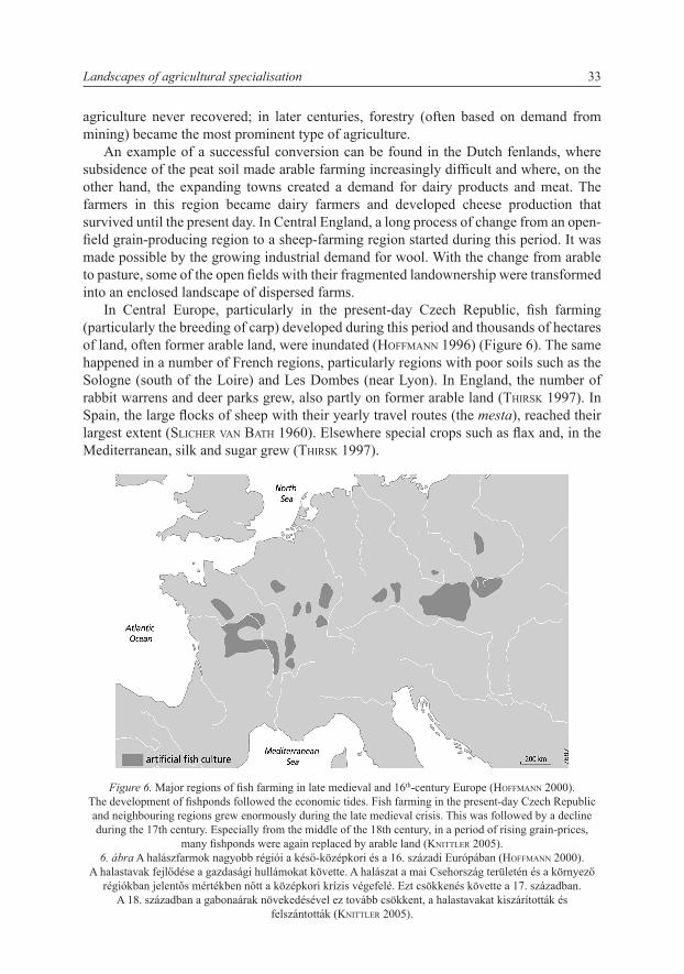
In Central Europe, particularly in the present-day Czech Republic, fish farming (particularly the breeding of carp) developed during this period and thousands of hectares of land, often former arable land, were inundated (HoffMann 1996) (Figure 6). The same happened in a number of French regions, particularly regions with poor soils such as the Sologne (south of the Loire) and Les Dombes (near Lyon). In England, the number of rabbit warrens and deer parks grew, also partly on former arable land (tHiRsk 1997). In Spain, the large flocks of sheep with their yearly travel routes (the mesta), reached their largest extent (sLicHeR Van batH 1960). Elsewhere special crops such as flax and, in the Mediterranean, silk and sugar grew (tHiRsk 1997).
Figure 6. Major regions of fish farming in late medieval and 16th-century Europe (HoffMann 2000). The development of fishponds followed the economic tides. Fish farming in the present-day Czech Republic and neighbouring regions grew enormously during the late medieval crisis. This was followed by a decline during the 17th century. Especially from the middle of the 18th century, in a period of rising grain-prices,
many fishponds were again replaced by arable land (knittLeR 2005).6. ábra A halászfarmok nagyobb régiói a késő-középkori és a 16. századi Európában (HoffMann 2000).
A halastavak fejlődése a gazdasági hullámokat követte. A halászat a mai Csehország területén és a környező régiókban jelentős mértékben nőtt a középkori krízis végefelé. Ezt csökkenés követte a 17. században.
A 18. században a gabonaárak növekedésével ez tovább csökkent, a halastavakat kiszárították és felszántották (knittLeR 2005).
Landscapes of agricultural specialisation 33
The ‘long sixteenth century’: landscapes of the European world systemRecovery started during the 15th century and continued during the ‘long 16th century’. A new phase of economic integration began during this period, in which the European economies and landscapes regrouped around north-western Europe, that outgrew Northern Italy and became the only remaining core region (nitz 1993). Within this core region, the main centre of trade moved from Antwerp (16th century) to Holland (particularly Amsterdam, 17th century) and England (18th century).
The German geographer Hans-Jürgen nitz (1993) applied Von Thünen’s model on Early Modern Europe and found the most intensive agriculture, including dairy farming and horticulture, in the core region. Further away, large-scale grain-growing extended along the Baltic and export-oriented breeding of cattle and horses was located in regions such as Jutland and Hungary. Scottish cattle were herded to the London market and Hungarian horses to the Rhineland; Danish oxen walked or were shipped to Holland.
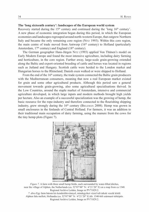
From the end of the 16th century, the trade system connected the Baltic grain producers with the Mediterranean consumers, meaning that now a real European market existed for grain and some other agricultural products. Although this period saw a general movement towards grain-growing, also some agricultural specialisations thrived. In the Low Countries, around the staple market of Amsterdam, intensive and commercial agriculture developed, in which large inputs and modern methods brought high yields per hectare. Also an example of a successful specialization was the growing of hemp, the basic resource for the rope-industry and therefore connected to the flourishing shipping industry, grew strongly during the 16th century (bieLeMan 2008). Hemp was grown in small enclosures in the fenlands of Central Holland. For farmers, it was an addition to their traditional main occupation of dairy farming, using the manure from the cows for the tiny hemp plots (Figure 7).
Figure 7. A farm with three small hemp fields, each surrounded by water-filled ditches,near the village of Alphen, the Netherlands (ca. 52°07’00” N / 4°21’20” E) on a map from ca 1540.
Regional Archive Leiden, Image nr PV71829.2.7. ábra Egy farm három kis kenderültevénnyel, mindegyiket vízzel telt árkok veszik körül.
Alphen falu mellett, Hollandia (ca. 52°07’00” N / 4°21’20” E) kb. 1540-ből származó térképén. Regional Archive Leiden, Image nr PV71829.2.
H. Renes34
Also small regions around other urban centres specialised in dairy farming or horticulture. Where grain gave way to cattle or sheep, the old open fields became dysfunctional and were often enclosed. Within a few decades open landscapes became characterised by hedges and dispersed farms. During the 16th and 17th centuries, this happened for example in parts of the Allgäu in southern Germany and in the Country of Herve near the industrial town of Liège (Belgium). The 16th century was also a period of experiments with new crops, many from the New World, that were often introduced in gardens or estates (tHiRsk 1997).
From 1650 to 1750: the Second Age of Specialised CropsIn some ways, the developments during this period mirrored those during the Late Medieval crisis. Fishponds, rabbit warrens and deer parks that had partly given way for arable land during the long sixteenth century, now grew again in importance (tHiRsk 1997). However, the Second Age of Specialised Crops showed more variation than the first. Some of the crops that were grown as experiments in the former phase, became important in the second half of the 17th century, when grain prices fell. American products such as potatoes and maize became popular because of their high yields per hectare and hence their ability to feed high population numbers. Maize took over small parts of the Mediterranean open fields. Potatoes, that started to become a staple food from the second half of the 17th century onwards (in Ireland already from the end of the 16th century (tHiRsk 1997)), were usually grown in enclosures. Another new product was tobacco, an addictive product that was fashionable for some time and was grown in large parts of Europe. The consumption by Europeans of this American product started during the 16th century. In the early 17th century, experiments in growing tobacco started in the Low Countries and in England, from where it spread to other parts of Europe (see scHMidt (1999) for Brandenburg). In the northern Netherlands, the town of Amsterdam developed into the world’s largest market for tobacco and Amsterdam merchants stimulated growing tobacco in the Netherlands. Success came after 1650 and particularly at the end of the 17th century, when the low grain prices made tobacco into an interesting crop, especially for small farmers (RoessingH 1976).
The period also showed a strong growth of industrial crops, such as hemp (for ropes), flax (for linen), hop (for brewing), rapeseed (for oil), madder and woad (both for dyeing of textiles). Many of these industrial crops tended to concentrate in certain regions. The consumption of vegetables and fruit grew, offering possibilities for the development of commercial horticulture and orchards (tHiRsk 1997). Around London, the first glass-houses appeared in the middle of the 17th century (tHiRsk 1997). In Holland, the cultivation of flower-bulbs, such as the tulip (originally from the Ottoman lands), grew enormously during the 17th and 18th centuries. It became a fashionable product and the breeding of new varieties even became a matter of speculation.
From 1750 to 1880: back to grainRising grain prices during the second half of the 18th century moved the pendulum back into the other direction. Many farmers returned to grain-growing. In the UK, a new wave of enclosures aimed at a more efficient use of arable land. The example was followed in south Scandinavia, where the landscape was reconstructed by enclosures.
Landscapes of agricultural specialisation 35

A number of specialised crops declined. In the Netherlands, for example, in the middle of the 18th century the growth of tobacco started its long decline, although the crop survived there for another two centuries.
Some specialised crops, especially those that represented a high value per unit, survived. An example is the production of wine. On the Iberian Peninsula, the growth of the wine trade during the 18th century led to a strong growth in the exploitation of cork oaks, which were combined with pasture of sheep and pigs in the savanna-like landscapes that were called montado (Portugal) or dehesa (Spain). These landscapes can have very old roots, but must have reached their highest extension only during the 18th to the early 20th centuries (PLieningeR 2004, gRoVe and RackHaM 2001).
After the Agrarian Crisis of 1880: the Third Age of Specialised CropsThe agrarian crisis of the 1880s brought yet another transformation. Again, this was mainly a grain crisis. The transport revolution – intercontinental trains and transatlantic steamships – tipped the balance and within a few years American grain, cheaply produced on large farms, flooded the European market. Again many farmers moved from grain-growing towards other, often industrial, crops, to horticulture or to animal husbandry. A good number of small farmers with good access to urban markets turned to breeding poultry or pigs.
A good example of the effects can be seen in the sandy landscapes of the Netherlands, which had traditionally been characterised by mixed farming and therefore could easily shift between products. During most of the 19th century, the farmers earned their main income through the products from their open fields, particularly rye. During the last decades of the century, they moved towards an emphasis on animal husbandry, using the produce of the arable as animal fodder. In fact this system survives to the present day, although rye has been replaced by maize during the last decades (bieLeMan 2008).
Again some crops showed a remarkable degree of concentration in certain regions, partly because of local circumstances, but also facilitated by the improved transport possibilities. A good example is the growing of hop that during the 19th century concentrated further in specific regions where it resulted in very characteristic landscapes. Examples are Kent (see below), the region around Poperinge in Flanders and the Holledau region in North Bavaria (at present still the largest hop-growing region in the world) (küsteR 1995)). A number of regions profited from the growth in wine consumption. The plains of the Languedoc, for example, started to specialise in wine growing during the second half of the 18th century and developed further in this direction during the 19th century. In Scotland, during the late 18th and 19th centuries the relatively densely populated countryside of mixed farming gave way to an ‘empty’ landscape of sheep pastures and hunting ranges (MuiR 1985).
The industrial development sometimes stimulated regional agricultural specialisations. The development of industrial processing of fruit, producing marmalade, syrup or cider, further strengthened the concentration of fruit-growing. On the other hand, the growth of the modern chemical industry brought the replacement of a growing number of agricultural products by industrial produced products. An example is the growth of madder (rubia), a plant that supplies a red dye and that was grown for centuries on a large scale in the province of Zealand (NL), but disappeared almost completely within a few years after chemical production of the specific pigment started in 1871 (bieLeMan 2008).
H. Renes36
The second half of the 20th century: influences of supra-national bodiesThe next major crisis, during the 1930s, more or less repeated the earlier ones. More than in earlier crises, governments turned to market regulations and sometimes to import restrictions to protect their own farmers. The World Crisis was followed by the Second World War, with increasing state intervention in the occupied countries. This pattern more or less continued in the post-war years, when agriculture in the European (Economic) Community (the Common Agricultural Policy) as well as in its Eastern European counterpart Comecon was characterised by a strong influence of (supra) national governments on price levels within a protected market (Renes and PauL 2004). Many of the uncertainties that had always characterised agriculture, now diminished as production circumstances were increasingly controlled and problems caused by pests were brought under control. Agriculture moved from risk management towards profit maximisation, resulting in increasing specialisation. Some of the subsidies stimulated the development of new regional specialisations, such as the growing of rapeseed and sunflowers in different French regions following measures to stimulate oilseed production during the 1980s (see Aoun, this volume).
Present trends: towards a post-productivist agricultural landscapeEuropean agriculture and its landscapes are now going through another transformation, again with large regional variations. In some regions, a further development of large-scale agriculture is taking place, with a new market developing for the production of biofuel. In regions that are marginal within the future European rural space, a large variety of survival strategies is being developed, particularly for small farms. These strategies include regional brands, tourist activities and organic farming, often sustained by subsidies for environmentally friendly practices. Agriculture in many rural regions is described as post-productivist: a situation in which agriculture becomes less a food producer than a producer of landscape. Some regions are now going through a phase of abandonment of agriculture, sometimes in a planned way to enable the development of ecological zones and networks, but in other cases as an unplanned retreat of agriculture.
The life cycle of an agrarian specialisation
Specialised crops always start on a small scale. They are introduced in a region, sometimes by traders, often by landowners or, from the 17th century onwards, by botanical gardens or other collectors. These early experiments with a crop can be very dispersed geographically. Some crops can function for centuries on a small scale, in gardens or orchards, producing for a local market. Fruit-growing is a very old activity on farmyards, that gradually developed into a small-scale enterprise around the main urban centres. Only during the 19th and 20th centuries the improved transport and the growing urban markets made the development of fruit-growing as a regional specialisation possible.
The development from experiments to a commercial success usually takes place only in a few regions. In many cases the proximity and connections to urban markets is an important success-factor. Within these limits, the actual location is often dependent on the persistence of individuals and, hence, to a certain degree of randomness. In some cases favourable physical conditions, such as soil, slope or hydrology, are important, particularly in the first phase of growth.
Landscapes of agricultural specialisation 37
When a crop concentrates in a few regions, serving a wide area, the second phase commences. In the particular regions an infrastructure of knowledge and trade networks as well as capital supply and storage and processing facilities is built up, further improving the initial advantage of the region. A good example is the growing of hop in Central Kent, which was described in a classic article by the geographer David HaRVey (1963). This region was an important centre of hop-growing already during the 17th century, partly because of excellent soil qualities as well as good transport facilities and the closeness to London. During the 19th century, the cultivation of hops grew, especially within the existing hop-region. In the extension phase also lands with less optimal soil conditions were used for hops. This shows that other factors grew in importance.
Harvey distinguishes three main factors in the spatial development of the crop: agglomeration, cumulative change, and diminishing returns. Agglomeration is connected to economies of scale. When a farmer had done a large investment by building an oast-house, it was profitable for him to extend his hop-gardens. Other factors were the supply of equipment (for example hop-poles, which made a large area of coppice wood necessary), of skilled labourers and of banks that had experience with the crop. The second factor, cumulative change, points to changes that support other changes that strengthen a development in the same direction. Hop-growing was a very profitable activity, but exactly that profitability had led to rising rents and wages that farmers could only afford to pay by increasing their hop-culture. From a certain point the third factor, diminishing returns limits further concentration. For this particular crop, the possibilities for concentration were limited by the large amounts of manure needed. This meant that no farmer could grow hops on more than 15 % of his farm, or 35 % when he was able to buy (expensive) manure elsewhere. Also rising overhead costs or rising production costs (for example scarcity of hop-poles) could move the crop out of the core region.
These processes are not described in the same depth for most other crops, but they may well be characteristic for the development of other specialised types of agriculture. During this phase of concentration and prosperity, the region can even become widely known for its specialisation. The local population may see it as part of their regional identity. Festivities, such as harvest feasts and wine feasts, sometimes become institutionalised markers of local identity as well as stimuli for marketing and tourism.
The last phase enters when changing circumstances diminish the advantage and the position of the region starts to erode. Causes can be varied. Many horticultural activities, being traditionally concentrated on the edges of the main cities, have been continuously pushed away by further urban extensions. In some cases, competition from other regions grew. Tobacco-growing, for example, disappeared from northern Europe through competition from better quality tobacco from subtropical regions. The competition of industrially produced products was already mentioned before.
The landscapes and heritage of specialised agriculture
During the last phase, the landscape features that remain from special types of agriculture that have declined or disappeared, can be seen as part of the regional heritage. The heritage of specialised agriculture can be divided into three categories: [1] the products themselves, [2] local traditions and [3] landscapes.
H. Renes38
Products as heritage Local specialisations often led to the breeding of regional or local varieties of crops or animals. These old breeds are now under threat as new, more productive breeds take over. Many people see this as an erosion of agricultural diversity and in different countries organisations have been founded to protect certain ‘traditional’ varieties. Examples are the Rare Breeds Survival Trust (GB, founded 1973), the Société d’Ethnozoologie (France), the Gesellschaft zur Erhaltung alter und gefährdeter Haustierrassen (Germany) and the Stichting Zeldzame Huisdierrassen (the Netherlands, 1976; Clason, 1980) as well as seed-banks (for example the Millennium Seed Bank Project that was initiated in 2000 by the Royal Botanic Gardens at Kew) in different countries. Some countries took initiatives to preserve local knowledge.4
Since 2006, the European Union protects ‘traditional’ products in relation to their regions of origin. Therefore, the EU developed a number of designations5 that count as quality guarantees and at the same time act as regional brands.
Protected Designation of Origin (PDO) covers agricultural products and foodstuffs, •which are produced, processed and prepared in a given geographical area using recognised know-how. Protected Geographical Indication (PGI) covers agricultural products and •foodstuffs closely linked to the geographical area. At least one of the stages of production, processing or preparation takes place in the area. Traditional Speciality Guaranteed (TSG) highlights traditional character, either in •the composition or means of production.
Most of the listed items are processed products, and in many cases, for example with beers, the fabrication process is more characteristic than the ingredients. However, many other processed products, such as different local meat and sausage varieties and the ciders of Normandy and Brittany (classified as PGI), stay close to types of specialised agriculture. Furthermore, the lists also contain agricultural products that are linked to long-standing agricultural specialisation, such the grapes that are traditionally produced in glasshouses in the Brussels region (PDO), different types of honey, carp from the Trébon region (Czech Republic) and horticultural products (lettuce, tomatoes, gherkin) from the German island of Reichenau (PGI). In some cases, the protection of landscapes of specialised agriculture is facilitated by this protection of special crops. Particularly Protected Designation of Origin can be used to protect landscapes that are connected with specific crops.
Local traditionsMany regions with specialised types of agriculture developed local customs and traditions, that are now seen as building stones of regional identity and, sometimes, as part of a regional tourist product. Examples are harvest festivals that can attract thousands of visitors. Many regional specialisations leave traces in regional cuisines. An example is the habit of eating carp for Christmas in the Czech Republic and in Poland. Sometimes local museums are built around such specialisations. In some cases, specialisations leave traces in field-names or even in place-names (Saffron Walden in Essex, England, in a region
Landscapes of agricultural specialisation 39
4 For example the Austrian Register on Traditional Knowledge in agricultural products and food (http://www.lebensmittelnet.at/article/articleview/51040/1/14406/) [11-2-2010]. 5 http://ec.europa.eu/agriculture/quality/schemes/index_en.htm [24-1-2010]
where saffron was grown extensively during the 17th and 18th centuries (tHiRsk 1997)). A recent development is the designation of local traditions as ‘intangible heritage’. In 2009, the irrigators’ tribunals of the Spanish Mediterranean coast, a basic institution for the Spanish huerta-landscapes of irrigated agriculture, were inscribed in UNESCO’s List of Intangible Heritage. It is the first of such agriculturally-based inscriptions on the list.
LandscapesSome ‘traditional’ specialised types of agriculture still make very distinct landscapes. Examples are the landscapes of vineyards, fruit trees and olive groves. Even some crops that are recognisable only during a short time of the year, such as lavender in the Provence or the bulb fields of Holland, can nevertheless be so distinguished that they attract many visitors during that short spell.
Most interesting from a landscape perspective are those specialised types of agriculture that leave persistent traces in the landscape and can become part of a preserved landscape. These traces can be extensive, for example the thousands of hedges that were planted when an arable landscape changed into a landscape of intensive animal husbandry. Other examples are the terraced landscapes of olive or grape-growing regions.
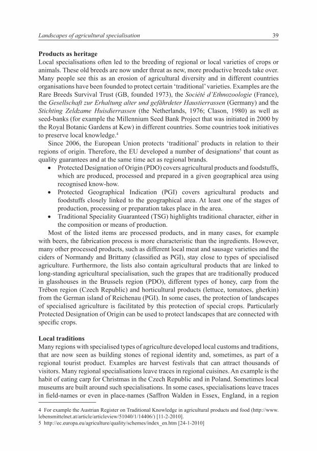
Less obvious are specialised buildings that remain from a former special crop. Often local historians are necessary to make the local population and politicians aware of buildings that remind of a vanished crop. In the bulb fields of Holland, a growing amount of energy has been invested in recent years in the preservation of the former drying sheds. Although the growing of bulbs is still thriving, the sheds are no longer in use. Another Dutch example are the large tobacco drying sheds in a few villages in the central Netherlands that survived the disappearance of the crop (Figure 8).
Figure 8. A landscape of tobacco growing around the village of Amerongen (the Netherlands; 51°59’58” N / 5°28’22” E). Tobacco-growing in this region started in the seventeenth
century and only stopped around 1950. The huge drying sheds still dominate the landscape. Photo: J. Renes (1999)
8. ábra Dohánytermesztő táj képe Amerongen falu körül, Hollandia; 51°59’58” N / 5°28’22” E). A dohánytermesztés ezen a vidéken a 17. században kedződött és csak 1950 körül szűnt meg.
A nagy szárítóépületek még ma is meghatározzák a tájképet. Fotó: J. Renes (1999)
H. Renes40
Conclusion
Historic agricultural specialisations have resulted in a number of landscapes that are very typical and characteristic as well as very localised. These landscapes play a role in the definition of regional identities, for example through harvest festivals and regional cuisine, and in landscape conservation. Some specialised crops belong to the most important examples of European agricultural heritage and some of the resulting landscapes are precious and interesting. On a local scale, many activities are undertaken to preserve terraces, old orchards and other relics of specialised agriculture. However, notwithstanding their importance, specialised crops and the landscapes they produced do not appear in most landscape classifications and landscape descriptions on national and European levels. Therefore, they are non-existent in many national and certainly in European landscape policies.
References
abeL, w. 1935: Agrarkrisen und Agrarkonjunktur in Mitteleuropa vom 13. bis zum 19. Jahrhundert. Parey, Berlin.
beckeR, H. 1998: Allgemeine historische Agrargeographie. Teubner, Stuttgart.bieLeMan, J. 2008: Boeren in Nederland; geschiedenis van de landbouw in Nederland 1500-2000. Boom,
Amsterdam.cLason, a.t. 1980: Zeldzame huisdierrassen. Thieme, Zutphen.dyeR, c. 2004: Alternative agriculture: goats in medieval England. In: Hoyle, R.W. (ed.). People, landscape,
and alternative agriculture; essays for Joan Thirsk. British Agricultural History Society, Exeter (The Agricultural History Review Supplement Series 3): pp. 20–38.
gRoVe, a.t., RackHaM, o. 2001: The nature of Mediterranean Europe; an ecological history. Yale UP, New Haven / London.
HaRVey, d.w. 1963: Locational change in the Kentish hop industry and the analysis of land use patterns. Transactions and Papers of the Institute of British Geographers 33: 123–144.
HoffMann, R.c. 1996: Economic Development and Aquatic Ecosystems in Medieval Europe. The American Historical Review 101 (3): 631–669.
HoffMann, R. 2000: Medieval fishing. In: squatRiti, P. (ed.). Working with water in medieval Europe. Brill, Leiden/Boston/Köln (Technology and Change in History 3), pp. 331–393.
knittLeR, H. 2005: Teiche als Konjunkturbarometer? Das Beispiel Niederösterreich. In: Klápštĕ, J. (ed.). Water management in medieval rural economy. Památky Archeologické – Supplementum 17 / Ruralia 5, pp. 208–221.
küsteR, H. 1995: Geschichte der Landschaft in Mitteleuropa; von der Eiszeit bis zur Gegenwart. Beck, München.
Lebeau, R. 1969: Les grands types de structures agraires dans le monde. Masson, Paris.LiVi-bacci, M. 1992: A concise history of world population. Blackwell, Cambridge (Mass.) / Oxford.Meeus, J., Van deR PLoeg, J.d., wiJeRMans, M. 1988: Changing agricultural landscapes in Europe: continuity,
deterioration or rupture? IFLA, Rotterdam.Meeus, J.H.a., wiJeRMans, M.P., VRooM, M.J. 1990: Agricultural landscapes in Europe and their transformation.
Landscape and Urban Planning 18: 289–352. MuiR, R. 1985: The lost villages of Britain. Book Club Associates, London.nitz, H.-J. 1993: The European world-system: a Von Thünen interpretation of its eastern continental sector.
In: nitz, H.-J. (ed.). The early-modern world-system in geographical perspective. Steiner, Stuttgart (Erdkundliches Wissen 110), pp. 62–83.
PLieningeR, t. 2004: Built to last? The continuity of holm oak (quercus ilex) regeneration in a traditional agroforestry system in Spain. In: konoLd, w., ReinboLz, a., yasui, a. (ed.). Weidewälder, Wytweiden, Wässerwiesen – traditionelle Kulturlandschaft in Europa. Freiburg (Culterra; Schriftenreihe des Instituts für Landespflege 39), pp. 5–62.
Landscapes of agricultural specialisation 41
Pungetti, g., kRuse, a. (eds) 2010: European culture expressed in agricultural landscapes: perspectives from the EucaLand Project. Palombi Editori, Roma.
Renes, H., PauL, L. 2004 : Landbouw en cultuurlandschappen. In: de PateR, b., bénekeR, t. buunk, w. (ed.). Europa: ruimtelijke samenhang en verscheidenheid in de Europese Unie. Van Gorcum, Assen, pp. 69–92.
Renes, J. (ed.) 2010: Histories of European landscapes. In: kRuse, a., Pungetti, g. (ed.). European culture expressed in agricultural landscapes: perspectives from the EucaLand Project. Palombi Editori. (in press)
RoessingH, H.k. 1976: Inlandse tabak; expansie en contractie van een handelsgewas in de 17e en 18e eeuw in Nederland. Walburg, Zutphen (Gelderse Historische Reeks 9) (with English summary).
scHMidt, a. [=a. kRuse] 1999: Beitrag der historischen Landschaftsanalyse für aktuellen Fragen des Naturschutzes; eine Untersuchung durchgeführt am Beispiel des Biosphärenreservates Schorfheide-Chorin. GCA-Verlag, Herdecke.
sLicHeR Van batH, b.H. 1960: De agrarische geschiedenis van West-Europa 500-1850. Spectrum, Utrecht/Antwerpen (English ed.: The agrarian history of western Europe. London 1963).
tabak, f. 2008. The waning of the Mediterranean, 1550–1870; a geohistorical approach. John Hopkins University Press, Baltimore.
tHiRsk, J. 1997: Alternative agriculture; a history from the Black Death to the present day. Oxford UP, Oxford.unwin, t. 1991: Wine and the vine; an historical geography of viticulture and the wine trade. Routledge,
London/New York.Van den eeRenbeeMt, H.f.J.M. 1993: Op zoek naar het zachte goud; pogingen tot innovatie via een zijdeteelt in
Nederland, 17e-20e eeuw. Gianotten, Tilburg.
A MEZőGAZDASÁG SZAKOSODÁSÁNAK TÁJAI EGy ELFELEJTETT TéMA A TöRTéNELMI TÁJAK KUTATÁSA éS KEZELéSE TERéN
H. RENES
Faculty of Geosciences Utrecht UniversityPO Box 80115, 3508 TC Utrecht, the Netherlands
Faculty of Arts, VU University, Amsterdam, e-mail: [email protected]
Kulcsszavak: kultúrtáj, történet, mezőgazdaság, Európa
Az európai tájak közül a legjellemzőbbek a mezőgazdaság szakosodott típusainak eredményei. Annak ellenére, hogy ezeket a tájakat a helyi lakosság nagy becsben tartja, a legtöbb regionális tájosztályozásnál elsiklanak fölöttük. A jelenlegi cikk – az Eucaland Projekt eredményeit folytatva – a mezőgazdaság szakosodásának köszönhetően kialakult tájakra koncentrál, bemutatja történetüket (főbb időszakok, életciklusok) és földrajzukat.
H. Renes42