Embed Size (px)
Citation preview
Laois-Kilkenny
Reinforcement Project
Application for Planning
Approval
Planning Report
ESBI Engineering Solutions
Stephen Court, 18/21 St Stephen‟s Green, Dublin 2, Ireland
Telephone+353-1-703 8000 Fax+353-1-661 6600
www.esbi.ie
January 2013
File Reference: PE687-F261
Client / Recipient: EirGrid
Project Title: Laois-Kilkenny Reinforcement Project
Report Title: Planning Application Report
Report No.: PE687-F261-R261-022-003
Rev. No.: 003
Volume 1 of 1
Prepared by: Brendan Allen
Title: Senior Planner Spatial Planning Unit
APPROVED: B.Dee
TITLE: Team Leader Spatial Planning Unit
DATE: January 2013
Latest Revision Summary:
COPYRIGHT © ESB INTERNATIONAL LIMITED
ALL RIGHTS RESERVED, NO PART OF THIS WORK MAY BE MODIFIED OR REPRODUCED OR
COPIES IN ANY FORM OR BY ANY MEANS - GRAPHIC, ELECTRONIC OR MECHANICAL,
INCLUDING PHOTOCOPYING, RECORDING, TAPING OR INFORMATION AND RETRIEVAL
SYSTEM, OR USED FOR ANY PURPOSE OTHER THAN ITS DESIGNATED PURPOSE, WITHOUT
THE WRITTEN PERMISSION OF ESB INTERNATIONAL LIMITED.
Laois-Kilkenny Reinforcement Project Planning Report
Table of Contents
1 Introduction 1
1.1 Report Context 1
1.2 Details of the Applicant 1
1.3 Project Overview 1
1.4 Purpose and Structure of this Planning Report 4
2 Project Need and Alternatives Considered 5
2.1 Project Justification 5
2.2 Existing Electricity Transmission Infrastructure 5
2.3 Limitations of the Existing Electricity Infrastructure 9
2.4 Reinforcement Options Considered 10
2.5 Preferred Reinforcement Option 13
3 Project Development 15
3.1 EirGrid‟s Project Development and Consultation Roadmap 15
3.2 Stage 1 – Lead Consultant‟s Report (Published in May 2011) 17
3.3 Stage 2 – Lead Consultants Report (Published in February 2012) 31
3.4 Stage 3 – Confirmation of Design 36
3.5 Stage 4 – Planning Application Submission 37
3.6 Stakeholder Consultation 37
3.7 Conclusions 49
4 Legislative Context 51
4.1 Strategic Infrastructure 51
4.2 Environmental Impact Assessment 51
4.3 Requirement for Appropriate Assessment 51
4.4 Conclusion 51
5 Planning Policy Context 52
5.1 National Plans and Policies 52
5.2 Regional Policies 54
5.3 Local Policies 57
5.4 Government Policy 59
5.5 Conclusion 60
6 Planning History 61
6.1 Planning History Relevant to the Proposed Development 61
6.2 Planning History of Other Relevant Developments 61
7 Alternative Project Solutions Considered 62
7.1 Description of Alternative Project Solutions 62
7.2 Amendments to Indicative Line Route 73
7.3 Conclusion 73
8 Description of the Proposed Transmission Infrastructure 74
Laois-Kilkenny Reinforcement Project Planning Report
ii
8.1 Project Description 74
8.2 Project Units 74
8.3 Engineering Design 91
8.4 Context for Angle Masts 92
8.5 Underground Cable 92
8.6 Construction Methodology 92
9 Environmental Evaluation 94
9.1 Background 94
9.2 Human Beings and Population 94
9.3 Landscape and Visual Impact 95
9.4 Cultural Heritage 95
9.5 Ecology 95
9.6 Soils and Geology 96
9.7 Hydrology and Hydrogeology 96
9.8 Material Assets 97
9.9 Air and Climate 98
9.10 Conclusions 99
10 Planning Assessment 101
10.1 Introduction 101
10.2 National 101
10.3 Regional 101
10.4 Local 101
10.5 Need for the Project and Alternatives 102
11 Conclusions 105
Appendix No. 1 - Stage 1 Lead Consultant’s Report
Appendices to this Stage 1 Report are contained on the CD Version of this Application. These should be read for a
full understanding of the project.
Appendix No. 2 - Stage 2 Lead Consultant’s Report Appendices to this Stage 2 Report are contained on the CD Version of this Application. These should be read for a
full understanding of the project.
Laois-Kilkenny Reinforcement Project Planning Report
iii
List of Figures
Figure 1.1: Development Location Map Showing Existing Transmission Network
2011
Figure 1.2: Development Location Map Showing Planned Transmission Network
2018
Figure 2.1: Map of Ireland’s Transmission System (as of January 2012)
Figure 2.2: Transmission System Map Showing the Transmission Network in the
Area of Concern
Figure 2.3: Maps Illustrating Evolution of the Transmission System in the Area of
Concern from 1980, 1997 and 2012
Figure 2.4: Map Illustrating the Reinforcements Associated with Option 1
Figure 2.5: Map Illustrating the Reinforcements Associated with Option 2
Figure 2.6: Map Illustrating the Reinforcements Associated with Option 3
Figure 2.7: Map Illustrating the Reinforcements Associated with Option 4
Figure 3.1: EirGrid’s Project Development and Consultation Roadmap
Figure 3.2: Laois-Kilkenny Reinforcement Project, Project Study Area as
identified in the Stage 1 Lead Consultant's Report
Figure 3.3: Constraints Map (as presented in Stage 1 Report)
Figure 3.4: Emerging Preferred Substation Site (as presented in Stage 1 Report)
Figure 3.5: Emerging Preferred 110 kV Route Corridor (as presented in Stage 1
Report)
Figure 3.6: Preferred 400 kV and 110 kV Route Corridors (as presented in Stage 2
Report)
Figure 3.7: Indicative 400 kV and 110 kV line to progress to Stage 3
Figure 7.1: Alternative Substation Study Areas
Figure 7.2: Potential Substation Sites Considered
Figure 7.3: Potentially Feasible Line Route Corridors (as presented in Stage 1
Report)
Figure 7.4: Preliminary Indicative Overhead Line Route (as presented in Stage 2
Report)
Figure 8.1: Map Showing Project Units
Figure 8.2: Site Layout of the Proposed Coolnabacky GIS Substation
Figure 8.3: Photomontage of the Proposed 400 kV OHL
Figure 8.4: Photograph of a 110 kV Earthwire Line/Cable Interface Mast
Figure 8.5: Photomontage and Site Layout of the Proposed Ballyragget 110 kV/38
kV/ MV substation
Figure 8.6: Aerial View of the Ballyragget Substation Location
Figure 8.7: Photograph of a 110 kV Earthwire Angle Mast
Figure 8.8: Photograph of a 110 kV Earthwire Poleset

Laois-Kilkenny Reinforcement Project Planning Report
iv
Figure 8.9: Photograph of a 110 kV Non-Earthwire Angle Mast
Figure 8.10: Photograph of a 110 kV Non-Earthwire Poleset
Figure 8.11: Photograph of the Existing Kilkenny Substation
Laois-Kilkenny Reinforcement Project Planning Report
v
Explanation of Technical Terms
This section provides an explanation of the technical terms used in the project documents.
Bay: A bay is a connection point to a busbar, and comprises switchgear and measurement
equipment.
Biological Oxygen Demand (BOD): The BOD of water is the amount of dissolved oxygen
needed by aerobic biological organisms in a body of water to break down organic material
present in a given water sample at certain temperature over a specific time period.
Busbar: An electrical conductor, maintained at a specific voltage and capable of carrying a
high current, usually used to make a common connection between several circuits in a
system.
Circuit: A line or cable, including associated switchgear, which carries electrical power.
Capacitor Bank: A capacitor (originally known as condenser) is a passive two-terminal
electrical component used to store energy in an electric field.
dB(A) : For planning purposes, noise is measured in dB(A), i.e. decibels on the „A‟ scale.
This scale simulates the response of human hearing to sound and the “A” filter is specified
for use in assessing noise levels by International Standards.
Demand: Peak demand figures refer to the power that must be transported from grid
connected generation substations to meet all customers‟ electricity requirements. These
figures include transmission losses.
Dissolved Oxygen (DO): Dissolved oxygen refers to the amount of oxygen dissolved in
water. It is used up in the decomposition of organic wastes and by animal respiration and is
essential to all normal forms of aquatic life. The minimum DO required to support a
balanced population of desirable aquatic flora and fauna is widely considered to be 5mg/l.
The saturation DO levels at 15oC and 25oC in freshwater are 10.2mg/l and 8.4mg/l
respectively.
Frequency of 50-Hertz (Hz): Fields alternate direction and intensity back and forth (50
times each second).
Grid: A meshed network of high voltage lines and cables (400kV, 220kV and 110kV) for the
transmission of bulk electricity supplies around Ireland. The grid, electricity transmission
network, and transmission system are used interchangeably in Planning and Environmental
Reports.
Ha: Hectare (100m x 100m)
km: Kilometre (One thousand metres)
kV: Kilovolt (One thousand volts)
LV: Low Voltage (220V network)
mg/l: In the measurement of water quality parameters such as dissolved oxygen, the metric
expression milligrams per litre (mg/l) is equivalent in volumetric terms to ppm.
MV: Medium Voltage (10kV/20kV network).
MVAr: Volt-Ampere reactive (VAr) - unit of reactive power. 1 MVAr = 1,000,000 VAr
MW: Megawatt (One million Watts).

Laois-Kilkenny Reinforcement Project Planning Report
vi
Power Flow: The flow of „active‟ power is measured in Megawatts (MW). When
compounded with the flow of „reactive power‟, which is measures in MVAr; the resultant is
measured in MegaVolt-Amperes (MVA).
Salmonid Waters: The EC Directive on the quality of freshwater in order to support fish life‟
states that salmonid waters are those which support or become capable of supporting fish
belonging to species such as salmon, trout, grayling and white fish.
Shunt Reactor: These are used in high voltage transmission systems systems to stabilise
the voltage during load variations. A traditional shunt reactor has a fixed rating and is either
connected to the power line all the time or switched in and out depending on the load.
Switchgear: A combination of electrical disconnects and/ or circuit breakers used to isolate
equipment in or near an electrical substation.
Tesla: The tesla (symbol T) is the SI derived unit of magnetic flux density, commonly
denoted as B, (which is also known as "magnetic field").
Transformer: An item of equipment connecting equipment at two different nominal voltages.

Laois-Kilkenny Reinforcement Project Planning Report
vii
List of Abbreviations
A Amperes
AA Appropriate Assessment
AADT Annual Average Daily Traffic
ABP An Bord Pleanála
AC Alternating Current
ACA Architectural Conservation Areas
AIS Air Insulated Switchgear
ALS Amyotrophic Lateral Sclerosis
AOC Area of Concern
AP Athy - Portlaoise
BC Ballyragget - Coolnabacky
BK Ballyragget - Kilkenny
CGS County Geological Sites
cm Centimetre
CHS Cultural Heritage Site
CO² Carbon Dioxide
CSO Central Statistics Office
DC Direct Current
DED District Electoral Divisions
DMRB Design Manual for Roads and Bridges
DO Dissolved Oxygen
DoEHLG Department of Environment, Heritage & Local Government
EC European Commission
EIA Environmental Impact Assessment
EIS Environmental Impact Statement
ELF Extremely Low Frequency
ELV Emission Limit Value
EMF Electric and Magnetic Fields
EMF RAPID Electric and Magnetic Fields Research and Public Information Dissemination
EMP Environmental Management System
EPA Environmental Protection Agency
EPRI Electric Power Research Institute
ER Environmental Report
EU European Union
GHz Gigahertz

Laois-Kilkenny Reinforcement Project Planning Report
viii
GIS Geographic Information System
GIS Gas Insulated Switchgear
GQA General Quality Assessments
GSI Geological Survey of Ireland
Ha Hectares
HPA Health Protection Agency
HV High Voltage
Hz Hertz
IARC International Agency for Research on Cancer
ICES International Committee on Electromagnetic Safety
ICNIRP International Commission on Non-Ionizing Radiation Protection
IEEM Institute of Ecology and Environmental Management
IGI Institute of Geologist of Ireland
IWEA Irish Wind Energy Association
km Kilometre
kV/m Kilovolts Per Metre
LCA Landscape Character Areas
LCT Landscape Character Types
LI Locally important aquifer, which is Moderately Productive only in Local Zones
LM Locally Important Aquifer - Bedrock which is Generally Moderately Productive
m Metres
MDC Moneypoint – Dunstown - Coolnabacky
m/s Metres/Second
m³ Cubic Metres
m³/s Cubic Metres Per Second
mg/l Milligrams Per Litre
mm Millimetres
mOD Metres Above Ordinance Datum
MPEs Maximum Permissible Exposures
μT microTesla (10-6 Tesla)
mT milliTelsa (10-3 Tesla)
NHA Natural Heritage Area
NIAH National Inventory of Architectural Heritage
NIS Natura Impact Statement
NPWS National Parks and Wildlife Service
NRA National Roads Authority
OHL Overhead Line
OPW Office of Public Works
Laois-Kilkenny Reinforcement Project Planning Report
ix
OSI Ordnance Survey Ireland
PE Potential Evapotranspiration
PM10 Particulate Matter
pNHA Proposed Natural Heritage Areas
PPM Parts Per Million
RMP Records of Monuments and Places
RPS Registered Protected Structures
cSAC Candidate Special area of Conservation
SF6 Sulphur Hexafluoride
SMR Site and Monuments Record
SPA Special Protection Area
UGC Underground Cable
V/m Volts per Meter
WFD Water Framework Directive
WHO World Health Organisation
WWTP Wastewater Treatment Plants
ZVI Zone of Visual Influence
Laois-Kilkenny Reinforcement Project Planning Report
1
1 Introduction
1.1 Report Context
This planning report has been prepared to accompany an application by EirGrid plc to An
Bord Pleanála for planning approval for the Laois-Kilkenny Reinforcement Project.
Planning and environmental appraisals have been carried out throughout the pre-application
design stage of this project. This report draws together all the relevant project reports and
information so that all the key information related to the project is provided in this planning
report.
This report (Volume 2) comprises part of a suite of application particulars, which also
includes Statutory Particulars (Volume 1) and an Environmental Report (Volume 3). All
documents are required to be read in order to have a full understanding of the nature,
location and extent of the proposed development.
It is necessary that the Stage 1 and Stage 2 Lead Consultant's Reports, included here as
appendices, should also be read.
1.2 Details of the Applicant
EirGrid plc (EirGrid) is the statutory operator of Ireland‟s national transmission system or
electricity grid. EirGrid is an independent state-owned company. EirGrid‟s role is as follows:
To develop, ensure maintenance and operate a safe, secure, reliable,
economical and efficient national electricity grid with due regard for the
environment;
To plan and develop the grid infrastructure needed to support Ireland‟s
economy;
To offer a grid connection to all new generation and demand applicants;
To supervise the security of the national grid;
To schedule electricity generation with power generators and stations; and
To facilitate the market for renewable electricity in Ireland.
It is in this capacity that EirGrid is proposing the Laois-Kilkenny Reinforcement Project.
EirGrid engaged ESB International (ESBI) as Lead Consultants to design all elements of the
project. ESBI, as lead consultants, compiled the planning and environmental application
documentation with the assistance of sub-consultants.
1.3 Project Overview
Under Article 8 of the European Communities (Internal Market in Electricity) Regulations
2000 (SI 445/2000), EirGrid has the exclusive statutory function “to operate and ensure the
maintenance of and, if necessary, develop a safe, secure, reliable, economical and efficient
electricity transmission system with due regard for the environment”.
Over the coming years it is anticipated that the demands placed on the system will become
increasingly more onerous. This project will ensure that the local network continues to
operate in accordance with the appropriate technical standards, to which the national power
Laois-Kilkenny Reinforcement Project Planning Report
2
grid must comply (these standards are known as the Transmission Planning Criteria). This
is set out in more detail in Chapter 2 of this report.
Accordingly, the project comprises:
development of a new 400/110 kV Gas Insulated Switchgear (GIS) substation at
Coolnabacky townland, north of Timahoe, Co. Laois;
new connections to the proposed Coolnabacky substation from the existing
Moneypoint - Dunstown 400 kV and Athy – Portlaoise 110 kV overhead lines;
development of a new 110/38kV/MV substation in Ballyragget, Co. Kilkenny,
adjacent to the existing 38 kV/MV substation; this will replace the existing
substation which will eventually be decommissioned;
development of a new 110 kV overhead line (OHL) between Ballyragget and
Coolnabacky;
an uprate of the existing Ballyragget - Kilkenny 110 kV overhead line, and;
a new bay in the existing Kilkenny 110 kV substation.
The Transmission System is a meshed network of approximately 6,500 km of high voltage
overhead lines and underground cables and over 100 transmission substations within the
Republic of Ireland. It operates at voltages of 110 kV, 220 kV and 400 kV. The design and
appearance of the proposed infrastructure associated with the Laois-Kilkenny
Reinforcement Project is consistent with and similar in appearance to that which has
already been developed on the national grid, and exists in the Irish landscape, including in
the local and wider vicinities of the proposed development. Indeed the proposal includes
connection to, or uprating of, existing overhead line transmission infrastructure.
A key feature of this project is ensuring that new infrastructure is kept to a minimum by
using existing lines to the greatest extent possible, as this will result in the least possible
environmental impact to the region.

Laois-Kilkenny Reinforcement Project Planning Report
3
Figure 1.1: Development Location Map Showing Existing Transmission Network 2011
Figure 1.2: Development Location Map Showing Planned Transmission Network 2018 Source = Figures A-1 and A-2 EirGrid Transmission Forecast Statement 2012 – 2018
Laois-Kilkenny Reinforcement Project Planning Report
4
1.4 Purpose and Structure of this Planning Report
The purpose of this planning report is to provide details which will assist An Bord Pleanála
in determining whether the proposed development is in accordance with the proper planning
and sustainable development of the area, and accordingly whether planning approval
should be granted for the proposed development. This Planning Report draws on and
makes references to various reports, including those previously prepared by the Lead
Consultant in developing the final proposal, and which have previously been subject to
public, stakeholder and landowner consultation.
The following sets out the structure of this planning report so that it is clear where
information can be found.
Introduction – Report context, details of the applicant, project overview and
purpose and structure of this report.
Project Need and Alternatives Considered – Project justification, alternatives
considered and preferred reinforcement option.
Project Development – Summary of Stage 1 and 2 Reports, details of Stages 3
and 4 and stakeholder consultation.
Legislative Context – Strategic Infrastructure Development (SID),
Environmental Impact Assessment (EIA) process and Appropriate Assessment
(AA) process.
Planning Policy Context – National, Regional, Local and planning guidance
documents.
Planning History – Review of planning history within the study area.
Alternative Project Solutions Considered - Description of alternative project
solutions and alternative line routes and substation locations
Description of Proposed Transmission Infrastructure – Project description
project units, engineering design and construction methodology.
Environmental Evaluation – Evaluation of environmental impacts associated
with proposed station(s), OHL and UGC routes, mitigation measures,
monitoring and remediation proposals.
Planning Assessment – Evaluation of proposed development having regard to
all national, regional and local planning policies and objectives.
Conclusions.
The Explanation of Technical Terms provided as part of this Planning Report will assist in
understanding the technical acronyms used in the project documents.
Laois-Kilkenny Reinforcement Project Planning Report
5
2 Project Need and Alternatives Considered
2.1 Project Justification
The Laois-Kilkenny Reinforcement Project is required to address forecasted constraints on
the existing transmission network in the Midlands Region, South East Region and County
Kildare (referred to from here on in this report as the Area of Concern (AOC)). In assessing
the technical need for reinforcement of transmission infrastructure in this area, two issues
were identified and each of these in of themselves are required to be addressed (these are
addressed in detail in section 2.3);
o Ensuring security of supply
o Improving quality of supply
Although the proposed infrastructure will specifically span between County Laois and
County Kilkenny, it will address and improve the above concerns in a the wider Area of
Concern, including the counties of Carlow, Kildare, Kilkenny, Laois and Wicklow.
2.2 Existing Electricity Transmission Infrastructure
This section gives a general description of the existing electricity transmission system in
Ireland and its purpose. It also describes the transmission network in the Area of Concern in
more detail, all with a view to assist in understanding the justification for the proposed Laois-
Kilkenny Reinforcement Project.
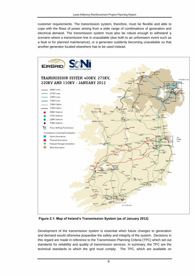
2.2.1 Existing Transmission System in Ireland
The transmission system in Ireland essentially refers to the higher-capacity electricity
network, and comprises the 400 kV (i.e. 400,000 Volts), 220 kV and the 110 kV networks.
The transmission system map of Ireland as of January 2012 is shown in Figure 2.1. This is
also available on EirGrid‟s website (www.eirgrid.com). The 400 kV network is represented
by red lines, the 220 kV network by green lines and the 110 kV by black lines. Various forms
of generators connected to the transmission system are also shown.
Electricity is supplied to most individual customers through the lower voltage distribution
system (typically 38 kV and below), which is connected to the transmission system at the
110 kV substations. At these substations, power flows from the transmission system to the
distribution system to supply demand. Electricity is distributed to end users via the lower
and medium-voltage distribution network, for which there is a separate Distribution System
Operator (DSO)
The transmission system needs to be robust to be able to fulfill its purpose which is to
reliably and economically transport electricity from generation stations to demand centres
around the entire country where the power is required by customers. The transmission
network is meshed which means that there are multiple network paths on which to transport
power to any substation so as to ensure that all customers have the benefit of the most
secure, reliable and economic power at any point in time.
The amount of power required by industrial, commercial, farming and domestic customers
varies depending on the time of day and year and other factors such as weather, holidays
etc. The number of generators providing power and the amount of power each generator
provides to the system is constantly monitored and adjusted to match the changing
Laois-Kilkenny Reinforcement Project Planning Report
6
customer requirements. The transmission system, therefore, must be flexible and able to
cope with the flows of power arising from a wide range of combinations of generation and
electrical demand. The transmission system must also be robust enough to withstand a
scenario where a transmission line is unavailable (due both to an unforeseen event such as
a fault or for planned maintenance), or a generator suddenly becoming unavailable so that
another generator located elsewhere has to be used instead.
Figure 2.1: Map of Ireland’s Transmission System (as of January 2012)
Development of the transmission system is essential when future changes to generation
and demand would otherwise jeopardise the safety and integrity of the system. Decisions in
this regard are made in reference to the Transmission Planning Criteria (TPC) which set out
standards for reliability and quality of transmission services. In summary, the TPC are the
technical standards to which the grid must comply. The TPC, which are available on
Laois-Kilkenny Reinforcement Project Planning Report
7
EirGrid‟s website, require the transmission network to be designed to be able to withstand
outages of any circuit or other item of equipment while maintaining continuity and quality of
electricity supply. These criteria must be met under normal operation conditions, and also
when any item of plant (lines, transformers, generators etc.) is out for essential maintenance.
EirGrid as the Transmission System Operator is statutorily obliged to ensure compliance
with these criteria and it is in compliance with this function that EirGrid strategically plans
the network to ensure that its reliability and security is maintained before any possible
weaknesses occur.
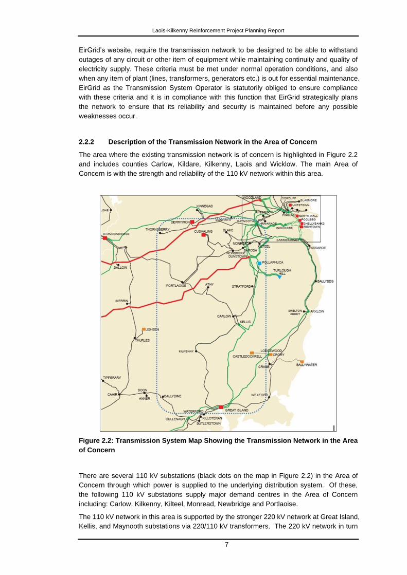
2.2.2 Description of the Transmission Network in the Area of Concern
The area where the existing transmission network is of concern is highlighted in Figure 2.2
and includes counties Carlow, Kildare, Kilkenny, Laois and Wicklow. The main Area of
Concern is with the strength and reliability of the 110 kV network within this area.
Figure 2.2: Transmission System Map Showing the Transmission Network in the Area
of Concern
There are several 110 kV substations (black dots on the map in Figure 2.2) in the Area of
Concern through which power is supplied to the underlying distribution system. Of these,
the following 110 kV substations supply major demand centres in the Area of Concern
including: Carlow, Kilkenny, Kilteel, Monread, Newbridge and Portlaoise.
The 110 kV network in this area is supported by the stronger 220 kV network at Great Island,
Kellis, and Maynooth substations via 220/110 kV transformers. The 220 kV network in turn
Laois-Kilkenny Reinforcement Project Planning Report
8
is supported by the existing 400 kV network at Dunstown 400 kV station in Co. Kildare. It
should be noted that the existing 400 kV circuit passes through the Area of Concern, but of
crucial importance it does not currently have a direct connection into the 110 kV network in
this area.
Peat-fired generation located at Cushaling 110 kV station and hydro generation at
Pollaphuca 110 kV station also provides support to the 110 kV network when available and
in operation.
Figure 2.3 illustrates the evolution of the transmission network in the Area of Concern from
the 1980s until today. Since the 1980s increased demand in the area has been
accommodated at existing substations or through the connection of new substations – Athy,
Baroda, Kilteel, Monread, and Stratford – which has increased the stress on the
transmission system as the network feeding the area has remained largely unchanged in
that time except for a few exceptions.
To maintain the network within standards, through the past 30 years a number of
reinforcements have been made to strengthen the network, including the addition of the
Kellis 220/110 kV substation in 1996, the looping of the Cushaling-Blake 110 kV line into
Newbridge substation providing Newbridge with an extra two connections, and the
establishment of Cushaling 110 kV station to connect a new generator. In addition, in recent
years, capacitor banks have been installed in the area to support the voltage. Capacitors
are electrical devices that are installed in stations to support the local voltage. These type of
devices are suitable for boosting the voltage in an area in the short term, but would not be
considered as long-term solutions, as their effect is reduced when more demand is added to
the system, subsequently decreasing the voltage even further. Despite these works, the
need to significantly reinforce the network in this area has been identified in technical
studies.
Figure 2.3: Maps Illustrating Evolution of the Transmission System in the Area of
Concern from 1980, 1997 and 2012

Laois-Kilkenny Reinforcement Project Planning Report
9
2.3 Limitations of the Existing Electricity Infrastructure
The need in the Midlands Region, South East Region and county Kildare is twofold and the
two issues will be described individually in the below section. Each of these issues in of
themselves is required to be addressed;
o Improving quality of supply
o Ensuring security of supply
Improving Quality of Supply
Quality of supply is a collective term for many performance issues affecting the transmission
system, including issues relating to low voltages, increased potential for fluctuation in
voltage (or voltage dips) and a proximity to voltage collapse, which ultimately leads to
complete loss of electricity supply.
The 110 kV network in the Area of Concern is supported by the stronger 220 kV network at
Great Island, Kellis, and Maynooth substations via 220/110 kV transformers. If any of the
220 kV circuits (lines or transformers) feeding these stations are unexpectedly lost, the
underlying 110 kV network would see a reduction of its strength and hence the voltage
would decrease and be more unstable (i.e. a small change in the network would have a
large effect on the voltage).
Studies carried out in 2008 estimated that the network would be outside standards as set
out in the TPC by as early as 2010 when the combined demand in the area was expected to
have reached 420 MW. However, as a result of the economic downturn, annual energy
demand for electricity countrywide has fallen by 7.8% since 2008 (as quoted on page 10 of
EirGrid‟s Transmission System Performance Report 2011) while the peak demand has
dropped by about 5% in the same period. The peak demand in the Area of Concern was
390 MW in 2011 and is now expected to reach critical levels by 2020, based on median
system demand growth rates quoted in the All Island Generation Capacity Statement 2012.
If actual demand were to increase in line with the higher growth forecast, the problem could
arise as early as 2016. These critical dates need to be considered against the length of time
required for planning, consenting and constructing such new infrastructure.
The most onerous loss of an item of plant for the Area of Concern is the outage of the
Dunstown - Kellis 220 kV circuit which results in the voltage at a large number of
substations across the area being outside of acceptable voltage limits. In this scenario, the
110 kV network would only be connected at Maynooth 220 kV station, Great Island 220 kV
station and Shannonbridge 220 kV station. With the amount of demand that is fed within this
area, these connections would not be enough to maintain the voltage in the area within the
limits as set out in the TPC. In addition, the unexpected loss of the Kellis - Kilkenny 110 kV
circuit would similarly result in stations being outside acceptable voltage limits, although it
would be more localised around Athy, Carlow, Kilkenny and Stratford 110 kV stations.
Furthermore, other contingencies (unplanned outages involving the above mentioned
circuits and others) during essential maintenance outages were also identified that would
result in 110 kV circuits in the area becoming overloaded and the voltage at a larger number
of substations across the counties of Carlow, Kildare, Kilkenny, Laois, and Wicklow falling
outside standards.
Security of Supply
From a transmission network perspective, security of supply is concerned with maintaining
continuity of electrical supply to consumers. As such, it is taken to mean the ability of the
Laois-Kilkenny Reinforcement Project Planning Report
10
transmission network to reliably transport electrical energy from where it is generated to the
demand centres where it is consumed. In relation to security of supply the Transmission
Planning Criteria (TPC) states that “The load that would be isolated for the loss of two 110
kV lines shall not exceed 80 MW of distribution load”. The loss of this amount of demand
(i.e. load) during the outage situation is described as unacceptable from a security of supply
perspective.
Kilkenny 110 kV substation, which is the only 110 kV substation in County Kilkenny, is
connected to the rest of the transmission system by two transmission lines, namely the
Kellis – Kilkenny 110 kV and Great Island – Kilkenny 110 kV lines.
The peak demand at the Kilkenny substation recorded in 2012 is 74 MW, which approaches
the 80 MW limit specified in the TPC. During a maintenance outage, when either circuit is
out of operation for a prolonged period for maintenance, the subsequent unplanned loss of
the other circuit would interrupt the supply of electricity to the substation. The loss of both
these circuits would isolate Kilkenny 110 kV substation from the rest of the transmission
system. In this situation the area fed from Kilkenny 110 kV substation would suffer a
complete loss of its electricity supply. Although the risk exists that both circuits could be out
simultaneously, the risk of this occurring is more likely during periods of planned
maintenance. For that reason, EirGrid attempts to schedule maintenance outages at times
other than the peak demand periods, generally from March through to October, in order to
minimize the potential for impact.
In the studies conducted in 2008 the demand in Kilkenny, during the normal maintenance
period, reached 63 MW and was expected to reach the specified 80 MW by 2019. Due to
the recent economic downturn, the demand during the normal maintenance period in 2012
reached 62 MW and is now expected to reach the specified 80 MW limit by 2028 based on
the median system demand growth rates quoted in the All Island Generation Capacity
Statement. As can be seen from the above, the demand levels for the Kilkenny 110 kV
substation is back to 2008 levels, but the growth rates applied have been reduced to a long-
term annualised growth rate of 1.6% (from 2.9%). Any incremental increase outside of the
expected organic growth in demand would accelerate the timing of the need significantly.
For example, a step increase in demand of 10MW, as a result of a new customer
connection or an expansion of existing customer‟s facility would require the third circuit into
Kilkenny by 2020.
Based on the uncertainty of when the third circuit would be required, this driver does not
now present the same urgency as before; however it is important to understand that it will
still emerge in time. It is also essential to recognise that a change in the economic climate or
a small change in the demand supplied by the station could accelerate the need for the third
circuit. This uncertainty in the timing of the third circuit, combined with the long lead-in time
for the planning, consenting and construction of transmission infrastructure makes it prudent
for EirGrid to consider the security of supply driver when addressing the separate quality of
supply issue to achieve an efficient solution for the entire Area of Concern.
The proposed development will provide a third circuit into the Kilkenny 110 kV substation
maintaining supply in the situation described and so will enhance the security of supply for
County Kilkenny.
2.4 Reinforcement Options Considered
To address issues of quality and security of supply, as identified above, four reinforcement
options were considered. All the options that were considered were designed to meet the
Laois-Kilkenny Reinforcement Project Planning Report
11
technical needs of transmission reinforcement in the Area of Concern, and are described
and discussed in the section below.
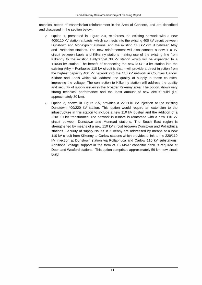
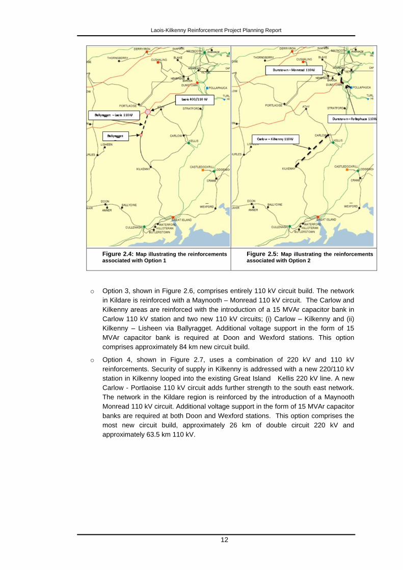
o Option 1, presented in Figure 2.4, reinforces the existing network with a new
400/110 kV station at Laois, which connects into the existing 400 kV circuit between
Dunstown and Moneypoint stations; and the existing 110 kV circuit between Athy
and Portlaoise stations. The new reinforcement will also connect a new 110 kV
circuit between Laois and Kilkenny stations making use of the existing line from
Kilkenny to the existing Ballyragget 38 kV station which will be expanded to a
110/38 kV station. The benefit of connecting the new 400/110 kV station into the
existing Athy – Portlaoise 110 kV circuit is that it will provide a direct injection from
the highest capacity 400 kV network into the 110 kV network in Counties Carlow,
Kildare and Laois which will address the quality of supply in those counties,
improving the voltage. The connection to Kilkenny station will address the quality
and security of supply issues in the broader Kilkenny area. The option shows very
strong technical performance and the least amount of new circuit build (i.e.
approximately 30 km).
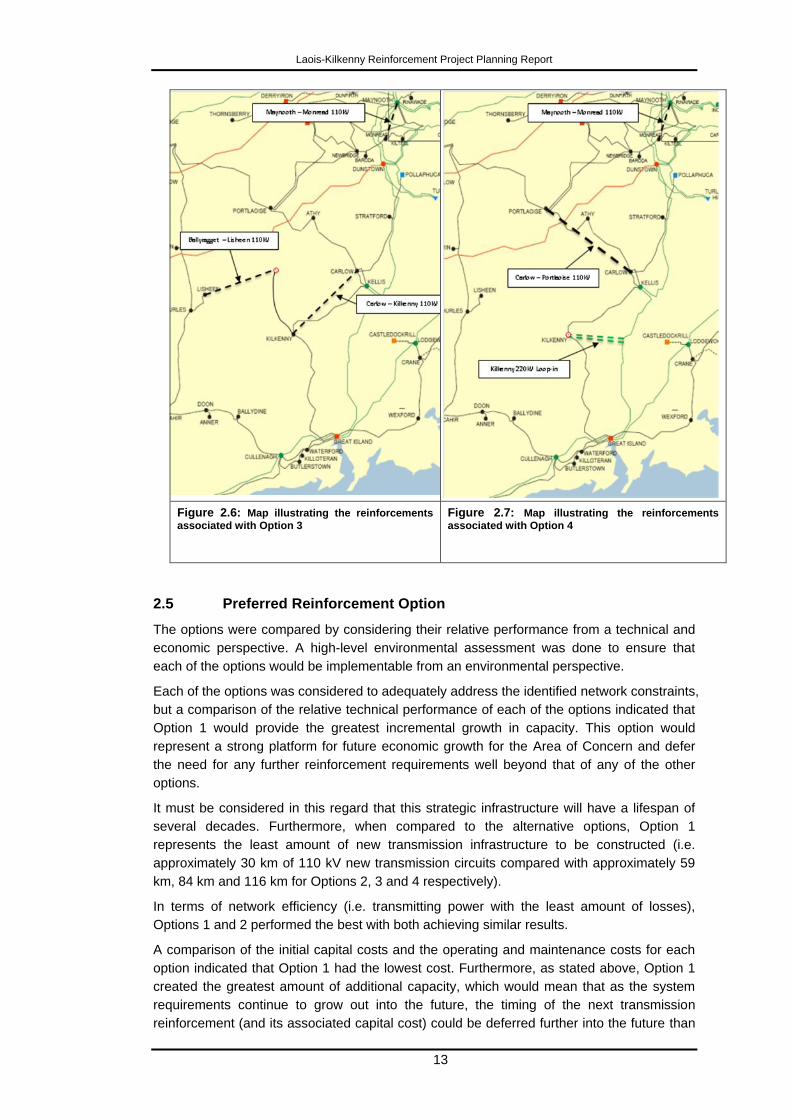
o Option 2, shown in Figure 2.5, provides a 220/110 kV injection at the existing
Dunstown 400/220 kV station. This option would require an extension to the
infrastructure in this station to include a new 110 kV busbar and the addition of a
220/110 kV transformer. The network in Kildare is reinforced with a new 110 kV
circuit between Dunstown and Monread stations. The South East region is
strengthened by means of a new 110 kV circuit between Dunstown and Pollaphuca
stations. Security of supply issues in Kilkenny are addressed by means of a new
110 kV circuit from Kilkenny to Carlow stations which provides a link to the 220/110
kV injection at Dunstown station via Pollaphuca and Carlow 110 kV substations.
Additional voltage support in the form of 15 MVAr capacitor bank is required at
Doon and Wexford stations. This option comprises approximately 59 km new circuit
build.
Laois-Kilkenny Reinforcement Project Planning Report
12
Figure 2.4: Map illustrating the reinforcements
associated with Option 1 Figure 2.5: Map illustrating the reinforcements
associated with Option 2
o Option 3, shown in Figure 2.6, comprises entirely 110 kV circuit build. The network
in Kildare is reinforced with a Maynooth – Monread 110 kV circuit. The Carlow and
Kilkenny areas are reinforced with the introduction of a 15 MVAr capacitor bank in
Carlow 110 kV station and two new 110 kV circuits; (i) Carlow – Kilkenny and (ii)
Kilkenny – Lisheen via Ballyragget. Additional voltage support in the form of 15
MVAr capacitor bank is required at Doon and Wexford stations. This option
comprises approximately 84 km new circuit build.
o Option 4, shown in Figure 2.7, uses a combination of 220 kV and 110 kV
reinforcements. Security of supply in Kilkenny is addressed with a new 220/110 kV
station in Kilkenny looped into the existing Great Island Kellis 220 kV line. A new
Carlow - Portlaoise 110 kV circuit adds further strength to the south east network.
The network in the Kildare region is reinforced by the introduction of a Maynooth
Monread 110 kV circuit. Additional voltage support in the form of 15 MVAr capacitor
banks are required at both Doon and Wexford stations. This option comprises the
most new circuit build, approximately 26 km of double circuit 220 kV and
approximately 63.5 km 110 kV.
Laois-Kilkenny Reinforcement Project Planning Report
13
Figure 2.6: Map illustrating the reinforcements
associated with Option 3
Figure 2.7: Map illustrating the reinforcements
associated with Option 4
2.5 Preferred Reinforcement Option
The options were compared by considering their relative performance from a technical and
economic perspective. A high-level environmental assessment was done to ensure that
each of the options would be implementable from an environmental perspective.
Each of the options was considered to adequately address the identified network constraints,
but a comparison of the relative technical performance of each of the options indicated that
Option 1 would provide the greatest incremental growth in capacity. This option would
represent a strong platform for future economic growth for the Area of Concern and defer
the need for any further reinforcement requirements well beyond that of any of the other
options.
It must be considered in this regard that this strategic infrastructure will have a lifespan of
several decades. Furthermore, when compared to the alternative options, Option 1
represents the least amount of new transmission infrastructure to be constructed (i.e.
approximately 30 km of 110 kV new transmission circuits compared with approximately 59
km, 84 km and 116 km for Options 2, 3 and 4 respectively).
In terms of network efficiency (i.e. transmitting power with the least amount of losses),
Options 1 and 2 performed the best with both achieving similar results.
A comparison of the initial capital costs and the operating and maintenance costs for each
option indicated that Option 1 had the lowest cost. Furthermore, as stated above, Option 1
created the greatest amount of additional capacity, which would mean that as the system
requirements continue to grow out into the future, the timing of the next transmission
reinforcement (and its associated capital cost) could be deferred further into the future than

Laois-Kilkenny Reinforcement Project Planning Report
14
any of the other options. This would directly translate into an economic value above that
offered by the other options.
In conclusion, all four options meet the network requirements to ensure a suitable level of
reliability and quality of supply in the area of concern. Based on a comparison of the four
options, Options 1 and 2 are preferable to Options 3 and 4 from an economic and efficiency
perspective. Option 1 is preferred to Option 2 as it involves the least new circuit length and
adds the greatest amount of spare network capacity for future growth.
Option 1, the Laois-Kilkenny Reinforcement Project, is therefore the best solution to meet
the long-term needs of the area.
Laois-Kilkenny Reinforcement Project Planning Report
15
3 Project Development
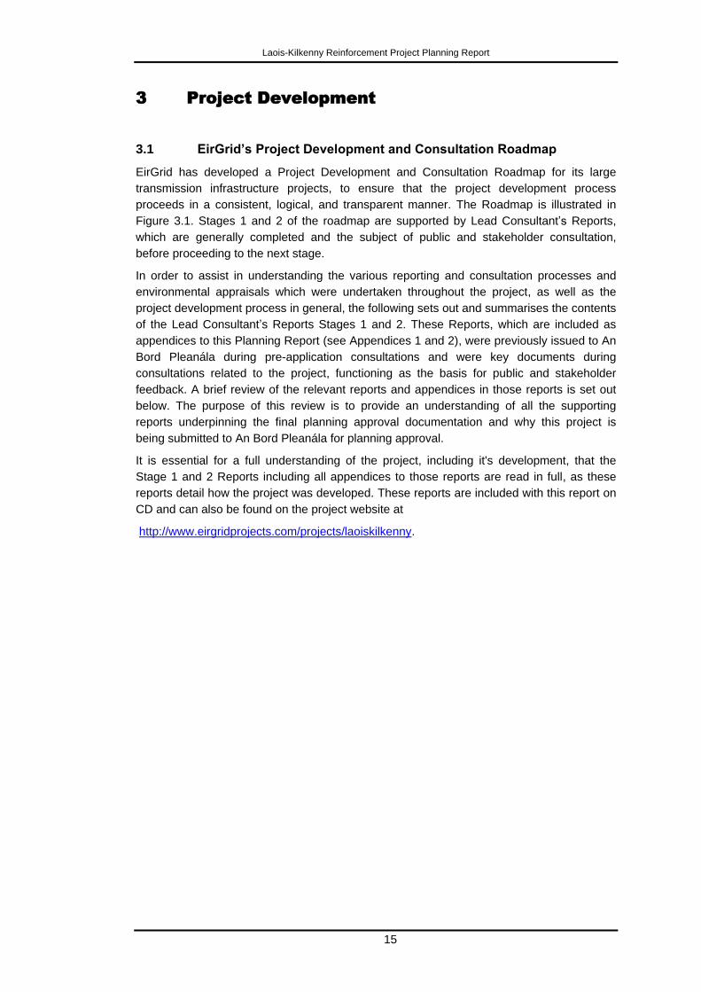
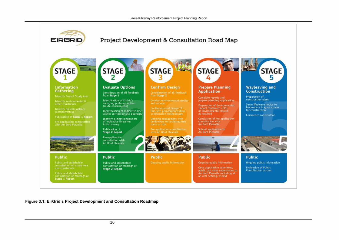
3.1 EirGrid’s Project Development and Consultation Roadmap
EirGrid has developed a Project Development and Consultation Roadmap for its large
transmission infrastructure projects, to ensure that the project development process
proceeds in a consistent, logical, and transparent manner. The Roadmap is illustrated in
Figure 3.1. Stages 1 and 2 of the roadmap are supported by Lead Consultant‟s Reports,
which are generally completed and the subject of public and stakeholder consultation,
before proceeding to the next stage.
In order to assist in understanding the various reporting and consultation processes and
environmental appraisals which were undertaken throughout the project, as well as the
project development process in general, the following sets out and summarises the contents
of the Lead Consultant‟s Reports Stages 1 and 2. These Reports, which are included as
appendices to this Planning Report (see Appendices 1 and 2), were previously issued to An
Bord Pleanála during pre-application consultations and were key documents during
consultations related to the project, functioning as the basis for public and stakeholder
feedback. A brief review of the relevant reports and appendices in those reports is set out
below. The purpose of this review is to provide an understanding of all the supporting
reports underpinning the final planning approval documentation and why this project is
being submitted to An Bord Pleanála for planning approval.
It is essential for a full understanding of the project, including it's development, that the
Stage 1 and 2 Reports including all appendices to those reports are read in full, as these
reports detail how the project was developed. These reports are included with this report on
CD and can also be found on the project website at
http://www.eirgridprojects.com/projects/laoiskilkenny.
Laois-Kilkenny Reinforcement Project Planning Report
16
Figure 3.1: EirGrid’s Project Development and Consultation Roadmap
Laois-Kilkenny Reinforcement Project Planning Report
17
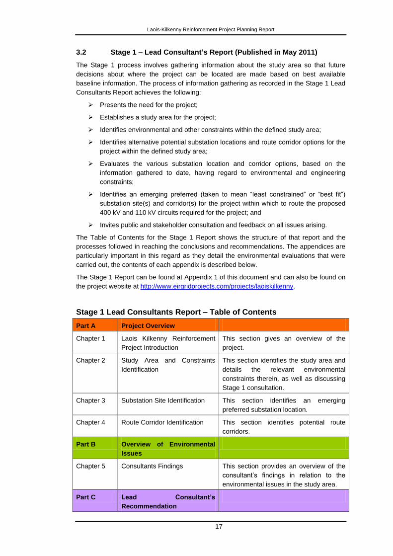
3.2 Stage 1 – Lead Consultant’s Report (Published in May 2011)
The Stage 1 process involves gathering information about the study area so that future
decisions about where the project can be located are made based on best available
baseline information. The process of information gathering as recorded in the Stage 1 Lead
Consultants Report achieves the following:
Presents the need for the project;
Establishes a study area for the project;
Identifies environmental and other constraints within the defined study area;
Identifies alternative potential substation locations and route corridor options for the
project within the defined study area;
Evaluates the various substation location and corridor options, based on the
information gathered to date, having regard to environmental and engineering
constraints;
Identifies an emerging preferred (taken to mean “least constrained” or “best fit”)
substation site(s) and corridor(s) for the project within which to route the proposed
400 kV and 110 kV circuits required for the project; and
Invites public and stakeholder consultation and feedback on all issues arising.
The Table of Contents for the Stage 1 Report shows the structure of that report and the
processes followed in reaching the conclusions and recommendations. The appendices are
particularly important in this regard as they detail the environmental evaluations that were
carried out, the contents of each appendix is described below.
The Stage 1 Report can be found at Appendix 1 of this document and can also be found on
the project website at http://www.eirgridprojects.com/projects/laoiskilkenny.
Stage 1 Lead Consultants Report – Table of Contents
Part A Project Overview
Chapter 1 Laois Kilkenny Reinforcement
Project Introduction
This section gives an overview of the
project.
Chapter 2 Study Area and Constraints
Identification
This section identifies the study area and
details the relevant environmental
constraints therein, as well as discussing
Stage 1 consultation.
Chapter 3 Substation Site Identification This section identifies an emerging
preferred substation location.
Chapter 4 Route Corridor Identification This section identifies potential route
corridors.
Part B Overview of Environmental
Issues
Chapter 5 Consultants Findings This section provides an overview of the
consultant‟s findings in relation to the
environmental issues in the study area.
Part C Lead Consultant’s
Recommendation
Laois-Kilkenny Reinforcement Project Planning Report
18
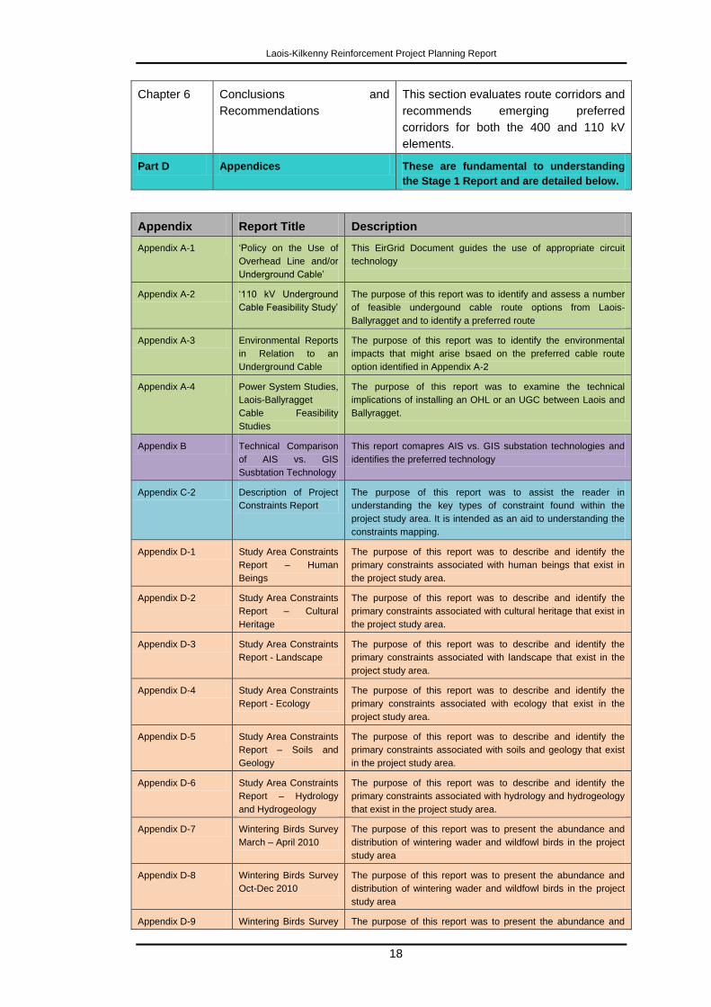
Chapter 6 Conclusions and
Recommendations
This section evaluates route corridors and
recommends emerging preferred
corridors for both the 400 and 110 kV
elements.
Part D Appendices These are fundamental to understanding
the Stage 1 Report and are detailed below.
Appendix Report Title Description
Appendix A-1 „Policy on the Use of
Overhead Line and/or
Underground Cable‟
This EirGrid Document guides the use of appropriate circuit
technology
Appendix A-2 „110 kV Underground
Cable Feasibility Study‟
The purpose of this report was to identify and assess a number
of feasible undergound cable route options from Laois-
Ballyragget and to identify a preferred route
Appendix A-3 Environmental Reports
in Relation to an
Underground Cable
The purpose of this report was to identify the environmental
impacts that might arise bsaed on the preferred cable route
option identified in Appendix A-2
Appendix A-4 Power System Studies,
Laois-Ballyragget
Cable Feasibility
Studies
The purpose of this report was to examine the technical
implications of installing an OHL or an UGC between Laois and
Ballyragget.
Appendix B Technical Comparison
of AIS vs. GIS
Susbtation Technology
This report comapres AIS vs. GIS substation technologies and
identifies the preferred technology
Appendix C-2 Description of Project
Constraints Report
The purpose of this report was to assist the reader in
understanding the key types of constraint found within the
project study area. It is intended as an aid to understanding the
constraints mapping.
Appendix D-1 Study Area Constraints
Report – Human
Beings
The purpose of this report was to describe and identify the
primary constraints associated with human beings that exist in
the project study area.
Appendix D-2 Study Area Constraints
Report – Cultural
Heritage
The purpose of this report was to describe and identify the
primary constraints associated with cultural heritage that exist in
the project study area.
Appendix D-3 Study Area Constraints
Report - Landscape
The purpose of this report was to describe and identify the
primary constraints associated with landscape that exist in the
project study area.
Appendix D-4 Study Area Constraints
Report - Ecology
The purpose of this report was to describe and identify the
primary constraints associated with ecology that exist in the
project study area.
Appendix D-5 Study Area Constraints
Report – Soils and
Geology
The purpose of this report was to describe and identify the
primary constraints associated with soils and geology that exist
in the project study area.
Appendix D-6 Study Area Constraints
Report – Hydrology
and Hydrogeology
The purpose of this report was to describe and identify the
primary constraints associated with hydrology and hydrogeology
that exist in the project study area.
Appendix D-7 Wintering Birds Survey
March – April 2010
The purpose of this report was to present the abundance and
distribution of wintering wader and wildfowl birds in the project
study area
Appendix D-8 Wintering Birds Survey
Oct-Dec 2010
The purpose of this report was to present the abundance and
distribution of wintering wader and wildfowl birds in the project
study area
Appendix D-9 Wintering Birds Survey The purpose of this report was to present the abundance and
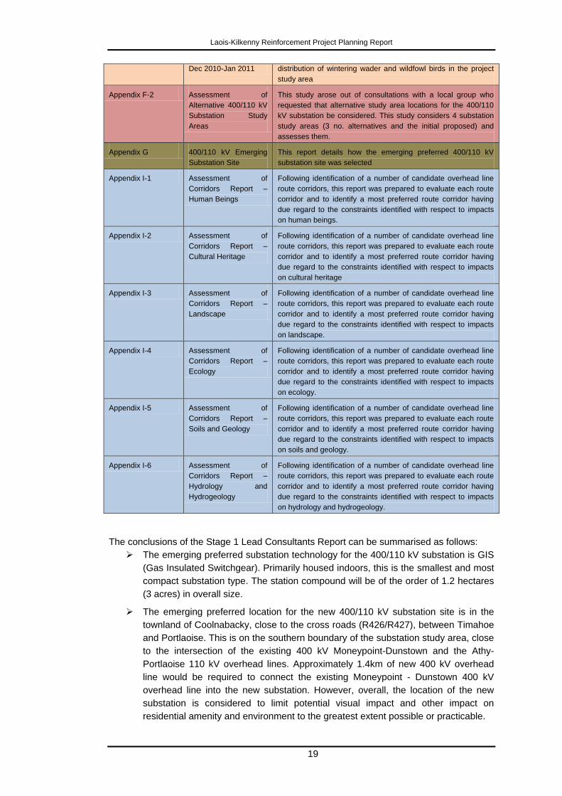
Laois-Kilkenny Reinforcement Project Planning Report
19
Dec 2010-Jan 2011 distribution of wintering wader and wildfowl birds in the project
study area
Appendix F-2 Assessment of
Alternative 400/110 kV
Substation Study
Areas
This study arose out of consultations with a local group who
requested that alternative study area locations for the 400/110
kV substation be considered. This study considers 4 substation
study areas (3 no. alternatives and the initial proposed) and
assesses them.
Appendix G 400/110 kV Emerging
Substation Site
This report details how the emerging preferred 400/110 kV
substation site was selected
Appendix I-1 Assessment of
Corridors Report –
Human Beings
Following identification of a number of candidate overhead line
route corridors, this report was prepared to evaluate each route
corridor and to identify a most preferred route corridor having
due regard to the constraints identified with respect to impacts
on human beings.
Appendix I-2 Assessment of
Corridors Report –
Cultural Heritage
Following identification of a number of candidate overhead line
route corridors, this report was prepared to evaluate each route
corridor and to identify a most preferred route corridor having
due regard to the constraints identified with respect to impacts
on cultural heritage
Appendix I-3 Assessment of
Corridors Report –
Landscape
Following identification of a number of candidate overhead line
route corridors, this report was prepared to evaluate each route
corridor and to identify a most preferred route corridor having
due regard to the constraints identified with respect to impacts
on landscape.
Appendix I-4 Assessment of
Corridors Report –
Ecology
Following identification of a number of candidate overhead line
route corridors, this report was prepared to evaluate each route
corridor and to identify a most preferred route corridor having
due regard to the constraints identified with respect to impacts
on ecology.
Appendix I-5 Assessment of
Corridors Report –
Soils and Geology
Following identification of a number of candidate overhead line
route corridors, this report was prepared to evaluate each route
corridor and to identify a most preferred route corridor having
due regard to the constraints identified with respect to impacts
on soils and geology.
Appendix I-6 Assessment of
Corridors Report –
Hydrology and
Hydrogeology
Following identification of a number of candidate overhead line
route corridors, this report was prepared to evaluate each route
corridor and to identify a most preferred route corridor having
due regard to the constraints identified with respect to impacts
on hydrology and hydrogeology.
The conclusions of the Stage 1 Lead Consultants Report can be summarised as follows:
The emerging preferred substation technology for the 400/110 kV substation is GIS
(Gas Insulated Switchgear). Primarily housed indoors, this is the smallest and most
compact substation type. The station compound will be of the order of 1.2 hectares
(3 acres) in overall size.
The emerging preferred location for the new 400/110 kV substation site is in the
townland of Coolnabacky, close to the cross roads (R426/R427), between Timahoe
and Portlaoise. This is on the southern boundary of the substation study area, close
to the intersection of the existing 400 kV Moneypoint-Dunstown and the Athy-
Portlaoise 110 kV overhead lines. Approximately 1.4km of new 400 kV overhead
line would be required to connect the existing Moneypoint - Dunstown 400 kV
overhead line into the new substation. However, overall, the location of the new
substation is considered to limit potential visual impact and other impact on
residential amenity and environment to the greatest extent possible or practicable.
Laois-Kilkenny Reinforcement Project Planning Report
20
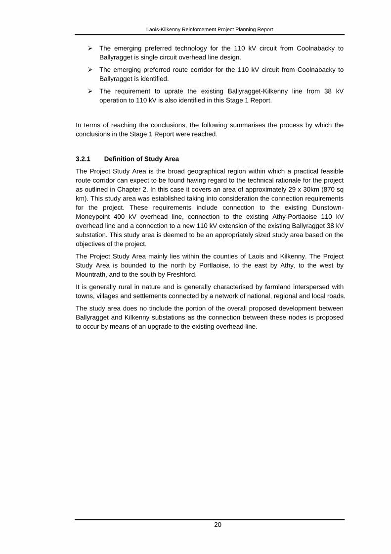
The emerging preferred technology for the 110 kV circuit from Coolnabacky to
Ballyragget is single circuit overhead line design.
The emerging preferred route corridor for the 110 kV circuit from Coolnabacky to
Ballyragget is identified.
The requirement to uprate the existing Ballyragget-Kilkenny line from 38 kV
operation to 110 kV is also identified in this Stage 1 Report.
In terms of reaching the conclusions, the following summarises the process by which the
conclusions in the Stage 1 Report were reached.
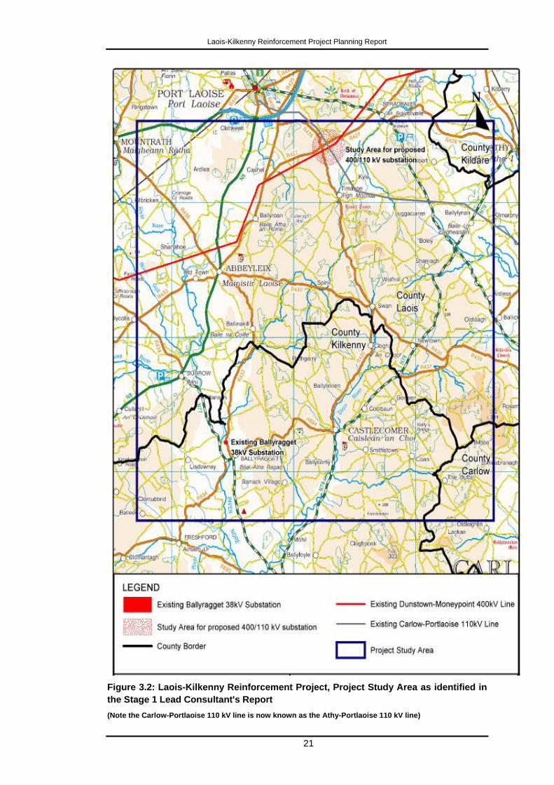
3.2.1 Definition of Study Area
The Project Study Area is the broad geographical region within which a practical feasible
route corridor can expect to be found having regard to the technical rationale for the project
as outlined in Chapter 2. In this case it covers an area of approximately 29 x 30km (870 sq
km). This study area was established taking into consideration the connection requirements
for the project. These requirements include connection to the existing Dunstown-
Moneypoint 400 kV overhead line, connection to the existing Athy-Portlaoise 110 kV
overhead line and a connection to a new 110 kV extension of the existing Ballyragget 38 kV
substation. This study area is deemed to be an appropriately sized study area based on the
objectives of the project.
The Project Study Area mainly lies within the counties of Laois and Kilkenny. The Project
Study Area is bounded to the north by Portlaoise, to the east by Athy, to the west by
Mountrath, and to the south by Freshford.
It is generally rural in nature and is generally characterised by farmland interspersed with
towns, villages and settlements connected by a network of national, regional and local roads.
The study area does no tinclude the portion of the overall proposed development between
Ballyragget and Kilkenny substations as the connection between these nodes is proposed
to occur by means of an upgrade to the existing overhead line.
Laois-Kilkenny Reinforcement Project Planning Report
21
Figure 3.2: Laois-Kilkenny Reinforcement Project, Project Study Area as identified in
the Stage 1 Lead Consultant's Report
(Note the Carlow-Portlaoise 110 kV line is now known as the Athy-Portlaoise 110 kV line)
Laois-Kilkenny Reinforcement Project Planning Report
22
3.2.2 Identification of Constraints within Study Area
The primary purpose of the Lead Consultants Stage 1 Report is to collect information in
relation to technical and environmental constraints in the study area. The identification of
environmental and other constraints within the study area assisted in determining potential
locations for the planned infrastructure. Constraints can generally be divided into three
principal categories, namely:
Natural Constraints (naturally occurring landscapes and features)
Manmade Constraints (forming part of the built environment)
External Parameters (design standards, policy, procedural and legal issues)
Constraints were identified through the following process:
Review of the Planning and Environmental Legislation.
Evaluation of Study Area by Environmental Consultants.
Aerial Photography.
OSI Mapping.
Consultation.
An Post Geodirectory.
Site Visits.
ESBI GIS Database.
The Study Area was examined under the following headings by environmental consultants:
Human Beings;
Cultural Heritage;
Landscape;
Ecology (Flora and Fauna);
Soils and Geology; and
Hydrology and Hydrogeology.
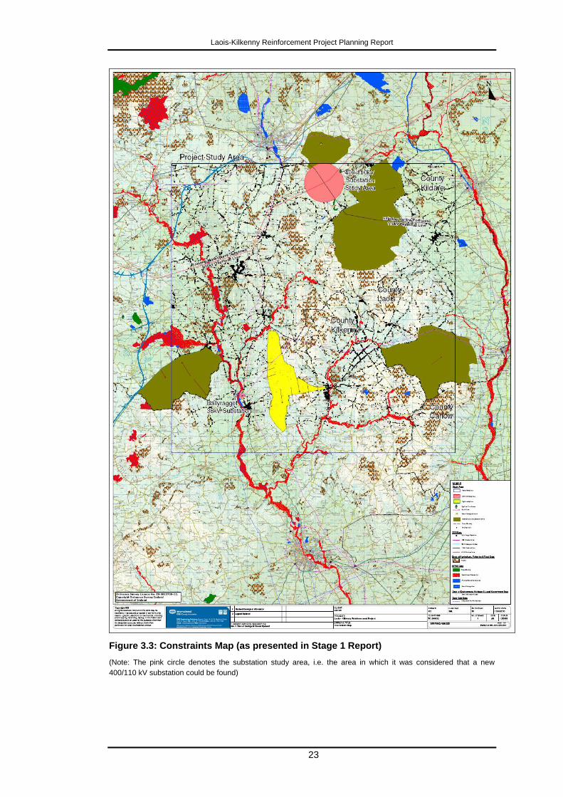
Figure 3.3 (Appendix C-1 in the Stage 1 Report) illustrates a map of the constraints
identified in the project study area.
The full reports which are summarised below can be found in Appendices D1 – D6 in the
Stage 1 Report.
Laois-Kilkenny Reinforcement Project Planning Report
23
Figure 3.3: Constraints Map (as presented in Stage 1 Report)
(Note: The pink circle denotes the substation study area, i.e. the area in which it was considered that a new
400/110 kV substation could be found)
Laois-Kilkenny Reinforcement Project Planning Report
24
3.2.2.1 Man Made Constraints
o Human Beings
The key constraints in relation to Human Beings are the following:
- Settlements
Towns including Stradbally, Timahoe, Ballyroan, Ballylynan, Luggacurren, Abbeyleix,
Ballycolla, Durrow, Ballinakill, Castlecomer, Ballyragget, as well as smaller villages and one
off housing scattered throughout the area, primarily along local and regional roads.
- Areas of Tourism Interest
The location of structures in and relative to, areas of scenic importance need to be carefully
considered in order to minimise the landscape impact and associated attractiveness of the
area for tourism and amenity purposes.
The main features of tourism within the study area include: The River Nore candidate
Special Area of Conservation (cSAC), the Heritage Town of Abbeyleix, the Abbeyleix Wood
Complex, views overlooking Castlecomer and Ballyragget and views towards the Slieve
Bloom Mountains, Timahoe Round Tower and heritage gardens and parks (for example
Heywood Gardens).
o Cultural Heritage
The archaeological and architectural heritage features located within the study area can be
categorised under the following headings:
- National Monuments
Three national monuments in state ownership are located within the study area and all are
located within the vicinity of Timahoe, Co. Laois.
- Recorded Monuments
993 recorded monuments including 15 redundant records are located within the study area.
- Protected Structures
See below under NIAH.
- National Inventory of Architectural Heritage (NIAH)
385 structures listed in the NIAH are located within the study area. 179 of these are found in
Laois, and 206 in Kilkenny. The majority of sites are located within towns or villages.
All of the cultural heritage sites identified within the study area represent constraints to the
proposed overhead lines and substation. The cultural heritage features data from the
Bronze Age through to the modern period and the overall density of sites within the study
area is considered high. Noticeable distribution patterns include the high numbers of
enclosures and ringforts (384), and churches (70) which occur within the study area. River
banks are areas of archaeological potential / sensitivity and this should be considered in the
route selection process. Whilst upland areas appear to have fewer recorded sites, this is
due mainly to the lack of detailed upland archaeological surveys which have been carried
out to date. This is the case within this study area where there appears to be a limited
number of monuments over upland areas. Of particular note in the study area are the
presence of field systems and deserted medieval settlements. These are extensive
monuments on the ground and span over several fields.
o Existing Infrastructure
The key existing infrastructure in the study area is as follows:
Laois-Kilkenny Reinforcement Project Planning Report
25
- Roads
The M7 / M8 motorway and the National Routes N77, N78, N80, and N8 all traverse the
study area as well as Regional Routes, R425, R426, R427, R430, R432, R433, R694, and
R431. There is also an extensive network of local and rural roads throughout.
- Electricity Infrastructure
The Dunstown - Moneypoint 400 kV, Athy - Portlaoise 110 kV and Ballyragget – Kilkenny 38
kV overhead transmission lines traverse the study area as well as a number of other 38 kV,
MV and LV distribution lines. Ballyragget 38 kV and Kilkenny 110 kV substations are also
within the study area.
- Gas Transmission Pipeline
A section of An Bord Gáis gas pipeline (4 bar) is also found in the southern section of the
study area, stopping at Ballyragget.
3.2.2.2 Natural Constraints
o Landscape
The study area contains four principal types of landscapes:
- Central Plain Lowlands
These are an abundant type of landscape through the centre of Ireland that comprise fairly
level ground - usually used for pasture and tillage on lighter soils – interspersed with areas
of wetlands and occasional bogs. These landscapes generally have lower visual absorption
capacity in areas with higher agricultural capability where fields are larger and hedges are
lower. In areas of impeded drainage or poor soils these areas can have medium to high
capacity to absorb visual effects - though areas of open water, wetland and bogs are very
visually vulnerable. Landscapes west of Ballyragget and Abbeyleix are of the more open
type.
- River Valleys
These are common, but very localised landscapes - rarely extending for more than 0.5 km
on either side of the river. They are visually complex – often having high degrees of visual
robustness on account of topography and dense vegetation – though open views along the
length of the river can be very expansive and proportionally vulnerable. These conditions
are usually interlinked, leading to a general character of visual sensitivity in such
landscapes. The River Nore is a river landscape that is noted as a visual and amenity
resource.
- Transitional Areas
The zone where lowlands blend into uplands are usually characterised by smaller fields,
less fertile soil and complex patterns of vegetation, topography and settlement - all of which
combine to give relatively high capacity to absorb visual effects.
- Uplands
Elevation, topographic exposure, little or no tall vegetation, and few other man-made
structures mean that upland areas are usually characterised as being more visually
vulnerable than other landscapes - even when used for agriculture.
The southern section of the study area is located in the Landscape Character Area
„Castlecomer Plateau‟ as identified in the Kilkenny Landscape Character Assessment
(Kilkenny County Development Plan). It is adjacent to the Castlecomer transition area B2.
Laois-Kilkenny Reinforcement Project Planning Report
26
The Castlecomer Plateau (B) is noted in the Landscape Assessment as being an extensive
upland area with an almost circular shape that lies between the valleys of the Rivers Nore
and Barrow, covering most of the north-east of the County. The terrain slopes steeply from
the river valleys to the surface of the Plateau, which gently undulates and gives rise to
several small ridgelines at an elevation of between 200 and 340m above the sea level. The
elevated nature of this physical unit provides a defined skyline and significant and scenic
views over the Kilkenny basin and the Nore and Barrow river valleys.
The Castlecomer Transition (B2) is also noted in the Landscape Assessment. This western
area is a long linear strip of land, running in a north-south direction, which is parallel to the
River Nore Valley and close to the Dinin River. The area encompasses the environs of
Ballyragget and Castlemarket areas. The Assessment notes that „These transitional areas
are not perceived as having special landscape or scenic amenity values and are considered
suitable for development‟.
o Ecology
Following the identification of ecological features within the study area, the main ecological
constraints relevant to the planned development include:
- Sites of Conservation Interest
The study area contains several sites of conservation interest that have been designated as
candidate Special Areas of Conservation (cSAC), Natural Heritage Areas (NHA) or
proposed Natural Heritage Areas (pNHA). The study area also includes one Nature Reserve
that is owned by the State (Timahoe Eskers). There are 3 cSAC‟s, 1 NHA and 10 pNHA‟s
within the study area.
The largest and most ecologically significant designated site in the study area is the River
Nore and Barrow cSAC. This large cSAC includes the main River Nore channel, the
majority of its main tributaries (Rivers Gully, Erkina, Owenbeg, Glashagal, Ironmills,
Gloshna, Dinin) and some adjacent habitats.
Other smaller sites designated for nature conservation are scattered around the study area.
- Important Bird Areas
There is only one Important Bird Area (IBA) close to the study area. This IBA is known as
the Upper Barrow flood plain (IE 108). It extends from Monasterevin to Athy on the North
Kildare/Laois border, adjacent to the study area. This area attracts wintering Bewick‟s and
Whooper Swans as well as Mute Swans.
Several important sites within the study area identified for waterbirds have been examined.
These sites have attracted various wetland species of conservation interest including
species listed on Annex I of the EU Birds Directive and other species listed on the Amber
and red lists of Bird Conservation Concern in Ireland (BoCCI).
- Fisheries and Protected Aquatic Species
The study area contains several important rivers, of which the River Nore is the most
significant. Several important tributaries of the River Nore flow through the study area. The
major tributaries are also designated in certain areas as part of the River Barrow and Nore
cSAC. Tributaries of the River Barrow are also found within the study area.
Many of the freshwater streams and rivers in the Nore and Barrow catchemnt are important
nursery waters for salmonid species such as Atlantic Salmon and Brown Trout. The River
Nore also contains several other aquatic species listed on Annex II of the EU Habitats
Directive including, White Clawed Crayfish, Brook, Sea and River Lamprey and Twaite
Shad.
Laois-Kilkenny Reinforcement Project Planning Report
27
The study area also contains the only site in the world for the hardwater form of the Fresh
Water Pearl Mussel (FWPM). This is an Annex II species requiring strict protection. Its
distribution is currently limited to a stretch of the River Nore between Poormansbridge and
Ballyragget. Other parts of the Nore and its tributaries contain the more common form of the
Fresh Water Pearl Mussel. Both species are only known from the Nore above Ballyragget.
Otter and Kingfisher, both legally protected species are likely to be found within the study
area also.
- Other Rare and Notable Species
There are a number of records of other rare plant and animal species, or species with
restricted distributions within the study area. Several records of rare plant species such as
Yellow Marsh Saxifrage are quite old and have not been verified for 100 years. Opposite-
leaved Pondweed is recorded in the NPWS as it has been recorded along the river Goul.
This species is listed in the Red Data Book and is also protected by the Flora Protection
Order.
Mammal species listed in the Red Data Book that are present within the study area include
Badger, Stoat, Hedgehog, Red Squirrel, Pine Marten and Irish Hare. Fallow Deer and Sika
Deer are also present in the area, as well as several bat species. All species of bat
occurring in Ireland are protected under the EU Habitats Directive, listed under Annex IV.
It should be noted that many notable and rare species of conservation importance are not
just confined to designated areas or sites of importance and may in fact be found widely
distributed throughout the study area.
o Soils & Geology
The key constraints in relation to soils and geology are the following:
- Sloping Ground and Soft Ground Including Blanket Peat
There are a number of potential impacts associated with the construction of structures in
sloping ground, soft ground and blanket peat, in particular in the identified areas to the west
of Ballyroan and to the south of Abbeyleix. Slope angle, accumulation of water following a
high intensity rainfall event and the presence of drains in the vicinity of the construction area
may lead to peat slope failure. On site machinery and dewatering activities may also be
contributing factors to peat slope failure.
- Areas of Made Ground
These areas are located at residential areas (towns and villages such as Castlecomer,
Ballyragget, Timahoe and Abbeyleix). Cut material would be generated if construction was
located in these areas, however the amount would not be significant.
- Areas where Rock is Close to the Surface
Rock at the surface is present in isolated locations within the study area. Bedrock would be
generated as surplus material if construction was located in these areas. Due to the nature
of the construction works the amount would not be significant.
- Areas of Geological Heritage
8 sites of geological interest lie within the study area. The Geological Survey of Ireland (GSI)
have stated that there are no set distance requirements for planned developments in the
vicinity of geological NHAs and CGSs, distance being decided on a site by site basis.
o Hydrology and Hydrogeology
The key constraints in relation to water are the following:
Laois-Kilkenny Reinforcement Project Planning Report
28
- Physical Constraints
Water courses are located within the study area. The requirement for the crossing of water
bodies is the main constraint.
- Historical Flooding
There is a history of flooding in some locations within the study area (e.g. the River Nore at
Abbeyleix and Durrow, and the River Dinin at Castlecomer). Cognisance should be given to
the locations of these previous flood events when locating structures, particularly in the
vicinity of watercourses and floodplains and other surface water features.
- Groundwater Supplies
A number of groundwater supplies have been identified from the GSI well database.
Additional public or private water supplies may be present in the area.
- Groundwater Vulnerability
Regionally important bedrock and gravel aquifers are located within the study area. The GSI
vulnerability rating in some of these locations is classified as extreme.
3.2.3 Emerging Preferred Substation Technology for 400/110kV Substation
Two alternative types of substation were considered for this particular project. One is an
outdoor type, known as an Air Insulated Switchgear (AIS) substation. The second type is an
indoor type, known as a Gas Insulated Switchgear (GIS) substation.
As their name suggests, both use different insulating mediums (Air or Gas) between
hardware devices (circuit breakers) within the station. Smaller distances between parts can
be achieved with gas as its insulating strength is higher than that of air, resulting in a more
compact overall station size. The land take size associated with the GIS stations can be
significantly smaller than when compared to AIS. For example an AIS substation would
require approximately 12 acres in comparison to approximately 2.6 acres for a GIS
substation.
When considering the type of substation to use, land take is only one consideration.
Technical performance including operational flexibility and maintenance as well as
comparative costs must also be considered.
ESBI carried out a comparison report on the substation technology options and the
recommendation was to proceed with a GIS solution. This recommendation was based on
both the cost and technical aspects as well as taking into account the overall smaller size
and the associated reduced environmental impact of the GIS substation. This Report is
entitled „Technical Comparison of AIS vs. GIS Substation Options‟ (Appendix B in the Stage
1 Report).
3.2.4 Emerging Preferred Location for the 400/110kV Substation
As previously stated, within the project study area provision was also made for a substation
study area. Within this area, 9 separate sites were considered as potential locations for the
substation.
The conclusion of the Stage 1 Lead Consultants Report was that, of 9 no. identified
potential sites, the substation site identified in Figure 3.4 is the emerging preferred
substation site from a technical and environmental perspective, and that future stages
should focus on further development of this site. Appendix G of the Stage 1 Report –
“400/110 kV Emerging Substation Site” provides a detailed report of all sites considered
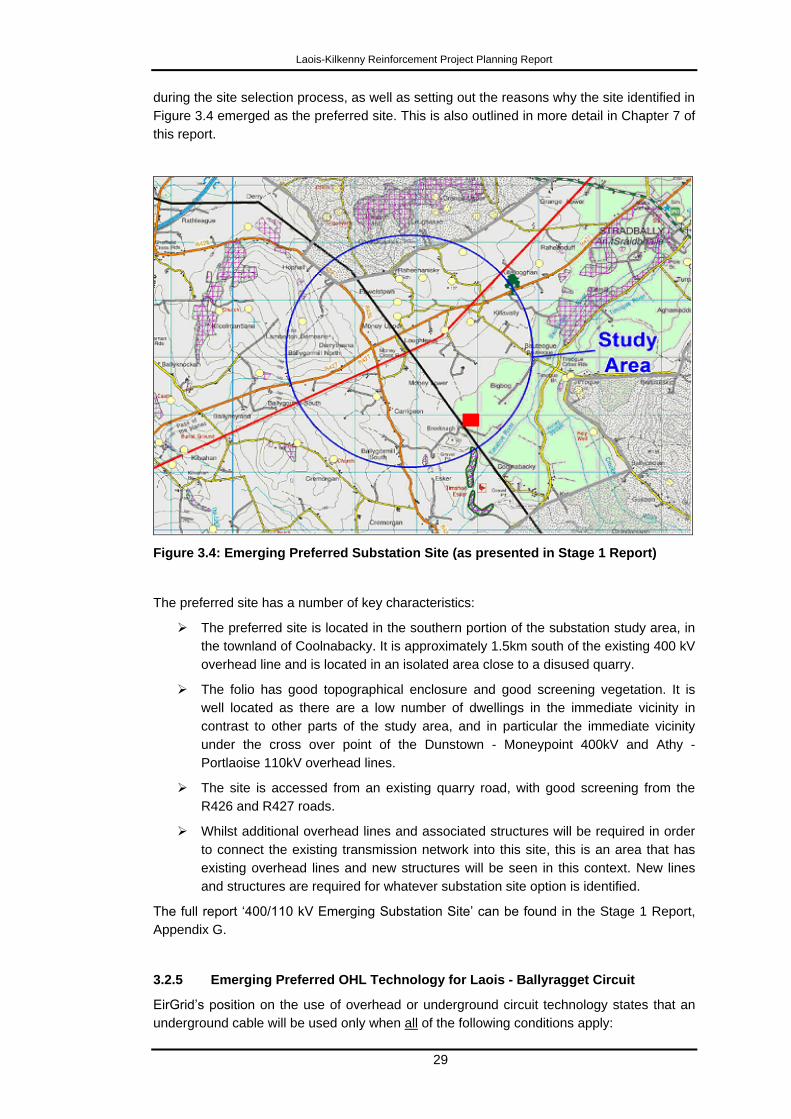
Laois-Kilkenny Reinforcement Project Planning Report
29
during the site selection process, as well as setting out the reasons why the site identified in
Figure 3.4 emerged as the preferred site. This is also outlined in more detail in Chapter 7 of
this report.
Figure 3.4: Emerging Preferred Substation Site (as presented in Stage 1 Report)
The preferred site has a number of key characteristics:
The preferred site is located in the southern portion of the substation study area, in
the townland of Coolnabacky. It is approximately 1.5km south of the existing 400 kV
overhead line and is located in an isolated area close to a disused quarry.
The folio has good topographical enclosure and good screening vegetation. It is
well located as there are a low number of dwellings in the immediate vicinity in
contrast to other parts of the study area, and in particular the immediate vicinity
under the cross over point of the Dunstown - Moneypoint 400kV and Athy -
Portlaoise 110kV overhead lines.
The site is accessed from an existing quarry road, with good screening from the
R426 and R427 roads.
Whilst additional overhead lines and associated structures will be required in order
to connect the existing transmission network into this site, this is an area that has
existing overhead lines and new structures will be seen in this context. New lines
and structures are required for whatever substation site option is identified.
The full report „400/110 kV Emerging Substation Site‟ can be found in the Stage 1 Report,
Appendix G.
3.2.5 Emerging Preferred OHL Technology for Laois - Ballyragget Circuit
EirGrid‟s position on the use of overhead or underground circuit technology states that an
underground cable will be used only when all of the following conditions apply:
Laois-Kilkenny Reinforcement Project Planning Report
30
1. An overhead line is not environmentally and/or technically feasible.
2. A technically and environmentally acceptable route for an underground cable can
be found.
3. The effect on the transmission network due to the electrical characteristics of the
underground cable is acceptable, and the relative poorer „availability‟ of the
underground cable relative to that of an equivalent overhead line is tolerable.
4. The relative greater cost of the underground cable when compared to an overhead
line can be justified.
Notwithstanding this position, the use of underground cable has been considered in detail
for this specific project. It should be noted that undergrounding of the Ballyragget-Kilkenny
circuit was not considered appropriate as this overhead line already exists.
In relation to the policy above, as only one of the four conditions is applicable, EirGrid are
proceeding with an Overhead Line solution for the Laois-Ballyragget circuit.
The full document 'Policy on the use of Overhead Line and/or Underground Cable', GDC-
1R001-00, is included in Appendix 1 of the Stage 1 Report.
3.2.6 Emerging Preferred 110kV OHL Route Corridor for Laois - Ballyragget
Circuit
Following a technical and environmental evaluation of a number of feasible route corridor
options, which is outlined in more detail in Chapter 7 of this report, the emerging preferred
option was deemed to be the Central Route Corridor (Node 1-2-4-6-7-8-9-10). This can be
seen in Figure 3.5.
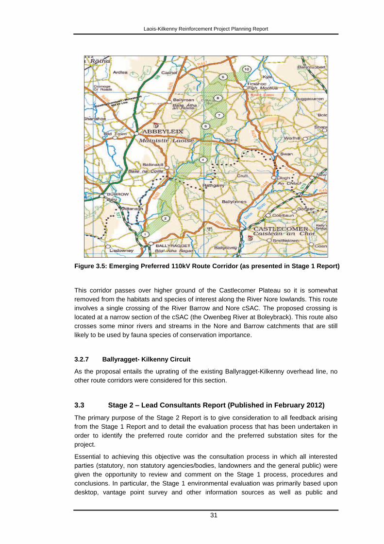
Laois-Kilkenny Reinforcement Project Planning Report
31
Figure 3.5: Emerging Preferred 110kV Route Corridor (as presented in Stage 1 Report)
This corridor passes over higher ground of the Castlecomer Plateau so it is somewhat
removed from the habitats and species of interest along the River Nore lowlands. This route
involves a single crossing of the River Barrow and Nore cSAC. The proposed crossing is
located at a narrow section of the cSAC (the Owenbeg River at Boleybrack). This route also
crosses some minor rivers and streams in the Nore and Barrow catchments that are still
likely to be used by fauna species of conservation importance.
3.2.7 Ballyragget- Kilkenny Circuit
As the proposal entails the uprating of the existing Ballyragget-Kilkenny overhead line, no
other route corridors were considered for this section.
3.3 Stage 2 – Lead Consultants Report (Published in February 2012)
The primary purpose of the Stage 2 Report is to give consideration to all feedback arising
from the Stage 1 Report and to detail the evaluation process that has been undertaken in
order to identify the preferred route corridor and the preferred substation sites for the
project.
Essential to achieving this objective was the consultation process in which all interested
parties (statutory, non statutory agencies/bodies, landowners and the general public) were
given the opportunity to review and comment on the Stage 1 process, procedures and
conclusions. In particular, the Stage 1 environmental evaluation was primarily based upon
desktop, vantage point survey and other information sources as well as public and
Laois-Kilkenny Reinforcement Project Planning Report
32
stakeholder feedback, but did not include on site assessment. As such, input and feedback
with regard to local issues is crucial and forms part of the ongoing evaluation process as
provided for in EirGrid's Project Development and Consultation Roadmap.
The Stage 1 report, which was published in May 2011 was the primary context within which
consultation and evaluation took place.
Feedback from this consultation process was reviewed and, where considered by EirGrid
and the project team to be required and justified, the route corridors and other findings
previously identified in the Stage 1 report were modified. The output from Stage 2 Report
was that the emerging preferences identified in Stage 1 become preferences.
The Stage 2 report presents preferred corridors (one for the 110 kV line and one for the 400
kV connection) with indicative line routes within these corridors and outlines the procedure
by which subsequent landowner identification and engagement occurred in respect of
confirming the indicative line route. Further consultation with the wider community also took
place. All feedback from this stage of the process was again reviewed by the project team
and modifications, where considered appropriate, were made to the preferred route
corridors and indicative line routes. The preferred 400 kV and 110 kV route corridors from
the Stage 2 Report can be seen in Figure 3.6. Again the Ballyragget-Kilkenny circuit is not
identified for consultation in the Stage 2 report, as it is intended to upgrade the existing
circuit between these two nodes.
The indicative line routes identified in Figure 3.7 (Figure 11.1 of the Stage 2 Report),
represents what the project team consider to be the most appropriate line routes within the
identified preferred 400 and 110 kV corridors, having regard to a list of technical, and
environmental criteria and to public and landowner consultation and engagement.
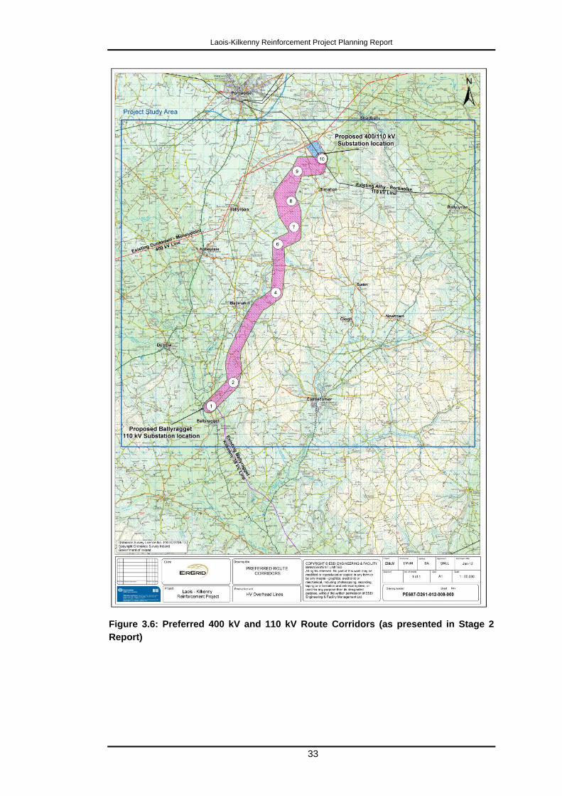
Laois-Kilkenny Reinforcement Project Planning Report
33
Figure 3.6: Preferred 400 kV and 110 kV Route Corridors (as presented in Stage 2
Report)
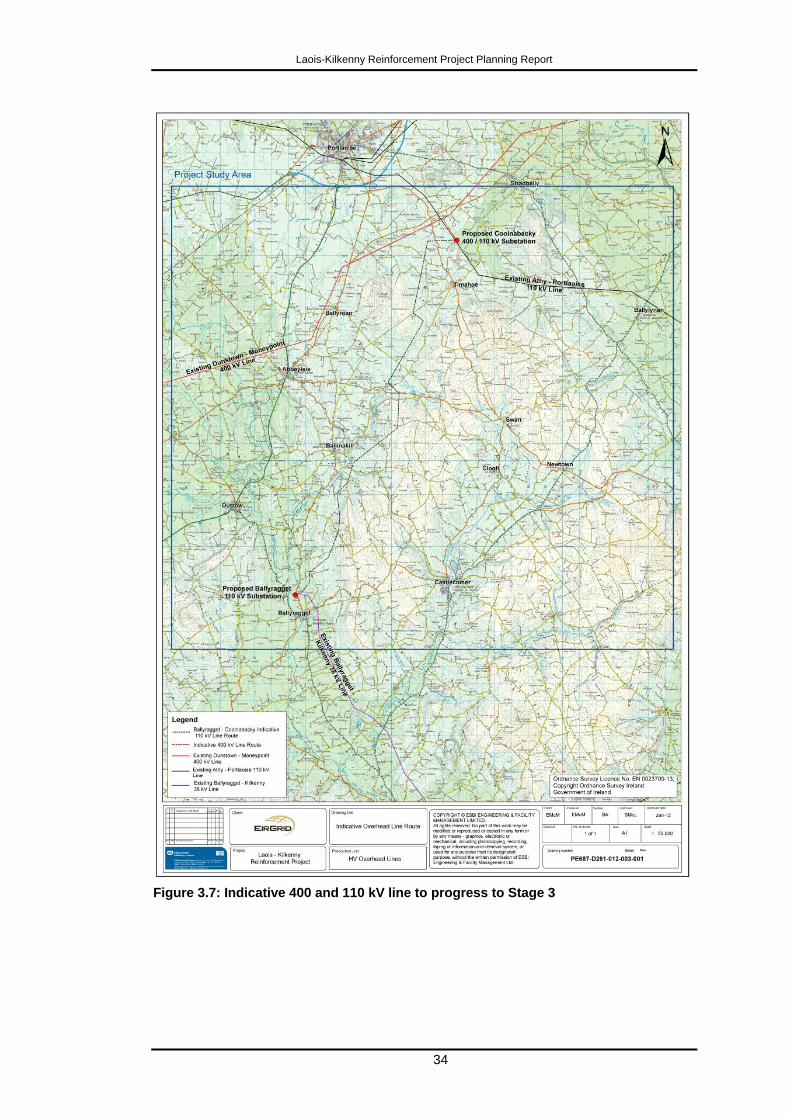
Laois-Kilkenny Reinforcement Project Planning Report
34
Figure 3.7: Indicative 400 and 110 kV line to progress to Stage 3
Laois-Kilkenny Reinforcement Project Planning Report
35
The Table of Contents for the Stage 2 Report shows the structure of that report and the
processes followed in reaching the conclusions and recommendations. The appendices are
particularly important in this regard as they provide further details showing how consultation
was structured for this stage.
The Stage 2 Report can be found at Appendix 2 of this document and can also be found on
the project website at http://www.eirgridprojects.com/projects/laoiskilkenny.
Stage 2 Lead Consultants Report – Table of Contents
Chapter 1 Introduction This section gives an overview of the
Stage 2 Report.
Part A
Chapter 2 Consultation on Stage 1 Report This section details consultations
arising from the Stage 1 Report.
Chapter 3 Proposed Substations This section provides details of the
proposed substations.
Chapter 4 Modifications to Route Corridor This section provides details of
modifications to route corridors.
Chapter 5 Route Corridor Evaluation This section provides an evaluation of
route corridors.
Chapter 6 Lead Consultant‟s Conclusion
Part A
This section provides conclusions in
relation to Part A.
Part B
Chapter 7 Consultation and Landowner
Engagement
This section provides details of
landowner engagement.
Chapter 8 400 and 110kV Connections to
Coolnabacky Substation
This section provides details of 400
and 110kV Connections to
Coolnabacky Substation.
Chapter 9 Lead Consultant‟s Conclusions
Part B
This section provides conclusions in
relation to Part B.
Chapter 10 Environmental Impact
Assessment and Appropriate
Assessment Screening Reports
This section provides information on the
requirements for EIA and AA screening.
Chapter 11 Next Steps
This list of appendices details the reports referred to in the appendices. Other appendices in
the Stage 2 Report consist of copies of maps, public notices/documents, etc. They are self
explanatory and are not detailed further in the table below.
Laois-Kilkenny Reinforcement Project Planning Report
36
Appendix Report Title Description
Appendix D Final Winter Birds
Survey
The purpose of this report was to present the abundance and
distribution of wintering wader and wildfowl birds in the project
study area. These surveys were carried out at various intervals
in 2010 and 2011 and a number of interim reports were
produced and issued as Appendices to the Stage 1 Report. This
final report gathers all of the information into one report.
Appendix J 400 kV Overhead Line
v Undergorund Cable
Feasibility Study
This study considers the use of underground cable and overhead
line for the purposes of making the 400 kV connection from
Coolnabacky substation to the existing Moneypoint-Dunstown
400 kV overhead line. A comparative assessment of both
technologies is made, having regard to technical, cost and
environmental considerations.
Appendix M Stage 1 Screening
Natura Impact
Statement
This Stage 1 Appropriate Assessment Screening Report, dated
Janurary 2012, was carried out to assist the competent authority
in carrying out Appropriate Assessment screening. This interim
report, dated January 2012, has subsequently been updated with
further information. The revised Stage 1 Screening Report was
issued to An Bord Pleánala during the course of the pre-
application consultation meetings. A Stage 2 Natura Impact
Statement was subsequently compiled and is submitted with this
application.
The key findings of the Stage 2 Report were as follows:
Following feedback from the consultation process along with further
investigation/ by the Lead Consultant on the localised impact of the route
corridors, the preferred route corridor for the 110 kV line from Coolnabacky
400/110 kV substation to Ballyragget 110 kV substation is the emerging
preferred corridor identified in the Stage 1 Report with two minor modifications.
These modifications are to the corridors‟ width at node 7 and between nodes 9
to 10. The emerging preferred route corridor for the 400 kV connection, as
identified in the Stage 1 report remains the preferred 400 kV route corridor.
The Lead Consultant also recommends that the emerging preferred
Coolnabacky 400/110 kV substation site as identified in the Stage 1 report is
the preferred 400/110 kV substation site for the project.
Further consultation with directly affected landowners and the wider community
along with the completion of the field walking stage of environmental
assessment may result in minor localised changes to the preferred route
corridors to facilitate the process of identification of a feasible line route within
the emerging preferred 400 kV and 110 kV corridors. These changes will be
reviewed where necessary.
The identified 400 and 110 kV line routes should progress to Stage 3 of the
project.
3.4 Stage 3 – Confirmation of Design
Stage 3 of the process continued consultation and engagement with the statutory and non
statutory agencies/bodies, the general public, landowners and An Bord Pleanála. It also
considered feedback from the Stage 2 report. The proposed substation designs and location
of structures on landholdings and the proposed line design were discussed with landowners,
generally on site where possible, during the course of landowner survey interviews, with a
view to accommodating suggested design changes, where considered appropriate. The
outcome of Stage 3 is not a formal Lead Consultants report but is a final confirmation of
Laois-Kilkenny Reinforcement Project Planning Report
37
substation and line design. Final environmental reports and the final planning drawings and
documentation presented as part of this Stage 4 – Prepare Planning Application, are based
on the outcome of the Stage 3 confirmation of design process. Stage 3 included meetings in
July and August 2012 with An Bord Pleanála to discuss specific details of the project and
planning approval process and also includes ongoing consultation with landowners.
During this Stage 3, it was confirmed that the majority of existing structures along the
Ballyragget-Kilkenny Overhead Line would have to be replaced to uprate the line to 110 kV
technical standards. It was originally intended to add a 110 kV extension to the Ballyragget
38 kV / MV substation. In developing this design and following discussions with ESB it was
considered more appropriate to instead develop a new 110 kV / 38 kV / MV substation
which would replace the existing 38 kV/ MV substation at Ballyragget. The replacement
substation would be built adjacent to the existing station on ESB owned lands with the
existing station eventually being decommissioned.
3.5 Stage 4 – Planning Application Submission
Stage 4 of the EirGrid planning roadmap is the application for planning approval submitted
to An Bord Pleanála. It includes all planning and environmental reports.
The planning application is structured as follows:
1. Volume 1 – Statutory Particulars
Contents include: Application Form, Public Notices, Schedule of Prescribed Bodies,
Letters of Consents and Plans and Drawings.
2. Volume 2 – Planning Report
Contents include: this Planning Report (with Stage 1 and 2 Lead Consultants
Reports as appendices).
It should be noted that there appendices to both the Stage 1 and 2 Reports which
are available on the project website. These are not reproduced in paper copy as
part of this planning report but are included on a CD at the back of this report.
3. Volume 3 – Environmental Report
Contents include: Reports relating to: Human Beings, Landscape and Visual,
Cultural Heritage, Ecology, Soils and Geology, Hydrogeology, Material Assets, Air
and Climate, Interactions and Schedule of Commitments.
Various appendices in the report provide supporting information and should be read
as part of the Environmental Report.
In addition and solely for the convenience of An Bord Pleanála, an A3 set of the statutory
plans and drawings is provided.
3.6 Stakeholder Consultation
As detailed previously, consultation with stakeholders is a fundamental element of the
EirGrid Project Development and Consultation Roadmap (Figure 3.1). Extensive

Laois-Kilkenny Reinforcement Project Planning Report
38
consultation was undertaken for this project with identified stakeholders and the general
public from the outset of the project with numerous open days, information clinics and
landowner surveys and interviews taking place.
The consultation based around the Stage 1 report is a key element of the project, as it is
vital to get feedback from all concerned parties, in order to obtain as much information as
early as possible so as to inform subsequent decisions regarding route identification and
project confirmation.
Consultation continued through Stages 2 and 3. Consultation in these stages occurred with
key stakeholders and agencies having regard to the feedback from Stage 1. It increasingly
focussed on landowner engagement during these stages, as landowners along the
indicative preferred line route were identified and interviewed, and options (where available)
for the location of structures were discussed.
This process of landowner engagement facilitated the more detailed siting of structures
along the alignment, with the focus being on seeking agreement between the project team
and the landowner regarding the optimum siting of structures. Where the project team could
not facilitate a landowner preference for siting of structures, for example due to a likely
significant technical or environmental constraint or impact arising (following consideration
and assessment of the option), this was explained to the affected landowner during this
engagement process.
The consultation can be broadly categorised as occurring with key stakeholders, agencies,
landowners and the general public. However, the principle behind such consultation
remains the same for all groups i.e. to engage in open, honest and meaningful dialogue,
and to evaluate and incorporate, where possible or appropriate, all suggestions and
modifications brought to the attention of, or subsequently identified by the project team.
The Project Team were cognisant that adoption of the Aarhaus Convention was in the
process of being ratified by the Irish Government as the project progressed and consultation
was structured with this in mind.
3.6.1 Key Stakeholders and Agencies
The Project Team endeavoured to work with key stakeholders and agencies with a view to
ensuring that the process of identifying the preferred project solutions took into account their
particular area of responsibility. Consultation letters, a project briefing document and a
notification of the Stage 1 Lead Consultants Report were issued on 20th May 2011. These
letters were followed up with phone calls, emails and meetings where requested. The list of
stakeholders and agencies that were consulted is as follows:
An Bord Pleanála
An Taisce
Fáilte Ireland
Inland Fisheries Ireland
Kilkenny County Council
Laois County Council
National Parks and Wildlife Service (NPWS) – Development Applications Unit
Development Application Unit – DoEHLG
BirdWatch Ireland
Bord na Móna
Laois-Kilkenny Reinforcement Project Planning Report
39
National Roads Authority (NRA)
Irish Farmers' Association (IFA)
South-East Regional Authority
Midlands Regional Authority
Department of the Environment, Community and Local Government
Coillte
Commission for Energy Regulation (CER)
Environmental Protection Agency (EPA)
Geological Survey of Ireland (GSI)
Health and Safety Authority (HSA)
Health Service Executive (HSE)
Irish Aviation Authority (IAA)
Irish Peatland Conservation Council
The Arts Council
Teagasc
County Carlow Chamber of Commerce
Carlow County Council
Wicklow County Council
Kildare County Council
Carlow County Enterprise Board
Forfás
Kilkenny Archaeological Society
Kilkenny Chamber of Commerce
Kilkenny County Enterprise Board
Kilkenny Strategic Policy Committee
Laois Chamber of Commerce
Laois County Enterprise Board
Laois Heritage Society
Mountaineering Ireland
Radiological Protection Institute of Ireland
RTE Frequency Coverage and Planning Department
The Heritage Council
Department of Transport
Department of Arts, Heritage and Gaeltacht Affairs
Department of Justice Equality and Law
Department of Enterprise, Trade and Employment
Department of Community, Rural and Gaeltacht Affairs
Department of Communication, Energy and natural Resources
Laois-Kilkenny Reinforcement Project Planning Report
40
Department of Agriculture, Fisheries and Food
Department of Environment, Heritage and Local Government
Public Representatives including Local Councillors, TDs and Senators.
3.6.2 The Public
EirGrid is committed to ensuring that all members of the public were fully aware of the
project and encouraged them to participate in the public consultation process.
At all times the project team endeavoured to engage with landowners and the general public
in respectful, honest and open discussion. The local knowledge of landowners and local
communities is invaluable to the project team, and therefore their input is vital. The project
team must merge this local knowledge with technological and environmental survey and
assessment, experience and expertise in line routing and station design, to come up with an
optimum solution.
Consultation on this project began week commencing 26th October 2009, with the
publication of a newspaper notice in six regional newspapers. The newspaper notice
consisted of a blank study area map supplemented with a project description. The purpose
of this notice was to inform the wider public of the proposed project, to seek information and
local inputs that could be incorporated into the decision making process and also to
publicise the project contact details.
A project website was set up as well as a dedicated project specific email address, phone
number and postal address. Numerous contacts have been made with the project team
since these were set up as well as meetings with local stakeholders.
Upon completion of the „Project Constraints Map‟ and supplementary „Description of Project
Constraints‟ report a second newspaper notice was placed during week commencing the
14th June 2010. The purpose of the notice was to present the findings to date and to show
the constraints that had been recorded in the study area which would influence the route
selection and site selection process.
Public Open Days were held on the 17th and 18th of June 2010 in Kilkenny and Portlaoise
respectively where members of the general public could meet with and discuss any aspect
of the project with members of the project team.
Feedback from these consultations was assessed and considered in the route and site
identification stage. This culminated with the publication of a „Stage 1 Lead Consultant‟s
Report‟ which identified the consultant‟s emerging preferred route corridor and site.
A third series of newspaper notices was published in early June 2011 to advise
stakeholders that the Stage 1 Report was available and sought feedback on the findings
therein.
A second series of Public Open Days was held on the 9th, 10th and 24th of June 2011 in
Kilkenny, Portlaoise and Ballyragget where the findings of the Stage 1 Report and indeed
any aspect of the project could be discussed with members of the project team. An EMF
specialist was also available to discuss any queries in relation to EMF and health.
Information brochures were also dropped to local shops, credit unions, libraries and county
council offices in Kilkenny, Ballyragget, Ballinakill, Timahoe, Stradbally and Portlaoise
ahead of the open days.
Anybody who had contacted the Project Team previously was also directly informed that
this report had been published as well as given dates for Open Days.
Laois-Kilkenny Reinforcement Project Planning Report
41
A fourth series of newspaper notices thanking people for the feedback received over the
course of the Stage 1 consultation period was also then published at the end of June.
Starting in August 2011, landowners along the preliminary indicative line routes
(Coolnabacky-Ballyragget) were issued survey packs, advising them of the proposed project.
This allowed landowners to outline any concerns or suggestions for consideration before the
line route and structure locations became finalised. Lands were also surveyed during this
period.
The „Stage 2 Lead Consultant‟s‟ report was published in February 2012. Key findings
included the identification of the preferred site locations as well as the indicative overhead
line routes.
A 5th series of newspaper notices, advertised a third series of Public Open Days which
were held on the 23rd and 24th of February in Kilkenny and Portlaoise.
Information brochures were again dropped to local shops, credit unions, libraries and county
council offices in Kilkenny, Ballyragget, Ballinakill, Timahoe, Stradbally and Portlaoise
ahead of these open days.
In March 2012, following review of feedback from Stage 2 Report consultations further
survey packs were issued to landowners along the line routes.
A series of 6 information clinics were then held in Portlaoise, Ballyragget and Kilkenny at the
end of March into early April 2012.
Landowners along the routes of the existing Ballyragget-Kilkenny and Portlaoise-Athy lines
were notified of intention to carry out walkover environmental and technical surveys by way
of hand delivered letters at the beginning of June 2012.
The consultation process is summarised as follows:
Event Date Description Location
Newspaper
Notices #1
w/c 26th Oct 2009 Description of Proposed
Project
Definition of Study Area
Kilkenny People,
Leinster Express,
Laois Nationalist,
Carlow
Nationalist,
Kildare
Nationalist,
Leinster Leader.
Newspaper
Notices #2
w/c 14th June 2010 Description of Proposed
Project
Presentation of
Constraints Recorded in
Project Study Area
Advertise Open Days
Kilkenny People,
Leinster Express,
Laois Nationalist,
Carlow
Nationalist.
Open Days #1 17th & 18th June
2010
As above
Project Team available in
person to discuss any
findings
Portlaoise
Heritage Hotel,
River Court Hotel
Kilkenny.
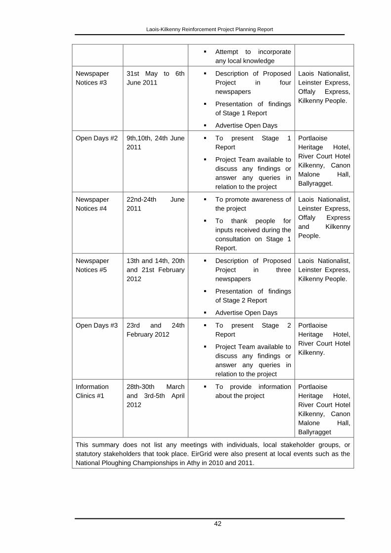
Laois-Kilkenny Reinforcement Project Planning Report
42
Attempt to incorporate
any local knowledge
Newspaper
Notices #3
31st May to 6th
June 2011
Description of Proposed
Project in four
newspapers
Presentation of findings
of Stage 1 Report
Advertise Open Days
Laois Nationalist,
Leinster Express,
Offaly Express,
Kilkenny People.
Open Days #2 9th,10th, 24th June
2011
To present Stage 1
Report
Project Team available to
discuss any findings or
answer any queries in
relation to the project
Portlaoise
Heritage Hotel,
River Court Hotel
Kilkenny, Canon
Malone Hall,
Ballyragget.
Newspaper
Notices #4
22nd-24th June
2011
To promote awareness of
the project
To thank people for
inputs received during the
consultation on Stage 1
Report.
Laois Nationalist,
Leinster Express,
Offaly Express
and Kilkenny
People.
Newspaper
Notices #5
13th and 14th, 20th
and 21st February
2012
Description of Proposed
Project in three
newspapers
Presentation of findings
of Stage 2 Report
Advertise Open Days
Laois Nationalist,
Leinster Express,
Kilkenny People.
Open Days #3 23rd and 24th
February 2012
To present Stage 2
Report
Project Team available to
discuss any findings or
answer any queries in
relation to the project
Portlaoise
Heritage Hotel,
River Court Hotel
Kilkenny.
Information
Clinics #1
28th-30th March
and 3rd-5th April
2012
To provide information
about the project
Portlaoise
Heritage Hotel,
River Court Hotel
Kilkenny, Canon
Malone Hall,
Ballyragget
This summary does not list any meetings with individuals, local stakeholder groups, or
statutory stakeholders that took place. EirGrid were also present at local events such as the
National Ploughing Championships in Athy in 2010 and 2011.
Laois-Kilkenny Reinforcement Project Planning Report
43
3.6.2.1 Co-ordination of Interactions with the Public
To co-ordinate interactions with the general public throughout the project, the project team
implemented a process to ensure that general and individual concerns were directly
addressed by the project team. This primarily occurs through:
Contact made through e-mail, by letter or phone;
All information received is made available to all members of the project
team for review;
The Lead consultant liaises with the EirGrid Project Manager to decide on
the appropriate course of action;
A member of the project team contacts the individual concerned and
becomes their personal point of contact for the duration of the project; and
The project team are always available to meet on request.
3.6.3 Landowners
It was decided for the project, that public consultation on the line route and possible project
solutions would be approached in three distinct phases:
1. Directly affected landowners were notified of the proposal. A dedicated wayleave
coordinator was appointed to be a direct point of contact for this group.
2. Landowners at a representative distance of 50 metres either side of the proposed
development were notified of the proposal. It should be noted that this
representative distance has no meaning in terms of routing or health and safety.
The dedicated wayleave coordinator was appointed to be a direct point of contact
for this group.
3. The wider general community were kept informed of project development, with
opportunities for feedback and consultation.
3.6.3.1 Landowner Identification Process
Property Registration Authority (PRA) searches were conducted to identify all landowners
along the indicative line route and station location. Any land parcels unidentified from the
above process were subsequently identified through a search of the registry of deeds and
by gathering information from other local residents and landowners. All information gathered
is confirmed with the identified landowner at the survey interview stage as outlined below.
3.6.3.2 Survey Interview Stage - Survey Interview Documentation
All landowners were contact by the project team and an information pack was delivered in
the majority of cases. This pack was issued to landowners along the Coolnabacky-
Ballyragget indicative line route on 8th August 2011.
A Cover Letter - This letter introduces the project, invites landowners to
engage in the consultation process, makes reference to the survey
letter including all attachments and introduces the lead project
consultant. Contact details for the wayleave officer appointed for the
project are also included in this letter. This gives every landowner a
personal point of contact for the duration of the project.
Laois-Kilkenny Reinforcement Project Planning Report
44
EirGrid Survey Letter - This letter again outlines the proposed project,
the Townland, Barony and County across which the initial indicative line
route crosses and station location and a general outline of the survey
interview process. Importantly the letter contains information regarding
EirGrid‟s 'Policy Towards Landowners For Access And Survey Of Land'.
Landowner Survey Map - This map accompanies each survey letter
and shows the initial indicative line route (in red) as it crosses the
landowner‟s property. The individual property boundary of each
landowner is highlighted in blue. The structure locations were not
established at this stage and therefore were not marked on the map.
Project Briefing Document - A further project briefing document (2nd
in
series – August 2011) outlining the project need, benefits and timelines
is included for information. This briefing document also includes contact
details of the project team.
A copy of the ESB/IFA Code of Practice for the Survey, Construction
and Maintenance of Overhead Lines (made available on request).
A booklet was made available (on request) explaining electric and
magnetic fields (EMF‟s).
3.6.3.3 Survey Interview Stage - Survey Interview Process
Following the issue of these survey packs, landowners were called to by a member or
members of an ESBI project survey interview team working on behalf of EirGrid. The
purpose of these visits was to explain the proposal to the landowners, to seek the
landowners agreement to facilitate walkover surveys by environmental consultants and to
ensure that all landowners had the opportunity to raise directly with the project team any
concerns or suggestions regarding the proposed indicative line route, and to establish a
direct line of communication between landowners and the project team.
The vast majority of landowners were contacted by an initial call to the door by a survey
interview team representative. All landowners at the time of contact were offered the
opportunity to discuss the project and complete a standard pre-survey interview form. If this
time was not convenient to the landowner, a more suitable date and time was arranged.
A pre-survey interview form was filled out with the landowner by the survey interview team
representative. The purpose of this interview is to accumulate as much information as
possible regarding the landholding for the purposes of routing and constructing the
proposed overhead line. It is also an opportunity for the landowner to express a preference
for where the line structures might be sited on the landholding. Finally, it is an important
opportunity to discuss the overall project and to address any queries or concerns that might
arise in respect of the project. A copy of this interview record is left with the landowner.
The majority of the survey interviews were carried out between August 24th and September
23rd
2011. As of that time most of the landowners were met; however some landowners
were not available or unreachable. Landowners were either met directly, or if they were not
directly met, contact was made through a third party such as an agent or through a family
member, where the landowner agreed to such an approach.
Whilst the majority of the landowners have facilitated the walkover surveys by the
environmental consultants, some did not consent to access and were subsequently sent a
second letter on 9th January 2012 requesting permission for access to conduct surveys and
discuss how impacts on farming activities could be minimised. The letter also stated that the
Laois-Kilkenny Reinforcement Project Planning Report
45
line will be designed with the information available in the event that the landowner was still
not willing to facilitate the walkover surveys. Maximum site access is preferable in order to
seek to place structures at locations in agreement with landowners to the greatest extent
practicable or feasible. Prior to the finalisation of the project design the project team
(including the environmental consultants) had been granted access by landowners to the
vast majority of landholdings.
This level of access is considered adequate to have ensured the optimal technical design of
the proposed line and an adequate environmental assessment of the proposed
development. Where lands were not accessed, information gathered had indicated that
there was no feature or item of concern that necessitated on site inspection in the first place
or alternatively, the lands were surveyed from neighbouring fields or public road in
conjunction with desktop records and aerial photography records.
Landowner engagement continues throughout the process and the project team are always
willing to meet with any landowner at any stage of the design process, as it is EirGrid‟s
preference to achieve maximum site access so that structures are placed at locations
agreed with landowners to the greatest extent practicable or feasible.
3.6.4 Feedback Received
From the public open days, a period of approximately one month was generally given for the
public to make submissions to the project team, within which the project team would seek to
accumulate information from statutory and non-statutory consultees. Any information
received after this time was also considered.
Important for the project team is the review and analysis of all feedback received throughout
the consultation period, so the project team can assess if any of the feedback causes:
Re-evaluation of the project;
Need for alternatives to, or modification of the project;
Re-evaluation of planned line route (i.e. minor deviations or the use of
alternative routes).
Whilst formal response dates were specified to respond to the Stage 1 and 2 reports, all
feedback was considered, irrespective of when it was received.
3.6.4.1 Key Stakeholders and Agencies
o An Bord Pleanála
Prior to the preparation of this application, four pre-application consultation meetings were
held with An Bord Pleanála in August 2009 and in July, August and October 2012.
Whilst various issues were discussed, the key purpose of these meetings was to determine
the following:
1. Whether the proposed development qualifies as a Strategic Infrastructure
Development (SID) under Section 182A of the Planning and Development Act
2000, as amended.
2. If it does qualify as SID, to seek the advice of An Bord Pleanála on the nature
and extent of the proposal, as well as on matters that should be addressed in
the application for Planning approval, in terms of accompanying reports,
studies, planning documentation, etc.
The outcome of the consultation meetings in relation to the above issues was as follows:
Laois-Kilkenny Reinforcement Project Planning Report
46
An Bord Pleanála issued a letter to EirGrid dated 26th October 2012 enclosing its record of
the meeting of the 15th October 2012. In the record it stated that:
“it was the preliminary view of the Board that it considered the proposed
development to be strategic infrastructure and that any planning application should
therefore be made directly to the Board”.
“The Board offer the preliminary view that Environmental Impact Assessment (EIA)
was not considered necessary for the proposed development; however an
Environmental Report (ER) would be required”.
An environmental report is now being submitted to An Bord Pleanála with this application for
planning approval.
o Local Authorities
The proposed development will take place within the functional areas of two Local
Authorities – Laois and Kilkenny County Councils. Neighbouring Local Authorities close to
the development area include Carlow and Kildare County Councils.
Consultation has taken place with all Local Authorities with a particular focus on those
authorities where the development will be located.
Consultation has mainly been through meetings between the Project Team and Council
Officials, as well as briefings to the Elected Members by the Project Team.
In order to obtain technical information required for developing the project and to inform
Council Officials, additional consultation focussing on specific technical areas including;
water, roads and heritage, have taken place with various departments in the relevant Local
Authority. Regular updates have been provided throughout the course of the project by way
of letter, email, phone call or other meetings.
The key meetings which took place between the Project Team and Local Authorities are set
out below.
Meeting Date Purpose
Laois Planners and County
Manager
14/08/2009 Presentation on Grid 25 and
to advise on Laois-Kilkenny
Reinforcement Project.
Laois Area Councillors 14/12/2009 Presentation on Laois-
Kilkenny Reinforcement
Project
Portlaoise Electoral Area
Councillors
16/12/2009 Presentation on Laois-
Kilkenny Reinforcement
Project
Laois Planners and County
Manager
05/05/2010 Status update meeting on
Laois-Kilkenny
Reinforcement Project
Kilkenny Planners and
County Manager
19/10/2009 Presentation on Grid 25 and
to advise on Laois-Kilkenny
Reinforcement Project
Laois-Kilkenny Reinforcement Project Planning Report
47
Kilkenny Strategic Policy
Committee
03/12/2009 Presentation on Grid 25 and
to advise on Laois-Kilkenny
Reinforcement Project
Kilkenny Planners 28/06/2012 Presentation on Laois-
Kilkenny Reinforcement
Project
Carlow (Director of Services) 8/10/2009 Presentation on Grid 25 and
to advise on Laois-Kilkenny
Reinforcement Project
Midlands Regional Authority 13/05/2010 Presentation on Laois-
Kilkenny Reinforcement
Project
Kilkenny Strategic Policy Committee wrote to ESB International on 25th August 2011
requesting an open day in Ballyragget. Kilkenny Strategic Policy Committee were made
aware that open days were previously held in Ballyragget on the 24th and 30
th June 2011.
Kildare County Council issued a letter (dated 2nd
June 2011) stating Kildare County Council
“does not wish to make any comment on the project at this stage but would appreciate
update on the later stages of the project”.
o National Parks and Wildlife Service (NPWS)
The NPWS were contacted by the project ecologist. From this correspondence the project
team were advised that subsequent to the Stage 1 Report, the River Nore was designated
as a Special Protection Area (SPA) under the EU Birds Directive (2009/147/EC), Site Code
004233, this is within the study area. Further to the NPWS informing the project ecologist of
the newly designated Nore SPA, a review of the potential impact arising from the project on
the new SPA was carried out by the project ecologist. The review found that modification of
the emerging preferred route corridor is not necessary as a result of the newly designated
SPA. This designated area overlays sections of the previously designated River Nore and
River Barrow Candidate Special Area of Conservation (cSAC) (site code 2162) which was
taken into account in the original Stage 1 assessments.
o National Roads Authority (NRA)
A letter was received from the National Roads Authority (June 2011) referring the project
team to several policy documents including:
The Authority‟s Policy Statement on Development Management and Access to
National Roads;
DoEHLG Spatial Planning & National Roads (Draft) Guidelines for Planning
Authorities, June 2010;
Environmental Impact Assessment of National Road Schemes – A Practical
Guide;
Guidelines for the Treatment of Noise and Vibration in National Road Schemes;
Guidelines for the treatment of Air Quality During the Planning and Construction
of National Road Schemes;
Road Safety Audit (NRA HD 19/09); and
Traffic and Transport Assessment Guidelines (TTA ).
Laois-Kilkenny Reinforcement Project Planning Report
48
The letter also advised that a full and comprehensive traffic assessment should be carried
out. The assessment is contained in the Environmental Report accompanying this
application.
o Inland Fisheries Ireland
A letter was received from Inland Fisheries Ireland (formally Central Fisheries Ireland) (June
2011) referred to a previous correspondence in which several issues were highlighted. The
following is a summary of these issues:
Consideration should be given to all river tributaries irrespective of size;
Care on the placement of line supporting structures relating to silt and erosion;
Care in relation to the use of concrete relating to pH values;
Care in relation to earth movement and the production of silt;
Care in relation to the use of oils and fuels;
From a visual perspective Inland Fisheries Ireland would prefer if the circuit is
undergrounded, however it also acknowledged that this method has the
potential to generate negative impact on the water habitats and state that if this
method is to be used that an under bore is used for river crossings; and
The line sag over waters should not be a safety concern for anglers.
o Fáilte Ireland
A meeting was held with Fáilte Ireland on 16th June 2011 at which EirGrid and ESBI gave
an overview of the project. Subsequent to that meeting Fáilte Ireland made a submission
(by email dated 24th June 2011) to the project team. The submission highlighted that there
are a number of important tourist assets in the vicinity of the study area including Abbeyleix
Heritage Town, the Rock of Dunamase, Castlecomer Discovery Park, as well as the
uplands that lie between the N8 and the N78.
Fáilte Ireland holds the view that the emerging preferred corridor as highlighted in the Stage
1 report “is the one to have the least effect on the tourism amenity value of the area”. Fáilte
Ireland also stated that they are not aware of any negative impacts on the tourism amenity
value of the area that are likely to arise from the proposed 400/110 kV substation.
o An Taisce
An Taisce replied (by email dated 25th May 2011) stating at this stage “there are no major
elements that would be problematic from our point of view.”
o Geological Survey of Ireland (GSI)
The GSI issued a map (by email dated 8th November 2011) showing the extent of the
Timahoe esker geological heritage site recommended for CGS designation under the IGH 7
Quaternary Theme.
o Office of the Minister for Agriculture, Fisheries and Food
A letter was received on 27th May 2011 from the Office of the Minister for Agriculture,
Fisheries and Food stating that the project will be brought to the attention of the Minister.
Laois-Kilkenny Reinforcement Project Planning Report
49
3.6.4.2 The Public
There has been a steady response from the general public which has continued outside the
official consultation period end date of the 9th March 2012. In addition to general queries,
expressions of objection were received. The majority of people responding are living along
or in close proximity to the emerging preferred route and/or the 400/110 kV substation site.
There also has been ongoing correspondence with a local opposition group located close to
the 400/110 kV substation area; and additional substation study areas (in the vicinity of
Cullenagh mountain) were assessed based on consultation with this group.
Contact with the project team was in most cases initially made through the project e-mail,
details of which where publicised on the project briefing document. Phone calls were the
next preferred method of communication. Post was the least used method. In September
2010 and 2011 EirGrid proactively engaged with stakeholders by having a stand at the
National Ploughing Championships in nearby Athy, where members of the project team
were on hand to deal with any queries on the project from the general public. Open Days
and Information Clinics in the area have also facilitated access to the project team.
Whilst many individual submissions were received from the public they have been grouped
into themes. The main submission themes from the public in relation to the project were:
Need for the project;
Impacts on the environment;
Health and safety issues, including electromagnetic fields (EMF);
Impacts on farming;
Landscape and visual impact;
Substation Size and Location; and
Undergrounding the 400 and 110 kV connections.
The EirGrid Project Development and Consultation Roadmap illustrates the importance of
public consultations at the various stages throughout the project development process.
3.6.4.3 Landowners
Feedback from landowners was received primarily during Stages 2 and 3, when landowner
interviews took place. The types of issues raised related mainly to the specific location of
structures on lands. Proposed structure locations have been selected having regard to a
variety of criteria, including landowner preference, following an extensive period of on-site
landowner engagement. Where feasible, and having regard in particular to technical and
environmental issues, such preferences have been accommodated in the proposal before
ABP.
3.7 Conclusions
Having established the need for the project, the project proceeded according to the EirGrid
Project Development Roadmap. This Roadmap provides for extensive consultation at all
stages in the process, so that the views of stakeholders and the public can be considered
during the project design process. This, in the view of EirGrid and its project team, has
resulted in an extremely robust project proposal now before An Bord Pleanála.
The proposal derives from a careful consideration of a number of strategic and more
detailed alternatives, particularly regarding the routing and siting of the proposed

Laois-Kilkenny Reinforcement Project Planning Report
50
transmission infrastructure, having regard to its necessary nature, form and extent, as well
as the governing strategic need for the proposal.
In this context, EirGrid submits that the proposed development is in accordance with best
international practice for the design of transmission infrastructure, and with the principles of
proper planning and sustainable development.
Laois-Kilkenny Reinforcement Project Planning Report
51
4 Legislative Context
4.1 Strategic Infrastructure
An Bord Pleanála has deemed that the proposed development falls within the scope of
Section 182A of the Planning and Development Acts 2000-2010, and accordingly this
application for Approval is being made to the Strategic Infrastructure Division (SID) of An
Bord Pleanála (ABP).
4.2 Environmental Impact Assessment
4.2.1 Requirements for an Environmental Impact Assessment (EIA)
Having regard to the preliminary view expressed by An Bord Pleanála that statutory
Environmental Impact Assessment is not required but that the preparation of an
Environmental Report is appropriate, EirGrid has proceeded on this basis but EirGrid
requests that An Bord Pleanála furnish its formal decision as to whether it considers than an
Environmental Impact Statement is required in relation to the application and, further, the
reasons and considerations grounding that decision.
4.3 Requirement for Appropriate Assessment
An Bord Pleanála as the competent authority must carry out the appropriate assessment if it
deems it to be necessary. In order to assist the Board, the planning application includes a
Natura Impact Statement. The purpose of the statement is to provide the following
information to the Board.
A description of proposed development and local site area characteristics;
Identification of relevant European sites, and compilation of information on their
qualifying interests and conservation objectives; and
An assessment of likely effects on European sites arising from the project.
4.4 Conclusion
An Bord Pleanála (ABP) has determined that the project constitutes Strategic Infrastructure
Development (SID) and accordingly it is being submitted to ABP for Planning Approval.
The preliminary view expressed by ABP is that statutory Environmental Impact Assessment
is not required but that the preparation of an Environmental Report is appropriate. An
Environmental Report is submitted with this application.
In order to assist the Board in carrying out Appropriate Assessment, the application for
planning approval includes a Natura Impact Statement.
Laois-Kilkenny Reinforcement Project Planning Report
52
5 Planning Policy Context
5.1 National Plans and Policies
5.1.1 White Paper on Energy Policy Framework 2007-2020
The White Paper „Delivering a Sustainable Energy Future for Ireland‟ sets out a strategic
Energy Policy Framework to deliver a sustainable energy future for Ireland. Strategic goals
outlined in the White Paper in relation to security of energy supply include:
Ensuring that the electricity supply available consistently meets demand;
Delivering electricity to homes and businesses over efficient, reliable and
secure HV and MV networks; and
Being prepared for energy supply disruptions.
The White Paper emphasises that „the availability of reliable, secure and competitively
priced electricity supply must be assured at all times‟ and highlights the fact that electricity
„is a vital ingredient in the competitiveness of Irish industry and Ireland‟s long term economic
and social development‟.
The White Paper also sets the target of 33% of electricity being produced from renewable
generation by 2020. This target was subsequently increased to 40%.
GRID25
EirGrid‟s GRID25 (published in 2008) – A Strategy for the Development of Ireland‟s
Electricity Grid for a Sustainable and Competitive Future, was published in response to the
above White Paper. Grid25 outlines EirGrid‟s high level strategy for upgrading Ireland‟s
electricity transmission network. Of particular note in this instance, Grid25 notes that
demand in the Midlands region is expected to rise by over 40% by 2025 and demand in the
South-East region is expected to rise by over 45% by 2025
Benefits for both the Midlands and South-East regions of the Grid25 strategy include:
Proposals will ensure increased security of supply to major urban areas and to the
region as a whole;
Increased power available to the region;
Increased transmission capacity will allow for growth of renewable generation
connections in the region;
A modern network that will allow for renewable generation from the region;
A significant future growth in demand from both industry and domestic users can be
accommodated;
Greater network capacity to allow for small-scale thermal generation in the region;
and
A significant investment by EirGrid in the region.
The consequences of not progressing with transmission infrastructure development in the
Midlands and South-East regions are identified in Grid25 as follows (Table 5.1)1:
1 GRID25, page 7
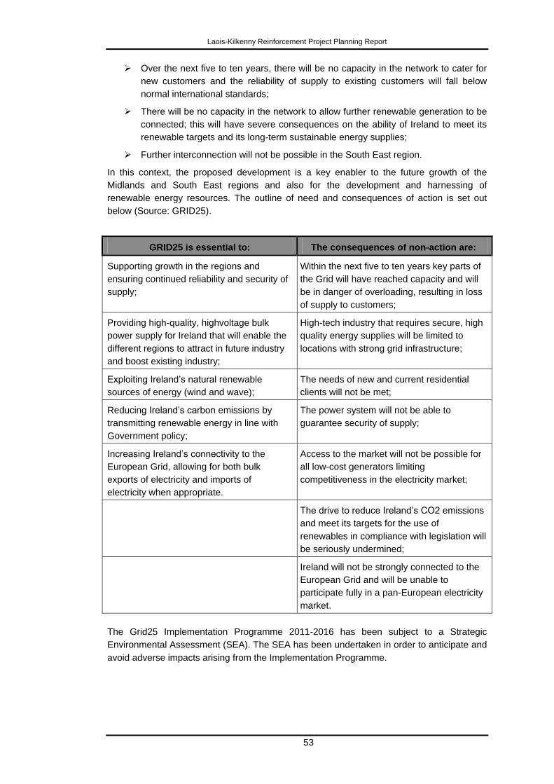
Laois-Kilkenny Reinforcement Project Planning Report
53
Over the next five to ten years, there will be no capacity in the network to cater for
new customers and the reliability of supply to existing customers will fall below
normal international standards;
There will be no capacity in the network to allow further renewable generation to be
connected; this will have severe consequences on the ability of Ireland to meet its
renewable targets and its long-term sustainable energy supplies;
Further interconnection will not be possible in the South East region.
In this context, the proposed development is a key enabler to the future growth of the
Midlands and South East regions and also for the development and harnessing of
renewable energy resources. The outline of need and consequences of action is set out
below (Source: GRID25).
GRID25 is essential to: The consequences of non-action are:
Supporting growth in the regions and
ensuring continued reliability and security of
supply;
Within the next five to ten years key parts of
the Grid will have reached capacity and will
be in danger of overloading, resulting in loss
of supply to customers;
Providing high-quality, highvoltage bulk
power supply for Ireland that will enable the
different regions to attract in future industry
and boost existing industry;
High-tech industry that requires secure, high
quality energy supplies will be limited to
locations with strong grid infrastructure;
Exploiting Ireland‟s natural renewable
sources of energy (wind and wave);
The needs of new and current residential
clients will not be met;
Reducing Ireland‟s carbon emissions by
transmitting renewable energy in line with
Government policy;
The power system will not be able to
guarantee security of supply;
Increasing Ireland‟s connectivity to the
European Grid, allowing for both bulk
exports of electricity and imports of
electricity when appropriate.
Access to the market will not be possible for
all low-cost generators limiting
competitiveness in the electricity market;
The drive to reduce Ireland‟s CO2 emissions
and meet its targets for the use of
renewables in compliance with legislation will
be seriously undermined;
Ireland will not be strongly connected to the
European Grid and will be unable to
participate fully in a pan-European electricity
market.
The Grid25 Implementation Programme 2011-2016 has been subject to a Strategic
Environmental Assessment (SEA). The SEA has been undertaken in order to anticipate and
avoid adverse impacts arising from the Implementation Programme.
Laois-Kilkenny Reinforcement Project Planning Report
54
5.1.2 National Development Plan 2007 - 2013
The National Development Plan (NDP) 2007-2013 seeks to ensure that Ireland remains
competitive in the global international marketplace and that any economic success will be
shared more equally at a regional level and throughout society. A strategic objective of the
Energy Programme of the NDP is to ensure security of supply nationally and regionally. The
NDP further states that the main focus of investment by EirGrid „will entail improvement of
the transmission network for electricity to accommodate increased usage and enhance
security of supply, to allow increased connection of sustainable and renewable energy
sources to the network and to support greater interconnection with Northern Ireland and
Great Britain‟.
It is considered that the strategic objectives of the NDP remain entirely valid, despite the
current economic downturn.
5.1.3 National Spatial Strategy
The NSS is a 20 year strategic vision for the spatial development of Ireland. It outlines how
a strengthened network of cities and towns together with rural communities and resources
will be mobilised and complemented by appropriate social and physical infrastructure, to
create more balanced development across the country. In relation to key infrastructure
projects, the NSS identifies that „a feature of the most mature and successful economies is
that they possess highly developed, well integrated infrastructure that supports movement,
i.e. public and private transport, and energy and communications networks.‟
The NSS identified nine, strategically located, medium sized 'hubs' whose purpose is to
work together to promote regional development in their areas. Kilkenny has been identified
as one of these hubs. Some 58% of current demand for electricity is in gateway cities and
towns, as identified in the National Spatial Strategy (NSS). The NSS defines gateways as
having a strategic location, nationally and relative to their surrounding areas, and provide
national scale social, economic infrastructure and support services. The Grid25 strategy
endorses the NSS goal of developing gateways and achieving balanced regional
development.
5.2 Regional Policies
The proposed development is located within the functional areas of the South-East and
Midland Regional Planning Authorities therefore it is necessary to set out the relevant
policies and objectives of the Regional Planning Guidelines (RPG) which relate to the
proposed development.
5.2.1 Regional Planning Guidelines for the South-East Region 2010 – 2022
The RPGs for the South East Region 2010 – 2022 provide a long term strategic planning
framework for the region. The key relevant Principle Planning Objectives of the South-East
RPGs are as follows:
„PPO 6.3: It is an objective of the Regional Authority that local authorities, the
private sector, energy production and supply companies are encouraged to
formulate sustainable energy policies and practices which seek to:
Ensure security of energy supply in order to support economic and social
development;
Source energy at a price that does not adversely affect competitiveness;
Laois-Kilkenny Reinforcement Project Planning Report
55
Develop variable and alternative sources of energy generation;
Maximise the use of renewable energy technologies;
Promote a culture of energy conservation by all users;
Assist the development of indigenous sustainable energy enterprises;
Support and promote sustainable indigenous Bio-energy industries
including the Bio-ethanol industry‟.
„PPO 6.5: The Regional Authority supports the sustainable development and
expansion of the GRID network and future connections to renewable sources of
energy (including Gate 3 projects), subject to appropriate assessment of all
necessary environmental considerations‟
Chapter 3, Section 3.2, Objective A9 sets out the following strategic goal for the region.
„Supporting the development and improvement of key economic infrastructure, such
as energy generation and transmission networks, including renewable energies and
telecommunications, all of which are essential for the continued development of the
region.‟
Section 6 of the RPG‟s considers „Communications/Energy/Regional Climate Change
Strategy‟.
Section 6.2.1 states that:
„The South-East Regional Authority actively and strongly supports the sourcing
and generation of energy from within the South-East. Security of energy supply at
a competitive price is a cornerstone of future sustainable development within the
region‟.
Section 6.2.2 states that:
„The Regional Authority endorses the Eirgrid document „Grid 25‟ for National
Electrical Grid Development from 2008–2025‟.
Section 6.2.3.2 „National Transmission/Distribution Network‟ states that:
„The South-East Regional Authority recognises the need to increase electrical
infrastructure which will be required within the region, including development of new
„main‟ 400 KV lines and strengthening of 220 KV, 110 KV transmission lines and
equipment. The potential of a new interconnector to the UK or mainland Europe will
strengthen the security of supply and provide opportunities to export and/or import
electricity. The electrical distribution network will be upgraded/maintained as
required in order to ensure quality of power supply and minimise electrical faults.
Early consultation by transmission system operators with Planning Authorities and
other relevant bodies is encouraged‟.
5.2.2 Regional Planning Guidelines for the Midland Region 2010 – 2022
The Regional Planning Guidelines provide a robust sustainable planning framework for the
Midlands Region within the context of the Planning and Development Act 2000 (as
amended), and the National Spatial Strategy 2002-2020. Importantly not only do they have
regard to the National Spatial Strategy in the context of the Midlands Region, but they also
consider the surrounding regions.
The key relevant energy policies of the Midland RPGs are as follows:
„TIP32: Support and promote the sustainable improvement and expansion of the
electricity transmission and distribution network that supply the Midland Region‟.
Laois-Kilkenny Reinforcement Project Planning Report
56
„TIP33: Support the sustainable development of the infrastructure required to assist
the Midland Region in the delivery of renewable energy particularly in the context of
the existing energy infrastructure in the region and the need to make a transition
from peat to renewable energy‟.
Strategic Goal 8 in the Midland Regional Planning Guidelines is:
„To promote the delivery of renewable energy particularly in the context of the
existing energy infrastructure in the Midland Region‟
Chapter 5 addresses the Region‟s „Transport and Infrastructure Strategy‟. This section
recognises that an efficient, reliable and cost effective electricity supply is a key resource for
regional development.
Section 5.8.1 Electricity Transmission states that:
„An efficient, reliable, and cost effective electricity supply is a key resource for
regional development. In „Eirgrid 25‟, the report outlines that without investment in
the region‟s electricity transmission network there will be no capacity over the next
five to ten years and the reliability of the supply will fall below normal international
standards. Furthermore, there will be no capacity in the network, to allow further
renewable generation to be connected. In order to avoid such a scenario, EirGrid,
the national body responsible for the management of the electricity transmission
network, have planned key investments, through upgrading of the transmission
network and new circuit build, reinforcement, to cater for continued demand growth
in the linked gateway towns of Athlone, Tullamore and Mullingar and principal towns
of Longford and Portlaoise.
The transmission reinforcement projects in the Midland Region are, in the short-
term, driven by the need to increase the security and quality of supply to key parts
of the network. There is also an identified long-term need to reinforce transmission
infrastructure equipment throughout the region so as to facilitate the integration of
new wind generation that is associated with meeting the commitment of providing
40% of the Republic of Ireland‟s energy demand from renewable sources. The
potential for renewable energy generation such as wind energy will require
connectivity to the electricity transmission network. Such connectivity will be
required to sustain power transfers between wind generation in the West and the
main load centre of Dublin. The upgrading of the transmission network will facilitate
power flows from both renewable and conventional sources to maximise the use of
existing power corridors. In this regard, these RPGs promote the improvement and
expansion of the transmission network throughout the Midland Region‟.
Section 5.8.1.1 outlines that:
Development Plans should facilitate the sustainable provision of energy networks in
principle provided that it can be demonstrated that:
The development is required in order to facilitate the provision or retention
of significant economic or social infrastructure
The route proposed has been identified with due consideration for social,
economic, environmental and cultural impacts
Where impacts are inevitable mitigation methods have been included
Where it can be shown that the development is consistent with best
international practice.
Laois-Kilkenny Reinforcement Project Planning Report
57
Section 5.11 outlines the transport and infrastructure objectives of the Midland RPGs with
objective TIO11 to:
„Promote and support the sustainable provision of the following electricity
transmission infrastructure:
Provide an electricity transmission network to the linked gateway of
Athlone, Tullamore, and Mullingar and principle towns of Longford and
Portlaoise that will provide for the future needs of the region.
Support the proposals to reinforce all 110 KV circuits to Lanesboro and
Portlaoise‟.
In summary, the policies and objectives of the Midland and South-East Regional Authorities
support the improvement and expansion of electricity transmission and distribution networks
to increase the security and quality of supply to both regions.
5.3 Local Policies
5.3.1 Laois County Development Plan 2011 – 2017
Chapter 9 of the County Development Plan (CDP) considers Energy and
Telecommunications. Within this chapter there are specific objectives relating to energy
networks, energy transmission and power lines. The Core aim of the chapter is:
„To identify the energy and telecommunications needs for the county and the
manner in which the council can facilitate their development to ensure a secure
energy and communications network to support the residents and future
development needs of the county while fostering the transition to a lower carbon
county‟.
Relevant policies in the CDP include:
LCC Ref ET 9 / O03: „To encourage and facilitate the development of renewable power
generation facilities in the County, including the support of non renewable energy
developments where it is consistent with the proper Planning and sustainable development
of the County and ensure that any plan or project associated with energy generation and
supply which has the potential to significantly affect a Natura 2000 site is appropriately
assessed in accordance with Article 6 of the Habitats Directive in order to avoid adverse
impacts on the integrity of the site and environmental legislation‟;
LCC Ref ET 9 / O05: „To support and facilitate the development of the electricity
infrastructure to ensure a secure supply for the residents of County Laois and ensure that
any plan or project associated with energy generation or supply which has the potential to
significantly affect a Natura 2000 site is appropriately assessed in accordance with Article 6
of the Habitats Directive in order to avoid adverse impacts on the integrity of the site and
environmental legislation‟.
Section 5 „Electricity‟ of this chapter includes the following policies:
LCC Ref ET 9 / P01: „Facilitate energy infrastructure provision, including the development of
renewable energy sources at suitable locations, so as to provide for the further physical and
economic development of County Laois‟.
LCC Ref ET 9 / P14: „Support and facilitate the development of enhanced electricity and
gas supplies, and associated networks, to serve the existing and projected residential,
commercial, industrial and social needs of the County‟.
Laois-Kilkenny Reinforcement Project Planning Report
58
LCC Ref ET 9 / P15: „Co-operate and liaise with statutory and other energy providers in
relation to power generation in order to ensure adequate power capacity for the future
needs of the County‟.
LCC Ref ET 9 / P16: „Ensure that the assessment of energy development proposals will
have regard to the impacts on public rights of way and walking routes‟.
LCC Ref ET 9 / P17: „Support the statutory providers of national grid infrastructure by
safeguarding such strategic corridors from encroachment by other developments that might
compromise the provision of energy networks where strategic route corridors have been
identified‟.
LCC Ref ET 9 / P18: „Protect areas of recognised landscape importance and significant
landscape views from construction of large scale visually intrusive energy transmission
infrastructure. In such circumstances, it is an objective to seek alternative routing or
transmission methods‟.
LCC Ref ET 9 / P19: „Only in cases where feasible, require the provision of electricity
cables underground, especially in the urban environment, and generally within areas of
public open space, in the interest of visual amenity‟.
LCC Ref ET 9 / P21: „Ensure that the development of high tension power lines will be
restricted, and that new high tension lines will not be permitted adjoining existing dwellings,
except where no other alternative can be shown to exist‟.
LCC Ref ET 9 / P24: „Facilitate the sustainable provision of energy networks in principle
provided that it can be demonstrated that:
The development is required in order to facilitate the provision or retention of
significant economic or social infrastructure.
The route proposed has been identified with due consideration for social, economic,
environmental and cultural impacts.
Where impacts are inevitable mitigation features have been included.
Where it can be shown the proposed development is consistent with international
best practice.
That any such projects shall fully comply with the Policies/Objectives provided
within the Plan, in relation to protection of environmental vulnerabilities and
sensitivities‟.
5.3.2 Kilkenny County Development Plan 2008 – 20142
Chapter 9 of the CDP considers „Infrastructure and Environment‟ refers to the provision and
renewal of energy infrastructure.
Section 9.8 „Energy and Telecommunication Facilities‟ states the following:
„The availability of energy is of critical importance to facilitate new development.
The National Development Plan 2007-2013 sets out policies for the provision of
electricity from both renewable and non-renewable sources‟.
Section 9.8.1 „The National Grid‟ states the following:
„In support of sustainable development and efficient energy utilisation, Kilkenny
County Council supports the infrastructural renewal and development of electricity
2 At the time of writing of this report the existing Kilkenny Plans are in the first stages of
review and the 2014 – 2020 Kilkenny County and City and Environs CDP will be adopted in
due course.
Laois-Kilkenny Reinforcement Project Planning Report
59
networks in the region, including the overhead lines to provide the required
networks, subject to amenity and health considerations‟
5.3.3 Kilkenny City and Environs Development Plan 2008 – 2014
The proposed development will be located adjacent to the boundary of the Kilkenny City
and Environs Development Plan. The CDP makes mention of the importance of energy
availability to sustain proposed development in the plan area.
Section 8.3 „Energy and Telecommunication Facilities‟ states the following:
„The availability of energy is of critical importance to facilitate new development.
The National Development Plan 2007-2013 sets out policies for the provision of
electricity from both renewable and non-renewable sources‟.
Section 8.3.1 „The National Grid‟ states the following:
„In support of sustainable development and efficient energy utilisation, the Councils
recognise and support all energy source providers in the development of a suitable
network in the South-East region capable of sustaining the scale of development
proposed for the region, subject to amenity and health considerations‟.
5.4 Government Policy
There are no specific national guidance documents relating to the design of overhead
electricity transmission lines, however the Government recently issued a “Policy Statement”
in relation the strategic importance of transmission and other energy infrastructure.
5.4.1 Government Policy Statement on Transmission Infrastructure
The „Government Policy Statement on the Strategic Importance of Transmission and Other
Energy Infrastructure‟ (published in July 2012), reaffirms the imperative need for
development and renewal of energy networks, in order to meet both economic and social
policy goals.
In the policy statement, the Government endorse the major investment underway in the high
voltage electricity transmission system under EirGrid‟s Grid 25 Programme and outlines that
the benefits will include:
Securing future electricity supply for homes, businesses, farms, factories and
communities;
Underpinning sustainable economic growth and new jobs in the regions; and
Enabling Ireland to meet its renewable energy targets and reducing the country‟s
dependence on imported gas and oil and reduce CO2 emissions.
The document notes that the planning process provides the necessary framework for
ensuring that all necessary standards are met and that comprehensive statutory and non-
statutory consultation is built into the process.
The document also states the following:
„While the Government does not seek to direct infrastructure developers to
particular sites or routes or technologies, the Government endorses, supports and
promotes the strategic programmes of the energy infrastructure providers,
particularly EirGrid‟s Grid 25 investment programme across the regions, and
reaffirms that it is Government policy and in the national interest, not least in the
current economic circumstances, that these investment programmes are delivered
in the most cost efficient and timely way possible, on the basis of the best available

Laois-Kilkenny Reinforcement Project Planning Report
60
knowledge and informed engagement on the impacts and the costs of different
engineering solutions‟.
5.5 Conclusion
The planned Laois-Kilkenny Reinforcement Project and its objectives are supported and
planned for at a national, regional and local planning level and the project is consistent with
relevant policies and objectives.
Laois-Kilkenny Reinforcement Project Planning Report
61
6 Planning History
6.1 Planning History Relevant to the Proposed Development
There have been no previous planning applications made for the proposed development,
therefore there is no relevant planning history.
6.2 Planning History of Other Relevant Developments
There are high voltage lines and related substations in the study area many of which have
been in existence or developed over the past 30 years.
The existing Ballyragget-Kilkenny line was permitted in 1988 (Reg. Ref. KCC P.702/88).
Planning permission was granted in 1998 (Reg. Ref. KCC P.98/10) to realign and upgrade
670m of the existing Ballyragget-Kilkenny 110 kV line from 38 kV to 110 kV. Planning
permission was also granted in 1998 to erect a 110 kV substation at Ballyragget (Reg. Ref.
KCC P.98/390). In addition, the existing substation in Athy was developed in 2011.
In addition there are lower voltage lines serving local villages and dwellings which have
been developed incrementally over many years. The proposed development is therefore not
a new feature in the study area.
Planning applications in the vicinity of the proposed development are monitored on a regular
basis by the lead consultants to ensure conflicts do not arise.
Permitted developments in close proximity to the centre line of the OHL, with extant
permissions are identified on 8 no. drawings (PE687-D261-026-001-001 to PE687-D261-
026-008-001), which form part of the Volume 1 -Statutory Particulars, submitted as part of
this planning application.
The types of planning applications that typically occur in the vicinity of the proposed
development primarily relate to applications for single rural dwellings.
Planning applications for housing developments submitted by landowners along or in the
vicinity of newly proposed overhead lines are not uncommon. EirGrid is of the view that any
conflicts that may arise in the future in relation to such developments can be resolved by
virtue of the ESB policy with respect to loss of development which is contained within the
ESB/IFA Code of Practice for Survey, Construction & Maintenance of Overhead Lines in
Relation to the Rights of Landowners.
Laois-Kilkenny Reinforcement Project Planning Report
62
7 Alternative Project Solutions Considered
7.1 Description of Alternative Project Solutions
7.1.1 Process for Considering Alternatives
The consideration of alternatives is a fundamental aspect of environmental appraisal for any
transmission infrastructure. The appraisal is an iterative process which follows a structured
process as follows:
Alternative options of achieving the objectives of the project are identified at a
technical level in Chapter 2 of this report;
Following identification of a preferred project solution at a technical level, a study
area is identified;
Within the study area a number of alternative substation locations and OHL and/or
UGC route corridors are identified and assessed having regard to the constraints
identified therein;
Based on the assessment a preferred substation site and route corridor emerges;
The emerging substation site and preferred route corridor is then reviewed in
respect of feedback received during the consultation phase;
A preliminary substation design is determined for the site and an indicative line
route is designed within that corridor; and
Finally, a substation is designed for the preferred site and the loop-ins to the
substation are finalised.
7.1.2 Preferred Project Solution
The technical alternatives considered for the Laois - Kilkenny Reinforcement Project have
been described previously in Chapter 2 of this report – Project Need and Alternatives
Considered, as well as in the Stage 1 Report. The preferred reinforcement option, identified
in Section 2.5, which is the subject of this application represents the preferred project
solution.
7.1.3 Substation Technology Alternatives (AIS vs. GIS)
As described in Section 3.2.3 and in Section 1.8 of the Stage 1 Report, two technologies
were considered for the 400/110 kV substation : Air Insulated Switchgear (AIS) and Gas
Insulated Switchgear (GIS). EirGrid concluded that it was appropriate to proceed with the
GIS option in this instance. The decision to proceed with GIS was based on both the cost
and technical aspects as well as taking into account the overall smaller size and associated
reduced environmental impact.
7.1.4 Undergrounding as an Alternative Technology
The option of undergrounding both the Coolnabacky to Moneypoint/Dunstown 400 kV
connection and the 110 kV Coolnabacky-Ballyragget circuit was investigated as part of the
consideration of alternatives.
Laois-Kilkenny Reinforcement Project Planning Report
63
The process of considering undergrounding follows a policy which has been developed by
EirGrid. This policy is set out previously in section 3.2.5 of this report.
Coolnabacky-Ballyragget 110 kV Circuit
Having regard to the Laois – Kilkenny Reinforcement Project, application of the policy
resulted in the following outcome.
In relation to condition (1) above for the 110 kV circuit, Chapters 4, 5 and 6 of the Stage 1
Report confirm that there are three environmentally feasible corridors including variants of
these corridors, within which to route a 110 kV overhead line, and that the predicted
environmental impacts of such a development are sustainable. As such, condition (1) does
not apply.
In relation to condition (2) above, EirGrid commissioned ESB International to carry out a
feasibility study to identify an underground cable route option. This study identified and
evaluated several feasible routes identifying one preferred route. This study entitled „110 kV
Underground Cable Feasibility Study‟ (Ref: PE424-F0000-R000-011-004) is included in the
Stage 1 Report, Appendix A-2. A further environmental study was then carried out on this
one cable route. This report found that while there are some environmental impacts,
especially during the construction phase, these can be minimised with appropriate
mitigation measures and the environmental impacts are therefore sustainable. This study is
entitled „Environmental Reports in Relation to an Underground Electricity Circuit for the
Laois-Kilkenny Reinforcement Project‟ and is included in the Stage 1 Report Appendix A-3.
As such condition (2), does apply.
In relation to condition (3) above, a project specific technical screening study has examined
the electrical characteristics of using a cable for the proposed circuit. This study found that
whilst the use of a cable would result in a more onerous utilisation of the local 110 kV
network, the overall effect is deemed tolerable. This study entitled „Power System Studies:
Laois-Ballyragget Cable Feasibility Studies‟ is also included in the Stage 1 Report, Appendix
A-4.
In relation to condition (3) above, the availability of both an overhead line and an
underground cable has been assessed based on a combination of fault data from the Irish
Transmission System and from CIGRÉ data on 110 kV faults. From these it has been
concluded that on average, over it‟s lifetime an overhead line will give a better service
availability than an underground cable. This is based on the knowledge that, on average,
the fault rates of underground cables are comparable with the fault rates of overhead lines
(sustained faults as opposed to transient faults) however the repair times for underground
cable faults (average repair time of 15 days for 110 kV UGC) are considerably longer than
for faults on overhead lines (average repair time of less than one day). It follows therefore
that an overhead line will provide a better level of service availability, and is therefore more
reliable than an equivalent underground cable. Based on this criterion and for this
development, an overhead line is considered preferable to an underground cable.
In relation to condition (4) above, the costs for both an overhead line and an underground
cable solution have been estimated. Based on the emerging preferred overhead line route
corridor identified in the Stage 1 Report, Chapter 6 and the emerging preferred underground
cable route identified in the Underground Cable Feasibility Report, it is estimated that the
underground cable would cost nearly three times more to install than the equivalent
overhead line. The relative high cost of an underground cable cannot be justified given the
fact that viable overhead line solutions exist and therefore condition (4) does not apply.
In summary, EirGrid‟s position on the use of high voltage underground cable and overhead
line in the Ireland states that all four of EirGrid‟s conditions must apply for an underground
cable to be used for a proposed circuit.

Laois-Kilkenny Reinforcement Project Planning Report
64
As only one of the four policy conditions is applicable, EirGrid are proceeding with an
overhead line solution for the 110 kV circuits which is consistent with relevant policies.
400 kV Coolnabacky-Moneypoint/Dunstown Connection and the Athy-Portlaoise 110
kV Connection
Having identified the preferred site for the substation (again the term „preferred‟ should be
taken to mean „best fit‟ or „least constrained‟ from a technical and environmental
perspective), the next step was to consider in detail how the existing OHL‟s would be
“looped into” (how the incoming circuit, irrespective of whether it is underground cable or
overhead line is routed to connect to the equipment within the substation) the new
substation.
In order to determine the most appropriate connection method, EirGrid commissioned a
feasibility study on the connection options to the proposed Coolnabacky substation from the
existing 400 kV overhead line entitled “Assessment of 400 kV Connection Methods to
Coolnabacky Substation” (see Stage 2 Report, Appendix J). The proposed substation is
located approximately 1.4 km from the 400 kV line. Overhead line connectivity to the
transmission network from candidate sites was a key consideration when assessing
suitability of substation sites.
The Athy – Portlaoise 110 kV line is adjacent to the proposed substation. 110 kV connection
options available to the substation are by overhead line to the substation site with very short
lengths of cable to the compound.
In the feasibility study four methods of connecting the Dunstown – Moneypoint 400 kV line
to the proposed Coolnabacky 400/110 kV substation were examined:
1. Double circuit underground cable (DC UGC)
2. Single circuit underground cable(s) (SC UGC)
3. Double circuit overhead line (DC OHL)
4. Single circuit overhead line(s) (SC OHL)
In order to establish the preferred connection method ESBI produced preliminary designs
for all four connection methods, environmental assessments were then carried out by
environmental consultants, and technical suitability and costs were established for each of
the methods. Using this information a preferred connection option was recommended.
The report recommended that the preferred connection option from the proposed
Coolnabacky 400/110 kV substation to the existing Dunstown – Moneypoint 400 kV line and
the existing Athy – Portlaoise is by way of a 400 kV double circuit overhead line and a 110
kV overhead line respectively with very short lengths of underground cables within the
substation compound.
As part of the final connections, referred to in technical terms as “loop-ins”, of the overhead
lines into the proposed substations at Coolnabacky and Ballyragget, very short sections of
underground cable are used within the station compounds. These very short lengths of
cable within the substation are required in order to achieve the optimal technical design for
the loop-ins.
7.1.5 Alternative Substation Locations
7.1.5.1 Substation Study Areas
As part of the Stage 1 Lead Consultants Report, a study was carried out to assess the
suitability of potential 400/110 kV substation study areas. This study was requested
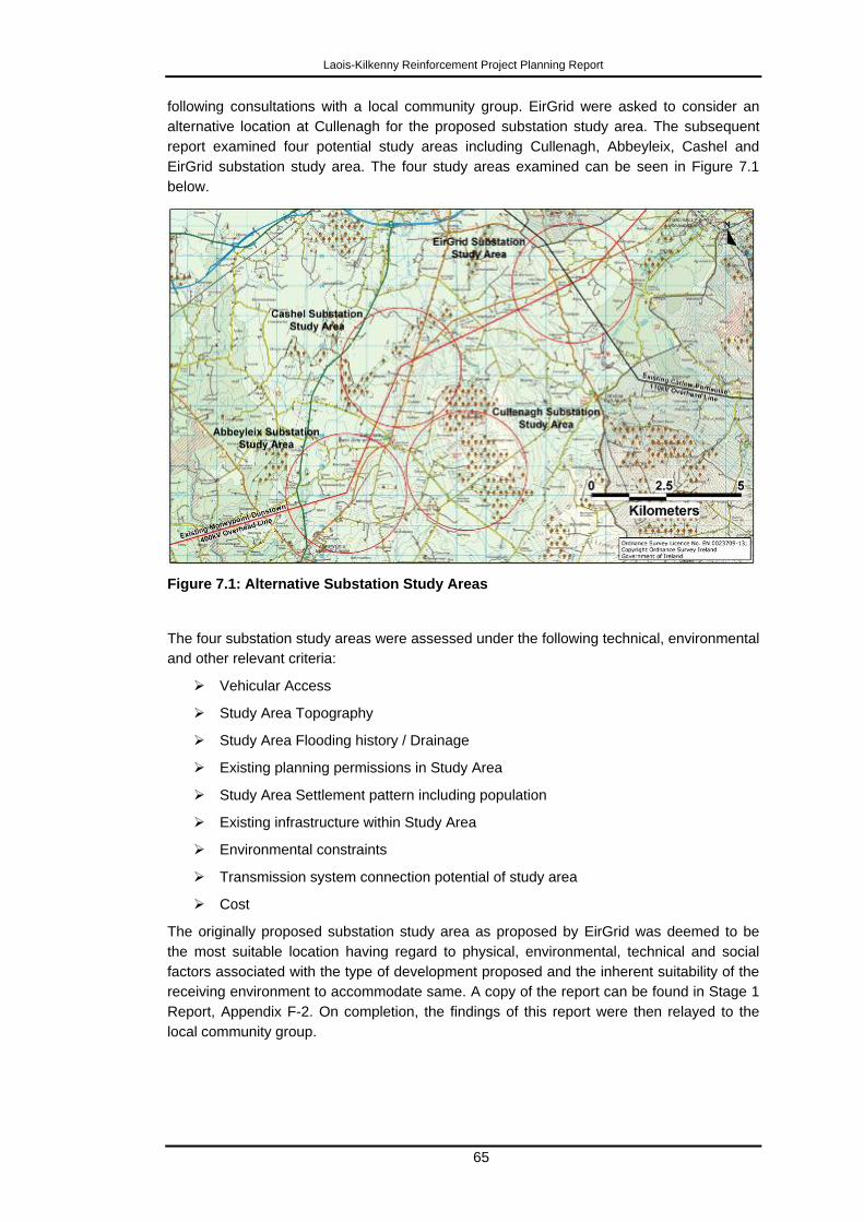
Laois-Kilkenny Reinforcement Project Planning Report
65
following consultations with a local community group. EirGrid were asked to consider an
alternative location at Cullenagh for the proposed substation study area. The subsequent
report examined four potential study areas including Cullenagh, Abbeyleix, Cashel and
EirGrid substation study area. The four study areas examined can be seen in Figure 7.1
below.
Figure 7.1: Alternative Substation Study Areas
The four substation study areas were assessed under the following technical, environmental
and other relevant criteria:
Vehicular Access
Study Area Topography
Study Area Flooding history / Drainage
Existing planning permissions in Study Area
Study Area Settlement pattern including population
Existing infrastructure within Study Area
Environmental constraints
Transmission system connection potential of study area
Cost
The originally proposed substation study area as proposed by EirGrid was deemed to be
the most suitable location having regard to physical, environmental, technical and social
factors associated with the type of development proposed and the inherent suitability of the
receiving environment to accommodate same. A copy of the report can be found in Stage 1
Report, Appendix F-2. On completion, the findings of this report were then relayed to the
local community group.
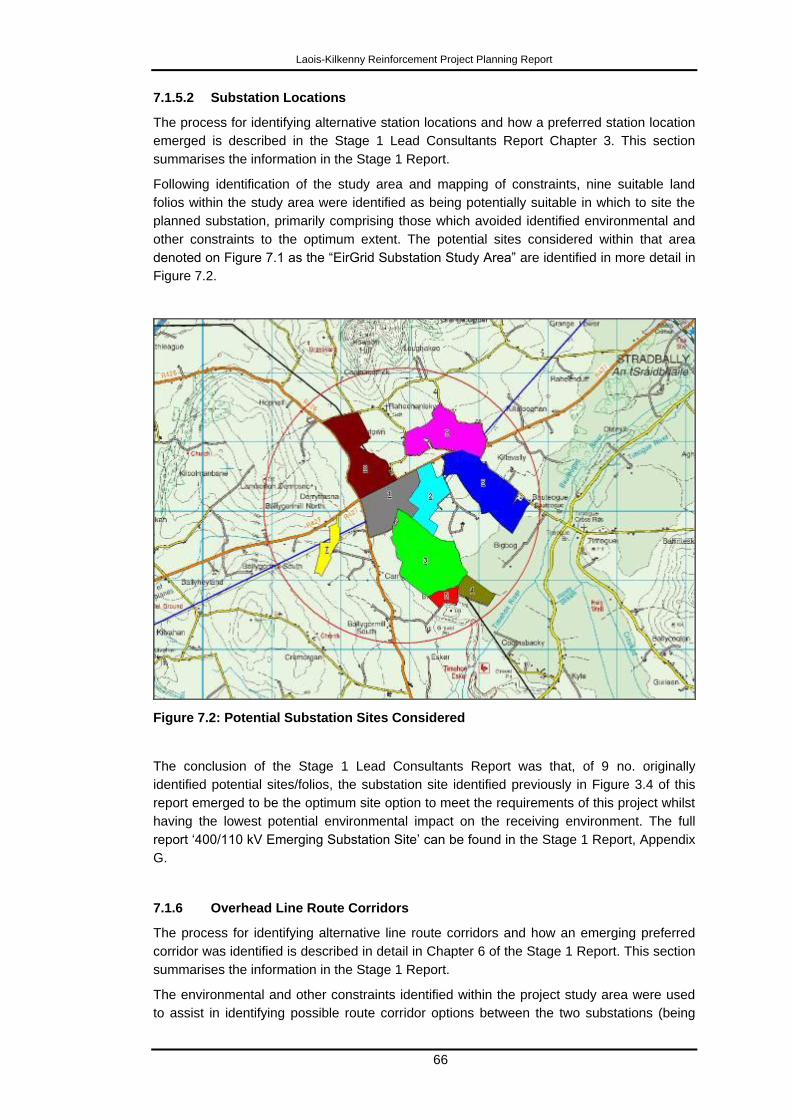
Laois-Kilkenny Reinforcement Project Planning Report
66
7.1.5.2 Substation Locations
The process for identifying alternative station locations and how a preferred station location
emerged is described in the Stage 1 Lead Consultants Report Chapter 3. This section
summarises the information in the Stage 1 Report.
Following identification of the study area and mapping of constraints, nine suitable land
folios within the study area were identified as being potentially suitable in which to site the
planned substation, primarily comprising those which avoided identified environmental and
other constraints to the optimum extent. The potential sites considered within that area
denoted on Figure 7.1 as the “EirGrid Substation Study Area” are identified in more detail in
Figure 7.2.
Figure 7.2: Potential Substation Sites Considered
The conclusion of the Stage 1 Lead Consultants Report was that, of 9 no. originally
identified potential sites/folios, the substation site identified previously in Figure 3.4 of this
report emerged to be the optimum site option to meet the requirements of this project whilst
having the lowest potential environmental impact on the receiving environment. The full
report „400/110 kV Emerging Substation Site‟ can be found in the Stage 1 Report, Appendix
G.
7.1.6 Overhead Line Route Corridors
The process for identifying alternative line route corridors and how an emerging preferred
corridor was identified is described in detail in Chapter 6 of the Stage 1 Report. This section
summarises the information in the Stage 1 Report.
The environmental and other constraints identified within the project study area were used
to assist in identifying possible route corridor options between the two substations (being
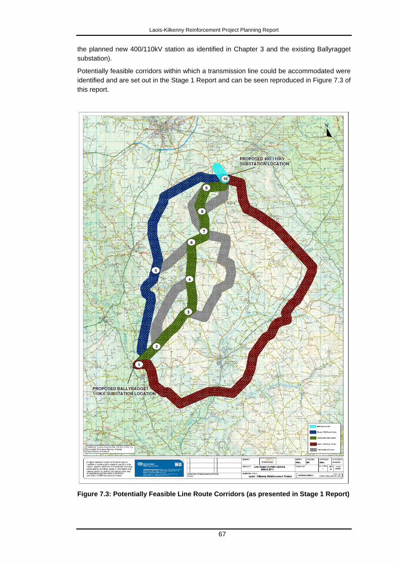
Laois-Kilkenny Reinforcement Project Planning Report
67
the planned new 400/110kV station as identified in Chapter 3 and the existing Ballyragget
substation).
Potentially feasible corridors within which a transmission line could be accommodated were
identified and are set out in the Stage 1 Report and can be seen reproduced in Figure 7.3 of
this report.
Figure 7.3: Potentially Feasible Line Route Corridors (as presented in Stage 1 Report)
Laois-Kilkenny Reinforcement Project Planning Report
68
The following describes at a high level how these corridors were selected and the
characteristics associated with each:
Identification of Feasible Route Corridor Options
Having regard to the constraints identified within the project study area (summarised
previously in this report), a number of feasible route corridors, within which a transmission
line could potentially be accommodated were then identified. The identified corridors
avoided the identified constraints to the greatest extent practicable or feasible. These can
be broadly classified as a western corridor, a central corridor and an eastern corridor. A
number of „sub-options‟ were also developed having regard to the constraints identified. The
corridors were typically 1km wide and the reasons for selecting same are as follows:
Western Corridor (28km)
The western corridor (Nodes 1-5-10) was primarily selected as it follows the route of
the existing Ballyragget-Portlaoise 38 kV line and is therefore an established
powerline corridor (albeit for a lower voltage line than is being proposed in this
instance). Further north, the western corridor changes direction and follows the
route of the existing 400 kV Moneypoint-Dunstown overhead line towards the
identified Coolnabacky substation site.
Central Corridor (and variants) (c.26km)
The central corridor was selected as it is the most direct route that minimises the
impacts on the majority of the constraints identified. This corridor, and it‟s
variants/sub-options, largely avoid the main population centres and associated one
off housing, as well as keeping to the transitional upland plains (off ridgelines and
out of river valleys). Where constraints were unavoidable, variant sub-corridors
were identified and considered.
The reasons for selecting these were as follows:
Node 1-3: Established to follow the existing 38 kV line route, however this route
traverses higher ground and a designated high amenity area.
Node 2-4: Established as an alternative to Node 2-3-4: which mainly avoids the
aforementioned High Amenity Area (although not entirely as it is constrained from
doing so by the cSAC to the north).
Node 4-6: Established to minimise impact on cSAC by crossing river at a narrow
point (Boleybeg Bridge North on a tributary of the Owenbeg river). Neither of the
supporting structures (polesets) are within the cSAC at this crossing point.
Node 3-7: An alternative to 4-6 which was established to avoid forestry, higher
ground and the cSAC.
Node 5-6: An alternative off the western corridor established to avoid Abbeyleix,
Ballyroan and the existing 38 kV and 400 kV lines.
Nodes 6-7-8: Chosen to avoid traversing the higher ground of Cullenagh Mountain.
Node 7-9 is an alternative to this.
Nodes 8-10 and Nodes 8-9-10: Corridor options for connecting to the Coolnabacky
substation site. These options have regard for housing, Timahoe village and
Timahoe Esker.
Laois-Kilkenny Reinforcement Project Planning Report
69
Eastern Corridor (44km)
This corridor (Nodes 1-10) is the longest of the alternatives as it attempts to avoid
the high amenity area to the east of Ballyragget. It is further constrained by
Castlecomer and associated one off housing/ribbon development along the
N77/N78, which results in a limited number of locations being available to cross
these roads, as well being constrained by the Barrow and Nore cSAC.
400 kV Corridor (1.8km)
This corridor is determined by the identified site location of the proposed substation
at Coolnabacky and routing options from the Moneypoint-Dunstown 400 kV line to
same. It parallels the existing 110 kV Portlaoise-Athy line route.
Assessment of Route Corridor Options
Following identification of the above corridors, a qualitative multi-criteria comparative
evaluation of all corridors was undertaken, ensuring the input of each technical and
environmental specialist discipline. This resulted in corridors, or parts thereof being
designated as Emerging Preferred, Less Preferred and Least Preferred. The objective was
to identify a corridor (or indeed a composite corridor) that on balance had the least overall
impact on the identified constraints.
Human Beings: The central corridor has the lowest population (124 addresses) when
compared with the other corridor options (west 442 and east 330). The central corridor is
the least constrained in terms of population numbers and population density and would
present relatively more options for line routing. It is therefore the preferred option with
respect to Human Beings.
Cultural Heritage: The central corridor was most preferred on the basis that it contains the
lowest number of cultural heritage sites, and does not contain any large clusters of
archaeological monuments or NIAH structures. The overall density of monuments in this
corridor is also low (0 National Monuments - however 1 has subsequently been confirmed
as being a National Monument, 0 NIAH structures, 23 recorded monuments). The central
corridor is therefore the preferred option with respect to Cultural Heritage.
Landscape: The central corridor is preferred as it minimises landscape and visual impacts
more than the alternative corridors considered, given the topography and characteristics of
the receiving environment.
Ecology: The emerging preferred corridor is the central corridor. The corridor passes over
higher ground of the Castlecomer Plateau so is somewhat removed from the habitats and
species of interest along the River Nore lowlands. The corridor involves one single crossing
at a narrow section of the cSAC. The western corridor would also need to cross the cSAC,
also passes close to the sensitive environment of Lisbigney bog, and is close to lowland
areas that are frequented by wintering waterbirds and as such could interfere with
flightpaths. The eastern corridor is least preferred as it is the longest and will therefore have
the largest construction footprint. Additionally it would need to cross cSAC twice and also
passes over Coan Bog NHA.
Soils and Geology: The least preferred options were western corridor (node 1-5) and
eastern corridor (1-10) due to the presence of blanket peat. The central corridor was
preferred, however it was noted that potential impacts at all other nodes would be similar
throughout. There is an identified site of geological significance (Timahoe Esker) near the
Coolnabacky substation site.
Laois-Kilkenny Reinforcement Project Planning Report
70
Hydrology and Hydrogeology: It was noted that the level of impact for all options was slight
negative and moderate negative for all corridor options however the western corridor (nodes
5-10), eastern corridor (nodes 1-10), and the 400 kV corridor were least preferred due to the
presence of both regionally and locally important sand and gravel and bedrock aquifers. The
most preferred corridor was central corridor (variant). It should be noted that such potential
constraints are generally overcome by means of good construction practice in line
development.
The findings of these assessments are set out in detail in the Stage 1 report and associated
appendices. They are included on CD as part of this application and continue to remain
freely available online on the project website.
http://www.eirgridprojects.com/projects/laoiskilkenny/phaseonereports/
The corridor evaluation process resulted in the central corridor being identified as the
emerging preferred option, in the Stage 1 Report. Some disciplines preferred a Node 2-3-4
whilst another preferred 2-4. Node 2-4 was considered to have the least impact on the
designated High Amenity Area and its associated Scenic Views whilst Node 7-9 and 7-8-9
were amalgamated as they overlapped substantially and both were considered equally
feasible.
Even though each corridor option was initially considered by each environmental discipline
in isolation, all identified the central corridor as being the most preferred. It should be noted
that as per EirGrid‟s Project Development and Consultation Roadmap, no decision is made
in this regard at this stage of project development; rather the findings of the Stage 1
Information Gathering stage form the basis and focus for public and stakeholder
consultation and engagement, with the intention of receiving valuable feedback.
In this regard, following this Stage 1 evaluation, the emerging preferred corridor and
associated Stage 1 report were issued to all stakeholders for consideration and feedback in
May 2011.
Stage 2 began by considering all feedback in respect of the publication of the emerging
preferred corridor.
A minor modification (corridor widened by 30m at node 7) was made to the emerging
preferred corridor due to line route design within that corridor.
A second minor modification (corridor widened by 600m at node 9-10) was made to the
emerging preferred corridor due to line routing exercise which sought to avoid the Timahoe
Esker.
In general no feedback emerged during this period of consultation which required EirGrid to
fundamentally re-appraise its process, information gathered, evaluation or conclusions.
During Stage 2 of the roadmap process, all corridor options were re-evaluated again in light
of modifications made above and also in light of all other stakeholder feedback received. It
concluded that the preferred corridor remained the emerging preferred corridor as
previously identified in Stage 1, with the two minor modifications described above.
Thus by the end of Stage 2, a preferred corridor had been identified that on balance,
generally avoids the constraints identified as far as is reasonably possible (the use of the
term „preferred‟ in this context should be considered to constitute a „best-fit‟ or „least-
constrained‟ option). It is not suggested that there will be no impact associated with such
infrastructural developments – zero impact is not possible – but it does seek to minimise
impacts on all identified constraints, primarily by means of avoiding them in the first instance.

Laois-Kilkenny Reinforcement Project Planning Report
71
Following confirmation of the preferred route corridor the next step in EirGrid‟s Roadmap
process, is the identification of a feasible line route within that corridor. The most significant
constraint here is generally the avoidance of houses and avoidance of other constraints that
the corridor itself has not been able to avoid given its 1km width (e.g cSAC river crossing),
or that encroach into the corridor boundary. The line route identification process generally
occurs in the context of direct landowner engagement (where possible and which has
generally occurred in this instance), and on site surveys and assessment. This continues up
to the submission of the application for the proposed development with associated
environmental assessment.
The overhead line route selection process attempts to generally avoid many changes of
direction, which in turn minimises the number of steel angle towers required, and maximises
the number of straight runs supported on the wood polesets.
The preliminary indicative overhead line route is set out in the Stage 2 Report and is seen
reproduced in Figure 7.4 of this report.
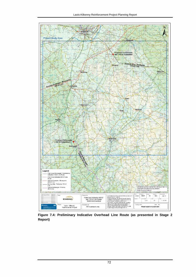
Laois-Kilkenny Reinforcement Project Planning Report
72
Figure 7.4: Preliminary Indicative Overhead Line Route (as presented in Stage 2
Report)
Laois-Kilkenny Reinforcement Project Planning Report
73
7.2 Amendments to Indicative Line Route
Following feedback from landowners and from the environmental consultants, and as a
result of landowner engagement, walkover and desktop studies, a number of localised
modifications were made to the initial indicative 110 kV line route issued to the landowners.
The majority of the modifications are only moves of a few metres and were requested by
either the environmental specialists or the line route designer to improve upon the original
indicative line route. Other modifications were requested by the landowners, some of which
were significant and the environmental consultants were requested to review these further.
At the time of publication of the Stage 2 report, only angle tower locations (used where the
line changes direction and the structures that therefore actually determine the alignment)
were identified - intermediate poleset locations had not been determined. Where
landowners did not consent to environmental consultants entering lands to carry out
surveys, some angle masts have been placed on improved grasslands with less ecological
value than hedgerows.
Stage 3 appraised in more detail the previously identified route for the OHL. Refinements to
the OHL generally arose as a result of the engagement process with landowners and other
directly affected parties. Where possible, requests for changes were accommodated.
7.3 Conclusion
As a result of the iterative project development process, in reference to the Project
Development Roadmap, and having regard to careful consideration of alternatives, a final
project solution emerged and is the subject of this application for planning approval.
Laois-Kilkenny Reinforcement Project Planning Report
74
8 Description of the Proposed Transmission
Infrastructure
8.1 Project Description
The proposed Laois-Kilkenny Reinforcement Project consists of the following inter-related
elements:
development of a new 400/110 kV Gas Insulated Switchgear (GIS) substation at
Coolnabacky townland, north of Timahoe, Co. Laois;
new connections to the proposed Coolnabacky substation from the existing
Moneypoint - Dunstown 400 kV and Athy – Portlaoise 110 kV overhead lines;
development of a new 110kV / 38kV / MV substation in Ballyragget, Co. Kilkenny
adjacent to the existing 38 kV/MV substation, this will replace the existing
substation which will eventually be decommissioned;
development of a new 110 kV overhead line (OHL) between Ballyragget and
Coolnabacky;
an upgrade to the existing Ballyragget - Kilkenny 110 kV overhead line, and;
a new bay in the existing Kilkenny 110 kV substation.
The statutory notices in Volume 1 provide a full description of the proposed development
that is the subject of the application for planning approval.
8.2 Project Units
Following iterative site selection, route selection and design process, each component of
this project can now be described in more detail and as such has been broken down into a
number of 'project units' as illustrated in Figure 8.1.
The locations of all structures (substation, OHL and UGC) referred to in this section are
identified on 8 no. drawings (PE687-D261-026-001-001 to PE687-D261-026-008-001),
which form part of the Volume 1 -Statutory Particulars, submitted as part of this planning
application.
These drawings show the proposed development in the context of all the various constraints.
The Explanation of Technical Terms provided as part of this Planning Report will assist in
understanding the technical acronyms used in this section.
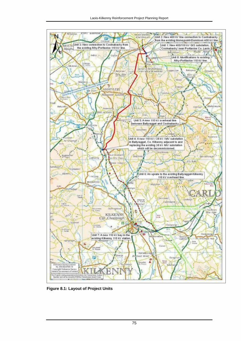
Laois-Kilkenny Reinforcement Project Planning Report
75
Figure 8.1: Layout of Project Units
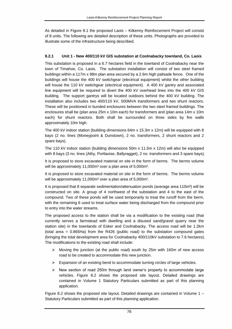
Laois-Kilkenny Reinforcement Project Planning Report
76
As detailed in Figure 8.1 the proposed Laois – Kilkenny Reinforcement Project will consist
of 8 units. The following are detailed description of these units. Photographs are provided to
illustrate some of the infrastructure being described.
8.2.1 Unit 1 - New 400/110 kV GIS substation at Coolnabacky townland, Co. Laois
This substation is proposed in a 6.7 hectares field in the townland of Coolnabacky near the
town of Timahoe, Co. Laois. The substation installation will consist of two steel framed
buildings within a 117m x 98m plan area secured by a 2.6m high palisade fence. One of the
buildings will house the 400 kV switchgear (electrical equipment) whilst the other building
will house the 110 kV switchgear (electrical equipment). A 400 kV gantry and associated
line equipment will be required to divert the 400 kV overhead lines into the 400 kV GIS
building. The support gantrys will be located outdoors behind the 400 kV building. The
installation also includes two 400/110 kV, 500MVA transformers and two shunt reactors.
These will be positioned in bunded enclosures between the two steel framed buildings. The
enclosures shall be (plan area 25m x 10m each) for transformers and (plan area 14m x 10m
each) for shunt reactors. Both shall be surrounded on three sides by fire walls
approximately 10m high.
The 400 kV indoor station (building dimensions 64m x 15.3m x 12m) will be equipped with 8
bays (2 no. lines (Moneypoint & Dunstown), 2 no. transformers, 2 shunt reactors and 2
spare bays).
The 110 kV indoor station (building dimensions 50m x 11.5m x 12m) will also be equipped
with 8 bays (3 no. lines (Athy, Portlaoise, Ballyragget), 2 no. transformers and 3 spare bays).
It is proposed to store excavated material on site in the form of berms. The berms volume
will be approximately 11,000m³ over a plan area of 5,000m².
It is proposed to store excavated material on site in the form of berms. The berms volume
will be approximately 11,000m³ over a plan area of 5,000m².
It is proposed that 8 separate sedimentation/attenuation ponds (average area 110m²) will be
constructed on site. A group of 4 northwest of the substation and 4 to the east of the
compound. Two of these ponds will be used temporarily to treat the runoff from the berm,
with the remaining 6 used to treat surface water being discharged from the compound prior
to entry into the water streams.
The proposed access to the station shall be via a modification to the existing road (that
currently serves a farmstead with dwelling and a disused sand/gravel quarry near the
station site) in the townlands of Esker and Coolnabacky. The access road will be 1.2km
(total area = 0.865Ha) from the R426 (public road) to the substation compound gates
(bringing the total development area for Coolnabacky 400/110kV substation to 7.6 hectares).
The modifications to the existing road shall include:
Moving the junction (at the public road) south by 25m with 160m of new access
road to be created to accommodate this new junction.
Expansion of an existing bend to accommodate turning circles of large vehicles.
New section of road 250m through land owner‟s property to accommodate large
vehicles. Figure 8.2 shows the proposed site layout. Detailed drawings are
contained in Volume 1 Statutory Particulars submitted as part of this planning
application.
Figure 8.2 shows the proposed site layout. Detailed drawings are contained in Volume 1 –
Statutory Particulars submitted as part of this planning application.
Laois-Kilkenny Reinforcement Project Planning Report
77
Figure 8.2: Site Layout of the Proposed Coolnabacky GIS Substation
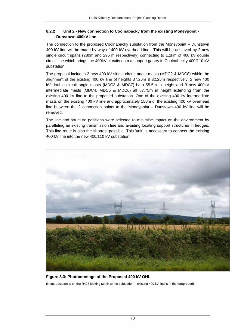
Laois-Kilkenny Reinforcement Project Planning Report
78
8.2.2 Unit 2 - New connection to Coolnabacky from the existing Moneypoint -
Dunstown 400kV line
The connection to the proposed Coolnabacky substation from the Moneypoint – Dunstown
400 kV line will be made by way of 400 kV overhead line. This will be achieved by 2 new
single circuit spans (280m and 295 m respectively) connecting to 1.2km of 400 kV double
circuit line which brings the 400kV circuits onto a support gantry in Coolnabacky 400/110 kV
substation.
The proposal includes 2 new 400 kV single circuit angle masts (MDC2 & MDC8) within the
alignment of the existing 400 kV line of heights 37.25m & 32.25m respectively; 2 new 400
kV double circuit angle masts (MDC3 & MDC7) both 55.5m in height and 3 new 400kV
intermediate masts (MDC4, MDC5 & MDC6) all 57.75m in height extending from the
existing 400 kV line to the proposed substation. One of the existing 400 kV intermediate
masts on the existing 400 kV line and approximately 150m of the existing 400 kV overhead
line between the 2 connection points to the Moneypoint – Dunstown 400 kV line will be
removed.
The line and structure positions were selected to minimise impact on the environment by
paralleling an existing transmission line and avoiding locating support structures in hedges.
This line route is also the shortest possible. This 'unit' is necessary to connect the existing
400 kV line into the new 400/110 kV substation.
Figure 8.3: Photomontage of the Proposed 400 kV OHL
(Note: Location is on the R427 looking south to the substation – existing 400 kV line is in the foreground)

Laois-Kilkenny Reinforcement Project Planning Report
79
8.2.3 Unit 3 - New connection to Coolnabacky from the existing Athy - Portlaoise
110 kV line
The proposed Coolnabacky substation is situated beside the Athy – Portlaoise 110kV line.
It is proposed to replace intermediate polesets AP98 and AP99 with lattice steel line/cable
interface masts approximately 21m in height (both these structures contained on the
Coolnabacky site). These structures have a generally similar scale and character to the
existing angle towers on this circuit. Short lengths of cable will connect the new line/cable
interface masts AP98 (100m) and AP99 (190m) into the 110kV building within the
Coolnabacky compound.
Approximately 150m of existing overhead line will be removed between AP98 and AP99.
This 'unit' is necessary to connect the existing 110 kV line into the new 400/110 kV
substation.
Figure 8.4: Photograph of a 110 kV Earthwire Line/Cable Interface Mast
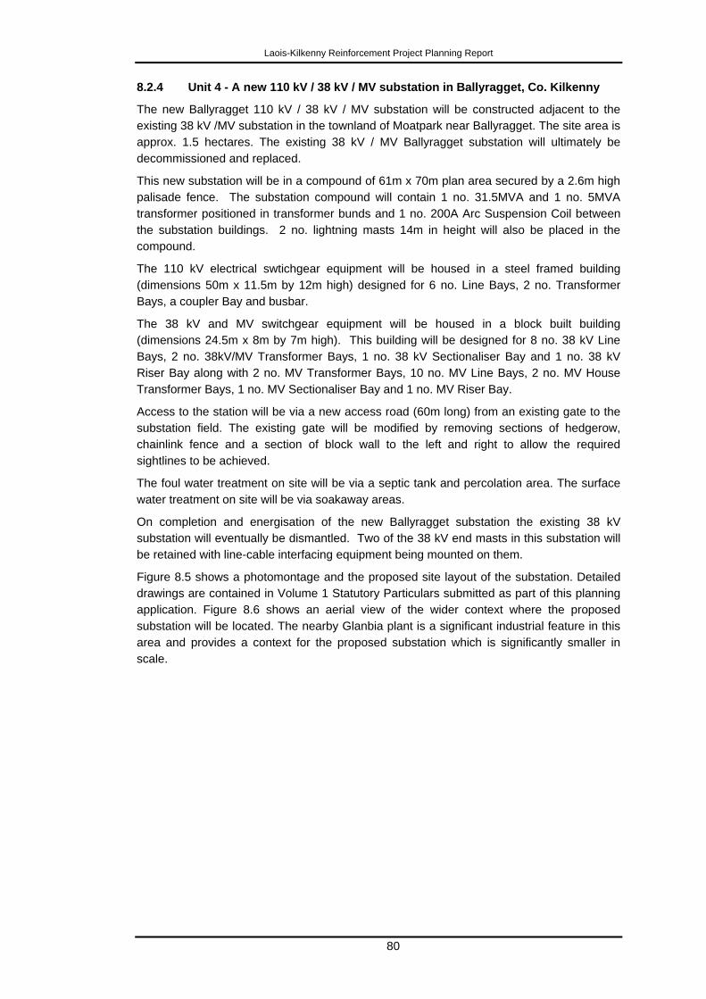
Laois-Kilkenny Reinforcement Project Planning Report
80
8.2.4 Unit 4 - A new 110 kV / 38 kV / MV substation in Ballyragget, Co. Kilkenny
The new Ballyragget 110 kV / 38 kV / MV substation will be constructed adjacent to the
existing 38 kV /MV substation in the townland of Moatpark near Ballyragget. The site area is
approx. 1.5 hectares. The existing 38 kV / MV Ballyragget substation will ultimately be
decommissioned and replaced.
This new substation will be in a compound of 61m x 70m plan area secured by a 2.6m high
palisade fence. The substation compound will contain 1 no. 31.5MVA and 1 no. 5MVA
transformer positioned in transformer bunds and 1 no. 200A Arc Suspension Coil between
the substation buildings. 2 no. lightning masts 14m in height will also be placed in the
compound.
The 110 kV electrical swtichgear equipment will be housed in a steel framed building
(dimensions 50m x 11.5m by 12m high) designed for 6 no. Line Bays, 2 no. Transformer
Bays, a coupler Bay and busbar.
The 38 kV and MV switchgear equipment will be housed in a block built building
(dimensions 24.5m x 8m by 7m high). This building will be designed for 8 no. 38 kV Line
Bays, 2 no. 38kV/MV Transformer Bays, 1 no. 38 kV Sectionaliser Bay and 1 no. 38 kV
Riser Bay along with 2 no. MV Transformer Bays, 10 no. MV Line Bays, 2 no. MV House
Transformer Bays, 1 no. MV Sectionaliser Bay and 1 no. MV Riser Bay.
Access to the station will be via a new access road (60m long) from an existing gate to the
substation field. The existing gate will be modified by removing sections of hedgerow,
chainlink fence and a section of block wall to the left and right to allow the required
sightlines to be achieved.
The foul water treatment on site will be via a septic tank and percolation area. The surface
water treatment on site will be via soakaway areas.
On completion and energisation of the new Ballyragget substation the existing 38 kV
substation will eventually be dismantled. Two of the 38 kV end masts in this substation will
be retained with line-cable interfacing equipment being mounted on them.
Figure 8.5 shows a photomontage and the proposed site layout of the substation. Detailed
drawings are contained in Volume 1 Statutory Particulars submitted as part of this planning
application. Figure 8.6 shows an aerial view of the wider context where the proposed
substation will be located. The nearby Glanbia plant is a significant industrial feature in this
area and provides a context for the proposed substation which is significantly smaller in
scale.
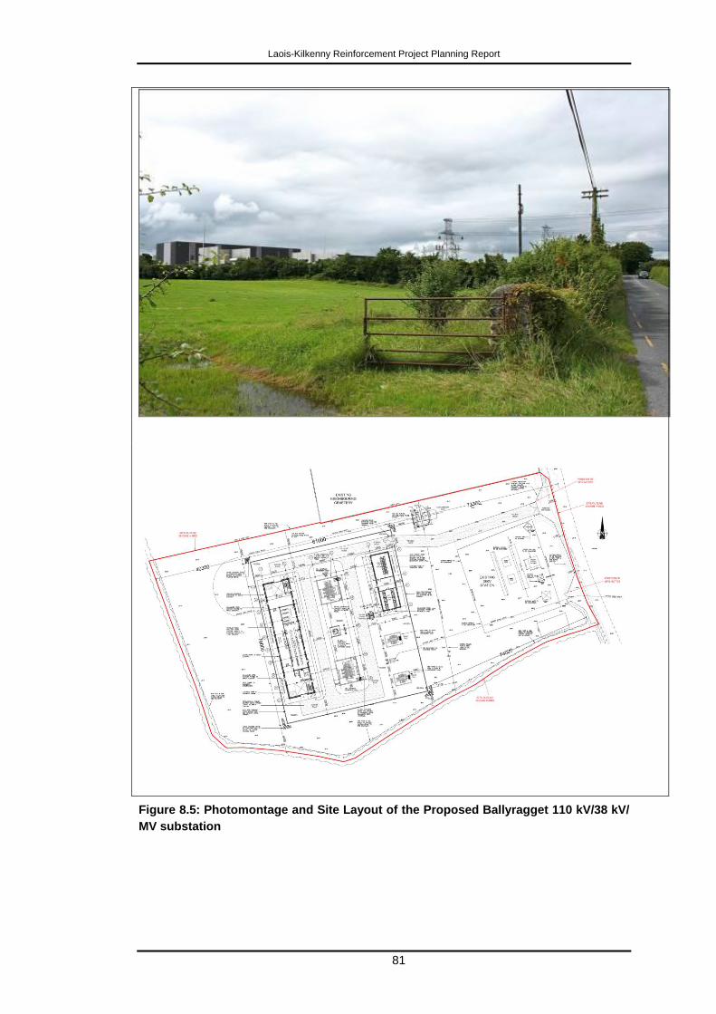
Laois-Kilkenny Reinforcement Project Planning Report
81
Figure 8.5: Photomontage and Site Layout of the Proposed Ballyragget 110 kV/38 kV/
MV substation
Laois-Kilkenny Reinforcement Project Planning Report
82
Figure 8.6: Aerial View of the Ballyragget Substation Location
(Note: The nearby Glanbia plant is a significant industrial feature in this area and provides a context for the
proposed substation which is significantly smaller in scale.
8.2.5 Unit 5 - A new 110 kV overhead line between Ballyragget and Coolnabacky
This 110 kV circuit will consist of 26km of overhead line and 2 short lengths of cable at
Ballyragget and Coolnabacky substations. The overhead line will consist of 143 double
wood polesets with height above ground level ranging from 13.7m to 21.7m and 17 lattice
steel angle masts with height above ground level ranging from 18m to 24.5m supporting
three electrical conductors and two earthwires.
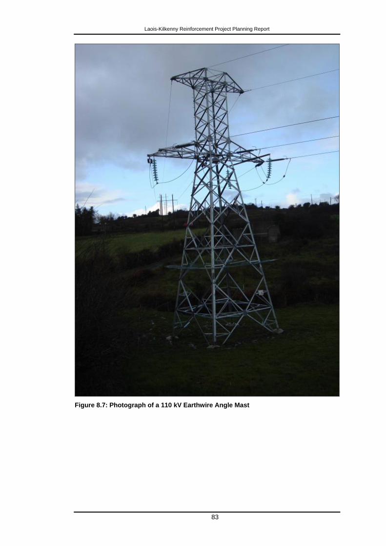
Laois-Kilkenny Reinforcement Project Planning Report
83
Figure 8.7: Photograph of a 110 kV Earthwire Angle Mast
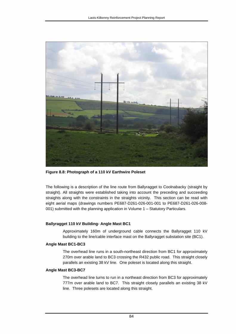
Laois-Kilkenny Reinforcement Project Planning Report
84
Figure 8.8: Photograph of a 110 kV Earthwire Poleset
The following is a description of the line route from Ballyragget to Coolnabacky (straight by
straight). All straights were established taking into account the preceding and succeeding
straights along with the constraints in the straights vicinity. This section can be read with
eight aerial maps (drawings numbers PE687-D261-026-001-001 to PE687-D261-026-008-
001) submitted with the planning application in Volume 1 – Statutory Particulars.
Ballyragget 110 kV Building- Angle Mast BC1
Approximately 160m of underground cable connects the Ballyragget 110 kV
building to the line/cable interface mast on the Ballyragget substation site (BC1).
Angle Mast BC1-BC3
The overhead line runs in a south-northeast direction from BC1 for approximately
270m over arable land to BC3 crossing the R432 public road. This straight closely
parallels an existing 38 kV line. One poleset is located along this straight.
Angle Mast BC3-BC7
The overhead line turns to run in a northeast direction from BC3 for approximately
777m over arable land to BC7. This straight closely parallels an existing 38 kV
line. Three polesets are located along this straight.
Laois-Kilkenny Reinforcement Project Planning Report
85
Angle Mast BC7-BC10
The overhead line turns away from paralleling an existing 38 kV line due to the
presence of a farmstead which causes the route to run in a northerly direction
from BC7 for approximately 623m over arable land to BC10 crossing over a local
public road. Two polesets are located along this straight.
Angle Mast BC10-BC18
To avoid housing the overhead line turns to run in a northeast direction from BC10
for approximately 1.4km over arable land to BC18. Seven polesets are located
along this straight. This places the line route in the transition area between the
lowlands and highlands of an area described as Zone A in the Landscape section
of the Environmental Report – this area is considered to have the best absorption
capacity for the proposed development both from lowlying and high vantage
points, while keeping out of the Special Protection Area as defined by Kilkenny
County Council.
The high absorption capacity arises from the existence between BC 27 and BC 39
of conditions that are very favourable for minimising visual effects – namely
paralleling the treeline of established forestry and following a „breakline‟ of
concavity in the topography which ensures that the line will be minimally visible
from the sensitive Scenic Route V19.
Angle Mast BC18-BC27
Again to avoid housing and get to suitable road crossings the overhead line turns
to run in a north-northeast direction from BC18 for approximately 1.6km over
arable land to BC27 crossing over two local public roads. Eight polesets are
located along this straight.
Angle Mast BC27-BC32
The overhead line turns to run in a north direction to avoid a Scenic Amenity Area
from BC27 for approximately 806m over arable land to BC32. Four polesets are
located along this straight.
Angle Mast BC32-BC41
The overhead line turns to run in a north-northwest direction from BC32 for
approximately 1.4km over arable land to BC41 crossing over a local access road
whilst continuing to avoid a Scenic Amenity area and housing. Eight polesets are
located along this straight.
Angle Mast BC41-BC46
The overhead line turns to run in a northeast direction from BC41 for
approximately 952m over arable land to BC46 crossing an access road. This
straight encroaches upon the Scenic Amenity area to avoid a cSAC and housing.
Four polesets are located along this straight.
Angle Mast BC46-BC53
The overhead line turns to run in a north-northeast direction from BC46 for
approximately 1.16km over arable land to BC53 crossing over three local public
roads and crosses the county border from Co. Kilkenny to Co. Laois. The straight
avoids a cSAC and several houses. Seven polesets are located along this
straight.

Laois-Kilkenny Reinforcement Project Planning Report
86
Angle Mast BC53-BC72
The overhead line turns to run in a northeast direction from BC53 for
approximately 3.29km over mainly arable land with the exception of approximately
50m of commercial forestry to BC72 crossing 1 public road. The straight avoids a
cSAC and a privately owned Heliport leading it to higher ground. Eighteen
polesets are located along this straight.
Angle Mast BC72-BC85
The overhead line turns to run in a north direction from BC72 for approximately
2.03km over mainly arable land with the exception of approximately 800m of
commercial forestry to BC85 crossing two local public roads and thereby avoiding
crossing the higher ridgelines. Twelve polesets are located along this straight.
Angle Mast BC85-BC90
The overhead line turns to run in a northwest direction from BC85 for
approximately 926m over arable land to BC90 crossing the R430 public road, a
further local public road and a cSAC. This straight crosses the SAC over a road
bridge in order to minimise impact on the cSAC. Four polesets are located along
this straight.
Angle Mast BC90-BC112
The overhead line turns to run in a north-northeast direction from BC90 for
approximately 4.13km over mainly arable land with the exception of approximately
940m of commercial forestry to BC112 crossing one local road. This straight has
a low amount of constraints which allows for a long straight. Twenty one polesets
are located along this straight.
Angle Mast BC112-BC117
The overhead line turns to run in a northwest direction from BC112 for
approximately 770m over arable land to BC117 crossing a regional public road.
This straight establishes a suitable road crossing point while avoiding housing
associated views towards the Special Area of Development Control. Four polesets
are located along this straight.
Angle Mast BC117-BC141
The overhead line turns to run in a north-northeast direction from BC117 for
approximately 4.28km over mainly arable land with the exception of approximately
835m of commercial forestry to BC141 crossing two public roads. This straight
has a low amount of constraints which allows for a long straight and is influenced
by housing at road crossings. Twenty three polesets are located along this
straight.
Angle Mast BC141-BC150
The overhead line turns to run in an east direction from BC141 for approximately
1.6km over arable land to BC150 (in the Coolnabacky substation site) crossing the
R426 public road. This straight also has a low amount of constraints which allows
for a long straight and is influenced by housing at road crossings. Eight polesets
are located along this straight.
Angle Mast BC150-Coolnabacky 110 kV Building
Approximately 190m of underground cable connects the line/cable interface mast
on the site (BC150) to the 110 kV building in the Coolnabacky compound.
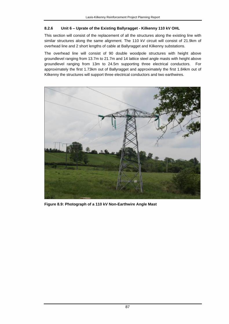
Laois-Kilkenny Reinforcement Project Planning Report
87
8.2.6 Unit 6 – Uprate of the Existing Ballyragget - Kilkenny 110 kV OHL
This section will consist of the replacement of all the structures along the existing line with
similar structures along the same alignment. The 110 kV circuit will consist of 21.9km of
overhead line and 2 short lengths of cable at Ballyragget and Kilkenny substations.
The overhead line will consist of 90 double woodpole structures with height above
groundlevel ranging from 13.7m to 21.7m and 14 lattice steel angle masts with height above
groundlevel ranging from 13m to 24.5m supporting three electrical conductors. For
approximately the first 1.73km out of Ballyragget and approximately the first 1.84km out of
Kilkenny the structures will support three electrical conductors and two earthwires.
Figure 8.9: Photograph of a 110 kV Non-Earthwire Angle Mast
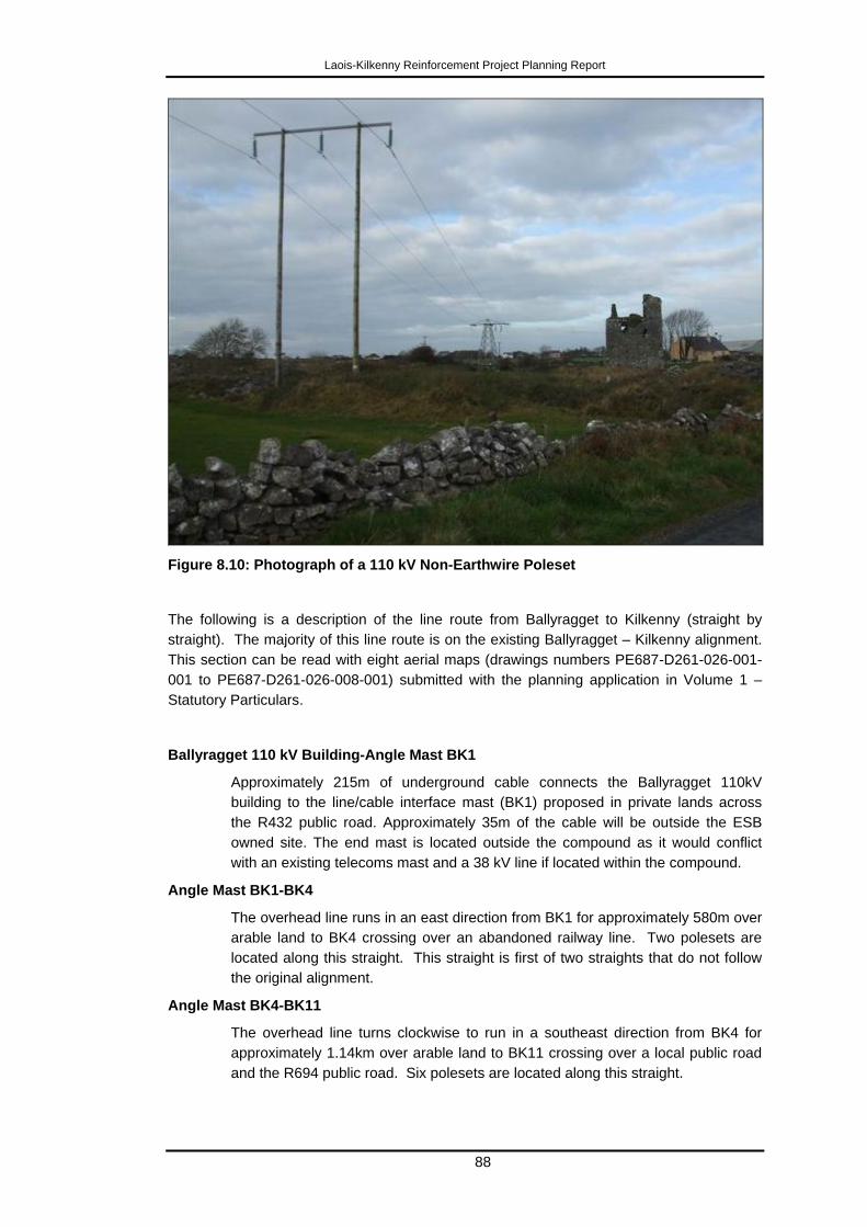
Laois-Kilkenny Reinforcement Project Planning Report
88
Figure 8.10: Photograph of a 110 kV Non-Earthwire Poleset
The following is a description of the line route from Ballyragget to Kilkenny (straight by
straight). The majority of this line route is on the existing Ballyragget – Kilkenny alignment.
This section can be read with eight aerial maps (drawings numbers PE687-D261-026-001-
001 to PE687-D261-026-008-001) submitted with the planning application in Volume 1 –
Statutory Particulars.
Ballyragget 110 kV Building-Angle Mast BK1
Approximately 215m of underground cable connects the Ballyragget 110kV
building to the line/cable interface mast (BK1) proposed in private lands across
the R432 public road. Approximately 35m of the cable will be outside the ESB
owned site. The end mast is located outside the compound as it would conflict
with an existing telecoms mast and a 38 kV line if located within the compound.
Angle Mast BK1-BK4
The overhead line runs in an east direction from BK1 for approximately 580m over
arable land to BK4 crossing over an abandoned railway line. Two polesets are
located along this straight. This straight is first of two straights that do not follow
the original alignment.
Angle Mast BK4-BK11
The overhead line turns clockwise to run in a southeast direction from BK4 for
approximately 1.14km over arable land to BK11 crossing over a local public road
and the R694 public road. Six polesets are located along this straight.
Laois-Kilkenny Reinforcement Project Planning Report
89
Angle Mast BK11-BK19
The overhead line turns clockwise to run in a south direction from BK11 for
approximately 1.42km over arable land to BK19 crossing over a local public road.
Seven polesets are located along this straight.
Angle Mast BK19-BK40
The overhead line turns anticlockwise to run in a south-southeast direction from
BK19 for approximately 4.67km over arable land to BK40 crossing over four local
public roads and two access roads. Twenty polesets are located along this
straight.
Angle Mast BL40-BK46
The overhead line turns anticlockwise to run in a southeast direction from BK40
for approximately 1.21km over arable land to BK46. Five polesets are located
along this straight.
Angle Mast BK46-BK51
The overhead line turns clockwise to run in a south-southeast direction from BK46
for approximately 1.23km over arable land to BK51 crossing over a local public
road, the N78 public road, the Dinin River and an SAC at two locations. Four
polesets are located along this straight.
Angle Mast BK51-BK62
The overhead line turns clockwise to run in a south-southeast direction from BK51
for approximately 2.62km over arable land to BK62 crossing one local public road.
Ten polesets are located along this straight.
Angle Mast BK62-BK71
The overhead line turns anticlockwise to run in a southeast direction from BK62
for approximately 1.99km over arable land to BK71 crossing two local public roads
and a local access road. Eight polesets are located along this straight.
Angle Mast BK71-BK79
The overhead line turns clockwise to run in a south-southeast direction from BK71
for approximately 1.72km over arable land to BK79. Seven polesets are located
along this straight.
Angle Mast BK79-BK89
The overhead line turns anticlockwise to run in a south-southeast direction from
BK79 for approximately 2.3km over arable land to BK89 crossing two local public
roads. Nine polesets are located along this straight.
Angle Mast BK89-BK94
The overhead line turns anticlockwise to run in a southeast direction from BK89
for approximately 1.19km over arable land to BK94. Four polesets are located
along this straight.
Angle Mast BK94-BK102
The overhead line turns clockwise to run in a south-southeast direction from BK94
for approximately 1.57km over arable land to BK102 crossing one local public
road, one access road and the N10 public road. Four polesets are located along
this straight.
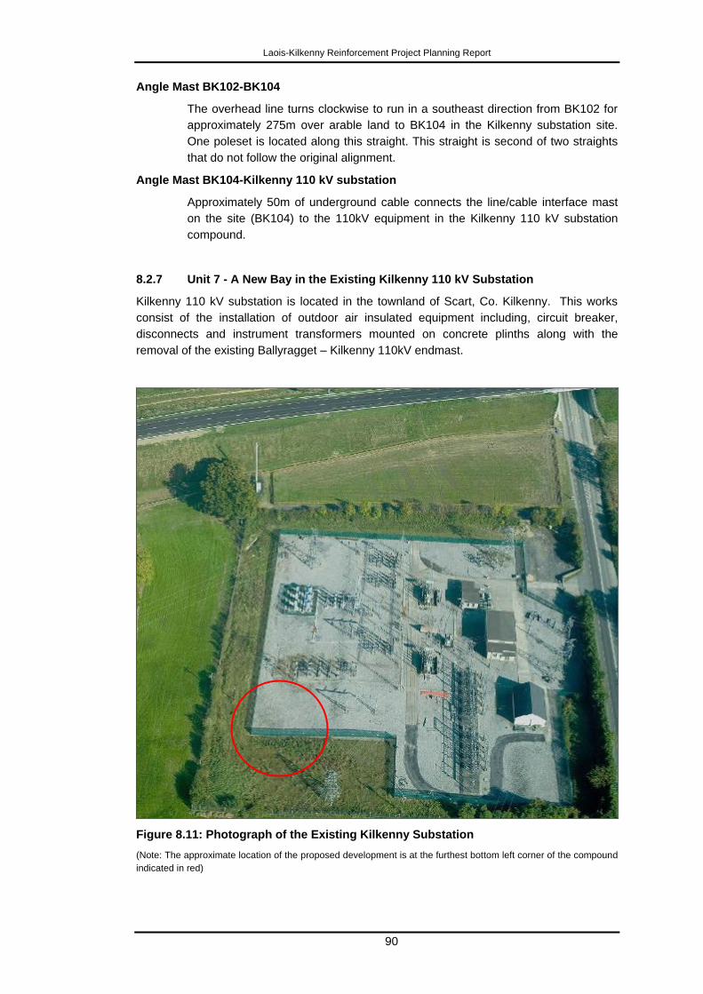
Laois-Kilkenny Reinforcement Project Planning Report
90
Angle Mast BK102-BK104
The overhead line turns clockwise to run in a southeast direction from BK102 for
approximately 275m over arable land to BK104 in the Kilkenny substation site.
One poleset is located along this straight. This straight is second of two straights
that do not follow the original alignment.
Angle Mast BK104-Kilkenny 110 kV substation
Approximately 50m of underground cable connects the line/cable interface mast
on the site (BK104) to the 110kV equipment in the Kilkenny 110 kV substation
compound.
8.2.7 Unit 7 - A New Bay in the Existing Kilkenny 110 kV Substation
Kilkenny 110 kV substation is located in the townland of Scart, Co. Kilkenny. This works
consist of the installation of outdoor air insulated equipment including, circuit breaker,
disconnects and instrument transformers mounted on concrete plinths along with the
removal of the existing Ballyragget – Kilkenny 110kV endmast.
Figure 8.11: Photograph of the Existing Kilkenny Substation
(Note: The approximate location of the proposed development is at the furthest bottom left corner of the compound
indicated in red)
Laois-Kilkenny Reinforcement Project Planning Report
91
8.2.8 Unit 8 - Modifications to Existing Athy - Portlaoise 110 kV Line
The modification is the retrofitting of earthwire onto the existing Athy – Portlaoise 110 kV
line from Coolnabacky towards Athy (AP98 to AP85) for 2.32km and from Coolnabacky
towards Portlaoise (AP 99 to AP105) for 1.29km. The purpose of earthwire is to provide
lightening protection and it is used by EirGrid in the following circumstances:
Install earthwires on the entire length of all new station-to-station transmission
lines;
Where a new line (or lines) is required to connect a new station to an existing
transmission line, install earthwire on the entire length of the new line section(s);
and
Where a new line is not required or where only a short section of new line is
required to connect a new station to the existing transmission system, earthwire
should be retrofitted, where feasible on the last two km of each existing line into
the new station.
To achieve this all structures will be replaced by similar structures except for structure
AP105 which is a poleset and will be replaced with a lattice steel angle mast. The overhead
line in this unit will consist of 17 double wood polesets with height above groundlevel
ranging from 13.7m to 21.7m and lattice steel angle masts with height above groundlevel
ranging from 18m to 24.5m supporting three electrical conductors and two earthwires (2 of
these lattice steel towers are already mentioned in section 8.2.3).
Angle Mast AP99-AP105
The overhead line runs in a northwest direction from AP99 for approximately
1.29km over arable land to AP105. Five polesets are located along this straight.
Angle Mast AP98-AP85
The overhead line runs in a southeast direction from AP98 for approximately
2.32km over arable land to AP85 crossing over one local public road. Twelve
polesets are located along this straight.
8.3 Engineering Design
8.3.1 OHL
The proposed new 400 kV overhead line circuits will have a normal conductor rating of 2473
Amps which equates to line design standard 600mm2 ACSR conductor (Bison or equivalent)
operating at 80°C.
The Ballyragget - Coolnabacky and Ballyragget - Coolnabacky 110 kV overhead line circuits
will have a normal conductor rating of 1170 Amps which equates to line design standard
430mm2 ACSR conductor (Bison or equivalent) operating at 80°C.
The Athy - Coolnabacky and Coolnabacky - Portlaoise 110 kV overhead line circuits will
have a normal conductor rating of 661 Amps which equates to line design standard
200mm2 ACSR conductor (Wolf or equivalent) operating at 80°C.
The engineering design has been significantly influenced by many factors including landuse,
environmental and other factors as previously described previously in this section.
Laois-Kilkenny Reinforcement Project Planning Report
92
8.3.2 Stations
The engineering designs of all stations are based around the electrical equipment which is
required at each station and the type of station technology being used. Full descriptions of
each station have been previously described previously in this section.
8.4 Context for Angle Masts
The location of angle masts (AM) is a significant feature of the engineering design. One of
the objectives in overhead line design is to reduce the number of such structures to a
minimum (i.e. to keep the alignment as straight as possible), having regard to the
requirement to design around identified constraints. The section of overhead line between
angle masts is referred to in technical terms as a “straight”. The rationale for each straight
has been previously explained. Units 6 and 8 are existing overhead lines so no further
explanation of these straights are required.
8.5 Underground Cable
The technical design standards for connection of 110 kV circuits to 110 kV GIS buildings
require a short underground link directly into the building. In the case of Kilkenny which is
an AIS substation due to station congestion, the optimal technical solution is a short length
of underground cable.
8.6 Construction Methodology
A detailed construction methodology statement has been prepared and is included in
Volume 3 Environmental Report. This outlines processes to be undertaken as part of the
construction of the project and potential construction impacts have been considered as part
of the Environmental Report.
Where possible, structures and cables will be constructed using existing tracks and on the
edge of field boundaries. Generally access to structure sites takes place using existing farm
entrances off the public road and along existing farm tracks to the location. The type of
machinery used is similar in scale to normal agricultural machinery. Construction of angle
masts typically takes no longer than three weeks with polesets taking less time, with the
lands being re-instated on completion. Prior to commencement of construction there is
engagement with the landowner in relation to the schedule of works.
Every effort will be made to avoid removal of hedgerow and tree lines for both the overhead
lines and the foundations for the structures. Careful management of the construction
process to adhere to the requirements of the National Parks and Wildlife Service and Inland
Fisheries Ireland will protect fisheries and river edge habitats.
Dust and emissions will arise from the construction process, these impacts will be short
term in nature and will be controlled using good site practice and are not expected to result
in significant impacts.
Construction noise levels will be confined to daylight hours and for short durations; they will
be in compliance with the NRA Guidelines for construction related noise – „Guidelines for
the Treatment of Noise and Vibration in National Road Schemes‟, NRA 2004.
For construction in proximity to cultural heritage sites, all such sites along the route corridor
will be clearly demarcated with appropriate buffer zones, so as to ensure no damage from
construction activities. Information regarding the location and extent of these demarcated
Laois-Kilkenny Reinforcement Project Planning Report
93
sites will form part of the site induction for all site personnel. Under the agreed Code of
Practice between the EirGrid and the Minister of Environment, Heritage and Local
Government, EirGrid will appoint a Project Archaeologist. The Project Archaeologist will
liaise with the Development Applications Unit of the Department of Arts, Heritage and
Gaeltacht (formally in the Department of the Environment, Heritage and Local Government),
relevant authorities and stakeholders. The impacts associated with the construction phase
of the proposed overhead line will be short term and are not predicted to be significant.
Almost all of these can be mitigated through implementation of a Construction Environment
Management Plan (CEMP) which is normal for construction projects of this nature. More
details of what will be contained in the CEMP is included in Volume 3 – Environmental
Report.
Construction of the Laois Reinforcement Project can be summarised as follows:
The substation construction activities will take place at a fixed construction
site. For both Coolnabacky and Ballyragget in particular, the works,
although on contained sites, will be large scale construction works whilst
the scale at Kilkenny substation will be lower.
OHL and UGC construction will take place at localised locations along the
linear alignment.
OHL and UGC construction is low density in terms of traffic and intensity at
both farm and local level.
OHL and UGC construction uses small scale machinery – farm equipment
would be very comparable in terms of size and scale.
Work will generally only be carried out during normal working hours.
All planning conditions and mitigation measures will be implemented and
contractor will be supervised and managed closely to ensure full
compliance.
Any temporary access roads required will be constructed under the
guidance of environmental experts and will be removed upon completion of
works.
Suitable mats and/or other construction methodology to be used in wetland
and/or sensitive habitats.
Duration of work at any tower location is usually between 5 and 10 working
days.
Laois-Kilkenny Reinforcement Project Planning Report
94
9 Environmental Evaluation
9.1 Background
Pre-application consultations with An Bord Pleanála and the preparation of an EIA
Screening Considerations Report have indicated that the Laois–Kilkenny Reinforcement
Project is below the threshold of projects requiring an EIS, as set out in the Planning and
Development Regulations 2001-2012. However, whilst a statutory EIS is not required, as
indicated in the preliminary view of An Bord Pleanála, for the purpose of assessing if the
Laois-Kilkenny Reinforcement project is likely to have significant effects on the environment
an Environmental Report, contained in Volume 3, has been prepared and is being submitted
with this application.
This submission of an Environmental Report (ER) was anticipated from the start of the
project and separate environmental reports have been prepared for each stage of the
project as set out in the EirGrid Project Development and Consultation Roadmap. The
reports have been prepared on an ongoing and iterative basis and have informed design
changes. Whilst Volume 3 - Environmental Report does not constitute a statutory EIS, its
preparation has generally followed the EPA Guidelines on Information to be Contained in
Environmental Impact Statements, so that the report is consistent with best practice, and
provides a comprehensive environmental assessment of the proposed development.
Issues which are not directly related to environment such as farming practices, land use
planning and employment have been considered by the project team but are not specifically
addressed in the ER, as they are addressed by more specific policies, guidelines or codes
of practice. For example, the implications for farming practices as a result of overhead lines
is addressed specifically in the long established guidelines contained in the ESB Networks
publication Farm Well Farm Safely.
A Construction and Environmental Management Plan (CEMP) will be prepared. A broad
outline of the contents is included in the Environmental Report.
The key findings and conclusions of the Environmental Report, including, in relation to both
the operation and construction phases of the project, are summarised in this section.
9.2 Human Beings and Population
The proposed project travels through a region that has experienced continued population
growth over the last few years. The route is proximate to the towns and villages of Abbeyleix,
Ballinakill, Ballyragget and Ballyroan. The route has, in the main, avoided centres of
population.
Economic activity in the general area is principally based around agricultural activities with
urban related economic activity occurring in Portlaoise and Kilkenny City. To continue to
attract investment (both domestic and foreign) and to support agricultural and rural
enterprise, physical infrastructure will continue to play a key role including energy,
broadband, and transport.
In addition to the urban areas of Laois and Kilkenny, which have buildings and features of
tourism interest, local amenities near the proposed route include; heritage towns, scenic
landscape, scenic routes, significant tree groups, high amenity zones, outdoor activities,
forestry, rivers and lakes.
Laois-Kilkenny Reinforcement Project Planning Report
95
There are no significant constraints in relation to human beings. The implementation of
appropriate mitigation measures (as described in the sections on Ecology, Landscape and
Visual Impact and Cultural Heritage) will ensure there will be no significant residual impact
on the environment from the proposed development with regards to Human Beings.
9.3 Landscape and Visual Impact
The renewal of the line south of Ballyagget will give rise to a localised increase in the
intensity of the established effect of the existing 110kV line.
The new project will give rise to significant localised changes to the appearance of the
immediate vicinity of the substation at Ballyragget.
North of Ballyragget the project will cause localised changes that will be intermittently visible
from roads close to the development with limited impacts on the wider landscape. Visibility
against the skyline, will be very localised on account of topography and vegetation,
particularly from the R342, the environs of Ballinakill or Haywood Demesne.
North of Ballinakill the route crosses some elevated areas that will give rise to some skyline
views affecting small numbers of houses or roads. There will be localised effects around
Bolybeg Cross Roads after which the route crosses elevated and afforested lands that
contain low levels of roads or dwellings. There will be no significant landscape or visual
effects on the historic settlement of Timahoe or its environs.
In the general vicinity of Loughteeog and Coolnabacky there will be a locally significant
landscape effects due to the combination of the existing 400kV and 110kV lines, the
proposed substation and the proposed 400kV link.
9.4 Cultural Heritage
Emphasis was placed on the avoidance of cultural heritage constraints when selecting the
location for the substations and designing the proposed overhead line routes.
The design and associated assessment of the archaeology and cultural heritage was
carried out having regard to the Code of Practice between EirGrid and the Department of
the Environment, Heritage and Local Government (DoEHLG) (2009).
No profound or significant impacts on the archaeological, architectural or cultural heritage
along the proposed reinforcement project have been identified. Where potential impacts
have been identified they are mainly categorised as „slight‟ and appropriate mitigation has
been recommended in order to minimise any such impact.
9.5 Ecology
A number of ecological reports and surveys have been carried out during the constraints
identification and route evaluation stages of the proposed development that have enabled
an assessment of the potential ecological impacts of the proposed scheme. These reports
and surveys include:
Ecological constraints report;
Winter bird surveys undertaken over two seasons (January 2010 – April 2010 and
October 2010 - April 2011);
Ecological assessment of potential route corridors and route selection;
Ecological Assessment of potential substation site options and site selection; and
Laois-Kilkenny Reinforcement Project Planning Report
96
Assessment of preferred route corridor which included multidisciplinary walkover
surveys of line routes and substation sites associated with the development.
A description of the existing ecological environment surrounding the proposed development
(divided into eight individual components or units) is presented, paying particular attention to
features of ecological interest.
Most of the lands that are present within the substation sites and along the line routes are of
low ecological value with few areas of semi-natural habitat recorded. The ecological
characteristics of the four line routes, substation sites and surroundings are evaluated and
features and areas of particular ecological sensitivity identified.
Those features of particular interest in the surrounding area are associated with the River
Barrow and River Nore candidate Special Area of Conservation (a designated site).
The potential impacts of the proposed development on this and other European sites in the
surrounding area have been assessed in the form of a Natura Impact Statement (NIS). The
NIS concluded that should the proposed mitigation measures be adhered to throughout the
project, the ecological integrity of the European site will not be adversely affected by the
proposed development.
The potential impacts of the project on the ecology of the study area are likely to be
imperceptible if proposed mitigation measures are implemented during the construction and
operation phases..
9.6 Soils and Geology
The assessment was carried out according to the methodology specified by the
Environmental Protection Agency (EPA) and the Institute of Geologists of Ireland (IGI).
According to the GSI, there is 1 no. site of geological interest that lies within the vicinity of
the proposed Coolnabacky substation (located 250m to the south) - Timahoe Eskers, Co.
Laois - Esker ridges.
There are three sites of geological interest in the vicinity of the proposed line route. These
are Ballyragget Quarry, Dunmore Cave and the Kyle Spring.
Potential short term impacts during the construction phase include activities associated with
the excavation, handling, storage, transport and re-use of soils, subsoils, bedrock and
contaminated materials (if present), foundations for substations, temporary paving or
compaction of soils, temporary construction of tracks and traffic management procedures.
The design of the proposed substations and line routes has taken account of the potential
impacts on the soils and geology local to the area where construction is taking place.
Measures have been incorporated into the design to mitigate the potential effects on the
surrounding soils and geology. A broad outline of the contents of the Construction and
Environmental Management Plan (CEMP) is provided in the Environmental Report.
The implementation of the mitigation measures will ensure that the soils and geology
environment is not adversely impacted during normal and/or emergency conditions and that
the impact will be short term - imperceptible.
9.7 Hydrology and Hydrogeology
The assessment was carried out according to the methodology specified in Environmental
Protection Agency (EPA) guidance documents and included a review of all necessary site
investigation reports, water related guidance, policy documents, legislation and databases.
Laois-Kilkenny Reinforcement Project Planning Report
97
The key civil engineering works involve the excavation of material for foundations and
deliveries of imported engineering fill, crushed stone, concrete, reinforcement and other
construction materials. Other construction activities will include site storage of cement and
concrete materials, oils and fuels. Existing access tracks will be utilised. The potential
impacts in relation to water include the following:
Increased runoff and sediment loading
Contamination of local water courses and groundwater
Diversion/Erosion of local watercourses
Flood Risk
Dewatering/localised alteration of groundwater flow, rate and direction
The design of the proposed substations and line routes has taken account of the potential
impacts of the developments on the water environment local to the area where construction
is proposed. Measures have been incorporated in the design to mitigate the potential effects
on the surrounding water environment and these are described in the ER. A broad outline of
the contents of the Construction and Environmental Management Plan (CEMP) is provided
in the Environmental Report.
The implementation of the mitigation measures will ensure that the water environment is not
adversely impacted during normal and/or emergency conditions and that the impact will be
short term - imperceptible.
9.8 Material Assets
9.8.1 Traffic
Transportation consultants were commissioned to carry out a Haulage Assessment Report
for the transportation of abnormal loads of two transformers to the site at Coolnabacky. A
feasibility study was also carried out on the entrance and access routes to site at
Coolnabacky and also at Ballyragget station.
The percentage increase in traffic due to development is low in relation to current traffic
volumes. In general, it is not anticipated that there will be any significant impacts on the
existing traffic flow as a result of this development. Predicted impacts will primarily occur
during the construction phase of the project but these will be short-term in nature.
To facilitate electricity cable laying under the R432 to Ballyragget substation, temporary
disruption of traffic flow will be required and a Traffic Management Plan will be put in place
to minimise potential impacts on road users and ensure safety. A Traffic Management Plan
will be prepared and included as part of the Construction Environmental Management Plan
(CEMP). This will document traffic activities surrounding any potential part closure of roads
and govern site access activities and abnormal loads.
It is not anticipated that the presence of additional heavy vehicles associated with the
construction of the development will decrease road safety, from current trends, along the
roads surrounding proposed development sites. The impact of overhead line construction
on traffic flows generally is not significant. Construction impacts will be short term and peaks
in activity will be for short durations only. Additional traffic volumes for the construction of
each angle mast and poleset will be very low and for a very limited duration.
At operational phase, the substations will generally be unmanned therefore traffic will be
limited to a relatively small number of personnel for maintenance and servicing
requirements at substations with infrequent visits to the sites.
Laois-Kilkenny Reinforcement Project Planning Report
98
The implementation of the mitigation measures will ensure that traffic is not adversely
impacted during normal and/or emergency conditions and that the impact will be short term
- imperceptible.
9.8.2 Water Supply and Effluent Treatment
Water requirements will be imported by tanker for construction works at Coolnabacky
substation. It is proposed to meet the long term water demand from the substation from the
local groundwater resource through a bored well. As the substation is unmanned, except for
routine maintenance works, the expected demand will be significantly lower than domestic
demands. At the site in Ballyragget, the proposal is to connect to the existing water mains
along the R432 road adjacent to the site subject to permission from the Local Authority.
A holding tank is proposed to collect sewage effluent from sanitary facilities at Coolnabacky.
This will be emptied and disposed off by a licensed waste contractor at regular intervals.
During construction works at the Ballyragget site, foul sewage tanks/facilities will be made
available by the contractor. These will be emptied and disposed off by a licensed waste
contractor at regular intervals. A wastewater treatment system comprising septic tank and
percolation area is proposed at Ballyragget as a permanent system for the station.
9.8.3 Waste
Waste generated from construction activities will be sent to licensed facilities where
recycling will occur where possible. Waste generated in the operational phase will be
removed off site by licensed contractors for appropriate treatment/disposal at licensed
facilities.
The implementation of the mitigation measures will minimise waste generation and ensure it
is disposed of by licensed waste contractors.
9.9 Air and Climate
9.9.1 Air Emissions
The primary existing source of air emissions at substation sites comes from passing traffic,
including farm machinery, natural land use and HGV‟s with the exception of Ballyragget,
where an additional source of air emissions is the Glanbia plant.
Short term impacts on local air quality will arise from construction related emissions but the
overall impacts on air quality will be negligible both in the national context and in the
immediate receptor area.
The main potential impact to air quality at construction sites will come from dust which could
potentially have an effect on aesthetic surroundings or cause a nuisance due to reduced
visibility, soiling of gardens, buildings or vegetation and impairment of air quality.
During the construction phase site works for the substations, dust and emissions associated
with construction vehicles and equipment will be short term and can be controlled using
good site practice during the construction phase.
The implementation of the mitigation measures will ensure minimisation of potential sources
of dust and air emissions from construction vehicles.
Laois-Kilkenny Reinforcement Project Planning Report
99
9.9.2 Noise
The construction phase will involve earthworks on sections of the site and the erection of
new buildings which will give rise to localised elevated noise levels. This impact is
considered relatively short-term in nature. The primary source of noise in the operational
context will be the noise emission from the mechanical and services plant associated with
the development, i.e. transformer noise and other mechanical and electrical services.
During erection of the lines, there may be additional noise on a small scale at localised pole
sites or tower sites along the line route, however, since such activities are confined to
daylight hours and are for a short duration and in compliance with the NRA Guidelines,
these temporary increases in noise levels will not be excessively intrusive.
Once the substations have been commissioned, noise is emitted by much of the equipment
in the station such as switchgear (circuit breakers and disconnects) and alarms. Many of the
noises associated with this equipment are typically of short duration and individually they
would be unlikely to cause significant annoyance.
Measured noise levels at the nearest noise locations in the area indicate that these levels
are generally higher than currently existing levels at the proposed substation site. This is
due to existing road traffic near the residences whereas the proposed substation site is
more remote. Noise modelling of the substation site indicates the noise from the substation
will not increase the existing background level at the residences and no significant impact is
predicted to occur.
Noise from overhead lines can be generally classed as either aeolian (wind-induced) noise,
corona (electrically-induced) noise or from gap sparking. Gap sparking occurs at tiny
electrical separations (gaps) that develop between mechanically connected metal parts
which give rise to electrical noise. Gap sparking can develop at any time on power lines at
any voltage and is monitored by the network. Corona noise is not expected to give rise to
complaints. Aeolian noise rarely occurs on overhead lines and in the unlikely event of it
occurring, appropriate mitigation measures will be applied.
Overall the predicted noise impact from the development will be low and is not expected to
impact significantly on local dwellings.
9.9.3 Electric and Magnetic Fields
International guidelines for both public and occupational exposure to extremely low
frequency (ELF) EMF were issued by the International Commission on Non-Ionizing
Radiation Protection (ICNIRP) in 1998 and updated in 2010 (ICNIRP 1998, 2010) and by
the International Committee on Electromagnetic Safety (ICES) in 2002. In Ireland, the
Communications Regulator and the Commission for Energy Regulation have adopted the
1998 ICNIRP guidelines (DCMNR, 2007). The EMF produced by transmission lines in this
project are all below the limits, i.e., the Basic Restriction Levels, recommended by these
international organisations.
9.10 Conclusions
The Environmental Report has identified potential adverse environmental impacts. Many of
these arise at construction stage. Almost all of these can be mitigated through
implementation of a detailed Construction and Environment Management Plan (CEMP),
which will be prepared in respect of the proposed development, in the event that planning

Laois-Kilkenny Reinforcement Project Planning Report
100
approval is granted. A broad outline of the contents of the CEMP is provided in the
Environmental Report.
Impacts which remain following implementation of mitigation measures are referred to as
residual impacts. These relate mainly to visual impacts with some negligible ecological
impacts. The purpose of identifying residual impacts allows the consenting authority to
determine whether all reasonable efforts have been made to minimise adverse effects,
having regard to the stated need to develop this strategic transmission infrastructure in the
area, and whether the residual effects are compatible with the proper planning and
sustainable development of the area. In this regard, it must be noted that the extensive
process of determining the final proposed development, following the stages of the Project
Development and Consultation Roadmap, and including significant public, landowner and
stakeholder consultation and engagement, is in itself a key mitigation measure, as it allows
for the identification and avoidance of potentially sensitive receptors.
Finally, it allows the consenting authority to decide whether any remaining environmental
impacts are proportionate to the benefits of the project.
Laois-Kilkenny Reinforcement Project Planning Report
101
10 Planning Assessment
10.1 Introduction
This section provides the applicant‟s assessment of the proposed development in relation to
national, regional and local planning policies and objectives, in order to ascertain whether it
is consistent with the proper planning and development of the area. The key areas of the
assessment relate to visual and landscape impacts, human health, ecology and cultural
heritage.
10.2 National
The relevant sections of the National Development Plan 2007 – 2013, The National Spatial
Strategy 2002 – 2020, the Government White Paper “Delivering a Sustainable Energy
Future for Ireland” and Grid25 have been outlined in Chapter 4 of this report.
Planning policies and objectives at national level generally support the development of the
energy transmission grid as it is recognised that this is a key element of infrastructure and is
necessary for economic growth.
The proposed Laois-Kilkenny Reinforcement Project is therefore consistent with national
policies and objectives.
10.3 Regional
The relevant sections of the Regional Planning Guidelines for the South-East Region 2010
– 2022 and the Regional Planning Guidelines for the Midland Region 2010 – 2022 have
been outlined in Chapter 4 of this report.
Planning policies and objectives at a regional level generally support the development of the
energy transmission grid in the midlands and south east, as it is recognised that this is a key
element of infrastructure necessary for economic growth. The policies of the midland RPG
also note the importance of the sustainable development of infrastructure required to assist
the region to make the transition from peat to renewable energy.
The proposed Laois-Kilkenny Reinforcement Project is therefore consistent with regional
policies and objectives.
10.4 Local
County Development Plans (CDP) are the most relevant plans in terms of assessing
whether the proposed development is consistent with the proper planning and sustainable
development of the area. The proposed development will be located in Laois and Kilkenny
therefore it is important to note the planning policy and objectives contained in both CDP.
10.4.1 Laois County Development Plan 2011 – 2017
The relevant sections of the Laois County Development Plan 2011 – 2017 have been
outlined in Chapter 4 of this report.
Specific policies and objectives relating to energy networks, energy transmission and power
lines are included in the CDP. A number of policies and objectives outline that the council
Laois-Kilkenny Reinforcement Project Planning Report
102
will encourage and facilitate the development of energy infrastructure where it is consistent
with the proper planning and sustainable development of the County subject to compliance
with environmental legislation.
The Stage 1 and Stage 2 Lead Consultants Reports and the Environmental Report have
outlined why this development is required, how the route proposed has been chosen with
due regard for social, economic environmental and cultural impacts. The Environmental
Report describes the potential impacts on the environment arising from the proposed
development, that the proposed development will not have any negative impacts on the
environmental vulnerabilities and sensitivities outlined in the plan.
The proposed development is in accordance with the relevant policies and objectives
contained in the Laois County Development Plan 2011 – 2017.
10.4.2 Kilkenny County Development Plan 2008-2014 and
The plan recognises the importance of energy availability to facilitate development in its
functional area. The CDP outlines the support of the County Council for infrastructure
renewal and the development of electrical networks such as overhead lines in the region
subject to amenity and health considerations.
The proposed Laois-Kilkenny Reinforcement Project development has been designed to
ensure environmental impacts are minimised and the Environmental Report describes this
process.
The proposed development is in accordance with the relevant policies and objectives
contained in the Kilkenny County Development Plan 2008 – 2014.
10.4.3 Kilkenny City and Environs Development Plan 2008-2014
The proposed development will be located adjacent to the boundary of the Kilkenny City
and Environs Development Plan. The City and Environs Development Plan recognises the
importance of energy availability to facilitate proposed development in the plan area. The
plan also outlines that the Councils recognise and support the development of a suitable
network in the South-East region which is suitable for planned and proposed development
in the region subject to amenity and health considerations.
The proposed Project development has been designed to ensure environmental impacts are
minimised and the Environmental Report describes this process.
The proposed development is in accordance with the relevant policies and objectives
contained in the Kilkenny City and Environs Development Plan 2008 – 2014.
10.5 Need for the Project and Alternatives
10.5.1 Need
The need for the project has been outlined in the Stage 1 – Lead Consultants Report and in
this Planning Report in Chapter 2. The project is required to address future impending
constraints on the transmission network in the Midlands and South-East region.
10.5.2 Alternatives
Alternative project solutions have been examined at both a strategic level and a local level,
these are detailed in Chapter 2 and 7 of this report. Strategic and local level project
alternatives have also been examined in the Stage 1 and Stage 2 Reports of the EirGrid
Laois-Kilkenny Reinforcement Project Planning Report
103
Project Development and Consultation Roadmap which are attached to Appendix 1 and 2 of
this report.
10.5.2.1 Technical
Consideration has been given to:
A combination 400 kV and 110 kV reinforcement option - A 220/110 kV injection
point at Dunstown 400/220 kV station. New 110 kV circuits: Dunstown
Monread 110 kV circuit; Dunstown Pollaphuca 110 kV circuit; and Carlow –
Kilkenny 110 kV circuit.
110 kV reinforcement option - New 110 kV circuits: Maynooth Monread 110
kV circuit; Carlow Kilkenny 110 kV circuit; and Kilkenny Lisheen via
Ballyragget 110 kV circuits.
A combination of 220 kV and 110 kV reinforcements - a new 220/110 kV station
in Kilkenny looped into the existing Great Island Kellis 220 kV line; new 110 kV
circuits: Carlow Portlaoise 110 kV circuit; and Maynooth Monread 110 kV
circuit. The proposed development being submitted for planning approval
emerged from the strategic assessment of alternatives as being the most viable
option. The sites were evaluated against a wide range of topics to determine
the best location for the proposed substation.
10.5.2.2 Substation Locations
Nine potential candidate sites within the substation study area were considered for
proposed Coolnabacky substation. The candidate sites were environmentally assessed and
Site No.4 (the proposed site) emerged from the assessment process as being the optimal
site to meet the requirements of the project whilst having the lowest potential impacts on the
environment.
10.5.2.3 Overhead Lines
Overhead line design is an iterative process. In line routing terms, whilst the shortest
distance between two points would be theoretically preferable, environmental and technical
constraints generally make this difficult to achieve.
A study area was initially identified where the proposed development could be located. A
number of potential corridors were identified within the study area where the line could be
located.
These potential corridors were subjected to environmental and technical assessment. A
route corridor emerged as the preferred corridor as it would create the least environmental
impacts.
This corridor was the subject of extensive consultation with stakeholders including the public
and statutory agencies. Amendments were made to this corridor in response to consultation.
An overhead line route within this corridor was initially designed having regard to
environmental issues and issues which were raised in consultation. Refinements were
made to this line route as design and consultation progressed.

Laois-Kilkenny Reinforcement Project Planning Report
104
10.5.2.4 Conclusions in Relation to Circuit Design
Having regard to achieving the technical objectives for the project and the alternatives
considered, the final circuit design which is being submitted for approval is considered to
represent the best balance between all competing constraints.
Laois-Kilkenny Reinforcement Project Planning Report
105
11 Conclusions
Having regard to the following:
a) the provisions of the National Development Plan 2007 – 2013;
b) the provisions of the National Spatial Strategy for Ireland 2002-2020, which seeks
to strengthen electricity networks in the region;
c) the provisions of the Government White Paper “Delivering a Sustainable Energy
Future for Ireland – The Energy Policy Framework 2007 – 2020”;
d) the provisions of GRID 25, EirGrid‟s transmission network development policy;
e) the provisions of South-East Regional Authority, Regional Planning Guidelines for
the South-East Region 2010 – 2022;
f) the provisions of the Midland Regional Authority, Regional Planning Guidelines for
the Midland Region 2010 – 2022;
g) the provisions of the Laois County Development Plan 2011 – 2017;
h) the provisions of the Kilkenny County Development Plan 2008 – 2014;
i) the provisions of the Kilkenny City and Environs Development Plan 2008 – 2014;
j) the demonstrated need for the proposed development in improving infrastructure
provision in the region; and
k) the mitigation measures identified in documentation submitted with the application,
including the Environmental Report and the Natura Impact Statement.
It is considered that the need for the proposed development has been demonstrated and
that, subject to compliance with the mitigation measures and any conditions attached by An
Bord Pleanála, the proposed development would not seriously injure the amenities of the
area or of property in the vicinity, would not be prejudicial to public health or safety, would
be acceptable in terms of traffic safety and convenience, would be acceptable in terms of
visual amenity and would not be detrimental to the setting of any recorded archaeological
monuments. The proposed development would, therefore, be in accordance with the proper
planning and sustainable development of the area.

A
Appendix No. 1 - Stage 1 Lead Consultant’s Report
Report No.: PE687-F0261-R261-007-000
Appendices to this Stage 1 Report are Contained on the CD Version of this
Application.
These should be read for a full understanding of the project.

B
Appendix No. 2 - Stage 2 Lead Consultant’s Report
Report No.: PE687-F0261-R261-010-002
Appendices to this Stage 2 Report are Contained on the CD Version of this
Application.
These should be read for a full understanding of the project.