Embed Size (px)
DESCRIPTION
Orbits..
Citation preview
EC 723Satellite Communication
Systems
Mohamed Khedrhttp://webmail.aast.edu/~khedr
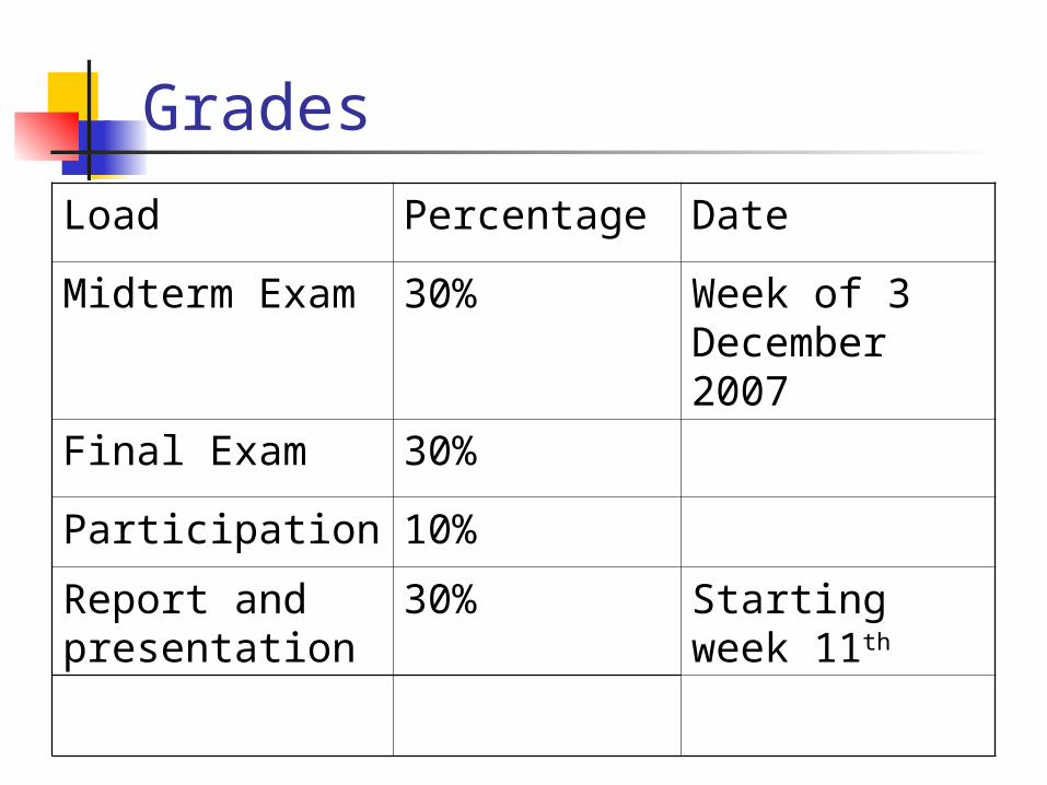
Grades
Load Percentage Date
Midterm Exam 30% Week of 3 December 2007
Final Exam 30%
Participation 10%
Report and presentation
30% Starting week 11th

Textbook and website
Textbook: non specific
Website: http://webmail.aast.edu/~khedr
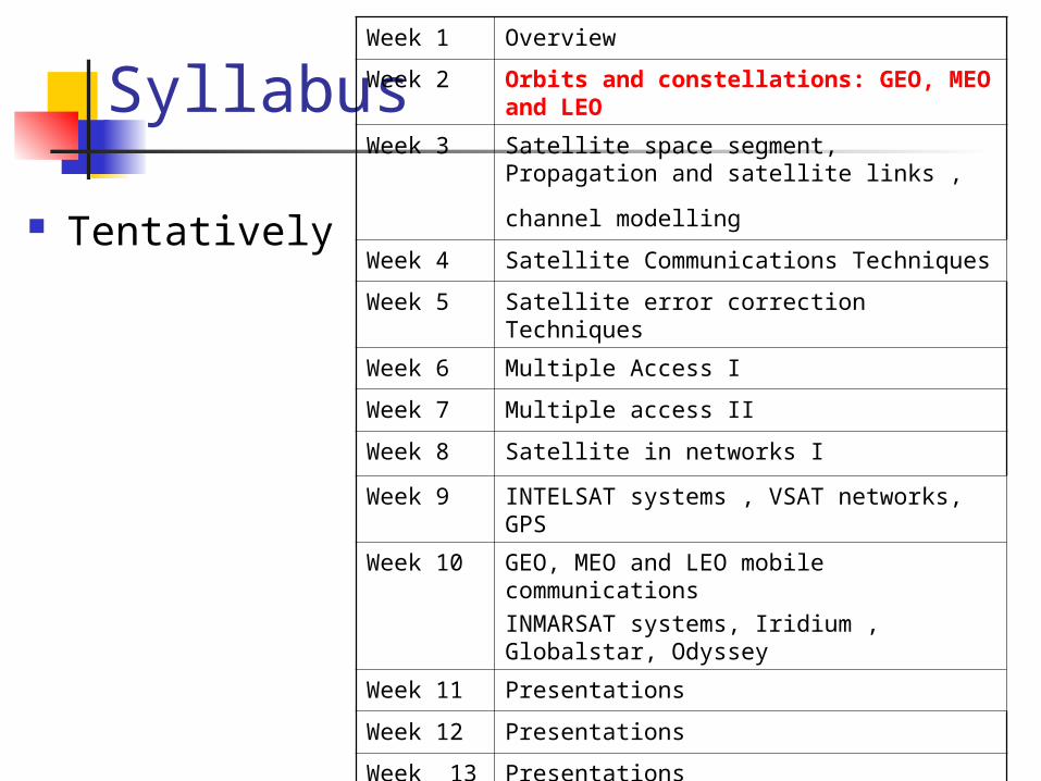
Syllabus
Tentatively
Week 1 Overview
Week 2 Orbits and constellations: GEO, MEO and LEO
Week 3 Satellite space segment, Propagation and
satellite links , channel modelling Week 4 Satellite Communications Techniques
Week 5 Satellite error correction Techniques
Week 6 Multiple Access I
Week 7 Multiple access II
Week 8 Satellite in networks I
Week 9 INTELSAT systems , VSAT networks, GPS
Week 10 GEO, MEO and LEO mobile communications INMARSAT systems, Iridium , Globalstar, Odyssey
Week 11 Presentations
Week 12 Presentations
Week 13 Presentations
Week 14 Presentations
Week 15 Presentations
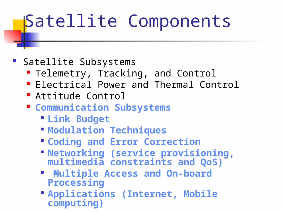
Satellite Components
Satellite Subsystems Telemetry, Tracking, and Control Electrical Power and Thermal Control Attitude Control Communication Subsystems
Link Budget Modulation Techniques Coding and Error Correction Networking (service provisioning,
multimedia constraints and QoS) Multiple Access and On-board
Processing Applications (Internet, Mobile
computing)
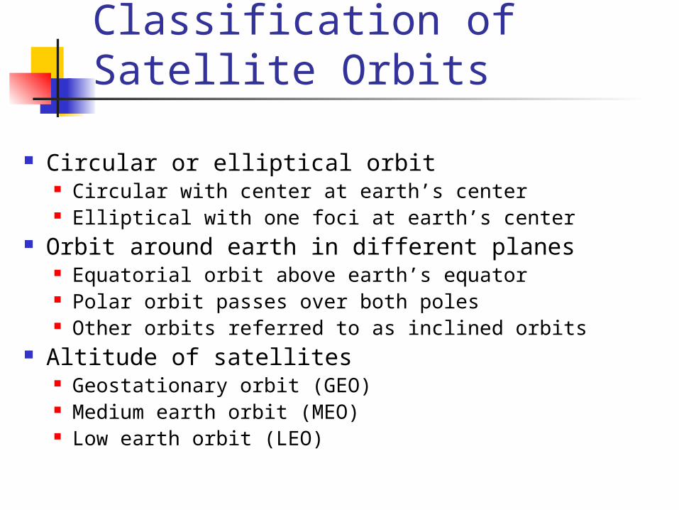
Classification of Satellite Orbits
Circular or elliptical orbit Circular with center at earth’s center Elliptical with one foci at earth’s center
Orbit around earth in different planes Equatorial orbit above earth’s equator Polar orbit passes over both poles Other orbits referred to as inclined orbits
Altitude of satellites Geostationary orbit (GEO) Medium earth orbit (MEO) Low earth orbit (LEO)
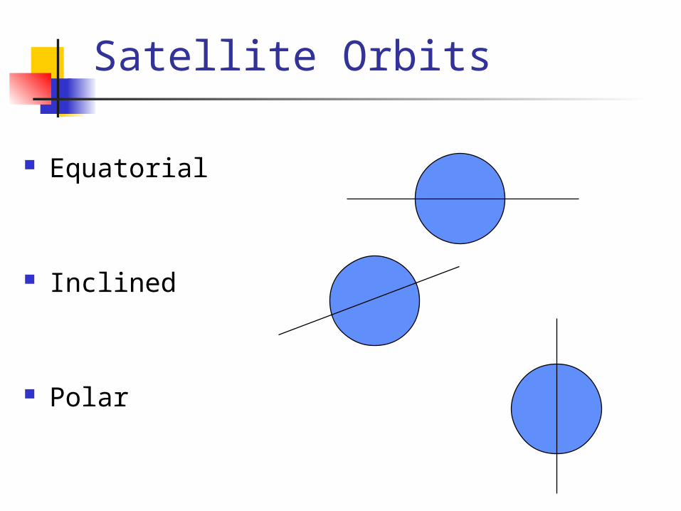
Satellite Orbits
Equatorial
Inclined
Polar
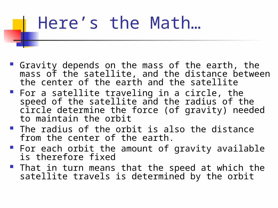
Here’s the Math…
Gravity depends on the mass of the earth, the mass of the satellite, and the distance between the center of the earth and the satellite
For a satellite traveling in a circle, the speed of the satellite and the radius of the circle determine the force (of gravity) needed to maintain the orbit
The radius of the orbit is also the distance from the center of the earth.
For each orbit the amount of gravity available is therefore fixed
That in turn means that the speed at which the satellite travels is determined by the orbit
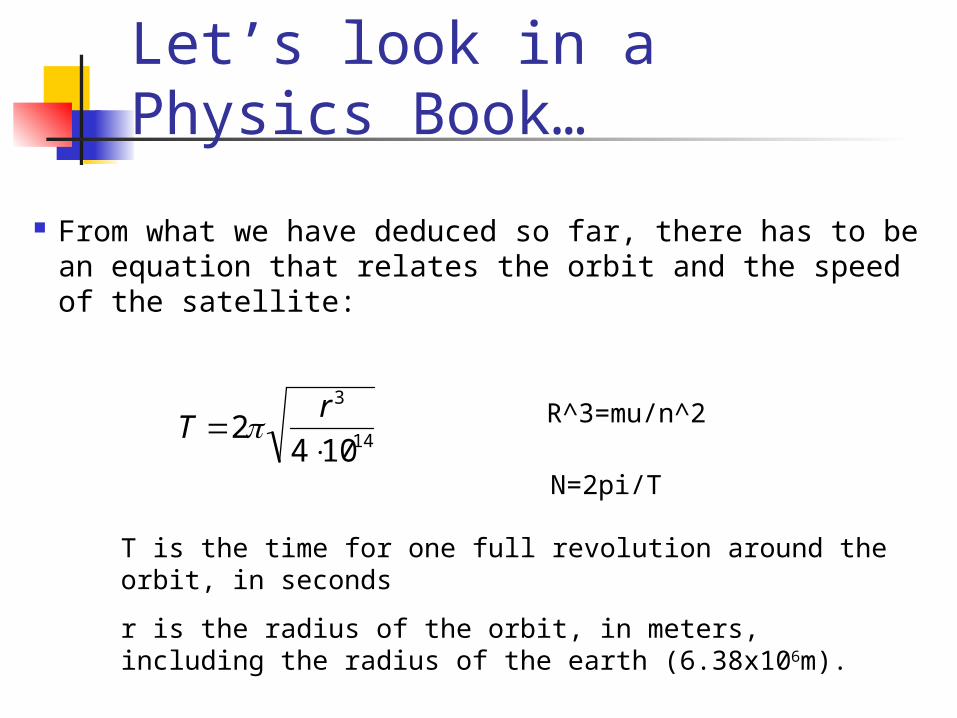
Let’s look in a Physics Book…
From what we have deduced so far, there has to be an equation that relates the orbit and the speed of the satellite:
T 2r3
4 1014
T is the time for one full revolution around the orbit, in seconds
r is the radius of the orbit, in meters, including the radius of the earth (6.38x10⁶m).
R^3=mu/n^2
N=2pi/T
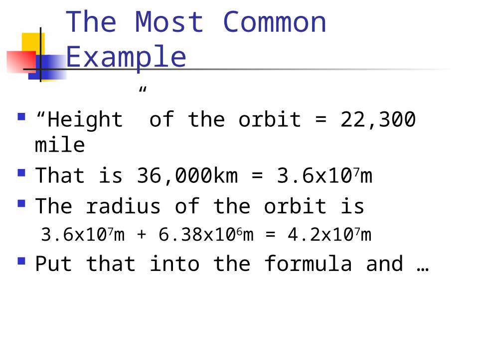
The Most Common Example
“Height” of the orbit = 22,300 mile That is 36,000km = 3.6x10⁷m The radius of the orbit is
3.6x10⁷m + 6.38x10⁶m = 4.2x10⁷m Put that into the formula and …
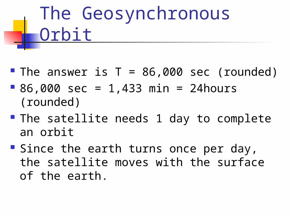
The Geosynchronous Orbit
The answer is T = 86,000 sec (rounded) 86,000 sec = 1,433 min = 24hours
(rounded) The satellite needs 1 day to complete an
orbit Since the earth turns once per day, the
satellite moves with the surface of the earth.
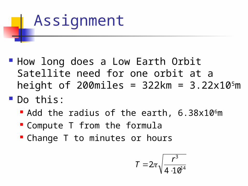
Assignment
How long does a Low Earth Orbit Satellite need for one orbit at a height of 200miles = 322km = 3.22x10⁵m
Do this: Add the radius of the earth, 6.38x10⁶m Compute T from the formula Change T to minutes or hours
T 2r3
4 1014
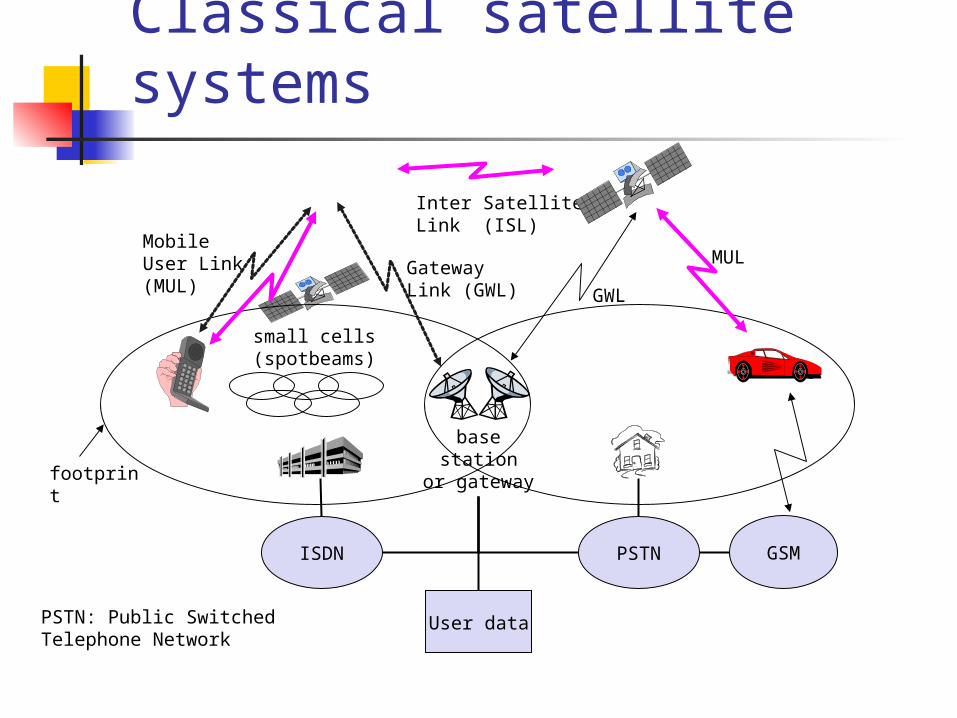
base stationor gateway
Classical satellite systems
Inter Satellite Link (ISL)
Mobile User Link (MUL) Gateway Link
(GWL)
footprint
small cells (spotbeams)
User data
PSTNISDN GSM
GWL
MUL
PSTN: Public Switched Telephone Network
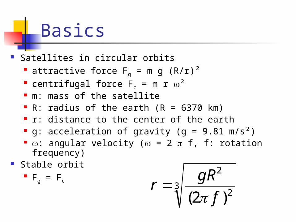
Basics Satellites in circular orbits
attractive force Fg = m g (R/r)² centrifugal force Fc = m r ² m: mass of the satellite R: radius of the earth (R = 6370 km) r: distance to the center of the earth g: acceleration of gravity (g = 9.81 m/s²) : angular velocity ( = 2 f, f: rotation frequency)
Stable orbit Fg = Fc
32
2
)2( f
gRr
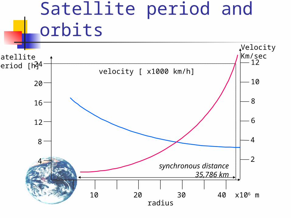
Satellite period and orbits
10 20 30 40 x106 m
24
20
16
12
8
4
radius
satellite period [h]
velocity [ x1000 km/h]
synchronous distance35,786 km
12
10
8
6
4
2
VelocityKm/sec
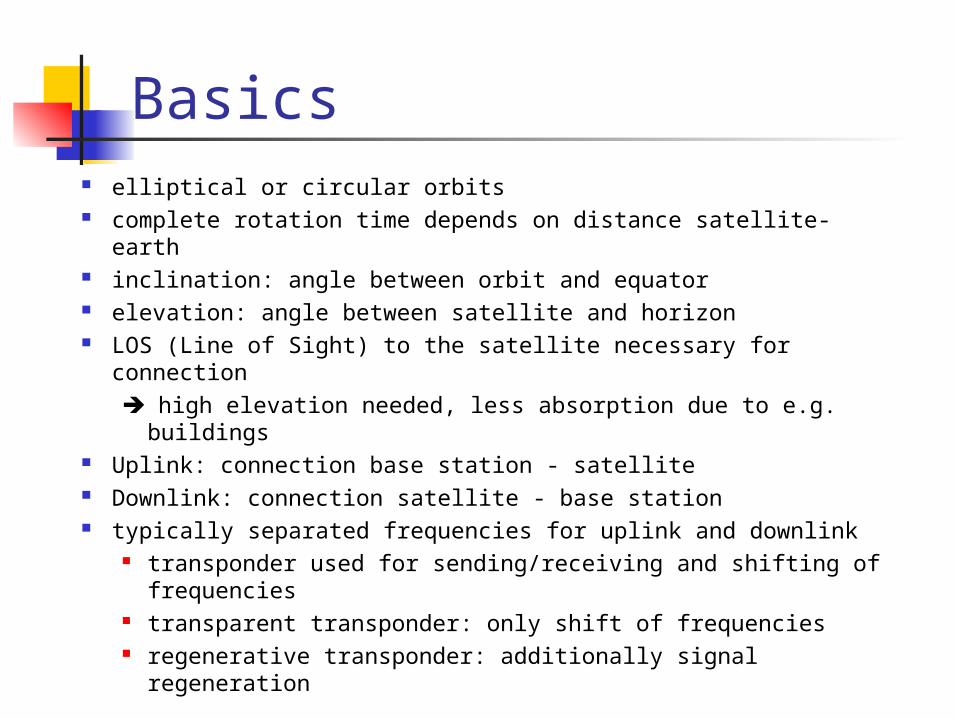
Basics elliptical or circular orbits complete rotation time depends on distance satellite-earth inclination: angle between orbit and equator elevation: angle between satellite and horizon LOS (Line of Sight) to the satellite necessary for connection
high elevation needed, less absorption due to e.g. buildings
Uplink: connection base station - satellite Downlink: connection satellite - base station typically separated frequencies for uplink and downlink
transponder used for sending/receiving and shifting of frequencies
transparent transponder: only shift of frequencies regenerative transponder: additionally signal
regeneration
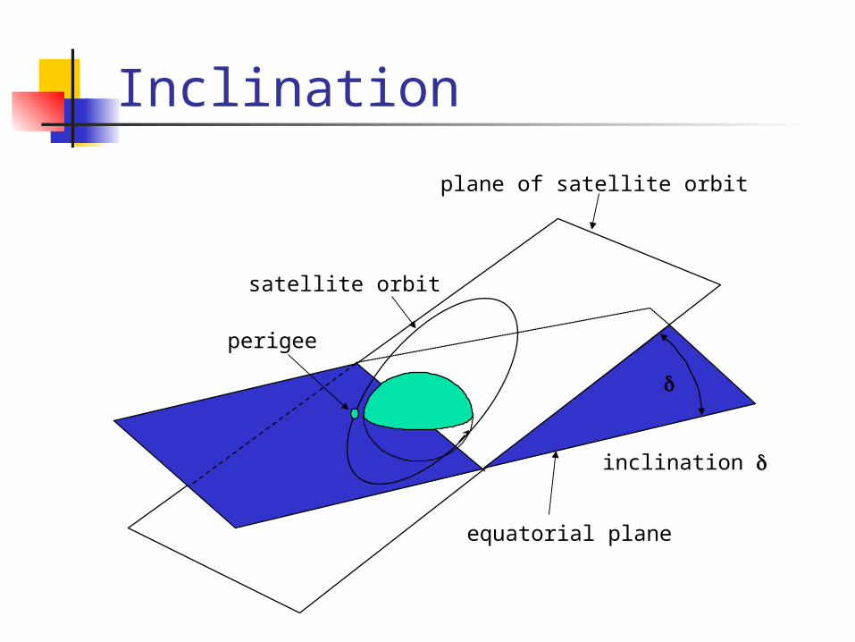
Inclination
inclination
satellite orbit
perigee
plane of satellite orbit
equatorial plane
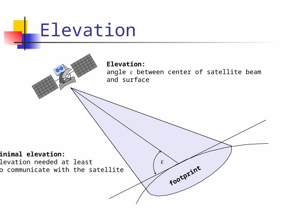
Elevation
Elevation:angle between center of satellite beam and surface
minimal elevation:elevation needed at leastto communicate with the satellite
footprint
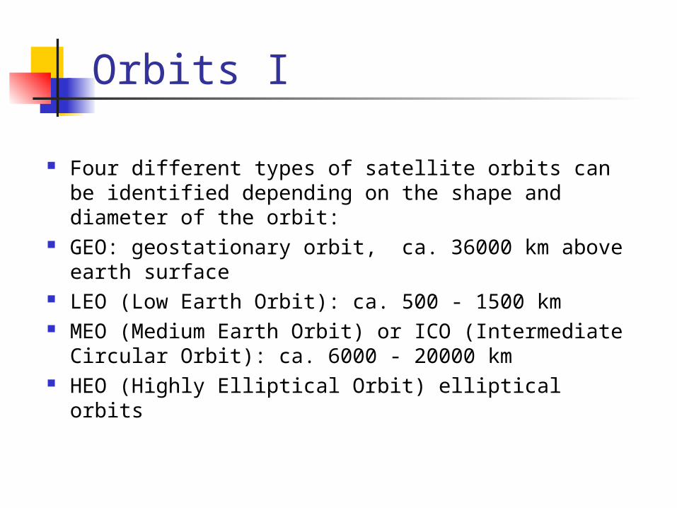
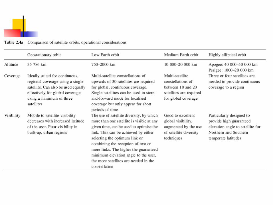
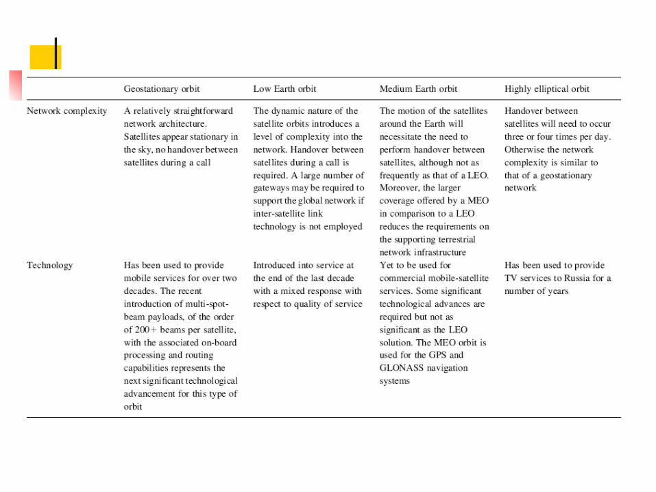
Four different types of satellite orbits can be identified depending on the shape and diameter of the orbit:
GEO: geostationary orbit, ca. 36000 km above earth surface
LEO (Low Earth Orbit): ca. 500 - 1500 km MEO (Medium Earth Orbit) or ICO (Intermediate
Circular Orbit): ca. 6000 - 20000 km HEO (Highly Elliptical Orbit) elliptical orbits
Orbits I
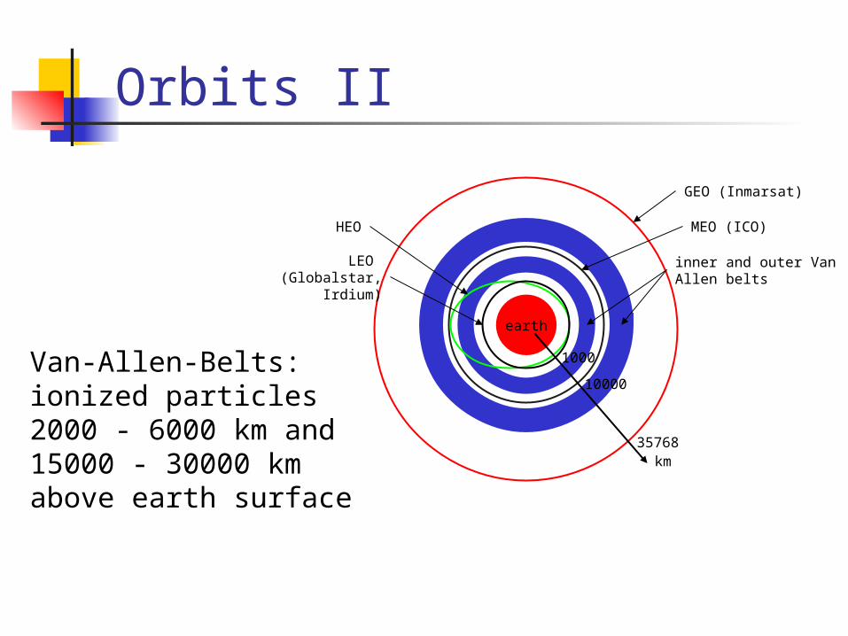
Orbits II
earth
km35768
10000
1000
LEO (Globalstar,
Irdium)
HEO
inner and outer VanAllen belts
MEO (ICO)
GEO (Inmarsat)
Van-Allen-Belts:ionized particles2000 - 6000 km and15000 - 30000 kmabove earth surface
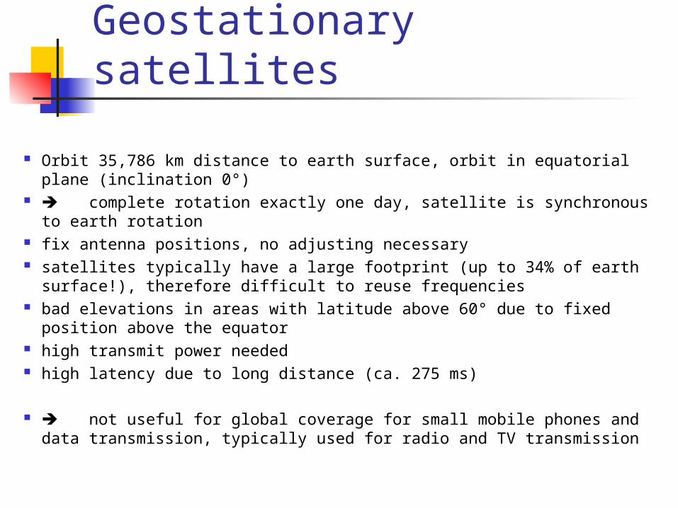
Geostationary satellites
Orbit 35,786 km distance to earth surface, orbit in equatorial plane (inclination 0°)
complete rotation exactly one day, satellite is synchronous to earth rotation
fix antenna positions, no adjusting necessary satellites typically have a large footprint (up to 34% of earth surface!),
therefore difficult to reuse frequencies bad elevations in areas with latitude above 60° due to fixed position
above the equator high transmit power needed high latency due to long distance (ca. 275 ms)
not useful for global coverage for small mobile phones and data transmission, typically used for radio and TV transmission
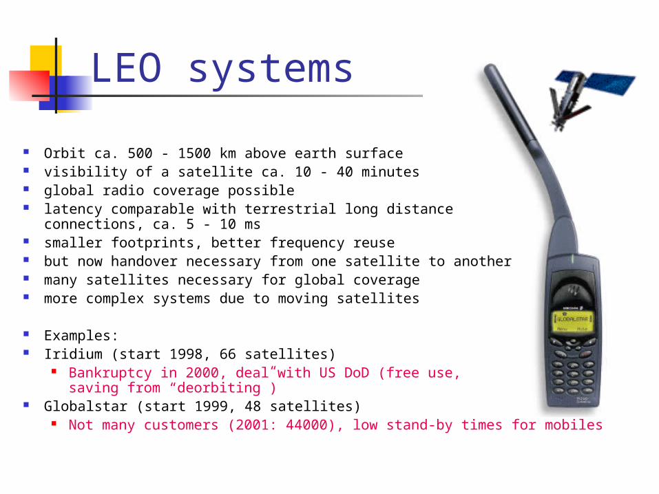
LEO systems
Orbit ca. 500 - 1500 km above earth surface visibility of a satellite ca. 10 - 40 minutes global radio coverage possible latency comparable with terrestrial long distance
connections, ca. 5 - 10 ms smaller footprints, better frequency reuse but now handover necessary from one satellite to another many satellites necessary for global coverage more complex systems due to moving satellites
Examples: Iridium (start 1998, 66 satellites)
Bankruptcy in 2000, deal with US DoD (free use, saving from “deorbiting”)
Globalstar (start 1999, 48 satellites) Not many customers (2001: 44000), low stand-by times for mobiles
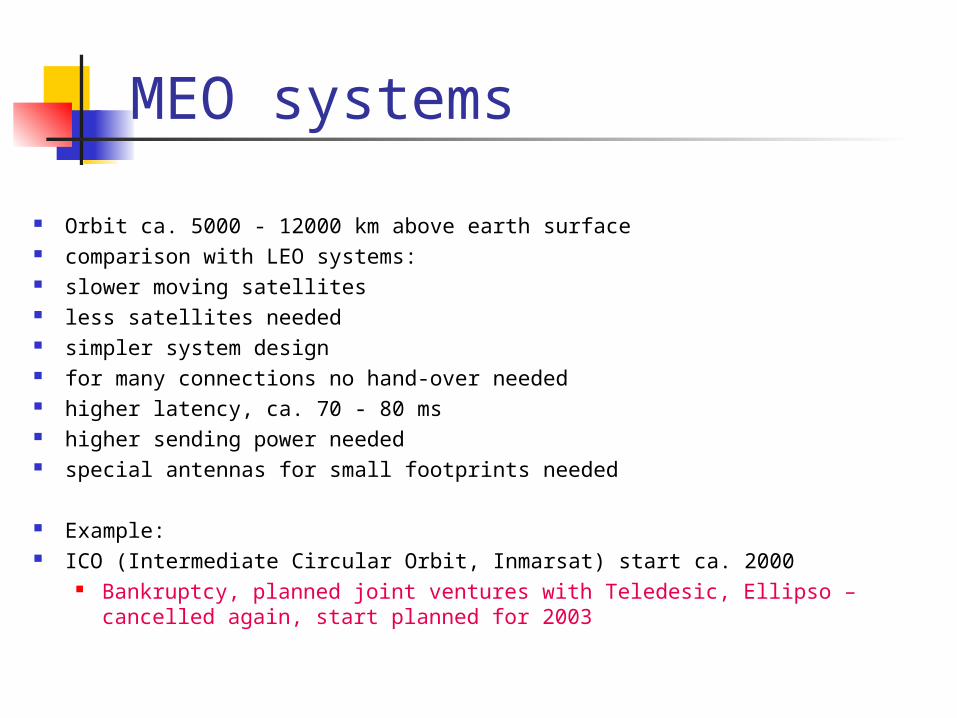
MEO systems
Orbit ca. 5000 - 12000 km above earth surface comparison with LEO systems: slower moving satellites less satellites needed simpler system design for many connections no hand-over needed higher latency, ca. 70 - 80 ms higher sending power needed special antennas for small footprints needed
Example: ICO (Intermediate Circular Orbit, Inmarsat) start ca. 2000
Bankruptcy, planned joint ventures with Teledesic, Ellipso – cancelled again, start planned for 2003
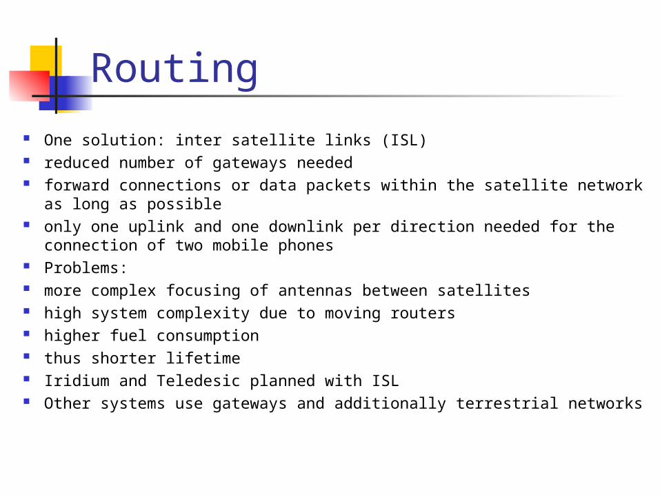
Routing
One solution: inter satellite links (ISL) reduced number of gateways needed forward connections or data packets within the satellite network as
long as possible only one uplink and one downlink per direction needed for the
connection of two mobile phones Problems: more complex focusing of antennas between satellites high system complexity due to moving routers higher fuel consumption thus shorter lifetime Iridium and Teledesic planned with ISL Other systems use gateways and additionally terrestrial networks
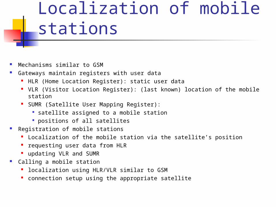
Localization of mobile stations
Mechanisms similar to GSM Gateways maintain registers with user data
HLR (Home Location Register): static user data VLR (Visitor Location Register): (last known) location of the mobile station SUMR (Satellite User Mapping Register):
satellite assigned to a mobile station positions of all satellites
Registration of mobile stations Localization of the mobile station via the satellite’s position requesting user data from HLR updating VLR and SUMR
Calling a mobile station localization using HLR/VLR similar to GSM connection setup using the appropriate satellite
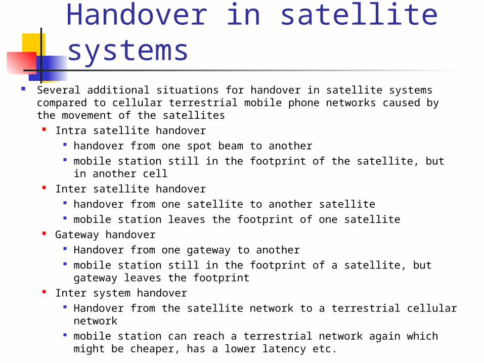
Handover in satellite systems
Several additional situations for handover in satellite systems compared to cellular terrestrial mobile phone networks caused by the movement of the satellites
Intra satellite handover handover from one spot beam to another mobile station still in the footprint of the satellite, but in another
cell Inter satellite handover
handover from one satellite to another satellite mobile station leaves the footprint of one satellite
Gateway handover Handover from one gateway to another mobile station still in the footprint of a satellite, but gateway leaves
the footprint Inter system handover
Handover from the satellite network to a terrestrial cellular network mobile station can reach a terrestrial network again which might
be cheaper, has a lower latency etc.
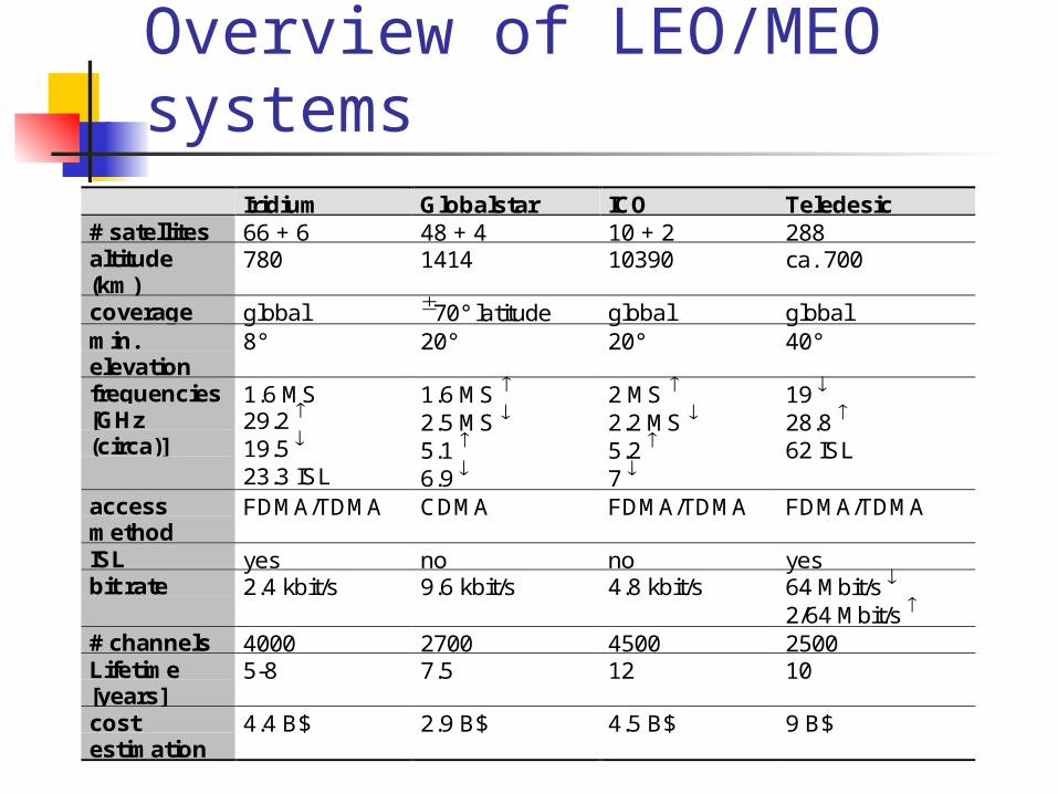
Overview of LEO/MEO systems
Iridium Globalstar ICO Teledesic# satellites 66 + 6 48 + 4 10 + 2 288altitude(km)
780 1414 10390 ca. 700
coverage global 70° latitude global globalmin.elevation
8° 20° 20° 40°
frequencies[GHz(circa)]
1.6 MS29.2 19.5 23.3 ISL
1.6 MS
2.5 MS 5.1
6.9
2 MS
2.2 MS 5.2
7
19
28.8 62 ISL
accessmethod
FDMA/TDMA CDMA FDMA/TDMA FDMA/TDMA
ISL yes no no yesbit rate 2.4 kbit/s 9.6 kbit/s 4.8 kbit/s 64 Mbit/s
2/64 Mbit/s # channels 4000 2700 4500 2500Lifetime[years]
5-8 7.5 12 10
costestimation
4.4 B$ 2.9 B$ 4.5 B$ 9 B$
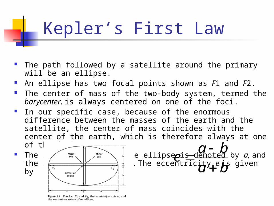
Kepler’s First Law
The path followed by a satellite around the primary will be an ellipse.
An ellipse has two focal points shown as F1 and F2. The center of mass of the two-body system, termed the
barycenter, is always centered on one of the foci. In our specific case, because of the enormous difference
between the masses of the earth and the satellite, the center of mass coincides with the center of the earth, which is therefore always at one of the foci.
The semimajor axis of the ellipse is denoted by a, and the semiminor axis, by b. The eccentricity e is given by
ba
bae
Kepler’s Second Law
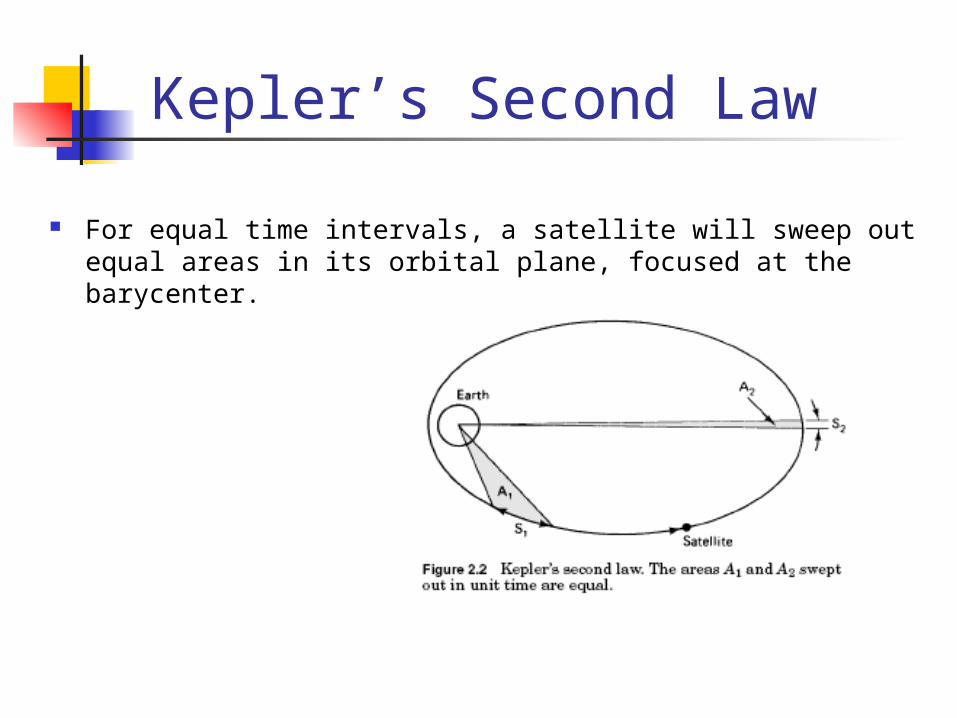
For equal time intervals, a satellite will sweep out equal areas in its orbital plane, focused at the barycenter.
Kepler’s Third Law
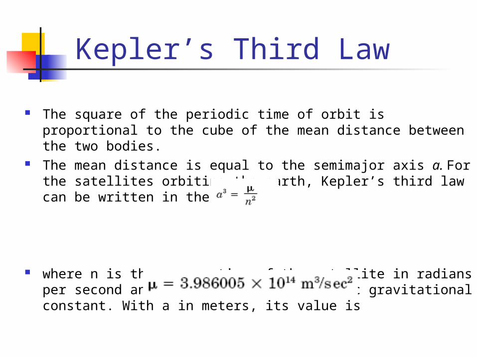
The square of the periodic time of orbit is proportional to the cube of the mean distance between the two bodies.
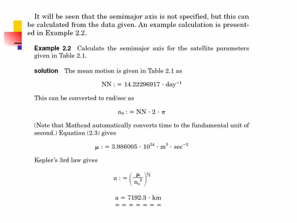
The mean distance is equal to the semimajor axis a. For the satellites orbiting the earth, Kepler’s third law can be written in the form
where n is the mean motion of the satellite in radians per second and is the earth’s geocentric gravitational constant. With a in meters, its value is
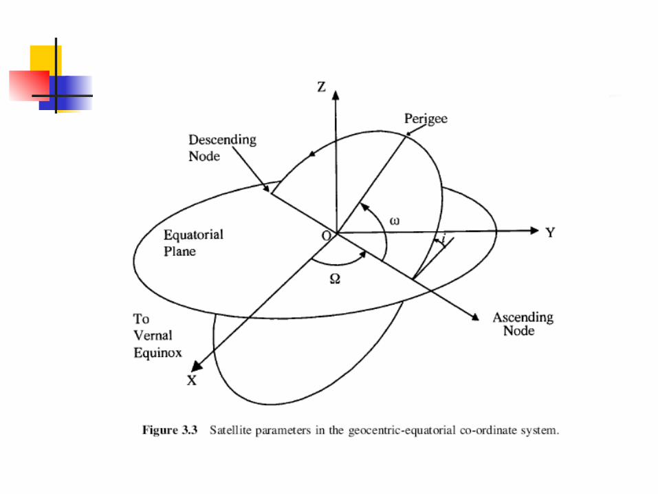
Definition of terms for earth-orbiting satellite
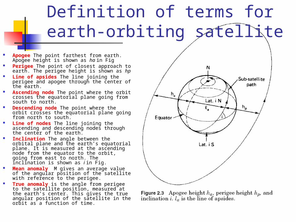
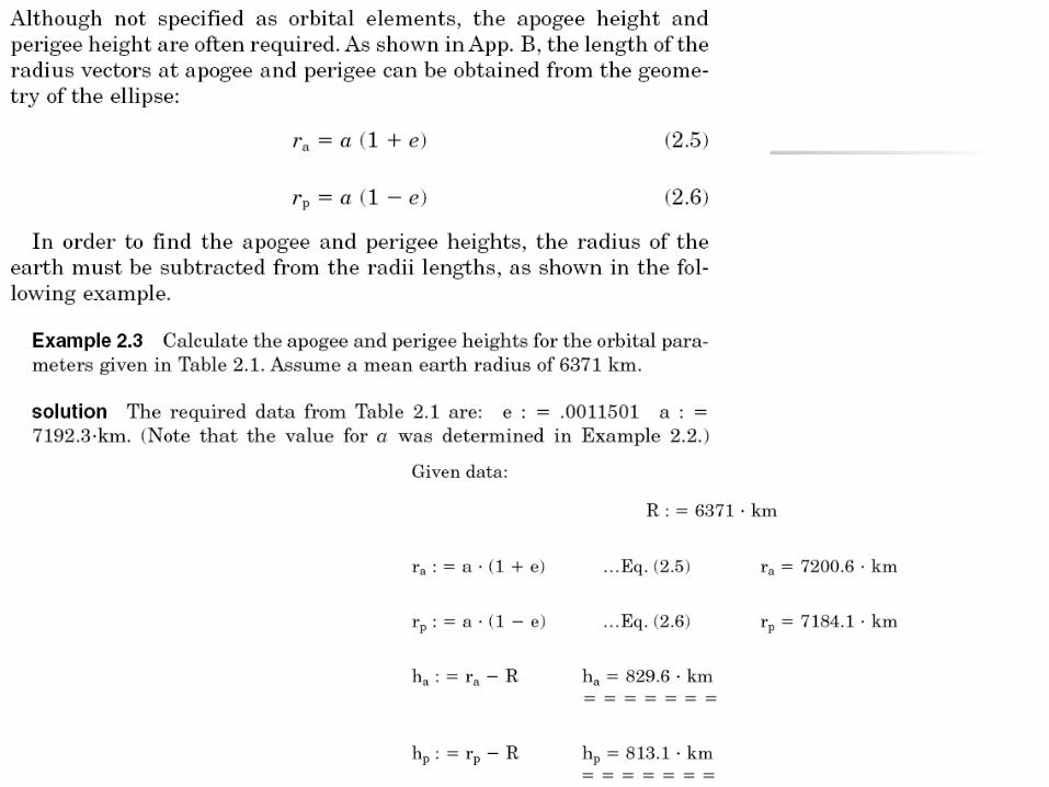
Apogee The point farthest from earth. Apogee height is shown as ha in Fig
Perigee The point of closest approach to earth. The perigee height is shown as hp
Line of apsides The line joining the perigee and apogee through the center of the earth.
Ascending node The point where the orbit crosses the equatorial plane going from south to north.
Descending node The point where the orbit crosses the equatorial plane going from north to south.
Line of nodes The line joining the ascending and descending nodes through the center of the earth.
Inclination The angle between the orbital plane and the earth’s equatorial plane. It is measured at the ascending node from the equator to the orbit, going from east to north. The inclination is shown as i in Fig.
Mean anomaly M gives an average value of the angular position of the satellite with reference to the perigee.
True anomaly is the angle from perigee to the satellite position, measured at the earth’s center. This gives the true angular position of the satellite in the orbit as a function of time.
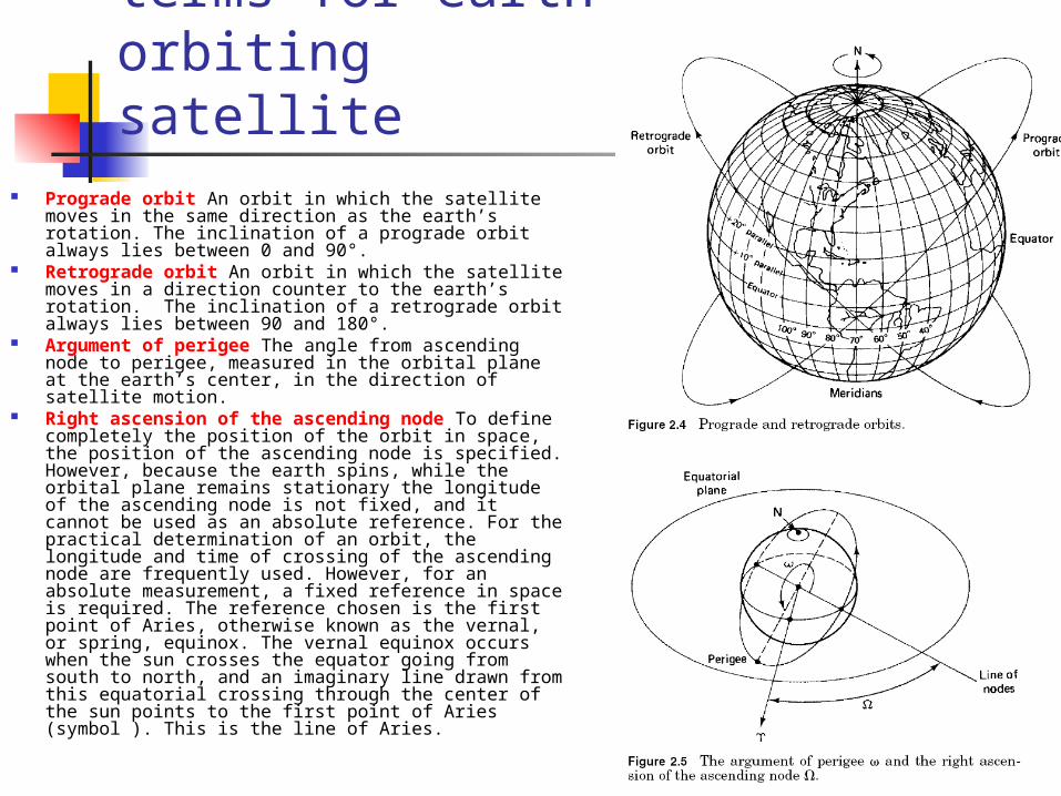
Prograde orbit An orbit in which the satellite moves in the same direction as the earth’s rotation. The inclination of a prograde orbit always lies between 0 and 90°.
Retrograde orbit An orbit in which the satellite moves in a direction counter to the earth’s rotation. The inclination of a retrograde orbit always lies between 90 and 180°.
Argument of perigee The angle from ascending node to perigee, measured in the orbital plane at the earth’s center, in the direction of satellite motion.
Right ascension of the ascending node To define completely the position of the orbit in space, the position of the ascending node is specified. However, because the earth spins, while the orbital plane remains stationary the longitude of the ascending node is not fixed, and it cannot be used as an absolute reference. For the practical determination of an orbit, the longitude and time of crossing of the ascending node are frequently used. However, for an absolute measurement, a fixed reference in space is required. The reference chosen is the first point of Aries, otherwise known as the vernal, or spring, equinox. The vernal equinox occurs when the sun crosses the equator going from south to north, and an imaginary line drawn from this equatorial crossing through the center of the sun points to the first point of Aries (symbol ). This is the line of Aries.
Definition of terms for earth-orbiting satellite
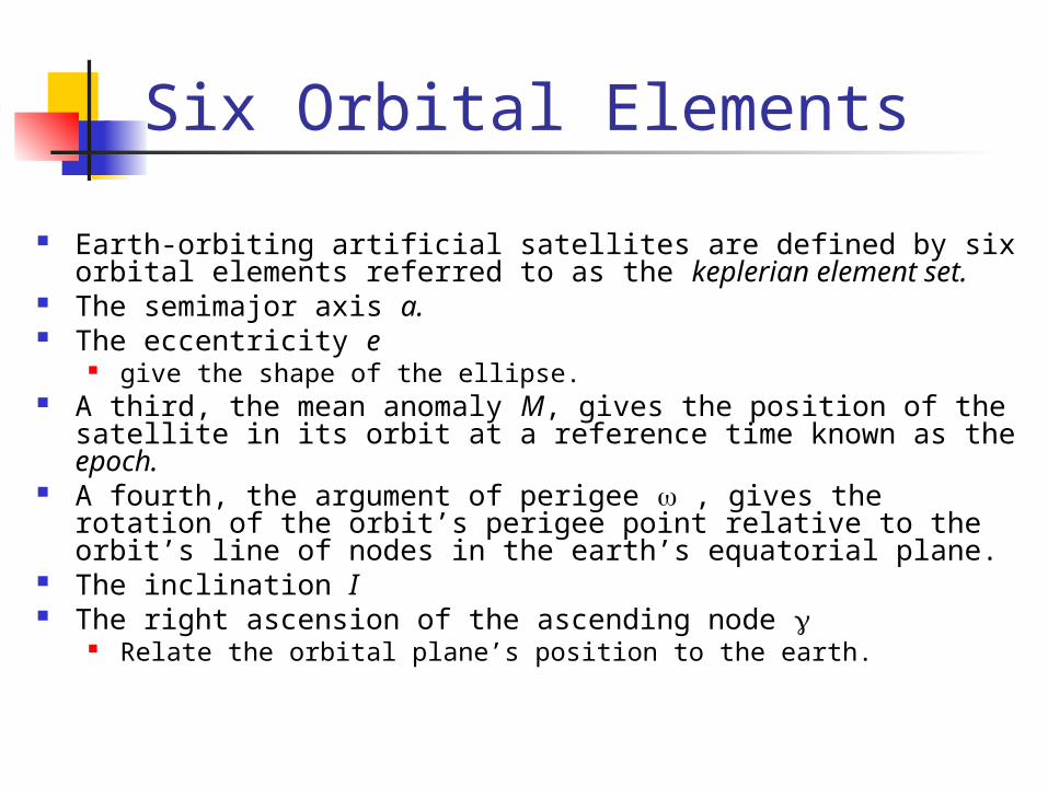
Six Orbital Elements
Earth-orbiting artificial satellites are defined by six orbital elements referred to as the keplerian element set.
The semimajor axis a. The eccentricity e
give the shape of the ellipse. A third, the mean anomaly M, gives the position of the satellite
in its orbit at a reference time known as the epoch. A fourth, the argument of perigee , gives the rotation of the
orbit’s perigee point relative to the orbit’s line of nodes in the earth’s equatorial plane.
The inclination I The right ascension of the ascending node
Relate the orbital plane’s position to the earth.
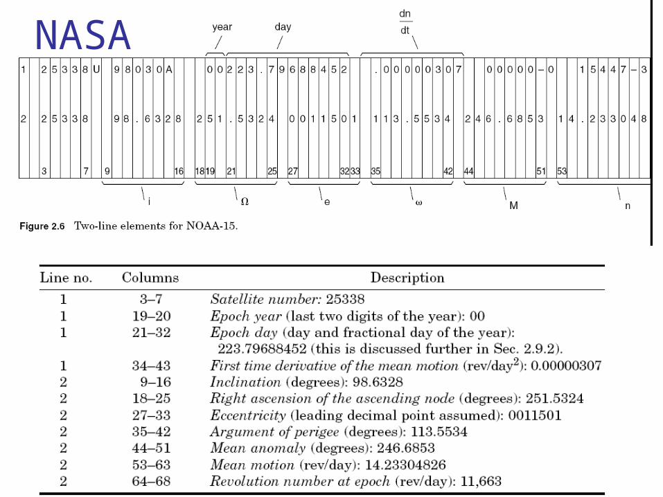
NASA
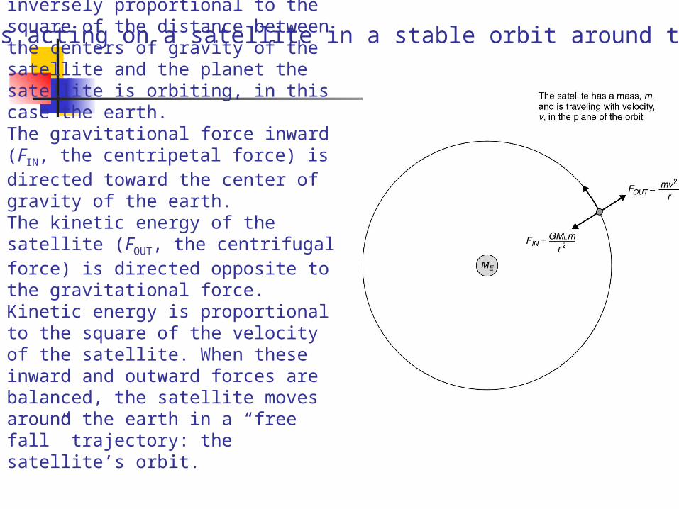
Gravitational force is inversely proportional to the square of the distance between the centers of gravity of the satellite and the planet the satellite is orbiting, in this case the earth. The gravitational force inward (FIN, the centripetal force) is directed toward the center of gravity of the earth. The kinetic energy of the satellite (FOUT, the centrifugal force) is directed opposite to the gravitational force. Kinetic energy is proportional to the square of the velocity of the satellite. When these inward and outward forces are balanced, the satellite moves around the earth in a “free fall” trajectory: the satellite’s orbit.
Forces acting on a satellite in a stable orbit around the earth.
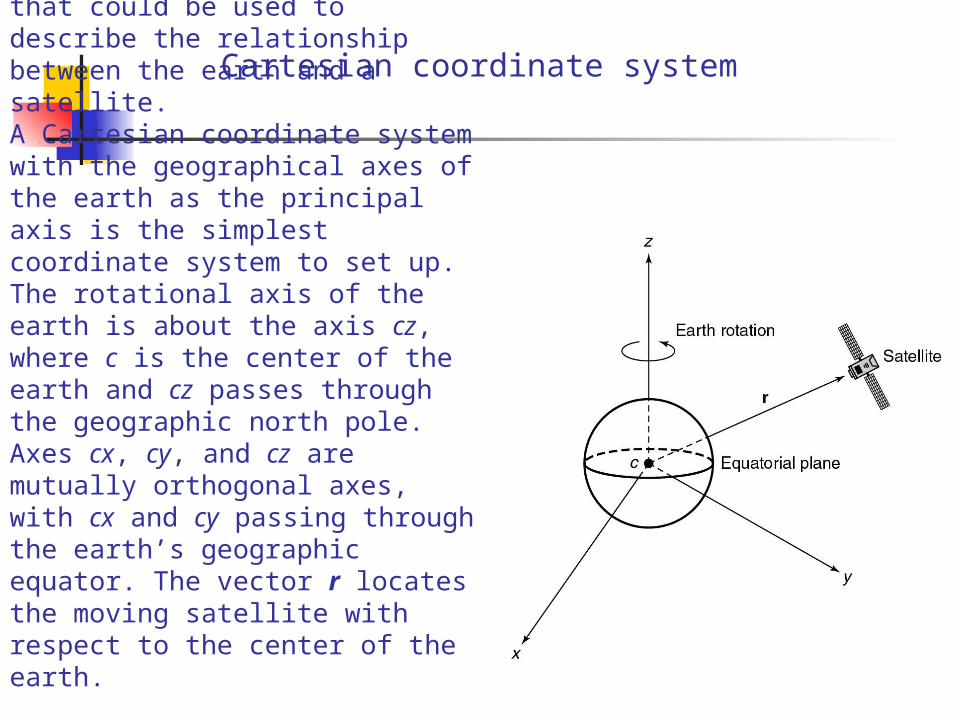
The initial coordinate system that could be used to describe the relationship between the earth and a satellite. A Cartesian coordinate system with the geographical axes of the earth as the principal axis is the simplest coordinate system to set up. The rotational axis of the earth is about the axis cz, where c is the center of the earth and cz passes through the geographic north pole.
Axes cx, cy, and cz are mutually orthogonal axes, with cx and cy passing through the earth’s geographic equator. The vector r locates the moving satellite with respect to the center of the earth.
Cartesian coordinate system
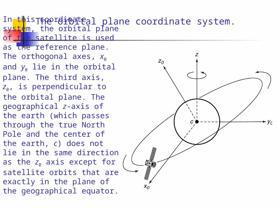
In this coordinate system, the orbital plane of the satellite is used as the reference plane. The orthogonal axes, x0 and y0 lie in the orbital plane. The third axis, z0, is perpendicular to the orbital plane. The geographical z-axis of the earth (which passes through the true North Pole and the center of the earth, c) does not lie in the same direction as the z0 axis except for satellite orbits that are exactly in the plane of the geographical equator.
The orbital plane coordinate system.
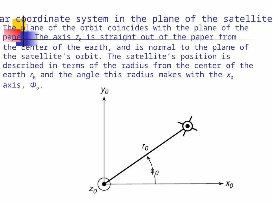
The plane of the orbit coincides with the plane of the paper. The axis z0 is straight out of the paper from the center of the earth, and is normal to the plane of the satellite’s orbit. The satellite’s position is described in terms of the radius from the center of the earth r0 and the angle this radius makes with the x0 axis, Φo.
Polar coordinate system in the plane of the satellite’s orbit.
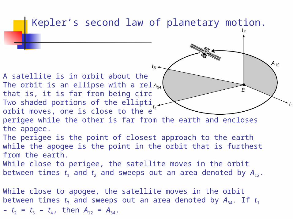
A satellite is in orbit about the planet earth, E. The orbit is an ellipse with a relatively high eccentricity, that is, it is far from being circular. Two shaded portions of the elliptical plane in which the orbit moves, one is close to the earth and encloses the perigee while the other is far from the earth and encloses the apogee. The perigee is the point of closest approach to the earth while the apogee is the point in the orbit that is furthest from the earth. While close to perigee, the satellite moves in the orbit between times t1 and t2 and sweeps out an area denoted by A12. While close to apogee, the satellite moves in the orbit between times t3 and sweeps out an area denoted by A34. If t1 – t2 = t3 – t4, then A12 = A34.
Kepler’s second law of planetary motion.
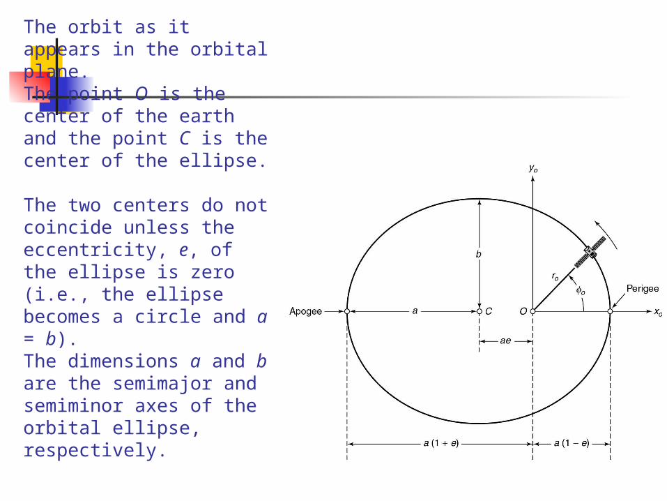
The orbit as it appears in the orbital plane.The point O is the center of the earth and the point C is the center of the ellipse. The two centers do not coincide unless the eccentricity, e, of the ellipse is zero (i.e., the ellipse becomes a circle and a = b). The dimensions a and b are the semimajor and semiminor axes of the orbital ellipse, respectively.

Point O is the center of the earth and point C is both the center of the orbital ellipse and the center of the circumscribed circle. The satellite location in the orbital plane coordinate system is specified by (x0, y0). A vertical line through the satellite intersects the circumscribed circle at point A. The eccentric anomaly E is the angle from the x0 axis to the line joining C and A.
The circumscribed circle and the eccentric anomaly E.
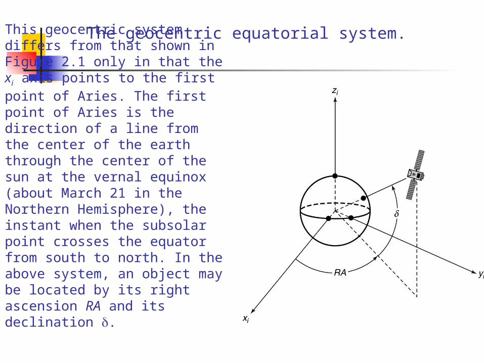
This geocentric system differs from that shown in Figure 2.1 only in that the xi axis points to the first point of Aries. The first point of Aries is the direction of a line from the center of the earth through the center of the sun at the vernal equinox (about March 21 in the Northern Hemisphere), the instant when the subsolar point crosses the equator from south to north. In the above system, an object may be located by its right ascension RA and its declination .
The geocentric equatorial system.
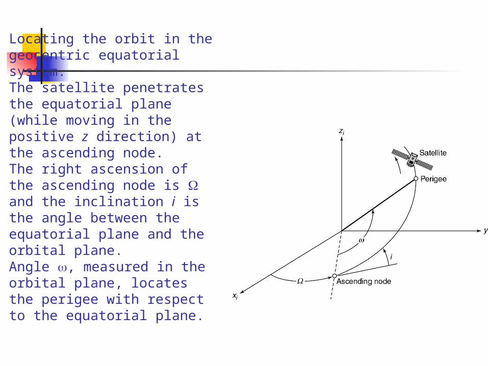
Locating the orbit in the geocentric equatorial system. The satellite penetrates the equatorial plane (while moving in the positive z direction) at the ascending node. The right ascension of the ascending node is and the inclination i is the angle between the equatorial plane and the orbital plane. Angle , measured in the orbital plane, locates the perigee with respect to the equatorial plane.
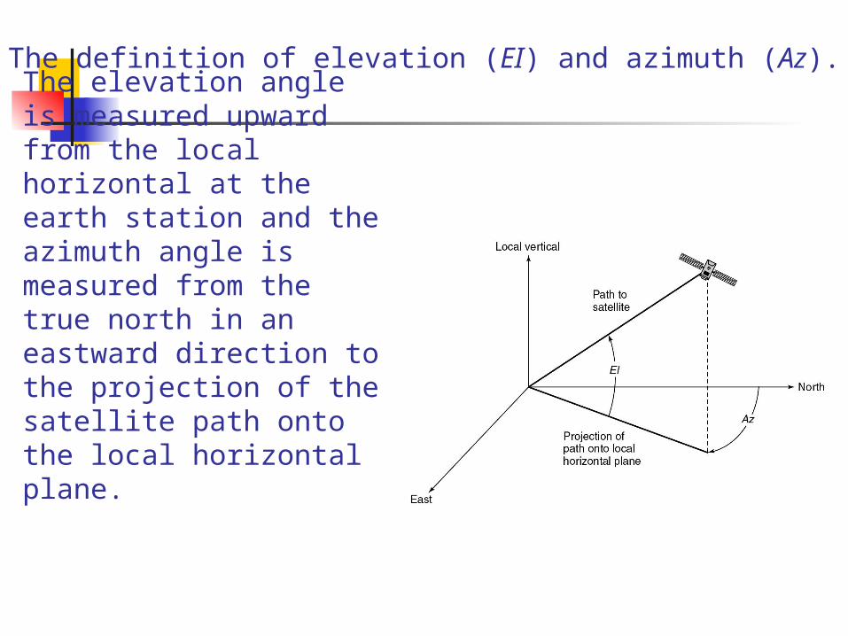
The elevation angle is measured upward from the local horizontal at the earth station and the azimuth angle is measured from the true north in an eastward direction to the projection of the satellite path onto the local horizontal plane.
The definition of elevation (EI) and azimuth (Az).
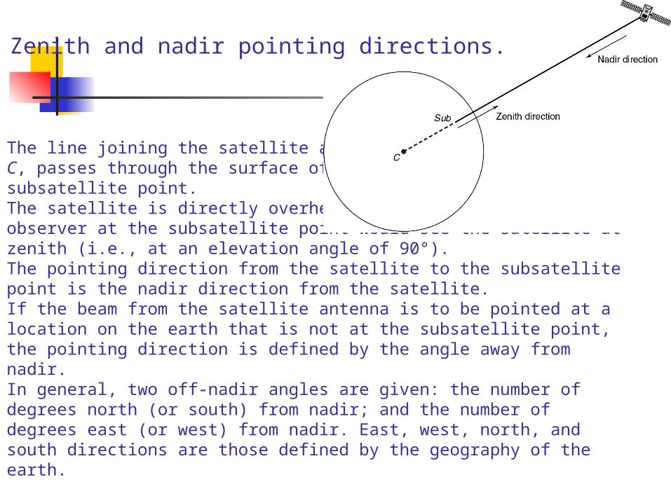
The line joining the satellite and the center of the earth, C, passes through the surface of the earth and point Sub, the subsatellite point. The satellite is directly overhead at this point and so an observer at the subsatellite point would see the satellite at zenith (i.e., at an elevation angle of 90°). The pointing direction from the satellite to the subsatellite point is the nadir direction from the satellite. If the beam from the satellite antenna is to be pointed at a location on the earth that is not at the subsatellite point, the pointing direction is defined by the angle away from nadir. In general, two off-nadir angles are given: the number of degrees north (or south) from nadir; and the number of degrees east (or west) from nadir. East, west, north, and south directions are those defined by the geography of the earth.
Zenith and nadir pointing directions.
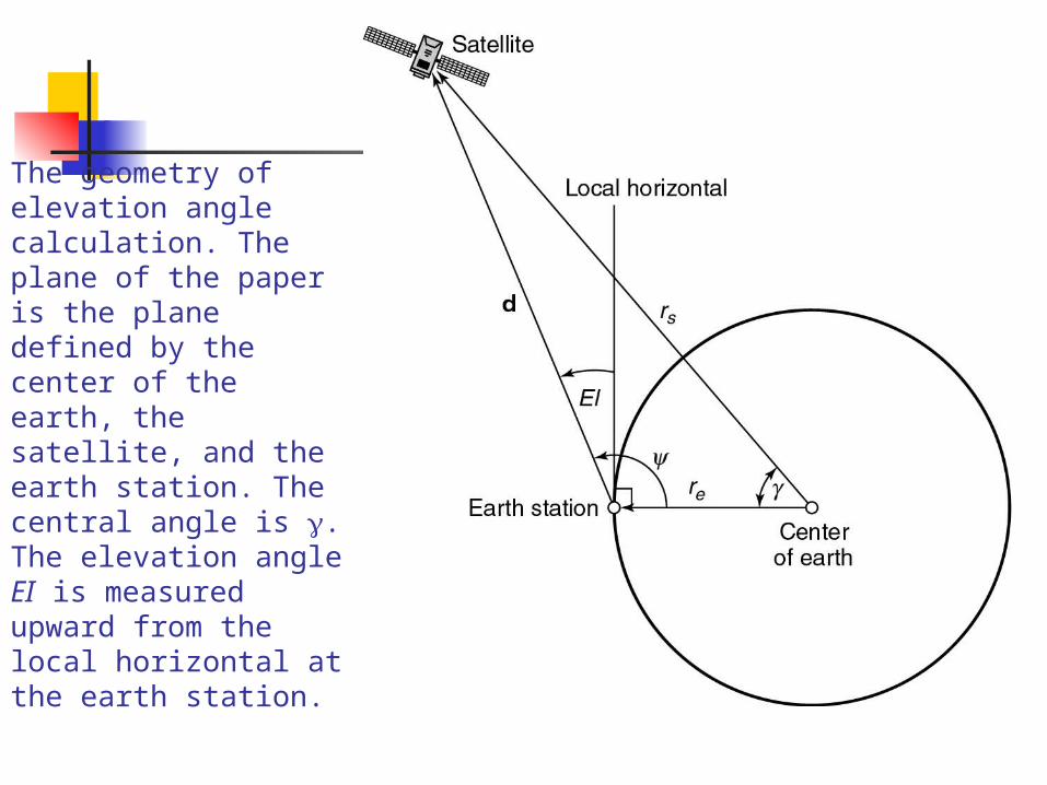
The geometry of elevation angle calculation. The plane of the paper is the plane defined by the center of the earth, the satellite, and the earth station. The central angle is . The elevation angle EI is measured upward from the local horizontal at the earth station.
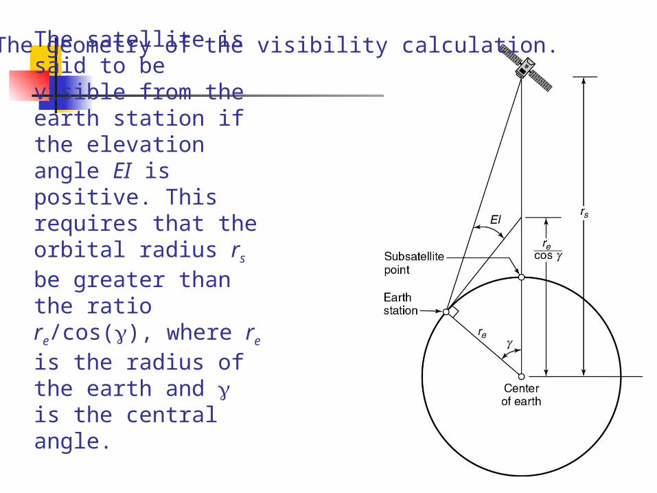
The satellite is said to be visible from the earth station if the elevation angle EI is positive. This requires that the orbital radius rs be greater than the ratio re/cos(), where re is the radius of the earth and is the central angle.
The geometry of the visibility calculation.
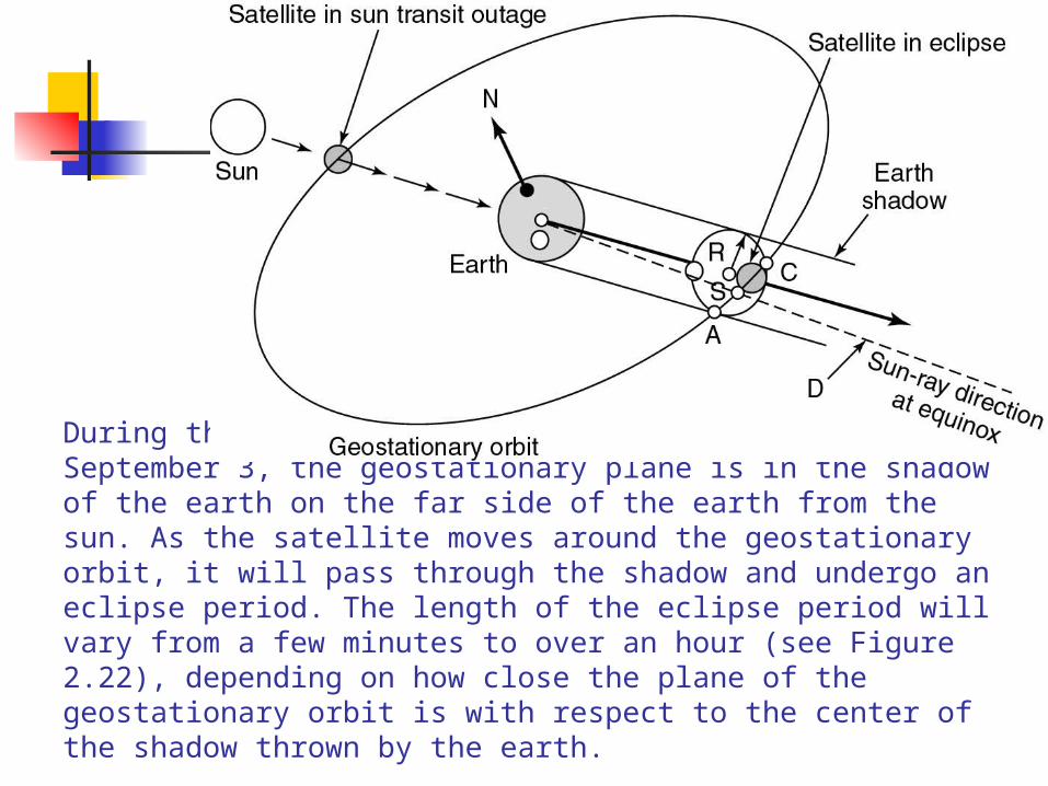
During the equinox periods around the March 21 and September 3, the geostationary plane is in the shadow of the earth on the far side of the earth from the sun. As the satellite moves around the geostationary orbit, it will pass through the shadow and undergo an eclipse period. The length of the eclipse period will vary from a few minutes to over an hour (see Figure 2.22), depending on how close the plane of the geostationary orbit is with respect to the center of the shadow thrown by the earth.
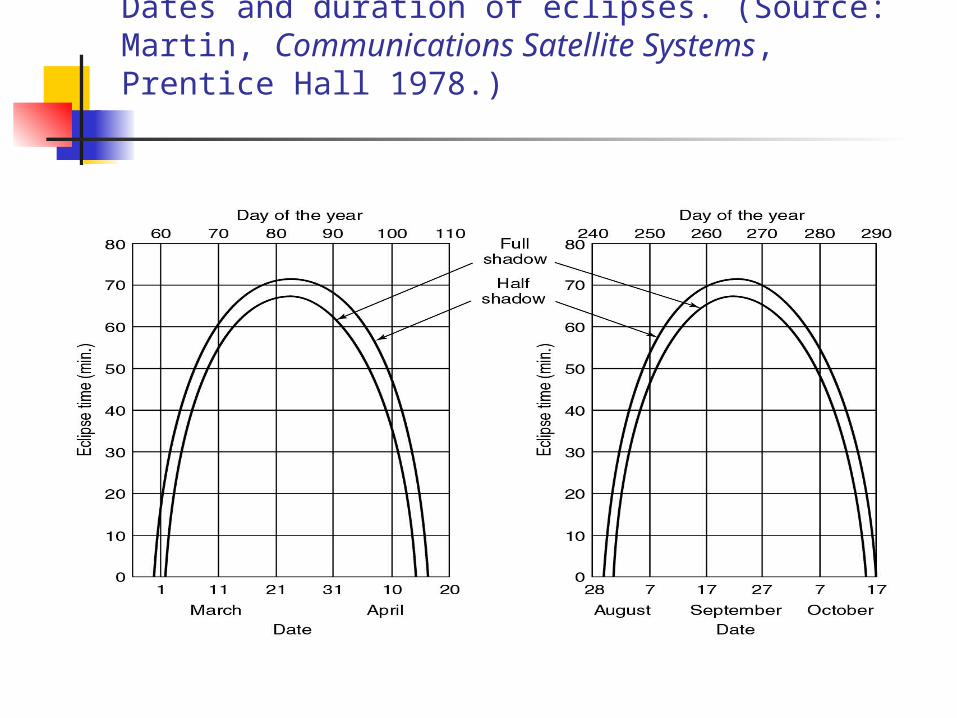
Dates and duration of eclipses. (Source: Martin, Communications Satellite Systems, Prentice Hall 1978.)
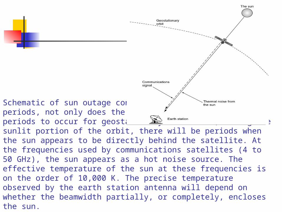
Schematic of sun outage conditions. During the equinox periods, not only does the earth’s shadow cause eclipse periods to occur for geostationary satellites, during the sunlit portion of the orbit, there will be periods when the sun appears to be directly behind the satellite. At the frequencies used by communications satellites (4 to 50 GHz), the sun appears as a hot noise source. The effective temperature of the sun at these frequencies is on the order of 10,000 K. The precise temperature observed by the earth station antenna will depend on whether the beamwidth partially, or completely, encloses the sun.
Thank you