Embed Size (px)
DESCRIPTION
book
Citation preview

FORECASTING EARTHQUAKES
Lecture-8
1
Forecasting Earthquakes: Earlier MethodsStrange Animal Behavior
Stress in the rocks causes tiny hairline fractures. Cracking of the rocks emits high pitched sounds and minute vibrations imperceptible to humans but noticeable by many animals.
Unusual Weather Conditions and Clouds
A few scientists claim to have observed clouds associated with a seismic event, sometimes more than 50 days in advance of the earthquake.
Foreshocks
Foreshocks are minor tremors of the earth that precede a larger earthquake originating at approximately the same location. Unusual increase in the frequency of these foreshocks are sign for an earthquake.
Changes in water level
porosity increases or decreases with changes in strain, causing fluctuations in ground water level
2
Forecasting Earthquakes: Recent Developments
Changes in Seismic Velocities
Earthquakes are often accompanied by temporal changes in seismic wave velocities in the region
Radon Emission
Emission of radon gas as a quake precursor is recently being explored by the geophysicists for developing a worldwide seismic early warning system
The Van Method
The method is based on the detection of "seismic electric signals" (SES) via a telemetric network of conductive metal rods inserted in the ground. Researchers have claimed to be able to predict earthquakes of magnitude larger than 5 using this method.
Geodetic Measurements
Laser geodimeter measures changes in distance across the fault between points. Changes in distances may indicate a precursor to an upcoming earthquake. 3
4
Seismic gap
A segment of an active plate boundary that, relative to rest of the boundary, has not recently ruptured and is considered to be more likely to produce an earthquake in the future is called a seismic gap.
The seismic gap theory states that a segment of a plate boundary that has not ruptured recently has the greatest chance of rupturing in the future relative to other segments that have experienced large earthquakes. This is based on the recognition that tectonic plates move relative to one another at an approximately constant speed and the assumption that the slip of plate boundary faults occurs primarily during major earthquakes.
Some earthquake forecasting models use seismic gap for predictions.
Prediction of Earthquakes
Earthquake prediction is a prediction that an earthquake of a specific magnitude will occur in a particular place at a particular time range. Despite considerable research efforts by seismologists, scientifically reproducible predictions cannot yet be made to a specific day or month.
Most useful way of predicting a future earthquake is in terms of probabilities. For well-understood faults seismic hazard assessment maps can estimate the probability that an earthquake of a given size will affect a given location over a certain number of years.
Experts do advise general earthquake preparedness, especially in areas known to experience frequent or large quakes, to prevent injury, death, and property damage if a quake occurs with or without warning.
5

Prediction of Earthquakes
Seismic hazard map of the San Francisco Bay Area, showing the probability of a major earthquake occurring by 2032
6Source: USGS public domain

Earthquake prediction has taken a scientific turn in late 1970s.
The first successful prediction was made in China in winter 1975 for the city of Haicheng (population about 1 million).
Scientists observed changes in land elevation and ground water levels in that region over a period of time. A regional increase in foreshocks had triggered a low-level alert.
Based on the reports from scientists, Chinese officials had ordered the evacuation of the city. On February 4, 1975, earthquake of magnitude 7.3 struck the region. Only very small fraction (2,041 people) died in this event. The number of fatalities and injuries would have exceeded 150,000 if no earthquake prediction and evacuation had been made.
First Successful Prediction
7

The energy released during the earthquake travels in the form of seismic waves
Modern Seismographs can sense the occurrence, intensity and duration of these waves in different directions.
Seismogram is the visual record of arrival time and magnitude of shaking associated with seismic wave, generated by a seismograph.
Sensing the EarthquakesSensing the Earthquakes
8
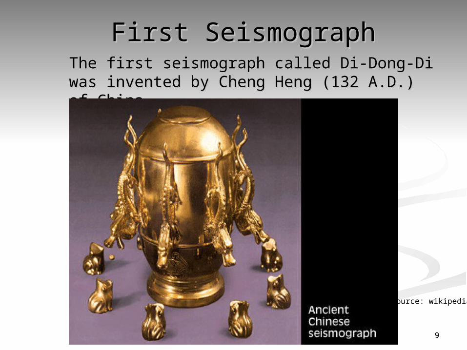
First SeismographFirst SeismographThe first seismograph called Di-Dong-Di was invented by The first seismograph called Di-Dong-Di was invented by Cheng Heng (132 A.D.) of ChinaCheng Heng (132 A.D.) of China. .
9
Source: wikipedia
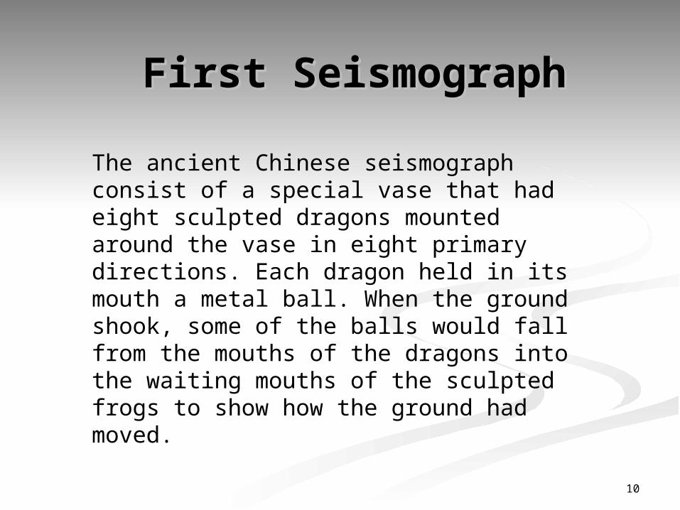
The ancient Chinese seismograph consist of a special vase that had eight sculpted dragons mounted around the vase in eight primary directions. Each dragon held in its mouth a metal ball. When the ground shook, some of the balls would fall from the mouths of the dragons into the waiting mouths of the sculpted frogs to show how the ground had moved.
First SeismographFirst Seismograph
10
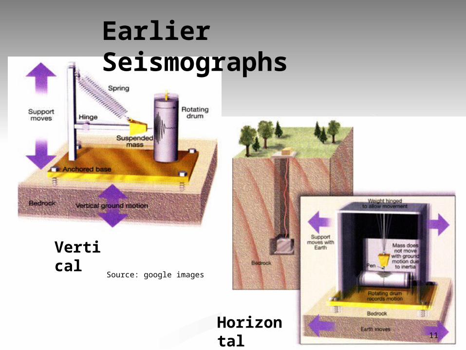
Earlier Seismographs
Vertical
Horizontal11
Source: google images
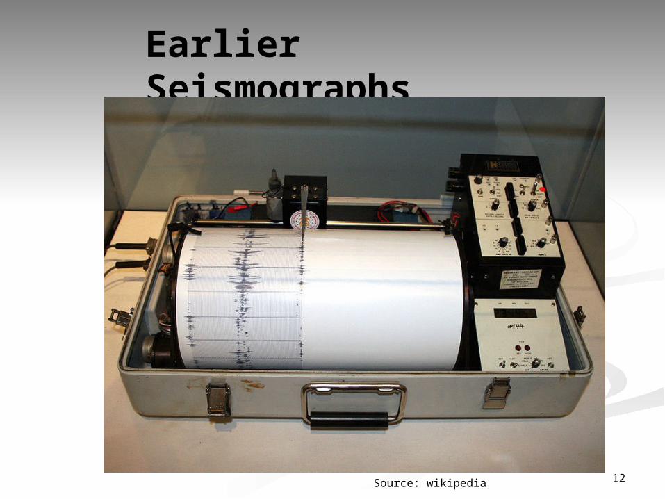
Earlier Seismographs
12Source: wikipedia
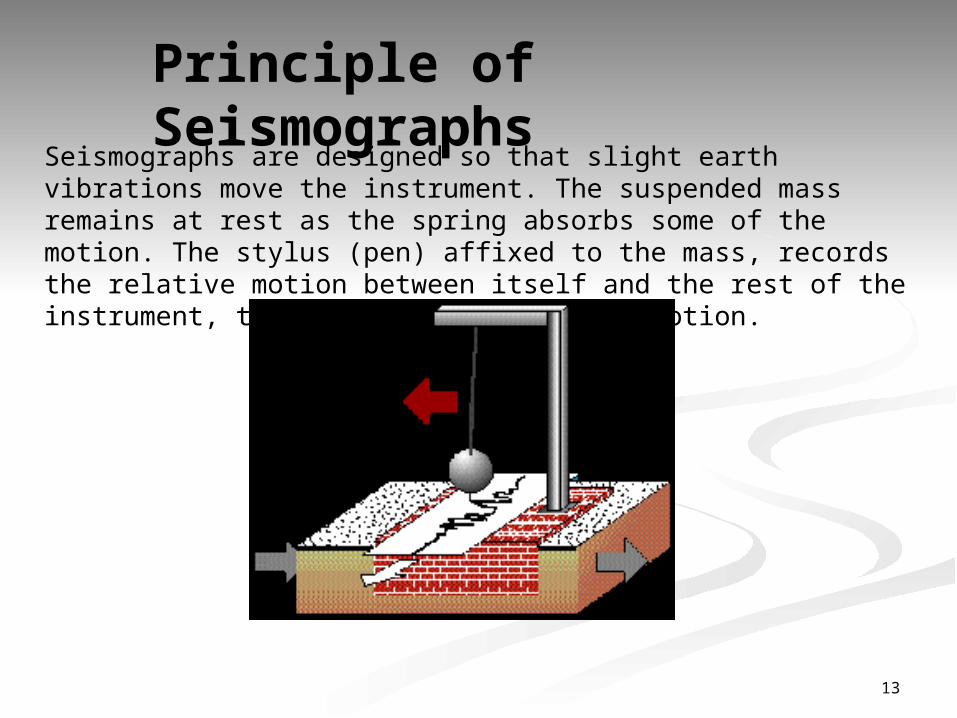
Principle of Seismographs
Seismographs are designed so that slight earth vibrations move the instrument. The suspended mass remains at rest as the spring absorbs some of the motion. The stylus (pen) affixed to the mass, records the relative motion between itself and the rest of the instrument, thus recording the ground motion.
13
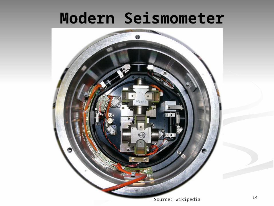
Modern Seismometer
14Source: wikipedia

Principle of Modern SeismometerModern seismometers use electronics.
In some systems, the mass is held nearly motionless relative to the frame by an electronic negative feedback loop. The motion of the mass relative to the frame is measured, and the feedback loop applies a magnetic or electrostatic force to keep the mass nearly motionless. The voltage needed to produce this force is the output of the seismometer, which is recorded digitally.
In other systems the weight is allowed to move, and its motion produces a voltage in a coil attached to the mass and moving through the magnetic field of a magnet attached to the frame. Professional seismic observatories usually have instruments measuring three axes: north-south, east-west, and the vertical.
15
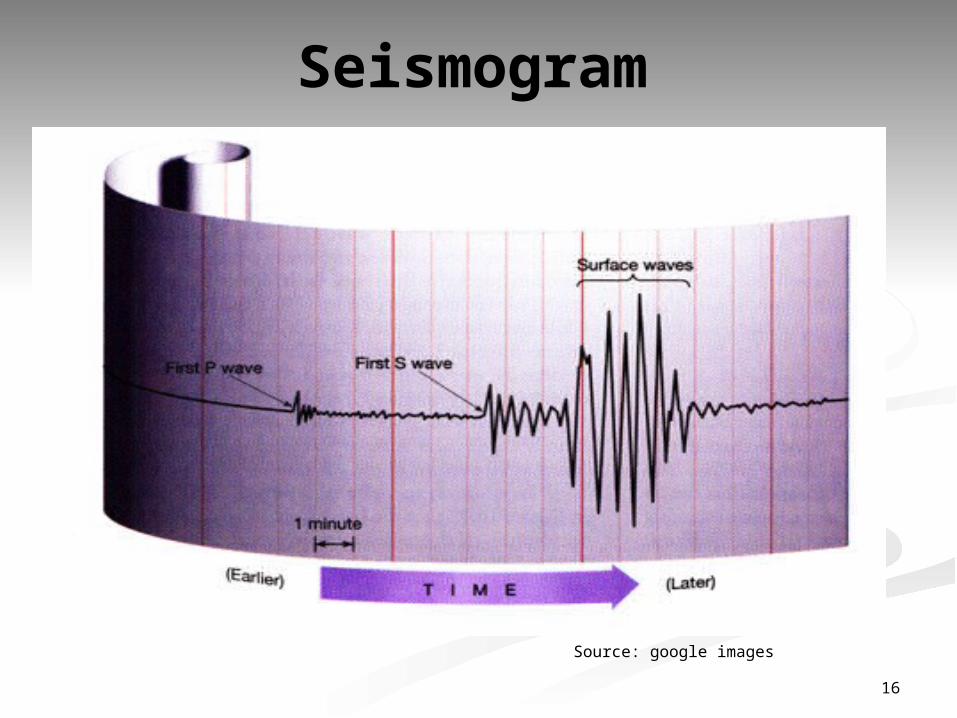
Seismogram
16
Source: google images
PROTECTING AGAINST EARTHQUAKE DAMAGEPrepare a Seismic Risk Map for the globe which identifies rock types, liquefaction potential, landslide potential.
Extensive geologic surveying has to be done to identify all active faults, including hidden faults.
Earthquake Resistant Design of StructuresEnact building codes to design and build earthquake-resistant structures in high seismic risk areas. wood, steel and reinforced concrete are preferred as they tend to move with the shaking ground (unreinforced concrete and heavy masonry tend to move independently and in opposition to the shaking, battering one another until the structure collapses)
Critical facilities such as nuclear power plants and dams should be built on stable ground and as far as possible from active faults. 17
http://www.bbc.co.uk/news/science-environment-17487482 (Article: Could
GPS be used to predict earthquakes?)
http://earthquake.usgs.gov/research/parkfield/pressrelease.html (Official press
release of Parkfield earthquake prediction)
http://abcnews.go.com/WNT/video/animals-sense-earthquakes-14375060
(Video of animals sensing earthquakes early)
Rikitake, T. (1966). A five year plan for earthquake prediction research in
Japan. Tectonophysics 3: 1–15
Tsunogai, U. & Wakita, H. (1995). Precursory chemical changes in ground
water: Kobe earthquake, Japan. Science, 269 (5220): 61–63
ReferencesReferences
18