Embed Size (px)
Citation preview
&for theWild Rare
Minnesota’s Comprehensive Wildlife Conservation Strategy
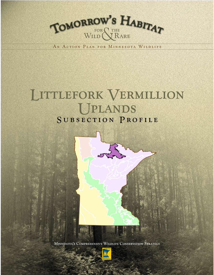
Littlefork Vermillion Uplands
S u b s e c t i o n P r o f i l e
A n A c t i o n P l a n f o r M i n n e s o t a W i l d l i f e
Tomorrow’s Habitat for the Wild and Rare: An Action Plan for Minnesota Wildlife 149
SPECIES PROBLEM ANALYSIS The species problem analysis provides information on the factors influencing the vulnerability or decline of SGCN that areknown or predicted to occur in the subsection. The table lists the nine problems, or factors, used in the analysis, and the percentage of SGCN in the subsection for which each factor influences species vulnerability or decline. The results of thespecies problem analysis indicate that habitat loss and degradation in the subsection are the most significant challenges facing SGCN populations.
NOTE: The inverse of the percentages for each problem does not necessarily represent the percentage of SGCN for which the factor is not a problem, butinstead may indicate that there is not sufficient information available to determine the level of influence the factor has on SGCN in the subsection.
Sources: MN DNR Natural Heritage database, MN DNR County Biological Survey (MCBS), MN DNR Statewide Mussel Survey, MN DNRFisheries Fish database. Areas with no MCBS animal surveys may have had mussel and fish surveys, as well as reports of other speciesoccurrences recorded in the MN DNR Natural Heritage database.
Problem Percentage of SGCN in the Subsection for Which This Is a Problem
Habitat Loss in MN 79 Habitat Degradation in MN 87 Habitat Loss/Degradation Outside of MN 46 Invasive Species and Competition 19 Pollution 28 Social Tolerance/Persecution/Exploitation 22 Disease 1 Food Source Limitations 1 Other 4
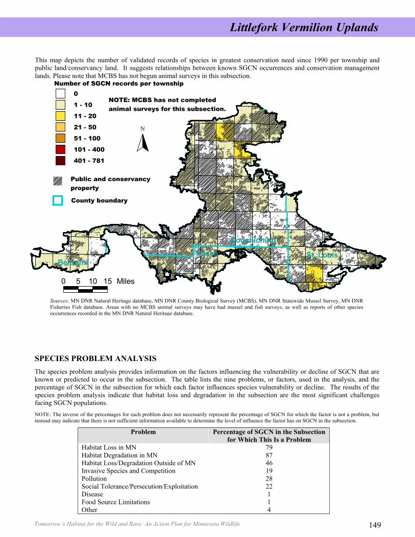
This map depicts the number of validated records of species in greatest conservation need since 1990 per township andpublic land/conservancy land. It suggests relationships between known SGCN occurrences and conservation managementlands. Please note that MCBS has not begun animal surveys in this subsection.
Littlefork Vermilion Uplands
Tomorrow’s Habitat for the Wild and Rare: An Action Plan for Minnesota Wildlife 148
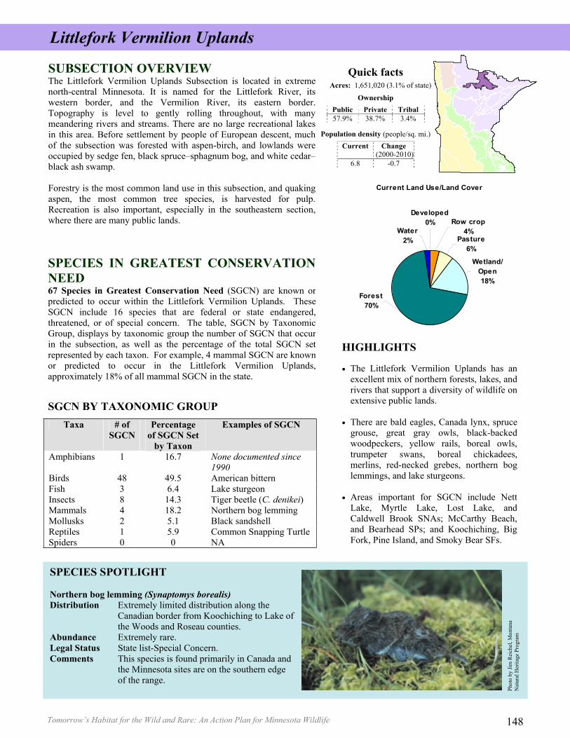
Current Land Use/Land Cover
Row crop4%
Developed0%
Water2% Pasture
6%
Wetland/Open18%
Forest70%
SUBSECTION OVERVIEW The Littlefork Vermilion Uplands Subsection is located in extremenorth-central Minnesota. It is named for the Littlefork River, itswestern border, and the Vermilion River, its eastern border.Topography is level to gently rolling throughout, with manymeandering rivers and streams. There are no large recreational lakesin this area. Before settlement by people of European descent, muchof the subsection was forested with aspen-birch, and lowlands wereoccupied by sedge fen, black spruce–sphagnum bog, and white cedar–black ash swamp.
Forestry is the most common land use in this subsection, and quakingaspen, the most common tree species, is harvested for pulp.Recreation is also important, especially in the southeastern section,where there are many public lands.
Quick facts Acres: 1,651,020 (3.1% of state)
Ownership Public Private Tribal 57.9% 38.7% 3.4%
Population density (people/sq. mi.) Current Change
(2000-2010) 6.8 -0.7
SPECIES IN GREATEST CONSERVATIONNEED67 Species in Greatest Conservation Need (SGCN) are known orpredicted to occur within the Littlefork Vermilion Uplands. TheseSGCN include 16 species that are federal or state endangered,threatened, or of special concern. The table, SGCN by TaxonomicGroup, displays by taxonomic group the number of SGCN that occurin the subsection, as well as the percentage of the total SGCN setrepresented by each taxon. For example, 4 mammal SGCN are knownor predicted to occur in the Littlefork Vermilion Uplands,approximately 18% of all mammal SGCN in the state.
SGCN BY TAXONOMIC GROUP
HIGHLIGHTS
• The Littlefork Vermilion Uplands has anexcellent mix of northern forests, lakes, andrivers that support a diversity of wildlife onextensive public lands.
• There are bald eagles, Canada lynx, sprucegrouse, great gray owls, black-backedwoodpeckers, yellow rails, boreal owls,trumpeter swans, boreal chickadees,merlins, red-necked grebes, northern boglemmings, and lake sturgeons.
• Areas important for SGCN include NettLake, Myrtle Lake, Lost Lake, andCaldwell Brook SNAs; McCarthy Beach,and Bearhead SPs; and Koochiching, BigFork, Pine Island, and Smoky Bear SFs.
SPECIES SPOTLIGHT
Northern bog lemming (Synaptomys borealis)Distribution Extremely limited distribution along the Canadian border from Koochiching to Lake of the Woods and Roseau counties. Abundance Extremely rare. Legal Status State list-Special Concern. Comments This species is found primarily in Canada and the Minnesota sites are on the southern edge of the range.
Littlefork Vermilion Uplands
Phot
o by
Jim
Rei
chel
, Mon
tana
N
atur
al H
erita
ge P
rogr
am
Taxa # of SGCN
Percentage of SGCN Set
by Taxon
Examples of SGCN
Amphibians 1 16.7 None documented since 1990
Birds 48 49.5 American bittern Fish 3 6.4 Lake sturgeon Insects 8 14.3 Tiger beetle (C. denikei)Mammals 4 18.2 Northern bog lemming Mollusks 2 5.1 Black sandshell Reptiles 1 5.9 Common Snapping Turtle Spiders 0 0 NA
Tomorrow’s Habitat for the Wild and Rare: An Action Plan for Minnesota Wildlife 149
SPECIES PROBLEM ANALYSIS The species problem analysis provides information on the factors influencing the vulnerability or decline of SGCN that areknown or predicted to occur in the subsection. The table lists the nine problems, or factors, used in the analysis, and the percentage of SGCN in the subsection for which each factor influences species vulnerability or decline. The results of thespecies problem analysis indicate that habitat loss and degradation in the subsection are the most significant challenges facing SGCN populations.
NOTE: The inverse of the percentages for each problem does not necessarily represent the percentage of SGCN for which the factor is not a problem, butinstead may indicate that there is not sufficient information available to determine the level of influence the factor has on SGCN in the subsection.
Sources: MN DNR Natural Heritage database, MN DNR County Biological Survey (MCBS), MN DNR Statewide Mussel Survey, MN DNRFisheries Fish database. Areas with no MCBS animal surveys may have had mussel and fish surveys, as well as reports of other speciesoccurrences recorded in the MN DNR Natural Heritage database.
Problem Percentage of SGCN in the Subsection for Which This Is a Problem
Habitat Loss in MN 79 Habitat Degradation in MN 87 Habitat Loss/Degradation Outside of MN 46 Invasive Species and Competition 19 Pollution 28 Social Tolerance/Persecution/Exploitation 22 Disease 1 Food Source Limitations 1 Other 4
This map depicts the number of validated records of species in greatest conservation need since 1990 per township andpublic land/conservancy land. It suggests relationships between known SGCN occurrences and conservation managementlands. Please note that MCBS has not begun animal surveys in this subsection.
Littlefork Vermilion Uplands
Tomorrow’s Habitat for the Wild and Rare: An Action Plan for Minnesota Wildlife 148
Current Land Use/Land Cover
Row crop4%
Developed0%
Water2% Pasture
6%
Wetland/Open18%
Forest70%
SUBSECTION OVERVIEW The Littlefork Vermilion Uplands Subsection is located in extremenorth-central Minnesota. It is named for the Littlefork River, itswestern border, and the Vermilion River, its eastern border.Topography is level to gently rolling throughout, with manymeandering rivers and streams. There are no large recreational lakesin this area. Before settlement by people of European descent, muchof the subsection was forested with aspen-birch, and lowlands wereoccupied by sedge fen, black spruce–sphagnum bog, and white cedar–black ash swamp.
Forestry is the most common land use in this subsection, and quakingaspen, the most common tree species, is harvested for pulp.Recreation is also important, especially in the southeastern section,where there are many public lands.
Quick facts Acres: 1,651,020 (3.1% of state)
Ownership Public Private Tribal 57.9% 38.7% 3.4%
Population density (people/sq. mi.) Current Change
(2000-2010) 6.8 -0.7
SPECIES IN GREATEST CONSERVATIONNEED67 Species in Greatest Conservation Need (SGCN) are known orpredicted to occur within the Littlefork Vermilion Uplands. TheseSGCN include 16 species that are federal or state endangered,threatened, or of special concern. The table, SGCN by TaxonomicGroup, displays by taxonomic group the number of SGCN that occurin the subsection, as well as the percentage of the total SGCN setrepresented by each taxon. For example, 4 mammal SGCN are knownor predicted to occur in the Littlefork Vermilion Uplands,approximately 18% of all mammal SGCN in the state.
SGCN BY TAXONOMIC GROUP
HIGHLIGHTS
• The Littlefork Vermilion Uplands has anexcellent mix of northern forests, lakes, andrivers that support a diversity of wildlife onextensive public lands.
• There are bald eagles, Canada lynx, sprucegrouse, great gray owls, black-backedwoodpeckers, yellow rails, boreal owls,trumpeter swans, boreal chickadees,merlins, red-necked grebes, northern boglemmings, and lake sturgeons.
• Areas important for SGCN include NettLake, Myrtle Lake, Lost Lake, andCaldwell Brook SNAs; McCarthy Beach,and Bearhead SPs; and Koochiching, BigFork, Pine Island, and Smoky Bear SFs.
SPECIES SPOTLIGHT
Northern bog lemming (Synaptomys borealis)Distribution Extremely limited distribution along the Canadian border from Koochiching to Lake of the Woods and Roseau counties. Abundance Extremely rare. Legal Status State list-Special Concern. Comments This species is found primarily in Canada and the Minnesota sites are on the southern edge of the range.
Littlefork Vermilion Uplands
Phot
o by
Jim
Rei
chel
, Mon
tana
N
atur
al H
erita
ge P
rogr
am
Taxa # of SGCN
Percentage of SGCN Set
by Taxon
Examples of SGCN
Amphibians 1 16.7 None documented since 1990
Birds 48 49.5 American bittern Fish 3 6.4 Lake sturgeon Insects 8 14.3 Tiger beetle (C. denikei)Mammals 4 18.2 Northern bog lemming Mollusks 2 5.1 Black sandshell Reptiles 1 5.9 Common Snapping Turtle Spiders 0 0 NA
Tomorrow’s Habitat for the Wild and Rare: An Action Plan for Minnesota Wildlife 151
DISTRIBUTION OF KEY HABITATS AND SPECIES RICHNESS BY TOWNSHIP
N/A: Insufficient data available to determine percent coverage within subsection. We have no data to indicate the existence of cropland, grassland, or developed land prior to settlement by people of European descent, although these land uses likely did occur at very low levels. NOTE: 0.0 indicates less than 0.05 percent coverage.
SUBSECTION HABITAT PERCENTAGES AND HABITAT USE BY SGCN TAXA This table presents information on the percentages for each habitat in the subsection (showing changes in coverage between the mid- tolate 1800s and the 1990s), as well as habitat use by SGCN taxonomic group. Habitats are listed in ranked order for percent coveragewithin the subsection in the 1990s. Key habitats for the subsection (as identified on previous page) are listed in BOLD. SGCN habitat useis broken down by taxonomic group, with a total number of species for all taxonomic groups listed at the far right of the table.
SGCN BY TAXONOMIC GROUP
HABITAT Perc
enta
ge o
f Su
bsec
tion
(189
0s)
Perc
enta
ge o
f Su
bsec
tion
(199
0s )
Am
phib
ians
Bird
s
Fish
Inse
cts
Mam
mal
s
Mol
lusk
s
Rep
tiles
Spid
ers
Tota
lN
umbe
r of
Sp
ecie
s
Forest-Lowland Coniferous 39.4 37.3 18 2 3 23Forest-Upland Deciduous (Aspen) 49.6 33.6 1 16 1 2 20 Grassland N/A 6.2 12 2 14Forest-Upland Coniferous 2.3 5.9 1 22 4 3 30 Cropland N/A 4.0 4 2 6Shrub/Woodland-Upland (Jack pine woodland) 3.7 3.0 13 3 3 19 Forest-Lowland Deciduous 1.3 2.6 12 1 13Wetland-Nonforest 0.2 2.5 18 2 1 21 Forest-Upland Deciduous (Hardwood) 1.0 2.2 1 15 3 19Lake-Deep N/A 1.8 2 1 1 4 Lake-Shallow N/A 0.6 4 1 5Developed N/A 0.3 4 1 1 6 Shoreline-dunes-cliff/talus N/A N/A 7 1 1 9Shrub-Lowland N/A N/A 15 1 3 19 River-Headwater to Large N/A N/A 2 2 1 2 1 8River-Very Large N/A N/A 1 1 1 3
This map depicts key habitats and thenumber of species of SGCN pertownship based on the sources listedbelow. It suggests there is often arelationship between key habitats andspecies richness (i.e., the variety ofspecies of SGCN in a township).
Littlefork Vermilion Uplands
Sources: Major River Centerline Traces in Minnesota, 1984; MN DNR 24K Rivers and Streams, 2005; MN DNR Fish database, 2005; MN DNR Natural Heritage database,2005; MN DNR Statewide Mussel Survey, 2005; MN GAP Landcover, 1993; The Nature Conservancy Rivers and Streams combined dataset, 2005
For more information on how this map was constructed, please see the Subsection Profile Overview in Chapter 5.
Tomorrow’s Habitat for the Wild and Rare: An Action Plan for Minnesota Wildlife 150
0 100 200 300 400 500 600 700 800 900
Grassland
Lowland Coniferous Forest/Shrubland
Forest- Upland Coniferous
Forest- Upland Deciduous (Aspen)
Acres (in thousands)
1890s%
1990s%
49.6 33.62.3 5.9
39.4 37.36.2
A/B – Terrestrial Habitat Use/Specialist Terrestrial Habitat Use
Description of Analyses
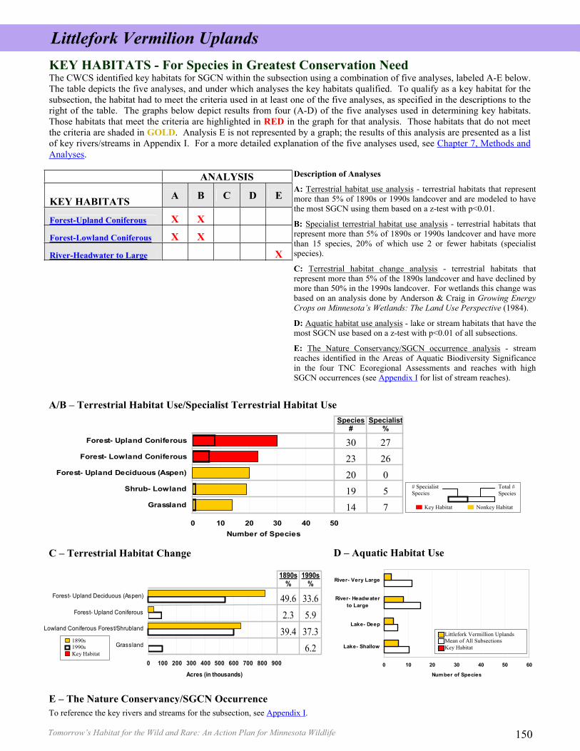
A: Terrestrial habitat use analysis - terrestrial habitats that representmore than 5% of 1890s or 1990s landcover and are modeled to havethe most SGCN using them based on a z-test with p<0.01.
B: Specialist terrestrial habitat use analysis - terrestrial habitats thatrepresent more than 5% of 1890s or 1990s landcover and have morethan 15 species, 20% of which use 2 or fewer habitats (specialistspecies).
C: Terrestrial habitat change analysis - terrestrial habitats thatrepresent more than 5% of the 1890s landcover and have declined bymore than 50% in the 1990s landcover. For wetlands this change wasbased on an analysis done by Anderson & Craig in Growing EnergyCrops on Minnesota’s Wetlands: The Land Use Perspective (1984).
D: Aquatic habitat use analysis - lake or stream habitats that have themost SGCN use based on a z-test with p<0.01 of all subsections.
E: The Nature Conservancy/SGCN occurrence analysis - streamreaches identified in the Areas of Aquatic Biodiversity Significancein the four TNC Ecoregional Assessments and reaches with highSGCN occurrences (see Appendix I for list of stream reaches).
KEY HABITATS - For Species in Greatest Conservation Need The CWCS identified key habitats for SGCN within the subsection using a combination of five analyses, labeled A-E below.The table depicts the five analyses, and under which analyses the key habitats qualified. To qualify as a key habitat for thesubsection, the habitat had to meet the criteria used in at least one of the five analyses, as specified in the descriptions to theright of the table. The graphs below depict results from four (A-D) of the five analyses used in determining key habitats.Those habitats that meet the criteria are highlighted in RED in the graph for that analysis. Those habitats that do not meetthe criteria are shaded in GOLD. Analysis E is not represented by a graph; the results of this analysis are presented as a listof key rivers/streams in Appendix I. For a more detailed explanation of the five analyses used, see Chapter 7, Methods andAnalyses.
D – Aquatic Habitat Use C – Terrestrial Habitat Change
E – The Nature Conservancy/SGCN Occurrence
# SpecialistSpecies
Total # Species
Key Habitat Nonkey Habitat
1890s 1990s Key Habitat
To reference the key rivers and streams for the subsection, see Appendix I.
ANALYSIS
KEY HABITATS A B C D E
Forest-Upland Coniferous X X
Forest-Lowland Coniferous X X
River-Headwater to Large X
0 10 20 30 40 50 60
Lake- Shallow
Lake- Deep
River- Headwaterto Large
River- Very Large
Number of Species
Littlefork Vermillion Uplands Mean of All Subsections Key Habitat
0 10 20 30 40 50
Grassland
Shrub- Lowland
Forest- Upland Deciduous (Aspen)
Forest- Lowland Coniferous
Forest- Upland Coniferous
Number of Species
Species#
Specialist%
30 2723 2620 019 514 7
Littlefork Vermilion Uplands
Tomorrow’s Habitat for the Wild and Rare: An Action Plan for Minnesota Wildlife 151
DISTRIBUTION OF KEY HABITATS AND SPECIES RICHNESS BY TOWNSHIP
N/A: Insufficient data available to determine percent coverage within subsection. We have no data to indicate the existence of cropland, grassland, or developed land prior to settlement by people of European descent, although these land uses likely did occur at very low levels. NOTE: 0.0 indicates less than 0.05 percent coverage.
SUBSECTION HABITAT PERCENTAGES AND HABITAT USE BY SGCN TAXA This table presents information on the percentages for each habitat in the subsection (showing changes in coverage between the mid- tolate 1800s and the 1990s), as well as habitat use by SGCN taxonomic group. Habitats are listed in ranked order for percent coveragewithin the subsection in the 1990s. Key habitats for the subsection (as identified on previous page) are listed in BOLD. SGCN habitat useis broken down by taxonomic group, with a total number of species for all taxonomic groups listed at the far right of the table.
SGCN BY TAXONOMIC GROUP
HABITAT Perc
enta
ge o
f Su
bsec
tion
(189
0s)
Perc
enta
ge o
f Su
bsec
tion
(199
0s )
Am
phib
ians
Bird
s
Fish
Inse
cts
Mam
mal
s
Mol
lusk
s
Rep
tiles
Spid
ers
Tota
lN
umbe
r of
Sp
ecie
s Forest-Lowland Coniferous 39.4 37.3 18 2 3 23Forest-Upland Deciduous (Aspen) 49.6 33.6 1 16 1 2 20 Grassland N/A 6.2 12 2 14Forest-Upland Coniferous 2.3 5.9 1 22 4 3 30 Cropland N/A 4.0 4 2 6Shrub/Woodland-Upland (Jack pine woodland) 3.7 3.0 13 3 3 19 Forest-Lowland Deciduous 1.3 2.6 12 1 13Wetland-Nonforest 0.2 2.5 18 2 1 21 Forest-Upland Deciduous (Hardwood) 1.0 2.2 1 15 3 19Lake-Deep N/A 1.8 2 1 1 4 Lake-Shallow N/A 0.6 4 1 5Developed N/A 0.3 4 1 1 6 Shoreline-dunes-cliff/talus N/A N/A 7 1 1 9Shrub-Lowland N/A N/A 15 1 3 19 River-Headwater to Large N/A N/A 2 2 1 2 1 8River-Very Large N/A N/A 1 1 1 3
This map depicts key habitats and thenumber of species of SGCN pertownship based on the sources listedbelow. It suggests there is often arelationship between key habitats andspecies richness (i.e., the variety ofspecies of SGCN in a township).
Littlefork Vermilion Uplands
Sources: Major River Centerline Traces in Minnesota, 1984; MN DNR 24K Rivers and Streams, 2005; MN DNR Fish database, 2005; MN DNR Natural Heritage database,2005; MN DNR Statewide Mussel Survey, 2005; MN GAP Landcover, 1993; The Nature Conservancy Rivers and Streams combined dataset, 2005
For more information on how this map was constructed, please see the Subsection Profile Overview in Chapter 5.
Tomorrow’s Habitat for the Wild and Rare: An Action Plan for Minnesota Wildlife 150
0 100 200 300 400 500 600 700 800 900
Grassland
Lowland Coniferous Forest/Shrubland
Forest- Upland Coniferous
Forest- Upland Deciduous (Aspen)
Acres (in thousands)
1890s%
1990s%
49.6 33.62.3 5.9
39.4 37.36.2
A/B – Terrestrial Habitat Use/Specialist Terrestrial Habitat Use
Description of Analyses
A: Terrestrial habitat use analysis - terrestrial habitats that representmore than 5% of 1890s or 1990s landcover and are modeled to havethe most SGCN using them based on a z-test with p<0.01.
B: Specialist terrestrial habitat use analysis - terrestrial habitats thatrepresent more than 5% of 1890s or 1990s landcover and have morethan 15 species, 20% of which use 2 or fewer habitats (specialistspecies).
C: Terrestrial habitat change analysis - terrestrial habitats thatrepresent more than 5% of the 1890s landcover and have declined bymore than 50% in the 1990s landcover. For wetlands this change wasbased on an analysis done by Anderson & Craig in Growing EnergyCrops on Minnesota’s Wetlands: The Land Use Perspective (1984).
D: Aquatic habitat use analysis - lake or stream habitats that have themost SGCN use based on a z-test with p<0.01 of all subsections.
E: The Nature Conservancy/SGCN occurrence analysis - streamreaches identified in the Areas of Aquatic Biodiversity Significancein the four TNC Ecoregional Assessments and reaches with highSGCN occurrences (see Appendix I for list of stream reaches).
KEY HABITATS - For Species in Greatest Conservation Need The CWCS identified key habitats for SGCN within the subsection using a combination of five analyses, labeled A-E below.The table depicts the five analyses, and under which analyses the key habitats qualified. To qualify as a key habitat for thesubsection, the habitat had to meet the criteria used in at least one of the five analyses, as specified in the descriptions to theright of the table. The graphs below depict results from four (A-D) of the five analyses used in determining key habitats.Those habitats that meet the criteria are highlighted in RED in the graph for that analysis. Those habitats that do not meetthe criteria are shaded in GOLD. Analysis E is not represented by a graph; the results of this analysis are presented as a listof key rivers/streams in Appendix I. For a more detailed explanation of the five analyses used, see Chapter 7, Methods andAnalyses.
D – Aquatic Habitat Use C – Terrestrial Habitat Change
E – The Nature Conservancy/SGCN Occurrence
# SpecialistSpecies
Total # Species
Key Habitat Nonkey Habitat
1890s 1990s Key Habitat
To reference the key rivers and streams for the subsection, see Appendix I.
ANALYSIS
KEY HABITATS A B C D E
Forest-Upland Coniferous X X
Forest-Lowland Coniferous X X
River-Headwater to Large X
0 10 20 30 40 50 60
Lake- Shallow
Lake- Deep
River- Headwaterto Large
River- Very Large
Number of Species
Littlefork Vermillion Uplands Mean of All Subsections Key Habitat
0 10 20 30 40 50
Grassland
Shrub- Lowland
Forest- Upland Deciduous (Aspen)
Forest- Lowland Coniferous
Forest- Upland Coniferous
Number of Species
Species#
Specialist%
30 2723 2620 019 514 7
Littlefork Vermilion Uplands
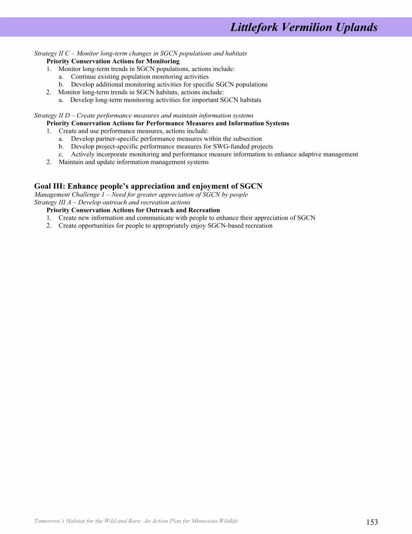
Tomorrow’s Habitat for the Wild and Rare: An Action Plan for Minnesota Wildlife 153
Strategy II C – Monitor long-term changes in SGCN populations and habitats Priority Conservation Actions for Monitoring 1. Monitor long-term trends in SGCN populations, actions include:
a. Continue existing population monitoring activities b. Develop additional monitoring activities for specific SGCN populations
2. Monitor long-term trends in SGCN habitats, actions include: a. Develop long-term monitoring activities for important SGCN habitats
Strategy II D – Create performance measures and maintain information systems Priority Conservation Actions for Performance Measures and Information Systems 1. Create and use performance measures, actions include:
a. Develop partner-specific performance measures within the subsection b. Develop project-specific performance measures for SWG-funded projects c. Actively incorporate monitoring and performance measure information to enhance adaptive management
2. Maintain and update information management systems
Goal III: Enhance people’s appreciation and enjoyment of SGCN Management Challenge 1 – Need for greater appreciation of SGCN by people Strategy III A – Develop outreach and recreation actions
Priority Conservation Actions for Outreach and Recreation 1. Create new information and communicate with people to enhance their appreciation of SGCN 2. Create opportunities for people to appropriately enjoy SGCN-based recreation
Littlefork Vermilion Uplands
Tomorrow’s Habitat for the Wild and Rare: An Action Plan for Minnesota Wildlife 152
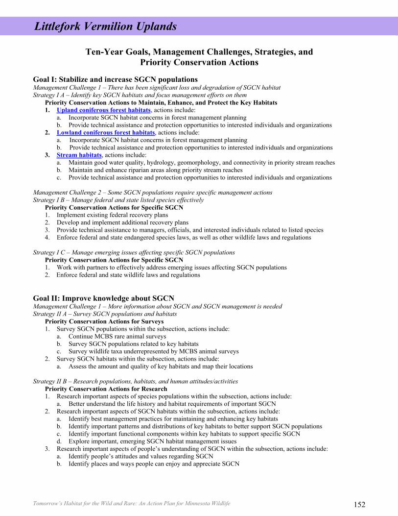
Ten-Year Goals, Management Challenges, Strategies, and Priority Conservation Actions
Goal I: Stabilize and increase SGCN populations Management Challenge 1 – There has been significant loss and degradation of SGCN habitat Strategy I A – Identify key SGCN habitats and focus management efforts on them
Priority Conservation Actions to Maintain, Enhance, and Protect the Key Habitats 1. Upland coniferous forest habitats, actions include:
a. Incorporate SGCN habitat concerns in forest management planning b. Provide technical assistance and protection opportunities to interested individuals and organizations
2. Lowland coniferous forest habitats, actions include: a. Incorporate SGCN habitat concerns in forest management planning b. Provide technical assistance and protection opportunities to interested individuals and organizations
3. Stream habitats, actions include: a. Maintain good water quality, hydrology, geomorphology, and connectivity in priority stream reaches b. Maintain and enhance riparian areas along priority stream reaches c. Provide technical assistance and protection opportunities to interested individuals and organizations
Management Challenge 2 – Some SGCN populations require specific management actions Strategy I B – Manage federal and state listed species effectively
Priority Conservation Actions for Specific SGCN 1. Implement existing federal recovery plans 2. Develop and implement additional recovery plans 3. Provide technical assistance to managers, officials, and interested individuals related to listed species 4. Enforce federal and state endangered species laws, as well as other wildlife laws and regulations
Strategy I C – Manage emerging issues affecting specific SGCN populations Priority Conservation Actions for Specific SGCN 1. Work with partners to effectively address emerging issues affecting SGCN populations 2. Enforce federal and state wildlife laws and regulations
Goal II: Improve knowledge about SGCN Management Challenge 1 – More information about SGCN and SGCN management is needed Strategy II A – Survey SGCN populations and habitats
Priority Conservation Actions for Surveys 1. Survey SGCN populations within the subsection, actions include:
a. Continue MCBS rare animal surveys b. Survey SGCN populations related to key habitats c. Survey wildlife taxa underrepresented by MCBS animal surveys
2. Survey SGCN habitats within the subsection, actions include: a. Assess the amount and quality of key habitats and map their locations
Strategy II B – Research populations, habitats, and human attitudes/activities Priority Conservation Actions for Research 1. Research important aspects of species populations within the subsection, actions include:
a. Better understand the life history and habitat requirements of important SGCN 2. Research important aspects of SGCN habitats within the subsection, actions include:
a. Identify best management practices for maintaining and enhancing key habitats b. Identify important patterns and distributions of key habitats to better support SGCN populations c. Identify important functional components within key habitats to support specific SGCN d. Explore important, emerging SGCN habitat management issues
3. Research important aspects of people’s understanding of SGCN within the subsection, actions include: a. Identify people’s attitudes and values regarding SGCN b. Identify places and ways people can enjoy and appreciate SGCN
Littlefork Vermilion Uplands
Tomorrow’s Habitat for the Wild and Rare: An Action Plan for Minnesota Wildlife 153
Strategy II C – Monitor long-term changes in SGCN populations and habitats Priority Conservation Actions for Monitoring 1. Monitor long-term trends in SGCN populations, actions include:
a. Continue existing population monitoring activities b. Develop additional monitoring activities for specific SGCN populations
2. Monitor long-term trends in SGCN habitats, actions include: a. Develop long-term monitoring activities for important SGCN habitats
Strategy II D – Create performance measures and maintain information systems Priority Conservation Actions for Performance Measures and Information Systems 1. Create and use performance measures, actions include:
a. Develop partner-specific performance measures within the subsection b. Develop project-specific performance measures for SWG-funded projects c. Actively incorporate monitoring and performance measure information to enhance adaptive management
2. Maintain and update information management systems
Goal III: Enhance people’s appreciation and enjoyment of SGCN Management Challenge 1 – Need for greater appreciation of SGCN by people Strategy III A – Develop outreach and recreation actions
Priority Conservation Actions for Outreach and Recreation 1. Create new information and communicate with people to enhance their appreciation of SGCN 2. Create opportunities for people to appropriately enjoy SGCN-based recreation
Littlefork Vermilion Uplands
Tomorrow’s Habitat for the Wild and Rare: An Action Plan for Minnesota Wildlife 152
Ten-Year Goals, Management Challenges, Strategies, and Priority Conservation Actions
Goal I: Stabilize and increase SGCN populations Management Challenge 1 – There has been significant loss and degradation of SGCN habitat Strategy I A – Identify key SGCN habitats and focus management efforts on them
Priority Conservation Actions to Maintain, Enhance, and Protect the Key Habitats 1. Upland coniferous forest habitats, actions include:
a. Incorporate SGCN habitat concerns in forest management planning b. Provide technical assistance and protection opportunities to interested individuals and organizations
2. Lowland coniferous forest habitats, actions include: a. Incorporate SGCN habitat concerns in forest management planning b. Provide technical assistance and protection opportunities to interested individuals and organizations
3. Stream habitats, actions include: a. Maintain good water quality, hydrology, geomorphology, and connectivity in priority stream reaches b. Maintain and enhance riparian areas along priority stream reaches c. Provide technical assistance and protection opportunities to interested individuals and organizations
Management Challenge 2 – Some SGCN populations require specific management actions Strategy I B – Manage federal and state listed species effectively
Priority Conservation Actions for Specific SGCN 1. Implement existing federal recovery plans 2. Develop and implement additional recovery plans 3. Provide technical assistance to managers, officials, and interested individuals related to listed species 4. Enforce federal and state endangered species laws, as well as other wildlife laws and regulations
Strategy I C – Manage emerging issues affecting specific SGCN populations Priority Conservation Actions for Specific SGCN 1. Work with partners to effectively address emerging issues affecting SGCN populations 2. Enforce federal and state wildlife laws and regulations
Goal II: Improve knowledge about SGCN Management Challenge 1 – More information about SGCN and SGCN management is needed Strategy II A – Survey SGCN populations and habitats
Priority Conservation Actions for Surveys 1. Survey SGCN populations within the subsection, actions include:
a. Continue MCBS rare animal surveys b. Survey SGCN populations related to key habitats c. Survey wildlife taxa underrepresented by MCBS animal surveys
2. Survey SGCN habitats within the subsection, actions include: a. Assess the amount and quality of key habitats and map their locations
Strategy II B – Research populations, habitats, and human attitudes/activities Priority Conservation Actions for Research 1. Research important aspects of species populations within the subsection, actions include:
a. Better understand the life history and habitat requirements of important SGCN 2. Research important aspects of SGCN habitats within the subsection, actions include:
a. Identify best management practices for maintaining and enhancing key habitats b. Identify important patterns and distributions of key habitats to better support SGCN populations c. Identify important functional components within key habitats to support specific SGCN d. Explore important, emerging SGCN habitat management issues
3. Research important aspects of people’s understanding of SGCN within the subsection, actions include: a. Identify people’s attitudes and values regarding SGCN b. Identify places and ways people can enjoy and appreciate SGCN
Littlefork Vermilion Uplands
Tomorrow’s Habitat for the Wild and Rare: An Action Plan for Minnesota Wildlife How to use this subsection profile Intended audience: Natural resource professionals and interested stakeholders Identify how the priority conservation actions and key habitats intersect and inform your
current and future priorities.
Using your additional insights and local knowledge, “step-down” the priority conservation actions into more detailed actions and practical on-ground tasks.
Use it to understand species in greatest conservation need priorities and tell a story about the subsection (its history, biology, ecology, demography) to other natural resource professionals, managers, decision makers and land owners.
Visit our website, or give us a call, and tell us how you’re using it, how others are using it, and ideas that “step-down” the priority conservation actions.
Website:
www.dnr.state.mn.us/cwcs For more information, please contact: Emmett Mullin, Project Manager, MN DNR, phone: 651-259-5566, email: [email protected] Daren Carlson, Ecologist/GIS Analyst, MN DNR, phone: 651-259-5079, email: [email protected] Brian Stenquist, Strategic Planner, MN DNR, phone: 651-259-5144, email: [email protected] How to cite this document: Minnesota Department of Natural Resources, 2006. Tomorrow’s Habitat for the Wild and Rare: An Action Plan
for Minnesota Wildlife, Comprehensive Wildlife Conservation Strategy. Division of Ecological Services, Minnesota Department of Natural Resources.
©2006, State of Minnesota, Department of Natural Resources Department of Natural Resources 500 Lafayette Road St. Paul, MN 55155-4040 (651) 296-6157 (Metro Area) 1-888-MINNDNR (646-6367) (MN Toll Free)
Equal opportunity to participate in and benefit from programs of the Minnesota Department of Natural Resources is available to all individuals regardless of race, color, creed, religion, national origin, sex, marital status, public assistance status, age, sexual orientation, disability or activity on behalf of a local human rights commission. Discrimination inquiries should be sent to MN DNR, 500 Lafayette Road, St. Paul, MN 55155-4049; or the Equal Opportunity Office, Department of the Interior, Washington, D.C. 20240. This document is available in alternative formats to individuals with disabilities by calling (651) 296-6157 (Metro Area) or 1-888-MINNDNR (MN Toll Free) or Telecommunication Device for the Deaf/TTY: (651) 296-5484 (Metro Area) or 1-800-657-3929 (Toll Free TTY). Printed on recycled paper containing a minimum of 10% post-consumer waste and soy-based ink.