Embed Size (px)
Citation preview
By B. S. BUTLER. E. D. WILSON. AND C. A. RASOR
Prepared under a co-operative agreement between the
ARIZONA BUREAU OF MINES
and the
PUBLISHED BY
l~nilTrn;ttu nf ArizouaTUCSON, ARIZONA
ARIZONA BUREAU OF MINES
llutu.rrntty of Art;:outtiuU.rUu
Fifty cents
(Free 10 rcside'nts of Arizona)
UNITED STATES GEOLOGICAL SURVEY
ARIZONA BUREAU OF MINES, GEOLOGICAL SERIES
NO. 10, BULLETIN NO. 143
GEOLOGY AND ORE DEPOSITS OF THETOMBSTONE DISTRICT, ARIZONA
Vol, IX, No.1
PREFACE
Through the co-operatiou of the United States Geological Survey, the Arizona Bureau of Mines has been able to present thisbulletin to the persons interested and to those who may becomeinterested in further development of the old mining camp ofTombstone. If the Survey had not supplied the services of Dr.B. S. Butler and made available the data collected years ago byDr. F. L. Ransome, the Bureau would have been unable to complete the project at this time. The Bureau is glad to acknowledgeits indebtedness to the Survey for this splendid co-operation andfor numerous courtesies extended in the past.
When a detailed investigation of an old mining camp is begun,it is always uncertain whether the report will be of any practicalvalue. Too often such an investigation indicates that the oredeposits have been exhausted, and the report shows that furtherwork in the camp is not justified by the conditions found.
Fortunately, that is not true of this report. The authors havedemonstrated that the positions of the ore bodies are determinedby definite structural conditions that are plainly set forth herein,and that numerous favorable areas remain unexplored. A goodmining geologist who familiarizes himself with the geology of thedistrict can, by following the suggestions offered in this bulletin,ascertain where new ore bodies are likely to be found, and it isconfidently believed that the development of such ore bodies willeventually mean a great deal to the district and the state.
G. M. BUTLERDecember 27, 1937.
TABLE OF CONTENTS
INTRODUCTIOi'i.
Location. Culture, and Transportation..Physical Features ...._ .Climate and Vegetation __ .Previous WorlcField 'Vork and AcknO\\'ledgments __
GENERAL GEOLOGY __General Statement.Pre-Cambrian HackLCambrian' RocksDevonian Beds..Carboniferous Rocks.IVfesozoic Roeks__Cenozoic Deposits ..Post~Paleozoic Igneous Rocks ..
Rhyolite Porphyry..Uncle Sam Porphyry..Schieffelin Granodiorite ..Dikes_Volcanic Rocks__
STRUCTURIL
Introduction..Sequence of Structural Events __Generally East-West Structures: Ajax Hill Horst..The Tombstone Basin..
Rolls_.Bedding-Plane Faults_.Bedding Faults Associated with Anticlines and Rolls..Tension Fissures ("Hoodoo Cracks").Saddle Fissures_.
Thrust Faulting..North-South Dike Fissures and Faults..Emplacement of Igneous Bodies..Northeast Ore Fissures.._Faults of Uncertain Age..
Tranquility-Contention Fault..Grand Central FaulLDate of the Late Faulting..
Cause and Re18.tion of Structural Features..ORE DEPOSITS.
History and Production ...Summary.Detailed Description.Production Summary.
I\-lineralogyGeneral Statement.. .Native Elements..
Oxides.CarbonatesSilicates
77H9
10[1111213J41-118232424242526282828293032383333343d
3434;353536:36;)73737:3838
'J'i\BI,E; (:fiT CONTKI\TTS -Co}lti,nued ILLUS'I'Hl\,'frONS
Supplement
Supplement
Supplement
Supplement
Supplement
SupplernentAND
___ Supplement__ Supplement
SILVER_Supplement
PAGE
l.--INIH~X MAP SHO\OVING LOCATION OF TOl\IIlSl'ONE DISTHICT 82.-- ·-CHOSS SF~CTION THROUGH COMET SI-L\FT 753.~"",CHOSS SECTION THROUGH PROMPTEH SHAFT 814. -Cnoss SECTION OF VIZlN A ROLL 905...-,--Cnoss SECTION OF INGEHSOL OVERTURN. 1-lJ3
-,PANORAIVLA OF P:\RT UF TOJ:'lclBSTONE DISI'RICT. Fnmtispiec(~
n. --GENEHil.I.,IZIW COI,U_MNAH SECTION.. _SupplementIII, ·GENERiI.L GEOLOGIC MAP OF' TOI\TBSTDNE
DrsTHlcT__IV. -GIWLOGIC MAP OF CENTHAL PAHT OF
TOl\'1BSTONE DISTlUCT.. SupplementS:t~CTIONS ALONG LINJ<~S A-A' and
Ole PLATE IIL . Supplement
VI, - -STIn.rCTUHE DIAGRAJVI OF TOMBSTONE DIS'l'RICT__ SupplcmcntVII. -MAP OF PIUNCIPAL CLAIMS AND WORKINGS IN
CENTRAL PART OF 'TOMBSTONE DISTHIC'l' __ ... SupplementVHI. --CROSS S.E,CTlON THROUGH CONTENTION DIKE AT
PUWIP SHAFT.. . SupplementIX. --LONGITUDINAL SECTION OF WORKINGS IN HEAD
CENTER AREA._ SupplementX. --LONGITUDINAL SECTION OF TOMBSTONE
EXTENSION MINE. __ SupplementXL -,-LONGITUDINAL SECTION OF COMET MINK Supplement
XII.-LoNGITUDINAL SECTION THHOUGH LUCKY Cuss,OLD GUARD, AND HERSCHEL MINES Supplernent
XIII ---CROSS SECTION THROUGH LUCKY CGSSWORKINGS AT l\iL-\IN SHAFT
XIV. ----]:..,ONGITUDINAL SECTION THHOUGH OREGONPHOMPTER MINES __
XV.-SE;C'fWN ALONG "409" FISSURE..XVI.---LONGITUDINAL SECTION NEAR AXIS OF
THREAD ROLL.XVII.-LONGITUDINAL SECTION NEAR AXIS OF
MACIA ROLLXVIII.-LONGITUDINAL SECTION NEAR AXIS OF
NORTHEAST VIZINA ROLL_.XIX, A, B.~LONGITUDIN AI, SECTION Nr~AR AXIS. OF
QUARRY ROLLXX.---LONGITUDINAL SECTION NEAR AXIS OF
GIHAHD ROLL __XXI.- LONGITUDINAL Sl':CTION NEAR AXIS OF
WEST SIDE ROLL SupplementXXII.-SEC'l'ION ALONG ARIZONA QUEEN FISSURE Supplement
XXIIL----LONGITUDINAL SECTION ON SKIP SHAFTFISSURE.. Supplement
XXIV/A, B.--SECTION ALONG yVESI' SIDE FISSURE ._. ..s-upplementXXV. ,-PLAN OF WORKINGS IN STATE OF MAINE MINE .Supplement
XXVI. ---CROSS SECTION THHOUGH STATE OF MAINE MINE Supplement
PAGE
6' PLATE~:;,
(-):3 PLATE
B4 PLATE
13466 PLAT~:
6667 PLi\TE137!~B PLATE
PLATE,G869 P'LA.TE:
6969 PLATE7172 PLi\TE7374 PLATE74 PU\TE7480 PL.:>"TE8485 PLAn:35Sf) PLATl':t803 PLATE
93FLATf.~95
96PLATE97
97PLATE98
99PljAl'E99
100102 PLATE
103PLATE103
1O:J PLATE103104 PLATE104 PLATE104 PLATE104104105 FIGURE105
FIGURl'~105106 FIGUHE
105 _FlGUEE
106 F'IGUEE
107lOB
Antimonatcs
and 'Tellurites (7)Molybdates
Classification of thc Ore Deposits_Favorable Rocks
Upper Part of Bisbee '""nee .....Upper Part of Naco and Lower Part of
Bisbee GroupDikes
Deposits Associated \vith North-South (Dike) Fissures.Contention-Grand Central Ore Zone..E:merald MineTombstone Extension Area._Comet Ore Zone_ .Minera1i:t.ation Associated with the Anchor or Coyote F'ault
Deposits Associated with Faults __Lucky Cuss Fault Zone __Prompter Fault ".\'o,,,n,
Deposits Associated Anticlines and Rolls..Location of Mineralization on the RollsDescription of Roll Deposits,.Holls East of the Empire Dike_Enwire Anticline West of Empire DikeRolls in Sulphuret S:ync1ineSulphuret Anticline_ .Boss 'TerraceIngel'sol Overturn
F'issure Deposits_Skip Shaft FissureWest Side FissureArizona Queen FissureDefence Fissure_Fissure Veins in Quartz LatHe
Distribution of Metals and MineraLSilverGoldLeadTvIanganeseCopperZincMolybdenum_Iron MineralsNonmetallic Minerals
FUTUHE OF THE DISTRICT
Deposits in the Eastern Part of the District above Water Level.Deposits in Northeast FissuresDeposits Associated with Faults._Deposits Associated with Dikes __Deposits Associated with Holls._
Deposits in the Eastern Part of the District below \A/ater LevelDeposits in the Vlestern Part of the DistI'icL
7
1::0 OF THE
district is served by a standard-gauge branch line froma station on the Douglas loop of the Southern Pacific
miles west of Tombstone. For agricultural supplies,access to the farms of the San Pedro Valley.
INTIWDUCTION
LOCATION, CULTURE, AND TEANSPORTATION
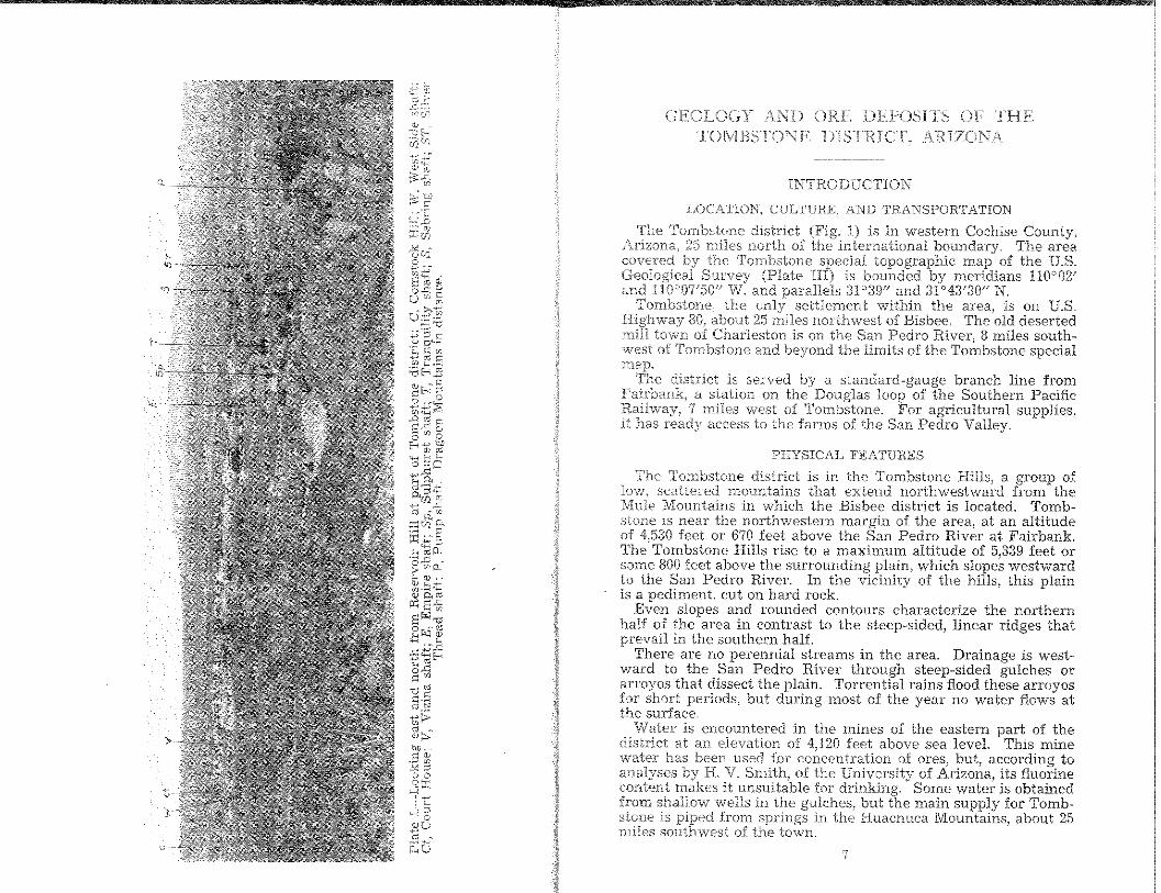
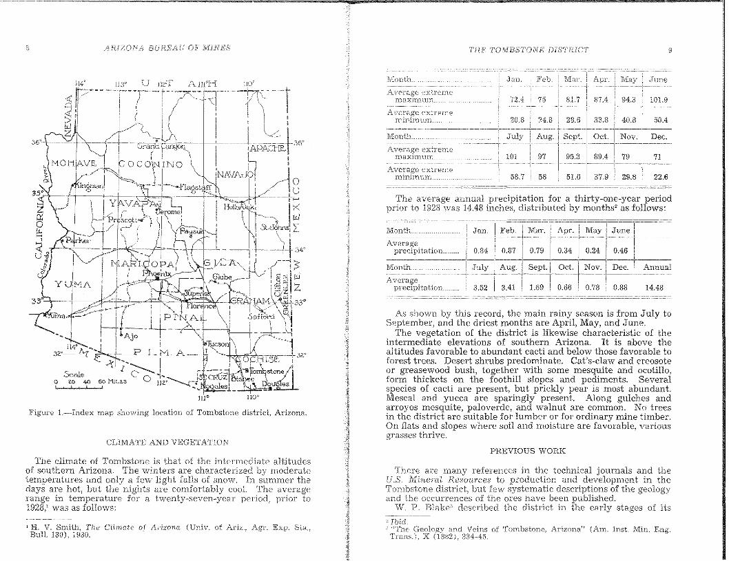
The Tombstone district Wig, I) is in western Cochise County,iU'lZ,Jna, 25 miles north of the international boundary, The area
the Tombstone special topographic map of the U.S.(Plate III) is bounded by meridians 1l0"02'
and paranels 3F39" and 31'43'30" N.the only settlement within the area, is on U.S.
aboui 25 miles northwest of Bisbee. The old desertedtown Charleston is on the San Pedro River, 8 miles south-
west of Tombstone and beyond the limits of the Tombstone special
PHYSICAL FEATURES
The Tombstone district is in the Tombstone niHs, a group ofscattered mountains that extend northwestward from theMountains in which the Bisbee district is located. Tomb
stone is near the northwestern margin of the area, at an altitudeof 4,530 feet or 670 feet above the San Pedro River at ~"airbank.
The Tombstone Hills rise to a maximum altitude of 5,339 feet orsome 800 feet above the surrounding plain, which slopes westwardto the San Pedro River. In tbe vicinity of the hills, this plainis a pediment, cut on hard rock.
Even slopes and rounded contours characterize the northernhalf of the area in contrast to the steep-sided, linear ridges that1)1'<0,,",1.1 in the southern half,
There are no perennial streams in the area. Drainage is westward to the San Pedro River through steep-sided gulches orarroyos that dissect the plain. Torrential rains flood these arroyosfor short periods, but during most of the year no water flows atthe surface,
Water is encountered in the mines of the eastern part of thedistrict at an elevation of 4,120 feet above sea level. This minewater has been used for concentration o.f ores, but1 according toanal'ysE<s by H. V. Smith, of the University of Arizona, its fluorinecont<mt makes it unsuitable for drinking. Some water is obtainedfrom sbaHow wells in the gulches, but the main supply for Tombstone .is piped from springs in the Huachuca Mountains, about 25miles sDutbwest of the town.
bJJ·c: w,"""' u;'~;:;00--;;:r;~
....._-~-~------------------------_----------------------------,1
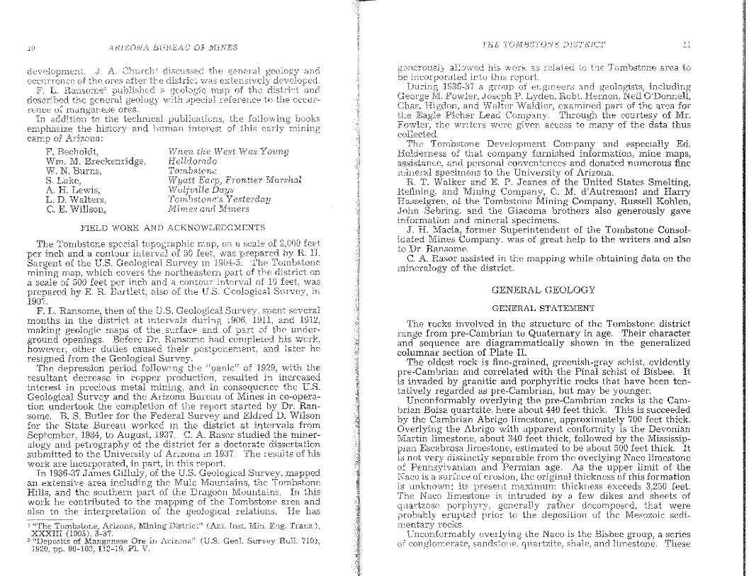
The average annual precipitation for a thirty-one-year periodprior to 1928 was 14.48 inches, distributed by months' as follows:
TIJE TOMBSTONE DISTRICT'
l\/lonth, Jan Feb. MaL June
extre.me72.4 75 81.7 101.9
extreme20.8 24.8 28.6 38.8 40.8 50.4
Month.. JuJy Aug. Sept. Oct. Nov. Dec,
extreme101 97 95.3 89.4 79 71
extreme58.7 58 51.6 37.9 29.8 22.6
14.48
Annual
Jan. :Feb. Mar. Apr. May June
Month..
Averageprecipitation..
ManDL_
Averageprecipitation __
As shown by this record, the main rainy season is from July toSeptember, and the driest months are April, May, and June.
The vegetation of the district is likewise eharacteristic of theintermediate elevations of southern Arizona. It is above thealtitudes favorable to abundant eacti and below those favorable toforest trees. Desert shrubs predominate. Cat's-claw and creosoteor greasewood bush, together with some mesquite and ocotillo,form thickets on the foothill slopes and pediments. Severalspecies of caeti are present, but prickly pear is most ahundant.Mescal and yucca are sparingly present. Along gulches andarroyos mesquite, paloverde, and walnut are common. No treesin the distriet are suitable for lumber or for ordinary mine timber.On flats and slopes where soil and moisture are favorable, variousgrasses thrive.
ARiZONA BUREilU OF JilHNES
Figure l.·-·-Index map showing location of Tombstone district, Arizona.
CLIMATE AND VEGETATIONPREVIOUS WORK
The climate of Tombstone is that of the intermediate altitudesof southern Arizona. The \vinters are characterized by n10deratetemperatures and only a few light falls of snow. In Sllmmer thedays are hot, but the nights are comfortably coo!. The averagerange in tenlperature for a twenty-seven-year period! prior to1928,' was as follows:
There are .lnany references in the technical journals and theU.S. Mineml Resources to produetion and development in theTombstone district, but few systematic descriptions of the geologyand the occurrences of the ores have heen published.
W. P. Blake" described the district in the early stages of its
H. V. Smith, The Clinwte of Arizona (Univ. of Ariz" Age Exp. Sta"Bull. 130), 1930.
:; Ibid,"The Geology and Veins of 'Tombstone, Arizona" (Am. lnst, Min. Eng.Trans.i, X (1882),334-45.
llRJZONA BIJREAU OF NnNES TIlT'; TOJ.VIBSTONI!; DISTHIC'T
al.Iowf~d his vlork as rel;':'l.t~';d to the '1\fmbstone area tointo this
19:36-:37 a groupFoviler, Joseph P,
mguuu, and Walter examined part of the area forLead Company. Tbrough the courtesy of Mr,
the vvriters were given access to ITlany of the data thuscolleeled,
The Tombstone Development Company and especially Ed,Holderness of that company furnished information) mine maps,aSSlSCallC'e, and personal conveniences and donated numerous finernineral specimens to the University of Arizona.
n T, Walker and E. P. Jeanes of the United States Smelting,Refining, and Mining Company, C. M, d'Autremont and HarryHasselgren, of the Tombstone Mining Company, Russell Kohlen,John Sebring, and tbe Giacoma brothers also generously gaveinfonnation and mineral specimens.
J, R Macia, former Superintendent of the Tombstone Consolidated Mines Company, was of great help to the writers and alsoto Dr, Ransome.
C, A Hasol' assisted in the mapping while obtaining data on theminera!or'v of the district.
GENERAL GEOLOGY
GENERAL STATEMENT
Tbe rocks involved in the struelure of the Tombstone districtrange from pre-Cambrian to Quaternary in age. Their characterand sequence are diagrammatically shown In the generahzedcolumnar section of Plate 11.
The oldest rock is fine-grained, greenish-gray scbist, evidentlypre-Cambrian and correlated with the Pinal schist of Bisbee, Itis invaded by granitic and porphyritic rocks that have been tentatively regarded as pre-Cambrian, but may be younger.
Unconformably overlying the pre-Cambrian rocks is tbe Cambrian Bolsa quartzite, here about 440 feet thick. This Is succeededby the Cambrian Abrigo limestone, approximatel{ 700 feet thick.Overlying the Abrigo with apparent conformIty IS the D~voman
Martin limestone, about 340 feet thick, followed by the MISSISSIP-Escabrosa limestone, estimated to be about 500 fect thick. It
not very distinctly sep~rable from the overlying Naco limestoneof Pennsylvanian and Permian age. As the upper limit of theNaco is a Stlrface of 121'08101'1\ the original thickness of this formationis unknown; its present maxilnum thickness exceeds 3,250 feet.The Naco limestone is intruded by a few dikes and sheets of
porphyry, generally rath~r. dec(;mposed, tha~ weI'.eerupted prior to the depOSItIOn of the MesozOIC sed,
H"'W,d'y rocks.overlying the N <:teo is the Bisbee group) a series
sandstone, quartzite, shale, and limestone. These
When the West WasHeIldoTadoTombstoneWyatt Earp, Frontier MaTshalWolfville DaysTornbstoneJs Yesterday1\,111.'1nes and Miners
J" Cb.urcb'; disc;ussed(iCeurrence oJ the ores after the district 'ivas exter}sivei
F. L. Ransome~ PClDllSLlllUdescribed tbe generalrenee or ores.
In addition the technical P~'~)l~~~~',:,':~~ theemphasize the history and lnuywn of thiscamp of Arizona:
F, Becholdt,Wm M, Brl2ckem'id§:e,W, N. DSlIllo,
S, Lake,A H. Lewis,L. D. Waiters,C. K Willson,
FIELD WORK AND ACKNOWLEDGMENTS
The Tombstone special topographic map! on a scale of feetper inch and a contour interval of 50 feet, was prepared R H.Sargent of the U.s, Geological Survey in li104··5. The Tc,mbsl,or,cmining map) which covers the of the district ona scale of 500 feet per inch and a contour of 10 wasprepared by K R Bartlett, also of the U.s, Geological in1907.
F, L, Hansome, then of the U,S, Geological severalmonths in the district at intervals during 1906, andmaking geologic nlaps of the. surface and of part of, . underground openings. Before Dr. Ran~ome had cornpleted tnshowever) other duties caused theIr postponernent, and later hE:resigned from the Geological Survey,
The depreasion period following the "panic" of 1929" with tberesultant decrease in copper prodnctioD 1 resulted In Increasedinterest in precious uletal mi?-ing, and in conse.queYl:ce the U.S.Geological Survey and the ArIzona BUTeau of Mmes 111 co-operation undertook the completion of the report staTted by Dr. Ransome. B. S, Butler for the ~'ederal Survey and Eldred D. Wilsonfor the State Bureau worked in the district at intervals fromSeptember, 1934, to August, 1937. C. A, Hasor studied the mineralogy and petrography of the district for a doctorate disseTtatIO,nsubmitted to the University of Arizona in 19:n The resuUs of hISwork are incorporated, in part, in this report.
In 1936-37 James Gilluly, of the U.S, Geological Survey, mappedan extensive area including the Mule Mountains, the TombstoneHills, and the southern part of the Dragoon Mountains. In tblswork he contributed to the mapping of the Tombstone area andalso to the interpretation of the geological relations, He has
~7,'Th-;-Tom·bston€,Arizona, Mining District" (Am. :fnst. Min. Eng. Trans.),XXXlI! (1903), 3-37,"Deposits of Manganese are in Arizona" (U.S. Geot Survey Bull. 710),1920, pp, 96-103, 113-19, P1. V.
2 4RIZ()/V B{J!<EliU OIi'MINES J'OMBST()NE' !JISTR,U:.7
ison the \-vcst
l.m.der· the granOCllOI'lIt is rnedium rather dark
olJ.glJ LC.: gri.ei::;sc,ld.81 Under the itsare see} to be quartz) orthoclase, plagioclase.,
which is partly altered to serIcite.oligoclase. The rock is classed as granodio·"
chemical analysis Inight show it to be quartz mOD-
Lindgren;'\ rocks of this composition areMesozoic or early Tertiary, rather than
The contacts of the granodiorite with theU1UlUI.lau Balsa nn"rl7iiip on the east and the Uncle Sam porphyryon the west do not reveal positive age relations. It has not been
that the granodiorite is earHer than the Cambrian beds.seen in a few shallow cuts, the lower contact of the Balsa seems
to be a fault plane rather than an erosional surface. Posslhly theof Ajax Hin is an intrusion akin to the Schielfelin
gran,odiorite west of Tombstone (page 25), and its upper extentwas determined by a low-angle fault at or near the base of
the Its gneissoidal character may be due to flowagethe mass. A short distance southwest of the Oregon Mine,
the granodiorite of Ajax Hill is separated fro:m Naco limestone onthe north by the Prompter reverse fault, which is believed to havebeen formed during the Laramide revolution between lateMesozoic and early Tertiary tirfle.
The area of Pinal schist and granodiorite is traversed by anearly north-south dike of a rock that is too decomposed forsatisfactory determination, but which is provisionally termedgranodiorite porphyry. Like the granodiorite of Ajax HilI, it isalso of doubtful age.
are of' Ivlf>s':)Z(Yicfhe BIsbee
whole is a)·aLlae'Ie
the' .lirnestoneagc< '['he thicl<.::ness
as .no measurul)lc section of theexceeds feet
After of the Tom.bstone the rocks ofthe district \Frere i'a.lded and faulted at the SElmc
w'ere inT\i'aded the mass of San1 latHen(ln,)nrrv that crops in the western part of the About
same tirne) bU.t probably slightly IateT) they were intrudedan iTregular body of granitic rock, the Schieifelin granodiorite.Southwest of the mapped area, near Charleston) the latHeporphyry is intruded into anele-sitic and rhyolitic extrusive Tocks.It seems likely that the earliest volcanic activity was extrusion of
foUowed by intrusion of quartz latHe porphyry near thethen existing surface, and this in turn was followed"'bv intrusionof granodiorite. C
After the intrusions) the district appears to have beento long-continued erosion. Probably in late Tertiary time lowlying parts of the district were covered by a :Cluvial deposit ofrudely stratified, more or less firmly consolldated angular rockdetritus with some layers of sand and sill. This material, whichappears to be analogous in age and mode of deposition. to the Gilaconglomerate of central Arizona, occupies laTge areas in the broadvalleys that separate the hills of the Tombstone district froIn theHuachuca) Whetstone) and Dragoon ranges. In n10st places it isoverlain by a few feet of Quaternary gravel, sand, and siIt. Atleast one basaltic eruption occurred during or after the accumulation of the valley fill, as shown ,in Walnut Gulch, about a milenortheast of Tombstone. Some faulllng has taken place since thedeposition of the valley fill, which has been deeply trenched bvarroyos of the present erosion cycle. . .
PRE-CAMBRIAN ROCKS
The pre-Cambrian basement rocks of the Tombstone district arerestricted in exposure to a narrow north-south bell west of theSummit of Ajax Hill, in the south-central part of the district.These rocks as a rule are rather decomposed and inconspicuousin outcrops. Consequently, and also because of their lack ofknown ore deposits, they entirely escaped the attention of Blake"and Church' who first described the geology of the district.
The Pinal schist Is gray, fine-grained, brittle, and moderatelyfissile. Microscopic examination of a specimen from a shaft 0.7mile south of Ajax Hill shows the rock to consist mostly of quartzand sericite with a very liltle biotlle and green hornblende. Evidently it is a metamorphosed sedimentary rock.
I) Wm. P. Blake, "The Geology and Veins of Tombstone, Arizona" (Am.Inst. Min. Eng. Trans,), X (382») 334-45. "Tombstone and Its Mines"(New York, 1902). (A report to the Development Company of America.)
7 Jc:hn A. Church, "The Tombstone, Arizona, Mining Districf' (Am, Inst.Mm. Eng. Trans.), XXXllI (903), 3-37.
CAMBRIAN ROCKS
Above tbe Pinal schist and the granodiorite is the Bolsa quartzite, about 440 feet thick. The actual base of the quartzite is verypoorly exposed but where seen is marked by a layer of basalconglomerate generally about a foot thick. The formation consists of hard cross-bedded, fine-grained to pebbly quartzite in bedsup to 6 feet in thickness, with small well-rounded pebbles up tothe size of a pea common throughout. Its color on weatheredsurfaces is generally rusty brown.
Conformably overlying the quartzite is the Abrigo limestone,of which a complete section 700 feet thick is fairly well exposedeast of Ajax HilL It consists chiefly of thin-bedded, impure, andin part very cherty limestone, together with some beds of sandstone and shale. Sandy beds are more abundant in the uppcrthan in the lower part of the formation. Some of them ate flaggy
\Valdemar Lindgren, "Ore Deposits of the Jerome and Bradshaw Mountains Quadrangles, Arizona'! (U,S, GeoL Survey Bun. 782), 1926, p. 22.
/lRIZON BUREAl.r OF J\ITrJES THE' TOMBST()ivP; DIS'I'HIC'T
26
6
33
58
4
74
58II
26
159
146
25
10
82
205
Feet
783)
2.
8"
5"6"
1.
7.
4.
16"
12.
13.
IH.19"
Limestone, thick-bedded, fiuc,-grained,vvitha feVi,T pink beds that contain small silicanodules ".. . . ._. .. .. . .... __ .__ ..." ..Limestone, blue to slightly grc.cn, interbedded with maroon dolomite. Thm-bedded,but some beds axe up to 2 feet thick_.Alternation of dolomite and red to maroonsh;:-lly limestone and Hmy mudstone. Thedolomite is some\vhat sandy, in places con-glomeratic, and forms ledges _Dolomite, massive, red-brown and gray onfresh fracture, weathers brown-gray....Concealed; probably maroon shale _Dolomite, coarse-grained and massive, pink,weathers yellow-gray ,., , ,..Alternating shale and dolomite, poorly ex-posed ,."" .. " , , ,__ ,Dolomite, somewhat sandy. Massive, redbrown, weathers bufL _
9, Red dolomitic breccia..10. Concealed; probably shale and thin-bedded
dolomite _ .. ._. ,.. ,.Dolomite, red-bro\\,'D, weathers light creamto buff..,.. "" "" _ _ "" ..Mudstone, Ted, with fragments of dolomite.Exposures pOOl' , .Dolomite, cream-colored, with mud cracksfilled by red muddy breccia..Concealed"Limestone, massive, san d y bright red,weathers brown and buft.Limestone, sandy, l'anging to limy sandstone,with some thin dolomite and maroon shale.Very red. Poorly exposed, forms saddle..Dolomite, beds 4 to 6 inches thick, weath-ers buff ,,, ,....................... " " ,.. ' .Sandstone, weathers yellow, forms saddle..Dolomite finely crystalline, black, weathersdark gray to yellow-gray and buff. Beds %to 2 feet thick. Carries many silica geodesand nodules 3 inches to 2 feet 3CT053..
(Total dolomite member..
14.15.
11.
SECTION OF' NACO LnVlESTONE SOUTH OF AJAX HILL
",,,onm surface overlain by Mesozoic conglomerate.Dolomite member:
the older tS rathc'l as a surface nick ifl UwT01nbstone district. occurrence is in the southeastern
0:1' the beds as a vvhole are folded;;",1'e 1n01'2 on the rnargins of area, The
Hmestone of Dartinvest of Tombstone) is mappedas as is that \vest of Luckv Cuss Mine and of an areaeast of Three Brothers BilJs" AlI" of these smaUer areas showo:msiderable duE':' to the intrusion of Schieffelin
Tht? limestone southeast (,f Tombstone is cut byand invaded by at least one sheet of rhyolite porphyry"
The foUo\ving section of Naco .limestone in the ridge 1 milesouth of Ajax Bill was measured by James Gilluly and Edgar
of the U.S. Geological
(BulL
-which contains thin streaks or oj li_mestone andbrovln, At the the is pure"
4 to ,j suppos"dJy the sameat Bisbee. is
\) F" L. Ransome, "8ome Paleozoic Sections inrelation" (U.s. Geol Survey Prof. 98), uno,A. A, Stoyanow, "Conclation of PaleozoicGeat Soc" Arner.), XLVII (1936), 48L
:0 Written communication, March 11, 1912.
marksspan"nf:1y fossilifemus"
the Ordovician and Silurian are wnOHVpositional record or are some ofimfossiliferous beds in the part the Martin llmestonenot known. The same hiatus in the record appears at Bisbee, inthe region" and at JeromE,"'
DEVONIAN BEDS
The Martin llmestone at its base, just above the white quartzlte,consists of gray limestone wlth layers of soft gray shale"probably are not over 10 feet thfck and are succeeded by hard,gray limestone with a few intercalated sandy beds" As at Bisbee,the characteristic Devonian fossils occur in the half orupper two thirds of the formation. According to Do Kindle"the fauna is the same as that of the Martin limestone at BIsbee.
CARBONIFEROUS ROCKS
The Mississippian series of the Carboniferous is represented bythe Escabrosa limestone which, iike all of the rocks that precedeit in the geologic section, is exposed in the south-central ofthe district. It also crops out in the anticline in the east-centralpart.
Mississippian rocks crop out on the summit of Militarythe crest of the ridge for about a mile soutb of that hiB,irregular areas I % miles farther east. The formation consists ofthick-bedded, light-gray Iimestone. Fossils are not verybut a small collection from Military HiB was made np of speciesthat occur in the Escabrosa limestone of Bisbee. No recognizableplane of separation appears between the Escabrosa limestone andthe Naco lim,estone at Tombstone, and) as there is a considerableinterval between the highest Mississippian and the lowest Pennsylvanian fossils, the line of separation as drawn in mapping isnecessarily somewhat The thickness of the Escabrosais taken as about 500 feet
The overlying Naco limestone is ingeneral thinner bedded and more compact than the Escahrosa" Afew beds of hard pinkish limestone, as a rule and ofreddish, calcareous shale the prevailing hueof the formation, Much of the upper part of the is
as sh.owD on pages 15-16. Thf:' Naco. in contrast to
Their Cor-
THE iTOJ1/IBST'ONE DISTRICT
Ineasured:F
1,100 approx.,----
Total Naco lirnestone._. 3,263+
The upper portion of the Naco contains numerous large orebodies, The Luck Sure and part of the Lucky Cuss deposits arein :its upper dolomite) and the Oregon-Prompter bodies were inthe limestone beneath the orange dolomite member.
The lower part of the Naco limestone is of Pennsylvanian age,and the upper portion, including the orange dolomite, black limestone, and dolomite members of Gilluly, is either Pennsylvanianor Permian. Regarding the age of the upper Naco, Dr. G, H. Girty,of the U.S. Geological Survey, wrote (November 18, 1936) asfollows:
The Naco formation contains faunas of two distinctly different aspectsand I understand that they occupy relatively higher and lower positions[n the formation. The older fauna is related to that of the Magdalenalimestone, the younger to that of the Eueca fmmation as now restricted.
To represent the younger fauna there is only one collection of sufficientsize to be useful for purposes of correlation, and even so, the specimensare not in a good state of preservation, being rather coarsely silicified.They do not therefore show details of sculpture satisfactorily, a circumstance which is especially unfavorable to the identification of gastropodsvilhich constitute the major part of the fauna. The general character ofthe fauna is shown by the following list of this collection.
Faunal Ust of collection from P'4 miles southeast of Military Hill,Tombstone District, Arizona.
Echinocrinus, several speciesPl'oductus ivesi Newberry val',Composita subtilita HallDeltapecten vanvleeti BeedePleurotomaria? sp.Bellerophon aff. Stevensianus McChesne)-'Euphemites subpapillosus White?Omphalotrochus obtusispira ShumardTurbo? sp.Orthonema sp.
Two other collections contain some of the same species, but add littleto the list that is significant. Mention may be made, however, of a smallRhynchoneUoid resembling WcUe'l'cHa? Utah Marcou, a Nucula resemblingN, anodo'ntoides Meek, a large Bellerophon resembling B. mujusc1l-lus, aMurchisonia resembling M. terebra, and a large Euomphalus. With regardto the species cited as Bellerophon alI. B. Stevensianus, the single specimenin the collection shows regularly arranged transverse imbrications, butit may also have fine revolving li1'ae, in which case it would be a Tatherlarge species of Bucanopsis. The facts are not clear.
Nearly all of the species mentioned above occur in the fauna of thefOTmation, at least so far as the preservation permits the character
be determined. To this agreement there are two main excepform resembling Froductus i.vesi represented b~ two poorand the :form cited as Plettrotmnm"ia? sp. which is :1'atherSome of the species n,entioned or species at present indistin
from them may occur in other faunas, but with no fauna isdose a parallel, species by species, as with the Bueco fauna. As
n'"m,,]s Pn)ductusivcsi., it is an outstanding species; it is almost characof: the Kaibab and San Andres faunas and it does not, seemingly,
the IIueeo Jauna, On the other hand, the large Omphalotrochus
B. Black limeste'tH' .rrlcrnbcr:1. Dolomite that 42, Black lixnestone beds to
thick. thicker bedded TU',CT'W
granite ~:;bout 20 feet 17;3:3, Same limestone as ]:]4, Black limestone, 4 to 20
feet thick. V,Teathers gray 995. Black hrnestone with some beds slightl}'
yello,,\' and dolomitic on top. Most beds lesst.han 1 foot thide. 74
G. Black limestone in beds 2 to 12 feet thick.Some nodules and irregular masses of chert. 81
I, Black lirrlestone, massive, \'leathers light tomedium gray. Forms l.edge... 5\
3. Dense black limestone, slightly sandy. Some\'I/11at shaly to\vard the top, Weathers darkgray. Beds 1 to {] inches thick :30
9. Like (8) but thicker-bedded.. 4510. Like (9) hut vi/ith a fe\v thin shaly and
dolomitic la:yers in lower 40 feet. A littlesandstone at top 59
(Total black lirnestone 62~l)
C. Orange dolomite member:1. Sandstone, pink and limy, \:vcathering ver.v
dark brown 4 1;c
2. Concealed 53. Dolomite, sandy, slightly cross-bedded near
top, Pink, Vc'eathers brownish. 34, Sandy shale :omd dolomitic sandstone, poor-
ly exposed n5. Aphanitic limestone in beds ~'2 to 8 feet: thick,
\veathering dark gray 13 1 2G. Dolomite, dense, pinkish gray on fresh frac-
ture, weathers orange, Slightly sandy7. Concealed :3B. Dolomite. like (6).. 49. Limestone. mottled pink and gray, Forms
conspicuous ridge 1810. Concealed; probably chieny limestone with a
little red shale. 19111. Lil'nestone. massive and pink, \\,reathering
gray. ~{n
12. Alternating red shale and pink limestone inlayers of about 10 feet thickness. lOB
1:3. Limestone, gray, mottled in places \vith redand orange, Beds 2 to 4 feet thidc Containssome thin shale beds nnd ct shaly zone about10 feet thick at base.. 5:3
j 4. Limestone, gray to pink on fresh fracture,weathers light gray. Contu.ins so.me nodularchert that \veathers buH to red-brov'/ll. Bedsaverage 1 foot in thickness 54
15. Lim(~stone, Eke (4) but with more chert.Beds 2 inches to 2 feet in thickness 100
l{), Thin-bedded, aphanitic, gray 11Jnestone.on fresh fracture. Very fossiliferous. Interbedded \vith a little red shale andsandy limestone 87
(Total orange eOHHeUk n",]nt,el'D. Black lirnestone, \veathering
stems. A little chert innear top 58
/-lRIZONA BU.REA.L- OF' ]vl'INES TE}E TO!Vl135''T()!.VE: D18T1<1(:"7
55-70
3,115+
Feet1.040 e
20054IJ
422+582IJ
35IJ105055
4801080
6
25-35
1025-35
20-40
some ii;;;~~i;;;;E; •••••·••••..•.•••.••·..··•• ··
GENER/l"LIZED COTVIPOSITE SECTION OF BISBEE GHOUP
Erosion surfacebrown shale and brown to white quartzitic sandstz;ne
M,'Ssivp buff to gray quartzitic sandstone with some m-shale,,,.,,.,,,, ,,,, _ ,,,, ,, ,, " "" "' " .green, hard siliceous :'I:ale with some ,sandstone.:
!VL",SlVE buff to white quartzltlc sandstone with some shalethin beds of limestone "" .. """''''' __.. ".
bluish shale with some conglomerate .. _to cherty limestone ("Joe" limestone) ..
1.2.
TaiaL
Gray, green;:, "jod black..!,):;,,),•••••••.•••:::••:••••·••.•••:••••.•••:••.••••::••.Yellow sandstone..
14. Reddish to black shale "" "'.Blue-gray limestone with some shale _ . . -- ....Greenish to gray and brown shale WIth "ii"ght-gray chertybeds , ""."" ._ " "",,,.,, .
17. Blue-gray fossiliferous limestone with some shale; lower7 feet is massive limestone ..
18. Gray to brown shale "" __ _ ;.; _ :.." .19. Blue limestone: blue-gray limestone, fOSSIlIferous III upper
portion.. __ .. _ _._" .. "" ,, _., __ , " - " ; ;" .20, "Novaculite": novaculite and fine-grained qu,,:rizIte, WIth
some limestone and limestone conglomerate. m northernportion of Tombstone basin: in places conta~ns lenses ofcollg1omerate at or near base. Rests on Naco llmestone,.
----"'-~"."
Lc,urcn, HThe Tombstone, Arizona, Mining District''' (Am. lnst.XXX (1UO:3), :3-:)7.
C. K ""S~~" in the Tornbstone (:;xtensio:n ar-c'C!! {)f the sotttI1f'.'d.sternthe hn.sin,
11.
The lower 55 to 70 feet of the Bisbee group constitutes a stratigraphic division that Ransome, in unpublished notes, termed"Novaculite." In the central part of the dIstrIct 1t IS referred to bythe miners as the "white quartzite. 17 Church,Il who was the firstto attempt a systematic account of the stratigraphy of the T().mb,~
stone district, refers to this division as t.he "Toughn~t quartZIte:His "Herschel quartzite," although he d1d not know It, 's also thesame division. This basal member IS not a true quartzlt~ ~nd IS
far from homogeneous. In its least metamorphosed c,:md1tlon asexposed on the ridge southeast of U.S.L.M. No: 2, tlus memberconsists of bard, compact, banded epidotlc shale mterbedded WIth
which on their rather rusty, weathered surfaces look lIkefirte-gr.ahled quartzite, but in wbich the detrital quartz ~rains arecemented by calcite into a hard, tough rock. Such materIal gradesratber irregularly across tbe bedding mto dense, brIttle rocks that
resemble fljnt or true novacuhte In texture. These rocksare gray on fresh and, alth?ugh so hard and flintythat cannot be seratehed with a kmfe, they effervesce WIth
tau; as and ,it seE'ros to be llighly
MESOZOIC HOCKS
The naHle Bisbee group is in th.is applied to a series ofshale, sandstone, quartzite) and limestone that un-conformably overlies the Naco lirnestone, T'hese rocks occurwithin the district in two rnain an-;as, rudely circular andabout Juiles in diarrleter, lies south of T'ombstone and containsmany of the principal mines. A and very areaextends from the northwestern the district to beyondthe southwest corner of the area mapped iu Plate III. This areain general lies between the large body of Uncle Sam onthe west and granodiorite) pre-Cambrian, and Paleozoic rocks onthe east. It contains the Bandolph, Mamie, and othersmall mines that at one time were px·oclwrtive.
In most places the Bisbee not well exposed. It formsrather S11100th, brown or that are littered withments of the harder beds. most abundant rocks arestonel quartzite; red, brown) green) or black shaIe~ and all k'dC'd
Hons between shale or quartzite and hnpure lirrlestone.has not only converted the sandstone
has produced abundant in the ~alcareous
sand or calcareous D1ud rocks and has converted some of the shaleto brittle aphanitio hornstono or novaculite. The epidote is generally in little nests or aggregates which on exposed surfacesweather out so that the rock bas a curious pitted appearance. Inaddition to the rocks mentioned) the formation contains somefairly pure Hrnestone members. Lenticular beds of conglomerate,made up largely of pebbles of Carhoniferous limestone and ofsiliceous rocks~ are locally present in the lo:ver portIOn, .
Nowhere' in the district is a complete sectIOn of the group aVailable for study and measurement Complexly foided, dislocatedby faulting, and extensively metal1?-0rphosed by ig!1eous intrusions)the Bisbee group has so far baffled attempts to dIscover the character and thickness of all its constituent parts, the total thicknessof the whole, or its exact geologic age. >
The following generalized section of the Bisbee group IS acomposite. Data for the iower :320 feet were obtained from mineworkings, drill records) and surface exposures in the northernhalf of the Tombstone basin. Tbe upper part is based uponmeasurements by J. P. Lyden, R M. Neil and
NIINES THE '{'()T'I1'BSTONE DlST,Fucr
the 10-foot Ihnestone is 25 to 35 feet of greenish toc"""" .." shale with light-gray cherty beds. Above this
is the '~6-foot liITlestonen ITlernber) \vhich consists of bluegray limestone \vith some shale; in places it contained ore bodies.
Overlying the 6-foo1: limestone is a .series) approximately 720feet thick, of dark to light-colored shale, with some sandstone anda few beds 01 limestone (see section, page 19). Near the upperlimit of this shaly series in the central Mesozoic area is a bed of
cherty limestone, generally about 20 feet thick, that hastraced on the surlace from the Head Center claim just north
of the shaft of the Contention Mine) along the north slopeof and Hardup hilIs to near the Tribnte shaft. Ex-posures are not continuous and in places the bed is plainly offsetby faults. West of the Trihute Mine and on the west slope ofHarclup Hill, what appears to he the same hed of limestone is muchdislocated by faulting and is repeated in outcrop so that intraverses up and down the slope it may he crossed from two tofour times. South of Hardup HilI, this limestone crops out almostcontinuously to a point about 900 feet northwest of the BunkerHill Mine, where it is cut off by a fault.
Overlying the gray, cherty limestone and forming the upperportions of Hardup and Reservoir hilIs as well as the slopes nearthe southeast of the Contention Mine .is a portion of the Bisbeegroup in which quartzite or hard quartzitic sandstone predominates (divisions 1 to 6 of section, page 19), Associated with itare beds of conglomerate, of impure, more or less metamorphosedlimestone, and considerable red and green shalc. These rocks arein many places rather conspicuously spolted with little segregations of epidote which weather out on exposure and leave therock with a pitted surface. The total thickness of this memberis not known. It probably is considerably over 1,800 feet,
The divisions of the Bisbee group just descrihed have receivedlocal recognition in the mines near Tombstone and may be strictlyapplicable only to the central Mesozoic area-perhaps only to apart of that area. Farther west the rocks of the Bishee group arein general less altered, the shale is less flinty, and sandstone takesthe place of quartzite.
The geologic age of the Bisbee group is stili rather uncertain.Fossils were collected frorn the Blue limestone at several localities
the' IJliw::'s and atin the DliJZC of that exteneJ fcorn surface nearstone dCYVln to the sc\'enth lc\rel of the ContentloIllvIine,
the Blue liInestone is 25 to 35 feet 01: hard, brittle~hnm,n shale. Above this shale is a 10-foot Inen1ber of
fossiliferous linle-stone \vith some shale. This ill,ember.in Tombstone basin is known as the "10-100t .li,mestone/ i
contained some iLTlportant ore bodies. It closely resembles tl1€Blue lirnestone in color and fossil content but can be readily dis
by its stratigraphic sequence and relatively small
micnJS(C('Kllcall.v in thin is seer:of verv of detrital
,,,,w,',!,,,,, \\"j1:h " and abundar, tiPl'''!'' calcite. Associa.ted v'lith the novaculite a1:'(' lenses of
in \vhieh all of the TEither an:'lirncstone. Most of these derived frOIn theCarboniferous limestone) are 6 irlches in diarnetersome are 18 inches across. As the beds in this lo(}ality80 southwest) they have been overturnedthe conglonlerate appears to have, been deposited, as sn1al1 andrelativelY th,ick lenses in a generally deposit of cal··((areous mud and sand, it is possible that apparently lenticularchara,der lYlay be duel at least in part, to intense folding and cornpreSSIOn. As seen underground in the lnines J.lear T01nbstone theso-called ~~white quartzi.te)) has evidently more metalnorphism than on Luck Sure HilL Associated with 11"131:eria1 ofnovaculitic character is rock that would be calied atypical quartzite in which detrital quartz grains have beenc€:xnented by quartz. Such white granular quartz rock, however;in 111any places eneloses residual masses of limestone or passes inthe most irregular and disconcerting way into the dense novaculiticmaterial or into limestone. The lin1estone conglornerates havebeen so altered as to be scarcely recognizable. T'hey have becomec.urh~:lsly blotchy rocks in which finely granular quartz; crystalhne 11ITlestone, and vaguely bounded streaks or bunches of fibrouswollastonite are so combined as to make a rock that is unusual1vdiflicuIt to driH and hreak Rock of this kind is exposed on th~fourth level of the West Side Mine near the Girard shaft and isahundant in the West Side dump. Before pumping stopped, itcould, accordmg to Ransome, also he seen at many places in thelower levels of the Contention Mine, The lower part of thedNovaculite" c~:mtained large ore bodies) particularly in the Vizina)Quarry, and GIrard rolis. Its middle portion has heen productivenotahly in the Chino stope of the Quarry roll and in the Vizinaroll.
Directly above the "Novaculite)) is the Blue limestone whichcontained some of the largest and richest ore bodies in the districtThis member consists of 20 to 40 feet of medium to thin-hedded.hlue-gray limestone that, where not metallized or otherwise meta:morphosed, is very eharacteristie and readily recognizable, Notonly is its color fairly distinctIve, hut its upper portion is in mostplaces crowded with poorly preserved shells of a smali undetermined species of oyster and of other genera, In the westernpart of the district, notably near the Randolph Mine and northof the Three Brothers Hills, are exposures of limestone similar tothe Blue limestone near Tomhstone and prohahly at about thesame stratigraphic horizon. These exposures prohably representlenses, and they are not thought to have been continuouswith the main Blue limestone that is exposed at the surface near
ARIZONli BUREiH.J OF NIlIVE,S THE '['OlY1BSTONF; DJSTRJCI'
CENOZOIC DEPOSITS
Tbe lower portions of the Tombstone district are mantled bydElpclSircs of D10re or less fi.rmly consolidated gravel) sand) and silt.
deposits, wbich are locally termed "caliche," appear to beanalogous to the Gila conglomerate, They are not deeply dissectedin the district and consequently are not well exposed for study,'rheir material as a rule consists of very roughly bedded, rathercoarse, rnore or less angular rock fragments and boulders froD1 theneighboring hiHs, In some places the larger fragments are ratherloosely held in a gravelly matrix; in other places they are firmlycemented by calcium carbonate,
The exposed thickness in the mapped area is not great, but theadjacent valleys are filled to an unknown depth by similar beds,A churn drill hole northeast of the town was discontinued in thismaterial at a depth of 500 feet, which indicates a rather steepslope of the bedrock wall of the old valley,
A large part, at least, of the Gila conglomerate of Arizona hasbeen shown to be of upper Pliocene age. J
'" Kirk Bryan1s originalof Pliocene fossils'll] within the formation was made a
Written communication<H Personal cDmmunication.lG M. "GcDlogical Relations of the Gila Conglomerate in
Al'izema," Am, Jour, Sci" XXXI (1936), 61-;)2,l'i 3', W. Gidley, Preliminary report on fossil vertebrates of the San Pedro
ValleY,Arizona, with description of new species of Rodentia andLangomorpha: U.S. Geot Survey Prof. Paper 131, pp. 119-31, 1922.HFossil Proboscidea and Edentata of the San Pedro Vaney, Arizona"(U.s. GeoI. Survey Prof. Paper 140), 1925, pp. 83-95.
Draw and TOlnbstone, J an1es mappc,ct this areabelieves that thE~ at the lVles()z()jc sectiona.t Torn'bstone is the of tht': thOugll it lTIay be
vouri 2E'r inasD1uch as the COl'nanche sea ()'V01'-
frorYl the south.:'?·
IYIuTal thins north'\vard from Bisbee as far as it'can b(,; traced in the Mule Iv1ountains~ and it seerns likely that itp.Locn('u Qut and the Cintura may have directly overlain
IVIor:J.t3 with a lIlorc miles to the north. The Cintura re-sernbles the Morita closely in lithology, and were it not forthe Mural it :is unlikely that the two forma-tions would been distinguished at Bisbee, The Mesozoic
above the basal conglomerate at Tombstone consists oflike those of the Morita and Cintura, though the prothe several varieties cannot be closely matched. Mr.
therefore the Mesozoic rocks at Tombstone aseouivalellt to some part of the Bisbee group at Bisbee, an opinion
is shared Dr, J. B. Reeside, J r,/4 who has examined thefossils in the InasITmch as the several formations repre-sented at Bisbf~e in the Bisbee group have not been discriminateda.t the Geological Survey classifies these rocks in theTombstone as the Bisbee group.
n.Cttl.' 'l'ornbstol1f:; ;::md fl'orn a lens oJ rather:2 to 3 feet 1. Vz miles southwestabout 375 feet southeast of the HUElchuca Water uHllp;myshne, AIl of the fossils collected were submitted ioStanton who that those frOID the Blue linv::stone are marineand are
In various small collections made from the Blue limestone nearthe Toughnut shaft, just south of Tombstone, Dr, Stanton identified:
)2 Vlritten communi'cation.
evidently Mesozoic as they contain Ostreidae, but the fossils are verypO~1'ly preserv:ed .and do not include any Tecognizable characteristic formswhICh would mdlCate whether they should be referred the Comancheseries or to the ,Jurassic. The fact that the Comanche is known tobe present in the neighboring Bisbee district and that no marine ,Jurassicis recorded within a long di~tance make it mOTe, probable that they areof Comanche age. Compansons have been made with Mr. Ransome'sprevious collections from the Bisbee district, but those collections do notinc1~de any from the Morita formation and there seem to be no identicalspeCIes in the lots from the Mural limestone and higher formations fromwhich fossils were obtained.
Ostrea sp,Gryphaea sp,Astarte (7) sp, a,Astarte (7) sp, b.Cyprina (7) sp,Modiola (?) sp,
It will be noted that for only two of the forms wasgeneric identification possible, '
From the locality southwest of Ajax Hill Dr, Stanton recognIzed:
Planorbis veternus M, and II, 7)Valvata scabrida M, and H,
He states: qThese are fresh-water shells and the two species towhich they are provisionally referred occur only in the Morrisionformation, the nearest locality at which they are known being
City, Colorado, It should be said, however, that thePlanorbis, v-:hich is the, most abundant and best preserved form,does not dIffer greatly IrOTTI a Tertiary species."12
The fresh-':later shens in the Tombstone district are probably ata hIgher hOrIzon strahgraphlCally than the marine fossils of theBIue limestone,
The Bisbee group of the Mule Mountains cannot be directlytraced to the Tombstone district The gap between the hills eastof Sandy Bob Ranch where the Glance conglomerate passes belowthe alluvium at the most nortberly point to which it can be tracedfrom Bisbee and the low hills north of Governnlcnt DTaw wheresin1i1ar conglomerate appears is about 6 .miles, There aresmall outcrops of shnilar conglomerate between
24 A.FtlZ()Iy'A 13UtlEA"U OF DdINES' '{()MBST01VE DiSTRICT 25
"'Granodiorite, Toadside by SchiefTelin's monument, Tombstone district,Arizona.
+Quartz latite porphyry, 2 1'2 miles \vest of Tombstone and L'2 mile east ofThe Dome, Tombstone district, Arizona.
SchieffeHn ~rra:nodiorite
Granodiorite is exposed over an area about 2 miles wide thatextends northwestward from the Lucky Cuss Mine, across Tombstone Gulch, and beyond the northern border of the area mappedas Plate III. Relatively weak in resistance to erosion, it formsa boulder-strewn pediment. It is termed the Schieffelin granodiorite from its typical occurrence in the vicinity of Schieffelin'smonument, northwest of Tombstone.
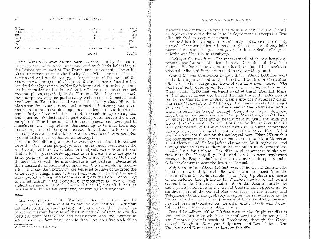
The granodiorite has the general appearance of a rather finegrained, light-gray granite and is locally known by that familiarrock name. In places it has a slightly reddish tint and passes intovarious porphyritic modifications along its contact with thesedimentary rocks into which it is intrusive. Under the microscope a typical specimen of the granodiorite from the roadsidenear Schieffelin's n1onument, a short distance north of the areaincluded in Plate is seen to be composed of about equal quantities of plagioclase, ranging from andesine to labradorite, andorthoclase, with quartz, biotite, hornblende and a little colorlessaugite, magnetite, and apatite. A chemical analysis of this rockis given under column 1, in the following table:
CHEMICAL ANALYSES OF GRANODIORITE AND QUARTZ LATITE PORPHYRY,TOMBSTONE DISTRICT, ARIZONA (R C. WELLS, ANALYST). .
I' 2t62.33 68.0416.92 15.823.95 2.341.24 .841.97 .804.48 3.263.62 3.933.36 3.32
110' .46 .37tlO .89.77
.63 .42,02 none.04 .04.17 .15.03 tr.
charactf;f thf'is intrusive into the SUl'JWJWne
"'\,ve31: of and to the southv,restintrudes breccias and flows. The porphyry
commonly sno\vs numerous smaH inclusions of s:hale and otherprobably derived from the enclosing walls. It does not,
hnW"Vf'r. appear to have brought about any pronounced contactmetamorphism and the conclusion is that it represents the solidification of a magma that, at the time of solidification. had nearlyreached the surface.
Rhyolite porphyry
The Naco limestone and older rocks are cut by dikes and invadedby sheets of light-colored quartz-bearing porphyry. These in··trusive rocks appear to have no connection with are deposition.As they are generally more or less decomposed, it will be sufficiently accurate to characterize them in genera1 as rhyoliteporphyry.
Occupying an extensive area in the western part of the districtand extending beyond the boundary of the area mapped (PlateIII), westward toward Charleston, is a mass of rock that Blakeand Church both called "rhyolite" and which Ransome also, in abrief report" on the manganese ores of the district, referred toas "rhyolite porphyry." Microscopic examination and chemicalanalysis (see page 25) show that this rock is not strictly a rhyolite but should be designated as quartz latite porphyry. It formsthe Three Brothers and Uncle Sam hills and is the general countryrock of the State of Maine, Merrimac, San Pedro, and Montezumamines. In this report it is referred to as the Uncle Sam porphyry.
The Uncle Sam porphyry is buff or rusty brown whereweathered but dark gray on fresh fractures. Its phenocrysts aresmall, generally less than a quarter of an inch in length, and arenot conspicuous. The apparent order of decreasing abundance isfeldspar, quartz, biotite, and hornblende. A characteristic featureof the rock is a blotchiness or unevenness of texture due to variations in the crystallinity of the groundmass. Under the microscopethe porphyry shows a vitrophyric texture, The feldspars areplagioclase and range from andesine to labradorite; no potashfeldspar was recognized. The quartz phenocrysts show the usualembayed outlines. Biotite, magnetite, a little hornhlende, andsmall priSlTIS of apatite are the other recognizable mineral constituents. The groundmass is a partly devitrified glass. A chemical analysis of the porphyry is given under 2, on page 25. It showsa rock more siliceous than the granodiorite) and with less alumina,iron oxides, lTIagnesia, and lin1e. The quantity and relative proportion of the alkalies in the two rocks are almost identical.
POST-PALEOZOIC IGNEOUS ROCKS
Uncle Sam porphyry
ft:nv D1Hes ,north of Tombstone in beds belH~'ath extensivements m.antled younger PTllVf'k
In the Tornbstone district oi~ the fonna-Han is represented. In or it is deforrnedfaulting (page 30), and in Walnut Gulch it is intruded by 1"",a1110ring dikes (page 28). The formation is overlain in many placesby a relatively thin alluvial cover of uDcemented gravel) sand, andsilt of Quaternary age.
n E. L, Jones, Jr., and F. L. Ransome, ;'Deposits of Manganese Ore in Arizona" U.S. GeoL Survey Bull. 710, 1920, p. 102 and Plate V,
2'/THE TOTVIBSTONE LilSTEICT
tc.averse the cerJtral IVlesuzoic are<:-l with a ""oeeaI course of nOTthri,'pn,es (,£l,st and E1 of 75 to g;) riepr,s,," v/eSl:, eXCcllt the Bos.s
which eastward,dikes not crop out pronllllenU} and as a rule aTe deeply
alh::red. arE' believed to as a relatively laterof the saIne :magma that gave to the Schieffelin gran-
odiorite and Uncle Sam porphyry.u'!)w'nTI CentTaI dike.·",,~-Themost easter1;/ of these dikes passes
Michigan Central, Cornell, and New Yearclaims. So far as no ore has been found in associationviith this dike and there are no extensive workings on it
GraTId Central-CoTItenti.on-Empire dikc.,·About 1.000 feet westof the Michigan Central dike is the Grand Central or Contention
{roIn which large quantities of ore have been rnined. Thesoutherly outcrop of this dike is in a ravine on th~ Gr~nd
UI:pp"r claim, 1,450 feet west-northwest of the Bunker HIll Mme.As dike is traced northward through the south extension ofthe Grand Central and Syduey claims into the Naumkeag claim,
is seen IV and VII) to be ofIset successively to the eastcross FrOITl the southern end of the Naumkeag north-
ward through the Grand Central, Cor:t.ention} Flc;rc~ ~orrison,Head Center Yellowjacket, and Tranqmhty clarms, It IS dIsplaced
curved that strike nearly parallel with the dike butto the east. The effect of these faults has been to shift
the upper of the dike to the east and, in places,. to producethree or more nearly parallel outcrops of the same dIke. All ofthe dike outcrops shown on the geological map (Plate lV) withinthe houndaries of the Grand Central, Contention. Flora Morrison,Head Center, and Yellowjacket claims are fault segments, andmining showed each of them to be cut off in its downward extension hy a fault plane. The dike in place appears at the surface near the Tranquility shaft and can be traced northwardthrough the Empire shaft to the point where it disappears underGila conglomerate near the town of Tombstone.
Sv'/phuret dike.·-About 400 feet west of the Grand Central dikeis the narrower Sulphuret dike which can be traced from themargiu of the Cenozoic gravels, on the Way Up claim just southof Tombstone, through the Little Wonder, Hawkeye, and Grrardclaims into the Sulphuret claim. A similar dike in nearly thesame position relative to the Grand Central dike appears in thesouthern part of the central Mesozoic area, on tbe Sydney and
'W,LC'~D u,muo'c_:and probably occupies the same fissure as thedike. actual presence of the dike itself) hO\VeVel\
has not been establis'J::led on the intervening Mayflower, Addie)Silver Dollar, and Alps claims.
Boss dilw.,~Trom 500 to 700 feet west of the Sulphuret dike isthe similar Boss dike which can be foUowed from the margin ofthe Cenozoic south of Tombstone, through the Good
Surveyor, Sulphuret, and Boss claims. TheBoss shafts are both on this dike.
.01tr.tT,none
tLtr.none
.07
100.:38
The Schief1\:;lin Inass~ as indicatedof its contact Naco limestone and vl'ith beds beIOJ}girthe Bisbee east of The and its contactNaco ;,.vest of the increases in sizedownward and would occupy a the area, of thedistrict were the general elevation. the surfac~,!,educed a fewhundred feet erosion; evidently it forms a stocktIke body. During its intrusion and solidification it effected pr?nounced contactmetamorphi.sm) especiaHy in the Naco an? Blue lImestones. Su~h
metamorphism may be particularly well seen on ~omstock H,linorthwest of Tombstone and west of the Cuss Mme.places the limestone is converted to mar,?l.e; in. ,pl~ces therehas been an extensive development of Slhcates In tn.e Innestone,particularly of vesuvianite1 garnet, rnonoclinic , a:ndwollastonite. Wollastonite is the meta-morphosed Blue limestone in some . has developed inassociation with sulphides at dIstances up to nule frorn anyknown exposure of the granodi.orite.. In addition, to these moreordinary contact si..licates there IS an abundDxlce of rarer complexhydrosilicates (see section on .
As the Schieffelin granodiorite was nowhere found in contactwith the Uncle Sam porphyry, there is no direct evidence of therelative age of these two rocks. A relatively . rocksimilar to the granodiorite appears to be intrusive. th~ quartzlatite porphyry in the flat south of the Three Brothers HIlls, butits correlation with the granodiorite is not certaIn. Because oftheir shnilarity in chemical composition) the Schieffelin granodio-rite and Uncle Sam porphyry are believed to have come' from thesame hody of magma and to have been erupted at about the sametime; prohably the granodiorite was slightly the later. Accordmgto James Gilluly," the Schieffelm granodlOnte at Bronco Peak,a short distance west of the limits of Plate cuts off dikes thatintrude the Uncle Sam porphyry) confirming sequence.
Dikes
/iRIZOTi! it BUJtEAU OF ,MINES'
18 Written communication,
The central of the Tornbstone district is traversed byseveral dikes granodiorite to dioritic Althoughnot noteworthy in their petrographic are of ex-ceptIOnal InteIest because of then structural to ore de-position, their parallehsm and rerslstency, and the manner inwhich some of them have been faulted. At least five such dikes
28 /lliIZON BUR.E /tiJ OF f1ilINJDS TF-JE T'Ofvl'BSTOr./EDfS'I'RICT
SEQUENCE OF STRUCTURAL EVENTS
sef~nlS to have continuedtl,e the To:mbsio:ne area and rnos\: of soutJseJ,lJ,{\rizona ,-,vere above sea level or WQre not deposits
nc"'J,,rl, of and Earlytirne. marine deposition was resumed Devonian time thercr-;dhnents were laid, down essentially in angular confonnitJT withthe Cambrian Tacks. This conformity in attitude of beds cont:inued. to the close of the Paleozoic era.
The earIiest rocks of Mesozoic age mark changed conditions ofsedirnentation from prevailingly marine limestone in the Paleozoicera to prevailingly conglomerate, sandstone, and shale in thet\/Ieso2oic
Jthough some marine lime-stone was still deposited. This
in character of sediments was doubtless the result ofchanges. According to James GiUuly'" the basal
Mesozoic conglomerate rests upon variable horizons in the dolomite serie-s of the Naco lime-stone j indicating an angular unconformitv at the base of the Mesozoic.
At Bisbee, 25 miles southeast ot Tombstone, Ransome'" hasshown that the Dividend fault with large displacement precededthe laying down of the Mesozoic rocks, and that the Paleozoiccocks were largely stripped from the upthrown side of the fault
erosion before the Mesozoic sediments were deposited.~'"3;~Jr~~i~b~~elievedthat the Sacramento Hill stock at Bisbee
and the Flat stock north of Bisbee were intruded beforethe Mesozoic sedimentary rocks were de-posited) but this conclusion as to the- Sacramento stock has since been questioned. ~2
Earth movements and accompanying igneous activity are knownto have been in progress in the Mesozoic in southern Arizona.
probably reached their climax in the Laramide revolution,between the close of the Mesozoic and the beginning of theCenozoic eras but continued with decreasing vigor through theTertiary period and perhaps even to the present. The structuralhistory of the Tombstone district concerns the folding, faulting,igneous intrusion, and fissuring that took place principally duringthis revolution.
1nine8nrpSI'nt in the
fect vvest of the Boss dike isDi',nis",'n; Trihute dike which can be
Vizina south of the
7'TiLnrte dtke.the }1.arHnv brtt ct:D,'U',j"
traced on the sLlrfacestation in T()YY'llls:tone
Intervener Vlestand Luck clairnsby the Prompter taulL
Dike material that forn1s no persistentunderground workings of the Lucky Cuss andon a north-south fault
Dikes in tuestcr7l- paTt of distTict.----In the wlcsterrdistrict numerous small dikes) generally lessinvade the Bisbee group, Uncle Sam porphyry, and Schieffelingranodiorite. These dikes, some ot which are mapped on PlateIII, prevailingly strike northeastward, but a few show eastwardtrends. Most ot them consist ot a deeply altered, dark, greenishblack rock, probably ot intermediate or ferromagnesian composition. Others, confined largely to the Uncle Sam area,appear to be rhyolitic or monzonitic.
Volcanic rooks
On the northwest side of the Huachuca Water c~lln';:l~';;;~'~line, about 2 miles southwest of is a smallandesite breccia. This breccia is probably to be withthe far larger area of volcanic breccia exposed east of Charleston,The larger area is younger than the Bisbee group and pr'O];,a];,lyof Tertiary age,
Basaltic rocks, probably of late Tertiary or Quaternarypresent at two places in the district Near the head ofGulch, 1,100 teet northeast of the Bunker HilI Mine, a narrow dikeof north-northeastward trend cuts the Bisbee group. This dike isof olivine basalt with numerous large phenocrysts of anda considerable percentage of magnetite. On the Gleeson Highway, 3/4 mne northeast of Tornbstone, an irregular mass of olivinebasalt about l/z mile wide intrudes the valley fill. This mass appears to be of ring dike type, surrounding a core of altered. cemented conglomerate.
STRUCTURE
INTRODUCTION
The schistose character of the oldest rocks exposed in the Tombstone district indicates the operation of structural forces of firstorder in pre-Cambrian time, but the exposure of these rocks in thearea is insufficient to reveal the pre-Cambrian structure. Thisoldest structure most probably influenced later structures.
The pre-Cambrian rocks had been deeply eroded and the surfacereduced to a very n1lld relief) indicating a long period of quiescence) before the olde.st Paleozoic sedirnental'Y Tocks were deposited.
A forerunner of the Laramide revolution in southern Arizonawas volcanic activity in Mesozoic time, but this vulcanism wasmild, if present, in the Tombstone area.
Next the Tombstone region was compressed in a general southwest-northeast to north-south direction with resulting folding of
Written communication.~'1 F. Ransome, "The Geology and Ore Deposits of the Bisbee Quad-
Arizona" (U.S. GeoL Survey Pro:f. Paper 21), 1904; ';Desc-riptionBisbee Quadrangle" (U.S. Geol. Survey, Geol. Atlas), revised
112.
"The Bisbee Mining District" (16th Int. Geol. Cong ... 19;~2: Eng. &. l\-fin. Jour.) CXXIII (1927),837-41,
/"LRiZO,NA BURL'/, MiNES THE 'TOlv[BST'(YNE DIST'RICT 31
the
rocksthp
D(JU.l.:U,U y of theNaco
rocks arc ill. ,contacta,but
~", Vlritten communication.
The south boundary fault seen1S, in its western part, to be anormal fault with steep southerly dip, but eastward it
off southeastward-trending branches that take up a largeof the throw, Its first and second branches bring Mesozoic
conglomerate against upper Naco limestone.The north-south fault that forms the western boundary of the
block is poorly exposed, Its extension north of the north boundary fault brings Naco limestone against Mesozoic rocks; and, whereexposed, it is of reverse type, with a dip of 70 degrees eastward.The extension of the north-south fault beyond the southernboundary fault is largely buried beneath surface wash, Accordingto James Gilluly, n it crops out I mile south of Ajax Hill and alsobrings Naco limestone against the lVIesozoic rocks. Where ex,posed along the main horst block the fault has a steep westwarddip, Much of its displacement seems to be taken up by the northand south boundary faults,
These relations indicate that the displacement is due to a sharpeastward tilt of the western portion of the block The synclinalaxis of this foId is in Naco limestone where the easterly dips become flat or give place to low westerly dips, and the prevailingnOl"th··south structural trends give place to east-west trends.South of the Ajax horst tbe eastward tilting gives a sharp, east..ward dip to the Naco limestone and a northerly trend to thestructure, Eastward, the northerly trends give place to1'nore trends as in the horst.
southernNaco hInestone,
the western border rocks, Bolsa nuarezlil'nestone lie agau,"c the Mesozoic ro~ks and
indicating a fault6,500 or rnore.
the displacernent decreases on both the north andsOI.1th boundary faults, and Naco limestone £o1'n1s both wans ofthe faults at the surface. In the 'western part of the block! thelo\ver fOTmations) frmn t.he pre-Cambrian to the Escabrosa limestone, strike nearly nor(h-south and dip rather uniformly to theeast at of 40 to 55 degrees. Near its western boundary the?\Taco limestone also has a shnilar attitude) but farther east thebeds flatten) and folds with an east-west trend become prominent.
the western border of the block, toward the northernDOluluClry, the Bolsa quartzite and the Abrigo limestone dip westward as turned down against the north-south fault. Noneof the boundary faults are simple breaks,
The northern or Prompter fault is of reverse type with a steepnnth,'rlv dip. It consists of two Inain branches in its western part,
crossing between the maln branches (Plates IV and
to forrri the nn"rl7v,'estern
Thewithin Schieffelin later theUncle Sarn porphyry. Some the siliceous the Paleozoicrocks rnay have preceded the Inain of and basalticdikes are present in the valley JilL dikes shov,r a considerablerange in composition ( pages 26, 23) and some dikes cut theintrusive bodies. Hence there was an intenral betweenearlier and the later intrusions.
The dikes in general follow the trend of the earlier structures-",~
nmnely, the north-south fissures and some of the east-west anti-clines and faults, In the western of the however!several dikes, some of which cut the intrusive havea northeasterly strike similar to the ore The Schieffelingranodiorite intrusive) which is bounded by Paleozoic beds on thesouth and Mesozoic rocks on the east and \vest, was for a ofits extent probably intruded along a north-south fault
Following the emplacen1ent of the intrusive bodies andthe dikes, the region was broken by northeasterly trending fissuresof very small displacement that cut an the rocks earlier than theCenozoic gravels except SOUiC dike.s that have the sanle trend asthe fissures and were probably later. The northeasterly fissures\vere the main channels through \vhich the mineralizing solutions\A/ere introduced.
Follo'Vving the deposition of the ores) the eastern part of thedistrlct was cut by normal faults, Of these later normal faults,the best known are the Tranquility-Contention) of northeast tonorthward strike) and the Grand Central, of northwestward strike.The fill is displaced by a northward-trending fault thatcrosses Emerald Gulch 300 feet east of the Dipper shaft
Basaltic rocks intruding the fin are exposed near WalnutGulch northeast of Tombstone, and a basaltic dlke probably of thesan}€. is present in Grand feet northeast of theBunker shaft.
X'{)c1{s, V''';'b.crc therocks hroke t}x'
These folds and :faults arearea,
GENERALLY EAST-WEST STHUCTURES: AJAX HILL HORST
The Ajax Hill horst) nam.ed for theits Vi/estern is perhaps the rnost OlltstaJ1Clmgfeature of the area, It is a block SOrTIE
to south in lis 'vi/estern part bounded onand \\'estern sides fauUs. the
/lEIZ()N J.3[jRE-,,4 OJ;' M1Iv'ES
East tljf~ rnain axis oJ the d.o:mirtan 1 structuxC' is C1.
:':lETies of Tather vv:ith aCCOl1lr:,a)]The faults horst decTease in
and their is taken up the folds of siTnilactrend. It seems likely n10vement on of the faults bound··ing the horst was going on at the sanle tirne. The westboundary or nortb-south fault is offset to the west by the northboundary or Prompter fault and its several branches) which indicates very considerable rnovelnent on the north boundary farlltafter moven1ent was well advanced on the west boundary fault.
THE TOMBSTONE BASIN
The Tornbstone basin is north of the Ajax horsi and includesthe most productive portion of the Tol1lbstone district fn itsborder features the Tombstone basin is an unsymmetrical o.yIll:nrUlfold that plunges southeasterly in its northern halfeasterly in its southern half.
The southern border adjacent to the Prompter fault istilted Naco limestone and Mesozoic sedimentary rocks. ~;"6";Jvertical dip.s prevail in the Mesozoic rocks as far north asLueky Cuss and Grand Central gulches (see section, Piate V)Northward are open folds with variable dips.
The steeply dipping rocks swing northwestward through LuckSure Hill and the Lucky Cuss Mine to form the western rim of thebasin. The Naco limestone is exposed as far north as theCuss Mine and may be largely eut out by the Sehiellelin granodiorite intrusion to the north. Where the rim of the basin crossesToughnut Gulch) basal l\iIesozolc rocks forD1 the surface.
North of the basin the older rocks are covered by conglomerateand recent wash, and underground openings do not give lnuchinformation about conditions there. Comstock HilL northwest ofTombstone, is composed of highly metamorphosed rocks, probablythe upper part of the Naco limestone, which suggests a rise of therim from Toughnut Gulch.
Within the Tombstone basin the rocks have been folded intosecondary anticlines and .synclines with a general trend of N. 40to 65 degrees W. They plunge gently southeastward in the northwestern part and more steeply in the southeastern part of thebasin. They arc best defined in the eastern part of the basin; inthe western part they are Inore cOlnpressed and indefinite.
From northeast to southwest the folds have been designated,the Empire anticline, Sulphuret syncline, Sulphuret anticline,Boss terrace, Ingersol overturn, and Hardup syncline (Plate .
Excepting the Ingersol, which is closely oppressed and overturned southwestward, these folds are mostly rather open. Thesouthwe.stern .limbs of the anticlines are in general steeper thanthe northeastern limbs.
The Hardup syncline probably forms the lowest part of the basinand. Its northwestward extension forms the low part in the V,.'e8te1'nrim near Toughnut Gulch. The Empire anticline is the highestpart of thE.~ basin.
TI1E TOAl,aSTONE DISTR.IC''r
Ii101ds 01' a third order ocellI' as corrugations on the sCI,orl0."ryanticlines and of the Ton1bstone basin. The anticlinesof this order are locally ter,med (~rons/l and within them, arelocated many ore bodies. 'I'hese third-order folds are more numer-·ous on anticlines than on synclines and more nurnerous on steepanticlines than on more open anticlines. They have the featurescharacteristic of drag folds produced by slipping of the beds dm·~·
folding. Most of them are asymmetrical with a steep and agentle limb. The steeper limb characteristically dips toward theaxial plane of its superior anticline.
The shale and the relatively thin-bedded Blue limestone arcfolded into closer rolls than the massive Naco limestone. IngeneTal the rolls become sharper northwestward. Further detailsrf.'garding the rolls are given on pages 84-97.
Bf~iiding-p1a.ne- faults
During the folding of the sedimentary beds, there \vasmuchsUpping along bedding planes or along planes crossing the bedsat a low angLe. Such move.ments are designated bedding-planefaults. z.1
Bedding-plane faults are probably most numerous in the highlytiIted rocks along the south rim of the Tombstone basin, but littleis known of then1 there because of lack 0:[ adequate surface expo.sures or underground openings.
Faults of this general t.ype are well shown in the steeply dipping rocks of the Lucky Cuss and Old Guard mines and the Oregonand Prompter mines. The Lucky Cuss fault occurs where thebeds swing from a we.sterly to a northwesterly strike and flattenin dip. This fault cuts the beds at a low angle. There has beenrelative upward movement of the haoging wall which causedthickening or repetition of formations. Most of the movementwas along the bedding and was a feature of the folding of therocks. It may be classed as a bedding-plane fault though notstrictly conforming to the bedding. The Oregon slip is a similarbreak in the steeply tilted rocks near the Prompter fault. (Seedescription of Oregon and Prompter mines.)
Hedding faults associated ,,,Uh anticlines and rolls
Bedding faults are characteristically associated with the anticlines and rolls of the 'l'ombstone basin.
As already indicated: the rolls have the characteristics of dragfolds on the anticlines. The rocks) however, were not undersufficient pressure to fIo\v, and the adjustments were made mainly
along t.he beels or by bedding faults. The more cmnof such faults is the apparent thinning or thickening
formations. Thinning is characteristic of the steep limbs
"Bedding Plane Faults ({I)d Their Economic Imporl\Tin. and Met. .Eng,), Mini'nu Tecll'lwloQY, 3cm., 1937,
Vol. l.
/IF{]ZONA. BUHEAfJ OF' MINES TFfETO.1vIBS'l·ON.E: DlS'TRIC'T :j5
of the rolls, and is COITUllon in hInbs,crests) and overturns,
Some of the faults of this character have th(,rocks suffidently. produce duplication of '~eds. faultscharacteristically dip toward the synclines, and the hanging wallhas rnoved relatively upward. Essentially, they are drag fold.sthat have broken and slipped toward the crest of the anticlineo
Such faults have been found most numerous and with the largest n10vement in the rolls on the northeast lirrlb of the Ernpireanticline where they duplicate the Blue limestone and "Novac'ulite" (see sectionsoPlate XXIV) 0
Tension fissures ("Hoodoo cracks"')
Along the sharp crests of the rolls are fissures locally termed"Hoodoo cracks," which strike parallel with the rolls, dip steeply,and in places appreciably displace the bedso These breaks arepresent in varying degrees on all the rolls but are most numerouson the closer foldso They cut all the rocks but are most conspicuous in the "Novaculite" and limestones, paTticularly of theQuarry rolt
Saddle fissures
The sharp bending of the beds at the crests of the rolls has inmany places produced openings parallel with the bedding that hasadded to the permeability of the top of the rolt This type ofopening, where mineralized, produces the wen-known saddle Teeh
The various types of fissures and faults produced in the foldingof layered rocks has recently been discussed in detail by Behre"to whose paper those interested in further consideration are Te w
ferredo
THRUST FAULTING
One half mile southwest of Ajax Hill is a block of Naco limestone, 3,000 feet long by 1,500 feet wide, completely surrounded byyounger rocks (Plate III) 0 On the northwest is a steep fault thatbrings Mesozoic rocks against the Naco limestoneo The northeast and eastern boundaries are probably an intrusive contact.Along the southwestern boundary, which is a low-angle faultdipping 15 to 20 degrees SWo, the Naco limestone rests on Mesozoicshale and sandstone. This contact has the appearance of a thrustfault but is not sufficiently exposed arcmnd the hlock to make therelations cleaL
NORTH-SOUTH DIKE FISSURES AND FAULTS
Following the folding and faulting already described, the rockswere cut by a series of breaks that strike No 10 to 15 degrees Kand generally dip 75 to 85 degrees Wo, except the Boss dikewhich di.ps steeply eastwardo Along most of these breaks there
'" Ibido
\\'8.S little rnovernent, but on the dike fault the C!Iliplac<2-ment anlOunted to Inore than 100 The great north-southfault that bonnds the Ajax horst on the west has this generalattitude, and some) at of its displacen1ent may have been ofthis periodo
Into some of these breaks, aparently those on which there hadbeen SOITle displacement of the rocks, igneous rnatel'ial entered andsolidified as dikeso In the Tombstone basin, from east to west,the Empireo·Contention, Sulphuret, Boss, and Tribute dikes arethe best known (Plates IV and VI). Dikes of similar trend are,however, present in other parts of the area and the dike-filledfissures represent but a small proportion of the fissures of thissystemo
EMPLACEMENT OF IGNEOUS BODIES
The main period of igneous intrusion closely followed or possiblyin part accompanied the formation of the structures alreadydescribedo .
Igneous rocks occupy much of the western part of the area butare present only as dikes in the eastern part The Uncle Samquartz latite porphyry, which forms the surface over a large section of the western part of the quadrangle, seems to have beenintruded largely as a stocklike body, but to the eastward it intruded the Bishee group as sills or laccolithic hodieso In the Stateof Maine workings under Uncle Sam Hill, Mesozoic sedimentaryrocks are present at essentially the level of those exposed on thesurface 2,000 feet farther north and are probably continuous withthomo This body of intrusive rock extends westward far beyondthe boundaries of the area mappedo To the southwest it intrudesvolcanic breccias and flowso A dike of the quartz latite porphyryappears to occupy the west boundary fault of the Ajax horst fora part of its extent, as well as some fissures in the Mesozoic rocks.
The Schieffelin granodiorite seems to have come in largely alongthe contact of Paleozoic and Mesozoic rocks and to occupy thenorthern extension of the great north-south fault It extends asdikes and sills into the Paleozoic rocks of the Lucky Cuss Mineand of Comstock HilL 0
In the eastern part of the district dikes occupy some of thenorth-south fissures, as descTibed on pages 26-28, and east-westfissures or faults associated with the east-west foldso
It seems quite certain that the east-west folding, the majoreast-west faulting, and the north-south faulting, in large partpreceded the introduction of the intrusive material, though therehas been movement on all the faults since intrusion.
NORTHEAST ORE FISSURES
Fissures that strike N. 30 to 55 degrees K, cnt all the rocks olderthan the Cenozoic gravels. These fissures prevailingly dip steeplysoutheastward in the Tombstone basin and northwestward in thewestern part of the district The line of the great north-south
/i{{IZ()N/l f3UrtEilU OF' ,MINES THE TOMBSTOin; DiSTRiCT 37
Most of the nssures) though no Ineans never",theless maintain rather uniforrn attitudes over long stretchf-:s.Fissure zones in which parallel fissures overlap) one fissllrestrong where another is weak) are more persiste.r:t and regydarthan arE' the individual fissures. The notable exceptiOns to unli:ormstrikes are where they cross dikes or faults.
The dikes and some of the faults strike at an acute angle to theore fissures) and the ore fissures that nleet thelD tend to \~arp in~oand follow thelu for a considerable distance before Tcsummg theunormal northeastward trend. This change in strike of the f'lssuresin crossing the dikes and fal~lts is .shnilar to the re:fra~tion offissures in passing from one formatwn to another:, descnbe~ byKnopf'" for the Mother Lode veins. This relation of faults, dlkes,and fissures is further cornphcated by later n10V1.~~ment al<ong thedike breaks. In general a fissure rneeting a dike bends Into theplane of the dike and c~'osses it at a lesser angle than it approachesit in the walls of the dlke.
The stronger ore fissures within the TOD1bstonc, basin are ratheruniformly spaced. Within the interval of 2,000feet between theIntervener and the Arizona Queen fissures are eIght large fissure.srather uniformly spaced at intervals of about 300 feet (Plates IVand VI).
fauH in Ina,rks the DCilnlWllfissures to th(~; east and llClnm\
FAULTS OF UNCERTAIN AGE
The northeastern part of the area was brokenof which sorne have large displacement whose ageknown.
nornlalfaultsnot certainly
The effect of the Tranquility fault systelTI is to drop the hangingwall arefl to the east) perhaps as a single block in the northel'l'l
and as a series of slices or blocks in the southern part. Theof this fault so far as known are illustrated and discussed
in the descriptions of the Contention-Grand Central orc zone.The displac<-?ITlent on the fault is not known from direct measure
ment. Assuming that the Contention dike is a faulted portion ofthe Empire dike and that the movement was down dip, a dispiacement of 500 feet is calculated. The total displacement ofthe segments of the Contention dike) shown on Plate VIII) amounts10 ,590 feet.
Grand Central fault
Cutting the rocks in the southern portion of the Tombstone basinis a system of northwesterly striking faults of which the bestknown is the Grand Central fault. This fault offsets both dikesand fissures, but its age relation to the Tranquility-Contentionfault is not known. Where the faults mcet in the Little J oc workings, the rocks are greatly crushed, and there are not enoughaccessible openings to make a determination of the relationspossible.
Date of the late faulting
The time of the late faulting is not definitely known. It wasiatcr than mineralization. On the Southcrn Belle claim, 300 feeteast of the Dipper shaft, is a fault that lies in strike with theTranquility-Contention fault, dips eastward, and displaces theCenozoic deposits. It seems likely that a part, at least, of themovement on the Tranquility-Contention fault took place at theend of Tertiary or in early Quaternary time.
Tranquility-Contention fault
The largest of these passes through the Silver Thread, Tranquility, Contention, and Grand Central workmgs.. It ~s known asthc Tranquility faLllt in its northern portion. With lts southerncontinuation, it 1uay be deSignated the Tranqulhty-ContentlOllfault.~'rom the Silver Thread to the Tranquility Mine it strikes south
westward nearly parallel to the Skip-shaft fissure but with considerably'flatter southeasterly dip; the fault here dips 60 to 70degrees) and the fissure 85 degrees SE, From, a pOInt ~ear theTranquility shaft the fault turns. rather sharply and With eastward dip alulOst into the st1'1k2 of the Ernpue-ContenhoD-Gl'andCentral di.ke which clips westward.
Northeast of the Tranquility shaft the displaccl'nent on the faultappears to be confi.ned to a single zone 15 to 30 feet wi:ie) whereasso LIth of the TranquilIty shaft it splits into several branches ofsimilar easterly dip that successively drop th'e rocks down to theeast. The Pump-shaft fault is such a branch.
'J" A,dolph Knopf, "The Mother System of Cahful'nicl" (U.S. GeoLSurvey Prof. Paper 157) 1929, p,
CAUSE AND RELATION OF STRUCTURAL FEATURES
The several structural features of the Tombstone district arcperhaps the result of a single system of forces acting over a con·siderable period of time, but, if so, the character and direction ofsuch forces have not been clearly determined or postulated. Theearliest forces in the Laramide revolution seem to have beencompressive and resulted in folding and reverse faulting. Asjudged by the nearly east-west Prompter reverse fault, the compression was in a north-south direction, but the folds in theTombstone basin and in the southeastern part of thc district indicate that the compression was in a northeast-southwest direction.
The early folding and reverse faulting were followed and perhaps in part accompanied by the nearly north-south fractuI~ing,DisplacemE::nt occurred on the stronger of these fractures) and thepresence of dikes in some of them indicates that they were deepseated. may be regarded as the results of shearing stressesthat accompanied the folding.
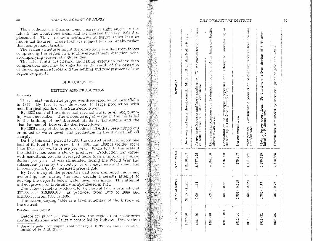
39
"'M,,;
'"M,00~
~~
<~,"'~~
~
'"'"'",,;,
<o"',,;
"'~'0,,;,
M
"'"',,;
00
"',,;
o
"''0",''0
"'",-
""'o
'Ho~o
:;3
-aw
coo~
~
~co~
,~~ ,0~
~~~~"'iDa:;~~~ww'-< >00
~.g
THE TOMBSTONE DISTRICT
'000,~
0000~
,1R.!ZONA BUREAU OP MiNES
Uetailed description2T
Before its purchase from 'Mexico) the region that constitutessouthern Arizona was largely controlled by Indians. Prospectors
Summary
The Tombstone district proper was discovered by Ed, SchieffeJinin 1877, By 1880 it was developed to large production withmetallurgical plants on the San Pedro RiveL
By 1882 some of the mines had reached water level, and pumping was undertaken, The encountering of water in the mines ledto the building of metallurgical plants at Tombstone and theabandonment of those on the San Pedro River,
By 1886 many of the large ore bodies had either been mined outor mined to water level, and production in the district fell offsharply,
During this early period to 1886 the district produced about onehalf of its total to the present In 1881 and 1882 it yielded morethan $5,000,000 worth of ore per year- From 1886 to the presentthe district has been a steady producer- Production has variedwith conditions but has averaged more than a third of a milliondollars per year, It was stimulated during the World War andsubsequent years by the high price of manganese and silver andin recent years by the increased price of gold.
By 1900 many of the properties had been combined nnder oneownership, and during the next decade a serious attempt todevelop the deposits below water level was made, This attemptdid not prove profitable and was abandoned in 191L
The valne of metals produced to the close of 1936 is estimated at$37,000,000: $19,000,000 was prodnced from 1879 to 1886 and$18,000,000 from 1886 to 1936,
The accompanying table 1S a brief summary of the history ofthe district,
27 Based largely upon unpublished notes by J. B. Tenney and informationfurnished by J < H. Macia.
HISTORY AND PRODUCTION
38
ORE DEPOSITS
The northeast OTe fissures trend at to thefolds in the Tombstone basin and are marked very little dis-placement They are rrlOre continuous as fissure zones than asindividual fissures. These features suggest tension breaks ratherthan compression breaks.
The earlier structures might therefore have resulted frorn forcescompressing the region in a southwest-northeast di,Tection, withaccompanying tension at right angles,
The later fanlts are normal, indicating extension rather thancompression, and may be regarded as the result of the cessationof the compressive forces and the settling and readjustment of theregion by gravity,
ARJZONABURE:iHJ OF NEIIVES 7'FlE"I'OlVIBSTONE J)ISTRIC7 4J
di.d nClt venture Jar frorn the scttlernents that extended theSanta Cruz and Colorado rivers for a hundred miles north the:lmosc,nt international oounaary
After the Mexican \ATar the Gadsden ,Anlericanpioneers undertook more intensive exploration. In a n1inera]location about 5 miles \~lest of the site of Tombstone was InadeFrederick Brunckow, an engineer of the Sonora ExploringMining Company, of New York. He was later killed there by aMexican employee. His old mine) comInonly kn.own" as" the"Bronco/) was later relocated and finaJly patented as the DeanRichmond cIaim.
From the ontbreak of the Civil War until the earlyno troops were left to guard against Apache an~l ou~l,nv :rVlexi~anraids
1and practically all mining and prospecting In the regIOJ.l
ceased.The Tombstone district proper was discovered in 1877 by Ed
Schieffelin a son of one of the forty-niners. An account furnishedhy Schieff~lin to Bancroft for his history of the Pacific Coast isthe basis for the following facts. Early in 1877, Schieffelin, afterseveral years of fruitless prospecting in Nevada, Montana, andCalifornia, came to Arizona. As the Apache,s) under CochIse, werethen giving considerahle trouble, he followed a troop of cavalrydestined for Fort Huachuca, starting from San Bernardino, California, and traveling by way of Fort Mohave. He deci;ied to gofarther than ~'ort Huachuca and started alone down the San PedroValley. On this trip he visited the old Brunckow Mine, thenowned by Tucson parties) and helped carryon its assessment work.He noticed the direction of the ledges, trending northeast, andmade several trips along that trend to the site of Tornbstone,where he found rich lloat. He finally staked the Tombstone andGraveyard claims on a small ledge of rich orcin the western partof the district and recorded them at Tucson, the county seat. Asthere was no assay office in Tucson at that time, the grade of thesamples could not be determined, and Schieffelin was unable torai.se money for further prospectIng.
Maintaining faith in the value of his discovery, Schieffelin decided to find his brother Albert, whom he supposed to be at theSilver King Mine, 75 miles north of Tucson. With literallynothing but his pack outfit, gun) and allllTIUDltloD, he Journeyedto the Silver King but learned there that his brother had goneto the McCracken Mine at Signal, 165 miles farther northwest.After working at a mine ncar Globe to obtain lTlOney for an outfit. he continued on to Signal early in the winter of 1877. Albertan'd oUler miners thc.re declared the Tonlbstone sc-unples to be"lead:-(' and of low grade) but Richard K,Gird, _the companyassayer
1irnmediately recognized thorn as high grade and offc'red
to go with the two brothers to prospect the ground. .Ed derntUTedfor seVCrallTIOnths) but, after the sclmples we:re ass(\;/ed an..dto run from $40 to $2,000 per ton, he was persuaded to Girdas a partner and to return to the discovery. Gird financed an()utfit:' including somE' crude assay equipment; and the party started
\vith s;:lddle and pack Inulesin H373./1.S Gird \\'8.S well knovvn as a rnining engineer and beenoffered tIle superintendency of the ]).
------------------------------'IJIIIIIiI.....----------------------------11
42 ARIZONA BUREA.U OF MINES THE TOI'lJ.'BS''!'ONE DISTRICT' 43
The Santa Fe holdings i:n the south were later boughtSouthern Pacific.
By the beginning of 1881, T?mbstone, the largest city in Arizona)was reported to have 600 dwellings, two churches, schools with 100pupils, and a population of 4,000. There were about 650 men work100 in the mines. and 150 in the mills at Charleston and ContentIOnCity. Most of the miners were American and Cornish. The wealthof Tombstone and the two mill towns had attracted numerousgamblers and undesira~le characters from the old frontier townsin Kansas and Texas. fhere ensued stage robbenes, cattle thIeving) D1iscellaneous murders j and ac~s of outlawry, cu~minating~n
the Earp-Clanton feud. As the mmers took very httle part mthe disturbances, the mines and mills continued operations without any serious interruption. By the end of 1882 the unruly element was subdued, and comparative quiet reigned. This periodof lawlessness, spectacular though it was, has been given undueweight in popular belief. The effects, other than g~ining a badreputation with the rest of the country, were very shght.
The first water was encountered in July, 1881, at a depth ofabout 520 feet in the Sulphuret shaft. The seriousness of thewater problem was not realized, however, until April, 1882, whenthe Grand Central shaft was stopped at water leveL The firstextensive pumping equipment of the camp was installed on thisproperty. The pumps were of the old Cornish type. With one
working at the Contention and one at the Grand Centralsome headway was made in sinking, but the flow proved toofor extensive drifting or stoping. Ore was proved to extend
at least 100 feet, and some stoping was done to a depth of about50 feet below the water table. United pumping action was notachieved until many years later.
In 1881-82. after the finding of water in the mines, a Philadelphia company erected near Tombstone the twenty-~tan:p Girardmill which used water from the West SIde Mme. ThIS mIll at firsttreated material from the Girard Mine, owned by the same comDany, but, as it proved to be below commercial grade, the minewas shut down in May, 1882. The mill continued to operate onlow-grade Tranquility and other custom ores up to November,1883. As expenditures exceeded receipts by $62,749, the companyassets were sold by the sheriff to a Philadelphia syndicate. Earlyin 1884, after the new operators reopened the mine and developeda body of rich silver ore on the 200-foot level, the former ownersredeemed the property.
The Benson Smelting and Refining Works was completed atBenson in October, 1881, for the treatment of silver-bearing leadores. It operated until 1885.
In October. 1882. the Watervale Mill was completed near Tombstone. After atwo months' run on custom ore it was closed.
In 1881 the old Corbin and Gird mills were modified and a smallwater-ja~ket furnace erected. Flux for this furnace was obtainedfrom the manganese-silver ores of the Lucky Cuss and Luck Sure
By the end of the yea]" Tombstone \ivas the rnost farnousmining carnp in the VIest) capitalists) froID thenewly exploited oil fields of Pennsylvania) were it ingreat numbers. Several of the.m acquired claims from the Sc'" pi_
feEns) Gird, and other early pioneers.T. E. Farrish and associates purchased the Head Center claim
from Jerry Ackerson early in 1880. After developing thethey bought the Sunset ten-stamp mill on the San Pedro River inApril, 1881. This company produced profitably until May, 1884.
In March, 1880, the Vizina claim, adjoining the Toughnut andcovering part of the townsite of Tomhstone, was purchased by H.Filkins of Bradford, Pennsylvania. The Vizina produced over ahalf million dollars' worth of ore in the three years of its activeoperation.
In 1880, the Boston and Arizona Smelling and Reduction Company, organized by Boston capitalists, erected a ten-stamp custommill on the San Pedro River, about 4 miles below Charleston, atEmery City, to treat the are of the Vizina and other small minesof the camp. Later, concentrating machinery and a patent roasting furnace were added. This plant stimulated production byfurnishing an outlet to numerous small producers. In October.1881, the company purchased the Stonewall (Oregon) Mine for$100,000 and mined on its own account, besides treating customore.
The Contention or Western Mining Company started buildinga mill in October, 1879, on the San Pedro about 2 miles belowFairbank. In 1880, the Grand Central Mining Company built theirmill 1'14 miles below Fairbank. At the site of the Gird, Corhin,Boston, and Arizona mil1s, the settlement of Charleston wasstarted. Several months later, Contention City grew up aroundthe Contention mill.
The growth of the mining camp was rapid. In 1878, at the firstminers' meeting, the district was christened Tombstone, from thefirst location. Schieffelin wrote that the name of the location wassuggested to him by the soldiers at Fort Huachuca, who had saidthat he would find nothing but his tombstone. This name is retained in spite of many attempts to change it.
The Arizona Weekly Star of November 2,1879, described Tombstone as a lively city of 1,000 to 1,500 people and Charleston as atown with a population of 600 to 800. The same issue of the Starstated that the incorporation petition of the city of Tombstone hadbeen granted at a meeting of the Board of Supervisors of PimaCounty.
At the time of the discovery of the district, the Southern PacificRailroad, building eastward from Los Angeles, had reached CasaGrande, which remained the terminal for several years. OnMarch 20, 1880, the road was formally opened into Tucson and bythe end of 1880 had reached the San Pedro River, where the townof Benson was started. In 1883 and 1884 the Santa Fe Railroadconstructed a line from Benson to Fairbank, Nogales~ and
ARIZONA. BURE 'tU OF MINES TIlE TONIBS7'ONF: DIS'TEICT 45
The 1886 to be disastrolis. In the Grand Cen··tra] house i:HH:i works leaving only theContention purn,ps to water. The Mine wasclosed the part of the year. The Head Center Com-
reorganized as Head Center an? 'I~r~lnquility Co~pany,
a small production by treatment 01 taIlIngs at t~e. mIlli anddeveJoped additional ore. The Tornbstonc Mill and ~lnlng Com
operated only a part of the j'car and closed dunng, the ":rc:rstsilver depression. The reorganiz~d B~n.ker,Hll~ Mll~lng
Company developed ore in the Bunker HIll Mme and bmlt a fivestamp filill at 'Watervale where part of t~eir are was treated. 'rhebalance was shipped. Development contmued at the Old Guard,State of Maine, and Silver Thread mines.
In 1887 only the Grand Central and Tombstone Mill and MiningCom.pany mi~les produced. The Grand ,Central repo.rte~ treat~ng14,500 tons, mostly from the Emerald, WIth a produ,ctlOn m bulllOnand concentrates of $572,740, an average yIeld of $3D.50 a ton. TheGrand Central Mine closed in October, 1887, but the mill continued to operate for two years on tailings.
During 1888 the price of silver averaged D4 cents per ounce ascompared with 98 cents in 1887. In Jul{' there were about 500 menat work in the camp, but by the end of the year theIr number hadbeen reduced to 400. Water was encountered in the Emerald Mineat a depth of 700 feet, and no deeper stoping was attempted. TheTombstone Mill and Mining Company worked the West SIde andLucky Cuss mines during most of the year. The Vizina and Ground
mines were operated by lessees, who up to July treated thellore the Fisher mill the equipment for which had been movedfrom the Old Head C~nter plant on the San Pedro River. Duringthe remainder of the year high-grade ore was shipped to customplants at Socorro and elsewhere. The Bunker Hill Company s.anka new vertical working shaft and shIpped about 150 tons of hIgh-grade ore per month. . . .
The 1889 production came largely from the Bunker H,ll Mmcand lessees on the Vizina and Old Guard mines.
In 1890 the silver market showed marked improvement wlth anaverage price of $1.05 per ounce. Most of the mines resumed operations and shipped their better ore to reducllOn works but dldnot attempt to operate the mllls. Freight concessions by railroadspermitted more profitable operation. The Tomhstone Mill andMining Company, under the management of Geo. W. Cheyney,was the principal shipper. The Grand Central, Bunker Hlll, andVizina properties were also operated during the year..
The silver market continued strong during most of 1891, butthe priCe' declined to 87 cents in 1892, 78 cents in 1893, and 63 centsin 1894. The Emerald Mine was closed in 1892. The Comet Mine.which received a premium for its manganese are, produced durin g 18D;). The Tombstone Mill and Mini:,g Company operated ata steadlIy reduced rate untIl the end of 1896, after WhlCh mtermittent work was carried on by lessees. Most of the other mineshad been turned over to lessees in 1892.
the Hendricks and At.·ore \iI/as Jound in th.:
lead ore.as shown iI'
Ell.nt·S. and SOUle lead ore was ... n .......
Clalms. in Bisbee. As num"lthe smelter dL;co·ntimled
yc'ar forThe rnost unJUllC
the table on page 4D.During 1883, production frDm the Contention and Grand Cen··
tral mines was interrupted by the instaIIation. of pumping machinery. The Grand Central Company started developing theEIIlerald Mine) and the Tombstone Min and lVIining Cmnpany,whieh had not yet developed to water level, maintained normalare extraction. During the year) operations were started on tlwPrompter and the Rattlesnake properties. The Prompter wasfinanced by Arizona capital and operated by J ohm Haley. TbeRattlesnake Company, which owned the Rattlesnake, Bunker Hill.and Mammoth mines, shipped $10,000 worth of ore a month tocustom plants. The Woronoco or San Diego Company built a ;10ton water-jacket furnace on its property 2 miles southeast ofTombstone, to treat silver-lead ore from the San Diego Mine andcustom ores from the Luck Sure and other properties. The WayUp and Ingersol mines, operated by small companies and "chtoriders," shipped ore to custom plants. A company did considerabledevelopment on the State of Maine vein and shipped a little highgrade ore from above the 200-foot leveL The Head Center Minecontinued production and operated its rnin at Contention Cit~l
during the year.At the beginning of 1884 the prospects of the Tombstone district
were very bright. The pumps were operating successfully, andore was being developed below the water table at the Contentionand Grand Central mines. Early in the year)however j the minersformed a union and struck for a raise from $3.00 to $4.00 a day.The strike was general, and all the mines closed, as the operatorsrefused any advance until the pumping prohIems were more completely solved and additional ore proved helow water leveL Thestrike lasted four months, after which, the men voluntarily dissolved the union and returned to work at the old wage scale. Allthe companies except the Contention reopened their mines afterthe strike. During 1884 the Rattlesnake Company continued mining from the Rattlesnake and Bunker Hill mines. The SilverThread Mine, which had heen started in 1882, continued to shiphigh-grade ore to custom plants.
During the first haH of 1885 the Contention and Grand Centralcompanies attempted combined pumping, which was not completely successfuL A large part of the Grand Central productioncame from the Emerald claim. In the latter part of the year theTombstone MiU and Mining Company bought the Girard miII andtreated all its ore, except stock-piled reserves, at Tomhstone. Theold Charleston mill was ahandoned at the end of the year. TheBoston miU had shut down at the end of 1884, leaving oniy theGrand Central miII operating on the San Pedro River at the endof 1886.
·4.£'" ARIZON BUT-?,E/UJ OF M1NOES' THE TOA'1BSTOI'/E j)fS'L'f:ZlCT 47
The Tombstone MiJ! andtrons in 1896, The value of itsamounted to approximately $10,550,000. of whichpaid in dividends prior to 1888.
!or the remaining years of the century) lessees op'ennea severalmmes, more notably the Tranquility, Silver and Tele-phone.
During the depression of the nineties, the Grand Central Company, through K B. Gage, had gradually absorbed the principalmdependent holdings of the district. In 1901 the Tombstone Milland Mining Company and Contention Company joined the GrandCentral Company in a reorganization. The Tombstone Consolidated Mines Company was formed with Gage as manager, and theDevelopment Company of America, whIch owned the CongressMme and the SIlverbe!l copper deposits was induced to financea program of pumping and prospecting below water level.
It was decided to sink a four-compartment pump shaft to ad~pth of 1,000 feet, mstalllarge pumps, and prospect the principalmmes. The shaft reached water level in August, 1902, and largetriple expanslOn Prescott steam pumps were lowered in November.
A branch of the El Paso and Southwestern Railway was builtf:om FaIrbank to Tombstone during 1902-3. Shaft sinking contmued throughout 1903, and the old working levels of the GrandCentral, ContentIon, Emerald, Lucky Cuss, Silver Thread andother mines were reconditioned. Considerable are was shipped toEl Paso. By the end of the year, two 1,500-gallon pumps were installedon th,e 700-foot station, and 2,300,000 gallons of water a daywere lIfted. -, The shaft was then sunk at the rate of 50 feet amonth. The water in the outlying mines was lowered at the rateof 4'12 feet a month. By the end of 1905, the shaft had reached adepth of 886 feet, and pumps were installed on the 800-foot levelA 125-ton cyanide mill was started during the year, and low-grad~~re wa~ stock-plied. Railroad line~ were run to the principalshafts, and two or three carloads of sliver-lead are per day wereshIpped to EI Paso. Independent companies started operating theLuck Sure, Old Guard, and Herschel mines, and the Slime Tailmgs Company attempted to treat the Grand Central mill tailingsat Fairbank .
In 1906 the Pump shaft was completed to the I,OOO-foot level,and drIftmg on that level was started. The mill, using stamps,Wl1fley ~ables) slIm~ cone,s) and cya~ide tanks, ran the greaterpart of the year and attamed a maXImum capacity of 225 tonsper day. The Old Glory Mmmg Company, operating tbe Luck Sureand Black Eagle mmes, shIpped are regularly. The Herschel Minmg Company developed to a depth of 325 feet and shipped twocars of are per month to EI Paso.
'.!fl The amount of \vater pumped during subseqlJent operations is shownon page 108,
In 1907 the Tombstone Conso1:i.datf:d lVIines Compan:y and theHerschel continued regular shipIYlents, and theconcentrator during lTIOst of the year. The Old GloryMining Company closed in December.
In 1908 the Tombstone Consolidated Mines Company producedlead and zinc concentrates beside silver and gold bullion. TheHerschel Mine continued production.
The year 1909 proved to be disastrous. On June 1, due to a defect in the fuel supply for the boilers, the 1,000-foot-level pumpswere submerged. Despite efforts to retrieve them by the aid ofeight sinkers, the water raised to the 900-foot level. Due to overload, the six boilers of the power plant went out of commissionsimultaneously. Larger sinkers were installed, but the heat fromthe exhaust steam proved to be excessive, and in 1910 a 4,000cubic-foot compressor was installed to run the sinkers by air.After installing new boilers, the pumps were recovered, and drifting on the 1,000-foot level was resumed by the end of the year.The amount of water pumped during this period is shown onpage 108.
The concentrator was operated in 1909 and 1910, but in the latter year only lead-silver concentrates were made. The cyanideplant was not operated after 1908.
In 1909 the Phelps Dodge Corporation acquired the Bunker HillMine and shipped are from it during 1909 and 1910.
As the extraordinary operating expenses proved too great forthe Development Company of America,'" pumping was discontinued on January 19, 1911. The pumps on the 1,000-, 800-, 700-,and 600-foot levels were left on the stations, where they remainto this day.
After unsuccessful attempts to refinance the Development Company of America in 1911, the mines were turned over to lesseeswho reworked the old dumps and upper-level stapes.
The Phelps Dodge Corporation, which had heen one of the principal creditors, acquired the holdings of the Tombstone Consolidated Mines Company in June, 1914, and carried on operationsat Tombstone under the name of the Bunker Hill Mines Company.This company made no attempt to regain the lost pumps but,after thorough sampling, prospected for are in the upper levelsabove water. Shipments on company account began at the endof the year.
In 1915 the thirty-stamp mill, remodeled from the old Tomhstone Consolidated concentrator, operated with cyaniding by percolation of the sands and agitation of the slimes. High-grade manganese concentrates of ores from the Escondido, Lucky Cuss,Oregon) and Prompter mines were shipped as chemical ore, andtails containing 10 ounces of silver per ton were sent to the smelter at Douglas. During the year the Old Guard and Solstice mineswere reopened and produced small quantities of ore.
:.<\! A summary of the activities and financing of the Development Company of America was published in the Engineering a.nd Mining Journal of July 3, 1911.
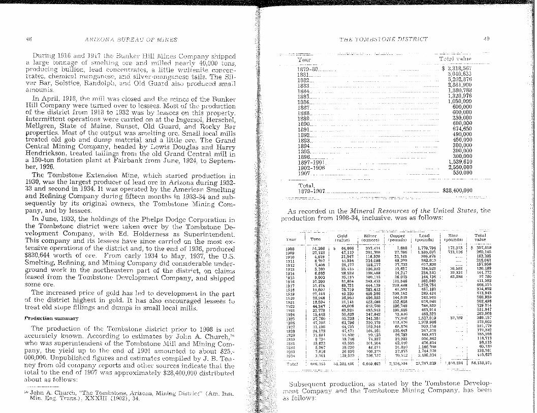
/~RIZ()N/-\ BURf.i;/icr OPil'[lrrBS THE TOi\ifBS'TONE DlS'TRTCT
Production summary
$ 357,S18260,145102,285216,042157,956120.189101.77297,780
411,592608,315354,892613,943560,939502,498729,214531,947263,508369.157873,003221,179177,3S2155,959118,71798,31560,186
1:18,261415,627
*8,138';,71
Totalvalue
n,592
;l6,50339,:12463,3Sll
173.313713.116
1,053,234
Zinc(pounds)
$28,400,0110
$ 2,318,5675,040,6335,202,87f)2,881,9001,380,7881 320 9761:050:000
600,000f)00,000250,000600,000f)74,850490,0011450,000300,000300,000300,000
1,539,6102,550,000
550,000
Total value
1,770,7941.535,637
305,876982,010617,820334,923234,345164,136983,983
1,278,'154457,183289,424243,946678,946744,529465,914465,323
1,527,0191,970,986
900.178247.316843,S17936.862476.814
1.166.7001.744,2702.400.324
2~1,76"I,lJ29
Lead(pounds)
7,60827,70631,163li8,20927,72310.65714,217:J6.075
131.546229.488
41,503290,182144,010132,688196,740195,485
72,83677.340
113,47668'.876
135.64386.793:32.90:)62,44024.81027,87570,512
Coppel'(pounds)
357.414201,700116,520224.098158,377126,392108,868100,115:143,453444,139283.412450,366456,855423.688613,700495,943247,642241,381220,579159,941164,16199,42374,937
101.50448,021
100,323296,737
6,659.692
Silver(ounces)
S1.281.480
Gold(value)
S 84,86647,11921,94744,55428,17725.41528.53225,13581,65469,72128.719'10,22036,95331,14148,00563.92450,82055,32861,79664,75747,47134,530,18,74645,55510.03036,886
129,529
51,26627,123
4,6198,7971,4055.7606,0639,003
57,20057,47419.50727.4<1528.94618,59444,34732,'17015,44827,76047,708:n,1.9624.17215.6018,734
15,6235,0677,016:1,701
BIlIi.345
Ton;;
Total,1879-1907.
Year
1879-80183L1882..188:31384"1885 __1386"1837,1388"1839,1390,l89L1392,1893"1894,1895,.1896"",1897-19011902-19061907"
Year
ru~al
190519091910UI11191219131914\9151916191.1'19181919HJ2019211922192319241925UJ261927\92819291930i9311932W3:J1934
Subsequent production, as stated by the Tombstone Deve1oprnent COnlpan}r and the TombstonE-: Mlmng Compan:y, has beenas follows:
As recorded in the Mineral ReSOUTces of the United States, theproduction from 1908-34, inclusive, was as follows:
A. Church, "The Tombstone, Arizona, Mining District" (Am. Inst.Eng, Trans,), XXXfll (1902), 34,
HH6 and 1917 the Bunkt'T Ffi.Jl JVUnesa of ore and Inillpdproducing lead a littleirates, chernical manganese, and tails.vcr Bar, Solstice, Randolph, and Old also PlPPPC,,,,
amounts.In April, 1918, the mill was closed and the mines of the Bunker
Hill Company were turned over to lessees, Most of the productionof the district from HJHl to 1932 was by lessees on this property,Intermittent operations were carried on at the Ingersol, Herschel,Mellgren, State of Maine, Sunset, Old Guard, and Rocky Barproperties, Most of the output was smelting ore, Small local millstreated old gob and dump material and a little are, The GrandCentral Mining Company, headed by Lewis Douglas and HarryHendrickson, treated tailings from the old Grand Central mil! ina 150-ton flotation plant at Fairbank from June, 1924, to Septembel', 1926,
The Tombstone Extension Mine, whieh started production in1930, was the largest producer of lead ore in Arizona during 1932:33 and second in 1934, It was operated by the American Smeltingand Reflning Company during fifteen months in 19:33-;J4 and subsequently by its original owners, the Tombstone Mining Company, and by lessees,
In June, 1933, the holdings of the Phelps Dodge Corporation inthe Tombstone district were taken over by the Tombstone Development Company, with Ed, Holderness as SuperintendentThis company and its lessees have since carried on the most extensive operations of the district and, to the end of 1936, produced$830,644 worth 01 ore, From early 1934 to May, 1937, the U,S,SmeIting, Refining, and Mining Company did considerable underground work in the northeastern part of the district, on claimsleased from the Tombstone Development Company, and shippedsome ore.
The increased price 01 gold has led to development in the partof the district highest in gold, It has also encouraged lessees totreat old stope fillings and dLI'mps in smalliocal mills,
The production of the Tombstone district prior to 1908 is notaccurately known. According to estimates by John A. Church/'who was superintendent of the Tombstone Mill and Mining Company, the yield up to the end of 1901 amounted to about $25,000,000, Unpublished figures and estimates compiled by J, B, Tenney frOln old cornpany reports and other sources indicate that thetotal to the end of 1907 was approximately $28,400,OO() distributedabout as follows:
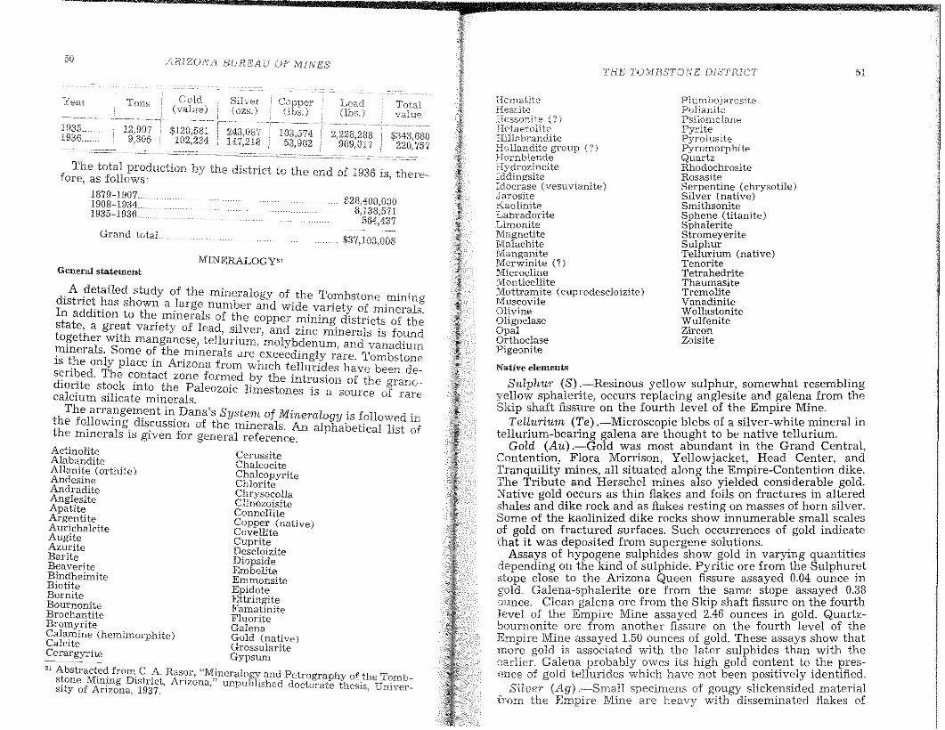
50 AlilZONA BUREAU OF MINESTHE TOMBSTONE DlSTE1CT
General statementMINERALOGY"'
.A detailed study of the mineralogy of the Tombstone minindIstnct has shown a large number and wide variety of mineral;In addItIOn to the. mmerals of the copper mining districts of th .~tat~ha gr~a~ vanety of lead, silver, and zinc minerals is foun~0!5e er WIt manganese, tellurium, molybdenum and vanadium
mmerals. Some of the minerals are exceedingly r~re. Tombston~IS ~he only place m Anzona from which tellurides have been descubed. The contact zone formed by the intrusion of the ranodIOlnte stock mto the Paleozoic limestones is a source of rareca Crum SIlIcate minerals. -
The arrapgement in Dana's System of Mineralogy is followed inthe followmg. dIs.cussIon of the minerals. An alphabetical list ofthe mmerals IS grven for general reference.
Actinolite CerussiteAlabandite ChalcociteAllanite (orthite) ChalcopyriteAndesine ChloriteAndradite ChrysocollaAnglesite ClinozoisiteApatite ConnelliteArgentite CAurichalcl'te opper (native)
CovelliteAugite CupriteAzurite Desc10iziteBarite DiopsideBeaverite EmboliteBindheimite EmmonsiteBiotite EpidoteBornite EttringiteBom:nonite FamatiniteBrochantite FluoriteBromyrite GalenaCalamine (hemimorphite) Gold (native)Calcite GrossulariteCerargyrit: Gypsum
31 Abstract,eq from, C. (i" Ras~n', "M,~neralog~ and Petrography of the Tomb~{f;~lV.2.~i~~n~1~V37:'ArIzona, unpublIshed doctorate thesis, Univer-
PlumbojarositePolianitePsilomelanePyritePyrolusitePyromorphiteQuartzRhodochrositeRosasiteSerpentine (chrysotile)Silver (native)SmithsoniteSphene (titanite)SphaleriteStromeyeriteSulphurTellurium (native)TenoriteTetrahedriteThaumasiteTremoliteVanadiniteWollastoniteWulfeniteZirconZoisite
'HematiteHessiteHessonite ('?).FfetaeroliteHillebranditeHollandite group (?)HornblendeHydrozinciteIddingsiteIdocrase (vesuvianite)JarositeKaoliniteLabradoriteLimoniteMagnetiteMalachiteManganiteMerwinite (1).MicroclineMonticelliteMottramite (cuprodescloizite)MuscoviteOlivineOligoclaseOpalOrthoclasePigeonite
Native elements
Sulphur (S) .-Resinous yellow sulphur, somewhat resemblingyellow sphalerite, occurs replacing anglesite and galena from theSkip shaft fissure on the fourth level of the Empire Mine.
Tellurium (Te) .-Microscopic blebs of a silver-white mineral intellurium-bearing galena are thought to be native tellurium.
Gold (Au) .-Gold was most abundant in the Grand Central,Contention, Flora Morrison, Yellowjacket, Head Center, andTranquility mines, all situated along the Empire-Contention dike.The Tribute and Herschel mines also yielded considerable gold.Native gold occurs as thin flakes and foils on fractures in alteredshales and dike rock and as flakes resting on masses of horn silver.Some of the kaolinized dike rocks show innumerable small scalesof gold on fractured surfaces. Such occurrences of gold indicatethat it was deposited from supergene solutions.
Assays of hypogene sulphides show gold in varying quantitiesdepending on the kind of sulphide. Pyritic ore from the Sulphuretstope close to the Arizona Queen fissure assayed 0.04 ounce ingold. Galena-sphalerite ore from the same stope assayed 0.38ounce. Clean galena ore from the Skip shaft fissure on the fourthlevel of the Empire Mine assayed 2.46 ounces in gold. Quartzbournonite ore from another fissure on the fourth level of thel~mpire Mine assayed 1.50 Ounces of gold. These assays show thatmore gold is associated with the later sulphides than with theearlier. Galena probably owes its high gold content to the presence of gold tellurides which have not been positively identified.
Silver (Ag) .·-Small specimens of gougy slickensided materialfrom the Empire Mine are heavy witb disseminated fiakes of
there-
$26,400,0003,138,571
564,437
$37,103,008
Tons Gold Silver Copper Lead TotaJ.(value) (02.0. ) (lbs.) (lbs.) value
12,907 $120,581 243,087 103,574 2,228,288 $343,6809,305 102,234 147,218 53,962 969,017 220,757
Grand
Year
The total production by the district to the end of 1936fore. as follows:
1879-1901..1908-1934",1935-1936..
ARIZONA ,BUREAC OF MiNES '['HE TOIvIB,s'']''ONE DISTIVCT
Ibid.A. J. Moses and L, Mel. Luquer, "Alabandite from Tombstone" School
j"vlines QuarteTly, XIII (1892), 236-39.A. Church, "The Tombstone, Arizona, Mining District" (Am. lust.
Eng. Trans.), XXXIII (1903),29.
ChalcocIte .-,..-Chalcocite has :Conned oxi-dation frorn sulphich.\ sec""Hans that contain tetrahedrite, chalcopyritE\ and sphaler-ite shov"r the chalcopyrite first to bornite, then thebornite to chalcocite. Chalcocite is best known from the ToughnutMine where it is associated with argentite and stromeyerite.
Stromeycrite (Ag,S·Cu,S) .--Stromcyerite was identified in arefrmD the Elnpire and Tonghnut mines associated 'with supergenechalcocitE\ covellite) malachite, and earthy hematite, Mineral associations suggest that some strorneyerite is supergene in origin;it also appears to be the result of unrnixing from solid solution ofargentite and chalcocite. Schwartz:::; has shown that argentite cannot :n~place cha1cocitp? but that, instead, it is soluble in chalcociteup to 15 per cent; beyond that limit stromeyerite will form andreplace chalcocite, Stromeyerite Is also replaced by feathery lathsof covel1ite. The HrYlOunt of str01neyerite is small~ but it is probabl;y an important source of silver in the oxidized ores.
Sphalerite (ZnS) .--Sphalerite was rather ahundant in ores fromthe Silver Thread and Sulphuret mines, Ores from the Lucky ellSS
and Toughnut rnines show small amounts with other minerals,Th-t:: sphalerite in the district ranges from reddish-brown resinousvarieties to black varieties and is rnainly coarsely crystalline,
Polished sections of sphalerite show that some of it containsmicroscopic blebs of chalcopyrite along the borders of crystals.Sphaierite is latcr than pyrite. It rarely replaces pyrite but fiUsin and around the fractured pyrite grains. Sphalerite has beenreplaced hy tetrahedrite, chalcopyrite, and galena,
Ore that has been acted on hy solutions shows sphalerite replaced by covellite, and on complete oxidation the zinc mineralsformed include smithsonite, hemimorphite, aurichalcite, and zincbearing descloizites.
A.labandite (MnS) ,~Alahanditefrom the Lucky Cuss Mine wasdescrihed by Moses and Luquer'" in 1892. It was found along thefootwall of the Lucky Cuss fault fissure in a pure white, crystalline limestone. Moses described the massive alabandite body asgradually merging into spar and then Into sulphides of Iron, zinc,and copper, with small amounts of alabandite. Church" says thatalabandite was under a tongue of minette on the :J50-foot level,mingled with galena and pyrite.
Specimens of alabandite recently found on the dump of theLucky Cuss Mine showed much oxidation on the surface to hrownand black coatings indistinguishable from the common manganeseoxides, On fresh breaks the alabandite appeared as hrilliant hlackdisseminations in a gray carbonate. Polished sections of alabanditefrom Tombstone in the mineralogical collections at the University
sUveL ThE'the ,to h,a,'\/e been sorncvvh.:n,. t11C :F'.lora JVlorrison NIh]"".nne silver -'- A"
Included or ' '.. .}~Omonal s "'k' f'",. . , wIth the Sll'i/er are DeC,,'l"pee s {). aI genhte or hessite.
A poll shed "petlon of hesOJte slna11ve slIver In clacks and :110 t110WS lYHCIOSCOPIC' quantItH-"s of;:,uggesbn o th~t ih ,I .-<. < ng le contac15 wlth other llllnE'TalS,
h ~ b ~ e SL.ver may have resulted ftOln dHC'laliOnesslte NatJ-ve sIlver In ih
POSItS)' IS generally neal the ~o~~es aS~OtchJatt~d WIth the "ron cp-A -r' om 01 e stopes
ssays CL hypogene sulphIdes sh thv,arylng an10unts 'dependmg' on thE'°~~nd (~F~~~eIJ%c~ oiT~:Ye1 "samples that wele assayed for old _ 1 e ~ e sanH:.'SlIver pyntIc me 418 ounces' g~len gJv~ tre ~ol]awlng assay ;0:clean galena orE' '')3784 oun ' a-spna en e me) 2186 ouncesounces The sllv~r~s bel[eve:~~'o~~~1;~a~~z-~btourndmllt(-"ore, 8738tetrahednte. .SSI e an al genhferous
CoppeT (Cu.) .-Microscopic parti i" f·,·sparsely disirib t,ci' '.... '. ~c es ?'" natIve copper BrelVI' . u e In speCImens ot cupnte from H T
1ne, The Irregular grains are grouped." ' t} ': Ie, ?ughnutcrystals rather than along the bound~ril~~~l Ie centers of
Sulphides
Galena (PbS) ,-Some remnants of 1 . .,ores of the "roll deposl·ts" a d f fi·f5a ena l"e.. -?1aln 111 the oxidiz.ed.. . no; ssure vems C I .galena '~ coarse grained, but that from tJ T b.. ammon y tJle'M
llne IS fine grained with a gneissic textu:: th~~issd~ne~.E~hten~~?n
a ong the fissure. e ,,0 >:J. ear lUg
Microscopic examination of 1',1 d .gaiena is one of the latest sUlpb~d,:~e,S~ci,.ons. indicates thatsphalerite, and tetrahedrite, and poss~bt~ b {"S ,~placed pynte.wlth pyrite it oxidIzes readily to form leld ~uf ~o~Yllie. Inlcontact~racks and around unaltered' rite . p a e a ~ong ~ eavagemg on galena yield covellite a~~ replgr,:ns. ~o)per solutlOns actgrams and as feathery laths in angle:i~~men a ong the boundary
Argentite (Ag.,S) .-Argentite 1 . . ,and part of It has 'formed from th occurs on y m the oXld,zed oreferous tetrahedrite, a fairl co e supergene ,:ltel'atlOn of argentigene ores. Some of it ma Kave~~onmmeral m most of the hypoThe black material fiIIs ~maII fra Ted by t~ehoXldatlOnof hessi.te.in the quartzose ore. A s ecimenc ~~,es an .oneyconlbed spacesphides, malachite, and e~thY hemati~ cc~ntam~~ sier/icne sulshowed on a polished f', c rom 10 mplre Mmestromeyerite and chalco~~~~~' arg~ntlte closely associated with~ copper reaction. Schwart;:)~ h~~o~h~~cf.£tfst~ ~n a~gel~tite gavem argentite up to 20 per cent bt t b 20a c a coelte lS soluhleis fanned. ) I a ove per cent stromeyerite
:~:' G. M. Schwartz "ReJatio " " , ' .. .Ceol., XXX (935), 128-,r{;"'. of Cha1coClh-'-Stromeyerite_Argentite'l Econ.
ARIZOb.fA BUREAU OF' MII'l f!,'S THE TOlvlBSTONE DISTRICT 55
Some of the richest are of the district contained considerablehorn silver. This has always been considered as cerargyrite, buta chemical analysis of material collected during this study indicates that bromyrite is probably more abundant.
Cemrgyrite (AgCI) ,-The silver chloride, cerargyrite, may bepresent in considerable quantities in the oxidized ores, but it cannot be distinguished physically from the other silver haloids, Onlyby chemical analysis are they determined,
Embolite [Ag (B1', CO ].-In unpublished notes, Dr, Ransomementions embolite in the ores from the State of Maine Mine,
Bromyrite (AgBr) ,-The detection of bromine in the silver oresled to the chemical examination of some nnusually well crystal..lized masses of dark green horn silver that have not changed colorsince they were collected from the Skip shaft fissure on the fourthlevel of the Empire Mine, April, 1935, A carefully separated sample of about 3 grams was submitted to the Chemistry Departmentof the University of Arizona for analysis, The following percentages were determined by R. Carrillo under the supervision of Dr.R. L. Nugent.
rnineral with only the borders or replaced by,native silver. Its association with crystalline vein quartzsuggests tbat the mineral is hypogene, but its relation to the othersulphides is not known.
Sulpho-salts
Bournonite (Cu,S·2PbS,Sb,S,) ,-Bournonite, a rare copper-leadsUlphantimonite, occnrs sparingly with other copper-antimonyminerals and is frequently mistaken for tetrahedrite, which itresembles. Its luster, more brilliant than that of tetrahedrite, mayhelp to identify it in the hand specimen. .
Tetmhedrite [5Cu,S·2 (Cu, Fe) S·2Sb,S,].-Tetrahedrite is widely distributed in the district, As the tetrahedrite ores are high In
silver, the mineral is probably argentiferous, Specimen are fromthe Toughnut Mine is reported'" to assay 85 ounces of silver to theton, It is said to have been abnndant in the ores from the LuckyCuss and Ingersol mines where it is associated with quartz, chalcopyrite) and galena. As seen in polished section, the tetrahedritewas intensely fractured before being replaced by galena,
Famatinite (,'lCu,S·Sb,S,) ,-Famatinite was found in ores fromthe Ingerso] and Toughnut mines but can be identified only byexamination of polished sections under the microscope. It is a raremineral and a minor constituent of the sulphides,
Haloids
of Arizona show th""minpral f" 1
for nurnerous triangular'" ~Fe~ {~f ntner .sulphides, eXCCIJtdel'S against other m;ner l' 0.", :v?d.lcopynte near the bor-often found ~ 1 h \ S•.Thls relatIOnship is sirnilar to that
C · II' sp a ente and chalcopyriteavc rte (CnS) ·-A common .,'
int5s of boxwork ~tructur~s for~~~u~~nce o~ covellite, is as Hnmmerals, and in this form it is easi.! ~its~e Icmoval of prllYlarycIte, It extensively replaces chal 't Yd' aken for sooty chalco-galena and anglesite, COCI e an to a subordmate degree,
Bornite (Cu FeS) . B 't ."West Side roll. I, The'~;leo~n~c~;ccurs In. are ~olle?ted from ~heof massive, sligbtly fractu¥ed' ch1 showTg tins mmeral consIstslarly replacing Chalcopyrite al ~{OPY~I e wIth bormte Irreguis replaced by chalcocite along~~~s lese r~ctures, Bornite in turn
Chalcopyrite (CuF S ) ~Ch e same, ractures,the copper minerals hut' i~ mor:l~~~Yflt~,I~tt~e most abundant ofof the secondarily concentrated e y IS n uted than are someMine it is rather abundant withc~Ph:fe:.rtmerals,.At the Contactcopyrrte IS sparingly distributed wifh tetra~'dbut ';' general chalas rn the siliceous are of the I . 1 E e nte and bournomte,mines. ngerso, rnplre, and Toughnut
Polished sections of ores sho 'h 1 'and filling fractu;es in pyrite':~datcfP~n~e replacing sphaleriteblebs and triangular inclusion' ~ ~a e nte, also as rounded
Pyrite (FeS) P' s m sp a ente and alabanditeh'd . ' ,,-- ynte, the most widespread and b d 't, 1
pIe mIneral IS commonly pI' ,t, ' a un an su-and as isolated crystals in shal~sen/"t~ranularmasses in quartz
In the veins pyrite occurs eith~~ 0 ,~r rocks,galena or as small, disseminated ma,ssl~e.WIth sphalerite andWIthout other sulphides, crystals m dark-gray quartz
An assay of the gold and silver t . ,Sl.llphuret stope showed 0.04 con tnt of pynhc ore from theSlIver, This are has not been mounc,e o. glolld and 4.18 ounces of
lcroscopica y examInedTellUrides .
Hessite (Ag Te) Hessite d 'Mine, Tombst~ne 'by Genth s;:~ escnbed fr~m the West Sidemineral occurred 'as bands a~d 'J.ordm~ to hIS, description theit was associated with cerar(1yrifS
1~~emll~atlOns ~n quartz whereto siskin green mineral Fr~m ej g~ dan an umdentified bluishlOWing chemical analysis: se ec e matenal he gave the fol.
Th I nSe.. 37,34 37,05Ag trace tracePb .. 62.87 62.34
0.28 0,30
, 100.49 9969A polIshed section of hessite m d f ' . '
Morrison ores at the University' f ~ e. r~m a collection of Flora:-::------~____ 0 nzona, shows a homogeneousa(, J. A. Genth, "Hessite from the W, . . "" .
Soc.), XXIV (1887),36. est SIde Mme, Anzona" (Am. Phil.
CIBr!Ag
;;',' E. P. Jeanes, personal communication.
0.638,9
2,656,7
98,8
/lRIZONABURElHJ OF tVIlNEE,S '['HE TOMBS'l"Ol\lE DISTRICT 57
Mil1erals of Franklin and Sterling I-1il~ Sussex County,Ceol. Survey Prof. Paper 180), 193.... , pp. 4.8:-49,
. WI. Bradley, "On Hetaerolite f~"om Lcadvll1e. Colo4th seT., XXXV (1913), 600-604.
C. Palachc,Nc\v Jcrse)'"W. K Fordrado" Am.
that have the \vaH rock. that containsCPiUCltC, and calcite. .- . i"t
,. C·,"tlly red .ferric OXIde IS a conS~l Tl-'ILe ,~cJ. -'.
('--:-t of parts of the oxidized ore bodieS.".TVI' - " ~tHe U?cO)' .~Magnetite is present chi~n:y i.n the .~ark-
. _aglte ,.., d t d' t eles m the hghtcolon~d igneous rocks and occurs as us _e .pa~: ~_: ,"f th ~colored igneous rocks. It has not been found \\iltn mInerals 0 econtact metamorphic type., . > _ ,_',
HetaeTohte (ZnO·Mn~)OJ.-,~Hetaerohte: a ra~e. ZI~1C hausrr:-a~1nite, has been described from but two othe; locahtl~~ In the UnlL,~States-Franklin Hili, New .Jersey, ano LeadvrLe, C~lorado. _IIetaerolite :from Tombstone ha~ be~n IdentIfied .l~1, p,ohsh~dIsec_hon only) principally with the .ald o:f etch ~nd Inlel och~mlc.a 1'e" "HODS 'Under the microscope It occurs as irregular velnl~ts and~~ringe~'s in Hwnganite and an unidentifi~d t.TIanganes~.oXl~e, c
Polianitc "nd pyrol.nsite (MnO,) .·--Pohamte and PYI~~S1teto .cur in quantities of economic Importance :11 th~ Ore~~n- ,rom-p e\:Lucky Cuss, Telephone, and Bunker Hrll mme;s, ,:nd m u,rmo._
uantities in the Luck Sure, Come.t, and Dry HIL,.- mln:~,. The dl::;(inchon between the two n~inerals IS ~ased up,on ~ard~Lss, In ha11~specimens the coarser-gral!1ed rnan&anese~,dlO,xlde g~ne1'ally h~_the oreater hardness and IS taken :for poilalute. ~ohshe~ SP~CIJYlf;n~ examined under the micro,scope sho~ a ,gra~n pat:ern t ~tis t pical of polianite. Mixed wrth the pohamte rs mOle or l~ss~sil;;melanewhich has replaced polianite along gram boundanes
and fractures. "1 d 'thPYl~olusite is a soft, sooty rnineral that, IS eaSI ,Y goug~ WI ,~edle and which generally occurs as fine-gram ed, hrghly drs
n~rsed aggregates and elon~ated streaks in a fibro~s manga~esepxide identilied as mangamte. It rs later than mangamt,e a~d~eems to have replaced that mineral as radial pnsmatrc aggre-gates, Psilomelane) siliceous matenal) Iron OXIdes, man~~nlte, an~
'd t'fi d manganese oxide of unknown compOSItIon OCCUIan um en 1 e ~ .. I b bl e fromwith pyrolusite. This aggregate of mmera s pro a : yea,';' '. 0
HlP nOl:ous and siliceous centers of the ll1anganese OXIde Ole bodl~,),
Manganite (l\
58 ARIZONA BUREAU OF lvIINES TIlE; TOIVIBSTONE D15'TRICT 59
most abundant in the oxidized lead ore bodies. TheVPIIOW Elineral is associated withplumbojarosite, and Lirnonite occurs with
manganese oxides from. ore bodies of the manganese mines,The iron has resulted from the oxidation of
Psilomelane [H,MnO, (7) ].--Psilomelane is regarded as a manganate, II,MnO" (n, with the H replaced by various elements,chIefly Iron, barIum, and potassium. At Tombstone psilomelaneis the most ahundant and widespread of the manganese minerals.It is present in the mixed oxides as hard) compact DlasseS
1gener-
ally intergrownwith polianite. .
Carbonates
Calcite (CaCO,J .-Calcite is an abundant mineral in the district, occurring both as a hypogene and a supergene rnineral inthe are deposits; as a prinlary constituent of the limestones; andas an alteration luineral of the igneous dikes and larger intrusives.As an early hypogene mineral in the ores from the Silver Thread,Sulphuret, and Northwest mines, it is generally coarsely crystalline and white. In the stopes of the "Quarry roll" it replaces fluorite. Coarser granular pyrite, sphalerite, and galena are the sulphides commonly associated with calcite.
Supergene calcite was deposited throughout the oxidation ofthe ores, but it is helieved that the colorless and pure white calcitethat forms coarsely crystalline aggregates and fills drusy cavitiesand "water courses" was a late deposition and probably is the latest mineral deposited. This type of calcite is common along theflanks of the ~'rol1 deposits" in caverns and water courses. Goodale" mentions that caverns in the widest parts of the manganeseore hodies were lined with snow-white, crystalline calcite.
A variety called "hlack calcite" also has two modes of formation: that believed to be supergene which occurs in caverns andwater courses, and that helieved to he hypogene which occurs inveins like the white variety. Thin sections of this hypogene blackcalcIte indicate that the coloring is due to disseminated minuteparticles of manganese oxide replacing the calcite along the cleavage planes. Supergene hlack calcite owes its color to small roundedand angular particles of manganese oxide. The origin and relationof some of the calcite is uncertain.
RhodochTOsite (MnCO,,) .-Rhodochrosite of hypogene originhas not been Identlfied. In some of the oxidized alabandite ore fromthe Lucky Cuss Mine small grains of a reddish-brown carbonatewere identified as supergene rhodochrosite after alabandite.
Smithsonite (ZnCO,) .-Smithsonite does not occur in sufficientamounts to constitute an ore of zinc. The few tiny rhomhohedralcrystals of smithsonite associated with crystals of azurite andhemimorphite from the Toughnut and West Side mines are onlyof mineralogic interest.
40 C. W. Goodale, "The Occurrence and Treatment of the ArgentiferousManganese ()res of Tombstone District, Arizona'l (Am. Inst. Min. Eng.Trans.), XVI! (1889),768.
.-.-""All the large ore bodies :mined d~Ting; the0,"jnmW1 of contained abundant cerUSSIte mIxediron oxides, Cerussite is still the most callinon lead mineral
in the ores now being Inined. Specimens of ore ~rom, the To~bstone Extension Mine retain centers of lead sulphIde ~lfS~ altenn.gto anglesite and then to cerussite. Most of ~he cerUSSIte IS as~ocIDted with much limonitic material mixed wIth hrown plumhojaro-
heaverite, wulfenite, and pyromorphite. Commonly the cenl.s"site is granular and dark gray. A few small porcelam-wbrte crys-tals were observed in drusy cavities. .
lVIalachite [CuCO,·Cu (OR) ,].-Malachite is sparingly present mall of the are hodies that originally contamed small amounts ofcopper-iron sulphide. The rosettes and radiating crystalline mas~essuggest that malachite was deposited from a hIcarhonate solutionrather than by replacing an earlier carhonate. These radIatmgmasses comlnonly occur around the borders of ore bodIes. In theToughnut Mine,' malachite fiUs fissures in chalcocite and smallvugs in cuprite. Some malachIte IS helIeved to be pseudomorphIcafter hrochantite where both are closely assocIated wIth cupnte.
Azurite [2CuCO,Cll (OR) j].-Azurite is less common th:>n malachite. Some specimens form dense earthy masses mIxed wIth othercopper and iron minerals. Other sped.mens s~ow perfect crystalsassociated with smithsonite and hemimorphIte. The Lucky Cussand Toughnut mines furnished most of the specimens.
Rosasite [(Cu, Zn) CO", (Cu, Zn) (OR) j].-A bright green mineral, commonly occurring in mammary spherules from the Toui'{hnut and Empire 111ines, has been tentatIvely IdentJ.fied as :'~sasltefrom physical and chemical properties. It occurs m the SIlIceouslining of quartz vugs and In the InterstIces behveen hemlmorphlt.ecrystals.
Aurichalcite [2 (Zn, Cu) CO,:3 (Zn, Cn) (OH) ,].--Plumose aggregates of pale blue crystals of aurichalcite were collected fn?m thewest side of the Quarry rolL The specimens were taken from asmall seam that also contained calcite, hemimorphite, and hydrozindte.
Hydrozincite [ZnCO,,·2Zn (OR) ,].-Hydrozineite was identifiedwith aurichalcite from the Quarry rolLSilicates
Orthoclase (K,O·Alp,,·6SiOJ .-Orthoclase is an importantrock-forming mineral of the granodiorite stock, quartz-lahte-porphyry stock, and rhyolite dikes and sills. It oc~urs as phenocrystsin the porphyritic rocks and as irregular ~r~lns In the granu~aI"rocks and the groundmass of the porphynhc rocks. A yeculrarcloudiness is distinctive of the orthoclase m the granodIOnte stock.
Microdine (K"O·jl!"O,.:6SiOj) .-Microcline forms ahout 5 percent of the granodiorite of Ajax Hill.
Plagioclase (Na..o·Alp,,·6SiO,-CaO·Al j O,,·2SiO,,) .-The rockforming plagioclases range in compositIOn from olIgoclase to labradorite. Oligoclase and andesine occur as. irregular graIns a~dphenocrysts in the granodiorite, quartz latIte porphyry, and m
.. -~-----------------"-----------------------IIII!I,'lRIZONA .BUREAlJ OF J'vI11'IBS
dikes, Labradorite forms tabular D.l1d
crystals in the di()l'1te and basalts.Pigeon!.te [ intor-
Inediate in COITlposition 012-~~l~S sornewhat abundantly' a.s dark-green in contactsIlIcate zone exposed in the LtlCky Cuss M,in.e. It is Llsualhr associate~ wi~h abundant idocrase, calcite, and minorandrad:it~.
Dzopsrde (CaO,MgO,28iOJ ,~Sman crystals of a pale greenroxene (probably dIOpsrde) wrth dear vitreoLls luster occur incontact zone of Comstock HilL, Al/gite [CaMg (SiO,,) ". (Mg, Fe) (Ai, Fe) ,S-iO,J,--Augite is anrmportant constrtuent of the ,augite-diorite porphyries thaf travers~. the dIstnct as nar~'ow dIkes. It also occurs as an importantconstrtuent of the basaltrc rocks exposed northeast of Tombstone,
Wollastomte (CaO,S,O.,) ,--Wollastonite OCCLlrs as radiatinofibrous n1Bsses in the Silv.er Thread NUne with residual grains' ofquartz, The whole mass IS pa~'t1y replaced sulphides of leadand Zlnc. Ransomc,lll. unpublIshed notes, Inentions \I;,Tollastoniteas occurring in the West Side Mine.
Tremolite (2CaO'5MgO,8SiO"H,O) ,-~Tremolite occurs as long,fibrous masses that replace Blue limestone in the fourth level ofthe Toughnut Minc, It apparently was formed by fhe contactmetamorj.lhrc e~ecf of the Empire dike upon the Blue limestone.
Actmohte [2CaO·5 (Mg, Fe) O'8SrO"B,O].-Ac!inolite occurs asreactIOn rrms around altering augite crystals in fhe augite dioriteporphyry. In most slJecrmens of this porphyry the augile is complccely altered to actmolIte,
Homblende rCa (Mg, Fe) "Si.,O,,].-Hornblende is a minor rockformmg, mmeral of the Schieffelin granodiorile stock. It occurs aslong) pTlsmahc crystals associated with biotite and orthoclase
Grassl/larite (3CaO.Alp,,3SiOJ ,--Two vari~ties of calci~m..alumInum garnet occur in the metamorphic zone. The more con1mon of .the tW?) the cinnar1!0n-brown garnet! hessonite (?) 1 isr::resent In v~rYlng mTIountsm nearly all areas of contact alteratIOn of the lImestone, Some limestone beds on Comstock Hill are:omposed almost entirely: of pure grossularite. At the Lucky Cussl':1me a. £i,brolls u!ld~termlned calciurYl silicate and coarse crystallme. calcrte are mtnnately associated with grossularile, Also inthe mters!Jces of the crystals is a pale green mineral that appearsto be merwinite.An(1T~dite (3CaO'F~,O,:3SiO,),--A few small black crystals of
andradl,~e were l~e~tlfied f:'om the contact rocks exposed on Comst?ck HIll :Nherelt ls,aSSOclated with an amorphous, yellow-greenmIneral of undetermIned composition. 0/
Chrysolit:e (olivine) [2(Mg, F'c)OBIOJ,--Mlnerals of the chrysolIte group are DlOst abundant in the contact zone exposed atComstock Hill and in the Lucky Cuss Mine, bLlt tlwy are also Important constltuents of fhe basaltic rocks,
Olivine ~s an, impo,rtant ct?nstituent of the basalts. It is an optica~ly I:egatlvc) Iron-nch vanety that alters to bro'Nll flakes of iddmgsrte.
THE T01HBSTON.fC Dl,s'THlCT
I'dofrhceUi.te ,,,--··T'he rare ca1-occurs as narrow bands be
T:l,veen bands of other silicati::: lnin.erals on the fourth level of theCuss NIine. It is distinguished by its light-gray color and
gTcas:y or vitreous luster. Closely associated with the monticelliteare minor amounts of calcit(?, thaurnasite, clino2oisite, and idocrase.
Idocmse (vesuvianite) [Ca" AI. (0 H, Fe) Ai" (SIO,) ,] ,-Idocrase(vesuvianite) 1:1as developed from the contact metamorphism ofthe J.imestone beds near the granodiorite intrusive. It is abundantin the contact zone of Comstock Hill where it occurs mainly asbrownish to greenish crystalline masses, Excellent crystals of adeep-green variety occur with coarse, crystalline calcite in a bedon the north side of the hill. At the LLlcky Cuss Mine it is associ.ated with monticellite, grossularitc, and the hydrothermalIninerals, thaumasite and hillebrandite.
Zircon (ZTSiO,) ,-Thin sections of many specimens of the lightcolored intrusive rocks sho\vmicroscopic grains of zircon, generally associated with plagioclase and biotite,
Zoislte (4CaO-Al,O,,.6SiO,B,O) ,--Small grains of zoislte are observed in thin sections of the igneous rocks.
Clinozoisite (CaO·3AI,O,:6SiO"H,O) ,-Small grains of vitreous green D"lineral associated with idocrase, monticellite.. thaumasite, and calcite were determined as clinozoisite from the indices of refraction.
Epidote [HCa, (AI, Fe) ,,si,;O,.J,-Epidote is a common mineralin the shale and quartzite of the upper portion of the Tombstoneformation. Small alllounts are present near the Lucky Cuss Mineassociated wIth garnet and specularite, but It is not an importantcontact mineral in the distrieL It is also presenf in small amountsin the altered porphyry dike in the Contact Mine and in otherigneous rocks.
A1lanite,-Allanite, a complex silicate with small amounts ofthe cerfum and yttrIum metals, was identified in a thin section ofthe granodiorite stock
Calamine (hemim01'phite) (2ZnO,SiO,B,o) ,-~Calamine occurssparingly in many of the ores that originally contained zinc sulphide, Small lumps o! loosely coherent, colorless crystals werecollected from the dumps of the Empire and Toughnut mines, Itc_ommo:nly occurs as radiating aggregates in drusy cavities andappears to have fonned later than smithsonite.
Hillebmndite (2CaO,Si,O,·H,O) ,-Tombstone is the second localfrOlTI which hil1ebrandite, a hydrous calcium silicate, has been
recorded. It was first described by WrighUJ from Velardefia, DurM'2xi.co, ,)I,rhen~ it occurs '."lith other unusual contact mineraL:>
as gehlenite, spurrite, and .n1erwinite. At Tombstone the mineral is associated with other silicates) chiefly monticellite. It wascollec!.cd from fhe end of a drift directly west of the shalt on the
"On Three Contact Minerals from Velardena, Durango,JOUT. Sci" 4th seT." XXVI (1908), 545-54.
ment vf:ins that vary fron1 4: inches to .~icroscopic"widths.Thethaumasite is believed to have resulted rlo:m the actlOn of h~po-
sulnhatedwaters upon siliceous limestones or upon calClumSlLlCdlCo ~ previously formed by contact metam~rphism. Smallmnounts of barite from a near-byn.ssure and ettnngIte In an ?rcshoot in the white, crystalline limestone of the Lucky Cuss Mme
at the water level give other evidence of sulphates.The snow-white, intcrl.aced needles, the silky luster, and its
lightness distinguish it from the altered and meta:norphosedlimestone and associated nuneraIs) whICh Include calCIte, garnet,monticellite, and hillehrandite.
Sphene (CaO·TiO,SiO,) .-Sphene (titanite) is an original constituent of the granodiorite and porphynes of. the dlstnct. Inthese rocks it is associated with epidote, biotite, ZIrcon, and apatlteand has been d.etected only in thin sections.
THE TOiViBST{)IVE DISTRICT
Vanadates
Vanadates of lead zinc, and copper have been identified frombut few mines in th~ district. Specific determinations have beenmade on ores from the Tomhstone Extension, Toughnut, Tribute,and Lucky Cuss mines. They are n?where abundant and commonly form botryoidal crusts and mmute crystals m drusy cavities.
Vanadinite (9PbO·3V,o,PbCl,).--Vanadinite from the TributeMine forms white to gray, waxy, hexagonal pnsms that rest oncalcite. At the Tombstone Extension Mine small masses of tmybrown crystals fill a small fissure on the fourth level. MICroscopic examination showed them restIng on, and therefore laterthan, black resinous descloizite.
Descloizite [4 (Pb, Zn) O·V,o,·H,O].--Descloizite has been identified from th'e Tombstone Extension Mine where It occurs m
cavities with vanadinite and from the Toughnut Mmewhere it. occurs in honeycomb quartz. The color ranges throughblack and reddish brown to pale yellow and green.
Mottramite [Pb (Cu, Zn) OH· (VO,,) ,].·-Mottramite (cuprodescloizite) from the Lucky Cuss Mine was first descnbed by Hllle-
Phosphates
Avatite rCa (PO.,)" (CaP) ].--Apatite is an unimportant acces;sory~ mineral in many of the intrusive rocks but IS not. present .Inthe augite diorite porphyries, the basalts, and the whIte rhyohtesills south of the Tombstone Extension Mine. It comn;onlyoccurs with epidote, chlorite, and magnetite near altered blOl1tei1rains.n Pyromorphite (9PbO.3P,0,PbCI,) .-Pyromorphite 0 C cur srather abundantly as tiny crystals assOCIated WIth much largercryst.als of wulfenite in th~ outer borders of the OXIdIzed leaddeposits. The color ranges from whIte to grass green but IS commonly bright lemon yellow.
AHIZON'.A BUREA OF JVIINES62
fourth leve.l of the Cuss NUnf'.and fibers are distinctive n}nn,icc'
It seerns identical with the rnineral from the type lO"aJH)
identification was Dlade by the indices of refra.dioD.Muscovi,te [H,KAI, (S'10,) ,,],-Muscovite is present chiefly in
the granodiorite on the west side of Ajax Hill, It occurs also as acontact mineral in the alteration and replacement of the limestone beds in the Lucky Cuss Mine. T'he fine, scaly variety; sericite, is commonly present in the hydrothermally altered rocks,
Biotite [H,K(Mg, Fe), (Ai, Fe) (SiO,J,J.-The dark mica, biotite, is one of the original constituents of the granodiorite. Underthe influence of solutions it readily alters to cblorite,
Chlorite [H, (Mg, Fe) ,AI,Si,,,o,,l-Chlorite, an iron magnesiumaluminum silicate of variable composition, occurs as a COlIlmODalteration product of horn blende and biotite.
Serpentine (3MgO.2SiO,2H,O) .-·-The fine, wooly, fibrous variety of serpentine called chrysotile is present on blue calcite fromthe fifth level of the Lucky Cuss Mine. Microscopic examinationof limestones from the Lucky Cuss and Contact mines shows afibrous serpentine replacing the limestone. Hydrothermal solutions are believed to have effected the pseudormorphic replacement of monticellite by serpentine. Serpentine associated withtalc and calcite is abundant in the altered limestone in the southdrifts of the Lucky Cuss Mine.
Iddingsite (MgO·FeO.3SiO,H,O).·--A thin section of the basaltic rock in the northeast part of the area shows iron-rich olivinealtered completely to deep reddish-brown iddingsite.
Kaolinite (AI,O,2SiO".2HP) .--Kaolinite (kaolin) is a commonmineral in the Tombstone Extension and Toughnut mines whereit has resulted from the alteration of aluminous minerals.
Chrysoco[la (CuSiO,:2HP) .-Chrysocolla is widely distributedthroughout the mines but is not abundant. It Occurs cbiefly withsmall quantities of the copper minerals, tenorite, malachite, andazurite, and with manganese and iron oxides.
Thaumasite (CaO·CO,.s0,,·SiO,.15H,0) .-Thaumasite is a raremineral that has been reportcd from but few localities. Butler"described it from the Old Hickory Mine, San Francisco region,Utah, where it occnrs filling fissures that were formed later thanthe contact metamorphism. Foshag E has described another locality. Hc believes that thaumasite was derived from spurrite by theaction of sulphated waters and was deposited as veins.
At Tombstone it was collected from the fourth level of theLucky Cuss Mine where it fHls small fissLlres and replaces alteredlimestone. Extensive collections were obtained 'from the du:mp.80111e of the specimens indicate that thaumasite occurs as replace-
12 B. S. Butler and W, T. Schaller, "Thaumasite from Beaver County,Utah" Am. Jaw' ScI,., 4th seT., XXXI (19.11), 131-34.B. S. Butler, "Geology and Ore Deposits of the San Francisco HegJon,Utah" (U.S. Geol. Survey Prof. Paper 80), 1913, pp. 10:3-5.
4;> W. F. Foshag, "Thaumasite (and Spurrite) from Crestmore. California."Am. Min.emloqist, V (1920). 80-81.
65THE T01\J[BSTOIVE DISTR.ICT
I', E. P. Jeanes, personal communication.I" A. J. Moses, "Ettringite from Tombstone, Arizona. and a Formda for
Ettrin{;ite," Am. JonI'. Sci., 3rd se1'., XLV (1893),489-92.F. A. Bannester, "Ettringite from SC,Hvt H,iH County, Antrim'" !\lUnC1"(dog. Mag., XXIV O(36), 324-29.
Gyp.SLun (CaSO.1,2H:!O) \",Fas not recognized as agangue mineral in the veins occurs as smal1 crystals and scaleslining srnall fissures in the shales and on the walls and roofs ofthe stopes) where it has apparently been deposited from the actionof sulphate solutions on limestone.
Beaverite (C"O,PbO,Fep,·2S0",4H,O) ,--,Beaverite was identified by microchemical tests upon a canary-yellow mineral fromthe Empire and Toughnut mines, where it is closely associatedwith cerussite.
Jarosite (Kp·3Fe,O,,4S0,,·6I-tP) ,~Jarosite is common in theoxidized ores of the district and was abundant in are from theToughnut and Empire mines, where it occurred as "specimen ore."The finest specimens are golden-yellow, crystalline masses withonly traces of quartz and iron oxides,
Plwnbojarosite (PbO,3Fe,O,·4S0,·6HP) ,-Plumbojarosite hasbeen identified in the heavy, compact, brown oxide ore minedtram the "Holderness rolL" It is rather abundant As seen in ahand specirnen: the mineral is dark brown and massive, with asilky luster, but under the microscope it is distinctly crystalline,The miners call this type "chocolate ore" because of the deephrown color, Besides being an ore of lead, Tombstone plumbojarosite yields considerable silver. An assay on a specimen fromthe Empire Mine yielded 58,92 ounces of silver, OA8 ounce ofgold, 8.50 per cent lead) and 26.10 per cent iron, Similar ore fromthe Toughnut Mi.ne is reported'" to bave yielded as high as 200ounces of silver per ton, \vhich suggests that argentojarosite ispresent, although it has not been recognized as a distinct mineral.
Ettringite (6CaOA1,O"3S0,,,3HP) ,-The rare mineral cttringite has been described from the Lucky Cuss Mine by Moses,·I'; and,since specimens were not found by the writeI': his description ofthe mineral is quoted:
The mineral was found in an ore shoot in the white crystalline limestone of the Lucky Cuss mine, just at the water level. It occurs incrustinga massive silicate of lime and alumina from which it has apparently beenproduced by the action of sulphuric acid, as it frequently fills little veinsand hollows in the silicate, and the latter is usually in these portionsloosely coherent as jf corroded. In appearance the sulphate resembles afibrous pectolite, as it is made up of white, somewhat translucent, radiating fIbers of a length up to one inch, or sometimes in little bunches ofsilky parallel fibers,
Bannester1, has recently stated that a specimen of so-called
ettringite from Tombstone, Arizona, in the mineral collection ofthe Britisb Museum was identified by X-ray and optical methodswith halotichite, the iron alum
.A,Fi..lZONA BURICAt· OF NllIvES'
brand. .He sa:::/8 that it occurs as SOlY.\(: haH an hiehon The incrustations showed more Dr less botn:oirl"
surfaces \vit11 dull colo,c. Other from. theTougbnut Mine show beautiful. crystallineof concentric crystals that have a brilliant black COIOL
indistinct) luinute) fibrous lnasses fill drusy cavities inmaterial and f01'Jn coatings and crusts on fluorite.Antimonates
Bin,dheirrd.te (a hyclro'U,s antinwnate of lead) .-' -l\/[icrochemicaltests on many of the yellowish-gra:y spots associated with themore siliceous ores gave distinct Jead and antimony reactions,indicating that the mineral is probably bindheimite. 'It "",h"LL,
owes its formation to the alteration of tetrahedrite and bournonite.Suhthates
Barite (BaSO,) ,,-White crystalline barite is present with quartzand manganese oxides in a vein exp6sed in a prospect pit about% miie west of the Lucky Cuss Mine, Pseudomorphs of limoniteseen in polished sections of the are indicate that pyrite may havebeen present. In one other localitYJ the Ground Hog Mine in thesouthwestern part of the district, there is exposed a vein of nearlypure, white barite from 1 to 3 feet wide, Quartz is a subordinategangue illineraL Barite is sparse or lacking inmost of the aredeposits of the district
Anglesite (PbSO ,) ,~Anglesite Is not an abundant mineral Inthe district Ore from the Tombstone Extension Mine exhibitsconcentric layers of anglesite around galena centers, In the samespecimens cerussite replaces anglesite, Polished sections ofgalena show that anglesite is the' first stage in the alteration, Itstarts along the cleavage cracks and spreads until all the galenahas been replaced, '
Connellite [C"SO,2C"Cl,J9Cu (OH) ,B,Ol-ConneIJite, a rarecopper mineral of the oxide zone, was found when a large mass ofcopper ore .from the Toughnut Mine was broken open) revealingdeep-red crystals of cuprite lining a vug with brilliant dark blue,needlelike crystals of eonnellite projecting outward into the openspac~~ PolIshed s~ctIons of ~he are show connellite replacingcuprIte. Brochantlte, malachlte1 an unknown white crystallinemineral that gave a test for chlorine: and an unidentified pale todark green) needlelike copper mineral are other minerals associated with connellite in the vug.
Bmchcmtite [C"SO"3C,, (OH) ,l,,-Brochantite, tlw green basicsulphate of copper) is a rare constituent of the ore and has beenidentified only from the Toughnut Mine where it OCCU.fS in smallgroups of radiating needlelike crystals lining vugs inOther minerals associated with it are malachite, foreasily mistaken) black pitchy··looking copper oxide,and connelhte.
4+ W. F. Hillebrcmd, "Analyses of Three Desc10izites horn Three Nt:'wLocalities," Am. JOH'!'. Sci., :3rd ser. XXXVII (1889), 484-a9,
A.RIZOI'!A BUREAU OF i.WIN ES THE TOTdBST()]\ E D1ST'RlC'T G7
'feHurates and. iellllrites ('?)
Tellurium-bearing minerals, which have not been identified butwhose physical and chernical properties are somc\vhat similar,arc grouped under the above heading.
A specimen of orc from the fourth level of the LillIe Joe Mineshows minerals not seen in any other ore front the district. Ayellowish-green mineral that occurred as scales and plates between pyrite crystals and on white quartz was deterrnined bvmicrochemical tests to be tellutium hearing. It has the physicc\lcharacterIstics of emmonslte) a hydrated ferric tellurite, but HH'.microchelnical tests were negative to iron. The rninf~ral mav bea hydrous tellurium oxide. v
A second tellurium mineral, probably also a hydrous telluriumoxide or tellurite, is sparingly present as bright, apple-green scaiesaSSOCIated wIth whIte quartz and the previously described yellowrmneraL It gave negative tests for iron and copper.
A third tellurium ITlineral.with a characteristic greenish-yellowcolor occu~'s as sl:na11 sphencal 111asses in a highly oxidized arethat contains natlve gold, bromyrite, cerussite, and iron oxides.It gave microchemical reactions for copper, zinc1 and tellurium.This mineral may possibly be a hydrous copper-zinc tellurite.Invariably associated with these yellow and areen telluriumminerals is a black mineral at first mistaken for ba tellurium sulphide but which seems to be a sulphate of lead and tellurium.Altaite, the lead telluride, has been sought for but has not beenfound on close examination of polished sections of tel1uriumbearing ores.
Ernrnonsite.··-Emmonsite, the hydrated ferric tellurite. has beenreported" from near Tombstone. .:'\ilolybdates
Wulfenite (PbMoOJ .--···Wulfenite is a common mineral although not abundant in many of the mines at Tombstone. 'It isgenerally well crystallized and ranges from 1 to 25 millimeters inlongest dimension. Many excellent specimens of wulfeniteclusters and roselles were collected from a stope on the fourthlevel of the Empire Mine. They were projecting downward andJlutward from the roof and walIs info a slump cavity at the topof the ore body. ., ':Vulfenite coats some specimens of oxidized galena from whichIt IS separated by a thin fUm of anglesite co, carbonate. Morecommonly, wulfenite occurs at the outer bordcrs of the oxidizedare bodIes where the rocks are porous and highly siliceous. Pvro~norphite.is generally the only other {)fe mineral present. ExamInatIOn .oJ m~my galena specirne~s has failed to reveal any traceof molybdel1lte as a source of the molybdenum. It is possiblethat Inolybdenite, having a higher ten1perature of fonnation, wasdeposited with the early quartz and pyrite and has been overlooked.
{S E. S. Dana and W. E. Ford. fl Tc,Ttbook of lvEneraloq1j ('±th eeL Nc\vYork, J932). p. 770. ....
CLASSIFICATION OF THE om: DEPOSITS
The oro deposits of the Tombstone district may b, classified onseveral bases of which each has its value depend' 'lg on the purpose d~sired. A. classification on the metal content) as havingthe maID value In gold, silver, lead, or manganese, or combinations of the metals, is of value, and such a classification togetherwith a discussion of the distribution of metals is attempted in thesection dealing with the zonal relations of the metals. The relation of the ores to structural features seems to have been the,"ost useful guide in prospecting and development in the past andseems likely to continue to be most useful. In such a classificationit is recognized that the different s~ructurcs are interrelated, andihat 'nost of the deposits are associated with at least two structural features. The character of the associated rocks has alsobeen an ilnportant factor in localization of mineralization andwill be emphasized along with the structure.
The simplest structural type is the fissure in the intrusive rocks.·Most of the depos.its and th~e larger deposits in the sedimentaryrocks are at the Junction or crossing of a fissurf.' with anotherstructure, as a fold or fault, though some fissures are productiveaway fron1 other structures. So large a proportion of the depositsis associated with northeasterly striking fissures that the relationlllay be assumed as general and the deposits classified, on thenext most important or most obvious structural feature, into thefollowing groups arranged in thE:' approximate order of past productivity:
Deposits assoelated with north-south (dike) fissuresDeposits assoelated with faultsDeposits associated with anticlines and "ro11s'1Deposits associated \vith northeast fissures only
FAVORABLE ROCKS
Before proceeding with a discussion of the structures, the importance of favorable sedimentary beds and dikes may be indicated.
Much of the ore in the Thombstone district has resulted fromreplacement of a few favorable formations that range from thelower Paleozoic to well above the base of the Mesozoi.c i.n theB;isbee group. The most productive sedilnentary zones recogmzed are;
Beds o.f lilnestone above t?e Blue limestone in the Bisbee groupBlue Irmestone near the base of the Bisbee group"Novaculite"Upper portion of Naco limestoneBeds lower in the Naco: Lucky Cuss and Bunker Hin minesLo\ver Paleozoic beds: Emerald NUneIn addition to the sedimentary beds the dikes in places, mainly
\vithin the Contention, Grand Central, and Head Center areas,\veI'C favorahle to are mineralization.
THE TOMBSTONE mSTfilCT 69
Upper part of Bisbee gTOUp
Along the,: Inincrahzed fissures there is so1'ne 1 C'llIlJClCl-
:rnent in rnan}' of beds of the }VTesozoicshale-sandstone se-quence; and nlineraJizationmay be continuous for considerabledistances, as illustrated in the Skip shaft and 'West Side fissures.Nlineralization tends to be 1nost intense where fissure walls arelimestone and to extend 01..1t farthest along limestone or Emvbeds. Several lenses of limestone near thp base of the sh<:d(;sandstone series have been productive. The veins of the Tomhstone Extension and neighboring mines are in the shale and sc:mdstone of the BisbEe group.
Upper part of Naco limestone and lowt~rp'H·tof Bisbee gTOUp
The largest production horn bed replacement depo.sits has come[rom a group of strata that includes the upper part of the Nacol~mE~stone, the ~'Novaculite," the Blue limestone, and some higherlImestone beds in tJ-l(~ lower part of the Bisbee group. These beds111ay best be considered together, since the physical and chemicalcharacteristics of the group produce the 'favorable conditions.
,The Naco .1~Inestone is a .strong, competent fonnation composedof rather UnIform rnassive beds. 'The "Novaculite" is chiefly i1negrained and siliceous but contains SOIT1C limestone lenses and sornedistinctly shaly and limy beds. The rocks are brittle and theformation relatively weak and incompetent.
The Blue lilnestone is CODlposed of medium to thin beds ofrather pure limestone that fractures readily but does not brecdate as extensively as the "Novaculite." The rock tends to breakv./11.h some shattering near the faults rather than to brecciate overa wide lone. The Blue limestone is still less competent than theunderlying ;(Novaculite." Overlying the Blue limestone areshale and sandstone vvith lenses of limestone. These are weak,incompetent rocks that folded readily.
This combination of physical properties has resulted in a rathersystematic structural pattern. Faults and fissures have nroducedr~ther definite, clean breaks in the Naco limestone, stro.l:ng zonesof shattering in the "Novaculite,"' rather definite breaks in theBlue limestone) and generally tight b!'eaks in the overlying shales.In rnany places the breaks in the limestones tend to be healed.
The different rocks also reacted differently during the folding.The masSIve Naco lrmestone bends to relatively broad open foldsbut With tensIOn cracks on the crests of the folds.
The saIne folding produced brecciation in the "Novaculite,"especially where the bending \vas sharp. 'Ihe EllIe limestonetended to fold into sharper crests Or' {'pinches'" than the Nacolimestone. The adjustrncnt to the sharp pinchps is rnainly in theincOlnpetent shales above and the "Novaculite" ben.eath the BlueLim.estone, though the Blue limestone has thinned and thickenedon different parts of the closely conlpressed rolls. On the sharpbends there was rnuch tension fracturing ("Hoodoo cracks'!).
Tl:IC shaJes of the Bisbee group above the Blue lirnestone areweak beds that in places are complexly folded, but for much olthe area the details of this folding have not been determined. Themost favorable beds on vvhich to work out the general structureare those of the Blue lin1cstone and the top of the Naco limestone.The brittle {'Novaculite" lying between these strata presents acomplexity due to adjustment that is difficult to understand untilthe main structure as represented by the more competent bedsis determined. The~'e i~ some suggestion) especially in the Empirearea! \vhere close foldIng has brecciated the "Novaculite" anddike flssures further broke it, that the entering dike tended to~ulge into th~ brecciated areas, and the re.sulting adjustmentfurther complIcated the structure of this zone.
Bikes
Opportunity for observing structural features in the dikes hasnot been favorable in the Contention-Grand Central zone wheremineralization aIong and in the dikes is greatest, since the mineworkings in that area are largely caved. This dike fissure is afault on which there has been considerable dispIacement) in contrast to most of the other dike flssures on which little movementhas taken place. The deformation resulted in considerable brecciation in some of the beds cut by the fault, and the intrusion ofthe dike material into the fissure probably further brecciated thecocks along the walls. The walls of the fissure and the dike werefurther broken by movement on the fissure after the dike materialhad solidified. In general, faulting of the dikes resulted in gougealong the break rather than in breccia, but the mineralization inthe Contention dike indicates that under some conditions permeable zones must have resulted from faulting along and in thedike. In general the dike fissures on whieh there was some faulting, such as the Contention-Empire dike flssure, have producedpermeable zones along the dikes and to some extent in the dikesthat have been favorable to mineralization. Prospecting alongother dikes WIth less moveluent on their fissures has not revealedTueh ore. The northeast fissures, where they crossed the dikefissures, further broke the rock and completed the preparation ofthe ground for mineralization.
As described in the section on structure, the northeast fissuresdo not cross the dikes directly but tend to swing into the dikes forsome distance in crossing.
The large are shoots are at such crossings.
DEPOSITS ASSOCIATED WITH NORTH-SOUTH (DIKE) FISSURES
Contention-Grand CentraJ ore zone
The Contention-Grand Central are zone follows the Contentiondike from the Tranql1ility fault southward through the HeadCenter. Contention, Flora lVIorrison, and Grand Central mines)past the Brady stope. In this length of 3,300 feet, it containedmany large, rich ore bodies mainly between the surface and the
Emerald Mine
1·' Wm. P. Blake, "Geology and Veins of Tombstone, Arizona" (Am. Inst.Min. Eng, Trans.), X (1882), 338-39.
Jalm~ated parallel to its walls, and large portions of it are stronglys!lJclhed. In the upper three levels, particularly, the dike andadjacent shale show extensive kaolinization. 4
!J
The ore was rich in silver, gold, and lead. Much of it was highIn iron, and most of it was oxidized,
In the northern part of the zone were numerous large ore bodIes, as shown on Plates IV and IX. South of the Grand Centralshaft there were three large are bodies in a faulted segment ofthe dike above the third leveL No ore was found in the dikesouth of the southernmost or Brady stope. On the footwall sideof the dike near the Brady stope, impure limestone in the shalesequence contained a sulphide ore body that was mined for 50feet below the third leveL
The Contention dike was followed on the third level for some1,500 feet south of the Brady stope to the Dipper shaft but without finding any important are bodies.
It may he noted that the intersections of the northeast fissuresvyith the Blue limestone, "Novaculite," and upper part of Nacolrmestone have not been thoroughly prospected in this area.
71THE TOMBSTONE DISTRICT
The collar of the Emerald shaft is at the top of the CambrianAbrigo limestone, which dips 35 to 45 degrees E. The mine workings connected with the 900-foot inclined shaft attain a verticaldepth of approximately 880 feet and pass from Abrigo limestoneinto Bolsa quartzite at the eighth leveL As these workings wereinaccessible at time of visit, the following description of the underground features is based upon unpublished notes by F. L.Ransome, together with additional information furnished by J.H. Macia.
The are deposit is mainly south of the shaft, within a fault fissure that strikes N. 20 degrees E. and dips about 76 degrees W.Replacing crushed material, the are is narrow to absent wherethe fissure is tight. It is wider and of somewhat better grade inthe Abrigo limestone than in the Balsa quartzite. Although notof commercial width or grade throughout, the are formed anessentially continuous shoot 1,100 feet long by Vz to 10 feet widefrom the surface to below the deepest workings. According toMr. Mada, an 80-foot winze from the ninth level, about 400 feetsouth of the Emerald shaft, showed a width of 6 feet of are thatcontained 10 per cent lead,.8 per cent zinc, % per cent copper, 11ounces of SIlver, and $2.00 m gold per ton. Discontinued becauseof water, this winze did not reach the bottom of the are shoot.Mr. Macia states that the production from below the seventh orwater level was worth $278,000.
The ore mined was partially oxidized sulphides. According toRansome, conSIderable wulfenIte was present in the oxidized,material, and horn silver occurred in some of the solid galena.
IlRIZOIVll BUREA.U OF MINES
fourth level. As the Contention) Grand Central, and Head Cen-ter mines yielded more than $10,000,000 worth of ore to1886, thfs are zone has been the most pmductive one of Tomb-stone district. Generally the rock was soft and the rnining costswere low.. Water was encountered below the sixth level. During 1901-6,m an expensIve effort to unwater the district, the Pump shaft ofthe Contention Mine was sunk to the tenth level. This projectwas abandoned m 1911, and subsequently the Pump shaft caved.The greater part of the Contention-Grand Central workings arenow inaccessible.
Here the surface is composed of shale and sandstone of theBisbee group, stratigraphically hfgher than the "Joe" limestonemember (page 19). These beds prevailingly dip at low angleseastward and are mtruded by the Contention dike. The Tranquility fault, swfnging southward near the Tranquility shaft andseparating into several branches, displaced the sedimentarv bedsand the dike in a complex manner (Plates IV and VIlI). C Someof these branches follow the bedding planes, and others dip moresteeply. Due to thelr eastward dip, these faults displaced threeor four segments of the dike successively downward and eastward, all above the fifth levei (Plate VlII). At places the structure has been further affected by cross faults of cast to northeaststrike and relatively small displacement.
. Ore ,?ccurs (1) in the faulted segments of the dike, (2) in breccIated footwall zones of these segments, and (3) in limestone bedsof the shale sequence. Very little are has been found below thefifth level where the dike is in place and unfaulted.
The are bodies appear to have been genetically connected withnortheast fissures, some of which are traceable on the surface(Plate IV). As stated on page 36, an ore fissure, upon inter
secting the dike, tends to follow it for an interval before resumingthe northeastward trend. .
Two ideas as to the structural relations nlay be considered.1. Pri,?r to displacement by the postmineral Tranquility fault
system, the upper portIOn of the dike, with steep, westward dip,and the sedImentary beds, WIth gentle easterly dip, formed aSIngle northward-tren01ng structure, like an inverted trough, thattrapped the ore solutIOns. Within this structure, the rocks ofsu.fficie~t permeability and favorable chemical composition weremIneralIzed by the ore solutions from the northeast fissures.. Due, proba~ly, to unknown conditions of fracturing, thE-: POT
hoI'S of the dIke above the fifth level wen, relatively permeableand :::;usceptIble to mIneralIzatIOn, whereas the dike on the seventh and lower levels was very little altered.
2. The Contention dike was faulted by the Tranquility faultsystem before the for.rnation of the northeast mi,neralizing fissures, and the ground m the faulted block was well prepcned formIneralIzatIOn. The eVIdence does not warrant a definite selection of one of these but suggests the latter with the probability ofrene\ved postmlneral movcInent. According to Blake the dike is
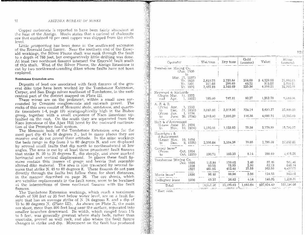
ARIZONA BUREAU OF MINES
Silver(ol.lnCes)Value
Gold(ounces)Dry tons
2,D1O.73 2,759.64 204.60 $ 4,229.08311.66 299.69 44.21 913.82
2,482.88 2,343.69 225.56 4.516.21
795.00 747.31 60.27 1,202.70 9,U93,OU
:l.O41.00 2,819.a6 224.14 5.6aO.77 :37,840.:::1)
2,018.00 2,006.211 116.33 4.0011.24 19,836,00
1,];15.0 I 1,123.113 79.38 2,778.30 };5.796,27
2.a08.64 2,164.36 70.36 2,795.58 2'j',D55,i:)1
106.71 133.35 3.14 298JjO ~;?1.2f:)
118.50 87.40 D(nA~!
80.78 82.73 643.74461.05 963.f5D 4.137.05
124.55 f:)tJ,;3.GH
140.DZ 1,228.01
$27,854.49 180,490.£36
Viet tons
1933193:n193419:34)
1 1932i: 193:3)
& d'Autremont193419:34)
Opex'ator
fI/lacia lease~' 1936
Gallagher lease 1936
10, 19349, 1935)
.:----_.-
Tombstone Mining Co.Dec. 19:35
18:361937
Total
A. S. & R
Tombstone Mining(,Jan.
to1\11ar. 11, 19:32)
Yr. 19:30Yr. lD31Yc 1932
Deposits of lead ore associated with fault fissures of the general dike type have been worked by the Tombstone Extension,Carper, and San Diego mines southeast of Tombstone, in the eastcentral part of the district mapped on Plate III.
These mines are on the pediment J within a 5111a11 area surrounded by Cenozoic conglomerate and outwash gravel. Therocks of this area consist of Mesozoic shale, sandstone, and quartzite (members 1-4, page 19) stratigraphically high in the Bisbeegroup, together with a small exposure of Naco limestone upfaulted on the east. On tbe south they are separated from theNaco limestone of the Ajax Hill horst by the eashvard continuation of the Prompter fault system.
The Mesozoic beds of the Tombstone Extension area for themost part dip 45 to 50 degrees N., but in rnany places they arcmassive and do not reveal their attitude. In the ITline workingsthe beds range in dip from 5 to 60 degrees N. and are displacedby several small faults that dip north to northeastward at lowangles. The area is cut by at least three prominent fault fissuresthat strike N. 20 to :35 degrees E., dip steeply, and show markedhorizontal and vertical displacement. In places these fault fissures contain thin lTIaSseS of gouge and beceia that resemblealtered dike materiaL The area is also traversed by several fissures that strike N. 45 to 60 degrees E. These fissures do not passdirectly through the faults but follow them for short distances,in the manner described on page :)6. The ore shoots, whichare veinlike replacen1E'nts in the tauIt zones, seem to be localizedat the inter.sections of these northeast fissures with the faultfissures.
The Tombstone Extension workings, which reach a maximumdepth of 550 feet or 35 feet below water level. are on a fault fissure that has an average strike of N. 24 degrees K and a dip of75 to 80 degrees N. (Plate III). As shown on Plate X. the mainore shoot, more than 800 feet long near the surface .. separated intosmaller branches downward. Its width) which ranged from 1%to 5 feet, was generally greatest where shaly beds, rather thanquartzite, prevail as wall rock, and also where the fault fissurechanges in strike and dip. Movement on the fault has produced
Copper carbonate is reported to have been fairly abundant atthe base of the Abrigo. M:acia states that a carload of chalcociteore that contained 40 per cent copper was shipped from the ninthlevel.
Little prospecting has been done in the southward extensionof the Emerald fault fissure. Near the southern end of the Emerald workings, the Silver Plume shaft was slmk through the faultto a depth of 788 feet, but comparatively little drifting was done.At least two northeast fissures intersect the Emerald fault southof this shaft. West of the Silver Plume, the Abrigo limestone iscut by two northward-trending dikes whose faults have not heenexplored.
Tombstone Extension area
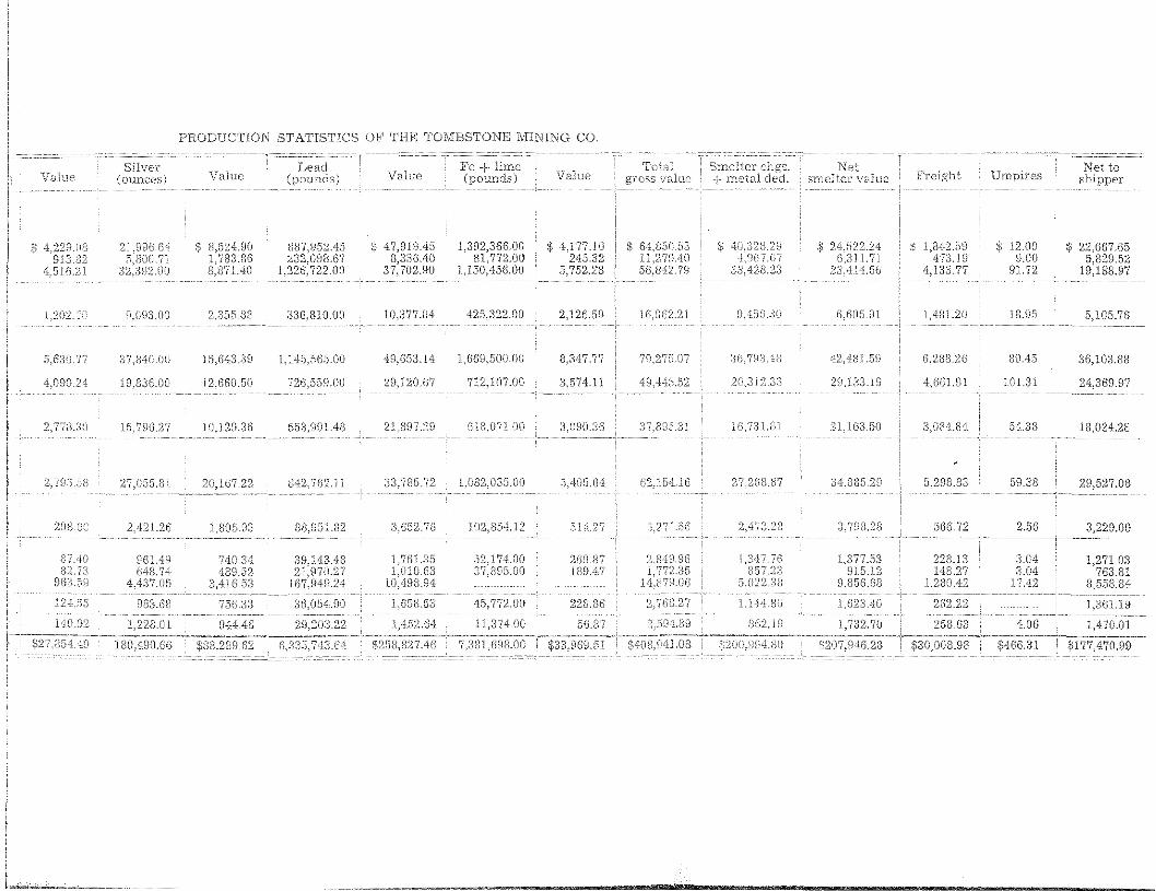
PRODUCTION STATISTICS OF THE TOMBSTONB MINING CO.
VaI1JCSilver
(ounces) ValueLead
(pounds) ValueFe + Erne(pounds) V;:llue
NetsrneHer vD.Iue F'reight Ompires
Net toshipper
s s 8,524,nO 887,952.45 S; 47,919.45 ] ,392,366.00 $ 4.177.10 $ 64,850.53 S .) 1,842.59 S 12.00 S 22.667.051.'783.86 232.0FJ3.67 8,336.40 81,772.00 245.32 11,279.40 47:3.19 9.00 5;a29.52
'U'iHL21 8,871.40 1,22C-;;722.00 37,702.90 1,150,456.00 5,752.28 56,842.79 4,133.77 Y1.72 19,188.97
1,202. H,093.00 2,355.8g :n6,8IO.01I 10,377.04 4:25,322.00 2,126.59 H)JJ62.21 9.456.30 CHiOS.OJ. 1.481.20 18.95 5,I05.76
5,G30.77 37,840.00 15J543.:39 1,l45,5{)5.00 49,65:3.14 1,66D,500.00 8,3"17.77 7U.27;'Ul7 :3(-),79:.).(1<1 42,481.59 G,Zda.26 B9.45 36,100.88
4J1\1O.24 19,83G.OO 12,6GO.50 72G,559JlO 29,1.20.07 7]2,107.00 3,574.11 49,445.52 20,:312,.:33 29,1:33.19 4,GGLDl 101.31 24.369.97
2<773.:30 I5.7fJG,27 j 0.129.3() 553,991.48 21,8~n,28 618J171.00 ;3,(J90.3G :n'(lDL1.31 16.731.8] 2LIG3.50 3,084.84 54.~)8 I S,(124.2B
2,79rj,5S 27,055,8\ 20)G7.22 B42,762.Il 33.785.72 1,032,035.00 5A05,M 62,15"'1,16 27.2G8.Wi :34,8B5,29 5,298.33 59.38 29,527.08
2ng.CO 2,421.26 1,805.83 38,951.82 3,652.7G 102,854.12 514.27 G271.5G 2A:7;',L28 3,79B.28 j66.72 2.56 3,229.00
87..4·0 961.49 740,34 38,143.48 7G L,;377.53 228.13 3.04 ] ,271.03'73 74 489,52 21,970.27 "0 ~n5.12 143.27 3.04 763.81".,)
3,416.5;3 167,949,24 :'),022.38 DJ35G.GB 1,2BIH2 17.42 8,558.84
124,5b H83J~8 756,33 :3G,054:.fJO 1,658.53 45,772.00 228.86 2,7G8,27 l.I44.nG 1,623.40 2G2.22 1,36I.J 9
1.'1:0.92 1,228.01 944AG 29,203,22 1,452.G4 1l,3H.OO 36.8'7 2,5G4.39 862,19 1,732.70 258.63 4.0G ) ,4'70.01
$27.n54.4H InO,490.GG $88,239.62 G,:3:'35,743.64 $258,827.46 7,381,698.00 $408,941,08 $200.\)94.80 $207,946,28 $30,008.98
THE' TOMBS'T'ONE' Dl,S'TNICT
brecciation and gn'::'ater pt~rmeabilit:y to ore solutions insuch areas. The are from the Tombston.eExtension mine is
oxidized, but galena .is relajj-vely abundant below waterlevel. The ore contained important arnounts of gold and silver.Locally, considerable jarosite and iron-bearing carbonate arcpresent in the gangue. The wall rock, particularly of the footwall) of the ore shoot is intensely kaolinized. Detailed figures ofproduction are given in the accompanying table.
A horizontal diamond-driB hole indicated another mineralizedfissure approximately :100 feet west of the Tombstone Extensionworkings. This fissure was sought by short drifts from a 70-footshaft and prospected by a drift from the 250-foot level, but no orehas been found within it.
The Carper workings) northeast of the Tombstone Extensionshalt, reach a depth of 150 feet. Here a fault fissure strikes N. :10to 35 degrees E., dips 70 to 80 degrees W., and in places is occupiedby aHerod, brecciated dike material. North of the sbaft it is intersected by a northeast fissure that dips about 35 degrees southeastward. Along this intersection an irregular pipelike body ofore, 5 to 15 feet in lnaximum diameter, was mined from the surface to a depth of 90 feel. Other smaller bodies were found, hathnorth and south of the shaft) where inconspicuous northeast fisSlues intersect the fault. The ore is oxidized and generally accODlpanied by jarosite. Some small masses were rich in gold.Detailed production figures are given in the accompanying table.
The San Diego JVIine, southeast of the Tombstone Extensionshall, is 400 feet deep. Its workings follow a fault fissure thatstrikes parallel to the Tombstone Extension fissure and ranges indip from steep westward near the surface to steep eastward below a depth 01 250 feel. The workings were not accessible at thetime of visit. According to J. H. Macia, the principal are shootis a sbort distance north of the shafl. It was mined over a lengthof 25 to 50 feet by a maximum thickness 01 5 feet for a height of140 feet above the fourth level. Some small bodies were minedfrom the fourth and third levels, 75 and 125 feet south of the shaft.
The major fault fissures of the area have not been thoroughlyexplored, particularly towards the south where limestone bedsmay be covered by the Cenozoic conglomerate.
Comet ore zone
Bodies of manganese-silver are) locally with some lead) occurassociated with the Comet dike in the southeastern portion of thearea mapped on Plate IV. They have been opened in the Cometand Black Eagle mines.
Here the surface is composed 01 thick-bedded Naco limestone,stratigraphically low in the formation, though higher than thatat the Bunker Hill Mine. These beds dip 20 to 30 degrees E. inthe vicinity of the Comet lVIine and eastward to northward at theBlack Eagle Mine. Immediately south of the Black Eagle shaftthey art':' cut by an cast-west fault of small displacement. The
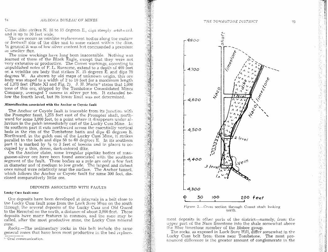
Lucky Cuss fault zone
75
10050
4.700
THIE TOj\1B,s'T'()NE [)[S'TRLCT
4,600
4,500
J'YIv v,":
1"1 ...I~,vi A
4, 4-00
4,300
4:800
zoo feet'---'-----''------',
Figure 2.--Cross section through Cornet shaft lookingnorth.
o
rnent deposits in other parts of the district-namely, from theupper part of the Naco limestone into the shale somewhat abovethe Blue limestone member of the Bisbee group.
The rocks, as exposed in Luck Sure Hill, differ somewhat in theLucky Cuss belt from those near Tombstone. The most pronouncpd difference is the greater amount of conglomerate in the
/l.RJZON/l BUREAU OF NUNES74
Mineralization associated with the Anchor or Co;rote fault
The Anchor or Coyote fault is traceable from its j unction withthe Prompter fault, 1,275 feet east of the Prompter shaft, northward for some 3,000 feet, to a point where it di.sappears under alluvium in the gulch immediately east of the Lucky Cuss Mine. Inits southern part it cuts northward across the essentially verticalbeds in the rim of the Tombstone basin and dips 45 degrees E.Northward, in the gulch east of the Lucky Cuss Mine, it strikesparallel to the beds and dips 50 to 60 degrees E. In its southernpart it is marked by 'Iz to 3 feet nf breccia and in places is occupied by a thin, dense, dark-colored dike.
On the Anchor claim, some irregular pipelike bodies of maoganese-silver are have been found associated with the southernsegment of the fault. These bodies as a rule are only a few feetin diameter and of medium to low grade. The largest and richestones mined were relatively near the surface. The Anchor tunnel,which follows the Anchor or Coyote fault for some 300 feet, disclosed comparatively little are.
Comet dike strikes N. 10 to 15 dipsand is up to 50 feet wide.
The ore occurs as veinlike replacement bodies along the easternor foot\vall side of the dike and to some extent within the dike.In general it was of low silver content but commanded a premiurnas srnelter flux.
The mine workings have long been inaccessible. Nothing \i\Taslearned of those of the Black Eagle, oxcopt that they were nol:very extensive or productive. The Comet workings
laccording to
unpublished notes of F. L. Ransome, extend to a depth of 400 feeton a veinlike are body that strikes N. 15 degrees E. and dips 70degrees W. As shown by old maps of unknown origin, this arcbody was stoped to a width of 2 to 10 feet for a maximum lengthof 1,375 feet (Plate XI and Fig. 2). J. H. Macia"" states that 1,000tons of this are, shipped by the Tombstone Consolidated MinesCompany, averaged 7 ounces in silver per ton. It extended below the fourth level, but its lower limit was not determined.
DEPOSITS ASSOCIATED WITH FAULTS
Ore deposits have been developed at intervals in a belt close tothe Lucky Cuss fault zone from the Luck Sure Mine on the southI:hl'Ough the several deposits of the Lucky Cuss and Old Guardto the Herschel on the north, a distance of about 3,000 feet. Thesedeposits have many features in common, and the zone may becalled, after the most productive mine, the Lucky Cuss mineralzone.
Rocks.·-The sedimentary rocks in this belt include tbe samegeneral zones that have been most productive in the bed replace-
-" Oral communication.
76 ;lR.lZONABURE'/iU OF ]V]lIVES TdE' T()MBST()NE DI,'':;'['F(lCT
Lucky Cuss area. SOTtle of the cOD£;-lomerate is rnadcof siliceous rocks rather than prevailingly ofthe principal component of the conglorneratc v.,rhcre present nearTombstone. The conglomerate beds are, hov;,Tcver, lenticular) forthe fhick lens of Luck Sure HilI thins before it reaches the Luck,,·Cuss Mine to the north and equalIy abruptly to the south. A second difference is the greater thickness over which siliceous no\'aculitic rock is interbedded with limestone. Crystalline) massivelimestone resembling Naco limestone apparently is above ';Novaculite." A third difference is that the first limestone ahove "Novaculite" and beneath the shale, in the position of the Blue limestone, is thinner than normal for the Blue Jimestone in the Tombstone area but otherwise resembles it
The Lucky Cuss mineral zone is near the Schieffelin granodiorite intrusive. Sills and dikes of granodiorite, apparently offshootsof the main mass, are exposed in the TIline. Alteration resultingfrom the proximity to the intrusive is pronounced. Much of thelimestone is bleached and recrystallized, and some of it containsabundant silicates, mainly hillebrandite, thaumasite, monticellite,grossularite, and vesuvianite. In other areas the Jirnestone hasbeen replaced by a claylike material. Some of the limestone exposed on the surface, however, .shows little alteration and containsfairly well-preserved fossils..
The stratigraphic differences of the mineralized beds in theLucky Cuss mineral zone as compared with those nearer Tombstone may be summarized as follows: The thickness of stratabetween the lowest "Novaculite" and the shale above the Bluelimestone is greater, due mainly to massive limestone above the"Novaculite." The Blue limestone is thinner. The rocks an~more altered and less readily classified.
StTucture.-The Lucky Cuss zone is located on the southwesternflank of the Tombstone basin where the strike of the formationsswings from northwesterly on the southern riln of the basin tonortherly on the western rim. Along this bow the dip of thebeds changes from nearly vertical southeast of Luck Sure Hillto 40 to 45 degrees into the basin at the Herschel Mine.
Much slipping or faulting along the beds accompanied the foldmg. Some of the displacements were doubtless small and followed the bedding closely. The adjustment was taken up inconSiderable part, however, by larger faults, in general parallelto the bedding but clltting I'rom one bed to another rather thanfollowing a single bedding plane. These larger faults are notsimple but branch and unite in a complex lTIanner.
The simple bedding faults are difficult to recognize, hy'gouges or slickensides on the bec1cling planes, and still rnure diificult to evaluate as to an10unt of 1110Vement. The larger faulLalso present many of thesL" difficulties.
These faults, where not parallel to bedding planes) show lessrange in dip than do the heds. To the north, where the beds flatten, the faults are steeper than the beds. To the south, where thebeds steepen, the faults are flatter than the beds. .
',I'he lTlO\'enJent 011 the [';;luH::; rei:iulted in the beds.VVhe.cc the ±<:iUltS cut across the the resultedin arl apparent or of the formations,
The Luckv Cuss fauH the; most conspicuous zone of beddirl&;faults on th~ sharp turn on the south\\rest rim of the Tombstonebasin. This fault can be traced from about 1,000 feet south ofLuck Sure HilL \vhere it strikes N. :::0 to 35 degrees VV.~ to northof the Old Guard !VIine and probably through the Herschel Mine,a distance of about 3,500 I'eet, where the strike is N. 10 to 15 degrees :B~. Throughout t.his distance the fault maintains a rathclunifonn dip on the surface of 70 to 75 degrees. Similar dips generally pre'iTail where the fault is exposed underground, thoughover limited areas the faults 01' this zone are much Hatter.
The southern part of the fault is in Naco limestone, and thenorthern part is in the Blue limestone and o\"cdying shale; it hasnot been definitely traced north of the Herschel Mine. It appearsto have its rnaximum development where the form~tions arestrongly warped in turning from the steep south rim of the basinto the flatter west rim.
The fault crosses at a small angle the favorable are zones fromthe Naco limestone to the shales. It produces a complexity ofstructure in detail, but the known relations seem to be producedby a fault at a low angle with the beds, that gives an apparentthickening and duplication of the beds.
Similar bedding I'aults or near-bedding faults are doubtlesspresent both above and below the Lucky Cuss zone. In the massive, recrystallized Naco limestone they are healed and difficultto recognize. In the poorly exposed shale sequence they are alsodifficult to recognize. There is, however, in the Herschel Mine atthe north end of the belt a well-defined series of easterly dippingslips in the shale that may belong to this fault system, thoughthey dip flatter than the Lucky Cuss fault.
Projections of several of the northeasterly striking are fissuresof the district cross this belt. Among the better recognized ofthese are the East Side, Blue Monday (West Side), 1ngersol, andIntervener, as well as others less well developed, Thc East Sidefissure has been I'oll.owed for more than 1,000 feet northeastwardfrom its junction with the Lucky Cuss fault. Numerous othernortheasterly fissures have been opened on the hanging-wall sideof the fault but have not been followed along their strikes. Theircorrelation with known fissures to the northeast is not now possible, though sorne of them are probably extensions of those flsSLues.
Where the;l meet the fault the fissures range in strike froD1 N.:35 to N. 60 de.§{l'ees E., and nearly all dip steeply southeastward.The fissures intersecting the fault :from the east 01' hangingVIall side are not found on their projected strike on the\Alest or footwall .side. On the footwall side there are similar fissures of which the best developed are the Rat shaft. Wedge, andLuck Sure, It seems probable that the fissures on opposite sidesof the fault are the same, but their definite correl:-ition \vas not
The CClUSC' ()f the oilset of the fissures on the InuIt isnot certain. The\ fault is believed to have beer initiated andlargel)' forrncc1 during the folding of the rocks and is earJier thanthe northeast fissures. That the fault preceded ore deposition isindicated by ore al011g the fault. There vvas, however~ post--oremovement on the fault, \vhich would have displaced Jlssures cross·ing the fault.
Another cause for the offset of the fissures is the effect or thefault on the fissuring, 'l'h2 fault zone was clearly a zone of weakness. The fissures rnet this zone at an acute angle on the strikeand a very acute angle on thE; dip. It would be natural for thelater fissure to follO\v the earlier fault for a distance rather thancross it directly on the strike.
Ore deposits.-The ore deposits in and associated with the LuckvCuss fault zone are of three types: veins in the Lucky Cuss fauJt:,veins in the northeast fissures, and limestone replacement deposits associated with the northeast fissures.
Deposits in the Lncky Cnss fanlt.··-From the Lueky Cuss shaftnorthward through the Old Guard Mine and possibly the HerschellVIine the ore was mai.nly in the Lucky Cuss fault. It was not,however, uniformly distributed but occurred in distinct shoots(Plates XII and XIII). The shoots in the Lucky Cuss and OldGuard mines seem to have been in the fault, near junctions of thefault with northeast fissures in the hanging wall. The junctionsof fissures with the fault extend nearly down the dip of the fault.and the are shoots likewise have this general trend.
Deposits in the Herschel Mine.--In the Herschel Mine the ore isin fissures of two distinctly different strikes. In the upper levelsthe fissure has essentially the strike of the Lucky Cuss fault,whereas in the lower levels the strike is essentially that of thenortheast fissures (Plate VII). There was little opportunity forobservation in this mine, but from the facts available it seerns atleast probable that the orc shoot was formed at the junction ofthe Lucky Cuss fault or a branch of it wIth a northeast fissure.The two breaks mect at an acute angle and possibly unite forsome distance. The northeast fissure is Inineralized, and the faultnear the junction is rnineralized, Within the fissure, rnineralizabon 'ivas controlled by bedding slips, beneath which the ore shootsoccur.
Deposits in rWTtheast fissu'tes.~Few of the northeast fissuresin the shale of the hanging wall of the fault have been prospected.The East Side fissure has been followed for more than 1,000 feeton the third levellvhere small shoots of are that occurred betweenshale walls and small replacement deposits in beds of limestone\vere opened. This fissure was also productive near the surface[or several hundred feet northeast from the fault where it cutshoth shale and limestone The extent of these deposits is notknown,
Other hanging-wall Hssures have been developed for short distances from their junctions with thf: faults and have yielded someore.
71; /lHIZOIV/\ BUREA[j OF' [yIINfi,'S THE TONJBSTONE D1STHIC'T
l'he fi';su1'c) deposits of the HCTschcI Nlinc ha\.'(' been t1lCntioDec!above.
RepVlccrnent depos'its in, fjlnestone.-",-~-Replacement deposits inlimestone have yielded the lTIain production south of the LuckyCuss shaft and in lhe footwall of the faul!. Above massive crystalline limestone that is defmitely Naco is a series of interbeddedsiliceous novaculitic and crystalline linlestone beds whose relation as determined in the limited accessible workings is uncertain. They rnay represent an alternation of siliceous and calcareous beds above the massive Naco limestone, or they mayrepresent a part of the Lucky Cuss fault zone, with a duplicationof beds by faulting nearly parallel with the beds. The latterquite certainly was a factor. The replacements occur where thisseries and the massive Naco limestone are cut by northeasterlyfissures. Generally the deposits are irregularly pipelike or chimueyIike, though some have a more tabular form. They follow theintersections of the northeast fissures and favorable limestonebeds and bed faults.
A maze of irregular replacernent deposits has been mined nearthe Lucky Cuss shaft where a group of northeast fissures, ofwhich the Rat shaft fissure is the most conspicuous, cut the rocksin the footwall of the fault. A part of these bodies seems appropriately named the Rat Hole shoots. The deposits have beenmined from the surface to below the eighth leveL From the surface nearly to the fourth level the stope is between a massive,white crystalline limestone footwall and a "Novaculite" or shalehanging walL Above the fourth level it meets the Lucky Cussfault and continues in the footwall of that fault to the sixth level.From the fourth to the sixth level it is in massive white limestone.About 50 feet from the footwall of the Rat Hole shoot on the fifthlevel is a shoot that has been mined from above the fifthto below the eighth leveL This body in general parallels the RatHole shoot and overlaps it from above the fifth to the sixth level(Plate XIII). This shoot is represented on old sections as inmassive, white (Naco) limestone in the footwall of the main faultbut approaching it with depth (Plate XIII).
The McCann shoots are on the Wedge fissure where it cuts themassive Naco limestone. The largest shoot is 150 feet from thefootwall of the main Lucky Cuss fault on the fifth level. It is anirregular chimney perhaps 25 feet in diameter that has beenmined from the surface to the fifth leveL A smaller pipe 50 feetsouthwest on the fissure was mined from the fifth to the thirdlevel. A third pipe 150 feet farther southwest, on the third level,was mined from the surface to the third level. At the surface itnearly joined the largest shoot.
The Escondido shoots are on the Escondido fissure or fissuresin the Naco limestone. The shoots appear to be in essentially thesame st.ratigraphic horizon as the McCann shoots and are verysimilar in character, though in the upper levels, as indicated onold ITlapS1 they are very irregular. The stopes are inaccessible.and little of the detail of the occurrence of the shoots is known.
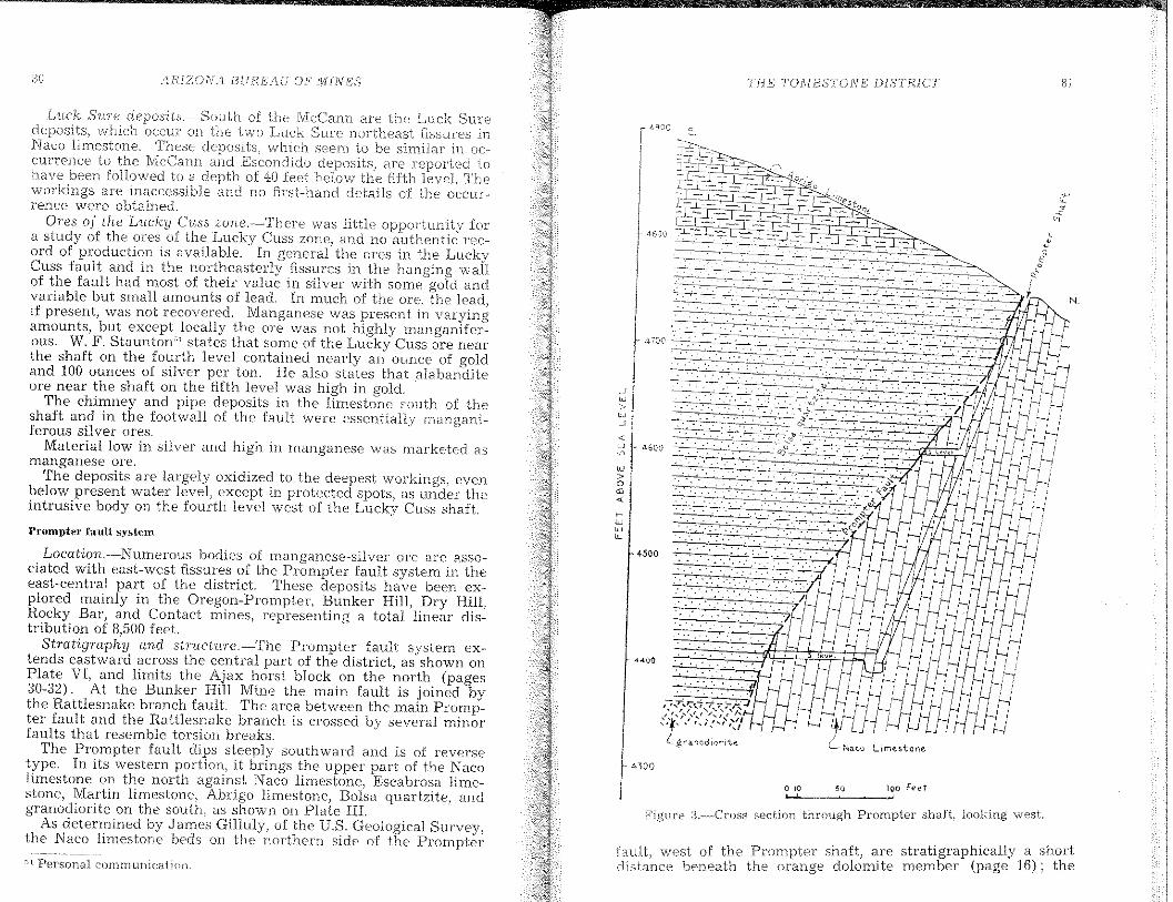
uu AHIZO[IJ /1 BUREA1F OF M[P,[ES' Ti:fETOXI,1BSTONl!: DTSTHICT 31
N
o "
--:-~~..~~.:.:.,...
--~-+~_..
4400
fault) west of the Prompter shaft) are stratigraphically a shortcHstance beneath the orange dolomite member (page 16); the
Figure :3.--Cross section through Prompter shaH, looking west.
4500
l',?.:T,,,;:--,'f...-t...Z>:/<"','"," /~" I~
~,'t,'" ,\-'.:,i','!lL grancd iorite
J. 700
."
~ ~I:~ "-600·n
w>oOJ
"'rww"-
Luck SVJ€ of the lvlcCann are the Luck Surf;deposits) "vhich occur on tb.£:: hOlo Luck Sure northeast fIssures inNaco limestone. These deposits) which s(';em to be similar in occurrence to the lV1cCann and Escondido deposi.ts, are reported iohave heen followed to a depth of 40 feet below the fifth level. Theworkings are inaccessible and no first-hand details of the occurrence were obtained.
OTes of the Lucky Cuss zone.--There was little opportunity fora study of the ores of the Lucky Cuss zone, and no authentic TCC
ord of production is available. In general the ores in the LuckyCuss fault and in the northeasferly fissures in the hanging wallof fhe fault had most of their value in silver with some gold andvariable but small amounts of lead. In much of the ore. the lead.if present, was not recovered. Manganese was present in varyingamounts, but except locally the orc was not highly manganiferous. W. F. Staunt()n~·· states that some of the Lucky Cuss orc nearfhe shaft on the fourth level contained nearly an ounce of goldand 100 ounces of silver per ton. He also states that alabanditeore near the shaft on the fifth level was high in gold.
The chimney and pipe deposits in the limestone Uluth of theshaft and in the footwall of the fault were pssentiall)' manganiferous silver ores.
Material Jaw in silver and high in manganese was marketed asmanganese are.
The deposits are largely oxidized to the deepest workings) evenbelow present water level, except in protected spots, as under theintrusive body on the fourth level west of the Lucky Cuss shaft.
",I. Personal communication.
Prompter fault system
Locat'ion.--Numerous bodies of manganese-silver are are associated with east-west fissures of the Prompter fauIt system in theeast-central part of the district. These deposits have been explored mainly in the Oregon-Prompter, Bunker HllI, Dry HllI,Rocky Bar, and Contact mines, representing a total linear distribution of 8,500 feet.
Stratigraphy and structwe.-Thc Prompter fault system extends eastward across the central part of the district. as shown onPtate VI, and limits the Ajax horsi block on the north (pages30-32). At the Bunker Hill Mine the main fault is joined bythe Rattlesnake branch fault. The area between the main Prompter fault and the Rattlesnake branch is crossed by several minorfaults ihat resemble torsion breaks.
The Prompter fault dips steeply southward and is of reversetype. In its western portion) it brings the upper part of the Nacolin1estone on the north against Naco limestone, Escabrosa limestone, Martin lin1cstone, Abrigo limestone) Boisa quartzite, andgranodiorite on the south, as shown on Plate III.
As determined by James Gilluly, of the U.S. Geological Survey,the Naco li11'lestono beds on the northern side of the Promptf::r
82 ARIZONA BUREAU OF' MINES THE TOI'vlBSTONE' DlSTHIC:'l' 8' ').,
10\v12r part of this dolornite here consists of r,athcl siHceous horn·fels that resembles novaculite. East\vard, still members ofthe Naco form the footwall of the fault
On the northern side of the fault the Naco strata provaiJinglydip steeply northward but in places are vertical or slightly overturned. There are numerous inconspicuous faults and slipsparallel or at slight angles to the bedding.
Northeast fissures, mostly of steep southeastward dip) intersectthe Prompter fault at many places (Plates IV and VI). Thesefissures) which are generally inconspicuous) appear to have beenthe channels through which the mineralizing solutions enteredThe ore bodies associated with the Prompter fault system occurwhere northeast fissures intersect favorable beds and favorablestructures.
Oregon-Prompter Mine.-The Oregon-Prompter w 0 r kin g s(Plates VII and XIV) extend to water level, with a maximumvertical depth of 800 feet. The are bodies exposed in these workings are irregular, pipelike to tabular replacement masses, ofwhich at least twelve have been mined. They occur within certain favorable beds of the Naco limestone where the Prompterfault and bedding slips have localized ore solutions from thenortheast fissures.
Associated with the Prompter fault were five separate orebodies of which three occurred near the Prompter shaft betweenthe surface and the fifth level, and one was ilOO to 325 feet east ofthe Oregon shaft between the surface and the first level (PlatesVII and XIV). The limestone beds that contained these bodies ingeneral conformed with the footwall of the fault. This are ingeneral was of medium to iow grade. Some 400 feet south of theOregon shaft was the Massey-Williams ore body in vertical tosteeply northward-dipping beds of Naco limestone beneath thePrompter fault. The stopes here are inaccessible, but accordingto maps and local information, the ore body extended, with medium to steep eastward plunge, from the faul', at a point approximately 125 feet above the third level, to water level. Throughoutmost of its vertical extent of 450 feet this ore was of high grade.
The ore bodies related to bedding slips in the Naco limestonearc indicated on Plate XIV. In general they were very persistent.and one of them was followed for a length of 850 feet, from thesurface near the Oregon shaft to water level. The most westernone~ the Giacoma are body, occurs along the intersection of anortheast fissure with steeply northward-dipping limestone bedsin the footwall of a bedding slip (Plate XIV). According to JohnGiacoma, this body yielded $175,000 worth of silver ore.
The Oregon-Prompter structures have not been thoroughlyprospected, The favorable limestone beds and associated bedding slips, such as those of the IVlassey-Williams and Giacoma orcbodies~ appear to be intersected by several other northeast arefissures in unexplored areas. Other favorable beds and favorablestructures may exist in the untested area north of the Oregonworkings and south of the hornfels contact shown on Plate IV.
BunkeT HET M'ine.~",~TheBunL::er Hill are \vithin thea ::ute angle of intersection of the Prompter and faultsand extend to a depth of 516 feet. These workings were inaccessible at the time visited, but SOlIle information regarding the underground features was obtained frOlYl the late John Pie1'oti andfronl rnine maps.
Here the Prompter lault dips 50 to 70 degrees S. and brings thelower part 01 the Naco limestone on the south against the upper
on the north. The Rattlesnake fault, 01 vertical to steep~~outhward dip, shows relatively small displacement, with itsnorthern side thrown relatively downward and westward.
In the area 01 the mine workings, the beds are sharply foldedinto a southeastward-trending anticline. They are also brokenby small laults and slips parallel to the Prompter and Rattlesnakefaults and are intersected by at least two northeast fissures.
The Ofe bodies occur as 'irregular replacements in the lowerpart of the Naco limestone along the Rattlesnake fault and alongthe small faults ancl slips already mentioned. Most of the arebodies are pockety, although some exceed 100 feet in length and:,0 feet in width. In general the are mined from them was ofmedium to low grade, worth less than $:30 per ton in silver, lead,and zinc. The largest and richest ore bodies were found in ornear the zone 01 the Rattlesnake fault. between the third and fifthlEvels. The ores are relatively more <manganiferous in the western part of the mine.
The northern or footwall side of the Prompter fault in this areahas not been prospected.
C')ntact workings.--On the Contact claim, the 100twal1 of thePn,mpter fault has been explored lor a distance of approximately1,200 feet on a level some 35 leet below the third level 01 the Oregon Mine. This level extended to a point approximately S. 10degrees W. of the Oregon shaft. The footwal1 has also been followed for short distances on upper levels. In this area the faultis intersected by several prOlninent northeast fissures in the vicinity of which some bodies of low-grade argentiferous manganeseoxide were found. No commercial Ofe was developed.
Dry HitZ Mine.-The Dry Hill Mine is on the Prompter faultsystem and 3,000 leet west of the Oregon Mine.
Here the Naco limestone is limited on the west by the greatnorth-south fault described on pages :31-32, and the main Prompterfault gives way to two faults, 75 to 100 feet apart, that trend aboutN. il5 to 45 degrees E. and dip 70 to 80 degrees SE. The larger ofthese northeast faults brings Cambrian Abrigo limestone on thesoutheast against the upper part of the Naco limestone on thenorthwest and west (Plate III). The limestones have beenstrongly altered by contact metamorphism. As shown undergTound 1 this fault is paralleled by a zone of fissuring in the Nacolimestone. This fault zone and the parallel fault that occurs 75feet farther northwest are intersected by several fissures thatstrike N. 60 to 70 degrees E. and dip 60 to 80 degrees SE. Alongthese i.ntersections are irregular pipelike to tabular bodies of
34 A.HIZONA B"[JI~EA[J OF MINES THE TOMBSTONE DISTRIC7 85
Tons:3,116
ore. The ore bodie's range in SiZf~ fl'orn srlE-dllenses to 20 feet wide by [j to 25 teet long and 100 feet or moredown the dip. Within a horizontal distance of 500 feet on thelarger fault zone) three shoots have been stoped to a depth ofabout 100 feet, and one was followed from the 100 to the 200 level,On the parallel tault to the northwest, the are hodies are ofslTlaller size and lower grade.
Ivrost of the production from this mine was made during theearly days and is unrecorded. Recent production, by the Tombstone Development Company and lessees, has been as follows:
Ore shipped from Dry Hill Mine, 1933-37
Oz. gold Oz. silver Lbs. copper Gross value131 53,957 10,40! S:34,075
Telephone Mine.--The Telephone Mine is 300 feet north of themain Prompter fault on a bedding slip parallel to that fault. Inthis vicinity the massive upper part of the Naco limestone strikeseastward and dips steeply to almost vertically. At the TelephoneMine the beds dip 65 to 70 degrees S. and are crossed by twoclosely spaced northeast fissures. These fissures show manganesemineralization at the surface, and the Telephone deposit is on theintersection of the fissures and the bedding slip in the limestone.The mine workings were inaccessible at the Hrne visited, but anold company map shows eight levels with a maXlmum east-westlength of 350 feet. The principal stopes are between the fourthlevel and the surface, and a small stope extends from the seventhlevel to a point midway between the fourth and third levels. Thelargest stope shown is 140 feet long by jllz to 5 feet wide and extends from the surface to the first level.
Projected southwestward, the northeast luineralized fissuresexposed at the Telephone Mine would intersect the Prompterfault, but. this projected probable intersection has not. beenprospected.
DEPOSITS ASSOCIATED WITH ANTICLINES AND ROLLS
It has been shown in the section on structure that the formations within the Tombstone basin have been compressed into aseries of rather broad southeastward-trending anticlines and synclines which have been designated, from northeast to southwestas the Ernpire anticline, Sulphuret ,syncline) Sulphuret anticlinc'"Boss terrace: Ingersol overturn, and Hardup syncline. On thelarger folds are numerous rrtinor folds or corrugations, the anticlinal portions of which are locally designated as roIls. Theyhave the characteristics of drag folds. Some of then1 have be'ennamed after ore bodies that have been developed on them. Thebroader folds show a general parallelisHl between the n1assivePaleozoic and the thin-bedded Mesozoic rocks. In the minor foldsor rons the lVl:esozoic Blue limestone is generally more closelyfolded than the underlying Naco limestone.
The anticlinal areas have been much more productive than theareas. This generalization applies to deposits in shale
the strong flssures, like t.hose shown in the West Side andSkip shaHs, as \\le11 as to replacen1ent deposits in the limestones.Bed replacelnent deposits are largest in the rolls and mainly inrolls on the anticlines as contrasted with those on the synclines.
LoclttiDn of mineralization on the rolls
Location of mineralization on the rolls is detenYlined by severalstructures and combinations of structures) so that prediction asto just where it will be found is somewhat uncertain. The severalfactors may be given in the following order, \vith dne allowancefor variation.
1. The overlying shale acts as a relatively irClpermeable cap.2. The "Novaculite" is the most brecciated and the most per
rneable zone.;3. The upper part of the Naco limestone, the "Novaculit.e," and
the Blue limestone are chemically the most favorable to replacement.
4. Brecciation is greatest and permeability generally greatestwhere the bends are sharpest. The folds are not symmetrical andthe sharpest bends mayor may not be at the crests of the folds.In some folds slipping along the beds has produced permeablezones on a limb of the fold, and mineralization extends far downthe limb.
5. ,'ollowing the folding, the north-south dike fissuring andint.rusion of the dikes further brecciated the rocks and increasedpermeability.
6. The northeast fissuring completed the preparation of theground for mineralization. These fissures ,",vere the channelthrough which the solutions rose and passed into the more permeable zones.
The resultant of the several controls has been variable. butsome generalizations may be stated. .
Mineralization is greatest in and near the northeast fissures andat or near the crests of the antielines, but this is subject to manyexceptions. Mineralization is least at or near the troughs of thesynclines. Mineralization is also greatest near the base of the('Novaculite" and in the Blue limestone, but other zones in theUNovaculite" have yielded are, especially where close to thenortheast flssures. The limestone beds in the shale series abovethe Blue limestone have been mineralized along some of thestrong fissures, as shown by the stapes on the\Alest Side roll.Where the N'aco limestone or the "Novaculite'~ is well rnineral-
the Blue lirnestone may be poorly mineralized or the reverse, but thi~) is not a genc'ralization, and the fact that one is wellrniner2.1ized does not mean that the oth(~r is barren of ore.
HeseripHon of roB de}}osits
The individual rolls plunge with the larger anticlinal structures\\,'iUI trends ranging from S. 60 to 70 degrees E. in the western
86 llRIZONA BUREA,!J OF 11;11l,[E5' TdlE TONIBSTONE DISTRICT 87
part of th£:: area to considerably IT10re southerly' in the easternpart (plate
The rolls are crossed by the north-south dike fissures. Displace~
Il'lent on the Empire-Contention dike fault f-lssure has offset therolls so that their correlation on opposite sides is not certain) andthe areas east and vvest of this break J:1'lay be considered sepa"rately. The horizontal offset is probably not great, but the folding on the east side of the dike is Inore complex than on the west.
Rolls east Qf the Empire dike
Jeanes mIL-The Jeanes roll (Plate XV), the most northeasterly that has been developed, is on the northeastern limb of theEmpire anticline. The fiftb level of the U.S. Smelting, Refining,and Mining COD1pany lease encountered Blue limestone near thecrest of the roll.
In the vicinity of a strong, northeast fissure, an aTe body ofirregular area was found on the crest and southwestern flank ofthe roll. This are was of fairly high grade only near the fissure.
Farther northwest the Jeanes roll becomes a close fold, slightlyoverturned southwestward. A fourth level drift followed theBlue limestone near its axis northwest for 200 feet. to within ashort distance from the Empire dike. In this interval the roll iscrossed by four distinct northeast fissures in the vicinity of whichthe limestone is mineralized with abundant low-grade sulphidematerial. Near the end of the drift a pipelike mass of oxidizedlead ore, 5 to 10 feet in diameter, occurred in the upper part ofthe Blue limestone on the southwestern, overturned limb of theroll. It was mined for a vertical distance of approximately 40feet.
As shown by churn drilling, the limb of the Empire anticlinenortheast of the Jeanes roll dips steeply, carrying the Blue limestone far below water level.
Holderness roll.-The Holderness roll, southwest of the Jeanesroll but also on the northeastern limb of the Empire anticline, hasbeen extensively developed. It is a broad, gentle arch, 250 to 300feet across on the fourth level. The crest at the top of the Bluelimestone where it meets the Empire dike is about 60 feet abovethe fourth level. The southeasterly plunge carries the crestnearly to the fifth level at the Skip-shaft fissure (Plate XXIII).
The gently dipping southwestern hmb of the Holderness rollis separated by a high-angle fault from the almost vertical northeastern limb of the Silver Thread roll at about the fourth levelnear the Empire dike. On the northeastern limb at the fourthlevel the Blue limestone dips steeply below the fourth level andis next exposed to the northeast on the fifth level of the U.S.Smelting, Refining, and Mining Company lease near the crest ofthe Jeanes roll (Plate XV).
The northwestern part of the roll near the dike is crossed bytwo northeast fissures which, to the southwest, meet the Empiredike. Outward from these fissures the Blue limestone has beenmineralized for a width of 50 to 100 feet in an irregular belt that
crosses the foldo From September, 1934, toore body, known as the H409,~' yielded 41218 tons agross value of $146,3620
The lower >iNovaculite~~ zone, which lies below the fourth level,has not been extensively prospected on this roll, though a winzeon the westerly fissure has been sunk to it, and some ore has beenmined near the fissure. The "10-foot" and "6-foot" lim,estones inthe shale sequence above the Blue limestone have not been prospected on the roll, but they are mineralized and have yielded arein the U.S. Smelting, Refining, and Mining Company lease to thenortheast along a northeast fissure on the northeastern limb ofthe roll.
Outside of this belt the roll has been prospected by drifts in theBiue limestone nearly to the point where it plunges below thefourth level. An irregular are body was developed along a northeast lissure crossing the rolls about 100 feet southeast of the "409"stope. This are extended along the fissure for a length of 160 feetand has a width of 5 to 100 feet and a thickness of 3 to 10 feet.
Where the Blue limestone at the crest of the roll is cut by theSkip-shaft fissure, just above the fifth level, it is mineralized andhas been productive.
Silver Thread mll.-The Silver Thread roll is south of the Holderness roll. ln contrast to the broad dome of the Holderness roll,it is a fold with both limbs steep. It corresponds, however, inhaving the northeastern limb the steeper, in places even overturned. Southeastward from the dike the fold becomes moreopen, but the northeastern limb continues to be the steeper. Nearthe Empire dike the Blue limestone crest is just below the Empiresecond level. Here it has a rather flat crest which hends sharplyinto a nearly vertical northeastern limb that drops about 200 feetto the fourth level where it flattens off sharply and rises into thefold to the northeast. The southwestern limb is not as clearlyoutlined by developments, but it is less steep and the top of th;'Blue limestone does not reach the third level before it fiatt ensinto the trough of the syncline.
The sharp bending has greatly brecciated the "Novaculite," andnear the dike fissure it has been further brecciated. The adjustments in the breccia mass during the folding and subsequent intrusion of the dike have produced a complexity of detailed structure that is difficult to decipher. The roll plunges to the southeastas shown in Plate XVI. Where it meets the Skip-shaft fissure theBlue limestone crest is midway between the third and fourthlevels.
Mineralization on the Silver Thread roll extends from the Empire dike to the Skip-shaft lissure, a distance of about 600 feet.It has been most productive near the Empire dike.
The Blue lirnestone has been more or less continuously mineralized along the crest of the roll 400 or 500 feet from the dike.There has also been Inineralization that has yielded commercialore on the steep northeastern limb of the roll.
8B AEIZONi\ BUHEilU ()F' NIIiVES THE TOMBSTONE D]STIUC7 89
The lovv(?r ;'NO'\/Clculite" zone has not as beenEve in this roll, but therE' has been irnportant fromthe Benson and Albert are bod:y! mainl:y between thE? third andfourth levels in brecciated "Novaculite"' and lirnestone close tothe Enlpire dike, This is a thicker and more irregular ore bodythan n10st) evidently due to the replacement of the breccia, butotherwise does not difIer from the replacements in the less-disturbed beds. The relation of mineralization to northeastfissUTl7Sis not as clear in the ore bodies of the Silver Thread roll as it isin that of the Holderness roll.
The Benson-Albert are body was nearly continuous with theare body on the Holderness roll and probably is related to northeast fissures southeast of those that formed the Holderness orebody.
In the Silver Thread roll the Blue limestone bas been mostproducUve. The lower ~;Novaculite'" zone has been prospectedin several places and locally is strongly silicified and mineralized.Brecciated fault zones have been largely productive in the Benson-Albert are body. The limestone beds in the shales ahove theBlue limestone have not been prospected on this roll exeent alongthe Skip shaft fIssure, where they have been productiv~.
Maeia rol!.-The Macia roll, next southwest of the Silver Threadroll, is in general similar to the Silver Thread roll. Where erossedby the Skip shaft fissure, however) it is a very narrow "pinch."The limestone folds sharply in the pinch 70 feet above the thirdlevel, and the width of the Blue limestone across both limbs ofthe pinch on the third level is only 50 feet (Plate XXIII).
The Naco limestone below the pinch is in a rather open fold,and only the Blue limestone and beds above are involved in thesharp fold.
At the Empire dike the top of the Blue limestone at the crestof the fold is about 15 feet above the second level. At the Skipshaft fissure it is about 65 feet above the third level. About 51lfeet farther southeast it is cut off by the Tranquility fault (PlateXVII) .
The Blue limestone at the crest of the roll has been mineralized from the Empire dike nearly to the Tranquility fault. Themineralization has been most continuous on the crest) but it hasalso extended down both flanks of the fold.
The lower "Novaculite" zone has been prospected near the Empire dike on the third level and along the Skip shaft fIssure onand below the fourth level. Some mineralization has been foundand a little ore developed. The limestone in the shale series hasnot been prospected except at the Skip shaft fissure.
Roll southwest of Macia roIl.-The second level of the EmpireMine exposes a small roll east of the Empire dike and 125 feetsouthwest ol the crest of the Macia roll. Ncar the dike, wherethe roll is crossed by a northeast fissure, the "11l-100t limestone"contained a small body or low-grade siliceous pyritic ore that wasmined down the southwestern flank for approximately 45 feethelow the second level. Immediately below on the third level,
the roll is not n.::presented; apparently it has bepl1 cut off by asteeply northeastward-dipping reverse lault. This displacementseerns to diminish southpastward where the roll is exposed in theSkip shaft fIssure workings and on the third level of the Tranquility Mine.
Empire anticline west of Empire dilie
The E1TIpire anticline has been extensively developed for a distance of about 2,01l1l feet between the Empire and Tribute dikes.Northwest of the Tribute dike there has been little developmentand production. The Blue limestone and the upper portion of the"Novaculite') were eroded from the top of the anticline over thenorthwestern part of the area before the Cenozoic conglomeratewas deposited. On the section of the Empire anticline betweenthe Empire and Tribute dikes are several rolls that tend to separ~te and JOIn, so that a definite designation is not everywhere posSIble, and there are some differences in naming on local minemaps.
East of the Tribute dike two rolls-the Vizina and the Quarry-form, respectively, a northerly and a southerly crest of the Empir~ anticline. They are not) however) sirnple rolls throughoutthel[ extent southeastward to the Empire dike. The Vizina roll,which near the Tribute dike is composed of three subrolls, hasnot been developed throughout from the Tribute dike to the Empire dike, but the compound Goodenough roll near the Empiredike has a similar position on the Empire anticline and ITlay beprovisionally correlated with it. The Quarry roll branches southeastward into the Toughnut and Girard rolls. All have associatedminor rolls.
This part of the Empire anticline is crossed by a series of northeast fissures of which many are mineralized and several havebeen mined as fissure deposits. FrOlTI southeast to northwest theprominent fIssures that have produeed ore are the Tribute, Girard, West SIde) Ingersol, and Defence fissures. These with manyless prominent fissures appear to be the channels from whichmineralizing solutions entered.
Vizina roIL---The Vizina is the most northeasterlv roll that hasbeen developed on the Empire anticline west of th~ Empire dike.At its northwestern extension near the Tribute dike it consists ofthree distinct rolls distributed over a width of 350 to 401l feet,which may be designated as the Northeast, Middle, and South\vest Vizina rolls.
Production from the Vizina roll has been mainly from the"Novaculite)) and to some extent from the top of the Naco limestone (Plate XVIII and Fig. 4). In most of this area east of theTribute dike, erosion prior to deposition of the Cenozoic conglomerate renlOved all the rocks above the "Novaculite:' Inplaces the conglOIT1Crate was laid down directlv on ore that hadbeen exposed by ero.sion. The area is crossed by many northeastfissures of which ~everal are mineralized) but none sufficiently toPl1courage extenSIve development as fissure deposits. West of
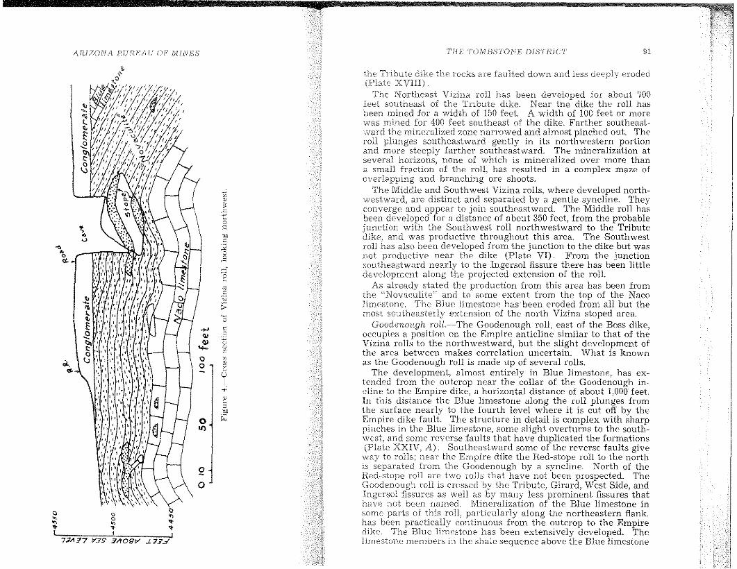
/-lRlZONA 13UHE'A.U OF' AliNES TiiE TOMBSTONE DISTRICT 91
The Northeast Vizina roll has heen developed for ahout 700feet southeast of the Tnbute dike. Near the dike the roll hasbeen mined for a width of 150 feel. A width of 100 feet or morewas mined for 400 feet southeast of the dike. Farther southeastward the mineralized zone narrowed and almost pinched oul. Theroll plunges southeastward gently in its northwestern portionand more steeply farther southeastward. The mineralization atseveral horizons, none of which is mineralized over more thana sn1all fraction of the roll, has resulted in a complex maze ofoverlapping and branching ore shoots.
The Middle and Southwest Vizina rolls, where developed northwestward, are distinct and separated by a gentle syncline. Theyconverge and appear to join southeastward. The Middle roll hasbeen developed for a distance of about 350 feet, from the probablejunction with the Southwest roll northwestward to the Tributedike, and was productive throughout this area. The Southwest1'011 has also been developed from the junction to the dike but wasnot productive near the dike (Plate VI). From the junctionsoutheastward nearly to the Ingersol fissure there has been littledevelopment along the projected extension of the roll.
As already stated the produetion from this area has been fromthe "Novaculite" and to some extent from the top of the Nacolimestone. The Blue limestone has been eroded from all but themost southeasterl:y extension of the north Vizina stoped area.
Goodenollgh 1'011.--The Goodenough roli, east of the Boss dike,occupies a position on the Empire anticline similar to that of theVizina rolls to the northwestward, but the slight development ofthe area between Inakes correlation uncertain. What is knownas the Goodenough roll is made up of several rolls.
The development, almost entirely in Blue limestone, has extended from the outcrop near the collar of the Goodenough incline to the Empire dike, a horizontal distance of about 1,000 feet.In this distance the Blue limestone along the roll plunges fromthe surface nearly to the fourth level where it is eut off by theEmpire dike fault. The structure in detail is complex with sharppinches in the Blue limestone, some slight overturns to the south\vest, and some reverse faults that have duplicated the formations(Plate XXfV, A). Southeastward some of the reverse faults giveway to rolls; ncar the Empire dike the Red-stope roll to the northis separated from the Goodenough by a syncline. North of theRed-stope roll are two rol1s that have not been prospected. TheGoodenough roll is crossed by the Tribute, Girard, West Side, andIngersol fissures as well as by many less prominent fissures thathave not been named. Mineralization of the Blue limestone insome parts of this roll, particularly along the northeastern flank,has been practically continuous from the outcrop to the Empiredike. The Blue limestone has been extensively developed. Thelimestone members in the shale sequence above the Blue limestone
the Tribute dike the rocks are faulted down and less deeply eroded
,.;
"0~
cS'-<0
• "~.. on" "-<> ~.. 0<>
"'... ~"'""0"".sN
;;:~
0.... "'lI E~ 0..... ~
"0 "'.... "0 C... "U,
I.,;0
"Con0 ~II)
~..I
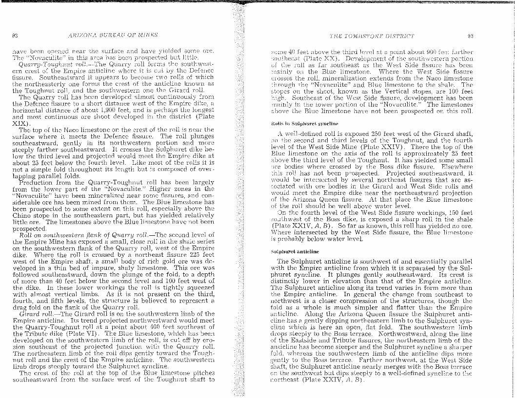
92 ilRIZONA EHni,EAU OF MINES THE TOtvIBSTO.NE DISTRICT' 93
have been opened near the surface and hElve som.e nrc.The "Novaculite'j in this area has been but little.
Quan'y-Toughnut ToU.~-The Quarry roll the southwest·ern crest of the En1pire anticline where it is cut by the Defencefissure. Southeastward it appears to become two rolls of whichthe northeasterly one forms the crest of the anticline known asthe Toughnut roll) and the southwestern one the Girard rolL
The Quarry roll has been developed almost contlnuously fromthe Defence fissure to a short distance west of the Ernpire dike, ahorizontal distance of about 1,900 reet, and is perhaps the longestand most continuous ore shoot developed in the district (PlateXIX).
The top or the Naco limestone on the crest of the roll is near thesurface whcre it meets the Derence fissure. The roll plungessoutheastward, gently in its northwestern portion and moresteeply farther southeastward. It crosses the Sulphuret dike below the third level and projected would meet the Empire dike atabout 25 reet below the fourth level. Like most or the rolls it isnot a simple fold throughout its length but is composed of overlapping parallel rolds.
Production from the Quarry-Toughnut raJ] has been largelyfrom the lower part of the "Novaculite,)) Higher zones in the"Novaculite') have been mineralized near some fissures, and considerable are has been mined tram them. The BIue limestone hasbeen prospected to some extent on this roll, especially above theChino stope in the southeastern part, but has yielded relativelylittle ore. The limestones above the Blue hmestone have not beenprospected.
Roll on so1tthwestern flank of Quarry Tot1.-The second level ofthe Empire Mine has exposed a small, close rolI in the shale serieson the southwestern flank or the Quarry roll, west or the Empiredike. Where the roll is crossed by a northeast fissure 225 rcetwest or the Empire shaH, a small body or rich gold are was developed in a thin bed or impure, shaly limestone. This ore wasrollowed southeastward, down the plunge or the rold, to a depthor more than 40 feet below the second level and 100 feet west orthe dike. In these lower workings the roll is tightly squeezedwith almost vertical limbs. As it is not present on the third,rourth, and fifth levels, the structure Is believed to represent adrag rold on the flank of the Quarry roIl.
Girard roll.-The Girard roll is on the southwestern limb of theEmpire anticline. Its trend projected northwestward would meetthe Quarry-Toughnut roll at a point about 400 reet southeast ofthe Tribute dike (Plate VI). The Blue limestone, which has beendeveloped on the southwestern limb of the roll, is cut off by e1'O
sion southeast oJ the projected junction with the Quarry roll.The northeastern limb or the roll dips gently toward the Too.ghnut roll and the crest of the Empire anticline. The southwesternlimb drops steeply toward the Sulphuret syncline.
The crest or the roll at the top of the BIue limestone pitchessoutheastward from t.he sudace west of the Toughnut shaH to
:-:;UIT1C 40 feet above the third level at a point about 900 feet fa.rth(~r
sDutheast (Plate XX). Developn1ent of the SOUU1\'i/estern portionof the roll as far southeast as the West Side fis.sure has beenrnainly on the Blue li111e3tono. Where the West Side fissurecrosses the roll, mineralization extends from the Naco limestonethrough the \'Novaculite ll and Blue limestone to the shale. Thestopes on the stloot, known as the Vertical stapes, are 100 feethigh. Southeast of the West Side fissure, developluent has beenmainly in the lower portion of the '~Novaculite.n The limestonesabove the Blue limestone havt-: not been prospected on this roll.
R{)i1s in Sulphuret syncline
A well-defined roJ] is exposed 250 leet west 01 the Girard shaH,on the second and third levels or the Toughnut, and the rourthlevel or the West Side lVline (Plate XXIV). There the top of theBlue lirnestone on the axis of the roll is approximately 25 feetahove the third level or the Toughnut. It has yielded some smaIlore bodies where crossed by the Boss dike fissure. .Elsewherethis roll has not been prospected. Projected southeastward, it\'vould be intersected by several northeast fissures that are as:;neiated with are bodies in the Girard and West Side rolls and\vould meet the Elupire dike near the northeastward projectionof the Arizona Queen fissure. At that place the Blue limestoneor the roll should be well above water level.
On the rourth level or the West Side fissure workings, 150 reetsouthwest or t.he Boss dike, is exposed a sharp roll in the shale(Plate XXIV, A, B). So rar as known, this roll has yielded no are.Where intersected by the West Side fissure, the Blue limestoneis probably below water level.
Sulphuret anticline
The SUlphuret anticline is southwest or and essentially paralIelwith the Empire anticline rrom which it is separated by the SuIphuret syncline. It plunges gently southeastward. Its crest isdistinctly lower in elevation than that or the Empire anticline.The Sulphuret anticline along its trend varies in rorm more thanthe Empire anticline. In general the change tram southeast. tonorthwest is a closer compression of the structures, though thefold as a whole is much simpler and flatter than the Empireanticline. Along the Arizona Queen fissure the Sulphuret anticline has a gently dipping northeastern limb to the Sulphuret syncline which is here an open, flat rold. The southwestern limbdrops steeply to the Boss terrace. Northwestward, along the line01 the Eastside and Tribute fissures, the northeastern limb or theanticline has become steeper and the Sulphuret syncline a sharperfold, whereas the southwestern limb of the anticline dips moregently to the Boss terrace. Farther northwest, at the ""Vest Sideshalt, the Sulphuret anticline nearly merges with the Boss terraceon the southwest but dips steeply to a well-defined syncline to thenortheast (Plate XXIV, A, B).

/\.HtZOI\/A BIJREAfJ OF lV£lJ\iES
s
TilE TOMflSTONE DlSTRIC'T 95
West Side roLL.-..-The crest of the Sulphuret anticline with associated minor folds is termed the West Side roll It has beenfoIlowed underground for 1,600 feet from the third level crosscut175 feet northwest of the West Side shaft southeastward to ttl"fifth level drift 50 feet southeast of the Sulphuret stope, As exposed in the West Side hssure workings, it is a double fold whosetwo rather sharp crests at the top of the Blue limestone are 125feet apart horizontally and 35 feet vertically (Plate XXIV, B),In the Arizona Queen fissure workings, the southwestern or nlinorcrest is 75 feet lower in elevation than the Inajor crest. The axisof the roll is essentially horizontal from the W cst Side fissure tothe Boss dike but pitches about 10 degrees southeastward betweenthe Boss and Sulphuret dikes and at 15 to 20 degrees southeast ofthe Sulphuret dike, Southeastward the rolI broadens from asharp fold at the West Side fissure to a broad flexure a i the Sulphuret stope (Plate XXII), Between the West Side fissure andthe Sulphuret dike, at least, the Blue limestone in the northeastern flank of the roll has been duplicated by a bedding faultWhether this duplication continues southeast of the Sulphuretdike, dies Qut, or gives vlay to a fold, is not known.
Development of the West Side roll has been very largely on itsnortheastern flank and northeastern major crest.
From the crosscut 175 feet northwest of the West Side fissureto the Boss dike, a third level drift near the northeastern axis ofthe roll encountered bunchy, high-grade are in an impure limestone bed in the shale sequence, Diamond drilling by the EaglePicher Company at a point 170 feet southeast of the West Sideshaft showed this drift to be 88 feet above the top of the Bluelimestone, The largest and richest ore body mined from the rollwas accidentally discovered on the northeastern flank, betweenthe fourth and flfth levels, where the Blue limestone is duplicatedby a bedding fault This ore body extended from the West Sideflssure to the Boss dike, In its northwestern half it was 10 to 50feet high by 5 to 20 feet wide and followed the zone of the beddingfault in the Blue limestone, In its sOlltheastern half it transectedthe limestone beds to the sbale along a northeast fissure, Fromthis fissure to the Boss dike the ore occurred in the upper part ofthe Blue limestone and was 10 to 20 feet high by 30 to 60 feet wide,The production from this ore body is reported to have exceeded$500,000, and much of the ore was worth $100 per ton, predominantly gold, Mineralization of the ore body appears to have beenaccomplished by northeast 'fissures, of which two are mapped onPlate IV,
Between the Boss and Slllphuret dikes the West Side roll hasbeen opened on its northeastern crest and flank by the third,fourth, and fifth levels which connect with the Boss and Sulphuretinclines. In this sector it is crossed by the Tribute and othernortheast fissures as 5ho\">/n on Plate XXI. On the third levelnear the Boss dike two ore bodies were found in a thin, impurelimestone member of the shale seguence, apparently at the horizon of thc "6-foot limestone" (Plate XXI), The production from
these stopes is reported to have been worth $125,000. Near thf:Boss incline Ore was mined from the "H)-foot limestone" alongthe main crest of the rolI and from the BIue limestone at placesalong the northeastern flank (Plate XXI), The Sulphuret incline followed ore at the top of the Blue limestone along the maincrest of the roli from the fourth level to the hfth level at the Sulohuret dike,. Southeast of the Sulphuret dike the roll has been opened on theiifth level, by the Sulphuret stope, and along the Arizona Queen!issure down to the seventh level of the Pump shaft workings, TheSulphuret ore body was a bed replacement at the top of the Bluelimestone of the main part of the roll, which, southeast of theSulpburet dike, was relatively broad, This ore body stope was'300 feet long by 25 to 100 feet wide and 3 to 8 feet high, According to J. R Macia, it was mined in 1904-5 and made a gross production, largely of sulphide ore, worth $500,000, The central portionaveraged $70 per ton, with a gold-silver value raho of approximately 1: 1. Its mineralization appears to have been accomplishedby the Arizona Queen and other northeastfissure.s.
Along the Arizona Queen fissure, are that, according to Mr,Macia, averaged $40 per ton was mined from the upper part of theBlue hmestone southwestward from the Sulphuret stope downto the seventh level of the Pump shaft workings, At the 650 level,some :,0 feet below water, the ore formed a body reported to be25 feet thick on the southwestern or minor crest of the West Sidemll and 5 to 30 feet wide by 30 feet long on the northeasternminor flank At the seventh level was another body of similarsize but higher grade,
In summary the West Side roll has not been thorou~hly prospected southeast of the West Side fissure and practically not atall northwest of that flssure, Its southeastern crest and hank havebeen explored only along the West Side and Arizona Queen hssures and Boss dike. The "Novaculite" of the roll has been openedonly in the West Side flssure workings and on the seventh levelof the Pump shaft, and the Naco limestone only in the West Sidefissure.
The Blue limestone on the main crest has been prospected foronly part of the length of the roll, and the Blue limestone-shalecontact along the northeastern flank has received comparativelylittle attention, ,
Northwestward from the West Side fissure to the Defence fissure, a distance of 1,000 feet, there has been little prospecting ofthe Sulphuret anticline and associated rolls, although this partof the anticline is crossed by the projected extension of the Ingersol and other fissures that appear to have been the channelwaysTor Inineralizing solutions that have produced deposits in otherrolls,
Boss terrace
1mmediately northeast of the West Side No, 1 shaft or some 550feet southwest of the main (No, :J) shaft, the West Side hssure
96 AHlZONA BUREAU OF MINES TIlE' 'tC);\{}3S'}'ONF: DI8J'HICT \)7
intersects a roll on the Boss terrace. As these workings havebeen inaccessible, little is known oJ the structure.to J. H, IVlaci.a, the "lO-foot limestone" reaches the fourthand the fifth level station of the No. 1 shaft is in the Blue limestone. Some 500 feet farther southeast, the top of the Blue limestone on this roll was opened by the sixth level.
On the seventh level of the Pump shaft workings, 250 feet southof the Boss shaft, a body of sulphide ore about 100 feet long by 75feet wide, known as the "29" body, was stoped from the upperpart of the Blue limestone. It appears to have occurred where alow flexure in the Boss terrace is intersected by a northeast fissure.
Ingersol overturn
Southwest of the Boss terrace the beds turn down in a sharpoverturned fold (Plate XXII and Fig. 5). The most extensivedevelopments on this structure are those of the IngersoI Mine.from which the name, Ingersol overturn, is taken.
C 10 .50 100 feet~-'--,.~
Figure 5.-Cross section of Ingersol overturn, looking northwest.
The overturn has been son1ewhat developed from north\vestof the Ingersol Mine to the Arizona Queen fissure, a horizontaldistance of about 2,000 feet. Most of this development has been,in the Blue limestone, but the Tribute Mine workings on theIngersol overturn, near the Tribute dike and Tribute fissure, arein the shale sequence above the Blue limestone. In the developedarea the overturn is crossed bv the Arizona Queen, Herald,Tribute, Blue Monday (West Side), Ingersol, and other less conspicuous fissures.
The crest of the overturn on the top of the Blue limestone iscut by the erosion surface near the collar of the Ingersol inclinebut is exposed on the southwestern side of the incline a shortdistance below the surface. The Ingersol workings in the Bluelimestone extend southeastward to the Blue Monday (West Side)fissure.
Tvlost of the has b{:F~n iron) the Blue limestone on theoverturned liInb of the fold where it is crossed by tl"ml:es,
the IngersoJ and Blue Monday Side), aod be-these fissures. The upper limh has been ltltle
developed. The fissures contain ore where they cut the Bluelimestone, but little ore has been found in the shale above thel,imestone: The "~NovaculiteP is exposed in the workings~ but theNaco limestone has not been reached,
The arc) except in the 10\ve1' workings, is oxidized, and so far ascan be judged from material remaining in the stopes, is similarto other Blue limestone replacement deposits with perhaps morezinc and rnanganese present than in the more northeasterly deposits and less manganese than in those farther to the south andwest. A stope tributary to the Ingersol incline, according to J. H.Macia, yielded ore that contained 0.08 ounce of gold and 40 to 80ounces of silver per ton and 25 per cent lead. Small streaks ofhigh-grade gold-silver are were mined in places,
Farther southeast the Ingersol overturn has been developed onthe Tribute fissure bv the Tribute shaft to the fourth level in theshale sequence aboY'e the Blue limestone. The workings werenot accessible at the ttme of the study, but the deposit is said to bein the Tribute fissure in and near the Tribute dike. The Tributeore was particularly rich in gold and silver.
The seventh level of the Pump shaft was extended across theTribute fissure near the overturn of the Blue limestone, but littleore was found. Still farther eastward, on the Arizona Queen fissure. the Blue limestone was cut in a winze below the seventhievel of the Pump shaft and is said by Mr. Macia to have containedore but not in sufficient amount to encourage further development.It may be noted that the sharp overturn of the fold was not openedwhere crossed by the Arizona Queen fissure.
FISSURE DEPOSITS
Several deposits of the district are confined to simple fissures.Other deposits consist of mineralized fissures closely associatedwith replacement deposits that extend outward from the fissuresalong favorable beds. The following descriptions ine!ude bothtypes.
Skip-shaft fissure
The Skip-shaft fissure is a strong northeast fissure that crossesthe northeastern section of the district. The Arizona Queen fissureis probably the southwestward continuation of the Skip-shaftfissure across the Empire dike. The North Point fissure has beenconsidered the upward continuation of the Skip-shaft fissure thathas been faulted down on the Tranquility fault. This assumesthe Tranquility fault to he postmineral (page 70).
The Skip-shaft fissure has been productive for about 900 feetthe strike and for a maximum of about 600 feet below the
.4RIZ()N/i 13 II F?,E'/l II OF iVIIII./E'S
surface neaT the Silver Thread shaft vv,here it has been Ininedhelm,v the 'Yvater level on the Blue and Naco li.rnestones. Stratigraphicall:y it has been de\,'cloped fro:m a short dista.nce bcdow thetop of the Naco limestone to perhaps 400 feet above the Blue lime-·stone in the shate-sandstone sequence (Plate XXIII).
it cuts across the Empire (,mUcline and the associatedSilver Thread, and Holderness rolls.
On the anticJi.ne the Blue linH~stone rises for a vertical distanceof about 470 feet, from below the sixth level ncar the Silver Threadshaft to 70 feet above the third level on the crest of the close Niaclaroll. Southwestward from the general crest the lim(~stone dropsabout :300 ieet to the Suiphuret syncline.
The fissure has perhaps been IYl()st productive along its intersection with the Blue limestone, where the ore rnakes out for considerable distance along the beds, and next most productive inlimestone beds of the shale-sandstone series.
IVlost of the area rnlned in the shale sequence \illas not acce.ssibleto the writers, but frorn reliable inforn'lat1on there seerns no doubtthat the fissure was mineralized and the vein rnined over considerable areas regardless of the character of the wall rock (PlateXXIII). The fissure cuts the rolls on the Elnpire anticline, asalready Inentioned, and undoubtedly had 80me- part in formingthe ore bodies on the rolls. It may be noted, however, that although a strong fissure it seems to have been less effective inluineralizing large areas of the limestones than were some appa:t'ently less prominent fissures,
West Side fissure
The \Vest Side fissure has been opened almost continuouslyfrom the Suiphuret dike on the northeast across the Empire andSulphuret anticlines to the Grand Central fault. Across this faultit is prohahly to be correlated with the Biue Monday fissure, whicbcan be traced to the Coyot" fault Beyond this fauit it is probablyrepresented by one oJ the fissures opened in the Lucky Cuss lVline,though the correlation here is questionahle. Where opened tothe greatest depth, the eighth levei in the West Side shaft, it dipssteeply southeastward, though wht:re exposed over lin1ited areasit commonly appears to be essentially vertical The developmentson the fissure cover a stratigrGlphic range from the Naco limestoneto prohabiy 500 feet above the Biue limestone.
The largest production from the simpie fissure deposit has been[rom limestone beds in the shale sequence near the West Sideshaft and southeast of that shaft (Plate XXIV, B). By far theiargest deposit of this type is in tlw limestone beds in the shaleson the Sulphuret anticline (Plate XXIV, B). As the workingshere are largely inacct:~sible, information regarding the distribution of stopes. as shown in Plate XXlV, B, is mostly taken fromold Inaps. Mineralization SeelTIS to have been essentially continuous over a large area but doubtless differed from place toplace due to the character of rock and other conditions. as it isknown to do in other fissures.
THE TOMBSTONE DISTRICT
Where the fissure crosses th(~ rolls of the Ernpire and SulphuretanticlinE~s th{~ fissure deposit lTIoerges with the bed replacen1entdeposits. In places) as along the crossing of the Girard .1'011, thefavorabie bed replacement horizons from the top of the Nacolirnestone through the ~'Novaculite" to the top of the Blue li.mestone have been replaced along the fissure, producing a largetissure ore body that merges with the bed replacement ore bodies.As mined in the Vertical stope it was 100 feet high (Plate XXIV,A)
A deposit probahly of similar character has been opened wherethe Blue Monday tissure cuts the Blue limestone on the Ingersoloverturn.
,\rizoua Queen fissure
The Arizona Queen fissure is probably the southwestward continuation of the Skip shaft fissure, offset about 150 feet south onthe Empire dike. Exposures of the fissure at the surface on theArizona Queen or Last Chance claim show a zone of shearing 4 or5 feet wide that strikes N. 50 degrees E. and dips verticaJJy orsteeply northeast. Farther southwest the assure ends at, or isprobably displaced by, the Grand Central fault.
The fissure has been most productive at its intersection withthe Blue limestone (Plate XXII), The Sulphuret bed replacement deposit, in the Blue limestone on the north limb of the WestSide roll, is said to have yielded ore to the value of half a milliondollars. A continuous shoot of are, one of the long shoots of thedistrict in the upper part of the Blue limestone, extends from theSulphuret stope southwestward down the south limb of the WestSide roll across the Boss terrace to the Grand Central fault, adistance of 1,150 feet (see structure section). Mr. lVlacia statesthat the are west of the Su1phuret stope was confined to the fissure, with a width of 10 to 12 feet and a maximum thickness of 20feet
Southwest of the Grand Central fault an indistinct fissure appears in the proper location for the Arizona Queen fissure, butits correlation is uncertain. From the Arizona Queen drift of theseventh level, 170 feet west of the fault, a winze reached the topof the Blue limestone at a depth of 110 feet but exposed little are.It is not known that this development was on the Arizona Queenfissure.
The fissure in the shale near the surface on the Arizona Queenor Last Chance claim has yielded some ore in narrow, irregularbodies that were developed to a depth of about 100 feet. Thefissure in the shale was opened from the third level of the WestSide shaft, hut little mineralization was found there.
Defence fissure
The Defence :fissure is the most northwesterly fissure withinthe Tomhstone basin that has heen productive as a fissure deposit.The main deveiopment has been where it crosses the Empire andSulphuret anticlines. It has been most productive on the east
100 AR.IZONA BURJi:AU OF' MiNES Tl-iE TOI1JBS'['ON E L)[/)'TRIC7· lilt
limb of the the f:lssure ha..s beencarried from liUlcstone ~'Novaculiie') andBlue lirnestone into the shale. Farther southwest the Dlineralization has been mainly in the sbak Northeast of the Quarry rollthere has been production fr01u the fissure near the surface in theNaco limestone and the "Novaculite.)!
The Defence fissure in its eastern part strikes distinctly rnoreeasterly than the prevailing direction of are fissures. It seemsprobable that it is not a true ore fissure but an earlier fault fissurethat has been mineralized by ore fissures that cross and perhapsjoin it.
Fissure veins in quartz latite
The Uncle Sam quartz latile porphyry occupies the westernpart of the district, including the Three Brothers Hill and UncleSam Hill and extends westward toward Charleston beyond themapped ~rea. This quartz latite porphyry mass, in its easternportion at least, seems to be a sill-Ilke bod:>: intruded mto, theBisbee group. Several mines and prospects, mcludmg the Stateof Maine, Montezuma, San Pedro, and Merrimac, have been developed in the quartz latite.
The mineralization is in a fissure zone of :northeasterly trend.The individual fissures range in strike from N. 25 degrees E. to N~
50 degrees E. and dip 30 to 75 degrees NW.The presence of gouge and striations on the walls of the fissures
clearly show them to be faults, and faulting is alsoshown on sm:neof the fissures that cross and offset the contact of the quartz lalltewith the sedimentary rocks. In general the fissure system isrelatively simple, but some of the fissure zones, as in the State ofMaine Mine, are complex in detaiL
Altemtion oj quartz latite.~All of the rock in the 6ssured zoneweathers brownish to reddish, apparently due to the oXldatlOn ojsmall amounts of pyrite. The wall rock of the fissures showsconsiderable range in alteration. The San Pedro vein c~nd othernear-bv veins crop out several feet above the surroundIng rocksthrough part of their length. The portions relatively resistant toerosion are characterized by silicified wall rock. Such outcropscommonly show rather strong stains of manganese. The wallrock alteration of the State of Maine vein is to a soft claylikematerial that erodes readily, and the outcrop of the vein is inconspicuol1s~ The alteration by the are solutions appears to havebeen n1ainly sericitization~ which was later modIfied by surf~ce
solutions. Intense alteration extended for not more than a fewfeet from the fissure.Veins.~The ore in the State of Maine vein appears to be con
fined mainly to narrow stringers in the crushed and sericitizedrock of the f'aultfissures. Vein quartz is present as a ganguemineral in small amounts in some of the stringers l but in much ofthe ore it is nearly or quite lacking. There was no opportunity tostudV the unoxidized ores of this type, but, from the oxidized oresthat uwere seen, some suggestions as to the character of the primary
lnf;taJiicI111nerals nlHY be offerecL The oxidized Of(::S and veinmaterial ccmtain bn,t the veins do not"'~>nc'''r La have been iron, of manganese are con-'f!'CL'U'" in a fevi/ the State of l'vlaine but rnanganese
\vas rwt abundant in the are. Copper stains arein places in the veins, but the assay n)aps show very little
copper and little lead. The princi.pal '.talue of the ores is in silver;the assay maps of th1:-: State of Maine veins sho\v from 0.01 to 0.02ounce in gold per ton.
The sil~'er in the oxidized ores is said to have occurred largelyas horn silver. This character of oxidized minerals indicates arathf:r \veak priularv sulphide rninera1ization with the silver insome rich sil~>er rninera1. Developments in this type of deposithave n(nv'here been carried below the zone of almost cmnpleteoxidation of the sulphides~ In the San Pedro Mine oxides ofen.anganese appear to .have been more general and abundant.
State oj Maine Mine.-~The State of Maine Mine has been themost extensively developed and most produclIve of the depOSItsin the quartz latite porphyry~ Detailed figures of production arenot available, but estimates range around $200,000.
1'1", State of Maine vein has been opened by an inclined shaft480 feet in length that reaches a vertical depth of 325 feet belowthe collar. Th~ zone has been developed for a maximum distanceof 900 feet along the strike, but most of the production has come[rom within an area 500 feet long.
The rock at the surface is all quartz latite porphyry, but theseventh or bollom Jevel penetrates an area of shale 225 feet wide.Probably this shale is connected with the area of MesozOIC rocksthat crop out 1,800 feet farther north.
The main or footwall vein has an average dip from top to bottomof the shaft of 40 degrees NW~ but with a pronounced upwardroll between the third and seventh levels (Plate XXVI). Thehanging-wall vein, of somewhat fla~ter average. dip, is 60 feethorizontally west of the footwall vem on the thIrd level and 90feet on the seventh level. The hangmg-wall vem Joms the footwall vein to the south and probably to the north. These two andother less developed veins are parts of a single fracture zone.
The fractures that have been cut by and developed from theseventh level crosscut lie west of the main producing fissures.Where developed, they show mineralization but little are.
The extent and position of the stoped areas as recorded onavailable maps is shown on Plate XXV. The width of the veinin places amounts to several .feet, but ,t?O little of the stoped areascould be seen for general eslJmates of 11.
No record of the grade of the ore mined is available~ Smallstringers arc said to have been very rich in silver, but the averageas mined was probably of moderate grade,
The average of extensive sampling of the accessible workingsin 1915 hv the Phelps Dodge Corporation, since which time therehas been v but little development, is as follows:
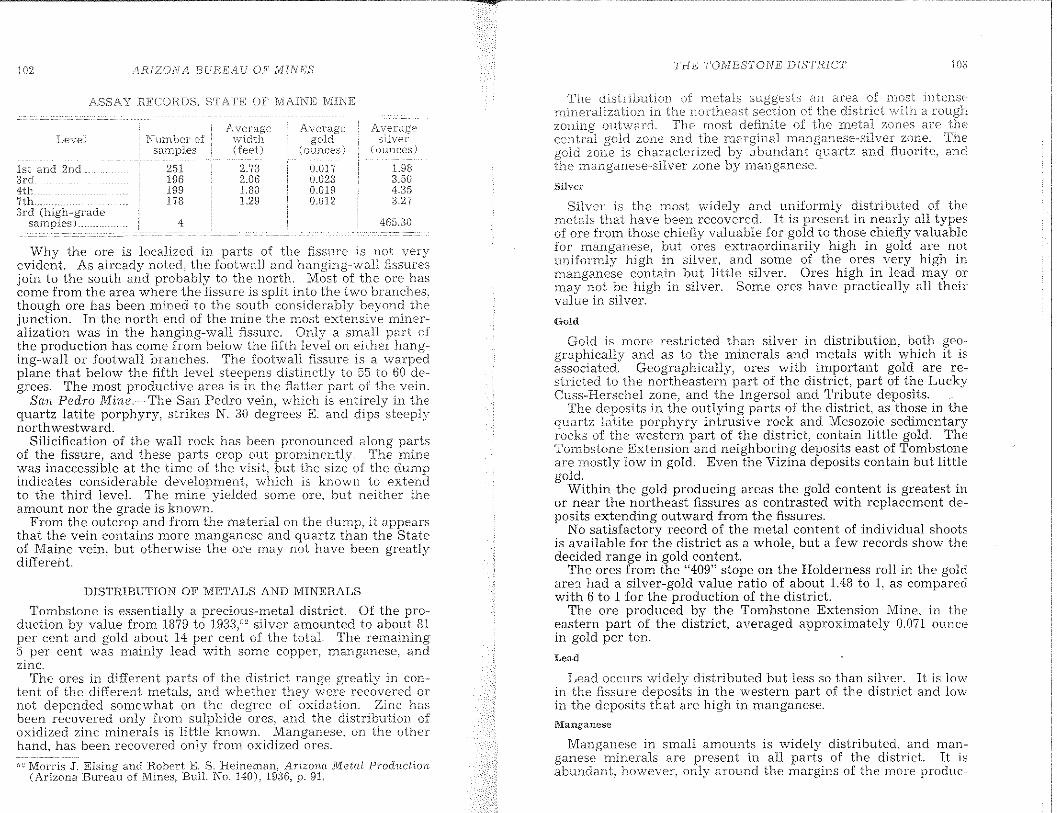
102 /lRIZOIVA BUREAU OFlyT]II/E'S T'H£ TOJvlBSTONE DISTRICT
DISTRIBUTION OF METALS AND MINERALS
Tombstone is essentially a precious-metal district. Of the productIon by value from 1879 to 19:33," silver amounted to about 8tper cent and gold about 14 per cent of the totaL The remaining5. per cent was mainly lead with some cappeL manganese, andZinc.
The ores in different parts of the district range greatly iu content of the dIfferent metals) and whether they were recovered ornot depended somewhat on the degree of oxidation. Zinc hasbeen recovered only from sulphide ores) and the distribution ofoxidized zinc minerals is 'little known. Manganese, on the otherhand, has been recovered only frOln oxidized ores.
;'i~ Morris .J . .Elsing and Robert E. S. Heineman, Arizona Meta/, Prodlwl:'ion(Arizona Bureau of Mines, Bull. No. 140), 1936, p. 91,
Why the ore is localized in parts of the fissure is not veryevident. As already noted) the footwall and hanging-wall fissure~sjoin to the south and probably to the north. Most of the are hascome from the area where the fissure is split into the two branches,though are has been mined to the south considerably beyond the]UnctlOn. In the north end of the mine the most extensive mineralization was in the hanging-wall fissure. Only a small part 01the production has come from below the fifth level on either hangmg-wall or footwall branches. The footwall fissure is a warpedplane that below the fifth level steepens distinctly to 55 to 60 degrees. The most productive area is in the flatter part of the vein.
San Pedro Mine~TheSan Pedro vein, which is entirely in thequartz latite porphyry, strikes N. :30 degrees K and dips steeplynorthwestward.
Silicification of the wall rock has been pronounced along partsof the fissure) and these parts crop out prominently. The minewas inaccessible at the time of the visit, but the size of the dumpmdIcates conSIderable development, which is known to extendto the third leveL The mine yielded some ore, but neither theamount nor the grade is known.
From the outcrop and from the material on the dump, it appearsthat the vein contains more manganese and quartz than the Stateof Maine vein) but otherwise the are Inay not have been greatly'different . .
l'.'Ianganese
Lead occurs widely distributed but less so than silveI'. It is lowin the fissure deposits in the western part of the district and lowin the deposits that are high in manganese.
Lead
Manganese in small amounts is widely distributed) and manganese minerals are present in all parts of the district It isabundant, however, only around the margins of the morE' produc-
The distribution of rnetals an area of rrlost intensemineralization in the northeast of the district '"vith a rou,ghzon-ing ouhvard. The rnost definite of the metaJ zones are thecentral gold zone and the marginal rnanganese-silver zone. Thegold zone is characterized by abundant quartz and fluorite, andthe manganese-silver zone by manganese.
Silvel<
Silver is the most widely and uniformly distributed of themetals that have heen recovered. It is present in nearly all typesof ore from those chiefly valuable for gold to those chiefly valuablefor lnanganese j but ores extraordinarily high in gold are notuniformly high in silver, and some of the ores very high inmanganese contain but little silver. Ores high in lead mayormay not be high in silver. Some ores have practically all theirvalue in silver.
Gold
Gol~ is more restricted th.an silver in distribution) both geographIcally and as to the mmerals and metals with which it isassociated. Geographically, ores with important gold are restricted to the northeastern part of the district, part of the LuckyCuss-Herschel zone, and the Ingersol and Tribute deposits.
The deposits in the outlying parts of the district, as those in thequartz latite porphyry intrusive rock and Mesozoic sedimentaryrocks of the western part of the district, contain little gold. TheTombstone Extension and neighboring deposits east of Tombstoneare mostly low in gold. Even the Vizina deposits contain but littlegold.
Within the gold producing areas the gold content is greatest inor near the northeast fissures as contrasted with replacement deposits extending outward from the fissures.
No satisfactory record of the metal content of individual shootsis available for the district as a whole, but a few records show thedecided range in gold content
The ores from the "409" stope on the Holderness roll in the goldare'.} had a silver-gold value ratio of about 1.48 to I, as comparedWIth 6 to 1 for the production of the district
The ore produced by the Tombstone Extension Mine, in theeastern part of the district, averaged approximately 0.071 ouncein gold per ton. .
L983.504.353.27
4G530
A\'eragesilveT;
(ounces)
0.017IUJ2;10.0190.012
(ounces)( (eet)
2.732.06L80L29
4
251196199178
ASSAY HECOBDS, STAT"E~ OF MAINE MINE
1st and 2nd;)rd4tl-:.7th.3rd (high-grade
samples) ..
liN /lP.IZON/l 1:3UHEAr' ()P" iViIiVE'/S' THE I'OIYIBST'ONE DIS'I'HICT 105
tivc In the rnines on theCuss aIret ore zmH0S and in Borne of the minesthe \vestern of: the district. His abundant inthe Vizin.a deposit Tn the area it in srnall a~l(~~:;"c\~\~largely in "black calcite, \\'11i.c11 is a mirwral and'supergene, at least in part.
Silver is present \vi.th rnuch of t.he rnanganes(', and aamount of silver-rnanganese ore has been ruined.
Copper
Copper is also vv'idel:/ distributed but in slna11 am.ounts, and itsdistribution is not \vell known. It seems to be Inost abundantin and near strong northeast fissures.
Copper carbonate stains in the fissures are gE:DE:ral1y regardedas good indications of are near by.
The Elnerald MinE,' probably contained the largest bod:' ofcopper are.
Zinc
The distribution of zinc is not well known.est body mined was in the Silver Thread area.
Molybdenum
Molybdenum occurs in the ores as wulfenite. the lead lllOlybdate. It is present over a considerable part of the district but ismoat abundant in the gold areas particularly of the Silver Threadroll. Like the gold it is most abundant in and near the northeastfissures, The wulfenite is, however, a secondary mineral notclosely associated with gold, and the material high in molybdenumis not generally high in gold. Wulfenite rather commonly occursaround or beneath an ore body, and although conspicuous, itnowhere forms n10re than a small percentage of the larger bodiesof ore.
Iron minerals
Iron minerals that have resulted from oxidation of iron sulphide are widely distributed. They are mainly hydrous ferricoxide that may be called limonite and basic ferric sulphates, memhers of the jarosite family. Although widely distributed, irondoes not form a large percentage of most of the ore. It has resulted mainly from the oxidation of pyrite and probably no largebodies of massive p:yrite were present in the primary ores.
Iron seems to be most abondant in and near the gold arca. Thesilver-manganese ore shoots and the fissure deposits in the westernpart of the district are low in iron.
Nonmctam(~minerals
Of the nonmetallic minerals, quartz and fluorite are of mostinterest.
Quartz is widespread but is most abundant in the gold areas.There are numerous types of occurrence) but two are particularly
a that has lalW".v rC]Jw.cCOand froTn verv size to as
mV.ch as 2 inches in that project frorn the"walls of cavities.Sili.cification of th{~ rock has extended for a considerable dis
tance frorn some of the fissures. The silicified material is largel:yquartz that in places contains dissenlinated
In process of silicification open vugs OT cavities werefm-mprl some of which are lined with layers of fine-grained quartz.From walls of the cavities project weE-formed quartz crystals.
Fluorite) like quartz) is rather widely distributed) and is mostabundant in the areas that are relatively rich in gold. It is nothowever, closely associated with gold or with other metals. Rocksrich in fluorite aTe generally not ore, It is mO-st closely associatedwith intense silicification where it forms a filling of silicifiedbreccia and seems to have fornled mainly during or after a latestage of the silicification.
FUTURE OF THE DISTRICT
In the discussion of the different deposits and areas in preceding pages, the extent to which they have been prospected has beenindicated where known. In the following paragraphs it is intended to point out some of the more general features to be considered in develonment
In the Tombstone district, as in many others that have beenextensively mined) several lines of development lllust be carriedout before its fun potentialities are tested. The results of someof them can to SOlne degree be predicted, whereas others can notyet be evaluated. They are discussed in what is regarded as theorder of their predictability.
Deposits in the eastern part of the district above water levelDeposits in the eastern part of the district below water levelDeposits in the western part of the district
DEPOSITS IN THE EASTERN PART OF THE DISTHICT ABOVE:WATER LEVEL
Deposits in the eastern part of the district include several typesthat may be considered separately, though two or more would beprospected together.
Deposits in northeast fissuresDeposits associated with faultsDeposits associated with dikesDeposits associated with rolls
Deposits in northeast fissures
Deposits in the northeast fissures are the simplest of the groupand except for some of the stronger fissures have perhaps been themost thoroughly prospected. It is not a simple matter, however,to determine from a few outcrops or a few openings what importance is to be assigned to a certain fissure.
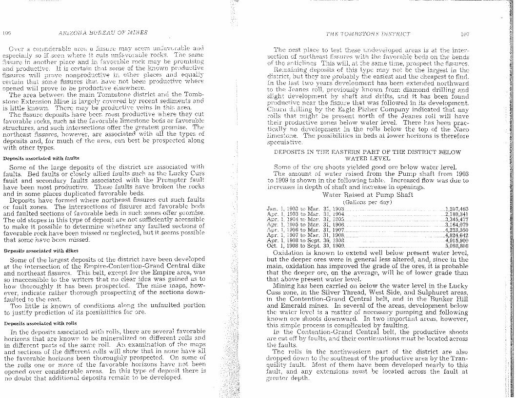
AJUZONA BUREAU OFlVHNES THE TO.MBSTONE DISTRICT 107
Ove1 a considerable area EJ. :fissure rnay seem unfavorable andso if seen where .it cuts l.mfavorable rocks. The San1{'
fissure in another place and in ,favorable rock may beand producti·ve. It is certain that sorne of the known productivE'fissures '''lill prO"ve nonproductive in other places andcertain that some fissures that have not been productive whereopened will prove to be productive elsc\vhere.
The area between the Hlain Tornbstone district and the Tombstone Extension Mine is largely covered by recent sediulents andis little known. There may be productive veins in this area.
The fissure deposits have been most productive whel'e they cutfavorable rocks, such as the :favorable Hmestone beds or favorablestructures, and such intersections offer the greatest promise, ThE'northeast "fissures l however, are associated with all the types ofdeposits and, for much of the area, can best be prospected alongwith other types.
Deposits associated with faults
Some of the large deposits of the district are associated withfaults. Bed faults or closely allied faults such as the Lucky Cussfault and secondary faults associated with the Prompter faulthave been most productive. These faults have brokeu the rocksand in some places duplicated favorable beds.
Deposits have formed where northeast fissures cut such faultsor fault zones. The intersections of fissures and favorable b(~ds
and faulted sections of favorable beds in such zones offer promise.The old stopes in this type of deposit are not wftlciently accessibleto make it possible to determine whether any faulted sectIOns offavorable rock have been missed or neglected, but it seems possiblethat some have been missed.
Oc}Wsits assodated with dikes
Some of the largest deposits of the district have been developedat the intersection of the Empire-Contention-Grand Central dikeand northeast fissures. This belt. except for the Empire area, wasso inaccessible to the writers that no clear idea was gained as tohow thorouahlv it has been prospected. The mine maps, however, indicate l~ather thorough prospecting of the sections downfaulted to the east.
Too little is known 01 conditions along the unfaulted portionto justify prediction of its possibilities for ore.
Hcposits associated with rolls
In the deposits associated with rolls) there are several favorable:horizons that are known to be mineralized on different rolls andin different parts of the Salne roll. An examination of the mapsand sections of the different rolls will show that in none have allthe favorable horizons been thoroughly prospected. On some ofthe rolls one or more of the favorable horizons have not beenopened over considerable areas. In this type of deposit there isno doubt that additional deposits remain to be developed.
The best to test these areas is at the inter-section of northeast flssures \vith thE' favorable beds on the bendsof the anticlines. This wilt at the san-ie time, prospect the fissures.
Remaining deposits of this type may not be the largest in thedistrict, but they a.re probably the easiest and the cheapest to find.In the last hOlo years development has been extended northwardto the Jcanes roll, previously known from diamond drilling andslight development by shaft and drifts, and it has been foundproductive near the fissure that was followed in its development.Churn dritling by the Eagle Picher Company indicated that anyrolls that might be present north of the Jeanes roll will havetheir productive zones below water level. There has been practically no development in the rolls below the top of the Nacolimestone. The possibilities in beds at lower horizons is thereforespeculative.
DEPOSITS IN THE EASTEHN PAIn OF THE DiSTRICT BELOWWATEH LEYEL
Some of the orc shoots yielded good ore below water leveLThe amount of water raised from the Pump shaft from 1903
to 1909 is shown in the following table. Increased flow was due toincreases in depth of shaft and increase in openings.
Water Raised at Pump Shaft(Gallons per day)
Jan. L t903 10 Mar. 31, U1031.207,465Apr. 1, 1903 to Mar. 31, 19042,180,341Apr. 1, UJ04 to Mar. 31, 19053,345,477Apr. 1, 1905 to Mar. 31, t906 ...3,164,079Apr. L 1906 to Mar. 3t, 19074,223,550Apr. I, 1907 to Mar. 31, 1908. ..4,824,642Apr. t, t908 to Sept. 30, 19084,915.900Oct I, 1908 to Sept. 30, 1909.5,008,808
Oxidation is known to extend well below present water level,but the deeper ores were in general less altered, and, since in themain, oxidation has improved the grade of the ores, it is probablethat the deeper ore, on the average, will be of lower grade thanthat above present water level
Mining has been carried on below the water level in the LuckyCuss zone, in the Silver Thread, West Side, and Sulphuret areas,in the Contention-Grand Central belt, and in the Bunker Hilland Emerald mines. In several of the areas, development belowthe water level is a matter of necessary pumping and followingknown ore shoots downward. In two important areas, however,this simpte process is complicated by faulting.
In the Contention-Grand Central belt, the productive shootsare cut off by faults 1 and their continuations must be located acrossthe faults.
The rolls in the northwestern part of the district are alsodropped down to the southeast of the productive area by the Tranquility fault. Most of them have been developed nearly to thisfanlt, and any extensions must be located across the fault atgreater depth.

108 /lRI20NA. BUREA,U OF'MIN,E:S
c
,12605361487474GO64635299:596059
6158735555595354
646594884364627412DB185493954442551541716455404023
107,17
,,93, 94, 95,
B
INDEX
A
fissure
Barite...Beaverite.Bedding faults.... .....33, 76, 82,Benson-,-Albert are body .B;:'nson, S1?clting and Refining WorksBmdhelmlte..Biotite..Black EagleBlake, Wm.Blue Monday fissureBonanza Mine..Bornite..Boss dike.. 27Boss terrace.. .. ._. ,........................84,Boston and Arizona milL .Boston and Arizona Smelting and Reduction Co..Bournonite _ , , ..Bowles, ";ICit:;~ .Boyer, CBrady stope.._..Brochantite..Bromyrite_.Brunckow, FrederickBrunckow Mine..Bryan, Kirk..Bunker Hill Mine.. ....45, 47, 83,Bunker Hill Mines Co.
Fissure deposits in the J\rlesozoic sedimentary rocks and in thequartz latite porphyry in the westero part of the district have notbeen largely productive bul are of some prospective i.nterest Someof the veins are persistent and strong, and contain enough metal)mainly silver) to have encouraged considerable development andluining.
The quartz latite porphyry, in part at least) appears to be insill-like bodies intruded into the .Mesozoic rocks. So far as isknown, no fissure in the latite or in the I'v'1esozic sedilnentaryrocks has been followed downward to the Paleozoic rocks orthrough the main ore zone of the eastern part of the district, Theposition of: the Paleozoic rocks in m.ost of the western part of thedistrict is not known, Whether the basal portion of the Mesozoicrocks and the top of the Paleozoic rocks may be mineralized, asin the eastern part, remains to be determined.
The water table has been reached in SOlne of the shafts) anddeeper exploration other than by drilling would necessitatepumping, Water io this part of tbe district, however, is en"countered at higher levels tban at Tombstone and apparently atdifferent levels in different openings, This suggests that localwater tables have been struck rather than the general watertable of the region,
DEPOSITS IN THE WESTERN PAH,T OF THE DISTRICT
the \vater to the tenth level in the sha.l't is saidto h:.:::t\"C J.o);vered the v/ate:r level over a \vide the district.This fact indicates that at one\vi11 drain a large area) but is not true that the SaineresuJt would be secured everywhere in the an~a. The \vatercould be lowered and held for short in Son1f.'localities without draining L:.{rge 7 areas. Itshould be recognized mining is to be continued forperiods below the present water levPl, draining of the area todepth of development will be necessary, Ore extraction belowthe \;vat2r lev(,:l) to be profitable, rnust be on a scale cornInensurate witb the cost ot pumping,
The elevation of the San Pedro VaHey at Fairbank, 3,859 feet.is approximately 260 feet lower than the water level at Tombstnnt::, 4,120 £(-:,et. As that is the lowest point in the area, it is notpossible to drain the area to any considerable depth by tunnel.It must further be recognized that the water level at TombstonelS not very different from that in the adjacent sediment-fiHedvalleys, If the level is lowered in the district, there may be someseepage into tbe area from the adjacent valleys,
109
111
PAC;;
41, 4(;:52[]
82809:14443
89. 92,n4117
]039J
toG:'IJ. 37. gCJ
42, 4841, 43, 45, 71, 107
41, 4°"40. 41
GO456"0
4484J14456HI4896
11, 184G, 48, 78. lIl:J
5457
L 1961
11, :1886, 81l, 9S. lO~-)
34, Gr--:GO59
'J26J
91, 96fin. 10.,9G. 99
77104
6511
]0737
H
G
I
INDEX
Gilluly,GirardGirardGirard Mine.GirardGirdGird, Richard K.
G.
E, E.
Haley, JohnHardup syncline..Basself!'ren. Harry..Head Center Mine_.Hematite ..HemimoruhiteI-lendrickson, Harry.Herald fissure.Hernon, RobLHerschel MineHessite_.Hetaerolite..Hi.gdon, C. E.HilllO'brandite..Holderness, Ed..Holderness roll.."Hoodoo cracks"Hurnblende...Hydrozincite ..
Goodenough roll..Grand Central dike ..Grand Central fault.Grand Central mill..Grand Central Mine..Grand Central Mining Co..Graveyard claim ..... __ .__ .Grossularite ..Ground Hog MineGypsum
Giacoma brothers.John..
IngersolT±1gersoJ Mine._Ingersol o'·erturn....IntervenerIt'on..
JarositeJeanes, E. P ...JeanesJoe workings, faults
119963
46, 4760714g
33, H2(t3
1, 94, 10778, ~n
0571, 107
4266
.. 84, 8G, 89. U827. 8B, 39
t; 17atiS
5474. 98
36{B
7, 48. LOU554242~15
103, 10411
T',\(;l'
7. 12, 124592G2f:i260
lO. J2, HJ617:,648;,44
27, lOt);36,J:j
.. 41, 4:3, 44, 45, 10752, JOc]
41en/1\
D
INDEX
w.
Eagle Picher Lead CO'ffiIJar\y.East Side fissure ...Embolite.Emerald Mine..Emery CityEmmonsite_ ..Empire anticline..Empire dike...Epidote._Escondido Mine...Ettringite
d'Autremont. C. 1VLDefence Ils:'m.'e ..Desc1oizite __ .__ _._ _. __ .--.Deve10nment Company of America..Diopside...Dipper shafL.Douglas, Lewis..Drag folds._ ..Dry Hill Mine...
F
FairbankFamatinite..Farrish, T. E.Filkins,FisherFluorite.Fo\vler, George M ..
110
ChinoChlorite.Chrysocolla_.ChrysoliteChurch, J. AClinozoisite.Comet Mine.Connellite.ContactContentionContentionContentionContention n'~.L .Contention Mine..Copper
Corbin, ~1;ll"K.........•••.•••.•........~.Corbin 1Corbin and IVllmngCovellite._..Coyote fault.Cuprite....C uprodescloizite ..
112 INDEXINDEX 113
481068258
1073654576a
207479334491235840234859
...51,72
101989746
7415847536322
48, 100, 101804253619392
10794
PAGE
100103
4173
10240
.. .... 38, 40, 4111
Q
s
R
Gov. A. P. K ..
RandolphRansome,Hat Hole oreRattlesnakeHattJesnakeHed-stope r:.c'"L.,... .
J.
PrompterPromnterPsilon1e1ane __Pump
SiIver ThreadSilver ThreadSkip-shaft fissure __Slime Tailings Co..Smith, H. V.Smith,
6214a611
35la, 29
99103
5713
20, 7580, 103
106, 10780, 98
2H_'11, 18
799798575913
103573243
59104100
616362
9755
1846
46, 48, 78236056
.42, 47, 8259
47, 48, 1018360596557
o
p
N
M
L
in
North Point fissureNugent, R L.
McCann are shootsMacia, J. H.Macia rolLMagnetite ..Malachite. __ .Mamie MineManganeseManganite._Massay-Williams ore bodyMellgren Mine ... _Merrimac Mine._1\fichigan Central dikeMicroc1ine.MolybdenumMontezuma MineMonticelliteMottramite.Muscovite
LaccolithicLaramideLast ChanceLead._Limonite..Lindgren,Luck Sure tiIIL .....Luck SureLucky CussLucky Cuss Iyl.me.. ,..ccLucky CussLyden, Joseph
Phelps Dodge CorporationPierotL John.PigeonitePlagioclase g.-TOUp __PlumbojarositePolianiie
O'DonnelLOld Glory MiningOld Guard Mine_Old Guard Mine. dike inOlivineOpaLOregon Minc._,.Orthoclase._
Knopf. r:~'~:;~'!lKohlen.
INDEX
1\;line
T
Mine
TombstoneTombstone ;5~~~'1~:~~,~~~ CompanyTmnbstoneTombstone .E"tcnsio!,. X,,""';;' """:~"~"b~t~:;~Mi1l and COh:~ Mining Company_Toughnut IVl::Hl.Toughnut WH...
Tranquility-ContentionTranquility Mine__Tremolite..Tribute dike._Tribute fissureTribute Mine.
Pi\GE
B4, !13,
U
United States Smelting, Refining, and M.ining Company
V
stopes __
w
zZinc._ZirconZoisite

![J. - AZGS Document Repositoryrepository.azgs.az.gov/sites/default/files/dlio/files/... · 2010-08-24 · n LJ Late Tertiary basin-fill r_51~]' Middle Proterozoic granite (Yg) deposits](https://img.pdfslide.net/doc/110x75/5f082d977e708231d420ba32/j-azgs-document-2010-08-24-n-lj-late-tertiary-basin-fill-r51-middle-proterozoic.jpg)