Embed Size (px)
Citation preview

Local Centre Monitor
Position in January 2015
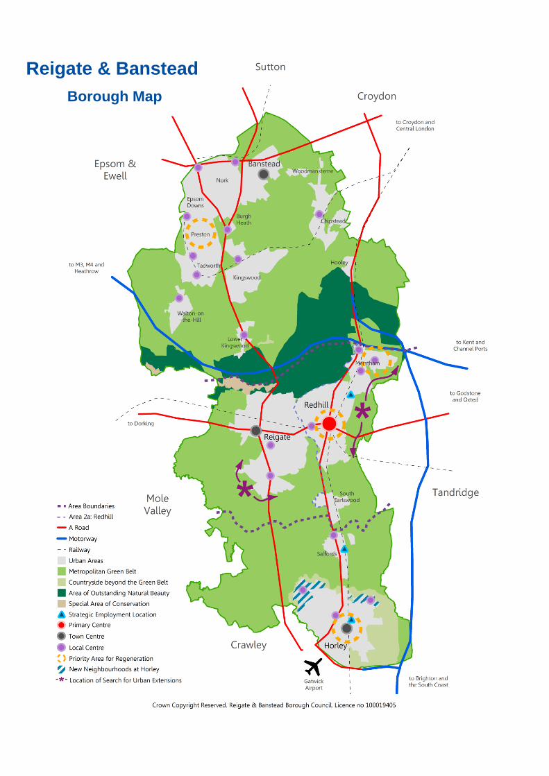
Reigate & Banstead
Borough Map
Local Centre Monitor January 2015
Contents Introduction ............................................................................................................................................ 1
Future Policy Developments ................................................................................................................ 1
Relevant Local Policies and Indicators ............................................................................................... 1
Key Messages ......................................................................................................................................... 2
Borough Key Messages ...................................................................................................................... 2
Local Centres Overview ........................................................................................................................ 3
Use Classes ......................................................................................................................................... 3
Use Class Trends ................................................................................................................................ 5
Vacancies & New Occupiers ............................................................................................................... 6
Burgh Heath ............................................................................................................................................ 8
Drift Bridge ............................................................................................................................................ 10
Lower Kingswood ................................................................................................................................ 12
Nork Way ............................................................................................................................................... 14
Kingswood Waterhouse Lane ............................................................................................................ 16
Shelvers Way ........................................................................................................................................ 18
Chipstead Station Approach ............................................................................................................... 20
Tadworth ............................................................................................................................................... 22
Tattenham Corner ................................................................................................................................ 24
Walton-on-the-Hill ................................................................................................................................ 26
Lesbourne Road ................................................................................................................................... 28
Woodhatch ............................................................................................................................................ 30
Linkfield Corner .................................................................................................................................... 32
Merstham Village .................................................................................................................................. 34
Nutfield Road ........................................................................................................................................ 36
Portland Drive ....................................................................................................................................... 37
Salfords Brighton Road ....................................................................................................................... 40
Horley Brighton Road .......................................................................................................................... 42
Appendix ............................................................................................................................................... 44
Please Note:
The information contained within this monitor is a record of the observed uses and occupiers within the designated local
centres in Reigate & Banstead as at January 2015 It does not constitute a record of the Lawful Uses of each property
under Sections 191 and 192 of the Town and Country Planning Act 1990 (as amended). For further information on lawful
uses, please contact Building & Development Services.
While every care has been taken to ensure that the information and analysis is accurate, the Council accepts no
responsibility for any loss resulting from errors or omissions. The Council welcomes comments and suggestions that
would make the monitoring information more accessible and useful.

1
Introduction The borough’s local centres are designated clusters and small parades of shops, services, community
facilities which valuably serve nearby neighbourhoods and residents. The purpose of monitoring local
centres is to:
Analyse use trends within the local centres and assess the on-going viability and vitality of service
provision within these areas, with particular regard to convenience offer;
Monitor local policies contained within the Borough Local Plan, namely policies Sh1, Sh10, Sh11 &
Sh12. Along with the council’s emerging Core Strategy, in particular polices CS5 & CS6 to ensure
at least 95% of new retail is located within local and town centres across the borough; and
Provide a regularly updated base data to assist in decision-making on planning applications within
the local shopping centres.
The analysis predominantly focusses on the ‘main frontage’ in each of the local centres; however, in many
cases there are additional, complementary uses within the designated boundary of the local centre. Full
schedules of occupiers are available by contacting the LDF Team on 01737 276178 or by emailing
Future Policy Developments
The Borough Local Plan 2005, including its saved policies, is in the process of being replaced by new
local planning documents. The Council had its Core Strategy hearing in May 2013, the Council made
some further modifications and further consultation was carried out between July and August 2013. The
Inspector requested a further hearing session on 10th December 2013 to address responses to the further
modifications. The Council expects to receive the Inspectors report at the end of January 2014.
The emerging Core Strategy recognises the important role which local shopping areas plan in providing
accessible services to the surrounding community. Specific policies relating to the management of
development within local centres will be contained within the emerging Development Management & Site
Allocations DPD; however, in the interim, this monitor will continue to assess performance against saved
policies Sh1, Sh10, Sh11 & Sh12.
Relevant Local Policies and Indicators
Policy Monitoring Target
Sh1 Improve shopping provision within Local Shopping Areas and resist the
loss of existing or proposed retail floorspace
Sh10 Generally permit proposals for redevelopment, extension or change of use
to Class A1 retail within Local Shopping Areas subject to certain criteria
Sh11 Retain A1 retail floorspace in Local Shopping Areas
Sh12 Generally resist proposals for change of use to, or development of, sale of
food and drink uses, including hot food take-away shops
The guidance and the policies are available under Planning Policies on the Council’s web site:
http://www.reigate-banstead.gov.uk/planning
2
Key Messages The emerging Core Strategy recognises the valuable role played by local shopping areas in the provision
of accessible services and convenience retail for nearby communities. The National Planning Policy
(NPPF) includes district and local centres both of which constitute town centres. “Positive planning for
local shops, services and community facilities, etc. will help to enhance the sustainability of communities
and residential environments. Whilst also ensuring established shops, facilities and services can develop
and modernise in a way that is sustainable and retained for the benefit of the community.” However, local
shopping areas are increasingly facing competition from town centres, out of town superstores and
increased internet shopping and as such, maintaining the quality of offer and environment in these areas
is essential.
The emerging Development Management Policies DPD will contain specific policies relating to the
management of development within local centres and will also propose changes to the boundaries of
these areas where considered necessary to support their on-going viability and vitality.
Since 2013 there has been the introduction of a number of temporary permitted development rights which
may affect the composition of the local centres. In 2013 a temporary permitted development right came
into effect which allowed a temporary change of use for high street and other business premises with A1,
A2, A3, A4, A5,, B1, D1 and D2 uses for a period of up to two years to A1, A2, A3 and B1uses. In 2014 a
temporary permitted development right came into effect which allowed a change of use from A1 and A2 to
C3.
Borough Key Messages
Vitality: For the third consecutive year A1 remains the predominant use class within the borough’s
local shopping areas, accounting for 54% of all premises. In total, A1-A5 uses accounts for 81% of
the total units within the centre. The number of A1 retail units has increased slightly form 211 to
215 since the last monitor. A3-A5 food & drink retail uses occupy 16% of all units, an increase from
11% in 2000.
Convenience Provision: There are a total of 67 units (17%) providing a convenience offer across
the borough’s eighteen local shopping centres. However, there is significant variance across the
centres with Tadworth having the highest convenience offer of around 27% and Walton-on-the-Hill
having the lowest 9%. Service provision remains the most predominant offer found within all the
borough’s local centres, accounting for 32% of all units.
Vacancy Rate: There are currently 24 vacant units across all of the borough’s local centres,
equivalent to a vacancy rate of 6%. This is a decrease from 34 vacant units last year. Once again
the vacancy rate across each individual centre varies considerably, with Drift Bridge, Nork Way,
Merstham Village, Tattenham Corner, Waterhouse Lane and Woodhatch all having no vacancies.
Whilst Chipstead Station Approach currently has 18% of its units standing vacant, however these
are located the derelict old station building which has been vacant for a number of years.
New Occupiers: A total of twenty six new occupiers moved into the borough’s local shopping
areas over the past year.
Floorspace: Since the last monitor was produced there has been a decline of vacant floorspace
by 255 sqm: 720 sqm of previously vacant floorspace has been occupied and 465 sqm of occupied
floorspace has become newly vacant. Salfords Brighton Road has the largest decline of vacant
floorspace and Tadworth the largest increase.
3
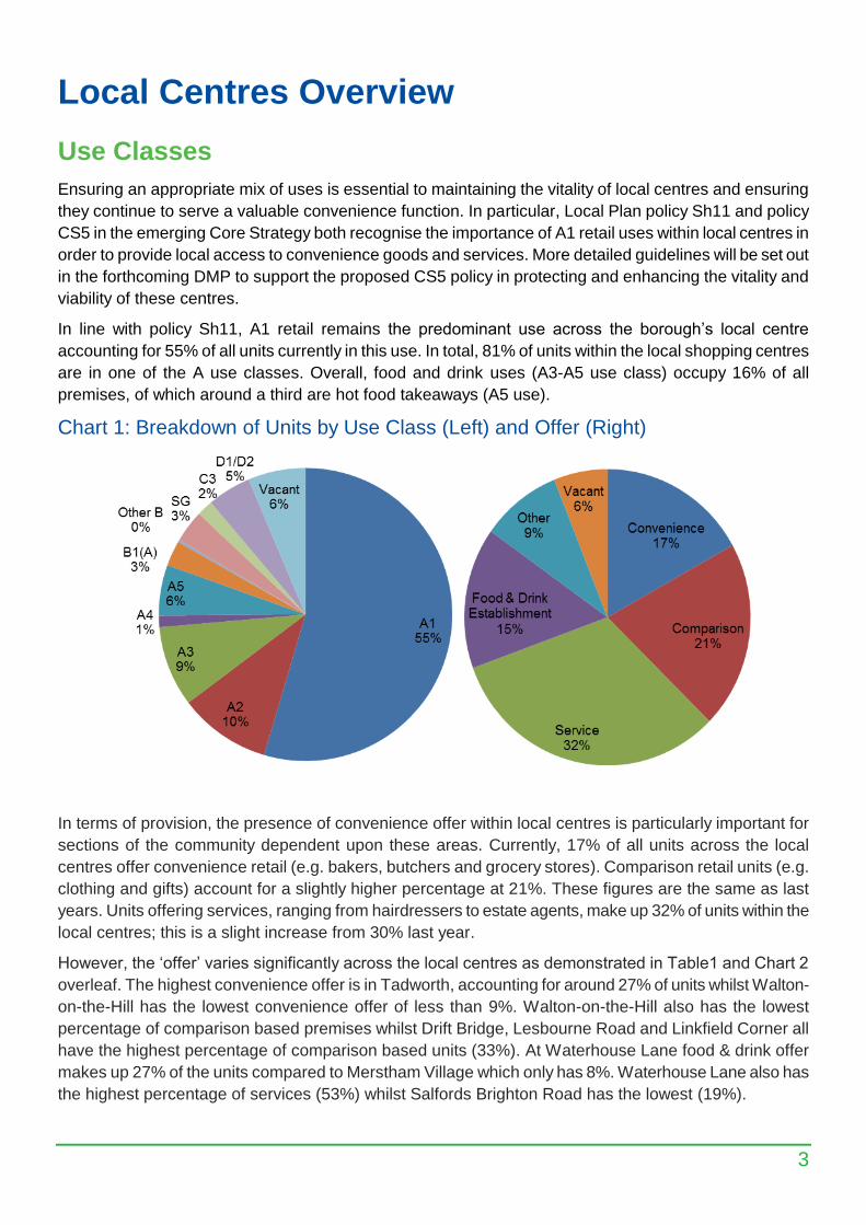
Local Centres Overview
Use Classes
Ensuring an appropriate mix of uses is essential to maintaining the vitality of local centres and ensuring
they continue to serve a valuable convenience function. In particular, Local Plan policy Sh11 and policy
CS5 in the emerging Core Strategy both recognise the importance of A1 retail uses within local centres in
order to provide local access to convenience goods and services. More detailed guidelines will be set out
in the forthcoming DMP to support the proposed CS5 policy in protecting and enhancing the vitality and
viability of these centres.
In line with policy Sh11, A1 retail remains the predominant use across the borough’s local centre
accounting for 55% of all units currently in this use. In total, 81% of units within the local shopping centres
are in one of the A use classes. Overall, food and drink uses (A3-A5 use class) occupy 16% of all
premises, of which around a third are hot food takeaways (A5 use).
Chart 1: Breakdown of Units by Use Class (Left) and Offer (Right)
In terms of provision, the presence of convenience offer within local centres is particularly important for
sections of the community dependent upon these areas. Currently, 17% of all units across the local
centres offer convenience retail (e.g. bakers, butchers and grocery stores). Comparison retail units (e.g.
clothing and gifts) account for a slightly higher percentage at 21%. These figures are the same as last
years. Units offering services, ranging from hairdressers to estate agents, make up 32% of units within the
local centres; this is a slight increase from 30% last year.
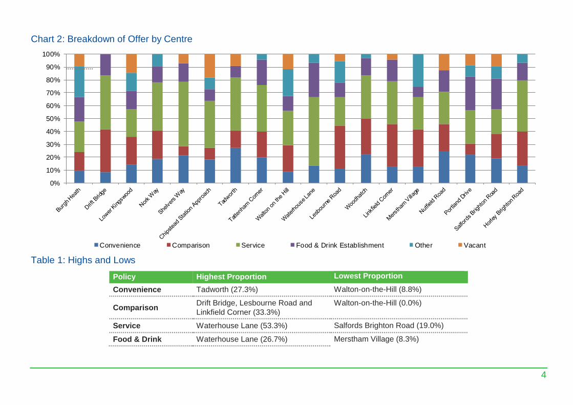
However, the ‘offer’ varies significantly across the local centres as demonstrated in Table1 and Chart 2
overleaf. The highest convenience offer is in Tadworth, accounting for around 27% of units whilst Walton-
on-the-Hill has the lowest convenience offer of less than 9%. Walton-on-the-Hill also has the lowest
percentage of comparison based premises whilst Drift Bridge, Lesbourne Road and Linkfield Corner all
have the highest percentage of comparison based units (33%). At Waterhouse Lane food & drink offer
makes up 27% of the units compared to Merstham Village which only has 8%. Waterhouse Lane also has
the highest percentage of services (53%) whilst Salfords Brighton Road has the lowest (19%).
4
Chart 2: Breakdown of Offer by Centre
0%
10%
20%
30%
40%
50%
60%
70%
80%
90%
100%
Convenience Comparison Service Food & Drink Establishment Other Vacant
Table 1: Highs and Lows
Policy Highest Proportion Lowest Proportion
Convenience Tadworth (27.3%) Walton-on-the-Hill (8.8%)
Comparison Drift Bridge, Lesbourne Road and
Linkfield Corner (33.3%)
Walton-on-the-Hill (0.0%)
Service Waterhouse Lane (53.3%) Salfords Brighton Road (19.0%)
Food & Drink Waterhouse Lane (26.7%) Merstham Village (8.3%)
5
Use Class Trends
Local retailing continues to come under sustained pressure for a number of reasons. Changes in
consumer behaviour, a recent influx in internet shopping and competition from other shopping formats all
continue to challenge the viability of neighbourhood shopping. However, for some, local centres remain an
important source of accessible shopping and services and Local Plan policy Sh11 and emerging CS5
policy (Core Strategy) both recognise the importance of protecting retail functions and resisting the undue
loss of shops.
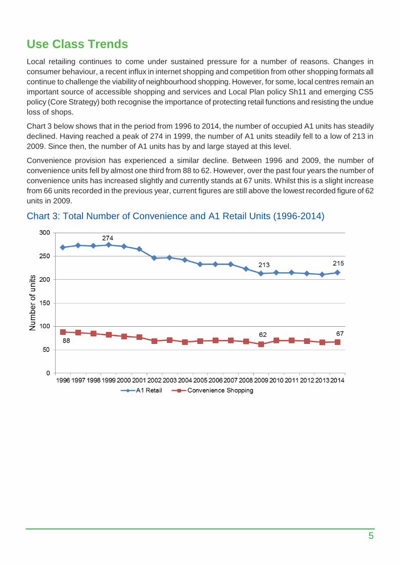
Chart 3 below shows that in the period from 1996 to 2014, the number of occupied A1 units has steadily
declined. Having reached a peak of 274 in 1999, the number of A1 units steadily fell to a low of 213 in
2009. Since then, the number of A1 units has by and large stayed at this level.
Convenience provision has experienced a similar decline. Between 1996 and 2009, the number of
convenience units fell by almost one third from 88 to 62. However, over the past four years the number of
convenience units has increased slightly and currently stands at 67 units. Whilst this is a slight increase
from 66 units recorded in the previous year, current figures are still above the lowest recorded figure of 62
units in 2009.
Chart 3: Total Number of Convenience and A1 Retail Units (1996-2014)
6
Vacancies & New Occupiers
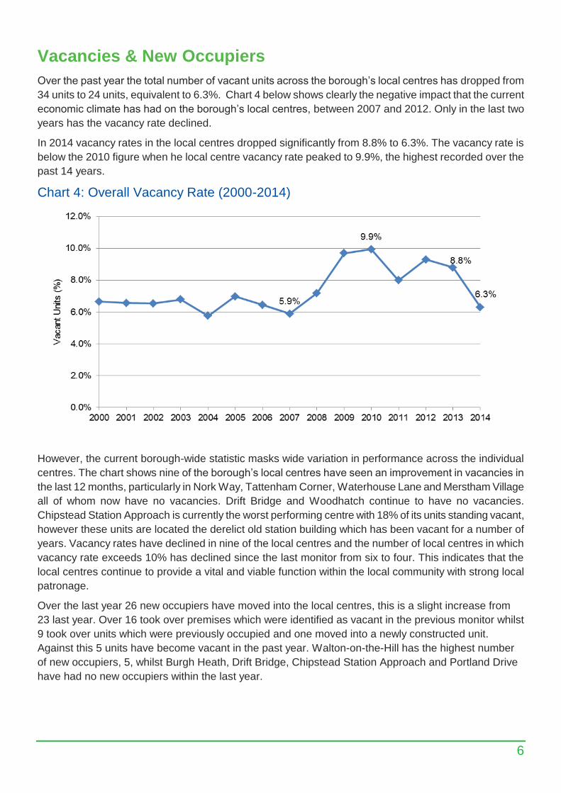
Over the past year the total number of vacant units across the borough’s local centres has dropped from
34 units to 24 units, equivalent to 6.3%. Chart 4 below shows clearly the negative impact that the current
economic climate has had on the borough’s local centres, between 2007 and 2012. Only in the last two
years has the vacancy rate declined.
In 2014 vacancy rates in the local centres dropped significantly from 8.8% to 6.3%. The vacancy rate is
below the 2010 figure when he local centre vacancy rate peaked to 9.9%, the highest recorded over the
past 14 years.
Chart 4: Overall Vacancy Rate (2000-2014)
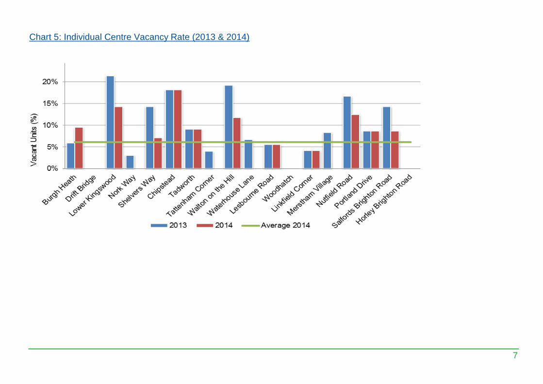
However, the current borough-wide statistic masks wide variation in performance across the individual
centres. The chart shows nine of the borough’s local centres have seen an improvement in vacancies in
the last 12 months, particularly in Nork Way, Tattenham Corner, Waterhouse Lane and Merstham Village
all of whom now have no vacancies. Drift Bridge and Woodhatch continue to have no vacancies.
Chipstead Station Approach is currently the worst performing centre with 18% of its units standing vacant,
however these units are located the derelict old station building which has been vacant for a number of
years. Vacancy rates have declined in nine of the local centres and the number of local centres in which
vacancy rate exceeds 10% has declined since the last monitor from six to four. This indicates that the
local centres continue to provide a vital and viable function within the local community with strong local
patronage.
Over the last year 26 new occupiers have moved into the local centres, this is a slight increase from
23 last year. Over 16 took over premises which were identified as vacant in the previous monitor whilst
9 took over units which were previously occupied and one moved into a newly constructed unit.
Against this 5 units have become vacant in the past year. Walton-on-the-Hill has the highest number
of new occupiers, 5, whilst Burgh Heath, Drift Bridge, Chipstead Station Approach and Portland Drive
have had no new occupiers within the last year.
7
Chart 5: Individual Centre Vacancy Rate (2013 & 2014)
8
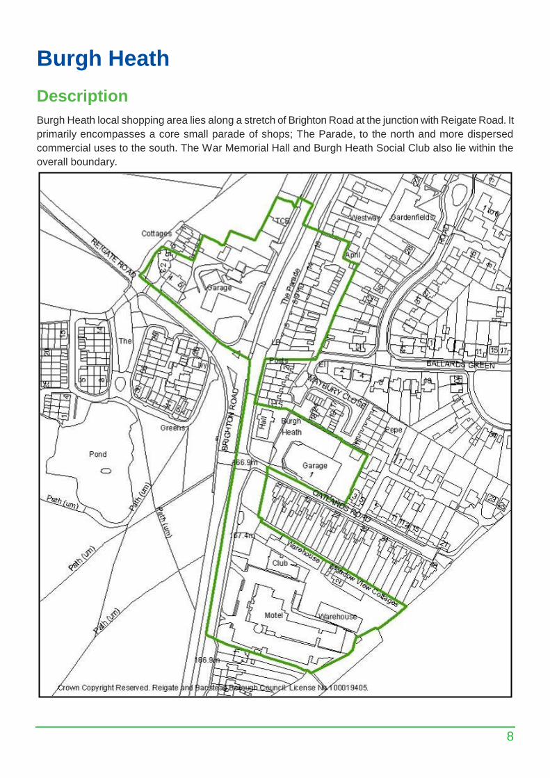
Burgh Heath
Description
Burgh Heath local shopping area lies along a stretch of Brighton Road at the junction with Reigate Road. It
primarily encompasses a core small parade of shops; The Parade, to the north and more dispersed
commercial uses to the south. The War Memorial Hall and Burgh Heath Social Club also lie within the
overall boundary.
9
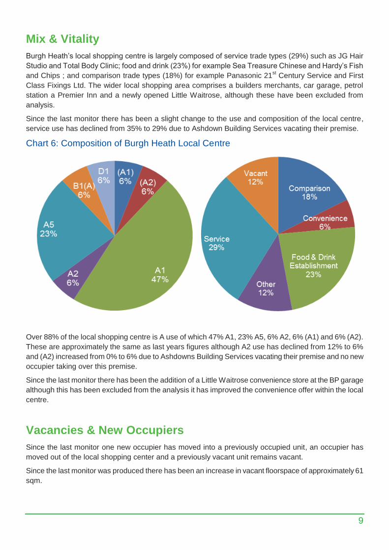
Mix & Vitality
Burgh Heath’s local shopping centre is largely composed of service trade types (29%) such as JG Hair
Studio and Total Body Clinic; food and drink (23%) for example Sea Treasure Chinese and Hardy’s Fish
and Chips ; and comparison trade types (18%) for example Panasonic 21st Century Service and First
Class Fixings Ltd. The wider local shopping area comprises a builders merchants, car garage, petrol
station a Premier Inn and a newly opened Little Waitrose, although these have been excluded from
analysis.
Since the last monitor there has been a slight change to the use and composition of the local centre,
service use has declined from 35% to 29% due to Ashdown Building Services vacating their premise.
Chart 6: Composition of Burgh Heath Local Centre
Over 88% of the local shopping centre is A use of which 47% A1, 23% A5, 6% A2, 6% (A1) and 6% (A2).
These are approximately the same as last years figures although A2 use has declined from 12% to 6%
and (A2) increased from 0% to 6% due to Ashdowns Building Services vacating their premise and no new
occupier taking over this premise.
Since the last monitor there has been the addition of a Little Waitrose convenience store at the BP garage
although this has been excluded from the analysis it has improved the convenience offer within the local
centre.
Vacancies & New Occupiers
Since the last monitor one new occupier has moved into a previously occupied unit, an occupier has
moved out of the local shopping center and a previously vacant unit remains vacant.
Since the last monitor was produced there has been an increase in vacant floorspace of approximately 61
sqm.
10
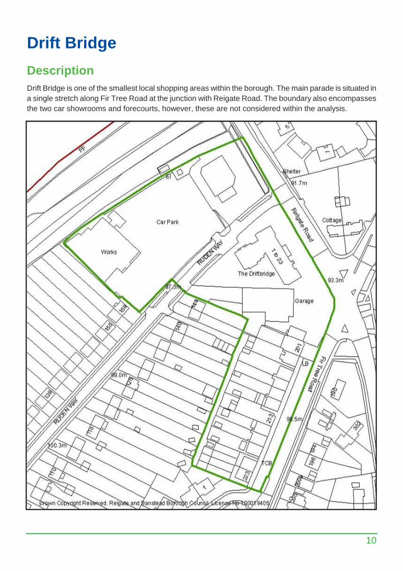
Drift Bridge
Description
Drift Bridge is one of the smallest local shopping areas within the borough. The main parade is situated in
a single stretch along Fir Tree Road at the junction with Reigate Road. The boundary also encompasses
the two car showrooms and forecourts, however, these are not considered within the analysis.
11
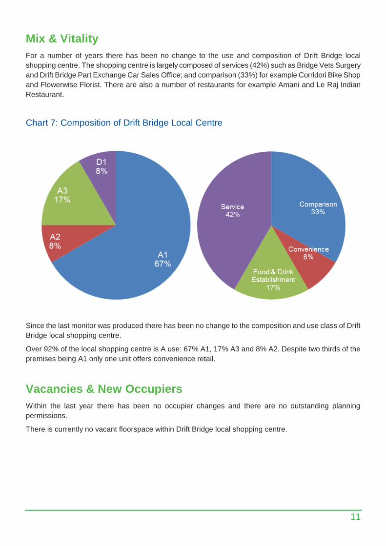
Mix & Vitality
For a number of years there has been no change to the use and composition of Drift Bridge local
shopping centre. The shopping centre is largely composed of services (42%) such as Bridge Vets Surgery
and Drift Bridge Part Exchange Car Sales Office; and comparison (33%) for example Corridori Bike Shop
and Flowerwise Florist. There are also a number of restaurants for example Amani and Le Raj Indian
Restaurant.
Chart 7: Composition of Drift Bridge Local Centre
Since the last monitor was produced there has been no change to the composition and use class of Drift
Bridge local shopping centre.
Over 92% of the local shopping centre is A use: 67% A1, 17% A3 and 8% A2. Despite two thirds of the
premises being A1 only one unit offers convenience retail.
Vacancies & New Occupiers
Within the last year there has been no occupier changes and there are no outstanding planning
permissions.
There is currently no vacant floorspace within Drift Bridge local shopping centre.
12
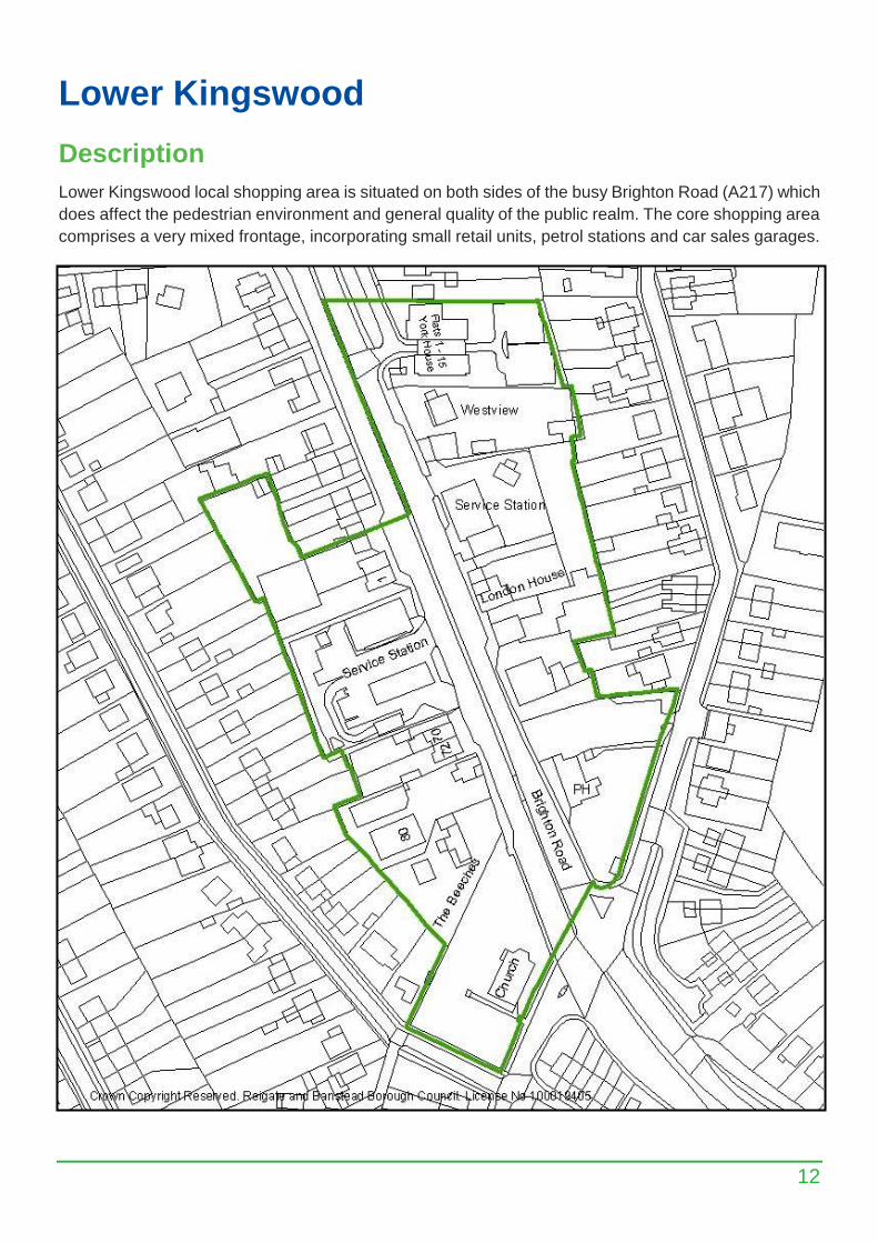
Lower Kingswood
Description
Lower Kingswood local shopping area is situated on both sides of the busy Brighton Road (A217) which
does affect the pedestrian environment and general quality of the public realm. The core shopping area
comprises a very mixed frontage, incorporating small retail units, petrol stations and car sales garages.
13
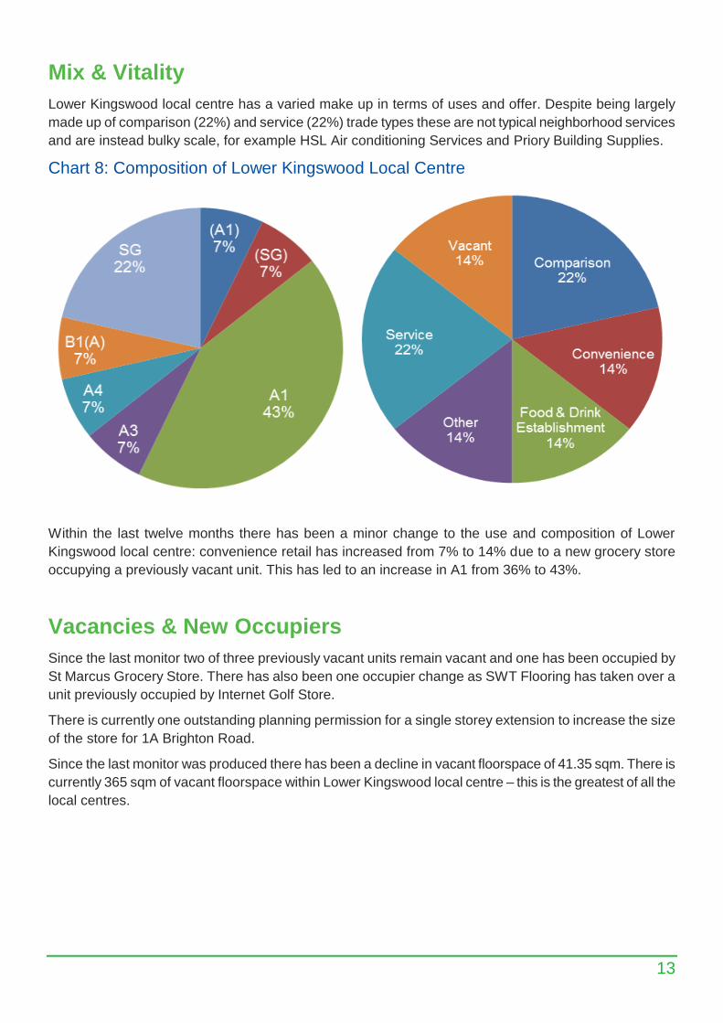
Mix & Vitality
Lower Kingswood local centre has a varied make up in terms of uses and offer. Despite being largely
made up of comparison (22%) and service (22%) trade types these are not typical neighborhood services
and are instead bulky scale, for example HSL Air conditioning Services and Priory Building Supplies.
Chart 8: Composition of Lower Kingswood Local Centre
Within the last twelve months there has been a minor change to the use and composition of Lower
Kingswood local centre: convenience retail has increased from 7% to 14% due to a new grocery store
occupying a previously vacant unit. This has led to an increase in A1 from 36% to 43%.
Vacancies & New Occupiers
Since the last monitor two of three previously vacant units remain vacant and one has been occupied by
St Marcus Grocery Store. There has also been one occupier change as SWT Flooring has taken over a
unit previously occupied by Internet Golf Store.
There is currently one outstanding planning permission for a single storey extension to increase the size
of the store for 1A Brighton Road.
Since the last monitor was produced there has been a decline in vacant floorspace of 41.35 sqm. There is
currently 365 sqm of vacant floorspace within Lower Kingswood local centre – this is the greatest of all the
local centres.
14
Nork Way
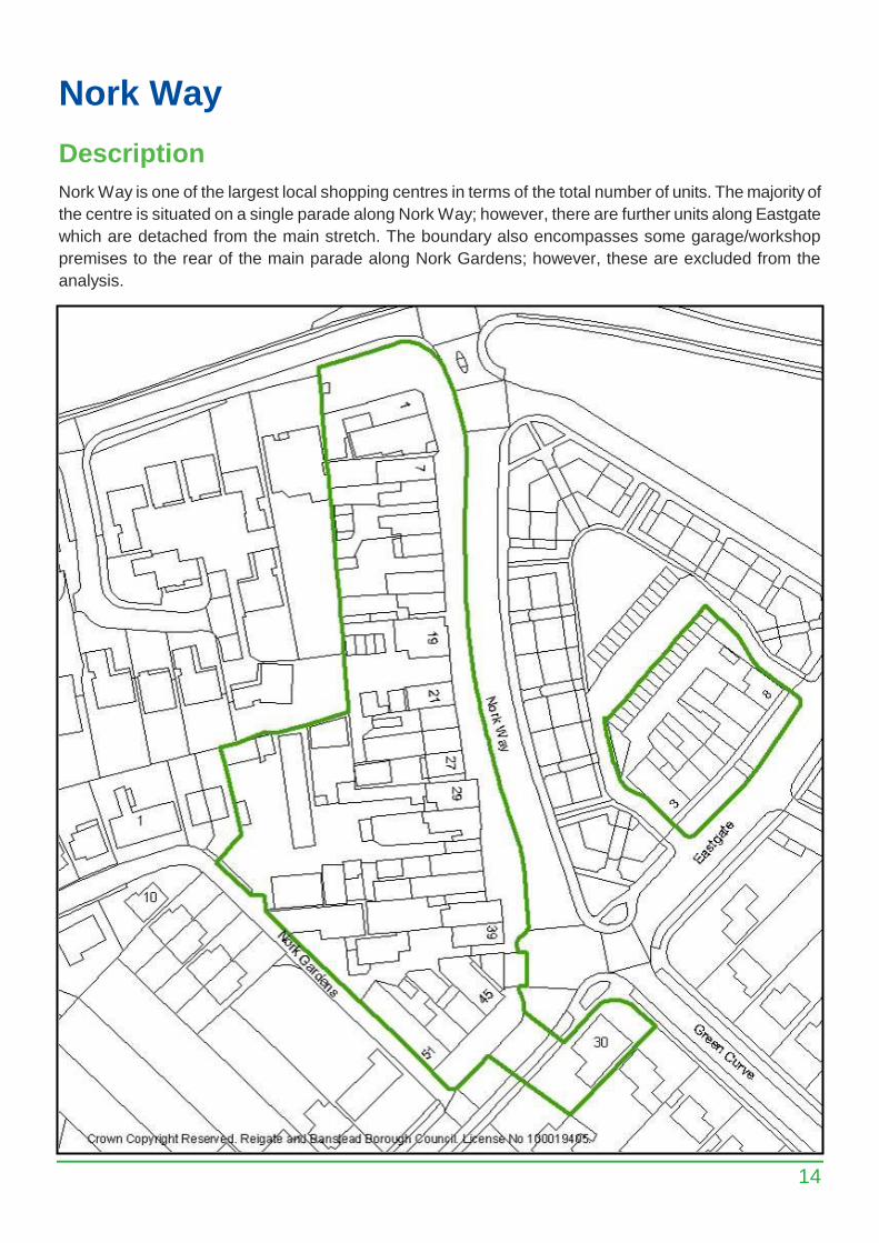
Description
Nork Way is one of the largest local shopping centres in terms of the total number of units. The majority of
the centre is situated on a single parade along Nork Way; however, there are further units along Eastgate
which are detached from the main stretch. The boundary also encompasses some garage/workshop
premises to the rear of the main parade along Nork Gardens; however, these are excluded from the
analysis.
15
Mix & Vitality
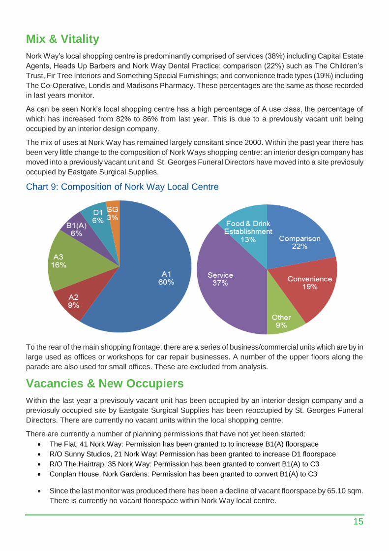
Nork Way’s local shopping centre is predominantly comprised of services (38%) including Capital Estate
Agents, Heads Up Barbers and Nork Way Dental Practice; comparison (22%) such as The Children’s
Trust, Fir Tree Interiors and Something Special Furnishings; and convenience trade types (19%) including
The Co-Operative, Londis and Madisons Pharmacy. These percentages are the same as those recorded
in last years monitor.
As can be seen Nork’s local shopping centre has a high percentage of A use class, the percentage of
which has increased from 82% to 86% from last year. This is due to a previously vacant unit being
occupied by an interior design company.
The mix of uses at Nork Way has remained largely consitant since 2000. Within the past year there has
been very little change to the composition of Nork Ways shopping centre: an interior design company has
moved into a previously vacant unit and St. Georges Funeral Directors have moved into a site previosuly
occupied by Eastgate Surgical Supplies.
Chart 9: Composition of Nork Way Local Centre
To the rear of the main shopping frontage, there are a series of business/commercial units which are by in
large used as offices or workshops for car repair businesses. A number of the upper floors along the
parade are also used for small offices. These are excluded from analysis.
Vacancies & New Occupiers
Within the last year a previsouly vacant unit has been occupied by an interior design company and a
previosuly occupied site by Eastgate Surgical Supplies has been reoccupied by St. Georges Funeral
Directors. There are currently no vacant units within the local shopping centre.
There are currently a number of planning permissions that have not yet been started:
The Flat, 41 Nork Way: Permission has been granted to to increase B1(A) floorspace
R/O Sunny Studios, 21 Nork Way: Permission has been granted to increase D1 floorspace
R/O The Hairtrap, 35 Nork Way: Permission has been granted to convert B1(A) to C3
Conplan House, Nork Gardens: Permission has been granted to convert B1(A) to C3
Since the last monitor was produced there has been a decline of vacant floorspace by 65.10 sqm.
There is currently no vacant floorspace within Nork Way local centre.
16
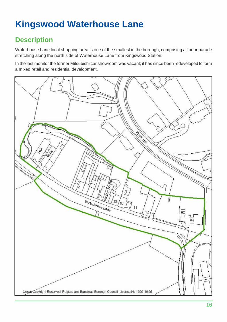
Kingswood Waterhouse Lane
Description
Waterhouse Lane local shopping area is one of the smallest in the borough, comprising a linear parade
stretching along the north side of Waterhouse Lane from Kingswood Station.
In the last monitor the former Mitsubishi car showroom was vacant; it has since been redeveloped to form
a mixed retail and residential development.
17
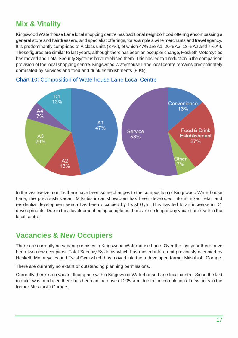
Mix & Vitality
Kingswood Waterhouse Lane local shopping centre has traditional neighborhood offering encompassing a
general store and hairdressers, and specialist offerings, for example a wine merchants and travel agency.
It is predominantly comprised of A class units (87%), of which 47% are A1, 20% A3, 13% A2 and 7% A4.
These figures are similar to last years, although there has been an occupier change, Hesketh Motorcycles
has moved and Total Security Systems have replaced them. This has led to a reduction in the comparison
provision of the local shopping centre. Kingswood Waterhouse Lane local centre remains predominately
dominated by services and food and drink establishments (80%).
Chart 10: Composition of Waterhouse Lane Local Centre
In the last twelve months there have been some changes to the composition of Kingswood Waterhouse
Lane, the previously vacant Mitsubishi car showroom has been developed into a mixed retail and
residential development which has been occupied by Twist Gym. This has led to an increase in D1
developments. Due to this development being completed there are no longer any vacant units within the
local centre.
Vacancies & New Occupiers
There are currently no vacant premises in Kingswood Waterhouse Lane. Over the last year there have
been two new occupiers: Total Security Systems which has moved into a unit previously occupied by
Hesketh Motorcycles and Twist Gym which has moved into the redeveloped former Mitsubishi Garage.
There are currently no extant or outstanding planning permissions.
Currently there is no vacant floorspace within Kingswood Waterhouse Lane local centre. Since the last
monitor was produced there has been an increase of 205 sqm due to the completion of new units in the
former Mitsubishi Garage.
18
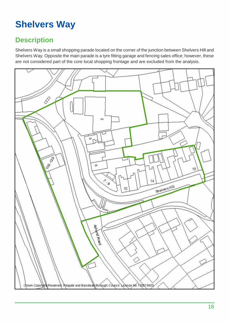
Shelvers Way
Description
Shelvers Way is a small shopping parade located on the corner of the junction between Shelvers Hill and
Shelvers Way. Opposite the main parade is a tyre fitting garage and fencing sales office; however, these
are not considered part of the core local shopping frontage and are excluded from the analysis.
19
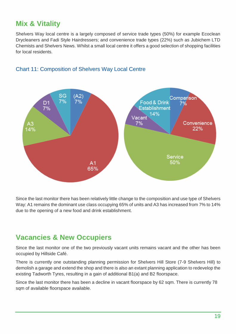
Mix & Vitality
Shelvers Way local centre is a largely composed of service trade types (50%) for example Ecoclean
Drycleaners and Fadi Style Hairdressers; and convenience trade types (22%) such as Jubichem LTD
Chemists and Shelvers News. Whilst a small local centre it offers a good selection of shopping facilities
for local residents.
Chart 11: Composition of Shelvers Way Local Centre
Since the last monitor there has been relatively little change to the composition and use type of Shelvers
Way: A1 remains the dominant use class occupying 65% of units and A3 has increased from 7% to 14%
due to the opening of a new food and drink establishment.
Vacancies & New Occupiers
Since the last monitor one of the two previously vacant units remains vacant and the other has been
occupied by Hillside Café.
There is currently one outstanding planning permission for Shelvers Hill Store (7-9 Shelvers Hill) to
demolish a garage and extend the shop and there is also an extant planning application to redevelop the
existing Tadworth Tyres, resulting in a gain of additional B1(a) and B2 floorspace.
Since the last monitor there has been a decline in vacant floorspace by 62 sqm. There is currently 78
sqm of available floorspace available.
20
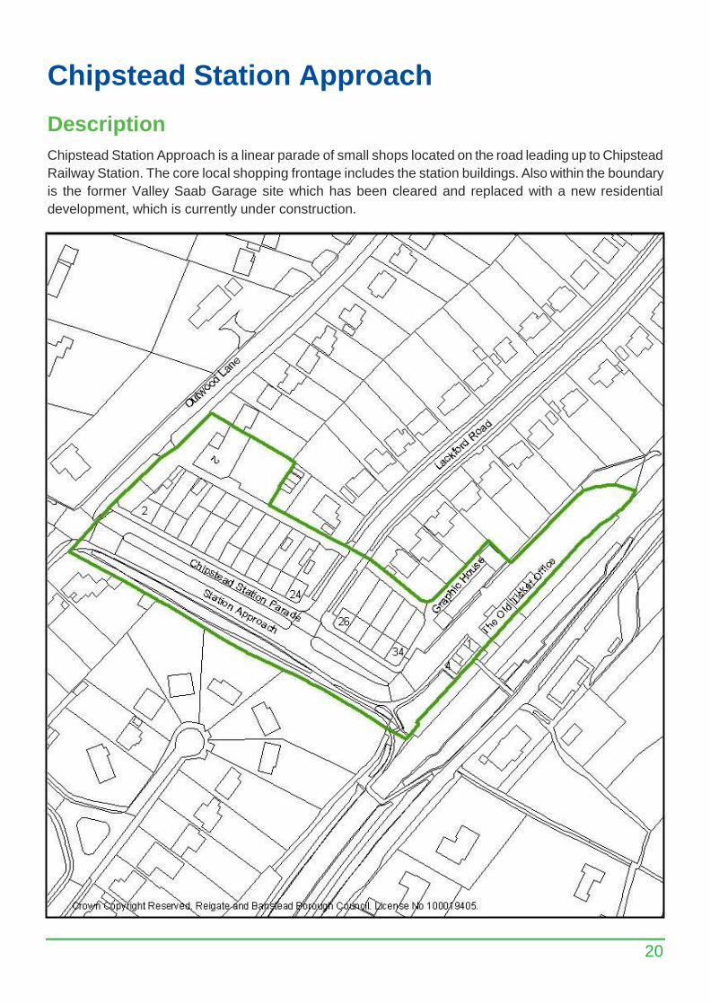
Chipstead Station Approach
Description
Chipstead Station Approach is a linear parade of small shops located on the road leading up to Chipstead
Railway Station. The core local shopping frontage includes the station buildings. Also within the boundary
is the former Valley Saab Garage site which has been cleared and replaced with a new residential
development, which is currently under construction.
21
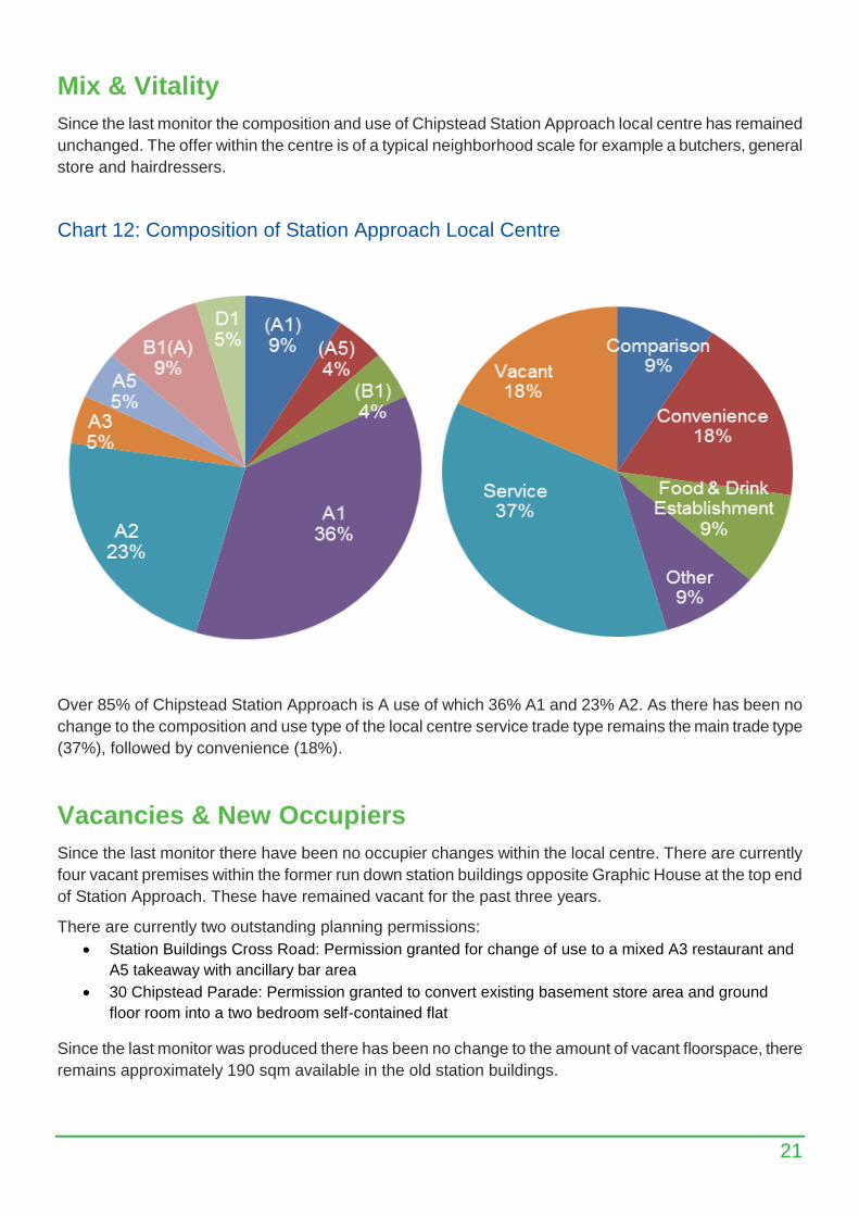
Mix & Vitality
Since the last monitor the composition and use of Chipstead Station Approach local centre has remained
unchanged. The offer within the centre is of a typical neighborhood scale for example a butchers, general
store and hairdressers.
Chart 12: Composition of Station Approach Local Centre
Over 85% of Chipstead Station Approach is A use of which 36% A1 and 23% A2. As there has been no
change to the composition and use type of the local centre service trade type remains the main trade type
(37%), followed by convenience (18%).
Vacancies & New Occupiers
Since the last monitor there have been no occupier changes within the local centre. There are currently
four vacant premises within the former run down station buildings opposite Graphic House at the top end
of Station Approach. These have remained vacant for the past three years.
There are currently two outstanding planning permissions:
Station Buildings Cross Road: Permission granted for change of use to a mixed A3 restaurant and
A5 takeaway with ancillary bar area
30 Chipstead Parade: Permission granted to convert existing basement store area and ground
floor room into a two bedroom self-contained flat
Since the last monitor was produced there has been no change to the amount of vacant floorspace, there
remains approximately 190 sqm available in the old station buildings.
22
Tadworth
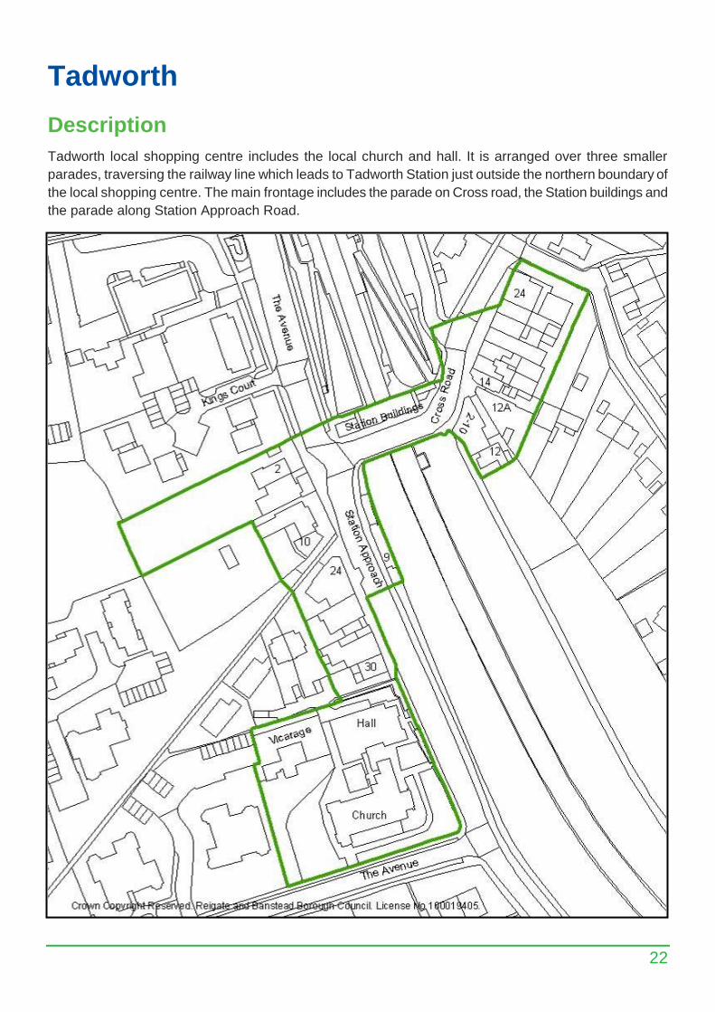
Description
Tadworth local shopping centre includes the local church and hall. It is arranged over three smaller
parades, traversing the railway line which leads to Tadworth Station just outside the northern boundary of
the local shopping centre. The main frontage includes the parade on Cross road, the Station buildings and
the parade along Station Approach Road.
23
Mix & Vitality
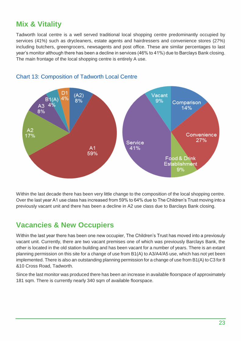
Tadworth local centre is a well served traditional local shopping centre predominantly occupied by
services (41%) such as drycleaners, estate agents and hairdressers and convenience stores (27%)
including butchers, greengrocers, newsagents and post office. These are similar percentages to last
year’s monitor although there has been a decline in services (46% to 41%) due to Barclays Bank closing.
The main frontage of the local shopping centre is entirely A use.
Chart 13: Composition of Tadworth Local Centre
Within the last decade there has been very little change to the composition of the local shopping centre.
Over the last year A1 use class has increased from 59% to 64% due to The Children’s Trust moving into a
previously vacant unit and there has been a decline in A2 use class due to Barclays Bank closing.
Vacancies & New Occupiers
Within the last year there has been one new occupier, The Children’s Trust has moved into a previosuly
vacant unit. Currently, there are two vacant premises one of which was previously Barclays Bank, the
other is located in the old station building and has been vacant for a number of years. There is an extant
planning permission on this site for a change of use from B1(A) to A3/A4/A5 use, which has not yet been
implemented. There is also an outstanding planning permission for a change of use from B1(A) to C3 for 8
&10 Cross Road, Tadworth.
Since the last monitor was produced there has been an increase in available floorspace of approximately
181 sqm. There is currently nearly 340 sqm of available floorspace.
24
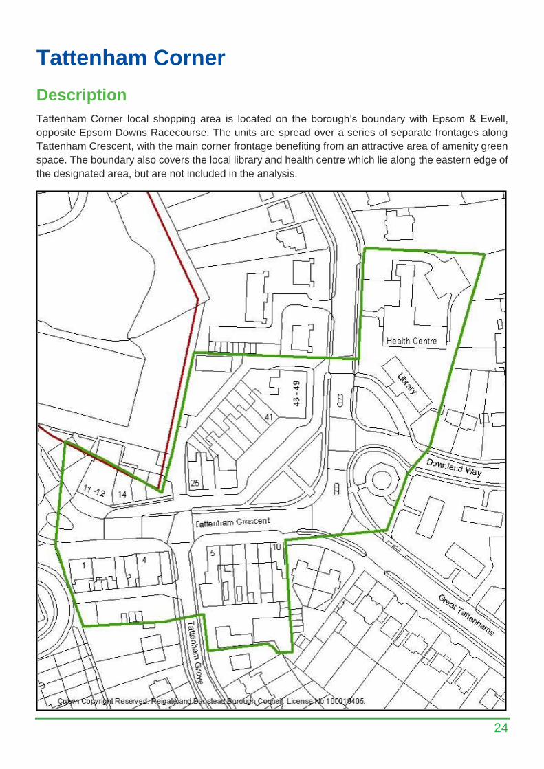
Tattenham Corner
Description
Tattenham Corner local shopping area is located on the borough’s boundary with Epsom & Ewell,
opposite Epsom Downs Racecourse. The units are spread over a series of separate frontages along
Tattenham Crescent, with the main corner frontage benefiting from an attractive area of amenity green
space. The boundary also covers the local library and health centre which lie along the eastern edge of
the designated area, but are not included in the analysis.

25
Mix & Vitality
Tattenham Corner’s local centre is a consistently well served local shopping centre comprised of services
(36%) including Corals the Bookmaker, Eastons Estate Agents and D&L Drycleaners; comparison (20%)
including The Children’s Trust, Masters of Epsom Toyshop and Pets Pals; convenience (20%)
encompassing Buckleys Butchers, The Co-Operative and Paydens Pharmacy; and food and drink
establishments (20%) such as Chilies Indian, El Rincon Tapas and The Post Place Fish and Chips. These
are similar percentages to last year although there has been a slight increase in services (32% to 36%)
due to Alan Greenwood and Sons Funeral Directors occupying a newly constructed unit that was vacant in
last year’s monitor.
Chart 14: Composition of Tattenham Corner Local Centre
As seen above, 92% of Tattenham Corner’s local shopping centre is A use class of which 64% is A1 and
20% A3. There has been very little change to the composition and use of Tattenham Corners local
shopping centre provision over the past year, although A1 has increased slightly from 60% to 64% due to
the opening of Alan Greenwood and Sons Funeral Directors. Within the local shopping centre there is also
a SG use for Belmont Used Cars and D1 use for Goddard Vetinary Group.
Vacancies & New Occupiers
Over the last year there has been no new vacancies within the local shopping centre and a newly
constructed unit that was vacant last year has now been occupied by Alan Greenwood and Sons Funeral
Directors. There is also an extant planning permission to redevelop an existing office unit to the rear of 1-5
The parade resulting in a gain of B1(a) office space.
Since the last monitor was produced there has been a decline in vacant floorspace of 40 sqm. There is
currently no vacant floorspace within Tattenham Corner’s local centre.
26
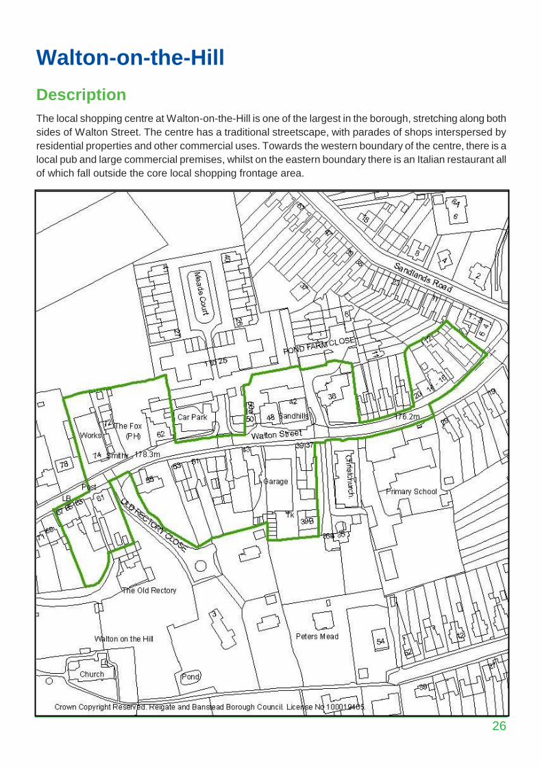
Walton-on-the-Hill
Description
The local shopping centre at Walton-on-the-Hill is one of the largest in the borough, stretching along both
sides of Walton Street. The centre has a traditional streetscape, with parades of shops interspersed by
residential properties and other commercial uses. Towards the western boundary of the centre, there is a
local pub and large commercial premises, whilst on the eastern boundary there is an Italian restaurant all
of which fall outside the core local shopping frontage area.
27
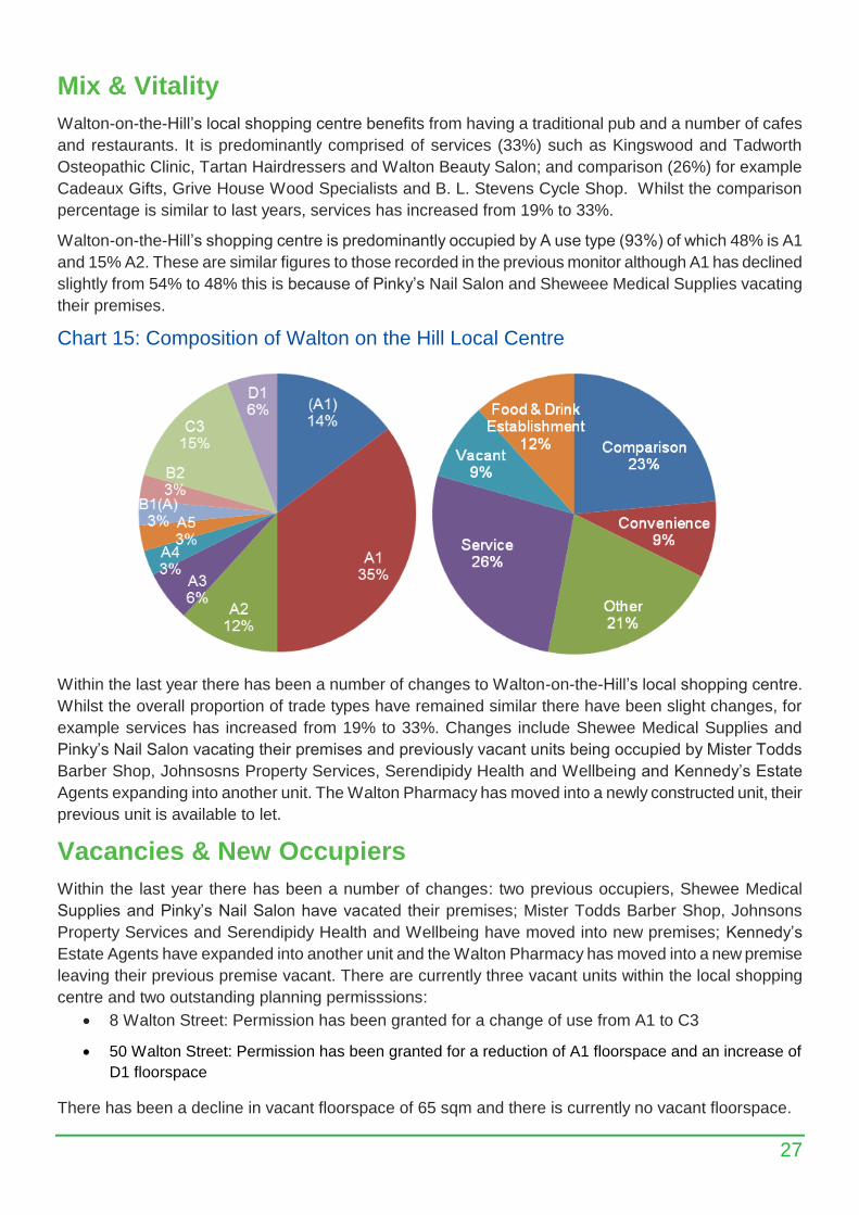
Mix & Vitality
Walton-on-the-Hill’s local shopping centre benefits from having a traditional pub and a number of cafes
and restaurants. It is predominantly comprised of services (33%) such as Kingswood and Tadworth
Osteopathic Clinic, Tartan Hairdressers and Walton Beauty Salon; and comparison (26%) for example
Cadeaux Gifts, Grive House Wood Specialists and B. L. Stevens Cycle Shop. Whilst the comparison
percentage is similar to last years, services has increased from 19% to 33%.
Walton-on-the-Hill’s shopping centre is predominantly occupied by A use type (93%) of which 48% is A1
and 15% A2. These are similar figures to those recorded in the previous monitor although A1 has declined
slightly from 54% to 48% this is because of Pinky’s Nail Salon and Sheweee Medical Supplies vacating
their premises.
Chart 15: Composition of Walton on the Hill Local Centre
Within the last year there has been a number of changes to Walton-on-the-Hill’s local shopping centre.
Whilst the overall proportion of trade types have remained similar there have been slight changes, for
example services has increased from 19% to 33%. Changes include Shewee Medical Supplies and
Pinky’s Nail Salon vacating their premises and previously vacant units being occupied by Mister Todds
Barber Shop, Johnsosns Property Services, Serendipidy Health and Wellbeing and Kennedy’s Estate
Agents expanding into another unit. The Walton Pharmacy has moved into a newly constructed unit, their
previous unit is available to let.
Vacancies & New Occupiers
Within the last year there has been a number of changes: two previous occupiers, Shewee Medical
Supplies and Pinky’s Nail Salon have vacated their premises; Mister Todds Barber Shop, Johnsons
Property Services and Serendipidy Health and Wellbeing have moved into new premises; Kennedy’s
Estate Agents have expanded into another unit and the Walton Pharmacy has moved into a new premise
leaving their previous premise vacant. There are currently three vacant units within the local shopping
centre and two outstanding planning permisssions:
8 Walton Street: Permission has been granted for a change of use from A1 to C3
50 Walton Street: Permission has been granted for a reduction of A1 floorspace and an increase of
D1 floorspace
There has been a decline in vacant floorspace of 65 sqm and there is currently no vacant floorspace.
28
Lesbourne Road
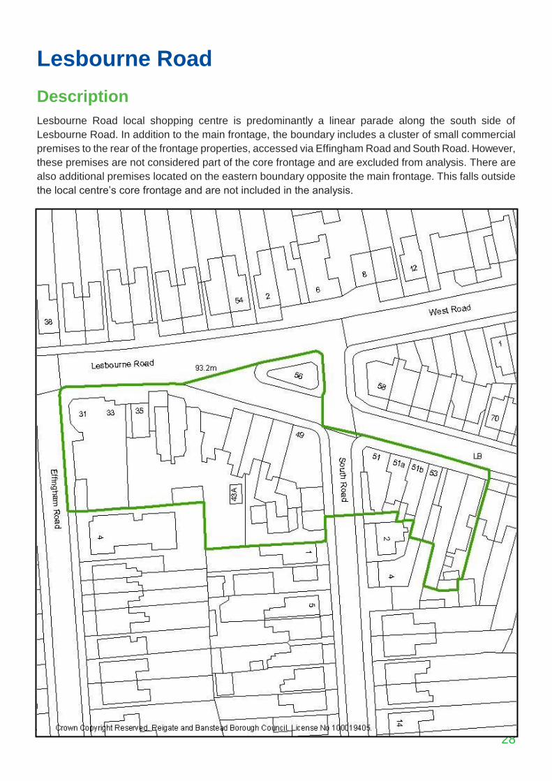
Description
Lesbourne Road local shopping centre is predominantly a linear parade along the south side of
Lesbourne Road. In addition to the main frontage, the boundary includes a cluster of small commercial
premises to the rear of the frontage properties, accessed via Effingham Road and South Road. However,
these premises are not considered part of the core frontage and are excluded from analysis. There are
also additional premises located on the eastern boundary opposite the main frontage. This falls outside
the local centre’s core frontage and are not included in the analysis.
29
Mix & Vitality
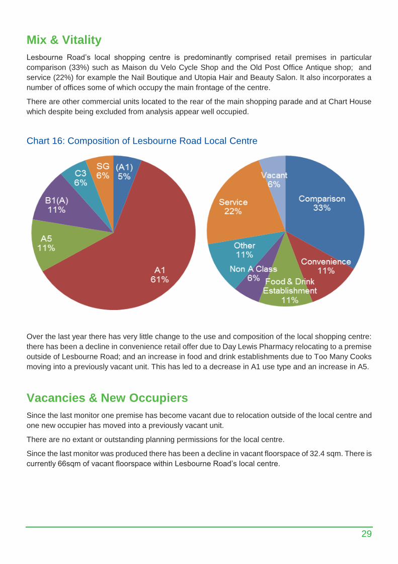
Lesbourne Road’s local shopping centre is predominantly comprised retail premises in particular
comparison (33%) such as Maison du Velo Cycle Shop and the Old Post Office Antique shop; and
service (22%) for example the Nail Boutique and Utopia Hair and Beauty Salon. It also incorporates a
number of offices some of which occupy the main frontage of the centre.
There are other commercial units located to the rear of the main shopping parade and at Chart House
which despite being excluded from analysis appear well occupied.
Chart 16: Composition of Lesbourne Road Local Centre
Over the last year there has very little change to the use and composition of the local shopping centre:
there has been a decline in convenience retail offer due to Day Lewis Pharmacy relocating to a premise
outside of Lesbourne Road; and an increase in food and drink establishments due to Too Many Cooks
moving into a previously vacant unit. This has led to a decrease in A1 use type and an increase in A5.
Vacancies & New Occupiers
Since the last monitor one premise has become vacant due to relocation outside of the local centre and
one new occupier has moved into a previously vacant unit.
There are no extant or outstanding planning permissions for the local centre.
Since the last monitor was produced there has been a decline in vacant floorspace of 32.4 sqm. There is
currently 66sqm of vacant floorspace within Lesbourne Road’s local centre.
30
Woodhatch
Description
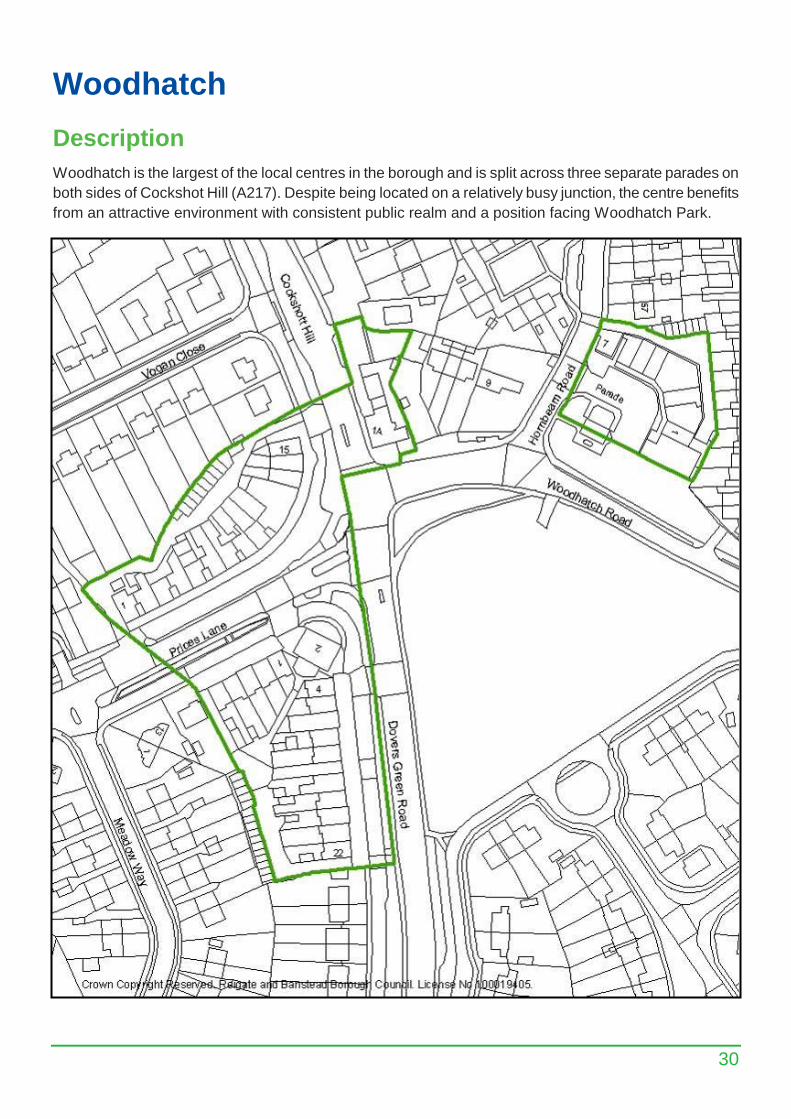
Woodhatch is the largest of the local centres in the borough and is split across three separate parades on
both sides of Cockshot Hill (A217). Despite being located on a relatively busy junction, the centre benefits
from an attractive environment with consistent public realm and a position facing Woodhatch Park.
31
Mix & Vitality
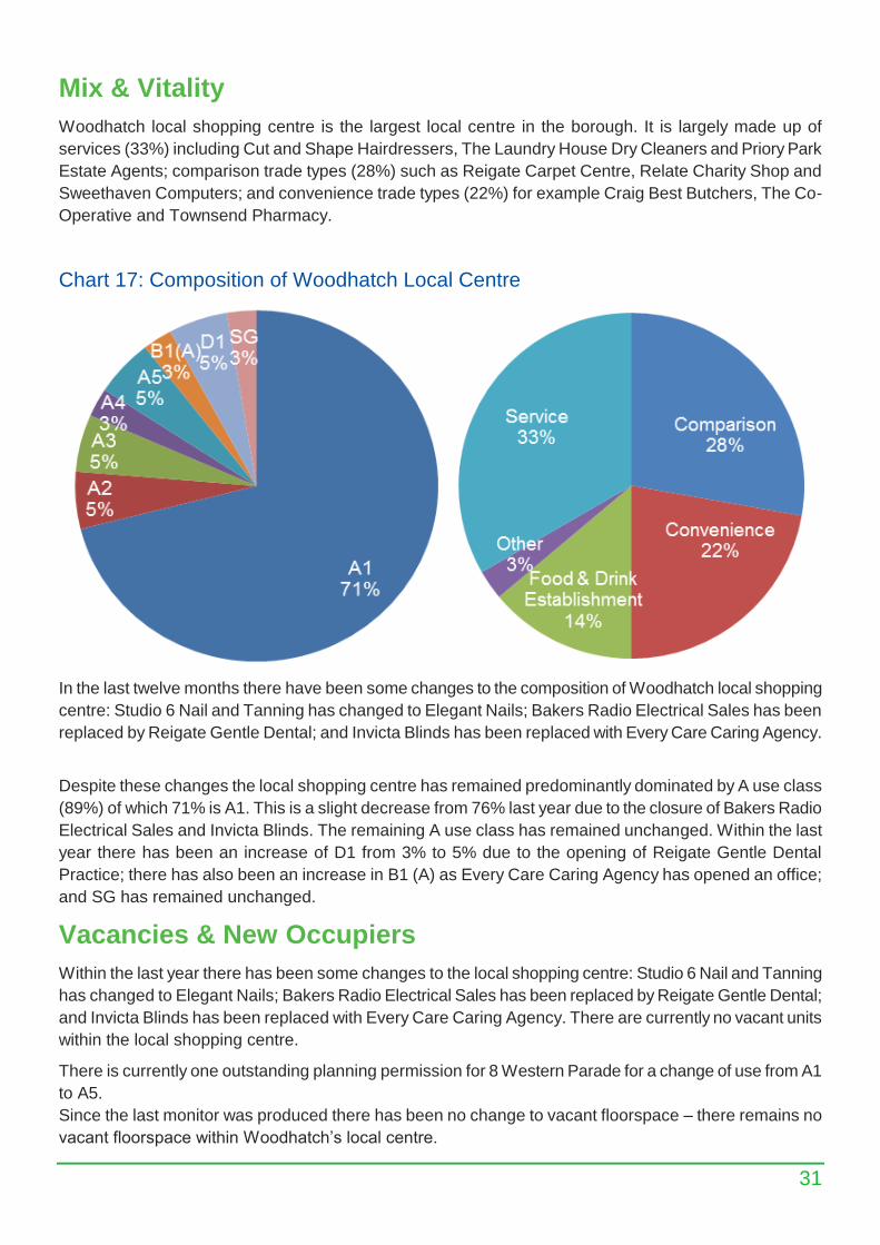
Woodhatch local shopping centre is the largest local centre in the borough. It is largely made up of
services (33%) including Cut and Shape Hairdressers, The Laundry House Dry Cleaners and Priory Park
Estate Agents; comparison trade types (28%) such as Reigate Carpet Centre, Relate Charity Shop and
Sweethaven Computers; and convenience trade types (22%) for example Craig Best Butchers, The Co-
Operative and Townsend Pharmacy.
Chart 17: Composition of Woodhatch Local Centre
In the last twelve months there have been some changes to the composition of Woodhatch local shopping
centre: Studio 6 Nail and Tanning has changed to Elegant Nails; Bakers Radio Electrical Sales has been
replaced by Reigate Gentle Dental; and Invicta Blinds has been replaced with Every Care Caring Agency.
Despite these changes the local shopping centre has remained predominantly dominated by A use class
(89%) of which 71% is A1. This is a slight decrease from 76% last year due to the closure of Bakers Radio
Electrical Sales and Invicta Blinds. The remaining A use class has remained unchanged. Within the last
year there has been an increase of D1 from 3% to 5% due to the opening of Reigate Gentle Dental
Practice; there has also been an increase in B1 (A) as Every Care Caring Agency has opened an office;
and SG has remained unchanged.
Vacancies & New Occupiers
Within the last year there has been some changes to the local shopping centre: Studio 6 Nail and Tanning
has changed to Elegant Nails; Bakers Radio Electrical Sales has been replaced by Reigate Gentle Dental;
and Invicta Blinds has been replaced with Every Care Caring Agency. There are currently no vacant units
within the local shopping centre.
There is currently one outstanding planning permission for 8 Western Parade for a change of use from A1
to A5.
Since the last monitor was produced there has been no change to vacant floorspace – there remains no
vacant floorspace within Woodhatch’s local centre.
32
Linkfield Corner
Description
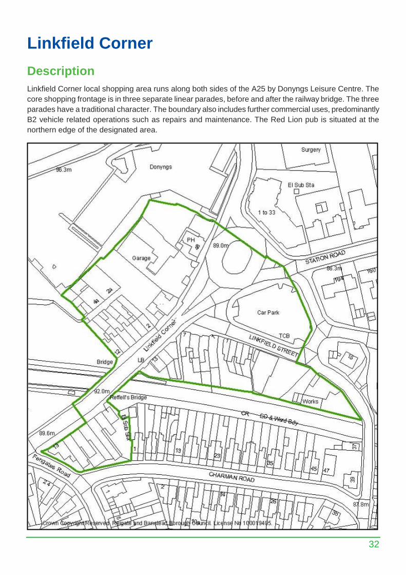
Linkfield Corner local shopping area runs along both sides of the A25 by Donyngs Leisure Centre. The
core shopping frontage is in three separate linear parades, before and after the railway bridge. The three
parades have a traditional character. The boundary also includes further commercial uses, predominantly
B2 vehicle related operations such as repairs and maintenance. The Red Lion pub is situated at the
northern edge of the designated area.
33
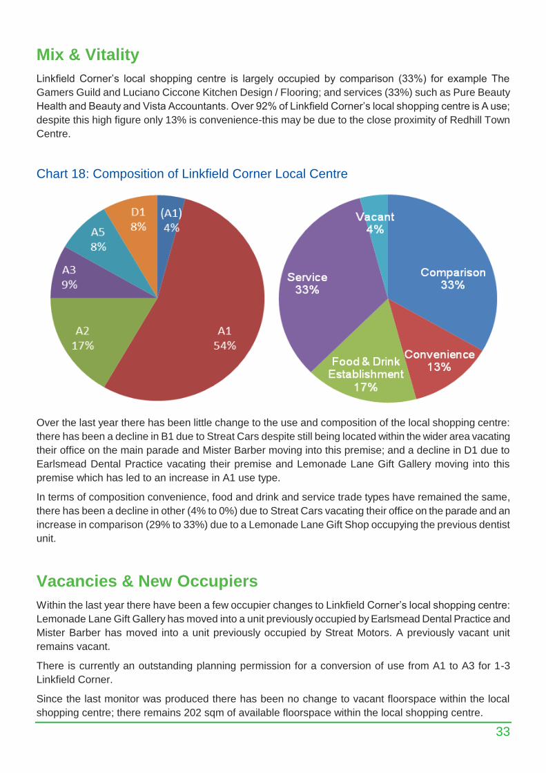
Mix & Vitality
Linkfield Corner’s local shopping centre is largely occupied by comparison (33%) for example The
Gamers Guild and Luciano Ciccone Kitchen Design / Flooring; and services (33%) such as Pure Beauty
Health and Beauty and Vista Accountants. Over 92% of Linkfield Corner’s local shopping centre is A use;
despite this high figure only 13% is convenience-this may be due to the close proximity of Redhill Town
Centre.
Chart 18: Composition of Linkfield Corner Local Centre
Over the last year there has been little change to the use and composition of the local shopping centre:
there has been a decline in B1 due to Streat Cars despite still being located within the wider area vacating
their office on the main parade and Mister Barber moving into this premise; and a decline in D1 due to
Earlsmead Dental Practice vacating their premise and Lemonade Lane Gift Gallery moving into this
premise which has led to an increase in A1 use type.
In terms of composition convenience, food and drink and service trade types have remained the same,
there has been a decline in other (4% to 0%) due to Streat Cars vacating their office on the parade and an
increase in comparison (29% to 33%) due to a Lemonade Lane Gift Shop occupying the previous dentist
unit.
Vacancies & New Occupiers
Within the last year there have been a few occupier changes to Linkfield Corner’s local shopping centre:
Lemonade Lane Gift Gallery has moved into a unit previously occupied by Earlsmead Dental Practice and
Mister Barber has moved into a unit previously occupied by Streat Motors. A previously vacant unit
remains vacant.
There is currently an outstanding planning permission for a conversion of use from A1 to A3 for 1-3
Linkfield Corner.
Since the last monitor was produced there has been no change to vacant floorspace within the local
shopping centre; there remains 202 sqm of available floorspace within the local shopping centre.
34
Merstham Village
Description
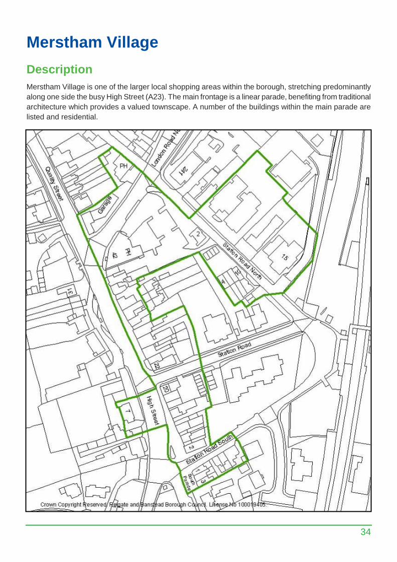
Merstham Village is one of the larger local shopping areas within the borough, stretching predominantly
along one side the busy High Street (A23). The main frontage is a linear parade, benefiting from traditional
architecture which provides a valued townscape. A number of the buildings within the main parade are
listed and residential.
35
Mix & Vitality
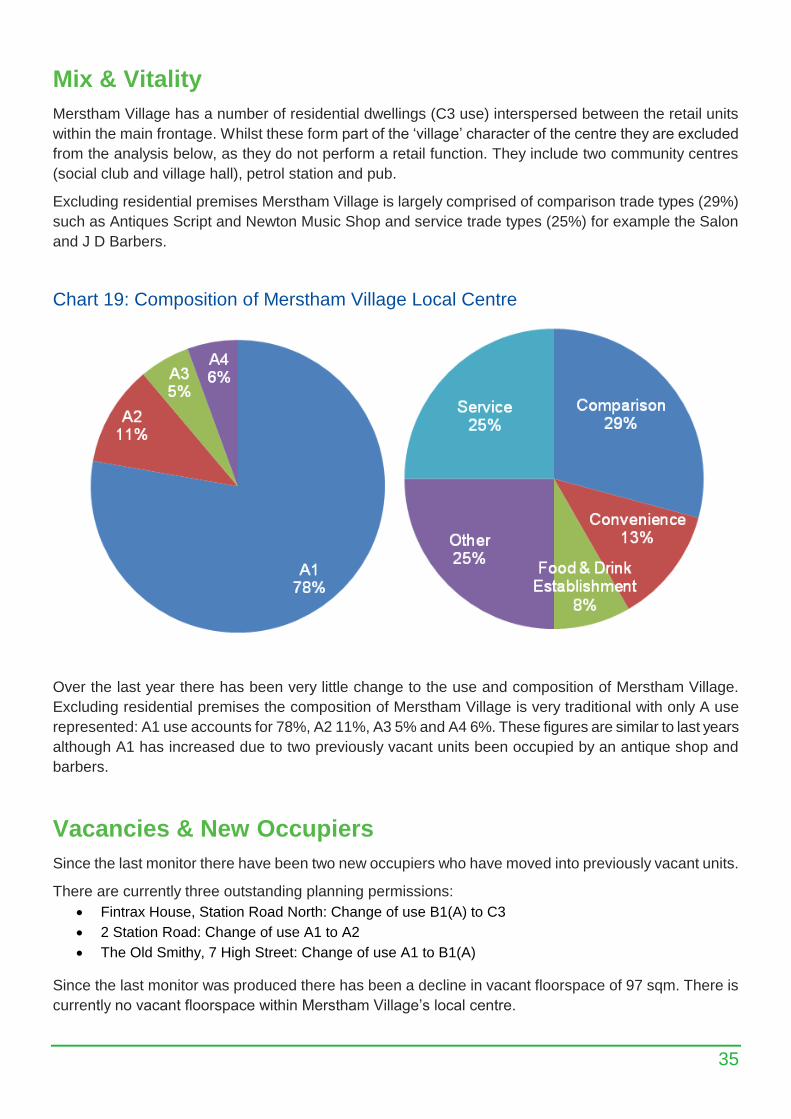
Merstham Village has a number of residential dwellings (C3 use) interspersed between the retail units
within the main frontage. Whilst these form part of the ‘village’ character of the centre they are excluded
from the analysis below, as they do not perform a retail function. They include two community centres
(social club and village hall), petrol station and pub.
Excluding residential premises Merstham Village is largely comprised of comparison trade types (29%)
such as Antiques Script and Newton Music Shop and service trade types (25%) for example the Salon
and J D Barbers.
Chart 19: Composition of Merstham Village Local Centre
Over the last year there has been very little change to the use and composition of Merstham Village.
Excluding residential premises the composition of Merstham Village is very traditional with only A use
represented: A1 use accounts for 78%, A2 11%, A3 5% and A4 6%. These figures are similar to last years
although A1 has increased due to two previously vacant units been occupied by an antique shop and
barbers.
Vacancies & New Occupiers
Since the last monitor there have been two new occupiers who have moved into previously vacant units.
There are currently three outstanding planning permissions:
Fintrax House, Station Road North: Change of use B1(A) to C3
2 Station Road: Change of use A1 to A2
The Old Smithy, 7 High Street: Change of use A1 to B1(A)
Since the last monitor was produced there has been a decline in vacant floorspace of 97 sqm. There is
currently no vacant floorspace within Merstham Village’s local centre.
36
Nutfield Road
Description
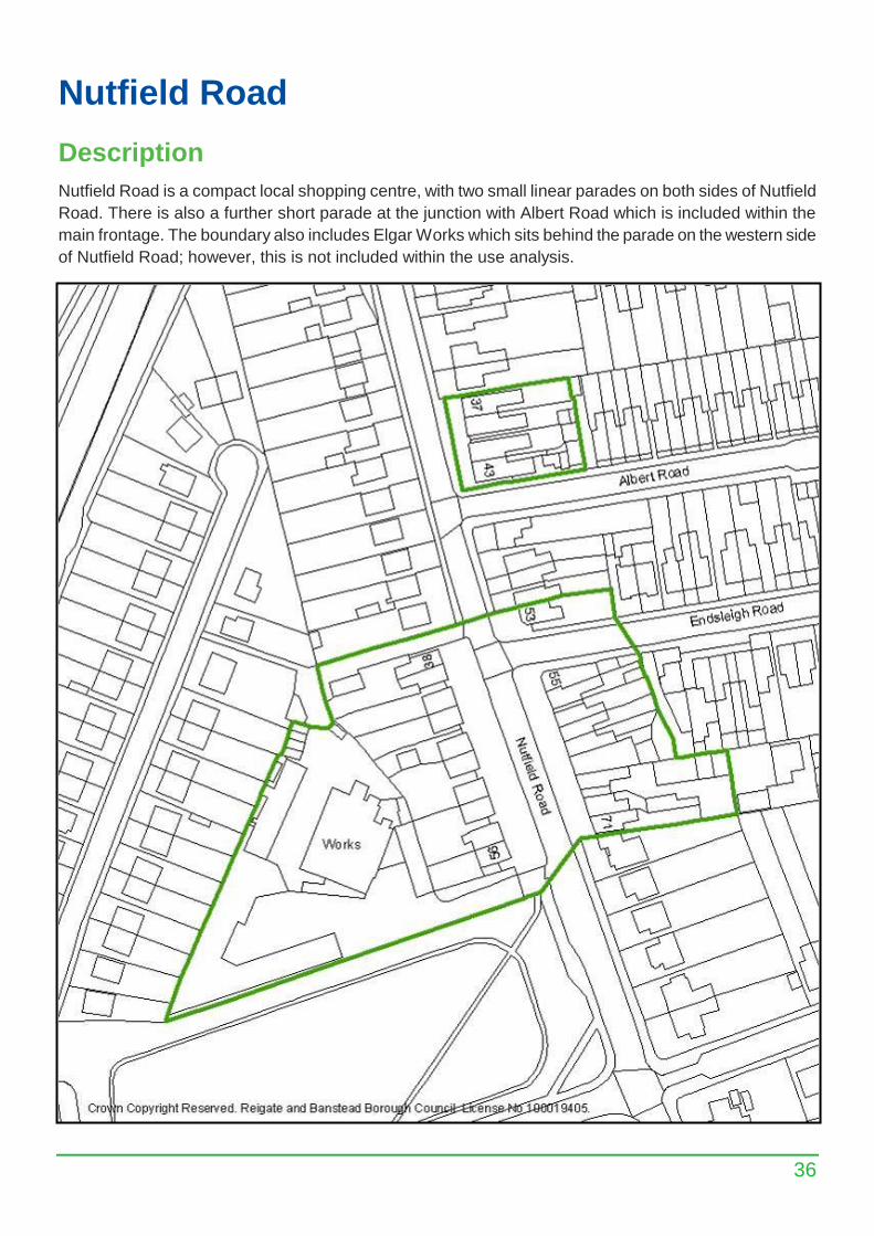
Nutfield Road is a compact local shopping centre, with two small linear parades on both sides of Nutfield
Road. There is also a further short parade at the junction with Albert Road which is included within the
main frontage. The boundary also includes Elgar Works which sits behind the parade on the western side
of Nutfield Road; however, this is not included within the use analysis.
37
Mix & Vitality
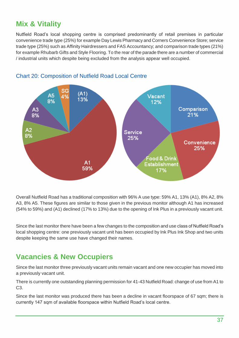
Nutfield Road’s local shopping centre is comprised predominantly of retail premises in particular
convenience trade type (25%) for example Day Lewis Pharmacy and Corners Convenience Store; service
trade type (25%) such as Affinity Hairdressers and FAS Accountancy; and comparison trade types (21%)
for example Rhubarb Gifts and Style Flooring. To the rear of the parade there are a number of commercial
/ industrial units which despite being excluded from the analysis appear well occupied.
Chart 20: Composition of Nutfield Road Local Centre
Overall Nutfield Road has a traditional composition with 96% A use type: 59% A1, 13% (A1), 8% A2, 8%
A3, 8% A5. These figures are similar to those given in the previous monitor although A1 has increased
(54% to 59%) and (A1) declined (17% to 13%) due to the opening of Ink Plus in a previously vacant unit.
Since the last monitor there have been a few changes to the composition and use class of Nutfield Road’s
local shopping centre: one previously vacant unit has been occupied by Ink Plus Ink Shop and two units
despite keeping the same use have changed their names.
Vacancies & New Occupiers
Since the last monitor three previously vacant units remain vacant and one new occupier has moved into
a previously vacant unit.
There is currently one outstanding planning permission for 41-43 Nutfield Road: change of use from A1 to
C3.
Since the last monitor was produced there has been a decline in vacant floorspace of 67 sqm; there is
currently 147 sqm of available floorspace within Nutfield Road’s local centre.
38
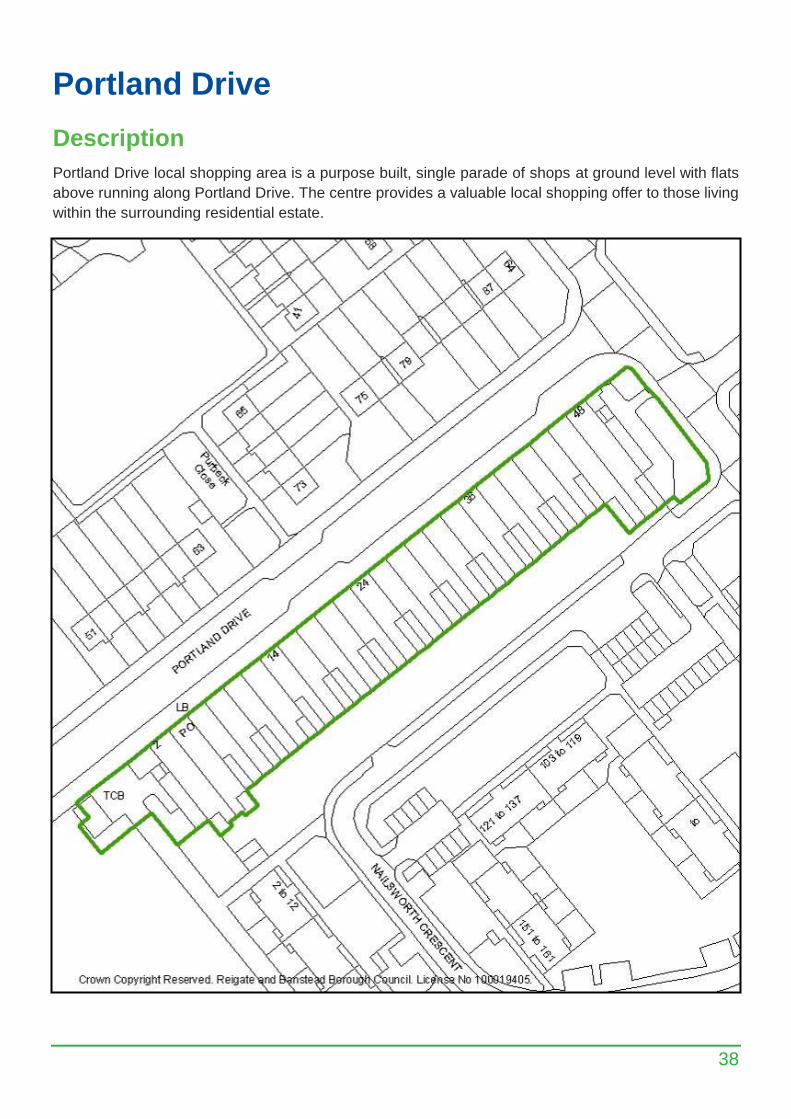
Portland Drive
Description
Portland Drive local shopping area is a purpose built, single parade of shops at ground level with flats
above running along Portland Drive. The centre provides a valuable local shopping offer to those living
within the surrounding residential estate.
39
Mix & Vitality
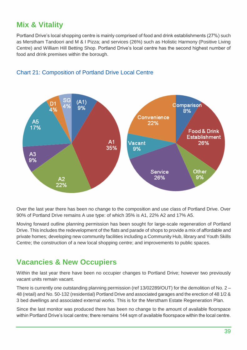
Portland Drive’s local shopping centre is mainly comprised of food and drink establishments (27%) such
as Merstham Tandoori and M & I Pizza; and services (26%) such as Holistic Harmony (Positive Living
Centre) and William Hill Betting Shop. Portland Drive’s local centre has the second highest number of
food and drink premises within the borough.
Chart 21: Composition of Portland Drive Local Centre
Over the last year there has been no change to the composition and use class of Portland Drive. Over
90% of Portland Drive remains A use type: of which 35% is A1, 22% A2 and 17% A5.
Moving forward outline planning permission has been sought for large-scale regeneration of Portland
Drive. This includes the redevelopment of the flats and parade of shops to provide a mix of affordable and
private homes; developing new community facilities including a Community Hub, library and Youth Skills
Centre; the construction of a new local shopping centre; and improvements to public spaces.
Vacancies & New Occupiers
Within the last year there have been no occupier changes to Portland Drive; however two previously
vacant units remain vacant.
There is currently one outstanding planning permission (ref 13/02289/OUT) for the demolition of No. 2 –
48 (retail) and No. 50-132 (residential) Portland Drive and associated garages and the erection of 48 1/2 &
3 bed dwellings and associated external works. This is for the Merstham Estate Regeneration Plan.
Since the last monitor was produced there has been no change to the amount of available floorspace
within Portland Drive’s local centre; there remains 144 sqm of available floorspace within the local centre.
40
Salfords Brighton Road
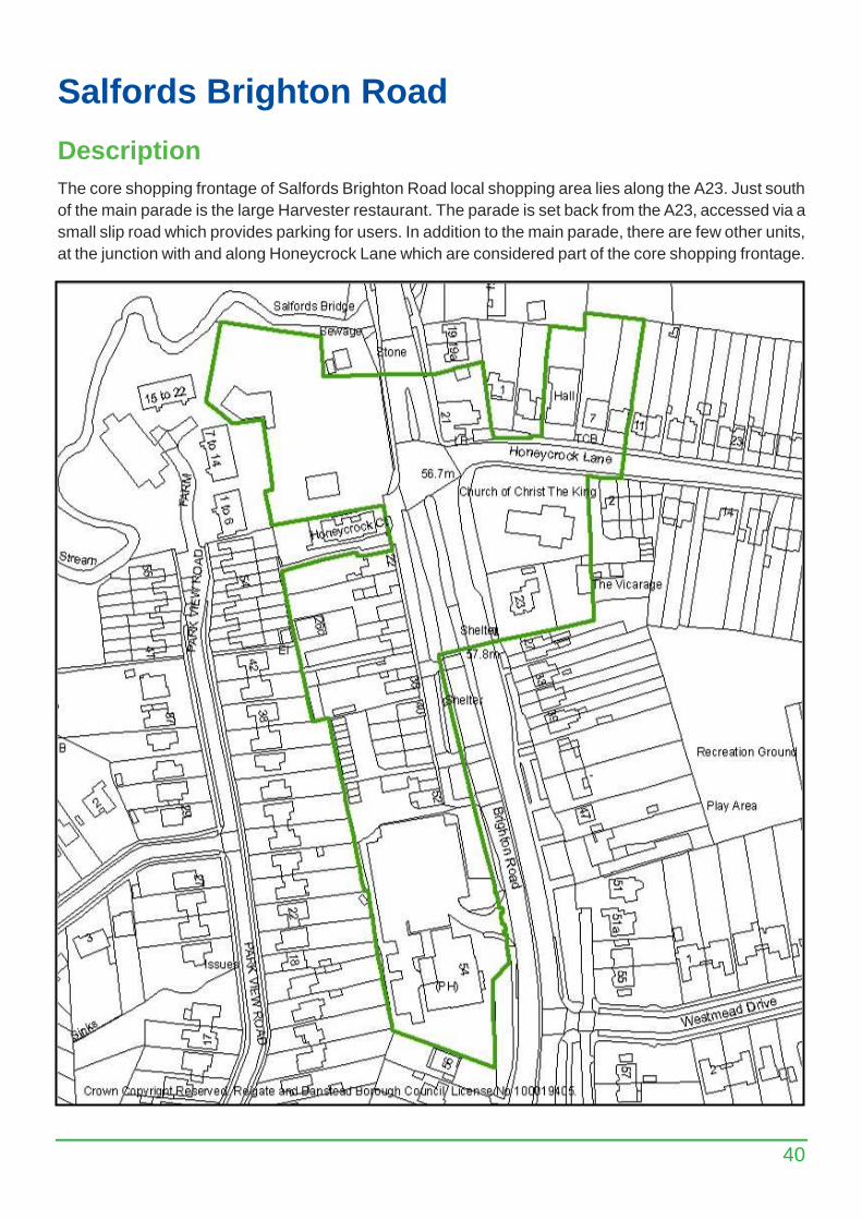
Description
The core shopping frontage of Salfords Brighton Road local shopping area lies along the A23. Just south
of the main parade is the large Harvester restaurant. The parade is set back from the A23, accessed via a
small slip road which provides parking for users. In addition to the main parade, there are few other units,
at the junction with and along Honeycrock Lane which are considered part of the core shopping frontage.
41
Mix & Vitality
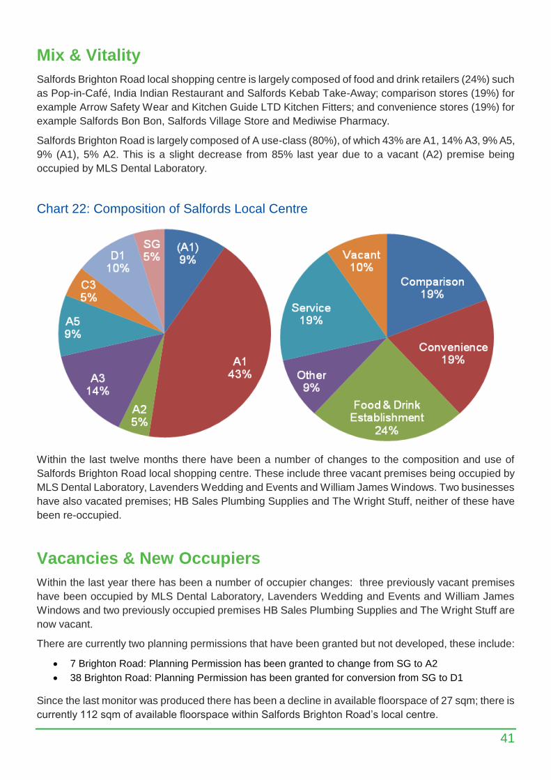
Salfords Brighton Road local shopping centre is largely composed of food and drink retailers (24%) such
as Pop-in-Café, India Indian Restaurant and Salfords Kebab Take-Away; comparison stores (19%) for
example Arrow Safety Wear and Kitchen Guide LTD Kitchen Fitters; and convenience stores (19%) for
example Salfords Bon Bon, Salfords Village Store and Mediwise Pharmacy.
Salfords Brighton Road is largely composed of A use-class (80%), of which 43% are A1, 14% A3, 9% A5,
9% (A1), 5% A2. This is a slight decrease from 85% last year due to a vacant (A2) premise being
occupied by MLS Dental Laboratory.
Chart 22: Composition of Salfords Local Centre
Within the last twelve months there have been a number of changes to the composition and use of
Salfords Brighton Road local shopping centre. These include three vacant premises being occupied by
MLS Dental Laboratory, Lavenders Wedding and Events and William James Windows. Two businesses
have also vacated premises; HB Sales Plumbing Supplies and The Wright Stuff, neither of these have
been re-occupied.
Vacancies & New Occupiers
Within the last year there has been a number of occupier changes: three previously vacant premises
have been occupied by MLS Dental Laboratory, Lavenders Wedding and Events and William James
Windows and two previously occupied premises HB Sales Plumbing Supplies and The Wright Stuff are
now vacant.
There are currently two planning permissions that have been granted but not developed, these include:
7 Brighton Road: Planning Permission has been granted to change from SG to A2
38 Brighton Road: Planning Permission has been granted for conversion from SG to D1
Since the last monitor was produced there has been a decline in available floorspace of 27 sqm; there is
currently 112 sqm of available floorspace within Salfords Brighton Road’s local centre.
42
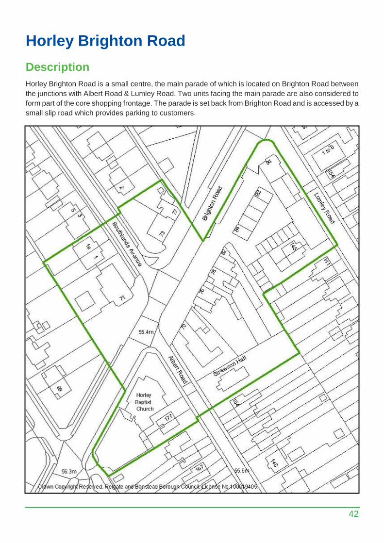
Horley Brighton Road
Description
Horley Brighton Road is a small centre, the main parade of which is located on Brighton Road between
the junctions with Albert Road & Lumley Road. Two units facing the main parade are also considered to
form part of the core shopping frontage. The parade is set back from Brighton Road and is accessed by a
small slip road which provides parking to customers.
43
Mix & Vitality
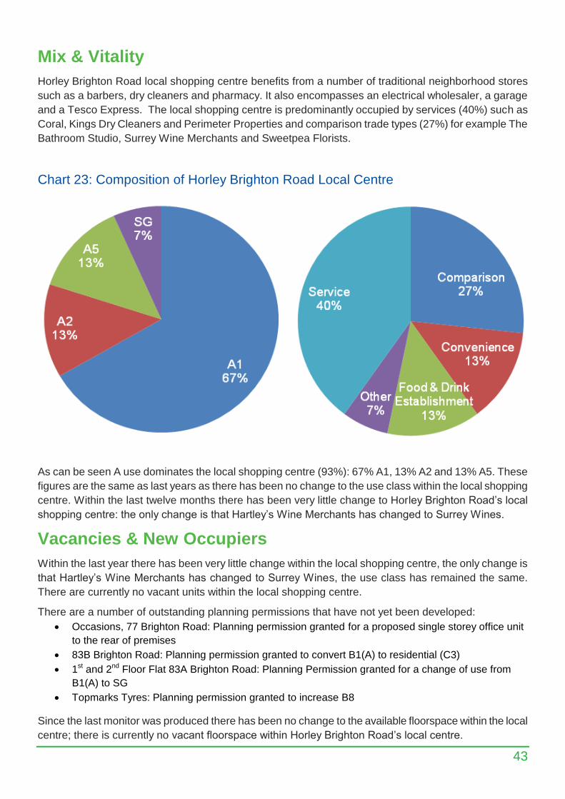
Horley Brighton Road local shopping centre benefits from a number of traditional neighborhood stores
such as a barbers, dry cleaners and pharmacy. It also encompasses an electrical wholesaler, a garage
and a Tesco Express. The local shopping centre is predominantly occupied by services (40%) such as
Coral, Kings Dry Cleaners and Perimeter Properties and comparison trade types (27%) for example The
Bathroom Studio, Surrey Wine Merchants and Sweetpea Florists.
Chart 23: Composition of Horley Brighton Road Local Centre
As can be seen A use dominates the local shopping centre (93%): 67% A1, 13% A2 and 13% A5. These
figures are the same as last years as there has been no change to the use class within the local shopping
centre. Within the last twelve months there has been very little change to Horley Brighton Road’s local
shopping centre: the only change is that Hartley’s Wine Merchants has changed to Surrey Wines.
Vacancies & New Occupiers
Within the last year there has been very little change within the local shopping centre, the only change is
that Hartley’s Wine Merchants has changed to Surrey Wines, the use class has remained the same.
There are currently no vacant units within the local shopping centre.
There are a number of outstanding planning permissions that have not yet been developed:
Occasions, 77 Brighton Road: Planning permission granted for a proposed single storey office unit
to the rear of premises
83B Brighton Road: Planning permission granted to convert B1(A) to residential (C3)
1st and 2nd Floor Flat 83A Brighton Road: Planning Permission granted for a change of use from
B1(A) to SG
Topmarks Tyres: Planning permission granted to increase B8
Since the last monitor was produced there has been no change to the available floorspace within the local
centre; there is currently no vacant floorspace within Horley Brighton Road’s local centre.
44
Appendix
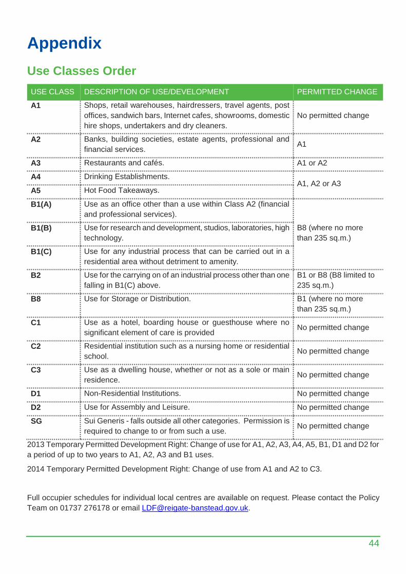
Use Classes Order
USE CLASS DESCRIPTION OF USE/DEVELOPMENT PERMITTED CHANGE
A1 Shops, retail warehouses, hairdressers, travel agents, post
offices, sandwich bars, Internet cafes, showrooms, domestic
hire shops, undertakers and dry cleaners.
No permitted change
A2 Banks, building societies, estate agents, professional and
financial services. A1
A3 Restaurants and cafés. A1 or A2
A4 Drinking Establishments. A1, A2 or A3
A5 Hot Food Takeaways.
B1(A) Use as an office other than a use within Class A2 (financial
and professional services).
B8 (where no more
than 235 sq.m.)
B1(B) Use for research and development, studios, laboratories, high
technology.
B1(C) Use for any industrial process that can be carried out in a
residential area without detriment to amenity.
B2 Use for the carrying on of an industrial process other than one
falling in B1(C) above.
B1 or B8 (B8 limited to
235 sq.m.)
B8 Use for Storage or Distribution. B1 (where no more
than 235 sq.m.)
C1 Use as a hotel, boarding house or guesthouse where no
significant element of care is provided No permitted change
C2 Residential institution such as a nursing home or residential
school. No permitted change
C3 Use as a dwelling house, whether or not as a sole or main
residence. No permitted change
D1 Non-Residential Institutions. No permitted change
D2 Use for Assembly and Leisure. No permitted change
SG Sui Generis - falls outside all other categories. Permission is
required to change to or from such a use. No permitted change
2013 Temporary Permitted Development Right: Change of use for A1, A2, A3, A4, A5, B1, D1 and D2 for
a period of up to two years to A1, A2, A3 and B1 uses.
2014 Temporary Permitted Development Right: Change of use from A1 and A2 to C3.
Full occupier schedules for individual local centres are available on request. Please contact the Policy
Team on 01737 276178 or email [email protected].

Monitoring Publications
Regular Monitors:
Areas for Small Businesses
Provides a list of all uses in the Borough's seven Areas for Small Businesses (Annual)
Commercial Commitments
Contains the amounts, types and location of all commercial commitments i.e. premises with outstanding
planning permissions or vacant floorspace (Annual)
Housing Commitments
Provides information on general housing market trends and the delivery of the amount, type and location
of housing commitments in the Borough (Annual)
Industrial Estates
Contains an analysis of occupational trends in the Borough's nine main Industrial Estates including a
schedule of occupiers (Annual)
Local Shopping Centres
Provides information on retail provision in the Borough's eighteen local shopping centres (Annual)
Town Centres
Provides information on the occupiers, together with vacancies and shop type of all premises within the
Borough's four Town and Village Centres (Bi-annual)
Population Information
These publications are available on the Council website:
http://www.reigate-banstead.gov.uk
Search for: “monitors”:
For further information on the content or other planning policy monitoring, please contact:
Planning Policy
Tel: 01737 276178
Email: [email protected]