Embed Size (px)
Citation preview

1
LOUISIANA DEPARTMENT OF
WILDLIFE & FISHERIES
OFFICE OF FISHERIES
INLAND FISHERIES SECTION
PART VI -A
WATERBODY MANAGEMENT PLAN SERIES
BAYOU D’ARBONNE LAKE
LAKE HISTORY & MANAGEMENT ISSUES

2
Chronology
JULY 2006 – Prepared by
Mike Wood, Biologist Manager, District 2
FEBRUARY 2013 – Updated by
Ryan Daniel, Biologist Manager, District 2
JANUARY 2015 – Updated by
Ryan Daniel, Biologist Manager, District 2
The remainder of this page left intentionally blank.

3
TABLE OF CONTENTS
LAKE HISTORY ........................................................................................................................................................ 5
GENERAL INFORMATION ................................................................................................................................. 5 Date Lake formed .................................................................................................................................................. 5 Impoundment ......................................................................................................................................................... 5 Size (surface area) ................................................................................................................................................. 5 Watershed .............................................................................................................................................................. 5 Pool Stage .............................................................................................................................................................. 5 Parish .................................................................................................................................................................... 5 Border Waters........................................................................................................................................................ 5 Spillway width........................................................................................................................................................ 5 Drawdown description........................................................................................................................................... 5 Who controls .......................................................................................................................................................... 6 Drawdown Schedule .............................................................................................................................................. 6
LAKE AUTHORITY .............................................................................................................................................. 6 Association ............................................................................................................................................................ 6 Authorization ......................................................................................................................................................... 7
MAPS ........................................................................................................................................................................ 7 Access .................................................................................................................................................................... 7 Boat Docks ............................................................................................................................................................. 8 Piers ....................................................................................................................................................................... 8 State/Federal facilities ........................................................................................................................................... 8 Artificial Reefs ....................................................................................................................................................... 8
SHORELINE DEVELOPMENT............................................................................................................................ 9 Commercial ........................................................................................................................................................... 9 Shoreline development by landowners................................................................................................................... 9
PHYSICAL DESCRIPTION OF LAKE ................................................................................................................ 9 Shoreline length ..................................................................................................................................................... 9 Timber type ............................................................................................................................................................ 9 Average depth ........................................................................................................................................................ 9 Maximum depth ..................................................................................................................................................... 9 Natural seasonal water fluctuation ........................................................................................................................ 9
EVENTS / PROBLEMS .......................................................................................................................................... 9 Drawdowns ............................................................................................................................................................ 9 Flooding .............................................................................................................................................................. 10 Water Supply........................................................................................................................................................ 11
MANAGEMENT ISSUES ........................................................................................................................................ 12
AQUATIC VEGETATION ................................................................................................................................... 12 Type Maps ........................................................................................................................................................... 12 Vegetation Biomass Sampling ............................................................................................................................. 12
HISTORY OF REGULATIONS .......................................................................................................................... 13 Recreational......................................................................................................................................................... 13 Commercial ......................................................................................................................................................... 15
DRAWDOWN HISTORY....................................................................................................................................... 16 Estimated % exposed ........................................................................................................................................... 17 Who operated structure ....................................................................................................................................... 18 Fish Kills ............................................................................................................................................................. 18
FISH KILLS / DISEASE HISTORY .................................................................................................................... 18 CONTAMINANTS / POLLUTION ..................................................................................................................... 18
Water quality ....................................................................................................................................................... 18 Water level ........................................................................................................................................................... 18
BIOLOGICAL ....................................................................................................................................................... 18 Fish Sampling History ......................................................................................................................................... 18 Largemouth Bass and Crappie Stock Assessments .............................................................................................. 21 Lake records ........................................................................................................................................................ 21 Stocking History .................................................................................................................................................. 21 Genetics ............................................................................................................................................................... 23

4
Species profile...................................................................................................................................................... 23 RECREATIONAL ANGLER CREEL SURVEYS ............................................................................................. 25 WATER USE ......................................................................................................................................................... 26
Hunting ................................................................................................................................................................ 26 Skiing ................................................................................................................................................................... 26 Swimming ............................................................................................................................................................ 26 Irrigation ............................................................................................................................................................. 26
APPENDIX I .............................................................................................................................................................. 27
APPENDIX II ............................................................................................................................................................ 28
APPENDIX III ........................................................................................................................................................... 29
APPENDIX V ............................................................................................................................................................. 32
APPENDIX VI ........................................................................................................................................................... 33
APPENDIX VII.......................................................................................................................................................... 36

5
LAKE HISTORY
GENERAL INFORMATION
Date Lake formed
Impoundment of Bayou D'Arbonne, Corney Bayou, and Middle Fork Bayou in November, 1963.
Impoundment
Pool stage achieved January, 1964. Ownership of Lake Bottom retained by private individuals.
Servitudes, rights of way, and flowage rights were acquired by Bayou D’Arbonne Lake
Watershed District (locally referred to as the D’Arbonne Lake Commission).
Size (surface area)
15,000 acres
Watershed
1,607 square miles (67:1 ratio of watershed to lake area). Primarily pine silviculture with bottom
land hardwood. Acidic, sandy, infertile soil. Alkalinity and pH low.
Pool Stage
80 feet, MSL
Parish
Union, Lincoln
Border Waters
Corney Bayou and Bayou D’Arbonne above and below the reservoir are designated as scenic
streams (APPENDIX I).
Spillway width
Earthen dam and 799' concrete spillway.
Drawdown description
Until 2013, four 5'x5' cast iron gates in the spillway structure were the only means of lake
dewatering. A stop log rack is immediately upstream of these gates. Stop logs were used to
prevent complete dewatering of the reservoir in the event of gate failure. Placing the stop logs
was difficult due to heavy current and debris in the structure.
The installation of two 10 x 40 ft tainter gates (Figure 1) was completed in 2013. This structure
was placed into the earthen dam on the south side of the spillway and was first operated in spring
2014. These gates will be used for flood control and they will provide an additional 80 ft. of
spillway. The maximum drawdown potential is now 10 feet below spillway crest height with use
of the gates.

6
Figure 1. Tainter gates installed into the earthen dam on the south side of the
D’Arbonne Lake spillway in 2013.
Who controls
Operation and maintenance of the dam and control structure is the responsibility of the Louisiana
Department of Transportation and Development (LDOTD). Operation procedures for the
purpose of flood control are described in APPENDIX III. Operation of the structure for lake
management purposes requires a written request from the Secretary of the Louisiana Department
of Wildlife and Fisheries to the Secretary of LDOTD. The request must include details including
rate of dewatering, target level, and dates for initiation and completion of the drawdown
Drawdown Schedule
To alleviate confusion regarding the scheduling of D’Arbonne Lake drawdowns, and to enable
homeowners to make necessary plans for maintenance and repairs, the D’Arbonne Lake
Commission has adopted a drawdown policy in 2004. The policy provides that drawdowns are
to be conducted every four years. The tainter gates are to be opened the day after Labor Day.
The closure date will be determined by current need for submerged vegetation control, but will
fall between November 15 and January 15 of the succeeding year. The four year drawdown may
be interrupted if a drawdown becomes necessary for dam inspection or maintenance. If so, the
schedule will be reset and the next drawdown would be scheduled four years after the event.
LAKE AUTHORITY
Association
Bayou D’Arbonne Lake Watershed District shall consist of seven commissioners, each of whom
shall be a qualified elector of the State of Louisiana who resides within the limits of Lincoln or
Union Parishes. The commissioners are appointed by the Governor of Louisiana for a term of 4

7
years and until their successors have been appointed and qualified. Vacancies are to be filled by
the remaining commissioners for the unexpired term. Beginning in 1984, every appointee must
be confirmed by the Louisiana Senate and re-submitted for conference by the Governor every 2
years after their initial confirmation.
Members (updated January, 2015)
Cagle, Stephen W
President
9365 Highway 2
Farmerville, LA 71241 [email protected] Jan., 2017
Edward Lee
Vice President Jan., 2017
David Hopkins
Secretary Jan., 2017
Towns, Terri L.
Treasurer
446 Dogwood Ln.
Farmerville, LA 71241 Jan., 2018
VACANT
VACANT
VACANT
Contact information
Post Office Box 1613
Ruston, LA 71273-1613
(318) 255-6825
Authorization
Created by R.S. 38:2555 as a political subdivision and budgetary unit.
ACT No. 9 By: Messrs. Field, Napper and Gibbs.
To create and establish the Bayou D’Arbonne Lake Watershed District, to be located in the
parishes of Lincoln and Union…
Section 2. The Bayou D’Arbonne Lake Watershed District shall be a political subdivision of the
State of Louisiana and a budgetary unit of the State of Louisiana, which shall have as its purpose
the conservation of soil and water, developing the natural resources and wealth of the district for
sanitary, agricultural and recreational purposes, as the same may be conductive to the public
health, safety, convenience or welfare or of public utility or benefit. The creation of the
D’Arbonne Lake within the said district as hereinafter authorized shall be for the purpose of
conserving the soil and water and developing the natural resources and wealth of the district for
sanitary, agricultural or recreational purposes, as the same may be conductive to the public health
or public utility or benefit.
MAPS
Maps of D’Arbonne Lake are available from the Farmerville / Union Parish Chamber of
Commerce and local area merchants (APPENDIX II).
Access

8
There are thirteen public boat launching facilities available for use at D’Arbonne Lake (Table 1).
All are free of charge.
Table 1. List of public boat launches located on D’Arbonne Lake, LA.
RAMP NAME COORDINATES RAMP PARKING
Spillway - N Side Below 32o 42' 45.19" -92
o 20' 19.03" Concrete Dirt - 10 Trailers
Spillway Ramp - South 32o 42' 40.20" -92
o 20' 52.60" Concrete Paved - 10 Trailers
Spillway - North 32o 42' 52.80" -92
o 20' 32.82" Concrete Paved - 12 Trailers
Meeks Landing 32o 42' 03.74" -92
o 14' 59.23" Unimproved Dirt - 10 Trailers
Hog Pen Landing 32o 49' 13.67" -92
o 30' 20.86" Concrete Dirt - 10 Trailers
D’Arbonne State Park 32o 46' 28.76" -92
o 28' 40.60" Concrete Paved - 33 Trailers
D’Arbonne Village 32o 47' 13.15" -92
o 27' 27.46" Concrete Paved - 10 Trailers
Hwy 2 Ramp 32o 47' 09.74" -92
o 27' 17.69" Concrete Paved - 10 Trailers
Jakes Landing 32o 45' 30.56" -92
o 24' 48.05" Concrete Paved - 35 Trailers
Old Hwy 33 32o 45' 23.00" -92
o 25' 02.91" Concrete Paved - 10 Trailers
Tech Landing 32o 45' 12.03" -92
o 26' 34.41" Concrete Dirt - 5 Trailers
Stowe Creek 32o 43' 04.24" -92
o 24' 48.70" Concrete Gravel - 15 Trailers
Terral Island 32o 45' 26.68" -92
o 22' 49.51" Concrete Dirt - 5 Trailers
Boat Docks
Public boat docks are located at all public boat ramps to enable boaters to temporarily moor
boats while parking.
Piers
Fishing piers are located on the State Park grounds. Several have gravel beds constructed in
close proximity to increase angler success.
State/Federal facilities
Lake D'Arbonne State Park
3628 Evergreen Road
Farmerville, LA 71241
318-368-2086 or 1-888-677-5200)
Website: www.lastateparks.com/lakedarb/darbonne.htm
Artificial Reefs
A series of artificial reefs have been placed in D’Arbonne Lake for use by recreational
fishermen. Maps detailing exact locations on the lake are attached and are available at local area
merchants. Coordinates for these reefs are listed below (Table 2).

9
Table 2. List of artificial reefs placed in D’Arbonne Lake by LDWF.
SHORELINE DEVELOPMENT
Commercial
D’Arbonne Motel located on LA Hwy 33
Shoreline development by landowners
Residential with boat houses and piers
PHYSICAL DESCRIPTION OF LAKE
Shoreline length
150 miles
Timber type
The pre-impoundment lake bottom was forested with an oak/gum/cypress complex. The
surrounding lands are primarily used for loblolly pine Pinus taeda silviculture. Approximately,
5,180 acres were cleared prior to impoundment.
Average depth
8.5 feet
Maximum depth
30 feet
Natural seasonal water fluctuation
4-6 feet
10.8 feet above pool stage in April and May due to flood in 1991
EVENTS / PROBLEMS
Spillway gates closed, November, 1963.
Pool stage achieved January, 1964.
Drawdowns
Annual 5 foot fall drawdowns were initiated in 1964 – extended through 1969.
Drawdown target increased to 8’ below pool stage in 1970.
Note: Eight foot drawdowns create extensive dewatering of the impoundment (>50%).
Drawdowns conducted in 1970 (8.8’ below pool stage), 1972 (7.9’), 1975 (9.5’), 1978 (10.8’),
1980 (9.9’), 1984 (8.8’), and 1985 (12.7’).
NAME MATERIAL COORDINATES
State Park Reef Polyethylene pallets 32 o 46’ 15.36”N -92
o 28’41.18”W
Horseshoe Reef Polyethylene pallets 32 o 47’ 25.34”N -92
o 27’17.66”W
4 Mile Reef Polyethylene pallets 32 o 46’ 37.64”N -92
o 25’34.22”W
Stowe Creek Reef Polyethylene pallets 32 o 43’ 54.09”N -92
o 24’12.08”W
Piney Point Reef Polyethylene pallets 32 o 44’ 33.09”N -92
o 22’31.04”W
Reef 5 Polyethylene pallets 32 o 43’ 52.09”N -92
o 21’32.04”W

10
Decrease in adult size largemouth bass closely correlated with more drawdowns over 5 feet.
Increased angler harvest during extensive drawdowns strongly suspected as cause.
1994 – Drawdown conducted – target reduced to 5 ft. below pool stage.
2001 - Drawdown conducted for spillway repair and to allow for shoreline property maintenance
2002 – D’Arbonne Lake Commission adopts policy of fall drawdowns every four years. The 5
foot drawdowns are set to begin in 2004. Spillway gates are to be opened the day after Labor
Day and closed on November 15. The action was to allow for homeowners to complete
necessary repairs, ramp maintenance, channel maintenance, and stump clearing.
2004 – Scheduled drawdown, Labor Day – Nov. 15, 5 ft. below pool stage
2008 – Scheduled drawdown, Labor Day – Jan. 15 (for additional hydrilla control), 5 ft. below
pool stage.
2009 – Spillway gate maintenance, Labor Day – approx. Oct. 1, 1.5 ft. below pool stage.
2011 – Construction begins on tainter gates.
2012 – Scheduled drawdown, Labor Day – Dec. 28 (for additional hydrilla control), 5 ft. below
pool stage
Flooding
The large watershed of D’Arbonne Lake insures that water levels above pool stage are common.
Structures built below design storm elevation (90.00 feet, MSL) will flood with varying degrees
of frequency (Table 3). Flood frequency is determined by elevation above the spillway crest.
According to flood stage elevation from USGS, approximately 323 structures were flooded in the
1991 flood which reached 90.78 feet, MSL. It's important to note that the second highest
recorded water level was 86.1 feet, MSL in 1958, before construction of the D’Arbonne Lake
spillway.
Since completion of the reservoir, numerous camps and homes have been constructed around the
lake at elevations below 90.00 feet, MSL. The lowest, according to Denmon Engineering field
surveys in 1996 and 1997, has a floor elevation of 82.06 feet, MSL, or only 2.06 feet above the
spillway crest. A total of 275 structures are located at or below elevation 90.00 feet, MSL.
Table 3. Number of structures flooded for various flood frequencies on D’Arbonne Lake, LA.
o Source: State Project No. 505-56-0031, Additional Spillway Capacity Bayou D’Arbonne Lake,
Denmon Engineering, April 1998.
June 18, 1997 – Opinion on use of the D’Arbonne Lake spillway for flood control from Paul
Colquette, District Design, Water Resources and Development Engineer.
“A flood control reservoir provides flood control benefits only to the area downstream of the
dam and spillway. Therefore, D’Arbonne Lake does not and cannot provide flood control
benefits for the residents surrounding the lake.”*** “Opening the gates (5x5 gates) during
periods of high lake levels will theoretically increase the overall flow out of the lake. However,
FREQUENCY
D’ARBONNE LAKE
POOL
(feet, MSL)
NUMBER OF STRUCTURES
FLOODED
2-year 82.20 1
5-year 84.32 5
10-year 86.64 26
25-year 86.94 80
50-year 88.73 205
100-year 89.76 262

11
the flow increase is such a small percentage; the results are more physiological than actually
measurable. Any time the gates are opened, the possibility exists for logs or other debris to
become lodged in the gate opening. If this happens, the gate cannot be closed completely until
the obstruction is removed. Forcing the gate closed will probably damage the gate or lift
mechanism.”
June 14, 1999 - Mr. Ed Preau, DOTD Engineer, affirmed that openings of the four 5'x5' gates
offer no significant increase over water that already flows over the 799' spillway. In fact, the
significance of the gates is progressively less as water flow increases over the spillway (as in
times of high water). He explained that the spillway structure was designed only for infrequent
lake dewatering, not flood protection. The gate openings also expose the structure to damage
from logs and debris in the gate openings. The cast iron gates and/or the concrete structure can
be damaged upon closure of the gates, resulting in partial to extensive dewatering of the lake.
Subsequent repairs would be available only from funds, allocated by legislative action, a process
not noted for being prompt.
Tainter Gate History
2010 – The option of installing tainter gates into the earthen dam on the south side of the
spillway was approved.
2011 – Construction began on flood control tainter gates on the south side of the spillway. The
project was expected to be completed in 2013.
2013 – Construction of the tainter gates was completed in fall.
2014 – Tainter gates were first used for flood control on April 6. The lake level reached 82.8’
MSL. The Union Parish Police Jury became concerned that the increase in discharge from the
tainter gates was responsible for erosion of the Rocky Branch Road (an unpaved road,
approximately 8 miles downstream). A request was made to open only one gate when the lake
level reached 82.25’ MSL. The current procedures for gates operation are provided in
APPENDIX III.
Water Supply
July, 20, 2006 – Local newspaper sources reported that federal funds totaling $500,000 were
available for a study to determine feasibility a water pipeline and treatment plant from
D'Arbonne Lake to the Farmerville and Ruston areas.

12
MANAGEMENT ISSUES
AQUATIC VEGETATION
During the warmer months, aquatic vegetation has historically been prevalent in the shallow
waters of both the Little D’Arbonne Arm and the Little Corney Arm. During the 20 year period
from 1965 to 1985, eight drawdowns were conducted for the purpose of aquatic weed control.
Results were generally unsatisfactory. In the 15 year period from 1970 to 1985, drawdowns
were increased to more than 5 feet below pool stage. Drawdowns ranged from 7.9 feet below
pool to 12.7 feet below pool stage in 1985. The more extensive drawdowns (>5’) were correlated
with reductions in adult size largemouth bass, crappie, and bluegill.
In 2005, hydrilla was first discovered in D’Arbonne Lake. The invasive plant has expanded in
coverage and is now occurs throughout the Bayou D’Arbonne and Corney arms of the lake.
Drawdowns temporarily reduce hydrilla coverage in water depths less than five feet, but the
plant typically becomes problematic again within two years after a drawdown. Manipulation of
lake level with the tainter gates may become necessary to control hydrilla (See MP-B).
Type Maps
The most recent aquatic vegetation type map and survey was completed in September 2013.
This report is included as an attachment in D’Arbonne Lake MP-B (updated 2015).
Previous Aquatic Vegetation Type Maps
1977, 1978, 1979, 1980, 1981, 1982, 1983, 1984, 1985, 1986, 1987, 1988, 1989, 1990, 1991,
1992, 1993, 1994, 1995, 1996, 2005*, 2007
*, 2009
*, 2011
*, and 2013
*.
*denotes type map surveys that are on file, using current standardized techniques, maps included.
Vegetation Biomass Sampling
1977, 1978, 1979, 1983, 2002, 2003.
Biological Control
NA
Chemical Control
Applications of glyphosate (0.75 gal/acre) or liquid 2,4-D (0.5 gal./acre) have been routinely
conducted from specially equipped boats to control emergent and floating species. Target plant
species include alligator weed (Alternanthera philoxeroides), water hyacinth (Eichhornia
crassipes), water primrose (Ludwigia spp.) and American lotus (Nelumbo lutea). Granular 2,4-D
(100 lbs./acre) has also been applied for lotus control. In recent years, the herbicides imazapyr
(0.5 gal./acre) and imazamox (0.5 gal./acre) have also been used to control emergent vegetation.
Imazapyr is used primarily in undeveloped areas due to label restrictions that limit proximity to
irrigation. The majority of the herbicide applications have been made in areas where vegetation
has impeded boating access. A small infestation of common salvinia (Salvinia minima) was
discovered in 2007 and treated with diquat dibromide (1.0 gal/acre). The plant has not been
observed since 2009. Aquatic vegetation treatments are listed in Table 4.
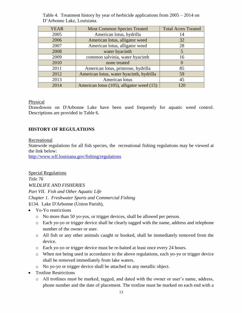
13
Table 4. Treatment history by year of herbicide applications from 2005 – 2014 on
D’Arbonne Lake, Louisiana.
Physical
Drawdowns on D'Arbonne Lake have been used frequently for aquatic weed control.
Descriptions are provided in Table 6.
HISTORY OF REGULATIONS
Recreational
Statewide regulations for all fish species, the recreational fishing regulations may be viewed at
the link below:
http://www.wlf.louisiana.gov/fishing/regulations
Special Regulations
Title 76
WILDLIFE AND FISHERIES
Part VII. Fish and Other Aquatic Life
Chapter 1. Freshwater Sports and Commercial Fishing
§134. Lake D'Arbonne (Union Parish),
Yo-Yo restrictions
o No more than 50 yo-yos, or trigger devices, shall be allowed per person.
o Each yo-yo or trigger device shall be clearly tagged with the name, address and telephone
number of the owner or user.
o All fish or any other animals caught or hooked, shall be immediately removed from the
device.
o Each yo-yo or trigger device must be re-baited at least once every 24 hours.
o When not being used in accordance to the above regulations, each yo-yo or trigger device
shall be removed immediately from lake waters.
o No yo-yo or trigger device shall be attached to any metallic object.
Trotline Restrictions
o All trotlines must be marked, tagged, and dated with the owner or user’s name, address,
phone number and the date of placement. The trotline must be marked on each end with a
YEAR Most Common Species Treated Total Acres Treated
2005 American lotus, hydrilla 14
2006 American lotus, alligator weed 32
2007 American lotus, alligator weed 28
2008 water hyacinth 5
2009 common salvinia, water hyacinth 16
2010 none treated 0
2011 American lotus, primrose, hydrilla 85
2012 American lotus, water hyacinth, hydrilla 59
2013 American lotus 45
2014 American lotus (105), alligator weed (15) 120

14
floating object that is readily visible.
o No person shall set more than three trotlines with a maximum of 50 hooks per trotline.
o All trotlines must be removed from lake waters when not in use.
o All trotlines must have an 8-foot cotton leader on each end of the trotline to insure that if
the trotline is left unattended, the cotton leader will deteriorate and the line will sink.
o All trotlines must be attended daily while in service.
Proposed Largemouth Bass Regulations
March, 2001 – The period of 1999-2000 was one of improved angling success for D’Arbonne
Lake. Moderation in the frequency and extent of lake drawdowns is credited with much of the
positive influence. In addition, benefits of Florida bass introductions were attracting angler
attention with trophy size bass (including one bass >15 pounds in 2000). Some anglers
expressed interest in additional management tools including largemouth bass harvest restrictions.
In related discussions with the D’Arbonne Lake Commission, LDWF staff explained that angler
support was a critical element to the success of any harvest restriction. Angler opposition to slot
limits was immediately acknowledged due to the popularity of bass tournaments on D’Arbonne
Lake. A review of LDWF sampling data indicated a minimum length limit would be ineffective
unless the restriction was set at least 16 inches.
Adjustments to the D’Arbonne Lake largemouth bass creel limit were not considered. The
purposes of a daily creel limit are to prevent over-harvest of the fishery, to allow equitable
distribution harvest, and to give anglers a reasonable target to mark their fishing success.
Harvest may reduce the number of quality-size bass available to anglers, but seldom to the
detriment of a population’s ability to sustain through natural recruitment. The equitable
distribution of harvest is implied through a daily creel limit. Distribution of harvest is more
dependent on angling skill than on a daily creel limit. Further, obtaining a daily limit of 10 bass
is a relatively rare event. The options are to reduce the creel limit it to a biologically significant
level was rejected because the required reduction in creel would be unacceptable to anglers.
With support from the D’Arbonne Lake Commission, the following Notice to the Anglers of
D’Arbonne Lake was published in the Farmerville Gazette, the Ruston Daily Leader, and the
Monroe News Star.
Notice to Anglers of D’Arbonne Lake:
Public comment is now being requested concerning a change in D’Arbonne Lake
largemouth bass regulations. D’Arbonne Lake is currently listed under statewide regulations for
largemouth bass that include no length limit and a 10 fish daily creel limit. Regulations being
considered include a 16" minimum length limit, with a 10 fish daily creel limit.
The issue originated from expressed angler desire to enhance the existing population with
harvest restrictions designed to produce larger bass. LDWF analysis indicates that a 16"
minimum size limit would be required to effect beneficial change to the current bass population.
By protecting largemouth bass smaller than 16" in length, the regulation would decrease angler
harvest rate, but would increase angler catch rate.
Until recently, LDWF biologists have recommended against additional harvest
restrictions for D’Arbonne Lake, advising that any changes be contingent on the successful
incorporation of Florida bass, and angler approval. Florida bass stockings have now been
confirmed as successful. Local angler opinion will now determine if the process to implement
15
the proposal is initiated under the Louisiana Administrative Procedures. Your written comments
are requested and encouraged. Please mail a short message with your opinion to:
LA Department of Wildlife and Fisheries
Attn: Mike Wood
368 CenturyTel Park Drive
Comments were received for a 30 day period. Final count was 8 in favor of the proposal and 18
against. As a result, the process to initiate length regulations for largemouth bass was not
recommended.
Crappie Regulations History
In April 2008, at a regularly scheduled meeting of the D’Arbonne Lake Commission, LDWF
presented information concerning regulations for crappie. The presentation was in response to
angler request for more restrictive crappie regulations (10” minimum length limit and 25 fish/day
creel limit) to improve the quality of the crappie population. Utilizing age and growth data from
D’Arbonne Lake crappie, LDWF advised against the proposed changes, citing only minimal
potential benefits. For example, that there would only be a slight increase in survival of age 2
fish under a 10 inch minimum length limit and there would be no benefit to the population with a
reduced creel limit of 25 crappie per day. Throughout 2009, LDWF conducted an on-the-water
opinion survey of D’Arbonne Lake anglers to gain information on angler perception of crappie
management. Overall, 67% of 223 anglers expressed satisfaction with the current regulations,
while the remainder desired change (minimum length, reduced creel limit, or both). This issue
resurfaced in the fall of 2011 and the Louisiana Wildlife and Fisheries Commission approved a
25 fish/day creel limit for D’Arbonne Lake crappie. The regulation became effective on
November 15, 2012 (see APPENDIX IV).
In April 2013, the Louisiana Legislature passed Act 334, which returned the D’Arbonne Lake
crappie creel limit 50 fish/day and prohibited Louisiana Wildlife and Fisheries Commission from
amending D’Arbonne Lake crappie regulations.
In 2014, Senate Bill 369 (Walsworth – West Monroe) returned regulatory authority for
D’Arbonne Lake crappie to the Louisiana Wildlife and Fisheries Commission.
Commercial
The commercial fishing regulations may be viewed at the link below:
http://www.wlf.louisiana.gov/fishing/regulations
Gill and trammel nets were removed from the main part of the lake in the 1970s to protect
stocked striped bass. Later, webbing was again allowed. On June 20, 1984, trammel nets, gill
nets, flag webbing, and fish seines were prohibited in D’Arbonne Lake. Hoop nets, slat traps,
trotlines, limb lines and stump hooks are allowed. No nets are allowed during drawdowns
(includes hoop nets).
Title 76 - WILDLIFE AND FISHERIES
Part VII. Fish and Other Aquatic Life
Chapter 1. Freshwater Sports and Commercial Fishing
§111. D'Arbonne Lake
A. Whereas, the Bayou D'Arbonne Lake Watershed District Commission, the local regulatory
body for D'Arbonne Lake passed a resolution at its meeting on February 7, 1984 prohibiting

16
trammel nets, gill nets, flag nets, and fish seines in D'Arbonne Lake effective June l, 1984, and
subsequently have requested the Wildlife and Fisheries Commission to ratify said resolution; and
B. whereas, studies conducted by the Department of Wildlife and Fisheries on D'Arbonne Lake
have demonstrated the detrimental effects the use of certain types of commercial fish nets have
on game fish populations; and C. whereas, D'Arbonne Lake does not support high poundage of
commercial species nor a true commercial fisheries; and D. whereas, the most sought after
commercial species, catfish (flathead), can still be harvested adequately using hoop nets, slat
traps, trot lines, limb lines, and stump lines.
E. Therefore be it resolved, the Louisiana Wildlife and Fisheries Commission hereby prohibits
the use of gill nets, trammel nets, flag nets and fish seines in D'Arbonne Lake (Union and
Lincoln Parishes) and includes all areas between the spillway structure and Gill's Ferry Landing
on D'Arbonne Creek and Hogpen Landing on Corney Creek.
AUTHORITY NOTE: Promulgated in accordance with R.S. 56:22.
HISTORICAL NOTE: Promulgated by the Department of
Wildlife and Fisheries, Wildlife and Fisheries Commission, LR
10:470 (June 1984).
DRAWDOWN HISTORY
D’Arbonne Lake drawdowns have been conducted for a variety of purposes (Table 5). The most
common has been to control overabundant submerged vegetation in the upper reaches of the
reservoir. Results were generally disappointing. The large watershed of D’Arbonne Lake makes
the maintenance of low water levels uncertain. During several drawdown efforts, the lake level
has rapidly rebounded several feet due to heavy rains. The drawdown of 2008 was successful in
temporarily removing much of the hydrilla from depths less than five feet. By mid-summer
2011, hydrilla had completely re-infested the areas and began to expand in coverage. Following
the drawdown of 2012, hydrilla had yet to form vast surface mats. Only scattered plants were
observed in the D’Arbonne Bayou arm of the lake during the late summer months of 2014.
Table 5. History of drawdowns on D’Arbonne Lake, LA from 1964 to 2008.
DATE PURPOSE LOWEST
LEVEL
GATES
OPENED
BACK TO POOL
STAGE
1964 Boat Ramp
Construction 5.0' 09/04/64 01/24/65
1965 Weed Control 5.2' 09/11/65 02/09/66
1966
Weed Control 4.9' 09/13/66
02/22/67
1968 Weed Control 5.3' 09/10/68 12/13/68
1969 Weed Control 5.1' 07/31/69 01/09/70
1970 Weed Control 8.8' 09/09/70 03/12/71
1971 Weed Control 7.9' 09/05/72 12/16/72
1972 Weed Control 7.9' 09/05/72 12/16/72
1973 Drawdown attempted, but unsuccessful
1974 Drawdown attempted, but unsuccessful
1975 Spillway 9.5' 08/18/75 02/08/76

17
Repair
1978
Construction,
Channel
marking
10.8' 07/17/78 01/10/79
1980 Spillway Gate
Repair 9.9' 09/11/80 04/03/81
1984 Weed Control 8.4' 09/10/84 10/26/84
1985 Weed Control,
Spillway repair 12.7' 09/05/85 02/10/86
1994 Dock and
seawall repair 5.5' 09/20/94
2001 Dock and
seawall repair 5.0’ 10-15-01 01-15-02
2004
Boat lane
project &
Dock and
seawall repair
5.0’ 09-07-04 12-15-04
2008
Dock and
seawall repair,
hydrilla control
5.0’ 9-02-08 01-15-09
2012
Dock and
seawall repair,
hydrilla control
5.0’ 9-04-12 12-28-12
Fishing closure
Recreational fishing has not been prohibited during any D’Arbonne Lake drawdown.
Commercial fishing is prohibited during drawdowns.
Estimated % exposed
The percent of lake bottoms exposed during drawdowns at various water levels is shown in
Table 6.
Table 6. Percentages of lake bottom exposed on Lake D'Arbonne, LA at various water levels.
LAKE LEVEL WATER SURFACE
AREA
PERCENTAGE LAKE
BOTTOM EXPOSED
80 foot, MSL (pool stage) 15,000 0%
5 foot below pool stage 8,819 41%
10 foot below pool stage 6,949 54%
15 foot below pool stage 5,411 64%

18
Areas determined by planimeter of D’Arbonne Lake contour map from Contour Maps of Major
Lakes in Louisiana, Janice S. Hughes, 1972.
Who operated structure
Louisiana Department of Transportation and Development is responsible for the maintenance
and operation of 19 reservoir embankments, including D’Arbonne Lake, to maintain their
integrity and to prevent any breach or damage to the existing facilities as per Act 270 of 1984.
Fish Kills
No fish kills reported during any D’Arbonne drawdowns.
FISH KILLS / DISEASE HISTORY
LMBV sampling conducted in 2000 (11% of 64 fish positive). Sampling also conducted in
2003 (20% of 60 fish sample – positive). Fish kills were reported during spring and early
summer. These kills have consisted almost entirely of channel catfish and were attributed to
releases from catfish traps that had been placed in depths that became subject to hypoxia during
the development of a thermocline.
A fish kill was reported in the upper reaches of the Bayou D’Arbonne arm in September 2007.
The kill was significant with many species documented. The cause of the kill was attributed to
release of water from upstream Lake Claiborne, with most of the fish believed to have been
affected in an area immediately below the Lake Claiborne spillway.
CONTAMINANTS / POLLUTION
Water quality
No water quality impairments documented for D’Arbonne Lake. Water quality concerns noted
for D’Arbonne watershed. Related US Environmental Protection Data is provided in
APPENDIX V. Additional information available from the following LADEQ links:
http://www.deq.louisiana.gov/portal/Portals/0/planning/305b/2004/04%20IR1-FINAL-
Appendix%20A%20WITH%20FINAL%20EPA%20ADDITIONS%20-
%20August%2017%202005.xls
Water level
Historic and real-time water level data is available from the USGS site below:
http://waterdata.usgs.gov/la/nwis/uv/?site_no=07366364&PARAmeter_cd=00065,72020,63160,
00060
BIOLOGICAL
Fish Sampling History
Rotenone (biomass) sampling was conducted from 1964 – 1995. Rotenone sampling was
discontinued due to negative public sentiment and availability of data from alternative sampling
techniques. Electrofishing is currently used as the primary largemouth bass sampling tool. Lead
netting is utilized as the primary crappie sampling tool. Gill netting is used to sample large fish,
including bass and commercial species. Table 7 below describes LDWF sampling efforts since

19
1964 and scheduled sampling until 2014.
Table 7. Summary of fish sampling on Lake D’Arbonne, LA from 1964 – 2014.
D’ARBONNE LAKE FISH SAMPLING
1964 – 1991 Rotenone 8 to 12–one acre sets (No rotenone samples in 1975, 1989, or 1990.
1989 Electrofishing (3)15 minute samples
1990
Electrofishing (5)15 minute samples (spring and fall)
Shoreline seining 18 samples
100’ experimental gill nets 2 samples
1991 Electrofishing (10)15 minute samples (spring and fall)
Rotenone 4–one acre sets
1992 No sampling
1993 Electrofishing (10)15 minute samples (spring and fall)
Gill Netting – 9 samples each including: 300' 2.5, 3.0, 3.5 in. bar.
1994 Electrofishing (7)15 minute samples (fall only)
Frame Nets – 7 sets
1995 Electrofishing (8)15 minute samples (spring and fall)
Rotenone 4–one acre sets
1996
Gill Netting – 9 samples each including: 9 samples each including: 300' 2.5,
3.0, 3.5, 4.0 in. bar.
Frame Nets – 7 sets
1997 Electrofishing – (8)15 minute samples (spring and fall)
1998 No sampling
1999
Electrofishing
•–(8) 15 minute samples (spring and fall)
•Age & growth
•Genetics
Frame/Lead Nets - 9 stations
Shoreline Seining
2000
Electrofishing
•–(8) 15 minute samples (spring and fall)
Gill Netting - 9 stations
2001 Electrofishing
•–(9) 15 minute samples (spring and fall)

20
2002
Electrofishing
•–(9)15 minute samples (spring and fall)
•Age & growth
•Genetics
Frame/Lead Nets - 9 stations
2003
Electrofishing
•–(9)15 minute samples (spring and fall)
Frame/Lead Nets - 9 stations
2004 No sampling
2005
Aquatic Type Map
Electrofishing
•–(9)15 minute samples (spring and fall)
•Age & growth
•Genetics
2006
Lead Nets - 9 stations
Gill Netting - 9 stations
Shoreline Seining
2007
Aquatic Type Map
Electrofishing
•–(9)15 minute samples (spring and fall)
•Age & growth
•Genetics
2008 Shoreline Seining
2009
Aquatic Type Map
Electrofishing
•–(9) 15 minute samples (spring and fall)
•Age & growth
•Genetics
Lead Nets - 9 stations
Gill Netting - 9 stations
2010
Electrofishing
•–(9) 15 minute samples (spring and fall)
•Age & growth
•Genetics
Lead Nets - 9 stations
Gill Netting - 9 stations
Mortality Study – first year

21
2011
Aquatic Type Map
Electrofishing
•–(9) 15 minute samples (spring and fall)
•Age & growth
•Genetics
Lead Nets - 9 stations
Mortality Study – second year
Recreational Angler Creel Survey
2012
Aquatic Type Map
Electrofishing
•(9) 15 minute samples (spring and fall)
•Age & growth
•Genetics
Lead Nets - 9 stations
Mortality Study – third year
Gill Netting – 9 stations
2013 Shoreline Seining – 5 samples
2014
Aquatic Type Map
Electrofishing
•(9) 15 minute samples (spring and fall) (fall forage)
2015 Lead Nets – 9 stations
Gill Netting – 9 stations
2016
Aquatic Type Map
Electrofishing
•(9) 15 minute samples (spring and fall)
•Largemouth Bass Genetics
2017 Lead Nets – 9 stations
Largemouth Bass and Crappie Stock Assessments
A bass and crappie stock assessment study for D’Arbonne Lake was completed in December
2012. This was an intensive study which involved age and growth analysis of largemouth bass
and crappie over a three year period and a recreational angler creel survey for one year. These
data were used to produce mortality estimates, age and growth models, and yield per recruit
models which will aid in determining the most appropriate management of these species.
Summaries of the stock assessments can be viewed in D’Arbonne Lake MP-B.
Lake records
No listing of D’Arbonne Lake record fish is compiled. See LOWA State Records
http://www.laoutdoorwriters.com/Records/LouisianaFishRecords/tabid/87/Default.aspx
Note: A 15.31 pound D’Arbonne Lake bass was caught in 2000. A 13 pound, 6 ounce bass was
caught in 1990.
Stocking History

22
The native fish population was not removed before impoundment of Lake D'Arbonne. The stocking
history of D’Arbonne Lake is provided in Table 9.
Table 9. Stocking history of D’Arbonne Lake.
Date Number / Species Stocked
1964 largemouth bass, black crappie, bluegill, channel catfish
1965 6,100 striped bass, 91,454 walleye
1967 16,870 striped bass
1968 79,279 striped bass
1969 70,500 striped bass
1970 111,633 striped bass
1971 81,613 striped bass
1972 2,644 striped bass
1973 7,232 striped bass
1974 6,110 striped bass
1975 207,165 striped bass
1976 20,540 channel catfish
1977 150,142 striped bass, 24,200 blue and channel catfish
1978 191,950 striped bass
1979 170,255 striped bass
1980 37,130 striped bass
1981 150,114 striped bass
1982 151,876 hybrid striped bass
1983 111,515 hybrid striped bass
1984 149,166 hybrid striped bass
1985 75,000 Florida largemouth bass, 152,334 hybrid striped bass
1986 4,290 channel catfish, 1,564 blue catfish
1987 75,000 Florida largemouth bass
1992 4,000 Florida largemouth bass (bought from bass tournament proceeds)
1995 138,143 Florida largemouth bass
1999 140,728 Florida largemouth bass
2000 3,300 Florida largemouth bass fry (from Lunker Program - 15.31# bass)
155,176 Florida bass fingerlings
2001 163,239 Florida bass fingerlings
2002 75,456 Florida bass fingerlings
2003 135,841 Florida bass fingerlings
2004 135,841 Florida bass fingerlings
2005 149,481 Florida bass fingerlings
2007 151,024 Florida bass fingerlings
2008 87,714 Florida bass fingerlings
2009 85,142 Florida bass fingerlings
2010 17,141 Florida bass fingerlings
2011 151,734 Florida bass fingerlings

23
2012 150,990 Florida bass fingerlings
2014 299,413 Florida bass fingerlings
Genetics
Largemouth bass genetic sampling has been conducted in the years: 2000, 2002, 2003, 2005,
2010*, 2011
*, and 2012
*.
*genetics sampling was conducted as part the largemouth bass stock assessment.
Species profile
LIST OF INDIGENOUS FRESHWATER FISHES OF THE D’ARBONNE DRAINAGE*
Lamprey Family, PETROMYZONTIDAE
Southern brook lamprey, Ichthyomyzon gagei Hubbs and Trautman
Chestnut lamprey, Ichthyomyzon castaneus Girard
Paddlefish Family, POLYODONTIDAE
Paddlefish, Polyodon spathula (Walbaum)
Gar Family, LEPISOSTEIDAE
Spotted gar, Lepisosteus oculatus (Winchell)
Longnose gar, Lepisosteus osseus (Linnaeus)
Shortnose gar, Lepisosteus platostomus Rafinesque
Alligator gar, Lepisosteus spatula (Lacépède)
Bowfin Family, AMIIDAE
Bowfin, Amia calva Linnaeus
Mooneye Family, HIODONTIDAE
Goldeye, Hiodon alosoides (Rafinesque)
Mooneye, Hiodon tergisus Lesueur
Freshwater Eel Family, ANGUILLIDAE
American eel, Anguilla rostrata (Lesueur)
Herring Family, CLUPEIDAE
Skipjack herring, Alosa chrysochloris (Rafinesque)
Gizzard shad, Dorosoma cepedianum (Lesueur)
Threadfin shad, Dorosoma petenense (Günther)
Minnow Family, CYPRINIDAE
Blacktail shiner, Cyprinella venusta (Girard)
Common Carp, Cyprinus carpio Linnaeus
Cypress minnow, Hybognathus hayi Jordan
Mississippi silvery minnow, Hybognathus nuchalis Agassiz
Striped shiner, Luxilus chrysocephalus Rafinesque
Ribbon shiner, Lythrurus fumeus Evermann
Redfin shiner, Lythrurus umbratilis (Girard)
Golden shiner, Notemigonus crysoleucas (Mitchill)

24
Pallid shiner, Notropis amnis Hubbs and Greene
Emerald shiner, Notropis atherinoides Rafinesque
Bluehead shiner, Notropis hubbsi Bailey and Robison
Taillight shiner, Notropis maculatus (Hay)
Weed shiner, Notropis texanus (Girard)
Mimic shiner, Notropis volucellus (Cope)
Pugnose minnow, Notropis emiliae Hay
Bluntnose minnow, Pimephales notatus (Rafinesque)
Bullhead minnow, Pimephales vigilax (Baird and Girard)
Creek chub, Semotilus atromaculatus (Mitchill)
Sucker Family, CATOSTOMIDAE
Creek chubsucker, Erimyzon oblongus (Mitchill)
Lake chubsucker, Erimyzon sucetta (Lacépède)
Smallmouth buffalo, Ictiobus bubalus (Rafinesque)
Bigmouth buffalo, Ictiobus cyprinellus (Valenciennes)
Black buffalo, Ictiobus niger (Rafinesque)
Spotted sucker, Minytrema melanops (Rafinesque)
Blacktail redhorse, Moxostoma poecilurum (Jordan)
Freshwater Catfish Family, ICTALURIDAE
Black bullhead, Ameiurus melas (Rafinesque)
Yellow bullhead, Ameiurus natalis (Lesueur)
Blue catfish, Ictalurus furcatus (Lesueur)
Channel catfish, Ictalurus punctatus (Rafinesque)
Tadpole madtom, Noturus gyrinus (Mitchill)
Brindled madtom, Noturus miurus Jordan
Freckled madtom, Noturus nocturnus Jordan and Gilbert
Brown madtom, Noturus phaeus Taylor
Flathead catfish, Pylodictis olivaris (Rafinesque)
Pike Family, ESOCIDAE
Grass pickerel, Esox americanus vermiculatus Lesueur
Chain pickerel, Esox niger Lesueur
Pirate Perch Family, APHREDODERIDAE
Pirate perch, Aphredoderus sayanus (Gilliams)
Killifish Family, CYPRINODONTIDAE
Golden topminnow, Fundulus chrysotus (Günther)
Starhead topminnow, Fundulus nottii (Agassiz)
Blackstripe topminnow, Fundulus notatus (Rafinesque)
Blackspotted topminnow, Fundulus olivaceus (Storer)
Livebearer Family, POECILIIDAE
Western mosquitofish, Gambusia affinis (Baird and Girard)
Silverside Family, ATHERINIDAE
Brook silverside, Labidesthes sicculus (Cope)

25
Temperate Bass Family, PERCICHTHYIDAE
White bass, Morone chrysops (Rafinesque)
Yellow bass, Morone mississippiensis Jordan and Eigenmann
Striped bass, Morone saxatilis (Walbaum)
Palmetto bass, Morone saxatilis Morone chrysops (cross)
Sunfish Family, CENTRARCHIDAE
Flier, Centrarchus macropterus (Lacépède)
Banded pygmy sunfish, Elassoma zonatum Jordan
Green sunfish, Lepomis cyanellus Rafinesque
Warmouth, Lepomis gulosus (Cuvier)
Orangespotted sunfish, Lepomis humilis (Girard)
Bluegill, Lepomis macrochirus (Rafinesque)
Dollar sunfish, Lepomis marginatus (Holbrook)
Longear sunfish, Lepomis megalotis (Rafinesque)
Redear sunfish, Lepomis microlophus (Günther)
Spotted sunfish, Lepomis punctatus (Valenciennes)
Bantam sunfish, Lepomis symmetricus Forbes
Spotted bass, Micropterus punctulatus (Rafinesque)
Northern largemouth bass, Micropterus salmoides salmoides (Lacépède)
White crappie, Pomoxis annularis Rafinesque
Black crappie, Pomoxis nigromaculatus (Lesueur)
Perch Family, PERCIDAE
Scaly sand darter, Ammocrypta vivax Hay
Mud darter, Etheostoma asprigene (Forbes)
Bluntnose darter, Etheostoma chlorosomum (Hay)
Creole darter, Etheostoma collettei Birdsong and Knapp
Swamp darter, Etheostoma fusiforme (Girard)
Slough darter, Etheostoma gracile (Girard)
Harlequin darter, Etheostoma histrio Jordan and Gilbert
Goldstripe darter, Etheostoma parvipinne Gilbert and Swain
Cypress darter, Etheostoma proeliare (Hay)
Redfin darter, Etheostoma whipplei (Girard)
Logperch, Percina caprodes (Rafinesque)
Blackside darter, Percina maculata (Girard)
Blackbanded darter, Percina nigrofasciata (Agassiz)
Dusky darter, Percina sciera (Swain)
Drum Family, SCIAENIDAE
Freshwater drum, Aplodinotus grunniens Rafinesque
RECREATIONAL ANGLER CREEL SURVEYS
Historic Information/Type
Recreational angler surveys were conducted for 12-month periods during 1964-70, 1981, 1983,
and 2011. The most recent creel survey was conducted in 2011 as an access survey with boat

26
counts conducted by lake zones. This survey was a requirement for the largemouth bass and
crappie stock assessments initiated in 2010.
______________________________________________________________________________
Summary of D’Arbonne Lake Creel Survey 2011
Interview Days = 63 (3/mo July – Sept.)
Interviews = 337
Avg. duration of trip = 4.4 hrs.
Avg. number in party = 1.6
Avg. distance driven = 24 miles
Catch Rates
Bass/Hr = 0.45
Bass/Trip = 1.57
Crappie/Hr = 0.49
Crappie/Trip = 2.21
______________________________________________________________________________
WATER USE
Hunting
Related Bayou D’Arbonne Lake Watershed District regulations listed in APPENDIX VI.
Skiing
Approximately 1,000 acres were cleared of timber immediately upstream of the dam prior to
impoundment. In addition, 1,000 acres were cleared of timber in the vicinity of Hwy 33. Both
areas are designated and marked with buoys for skiing.
Swimming
There is no longer a designated swimming area on the lake.
Irrigation
Residential

27
APPENDIX I
(return to border waters )
RELATED NATURAL AND SCENIC RIVERS INFORMATION
The following rivers or designated segments thereof are hereby designated as being natural
and scenic rivers:
Bayou D’Arbonne - Union, Ouachita - From the Lake D’Arbonne dam to its entrance into the
Ouachita River.
Corney Bayou - Claiborne, Union - From the Louisiana-Arkansas state line to Corney Lake
Corney Lake Dam to Lake D’Arbonne.
Middle Fork of Bayou D’Arbonne - Claiborne, Union - From its origin near La. Hwy. 2
alternate to Lake D’Arbonne. Notwithstanding any other law to the contrary, however, that
portion of the bayou located in Sections 19, 20, 21, and 28 of Township 23 North, Range 7
West in Claiborne Parish shall not be a natural and scenic river; provided however, if a
reservoir and dam in said portion of the bayou are not approved, funded, and under
construction by September 1, 1995, said portion of the bayou shall be a natural and scenic
river.

28
APPENDIX II
(return to maps)
MAP OF D’ARBONNE LAKE
29
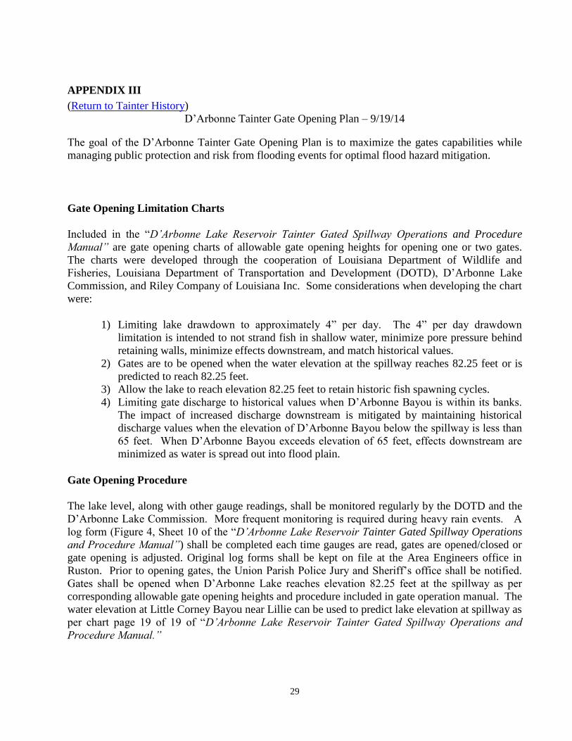
APPENDIX III
(Return to Tainter History)
D’Arbonne Tainter Gate Opening Plan – 9/19/14
The goal of the D’Arbonne Tainter Gate Opening Plan is to maximize the gates capabilities while
managing public protection and risk from flooding events for optimal flood hazard mitigation.
Gate Opening Limitation Charts
Included in the “D’Arbonne Lake Reservoir Tainter Gated Spillway Operations and Procedure
Manual” are gate opening charts of allowable gate opening heights for opening one or two gates.
The charts were developed through the cooperation of Louisiana Department of Wildlife and
Fisheries, Louisiana Department of Transportation and Development (DOTD), D’Arbonne Lake
Commission, and Riley Company of Louisiana Inc. Some considerations when developing the chart
were:
1) Limiting lake drawdown to approximately 4” per day. The 4” per day drawdown
limitation is intended to not strand fish in shallow water, minimize pore pressure behind
retaining walls, minimize effects downstream, and match historical values.
2) Gates are to be opened when the water elevation at the spillway reaches 82.25 feet or is
predicted to reach 82.25 feet.
3) Allow the lake to reach elevation 82.25 feet to retain historic fish spawning cycles.
4) Limiting gate discharge to historical values when D’Arbonne Bayou is within its banks.
The impact of increased discharge downstream is mitigated by maintaining historical
discharge values when the elevation of D’Arbonne Bayou below the spillway is less than
65 feet. When D’Arbonne Bayou exceeds elevation of 65 feet, effects downstream are
minimized as water is spread out into flood plain.
Gate Opening Procedure
The lake level, along with other gauge readings, shall be monitored regularly by the DOTD and the
D’Arbonne Lake Commission. More frequent monitoring is required during heavy rain events. A
log form (Figure 4, Sheet 10 of the “D’Arbonne Lake Reservoir Tainter Gated Spillway Operations
and Procedure Manual”) shall be completed each time gauges are read, gates are opened/closed or
gate opening is adjusted. Original log forms shall be kept on file at the Area Engineers office in
Ruston. Prior to opening gates, the Union Parish Police Jury and Sheriff’s office shall be notified.
Gates shall be opened when D’Arbonne Lake reaches elevation 82.25 feet at the spillway as per
corresponding allowable gate opening heights and procedure included in gate operation manual. The
water elevation at Little Corney Bayou near Lillie can be used to predict lake elevation at spillway as
per chart page 19 of 19 of “D’Arbonne Lake Reservoir Tainter Gated Spillway Operations and
Procedure Manual.”

30
Gate Closing Procedure
The lake level, along with other gauge readings, shall be monitored and logged daily when gates are
open and shall continue until all gates are closed and the lake elevation at D’Arbonne Spillway
reaches 81.75 feet. Gate openings should be adjusted as per allowable gate opening heights included
in gate operation manual. All gates shall be closed when the lake elevation at D’Arbonne Spillway
reaches elevation 81.75 feet and the lake is predicted to continue to fall.
Rules of Thumb for Gate Operation
The following is a summary of helpful information for lake level control:
1) Box area in yellow on allowable gate opening heights included in gate operation manual
is for the lake at 80 feet and a low Bayou D’Arbonne downstream elevation. Anything
outside of this box could draw lake down greater than 4” per day. The 4” per day is a
request of LDWF and is intended to not strand fish in shallow water, minimize pore
pressure behind retaining walls, minimize effects downstream, and match historical
values. Since every possible rain pattern cannot be estimated, working outside this box
will be determined on a case by case basis.
2) The intention is to have some gate opening when the lake level reaches 82.25 feet. The
gates can also be opened when the lake is anticipated to reach 82.25 feet. The top line of
the allowable gate opening heights included in gate operation manual in red is for
clarification that at 82.25 feet, the gate should be open and at these amounts as a
minimum.
3) To help predict when lake level will reach 82.25 feet at D’Arbonne Spillway so gates can
be opened preemptively, the elevation at Little Corney Bayou near Lillie can be
used. There is an approximate one day lag time between water rising at Little Corney
Bayou near Lillie and water rising at D’Arbonne Spillway. This is only an estimate. The
lake can rise without any water entering Little Corney.
4) When D’Arbonne Bayou, downstream of spillway, reaches an elevation of approximately
60 feet, the bank is full. Additional flow at or above 65 feet would spread out into flood
plain with minimal impact. That is why the range of 54 feet to 65 feet is separated. If the
opening values in the tables for 54 feet to 65 feet are maintained, flows downstream will
mirror historical values.
5) If drawdown of the lake is required while lake level is at or below 80 feet, a gate height
opening for one gate of 2 feet above the sill should produce a lake drop of 4 to 6 inches
per day. Once the lake level is below 78 feet, a greater opening may be required to
sustain the 4 inch per day drop.
Closing
The opening and closing recommendations included in this plan are based on historical data and
engineering judgment. The actual lake elevation can be affected by timing, the intensity of heavy
rains, summer evaporation rates, wet/dry years, etc. It is expected that these charts and requirements
will require adjusting as future data is gathered.

31
APPENDIX IV
(return to crappie regs)
NOTICE OF INTENT
Department of Wildlife and Fisheries
Wildlife and Fisheries Commission
The Wildlife and Fisheries Commission hereby establishes the following Rule on Crappie (Pomoxis
spp.) on Bayou D’Arbonne Lake, located in Union and Lincoln Parishes, Louisiana.
Title 76
WILDLIFE AND FISHERIES
Part VII. Fish and Other Aquatic Life
Chapter 1. Freshwater Sports and Commercial Fishing
§197. Crappie Regulations – Daily Take
A. – A.1.a.…
B. Bayou D’Arbonne Lake (Union and Lincoln Parishes) including all areas between the Bayou
D’Arbonne spillway structure and Gill’s Ferry Landing on D’Arbonne Creek and Hogpen Landing
on Corney Creek.
1. Daily Limit – 25 fish per person
a. on water possession – same as daily limit per person.
AUTHORITY NOTE: Promulgated in accordance with R.S.
56:325.1(c).
HISTORICAL NOTE: Promulgated in accordance with Department of Wildlife and
Fisheries, Wildlife and Fisheries Commission, LR 30:2339 (October 2004), amended LR
38:2941(November 2012), amended LR 39:
The secretary of the Department of Wildlife and Fisheries is authorized to take any and all
necessary steps on behalf of the Commission to promulgate and effectuate this Notice of Intent and
the final Rule, including but not limited to, the filing of the Fiscal and Economic Impact Statements,
the filing of the Notice of Intent and final Rule and the preparation of reports and correspondence to
other agencies of government.
Interested persons may submit written comments of the Notice of Intent to Mr. Mike Wood,
Director, Inland Fisheries Section, Department of Wildlife and Fisheries, Box 98000, Baton Rouge,
LA 70898-9000 no later than 4:30 p.m., June 2013.
In accordance with Act #1183 of the 1999 regular session of the Louisiana Legislature, the
Department of Wildlife and Fisheries/Wildlife and Fisheries Commission hereby issues its Family
Impact Statement in connection with the preceding Notice of Intent: This Notice of Intent will have
no impact on the six criteria set out at R.S. 49:972(B).
Mr. Ronald Graham
Chairman

32
APPENDIX V
(return to water quality )
EPA ASSESSMENT DATA FOR D’ARBONNE WATERSHED - 2002
Table
Legend:
Water Status is
Good
Water Status is
Threatened
Water Status is
Impaired
Water Status has not been
Assessed
Water Name Assessment
Unit ID Location
Water
Type
Water
Size Unit
Water
Status
Bayou D'Arbonne -
From Bayou
D'Arbonne Lake to
Ouachita Riv.
LA080605_00
Bayou D'Arbonne-
From Bayou
D'Arbonne Lake to
Ouachita River
(Scenic)
RIVER 31 MILES IMPAIRED
Bayou D'Arbonne -
Headwaters to Lake
Claiborne
LA080601_00
Bayou D'Arbonne-
Headwaters to Lake
Claiborne
RIVER 20 MILES IMPAIRED
Bayou D'Arbonne -
Lake Claiborne to
Bayou D'Arbonne
Lake
LA080603_00
Bayou D'Arbonne-
From Lake Claiborne
to Bayou D'Arbonne
Lake
RIVER 35 MILES GOOD
Bayou D'Arbonne
Lake LA080604_00
Bayou D'Arbonne
Lake LAKE 15251 ACRES GOOD
Corney Bayou -
From Arkansas
State Line to
Corney Lake
LA080607_00
Corney Bayou-From
Arkansas State Line to
Corney Lake (Scenic)
RIVER 28 MILES GOOD
Corney Bayou -
From Corney Lake
to Bayou
D'Arbonne Lake
LA080609_00
Corney Bayou-From
Corney Lake to Bayou
D'Arbonne Lake
(Scenic)
RIVER 21 MILES IMPAIRED
Corney Lake LA080608_00 Corney Lake LAKE 1920 ACRES GOOD
Cypress Creek -
Headwaters to
Bayou D'Arbonne
LA080606_00
Cypress Creek-
Headwaters to Bayou
D'Arbonne (includes
Colvin Creek)
RIVER 17 MILES IMPAIRED
Lake Claiborne LA080602_00 Lake Claiborne LAKE 6400 ACRES GOOD
Middle Fork of
Bayou D'Arbonne -
Origin-Bayou
D'Arbonne Lake
LA080610_00
Middle Fork of Bayou
D'Arbonne-From
origin to Bayou
D'Arbonne Lake
(Scenic)
RIVER 43 MILES IMPAIRED
33
APPENDIX VI
(return to hunting)
BAYOU D’ARBONNE WATERSHED DISTRICT REGULATIONS
Pursuant to its goal to maintain Lake D’Arbonne as a premier lake and to facilitate its use and
enjoyment by all citizens, the Lake Commission has adopted various Ordinances regulating use of
the Lake. These regulations are summarized below.
Boat Launching
No person is allowed to use any Boat Launching Facility, whether publicly or privately owned, for
any purpose other than the launching of a boat.
All water craft shall be placed into the water and removed from the water at the ramp.
No fishing is permitted within 50 feet from the ramp at any Boat Launching Facility.
No overnight camping is permitted anywhere on any Boat Launching Facility.
No fires of any kind are allowed on any Boat Launching Facility.
No person is allowed on any Boat Launching Facility from sunset to sunrise except individuals
loading and unloading boats and gaining access to vehicles lawfully parked on the Boat
Launching Facility parking area
No littering, dumping or depositing refuse is allowed in or around any Boat Launching Facility
except in proper garbage and trash containers.
No horses are allowed on any Boat Launching Facility.
Only licensed motor vehicles are allowed on any Boat Launching Facility. Vehicles should not be
driven at a greater rate of speed than shown on posted speed limit signs at the Boat Launching
Facility. Parking of vehicles is restricted to hard road surfaces and designated parking areas.
No alcoholic beverages are to be consumed on any Boat Launch Facility. Loud, unnecessary noises
or music or improper conduct are not permitted, also.
No firearms shall be discharged on any Boat Launching Facility.
No swimming is allowed from any Boat Launching Facility.
Willful injury or destruction, or attempt to injure or destroy, any kind of public structure is
prohibited at any Boat Launching Facility.
A violation is considered a misdemeanor and carries a fine not to exceed $500 or imprisonment in
the parish jail for no more than 30 days, or both.
Watercraft Speeds
All watercraft must reduce to idle speed within fifty (50’) feet of all state highway bridges over the
Lake.
A violation is considered a misdemeanor and carries a fine not to exceed $500.
Duck Blinds / Firearms
No duck blind or other structure is allowed to be constructed less than 1,000 feet from any dwelling
located on or near the shoreline of the Lake.
No person is allowed to engage in hunting activities or discharge any firearm less than 1,000 feet
from any dwelling located on or near the shoreline of the Lake.
A violation is considered a misdemeanor and carries a fine not to exceed $500 or imprisonment in
the parish jail for no more than 30 days, or both.
Metallic Objects
The placing of metallic objects in the Lake is strongly discouraged, other than a metallic object for a
user’s temporary use, such as a boat, motor or recreational equipment.

34
The use of any types of metallic rods, stakes, pipes, poles, tubing, rebar, or similar objects in the
Lake is prohibited except in the following situations:
a) In connection with signs, markers, or other objects placed with the permission of the State of
Louisiana;
b) In connection with docks, piers, boathouses or other structures permanently attached to the
shore/bank of the Lake;
c) In connection with floating docks or other structures clearly marked to be visible to persons
using the Lake;
d) In connection with duck blinds constructed on or prior to September 1, 2003, if the duck
blind is actually used for waterfowl hunting each season and is clearly marked;
e) In connection with floating duck blinds constructed after September 1, 2003, (no metal
objects should be driven into the Lake bed), if the duck blind is actually used for waterfowl
hunting each season and is clearly marked;
f) In connection with the mounting of a light, birdhouse, slide, swing, or similar object in close
proximity to a dwelling located on the shore or bank of the Lake.
The placing of any cable, wire, rope or other similar apparatus above the surface of the Lake that is
used to support, hang, or attach markers, signs, yo-yos, mechanical trigger devices, trotlines, hooks,
or any other device is prohibited.
A violation is considered a misdemeanor and carries a fine not to exceed $500.
Piers / Boathouses
Each pier, dock, boathouse, barge or other structures extending into the Lake should not extend more
than 100 feet or 25% of cove width, whichever is less, perpendicular from the 80.0 foot mean sea
level contour line of the Lake, unless written approval is obtained from the Lake Commissioners
Board.
This applies to all such existing piers and structures which are materially enlarged or altered after
July 1, 2004, and applies to all new structures constructed after July 1, 2004.
Commercial piers or structures are exempt from this ordinance, although such commercial piers or
structures may otherwise be regulated by the Board.
The following guidelines are recommended on the Lake:
a) Each pier or dock extending into the Lake may contain a porch, deck, or similar structure,
provided that the same shall not be used for living quarters, and may contain a boat house
or boat slips.
b) Posts and material touching water should be treated wood. Flooring and handrails should
be treated wood (minimum 2” x 6”).
c) All pier wiring should be placed in conduit.
d) All floating piers, docks, boathouses, barges and/or other structures must be securely
attached or moored in an approved manner at all times and anchored properly in order to
prevent them from becoming unmoored and floating away during periods of high water.
Highway Rights of Way
Parking on highway rights of way is prohibited by the Louisiana Department of Transportation and
Development.
Flood Mitigation
The normal pool stage for Lake D’Arbonne is 80 feet. Lake water levels of 84 feet and higher is
considered to be flood level stage and the Lake is closed to all boat traffic. The Bayou D’Arbonne
Lake Watershed District has adopted procedures to request opening the spillway gates at 85 feet and
having them remain open until the water level drops back to 83 feet.

35
Drawdown Schedule
The Bayou D’Arbonne Lake Watershed District has adopted a policy of a fall drawdown every four
years beginning in 2004 involving opening the spillway gates the day after Labor Day and closing
them on November 15th
. This will enable homeowners to complete necessary repairs and allow for
ramp maintenance, channel maintenance, and stump clearing.

36
APPENDIX VII
RELATED PUBLICATIONS
Davis, James T. and Janice S. Hughes. 1964. Results of Creel Census on Four North Louisiana
Lakes. Proc. Ann. Conf. Southeast. Assoc. Fish and Wild. Agencies 18:495-506.
Hughes, Janice S. and Neil H. Douglas. 1965. Movement of Native and Stocked Fish in
D’Arbonne Lake after Impoundment. Proc. Ann. Conf. Southeast. Assoc. Fish and
Wildl. Agencies 19:349-363.
Davis, James T. and Janice S. Hughes. 1965. Effects of Impoundment on the Benthic Population of
Bayou D’Arbonne, Louisiana. Proc. Ann. Conf. Southeast. Assoc. Fish and Wild.
Agencies 19:364-374.
Grafton, Tommy D. 1965. A History of the Lake D’Arbonne Project. Unpublished. 57 pp.
Walker, Bobby T. 1965. A Taxonomic Survey of the Fish Fauna of Bayou D’Arbonne Drainage
System Prior to Impoundment. Proc. LA Acad. Sciences Vol. XXVIII, December, pp.
105-110.
Wood, Michael G. 1981. A Taxonomic Survey of the Fishes of Bayou D’Arbonne after
Impoundment. MS Thesis. NLU. 115 pp.
FTN Associates Ltd., 2001, Tributaries to Bayou D’Arbonne Lake TMDL for Biochemical
Oxygen-Demanding Substances, 30pp.