Embed Size (px)
Citation preview
STAG: Smart Tools & Apps for Graphics (2015)Silvia Biasotti and Marco Tarini and Andrea Giachetti (Editors)
Low-cost Experimental Setups for Mid-air 3D Reconstruction
Alexandru Dancu1, Marco Fratarcangeli1, Mickaël Fourgeaud1, Zlatko Franjcic2,1, Daniel Chindea3, Morten Fjeld1
1Chalmers University of Technology, Sweden 2Qualisys AB, Sweden 3highimage.se
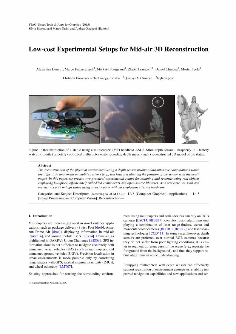
Figure 1: Reconstruction of a statue using a multicopter: (left) handheld ASUS Xtion depth sensor - Raspberry Pi - batterysystem; (middle) remotely controlled multicopter while recording depth maps; (right) reconstructed 3D model of the statue.
AbstractThe reconstruction of the physical environment using a depth sensor involves data-intensive computations whichare difficult to implement on mobile systems (e.g., tracking and aligning the position of the sensor with the depthmaps). In this paper, we present two practical experimental setups for scanning and reconstructing real objectsemploying low-price, off-the-shelf embedded components and open-source libraries. As a test case, we scan andreconstruct a 23 m high statue using an octocopter without employing external hardware.
Categories and Subject Descriptors (according to ACM CCS): I.3.8 [Computer Graphics]: Applications—; I.4.5[Image Processing and Computer Vision]: Reconstruction—
1. Introduction
Multicopters are increasingly used in novel outdoor appli-cations, such as package delivery (Swiss Post [drob], Ama-zon Prime Air [droa]), displaying information in mid-air[SAS∗14], and around mobile users [Luk14]. However, ashighlighted in DARPA’s Urban Challenge [BIS09], GPS in-formation alone is not sufficient to navigate accurately bothunmanned aerial vehicles (UAV) such as multicopters, andunmanned ground vehicles (UGV). Precision localisation inurban environments is made possible only by correlatingrange images with GPS, inertial measurement units (IMUs),and wheel odometry [LMT07].
Existing approaches for sensing the surrounding environ-
ment using multicopters and aerial devices can rely on RGBcameras [ESC14,BBBE14], complex fusion algorithms em-ploying a combination of laser range-finders, stereo andmonocular color cameras [BPHR11,BBR12], and laser scan-ning technologies [CCD∗11]. In some cases, however, depthsensors are preferred over normal RGB cameras becausethey do not suffer from poor lighting conditions, it is eas-ier to segment different parts of the scene (e.g., separate theforeground from the background), and thus they support ro-bust algorithms in scene understanding.
Equipping multicopters with depth sensors can effectivelysupport registration of environment geometries, enabling im-proved navigation capabilities and new applications and ser-
c© The Eurographics Association 2015.

A. Dancu et. al / Low-cost Experimental Setups for Mid-air 3D Reconstruction
vices. For example, there are already ongoing initiativesaiming to create connected and sustainable cities and somemethods are to utilize networks of fixed and mobile sensors[icr]. Data from urban sensors and mobile phones can be ag-gregated and could be used in urban analysis studying urbandynamics and offering location-based services [RWFP06].The required data of the urban state can be collected inmainly two ways: installing fixed sensors and aggregatingdata from moving sensors roaming in the environment. Us-ing multicopters clearly offers an additional method to col-lect the required environmental data.
As we synthesise the engineering challenges raised in thearea of navigation and in the area of cartographic services,we suggest that both these, and further areas (e.g., culturalheritage [MFE13, PCGS15]), present the following researchquestions (RQ) worthy of scientific investigation:
RQ1: What are the criteria for successful low-cost strategyfor acquiring 3D geometry from a multicopter hardware set-up enabling real-time reconstruction?
RQ2: What is an efficient strategy for online analysis ofa reconstructed mesh enabling mesh correction and re-scanning if needed?
In this paper, we describe two hardware setups based onregistration tools using components that are low-cost andwidely available on the market. In the first experiment, weuse a Raspberry Pi connected to an ASUS Xtion depth sen-sor. Depth maps are recorded and then downloaded and re-constructed offline. The obtained meshes are visualized andfurther aligned manually. In the second experiment, we testthe real-time reconstruction capabilities of the mobile paral-lel platform Jetson K1.
2. Related work
We review applications of real-time reconstruction per-formed on the ground indoors or outdoors, and research em-ploying multicopters where SLAM is used in navigation andenvironment mapping.
Low-cost depth sensors support new types of applicationsbased on real-time reconstruction of the physical environ-ment. Google Tango [tan] attempts to give mobile devicesan understanding of space and motion by integrating depthsensors and combining it with accelerometer and gyroscopedata of mobile phones. Chow et. al [CLH∗14] propose a mo-bile mapping system for indoor environments that integrateIMU, depth maps from two Kinects, and range images froma LiDAR system.
The wide availability of multicopter systems support theacquisition of images from hovering or flying objects andpose new research challenges. Several autonomous quadro-tor platforms have been developed that are able to navigate,
map, and explore the environment using stereo vision andrun SLAM off-board [FHH∗12, HHL∗14].
Indoor real-time reconstruction was performed by stream-ing depth maps through a wifi connection from an ASUSXtion sensor mounted on a quadcopter [Hub14]. More re-cently, a multicopter platform has been developed that runsSLAM real-time and can integrate the data from a team ofmicroaerial vehicles into a global mapping and localizationat 1 Hz [SAD∗14].
Another approach is to use monocular RGB vision and cre-ate inexpensive 3D models of buildings through aerial pho-tography using a GoPro camera mounted on multicopter[BBBE14]. This approach is similar to a commercial freeservice called ReCap 360 [rec] that uses cloud-computing tocreate 3D models of environments from photographs takenwith a GoPro camera and a multicopter.
In contrast, we present two setups not relying on any WIFIconnection, using a depth sensor instead of RGB camera,and thus more robust to lighting conditions. Furthermore,our second setup (Sec. 3.2) is able to reconstruct a scannedobject online without using external computers.
3. Experiments
We present two setups for mid-air reconstruction to ob-tain range images from depth sensors using an octocopter.Both the setups are based on off-the-shelf hardware compo-nents and open-source software. As a test case, we recon-structed a sculpture which is 23.3 meters high and, as such,it is impractical to scan without an aerial device (Fig. 2).
Figure 2: The scanned statue.
In the first experiment(Sec. 3.1), the depthmaps are recordedduring the flight, andthen the reconstructionpress is performedoffline on a laptopcomputer with CUDAcapabilities. The sec-ond experiment (Sec.3.2) is designed toperform real-timereconstruction directlyduring the flight. Inboth the experiments,we used the Kinect Fu-sion [NDI∗11,IKH∗11] reconstruction method implementedin the Point Cloud Library (PCL) [AMT∗12].
3.1. Offline reconstruction with Raspberry Pi
In this first experiment, we recorded range images with adepth sensor connected to a Raspberry Pi (a small, low-costcomputer) [UH14], mounted on the octocopter. There are
c© The Eurographics Association 2015.

A. Dancu et. al / Low-cost Experimental Setups for Mid-air 3D Reconstruction
Figure 3: Components of the mid-air reconstruction system.
mainly two low-cost depth sensors available on the mar-ket, namely the Microsoft Kinect [Zha12] and the ASUSXtion [GJRVF∗13]. Since the Kinect has a significantly big-ger weight (810g) and power consumption (3.4W) comparedto Xtion (220g and 2.5W), we employed the Xtion sensor.
3.1.1. System components
Our system uses low-price components: the Raspberry Pi(RPi) [UH14] and the ASUS Xtion sensor [GJRVF∗13] toacquire and record depth maps. RPi is a $35 credit-cardsized computer equipped with a 700 MHz CPU and 500 MBRAM. The Raspbian operating system (OS) is basically adistribution of Linux optimized for the RPi. The open-sourcelibrary OpenNI [Fal13] is used to acquire the depth maps.
We connected the Xtion to the RPi through one of the twoUSB ports. However, problems with SD cards threatened thestability of the system. These issues were investigated andtests were made in order to determine the state of the sys-tem. Because of the great number read-write cycles requiredby the compilation process, several cards got corrupted. Asolution was found by connecting a flash drive and compil-ing and recording depth maps on it instead of the SD cardfrom where the OS was running.
The octocopter frame was built from aluminum rodsmounted in a star-shape. At the ends of the eight rods thebrushless motors Turnigy 2216 were mounted. The flightcontroller was Mikrokopter [mks]. The Lithium Polymer 4sbattery of 14.8V and 5A supported a 10 minute flight time.Two batteries were used. One rod was extended and theXtion was mounted on it. For balance, on the opposite rod a5V battery connected to the RPi from Fig. 3 were mounted.
3.1.2. Procedure and stages of reconstruction
The steps required for this experiment were the following:
Figure 4: A screenshot of Meshlab [CCC∗08] during themanual mesh alignment.
Record depth maps: The depth maps were recorded on theflash drive using the OpenNI library [Fal13] as an ONI file.The front of the statue was of interest with the the body of thehorse rider and the horse front. The octocopter was flown re-motely by looking up at it (Fig. 1, middle). After each flight,the octocopter landed and the recording process restarted.
Reconstruct with Kinect Fusion: The ONI files were thenloaded in Kinect Fusion and the mesh patches were acquiredexamining various sequences of the video. Since the oc-tocopter moved continuously and the scanned volume waslarge, the amount of acquired did not fit in the availablememory. Hence, the reconstruction process had to be oftenrestarted, and the resulting 8 meshes were obtained from se-quences of a couple seconds.
Manual mesh alignment: The meshes obtained in the pre-vious stage have been aligned and visualized in Meshlab[CCC∗08] (Fig. 4). This manual process took several hoursand was mainly due to the loss in camera tracking and thelimited reconstruction volume of Kinect Fusion.
3.1.3. Speedup of recording depth maps
We customized the RPi hardware configuration, sothat the dynamic cpu frequency driver is disabled(force_turbo=1), and the frequency of the CPU, GPUprocessor core and RAM are overclocked. The Rasp-berry Pi system configuration parameters, that are usu-ally in the BIOS settings, are stored in the folder/boot/config.txt file on the SD card. Table 1 sum-marizes some filesystem, memory, and processor configura-tions. These are settings which were tested and incremen-tally adjusted. The following options raised the ONI filerecording performance from 4 to 7 fps:
• force_turbo=1
c© The Eurographics Association 2015.

A. Dancu et. al / Low-cost Experimental Setups for Mid-air 3D Reconstruction
• over_voltage=0• core_freq=350• arm_freq=800• sdram_freq=600
In particular, increasing the CPU and SDRAM frequencyincreased the performance to 10 – 15 fps. To compen-sate the consequent over-heating, we mounted an additionalheatsink. Finally, we found that recording speed increasesover 20 fps when an externally mounted USB memory isemplyed instead of the SD card where the OS resides.
3.1.4. Lessons learned
Using the described set-up, the actual 3D reconstructiontakes place offline and there is not any real-time visual feed-back of the scanning process. Hence, the user is not ableto assess the quality of the 3D model while the octocopteris flying to 10–15m from the ground, e.g., the presence ofholes in the mesh, if the sculpture is outside the field of viewof the sensor due to a wrong flight path, etc.
Furthermore, the size of the volume which can be recon-structed with the PCL Kinect Fusion is constrained to alimited size (i.e., 512 x 512 x 512 voxels), which wasnot enough to include the whole statue in a single flightscan. This, together with aforementioned issues, forced us torestart the reconstruction several times for different pieces ofthe statue, and acquire several meshes that were later alignedmanually.
Robustness is an acknowledged issue with real-time recon-struction algorithms and rely mostly on the movement of thesensor around the scanned object. We found that also visual-izing the current state of the reconstruction is of utmost im-portance. In our test case, this interaction is given by the stateof the reconstruction and necessary sensor movement, and itis even more difficult since the movement is done remotelyfrom the ground while the multicopter is several meters upin the air.
3.2. Real-time reconstruction with Jetson K1
In the second experiment, we tested the NVIDIA JetsonK1 board capabilities for real-time reconstruction. We didnot mount this system on a multicopter yet since the re-construction performance requires improvement. Here wepresent our current promising results on this platform. TheJetson K1 is a parallel mobile platform which has been re-cently released by Nvidia for embedded applications suchas computer vision, robotics, and automotive [Teg]. It deliv-ers 326 GFlops at low cost ($192) and low power consump-tion (10w). The Jetson TK1 is powered by Tegra K1, whichcurrently sets the performance record of embedded systemchips. the hardware set-up is depicted in Fig. 5.
We compiled the PCL Kinect Fusion implementation for theARM platform, and then analyzed its performance using the
Figure 5: Jetson board connected to the ASUS Xtion depthsensor on top of a battery
Figure 6: Experiment 2 library calls and their CPU usage
NVIDIA System Profiler. The obtained average frame rateis 3.1 fps while moving the sensor and 4.1 fps while keep-ing the sensor still. Running the application from the shellonly and removing the windows that render the reconstruc-tion and the depth maps yield an average of 4.2 fps whenmoving the sensor and 4.9-5.2 while still. This frame ratewas considered not sufficient in order to try the reconstruc-tion on the multicopter, so we started to analyze bottleneckswith NVIDIA System Profiler. Fig. 6 shows the library callsresponsible for the highest CPU usage together with the rel-ative percentage of CPU load within a single frame.
Reading from the USB requires the highest CPU load(xnUSBReadThreadMain: 22%, libusb: 19.7%). Re-garding the CUDA kernel calls, the following have the high-est call frequency: combinedKernel (42.7%), tsdf23(15.7%), computeNmapKernel (13.3%), rayCastK-ernel (11.2%), bilateralKernel (10.8%).
Based on our tests, additional factors that influence the qual-ity of the reconstruction are:
• the angle between the reconstructed surface and the cam-era: if the angle is perpendicular on the reconstructed sur-face, then the quality of the mesh is visibly higher.
• the distance from the sensor to the surface: a closer prox-
c© The Eurographics Association 2015.

A. Dancu et. al / Low-cost Experimental Setups for Mid-air 3D Reconstruction
Dev File Argument Description
FS tune2fs -c 1 /dev/mmcblkp02 Check alwaysFS /etc/default/rcS FSCKFIX=yes AutocorrectionSW /etc/init.d/rc.local swapoff -a Turn off swapCPU /boot/config.txt force_turbo=1 Turn off dynamic freq.
Table 1: Experiment 1, parameters for filesystem (FS), swap (SW), CPU
imity to the reconstructed surface results in a higher qual-ity mesh.
• the path of the sensor: the path of the sensor movementaround the scanned statue reduce the holes in the meshgeometry. At the object boundaries, the sensor should bemoved so that the object is completely scanned.
• planar surfaces often result in failure of tracking of thecamera position.
4. Discussion and future work
We presented two experimental setups to obtain the geom-etry of a statue that does not allow a direct scan from theground. The first experiment employed the widely availableRaspberry Pi platform. The reconstruction process and re-sults showed the need for visualizing and processing thedepth maps in real-time.
Concerning RQ1, and based on the insights from our firstset-up (Sec. 3.1), we developed the hardware set-up usingthe the Jetson K1 which enables 3D reconstruction in real-time on the multicopter (Sec. 3.2). This allowed for the on-line analysis of the current state of the reconstructed mesh,enabling its correction and re-scanning if necessary. In thissecond experiment we show that nearly real-time reconstruc-tion is achievable, however faster performance is desirableand more optimization is required. Also, this set-up posednew research questions, such as:
• what is a good path for moving the sensor?• what interface and visualization would allow the user to
have a complete understanding of what was scanned?• how shall the path of scanning be modified so that the user
is able to correct the scan?
Concerning RQ2, we found that real-time reconstruction andvisualization is necessary in order to fully reconstruct andobtain a quality mesh of the real object. Controlling the oc-tocopter flight path and checking the state of the reconstruc-tion is a challenge, but might be solved through a screen thatis permanently in the field of view of the user who controlsthe octocopter.
Future work could include visualization and analysis of thereconstruction state in real-time and to explore the inter-action of the user while in the loop of this data-intensiveprocess. Future applications could include prototyping non-wearable applications for interaction in motion consisting
Figure 7: Reconstructed 3D model of the statue.
in projecting interfaces from above around the body ofusers, similar to the Autonomous Wandering Interface con-cept [Luk14]. Such mobile platforms would follow users andaugment the physical space around them with contextual in-formation. The work presented here is the basis for develop-ing interaction techniques and visualization methods relyingon real-time reconstruction methods.
5. Acknowledgments
This work was supported by the EU FP7 People Programme(Marie Curie Actions) under REA Grant Agreement 290227.
References[AMT∗12] ALDOMA A., MARTON Z.-C., TOMBARI F.,
WOHLKINGER W., POTTHAST C., ZEISL B., RUSU R. B.,GEDIKLI S., VINCZE M.: Point cloud library. IEEE Robotics& Automation Magazine 1070, 9932/12 (2012). 2
[BBBE14] BERTRAMA T., BOCKB T., BULGAKOVC A.,EVGENOVD A.: Generation the 3d model building by using thequadcopter. The 31st International Symposium on Automationand Robotics in Construction and Mining (ISARC 2014) (2014).1, 2
c© The Eurographics Association 2015.
A. Dancu et. al / Low-cost Experimental Setups for Mid-air 3D Reconstruction
[BBR12] BRY A., BACHRACH A., ROY N.: State estimation foraggressive flight in gps-denied environments using onboard sens-ing. In Robotics and Automation (ICRA), 2012 IEEE Interna-tional Conference on (2012), IEEE, pp. 1–8. 1
[BIS09] BUEHLER M., IAGNEMMA K., SINGH S.: The DARPAUrban Challenge: Autonomous vehicles in city traffic, vol. 56.springer, 2009. 1
[BPHR11] BACHRACH A., PRENTICE S., HE R., ROY N.:Range - robust autonomous navigation in gps-denied environ-ments. Journal of Field Robotics 28, 5 (September 2011), 644–666. 1
[CCC∗08] CIGNONI P., CALLIERI M., CORSINI M., DELLEPI-ANE M., GANOVELLI F., RANZUGLIA G.: Meshlab: an open-source mesh processing tool. In Eurographics Italian ChapterConference 2008, Salerno, Italy, 2008 (2008), pp. 129–136. 3
[CCD∗11] CALLIERI M., CHICA A., DELLEPIANE M., BE-SORA I., CORSINI M., MOYÉS J., RANZUGLIA G., SCOPIGNOR., BRUNET P.: Multiscale acquisition and presentation of verylarge artifacts: The case of portalada. J. Comput. Cult. Herit. 3,4 (Apr. 2011), 14:1–14:20. 1
[CLH∗14] CHOW J. C., LICHTI D. D., HOL J. D., BELLUSCIG., LUINGE H.: Imu and multiple rgb-d camera fusion for as-sisting indoor stop-and-go 3d terrestrial laser scanning. Robotics3, 3 (2014), 247–280. 2
[droa] Amazon primeair. http://www.amazon.com/b?node=8037720011. Accessed: 2015-07-30. 1
[drob] Swiss post, swiss worldcargo and matternet drone tests.https://goo.gl/GcCu0o. Accessed: 2015-07-30. 1
[ESC14] ENGEL J., STURM J., CREMERS D.: Scale-aware nav-igation of a low-cost quadrocopter with a monocular camera.Robotics and Autonomous Systems (RAS) 62, 11 (2014), 1646–U1656. 1
[Fal13] FALAHATI S.: OpenNI Cookbook. Packt Publishing,2013. 3
[FHH∗12] FRAUNDORFER F., HENG L., HONEGGER D., LEEG. H., MEIER L., TANSKANEN P., POLLEFEYS M.: Vision-based autonomous mapping and exploration using a quadrotormav. In Intelligent Robots and Systems (IROS), 2012 IEEE/RSJInternational Conference on (2012), IEEE, pp. 4557–4564. 2
[GJRVF∗13] GONZALEZ-JORGE H., RIVEIRO B., VAZQUEZ-FERNANDEZ E., MARTÍNEZ-SÁNCHEZ J., ARIAS P.: Metro-logical evaluation of microsoft kinect and asus xtion sensors.Measurement 46, 6 (2013), 1800–1806. 3
[HHL∗14] HENG L., HONEGGER D., LEE G. H., MEIER L.,TANSKANEN P., FRAUNDORFER F., POLLEFEYS M.: Au-tonomous visual mapping and exploration with a micro aerialvehicle. Journal of Field Robotics 31, 4 (2014), 654–675. 2
[Hub14] HUBER G.: Full autonomous quadcopter for 3D recon-struction without external sensors. Master’s thesis, Linz Univer-sity, http://goo.gl/HGoi6A, 2014. 2
[icr] Icri cities. http://www.cities.io. Accessed: 2015-07-30. 2
[IKH∗11] IZADI S., KIM D., HILLIGES O., MOLYNEAUX D.,NEWCOMBE R., KOHLI P., SHOTTON J., HODGES S., FREE-MAN D., DAVISON A., FITZGIBBON A.: Kinectfusion: Real-time 3d reconstruction and interaction using a moving depth cam-era. In Proceedings of the 24th Annual ACM Symposium on UserInterface Software and Technology (New York, NY, USA, 2011),UIST ’11, ACM, pp. 559–568. 2
[LMT07] LEVINSON J., MONTEMERLO M., THRUN S.: Map-based precision vehicle localization in urban environments. InRobotics: Science and Systems (2007), vol. 4, Citeseer, p. 1. 1
[Luk14] LUKE VINK, JESSICA CAUCHARD, JAMES A. LAN-DAY: Autonomous wandering interface (awi) – concept video.https://youtu.be/cqU_hR2_ILU (2014). 1, 5
[MFE13] MURRU G., FRATARCANGELI M., EMPLER T.: Practi-cal augmented visualization on handheld devices for cultural her-itage. In Computer Graphics, Visualization and Computer Vision(2013), Agency V. S.-U., (Ed.). 2
[mks] Mk sweden. http://www.mksweden.se/. Accessed:2015-07-30. 3
[NDI∗11] NEWCOMBE R. A., DAVISON A. J., IZADI S., KOHLIP., HILLIGES O., SHOTTON J., MOLYNEAUX D., HODGES S.,KIM D., FITZGIBBON A.: Kinectfusion: Real-time dense sur-face mapping and tracking. In Mixed and augmented reality(ISMAR), 2011 10th IEEE international symposium on (2011),IEEE, pp. 127–136. 2
[PCGS15] PINGI P., CORSINI M., GANOVELLI F., SCOPIGNOR.: Fast and simple automatic alignment of large sets of rangemaps. Computers & Graphics 47 (2015), 78 – 88. 2
[rec] Autodesk recap 360. https://recap360.autodesk.com. Accessed: 2015-07-30. 2
[RWFP06] RATTI C., WILLIAMS S., FRENCHMAN D.,PULSELLI R.: Mobile landscapes: using location data fromcell phones for urban analysis. Environment and Planning BPlanning and Design 33, 5 (2006), 727. 2
[SAD∗14] SCARAMUZZA D., ACHTELIK M. C., DOITSIDISL., FRIEDRICH F., KOSMATOPOULOS E., MARTINELLI A.,ACHTELIK M. W., CHLI M., CHATZICHRISTOFIS S., KNEIPL., ET AL.: Vision-controlled micro flying robots: from sys-tem design to autonomous navigation and mapping in gps-deniedenvironments. Robotics & Automation Magazine, IEEE 21, 3(2014), 26–40. 2
[SAS∗14] SCHNEEGASS S., ALT F., SCHEIBLE J., SCHMIDTA., SU H.: Midair displays: Exploring the concept of free-floating public displays. In CHI ’14 Extended Abstracts on Hu-man Factors in Computing Systems (New York, NY, USA, 2014),CHI EA ’14, ACM, pp. 2035–2040. 1
[tan] Google tango. https://www.google.com/atap. Ac-cessed: 2015-07-30. 2
[Teg] Nvidia embedded computing. https://developer.nvidia.com/embedded-computing. Accessed: 2015-07-30. 4
[UH14] UPTON E., HALFACREE G.: Raspberry Pi user guide.John Wiley & Sons, 2014. 2, 3
[Zha12] ZHANG Z.: Microsoft kinect sensor and its effect. Mul-tiMedia, IEEE 19, 2 (2012), 4–10. 3
c© The Eurographics Association 2015.