Embed Size (px)
Citation preview
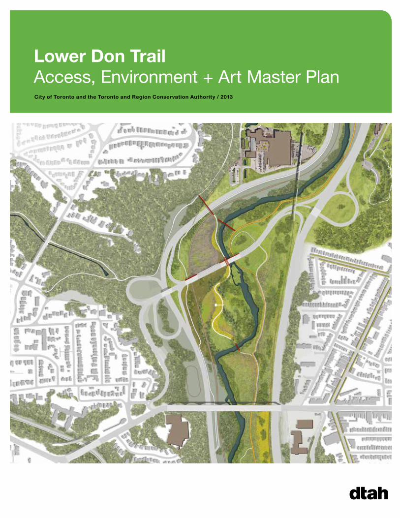
Lower Don Trail Access, Environment + Art Master PlanCity of Toronto and the Toronto and Region Conservation Authority / 2013


Prepared for:
City of Toronto
Toronto and Region Conservation Authority
Prepared by:
DTAH Project Lead, Landscape Architecture and Urban Design
AECOM Ecology, Transportation, Civil Engineering
Public Space Workshop Trail Connectivity
LURA Consultation
Andrew Davies Design Public Art
SPH Planning + Consulting Accessibility
September 2013
With special thanks to the staff of TRCA and the City of Toronto Parks, Transportation, Culture and Planning Departments. Thanks also to Metrolinx, Evergreen, and those members of the public who attended the open house session or contacted us with their comments on the future of the Lower Don Trail.
Lower Don Trail Access, Environment + Art Master Plan

“As the years go on and the population increases, there will be a need of these and more lands, and in life where so much appears futile, this one thing will remain. In essence, those who continue to support the work of conservation can say, I have lived here, I have done something positive to ensure that its natural beauty and natural values continue.”
– Charles Sauriol (1904-1995), local resident and lifelong advocate for conservation in the Don Valley.

Executive Summary 1
1 / Introduction
1.1 Background 31.2 Problem Statement, Goals and Context 61.3 Recommended Design Principles 7
2 / Process
2.1 Project Timeline 92.2 Existing Conditions 102.3 Previous Studies 122.4 SWOT Analysis 132.5 Public Consultation 152.6 Stakeholder Consultation 17
3 / Master Plan
3.1 Demonstration Plan 193.2 Themes and Strategies 283.3 Site-Specific Project Guidelines 363.4 Non-Site-Specific Project Guidelines 52
4 / Next Steps
4.1 Implementation 574.2 Short-Term Period (0 to 3 Years) 584.3 Medium-Term Period (3 to 10 Years) 614.4 Opportunities for Future Exploration 64
Appendices
Project Cost EstimatesPublic Meeting SummaryExisting Conditions and Opportunities and Constraints Memo
Table of Contents

Prince Edward Viaduct, seen looking northeast from the Lower Don Trail.

Lower Don Trail Access, Environment + Art Master Plan 1
Executive Summary
Structure
The Introduction includes a brief description of the historic and present conditions of the Valley and an explanation of the goals and principles of the Master Plan. This is followed by a summary of the study’s Process in terms of research and consultation.
The vision of the Master Plan–encapsulated in the Demonstration Plan–shows the Lower Don Valley as it might be after the completion of an array of projects and restoration efforts. Those projects are itemized, mapped and described through guidelines.
The final Next Steps section organizes the implementation of those projects into phases, and describes which actors would be involved in realizing them.
The Master Plan in Context
The work of restoring and revitalizing the Don Valley is ongoing. In some cases, this Master Plan has brought back proposals that were previously contemplated but never implemented, such as stairways at the Dundas and Gerrard bridges. In other cases, it has aimed to capitalize on recent or planned redevelopments. In still other cases, entirely new opportunities have presented themselves, far beyond the expectations of the past.
The Master Plan is a road map forward, laying out a logical and interconnected series of future projects. As it has built on a body of previous work, the detailed implementation of each of these projects will build on it in turn. Consequently, the description of each of these projects is painted in broad strokes, and framed as guidelines rather than detailed designs.
It is hoped, and indeed believed at this present stage, that this Master Plan will be the beginning in a bold new chapter of the ongoing revitalization of the Lower Don Valley.
The Lower Don Trail stretches from Taylor Creek to Lakeshore Boulevard, following the Don River. This document presents a high-level vision for the future of the portion of that trail south of Pottery Road.

2 Lower Don Trail Access, Environment + Art Master Plan
Former Don Roadway (the current site of the Don Valley Parkway), following the straightening of the lower Don River.
2 Lower Don Trail Access, Environment + Art Master Plan Lower Don Trail Access, Environment + Art Master Plan 3
Not every city has a vast landscape of forests, fields and marshes within walking distance of its downtown core. The Lower Don Valley is one of Toronto’s largest, most centrally located—but perhaps also most under appreciated—urban open spaces.
Toronto’s Backyard
The lower Don Valley, in many ways, echoes the history of Toronto. Although its marshy character never allowed intensive development, it was the site of some of the earliest European settlement in the present city, as pioneers sought to harness the power of the river to operate their mills. That legacy is still visible in the restored Brick Works and Todmorden Mills sites, which were once closely connected. Clay used to produce bricks was quarried on site, and served literally as the building blocks of Toronto.
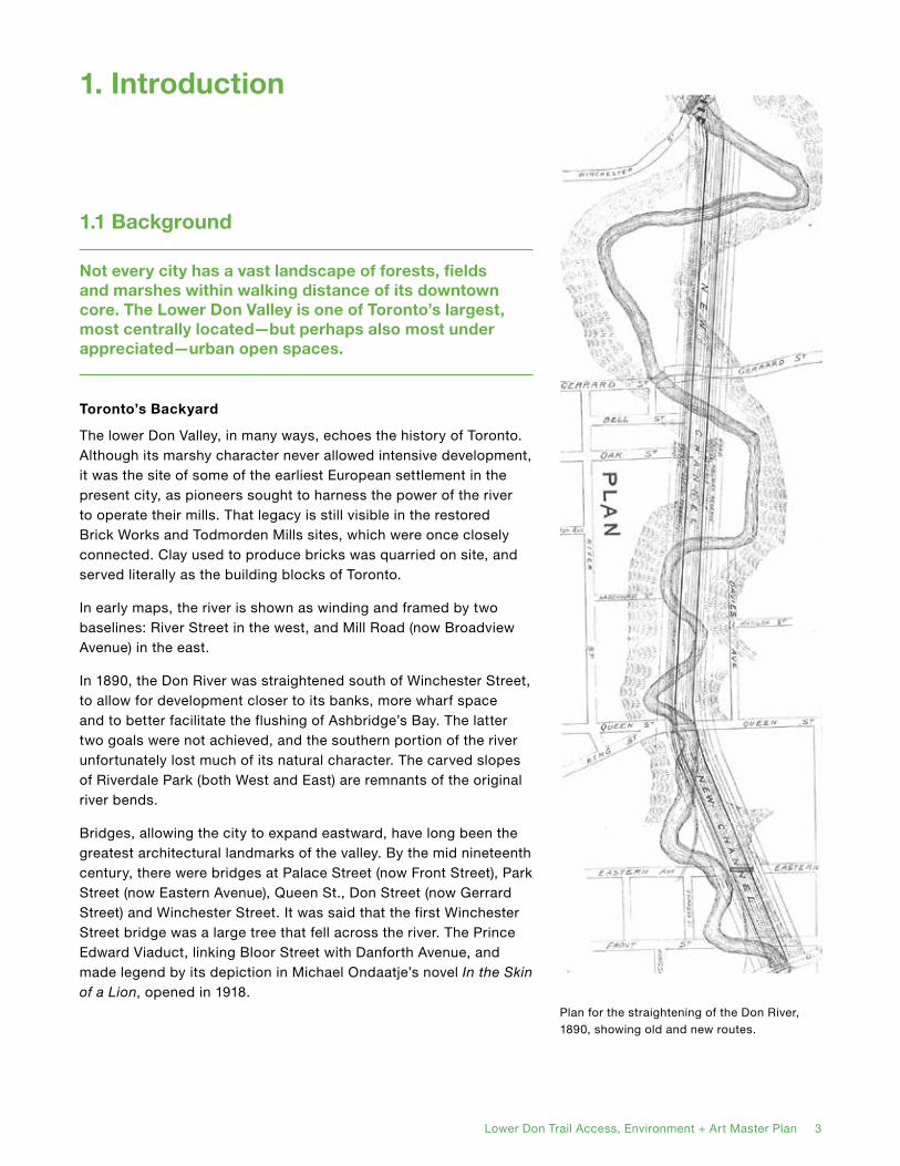
In early maps, the river is shown as winding and framed by two baselines: River Street in the west, and Mill Road (now Broadview Avenue) in the east.
In 1890, the Don River was straightened south of Winchester Street, to allow for development closer to its banks, more wharf space and to better facilitate the flushing of Ashbridge’s Bay. The latter two goals were not achieved, and the southern portion of the river unfortunately lost much of its natural character. The carved slopes of Riverdale Park (both West and East) are remnants of the original river bends.
Bridges, allowing the city to expand eastward, have long been the greatest architectural landmarks of the valley. By the mid nineteenth century, there were bridges at Palace Street (now Front Street), Park Street (now Eastern Avenue), Queen St., Don Street (now Gerrard Street) and Winchester Street. It was said that the first Winchester Street bridge was a large tree that fell across the river. The Prince Edward Viaduct, linking Bloor Street with Danforth Avenue, and made legend by its depiction in Michael Ondaatje’s novel In the Skin of a Lion, opened in 1918.
1.1 Background
Plan for the straightening of the Don River, 1890, showing old and new routes.
1. Introduction

4 Lower Don Trail Access, Environment + Art Master Plan
The Don Valley played a substantial social role in the history of Toronto. Prior to the mid-twentieth century, photographs reveal that it was the site of popular recreation, including swimming, skating, sledding, cycling and walking. In his novel Cabbagetown, Hugh Garner describes the wooded slopes of Riverdale Park as a meeting place for lovers.
Railways first appeared in the Don Valley after the straightening of the river, and by the early twentieth century it was deemed a convenient place to route hydro lines. But the most significant (and in many ways, most harmful) infrastructral intervention came with the opening of the Don Valley Parkway in 1961. Running high speed traffic through the valley was a cheap and convenient alternative to constructing a highway through established neighbourhoods, but it required the further straightening of the Don River and major regrading of its slopes. It also permanently divided the valley, rendering much of it inaccessible, or only accessible through roundabout means.
Rebirth of the Valley
In 1967, Todmorden Mills was declared a historic site and local conservation activist Charles Sauriol had advocated preservation of the valley’s natural environment since at least the 1940s. However, significant action to restore the Don Valley and Don River’s ecosystems did not begin until the 1980s, when the Lower Don Trail was first opened and broad public support began to coalesce. Since that time, a number of studies and plans have been conducted to further that work–many of them now approved or successfully implemented. These are summarized in the Previous Studies section of this document.
A Place for All
The Lower Don Valley is Downtown Toronto’s green backyard, and represents a unique social mixing space, bordering some of the city’s richest and poorest neighbourhoods. With the recent reopening of the Brick Works, the upcoming launch of the Pan Am Games Athletes’ Village and Corktown Commons, as well as other significant developments, far greater interest in, and use of, the Lower Don Trail System can be expected. It is already,
Castle Frank, as seen from Don River. Painted by Elizabeth Simcoe, 1796.
Recreation in the Valley, early 20th century.

4 Lower Don Trail Access, Environment + Art Master Plan Lower Don Trail Access, Environment + Art Master Plan 5
Don Valley Brick Works in operation.
Construction of the Prince Edward Viaduct.
Preparing for construction of the DVP.
in effect, the most readily available go-to natural experience for downtown residents, a perfect setting for environmental and historic interpretation, public art, and recreation.
The Lower Don Trail should be a welcoming and accessible place for all residents and visitors. Upgrading accessibility means not only adding more trail entrances, but also improving the conditions and signage of the trail to ensure clarity, safety and better access for people with different mobility levels.
The Lower Don Valley is also home to a wide array of plant and animal species, some part of sensitive ongoing natural habitat restoration. Informal trails, dumping, vandalism and other activities threaten them. A more developed and better maintained trail condition can clearly delineate open and closed portions of the valley by drawing a strong visual contrast and removing ambiguity. It should welcome visitors, but discourage trampling of areas away from the path, using fencing and signs where necessary. Opening new trail links and connections will also remove the impetus for taking shortcuts.

6 Lower Don Trail Access, Environment + Art Master Plan
The intensification and development of new communities in the lower Don Valley neighbourhoods will bring an estimated 80,000 new residents into the core of the city. These new residents will significantly increase the demands put on the Don Valley lands as a place to recreate, commute and travel through.
At its core, this Master Plan seeks to reconcile the apparent contradiction: how can more people enjoy the benefits of the Don Valley, while simultaneously better protecting and enhancing its natural environment?
Goals
• To recommend strategies to improve environmental protection and access, and consider possibilities for public art in the lower Don River valley lands.
• To provide a long-term strategy to establish a theme, create positive user experiences and improve access.
• To incorporate all existing studies, plans and initiatives in the study area.
Ph
oto
s: G
eo
ff F
itzg
era
ld
Cycling through the existing Belleville underpass.
Riverdale Farm.
1.2 Problem Statement and Goals

6 Lower Don Trail Access, Environment + Art Master Plan Lower Don Trail Access, Environment + Art Master Plan 7
Accessibility
• Provide clear and safe access to the trail for different levels of mobility and ability.
Connectivity
• Connect major destinations along and adjacent to the trail, while promoting the Don Valley as a destination unto itself.
• Link the trail to existing infrastructure including other trails, bike lanes, streets and transit.
• Integrate the trail into the life of its surrounding neighbourhoods, through signage and public realm improvements.
Preservation
• Protect and preserve the most sensitive natural areas.
Recreation
• Enhance responsible interaction with the natural environment.
• Develop multiple options for movement and recreation routes.
Education
• Share the story of the Don Valley’s natural and human history through public art and other installations.
Visibility
• Elevate the visibility and profile of the trail through public art.
• Develop clear and consistent wayfinding and interpretive signage, particularly around major trail entry points and nodes.
Participation
• Invite opportunities for public participation in future implementation of improvements to the trail system.
The following series of principles underpin the Master Plan:
1.3 Recommended Design Principles

8 Lower Don Trail Access, Environment + Art Master Plan
Ramp connecting Gardiner Expressway and Don Valley Parkway.

8 Lower Don Trail Access, Environment + Art Master Plan Lower Don Trail Access, Environment + Art Master Plan 9
2. Process
2.1 Project Timeline
The Master Plan was developed between November, 2012 and July, 2013.
Development of the Plan
The process began with an analysis of existing conditions and previous studies, which was presented in the Existing Conditions and Opportunities and Constraints Memo in December, 2012.
From January to March, 2013, a number of meetings with stakeholders took place, and the master plan was conceptually and graphically developed.
On April 2, a draft Master Plan was presented to the public in a meeting that included a workshop in which attendees asked questions and provided feedback. Additional comments from the public were received up until May 2.
The final Master Plan was then developed between May and July.
Findings
This section of the Master Plan document summarizes the plan development process and the findings that informed it.

10 Lower Don Trail Access, Environment + Art Master Plan
From the outset, this project has aimed to rethink the Lower Don Trail, shifting it from a poorly-defined ‘in-between’ space to a destination in its own right. This process not only involves making physical improvements to the trail – adding connections and safety features, upgrading accessibility, better managing natural environments, and developing a strategy for public art installations – but also generating a strong and resonating identity for the entire route.
With these goals in mind, the process began with an analysis of the site’s existing conditions and its opportunities and constraints.
The Existing Conditions and Opportunities and Constraints Memo, contained within the Appendices, provides a lengthier account of these findings, itemizing the observations made.
It covers the following categories:
Trail Use and Connectivity
Poor connectivity is the greatest challenge facing the trail, and presents a host of problems for safety, accessibility and simple functionality of the trail as a site for public recreation. The trail often becomes trapped between the river, highway, roads or railway, resulting in long stretches between entry points. Opening new entry points, through the use of stairs, bridges and new connecting trails, is its best chance for improvement. The experiential quality of the trail could also be enhanced through the addition of new amenities, safety features and promontory approaches.
Civil Infrastructure
The Lower Don Trail would benefit from a number of upgrades to improve user experience and safety, as well as to more effectively deal with drainage and erosion issues. The role of the Don Valley as a floodplain and floodwater conveyance mechanism needs to be considered and more closely integrated with the trail design.
2.2 Existing Conditions

10 Lower Don Trail Access, Environment + Art Master Plan Lower Don Trail Access, Environment + Art Master Plan 11
Environment
Two centuries of pollution, encroachments and channelization have left the natural features of the Lower Don Trail in a damaged and disturbed condition. There is opportunity for improvement, however, and some efforts have already been made to plant native trees in the valley. The results have largely been fruitful, and there is evidence of gradual improvement to natural habitats.
Public Art
The Don Valley has previously seen the installation of a number of public art pieces, both temporary and permanent. While the threat of vandalism or damage from the elements is always a major concern, there is considerable opportunity and ample space for new installations. No public art installations are currently present.
Transportation
There are substantial transportation issues on and around the trail route, especially due to the way trail facilities interface with fast-moving traffic. Bayview Avenue, as one of the main access routes to the trail and Brickworks, contains a number of undesirable conditions related to pedestrian and cyclist safety, while the Don Valley Parkway is often a barrier to trail access. Pottery Road narrows as it crosses over the Don River, pushing cyclists into mixed traffic and limiting pedestrians to a single sidewalk.
Accessibility
Accessible design barriers were identified at various locations along the trail. In particular, no accessible entry points are existent between Pottery Road in the north and Lakeshore Boulevard/Cherry Street in the south. Several particular obstacles were identified, such as uneven surfaces, slipping hazards and low overhead clearance at one point. Current signage contains no accessibility-oriented information
Marsh restoration project north of the Prince Edward Viaduct
Lower Don has significant tree deficiency and is mostly limited to invasive species
Heavy informal use threatens the valley

12 Lower Don Trail Access, Environment + Art Master Plan
Over the past 30 years, the lower Don Valley has been one of the most studied parts of Toronto. Rather than duplicating previous work, the production of this Master Plan has relied heavily on gaining an understanding of previous studies.
The following reports informed the current plan. Summaries of each can be found in the Appendices.
• Bringing Back the Don (1991)
• Lower Don Lands Strategy (1994)
• Forty Steps to a New Don (1994)
• Toronto Bike Plan (2000)
• West Don Lands Precinct Plan (2005)
• Bridgepoint Health Master Plan (2006)
• Crothers Woods Trail Management Strategy (2007)
• Don River Watershed Plan: Beyond Forty Steps (2009)
• Corktown Commons Plan (2010)
• Keating Channel Precinct Plan (2010)
• Connecting Trails, Communities and the Brickworks in the Lower Don (2011)
The Lower Don Lands Strategy (1994) called for a more naturalized river edge and the introduction of a slightly waving river course. Like Bringing Back the Don, it proposed the expansion of the trail right-of-way by moving the rail fence.
Bringing Back the Don (1991): One of the most significant recommendations of this plan is the call for a hard-edge dock wall condition along the Don River, south of Riverdale Park. It also calls for the expansion of the trail right-of-way by removing one line of railway track.
2.3 Previous Studies

12 Lower Don Trail Access, Environment + Art Master Plan Lower Don Trail Access, Environment + Art Master Plan 13
The Don Valley Trail area is characterized by its unique, positive qualities, but also by powerful constraints.
The Don Valley has a high profile in Toronto – second only to the waterfront – and has the opportunity to become a true landmark space, integrating recreation, infrastructure and natural systems.
It the most basic level, it is a large, badly-needed natural area in the middle of city. It offers striking views, both from above and below, and an opportunity to get close to the Don River. It connects, albeit inadequately, to several major destinations, including the Brickworks, Riverdale Park, and the West Don Lands.
The main trail route is, thankfully, already existent, and represents – alongside the Waterfront and Humber routes – one of the major multi-use recreation corridors in Toronto.
On the other hand, it is compromised and complicated by the intensive infrastructure running through the Don Valley: the DVP, the railway lines, Bayview Avenue, the hydro and gas corridors, numerous overhead bridges, and in some cases by the Don River itself. Increased rail activity, although perhaps inevitable, may threaten certain opportunities for trail expansion and connectivity.
Connectivity / AccessThe overwhelming greatest weakness of the trail is its lack of connectivity – both to other trails and to surrounding neighbourhoods. This closes it off to many potential users, and poses serious safety risks, especially at night.
Opening new entry and exit points to the trail at key locations will be the single largest way to improve its functionality.
Program / Facilities and EnvironmentThrough public engagement, a lack of public amenities on the trail was noted. Those public amenties that do exist are not always clearly identified. Wayfinding added to the trail should indicate directions to existing facilities.
There is also great potential for additional features, such as boardwalks, look-out points and public art installations that would add interpretive qualities to the trail experience and enhance public engagement in ongoing environmental remediation efforts.
2.4 SWOT Analysis

14 Lower Don Trail Access, Environment + Art Master Plan
STRENGTHS WEAKNESSES OPPORTUNITIES THREATS
CO
NN
EC
TIV
ITY
/ A
CC
ES
SP
RO
GR
AM
/ F
AC
ILIT
IES
• Continuous valley system• Central location in city• Existing trail• Paved, no stairs or other
major barriers on main trail
• Parallel/overlapping infrastructure corridors
• Narrow right-of-way south of Riverdale Park
• Poor safety due to isolation
• Existing Bayview Avenue arrangement
• Limited access points• DVP and railway are
barriers • Limited transit access• Limited connectivity• Steep topography limits
access
• Opportunities to widen, connect segments, spurs
• Level rail crossings in specific locations
• New crossings• Downtown Relief Line
connection • Proximity to
neighbourhoods• Connections to east-
west streets• Pottery Road
improvements• Improve access, remove
barriers • Bayview Avenue / River
Street links
• Varied experience along trails
• Highly visible• Subject of attention • Cultural heritage • Potential destinations and
points of interest• Seasonal interest• Commuter route• Recreational opportunities
• Limited engagement with Don River
• Temporal limitations on use
• Seasonal limitations on use
• Percieved limited facilities• Limited wayfinding /
information• Maintenance challenges
• Adding spaces to pause or rest
• Health and recreation• Places for interpretation• Education and
interpretation• Wayfinding• Rebranding trail
EN
VIR
ON
ME
NT
• Natural context of trail• Important natural space
in city• Planting arrangement• Species returning
• Engineered river edge in narrows
• Noise, pollution from roads
• Invasive species• Water quality• Air quality
• Tension between nature and recreation
• Salt and other pollution• Flooding
• Vegetation restoration• Art that brings
awareness to environmental issues
• Existing lighting proposal for the Prince Edward Viaduct
• Existing permanent artworks
• Successful temporary public art projects
• Temporary and permanent installations
• Urban mural projects• Mentorship of art
education
• Vandalism
PU
BL
IC A
RT
• Access for public art installation
• Maintenance challenges
• Possible design restrictions because of preservation issues
• There appear to be opportunities for public use iof railway property, including level crossings over the tracks, but future increases in rail service may limit this
SWOT Analysis Chart
• Jurisdiction conflicts • Balancing usage and
safety• High maintenance
commitments• Property ownership
conflicts• Conflicts between user
groups

14 Lower Don Trail Access, Environment + Art Master Plan Lower Don Trail Access, Environment + Art Master Plan 15
Below is a summary of the key themes emerging from the feedback received at an April 2 public meeting and electronically up until May 1, 2013.
The purpose of the public meeting was to:
• Provide participants with an overview of the project, criteria for selection and the proposed plan;
• Share the work completed to date and demonstrate how the Master Plan integrates with prior projects on the Don; and
• Provide a forum to discuss the proposed plan and potential projects.
Following a presentation, participants were divided into groups and asked to describe their favourite aspects of the Lower Don Trail and those most in need of improvement. For a full record of the input received, and a description of the meeting structure, please see the consultation report in the Appendices.
Multiple Access Points
The idea of creating multiple new access points along the trail was strongly supported. Several participants suggested that access points be designed so that they are accessible to a wide cross-section of users, including cyclists, seniors, those in wheelchairs, with strollers, etc. Many participants also suggested specific locations where access is needed/desired, including at Riverdale Farm, Castle Frank Station and the Prince Edward Viaduct.
Links and Connections
A continuous network of trails is important for trail users, especially cyclists. Multi-use trail networks can encourage bike commuting as well as ‘bike tourism.’ Several participants suggested that an emphasis be placed on connecting the Lower Don Trail to existing trails and on-road and off-road bike routes, such as the Martin Goodman Trail.
2.5 Public Consultation

16 Lower Don Trail Access, Environment + Art Master Plan
Strategic Placement of Public Art
Participants were excited about the opportunities for using public art to activate the Lower Don Trail. However, past experiences in the Don Valley suggest that art installations are susceptible to vandalism and therefore their location should consider accessibility. Locating art installations at key intersections and/or where they can be seen from both the trail and the Don Valley Parkway was also suggested.
Environmental Protection
Some participants felt that environmental protection should be given priority over other aspects of the Plan. Others suggested placing any new infrastructure of trails away from sensitive areas and wildlife.
Natural Corridors
A strong emphasis should be placed on creating green corridors and linking green areas within the Valley. Continuous green space is important for protecting the natural environment and supporting wildlife.
Natural Area Enhancement
Participants supported the idea of continued reforestation and planting along key areas of the Lower Don. The importance of on-going maintenance and stewardship for new planting projects was raised.
Importance of Good Wayfinding
The Master Plan provides an opportunity to create a new standard of signage and wayfinding along the trail. Wayfinding helps people know where they are and where they can go along the trail. Suggestions for what to include on signage were: current location, trail options, directions, distances, destinations/ important places. Others suggested signage/web-based information be used to update trail users on trail conditions, such as flooding or construction.
Natural, Cultural and Industrial Heritage
The Lower Don has a rich natural, cultural and industrial heritage. Interpretive elements that celebrate these aspects of the past were strongly encouraged.
Options for Different Users
Many people use the Lower Don Trail for commuting to and from work. Providing options for this group and other more leisurely visitors was suggested as a way to encourage safety and allow commuters to use the trail or parallel routes.
Lighting
Although lighting is not part of the scope of this project, many participants took the opportunity to discuss its placement within the trail. Lighting can cause light pollution and the majority of people agreed it is not appropriate to install in sensitive natural areas. However, participants suggested that it is important to light priority areas along the trail, such as dark underpasses, blind corners and more urban sections (e.g. the Narrows).
Stainability and Maintenance
Participants suggested that consideration be given to the long-term maintenance requirements and costs of the recommended strategies and projects. Materials and approaches that are durable and easy to maintain were encouraged.
Note: Trail maintenance was not part of the scope of this project.
Continued Engagement
Trail users and members of the surrounding community noted they were interested in continued consultation and involvement in the Lower Don Trail Master Plan and its implementation. Youth engagement in public art is a good opportunity for community involvement.

16 Lower Don Trail Access, Environment + Art Master Plan Lower Don Trail Access, Environment + Art Master Plan 17
As well as the formal public meeting, a number of informal consultations were held with individual stakeholder entities to inform the Master Plan.
The internal groups consulted included:
• City of Toronto Parks, Forestry and Recreation Division
• City of Toronto Transportation Division, including the Cycling Infrastructure and Programs Unit
• City of Toronto Planning Division, including the Urban Design Section
• City of Toronto Economic Development and Culture Division, including the administration of the Todmorden Mills complex
• Toronto and Region Conservation Authority (TRCA)
The external groups consulted included:
• Metrolinx / GO Transit
• Evergreen Stakeholders’ Advisory Group
• Developers with ongoing projects adjacent to the Don Valley:
• Waterfront Toronto
• First Gulf Developments
• TAZ Developments
2.6 Stakeholder Consultation

18 Lower Don Trail Access, Environment + Art Master Plan
Belleville rail line trestle over the Don River.

18 Lower Don Trail Access, Environment + Art Master Plan
At the core of the Master Plan, the Demonstration Plan is a broad response to the issues uncovered during research and consultation work. It represents a fresh vision for the Lower Don Trail, repositioning it from a leftover space to a signature parkland at the centre of the city.
The Demonstration Plan speaks to a need for greater landscape continuity and highlights open space components in or near the trail, including the Don Valley Brick Works, Todmorden Mills, Riverdale Park East and West and Corktown Commons. It strengthens connections to adjacent neighbourhoods through new trail access points and a network of ‘green streets’ that parallel the valley’s form.
The Demonstration Plan graphic (at right) represents the big picture of the Master Plan for the Lower Don Trail. It shows the Plan at full build-out, as well as the completion of adjacent developments in the Lower Don Lands, Keating Precinct, West Don Lands, East Bayfront and Regent Park. Individual component projects are identified in Section 3.3: Site-Specific Project Guidelines.
The Demonstration Plan should only be considered as a high-level road map, and its precise realization will be affected by the processes in which its component projects are implemented.
The following pages contain a number of renderings that illustrate what the Demonstration Plan could achieve when implemented.
3.1 Demonstration Plan
BRICK WORKS
WEST DON LANDS / PAN AM ATHLETES’ VILLAGE
SOUTH OF EASTERN
KEATING PRECINCT
LOWER DON LANDS
EAST BAYFRONT
REGENT PARK
CABBAGETOWN
CORKTOWN
THE DANFORTH
ROSEDALE
ST. JAMESTOWNNORTHRIVERDALE
SOUTHRIVERDALE
EAST CHINATOWN
RIVERDALEPARKEAST
RIVERDALEPARKWEST
TODMORDENMILLS
DON MOUNT
CORKTOWNCOMMONS
DISTILLERYDISTRICT
3. Master Plan
Lower Don Trail Access, Environment + Art Master Plan 19
20 Lower Don Trail Access, Environment + Art Master Plan
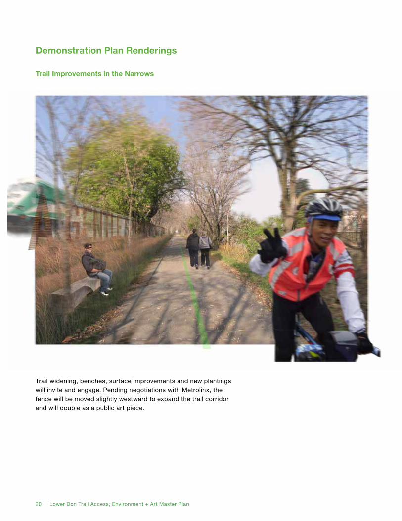
Trail widening, benches, surface improvements and new plantings will invite and engage. Pending negotiations with Metrolinx, the fence will be moved slightly westward to expand the trail corridor and will double as a public art piece.
Trail Improvements in the Narrows
Demonstration Plan Renderings

20 Lower Don Trail Access, Environment + Art Master Plan Lower Don Trail Access, Environment + Art Master Plan 21
New stair access from the existing bridges at Gerrard and Dundas Streets will provide additional opportunities for enjoying the Don River, create a broader network of connections, and improve security.
New Stairs in the Narrows

22 Lower Don Trail Access, Environment + Art Master Plan
1. Lower Don River
2. Improvements to Lower Don Trail
3. Habitat Enhancements to Rivers Edge
4. Existing East-West Bridge
5. New Stair Access from Bridge
6. Public Art Opportunity along Fence
7. Lookout from Queen/River Neighbourhood
8. Bayview Avenue
9. Metrolinx/Rail Corridor
10. Don Valley Parkway
Today, the Narrows (from the footbridge north of Riverdale Park down to Lakeshore Boulevard) is the most constrained part of the Lower Don Trail. It runs between the railway tracks and the straightened section of the Don River.
Upgrading the conditions of the Narrows is a critical component of the Master Plan and many of its short-term priority projects are located in this area.
Enhanced habitat, improved trail conditions, new stairs, public art installations, and lookouts from the revitalizing Queen/River Neighbourhood will improve access and the overall experience in the Narrows.
Other Opportunities in the Narrows
1
2
3
4
5
6
7
8
9
10

22 Lower Don Trail Access, Environment + Art Master Plan Lower Don Trail Access, Environment + Art Master Plan 23
A new protected two-way pedestrian and bicycle facility on the east side of Bayview Avenue will formalize an important parallel route to the Lower Don Trail. Phase 1 of this project will go from Pottery Road to Rosedale Valley Road. Phase 2 will continue south to River Street, connecting to the existing River Street bicycle lanes. The barrier between the trail and roadway could become a canvas for public art, as is done in New York City.
The functional, but currently unused, Belleville railway trestle could become a route for special ‘art trains’ associated with the Pan Am Games or other events at the Brick Works.
Bayview Avenue Multi-Use Trail and Art Train

24 Lower Don Trail Access, Environment + Art Master Plan
A new structure connecting the Pottery Road Trailhead to the new Bayview Avenue Multi-use Trail will allow pedestrians and cyclists to cross in greater comfort, separated from motor traffic.
New Pottery Road Crossing

24 Lower Don Trail Access, Environment + Art Master Plan Lower Don Trail Access, Environment + Art Master Plan 25
The Snow Dump site is no longer in use and offers a wonderful opportunity to provide further connections, amenities, and expand natural habitat restoration efforts. It will be the site of a future rest stop or observation point and potentially a venue for large public art installations.
Potential New Green Space on the Former Snow Dump Site
26 Lower Don Trail Access, Environment + Art Master Plan
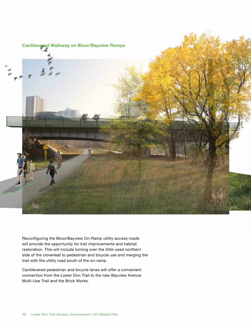
Reconfiguring the Bloor/Bayview On-Ramp utility access roads will provide the opportunity for trail improvements and habitat restoration. This will include turning over the little-used northern side of the cloverleaf to pedestrian and bicycle use and merging the trail with the utility road south of the on-ramp.
Cantilevered pedestrian and bicycle lanes will offer a convenient connection from the Lower Don Trail to the new Bayview Avenue Multi-Use Trail and the Brick Works.
Cantilevered Walkway on Bloor/Bayview Ramps

26 Lower Don Trail Access, Environment + Art Master Plan Lower Don Trail Access, Environment + Art Master Plan 27
New trails through the Snow Dump and Salt Dome sites will increase opportunities to engage the river and natural landscape. Bridges will connect the park to the Lower Don Trail and the Kay Gardner Beltline Trail.
New Connections through the Snow Dump and Salt Dome Sites
28 Lower Don Trail Access, Environment + Art Master Plan
3.2 Themes and Strategies
Themes
Although the Master Plan calls for a number of individual interventions, it is based on the view that the Don Valley is a continuous, interconnected system. The next four pages look at the entirety of the Valley through four different lenses. Each is a system-based approach, applying a pattern as a means of organizing the space.
• Landscape Connectivity: The trail as a device for Landscape Connectivity, containing three environments to be restored and enhanced.
• Precincts and Nodes: The trail as a series of structured Precincts and Nodes, in which five segments could be experienced distinctly as a part of their adjacent neighbourhoods.
• Parallel Routes: The trail as three Parallel Routes, over which users can be dispersed to facilitate north-south movement with different experiences.
• Links and Loops: The trail as a curated network of Links and Loops, in which users will be offered the choice between a number of experiences extending into the neighbourhoods.
Strategies
The Strategies explain the features of the Demonstration Plan. They are divided into three parts.
• Environment: The approach to environmental conservation and restoration.
• Access: The addition of new entry points to the trail to provide more options for users.
• Art: Potential locations for future public art installations.
The Themes and Strategies diagrams explain the design concept and features of the Master Plan.

28 Lower Don Trail Access, Environment + Art Master Plan Lower Don Trail Access, Environment + Art Master Plan 29
New Green Space
Don ValleyBrick WorksPark
Todmorden Mills Park
CorktownCommons
Promontory Park
Riverdale Park East
Riverdale Park West
Bikeway Park /Sediment + Debris Management
Boat Park
Lower Don Floodway
Valley Lands and Slopes
Narrows
Mouth of the Don
• Species diversity and conservation• Improved connectivity, new bridges and trail upgrades• New green space at former snow dump
• Green development standards• Urban forest• Green streets• Widening of corridor
Zone 1
Successful Restoration
Zone 2
Future Potential
Zone 3
Renaturalization• Flood protection• Wetland establishment• Mixed-use urban development
Chester Springs Marsh
Helliwell HillWetland
The ravines and broader reaches of the Lower Valley are a successful example of habitat creation and restoration. The Mouth of the Don has witnessed significant progress with the near completion of Corktown Commons and planning for the Lower Don Lands. The Narrows—although more constrained—represents the future with opportunities to extend into and embrace the surrounding urban form.
Landscape Connectivity Theme
Helliwell Hill Marsh.
30 Lower Don Trail Access, Environment + Art Master Plan
Pottery Road
Bayview On-Rampand Potential Foot Bridges
Rosedale Valley Foot Bridge
Riverdale Park Foot Bridge
Gerrard Street Stairs
Dundas Street Stairs
Queen Streetand
Eastern AvenueStairs
Bala Underpass andPotential New Foot Bridge
Lakeshore BoulevardParliament Street
Cherry Street
MIL
LS
AN
D M
AR
HE
S P
RE
CIN
CT
RIV
ER
DA
LE
PR
EC
INC
TN
AR
RO
WS
PR
EC
INC
T
LO
WE
R D
ON
PR
EC
INC
T
LAKESHORE PRECINCTNode as Precinct Boundary
Node as Precinct Centre
Existing / Potential
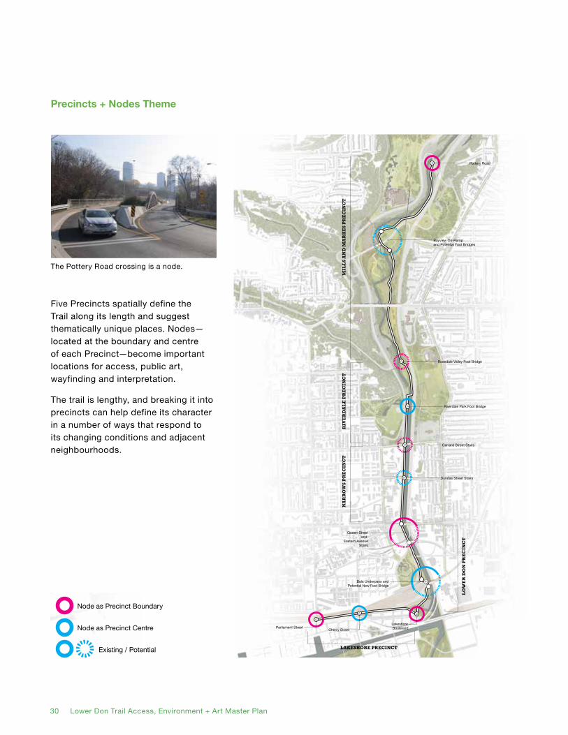
Five Precincts spatially define the Trail along its length and suggest thematically unique places. Nodes—located at the boundary and centre of each Precinct—become important locations for access, public art, wayfinding and interpretation.
The trail is lengthy, and breaking it into precincts can help define its character in a number of ways that respond to its changing conditions and adjacent neighbourhoods.
Precincts + Nodes Theme
The Pottery Road crossing is a node.
Pottery Road
Bayview On-Rampand Potential Foot Bridges
Rosedale Valley Foot Bridge
Riverdale Park Foot Bridge
Gerrard Street Stairs
Dundas Street Stairs
Queen Streetand
Eastern AvenueStairs
Bala Underpass andPotential New Foot Bridge
Lakeshore BoulevardParliament Street
Cherry Street
MIL
LS
AN
D M
AR
HE
S P
RE
CIN
CT
RIV
ER
DA
LE
PR
EC
INC
TN
AR
RO
WS
PR
EC
INC
T
LO
WE
R D
ON
PR
EC
INC
T
LAKESHORE PRECINCTNode as Precinct Boundary
Node as Precinct Centre
Existing / Potential
Queen Street East
Dundas Street East
Gerrard Street East
Gerrard Street East
King Street East
Par
liam
ent
Str
eet
Che
rry
Str
eet
Front Street East
Eastern Avenue
Riv
er S
tree
t
eunevA
wei vdaor
B
Danforth Avenue
Bloor Street East
Rosedale Valley Road
Don
Val
ley
Par
kway
Chester Hill Road
Pottery R
oad
Bay
view
Ave
nue
Shuter Street
Par
liam
ent
Str
eet
Sum
ach
Str
eet
Langley Avenue
Withrow Avenue
Hogarth Avenue
Broadview
Avenue
Bro
advi
ew A
venu
e
Lake Shore Boulevard East
Mill Street
Queens Quay Boulevard East
Cherry S
treet
Queen Street East
Bayview
Avenue
Bayvie
w Ave
nue
Mortimer Avenue
Don V
alle
y Pa
rkw
ay
Richmond Street East
Adelaide Street East
Eastern Avenue
Kay
Gar
dner
Bel
tline
Tra
il
30 Lower Don Trail Access, Environment + Art Master Plan Lower Don Trail Access, Environment + Art Master Plan 31
Primary Lower Don Trail
Western Parallel RouteBayview Avenue Segment
Eastern Parallel RoutePottery Road Segment
Eastern Parallel RouteBroadview Avenue Segment
Eastern Parallel RouteBroadview Avenue Segment
Western Parallel RouteRiver Street Segment
Western Parallel RouteWest Don Lands Segment Eastern Parallel Route
South of Eastern Segment
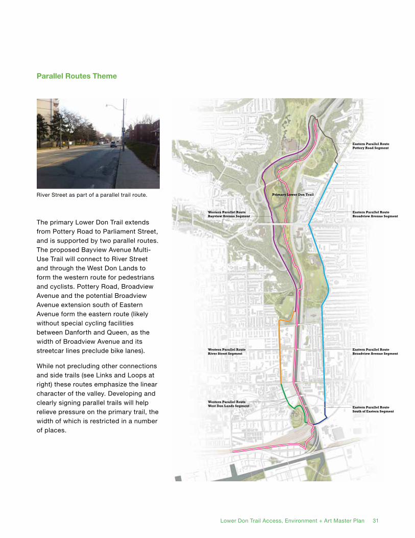
Parallel Routes Theme
The primary Lower Don Trail extends from Pottery Road to Parliament Street, and is supported by two parallel routes. The proposed Bayview Avenue Multi-Use Trail will connect to River Street and through the West Don Lands to form the western route for pedestrians and cyclists. Pottery Road, Broadview Avenue and the potential Broadview Avenue extension south of Eastern Avenue form the eastern route (likely without special cycling facilities between Danforth and Queen, as the width of Broadview Avenue and its streetcar lines preclude bike lanes).
While not precluding other connections and side trails (see Links and Loops at right) these routes emphasize the linear character of the valley. Developing and clearly signing parallel trails will help relieve pressure on the primary trail, the width of which is restricted in a number of places.
River Street as part of a parallel trail route.
32 Lower Don Trail Access, Environment + Art Master Plan
Riverdale WestLoop
Castle FrankLoop
Port LandsLoop
BeltlineLoop
Distillery Loop
LowerDonLandsLoop
BroadviewSouthLoop
RiverLoop
RiverdaleEastLoop
OldSnowDumpLoop
BroadviewNorth Loop
Brick WorksLoop
TodmordenLoop
Valley LandsNorth Loop
Valley LandsSouthLoop
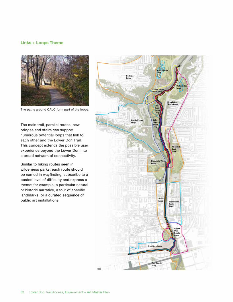
The main trail, parallel routes, new bridges and stairs can support numerous potential loops that link to each other and the Lower Don Trail. This concept extends the possible user experience beyond the Lower Don into a broad network of connectivity.
Similar to hiking routes seen in wilderness parks, each route should be named in wayfinding, subscribe to a posted level of difficulty and express a theme: for example, a particular natural or historic narrative, a tour of specific landmarks, or a curated sequence of public art installations.
Links + Loops Theme
The paths around CALC form part of the loops.

32 Lower Don Trail Access, Environment + Art Master Plan Lower Don Trail Access, Environment + Art Master Plan 33
Existing Ecological Communities
Forest (>60% Mature Tree Cover)
Woodland (35-60% Mature Tree Cover)
Savannah (15-35% Mature Tree Cover)
Thicket / Meadow (<25% Woody Cover, Dry)
Marsh / Swamp (<25% Woody Cover, Moist/West)
Manicured (Turf/Lawn) Green Streets
Developed from Toronto Region Conservation AuthorityVegetation Community Categorization (2013)
New Green Space
Don ValleyBrick WorksPark
Todmorden Mills Park
Corktown Commons
Promontory Park
Riverdale Park East
Riverdale Park West
Bikeway Park /Sediment + Debris Management
Boat Park
Lower Don Floodway
The Don Valley is a highly significant natural space in the city. Ongoing restoration efforts should continue, with the aim of allowing the Valley’s numerous distinct ecosystems to thrive, especially in the river mouth area. Acquiring and restoring the snow dump site south of the Bayview on-ramp as a new green space will transform a major part of the Valley.
The Environment Strategy also calls for the formal designation of a number of ‘green streets’ between (and including) River Street and Broadview Avenue. These streets, featuring special plantings, would serve to visually extend the Valley, especially important in the urbanized Narrows segment of the river.
Forest by Rosedale Valley Road.
Environment Strategy
Existing Ecological Communities
Forest (>60% Mature Tree Cover)
Woodland (35-60% Mature Tree Cover)
Savannah (15-35% Mature Tree Cover)
Thicket / Meadow (<25% Woody Cover, Dry)
Marsh / Swamp (<25% Woody Cover, Moist/West)
Manicured (Turf/Lawn) Green Streets
Developed from Toronto Region Conservation AuthorityVegetation Community Categorization (2013)
New Green Space
Don ValleyBrick WorksPark
Todmorden Mills Park
Corktown Commons
Promontory Park
Riverdale Park East
Riverdale Park West
Bikeway Park /Sediment + Debris Management
Boat Park
Lower Don Floodway
Queen Street East
Dundas Street East
Gerrard Street East
Gerrard Street East
King Street East
Par
liam
ent
Str
eet
Che
rry
Str
eet
Front Street East
Eastern Avenue
Riv
er S
tree
t
eunevA
wei vdaor
B
Danforth Avenue
Bloor Street East
Rosedale Valley Road
Don
Val
ley
Par
kway
Chester Hill Road
Pottery R
oad
Bay
view
Ave
nue
Shuter Street
Par
liam
ent
Str
eet
Sum
ach
Str
eet
Langley Avenue
Hogarth Avenue
Broadview
Avenue
Bro
advi
ew A
venu
e
Lake Shore Boulevard East
Mill Street
Queens Quay Boulevard East
Cherry S
treet
Queen Street East
Dundas Street East
Bayview
Avenue
Bayvie
w Ave
nue
Mortimer Avenue
Don V
alle
y Pa
rkw
ay
Richmond Street East
Adelaide Street East
Eastern Avenue
Kay
Gar
dner
Bel
tline
Tra
il
Chester Springs Marsh
34 Lower Don Trail Access, Environment + Art Master Plan
A
A
A
A
A
AA
A
A
AAAA
AAAA
Don Valley Brick Works
Access + Connections
Primary Lower Don Trail
Parallel Route
Connecting Route
New Connecting Structure (Bridge, Underpass, Stair)
Accessible Trail Entrances (Existing or Potential)
Decision Point / Wayfinding
Existing Trail Access
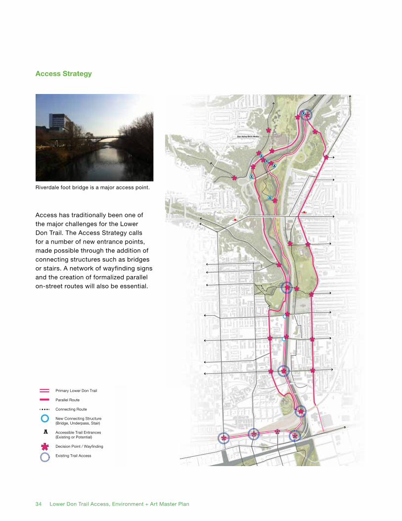
Access has traditionally been one of the major challenges for the Lower Don Trail. The Access Strategy calls for a number of new entrance points, made possible through the addition of connecting structures such as bridges or stairs. A network of wayfinding signs and the creation of formalized parallel on-street routes will also be essential.
Riverdale foot bridge is a major access point.
Access Strategy
A
A
A
A
A
AA
A
A
AAAA
AAAA
Don Valley Brick Works
Access + Connections
Primary Lower Don Trail
Parallel Route
Connecting Route
New Connecting Structure (Bridge, Underpass, Stair)
Accessible Trail Entrances (Existing or Potential)
Decision Point / Wayfinding
Existing Trail Access
Queen Street East
Dundas Street East
Gerrard Street
Gerrard Street
King Street East
Par
liam
ent
Str
eet
Che
rry
Str
eet
Front Street East
Eastern Avenue
Riv
er S
tree
t
eunevA
wei vdaor
B
Danforth Avenue
Bloor Street East
Rosedale Valley Road
Don
Val
ley
Par
kway
Chester Hill Road
Pottery R
oad
Bayview
Avenue
Shuter Street
Par
liam
ent
Str
eet
Sum
ach
Str
eet
Langley Avenue
Withrow Avenue
Hogarth Avenue
Broadview
Avenue
Bro
advi
ew A
venu
e
Lake Shore Boulevard East
Mill Street
Queens Quay Boulevard East
Cherry S
treet
Queen Street East
Dundas Street East
Bayview
Avenue
Bayvie
w Ave
nue
Mortimer Avenue
Don V
alle
y Pa
rkw
ay
Richmond Street East
Adelaide Street East
Eastern Avenue
Kay
Gar
dner
Bel
tline
Tra
il

34 Lower Don Trail Access, Environment + Art Master Plan Lower Don Trail Access, Environment + Art Master Plan 35
ART TRAINDISTILLERY DISTRICT / WEST DON LANDS STOP
ART TRAINBRICK WORKS STOP
Prince Edward ViaductLuminous Veil Lighting InstallationDereck Revington Studio
Lower Don Trail to Nature Park Crossing
Trail Crossroads
Trail Beneath Prince Edward Viaduct
Lower Don Trail to Beltline Trail Crossing
Todmorden Mills /TrailheadEvergreen Brick Works
Trailhead
Don Valley Brick Works
Todmorden Mills Park + Trail
Nature Park Stop Opportunities
Stop Opportunity
Rosedale Valley Road/Bayview Avenue Intersection
Rosedale Valley to Trail Crossing
Belleville UnderpassSound InstallationRobert Sprachman ‘Interlude’
Significant Viewpoint
Significant Viewpoint
Chester Hill Lookout
Don Valley ParkwayBloor/Bayview Ramps
Significant Views aspart of Queen/River Redevelopment
River Crossing with Access to Trail
River Crossing with Access to Trail
River Crossing with Access to Trail (Existing)
Historic Old Eastern Avenue Bridge
Significant Viewpoint
Significant Connection to West Don Lands
Unique Boardwalk Experience
Significant Viewpoint
Don Valley ParkwayEastern Northbound Ramp
Public Art Opportunities
Permanent Installations
Revolving Temporary Installations
Art and Design: Bridges, Structures
Interpretation: Wayfinding and Branding
Street Art / Urban Installation
Art Train: Special Events
Significant Views as part of Bridgepoint Health Development
Art Strategy
The open spaces and infrastructure of the Don Valley are ripe with opportunities to host public art. The Public Art strategy calls for six categories of installation: high priority points for major permanent works, temporary sites for revolving works, existing structures which could see artwork incorporated or affixed to them, interpretation points for major signage or kiosks, walls onto which murals or street art could be painted, and a special art train that could run temporarily during the Pan Am Games.
Old Eastern Avenue bridge as public art site.
ART TRAINDISTILLERY DISTRICT / WEST DON LANDS STOP
ART TRAINBRICK WORKS STOP
Prince Edward ViaductLuminous Veil Lighting InstallationDereck Revington Studio
Lower Don Trail to Nature Park Crossing
Trail Crossroads
Trail Beneath Prince Edward Viaduct
Lower Don Trail to Beltline Trail Crossing
Todmorden Mills /TrailheadEvergreen Brick Works
Trailhead
Don Valley Brick Works
Todmorden Mills Park + Trail
Nature Park Stop Opportunities
Stop Opportunity
Rosedale Valley Road/Bayview Avenue Intersection
Rosedale Valley to Trail Crossing
Belleville UnderpassSound InstallationRobert Sprachman ‘Interlude’
Significant Viewpoint
Significant Viewpoint
Chester Hill Lookout
Don Valley ParkwayBloor/Bayview Ramps
Significant Views aspart of Queen/River Redevelopment
River Crossing with Access to Trail
River Crossing with Access to Trail
River Crossing with Access to Trail (Existing)
Historic Old Eastern Avenue Bridge
Significant Viewpoint
Significant Connection to West Don Lands
Unique Boardwalk Experience
Significant Viewpoint
Don Valley ParkwayEastern Northbound Ramp
Public Art Opportunities
Permanent Installations
Revolving Temporary Installations
Art and Design: Bridges, Structures
Interpretation: Wayfinding and Branding
Street Art / Urban Installation
Art Train: Special Events
Significant Views as part of Bridgepoint Health Development
Queen Street East
Dundas Street East
Gerrard Street
Gerrard Street
King Street East
Par
liam
ent
Str
eet
Che
rry
Str
eet
Front Street East
Eastern Avenue
Riv
er S
tree
t
eunevA
wei vdaor
B
Danforth Avenue
Bloor Street East
Rosedale Valley Road
Don
Val
ley
Par
kway
Chester Hill Road
Pottery R
oad
Bayview
Avenue
Shuter Street
Par
liam
ent
Str
eet
Sum
ach
Str
eet
Langley Avenue
Withrow Avenue
Hogarth Avenue
Broadview
Avenue
Bro
advi
ew A
venu
e
Lake Shore Boulevard East
Mill Street
Queens Quay Boulevard East
Cherry S
treet
Dundas Street East
Bayview
Avenue
Bayvie
w Ave
nue
Mortimer Avenue
Don V
alle
y Pa
rkw
ay
Richmond Street East
Adelaide Street East
Eastern Avenue
Kay
Gar
dner
Bel
tline
Tra
il

36 Lower Don Trail Access, Environment + Art Master Plan
A1 New Green Space on Former Snow Dump
A2 Lower Don Trail to Beltline Trail Bridge (West)
Smaller Bridges
A3.1 Pottery Road Bridge
A3.2 Lower Don Trail - Beltline Trail Bridge (East)
A3.3 Lower Don Trail to New Green Space Bridge
A5 Stops / Observation Points
One-Sided On-Street Trails
A6.1 Bayview Multi-Use Path (Phase 1)
A8 Bayview On-Ramp Walkways
Streetscape Improvements
A9.1 Broadview Streetscape Improvements
3.3 Site-Specific Project Guidelines
Northern Area
A3.1
Bayvie
w Ave
.
Bayview On-Ramp
Do
n V
alle
y P
kwy.
Prince Edward Viaduct
Bro
advi
ew A
ve.
BRICK WORKS
TODMORDENMILLS
A9.1
A6.1
A2
A3.2
A8
A8
A5
A5
A1
A3.3
Danforth Ave.
Bloor St. E
.
This section lists the component projects proposed by the Access, Environment + Art Master Plan. Each project is assigned a name and code number, and is described in greater detail over the following pages.

36 Lower Don Trail Access, Environment + Art Master Plan Lower Don Trail Access, Environment + Art Master Plan 37
Smaller Bridges
A3.4 Existing Bridge Crossing Realignment
A4 Belleville Underpass Improvements
A5 Picnic Areas / Observation Points
One-Sided On Street Trails
A6.1 Bayview Multi-Use Path (Phase 1)
A6.2 Bayview Multi-Use Path (Phase 2)
Stairways
A7.1 Gerrard Stairs
Streetscape Improvements
A9.1 Broadview Streetscape Improvements
A9.2 River Streetscape Improvements
A10 Rosedale Valley Intersection Improvements
A11 Narrows Trail Widening, Surface Improvements and Art Fence
Middle Area
Prince Edward Viaduct
Rosedale Valley Rd.
Broadview
Ave.
Gerrard St. E.
Do
n Valley P
kwy.
Bayview
Ave.
A9.2
A9.1
A10
A7.1
A6.2
A6.1A5
A4
A5
A3.4
A11
Danforth Ave.
Bloor St. E
.
RIVERDALEPARK EAST
RIVERDALEPARK WEST
RIVERDALEFARM
38 Lower Don Trail Access, Environment + Art Master Plan
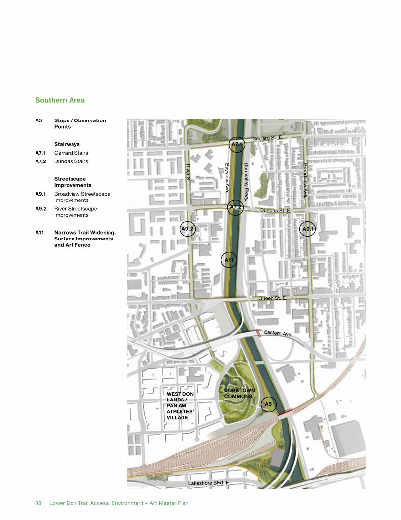
A5 Stops / Observation Points
Stairways
A7.1 Gerrard Stairs
A7.2 Dundas Stairs
Streetscape Improvements
A9.1 Broadview Streetscape Improvements
A9.2 River Streetscape Improvements
A11 Narrows Trail Widening, Surface Improvements and Art Fence
Southern Area
Gerrard St. E.
Dundas St. E.
Queen St. E.
River S
t.
Eastern Ave.
Bro
adview
Ave.
Lakeshore Blvd. E.
Bayview
Ave.
Do
n Valley P
kwy.
CORKTOWN COMMONSWEST DON
LANDS / PAN AM ATHLETES’ VILLAGE
A9.2
A7.2
A9.1
A7.1
A5
A11

38 Lower Don Trail Access, Environment + Art Master Plan Lower Don Trail Access, Environment + Art Master Plan 39
A1. New Green Space on Former Snow Dump Site
A1Former Snow
Dump Site
The closure of the former ‘Snow Dump’ site between Bayview Avenue and the Don River presents a tremendous opportunity for a large, new natural space connected to the existing Bayview and Lower Don Trails.
Immediately to the north, the present salt dome site continues to function seasonally as a road salt and snow plough storage lot. There is, however, enough room to run a connecting trail on its east side, linking the former snow dump site to a future set of bridges to the Beltline Trail and to the main Lower Don Trail.
Design Guidelines
• Given the salt and toxins likely to be found in the soil, the main initial thrust of work should be on-site bio or phytoremediation.
• The new trail running through the site should be separated from active remediation areas, using temporary fencing of an attractive design. Educational or interpretive information should be present to explain the process to the public.
• The long term remediation goal for the site should be naturalized reforestation, achieving a condition similar to that found on the other side of the Bayview Avenue / railway corridor. No lawns, sports facilities or parking should appear on the site.
• Plantings should be used to shield views of Bayview Avenue and the railway from the site.
• The trail route should run closely to the Don River (the most forested part of the site) and allow users to experience views of the river.
• The trail surface should be of a similar quality to that the rest of the Lower Don Trail (after its resurfacing); that is, asphalt-paved and 4 m in width.
• Short side trails (if any) in these areas, should be clearly designed to indicate their lesser status in comparison to the main trail, but be distinguished in maintenance and material quality from informal trails.

40 Lower Don Trail Access, Environment + Art Master Plan
• A viewing platform or tower would be constructed in the former snow dump site. The intention of this should be to allow trail users to experience the whole of the relatively large site, without directly walking through sensitive areas. This should double as a rest site and seating area. It could also be a site for public art installations and interpretive signage.
• To connect the former snow dump site to the salt dome site (as well as the cantilevered multi-use trail along the Bayview on-ramp and the bridges between the main Lower Don trail and Beltline trail), the path must go under the Bayview on-ramp beside the Don River (and also pass over a small drainage ditch). This underpass route should be designed with sufficient headroom and lighting for safety. It should also be able to withstand occasional flooding.
40 Lower Don Trail Access, Environment + Art Master Plan Lower Don Trail Access, Environment + Art Master Plan 41
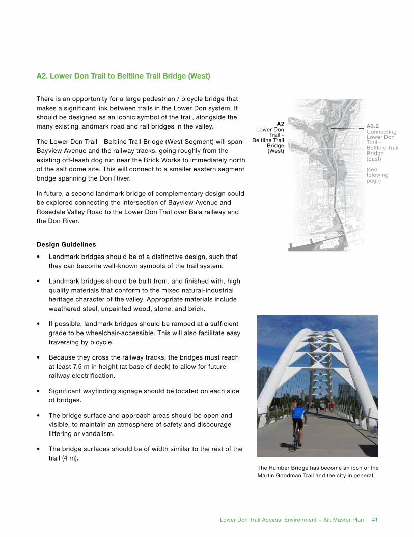
A2Lower Don
Trail - Beltline Trail
Bridge (West)
There is an opportunity for a large pedestrian / bicycle bridge that makes a significant link between trails in the Lower Don system. It should be designed as an iconic symbol of the trail, alongside the many existing landmark road and rail bridges in the valley.
The Lower Don Trail - Beltline Trail Bridge (West Segment) will span Bayview Avenue and the railway tracks, going roughly from the existing off-leash dog run near the Brick Works to immediately north of the salt dome site. This will connect to a smaller eastern segment bridge spanning the Don River.
In future, a second landmark bridge of complementary design could be explored connecting the intersection of Bayview Avenue and Rosedale Valley Road to the Lower Don Trail over Bala railway and the Don River.
Design Guidelines
• Landmark bridges should be of a distinctive design, such that they can become well-known symbols of the trail system.
• Landmark bridges should be built from, and finished with, high quality materials that conform to the mixed natural-industrial heritage character of the valley. Appropriate materials include weathered steel, unpainted wood, stone, and brick.
• If possible, landmark bridges should be ramped at a sufficient grade to be wheelchair-accessible. This will also facilitate easy traversing by bicycle.
• Because they cross the railway tracks, the bridges must reach at least 7.5 m in height (at base of deck) to allow for future railway electrification.
• Significant wayfinding signage should be located on each side of bridges.
• The bridge surface and approach areas should be open and visible, to maintain an atmosphere of safety and discourage littering or vandalism.
• The bridge surfaces should be of width similar to the rest of the trail (4 m).
A2. Lower Don Trail to Beltline Trail Bridge (West)
The Humber Bridge has become an icon of the Martin Goodman Trail and the city in general.
A3.2ConnectingLower Don Trail - Beltline Trail Bridge (East)
(see folowing page)

42 Lower Don Trail Access, Environment + Art Master Plan
A3. Smaller Bridges
A3.2Lower Don Trail - Beltline Trail Bridge (East)
A3.3Lower Don Trail - New
Green Space Bridge
A3.1Pottery Road Foot / Cycle
Bridge
A3.4Realigned
Narrows Bridge
As well as the large landmark bridges, there are opportunities for a number of small bridges that link elements of the trail.
Specifically:
• Pottery Road Foot / Cycle Bridge: This will resolve the problems posed by the narrowness of the current Pottery Road bridge, in which cyclists are briefly forced into mixed traffic and pedestrians are restricted to a single, narrow sidewalk. It will run parallel to the existing bridge, immediately south of it and connect to a level crossing over the railway.
• Lower Don Trail - Beltline Trail Bridge (East Segment): This will link the trail to the northern tip of the salt dome site over the Don River. From there, the larger West Segment will take trail users over the railway and Bayview Avenue to the Beltline Trail.
If a level crossing of the railway tracks at the Brick Works is possible (making the larger West Segment bridge unnecessary), this bridge could be used to connect that crossing to the main trail. It could either remain in the location presently proposed, or be moved forther north, closer to the level crossing.
• Lower Don Trail - New Green Space Bridge: This will allow trail users to cross the Don River to access the new green space on the former snow dump site.
• Realigned Narrows Bridge: This replaces the current right-angled crossing with a longer one more smoothly aligned to the direction of the trail. The removal of the ‘kink’ will be especially beneficial to cyclists and generally improve sightlines.
Design Guidelines
• These bridges should be functional and similar in design to existing weathered steel park bridges.
• They should either be level, or with a gentle arch that is wheelchair accessible.
• The transition between the trail and bridge surfaces should be smooth, to facilitate movement by wheelchairs or cyclists and avoid tripping hazards.
• The bridges should be as wide as the trail surface (4 m).
• When bridges are removed from the Narrows (such as the abandoned railway bridge north of Lakeshore Boulevard) they should be considered for reuse as small foot / cycle crossings.

42 Lower Don Trail Access, Environment + Art Master Plan Lower Don Trail Access, Environment + Art Master Plan 43
A4. Belleville Underpass Improvements
A4Belleville
Underpass Improvements
The current tunnel under the Belleville railway line is contained within a corrugated steel cylinder aligned at a right angle to the rest of the trail. The narrowness of the tunnel, its limited headroom, sharp angle and the lack of sightlines present a number of safety hazards, especially involving bicycles.
There is a timely opportunity to construct a new underpass, both wider and better aligned to the direction of the trail, before the Belleville line again becomes actively used by rail traffic.
Design Guidelines
• The new tunnel should be wider than the rest of the trail (at least 5 m), to provide passing room and better light penetration, perhaps with square bracing to allow greater head room.
• It should provide at least 3 m overhead clearance.
• The tunnel should be aligned as closely as possible with the rest of the trail, including the nearby realigned Narrows Bridge.
• Because this will produce a longer, diagonal route under the railway tracks, the space should be well lit.
• The existing tunnel was previously the site of an audio art piece. The new underpass should likewise be used for temporary or permanent art installations, taking advantage of its unique condition within the rail.
Located further up the Don Valley, the ‘Rainbow’ tunnel is a more substantial trail underpass.

44 Lower Don Trail Access, Environment + Art Master Plan
A5. Stops / Observation Points
A5Stops /
Observation Points
The Don Valley offers the potential for fantastic views, not only from the surrounding slopes, but also from within the valley itself. Constructing observation points, especially raised on platforms or small viewing towers, will allow trail users to better experience its natural beauty, and to understand the lay of the land in ways not possible from the ground. Furthermore, controlled platforms will fulfill users’ impulse to visually ‘explore’ the remote corners of the valley without resorting to cutting informal trails.
These vantage points should also double as picnic areas. Such stops, especially beneficial to children and the elderly, will allow for small picnics, breaks and other social activities.
Design Guidelines
• Stops or observation points should be greater in scale than a single bench (benches should be dispersed along the entire trail route), but not so large as to encourage very large gatherings that could endanger the surrounding environment. In general, they should accommodate no more than 10 people seated at once.
• They should located either immediately adjacent to the trail, or at the terminus of a side path no longer than 50 m in length. These paths should be straight and broad, allowing clear sightlines from the main trail for safety and to discourage vandalism or other illegal activity.
• They should be relatively evenly spaced throughout the northern portion of the trail (north of the Narrows). There may be an additional opportunity for a rest stop / observation point adjacent to the Bala underpass.
• The precise siting of observation points should be subject to future discussion. However, providing appealing views to trail users, especially of environmentally or culturally significant sights, should be the primary aim.
• The tallest observation platforms or towers should be iconic architectural objects, landmarks themselves. They should be built from and finished with high quality materials that conform to the mixed natural-industrial heritage character of the valley. Appropriate materials include weathered steel, unpainted wood, stone, and brick.

44 Lower Don Trail Access, Environment + Art Master Plan Lower Don Trail Access, Environment + Art Master Plan 45
• Stops or observation points should always be combined with wayfinding and interpretive signage, and potentially also with public art installations.
• Public consultation suggested that additional public washroom facilities would be welcome.

46 Lower Don Trail Access, Environment + Art Master Plan
A6. One-Sided On-Street Trails
A6.1Bayview
Multi-Use Path Phase 1
A6.2Bayview
Multi-Use Path Phase 2
One-sided on-street multi-use trails will improve the safety of cyclists and pedestrians who currently travel along high speed roads, while also opening up new linkages.
The first phase of the Bayview Multi-Use Path will extend along the east side of Bayview Avenue from Pottery Road to Rosedale Valley Road, briefly going off-road through an existing route. The second phase will connect it to River Street.
Design Guidelines
• To improve safety and legibility, the trail should include a centre line, similar to the Martin Goodman Trail, to define the direction of travel. Trails should be at least 4 m in width where possible.
• They should be physically separated from the roadway, using jersey barriers, bollards or curb separation. Although their primary purpose is safety, these should be designed as attractive and permanent objects, potentially beautified with public art or urban illustration.

46 Lower Don Trail Access, Environment + Art Master Plan Lower Don Trail Access, Environment + Art Master Plan 47
A7. Stairways
A7.1Gerrard
Stairs
A7.2Dundas
Stairs
Adding two new stairways at the Gerrard and Dundas Street bridges is an relatively simple way to substantially improve access to the trail.
Design Guidelines
• The stairways should be loosely modelled on the existing Queen Street stairs, broad in width, with bike troughs and evenly spaced landings.
• Wayfinding should appear at both the top and bottom of the stairs.
• Sufficient landing room should be given at the base of the stairs to prevent any collisions with passing trail users.
• The design of the stairs should be unobtrusive, and in keeping with the materials and colour of the existing bridge structure (concrete and blackened steel).
The Queen Street stairs are a model for additional stairways on Gerrard and Dundas streets.

48 Lower Don Trail Access, Environment + Art Master Plan
A8. Bayview On-Ramp Cantilevered Walkways
A8Bayview
On-RampCantilevered
Walkways
The Bayview on-ramp spans the Belleville railway line and Don River (in two segments). Adding a two-way multi-use path to these segments, cantilevered over the north side, would allow cyclists and pedestrians to move between the main Lower Don Trail and the Bayview Avenue multi-use path. It would also provide access to the new green spaces to be added at the snow dump site and (potentially) at the salt dome site.
At its east side, the cantilevered walkway would be accessed via north portion of the disused cloverleaf ramp.
Design Guidelines
• Walkways should be consistent in width with the rest of the trail (4 m).
• Existing guardrails should be maintained to separate the trail from the roadway.
• Walkway surfaces and fencing should be simple and attractive in design, with materials and details appropriate for the setting.

48 Lower Don Trail Access, Environment + Art Master Plan Lower Don Trail Access, Environment + Art Master Plan 49
A9. Streetscape Improvements
A9.1Broadview
Avenue Improvements
A9.2River Street
Improvements
River Street and Broadview Avenue are the traditional west and east baseline streets framing the Don Valley. In future, they can play greater roles as parts of parallel trails.
Design Guidelines
• Both streets should be considered for special interpretive and wayfinding signage and public art, indicating their histories and showing connections to the main Lower Don Trail.
• Both streets (and those side streets between them) should be considered priority ‘green streets,’ subject to high quality plantings and streetscape materials.
• Sidewalks should be widened where possible to improve the pedestrian experience.

50 Lower Don Trail Access, Environment + Art Master Plan
A10. Rosedale Valley Intersection Improvements
A10Rosedale
Valley Intersection
Improvements
Regularizing the Rosedale Valley Road - Bayview Avenue intersection will make it more friendly to pedestrians befitting its growing role as a major trail node.
In future, the intersection will see the meeting of no less than five trails: both phases of the Bayview multi-use trail, the existing Rosedale Valley trail, the Cabbagetown steps, and a possible new bridge to the main Lower Don Trail.
Design Guidelines
• The intersection should be normalized to form a right-angled ‘T’ junction, with Rosedale Valley Road restricted to a single roadway.
• As a trail node, it should be the site of major wayfinding signage, seating areas, and public art installations.
• The Rosedale Valley Trail should be widened and its surface repaired.
• The Cabbagetown link should be made more visible from the intersection.
• If the intersection improvements are made before the construction of the Rosedale Valley bridge (as is expected), sufficient room should be left to accommodate the future structure.
The normalizing of the Bayview Avenue - Pottery Road intersection is a precedent for the Rosedale valley Road intersection.

50 Lower Don Trail Access, Environment + Art Master Plan Lower Don Trail Access, Environment + Art Master Plan 51
A11. Narrows Trail Widening, Surface Improvements and Art Fence
In the Narrows, the trail has traditionally been highly restricted by the railway right of way. However, pending negotiations with Metrolinx, it may be possible to relocate the fencing westward and slightly widen the trail. The new fencing could be an opportunity for a major public art piece. The removal of the utility bridge (beside the former Eastern Avenue bridge) will also eliminate a pinch point.
Widening the trail to a consistent 4 m and repaving its surface where necessary will allow it to accommodate a greater number of users.
Extensive maintenance is required is this area, as frequent flooding damages the trail surface and deposits sediment onto it. In the long term, the planned reopening and naturalization of the Don River mouth should substantially improve this problem by reducing backflow.
Design Guidelines
• The trail should be widened to 4 m, and resurfaced with new asphalt where necessary.
• An additional 0.5 m mowed buffer should appear on either side of the trail wherever possible.
• Benches should be placed regularly along the trail.
• A painted centre line should be added to the trail to encourage users (especially cyclists) to travel on the right hand side.
• New fencing along the railway tracks should be attractive and considered as a potential venue for public art.
• Fencing should nevertheless be visually permeable, allowing sightlines between the trail and railway corridor for safety reasons.
• Fencing should not impede stormwater flow.
A11Narrows Trail
Widening, Surface
Improvements and Art Fence
Public art on the fencing around the former TTC yards on Lansdowne Ave.

52 Lower Don Trail Access, Environment + Art Master Plan
B1. Movement Limitations
At a number of points along the trail, off-trail pedestrian movement needs to be managed, either for safety or environmental protection reasons.
All informal trails should be managed, disguised and/or blocked, using either signage or, if necessary, fencing.
Design Guidelines
• Aggressive and ongoing efforts should be made to remove informal trails. Where necessary, access to such trails (or other environmentally sensitive areas) should be blocked using sturdy low fencing constructed from wood (similar to that currently used around the Milkman’s Lane trail and further north along the Don Trail).
Fencing along the Milkman’s Lane trail.
3.4 Non-Site-Specific Project Guidelines
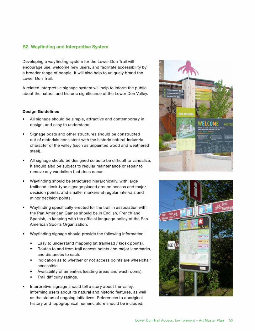
52 Lower Don Trail Access, Environment + Art Master Plan Lower Don Trail Access, Environment + Art Master Plan 53
B2. Wayfinding and Interpretive System
Developing a wayfinding system for the Lower Don Trail will encourage use, welcome new users, and facilitate accessibility by a broader range of people. It will also help to uniquely brand the Lower Don Trail.
A related interpretive signage system will help to inform the public about the natural and historic significance of the Lower Don Valley.
Design Guidelines
• All signage should be simple, attractive and contemporary in design, and easy to understand.
• Signage posts and other structures should be constructed out of materials consistent with the historic natural-industrial character of the valley (such as unpainted wood and weathered steel).
• All signage should be designed so as to be difficult to vandalize. It should also be subject to regular maintenance or repair to remove any vandalism that does occur.
• Wayfinding should be structured hierarchically, with large trailhead kiosk-type signage placed around access and major decision points, and smaller markers at regular intervals and minor decision points.
• Wayfinding specifically erected for the trail in association with the Pan American Games should be in English, French and Spanish, in keeping with the official language policy of the Pan-American Sports Organization.
• Wayfinding signage should provide the following information:
• Easy to understand mapping (at trailhead / kiosk points).• Routes to and from trail access points and major landmarks,
and distances to each.• Indication as to whether or not access points are wheelchair
accessible. • Availability of amenities (seating areas and washrooms).• Trail difficulty ratings.
• Interpretive signage should tell a story about the valley, informing users about its natural and historic features, as well as the status of ongoing initiatives. References to aboriginal history and topographical nomenclature should be included.

54 Lower Don Trail Access, Environment + Art Master Plan
B3. Habitat Enhancement and Restoration
The Lower Don Valley is the site of substantial completed and ongoing natural restoration work, that will continue.
Design Guidelines
• On-going efforts should be made to remove invasive species from the valley, clean up litter, and close informal trails.
• All human-oriented trail improvements should be made in consideration of future habitat restoration opportunities.
• The eventual goal of habitat restoration should be the return of traditional wetland or forest conditions (depending on water levels) to the valley.
• The limited trail right-of-way in the Narrows prevents extensive new planting, but efforts should nevertheless be made to manage, and if necessary add, to existing tree plantings.
• Special efforts should be made to protect the diverse ecosystems of the Castle Frank ‘hogback’ hill, and to close informal trails there.
• All restoration efforts should be combined with interpretive signage to inform the public about ongoing activities and, where possible, invite their participation.
• (See the ‘New Green Spaces’ section for comments on restoration of the snow dump and salt dome sites).

54 Lower Don Trail Access, Environment + Art Master Plan Lower Don Trail Access, Environment + Art Master Plan 55
B4. Permanent and Temporary Public Art Installations
Public art has the potential to tell personal and communal stories, challenge beliefs, and provide aesthetic delight.
As a special open area at the nexus between urban and natural environments, the Lower Don Trail is an ideal site for public art installations.
Design Guidelines
• Public art installations should be varied in nature, ranging from traditional large, permanent ‘sculpture garden’ pieces to temporary and ephemeral works.
• Permanent works should be especially related to the condition of the relationship between the valley and city.
• Where possible, public art should make use of the valley’s infrastructure, such as bridges, tunnels and retaining walls.
• A single committee should be formed by the City (and other stakeholders) to coordinate the curation of public art in the Lower Don valley. Art works in the valley should be viewed and managed as a coordinated system.
• Public art works should be combined with signage to provide appropriate credit and artists’ statements.
• The potential for a temporary ‘art train’ should be explored to operate during the Pan Am Games. Such a train would make use of the presently unused Belleville rail line, and link the West Don Lands with the Brick Works. The train would allow user to experience the valley from a different angle and provide easy transit between the Lower Don Trail’s two major nodes. It could be combined with other special programming (such as an art show at the Brick Works).
• Any public art labels or signage specifically erected for the trail in association with the Pan American Games should be in English, French and Spanish, in keeping with the language policy of the Pan American Sports Organization.

56 Lower Don Trail Access, Environment + Art Master Plan
View across the pedestrian bridge linking Riverdale Park East and CALC. This bridge is identified as part of a future Riverdale Trail (project A4.1) in the Long-Term Phase.

56 Lower Don Trail Access, Environment + Art Master Plan Lower Don Trail Access, Environment + Art Master Plan 57
4. Next Steps
4.1 Implementation
The implementation of the Master Plan is divided into two phases: Short-Term (zero to three years) and Medium-Term (three to ten years). Additionally, some potential projects have been placed under Opportunities for Future Exploration.
Phasing
Short-term projects are high priority interventions designed to make an impact quickly. Some of these projects have already been contemplated by the City, or could be funded by existing budgets. The Narrows Trail Widening, Surface Improvements and Art Fence (project A11) is one of the highlights of this phase, aiming at improving the condition of the trail’s most restricted segment. Other projects beginning in this phase will continue indefinitely, such as the restoration of natural habitats (B3) and the commissioning of public art works (B4). All projects associated with the Pan Am Games must take place during this phase.
The medium-term phase includes most of the Master Plan’s most dramatic and substantial recommendations, including a major New Green Space on the Former Snow Dump site (A1) and an iconic bridge between the Beltline Trail and the New Green Space (A2). These projects will go the furthest in defining the character of the Lower Don Trail and its surroundings.
Opportunities for Future Development are loosely defined interventions either associated with future private developments, or of a substantially complex and currently unresolved nature.
Partnerships
Potential funding or implementation partners have been identified for each project. These include City departments, other public agencies and private organizations.

58 Lower Don Trail Access, Environment + Art Master Plan
4.2 Short-Term Period: 0 to 3 Years
Smaller Bridges
A3.1 Pottery Road Bridge
A3.4 Existing Bridge Crossing Realignment
A4 Belleville Underpass Improvements
One-Sided On-Street Trails
A6.1 Bayview Multi-Use Path (Phase 1)
Stairways
A7.1 Gerrard Stairs
A7.2 Dundas Stairs
A10 Rosedale Valley Intersection Improvements
A11 Narrows Trail Widening, Surface Improvements and Art Fence
A3.1
A3.4
A4
Site Specific Projects
Non-Site-Specific Projects
B1. Movement Limitations
B2. Wayfinding and Interpretive System
A6.1
A7.1
A7.2
A11
A10

58 Lower Don Trail Access, Environment + Art Master Plan Lower Don Trail Access, Environment + Art Master Plan 59
A3.1 Pottery Road Bridge and Connection
This new bridge will provide an improved and separated connection between the new Pottery Road Trailhead and the future Bayview Avenue Multi-Use Path, so that trail users are separated from motorized vehicular traffic. The connection will be incorporated into the existing at-grade rail crossing and make use of the existing signals and controls. The City is committed to the design and implementation of these facilities.
Partners: City of Toronto (Parks, Recreation and Forestry; Planning - Urban Design; Transportation - Cycling Infrastructure), TRCA, Metrolinx.
A3.4 Existing Bridge Crossing Realignment
The existing east-west bridge will be replaced with a new structure that parallels the Belleville rail bridge to improve safety and flow and to reduce conflict between users.
Partners: City of Toronto (Parks, Recreation and Forestry; Transportation - Cycling Infrastructure), TRCA.
A4 Belleville Underpass Improvements
The repositioning and widening of the Belleville underpass is a top priority. Grades on the approaches will be reduced and sight lines improved. The existing public art installation could be repurposed and be included as part of the new underpass. The artist should be contacted to ensure the piece is installed correctly.
Partners: City of Toronto (Parks, Recreation and Forestry; Culture; Transportation - Cycling Infrastructure), TRCA, Metrolinx.
A6.1 Bayview Multi-Use Path (Phase 1)
This new facility will provide a protected two-way cycling facility on the east side of Bayside Avenue from Pottery Road to Rosedale Valley Road. The City is committed to the design and construction on this first phase.
Partners: City of Toronto (Transportation - Cycling Infrastructure).
A7.1, A7.2 Dundas and Gerrard Staircases
These new stairs will provide access from two major crossings of the river that connect the east and west side of the Lower Don Valley. Each staircase will follow a similar arrangement as the existing Queen Street staircase. These staircases were originally proposed in the Bring Back the Don Master Plan (1993). The City is committed to the design and implementation of these facilities.
Partners: City of Toronto (Parks, Recreation and Forestry; Planning - Urban Design).
A10 Rosedale Valley Intersection Improvements
The intersection point between the planned Bayview Multi-Use Path (Phase 1), the proposed Bayview Multi-Use Path (Phase 2) and Rosedale Valley Road (and trail) and the Cabbagetown steps will need to be normalized and made more friendly to pedestrians and cyclists. This should be timed with the first phase of the Bayview Multi-Use Path.
Partners: City of Toronto (Transportation - Cycling Infrastructure, Transportation - Roads, Planning - Urban Design).
Site Specific Projects
60 Lower Don Trail Access, Environment + Art Master Plan
A11 Narrows Trail Widening, Surface Improvements, and Art Fence
This is one of the signature projects in this short-term phase of implementation. The existing trail surface will be improved to facilitate better drainage, minimize root intrusion and provide a smoother cycling surface. With the support of Metrolinx, the fence along the rail corridor will be relocated to allow the widening of the trail and to introduce other improvements to support a higher level of use. An ‘art fence’ will replace the existing fence and provide a significant public art installation from Riverdale Park bridge to Corktown Commons in the West Don Lands.
Partners: City of Toronto (Parks, Recreation and Forestry; Culture, Transportation - Cycling Infrastructure), TRCA, Evergreen, Metrolinx.
B1 Movement Limitations
Fencing is needed around some portions of the trail, for both environmental and safety purposes. The closure and active removal of informal trails is also badly needed to prevent environmental degradation.
Partners: City of Toronto (Parks, Recreation and Forestry), TRCA.
B2 Wayfinding and Interpretive SystemA extensive standardized wayfinding and interpretive system throughout the Lower Don Valley area is badly needed and should be completed before the Pan Am Games.
Partners: City of Toronto (Parks, Recreation and Forestry), Evergreen, Toronto Pan Am Games Committee.
B3 Habitat Enhancement and Restoration
Habitat restoration has been and will continue to be a major ongoing program. Elements of this will be associated with other projects listed here, such as the opening of new green spaces and closure of informal trails.
Partners: City of Toronto (Parks, Recreation and Forestry), TRCA, private clubs and volunteers.
B4 Permanent and Temporary Public Art Installations
Beginning immediately, permanent and temporary public art installations will be an ongoing program in the Don Valley, with special projects associated with major public events such as the Pan Am Games. Potential sites for public art are shown in the Public Art Strategy section of the Demonstration Plan.
Partners: City of Toronto (Culture; Parks, Recreation and Forestry), Metrolinx, Evergreen.
Non-Site-Specific Projects
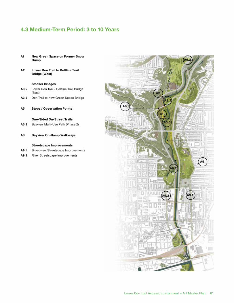
60 Lower Don Trail Access, Environment + Art Master Plan Lower Don Trail Access, Environment + Art Master Plan 61
4.3 Medium-Term Period: 3 to 10 Years
A1 New Green Space on Former Snow Dump
A2 Lower Don Trail to Beltline Trail Bridge (West)
Smaller Bridges
A3.2 Lower Don Trail - Beltline Trail Bridge (East)
A3.3 Don Trail to New Green Space Bridge
A5 Stops / Observation Points
One-Sided On-Street Trails
A6.2 Bayview Multi-Use Path (Phase 2)
A8 Bayview On-Ramp Walkways
Streetscape Improvements
A9.1 Broadview Streetscape Improvements
A9.2 River Streetscape Improvements
A1
A2
A3.2
A3.3
A5
A8
A9.2 A9.1
A6.2
A6.2
62 Lower Don Trail Access, Environment + Art Master Plan
A1 New Green Space on Former Snow Dump
One of two signature projects of this medium-term phase of implementation (and indeed the entire Master Plan), this public new green space will replace the disused snow dump, substantially increasing the parkland in the Don Valley. It will require a detailed site plan to locate a new trail, two rest stops / observation points, a bridge, the crossing of a water outflow point and an underpass under the Bayview On-Ramp. A study to determine what level and process of soil remediation must take place is necessary.
Partners: City of Toronto (Parks, Recreation and Forestry; Transportation - Cycling Infrastructure), TRCA.
A2 Lower Don Trail to Beltline Trail Bridge (West)
The other key project of the this medium-term phase of implementation, thus landmark bridge will span the Bala railway line and Bayview Avenue, connecting the New Green Space to the Beltline Trail (and by extension, the Brick Works). Unlike most of the other bridges, it will need to be elevated to a high level and will require a long ramped approach to accommodate bicycles and wheelchairs. Consequently, it will become a visible icon of the Lower Don Trail system will and will need to achieve design excellence.
Partners: City of Toronto (Parks, Recreation and Forestry; Transportation - Cycling Infrastructure), TRCA, Evergreen, Metrolinx.
A3.2 Lower Don Trail - Beltline Trail Bridge (East)
This smaller bridge will cross the Don River and connect to the larger Lower Don Trail - Beltline Trail Bridge (West), forming a single link from the Lower Don Trail to the Beltline Trail. It should therefore be completed in conjunction with the Lower Don Trail - Beltline Trail Bridge (West).
Partners: City of Toronto (Parks, Recreation and Forestry; Transportation - Cycling Infrastructure)., TRCA.
A3.3 Don Trail to New Green Space Bridge
This bridge will cross the Don River, linking the southern end of the New Green Space to the Lower Don Trail. It should be completed in conjunction with the New Green Space.
Partners: City of Toronto (Parks, Recreation and Forestry; Transportation - Cycling Infrastructure), TRCA.
A5 Stops / Observation Points
Several stops or observation points have been preliminarily identified. An additional study will be required to determine their exact number, siting and the services they will provide. These small structures will be both functional and aesthetic and will become landmarks within the trail system. They will be designed in concert with one another (and possibly also with the landmark bridges, in order to match their aesthetic).
Partners: City of Toronto (Parks, Recreation and Forestry; Culture), TRCA.
A6.2 Bayview Multi-Use Path (Phase 2)
The second phase of this facility will extend south from Rosedale Valley Road to River Street, as well as north from Pottery Road to Moore Avenue. The City of Toronto Transportation Division is committed to a transportation study to determine the appropriate design configuration.
Partners: City of Toronto (Transportation - Cycling Infrastructure).

62 Lower Don Trail Access, Environment + Art Master Plan Lower Don Trail Access, Environment + Art Master Plan 63
A8 Bayview On-Ramp Walkway
This project will add a Multi-Use Trail cantilevered to one side of the Bayview On-Ramp, as it passes over the Bala railway line and the Don River. It will link the Lower Don Trail with the Bayview Multi-Use Trail and the Snow Dump and Salt Dome sites.
Partners: City of Toronto (Transportation - Cycling Infrastructure; Planning - Urban Design), TRCA, Metrolinx.
A9.1 Broadview Streetscape Improvements
Broadview Avenue is the first major street east of the Don Valley. Recognizing its status as a parallel north-south pedestrian and cycling route will require streetscape greening and signage. This should be undertaken in concert with major reconstruction and the potential southward extension of Broadview Avenue to Lakeshore Boulevard East. Smaller and more short-term improvements could precede major reconstruction
Partners: City of Toronto (Planning - Urban Design; Transportation).
A9.2 River Streetscape Improvements
Mirroring Broadview, River Street is the first major street west of the Don Valley. Already with bike lanes, it will link the second phase of the Bayview Avenue Multi-Use Trail to the West Don Lands. Several small streets going east from River present opportunities for lookouts and other amenities associated with future development. Recognizing River Street’s status and historic connection to the Don River will require streetscape greening and signage.
Partners: City of Toronto (Planning - Urban Design; Transportation).
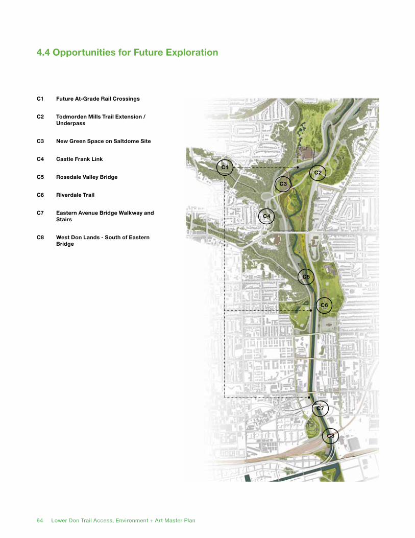
64 Lower Don Trail Access, Environment + Art Master Plan
4.4 Opportunities for Future Exploration
C1 Future At-Grade Rail Crossings
C2 Todmorden Mills Trail Extension / Underpass
C3 New Green Space on Saltdome Site
C4 Castle Frank Link
C5 Rosedale Valley Bridge
C6 Riverdale Trail
C7 Eastern Avenue Bridge Walkway and Stairs
C8 West Don Lands - South of Eastern Bridge
C1
C3
C5
C6
C7
C8
C4
C2
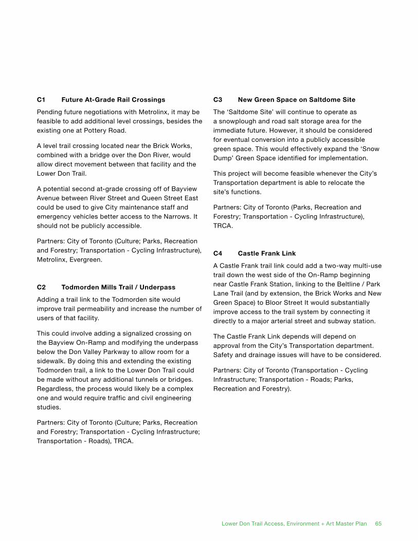
64 Lower Don Trail Access, Environment + Art Master Plan Lower Don Trail Access, Environment + Art Master Plan 65
C1 Future At-Grade Rail Crossings
Pending future negotiations with Metrolinx, it may be feasible to add additional level crossings, besides the existing one at Pottery Road.
A level trail crossing located near the Brick Works, combined with a bridge over the Don River, would allow direct movement between that facility and the Lower Don Trail.
A potential second at-grade crossing off of Bayview Avenue between River Street and Queen Street East could be used to give City maintenance staff and emergency vehicles better access to the Narrows. It should not be publicly accessible.
Partners: City of Toronto (Culture; Parks, Recreation and Forestry; Transportation - Cycling Infrastructure), Metrolinx, Evergreen.
C2 Todmorden Mills Trail / Underpass
Adding a trail link to the Todmorden site would improve trail permeability and increase the number of users of that facility.
This could involve adding a signalized crossing on the Bayview On-Ramp and modifying the underpass below the Don Valley Parkway to allow room for a sidewalk. By doing this and extending the existing Todmorden trail, a link to the Lower Don Trail could be made without any additional tunnels or bridges. Regardless, the process would likely be a complex one and would require traffic and civil engineering studies.
Partners: City of Toronto (Culture; Parks, Recreation and Forestry; Transportation - Cycling Infrastructure; Transportation - Roads), TRCA.
C3 New Green Space on Saltdome Site
The ‘Saltdome Site’ will continue to operate as a snowplough and road salt storage area for the immediate future. However, it should be considered for eventual conversion into a publicly accessible green space. This would effectively expand the ‘Snow Dump’ Green Space identified for implementation.
This project will become feasible whenever the City’s Transportation department is able to relocate the site’s functions.
Partners: City of Toronto (Parks, Recreation and Forestry; Transportation - Cycling Infrastructure), TRCA.
C4 Castle Frank Link
A Castle Frank trail link could add a two-way multi-use trail down the west side of the On-Ramp beginning near Castle Frank Station, linking to the Beltline / Park Lane Trail (and by extension, the Brick Works and New Green Space) to Bloor Street It would substantially improve access to the trail system by connecting it directly to a major arterial street and subway station.
The Castle Frank Link depends will depend on approval from the City’s Transportation department. Safety and drainage issues will have to be considered.
Partners: City of Toronto (Transportation - Cycling Infrastructure; Transportation - Roads; Parks, Recreation and Forestry).

66 Lower Don Trail Access, Environment + Art Master Plan
C5 Rosedale Valley Bridge
As a major trail node, the intersection of Rosedale Valley Road and Bayview Avenue is a logical place for a new pedestrian and bicycle bridge over the Bala railway line and Don River to the Lower Don Trail. Like the Lower Don Trail to Beltline Trail Bridge, this would be a substantially-sized and high profile structure. Detailed study would be required to determine exactly where it should be sited and oriented to provide enough room for an approach.
Partners: City of Toronto (Parks, Recreation and Forestry; Transportation - Cycling Infrastructure; Transportation - Roads), TRCA, Metrolinx.
C6 Riverdale Trail
The construction of a parallel trail on the east side of the Don River would mean upgrading trails in Riverdale Park East, opening new trail segments and signifying on-street connections. This timing and design of this trail would be connected to the South of Eastern development, through which its southern segment would go.
Partners: City of Toronto (Parks, Recreation and Forestry; Transportation - Cycling Infrastructure), TRCA, private landowner partners.
C7 Eastern Avenue Bridge Walkway and Stairs
Similar to the Bayview On-Ramp, a one-sided multi-use trail could be cantilevered on the Eastern Avenue bridge, which is currently auto-oriented. This timing and design of this link would be connected to the South of Eastern development.
Partners: City of Toronto (Parks, Recreation and Forestry; Planning - Urban Design; Transportation - Cycling Infrastructure), TRCA, Metrolinx, private landowner partners.
C8 West Don Lands - South of Eastern Bridge
Future development in the South of Eastern area will increase pressure for pedestrian and bicycle links between that district and the Lower Don Lands. The opportunities for siting and constructing a new bridge should be studied in concert with the redevelopment of the South of Eastern area. This might occur either north or south of the existing rail bridge, or even cantilevered onto its side.
Partners: City of Toronto (Parks, Recreation and Forestry; Planning - Urban Design; Transportation - Cycling Infrastructure), TRCA, Metrolinx, private landowner partners.

66 Lower Don Trail Access, Environment + Art Master Plan
Appendices
Component Projects Plan
Project Cost Estimates
Public Meeting Summary Report
Existing Conditions and Opportunities and Constraints Memo

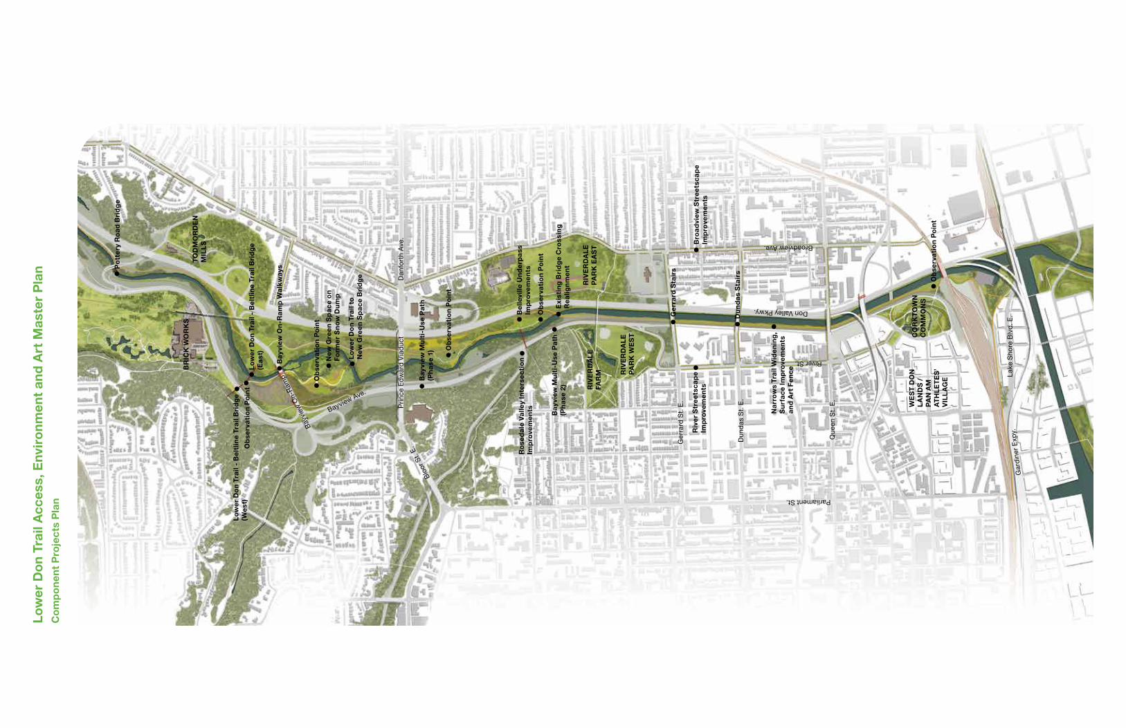
Bayview Ave.
Bay
view
On-
Ram
p
Don Valley Pkwy.
Pri
nce
Ed
war
d V
iad
uct
Broadview Ave.
BR
ICK
WO
RK
ST
OD
MO
RD
EN
MIL
LS
Dan
fort
h A
ve.
Blo
or S
t. E.
Po
tte
ry R
oa
d B
rid
ge
Bay
view
Mu
lti-
Use
Pa
th
(Ph
ase
1)
Lo
we
r D
on
Tra
il -
Be
ltlin
e Tr
ail
Bri
dg
e (E
ast
)
Lo
we
r D
on
Tra
il -
Be
ltlin
e Tr
ail
Bri
dg
e (W
est)
Bay
view
On
-Ra
mp
Wa
lkw
ays
Lo
we
r D
on
Tra
il to
N
ew G
ree
n S
pac
e B
rid
ge
New
Gre
en
Sp
ace
on
Fo
rme
r S
no
w D
um
p
Ob
serv
ati
on
Po
int
Ob
serv
ati
on
Po
int
Bro
ad
view
Str
eet
sca
pe
Imp
rove
me
nts
Ob
serv
ati
on
Po
int
Bay
view
Mu
lti-
Use
Pa
th
(Ph
ase
2)
RIV
ER
DA
LE
PA
RK
EA
ST
RIV
ER
DA
LE
PA
RK
WE
ST
RIV
ER
DA
LE
FA
RM
Ge
rra
rd S
tair
s
Riv
er
Str
eet
sca
pe
Imp
rove
me
nts
Na
rro
ws
Tra
il W
ide
nin
g,
Su
rfac
e Im
pro
vem
en
tsa
nd
Art
Fe
nc
e
Du
nd
as
Sta
irs
Exi
stin
g B
rid
ge
Cro
ssin
g
Rea
lign
me
nt
Ob
serv
ati
on
Po
int
Be
llevi
lle U
nd
erp
ass
Im
pro
vem
en
tsR
ose
da
le V
alle
y In
ters
ec
tio
n Im
pro
vem
en
ts
Ob
serv
ati
on
Po
int
CO
RK
TO
WN
CO
MM
ON
S
WE
ST
DO
N
LA
ND
S /
PA
N A
M
AT
HL
ET
ES
’ V
ILL
AG
E
Low
er D
on
Trai
l Acc
ess,
Env
iro
nm
ent
and
Art
Mas
ter
Pla
nC
om
po
nen
t P
roje
cts
Pla
n
Dun
das
St.
E.
Ger
rard
St.
E.
Que
en S
t. E
.
Lak
e S
hore
Blv
d. E
.G
ard
iner
Exp
y.
River St.
Parliament St.