Embed Size (px)
Citation preview
EVIDENCE FOR TEMPORAL CONTINUITY OF DEFORMATION IN THE BALTIS VALLIS REGIONOF VENUS FROM OBSERVATIONS OF CANALI TOPOGRAPHY. E. M. Stewart1 and J. W. Head III,Brown University, Providence, RI, 02912, [email protected].
Introduction: Researchers have established theusefulness of the 6800-km-long canali Baltis Vallis forthe illumination of the history of topography along itslength [1,2]. Three distinct scales of deformation havebeen observed, corresponding to regional basins(1000s of km), ridge belts (100s of km), and wrinkleridges (10s of km). The use of Geographic Informa-tion System (GIS) software allows more precise meas-urement of the sizes, shapes, and locations of defor-mational features than was previously possible. Thepresent study suggests that deformation in the BaltisVallis region was continuous over much of the timeobservable in the stratigraphic column [5].
Occurrence of Canali: Although Baltis Vallis isnormally regarded as a single channel, mapping onfull-resolution Magellan images reveals hints of manymore canali segments in the Baltis Vallis region thanwere previously documented [4]. Many researchershave noticed that canali are visible in the plains downto the limit of image resolution [5]. Short braidedstretches have been observed (near 44°N, 161°E) [2].In many locations Baltis Vallis splits into more thanone channel, with the split channels rejoining “down-stream” after running for as long as 400 km (near52°N, 175°E). There are long channels that appear tobe tributaries to Baltis Vallis (figure 1), and otherchannels whose relation to Baltis Vallis is not clear.Mapping of canali, as well as surface geology, is on-going through the use of GIS software.
This widespread occurrence of canali, many ofwhich apparently join with Baltis Vallis, indicates thatthe assumption of the existence of smooth topographywhen Baltis Vallis formed may be generalized to aswath of plains at some distance from the channel.Though it cannot be assumed that the plains were per-fectly flat, the assumption of a fluid origin for thesecanali would require a continuously negative slopealong Baltis Vallis from source to terminus and a posi-tive slope with increasing distance away from thechannel.
Stratigraphic Relations: Baltis Vallis occurs onlyon wrinkle ridged plains identified as Pwr1, and is lo-cally infilled by the younger, brighter plains materialidentified as Pwr 2 [3, 6]. The same is generally true ofother canali segments discussed above, although somecanali are apparently associated with distinct plainsflows whose relationship to Pwr2 is uncertain (42°N,156°E). The canali are cut everywhere by wrinkleridges. In a few locations a canal segment seems tohave controlled the location of a wrinkle ridge. Canali
are locally cut by very straight, radar bright featuresinterpreted as fractures [3].
Topographic Relations: The three scales of de-formation observed by [1] are clearly visible in theregional topography (figure 1). Intermediate-scalefeatures are visible in the plains as subdued arches,about 700 m high, spaced approximately 100 km apart.This scale corresponds to the distance between ridgebelts older than (embayed by) the plains on whichBaltis Vallis formed. These low-amplitude ridges areherein referred to as “plains arches” to differentiatethem from ridge belts and wrinkle ridges. One set ofarches has orientations sub-parallel to the structuraltrends of ridge belts, but other arches trend nearly or-thogonal to the ridge belts and butt against them.
Wrinkle ridges on Venus often occur in parallelsets that are coherent over large areas [7]. However, inthe Baltis Vallis region, wrinkle ridge orientationsgenerally reflect smaller-scale, local topography, ori-enting parallel to the local trend of the plains arches.The temporal relationship between wrinkle ridges andplains arches is unclear; they may be contemporaneousor the wrinkle ridges may postdate the plains arches.
Inferred Timing of Structure Formation: Theabove observations indicate a complex deformationalhistory for the Baltis Vallis region. Ridge belt topog-raphy must have occurred before the formation ofBaltis Vallis and the other canali, because the materialmaking up the ridge belts is clearly embayed by theplains on which the canali formed. If the assumptionthat canali were formed by fluid flowing under gravityis correct, then the plains arch topography, which ap-pears in some places to be the continuation of ridgebelt structural trends, could not have been the originaltopography of the plains lava flows. The tendency ofBaltis Vallis to become more sinuous and to anasto-mose over some plains arches suggests the possibilitythat some topography may have been developing as thechannel formed.
All of this evidence suggests that deformation inthe Baltis Vallis region was a continuous process fromridge belt formation time through wrinkle ridge forma-tion time, rather than several discrete deformationalepisodes. The difficulty of age dating material units onVenus due to the low numbers of preserved cratersprevents more than the coarsest estimation of thelength of the time scale of deformation. However, itcan at least be stated that the deformation was continu-ous through a large portion of the time represented bythe observable stratigraphic column [3].
Lunar and Planetary Science XXXI 1692.pdf
DEFORMATION OBSERVED IN VENUS CANALI TOPOGRAPHY: E. M. Stewart and J.W. Head III
The fact that deformation was continuous in loca-tion, direction, and wavelength suggests temporal con-tinuity of the stresses driving the deformation sincebefore the widespread wrinkle ridged plains were em-placed. If the stresses driving the deformation wererelated to whatever process caused the generation oflarge amounts of basaltic volcanism, a model that at-tempts to explain observed structures in the BaltisVallis region should predict compressive stresses withapproximately the same direction before, during, andafter basaltic volcanism.
Conclusions: Analysis of local and regional strati-graphic relationships [8, 9] has resulted in the devel-opment of a view of Venus tectonic history involving aseries of phases of deformation: (1) initial shorteningin tessera terrain; (2) widespread and distributed frac-turing in tessera and early post-tessera volcanic plains;(3) shortening and broad arching of plains to produceridge belts, along with local extension to form fracturebelts; and (4) emplacement of regional plains followedclosely by global wrinkle ridging [5]. Tectonism in theBaltis Vallis region proceeded through these distinctphases but with continuity of deformation patternsfrom one phase to the next. The apparent change indeformation style from ridge belts to plains arches andwrinkle ridges may result from the wrinkle ridgedplains having accrued less strain than is reflected in theridge belts. Alternatively, the changing deformation
style could reflect changing mechanical properties ofthe layer being deformed, a result of directional evolu-tion of the thermal and mechanical properties of theplanet.
References: [1] G. Komatsu and V. Baker, 1994.[2] E. Stewart and J. Head, 1999. [3] J. Head and A.Basilevsky, 1998. [4] G. Komatsu and V. Baker, 1993.[5] V. Baker et al., 1997; K. Roberts et al., 1992. [6]A. Basilevsky and J. Head, 1996. [7] F. Bilotti and J.Suppe, 1999. [8] A. Basilevsky and J. Head, 1995. [9]A. Basilevsky and J. Head, 1998.
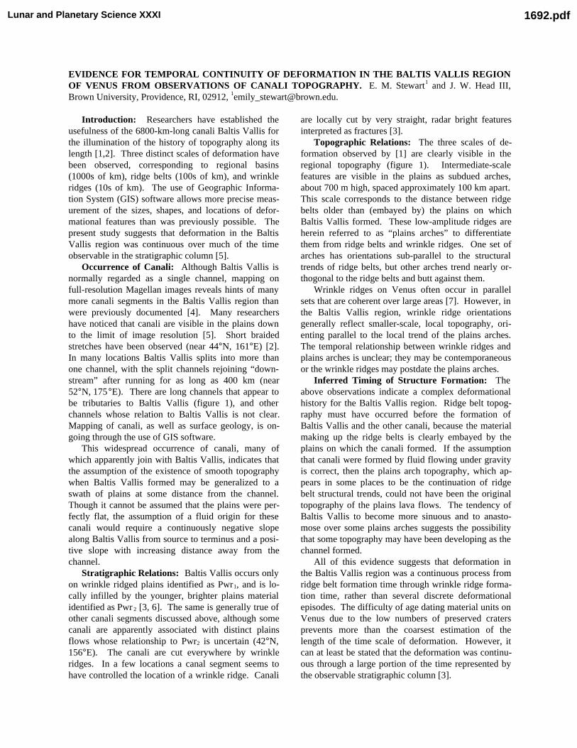
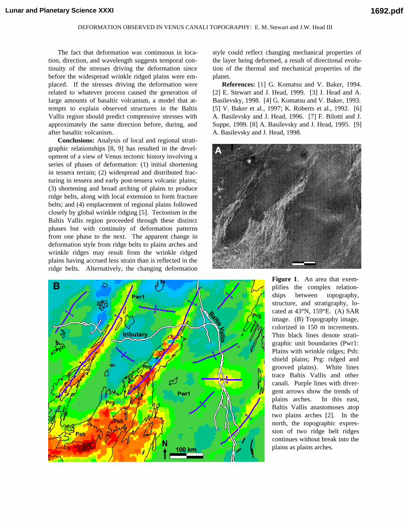
Figure 1. An area that exem-plifies the complex relation-ships between topography,structure, and stratigraphy, lo-cated at 43°N, 159°E. (A) SARimage. (B) Topography image,colorized in 150 m increments.Thin black lines denote strati-graphic unit boundaries (Pwr1:Plains with wrinkle ridges; Psh:shield plains; Prg: ridged andgrooved plains). White linestrace Baltis Vallis and othercanali. Purple lines with diver-gent arrows show the trends ofplains arches. In this east,Baltis Vallis anastomoses atoptwo plains arches [2]. In thenorth, the topographic expres-sion of two ridge belt ridgescontinues without break into theplains as plains arches.
Lunar and Planetary Science XXXI 1692.pdf