Embed Size (px)
Citation preview

ATOLL RESEARCH BULLETIN
NO. 435
MORPHOLOGY AND MARINE HABITATS OF TWO SOUTHWESTERN
CARIBBEAN ATOLLS: ALBUQUERQUE AND COURTOWN
JUAN M. DIAZ, JUAN A. SANCHEZ, SVEN ZEA, AND JAIME GARZON-FERREIRA
ISSUED BY NATIONAL MUSEUM OF NATURAL HISTORY
SMITHSONIAN INSTITUTION WASHINGTON, D.C., U.S.A.
APRIL 1996
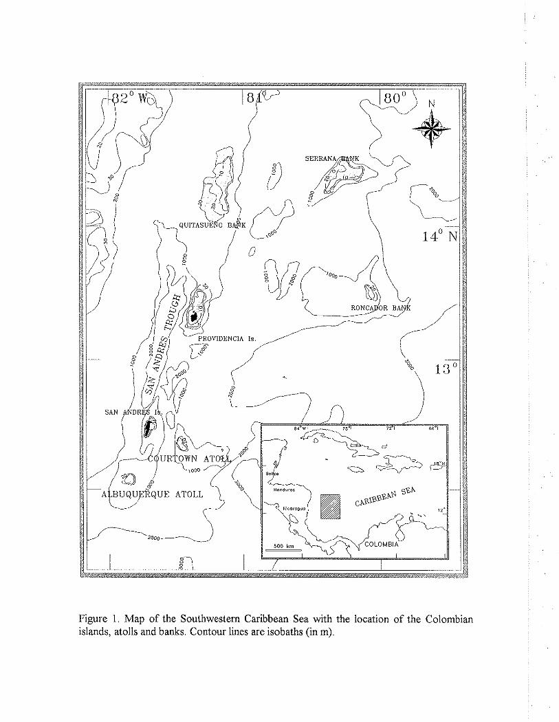
Figure 1. Map of the Southwestern Caribbean Sea with the location of the Colombian islands, atolls and banks. Contour lines are isobaths (in m).

MORPHOLOGY AND MARINE HABITATS OF TWO SOUTHWESTERN
CARIBBEAN ATOLLS: ALBUQUERQUE AND COURTOWN
BY
JUAN M. DIAZ', JUAN A. SANCHEZ', SVEN ZEA',~ and
JAIME GARZON-FERREIRA'
ABSTRACT
Albuquerque and Courtown are two small, uninhabited oceanic atolls, located in the southwestern Caribbean Sea, belonging to the San Andres and Providencia archipelago, Colombia. These atolls have a volcanic basement and are surrounded by deep water. Based on photo-interpretation of geomorphological and ecological features as well as on data collected during field work, the gross morphology, marine bottom habitats and reef structures of both atolls are described down to a depth of 50 in. Distributions of morphological and bottom habitat units are presented in thematic maps showing the overall zonational patterns in the two atolls.
Morphological and ecological zonation; in both atolls are primarily controlled by both wave exposure in a windward-leeward gradient and depth. The presence of an ample windward fore-reef terrace, a well developed windward barrier reef with spur-and-groove system, an extensive lagoonal terrace with sudden transition to the lagoon basin, and profuse development of ribbon and anastomosing patch reefs in the lagoon are characteristics common to both atolls. As in other Caribbean atolls, the outer slope in Albuquerque and Courtown is outlined by a sandy step or bench at 35 to 45 m depth. Significant differences between the two atolls exist in the degree of development and structure of leeward peripheral reefs, as well as in the amplitude of the leeward fore-reef terrace. At Albuquerque, peripheral reefs grow on a shallow flat and enclose the lagoon along a wide semicircle, whereas at Courtown such reefs have in part developed algal ridge-like structures and are unevenly distributed, leading to an open lagoon to the east. The broad leeward terrace in Albuquerque contrasts markedly with the rapidly dipping leeward slope towards the outer shelf margin in Courtown.
Accumulations of sand and rubble have led to the formation of cays and small islands on the lagoonal terrace in both atolls, but also on leeward peripheral reefs in
' Institnto de Investigaciones Marinas y Costeras, INVEMAR, Apartado 1016, Santa Marta, Colombia
Universidad Nacionat de Colombia (Departamento de Biologia) Manuscript received 31 March 1995; revised 21 November 1995

Courtown, some of which have experienced remarkable changes in their size and shape in the last 25 years.
Biological composition and structure of reefs in both atolls show a great resemblance to one another and to the better-known reef complexes around the nearby islands of San Andres and Providencia. Although no urban development exists in these atolls, recent decline of living coral and over-exploitation of marine resources were evident.
INTRODUCTION
There are about 425 atolls worldwide and only 15 of them are located in the Atlantic, of which four are part of the San Andres and Providencia archipelago in the Southwestern Caribbean Sea (Milliman, 1973; Geister, 1983). This archipelago comprises a series of islands, atolls and coral shoals running in SSE-NNE direction, parallel to the Nicaraguan Rise for more than 500 km. It is separated from the Central American continental shelf by the San Andres Trough (Fig. 1). The southernmost reefs of the archipelago, Albuquerque and Courtown (the latter are also called Bolivar Cays) are two small atolls lying about 200 km east of the Nicaraguan coast. Although geographically closer to Central America than to the South American continent, the archipelago has belonged to the Republic of Colombia since 1822.
The accurate date of human discovery of these atolls is uncertain but their locations were well known to the Spanish sailors of the 16th century and were probably occasionally visited by Miskito Indians from the Central American coast, who came for fishing and turtling (Parsons, 1956). None of the tiny sand cays on the atolls has sufficient land to warrant permanent settlement, but one of them on each atoll serves presently as a military post for the Colombian navy, and they are visited regularly by fishermen and tourists in chartered yachts from nearby San Andres.
Briefly mentioned by Darwin (1842) in his interpretation of Caribbean reef structures and their origin, the reefs of Albuquerque and Courtown have since received little scientific attention in comparison with those around the nearby islands of San Andres and Old Providence (Geister, 1969, 1973,1975,1992; Kocurko, 1977; Marquez, 1987; Diaz el al., 1995) and other West Atlantic and Caribbean atolls such as Hogsty Reef (Milliman, 1967), Alacran Reef (Kornicker and Boyd, 1962; Bonet, 1967), Chinchorro (Jordan and Martin, 1987) and those off Belize (Stoddart, 1962; James and Ginsburg, 1979; Riitzler and Mcintyre, 1982; Gischler, 1994). Albuquerque and Courtown were briefly visited by the Fifth George Vanderbilt Expedition in 1941. Published observations include reports on the birds (Bond and DeSchauensee, 1944), fishes (Fowler, 1944) and crustaceans (Coventry, 1944). The R/V GERDA, of the University of Miami, stopped in May 1966 for few days at Albuquerque and Courtown and conducted observations on the

ecology, morphology and oceanography of the atolls. From this visit, Milliman and Supko (1968) made preliminary conclusions on the geological origin, and Milliman (1969) described the general characteristics of the reefs and commented on hydrography. Further oceanographic findings from the waters surrounding the atolls have been recorded during research cruises by the Colombian navy (Gonzalez, 1988; Tellez et aL, 1988). Aspects of the terrestrial environment and fauna were more recently discussed by Chirivi (1988). However, very little is known about the distribution of marine bottom habitats and the zonation of the reefs constituting these atolls.
Therefore, the purpose of this paper is to give the first detailed systematic description of the gross morphology and the marine habitats of Albuquerque and Courtown atolls, with emphasis on the reef structures.
REGIONAL SETTING
Albuquerque and Courtown are the southernmost reef complexes of the San Andres and Providencia archipelago. Albuquerque (12O 10' N and 81° 51' W) is located 37 km south of San Andres Island and about 190 km east of the Nicaraguan coast. It is nearly circular in shape, about 5.5 km E-W and 4.5 km N-S. Two small islands, North Cay and South Cay, rise up to 2 m above mean sea level behind the seaward barrier reef and are separated from each other by a 250 m shallow channel.
Courtown (12O 24' N and 81° 28' W) lies 30 km southeastward from San Andres and 47 km northeast of Albuquerque. It is kidney shaped, about 3.5 km E-W and 6.5 km SSE-NNW (Fig. 3). Although this atoll presently bears two cays (East Cay and West or Bolivar Cay) and a tiny sand spit, their size, shape and number seem to be quite variable in the course of time, as can be easily inferred from an earlier description and map of the atoll by Milliman (1969).
Toward the north and eastern sides of both atolls, an almost continuous barrier reef is well developed, whereas the leeward peripheral reefs are absent or ill defined and are separated by wide gaps and channels.
Both atoll foundations rise from the surrounding sea floor more than 1000 m deep, and apparently have a volcanic basement. Unequivocal evidence for the volcanic origin of these atolls and nearby islands comes from the magnetic anomalies detected at San Andres Island and Courtown, one volcanic pebble dredged from Albuquerque basement (Milliman and Supko, 1969), as well as the volcanic rocks of Providencia (Geister, 1992) and the Corn Islands (McBirney and Williams, 1965). Further aspects of the geological origin of the archipelago are discussed by Geister (1992: p. 56-58)
Available meteorological data recorded from nearby San Andres between 1959 and 1986 (Diaz et al., 1995) are used here, as there are no recorded observations from

either atoll. The mean annual air temperature is 27.4OC, with a 1°C range in monthly values.The annual rainfall measured at San Andres is about 1900 mm, of which over 80% falls between June and November. Winds are trades, from the ENE, with a mean annual intensity of 6.1 d s and mean monthly variations between 4.5 d s (May, September- October) and 6.6 d s (December-January, July). Sporadic storms occur mostly in the second half of the year, with westerlies or northwesterlies attaining speeds over 20 d s .
Albuquerque and Courtown lie in the Caribbean hurricane belt. Hurricanes were recorded in 1818, 1876, 1877, 1906, 1940, 1961, 1971 and 1988 (cf Barriga et aL, 1969: 23; Geister, 1992: 7; Diaz et al., 1995: 112). The latter, 'Joan', on October 20-22 1988, passed westwards 90 km south of San Andres (about 50 km south of Albuquerque); its eye attained a diameter of about 35 km and the wind reached speeds over 210 k d h (Geister, 1992).
The Caribbean Current reaches Albuquerque and Courtown from the NE with speeds of 0.5-1 d s and passes over the atoll shelf in a SW to W direction, being highly affected by the irregular bottom topography of the shallow-water zones. Waves are generated by the trade winds and approach the atolls from the NE to E, the effective fetch extending for nearly 2,000 km over almost the entire width of the Caribbean Sea. Hence, the considerable amplitude and height of waves breaking on the barrier reef along the windward side of the atolls.
The sea surface temperature averages 27.S°C, with mean monthly values ranging between 26.8 (February-March) and 30.205: (September-October). Surface salinity fluctuates between 34.0 and 36.30/00 (Gonzalez, 1988). Tides on the atolls are mixed with a strong diurnal component. ~ i d a l ranges between 0.3 and 0.6 m are recorded from nearby San Andres (Geister, 1975).
METHODS
A preliminary photo interpretation of geomorphological and ecological features of both atolls was done on panchromatic total coverage air photography taken in 1971 and 1984 by the Colombian Geographical Institute (Instituto Geografico 'Agustin Codazzi') approximately 1:22,500, 1:23,000 and 1:30,000, which was then used as basis for field sampling. Preliminary morphological and habitat distribution maps at 1 :20,000 scale were drawn combining reef and lagoon photo-patterns defined on the basis of tone, texture and location, as well as bottom topography inferred from bathymetric charts 1:20,000 COL- 203 (Albuquerque) and COL-204 (Courtown). Further detail of the spur-and-grove system of the barrier reefs and lagoonal patch reefs was obtained from oblique aerial colour slides taken on September 29, 1994 from a chartered aircraft at altitudes of 200 to 500 m.

During a cruise to the atolls in May-June 1994 aboard the RIV ANCON of the Instituto de Investigaciones Marinas y Costeras (Santa Marta, Colombia), 8 days (May 20-27) were spent at Courtown and 12 (May 28 - June 8) at Albuquerque. A total of 23 (Courtown) and 25 (Albuquerque) observation and sample sites were visited (Figs. 2-3). Location of sample sites included several examples of each of the photo-pattern units, and their exact geographical placement was carried out with an accuracy of 20 m with the aid of a portable Geographic Positioning System (GPS) instrument. SCUBA was used for depths over about 6 m SCUBA was used, otherwise observations were made while skin diving or walking for shallower areas. Observations of bottom types, depth, direction of currents, dimensions and distribution patterns of the reef structures, as well as species composition of dominant biota were recorded on acrylic data sheets. Complementary depth profiles were recorded with the ship's echosounder (28 khz).
Final thematic maps at 1:20,000 (bathymetry, geomorphology, bottom habitats, wave exposure) were entered via a digitizing table into a geographic information system (GIs-ILWIS) for storage, processing and further analysis. Morphology and habitat classification and terminology vary considerably between authors, and the terms used here to define morphological units and reef zones follow those of Geister (1975, 1977, 1983). Marine habitats are named, where possible, after the substrate dominating macrobiota or substrate features, as was done by Duyl (1985) for the reef environments of the Netherland Antilles.
RESULTS
Both atolls have the same basic morphological features (Figs. 2 and 3) and, with minor differences, the same marine environments (Figs. 4 to 7). To save space, a general description of each of the morphological units is given below with comments on the bottom habitats found there (map units on Figs. 6 and 7) and, where necessary, on the pecularities of each atoll. Table 1 includes a brief description of the habitats (map units) and allows cross referencing to morphological units. Figures 4 and 5 are representative profiles of the atolls and show the morphological features and bottom habitat distribution i o n g a windward-leeward (right to left) gradient.
FORE-REEF TERRACE AND OUTER SLOPE The windward margin of the atolls is characterized by the presence of a gently
dipping terrace, descending at low angle (from 6 to 9 degrees) to -24 to -30 m (somewhat deeper in Albuquerque than in Courtown), where a topographical break gives way to a subvertical slope below -30 m. The break marks the transition to the outer slope of the atoll shelf. From a depth of 4-8 m seaward of the barrier reef, to about -15 m, this flat, calcareous platform is, with the exception of scattered gorgonians (I'seudopterogorgia sp.) and large sheets of excavating sponges (Cliona aprica and C: carihhea), mostly devoid of sessile organisms and sediments ('bare calcareous hard bottom' unit). Low relief calcareous ridge-like structures, with a parallel layout similar to the spur and groove

system of the barrier reef (see below), are found along the entire width of the terrace and are more conspicuous on the northeastern section of the atolls. Shallow furrows between these low ridges are filled with coarse sediments and rubble below 18 m. Toward the outer margin of the fore reef terrace, faunal richness and diversity increase gradually, at first especially with brown algae (Sargassum sp., Sfypopodium sp.), green algae (Halimeda spp.), massive scleractinians (Diploria spp., Porites astreoides, Siderastrea siderea) and many branching octocorals (Pseudopterogorgia spp., Pterogorgia citrina, Eunicea spp., Plexaurella spp.) ('Gorgonaceans on hard bottom' unit). Below 18 m more and more hemispherical scleractinians (Montastraea spp., Colpophyllia natans, and others) and sponges come into sight, as well as coarse sediments that accumulate in shallow hollows. Although coral heads often attain considerable size, they are mostly solitarily, tens of meters apart. In contrast to this, a narrow belt along the transition zone to the outer slope (24 to 30 m) exhibits a well developed coral community, and the calcareous platform appears therefore almost totally covered by corals (Montastraea spp., Colpophyllia natans, Agaricia agaricites, Dichocoenia stokesii, Stephanocoenia intersepta, among others) , algae (Lobophora sp., Halimeda spp.), sponges and octocorals Cmixed corals' unit).
The windward outer slope was visited only in Courtown, but its morphology seems to be similar in both atolls, as could be inferred from the recorded bathymetric profiles. The outer slope dips gently (ca. 40-50°) to a sand step beginning at -30 to -35 m. Since this step can be easily recognized on the aerial photographs as a narrow, light grey band along the windward margin of the atolls, thus it seems to be covered by high- reflectance sediments. Below this step, the outer slope decreases subvertically to -400 m and then at lower angle to depths beyond 1,000 m.
WINDWARD BARRIER REEF The barrier reef does not completely encircle the atolls, but extends only along the
inner shelf from the NNW, N, NE, E, and SE almost continuously for about 5.6 km at Albuquerque and 7.5 km at Courtown. The continuous reef segments are 50-250 m across, being formed by more or less coherent ridges rising from the upper margin of the fore-reef terrace at 5 to 6 m to a reef flat near low tide level.
The barrier reef is normally deeply penetrated by surge channels oriented perpendicular to the reef front, forming a typical spur-and-groove system which is easily recognizable on the aerial photographs. Also scattered coral pinnacles rise in some places from about -4 m, just windward of the surf zone, often breaking the surface. The spurs rise 0.5 to 2 m above the adjacent grooves, the latter being 1 to 5 m or more wide and often exhibiting anastomosing bifurcations (Plate 1). At Courtown, the barrier reef is indented at two places, giving the atoll its distinctive kidney shape. Here, the reef crest becomes discontinuous, and a well developed buttress-groove system appears instead (Plate 2), creating a transition zone 300 to 500 m wide between the fore-reef terrace and the lagoonal terrace in its lee. The 2-3 m depth surge channels in this area allow small boats to pass the barrier during calm days. At Albuquerque, the barrier reef is virtually continuous, but on its NE margin a few unusually wide grooves interrupt the reef flat for

10 to 20 m, permitting some waves to pass undisturbed into the lagoonal terrace. At this place, a second, discontinuous barrier reef, located 100 to 200 m behind the former and nearly parallel to it, generates a displaced surf zone clearly observable from the air.
The main framework builder in the windward reef flat is the hydrocoral Millepora complanata, which is commonly associated with incrustations of coralline algae. Millepora and the zoanthid Palythoa sp, overgrow the shallowest zone of the barrier reef flat and the upper surfaces of the spurs ('Millepora-Palythoa' unit), the high surf splashing and washing permanently the emergent colonies. In the buttress-groove area in Courtown, as well as in the second barrier at the NE margin of Albuquerque, Palyihoa is generally replaced by Porites porites (growing usually within the Millepora colonies) and crustose forms of Porites astreoides and Diploria clivosa, which overgrow with Millepora the upper parts of the buttresses and the reef flat ('Millepora-I? porifes' unit). The upright sides of the spurs and buttresses are encrusted with Diploria spp., Porites astreoides and Agaricia agaricifes, often assuming a flat form. The hydrocoral Stylaster roseus, the green alga Halinzeda, as well as coralline red algae (Porolithon sp.) are also common elements in this zone. Large (up to 2-3 m in diameter) sheet-like excavating sponges (Cliona aprica, (1: caribbea) may be fairly common at the sides and bottom of grooves.
Leeward of the reef crest, following the 'Millepora-Palythoa ' unit, cushion-like colonies of Porifesporites as well as massive P. astreoides and Diploria srrigosa occur at some places among small ridges of Millepora and calcareous boulders ('Millepora-P. porites' unit). The displaced rear barrier reef.on the NE side of Albuquerque consists likewise of extensive ridges with Millepora complanata and Porites porifes rising from - 1.5 to -2.5 m. In some places, like in the NE barrier of Albuquerque and the SE section of Courtown, the coral growth on the rear reef zone extends for about 250 m. There, the end of the barrier reef is marked lagoowards by patchy thickets of Acropora palmata, accompanied by small colonies of Diploria strigosa, Montastraea spp. and occasionally also by cushion shaped colonies of Poritesporifes ('Diploria-A. palmafa' unit).
In Courtown, the southernmost portion of the barrier reef becomes discontinuous after it bends westward. Numerous pinnacles, constituted mostly by a framework of Millepora at their upper parts, rise in this area from -4 to -5 m reaching up usually to a few centimeters below the surface (Plate 3). At the base of the pinnacles are massive colonies of Uiploria spp, commonly more than 2 m in diameter, small thickets of Acropora cervicornis and branching octocorals. The pinnacles are generally arranged in groups, separated by anastomosing sandy channels, with a characteristic wave-induced pattern of ripple marks. Coral rubble (mostly of Acropora cervicornis) accumulates at the sides of the channels.
LAGOONAL TERRACE The leeward margin of the reef flat leads down to the lagoonal terrace usually with
an abrupt, 0.6 to 1.5 m high, steep slope. The lagoonal terrace is a flat platform attaining a width of 200 to 900 m and increasing in depth from 1 to 3 m towards its inner margin. The lagoonal terrace is one of the most discernible features from the air due to its pale

hue. Close to the rear reef, the terrace is covered by rubble ('hard bottom and rubble' unit), which is gradually replaced lagoonwards by gravel and coarse sand ('sand and rubble' unit). The rubble zones are usually arranged in elongated layers perpendicular to the barrier reef, apparently related to the grooves and depressions of the reef crest. The innermost rubble areas on the terrace are overgrown by green (Halimeda, Padina), brown (Dictyota, Turbinaria) and red algae (Amphiroa, Neogoniolithon), as well as scattered encrusting scleractinians (P. astreoides, Siderastrea)('rubble with algae' unit). Some portions of the sandy bottom, particularly in Albuquerque, are sparsely colonized by green algae (Penicillus, Rhipocephalus, Udotea), where juvenile individuals of the gastropod Strombus gigas are fairly common. The lagoonal terrace normally terminates on its lee with a steep 'sand cliff', leading down into the lagoon basin with slopes up to 400. It represents an accretionary fore-set of fine-grained sediments transported from the reef area to the leeward margin of the terrace
The two cays existing in Albuquerque (North Cay and South Cay, Plate 4), as well as East Cay in Courtown (Plates 5 and 6) , are sand and rubble accumulations on the lagoonal terrace. Coconut palms, Ficus trees, Scaevola bushes and lburnefortia shrubs are the dominant vegetation. North Cay, at Albuquerque, serves today as military post for the Colombian navy. Several bands of beachrock, paralleling the windward shoreline of these cays, extend eastward on the lagoonal terrace for about 15 (both cays in Albuquerque, Plate 7) to 70 m (East Cay in Courtown), suggesting the location of previous shorelines and thus a lagoonward migration of the cays. The two cays at Albuquerque are presently very close to the leeward margin of the lagoonal terrace. Where submerged beachrock is not covered by rubble and sand, it is mostly overgrown by encrusting coralline and green algae (HaZimeda, Rhipocephalus) that contain dense populations of boring sea urchins (Echinometra Zucunter). The only sea grasses on the atolls occur on the sheltered leeward side of North Cay in Albuquerque and East Cay in Courtown, where they cover the shallow sandy bottom of the terrace ('sea grass' unit) The dominant grasses in Courtown are Syringodium and Halodule, whereas Thalassia is more abundant in Albuquerque. The edible urchin, Tripneustes ventricosus, is abundant in these grass meadows.
LAGOON WITH PATCH REEFS The depth of the lagoonal basin is as much as 18 m (in Albuquerque, see below)
but generally it varies between 8 and 10 m. Where corals and coral reefs are lacking, the lagoon floor is covered by white calcareous sediments, the coarser fractions of which consist mostly of fragments of coral, molluscs, foraminifera, coralline algae and Halimeda, and rubble. Numerous burrows, mouds and faecal pellets throughout the deeper parts of the lagoon evidence an active bioturbation of the bottom ('bioturbated sediments' unit). Green algae (Rhipocephalus, IJdotea, Halimeda) grow sparsely around coralline areas forming small patches, where one or more individuals of the Queen Conch, Strombus gigas, as well as patchy aggregations of garden eels (Taeniconger sp.) are occasionally found.

A significant portion of the lagoon is occupied by coral reefs, which are highly variable in shape and size, as well as in the dominant scleractinian species, depending mainly on the depth and wave exposure. Reefs occur as solitary mounds and miniatolls, or as ribbon and anastomosing patch reefs. In order to simplify the nomenclature, we divided the patch reefs found inside the lagoon into three main types (map units, see Table I), according to the dominant scleractinian species: a) emergent to very shallow 'Diploria-A. palmata' reefs dominated at their summit by Diploria strigosa and Acropora palmata, b) 2-5 m deep 'A.cervicornisf reefs dominated by thickets of Acropora cervicornis, and c) 4- 16 m deep 'Montastraea spp'.-reefs dominated by one or more species of the Montastraea annularis species complex (see Weil and Knowlton, 1994).
At Courtown, lagoon depths vary between 7 and 15 m. Patch reefs cover about 30% of the lagoon floor. In the northern half of the lagoon, where the average depth is about 10 m, a dense net of anastomosing reefs (Montastraea spp.) covers nearly 50% of the bottom. Most of them are low-lying, rising no more than 4 m above the bottom (Plate 8), but some are nearly emergent and form a wave-breaking zone of thickets of A. palmata. The relative coverage of living scleractinians composing these reefs ranges between 10 to 50% from one patch to another. In many places, heads of Montastraea annularis are extent overgrown by filamentous and brown algae (mainly Lobophora variegata), and scattered thickets of Acropora cervicornis are up to 90% devoid of living tissue. Although the bottom in the central and southern portions of the lagoon is predominantly covered by sand, solitary mounds and scattered coral heads are common. In some places of the central area, large aggregations of single coral heads and small thickets of A. cervicornis occur (at present largely dead), forming diffise, non-cohesive reef communities. The lagoon is rather open to the E and NE, lacking a well defined sill.
Nearly 25% of the lagoon floor at Albuquerque is covered by patch reefs. The lagoon exhibits two distinctly depth levels, which are easily recognized from the air because of their different blue hues (Plate 9). A first level, with an average almost constant depth of 9 m, takes up the N and E parts of the lagoon and about 65% of its whole area. The second depth level averages about 15 m and takes up the leeward half of the lagoon to the W and S. Both levels are separated by a meandering ribbon reef of 'Montastraea spp.', which wanders for nearly 6 km, attains 10 to 30 m in width and rises up to -4 m. On the upper lagoon level there are also several nearly circular shaped miniature atolls which break the surface. These reefs are of type Montastraea spp. at their base but show a typical zonation to the 'Diploria-A.palmataf type towards the summit. Anastomosing patch reefs (Montastraea spp.), with the same basic structure as those at Courtown, are found in the northeastern and southeastern parts of this lagoon level. The deeper level is more sparsely covered by reefs. These are mostly low-lying, isolated patch reefs of the 'Monfastraea spp' type. The depth of the lagoon diminishes leewards to about -5 m or less and the bioturbated sediments of the bottom give way to a gravel-rubble zone, representing the lagoon sill and the transition zone to the western terrace.
According to our observations, lagoonal currents are completely wind-driven and perceptible over the entire water column. Although some differences in direction and
intensity were noticed from one location to another, average current velocities of about 2.5 mlmin were estimated on the surface at an almost constant wind intensity of 3 m/s in Courtown, and of about 3.5 ndmin (wind velocity: 6.5 m/s) in Albuquerque. Considering the rather small size as well as the shallow and open nature of the lagoons, the residence time of lagoonal water masses are thus apparently short, probably not exceeding 24-36 hours.
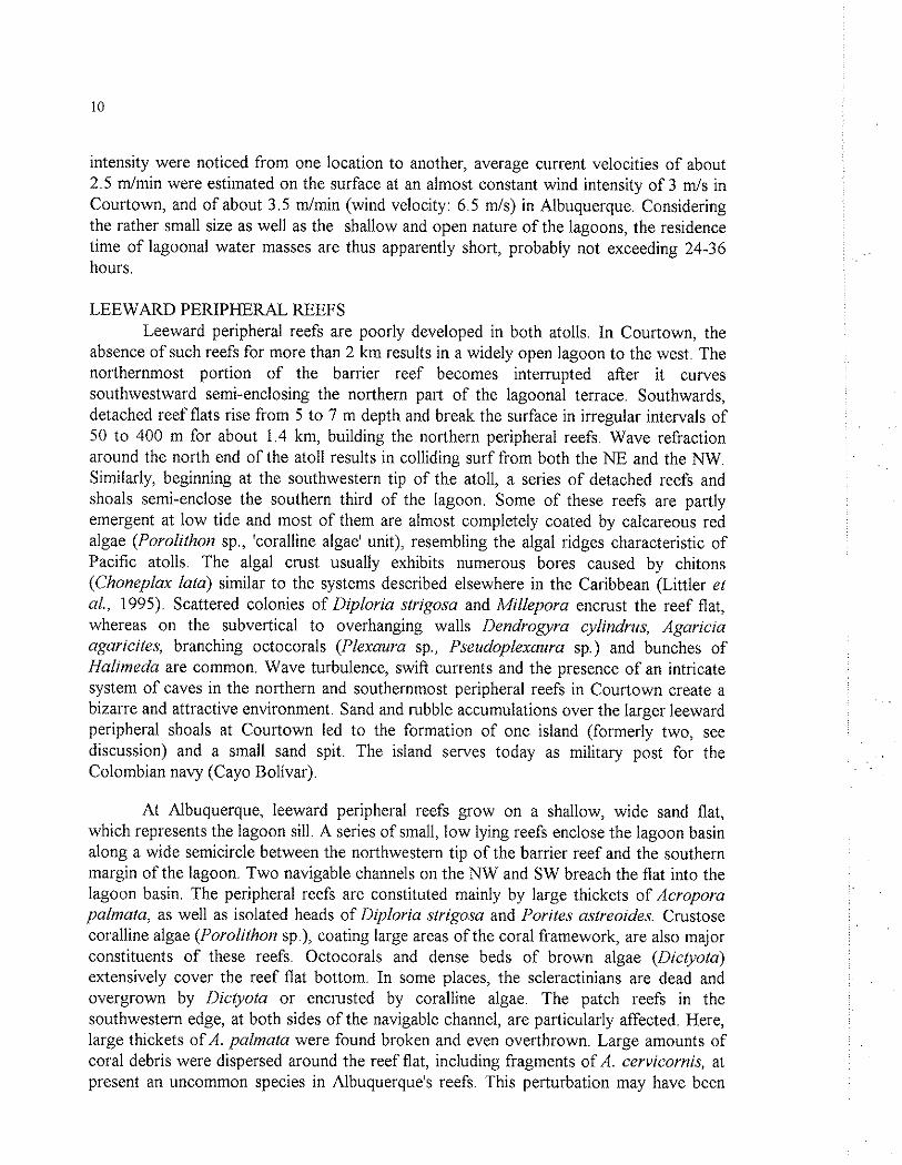
LEEWARD PERIPHERAL REEFS Leeward peripheral reefs are poorly developed in both atolls. In Courtown, the
absence of such reefs for more than 2 km results in a widely open lagoon to the west. The northernmost portion of the barrier reef becomes interrupted after it curves southwestward semi-enclosing the northern part of the lagoonal terrace. Southwards, detached reef flats rise from 5 to 7 m depth and break the surface in irregular intervals of 50 to 400 m for about 1.4 km, building the northern peripheral reefs. Wave refraction around the north end of the atoll results in colliding surf from both the NE and the NW. Similarly, beginning at the southwestern tip of the atoll, a series of detached reefs and shoals semi-enclose the southern third of the lagoon. Some of these reefs are partly emergent at low tide and most of them are almost completely coated by calcareous red algae (Porolithon sp., 'coralline algae' unit), resembling the algal ridges characteristic of Pacific atolls. The algal crust usually exhibits numerous bores caused by chitons (Choneplax lata) similar to the systems described elsewhere in the Caribbean (Littler et aL, 1995). Scattered colonies of Diploria strigosa and Millepora encrust the reef flat, whereas on the subvertical to overhanging walls Dendrogyra cylindrus, Agaricia agaricites, branching octocorals (Plexaura sp., Pseudoplexaura sp.) and bunches of Halimeda are common. Wave turbulence, swift currents and the presence of an intricate system of caves in the northern and southernmost peripheral reefs in Courtown create a bizarre and attractive environment. Sand and rubble accumulations over the larger leeward peripheral shoals at Courtown led to the formation of one island (formerly two, see discussion) and a small sand spit. The island serves today as military post for the Colombian navy (Cayo Bolivar).
At Albuquerque, leeward peripheral reefs grow on a shallow, wide sand flat, which represents the lagoon sill. A series of small, low lying reefs enclose the lagoon basin along a wide semicircle between the northwestern tip of the barrier reef and the southern margin of the lagoon. Two navigable channels on the NW and SW breach the flat into the lagoon basin. The peripheral reefs are constituted mainly by large thickets of Acropora palmata, as well as isolated heads of Iliploria strigosa and I'orites aslreoides. Crustose coralline algae (Porolithon sp.), coating large areas of the coral framework, are also major constituents of these reefs. Octocorals and dense beds of brown algae (Dictyota) extensively cover the reef flat bottom. In some places, the scleractinians are dead and overgrown by Dictyota or encrusted by coralline algae. The patch reefs in the southwestern edge, at both sides of the navigable channel, are particularly affected. Here, large thickets of A. palmata were found broken and even overthrown. Large amounts of coral debris were dispersed around the reef flat, including fragments of A. cervicornis, at present an uncommon species in Albuquerque's reefs. This perturbation may have been

caused by hurricane 'Joan', whose eye passed westward in October 1988 only a few kilometers south of Albuquerque, with winds of more than 200 kmlh, which produced very abrasive swells from the south.
LEEWARD TERRACE AND OUTER SLOPE In the leeward margin of Courtown Atoll there is not a well defined fore-reef
terrace. A slope descends in a distance of no more than 200 to 300 m from the shallow reef flat or the lagoon sill to 17 to 20 m, giving rise suddenly to a subvertical sand slope or to a vertical cliff with locally overhanging ledges. The sand-covered slope of the terrace acts as sedimentary ramp, across which reef detritus falls to greater depths. In the northern and central sections, extensive but somewhat diffuse coral carpets cover as much of the bottom, forming elongated low buttresses in an E-W direction and alternating with rather broad sandy channels. Much of the coral (ca. 75% of the bottom) is at present dead and overgrown by fleshy brown algae (Lobophora, Dictyota), whereas living scleractinians cover no more than 10% of the bottom. Although in the southern half of the terrace coral carpets are scantier and have a patchy distribution, they are better developed and form a distinct hardground on the sandy slope, showing a coverage of nearly 70% of living tissue ('scattered corals' unit).
At the outer edge of the terrace, the angle of the sandy slope increases to nearly 45O, whereas the reef slope drastically changes to a near vertical wall at about -15 m. Species richness and abundance of scleractinians are very high on the outer margin of the terrace, where massive Montastraea annularis, M franksi, M cavernosa and Colpophyllia natans form especially in the southern part, large dome-like structures rising up to 3 m above the bottom ('mixed corals' unit). Between these structures usually run 'sand rivers', which continue as sand falls on overhanging locations along the drop-off. Apart from scattered, small plate-like agariciids such as Agaricia undata, the vertical cliff is mostly devoid of corals and the only organisms attached to the rather smooth substratum are large tube-like and ramose sponges (Agelas conifera, Aplysina spp., Iofrochota hirofulata), antipatharians and clumps of Halimeda. At the southern locality visited, the cliff remains vertical to about -45 m, where a slanting sand-covered step, about 40 m wide, lines the outer slope of the atoll shelf In this area, the sand-covered bench deepens at an angle of nearly 300 to about -55 m, where a steep slope continues to greater depths. The loose sand on the slope is composed ofHalimeda with accessory shell and coral grains. Large plate-like corals (probably Agaricia and Montastraea) and antipatharians could be observed from above growing along the outer margin of the sandy slope. At another locality, situated in the central section, the drop-off is subvertical to -28 m and is mostly covered by plate-like scleractinians (Agaricia, Montasiraea); the sand step is much wider and dips at a lower angle. It seems probable that such a sandy step does occur along the entire leeward margin of the atoll, although the indicative lighter photo-pattern is not always visible on the aerial photographs, possibly due to its variable slope angle and width.
In contrasting to Courtown, the leeward fore-reef terrace at Albuquerque is broader, extending for 1 to 1.6 km, and reaching depths greater than 30 m. It is an

extensive, gently dipping platform, descending at a low angle (4 to 7 degrees) to about 15 m and then gradually steeper to nearly 40 m, where the subvertical drop-off of the outer slope begins. The bottom in the upper portions of the terrace is mostly covered by ripple marked sand and rubble, although the calcareous hardground appears at certain locations as elongated buttresses, about 1.5 m high, being thus sparcely overgrown by brown algae (Slypopodium, Dictyota) and branching octocorals. Scleractinians are very scarce to depths of about 12 to 15 m (living coral coverage: 5-20%), but their abundance and species richness increase gradually with a simultaneous increase of the slope angle. At the two localities visited, the outer margin of the terrace is marked respectively at -18 and -27 m by a subvertical escarpment, densely covered by plate-like and pagoda-like scleractinians (Agaricia spp., Montastraea franksi), sponges and antipatharians, which descend to nearly -35 m and give way to the accustomed sand step. Such a sand-covered bench or step at 40-45 m depth was recorded on bathymetric profiles at other places of the leeward outer margin of Albuquerque (Fig. 8), and can be distinguished on aerial photographs as a lighter narrow band, outlining almost the entire outer slope around the atoll shelf.
DISCUSSION
Rather than by its origin (e.g. Darwin, 1842), an atoll is defined by its geomorphic features (Milliman, 1967, 1973; Geister, 1983). Hence, Albuquerque and Courtown may be called atolls. When Milliman (1969) first described the gross morphology and environmental features of the southwestern Caribbean atolls, he was impressed by their close climatologic, oceanographic and geologic resemblance to many Pacific atolls: surrounded by deep water, little seasonal change, appreciable windward fetch, and a Millepora-I'alythoa zone that emerges at low tide, resembling somehow the leeward portions of the algal ridge found in Pacific reefs. Besides this, the atolls belonging to the archipelago of San Andres and Providencia are supposedly the only ones in the Caribbean atolls with a volcanic basement (cf Milliman and Supko, 1968; Geister, 1992).
The atolls of Albuquerque and Courtown share with nearby San Andres Island and other reef areas of the archipelago, the geological foundations upon which they rest and a similar set of environmental conditions. Other Atlantic atolls, such as the ones found off Belize and the Yucatan Peninsula (Lighthouse Reef, Glover's Reef, Turneffe Islands, Chinchorro Bank, see Stoddart, 1962; James and Ginsburg, 1979; Jordan and Martin, 1987), in the Gulf of Mexico (Alacran Reef, Kornicker and Boyd., 1962) and the Bahamas (Hogsty Reef, Milliman, 1967) show indeed some analogies with Albuquerque and Courtown in their basic morphology, but they have different geological histories.
The presence of an extensive windward fore-reef terrace in Albuquerque and Courtown is a characteristic common to most Caribbean atolls. As in the Belizean atolls, the outer margin of the fore-reef terrace is defined by a sudden change of the slope angle at about -20 to -25 m, where the nearly vertical cliff of the outer slope begins. The fore- reef terrace or seaward bank is likely one of the essential morphological differences between Caribbean and Pacific atolls. In the latter, the exposed reef margin margin is the

site of most active coral growth, leading to the development of characteristic shelf-edge reefs.(cf Wiens, 1962). The existence of a sandy step or bench at -35 to -45 m, that outlines the outer slope of the atoll shelf, is also a common feature of the Belizean atolls (cf James and Ginsburg, 1979). This step, called by some authors the '-40 m Terrace', is a widespread characteristic of Caribbean reefs. It occurs also in the Bahamas (Zankl and Schroeder, 1972), Jamaica (Goreau and Land, 1974), Curaqao (Focke, 1978), San Andrb (Geister, 1975), Providencia (Geister, 1992) and other Caribbean islands.
The present morphology of the outer margin in Caribbean reefs has been interpreted in relation to the fluctuations of sea level in the last 80,000 years. As did James and Ginsburg (1979) for the Belizean reefs, and Geister (1975, 1992) for the fore-reef terraces of San Andres and Providencia, respectively, we may assume that the outer margin of Albuquerque and Courtown, indicated by the '-20 m Terrace', corresponds to a truncation of the former marginal reef area that occurred before the last interglacial (Sangamon, about 125,000-80,000 years b.p.). In the period between Sangamon and 10,000 years b.p. sea level was not constantly low (about -120 m under present sea level). At least three high stands of sea level took place during that time, reaching to nearly -25 to -40 m below present sea level (Bowen, 1988). The coincidence of the sandy bench in present morphology at -35 to -40 m around both atolls, as well as the occurrence of a deep intertidal notch at this level on the vertical cliff (at least at the visited locality in Courtown), led us to explain this topography as a truncation of the emerging shelf margin during a Pleistocene sea-level stand at about -40 m that may be regarded primarily as an erosional feature. Unlike other Caribbean reefs, such as those off Belize (James and Ginsburg, 1979) and Jamaica (Goreau and Land, 1974), where this feature is now subdued by overgrowing modern facies, no significant accretion to the reef margin seems to have occurred during the Holocene rise of the sea level either in Albuquerque or in Courtown, or in the reefs surrounding San Andres (cf. Geister, 1975) and Providencia (cf. Geister, 1992), where a truncation of the outer margin at -35 to -40 m and an intertidal notch are very distinctive.
The uppermost part of the reef front in both atolls shows a well developed spur- and-groove system, similar to other reef complexes in the western Caribbean, such as those off Belize, Yucatan, San Andres and Providencia (cf Stoddart, 1962; James and Ginsburg, 1979; Jordan and Martin, 1987; Geister, 1975, 1992). In some localities, such as the northeastern barrier of Courtown, where the relief between the spurs and grooves often attains more than 3 m, and the grooves penetrate deeply into the reef flat, they are apparently cut into Pleistocene rock, indicating an essentially erosional origin of this system. It acts as an effective baffle for the immense energy expended by incoming surf (Roberts, 1974; Geister, 1982). In other parts of the Caribbean, where the effective windward fetch and the energy of the incoming surf are not as great, the spur-and-groove system may owe much of its relief to differential rates of scleractinian growth (cf. Goreau, 1959). The presence of an extensive lagoonal terrace between the reef crest and the lagoon basin on the windward side, as well as its abrupt transition into the lagoon in the form of a 'sand-cliff, are also characteristics common to most oceanic reefs with a considerable windward fetch, due to active movement of debris associated with the

prevailing northeasterly winds and waves. The presence of seagrasses on the lagoonal terrace is conditioned by shelter created on the leeward side of the cays and islands.
The depth of the lagoon floor in Albuquerque and Courtown is not very different from most Caribbean atolls, whose average lagoon depth ranges between 10 and 15 m (Milliman, 1973). A singular feature is the existence of two well defined lagoon depth- levels in Albuquerque. It is likely a consequence of the barrier effect of the 'Montastraea spp.'-ribbon reef, which restricts leeward transport of bottom sediments to fill the lagoon basin evenly. The occurrence of anastomosing and ribbon patch reefs covering unusually large portions of the lagoon floor seems to be a rather common feature of oceanic reef complexes in the Caribbean, such as Serrana Bank (Milliman 1969) and Alacran Reef (Kornicker and Boyd, 1962). The NE portion of the lagoon bottom in Providencia Island exhibits also several coalescing patch reefs (J.M. Diaz, J.A. Sanchez and S. Zea, pers. obs., Sept. 1994). It seems likely that the greatest development of anastomosing patch reefs is attained always on the windward side of the lagoon.
Contrasting with Pacific atolls, the absence or poor development of leeward peripheral reefs is a characteristic common to most Caribbean atolls (Milliman, 1973). However, Chinchorro Bank and some of the Belizean atolls exhibit a discontinuous leeward reef crest which almost completely encloses the lagoon. Residence time of lagoonal water may hence undergo a notable prolongation in these atolls. Coincidentally, the abundance and development of lagoonal patch reefs in these atolls is apparently much reduced in comparison to Albuquerque and Courtown (cf Stoddart, 1962; Jordan and Martin, 1987). It seems probable that the residence time of lagoonal water plays an important part in the luxuriance and relative bottom coverage of patch reefs in Caribbean atolls along with other physical factors, such as substrate availability and depth.
As stated by Milliman (1969), it seems probable that leeward peripheral reefs in Albuquerque have originated from coalescing patch reefs. On the aerial photographs, most peripheral reefs and the rubble zones surrounding them are arranged in a meander- like fashion. Former ribbon and cellular reefs on the leeward lagoon margin have apparently been damaged again and again by storms and hurricanes, leaving only the most resistant frameworks of Acroporapalmata and coralline algae, which built such peripheral reefs. In Courtown, leeward peripheral reefs have developed only in the NW and SW parts of the atoll, where the windward barrier reef bends southwestward at its northern end and northwestward at its southern end. They are heavily exposed to colliding surf from both the NW and the NE (or SW and NW) and are formed mainly by a framework of coralline algae (l'orolithon sp , Titanoderma spp., Lithophyllum sp.) comparable to that of algal ridges. Although algal ridges had been thought characteristic of the Indo- Pacific region until recently (Frost and Weiss, 1975), the southernmost leeward peripheral reef in Courtown, with its emergent crest, represents in fact a true algal ridge, such as those described recently elsewhere in the Caribbean (Glynn, 1973; Adey, 1975; Adey and Burke, 1976). This feature was apparently overlooked by Milliman (1969), who refers to it as a 'small rocky spit, composed of massive coral debris'. Although not so well developed, similar structures also have been recognized adjoining the NW end of the

barrier reef in nearby San Andres by Geister (1975). Interesting discussions concerning the existence and development of Caribbean algal ridges are found in Adey and Burke (1976), Stoddart (1977) and Littler et a1 (1995).
At present, two cays exist in Albuquerque, both lying on the lagoonal terrace. Their position, size, and shape have not changed significantly in the last 25 years, except that North Cay has currently a more rounded shape than in the map of Milliman (1969) and on the aerial photograph taken 1971. On the 1984-photograph it exhibits approximately the current shape and size. The western and southern shores of this cay have been dammed with piles of Strombus shells by the marines of the Colombian navy. On the other hand, islands and cays in Courtown experienced remarkable changes in number, size and shape since that time, and it seems likely that further changes are even now taking place. Milliman (1969) mentioned four small cays, a sand spit and a rocky spit. Sand Cay and East Cay lay close together on the lagoonal terrace and have currently coalesced in an arrow-shaped island (about 800 m long), which seems to grow further to the NW by accretion of sand and rubble (Plates 5 and 6). Of the formerly two cays sitting on leeward peripheral reefs, Middle Cay was the only one visited by Milliman, who noticed the presence of Tournefortia and Scaevola bushes and even some native fishermen living on it. This cay might have disappeared between 1966 and 1971, since no trace of it can be seen in the aerial photographs taken in August 1971. On the contrary, West Cay (currently called Cayo Bolivar and serving as military post) and the sand spit have experienced little change. The shallow bottom (1-2 m depth), where Middle Cay lies, is currently covered with rubble and coral debris. It is not known if the.disappearance of the cay was a slow erosional process that took place within five years or a rapid loss produced by a forceful weather event. The latter seems less probable, since the only hurricane recorded between 1966 and 1971 affecting this area, 'Irene' in 1971, had only trivial consequences in nearby San Andres (IGAC, 1986).
Although a detailed checklist of scleractinians from Albuquerque and Courtown has not yet been published, our survey indicates no noteworthy differences in species composition and structure between the reefs of both atolls. It can be stated however that the reefs in both atolls show a highly diverse fauna of about 40 species, not significantly diverging from those known from neighbouring San Andrb and Providencia, where 44 and 43 species have been respectively recorded (Geister, 1975; 1992). The distribution pattern of reef framework associations in both atolls, at least in shallow-water to about 15 m, is highly controlled by wave-energy and corresponds well to the 'wave zones' model postulated by Geister (1977). With the exception of a 'Porites zone', each of the most important reef framework associations recognized in the Caribbean Sea were found in Albuquerque and Courtown. Only the names employed by Geister (1977) for his 'Melobesiae-zone' has been modified to designate the 'Coralline algae' unit (including the algal ridges) in our maps.
In spite of a generally similar distribution pattern of reef framework associations, there are some qualitative differences between Albuquerque and Courtown. Neither Xcervicornis' reefs nor a 'coralline algae' (or algal ridges) unit occur in Albuquerque.

Due to the interrupted windward reef crest in Courtown (ie.,discontinuity of the 'Millepora-Pulyihoa" unit), medium-energy waves can penetrate in some places into respective rear reef and lagoonal areas, leading to a better development of 'Diploriu- A.pulmata" and 'A.cervicornisJ reefs in this atoll. Contrary to Albuquerque, Courtown lacks a gently dipping and extensive leeward terrace, which represents a highly abrasive environment during 'storms and hurricans coming usually from the SW. This is seemingly the main reason for a much reduced 'scattered corals' unit and the lack of a 'bare calcareous hard bottom' unit there.
Although detailed information about the current conditions of reef health in these atolls will be presented and discussed elsewhere, some preliminary statements can be made here. In the description of habitats presented above, we mentioned several signs that are indicative of some degradation of the coral reef environment in both atolls. Proliferation of algae overgrowing scleractinian colonies, low proportions of living coral cover at several sites, abundance of heaps of skeletons of recently dead scleractinians (i.e. Acropora spp.), as well as a noticeable depletion of commercial organisms, such as queen conchs (Strombus gigas), lobsters (Panilurus spp.), snappers (Lutjanidae), groupers (Serranidae) and turtles, are the most evident signs of degradation. Although no human development exists in the atolls, they have been visited for many years by San Andrean and Providencian natives for fish and turtles. In contrast to the condition in 1944, when Fowler reported abundant fish and lobsters, by 1966 the populations of these resources seemed to be low at Courtown, possibly a result of the increasingly fishing pressure caused by overexploitation of Strombus, lobster and fish stocks at San Andres (Wells, 1988). The health condition of reefs in these atolls is even at several sites not significantly different from those around the densely populated San Andres island (cf Diaz et. al., 1995), indicating that, besides local human factors (i.e. sand mining, siltation, pollution) and local natural agents (i.e. hurricanes), recent coral mortality is highly associated rather to a generalized phenomenon of coral decline occurring in the Caribbean from beginning of the 1980's (Hallock et al., 1993; Ginsburg, 1994). Overfishing has also been recently recognized as an indirect agent of coral mortality (Hughes, 1994).
ACKNOWLEDGMENTS
The authors express their gratitude to Luz S. Mejia, Guillermo Diaz (INVEMAR, Santa Marta) and the crew of the RIV 'Ancon' for assistance in the field surveys. We extend our appretiation to Dr. Jorn Geister (University of Bern, Switzerland) for his helphl discussions and encouragement to make possible the flight over the atolls, as well as friendly loan of the photos included in Plates 2, 4, 5 and 9. We thank Martha Prada for her friendly hospitality at San Andres. For their help in map digitizing and improvement of computer drawings we are indebted to the students P. Sierra, J.A. Pulido and N. Ardila. This study has been funded by the Instituto Colombiano de Ciencia y Tecnologia (COLCIENCIAS, Grant No. 2105-09-023-93), the Instituto de Investigaciones Marinas y Costeras (INVEMAR, Santa Marta) and the Universidad Nacional de Colombia.

REFERENCES
ADEY, W.H., 1975. The algal ridges and coral reefs of St. Croix: their structureand Holocene development. Atoll Res. Bull., 187: 1-67.
ADEY, W.H. and R. BURKE, 1976. Holocene bioherms (algal ridges and bank-barrier reefs) of the eastern Caribbean. Bull. Geol. Soc. Arner., 87: 95-109.
BARRIGA, E., J. HERNANDEZ, I. JARAMILLO, R. JARAMILLO, L.E. MOM, P. PINTO and P. RUIZ., 1969. La Isla de San Andres: contribuciones al conocimiento de su ecologia, flora, fauna y pesca. Univ. Nacional de Colombia, Direction de Divulgacion Cultural, Bogota, 152 p., 4 + 3 1 figs, 6 tab.
BOND, J. and R. DeSCHAUENSEE, 1944. Results of the Fifth George Vanderbilt Expedition (1941): The birds. Monog. Acad. Nat. Sci. Philad., 6: 7-57.
BONET, F., 1967. Biogeologia subsuperficial del arrecife Alacranes, Yucatan. Bol. Inst. Geol. Univ. Nac. Auton. Mexico, 80: 1-192.
BOWEN, D.Q., 1988. Quaternary Geology: a Stratigraphy Framework for Multidisciplinary Work. Pergamon Press, Oxford, 234 pp.
CHIRIVI, H., 1988. Fauna tetrapoda y algunos aspectos ecologicos de 10s cayos del archipielago de San Andres y Providencia. Trianea, 2: 277-337.
COVENTRY, G.A., 1944. Results of the Fifth George Vanderbilt Expedition (1941). The Crustacea. Monog. Acad. Nat. Sci. Philadelphia, 6: 531-544.
DARWIN, C., 1842. The Structure and Distribution of Coral Reefs. (Reprinted 1962 by University of California Press, 214 pp.).
D I M , J.M., J. GARZON-FERREIRA and S. ZEA, 1995. Los arrecifes coralinos de la isla de San Andres, Caribe colombiano: estado actual y perspectivas para su conservation. Acad. Col. Cienc. Exact. Fis. Nat., Col. Jorge Alvarez Lleras, No 7, 150 p.
DUYL, L.F. Van, 1985. Atlas of the Living Reefs of Cura~ao and Bonaire (Netherlands Antilles). Uitg. Natuunvetenshappelijke Studiekring Suriname & Ned. Antilles, Utrecht, 117, 37pp. + 41 maps.
FOCKE, J.W., 1978. Holocene development of coral fringing reefs, leeward off Cura~ao and Bonaire (Netherlands Antilles). Mar. Geol., 28: M31-M41.

FOWLER, H.W., 1944. Results of the Fifth George Vandetbilt Expedition (1941): The fishes. Monog. Acad. Nat. Sci. Philad., 6: 57-529.
FROST, S.H. and M.P. WEISS, 1975. Caribbean reefs reviewed. Geotimes, 20(2): 2-23.
GEISTER, J., 1973. Los arrecifes de la Isla de San Andres (Mar Caribe, Colombia). Mitt. Inst. Colombo-Aleman Invest. Cient., 7: 21 1-228
GEISTER, J., 1975. R B a u und geologische Entwicklungsgeschichte der Insel San Andres (westliches Karibisches meer. Kolurnbien). Stuttgarter Beitr. Naturk..
GEISTER, J., 1977. The influence of wave exposure on the ecological zonation of Caribbean coral reefs. Proc. Third Int. Coral reef Symp. (Miami), 1: 23-29.
GEISTER, J., 1983. Holozane westindische Korallenriffe: Geomorphologie, Okologie und Fazies. Facies, 9: 173-284.
GEISTER, J., 1992. Modern reef development and Cenozoic evolution of an oceanic islandlreef complex: Isla de Providencia (Western Caribbean Sea). Facies, 27: 1- 70.
GINSBURG, R. (compiler), 1994. Proceedings of the Colloquium on Global Aspects of Coral Reefs: Health, Hazards and History, Rosenstiel School of Marine and Atmospheric Sciences, University of Miami, Miami, 420 pp.
GISCHLER, E., 1994. Sedimentation on three Caribbean atolls: Glover's Reef, Lighthouse Reef and Turneffe Island, Belize. Facies, 3 1 : 243-254.
GLYNN, P.W., 1973. Aspects of the ecology of coral reefs in the western Atlantic region. In O.A. Jones and R. Endean (Ed.): Biology and Ecology of Coral Reefs, vo1.2 (Biology I), Academic Press, New York-London, pp. 271-324.
G O N Z ~ E Z , E., 1988. Oceanografia fisica descriptiva del archipielago de San Andres y Providencia con base en el analisis de 10s cruceros Oceano IV a IX. Bol Cient. CIOH, 7: 73-100.
GOREAU, T.F., 1959. The ecology of Jamaican coral reefs. 1. Species composition and zonation. Ecology, 40: 67-89.
GOREAU, T.F. and L.S. LAND, 1974. Fore-reef morphology and depositional processes, north Jamaica. Spec. Publ. Soc. Econ. Paleontol. Miner., Tulsa, 18: 77-89.
HALLOCK, P., F.E. MULLER-KARGER and J. HALLAS, 1993. Coral reef decline. Nat. Geogr. Res. & Explor., 9(3): 358-378.
HUGHES, T.P., 1994. Catastrophes, phase shifts, and large-scale degradation of a Caribbean coral reef. Science, 265: 1547-1 551
IGAC, 1986. San Andres y Providencia, aspectos geograficos. Instituto Geografico 'Agustin Codazzi', Bogota, 156 pp.
JAMES, N.P. and R.N. GINSBURG, 1979. The Seaward Margin of Belize Barrier and Atoll Reefs. Special Publ. No.3, Int. Assoc. Sedimentologists. Blackwell Scientific Publications, Oxford, 191 pp.
JORDAN, E, and E. MARTIN, 1987. Chinchorro: morphology and composition of a Caribbean atoll. Atoll Res. Bull., 310: 1-20, 9 figs.
KOKURKO, M.J., 1977. Preliminary survey of modern marine environments of San Andres Island, Colombia. Tulane Stud. Geol. Paleont., 13(3): 111-134.
KORNICKER, L.S. and D.W. BOYD, 1962. Shallow-water geology and environments of Alacran Reef complex, Campeche Bank, Mexico. Bull. Amer. Assoc. Petrol. Geol., 64: 640-673
LITTLER, M.M., D.S. LITTLER and P.R. TAYLOR, 1995. Selective herbivore increases biomass of its prey: a chiton-coralline reef-building association. Ecology, 76(5): 1666-1681
MARQUEZ, G., 1987. Las Islas de Providencia y Santa Catalina. Ecologia regional. Fondo FEN Colombia-Univ. Nacional de Colombia, Bogota, 110 pp.
McBIRNEY, A.R. and H. WILLIAMS, 1965. Volcanic history ofNicaragua. Publ, Geol. Sci. Univ. California, 55: 1-73.
MILLIMAN, J.D., 1967. The geomorphology and history of Hogsty ReeS a Bahamian atoll. Bull. Mar. Sci., 17(3): 519-543.
MILLIMAN, J.D., 1969. Four southwestern Caribbean atolls: Courtown Cays, Albuquerque Cays, Roncador Bank and Serrana Bank. Atoll. Res. Bull., 129: 1- 22, 10 Figs.
MILLIMAN, J.D., 1973. Caribbean coral reefs, In O.A. Jones and R. Endean (Ed.), Biology and Ecology of Coral Reefs, vol. 1 (Geology). Academic Press, New York-London, pp. 1-50.
MILLIMAN, J.D and P.R. SUPKO, 1968. On the geology of San Andres Island, western Caribbean. Geol. Mijn., 47: 102-105.

PARSONS, J.J., 1956. San Andres and Providencia. English speaking islands in the western Caribbean. Publ. Geogr., Univ. California, 12: 1-84.
ROBERTS, H.H., 1974. Variability of reefs in regard to wave power around an island Procc. 2th. Internat. Coral Reef Symp., 2: 497-512.
RUTZLER, K and I.G. MACINTYRE, 1982. (Ed.): The Atlantic barrier reef ecosystem at Carrie Bow Cay, Belize. I, Structure and communities. Smith. Contrib. Mar. Sci.. 12: 1-539.
STODDART, D.R., 1962. Three Caribbean atolls: Turneffe Islands, Lighthouse Reef and Glover's Reef, British Honduras. Atoll Res. Bull., 87: 1-151.
STODDART, D.R., 1977. Structure and ecology of Caribbean coral reefs. FA0 Fish Rep., 200: 427-448.
TELLEZ, C., G. M ~ Q U E Z and F. CASTILLO, 1988. Fitoplancton y ecologia en el archipielago de San Andres y Providencia: Crucero Oceano VI en el Caribe colombiano. Bol. Cient. CIOH, 8: 3-26.
WELLS, S.M., 1988. Coral reefs of the world. Vol 1: Atlantic and Eastern Pacific. UNEPIIUCN, Gland, Switzerland, 373 pp.
WEIL, E. and N. KNOWLTON, 1994. A multi-character analysis of the Caribbean coral Montastraea annularis (Ellis & Solander, 1786) and its two sibling species, M. faveolata (Ellis & Solander, 1786) and M. franksi (Gregory, 1895). Bull. Mar. Sci., 55(1): 151-175.
WIENS, H.J., 1962. Atoll environment and ecology. Yale Univ. Press, New haven and London, 532 pp.
ZANKL, H. and J.H. SCHROEDER, 1972. Interaction of genetic processes in Holocene reefs off North Eleuthera Island, Bahamas. Geol. Rundschau, 61(2): 520-541
Table 1. Marine habitats (Map units) o f Albuquerque and Courtown atolls with their corresponding geomorphological units and absolute and relative area.
Habitat Geomorphol. Brief description Area (Ha) unit units
'bioturbated sand'
'rubble with algae'
'sand and rubble'
'A. cervicornis'
'scattered corals'
'rubble on hard bottom'
'Gorgonaceans on hard bottom'
'mixed corals'
'Diploria4 palmata'
Lagoon (6-1 8m)
Lagoonal terrace (1 -2m)
All zones
Lagoon (3-5m)
Leeward terrace
( I 5-30m)
Laggonal terrace (1 -2m)
Fore-reef terrace
(1 5-30m)
Fore-reef and
Leeward terraces (25-37m)
Lagoon and Lagoonal terrace
(0.5-3 m)
Calcareous sand (Haiimeda, coral, shells) with many burrows and mounds (Arenicola, Caiiianasa).
Coral debris with rodoliths formed by coralline algae mostly overgrown by brown algae.
Bare coarse to medium sand wilh scattered coral rubble and algal rodoliths.
Patch reefs dominated by thickets of Acropora cervicornis, scattered coral heads (Siderasfrea, Monfaslraea) and plexaurid octocorals.
Scattered massive and hemispheric scleractinians (Siderasfrea, Colpophyiiia, Diploria, Monfasfraea), gorgonaceans and fleshy brown algae.
Rather barren bottom with coral debris sometimes encrusted with coralline algae.
Rather flat bottom with luxuriant growth of gorgonaceans (Pseudopferogorgia spp., Pterogorgia, Plexaureiia, Eunicea, Muriceopsis, etc), scattered massive scleractinians, many fleshy algae and large sponges.
Diverse scleractinians (Montastraea franksi, Diploria, Coipophyiiia, ~orifes, Mycefophyiiia, etc.) gorgonaceans, sponges and Haiimeda.
Moderate wave exposed reefs dominated in the shallow zones by thickets of Acropora palmala, massive Diploria stngosa and encrusting Pontes asfreoides.

Table 1. continued. Habitat Geomorphol. Brief description Area (Ha)
unit units
Courtown Albuquerque
'sea grass'
'land (cays)'
'Millepora- Palythoa'
'Millepora- P.porites'
'Montastraea SPP.'
'bare calcareous hard bottom'
'outer slope'
'coralline algae'
Lagoonal terrace (1-3m)
Lagoonal terrace, Leeward
peripheral reefs
Barrier reef (0-3 rn)
Barrier reef (0-3 m)
Lagoon (5-1 5 m)
Fore-reef terrace (3-1 5m)
Fore-reef and
Leeward terraces (>35m)
Leeward peripheral
reefs (0-5rn)
Patchy seagrass meadows with Thalassia, Halodule andlor Syringodium growing on sandy bottom.
Emerging sand and rubble accumulations. mostly vegetated with shrubs (Scaevola, Tournefortia), coconut palms or Ficus trees.
Highiy wave-exposed reefs dominated by Millepora complanafa and Palyfhoa sp., mostly accompained by crustose corailine algae.
Rear surf zone of the barrier reef. Millepora complanafa, Porifes pontes, Pasfreoides and Diploria sfrigosa.
Ribbon and anastomosing patch reefs dominated by massive Monfasfraea annulans and M. faveolafa, brown algae (Lobophora-Dicfyota) and some octoCoraIS.
Wave-exposed bottom, virtually devoid of sessile organisms; encrusting coralline algae, scattered sea fans, brown algae. Heavily excavated by sheet-like sponges (Cliona spp.).
Veitical to subvertical drop-off of the atoll shelf. Sedimentary ramp or subvertical calcareous wall (covered or not with piate-like scleractinians, sponges and antipatharians).
Wave-exposed reefs, almost completely covered by encrusting algae (Porolithon) building algal-ridge-like emerging crests.

Figure 2. Geomorphological units and visited stations at Albuquerque Atoll. Straight lines mark the location of the schematic PI-ofiles of Fig. 4.
!r s lope
s lope
Figure 3. Geomorphological units and visited stations at Courtown Atoll. Straight lines mark the location of schematic profiles of Fig. 5.

~ w ~ m ~ L b u 0 r n lluhhie vuULa1ee.c
- A f n n t a r f r c m a ed c d s -
- --
60 m 1
8 . LEEWARD TERRACE P.R UCOON ~ & J B . A / F.R.IZRRIICL / :%; / 1 4 7 9 I i O L r n
Figure 4. West-East schematic profiles (straight lines in Fig. 2), showing the different geomorphological and habitat units of Albuquerque Atoll. P.R- peripheral reefs, B.R- barrier reef. F.R.- fore-reef.

- coralline algae ru i~blc with algae -
(rot-goninrrs on hard hotiorn . hlontnstraea spp .
scaitimid corals
i mixed corals
50 L....
B.
depth
I 1-
I- 50 m -
W~ sea. . . . . ~ ................................ level
- d g a a or grass l n _ c a d o L col-amo algae g o r g o n ~ n n s on hard botl.om
- -- Mon.Lastrarn spp. sc;it.lci-cd col-als
mixed COI.RIS
Figure 5. West-East schematic profiles (straight lines in Fig. 3), showing the different geomorphological and habitat units of Courtown Atoll. P.R- peripheral reefs, B.R- barrier reef.

Figure 6. Distribution of bottom habitats and reef types at Albuquerque Atoll (for brief description of map units see Table 1).

Figure 7. Distribution of bottom habitats and reef-types at Courtown Atoll (for brief description of map vnits see Table 1).

1;igure 8 lichosounder bathymetric profile of the leeward terrace and outer slope at Albuquerque atoll. Note the pi-esence of a truncation (sandy bench or step) at about -40 m depth oil the outer slope.
Plate 1 . The spur-and-groove system of the windward barrier reef. The spurs are overgrown on the top by Mi1leppor.a complar7atn and by 1'or.ile.s spp. and crustose coralline a l ~ a e on thc sides, whereas the narrow groove is filled with sand (Courtown, 22 May, 1994).

Plate polti
Oblique aerial view to the N, showing the buttress-groove system on the central of the windward barrier reef at Courtown atoll (Sept. 29, 1994).
Plate 3. Rounded pinnacle (left) and narrow pillar formed by Millepora spp. at the SW section of Courtown atoll, where the barrier reef becomes discontinuous (27 May, 1994).

Plate 4. Oblique aerial view to the W of Albuquerque atoll showing the two cays lying close to the leeward margin of the lagoonal terrace (Sept. 29, 1994).
Plate 5. Oblique aerial view to the NW of Courtown atoll. The arrow-shaped island in the center right is East Cay, which currently is connected with Sand Cay by a sand bar. Sand Cay grows seemingly firther to the NW by recent gradual addition of sand (Sept. 29, 1994).

Plate 6. East Cay, Courtown atoll, looking SE along the sand bar which at present connects this cay with Sand Cay (21 May, 1994).
Plate 7. East shore of South Cay, Albuquerque atoll. Note the conspicuous band of beachrock parallelling the shore line ( June 6, 1994)

Plate 8. Lagoonal patch reef in the upper depth level at Albuquerque atoll, made up mostly by Montastraea annularis and M. faveolata (June 7 , 1994).
Plate 9. Oblique aerial view to the SE of Albuquerque atoll. Note the two different hues of the lagoon basin denoting the two depth-levels of the lagoon floor (Sept. 29, 1994).