Embed Size (px)
Citation preview

M I N U T E S
28 NOVEMBER, 2011


ORDINARY COUNCIL MINUTES 28 NOVEMBER 2011
Page i
TABLE OF CONTENTS
ITEM SUBJECT PAGE NO
1. DECLARATION ..........................................................................................22466
2. APOLOGIES AND LEAVE OF ABSENCE .................................................22466
3. DECLARATION OF INTERESTS ...............................................................22466
4. CONFIRMATION AND SIGNING OF MINUTES NOT PREVIOUSLY CONFIRMED ..............................................................................................22467
5. PETITIONS AND JOINT LETTERS ...........................................................22467
5.1 REQUEST FOR EXTENSION TO SEYMOUR LIBRARY HOURS ................... 22467
6. QUESTION TIME ........................................................................................22468
6.1 R. GODWILL – KILMORE WALLAN BY-PASS AND COUNCIL MINUTES ...... 22468 6.2 W. LAW – MONUMENT HILL - KILMORE WALLAN BY-PASS ........................ 22469 6.3 B. MAWHINNEY - LOCKERBY DEVELOPMENT ............................................ 22470 6.4 B. PURCELL – MONUMENT HILL - KILMORE WALLAN BY-PASS ................ 22470 6.5 M. FLEISCHMANN – KILMORE WALLAN BY-PASS ....................................... 22471 6.6 J. GODWILL – KILMORE WALLAN BY-PASS ................................................. 22471
7. COMMUNITY AND RECREATION ............................................................22472
NIL REPORTS ........................................................................................................... 22472
8. CORPORATE SERVICES ..........................................................................22473
8.1 RATING STRATEGY REVIEW ........................................................................ 22473
9. ENGINEERING AND INFRASTRUCTURE ................................................22482
9.1 EXTENSION TO THE KERBSIDE COLLECTION TO RURAL AREAS SURROUNDING TALLAROOK .................................................................................. 22482 9.2 EXTENSION OF OPENING HOURS AT WALLAN TRANSFER STATION ...... 22486 9.3 REVIEW OF ROAD MANAGEMENT PLAN ..................................................... 22488
10. GOVERNANCE AND EXECUTIVE ............................................................22492
10.1 ASSEMBLY OF COUNCILLORS ..................................................................... 22492 10.2 CORRESPONDENCE RECEIVED FROM OR SENT TO GOVERNMENT MINISTERS OR MEMBERS OF PARLIAMENT – OCTOBER, 2011 .......................... 22493 10.3 MAYORAL AND COUNCILLOR ALLOWANCE REVIEW ................................. 22496
ORDINARY COUNCIL MINUTES 28 NOVEMBER 2011
Page ii
11. SUSTAINABLE DEVELOPMENT ..............................................................22500
11.1 CONSERVATION COVENANT - COLIN OFFICER FLORA RESERVE ........... 22500 11.2 PROPOSED WALLAN SUPER CLINIC – MINISTERIAL PLANNING SCHEME AMENDMENT SUPPORT ................................................................ 22502 11.3 PLANNING PERMIT APPLICATION NO. P306539/11- SUBDIVIDE THE LAND INTO TWO LOTS - 6 ANDERSON ROAD KILMORE ............................ 22510 11.4 PLANNING PERMIT APPLICATION NO. P306659/11 - SUBDIVIDE THE LAND INTO TWO LOTS AND THE USE AND DEVELOPMENT OF A SINGLE DWELLING AND THE REMOVAL OF NATIVE VEGETATION - 1125 SUGARLOAF CREEK ROAD, SUGARLOAF CREEK ............................. 22523 11.5 COMMUNITY AND BUSINESS REPRESENTATIVE NOMINATIONS – GOULBURN RIVER HIGH COUNTRY RAIL TRAIL ......................................... 22536
12. NOTICES OF MOTION ...............................................................................22540
12.1 NOTICE OF RESCISSION – 743 – PLANNING PERMIT APPLICATION NO. P306552/11 - USE AND DEVELOPMENT OF THE LAND AS A PLACE OF WORSHIP AT 22 DEMPSEY ROAD SEYMOUR ....................................... 22540
13. DELEGATES REPORTS ............................................................................22544
14. GENERAL BUSINESS ...............................................................................22544
15. CLOSURE OF MEETING TO MEMBERS OF THE PUBLIC ......................22544
15.1 CONFIRMATION AND SIGNING OF MINUTES NOT PREVIOUSLY CONFIRMED ................................................................................................... 22544 15.2 WALLAN MULTIPURPOSE COMMUNITY CENTRE ....................................... 22544 15.3 PROVISION OF ESSENTIAL SERVICES MONITORING ................................ 22544 15.4 SUPPLY OF PRE-FABRICATED CONCRETE DRAINAGE PIPES .................. 22544 15.5 CONTRACT FOR THE SUPPLY OF ROAD SIGNS AND ASSOCIATED PRODUCTS ............................................................................. 22544 15.6 NEW POLICY DOCUMENT- PROCUREMENT ............................................... 22544 15.7 SALE OF PROPERTY ..................................................................................... 22544 15.8 RE-OPENING OF MEETING TO MEMBERS OF THE PUBLIC ....................... 22544
16. DATE OF NEXT MEETING ........................................................................22544
17. CLOSURE OF MEETING ...........................................................................22544
ORDINARY COUNCIL MINUTES 28 NOVEMBER 2011
Page 22466
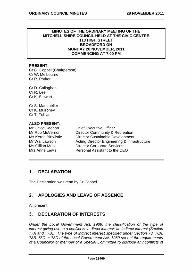
MINUTES OF THE ORDINARY MEETING OF THE MITCHELL SHIRE COUNCIL HELD AT THE CIVIC CENTRE
113 HIGH STREET BROADFORD ON
MONDAY 28 NOVEMBER, 2011 COMMENCING AT 7.00 PM
PRESENT: Cr G. Coppel (Chairperson) Cr W. Melbourne Cr R. Parker Cr D. Callaghan Cr R. Lee Cr K. Stewart Cr S. Marstaeller Cr K. Mulroney Cr T. Tobias ALSO PRESENT: Mr David Keenan Chief Executive Officer Mr Rob McVernon Director Community & Recreation Ms Kerrie Birtwistle Director Sustainable Development Mr Wal Lawson Acting Director Engineering & Infrastructure Ms Gillian Metz Director Corporate Services Mrs Anne Lewis Personal Assistant to the CEO
1. DECLARATION
The Declaration was read by Cr Coppel.
2. APOLOGIES AND LEAVE OF ABSENCE
All present.
3. DECLARATION OF INTERESTS
Under the Local Government Act, 1989, the classification of the type of interest giving rise to a conflict is: a direct interest; an indirect interest (Section 77A and 77B). The type of indirect interest specified under Section 78, 78A, 78B, 78C or 78D of the Local Government Act, 1989 set out the requirements of a Councillor or member of a Special Committee to disclose any conflicts of
ORDINARY COUNCIL MINUTES 28 NOVEMBER 2011
Page 22467
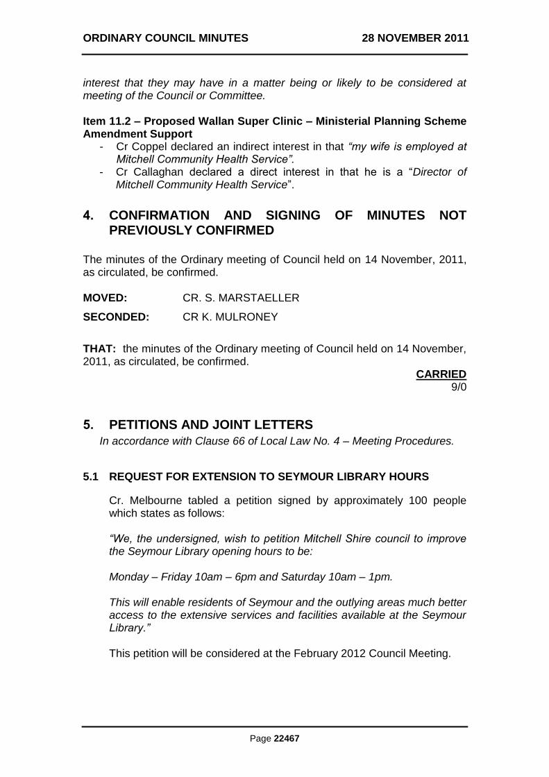
interest that they may have in a matter being or likely to be considered at meeting of the Council or Committee. Item 11.2 – Proposed Wallan Super Clinic – Ministerial Planning Scheme Amendment Support
- Cr Coppel declared an indirect interest in that “my wife is employed at Mitchell Community Health Service”.
- Cr Callaghan declared a direct interest in that he is a “Director of Mitchell Community Health Service”.
4. CONFIRMATION AND SIGNING OF MINUTES NOT PREVIOUSLY CONFIRMED
The minutes of the Ordinary meeting of Council held on 14 November, 2011, as circulated, be confirmed. MOVED: CR. S. MARSTAELLER
SECONDED: CR K. MULRONEY
THAT: the minutes of the Ordinary meeting of Council held on 14 November, 2011, as circulated, be confirmed.
CARRIED 9/0
5. PETITIONS AND JOINT LETTERS
In accordance with Clause 66 of Local Law No. 4 – Meeting Procedures.
5.1 REQUEST FOR EXTENSION TO SEYMOUR LIBRARY HOURS
Cr. Melbourne tabled a petition signed by approximately 100 people which states as follows: “We, the undersigned, wish to petition Mitchell Shire council to improve the Seymour Library opening hours to be: Monday – Friday 10am – 6pm and Saturday 10am – 1pm. This will enable residents of Seymour and the outlying areas much better access to the extensive services and facilities available at the Seymour Library.”
This petition will be considered at the February 2012 Council Meeting.

ORDINARY COUNCIL MINUTES 28 NOVEMBER 2011
Page 22468
6. QUESTION TIME
In accordance with Clause 65 of Local Law No. 4 – Meeting Procedures.
6.1 R. GODWILL – KILMORE WALLAN BY-PASS AND COUNCIL MINUTES
My questions are: “1) Minister Mulder‟s media release states “this by-pass will improve road safety for families” yet two of the proposals will bring trucks and through traffic via Kilmore East. This will mean that residents will again be fighting to use the internal roads to get to the station and their homes in Kilmore East. Will council stand up for the residents against these proposals? 2) After numerous questions regarding the by-pass were asked at the last council meeting and were unable to be answered due to the fact that Vicroads supposedly had not yet contacted council regarding the 3 options it was proposing; has council mad any attempt to talk to Vicroads about the by-pass options and the fact that none of these options are actually a true by-pass of both Wallan and Kilmore as was promised prior to the election? And if not, why not?. 3) At the commencement of the last council meeting the Mayor made a point of stating that all council meetings were recorded so that the minutes would be recorded accurately. Following the process of the meeting the Mayor moved that the minutes of the previous meeting be accepted as being true and correct. At this point when asked for those in favour, several councillors raised their hands. When asked for those who were against, a couple of councillors raised their hands. Much to my astonishment, the minutes were accepted as being true and correct. When one of the councillors who had voted that the minutes were incorrect, and asked to listen to the recording of the previous minutes he was told that they had already been passed and therefore no further discussion would take place on the subject. I would have thought that if you have councillors who are voting that the minutes are not true and correct, that the Mayor should have asked them at that time what they perceived the problem was, rather than ignoring them and passing the motion. When exactly would this question be answered, and why bother recording the minutes in the first place if you are not prepared to be challenged on the issue of their correctness?” A written response was provided which stated: The proposed bypass of Kilmore and Wallan project is being conducted by VicRoads and not by Council. Currently VicRoads is undertaking a number of studies and consultation with residents on the proposed options. Council has not put forward any formal position on the current options until all these studies, and consultation has been completed. The purpose why Council meetings are recorded is for the preparation of minutes. The Council policy adopted to destroy audio recordings as soon as practical after the confirmation of the minutes is also in line with the Public

ORDINARY COUNCIL MINUTES 28 NOVEMBER 2011
Page 22469
Record Office Standards which state “class 8.4.2 includes draft and rough minutes and audio recordings. – destroy when administrative use concludes”. Any Councillor who believes that the minutes as distributed are incorrect must move at the next meeting that the minutes are incorrect and state the item/s to which they object, this must then be seconded and each item must then be considered separately and voted. At the last Council meeting no Councillor moved a motion that the minutes were inaccurate and as such the minutes were confirmed. After confirmation Cr Parker raised an issue however as the minutes had already been confirmed this could not be considered.
6.2 W. LAW – MONUMENT HILL - KILMORE WALLAN BY-PASS
My questions are: “1 As Council is seeking Heritage Overlay on Memorial Hill and environs, will it vigorously oppose the use of the land for one of the proposed options being put forward by VicRoads and the State Government, which includes use of land within the Monument Hill precinct, to get traffic out of the main street of Kilmore, instead of a true Bypass of the township? 2. Has Council through it's three officers on the Steering Committee, considered putting forward a proposal to the Government such as the one on the Kilmore Strategy Plan 4.3.9 of 2008 titled "Improve north south connections in local road network" put forward by Hansen Partners, which says "in spite of the options tabled by VicRoads, the most appropriate and logical solution to the passage of heavy vehicles movements through Kilmore is redirection of vehicles to the Hume Freeway well north of Kilmore to Pyalong or High Camp, leading to a junction near Broadford" as this route adheres to the promises made by the Government to "Build a two lane Bypass constructed from the Clonbinane turnoff on the Hume Freeway to the Northern Highway north of Kilmore? 3. Have the Council Officers on the Steering Committee been advised by the State Government in so many words, to plan a route to take as much traffic from the main street of Kilmore for the least cost?” A written response was provided which stated: As per our previous advice, Council at the meeting on the 22 November 2010, resolved to seek authorisation from the Minister for Planning to prepare a planning scheme amendment to implement the recommendations of the Mitchell Shire Heritage Study 2006 and subsequent review work. Council officers are currently preparing the documentation required to support the Heritage planning scheme amendment, and will request authorisation from the Minister for Planning shortly in accordance with the Council resolution. If the Minister for Planning grants Council Ministerial Authorisation for the amendment it is anticipated that the amendment will be placed on a formal
ORDINARY COUNCIL MINUTES 28 NOVEMBER 2011
Page 22470
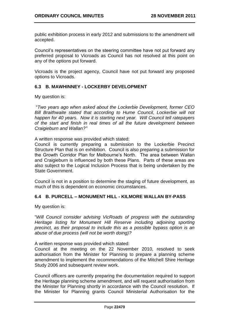
public exhibition process in early 2012 and submissions to the amendment will accepted. Council‟s representatives on the steering committee have not put forward any preferred proposal to Vicroads as Council has not resolved at this point on any of the options put forward. Vicroads is the project agency, Council have not put forward any proposed options to Vicroads.
6.3 B. MAWHINNEY - LOCKERBY DEVELOPMENT
My question is: “Two years ago when asked about the Lockerbie Development, former CEO Bill Braithwaite stated that according to Hume Council, Lockerbie will not happen for 40 years. Now it is starting next year. Will Council tell ratepayers of the start and finish in real times of all the future development between Craigieburn and Wallan?” A written response was provided which stated: Council is currently preparing a submission to the Lockerbie Precinct Structure Plan that is on exhibition. Council is also preparing a submission for the Growth Corridor Plan for Melbourne‟s North. The area between Wallan and Craigieburn is influenced by both these Plans. Parts of these areas are also subject to the Logical Inclusion Process that is being undertaken by the State Government. Council is not in a position to determine the staging of future development, as much of this is dependent on economic circumstances.
6.4 B. PURCELL – MONUMENT HILL - KILMORE WALLAN BY-PASS
My question is: “Will Council consider advising VicRoads of progress with the outstanding Heritage listing for Monument Hill Reserve including adjoining sporting precinct, as their proposal to include this as a possible bypass option is an abuse of due process (will not be worth doing)? A written response was provided which stated:
Council at the meeting on the 22 November 2010, resolved to seek authorisation from the Minister for Planning to prepare a planning scheme amendment to implement the recommendations of the Mitchell Shire Heritage Study 2006 and subsequent review work. Council officers are currently preparing the documentation required to support the Heritage planning scheme amendment, and will request authorisation from the Minister for Planning shortly in accordance with the Council resolution. If the Minister for Planning grants Council Ministerial Authorisation for the
ORDINARY COUNCIL MINUTES 28 NOVEMBER 2011
Page 22471
amendment it is anticipated that the amendment will be placed on a formal public exhibition process in early 2012 and submissions to the amendment will accepted. As VicRoads is still in the process of conducting studies and consultation with residents on the options proposed, Council is awaiting the conclusion of these studies and consultation prior to making any formal submission.
6.5 M. FLEISCHMANN – KILMORE WALLAN BY-PASS
My questions are: “1) Minister Terry Mulder's media release in May 2011 stated that "the community had rejected the former Labor Government's plan to use existing local roads to construct a Link Road. Will Council object to local roads being used yet again for the three so called bypass proposals being brought to the community on Wednesday and shown in letters to residents? 2) as there are three Council officers, including the CEO of Mitchell Shire on the Steering Committee planning a bypass for Wallan and Kilmore, what objections have they put forward regarding the use of internal roads?” A written response was provided which stated: The proposed bypass of Kilmore and Wallan project is being conducted by VicRoads and not by Council. Currently VicRoads is undertaking a number of studies and consultation with residents on the proposed options. Council has not put forward any formal position on the current options until all these studies have been completed. Until a final determination is made by VicRoads, Council is unlikely to have a formal position on the use of local roads.
6.6 J. GODWILL – KILMORE WALLAN BY-PASS
My questions are: “1) Will Councillors stand up for their constituents and ask the government to adhere to their promise to build a true bypass out of town… “to improve road safety for families living in Wallan and Kilmore by taking through traffic out of townships”, as it is stated in Minister Mulder‟s media release? 2) Even though Council may not have been notified by VicRoads regarding the 3 proposed options for the by-pass, this must surely be a topic that a responsible Council would have discussed. Therefore, I would like to ask what options Council would consider appropriate for a by-pass of Wallan and Kilmore ”
ORDINARY COUNCIL MINUTES 28 NOVEMBER 2011
Page 22472
A written response was provided which stated: The proposed bypass of Kilmore and Wallan project is being conducted by VicRoads and not by Council. Currently VicRoads is undertaking a number of studies and consultation with residents on the proposed options. Council has not put forward any formal position on the current options until all these studies, and consultation has been completed.
7. COMMUNITY AND RECREATION
NIL REPORTS
ORDINARY COUNCIL MINUTES 28 NOVEMBER 2011
Page 22473
8. CORPORATE SERVICES
8.1 RATING STRATEGY REVIEW
Author: Allan Wise, Revenue Coordinator
File No: RA/13/001
Attachment: Rating Strategy
Reference: Item 8.2, 12 September 2011
Summary The draft rating strategy adopted by Council on 12 September 2011 was placed on public exhibition and remained open for submissions until 21 October. This report details the written submissions received during the exhibition period and proposes the final rating strategy to be adopted by Council. Background At the Council meeting of 14 February 2011, it was resolved that a review of the current rating strategy be undertaken. Further reports were presented on 14 June where proposed communication and consultative methodologies were endorsed and on 12 September where the draft rating strategy was adopted for public exhibition and submissions. More recently at the Council meeting of 14 November, the rating strategy was considered by Council but no resolution was passed. However as a result of debate originating from this meeting, the Electronic Gaming Machine Venue differential has been reduced from 2 to 1. Submissions Received Six submissions were received within a timeframe that enabled them to be considered in this report. The detailed commentary nature of some submissions makes them lengthy to document and respond to, however the following key issues directly relevant to the rating strategy have been paraphrased from the submissions received: Personal Submission 1 The preface to this submission states: “We write to you to address the proposal to impose a differential rate on Gaming Pubs and Clubs in Mitchell as a form of raising additional revenue for the Shire. We want to appeal to common sense and the moral and ethical standards of the people who have been elected to make decisions for the constituents of Mitchell Shire. If we are serious about helping problem gamblers we should be looking at all aspects of gambling and how we as a society have formed opinions and values about what gambling is all about”.
ORDINARY COUNCIL MINUTES 28 NOVEMBER 2011
RATING STRATEGY REVIEW (CONT‟D)
Page 22474
The submission concludes: “We ask Councillors to consider all parties in their decision making especially people like us who are small business operators and would like to be part of the community of the Mitchell Shire”. Comment: This submission contains two main themes of (a) the discrimination against gaming venues as opposed to other forms of gambling and (b) the proposed use of the additional revenue derived from the Electronic Gaming Machine (EGM) venue differential rate. (a) It is not the role of Council to decide whether one form of gambling is
likely to cause increased societal issues than another. The rating strategy merely reflects the will of Council to achieve specific objectives that facilitate outcomes for the overall betterment of the community. In relation to the EGM venue differential, the Council of the day has identified that it wishes to raise additional revenue to provide funding for problem gambling support programs within Mitchell Shire. These funds are being sourced specifically from EGM venues as there is ample evidence this form of gambling is a primary contributor to problem gambling.
(b) The submission rightly raises the issue of how the additional revenue will
be used to achieve the objective of funding problem gambling programs. A rating strategy is a strategic statement whereas the detailed distribution of all revenue derived is determined by the annual budget. It is sufficient for the rating strategy to merely state the objective and for the budget to then provide the details, suffice to say that every dollar of additional revenue from EGM venues will be allocated to the funding of problem gambling programs.
Personal Submission 2 The differential of 2.00 for vacant residential land could penalise elderly people and young couples saving to build a house. Comment: It is considered a higher rate is more likely to achieve the “development” objective of the vacant residential land differential than imposing rates at the normal level. A financial penalty to address the lack of maintenance of properties and encourage land to be kept in a tidy and safe manner. Comment: Improving the amenity of residential areas within the municipality is to be supported however a rating strategy is not the correct avenue. Mitchell Economic Development Advisory Committee The committee recommends Council ask the MAV to promote to State Government for more flexibility in rates collections options including due dates and payment options.
ORDINARY COUNCIL MINUTES 28 NOVEMBER 2011
RATING STRATEGY REVIEW (CONT‟D)
Page 22475
Comment: The Local Government Act (LGA) prescribes the instalment and in-full due dates for payment of rates. Of particular concern is the “in-full” payment date of 15 February following issue of the rate notice. This date equates to 7.5 months into the financial year and would alter Council‟s cash flow profile substantially if introduced. Pursuant to the LGA, no other in-full date can be chosen hence the rating strategy dictates that four instalments be the legislated payment frequency. However any move towards flexible due date setting is to be supported and Council should approach the MAV as suggested by the committee. Mitchell Environment Advisory Committee Supports the inclusion of the Land Management Rebate. Comment: This rebate will continue to be given in accordance with the policy. Supports higher differentials for vacant residential, commercial and industrial land due to higher likelihood of weed infestations. Comment: Whilst there may be an associated environmental benefit, the objective of the vacant land differential is to encourage development. Suggests that Tree Plantation land might actually fall into the Rural Agricultural land category. Comment: The definition of the differential category is the controller of which category land is applied to. The definition can remain as-is in the rating strategy however legal advice will be sought prior to the declaration of the rate for the 2012/13 year. Requests that plantations registered under the National Carbon Offset Standards should be exempt. Comment: This can be managed through the differential category objection process pursuant to Section 183 of the LGA whereby a demonstrated carbon offset purpose can override the commercial intent. Requests that only that portion under commercial plantation should be in the Tree Plantation category, not the entire property. Comment: This is a requirement under the LGA whereby land which is in one holding can be split between multiple differential categories. Mitchell Shire Council Environment Programs Team Increase the Industrial Land differential from 1.00 to 2.00 to deal with environmental issues such as runoff, discharge and disposal of waste

ORDINARY COUNCIL MINUTES 28 NOVEMBER 2011
RATING STRATEGY REVIEW (CONT‟D)
Page 22476
Comment: Council is mindful of the current difficult economic period and has made a conscious decision not to impose additional financial burden on the general commercial and industrial sectors of the municipality. Increase the Extractive Industry Land differential from 2.00 to 2.50 to maintain roads, replace lost vegetation, monitor runoff/discharge and to protect and repair environmental assets affected by Council. Comment: The differential of 2.00 has been set at that level to recognise the impact on Council assets whilst at the same time acknowledging the financial impost of increased rates. A level of 2.50 may alter the balance difference between acceptable and unacceptable cost versus benefit. Questions the benefit in dividing the Rural Agricultural Land differential into large (100ha+) and small (40-100ha) Comment: The rationale for the area based two-tier Rural Agriculture differential is to: (a) Recognise the contribution of large scale farming enterprises and to
support their ongoing viability with the lowest rate. (b) Acknowledge the growing number of single title holdings in the 40-100ha
category with the second lowest rate. (c) Allow all area holdings of the same ratepayer to be cumulative when
deciding on the higher or lower category. Requests a rate concession for land dedicated to Trust for Nature of $20 per hectare with a minimum of $100 and maximum of $500 per covenant Comment: The Council currently offers this as an annual “grant” pursuant to the Conservation Covenant Grant Program. The submission suggests the grant should be replaced by a “rate” concession supported by the rating strategy. As the Land Management Rebate is managed as a rate concession, it is considered the Conservation Covenant Grant can also be administered as a rate concession and has been added to the rating strategy. Requests the definition of Tree Plantation Land be restricted solely to land licensed under Part 3A of the Victorian Plantations Corporation Act. It is suggested the definition of “any other commercial tree plantation” may unfairly penalise trees planted for environmental reasons, private use or plantations with little commercial value. Comment: This can be managed through the differential category objection process pursuant to Section 183 of the LGA whereby the alternative reasons for the presence of a tree plantation can override the commercial intent. Kilmore Racing Club Incorporated Higher rates will reduce by one-third the net real profit of Kilmore Racing Club Inc (KRCI) including Trackside.
ORDINARY COUNCIL MINUTES 28 NOVEMBER 2011
RATING STRATEGY REVIEW (CONT‟D)
Page 22477
Comment: The total revenue for the KRCI disclosed in the Community Benefit Statement for 2010/11 was $4,272,699. The modelling of the EGM venue rate at a differential of 2.00 increases the annual rates by $6112 or just 0.14% of total revenue. The KRCI is a significant employer in the region. Comment: The impact of an EGM venue differential should have no impact on employment. The KRCI is not-for-profit and has been unfairly compared to commercial EGM venues. Comment: The purpose of the EGM venue differential is to source additional revenue to fund problem gambling programs in Mitchell Shire. It is considered all EGM venues are a potential source of problem gambling and should be treated equally in the application of an EGM venue differential rate. We give to the community more than what most people understand including $355,916 on approved community purposes with a real community based benefit value of $1,985,784 in 2010/11 Comment: The KRCI is to be congratulated on contributing funds back into the community however the EGM venue differential is for a specific purpose additional to any programs funded by the club and over which the Council has no control. KRCI has lost substantial revenue since June due to track closure and rectification works and generally, the KRCI is experiencing a decline in turnover. Comment: The EGM venue rate will not take effect until 1 July 2012. It is considered the Club will have resolved the technical issues that have resulted in lost racing and associated revenue to date. The KRIC requests that any proposed changes be deferred to avoid unfair duress to KRCI in the immediate future and reiterate the not-for-profit situation of the Club and its unfair comparison with private commercial ventures. Comment: The rate does not take effect until 1 July 2012 thereby providing the Club with the opportunity to address the rate increase in its 2012/13 budget. The EGM venue rate cannot be applied selectively hence it must apply to all venues as described in the definition.
ORDINARY COUNCIL MINUTES 28 NOVEMBER 2011
RATING STRATEGY REVIEW (CONT‟D)
Page 22478
Differential Rating The differential rating categories in the rating strategy are: Differential Category Ratio General Land* 1.00 Vacant Residential Land 2.00 Vacant Commercial Land 2.00 Vacant Industrial Land 2.00 Improved Commercial Land 1.00 Improved Industrial Land 1.00 Electronic Gaming Machine Venue Land 1.00 Rural Agricultural Land (40ha-100ha) 0.90 Rural Agricultural Land (greater than 100ha) 0.80 Subdivisional Land 2.00 Tree Plantation Land 2.00 Extractive Industry Land 2.00 *General Land includes properties not included in any other category. These are predominately urban residential land, rural residential/vacant land less than 40ha and retirement village units.
The “Mixed Use” category proposed in the draft rating strategy has been removed as there is now no differential between the residential and commercial categories where mixed use was most likely to have occurred. The “Retirement Village” category proposed in the draft rating strategy has been removed as these properties are to be rated residentially (i.e. the General category). The “Electronic Gaming Machine Venue” differential has been amended to a ratio of 1 however the category will remain as a distinct category. Summary of Differential Rating Structure (by average property)
Land Category Number
of Properties
Average CIV
Rateable Value*
Average Rate on
CIV (OLD)
Average Rates on
CIV (NEW)
Average Rate on CIV Difference**
General 13,189 $281,971 $902 $894 -$8
Vacant Residential 1,613 $143,048 $916 $907 -$8
Electronic Gaming Machine Venue
5 $1,735,400 $5,553 $5,511 -$42
Rural Agricultural (40ha-100ha)
609 $453,801 $1,452 $1,295 -$157
Rural Agricultural (greater than 100ha)
439 $1,000,975 $3,203 $2,539 -$664
Tree Plantations 3 $1,544,000 $4,941 $9,791 $4,850
Subdivisional 64 $1,694,875 $5,424 $10,748 $5,324
Improved Commercial 515 $451,283 $1,444 $1,431 -$13
ORDINARY COUNCIL MINUTES 28 NOVEMBER 2011
RATING STRATEGY REVIEW (CONT‟D)
Page 22479
Land Category Number
of Properties
Average CIV
Rateable Value*
Average Rate on
CIV (OLD)
Average Rates on
CIV (NEW)
Average Rate on CIV Difference**
Improved Industrial 187 $348,289 $1,115 $1,104 -$10
Vacant Commercial 72 $357,819 $1,145 $2,269 $1,124
Vacant Industrial 57 $220,561 $706 $1,399 $693
Extractive Industry 4 $1,256,000 $4,019 $7,965 $3,945
*A revaluation of all land in the municipality will take effect from 1 July 2012 **Based on revenue neutral modelling using 2011/12 data
Summary of Differential Rating Structure (by category)
Land Category Number of Properties
Differential Ratio
Total Rates (OLD)
Total Rates (NEW)
Change%
General 13,189 1.0 11,900,509 11,791,333 -0.9%
Vacant Residential 1,613 2.0 1,476,716 1,463,168 -0.9%
Electronic Gaming Machine Venue
5 1.0 27,766 27,556 -0.9%
Rural Agricultural (40ha-100ha)
609 0.90 884,368 788,629 -10.8%
Rural Agricultural (greater than 100ha)
439 0.80 1,406,170 1,114,615 -20.7%
Tree Plantations 3 2.0 14,822 29,373 98.2%
Subdivisional 64 2.0 347,110 687,852 98.2%
Improved Commercial 515 1.0 743,715 736,892 -0.9%
Improved Industrial 187 1.0 208,416 206,504 -0.9%
Vacant Commercial 72 2.0 82,442 163,371 98.2%
Vacant Industrial 57 2.0 40,230 79,723 98.2%
Extractive Industry 4 2.0 16,077 31,859 98.2%
Note: The redistribution of the rates results in slight variations in change % compared
to the differential ratio
Rating Components The Act provides the framework around which rating policy can be developed to suit the varying needs of individual Councils. This framework provides flexibility to make decisions that are relevant to Mitchell Shire, having regard to the “equitable imposition of rates” and the “stability in the distribution of the rate burden” provisions of the Act. The rating strategy contains clarifying statements about the many components that determine the ultimate rating outcome.
ORDINARY COUNCIL MINUTES 28 NOVEMBER 2011
RATING STRATEGY REVIEW (CONT‟D)
Page 22480
Policy Implications The provisions of the rating strategy are consistent with the obligations placed on Council pursuant to section 3E of the Local Government Act as follows:
Advocating and promoting proposals which are in the best interests of the local community.
Planning for and providing services and facilities for the local community.
Providing and maintaining community infrastructure in the municipal district.
Undertaking strategic and land use planning for the municipal district.
Raising revenue to enable the Council to perform its functions.
Making and enforcing local laws.
Exercising, performing and discharging the duties, functions and powers of Councils under this Act and other Acts.
Any other function relating to the peace, order and good government of the municipal district.
In addition, the rating strategy facilitates the application of the Land Management Rebate policy and Conservation Covenant Grant contained in the Mitchell Shire Environment Strategy. Issues A conservative approach has been taken by Council in the development of the rating strategy. This includes adopting many of the existing rating practices as well as having due regard to the impact differential rating would have on some categories of properties. The major changes in rating strategy are targeted at specific categories of ratepayers and are underpinned with strong objectives, whilst significantly impacting only a small number of properties. Legal Review The event that gives effect to the rating strategy is not the strategy itself but rather the Declaration of Rates and Charges as part of the annual budget process. It is proposed that legal review will be sought when preparing the annual budget resolution to ensure the rating strategy is implemented in accordance with relevant legislation. Any anomalies identified in the rating strategy can be addressed at this time. Financial, Resource and Asset Management Implications From a financial perspective, the rating strategy is designed to be revenue neutral for Council. From a resource perspective, the final strategy once adopted must ensure surety of rate income is maintained which will require thorough reconciling of the modelling results and auditing of the system changes. In relation to the EGM venue differential rate, the additional revenue raised must be properly accounted for in the budget as a standalone item. Environment and Sustainability Implications There are no Environment and Sustainability Implications.
ORDINARY COUNCIL MINUTES 28 NOVEMBER 2011
RATING STRATEGY REVIEW (CONT‟D)
Page 22481
Consultative Procedures The proposed rating strategy was presented to the August meeting of the Audit Committee who recommended the report be received with the following (summarised) comments: Appropriate legal advice Advice was sought from Council's Solicitors who identified only one major issue in regards to the differential rating of Tree Plantations. This is a bona fide farming activity pursuant to the Valuation of Land Act hence tree plantations specifically need to be excluded from the Rural Agricultural Land categories. In addition, there were minor terminology and clarifying amendments suggested which have been acted upon. Statistical/Sensitivity analysis Subsequent to the Audit Committee meeting, the Council modified the rating strategy by reducing commercial and industrial categories from 1.25 to 1.00 and electronic gaming machine venues from 4.00 to 2.00. This resulted in just 1% of rateable properties moving to a higher differential and 6% of properties moving to a lower differential. It is difficult to perform statistical/sensitivity analysis when 93% of the rate base is not affected. However this report does contain summarised statistical information resulting from the differential rating proposals. Objectives clearly underpin each proposed differential rate The legal advice received confirms the validity of each objective however recommends that further review be sought when transcribing these into the annual Declaration of Rates and Charges in the adoption of the budget. Appropriate advice be provided in regard to the Electronic Gaming Machine Venue differential rate The legal advice did not identify any issues relating to the introduction of this differential category. The community has also been extensively encouraged to participate by providing feedback on what rating issues they would like considered in the development of a rating strategy. The feedback process was underpinned by the Community Engagement Strategy which assisted in the management of community expectations while strengthening the capacity of council and the community to work together. RECOMMENDATION THAT the rating strategy be adopted and take effect from 1 July 2012. MOVED: CR. R. LEE
SECONDED: CR. S. MARSTAELLER
THAT: the recommendation be adopted. CARRIED
8/1
ORDINARY COUNCIL MINUTES 28 NOVEMBER 2011
Page 22482
9. ENGINEERING AND INFRASTRUCTURE
9.1 EXTENSION TO THE KERBSIDE COLLECTION TO RURAL AREAS SURROUNDING TALLAROOK
Author: John Smyth Waste Management Coordinator
File No: WM/03/002
Attachment: 1. Community Information Session Flyer; 2. Letter to Residents;
3. Expansion of Kerbside Collection Service Survey 2011 4. Frequently Asked Questions; 5. Map Collection Area
Reference: CM11/322
Summary
This report recommends that the kerbside collection be extended to incorporate the area surrounding Tallarook where the service may be provided safely.
Background
During 2009, the internal and community consultations process recommended to Council the methodology that should be used to undertake a survey for the extension of the kerbside collection. In October 2010 the findings from both the internal and community consultations were collated and presented to Councillors in a Strategy Briefing. Councillors were informed that the following guidelines were used in deciding whether the extension would occur in each of the individual regions discussed:
The preferred method to decide whether to extend kerbside collection from both internal and community consultations was a survey;
Non-responses to the survey would not be counted in the final results;
There is agreement that a simple yet comprehensive information sheet should go out with the survey;
The majority of 51% - 49% will be used as the overwhelming majority of consultations indicated that this would be the most preferred percentage;
If the service was extended as a result of a positive to this survey, all properties would be provided this service, ie residents could not decline the service at this stage;
Each zone will be decided separately and as a majority rules;
Officers will prepare a survey and information sheet which will be checked by community participants prior to distribution;

ORDINARY COUNCIL MINUTES 28 NOVEMBER 2011
EXTENSION TO THE KERBSIDE COLLECTION TO RURAL AREAS SURROUNDING TALLAROOK (CONT‟D)
Page 22483
Time will be given for communities to come together to discuss issues and some community information sessions will be arranged.
Council‟s website had a Frequently Asked Questions page and a phone number to ring for any questions to be answered. Existing community groups in each of the areas were also encouraged to provide information for community members during the process. A report was prepared for the Council meeting on 24 August and deferred to a strategy briefing. The report was represented on the 12 September 2011 and determined: “Council defer the determination on the extension of the kerbside collection to the Tallarook surround to allow for further community engagement and conduct another survey.” The community engagement involved re-engaging with the residents about the potential extension to kerbside collection surrounding Tallarook where the service can be provided safely, and advising of Council‟s Waste Management Strategy recommendations that;
a. Extend kerbside collection to 95% shire coverage, and b. The Tallarook Transfer Station will be closed once kerbside collection
has been extended to the Tallarook region.
The collection area was resurveyed on the 20 October 2011 with a closing date on 11 November 2011. The new survey did include the information on the closure of the Tallarook Transfer Station.
A community information session was held on the 6 November at the Tallarook Mechanics Hall from 9.00am to 12.00 noon.
Policy Implications
This report is consistent with the Council Plan (2009-2013) strategic objective to: “Develop, maintain and management services in conjunction with the Regional Waste Management Group”
Issues
Of the two hundred and fifty eight properties surveyed one hundred and twenty four responses were received. Of those one hundred and twenty eight (128) responses, sixty five (65) were in favour and sixty three (63) were against. Of the respondents 50.8% of were in favour of extending the Kerbside Collection Service. Typical comments made in response to the survey by residents were; For:
Would be handy – convenient;
Encourage recycling;
Long overdue;
ORDINARY COUNCIL MINUTES 28 NOVEMBER 2011
EXTENSION TO THE KERBSIDE COLLECTION TO RURAL AREAS SURROUNDING TALLAROOK (CONT‟D)
Page 22484
Providing essential service;
Elderly are having difficulty getting someone to take waste to the tip. Against:
Not required;
Cost too high;
Long way to take bin to front gate for elderly-inconvenient;
On pension and cannot afford;
Happy with present arrangements. There are some properties with houses that the contractors cannot pass due to roads being unsuitable for collection throughout the year. These properties will be offered access to centralised collection points if Council determine to proceed with the extension of the kerbside collection area. Some other roads within the proposed collection area will require turning circles and or tree height and width clearance. This may delay the introduction of the service to some properties for a short period. It is anticipated that the extended service will be fully operational by the end of January 2012. Financial Resource and Asset Management Implications
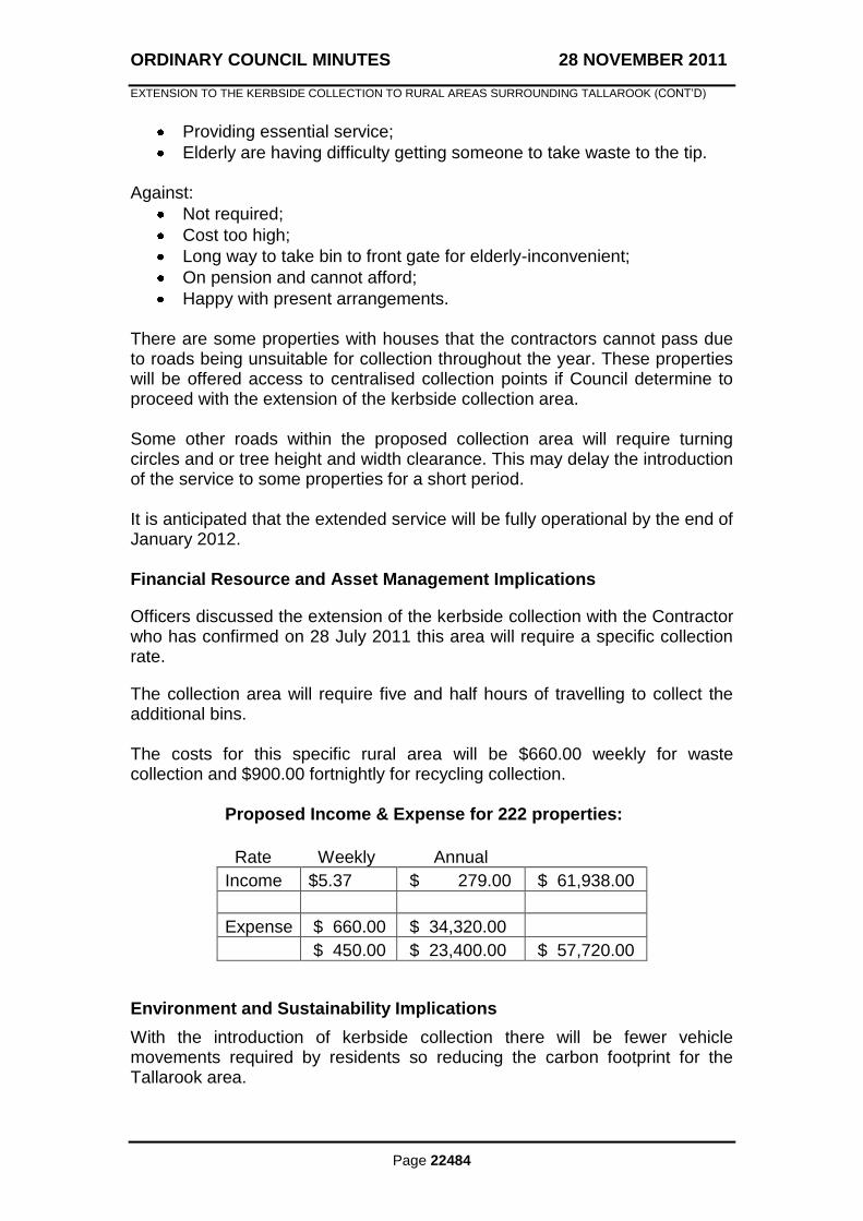
Officers discussed the extension of the kerbside collection with the Contractor who has confirmed on 28 July 2011 this area will require a specific collection rate.
The collection area will require five and half hours of travelling to collect the additional bins. The costs for this specific rural area will be $660.00 weekly for waste collection and $900.00 fortnightly for recycling collection.
Proposed Income & Expense for 222 properties:
Rate Weekly Annual Income $5.37 $ 279.00 $ 61,938.00
Expense $ 660.00 $ 34,320.00
$ 450.00 $ 23,400.00 $ 57,720.00
Environment and Sustainability Implications
With the introduction of kerbside collection there will be fewer vehicle movements required by residents so reducing the carbon footprint for the Tallarook area.
ORDINARY COUNCIL MINUTES 28 NOVEMBER 2011
EXTENSION TO THE KERBSIDE COLLECTION TO RURAL AREAS SURROUNDING TALLAROOK (CONT‟D)
Page 22485
Recycling rates will improve with the provision of the service to an area where little recycling was occurring.
Consultation Procedure
The consultation process for this program has been extensive:
1. Internal consultation with stakeholder; 2. Consultation with representatives of community to discuss
methodology; 3. Briefing to Council on agreed methodology; 4. Prepare survey; 5. Notify community representatives of survey; 6. Website with information and contact number; 7. Community information session at Wallan Multi Purpose Centre; 8. Community feedback on results of survey; 9. Community survey;
10. Report to Council; 11. Community feedback on Council resolution; 12. Community resurveyed; 13. Community information session; 14. Waste Management will send out to surveyed area the resolution of
Council.
RECOMMENDATION
THAT: Council determine to extend the Kerbside Collection to the rural area surveyed surrounding Tallarook. MOVED: CR. S. MARSTAELLER
SECONDED: CR. T. TOBIAS
THAT: the recommendation be adopted. CARRIED
8/1

ORDINARY COUNCIL MINUTES 28 NOVEMBER 2011
Page 22486
9.2 EXTENSION OF OPENING HOURS AT WALLAN TRANSFER STATION
Author: John Smyth – Waste Management Coordinator
File No: CM11/433
Attachment: Attachment 1 - Waste Management Brochure
Reference: Nil
Summary
This report deals with a Council request regarding the extension of hours of operation at the Wallan Transfer Station and budget impacts. Background
A motion was put forward at Council‟s meeting on 24 October 2011 stating: “Council will be provided with a report on opening hours of Wallan Transfer Station and whether extension of times can be provided without major budget impacts.” Policy Implications Community Engagement Policy, “Work in partnership with the community to advocate for resources to meet the community‟s needs.” Issues This report has been initiated following a request from Council. Council has requested information on the opening hours of the Wallan Transfer Station and any associated budgetary impact. Council has received one request to extend the operating hours at the Wallan Transfer Station. Residents appear to be satisfied with the present hours of operation. The present opening hours at Wallan Transfer Station as in attachment 1: Monday, Tuesday, Thursday, Friday 10.00am – 2.00pm Saturday, Sunday 10.00am – 4.00pm Financial Resource and Asset Management Implications
Assume that there will be two additional hours on existing operational day being from 10.00am - 4.00pm and no additional operational days.
Weekly Cost Annual Cost
Four days extended hours $374.80 $19,489.60
ORDINARY COUNCIL MINUTES 28 NOVEMBER 2011
EXTENSION OF OPENING HOURS AT WALLAN TRANSFER STATION (CONT‟D)
Page 22487
Environment and Sustainability Implications
There are no environment and sustainability implications. Consultative Procedures
Not Applicable. RECOMMENDATION
THAT: Council receive and note the report. MOVED: CR. R. LEE
SECONDED: CR. T. TOBIAS
THAT: 1. Council receive and note the report. 2. Two additional hours on existing operational days of Monday, Tuesday,
Thursday and Friday, to operate 10.00am to 4.00pm be added at the budget of $19,489.60, be considered at the next mid-year budget review.
CARRIED
9/0
ORDINARY COUNCIL MINUTES 28 NOVEMBER 2011
Page 22488
9.3 REVIEW OF ROAD MANAGEMENT PLAN
Author: Shane Power, Maintenance Coordinator
File No: Nil
Attachment: Nil
Reference: Item 9.7, 29 June 2009
Summary
This report recommends that in accordance with the Road Management Act 2004 and the Road Management (General) Regulations 2005, Council conduct a review of its Road Management Plan and publicise its intent to do so.
Background
At its 29 June 2009 meeting, Council adopted the Road Management Plan Version 3 which included minor amendments to the previous version. Levels of service with regard to inspection and repair timeframes were left unchanged. An extract of Council‟s Road Maintenance Management Service Agreement is included as an appendix to the current Road Management Plan and is available for public viewing via Council‟s website. Division 1, Regulation 302 (1) of the Road Management (General) Regulations 2005, states that a Council must ensure that the standards in relation to and the priorities given to the inspection, maintenance and repair of roads are appropriate. An internal audit following storm events earlier this year showed Council was non-compliant with its Road Management Plan due to insufficient resources. As a result the Road Management Plan was suspended for a period of 3 months effective from 9 May 2011. It is proposed to address resource issues following extreme events as part of the review. The suspension of the plan prompted a review of the maintenance standards prescribed within. In accordance with the Road Management Act 2044, a Council conducting a review of its Road Management Plan, is required to give the community an opportunity to comment on the Road maintenance Standards described within the Plan, and to request amendments they deem necessary that may have arisen from the change in use of particular roads and general residential development within the area. Policy Implications
The review of the Road Management Plan is in direct response to the Road Management Act 2004 and the Road Management (general) Regulations 2005, requirement to publicly notify of Council‟s intent to review the Road Management Plan. Further to this, it can be considered that the review of the
ORDINARY COUNCIL MINUTES 28 NOVEMBER 2011
REVIEW OF ROAD MANAGEMENT PLAN (CONT‟D)
Page 22489
Road Management Plan and its outcomes are consistent with Council‟s 2009-2013 Council Plan strategic indicator to “Ensure Council‟s Asset Management Processes are in line with current industry standards” and “Review all Major Asset Classes Levels of Service (LOS).” Issues
In conducting the review of its Road Management Plan, Council must ensure that the standards are appropriate in relation to and the priorities to be given to the inspection, maintenance and repair of the roads and classes of roads to which the Plan applies. A review of the Road Management Plan will be carried out in accordance with the following:
The review is to consider the appropriateness and effectiveness of Council‟s priorities in relation to the inspection, maintenance and repair of the roads covered by its Road Management Plan with regard to available budget and resources;
The review will be carried out in reference to all the roads listed in the Register of Public Roads that fall within the hierarchy classes of link, collector, access and pathways;
A copy of the current Road Management Plan may be inspected at any of Council‟s Customer Service Centres located in Wallan, Kilmore, Broadford and Seymour or a copy may be obtained by downloading it from Council‟s website;
Any person may make a submission in regard to the proposed review of the road Management Plan to Council in accordance with Section 223 of the local Government Act, 1989;
Each incoming Council must review its Road Management Plan under the Local Government Act 1989.
Following the review process, Council must produce a written report summarising the findings and conclusions of the review. Subsequent to production of the report, it must be made available for copying or inspection at the place where Council‟s Road Management Plan may be inspected or viewed. Financial Resource and Asset Management Implications
The Road Management Plan will be carried out within Council‟s existing adopted budget. Consulting support services may be required to ensure the proposed plan is defendable against potential claims and is accepted by Council‟s insurer. While the review of the Road Management Plan will have no Asset Management implications to Council, the outcomes of the plan review may see that additional budget funds may be required in the future to address any service level changes which result from the review of the Road Management Plan.

ORDINARY COUNCIL MINUTES 28 NOVEMBER 2011
REVIEW OF ROAD MANAGEMENT PLAN (CONT‟D)
Page 22490
Environment and Sustainability Implications
The review if the Road Management Plan has environment and sustainability implications which have been outlined in the Road Management Plan.
Consultative Procedures
Division 1, Regulation 302(2)(a) of the Road Management (General) Regulations 2005, states that a Council must give notice describing the purpose of the review, and classes of road to which the Road Management Plan applies, and is required to advertise that it is commencing a review of its Road Management Plan and as part of that advertisement advise where the current Road Management Plan may be viewed or obtained. Upon receiving any submissions in relation to a review of the Plan, amendments to the Road Management Plan may be determined necessary and subsequent to making those amendments, Council will then again require to advertise and call for submissions in relation to making an amendment to the Road Management Plan. Advertising will commence on the third week in January 2012 to avoid advertising over the Christmas break. RECOMMENDATION
THAT: Council advertise its intention to review its Road Management Plan in the Government Gazette, a locally circulating daily newspaper and the local weekly newspapers as per its advertising policy, stating the following: 1. The review is to consider the appropriateness and effectiveness of
Council‟s priorities in relation to the inspection, maintenance and repair of roads covered by its Road Management Plan;
2. The review will be carried out in reference to all of the roads listed in the Register of Public Roads that fall within the hierarchy classes of link, collector, access and pathways;
3. A copy of the current Road Management Plan may be inspected at any of Council‟s Customer Service Centres located in Wallan, Kilmore, Broadford and Seymour or a copy may be obtained by downloading it from Council‟s website;

ORDINARY COUNCIL MINUTES 28 NOVEMBER 2011
REVIEW OF ROAD MANAGEMENT PLAN (CONT‟D)
Page 22491
4. Any person may make a submission in regard to the proposed review of the Road Management Plan to Council in accordance with Section 223 of the local Government Act, 1989.
MOVED: CR. K. STEWART
SECONDED: CR. D. CALLAGHAN
THAT: the recommendation be adopted.
CARRIED 9/0
ORDINARY COUNCIL MINUTES 28 NOVEMBER 2011
Page 22492
10. GOVERNANCE AND EXECUTIVE
10.1 ASSEMBLY OF COUNCILLORS
Author: David Keenan, Chief Executive Officer
File No: CL/04/013-02
Attachment: Record of Assemblies of Councillors
Reference: Nil
Summary
This report provides records of assemblies of Councillors that have occurred since the last Council meeting. Background
The Local Government Act, 1989 requires assemblies of councillors to form part of the Council minutes. Policy Implications
This report is consistent with the Local Government Act, 1989. Issues
The records of Assemblies of Councillors since the last Council meeting are:
7 November, 2011 – Strategy Session
14 November, 2011 – Informal Council Discussion RECOMMENDATION
THAT: Council receive and note the records of the Assembly of Councillors received since the last Council meeting.
The resolution for Item 10.1, Assembly of Councillors, is found at the end of this section.
ORDINARY COUNCIL MINUTES 28 NOVEMBER 2011
Page 22493
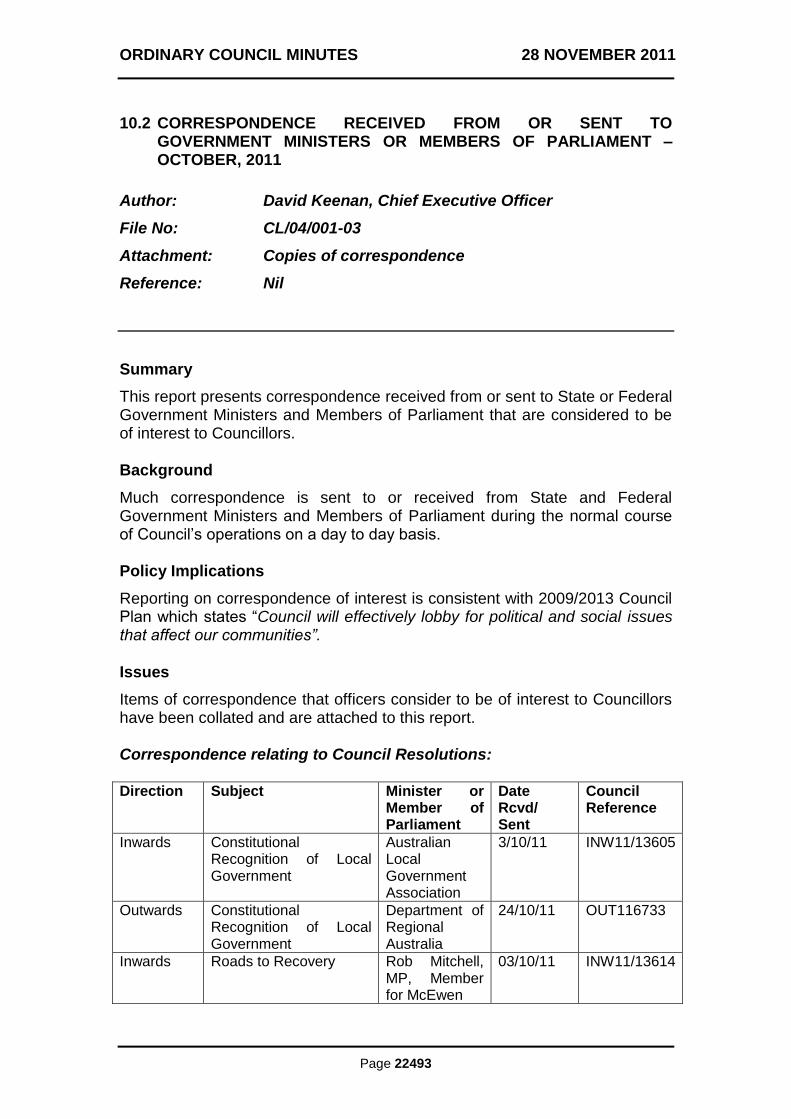
10.2 CORRESPONDENCE RECEIVED FROM OR SENT TO GOVERNMENT MINISTERS OR MEMBERS OF PARLIAMENT – OCTOBER, 2011
Author: David Keenan, Chief Executive Officer
File No: CL/04/001-03
Attachment: Copies of correspondence
Reference: Nil
Summary
This report presents correspondence received from or sent to State or Federal Government Ministers and Members of Parliament that are considered to be of interest to Councillors. Background
Much correspondence is sent to or received from State and Federal Government Ministers and Members of Parliament during the normal course of Council‟s operations on a day to day basis. Policy Implications
Reporting on correspondence of interest is consistent with 2009/2013 Council Plan which states “Council will effectively lobby for political and social issues that affect our communities”. Issues
Items of correspondence that officers consider to be of interest to Councillors have been collated and are attached to this report. Correspondence relating to Council Resolutions: Direction Subject Minister or
Member of Parliament
Date Rcvd/ Sent
Council Reference
Inwards Constitutional Recognition of Local Government
Australian Local Government Association
3/10/11 INW11/13605
Outwards Constitutional Recognition of Local Government
Department of Regional Australia
24/10/11 OUT116733
Inwards Roads to Recovery Rob Mitchell, MP, Member for McEwen
03/10/11 INW11/13614
ORDINARY COUNCIL MINUTES 28 NOVEMBER 2011
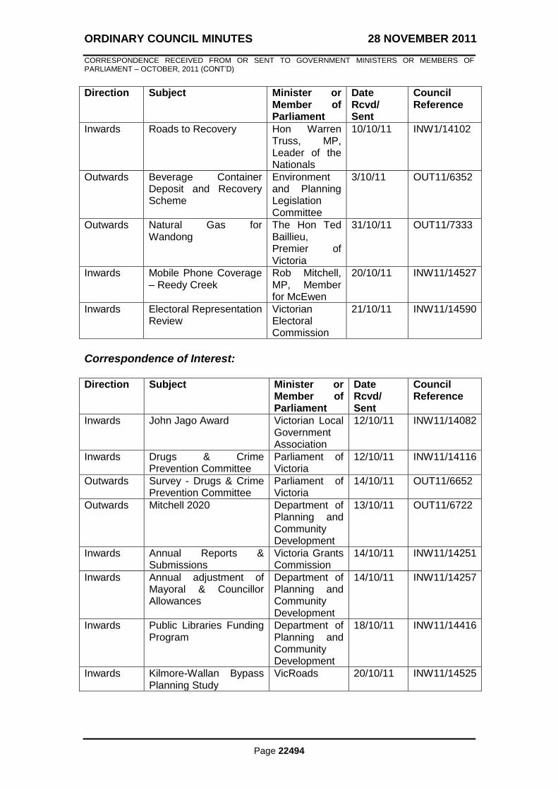
CORRESPONDENCE RECEIVED FROM OR SENT TO GOVERNMENT MINISTERS OR MEMBERS OF PARLIAMENT – OCTOBER, 2011 (CONT‟D)
Page 22494
Direction Subject Minister or Member of Parliament
Date Rcvd/ Sent
Council Reference
Inwards Roads to Recovery Hon Warren Truss, MP, Leader of the Nationals
10/10/11 INW1/14102
Outwards Beverage Container Deposit and Recovery Scheme
Environment and Planning Legislation Committee
3/10/11 OUT11/6352
Outwards Natural Gas for Wandong
The Hon Ted Baillieu, Premier of Victoria
31/10/11 OUT11/7333
Inwards Mobile Phone Coverage – Reedy Creek
Rob Mitchell, MP, Member for McEwen
20/10/11 INW11/14527
Inwards Electoral Representation Review
Victorian Electoral Commission
21/10/11 INW11/14590
Correspondence of Interest: Direction Subject Minister or
Member of Parliament
Date Rcvd/ Sent
Council Reference
Inwards John Jago Award Victorian Local Government Association
12/10/11 INW11/14082
Inwards Drugs & Crime Prevention Committee
Parliament of Victoria
12/10/11 INW11/14116
Outwards Survey - Drugs & Crime Prevention Committee
Parliament of Victoria
14/10/11 OUT11/6652
Outwards Mitchell 2020 Department of Planning and Community Development
13/10/11 OUT11/6722
Inwards Annual Reports & Submissions
Victoria Grants Commission
14/10/11 INW11/14251
Inwards Annual adjustment of Mayoral & Councillor Allowances
Department of Planning and Community Development
14/10/11 INW11/14257
Inwards Public Libraries Funding Program
Department of Planning and Community Development
18/10/11 INW11/14416
Inwards Kilmore-Wallan Bypass Planning Study
VicRoads 20/10/11 INW11/14525

ORDINARY COUNCIL MINUTES 28 NOVEMBER 2011
CORRESPONDENCE RECEIVED FROM OR SENT TO GOVERNMENT MINISTERS OR MEMBERS OF PARLIAMENT – OCTOBER, 2011 (CONT‟D)
Page 22495
Direction Subject Minister or Member of Parliament
Date Rcvd/ Sent
Council Reference
Outwards Letter of Support for Mitchell Community Health – National Binge Drinking Strategy
Department of Health & Ageing
19/10/11 OUT11/6947
Inwards Inquiry into Flood Mitigation Infrastructure in Victoria
Parliament of Victoria
31/10/11 INW11/15064
Financial and Resource Implications
There is no financial and resource implications involved reporting to Council the advocacy undertaken during the month. RECOMMENDATION
THAT: the correspondence received from or sent to Government Ministers or Members of Parliament for October be received and noted. The resolution for Item 10.2, Correspondence received from or sent to Government Ministers or Members of Parliament – October, 2011, is found at the end of this section.
ORDINARY COUNCIL MINUTES 28 NOVEMBER 2011
Page 22496
10.3 MAYORAL AND COUNCILLOR ALLOWANCE REVIEW
Author: Vicki Potts, Governance & Executive Services Coordinator
File No: CL/01/002-02
Attachment: Nil
Reference: Item 11.2, 27 September, 2010 (CM10/293)
Summary
This report overviews the notice received from the Department of Planning and Community Development regarding the annual adjustment and rates set as part of the 2011/2012 Budget preparation and in response to Notice of Motion 740 Councillors Allowances. Background
On 24 August, 2009, Council resolved to adopt the Order in Council limit applicable for Category 2 Councils as:
Councillors $22,568.45 Mayor $69,827.58.
After publication of a further Order in Council, Council resolved on 27 September, 2010 to increase allowances to: Councillors $23,245.34 Mayor $71,922.56 Council on 24 October, 2011, resolved: “THAT: the Councillor Allowances be calculated and paid by financial year, rather than November to November each year. This would mean the following payment terms for the next Councillor term: • election in October 2012 to 30 June 2013 (paid pro rata) • 1 July 2013 to 30 June 2014 • 1 July 2014 to 30 June 2015 • 1 July 2015 to 30 June 2016 • then 1 July 2016 to election 2016 (pro rata)” Policy Implications
Councillor and Mayoral Allowances are set in accordance with Section 73 of the Local Government Act, and any Order in Council published in the Government Gazette. Any future budget implications will be considered as part of the Budget process.

ORDINARY COUNCIL MINUTES 28 NOVEMBER 2011
MAYORAL AND COUNCILLOR ALLOWANCE REVIEW (CONT‟D)
Page 22497
Issues
Council has been advised of the recent Order in Council published on 29 September, 2011 which provides for a 2.5% adjustment to apply to all Mayor and Councillor allowances effective from 1 December, 2011. Annual adjustments are not subject to reviews or Section 223 community submissions. Current allowance payments paid to Councillors are as follows:
Allowance 9% Superannuation Equivalent
TOTAL PAYABLE
Councillors $21,326 $1,919.34 $23,245.34
Mayor $65,984 $5,938.56 $71,922.56
Should Council elect to increase the allowance to the maximum level for Category 2 Councils, there will be no further adjustments made until a further Order in Council is made. Therefore leading up to the General Election in October, 2012, if Council chooses the new adopted allowances will be applicable to the new Council. The Councillor Expenses and Support Policy provides for the following allocation towards conferences and seminars:
$3,000 per annum.
Mayor additional $2,000 per year; Therefore in line with the Notice of Motion on 24 October, 2011 the following allocations will be made available to Councillors: • Election October 2012 to 30 June 2013 (paid pro rata) – Councillors $2,000 Mayor $3,333 • 1 July 2013 to 30 June 2014 – Councillors $3,000 Mayor $5,000 • 1 July 2014 to 30 June 2015 – Councillors $3,000 Mayor $5,000 • 1 July 2015 to 30 June 2016 – Councillors $3,000 Mayor $5,000 • then 1 July 2016 to election 2016 (pro rata) – Councillors $1,000 Mayor $1,666 It must be noted that following a General Election the Councillor Expenses and Support Policy is required to reviewed within 12 months after the election, therefore if the Council at that time so chooses may increase the amounts for conferences and seminars. Finance, Resource and Asset Management Implications
Officers made an allowance in preparation of the 2011/2012 Budget based on estimates to cover increases to the amount of $265,616.
ORDINARY COUNCIL MINUTES 28 NOVEMBER 2011
MAYORAL AND COUNCILLOR ALLOWANCE REVIEW (CONT‟D)
Page 22498
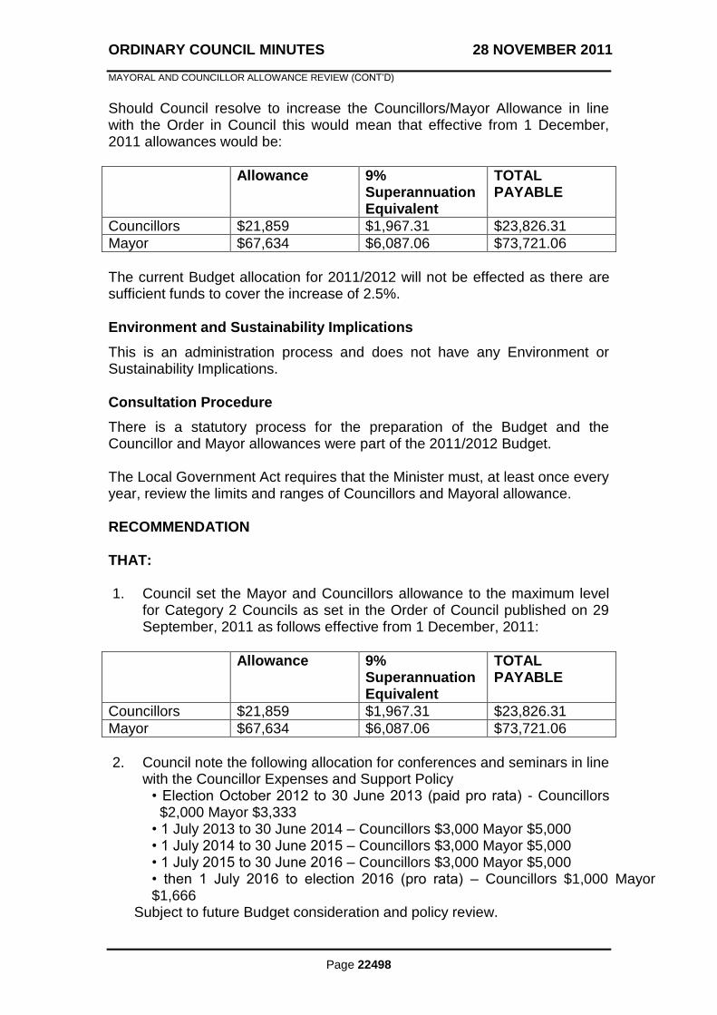
Should Council resolve to increase the Councillors/Mayor Allowance in line with the Order in Council this would mean that effective from 1 December, 2011 allowances would be:
Allowance 9% Superannuation Equivalent
TOTAL PAYABLE
Councillors $21,859 $1,967.31 $23,826.31
Mayor $67,634 $6,087.06 $73,721.06
The current Budget allocation for 2011/2012 will not be effected as there are sufficient funds to cover the increase of 2.5%. Environment and Sustainability Implications
This is an administration process and does not have any Environment or Sustainability Implications. Consultation Procedure
There is a statutory process for the preparation of the Budget and the Councillor and Mayor allowances were part of the 2011/2012 Budget. The Local Government Act requires that the Minister must, at least once every year, review the limits and ranges of Councillors and Mayoral allowance. RECOMMENDATION
THAT: 1. Council set the Mayor and Councillors allowance to the maximum level
for Category 2 Councils as set in the Order of Council published on 29 September, 2011 as follows effective from 1 December, 2011:
Allowance 9% Superannuation Equivalent
TOTAL PAYABLE
Councillors $21,859 $1,967.31 $23,826.31
Mayor $67,634 $6,087.06 $73,721.06
2. Council note the following allocation for conferences and seminars in line
with the Councillor Expenses and Support Policy • Election October 2012 to 30 June 2013 (paid pro rata) - Councillors $2,000 Mayor $3,333
• 1 July 2013 to 30 June 2014 – Councillors $3,000 Mayor $5,000 • 1 July 2014 to 30 June 2015 – Councillors $3,000 Mayor $5,000 • 1 July 2015 to 30 June 2016 – Councillors $3,000 Mayor $5,000 • then 1 July 2016 to election 2016 (pro rata) – Councillors $1,000 Mayor $1,666
Subject to future Budget consideration and policy review.
ORDINARY COUNCIL MINUTES 28 NOVEMBER 2011
MAYORAL AND COUNCILLOR ALLOWANCE REVIEW (CONT‟D)
Page 22499
The resolution for Item 10.3, Mayor and Councillor Allowance Review, is found at the end of this section. GOVERNANCE AND EXECUTIVE SERVICES REPORTS – ITEMS NOT OTHERWISE DEALT WITH: MOVED: CR. D. CALLAGHAN
SECONDED: CR. T. TOBIAS
THAT: the recommendations contained within Items 10.1, 10.2 and 10.3 of the Governance and Executive Services Reports, be adopted.
CARRIED 9/0
SUSPENSION OF STANDING ORDERS In accordance with Clause 85 of Local Law No. 4 – Meeting Procedures. MOVED: CR. S. MARSTAELLER
SECONDED: CR. D. CALLAGHAN
THAT: Standing Orders be suspended to allow for submissions to be heard in relation to Planning reports.
CARRIED 9/0
Standing Orders suspended at 7.42pm RESUME STANDING ORDERS In accordance with Clause 85 of Local Law No. 4 – Meeting Procedures. MOVED: CR. S. MARSTAELLER
SECONDED: CR K. MULRONEY
THAT: Standing Orders be resumed.
CARRIED 9/0
Standing Orders resumed at 7.58pm.
ORDINARY COUNCIL MINUTES 28 NOVEMBER 2011
MAYORAL AND COUNCILLOR ALLOWANCE REVIEW (CONT‟D)
Page 22500
11. SUSTAINABLE DEVELOPMENT
11.1 CONSERVATION COVENANT - COLIN OFFICER FLORA RESERVE
Author: Vivian Pasic, Senior Environmental Services Officer
File No: RE/03/047 - Property: 114782
Attachment: Draft Deed of Covenant
Reference: Item 9.8 – 27 November 2006
Summary At its meeting in November 2006 Council resolved to apply to the Trust for Nature to apply a conservation covenant on the entire reserve, with different management zones. This report provides a summary of activities regarding the reserve and covenant process since November 2006, and recommends Council sign and seal the Deed of Covenant. Background The 13.7 ha reserve was created in April 2005 as an open space contribution to the Shire for the subdivision of land known as the Broadford Lakes Estate. The reserve is highly significant for its environmental conservation values supporting over 105 different species of indigenous vegetation. The Reserve is named after Dr Colin Officer OAM. Dr Officer was a medical practitioner in Seymour from the 1950‟s to 2010 and an advocate for the natural environment in Mitchell Shire. Council has appointed the Broadford Land Management Group Inc (former Colin Officer Reserve Committee of Management and Broadford Environmental Reserves Committee of Management) to assist Council with the management of the reserve. The group has been actively managing the Reserve since November 2006. Policy Implications The recommendations of this report are supported by the following Council policies and strategies:
Council Plan 2009-2013 which seeks to protect and rehabilitate Council‟s environmental and bushland reserves.
ORDINARY COUNCIL MINUTES 28 NOVEMBER 2011
CONSERVATION COVENANT - COLIN OFFICER FLORA RESERVE (CONT‟D)
Page 22501
Mitchell Shire Environment Strategy 2008, which states, “Consider placing a conservation covenant and Land for Wildlife status on appropriate Council owned and managed land”.
Recreation and Open Space Strategy which aims to “Protect remnant vegetation along roadsides, ridgelines, watercourses and in open space”.
Conservation covenants derive from the Victorian Trust Act 1972 and have the force of statute law. Issues There have been a number of issues that have prolonged the process since Council‟s original resolution. Goulburn Valley Water was required to create easements on the property title (completed November 2009). The draft deed of covenant received in February 2011 was then sent back to Trust for Nature as the easements were not illustrated on the map. Council officers are now satisfied that the amended final deed is correct and that the easements will not be covenanted. Financial Resource and Asset Management Implications There are minimal costs associated with conservation covenants other than Council officer time in administration. Trust for Nature will prepare a management plan for the reserve in consultation with Council and the Broadford Land Management Group Inc. Environment and Sustainability Implications As part of Council‟s commitment to environmental management at its meeting in November 2006, Council resolved to apply to the Trust for Nature for a conservation covenant on the entire reserve with different management zones. The conservation covenant is to be registered on the property title and is permanent. The agreement between Trust for Nature and Mitchell Shire Council is to protect and enhance the natural, cultural and/or scientific values of the land. Consultative Procedures There has been lengthy consultation between Council officers, Goulburn Valley Water, Surveying consultants, Trust for Nature and the Broadford Land Management Group Inc to ensure the deed is accurate. It was recommended that different management zones apply over the land and this has occurred. RECOMMENDATION
THAT: Council sign and seal the Deed of Covenant for the Colin Officer Flora Reserve. The resolution for Item 11.1, Conservation Covenant – Colin Officer Flora Reserve, is found at the end of this section.
ORDINARY COUNCIL MINUTES 28 NOVEMBER 2011
Page 22502
11.2 PROPOSED WALLAN SUPER CLINIC – MINISTERIAL PLANNING SCHEME AMENDMENT SUPPORT
Author: Stacey Gardiner, Manager Strategic Planning
File No: PL/09/024
Attachment: Location and Zoning Maps and Incorporated Documents
Reference: Item 15.3 - 26 September 2011 (Confidential Meeting)
Summary Council has received a request to support a Ministerial Planning Scheme Amendment to facilitate the development of the Wallan Super Clinic at No‟s 7, 9 and 11 High Street Wallan. The development of a Medical Centre and ancillary Pharmacy is currently prohibited under the current Business 4 Zone which exists over the land. The Ministerial Amendment proposes to introduce site specific controls and exclusions as well as an Incorporated Document into the Mitchell Planning Scheme rather than rezoning the site to a different zone. This is considered an appropriate approach to facilitate the proposed use and development. The amendment would result in no planning permits being required for the use and development of the site for a Medical Centre and related Pharmacy. Accordingly, Council Officers have ensured that there are a number of conditions included in the Incorporated Document which require Council approval and mean that Council can influence the development and use on the site. The Ministerial Amendment is considered appropriate in this instance and it is recommended that Council write to the Minister for Planning and provide its support for the proposed Amendment. Background Since 2007, Council has been aware of the need for a Super Clinic and has expressed its support for the development of the service within the Shire. The Federal Government has committed funding as part of a grant to Mitchell Community Health to support the development of a GP Super Clinic. The most appropriate location for the Super Clinic has been determined to be within the Wallan township. Following a number of discussions with Mitchell Community Health in March 2011, Council resolved to advertise its intent to lease a portion of land which formed part of Hadfield Park, Wallan to Mitchell Community Health Service for the construction of a Super Clinic. Following Council‟s advertisement of its intent, a number of submitters were heard by Council at its meeting 23 May 2011. In addition, Council received two petitions relating to the Super Clinic and Council‟s intent to lease part of Hadfield Park for its development.
ORDINARY COUNCIL MINUTES 28 NOVEMBER 2011
PROPOSED WALLAN SUPER CLINIC – MINISTERIAL PLANNING SCHEME AMENDMENT SUPPORT (CONT‟D)
Page 22503
Following the consideration of submissions received, Council at its meeting of 27 June 2011, resolved to commence the statutory process to allow a lease to be created on a parcel of land in the north-east corner of Hadfield Park, Wallan for the construction of a Super Clinic. In late August 2011, Council officers were approached by representatives of Mitchell Community Health who indicated an alternative site in Wallan was being investigated as an option to Hadfield Park. A formal request for Council support of a Ministerial Planning Scheme Amendment has now been received by Nicholson Planning and Development (planning consultants) on behalf of Mitchell Community Health. Policy Implications The provision of a Super Clinic in Wallan is considered to be consistent with the Council Plan 2009 – 2013. Specifically, the Plan states that Council should „plan and provide an appropriate range of community facilities and services to support ongoing population growth of the Shire, demographic change, new legislation,…and community needs and concerns‟. If Council determines to support a Ministerial Planning Scheme Amendment consistent with that outlined within this report, then the site will be exempt from planning policies and controls included within the Mitchell Planning Scheme which currently apply to the site. In addition, site specific controls in the form of an Incorporated Document into the Planning Scheme would be introduced specifically addressing the development and use of the site for the purposes of a Medical Centre and ancillary (related use) Pharmacy. Issues Ministerial Planning Scheme Amendment In September 2011, Council received a request from Nicholson Planning and Development on behalf of Mitchell Community Health to support a Ministerial Planning Scheme Amendment under Section 20(4) of the Planning and Environment Act 1987. Support has been sought for an amendment to allow for the introduction of site specific controls to land at No‟s 7, 9 and 11 High Street Wallan to facilitate the development of the Wallan Super Clinic. A Ministerial Planning Scheme Amendment, or Section 20(4) Amendment, means the Minister for Planning is the Planning Authority for the Planning Scheme Amendment and can exempt himself from notification and exhibition of the amendment. Generally the Planning Minister seeks support from Council for him to exercise his power prior to completing the amendment. Ministerial Amendments are usually completed when the Minister for Planning considers a development to be of state importance or in the interests of the State. A Ministerial Amendment is often used for significant projects and is a means of fast-tracking the amendment process. It is understood that given the funding proposed for the Super Clinic is both federal
ORDINARY COUNCIL MINUTES 28 NOVEMBER 2011
PROPOSED WALLAN SUPER CLINIC – MINISTERIAL PLANNING SCHEME AMENDMENT SUPPORT (CONT‟D)
Page 22504
and state, that this project is considered significant and in order to secure the money, the state government is seeking to fast track the amendment by exercising the Minister‟s powers. Since the request was received, Council officers have held a number of discussions with Department of Planning and Community Development as well as the proponent regarding the form and content of the proposed planning scheme amendment. Subject Site - No’s 7, 9 and 11 High Street, Wallan The subject site is identified as No‟s 7, 9 and 11 High Street (Northern Highway), Wallan and is located on the east side between Duke and Watson Streets and is currently vacant (Attachment 1). There are currently two vacant lots immediately south of the site and the United Petrol Station is immediately north of the site. To the west of the site is the Wellington Street road reserve which is currently unconstructed and west of this reservation is a residential neighbourhood. The Wallan School is opposite the site on the east side of High Street (Northern Highway). Planning Controls The subject site is currently included in a precinct zoned Business 4. The Business 4 Zone encompasses land west of High Street between Duke and Watson Streets and east of Wellington Street (Attachment 2). The purpose of the Business 4 Zone is to encourage the development of a mix of bulky goods retailing and manufacturing industry and their associated business services. The zone is commonly established to allow the development of homemaker centres or „big box‟ retailing such as furniture and white goods stores in close proximity to town centres which are usually finer grain retail and professional suites and office uses. The Business 4 Zone limits the amount of office space permitted to be developed on a site to a maximum leasable floor space of 500m2. A use that proposes over 500m2
of office floor space is prohibited under the zone and a permit cannot be granted. The proposed use of a Super Clinic which has a floor space area of over 500m2 is prohibited under the current Business 4 Zone. Accordingly, in order for the use to be permitted on the site, a Planning Scheme Amendment is required.
ORDINARY COUNCIL MINUTES 28 NOVEMBER 2011
PROPOSED WALLAN SUPER CLINIC – MINISTERIAL PLANNING SCHEME AMENDMENT SUPPORT (CONT‟D)
Page 22505
Proposed Planning Scheme Amendment The proponent has approached Council seeking support for a Ministerial Amendment to introduce Site Specific controls and exclusions at Clause 52.03 of the Mitchell Planning Scheme. The purpose of site specific controls and exclusions is to recognise specific controls designed to achieve a particular land use and development outcome already existing or to provide, in extraordinary circumstances, specific controls designed to achieve a particular land use and development outcome. The amendment proposes to include the subject site in the schedule to Clause 52.03 and accordingly would allow the site to be used and developed in accordance with specific controls. Site specific controls are introduced into the Planning Scheme via an Incorporated Document. An Incorporated Document effectively forms part of the Planning Scheme and once it is included in the Planning Scheme a further Planning Scheme Amendment is required to change any part of the document. The specific controls included in an Incorporated Document may:
- allow the land to be used or developed in a manner that would otherwise be prohibited or restricted;
- prohibit or restrict the use or development of the land beyond the controls that may otherwise apply;
- exclude any other control in this scheme. The proposed amendment to introduce Site Specific Controls and Exclusions would mean that the site would still remain zoned Business 4, however, the controls within the Business 4 Zone and other planning scheme controls with the Scheme would not apply to the site. The amendment proposes to introduce an Incorporated Document which allows the site to be used and developed as a Medical Centre with a related Pharmacy. The site specific controls and exclusions would also mean that the use and development of the site for a Medical Centre and related Pharmacy would not require any future planning applications and accordingly there would be no requirement to apply for future planning permits. The use of the Site Specific Controls and Exclusions provision of the Planning Scheme is considered appropriate in this instance to allow for the development of the site for the Super Clinic. The alternative option would be to consider a rezoning of the land to another zone which would permit the use and development of the site for a Medical Centre and related Pharmacy. Council officers do not support a straight rezoning of the site to a zone such as the Business 1 Zone as it is considered problematic and would introduce controls which would allow a range of uses beyond that of a Medical Centre and related Pharmacy.
ORDINARY COUNCIL MINUTES 28 NOVEMBER 2011
PROPOSED WALLAN SUPER CLINIC – MINISTERIAL PLANNING SCHEME AMENDMENT SUPPORT (CONT‟D)
Page 22506
If a zone change occurred, some of the uses would not require a permit and it is considered that there is no strategic justification or merit to support a change to an alternative zone from the current Business 4 Zone. A change in zone would require some analysis of the current retail supply and demand needs or the preparation of a Structure Plan for Wallan which outlined future directions for changes in land use and related zones with the supporting evidence base. Accordingly, Council Officers consider that in this instance the introduction of site specific controls is appropriate as it is an extraordinary circumstance whereby a particular land use and development outcome is desirable. Moreover, there is no debate regarding the need or support for the development of a Super Clinic; the only matter that has remained unresolved for some time is the availability of securing an appropriate site. This site is considered appropriate and will enable this important service to be provided to the community. Incorporated Document As part of the Site Specific Controls and Exclusions, an Incorporated Document is proposed to be introduced into the Mitchell Planning Scheme (Attachment 3). The Incorporated Document allows for the use and development of the site for a Medical Centre and ancillary Pharmacy. It sets out the specific provisions that do not apply to the site including: Clause 52.05 – Display of Advertising Signs Clause 52.05 – Car Parking Clause 52.07 – Loading and unloading of Vehicles Clause 52.29 – Land Adjacent to a Road Zone, Category 1 or Public Acquisition
Overlay for a Category 1 Road Clause 52.34 – Bicycle Facilities Furthermore, the Incorporated Document sets out that there is no requirement to apply for a permit for use and development of the land for a Medical Centre and ancillary pharmacy providing the development is generally in accordance with plans to be submitted to Council and the conditions set out in the Incorporated Document are complied with. The conditions set out a number of matters which need to be submitted to Council and endorsed by Council before the development starts. This means that Council will still have the ability to endorse plans for the development and control the use and operation on the site. Accordingly, the conditions set out in the Incorporated Document address matters which Council officers consider are pertinent to the development, use and continuing operation of the Medical Centre including:
- Council endorsed plans which include a site plan and details the location and buildings, structures, elevations and external materials and finishes
- Council endorsed Landscape plans and landscaping to be complete prior to occupation unless otherwise agreed to by Council
ORDINARY COUNCIL MINUTES 28 NOVEMBER 2011
PROPOSED WALLAN SUPER CLINIC – MINISTERIAL PLANNING SCHEME AMENDMENT SUPPORT (CONT‟D)
Page 22507
- Traffic and Car Parking Management Plan outlining access arrangements to and from the site, including the provision of a service road along High Street, traffic management and control works, and internal layout and design with car parking
- Traffic management and access works must be completed prior to the use commencing or otherwise agreed to by Council
- Advertising signs location, size and types detail to be provided and approved by Council before the use commences
- Waste management and collection
- Limiting the number of practitioners which can operate on the site to six (6) at any one time
- Limiting the hours of operation to 8am to 9pm Monday to Friday unless otherwise agreed in writing by the Responsible Authority
Whilst the Site Specific Controls and Exclusions exempt the land owner from future planning permit requirements for the use and development of a Medical Centre and related Pharmacy, the conditions outlined above and included in the Incorporated Document (Attachment 3) address many of the same issues which would be required as part of a planning permit. Moreover, the conditions included in the Incorporated Document are to be complied with to the satisfaction of the Responsible Authority and accordingly provides Council with the ability to approve future plans for the site as it considers appropriate. In addition, VicRoads have provided input into the conditions, specifically those relating to the traffic access and management arrangements to the site because the land has direct access to High Street (Northern Highway) which is controlled by VicRoads. The requirement to prepare a Traffic and Car Parking Management Plan before the use commences will be approved by Council and VicRoads. It is considered that the proposed amendment to introduce Site Specific Controls and Exclusions, along with the Incorporated Document, is appropriate and will facilitate the development and future use of the site for the Super Clinic whilst providing Council with adequate consideration of development, use and ongoing occupation of the site at a later date as set out in the conditions. Financial Resource and Asset Management Implications The original proposal for the development of a Super Clinic at Hadfield Park had the potential to have both financial and asset management implications. The proposal is to support the use and development of the Super Clinic at a different site which would then remove any future financial or asset implications for Council relating to the use of Hadfield Park. In addition, the amendment would ensure the Super Clinic can be developed on the site and in turn ensures that the funding made available from both the federal and state governments is secured. If a site for the Super Clinic remained unknown then there is a danger that the funding committed to the development could be withdrawn and the Super Clinic may not be delivered.
ORDINARY COUNCIL MINUTES 28 NOVEMBER 2011
PROPOSED WALLAN SUPER CLINIC – MINISTERIAL PLANNING SCHEME AMENDMENT SUPPORT (CONT‟D)
Page 22508
Environment and Sustainability Implications There has been a considerable need identified for the provision of a Super Clinic in Wallan. The development will have a positive effect on the communities‟ access to health services and would have a positive impact on the long term sustainability of the community now and into the future when significant population increases are expected. Consultative Procedures Planning Scheme Amendments are usually placed on a four week public exhibition period where submissions are sought. If submissions are received and cannot be resolved they are referred to Independent Panels for review. In this case, where a Ministerial Amendment is proposed, it does not include a public exhibition period nor are submissions sought. The community has had previous opportunity to make submissions and provide feedback as part of Council‟s notice to lease part of Hadfield Park for the development of the Super Clinic. As part of this process, Council received petitions and the community had the opportunity to make submissions at a Council meeting. Whilst community members raised concern and did not support the development of the Super Clinic at Hadfield Park, the petitions did note support for the development of the Super Clinic. The Ministerial Amendment facilitates the development of the Super Clinic at an alternative location that would otherwise be developed for commercial purposes. This addresses the community‟s concerns regarding the use of Hadfield Park for the Super Clinic which was the main point of contention. Given the community has previously indicated support for the development, and the need to fast track the amendment to ensure the funding can be secured, it is considered that in this instance a Ministerial Amendment can be supported without the usual notification process. RECOMMENDATION
THAT: Council provide its written support for a Ministerial Planning Scheme Amendment in accordance with Section 20 (4) of the Planning and Environment Act 1987 to introduce site specific controls and exemptions and an Incorporated Document into the Mitchell Planning Scheme to facilitate the development of the super clinic at No‟s 7, 9 and 11 High Street Wallan.
ORDINARY COUNCIL MINUTES 28 NOVEMBER 2011
PROPOSED WALLAN SUPER CLINIC – MINISTERIAL PLANNING SCHEME AMENDMENT SUPPORT (CONT‟D)
Page 22509
ELECTION OF TEMPORARY CHAIRPERSON In accordance with Clause 10 Local Law No 4 – Meeting Procedure, the Chief Executive Officer called for nominations of a temporary Chairperson. MOVED: CR. S. MARSTAELLER
SECONDED: CR. R. LEE
THAT: Cr Melbourne be appointed temporary Chairperson CARRIED
9/0 Cr Melbourne assumed the role of temporary Chairperson. Cr Callaghan and Cr Coppel having declared an interest in the consideration of this item, left Council Chambers at 8.00pm
MOVED: CR. T. TOBIAS
SECONDED: CR. S. MARSTAELLER
THAT: the recommendation be adopted. CARRIED
5/2 Cr Callaghan and Cr Coppel returned to Council Chambers at 8.02pm. Cr Coppel resumed the role of Chair.
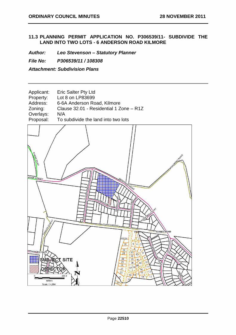
ORDINARY COUNCIL MINUTES 28 NOVEMBER 2011
Page 22510
11.3 PLANNING PERMIT APPLICATION NO. P306539/11- SUBDIVIDE THE LAND INTO TWO LOTS - 6 ANDERSON ROAD KILMORE
Author: Leo Stevenson – Statutory Planner
File No: P306539/11 / 108308
Attachment: Subdivision Plans
Applicant: Eric Salter Pty Ltd Property: Lot 8 on LP83699 Address: 6-6A Anderson Road, Kilmore Zoning: Clause 32.01 - Residential 1 Zone – R1Z Overlays: N/A Proposal: To subdivide the land into two lots
ORDINARY COUNCIL MINUTES 28 NOVEMBER 2011
PLANNING PERMIT APPLICATION NO. P306539/11- SUBDIVIDE THE LAND INTO TWO LOTS - 6 ANDERSON ROAD KILMORE (CONT‟D)
Page 22511
Introduction This report recommends that Council issue a Refusal to grant a planning permit for application number P306539/11, which seeks permission to subdivide the land at No. 6-6A Anderson Road, Kilmore into two lots. Proposal This application proposes the subdivision of land into two lots and is described as follows:
Lot 1 would be irregular in shape and would cover 6828m2;
Lot 1 would front Anderson Road;
Lot 1 would contain the existing Kilmore Golf Club, club house/restaurant and associated car parking spaces;
Lot 1 would gain access from Anderson Road at its eastern and western boundaries. The access at the western boundary is the existing access to the subject land;
Lot 2 would be an irregular “battle-axe” lot and would cover 8789m2;
Lot 2 would front Anderson Road at its eastern boundary;
Lot 2 would be vacant;
Lot 2 would gain access to Anderson Road at its eastern boundary through the “battle-axe” frontage;
The boundary line between Lots 1 and 2 would abut the club house along its western and southern boundaries.
History Council records reveal that Planning Permit No P303193/02 was issued in 2002 to allow the use of the land at No. 6-6A Anderson Road Kilmore for a restaurant. A condition of the permit was that 90 car parking spaces must be provided on site. The subject application was received 6 April 2011. The application proposed to subdivide the land into two lots and to create a carriageway easement along the western boundary. This easement would provide access to Lot 2 from Anderson Road at the west, while the “battle-axe” would provide direct access in the east. Additional information was requested from the applicant on 2 May 2011. The information required was:
Floor plans of the clubhouse
A car parking layout added to the plan of subdivision showing each space and accessway on Lot 1 to ensure that the lot would comply with the Clause 52.06 – Car Parking requirements for a Golf Course.
ORDINARY COUNCIL MINUTES 28 NOVEMBER 2011
PLANNING PERMIT APPLICATION NO. P306539/11- SUBDIVIDE THE LAND INTO TWO LOTS - 6 ANDERSON ROAD KILMORE (CONT‟D)
Page 22512
A concern was also raised in the letter regarding the proposed carriageway easement. It is generally considered poor planning policy and practice to provide carriageway easements to a new subdivision as a myriad of complications can arise in the future if the land is further developed. It was recommended that the easement be replaced with common property which avoids many of the issues associated with a carriageway easement. The applicant then submitted new plans showing the car park layout and amended the plan to show a common property rather than a carriageway easement. The application was referred to Council‟s engineers who did not raise any issues. They also did not require any conditions to be placed on the permit. The application was advertised to adjoining and adjacent land owners and occupiers and one objection was received. On 20 September 2011, the applicant submitted amended plans reverting the common property back to a carriageway easement. Pursuant to Section 57A of the Planning and Environment Act 1987 (the Act), the statutory clock was reset on this date. The application was re-referred to Council‟s engineers on 26 September 2011. A response was received on 27 September advising that Council‟s traffic engineers did not support the proposal and were requesting additional information. On 28 September 2011 a letter was sent to the applicant requesting additional information. The information required was:
The payment of the fee to amend the application after advertising in accordance with Section 57A(3)(a) of the Act;
An indicative or “Master Plan” for the proposed future development of Lot 2;
A Traffic Impact study of the golf club and the provision of parking for future development;
Details of how the car park on the east side of Lot 1 would be accessed;
A statement describing the proposed use and function of Lot 2;
A statement describing the clubhouse operations and how they are proposed to continue if a boundary was created abutting the club house walls;
An amended plan showing the “battle-axe” access to Lot 2 being increased in width to 16 metres to allow for future development and 90 additional car parking spaces on Lot 1 in accordance with the requirements of Planning Permit P303193/02.
A concern was also listed in this letter stating that if the additional 90 car parking spaces on site could not be provided, the use of the restaurant would be required to cease.
The applicant responded to this request on 4 October 2011as follows:
ORDINARY COUNCIL MINUTES 28 NOVEMBER 2011
PLANNING PERMIT APPLICATION NO. P306539/11- SUBDIVIDE THE LAND INTO TWO LOTS - 6 ANDERSON ROAD KILMORE (CONT‟D)
Page 22513
They were unwilling to provide a master plan or traffic study for the site.
They advised that access to the eastern section of the car park on Lot 1 was by way of agreement between proposed Lots 1 and 2.
The plan was amended to show 90 car parking spaces on site, however these were the same car parking spaces as shown for the golf course. As the operation of the golf course requires 72 spaces and Planning Permit P303193/02 requires 90 spaces, the plan showed a shortfall of 72 spaces.
The applicant advised that there would be no impediment or change to the operation of the clubhouse although the walls of the clubhouse would be located on the proposed new subdivision boundary.
They were unwilling to increase the width of the access to Lot 2 as it was claimed it would result in a significant change to the existing features on the ground.
A letter was sent on 11 October 2011 to the applicant requesting clarification on two points;
The details of the proposed agreement between the two lots for access to the east of Lot 1; and
Details of how it is proposed to access the rear of the clubhouse if the subdivision was approved.
The applicant responded on 13 October 2011 and advised:
In regards to the access arrangements, “The agreement between the Kilmore Golf Club Incorporated and the other party is subject to a confidentiality clause however the club can state that the access over Lot 2 will be by means of an 8m wide carriageway easement”.
In regards to access to the rear of the clubhouse, “There is no requirement for access along the rear section (southern) of the building as there are more than adequate alternative access points”.
As this response, as well as the previous responses, from the applicant did not satisfactorily address Council‟s concerns, a letter was sent on 19 October 2011 advising that the application would be recommended for refusal as it could not be supported by officers. Following conversations between the applicant and the Council officers, an amended plan was submitted on 20 October 2011 which removed the reference to the easement along the western boundary as a carriageway and created a new proposed access point to the car parking area on Lot 1. The remainder of the plan was unchanged. A letter was sent to the applicant on 26 October 2011 advising that the amended plan still did not address Council‟s concerns and that the application would be recommended for refusal.
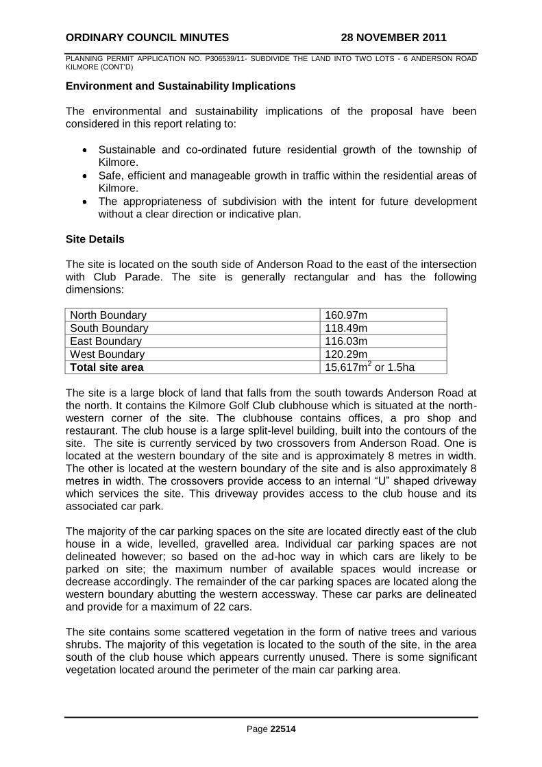
ORDINARY COUNCIL MINUTES 28 NOVEMBER 2011
PLANNING PERMIT APPLICATION NO. P306539/11- SUBDIVIDE THE LAND INTO TWO LOTS - 6 ANDERSON ROAD KILMORE (CONT‟D)
Page 22514
Environment and Sustainability Implications The environmental and sustainability implications of the proposal have been considered in this report relating to:
Sustainable and co-ordinated future residential growth of the township of Kilmore.
Safe, efficient and manageable growth in traffic within the residential areas of Kilmore.
The appropriateness of subdivision with the intent for future development without a clear direction or indicative plan.
Site Details The site is located on the south side of Anderson Road to the east of the intersection with Club Parade. The site is generally rectangular and has the following dimensions:
North Boundary 160.97m
South Boundary 118.49m
East Boundary 116.03m
West Boundary 120.29m
Total site area 15,617m2 or 1.5ha
The site is a large block of land that falls from the south towards Anderson Road at the north. It contains the Kilmore Golf Club clubhouse which is situated at the north-western corner of the site. The clubhouse contains offices, a pro shop and restaurant. The club house is a large split-level building, built into the contours of the site. The site is currently serviced by two crossovers from Anderson Road. One is located at the western boundary of the site and is approximately 8 metres in width. The other is located at the western boundary of the site and is also approximately 8 metres in width. The crossovers provide access to an internal “U” shaped driveway which services the site. This driveway provides access to the club house and its associated car park. The majority of the car parking spaces on the site are located directly east of the club house in a wide, levelled, gravelled area. Individual car parking spaces are not delineated however; so based on the ad-hoc way in which cars are likely to be parked on site; the maximum number of available spaces would increase or decrease accordingly. The remainder of the car parking spaces are located along the western boundary abutting the western accessway. These car parks are delineated and provide for a maximum of 22 cars. The site contains some scattered vegetation in the form of native trees and various shrubs. The majority of this vegetation is located to the south of the site, in the area south of the club house which appears currently unused. There is some significant vegetation located around the perimeter of the main car parking area.
ORDINARY COUNCIL MINUTES 28 NOVEMBER 2011
PLANNING PERMIT APPLICATION NO. P306539/11- SUBDIVIDE THE LAND INTO TWO LOTS - 6 ANDERSON ROAD KILMORE (CONT‟D)
Page 22515
The subject site does not contain any current easements. The subject site lies to the south of the golf course itself, which is located opposite, on the north side of Anderson Road. To the east, south and west are residential properties. These properties are generally 800-1000m2 and contain single dwellings with setbacks varying from 5-15 metres. The surrounding area contains some vegetation including remnant trees. The land is zoned Residential 1. Restrictive Covenants The subject site is not affected by any restrictions or covenants. Planning Controls The following clauses of the Mitchell Shire Planning Scheme are applicable to this application; State Planning Policy Framework Clause 11.02-1 – Supply of Urban Land
To ensure a sufficient supply of land is available for residential, commercial, retail, industrial, recreational, institutional and other community uses.
Clause 15.01-3 – Neighbourhood and subdivision design
To ensure the design of subdivisions achieves attractive, liveable, walkable, cyclable, diverse and sustainable neighbourhoods.
Local Planning Policy Framework and the Municipal Strategic Statement Clause 21.05-3 – Settlement
Key Features of Kilmore Clause 22.02-1 – Structure Plans for Towns
To ensure the co-ordinated management of new urban development and growth.
Residential 1 Zone Pursuant to Clause 32.01-2 of the Mitchell Shire Planning Scheme, a planning permit is required to:
Subdivide land
ORDINARY COUNCIL MINUTES 28 NOVEMBER 2011
PLANNING PERMIT APPLICATION NO. P306539/11- SUBDIVIDE THE LAND INTO TWO LOTS - 6 ANDERSON ROAD KILMORE (CONT‟D)
Page 22516
Particular Provisions Clause 56 An application to subdivide land within the Residential 1 Zone must meet the relevant objectives of Clause 56 of the Mitchell Planning Scheme. Referrals This application was referred internally to Council‟s Engineers who have stated that they do not support the creation of a carriageway easement for access. Notification Pursuant to the provisions of Section 52 of the Planning and Environment Act 1987, notice of the application was provided. Notification was carried out in the following manner:
Letters were sent to adjoining owners on 11 July 2011;and
A sign was erected on the site for a period of 14 days. One objection was received. The key points raised by the objectors were:
The potential rezoning of the land from residential to business to allow a medium density commercial development;
The possibility of the Lot 2 becoming a “Hidden Valley” style development;
Loss of visual amenity due to a change in views if Lot 2 were developed;
Likely removal of native vegetation; and
The potential change in the density of the area if Lot 2 were intensively developed.
Planning Officer Assessment This application is seeking permission to subdivide land at No. 6-6A Anderson Road, Kilmore into two lots. The subject land is located within a Residential 1 Zone and is not affected by any overlays. Within the Residential 1 Zone, a planning permit is required to subdivide land and any subdivision must meet the relevant objectives of Clause 56 of the Mitchell Planning Scheme. The objectives of Clauses 11.02-1, 15.01-3, 21.05-3, 22.02-1 of the Mitchell Planning Scheme, the purpose of the Residential 1 Zone and the objectives of Clause 56 of the Mitchell Planning Scheme are pertinent to this application. The following is an assessment of the proposal against these provisions. The objective of Clause 11.02-1 of the Mitchell Planning Scheme is to ensure a sufficient supply of land is available for residential, commercial, retail, industrial,
ORDINARY COUNCIL MINUTES 28 NOVEMBER 2011
PLANNING PERMIT APPLICATION NO. P306539/11- SUBDIVIDE THE LAND INTO TWO LOTS - 6 ANDERSON ROAD KILMORE (CONT‟D)
Page 22517
recreational, institutional and other community uses. The subject site is located within the Residential 1 Zone and as such has been set aside for a range of residential and community uses. The subject site is quite a large block within the township and is one of the remaining few infill development opportunities for Kilmore. When considering that the township itself is constrained not only by zoning, but physically by the topography of the land at its periphery, infill development opportunities such as this one become all the more important. This report is not suggesting that the land not be subdivided. It is simply suggesting that to meet the objective of Clause 11.02-1, a carefully and appropriately designed subdivision needs to take place. The township of Kilmore, as it is located in the southern region of the shire, is expected to experience heavy growth in the coming years. With this growth will come the demand for residential land. The subject site has the potential to provide for some of this demand, however, if the land is not appropriately subdivided the objectives at Clause 11.02-1 of the Mitchell Planning Scheme would be compromised. Clause 21.05-3 identifies that most towns within the Shire have a sufficient supply of residential zoned land, based on existing zoning, to exceed the 10 to 15 year residential land supply established as a benchmark by the State Government. It has been established that the supply of land based on growth rates would be sufficient for up to 60 years. However, the most recent review of the Municipal Strategic Statement was carried out in 2004. Therefore, the supply of land within the townships of Mitchell is likely to have changed significantly. Additionally, due to the unprecedented growth in the south of the shire, the supply of land within the townships of Kilmore and Wallan has decreased in the last few years. This means, that larger, undeveloped lots, such as the subject site become increasingly important tools in the continued and co-ordinated growth of these townships. The objective of Clause 22.02-1 of the Mitchell Planning Scheme is to ensure the co-ordinated management of new urban development and growth. As discussed previously, the supply of available residential land within Kilmore has declined in recent years due to growth. The subject site is located in an established residential area. As such it is important that any subdivision is designed to ensure co-ordinated management of new growth with the existing land use. This application proposes that Lot 2 would be accessed by a 14 metre wide “battle-axe” fronting Anderson Road. As the applicant did not provide an indicative master plan for Lot 2, it is unknown how the lot would be developed in the future, but it can be assumed that it would be accessed by the 14 metre wide section of land at west. In the current plan, Lot 2 does not have an access interface at the west with Anderson Road therefore; in the event that Lot 2 is further subdivided, it is likely to create a courtbowl. Any dwellings constructed within this courtbowl would gain access from the 14 metre wide area of land at the east. Anderson Road curves at this point of the subject site and could potentially create an unsafe turning situation. This was flagged by Council‟s engineering department, who requested a traffic study for the site. Council‟s engineers were also concerned that a 14 metre wide piece of land would be inadequate to provide a new road to service

ORDINARY COUNCIL MINUTES 28 NOVEMBER 2011
PLANNING PERMIT APPLICATION NO. P306539/11- SUBDIVIDE THE LAND INTO TWO LOTS - 6 ANDERSON ROAD KILMORE (CONT‟D)
Page 22518
the number of dwellings that could potentially be constructed on Lot 2. A master plan was requested from the applicant in order to gain an understanding of the potential development of Lot 2. The applicant has proposed that an 8 metre wide carriageway easement be created along the western boundary of the site to provide an additional access point to Lot 2, however; aside from the complications that arise from the use of carriageway easements, the same issues facing the access at the east also apply to the proposed carriageway access in the west; namely, an inadequate width to provide for future development and the access being located on a curve in the road. The application also proposes that the boundary between Lots 1 and 2 would be constructed abutting the western and southern walls of the clubhouse. Although the applicant has stated that this will not affect the operation of the building, it causes concern for the future operation of the building and potential development. It is unclear how the building would be maintained along these areas, it is also not understood how access would be gained to these areas. Additionally, located directly south of the building is a 3 metre wide access driveway and a sheer 3-5 metre high embankment. By locating the boundary in a position abutting the building, the existing access driveway is placed within Lot 2, but is in between the building to the north and the embankment to the south. This means that the accessway may potentially become an unused piece of land. It could also become a safety concern as a hazard. The concerns regarding the future development of Lot 2 could be allayed by the submission of an indicative Master Plan, however since one has not been forthcoming from the applicant, Council must consider a worst case scenario. The purpose of the Residential 1 Zone is to provide for residential development at a range of densities with a variety of dwellings to meet the housing needs of all households and to encourage residential development that respects the neighbourhood character. This application proposes to subdivide land into two lots. Lot 1 would contain the existing golf clubhouse and associated car park. Lot 2 would be vacant and would comprise 8,789m2. This subdivision is unlikely to change the neighbourhood character, however the layout of the lots, especially Lot 2 causes concern about the potential use and development of the land and the effect this may have on the neighbourhood character, amenity and safety of the area. Clauses 56.03-5, 56.04-2, 56.04-3, 56.04-5, 56.06-8 to 56.09-2 of the Mitchell Planning Scheme are applicable to this application as it is for the subdivision of two lots only. The proposal generally meets the standards and objectives of the clauses, however; as described previously, the lot layout and potential further development of Lot 2 cause concern in relation to Clause 56. As it is unclear how Lot 2 will be developed it cannot be determined whether the objectives of Clause 56 will be met. It appears that in relation to traffic safety and neighbourhood character that any development on Lot 2, due to its proposed layout, would be compromised.
ORDINARY COUNCIL MINUTES 28 NOVEMBER 2011
PLANNING PERMIT APPLICATION NO. P306539/11- SUBDIVIDE THE LAND INTO TWO LOTS - 6 ANDERSON ROAD KILMORE (CONT‟D)
Page 22519
Objectors Concerns Grounds of objection and officer response now follow: The potential rezoning of the land from residential to business to allow a medium density commercial development. At this stage, Council has not received an application to re-zone the land. The land is currently located within a Residential 1 Zone and as such, limited commercial uses are allowable subject to the application of a planning permit. The possibility of the Lot 2 becoming a “Hidden Valley” style development. As described above, the current zoning precludes many commercial uses. Additionally, Lot 2 would only comprise 8,789m2 whereas Hidden Valley covers many hundreds of hectares. However, without an indicative Master Plan, Council is unable to determine what, if any, development would occur on the land. Loss of visual amenity due to a change in views if Lot 2 were developed. If Lot 2 were developed it is likely that it would be for residential or other purposes. The visual amenity of the area would be changed however it has been well established by VCAT that there is no right to a “view”. Additionally, as the subject land is located within the Residential 1 Zone, it is reasonable to expect that development on the land would occur. It is unreasonable to expect, within a residential area, visual amenity would be protected by a vacant adjoining lot in perpetuity. Likely removal of native vegetation. The subject site is greater than 4000m2. Pursuant to Clause 52.17 of the Mitchell Planning Scheme, the removal of native vegetation on a lot greater than 4000m2 requires a planning permit. If any vegetation were proposed to be removed, it would be subject to a planning permit application. The potential change in the density of the area if Lot 2 were intensively developed. The neighbourhood and surrounding area consists mostly of residential lots containing single dwellings. As discussed the likely use and development of the subject land would be for residential purposes. It is considered unlikely that the development of the subject site would change the density of the area by being developed. There is the likelihood that if approved, Lot 2 would be developed more intensively than the surrounding area, however as any development application would be subject to planning approval, Clause 56 of the Mitchell Planning Scheme would apply and any design would be required to respect the existing neighbourhood character.

ORDINARY COUNCIL MINUTES 28 NOVEMBER 2011
PLANNING PERMIT APPLICATION NO. P306539/11- SUBDIVIDE THE LAND INTO TWO LOTS - 6 ANDERSON ROAD KILMORE (CONT‟D)
Page 22520
Conclusion This application is seeking to subdivide land at No. 6-6A Anderson Road, Kilmore into two lots. The subject site is located within a Residential 1 Zone. The site is one of the few remaining potential infill development sites within Kilmore. There is strong policy and strategic planning support for appropriate and co-ordinated management of new urban development and growth. The proposed subdivision and lot layout causes concern regarding traffic safety, neighbourhood character and the potential development of proposed Lot 2. There is also concern regarding the use and maintenance of the existing building on proposed Lot 1. The subdivision design and unknown future plans for the land do not comply with the State Planning Policy Framework, MSS, Local Planning Policy Framework and the purposes of the Residential 1 zone. It is therefore recommended that the application be refused. RECOMMENDATION
THAT: a Refusal to Grant a Planning Permit be issued for Application P306539/11 for the subdivision of land into two lots at No. 6-6A Anderson Road, Kilmore, on the following grounds: 1. The application does not meet the objectives of Clause 11.02-1 of the Mitchell
Planning Scheme, as it does not propose to subdivide a potential infill site in a safe, efficient and co-ordinated manner.
2. The application does not meet the objectives of Clause 22.02-1 of the Mitchell
Planning Scheme as it would prejudice the ability of the Responsible Authority to ensure the co-ordinated management of urban development and growth.
3. The application does not satisfactorily address concerns regarding the future
use and maintenance of the existing building on the subject site.
4. The application proposes to subdivide land in a way which is likely to prejudice future development.
5. The application proposes to subdivide land in a way which is likely to cause future concern for safety.
MOVED: CR. S. MARSTAELLER
SECONDED: CR. T. TOBIAS
THAT: the recommendation be adopted. LOST
4/5
ORDINARY COUNCIL MINUTES 28 NOVEMBER 2011
PLANNING PERMIT APPLICATION NO. P306539/11- SUBDIVIDE THE LAND INTO TWO LOTS - 6 ANDERSON ROAD KILMORE (CONT‟D)
Page 22521
MOVED: CR. R. LEE
SECONDED: CR. K. STEWART
THAT: Council, having considered the objection received and the application on its merits, resolves to issue a Notice of Decision to Grant a Planning Permit on the following grounds: 1. Before the plan of subdivision is certified under the Subdivision Act 1988,
amended plans to the satisfaction of the Responsible Authority must be submitted to and approved by the Responsible Authority. When approved, the plans will be endorsed and then form part of the permit. The plans must be drawn to scale with dimensions and three (3) copies must be provided. The plans must be generally in accordance with the plans submitted with the application but modified to show: a) The eastern area of Lot 2, where it abuts Anderson Road, increased in
width to 16m; b) The replacement of Easement E-1 with common property at the western
edge of the subject site; c) The boundary between Lots 1 and 2 amended so as to provide a setback
of at least 3m to the west of the existing building on the subject site; d) The boundary between Lots 1 and 2 amended so that it is located at the
top of the embankment south of the building on the subject site; e) The 90 car parking spaces as required by Permit P303193/02 shown on
Lot 1.
2. The layout of the proposed subdivision as shown on the endorsed plan, must not be altered or modified (whether or not in order to comply with any Statute, Statutory Rule or Local Law or for any other reason) without the prior written consent of the Responsible Authority.
3. The owner of the land must enter into agreements with the relevant authorities for the provision of water supply, drainage, sewerage facilities, electricity, gas and telecommunication services to each lot shown on the endorsed plan in accordance with the authority‟s requirements and relevant legislation at the time.
4. All existing and proposed easements and sites for existing or required utility
services and roads on the land must be set aside in the plan of subdivision submitted for certification in favour of the relevant authority for which the easement or site is to be created.
5. The plan of subdivision submitted for certification under the Subdivision Act
1988 must be referred to the relevant authority in accordance with Section 8 of that Act.
6. Prior to the issue of a Statement of Compliance, the owner/developer must pay
a Community Development Levy of $900 per each new lot created by the
ORDINARY COUNCIL MINUTES 28 NOVEMBER 2011
PLANNING PERMIT APPLICATION NO. P306539/11- SUBDIVIDE THE LAND INTO TWO LOTS - 6 ANDERSON ROAD KILMORE (CONT‟D)
Page 22522
subdivision into a Council Community Development Levy Reserve account for the future provision of services in the vicinity of the development.
7. Prior to issue of a Statement of Compliance, the owner/developer must pay to
the Responsible Authority 5% of the site value of all the land in the subdivision, pursuant to Section 18 of the Subdivision Act 1988
8. This permit will expire if either of the following circumstances applies:-
a) the plan of subdivision is not certified within two years of the issue date of this permit; or
b) the statement of compliance is not lodged at the titles office within five years of the date of certification of the plan of subdivision.
The Responsible Authority may extend the permit if a request is made in writing prior to expiry of the permit or within three months afterwards
CARRIED 9/0
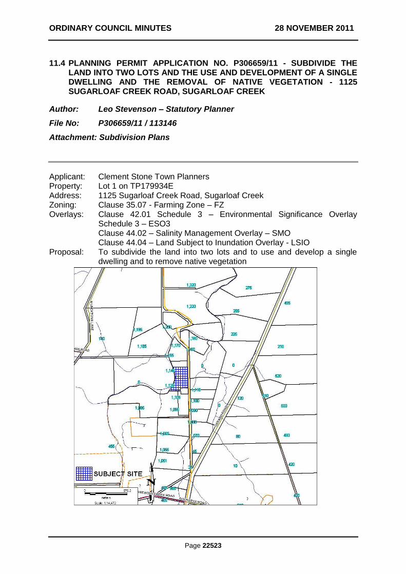
ORDINARY COUNCIL MINUTES 28 NOVEMBER 2011
Page 22523
11.4 PLANNING PERMIT APPLICATION NO. P306659/11 - SUBDIVIDE THE LAND INTO TWO LOTS AND THE USE AND DEVELOPMENT OF A SINGLE DWELLING AND THE REMOVAL OF NATIVE VEGETATION - 1125 SUGARLOAF CREEK ROAD, SUGARLOAF CREEK
Author: Leo Stevenson – Statutory Planner
File No: P306659/11 / 113146
Attachment: Subdivision Plans
Applicant: Clement Stone Town Planners Property: Lot 1 on TP179934E Address: 1125 Sugarloaf Creek Road, Sugarloaf Creek Zoning: Clause 35.07 - Farming Zone – FZ Overlays: Clause 42.01 Schedule 3 – Environmental Significance Overlay
Schedule 3 – ESO3 Clause 44.02 – Salinity Management Overlay – SMO Clause 44.04 – Land Subject to Inundation Overlay - LSIO Proposal: To subdivide the land into two lots and to use and develop a single
dwelling and to remove native vegetation
ORDINARY COUNCIL MINUTES 28 NOVEMBER 2011
PLANNING PERMIT APPLICATION NO. P306659/11 (CONT‟D)
Page 22524
Introduction This report recommends that Council issue a Notice of Refusal to grant a planning permit for application number P306659/11, which seeks permission to subdivide the land at No. 1125 Sugarloaf Creek Road, Sugarloaf Creek into two lots and to use and develop a single dwelling and remove native vegetation. Proposal This application proposes the subdivision of the land into two lots and the use and development of a single dwelling and is described as follows;
Lot 1 would be rectangular in shape and would cover 1.995ha;
Lot 1 would front Sugarloaf Creek Road;
Lot 1 would contain the existing dwelling and associated outbuildings;
Lot 1 would gain access from Sugarloaf Creek Road by the existing crossover at its eastern boundary;
Lot 2 would be irregular in shape and would cover 3.119ha;
Lot 2 would front Sugarloaf Creek Road;
Lot 2 would be proposed to contain a new dwelling;
Lot 2 would gain access to Sugarloaf Creek Road at its eastern boundary by way of a new crossover;
Lot 2 would contain a building envelope 40 metres in length and 25 metres in width. It would be set back 27 metres from the eastern boundary and 66 metres from the southern boundary;
To remove vegetation at the location of the building and effluent envelopes. The supporting documentation does not list the numbers, species and locations of specific trees or vegetation to be removed.
History Council records show that no previous permit applications have been made on the land. Environment and Sustainability Implications The environmental and sustainability implications of the proposal have been considered in this report relating to:
Reduced sustainability of farming land in relation to productivity and environmental outcomes;
The proliferation of dwellings within an agricultural area; and
The potential for a reduced capacity on farming land nearby.
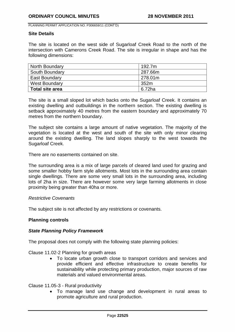
ORDINARY COUNCIL MINUTES 28 NOVEMBER 2011
PLANNING PERMIT APPLICATION NO. P306659/11 (CONT‟D)
Page 22525
Site Details The site is located on the west side of Sugarloaf Creek Road to the north of the intersection with Camerons Creek Road. The site is irregular in shape and has the following dimensions:
North Boundary 192.7m
South Boundary 287.66m
East Boundary 278.01m
West Boundary 352m
Total site area 6.72ha
The site is a small sloped lot which backs onto the Sugarloaf Creek. It contains an existing dwelling and outbuildings in the northern section. The existing dwelling is setback approximately 40 metres from the eastern boundary and approximately 70 metres from the northern boundary. The subject site contains a large amount of native vegetation. The majority of the vegetation is located at the west and south of the site with only minor clearing around the existing dwelling. The land slopes sharply to the west towards the Sugarloaf Creek. There are no easements contained on site. The surrounding area is a mix of large parcels of cleared land used for grazing and some smaller hobby farm style allotments. Most lots in the surrounding area contain single dwellings. There are some very small lots in the surrounding area, including lots of 2ha in size. There are however some very large farming allotments in close proximity being greater than 40ha or more. Restrictive Covenants The subject site is not affected by any restrictions or covenants. Planning controls State Planning Policy Framework The proposal does not comply with the following state planning policies: Clause 11.02-2 Planning for growth areas
To locate urban growth close to transport corridors and services and provide efficient and effective infrastructure to create benefits for sustainability while protecting primary production, major sources of raw materials and valued environmental areas.
Clause 11.05-3 - Rural productivity
To manage land use change and development in rural areas to promote agriculture and rural production.
ORDINARY COUNCIL MINUTES 28 NOVEMBER 2011
PLANNING PERMIT APPLICATION NO. P306659/11 (CONT‟D)
Page 22526
Prevent inappropriately dispersed urban activities in rural areas.
Clause 11.05-4 Rural planning strategies and principles
Siting and designing new dwellings, subdivisions and other development to minimise risk to life, property, the natural environment and community infrastructure from natural hazards, such as bushfire and flooding.
Clause 14.01-1 – Protection of agricultural land
Ensure that the State‟s agricultural base is protected from the unplanned loss of productive agricultural land due to permanent changes of land use.
To protect productive farmland which is of strategic significance in the local or regional context.
In considering a proposal to subdivide or develop agricultural land, the following factors must be considered: -The desirability and impacts of removing the land from primary production, given its agricultural productivity. -The impacts of the proposed subdivision or development on the continuation of primary production on adjacent land, with particular regard to land values and to the viability of infrastructure for such production. -The compatibility between the proposed or likely development and the existing uses of the surrounding land.
16.02-1 - Rural residential development
Manage development in rural areas to protect agriculture and avoid inappropriate rural residential development.
Discouraging development of isolated small lots in rural zones from use for rural living or other incompatible uses.
Local Planning Policy Framework and Municipal Strategy Statement The proposal does not comply with the following State planning policies: Clause 21.04 – Strategic Vision and Framework
The provision and management of new rural residential and low density residential development associated with selected existing settlement centres as shown on the various town structure plans.
Clause 21.05-1 – Natural resources and the environment
To ensure that the development of the land within Mitchell is not prejudicial to agricultural industries or to the productive capacity of the land.
The retention of the resource of agricultural land in productive units will be preferred and the fragmentation of land will be strongly discouraged.
Protect farming and other agricultural practises from the encroachment of urban growth.

ORDINARY COUNCIL MINUTES 28 NOVEMBER 2011
PLANNING PERMIT APPLICATION NO. P306659/11 (CONT‟D)
Page 22527
Discourage the development of rural residential development within established agricultural areas.
Retain productive land for agricultural purposes.
Clause 21.05-2 Economic context
Support agriculture as a major contributor to the Shire‟s economy Clause 21.05-3 Settlement
Unplanned development of rural areas for residential development will not be provided for.
Clause 22.05-1 Agriculture, Agroforestry and Processing
To ensure that the use and development of land within Mitchell is not prejudicial to agricultural industries or to the productive capacity of the land.
The retention of the resource of agricultural land in productive units will be preferred and the fragmentation of land will be strongly discouraged.
Expansion of urban uses and development into high quality agricultural areas will be discouraged.
Farming Zone Pursuant to Clause 35.07-3 of the Mitchell Planning Scheme, a planning permit is required to:
To subdivide the land;
To use and develop a single dwelling. Salinity Management Overlay Pursuant to Clause 44.02-2 of the Mitchell Planning Scheme, a planning permit is required:
To subdivide the land;
To construct a building or construct and carry out works. Land Subject to Inundation Pursuant to Clause 44.04-2 of the Mitchell Planning Scheme, a planning permit is required:
To subdivide the land.
ORDINARY COUNCIL MINUTES 28 NOVEMBER 2011
PLANNING PERMIT APPLICATION NO. P306659/11 (CONT‟D)
Page 22528
Notification This application has not been advertised in accordance with Section 52 (1A) of the Planning and Environment Act 1987 due to the recommendation for refusal based on the clear intent of the policies of the Mitchell Planning Scheme and previous VCAT determinations. Planning Officer Assessment The application proposes a two lot subdivision and use and development of a dwelling in the Farming Zone. The land is 6.72ha in size and is a Title Plan allotment which was previously a Crown Allotment created in 1979. The dwelling was constructed in 1989. The application has been assessed against the decision guidelines contained in Clause 65.02 of the Mitchell Planning Scheme as follows:
The suitability of the land for subdivision The site is zoned Farming Zone (FZ) and,
in accordance with the Schedule to the Farming Zone, the minimum subdivision size for land in a farming zone is 40ha. The proposal would provide for two lots, Lot 2 being 3.119ha and Lot 1 being 1.995ha. It is considered that the size of both lots would render the land inconsistent with the purpose of the Zone:
To provide for the use of land for agricultural land.
It is considered that the land is not suitable for subdivision as while the land may already be too small to be productively used for agriculture and may already be used as a rural residential lot, further fragmentation of rural land is contrary to the purpose of the zone. Both lots are well below the 40ha minimum to subdivide or have a dwelling „as of right‟, however a subdivision with a maximum land area of 2ha can be considered in accordance with Clause 35.07-3 ie. A permit may be granted to create smaller lots if the subdivision is to create a lot for an existing dwelling. After taking into account the factors of this application, the proposal is considered to be inappropriate to the
ORDINARY COUNCIL MINUTES 28 NOVEMBER 2011
PLANNING PERMIT APPLICATION NO. P306659/11 (CONT‟D)
Page 22529
rural area and inconsistent with the zoning:
To ensure that non-agricultural uses, particularly dwellings, do not adversely affect the use of land for agriculture.
and the decision guidelines:
How the use or development relates to sustainable land management.
Whether the site is suitable for the use or development and whether the proposal is compatible with adjoining and nearby land uses.
Whether the use or development will support and enhance agricultural production.
Whether the use or development will permanently remove land from agricultural production.
The potential for the use or development to limit the operation and expansion of adjoining and nearby agricultural uses.
The capacity of the site to sustain the agricultural use.
The agricultural qualities of the land, such as soil quality, access to water and access to rural infrastructure.
Whether the dwelling will result in the loss or fragmentation of productive agricultural land.
Whether the dwelling is reasonably required for the operation of the agricultural activity conducted on the land.
Whether the dwelling will be adversely affected by agricultural activities on adjacent and nearby land due to dust, noise, odour, use of chemicals and farm machinery, traffic and hours of operation.
Whether the dwelling will adversely affect the operation and expansion of adjoining and nearby agricultural uses.
The potential for the proposal to
ORDINARY COUNCIL MINUTES 28 NOVEMBER 2011
PLANNING PERMIT APPLICATION NO. P306659/11 (CONT‟D)
Page 22530
lead to a concentration or proliferation of dwellings in the area and the impact of this on the use of the land for agriculture.
The last point is particularly significant when considered in conjunction with Clauses 11.05-2, Melbourne‟s hinterland areas, and 11.05-3, Rural productivity, of the Mitchell Planning Scheme, the strategies of which include to:
Prevent dispersed settlement.
Site and design new development to minimise risk to life, property, the natural environment and community infrastructure from natural hazards such as bushfire and flooding.
Limit new housing development in rural areas, including: o Directing housing growth into existing settlements. o Discouraging development of isolated small lots in the rural zones from use for single dwellings, rural living or other incompatible uses. o Encouraging consolidation of existing isolated small lots in rural zones.
The existing use and possible future development of the land and nearby land.
The Farming Zone encourages agricultural uses and it is considered that further subdivision, resulting in an excision of the dwelling, would render that portion of land unviable for agricultural and farming purposes. In addition the proposed subdivision and resulting lot would confine the future use of the land essentially to quasi residential purposes, which are also contrary to the strategic direction of the Municipal Strategic Statement (Clause 21.04 & 21.05) of the Mitchell Planning Scheme, as per the next guideline assessment. The surrounding land is used for some grazing activity and some established rural-residential use and the granting of a permit for a small dwelling lot may set a precedent and expectation that small lot subdivision would be supported by

ORDINARY COUNCIL MINUTES 28 NOVEMBER 2011
PLANNING PERMIT APPLICATION NO. P306659/11 (CONT‟D)
Page 22531
Mitchell Shire Council resulting in the possible further fragmentation of rural land and further proliferation of dwellings in the Farming Zone.
The availability of subdivided land in the locality, and the need for the creation of further lots
The Mitchell Planning Scheme encourages residential style development to be located within established towns where there is adequate provision of existing infrastructure and services, therefore ensuring the availability of agricultural land. The established townships of Broadford and Seymour are within a short drive of the subject site. Both of these towns provide for residential use and some rural residential use in the form of existing Rural Living Zoned areas. It is considered that there is not a need for the creation of smaller lots in the rural area of the subject site.
The subdivision pattern having regard to the physical characteristics of the land including existing vegetation
The subject site is heavily vegetated and the subdivision and construction of buildings would likely result in the removal of much of the vegetation.
The density of the proposed development The proposed density is considered to be inconsistent with the purpose of the Farming Zone, and specifically with Clause 35.07-3, which requires a minimum 40ha lot size. Whilst excisions with a maximum size of 2ha are permitted under some circumstances, it is considered inappropriate in this instance due to the rural character of the area containing primarily larger lots. It is considered that the lots would be inconsistent with this character and presents the potential of setting a precedence which is in direct conflict with the support of agriculture and general rural activity encouraged by the Farming Zone.
The area and dimensions of each lot in the subdivision
As previously discussed, the proposed plan of subdivision is considered to be inconsistent with the purpose of the Farming Zone.
The layout of roads having regard to their function and relationship to existing roads
N/A
The movement of pedestrians and vehicles throughout the subdivision and the ease of access to all lots
N/A
The provision and location of reserves for public open space and other community
N/A
ORDINARY COUNCIL MINUTES 28 NOVEMBER 2011
PLANNING PERMIT APPLICATION NO. P306659/11 (CONT‟D)
Page 22532
facilities. The staging of the subdivision. N/A The design and siting of buildings having regard to safety and the risk of spread of fire.
N/A
The provision of off-street parking N/A The provision and location of common property.
N/A
The functions of any body corporate. N/A The ability and provision of utility services, including water, sewerage, drainage, electricity and gas.
Utility services available are electricity and telecommunications.
If the land is not sewered and no provision has been made for the land to be sewered, the capacity of the land to treat and retain all sewage and sullage within the boundaries of each lot.
The existing dwelling is currently serviced by wastewater systems.
Whether in relation to the subdivision plans, native vegetation can be protected through subdivision and siting of open space areas.
N/A.
The use of a dwelling in the Farming Zone is required to be in association with and support the agricultural use of the land. The subject site currently contains one dwelling on land with an area of 6.72ha. The proposed subdivision would subdivide the land in two creating an additional small lot within the Farming Zone without the potential for agricultural activity. The proposed lot would only be able to be effectively used for rural residential purposes. This would further proliferate the existence of dwellings on small lots within the Farming Zone and would further fragment farming land. Although it could be argued that is it stands the existing lot is already used for rural residential purposes, it is still contrary to the purpose of the Farming Zone. Clause 21.05-3, Settlement of the Mitchell Planning Scheme states that: A clear „urban edge‟ for each town has been provided for and is shown in the structure plans prepared for each town and by the use of the Rural zone zoning around each town. This pattern of development is designed to reinforce the rural setting and character of each town and facilitate a co-ordinated provision of infrastructure services and community facilities within the town boundaries. The proposed lots would create a parcel of land far removed from the existing township and its “clear urban edge”. These small proposed lots would be out of character with the surrounding area and would create a rural-residential/township style allotment more in keeping with the urban fringe of a township rather than in isolation in a rural area. Clause 21.05-3, Settlement Strategy, acknowledges the demand for low density and rural residential allotments within the shire. The isolated nature of the location and small area of the lot creates a situation whereby it would normally be found within or nearby to a township with access to infrastructure services, community facilities and the like. The creation of a rural residential lot separated from a township creates a greater reliance on vehicle travel to access
ORDINARY COUNCIL MINUTES 28 NOVEMBER 2011
PLANNING PERMIT APPLICATION NO. P306659/11 (CONT‟D)
Page 22533
basic services and facilities, creating lots which are inconsistent with sustainable development. The area of the subject site is considered to be unsuitable for rural residential development and as such it has remained within the Farming Zone. The Department of Sustainability and Environment practice note “Applying the rural zones of March 2007” states;
“The use and development of rural areas should fit into the overall strategic plan of the municipality, housing needs and settlement strategy”
The practice note discourages ad hoc use and development in rural areas. The Mitchell Planning Scheme (Clause 21.04) attempts to ensure residential growth be concentrated in and around the main towns to protect viable rural and farming areas. The subject site is located outside the area designated for growth found under Clause 21.04. VCAT have consistently made decisions disallowing excisions and subdivision of farming land, particularly where the required minimum lot sizes could not be met. In the case of Bellavale Pty Ltd v Greater Geelong CC (2 December 2008) the Tribunal affirmed the decision of the Responsible Authority and a permit for the excision of a dwelling was refused. The Tribunal stated: „I am not persuaded the proposal would facilitate purposes of the Farming Zone with respect to the protection of the productive resource. Proposed Lot 1 would have very limited grazing or other farming opportunities as fairly identified by Mr Phillips. It is also clear that the balance lot is intended for a second rural living property albeit with some livestock or other opportunities not afforded to the excised lot. Even though the review site, at 15.24ha, might be argued to be already rural living, the outcome of this proposal would be to excise the dwelling with no association with agricultural production and to produce a balance lot of a reduced size for which a dwelling application would be pursued. An excised dwelling with no association with production is discouraged by the Scheme and two dwellings instead of one, both on smaller lots, in this location would represent an even greater departure from policy outcomes being pursued.‟ [14]. The Tribunal also stated that the proposal would add to fragmentation (16) and „…it is imperative that planning decision makers are guided by relevant policy. It is not appropriate to exempt individual decision from the application of policy because it is only through the consistent application of policy that objectives leading to net community benefit and sustainable development will be achieved.‟ (7). As the decision states, it could be argued that the land is already considered rural living however; an excised dwelling with no association to agricultural use is discouraged by the Scheme and two dwellings, on smaller lots would represent an even greater departure from policy. It is clear from the Municipal Strategic Statement, State and Local policies of the Mitchell Planning Scheme that small lots in rural zones, including those created
ORDINARY COUNCIL MINUTES 28 NOVEMBER 2011
PLANNING PERMIT APPLICATION NO. P306659/11 (CONT‟D)
Page 22534
through the excision of dwellings are inconsistent with the purpose of the Farming Zone and intent of the scheme. The prevention of the fragmentation of viable farming land and the proliferation of dwellings not associated with agricultural use in the rural area are key concerns of the Planning Scheme. The proposed subdivision is considered to be inconsistent with the purpose of the zone and the orderly planning of agricultural land. The subject land is covered by a Salinity Management Overlay. The land does not appear to be affected by salinity and is not in a mapped area of discharge or recharge. As there is no vegetation removal proposed, the subdivision should not heighten the salinity risk to the land. The application provides no evidence as to how the proposal would enhance or create additional support of any agricultural use of the land. The creation of two sub 40ha lots within the area each containing a single dwelling does little other than create residential pressures within a rural setting. It is considered that while it may be argued that the existing lot is used for rural living purposes the creation of a further small lot would only serve to create residential pressures and expectations within the area and may set a precedent which would further fragment the rural area. Conclusion This application is seeking to subdivide land at No. 1125 Sugarloaf Creek Road, Sugarloaf Creek into two lots and to use and develop a single dwelling on one of the proposed lots. The subject site is located within a Farming Zone. The proposed lots would comprise areas of 1.995ha and 3.119ha respectively. These lot sizes are far less than the 40ha minimum required by the Farming Zone. This application fails to meet the State and Local Planning Policies, MSS and purpose of the Farming Zone. It is considered to be an inappropriate development, which further removes an area from agricultural use, adds to the proliferation of dwellings outside an urban area and causes an inappropriate change to the character and use of the rural area. Based on this is recommended that the application be refused. RECOMMENDATION
THAT: a Refusal to Grant a Planning Permit be issued for Application P306659/11 to subdivide land known as 1125 Sugarloaf Creek Road, Sugarloaf Creek into two lots and to use and develop a single dwelling and the removal of native vegetation, on the following grounds: 1. The proposal is not consistent with the intent of the Farming Zone or the orderly
planning of agricultural land.
2. The proposal fails to comply with State and Local Planning Policy and Municipal Strategic Statement. The location of the proposed subdivision which would result in a rural residential lot is isolated from townships. The proposal does not result in good planning outcomes and is not respectful of the rural and agricultural nature of the site and character of the surrounding area.
ORDINARY COUNCIL MINUTES 28 NOVEMBER 2011
PLANNING PERMIT APPLICATION NO. P306659/11 (CONT‟D)
Page 22535
3. The proposal fails to comply with Clause 11.02-2 of the Mitchell Planning Scheme which relates to containing urban patterns of growth to close to service centres and protecting urban primary production land.
4. The proposal fails to comply with Clause 11.05-3 of the Mitchell Planning Scheme which relates to promoting agricultural and rural production and prevent inappropriate urban activity.
5. The proposal fails to comply with Clause 14.01-1 of the Mitchell Planning Scheme which seeks to protect agricultural land and orderly planning of urban areas.
6. The proposal fails to comply with Clause 16.02-1 of the Mitchell Planning Scheme which seeks to protect agricultural land, avoid inappropriate residential development and the development of isolated small lots.
7. The proposal fails to comply with Clause 21.04 of the Mitchell Planning Scheme which relates to residential style development being located in existing settlement centres.
8. The proposal fails to comply with Clause 21.05-1 of the Mitchell Planning Scheme which seeks to discourage development of rural residential development within established agricultural areas, protecting farming and agricultural practices from the encroachment of urban growth and the strong discouragement of land fragmentation.
9. The proposal fails to comply with Clause 21.05-3 of the Mitchell Planning Scheme which seeks to discourage development of rural residential development within established agricultural areas, protect farming and agricultural practices from the encroachment of urban growth and focus residential growth in and around townships.
The resolution for Item 11.4, Planning Permit Application No. P306659/11 - Subdivide the Land into two lots and the use and development of a Single Dwelling and the removal of native vegetation - 1125 Sugarloaf Creek Road, Sugarloaf Creek is found at the end of this section.
ORDINARY COUNCIL MINUTES 28 NOVEMBER 2011
Page 22536
11.5 COMMUNITY AND BUSINESS REPRESENTATIVE NOMINATIONS – GOULBURN RIVER HIGH COUNTRY RAIL TRAIL
Author: Chris Guthrie, Economic Development Manager
File No: EC/05/018-02
Reference: Item 11.1 – 26 September 2011
Summary The Goulburn River High Country Rail Trail (GRHCRT) is due for completion in late 2011 and the three Councils involved have agreed to establish an Advisory Committee to oversee its operation and ongoing management. This report presents recommendations to Council on the appointment to the Advisory Committee of one Mitchell Shire Community representative and one Mitchell Shire Business representative. Background Mitchell Shire Council has been working in partnership with the Shires of Murrindindi and Mansfield to deliver a rail trail that will provide economic stimulus, through large numbers of tourists that will no doubt use this facility in the coming decades. The project is supported by all three levels of government, with a total budget to be expended in the order of $13 million. At its meeting of 26 September, 2011 Council resolved to adopt the Goulburn River High Country Rail Trail Management Plan and sign the Memorandum of Understanding between Mitchell Shire Council, Murrindindi Shire Council and Mansfield Shire Council, regarding the Goulburn River High Country Rail Trail – Governance Structure and Management of the Rail Trail Reserve. Effectively this established an Advisory Committee to assist the three Councils to oversee the management, marketing and development of the Rail Trail. At this same meeting Council also resolved that: A public advertising process be undertaken, seeking Expressions of Interest for the positions of Mitchell Shire Community representative and Business representative on the Goulburn River High Country Rail Trail Advisory Committee for a one year period. The balance of this report provides Council with the outcomes of the public advertising period and presents recommendations on appointments to the Advisory Committee.

ORDINARY COUNCIL MINUTES 28 NOVEMBER 2011
COMMUNITY AND BUSINESS REPRESENTATIVE NOMINATIONS – GOULBURN RIVER HIGH COUNTRY RAIL TRAIL (CONT‟D)
Page 22537
One Councillor (to be appointed by Council) and the Chief Executive Officer (or delegate) will also take a seat on the Advisory Committee. Policy Implications The outcome of this report is consistent with the 2009-2013 Council Plan strategic objective which seeks to “provide infrastructure appropriate to the communities‟ needs, managed in a sustainable way” and supports the activities of the United Approach to Tourism (now Goulburn River Valley Tourism). Issues Appointments to the Advisory Committee are important in the context of the ongoing success of the GRHCRT. Selection Criteria for the two roles were developed by Council staff and made available to interested people and were also available on Council‟s website. The Selection Criteria were: 1. Previous experience working with the community 2. Knowledge of Rail Trails and their operation 3. Ability to develop networks relating to the Rail Trail 4. Knowledge of and/or previous experience working with or on Boards and
Advisory Committees 5. Experience in managing competing issues and well developed time
management skills 6. Ability and commitment to attend approximately six meetings per year 7. An understanding of the issues relating to the Goulburn River High Country Rail
Trail and its ongoing management challenges. At the close of the advertising period, there were three applications received for the two roles. Council‟s Economic Development Manager and Human Resources Coordinator conducted interviews on Wednesday 9 November. The two people recommended for the representative roles both demonstrated experience and knowledge which were strongly aligned with the selection criteria above.
ORDINARY COUNCIL MINUTES 28 NOVEMBER 2011
COMMUNITY AND BUSINESS REPRESENTATIVE NOMINATIONS – GOULBURN RIVER HIGH COUNTRY RAIL TRAIL (CONT‟D)
Page 22538
Mr Joe Anka is the current Chair of Seymour Business and Tourism and also the Manager of GOTAFE in Seymour. He has broad experience working with the community and with local business on development issues. Mr John Pyle is a resident of Kilmore and a founding member of the Mitchell Bicycle Users Group and Rail Trails Australia. He also has a long history of involvement with community groups particularly within the Shire of Mitchell. Financial, Resource and Asset Management Implications There are no resource issues directly related to this report and the recommendations contained within. Community and Business Representative appointments to the GRHCRT Advisory Committee will not be remunerated and will be expected to offer their time and expertise as a community service. Environment and Sustainability Implications The GRHCRT has been constructed only after environmental assessment and the management team have endeavoured to keep environmental effects of construction to a minimum. Users of the GRHCRT will be advised of environmental responsibilities via signage along the trail itself. Consultative Procedures Vacancies on the Advisory Committee were advertised publicly in local papers and on Council‟s website. Selection Criteria were also available on the website and from the Economic Development Department. Interviews for the two roles took place on Wednesday 9 November 2011. RECOMMENDATION THAT: 1. Mr John Pyle be appointed as the Mitchell Shire‟s Community representative
to the GRHCRT Advisory Committee for a period of 12 months. 2. Mr Joe Anka be appointed as the Shire‟s Business representative to the
GRHCRT Advisory Committee for a period of 12 months. The resolution for Item 11.5, Community and Business Representative Nominations – Goulburn River High Country Rail Trail, is found at the end of this section.
ORDINARY COUNCIL MINUTES 28 NOVEMBER 2011
COMMUNITY AND BUSINESS REPRESENTATIVE NOMINATIONS – GOULBURN RIVER HIGH COUNTRY RAIL TRAIL (CONT‟D)
Page 22539
SUSTAINABLE DEVELOPMENT REPORTS – ITEMS NOT OTHERWISE DEALT WITH: MOVED: CR. D. CALLAGHAN
SECONDED: CR. W. MELBOURNE
THAT: the recommendations contained within Items 11.1, 11.4, and 11.5 of the Sustainable Development Reports, be adopted.
CARRIED 9/0
ORDINARY COUNCIL MINUTES 28 NOVEMBER 2011
Page 22540
12. NOTICES OF MOTION
12.1 NOTICE OF RESCISSION – 743 – PLANNING PERMIT APPLICATION NO. P306552/11 - USE AND DEVELOPMENT OF THE LAND AS A PLACE OF WORSHIP AT 22 DEMPSEY ROAD SEYMOUR
Author: Cr Melbourne; Cr Lee and Cr Parker
File No: 103457/306552
Reference: Item 11.2 – 14 November 2011
MOVED: CR. W. MELBOURNE
SECONDED: CR. R. LEE
THAT the resolution of the Ordinary Council meeting on 14 November 2011 in relation to Item 11.2, Planning Permit Application No P306552/11 “MOVED: CR. K. STEWART
SECONDED: CR. S. MARSTAELLER
A Notice of Decision to Grant a Planning Permit be issued for application number P306552/11 to allow for the use and development of the land as a place of worship and for a reduction in the number of car parking spaces in accordance with endorsed plans on the following conditions: 1. Before the development and use commence, three (3) copies of amended
plans drawn to scale and dimensioned, must be submitted to and approved by the Responsible Authority. When approved, the plans will be endorsed and will form part of the permit. The plans must be generally in accordance with the plans submitted with the application (dated 11 April 2011) but modified to show: a) full elevation drawings of the place of worship and associated verandah,
ablutions block, pergola and all fencing at a scale of 1:100;
b) the provision of a minimum of six (6) car parking spaces located so as not to restrict the existing parking provided for the dwelling;
c) annotation on plan that the copper dome is to be a non-reflective finish;
and d) a landscape plan prepared by a suitably qualified person / firm. The
landscape plan must be drawn to scale and accurately dimensioned. The landscape plan must show:
ORDINARY COUNCIL MINUTES 28 NOVEMBER 2011
Page 22541
i. the location, quantity, and maturity of all proposed plants; ii. the botanical names of all plants; iii. details of proposed maintenance requirements of new plants; iv. provision of additional planting along the south-western side of the
open courtyard in the form of native vegetation sufficient to provide a screen barrier to the adjoining property.
2. The development and layout of the premises as shown on the endorsed plans
must not be altered without the prior written consent of the Responsible Authority.
3. The use must only operate between the following hours unless with the prior written consent of the Responsible Authority: a) For the purpose of prayer between 4:20 am and 11:10 pm Monday to
Sunday.
b) For the purpose of other uses (meetings/discussions, meals, etc) between 9:00 am to 9:00 pm Monday to Sunday.
4. No more than 20 persons may be present on the subject land at any one time, with the exception of recognised Islamic religious or cultural days where no more than 40 persons may be present on the subject land, unless with the prior written consent of the Responsible Authority.
5. The amenity of the area must not be detrimentally affected by the use or development on the land to the satisfaction of the Responsible Authority, through the:
a) transport of materials, goods or commodities to or from the land;
b) appearance of any buildings, works or materials;
c) emission of noise, artificial light, vibration, smell, fumes, smoke, vapour, steam, soot, ash, dust, waste water, waste products, grit or oil; and
d) adverse behaviour or actions of patrons on, to or from the premises all to the satisfaction of the Responsible Authority.
6. Noise levels emanating from the premises must not exceed the permissible noise levels determined in accordance with the State Environment Protection Policy N-2 (Control of Music Noise from Public Places).
7. No amplification or public address system shall be installed or otherwise operated on the site.
8. Goods, materials, equipment and the like associated with the use of the land must not be displayed or stored outside the building, without the prior written consent of the Responsible Authority.
ORDINARY COUNCIL MINUTES 28 NOVEMBER 2011
Page 22542
9. Bins or other receptacles for any form of rubbish or refuse must not be placed
or allowed to remain in view of the public, and smell must not be emitted from any such receptacle.
10. Before the use starts or by such later date as is approved by the Responsible Authority in writing, the landscaping works shown on the endorsed plans must be carried out and completed to the satisfaction of the Responsible Authority.
11. The car parking provided on the land must always be made available for use by persons visiting the subject site and no measure may be taken to restrict access to the car spaces by such persons, all to the satisfaction of the Responsible Authority.
12. The car parking area must be maintained in good order to the satisfaction of the Responsible Authority.
13. Prior to any works commencing on site, approval of a separate wastewater
disposal system must be obtained from Council‟s Environmental Health Unit. Thereafter, the wastewater disposal system must be installed and maintained in good order to the satisfaction of the Responsible Authority.
14. All sewage and sullage waters must be treated in accordance with the
requirements of the Environment Protection Act 1970, the Code of Practice – Septic Tanks 2003. All wastewater must be disposed of within the cartilage of the land and sufficient area must be kept available for the purpose of wastewater disposal to the satisfaction of the responsible Authority. No wastewater to drain directly or indirectly onto an adjoining property, street or any watercourse or drain.
Goulburn Valley Regional Water Corporation Conditions (conditions 15-16)
15. Provision of a reticulated water supply and associated construction works, at
the developer‟s expense, in accordance with standards of construction adopted by and to the satisfaction of the Goulburn Valley Region Water Corporation (may require upgrade of existing main under car park);
16. The operator under this permit shall be obliged to enter into an Agreement
with Goulburn Valley Region Water Corporation relating to the design and construction of any water works required. The form of such Agreement shall be to the satisfaction of Goulburn Water.
Time Limit Condition 17. This permit will expire if the development is not commenced within two years
from the date of this permit. All development must be completed within four years from the date of this permit. The Responsible Authority may approve extensions to these time limits if requests are made within three months of expiry.
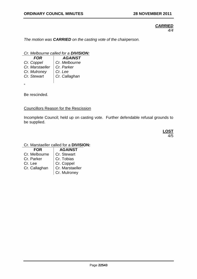
ORDINARY COUNCIL MINUTES 28 NOVEMBER 2011
Page 22543
CARRIED 4/4
The motion was CARRIED on the casting vote of the chairperson. Cr. Melbourne called for a DIVISION:
FOR AGAINST Cr. Coppel Cr. Melbourne Cr. Marstaeller Cr. Parker Cr. Mulroney Cr. Lee Cr. Stewart Cr. Callaghan ” Be rescinded. Councillors Reason for the Rescission Incomplete Council; held up on casting vote. Further defendable refusal grounds to be supplied.
LOST 4/5
Cr. Marstaeller called for a DIVISION:
FOR AGAINST Cr. Melbourne Cr. Stewart Cr. Parker Cr. Tobias Cr. Lee Cr. Coppel Cr. Callaghan Cr. Marstaeller Cr. Mulroney
ORDINARY COUNCIL MINUTES 28 NOVEMBER 2011
Page 22544
13. DELEGATES REPORTS
Nil
14. GENERAL BUSINESS
In accordance with Clause 30 of Local Law No. 4 Meeting Procedures. Nil
15. CLOSURE OF MEETING TO MEMBERS OF THE PUBLIC
In accordance with Section 89 of the Local Government Act, 1989 (as amended) MOVED: CR. S. MARSTAELLER
SECONDED: CR. T. TOBIAS
THAT: the meeting be closed to members of the public to consider the following items: 15.1 CONFIRMATION AND SIGNING OF MINUTES NOT PREVIOUSLY
CONFIRMED 15.2 WALLAN MULTIPURPOSE COMMUNITY CENTRE 15.3 PROVISION OF ESSENTIAL SERVICES MONITORING 15.4 SUPPLY OF PRE-FABRICATED CONCRETE DRAINAGE PIPES 15.5 CONTRACT FOR THE SUPPLY OF ROAD SIGNS AND ASSOCIATED
PRODUCTS 15.6 NEW POLICY DOCUMENT- PROCUREMENT 15.7 SALE OF PROPERTY 15.8 RE-OPENING OF MEETING TO MEMBERS OF THE PUBLIC
CARRIED 9/0
The meeting was closed to members of the public at 8.20pm.
16. DATE OF NEXT MEETING
The next Ordinary meeting of Council is proposed to be scheduled to be held on Monday 12 December, 2011, at the Civic Centre, Broadford, commencing at 7.00pm.
17. CLOSURE OF MEETING
There being no further business the meeting was closed at 8.25pm.