Embed Size (px)
Citation preview

Mr. Jal!lls D. Baker Geoloqiet Planning Department
Ma.rah 4, 1981
CoW\ty Administration Building, Uorth Winy
p. o. l'l<m 951 Martine2, California 94553
Dear Jim:
we are placing on open file the following reports, renewed and a,pproved by the CoW'l.ty of Contra Cost.a, in COl!lPliance with the. AlquistPriolo special Studies Zones Act•
1,/ Geotaohnical re-evaluation of Lots 4 through 12 of San Ramon Pai:-eel •h4l1 by Gasch & Aseo<i. 1 Jlllle 28, 1979 (CDMG file # AF?- :1117) •
Alquiat-Priolo seismic haaarde inve•tigation, Edwards prol"lrty ~cal nUl!lber 208-250-JB, San Ramon, CA1 by Enqeo, Inc. 1 Janllftry 15, 19601 vith addenda of PGbJ:'1>8:.:Y 21, 1900 and October 20, 1960 (CDMG file 0 A-P-1279).
Alquiet-Priolo study of Pacific Gas and Electri<i COmpll.J\y prop<!lrty (APn 216-040-012), s.an Ramon, CA; by Michael Rayes (PG&E)1 January 1901.
Your pro111pt filinq of th'1se reports is app:i:eotated,
EWH/cl:!:
cc: file/
Sincerely yours,
rz:":tv/4 B.>\ru. W. HART Office of the state Geologist CEG 935

~lanning Department
Co\Jnty Administration Building, North Wing 1>:0. Sox g51 Martinez. California 94553
Anthony A. Oehaesus Director of Planning
Phone: 372-2024
Earl W. Hart
Contra Costa County
Office of the State Geologist California Division of Mines and Geology Ferry Building, Room 1009 San Francisco, California 94111
Dear Mr. Hart:
Please place the following report on open file:
\
Title: Dc.ofc.UiM•CAl_l?c.~t.A..f>co'\,
For: lofs l/-1ha.,I l"Z.. S-... ~ By: GA$CH /i..ASSOC. Dated: ::!"~......_ -z.g, f'1 79 FI LE: Su B '+'fc./ I
One copy of the report is attach I:
rPle~~~ Mrl::i's9 !!$pf the 8-p 011mher assigns~ I I !!!Ii ;8LJ ( pa·dedoe receipt
Sincerely yours,
JBB:sv
cc: Fi ie PrfN ?.Jo-h8J- q+to &V~ "14<-/I
Geologist CEG 1021

--.-·-·---... .,. ___ .,--·-·-·--"~---- . -·------··
·-'SIGN!!!ff'.::__.,, __ ···· ···--····--····--- ,. __
~t__:l ~jJl_((_· ._, .:· .. : ·--· _1 _-1 ___ -:..._· L±J~---·-- _ _.:,9~w-.::::.... ~- _______ _ ·-.. ~: ( i)+ . __ · _:_t_~~~- :_· .1_:._ + . A _ ,, . f -.. ! Ii_~_ f±~~:> ,.) r.:, { .:~
?'-\ ()f; .;,.,I : ... I ·:I~-~----· __ 1 ~) ('}), _____ ·--~---------_, _ _] 1. . _( .::~) f..:3:._L1_ ··-·· _, 11_ .. • __ .. _- __ , _,, tr .- r: fp ( , f~._J_. _1~.l-1L _71r ..... ctJ __ _':2_11~~:i r-2-:_L_J __ i _ _:.__ ~·d21 "'I, "2, ___ . __________ _
....... ____ ,,. __ ,, ___ ., ~---.... ----·-------··---._ .. Jl-·:·:·· c-<2--__ ,_j_;fl_/1.· ·<___!_ ____ h_,111 .. -/1, .. b2-!) l'f···· r ,,~(YJ"' ,,_f ,,_\ -----'-' · f _r:,,. : .. +1-LLL~:~1 _ _'.__
SIGNED
IN$TRVCTION<;: . ' II I I.ti T!',."lf' ~·nf'"<TIOf'I. l!~:}!.~'l~E nl.!('\..l~.:'\f,!;,i;i;-1.,i. IA 9,w,l,f'/,':t!,'1, r;.<;i,i;i:-'Y,"/.11~),,ll.I ".11\l.r:-Jli';lfi ,l'ARTS WIT~l (:ARBONS TO ~f"PLY. -----

i:o _·_ ------.-· --- ----" ---- - -------- --------·x'/-·o;:p
__ DATE O~- _ - --~~"'---------/
1. ·-·/ ·z;) t ,, '- . ..- / z r·q -· FRO-M __ ··--·· .. --... --------.... ·---,···--····----·-- ____ ._SUBJECT_/. i_i... ____ · ... ·-·~.:•.· <. .... -- .:::~.;:)_~'::;.l.,,1 IC'1~11, '; /c..)
--··----------------- -·------------ __ ,_ --------------- --·--------· (/) .. z <.7 f 2-) ti /
'-
,etGNEO' ____ ---------·---- ---·--·--·---
--~------_/-/-rft/_7_/J-_,._I'.,;:·.-,/~--,-·.-, _J,.-1f_s___cf_f __ /-e,_-) ·-f;-.,, __ -,1:--~~_'-) f( c,_,/:f-C7£ __ --·· - ''> -. t .-- .-.. - ' - ( --- '")'>·-·] ;') .. ---.. ·~7--r~_,.-;' '.'~ ..... _l_r' .... ~~-·.,::::____.:_,'..,__, __ .. ~ . i'"\ . .... ~ __ ,_________ . ,
----·--·---------·-·-------·--
--·--------·------·--·----- ·-- ------------------- ---
----------------· --------~~~·:i[\ )/-.,_· _ . .f .... _______ ,, .. _, ___ ,. __ , ---------
// , __ ,, f -----·---------·-------
INS f"RUt::Tf()N5 . l"l,LL IN 1 (IP F>o,...rioN. f-11. lw'IOVE:. l)!IPLICl'll!: ('i'ELLOll'lll AND f·OllWAFILl r~F.:M/\INlNC, PAH I'S WITH C'if>.RBONS. ro REPLV,
~II LIN .LOllVFR Prlll 1'10N /\NI_) 'i.NllP ('JlJT r·.,..11FIOf'Vi' m·'fAIN Tl'lll"l.ICJI. j F IPIN~) AND Fl:ETl.11"-!N ORIGINAL

x-;.,:: ,</!('-_oATE U <--·' () 0 --~;---'/ ,., _____ ..
· -j·· ·I - · I _..,/- --i _ /_ "/- ,-.) f -·-<-'-----suaJEcT_1 i ____ :_ "· c .-=::J:2!8 -- j_ / <--'
--------------·---·----·-----·----------------------,.,.. .. ,
,,.-( h, <• -, .t·.),,,,1 ___ I ( ·' _,,,, --~-t-+-·~-- I I, /, <..- --,7~- --- ___ ...
('. :-1- ( (_, '·' - ·J·; 1/ I SIGNED
INSTRVC:TION5 rlLL IN 1 nP P0"11 !!)N, REMOVf i!IJPLIGll ff' (VELLOW) ANO F=ORWARD RJ::MlllNING PA~'l"S WITH cAl=IE'IONS. TO RfPLV,
rfLl fN \. 0WF Fl f"' ''·' / lr'N f".'D 1,NAP {ll.' 1 (', /\r~'?'r'r·" · 11f'"T fl.IN 1 lllr>l lf'.".A1 j' li'IN\'I:) i\Nl1 l~FTlJR~I r1•/l!~INAI.
ro. ~~J'.~~-''i FRO~ :-r 1 ',.,'- _ t;:-__ I_:~
{, '_ ... ~·-·-"-'~L._l ...... .
I if, I r' ,··, '
.' I I -·-··
I I
____;____-,_· SU BJ E CT. ________ ,~ ' ,/
-···--·-·-·-···-·-----······~· -·--·~·-·---·-· -· --··-·----
---==----cc, : <:~(}~ ' '.h_,
TO_ , .--~/~-:·~-0. ::d_c c~_(."-------·/:Jr-1 <A
--~f~)'..,.)~1,, U:o_~I-"_· -~-f~---
~"·"·~~--·---- -----
_____________ DATE ____ _
__ LI· ..,.1- ----------· -~~r_:~'~t'. __ s_f!_r,_ __ ,,1_(/_1 _
·---------------'-·
----------·--------------- --------------------------·· ,,, _____ _
----------------·------------. -····-
--·--~------------ -·~" ·-·-·-·----- ----·~~~~---------·
------~·,····----·--------- .. ····-·····--------~--
SIGNED----~-------------------
INST~l)CTl(.iNS · F'ILL IN TOP PORTION l~FMOV1" flV~'Ll(:llT!: IYELt.OW> AN{) .f'O~WARD l'lE:.MAINTNG PART.!5 WtTH CA,~BCINS. TO Rl;Pt.Y.
f"ll ! 1t.J \,!)WI ~ ~'''!1' rc:ir~ I' t-H'.1 'Ctl,~I" 1">111' ( /.I:"• ""I'· "' T !c!~I 'T!'l!"!. ICl\TF !PINK! ANfl !'.-11!:.TUR~ r')~IGINAl

I I
I I
, _.. ~ : .... - - - 11 ~ __[_ .. -- ·~ - __ ... F- - - - - - - - - ~ q - - - -, -
• T -:-7 • j .! • I • ' I l.
3se: United Soil Engineering, nc., "Site Pl an, Proposed Rescential Oevetop~ent, Tracts 440, C44l 4481 & 4196 ~n Ra~·oni Cali orniac1 ~ dated 1 - 5- 7 6, Sea 1 e " ~ l 00 ' .
' ,-.~ :
14
15
- --:-- -·-
!04-
\. 102
GASCH• ASSOCIATES INC.
Geophysfcs/G &01 ogy
4302 Madison Ave, Sacramento, Ca. 95842
{916 I 334-8400
..:- 't
i I
·11 IOI
l 1 !OD
SAN RAMON ?AACEL 4441 HIGH RESOLUTION REFLECTION
SEISMIC INVESTIGATION
Plan
Pro1ect No. GA 724 Date: 6/79

• t •
'1 ••
f. '1 la ll
1 1 ·1
1 ·1
l 1 1 , 1 l 1 1.
GEOTECHNICAL RE-EVALUATION OF LOTS 4 THROUGH 12
OF SAN RAMON PARCEL 4441
PREPARED FOR!
GARCIA & KNOPF DEVELOPMENT MORGAN HILL, CALIFORNIA
PREPARED BY:
GASCH & ASSOCIATES, INC. Consultants in Geophysice. & Geology
SACRAMENTO, CALIFORNIA
PROJECT NUMBER: GA724 JUNE 1979·
GASCH & ASSOCIATES • 4:l02 MADISON AVENUE • SACP.AMEHTQ, CA 956<12 • (916) :l:l4·6400

1 1 1. 1 1.
1
1 1
l I l I
June 28, 1979
Garcia & Knopf Development 15755 Walter Brenton Drive Morgan Hill, CA 95037
RE: San Ramon Parcel 4441 GA724
Gentlemen:
CONTR1\ COST;\ COU.'HY l'LANrJl~:G UEPAnTMENT
Following is our report summarizing our findings and opinions in regard to fault studies for Lots 5 through 10 of San Ramon Parcel, 4441.
If you have any qeustions, please contact us.
Very truly yours,
H & ASSOCIATES, INC.
Gasch, President
TI. GASCH (,,ASSOCIATES • 4302 MADISON AVENUE • SACAAMENTO, CA 95842 • (916) J::l4·84DO

1 l ' 1 1 ., 1 1 1 l 1 I 1 I ·1·
' '
' l.
PURPOSE AND SCOPE
This report represents our interpretation and evaluation of the ac
cumulated geophysical and geological data in the vicinity of Lots 4 through
12 of San Ramon Parcel 4441. Our evaluation included data collected and
published by Terrasearch, United Soil Engineering, and Gasch & Associates, Inc.
on San Ramon Parcels 4440, 4441, 4481, 4196 and 4450. Included in our work
were the following:
1. A review of existing geophysical and geological .literature of the area.
2. Interpretation of black and white stereopaired aerial photographs.
3. A review of surface geologic mapping of the site.
4. A review of all trench logs within the Lot 4 through 12 area.
5. Evaluation and interpretation of three high resolution reflection seismic lines across the alleged fault zone.
HIGH RESOLUTION REFLECTION SEISMIC INVESTIGATION
In an effort to deteni1ine the existence or non-existence of an alleged
fault traversing Lots 4 through 10 of Parcel 4441, Gasch & Associates, Inc.
has completed High Resolution Reflection Seismic traverses across these lots
at three locations (see· Figure 1). Each of these seismic traverses would
have crossed the alleged fault zone approximately perpendicular.
GASCH & ASSOCIATES • 4.'.l02 MADISON AVENUE e SACRAMENTO. CA 95842 • (916) .'.134-8400
Garcia & Knopf Development Project NumbGr: GA724
HIGH RESOLUTION REFLECTION SEISMIC INVE5TIGATION
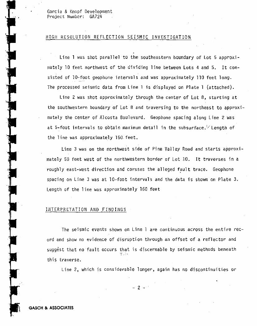
Line l was shot parallel to the southeastern boundary of Lot 5 approxi
mately 10 feet northwest of the dividing line between Lots 4 and 5. It con
sisted of 10-foot geophone intervals and was approximately 110 feet long.
The processed seismic data from Line l is displayed on Plate l (attached).
Line 2 was shot approximately through the center of Lot 8, starting at
the southwestern boundary of Lot 8 and traversing to the northeast to approxi
mately the center of Alcosta Boulevard. Geophone spacing along Line 2 was
at 5-foot intervals to obtain maximum detail in the subsurface. 1./ Length of
the line was approximately 150.feet.
Line 3 was on the northwest side of Pine Valley Road and starts approxi
mately 50 feet west of the northwestern border of Lot 10. It traverses in a
roughly east-west direction and corsses the alleged f~ult trace. Geophone
spacing on Line 3 was at 10-foot intervals and the data is shown on Plate 3.
Length of the line was approximately 160 .feet
INTERPRETATION AND FINDINGS
The seismic events shown on Line l are continuous .across the entire rec-
ord and show no evidence of disruption through an offset of a reflector and
suggest that no fault occurs that is di scernab le by set smi c methods beneath
this traverse.
Line 2, which is considerable longer, again has no discontinuities or
- 2 -
GASCH &. ASSOCIATES

1 I
Garcia & Knopf Development Project Number: GA724
INTERPRETATION AND FINDINGS (Continued)
disruptions well into the subsurface and it appears that no seismically dis
cernable fault exists within the first .100 or more milliseconds in time. This·
is equivalent to approximately 300 feet in the subsurface.
Line 3 shot northwest of Lot 10 has a distinct flexure in the 150 to
250.milliseconds .in depth zone. One hundred milliseconds or 1/10 of a second
as noted on the record, is equivalent to approximately 300 feet in depth. Two
hundred, fifty milliseconds is approximately 750 feet in depth. Two interpre
tations can be made of this feature. One is that the feature is at an oblique
angle to the direction of the reflection line, Line 3, or that the feature is
a small fold well within the subsurface which occurred sometime earlier. The
data does not support evidence that this feature comes back· to surface. With
regard to this geophysical evidence, it is Gasch & Associates' firm opinion
that a fault does not traverse lots 4 through l 0. This is further borne out by
the trenching data which is also presented with this report. The trench refer-
red to was excavated on January 18, 1979 in the accompany of numerous professionals
in the field of geology and engineering geology. The location of this trench,
TT-1, is along the lot line in a northeast-southwest direction between Lots 9 and
10. Our letter report dated January 26, 1979 to Terrasearch, Inc. discusses our
findings. Further, it is our understanding that the consensus of the professionals
present was that diagnostic evidence of faulting was not observed in the trench.
·J.· ' - 3 -,., ' I I
.II GASCH & ASSOCIATES

Garcia & Knopf Development Project Number: GA724
INTERPRETATION AND FINDINGS (Continued)
The trenches excavated and referred to as Trenches Tl, T2, T4 and Tl
by United Soil Engineering, Inc. suggest geologic anomalies were observed.
It is Gasch & Associates' opinion that the anomalies as described and illus-
trated in the United Soil Engineering report could easily be attributed to
other geologic conditions in the near-surface materials. Trench No. 2 is
very near where our Number 3 (HRS) High Resolution Reflection Seismic Line
was located. Our data to a depth of over 500 feet shows no discontinuities ·---·---~ --· .
in reflector surfaces. Since our Seismic Line 2 was run across the alleged
fault and no evidence suggesting any type of disruption was found, it is our
opinion that a fault does not traverse this area.
Regarding magnetometer traverses MTl and MT2 through the trenches and
Seismic Line S4 of the United Soil Engineering information, we have these com
ments: To utilize a proton-precession magnetometer within a c~~s~_}y_ confined
area is an improper technique ana typically will result in spurious data
at best. This information should be treated with light regard since its validity
is very questionable. Further, the use of a single-channel refraction seismic
technique to define a fault of the suggested magnitude, approximately __ l_-}-_::_f_oot
offset, is a technical impossibility given the geophone spacing, depth conditions, \::
and resolution of the ~quipment involved.
The step in seismic profile S4 of United Soil Engineering data can easily
- 4 -
GASCH &. ASSOCIATES

J
I t 1
1 l 1 1 l 1
Garcia & Knopf Development Project Number: GA724
INTERPREifATION AND FiINDINGS (Continued)
and more properly be interpreted as a lateral/velocity change caused by
a c;hange in material type and moisture content. Generally, the data in-
die.ates that a velocity change laterally has occurred, however, this does
not necessarily represent faulting.
An evaluation of the trench logs from the area suggests lateral velocity
changes should be expected.
As a final point, the data submitted by Terrasearch, Inc. on tract 4450
found the "Old Ranch Road Fault" of a 1974 and 1979 investigation did not
trend toward Lots 4 through 10 as previously indicated.
The trenching completed on tract 4450 substantiates that the soil and
shallow subsurface materials are typically variable laterally and vertically,
This was also observed in the United Soil Engineering trenches near the lots
of interest.
SUMMARY
In summary of this entire over"worked alleged fault, Gasch & Associates.
has these comments: All evidence of alleged faulting is very meager, at best,
within the bounds of Lot 4 through Lot 10. It is Gasch & Associates' opinion
that slumping of materials within past geologic time is a much·,more plausible
explanation of the anomalies found in the trenches northwest of Lot 10. It
5 -
GASCH &. ASSOCIATES

,, :1 ,, , , I "
I J
f 'f : .
l l T T T
n.
Garcia & Knopf DevQlopment Project Number: GA724
SUMMARY (Continued)
is our recommnedation that Lots 5, 6, 7, 8, 9 and 10 be allowed for con
struction of single-family home sites without any type of set-back or re
striction due to an alleged fault.
This concludes our report regarding these six lots. Thank you for
the opportunity to be of service and submit our High Resolution Reflection
Seismic data and our opinions and facts on this project.
Respectfully submitted,
~H & ASSOCIATES, INC.
U~w.»~ rie W. Gasch, President istered Geologist #1203
gistered Geophysicist #516 Engineering Geologist #450
JWG:cjs
GASCH & ASSOCIATES
- 6 -

~.
~ -~
11
·~ ~ ~
1, I ,;. I ~
January 26, 1979
GA724
SAN RAMON PARCEL 4441
Exploratory Trench for Fault Investigation
On January 18, 1979, at the request of Tom Makdissy of Terrasearch, Inc., Jerrie W. Gasch and James C. Gamble of Gasch & Associates, Inc. examined a trench excavated to explore for possible faulting on Parcel 4441 in San Ramon, Contra Costa County, California. The trench was located in an east-west direction on the southwest corner of Alcosta Boulevard and Pine Valley Road. It was excavated by backhoe, after partial stripping of fill and topsoil, with a width of about 2 feet and to a depth of about 10 to 12 feet.
Others at the site who examined the trench included: Tim Porter - Terrasearch, Inc. Paul Venuti Richard Roland Tom Makdissy Curt Messinger -Tod Nelson Earl Hart
Terrasearch, Inc. Terrasearch, Inc. Terra search, Inc .............. . Bay Soils Kleinfelder Associates California Division of Mines & Geology
Tim Porter and Paul Venuti of Terrasearch were logging the trench in some detail,
J. Gamble spent about three hours exam1n1ng the walls of the trench which was progressively being excavated. The sides of the trench were generally smeared with a layer of very stiff clayey soil. To observe the insitu materials, vertical and horizontal strips along the trench were cleaned by pick. There were no distinct marker strata present in the generally very stiff or very compact materials. There were some irregular and discontinuous gravelly zones with gradational boundaries in the )ower portion of the section examined.
A few dessication cracks were observed. One of particular note about 45 feet
GASCH & ASSOCIATES • 4302 MADISON AVENUE • SACP.AMEHTO, CA 95842 e (916) 334-8400

1 l
• • 1 1 1 I 1 I
l I 1 .1 1
\
1
San Ramon Parcell 4441 Exploratory Trench for Fault Investigation Page Two
from the west end of the trench was open about an inch near the surface and gradually became tighter downward. A series of aligned irregular fissures was noted to extend below the crack to a depth of about 8 fe..et: There was no evidence of shear on these surfaces. These cracks and fissures as well as fissures throughout the trench are interpreted to result from normal contraction and expansion from .dessication and wetting. Attached is a generalized section and description of trench stratigraphy.
No evidences of shearing or faulting were observed in the trench.
Considerable settlement {about a foot) with resultant cracking of the sidewalk was noted along the north side of Lot# 10 along Pine Valley Road. This was.apparently the location of a previously dug trench which was poorly compacted in backfilling.
Respectfully submitted,
& ASSOCIATES, INC.
~w.~~ ~ rie W. Gasch, President egistered Geologist #1203
Registered Geophysicist #516 Engineering Geologist #450
JWG/JCG/cjs
J:. c ./1. James C. Gamble Registered Geologist #3484 Engineering Geologist #1027
II GASCH & ASSOCIATES

'!I '.I ' .
1
• 1 I
fl 1 I 'I i
il I
l ~(
ll l 1 I
U:PTI-\ F<XT
-o
-4
-8
-12.
~ /\ 7 2..4 JU'j
I- IB-79
Ci SN er::...A L.. I "U"::.l:> Sc.c .. :n D N ' .
Si.._ p L.o R p.., TO R-'i \l<..t:. t-J Cl-\
S /\ N R K Mo t-...1 i:' f\R.c_E..L 444 I
/
'
,/ I
I
, I ·' ~ ' ,,. • .. -
,....-lll'-S .. \<. GiAAi- e>R<>...:>t-1 / \J. "">TIF-'F SAN.I:>'/ C:.IA'IE'I S:il.r;
'S'-16.,HTl-'I t>R.CjA+-llL \tJ 1\1-\ So"'\IS ~/ FISSURW f w Ill-\ 'SoN'\ 1; Dess1,;.noi.1 CR~ (o!"E:>.1. TO l"'-"1oe)
/ 5R.»wtJ I v, 'O>\lf-F C...1-N-f e'{ $\L"T'I s,0..\4t>i fiSS<-41"..E..C>
W 1"114 c...i..,.,'! Fll..MS Al-l D CA-1.-10{«. iRAa- of-! 1~ul/\
~Uf':.F~; ~qULM-.. ""11:> ~'! S"fRUC.1"\11!.l::.jlt>.0~•
5Row 1-l 9R.A\JEU.-'\ S\1..-1"'{ SM-IC> 1.J IRRE-<.,<ILA~ 1 \)ISC.•,.:>n>
UoUS L"E-NS.e'S wrn.\ 6i~-"<t>M"\o~N.,- eo<.1~D"i'-IE.S (o~3 Tl-he¥-).
\!>Rou.Jt-1 V. SnF-F c.i....o. 'l e '/ Sl'-T'/ s ~ IJD i SU(\1111..'l 11\01~
BR.owl-I 'I. ST1F-f= S!Tt-..10'1 ..:;\L\'I Cl-1<'1 j f\S5UICEo1 \.J,
\oJ 1-\ l\"E; C. l'<l..-1 c..1-\G 'Ple«A~$. AAID \-1<> l)U\..£.$ i tl\01',""f".
l31"-<>"-l\'.\. \/ , <;iT 1 Fr' CLAY"'/ S\LT'( 'SAN\:>.
GASCH&. ASSOCIATES

~ -.~n -.g
,.,.- -~I .: l. .J."f
l.
, 12
•
II
• \ •
Base: United Soi 1 Engineering, Inc., "Site Plan, Proposed Residenti~l Development, Tracts 4440, 4441 4481 & 4195 San Ramon , Ca 1 if om i a o:..,_da ted 11-5-76, Scale 1" = 100' .~
14
15
- -- -r- --··~
. \~- ...
!04-
\
' \ ~·- . .··• ; : .- ,. \
~-~-· ~ ....... · ~-.
s-c ·.
/OE
GASCH 6 ASSOCIATES INC.
GeophysicsiGeology
·--
II
\ \ .\ S-J
. ··i _., (. - - - ....... , :"_,-~. ,":_ .... _.~ ~--
100 39
SAN RAMON PARCEL 4441 HIGH RESOLUTION REFLECTION
SEISMIC INVESTIGATION
Plan
4302 Madison Ave. Sacramento, Ca. S5642
(S 16) 334--8400 Project No. GA 724 Date: 6/79

2 I I 1 j J J• -_
~-· .. ~ r - (
?:: "'· .,_ - I ,,,. -c ~
........ J •
... "'"<" ... _ .. _
.;:;_ c -.. -r ·~fl! t;;.--.1 . .,. .... _~ _.J (
, .
. ~
' "-~-«:---~1 "I· - -
~ '....,._ ... < ............
!- • -- _,,
···''If' !> :.· -- -- "-
NE
time approximate in depth in
seconds feet
o.o - 0
o. 1 - 300
0.2 - 600
0.3 - 900
0.4 - 1200
0,5 - 1500
SAN RAMON Ff.JJLT INVESTIGATION 1/4 MILLISECOND I SECOND PROCESSING SEQUENCE : I) REFORMAT 2) CDP GATHER 3) VELOCITY ANALYSIS 4). DECONVOLUTIOO 5)NORMAL MOVEOUT 6) CDP STACK 7'J DIGITAL FIL 1ER 55 HZ-250HZ
5' GROUP INTERVAL
GASCH• ASSOCIATES INC. SAN RAMON PARCEL 4441
HIGH RESOLUTION REFLECTION SEISMIC TRAVERSE Geophysics/Geology
I I .
4302 Madison Ave, Sacramento, Ca. 95842
(916) 334-8400
Line 2
Project No. GA 724 Date: 6/79
PLATE

I 1
• 1 1 1 J l 1 1 1 1 1 '
•• ~·
I
I '
I ' i
SAN RAMON F/IJJLT INVESTIGATION 1/4 MILLISECOND I SECOND PROCESSING SEQUENCE : I) REFORMAT 2) CDP GATHER 3) VELOCITY ANALYSIS 4) DECONVOLUTION 5)NORMAL MOVEOUT 6) CDP STACK 7) DIGITAL FILTER 55 HZ-250HZ
7
10' GROUP INTERVAL
time approximate
2 in depth in seconds feet
1 NE SW I , 0 - ' I \\\ \I\
- "- - I I ' -
- .... . .....__ -· J. -. - ~'.::.l ~.~~·· ..
f-+-+-+~)"~r.-.~ ~ .~.r:!.. J . -......._. .... , '""- '' . .;....,_....-
-~.-l_~~
' ' ' I
\. - .z -- r ...__
~ ~ < • - < c
' ' ,.... J J r•T .. _. - ' - ' ' r • < ' '
' • ,,. ' ·• < , ' I -' ' ...
t _J• - _,., ' . ( ......... _. ... <.
'· •. Y'C--.. ...... . ~ [;._
'- . ' .
-...___ . } (. \. •< C I I .. ' . '
-, --- -rr • ri.::.._. - ,_. -:.--.......~~~ ...
' -_ ·- - .. "--
~· •. .• - ........ ·- •• - ~- oC. ·~ _ ..
- . .. ... <~ _ ... ~ --.. ..... ..,. ~P:""'4.::;,~~;:. ~
...... :._ ... , ) C.C'lli. --._.-
1--· c . :-t-- ·~· F . • -~.- C - ·r • • - r .. . -l-'J: .
\_•~' ._-.l • ·r ,._ -- ...:...:_ - -~ - ... : ... : .... ~ - ....
,,.: ... ,i, ":- ..... - . -•(· ·~---i:-.... .
--- --
.. . J , .. ~~
I -,•
·- - .. _"'r""·-~ ~~-.~ ....
GASCH & ASSOCIATES INC.
Geophysles/Geology
4302 Madison Ave, Sacrarnonto, Ca. 95842
(916) 334-8400
GASCH &. ASSOCIATES
0.0 - 0
0. l - 300
0.2 - 600
0.3 - 900
0.4 - 1200
0.5 - 1500
SAN RAMON PARCEL 4441 HIGH RESOLUTION REFLECTION
SEISMIC TRAVERSE
Line
Project No. GA 7 2 4 Date: 6 /7 9
PLATE l

SAN RAMON F/lJJLT INVESTIGATION 1/4 MILLISECOND l SECOND PROCESSING SEQUENCE : l) REFORMAT 2) CDP GATHER 3) VELOCITY ANALYSIS 4) DECONVOLUTIOO 5)NORMAL MOVEOUT 6) CDP STACK -n DIGITAL FlLTER 55 HZ-250HZ
K> 5 w E
10' GROUP INTERVAL
time in
secorids
approximate depth in
feet
I 1 I. I I I I 0.0 - 0 I ! I l I { / 1 f ( r-.~ 7 .. ..,,.._.\._ ,, ' ,,), . .. . . -"..·-" .. ..,,,. ... " ....
·,...... "I' - --- r ...- 1 .>
GASCH a. ASSOCIATES INC.
Geophyslcs/Goology
4302 Madison Avo, Sacramenlo, Ca. 95842
(916) 3;)Hl400
GASCH &. ASSOCIATES
0. l - 300
0.2 - 600
0.3 - 900
0.4 - 1200
0.5 - 1500
SAN RAMON PARCEL 4441 HIGH RESOLUTION REFLECTION
SEISMIC TRAVERSE
Line 3
Project No. GA 7 2 4 Dale: 6/79
PLATE 3

Gravels
40 I
so I
N64E
i' 60 I
70 I
ILL __ - -r-.--_ lrinkage cracks
L_~_J_..lLl.-L~ -----i----1--------------------------.
!_ L L_l ~ _ L_~ -'--'-'~'-'-'-L J _L _,_,,_Li_ Li_ i L_,'___'. _ ~ "' a .... -.J # .... - ....
'~ : -.,,,.... -~-. ' . - ..... ....1..!_~Q-..... - .
Q
• .. . •
~--c..,:.:JJ...a.. ~-~-- .......... _~....... J
I ' ' I 1 '•I\-----,----------'?---?------? ~ \ "' . . . .
Yellow-tan Cla< massive, scatl caliche nodule'
\ \ I--~~~---\-1-----------~-~ ~-----~-----~ ? ~-----~--~
Caliche
Light grey Silty CLAY. w/caliche at contact,
bloi::ky fracture Light tan Silty SAND
Weak horizontal Sand lamination
COMPOSITE TRENCH LOG (T T-1)
BY
\TIM PORTER PAUL VENUTI
RICHARD ROLAND
JERRIE GASCH
•

70
I 80
I 90
I 100
I
t 2' to £d!3°' ~id~alk {
St.,, Ho
-- ---- --- - ---- - --- -- ....-.... -----------------------------------
.. llow-tan Cla,.ey Sl\ND, >sive, scattered -Uche nodules
·-----~--?
LOG
\ND
' '
• • /)
l 1 ;,. I \
Caliche nodules • • ..
Caliche
scale: 1 • "" 5 1 /;or/z. I V<Zrf,
------·--······----------

~ ~ ~
-" .. JI
• • • • • • • • " I .JI
I
·~
~ "
·: . ..:--In October of 1974, Gasch & Associates prepared a report/(GA 425)
covering geophysical work done for Terrasearch on San Ramon Village·
land parcels 4481, 4440, 4441, and 4496. At that time the land was
owned by Boise Cascade. G&A states in that report that nine (9) mag-
netic traverses and five 550 refraction seismic spreads with 25 foot
step outs were required to adequately cover the site. Magnetic line
seven (7) was stopped approximately 240 feet short of the northwest
corner of parcel 4441 {area of alleged fault), due to interference
from power lines and cultural features.
Terrasearch accepted the report of G&A and included it in the
geologic section of their report titled ''Soil and Geologic Investigation
of Tentat·ive Maps 4441, 4440, 4196, and 4481, Contra Costa County,
California". Geologic work, such as aerial photo interpretation,
trenching, etc. (other than geophysical), was carried out by geologists
at Terrasearch .
March 6, lg73, Boise Cascade was granted approval of their tent
ative map of Parcels 4440 and 4441 by the Contra Costa County Planning
Commission. In a letter to Tom Makdissy, Shapell Industries, Inc.,
states that the final map was filed in December, 1974, (which appears
to be correct), "only one or two days prior to the expiration date
of the tentative map". According to Dr. Darwin Meyer, Contra Costa
County Geologist, approval of a tentative map is for one year, but
GASCH & ASSOCIATES • 1832 TRIBUTE ROAD • SACRAMENTO, CA. 95815 • 1916) 927-47

.. JI -.
• w 11
• -11
San Ramon Pvrcel 441\l Project NLJ111ber: G/\724
can be extended one more year. This was the case with Parcels 4440
and 4441; thus, expiration was March 3, 1975, not Decelllber, 1974.
The Shapell letter claims the late date of filing was the reason Dr.
Meyer did not review the report by Terrasearch, but Dr. Meyer claims
he never received a copy of the report.
In compliance with the State Map Act, the Contra Costa County
Planning Commission approved the final map and issued grading perlllits
to Boise Cascade. Dr. Meyer claims that acceptance of the Map does
not mean that further work cannot be requested at the time a structure
is proposed .
Boise sold the land to Shapell. Shapell sold the lots (not the
golf course, according to Dr. Meyer) to Century Community Developers
on July 27, 1976. In October of 1976, Century applied for building
permits. /\t this ti Ille, Dr. Meyer received the Terra search report o.f
Novelllber, 1974, for review. Dr. Meyer's reasons for finding the
report inadequate include the following:
l. The report does not follow the ''Guidelines for Evaluating
the Hazard of Surface Fault Rupture", a CDMG note published
in October, 1975, one year after filing of the Terrasearch
report. Therefore, the guidelines could not have been
followed by G&A in 1974.
2. Lack of documentation of air photos and failure to review
GASCH & ASSOCIATES
previous reports on the area. This phase of Terrasearchs'
report did not involve G&A, who were hired solely for a
geophysical investigation, which was completed as directed
by Terrasearchs' geologist.
2

.. ----• •
---.. .. -... Ill
•
Siln llmnun l'vt·cel 4441 Project Nu111bcr: GA724
3. The discussion of the seismic anomaly requires strengthening
(i.e. determine throw on fault). This does not concern the
area in question.
4.· The report did not carefully establi~h that a registered
geologist had authority over the scope of the investigation.
The geophysical aspect of the report prepared by G&A clearly
indicates that a registered geologist had authority over
that part.
Dr. Meyer suggested that updating and more detailed work be done.
Century retained United Soils Engineers (U.S.E.) for this purpose.
U.S.E.'s investigation included six (6) trenches and one seismic
line in the northwest corner of Parcel 4441 (the area in question) .
Their report on this investigation includes a Seismic/Geologic Report
and recommends a fifty (50) foot setback from possible faults. This
was agreed upon by Dr. Meyer.
U.S.E. 's review of aerial photos discovered no lineations ex-
tending into the area in question. Lineations in a northwest direction
can be found both south and north of parcel 4441. G&A currently re
viewed aerial photos 1-71,72,73 (black and white) dated Auyust 21, 1973,
obtained from Terrasearch Inc., San Jose, California, and infra-red pnotos
{no dates). The infra-reds show ~light lineaments (showipg up as change~
in tone) southeast of parcel 4441, but these cannot be traced across
Old Ranch Road towards parcel 4441. The black and white photos show
the same slight lineaments.
3
>ASCH. & ASSOCIATES

ll ll ll 11 JI 'JI 'JI
--
\
San Ra111on Parcel 4441 l'roj cc t Nu111bcr: GI\ 7 24
U.S.E. excavated six (6) trenches to a depth of ten (10) feet
in October, 1976. Five of these cross the trace of the alleged fault.
Only trench one (1) shows any offset, which would seem to indicate \
isolated slumping, a common feature in the surrounding hills, rather
than faulting. In January, 1977, U.S. E. excavated a seventh trench
across the alleged fault. This trench shows slight offset.
U.S.E. ran one seismic line (S-4) across the alleged fault.
The slight break they interpret as a fault is so minute that a straight
line fit (no break) would be equally appropriate. The break is in
the upper twenty (20) feet of very low velocity material. Therefore,
the "fault" was not shown to extend into the bedrock (further supporting
the hypothesis of slumping).
U.S.E. states in their report: '' ... the offset and other physical
features found in trenches, are near surface manifestations (Riedel
shears?) of deeper-seated faulting with larger displacements than
observed near the surface''. As stated previously, nowhere in the
report does U.S. E. present evidence of ''deep-seated faulting". There
appears to be nothing to support the hypothesis that ·the s111all offsets
in two (2) out of seven (7) trenches indicate large displacements
with depth.
Furthermore, if the small offsets seen are actually an attenuation
of greater offsets, this along with the additional fill would reduce
the .effects of surface rupture from the alleged fault.
4
GASCH & ASSOCIATES

• • ll ll c. '
San Ramon Parcel 4441 Project Nu111ber: Gf\724
It appears tl1at U.S.E. had a preconceived idea of the fault by
extending a fault located by G&A in 1974 southeast of Parcel 4441,
in a straight line. Keeping in 1nind the hilly topography, the fault
would have to be vertical for a straight line surface trace, but the
"fault" is shown as dipping in the trench logs of U.S.E. Also, no.
surface expression of this fault, located by U.S.E. in the upper ten
(10) feet of soil, is apparent.
G&A feels that their report of 1974 was adequately prepared
considering the State of the Art at that time G.e. limits of magnetics
and seismic refraction in areas of power lines and considering the
lack of guidelines for reports in special studies zones in 1974).
Furthermore, G&A does not believe that evidence presented by
U.S.E. is conclusive in locating a fault (as discussed, their data
has numerous discrepancies). G&A suggests that mitigation measures
be taken, as if a fault does exist, to insure the maximum possible
sofety to residents.
Shaking and other seismic hazards would be the same for lots
four (4) through ten (10) as for the surrounding lots. Therefore,
this report will only be concerned with surface fault rupture.
The fault, if it exists, may extend south to the Camp Parks
Pleasan.ton faults; thus, the fault is at a maximum three (3) to five
(5) miles long. It is not a branch of the Calaveras or other major
active fault (Special Studies Zone Map). According.to Bonilla
5
GASCH & ASSOCIATES

• I . .. 1
1• ' • 1 -i • I
~ I -. ... w ~
ll .. 11
•• JI
--·~
. ' SiHl Ramon Parcel ~~1\1
Project Number: GA724
(''Surface Faulting and Related Effects'', GA 11-13), a surface rupture
of five (5) miles will cause an earthquake of a maximum magnitude of
3.3 Richter. In the same report, Bonilla states that an earthquake
of 3.3 will have a maxirnwn surface displacement of less than .1 feet
(less than l.2 i.nches). Due to their location on the hillside, lots
four (4) to ten (10) have from five (5) to ten (10) feet of fill
which would further diminish the length of surface displacement.
It is, therefore, the opinion of Gasch & Associates that a fifty (50)
foot setback is unnecessarily high. Adjustments of setback can be
made such that lots four (4) to ten (10) are suitable for residential
structures with proper engineering.
err·ie W. Gasch Registered Geologist #1203 Registered Geophysicist #516 Engineering Geologist #450
JWG:BC:lh
6
Barbara Cosens Geologist
GASCH & ASSOCIATES