1
General Information Area of Interest Administrative boundaries International Boundary District Settlements ! Populated Place Built-Up Area Transportation Secondary Road Local Road Hydrology River Stream Lake The present map shows basic topographic features such as transportation, hydrology and settlements in the area of Zomba (MALAWI). These basic topographic features are derived from public datasets, refined by means of visual interpretation of pre-event Landsat-8 image (acquired on 13/12/2014 07:41 UTC). The estimated geometric accuracy of this product is 12 m CE90 or better, from native positional accuracy of the background satellite image. The estimated thematic accuracy of this product is 85% or better, as it is based on visual interpretation of recognizable items on medium resolution optical imagery. Shadowed areas are zones of lower interpretation accuracy due to the poorer image radiometry. Only the area enclosed by the Area of Interest has been analyzed. Map produced on 28/01/2015 by e-GEOS under contract 257219 with the European Commission. All products are © of the European Commission. Name of the release inspector (quality control): e-GEOS (ODO). E-mail: [email protected] ! ! Lake Chilwa Mpoto Lagoon Likangala Nama d z i S o m b a n i Th ondwe P ha l o m b e S147 Chigukumile Trading Center Chawesa Zomba Mulanje Phalombe 35°48'0"E 35°48'0"E 35°45'0"E 35°45'0"E 35°42'0"E 35°42'0"E 35°39'0"E 35°39'0"E 35°36'0"E 35°36'0"E 35°33'0"E 35°33'0"E 35°30'0"E 35°30'0"E 15°27'0"S 15°27'0"S 15°30'0"S 15°30'0"S 15°33'0"S 15°33'0"S 15°36'0"S 15°36'0"S 15°39'0"S 15°39'0"S 770000 770000 775000 775000 780000 780000 785000 785000 790000 790000 795000 795000 800000 800000 8265000 8265000 8270000 8270000 8275000 8275000 8280000 8280000 8285000 8285000 8290000 8290000 GLIDE number: FL-2015-000006-MWI ! ( ! ( Zomba Blantyre Malawi Mozambique S h ire Za m b e zi L i go n ha Licu n g o Lake Malawi ^ Zambia Zimbabwe Mozambique Tanzania Malawi Lilongwe Production date: 28/01/2015 Cartographic Information 1:55000 ± Grid: WGS 1984 UTM Zone 36S map coordinate system Full color ISO A1, medium resolution (200 dpi) The products elaborated in the framework of current mapping in rush mode activation are realized to the best of our ability, within a very short time frame during a crisis, optimising the available data and information. All geographic information has limitations due to scale, resolution, date and interpretation of the original data sources. The products are compliant with GIO-EMS RUSH Product Portfolio specifications. Weeks of heavy rains have caused extensive flooding and left hundreds of thousands of people homeless in Malawi. The floods have also caused extensive damage to crops, livestock and infrastructure. Republic of Malawi declared a State of Disaster in the 15 affected districts (out of a total of 28 districts). The southern districts of Nsanje, Chikwawa, Phalombe and Zomba are the most affected. Some areas are inaccessible, impeding the conducting of assessments. No restrictions on the publication of the mapping apply. Delivery formats are GeoTIFF, GeoPDF, GeoJPEG and vectors (shapefile and KML formats). Legend Tick marks: WGS 84 geographical coordinate system Product N.: 02Zomba, v1 Activation ID: EMSR-116 Inset maps based on: Administrative boundaries (JRC 2013), Hydrology, Transportation (Natural Earth, 2012), Settlements (Geonames, 2013). Landsat-8 © U.S. Geological Survey (acquired on 13/12/2015 07:41 UTC), GSD 15 m, approx. 5% cloud coverage). Base vector layers based on OpenStreetMap © OpenStreetMap contributors, Wikimapia.org, GeoNames (approx. 1:10.000, extracted on 01/01/2001), refined by e-GEOS. Source information is included in vector data. Population data: Landscan 2010 © UT BATTELLE, LLC. All Data sources are complete and with no gaps. Civil Protection Response Reference Map - Detail Planning Landsat-8 © USGS 17-01-2015 Flood 0 2,5 5 1,25 km Zomba - MALAWI Flood - 17/01/2015 Reference Map - Detail Data Sources Map Information Dissemination/Publication Framework Map Production Map products available at http://emergency.copernicus.eu/mapping/list-of-components/EMSR116 Area of Interest - Detail Malawi Mozambique Mozambique Channel Estimated population 223094 Settlements Residential ha 26,51399 Secondary roads km 40,68852 Local roads km 158,1202 inhabitants Transportation Exposure within the detail AOI

Malawi - Copernicus

  • Upload
    others

  • View
    17

  • Download
    0

Embed Size (px)

Citation preview

General InformationArea of Interest

Administrative boundariesInternational Boundary

District

Settlements! Populated Place

Built-Up Area

TransportationSecondary Road

Local Road

HydrologyRiver

Stream

Lake

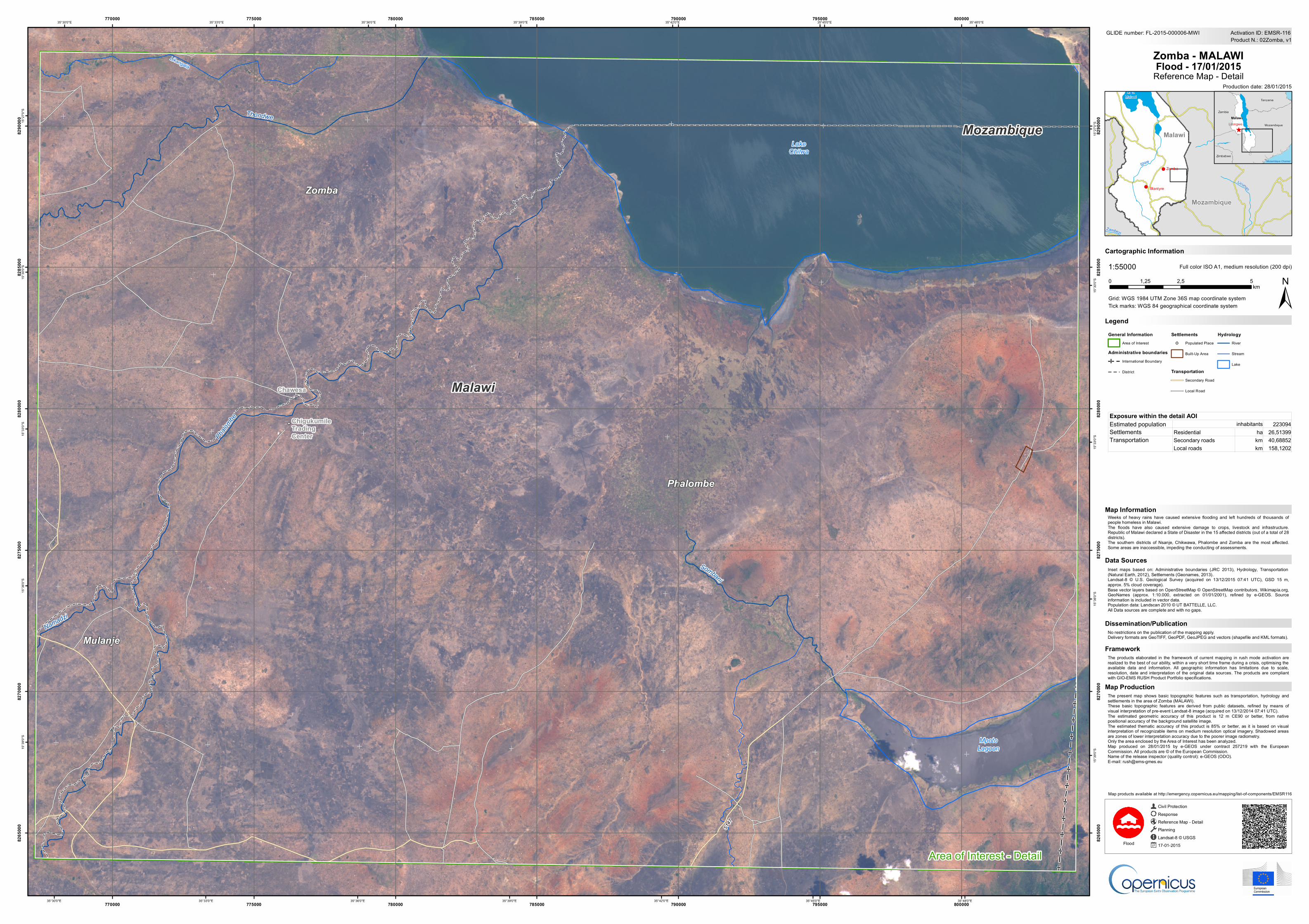
The present map shows basic topographic features such as transportation, hydrology andsettlements in the area of Zomba (MALAWI).These basic topographic features are derived from public datasets, refined by means ofvisual interpretation of pre-event Landsat-8 image (acquired on 13/12/2014 07:41 UTC).The estimated geometric accuracy of this product is 12 m CE90 or better, from nativepositional accuracy of the background satellite image.The estimated thematic accuracy of this product is 85% or better, as it is based on visualinterpretation of recognizable items on medium resolution optical imagery. Shadowed areasare zones of lower interpretation accuracy due to the poorer image radiometry.Only the area enclosed by the Area of Interest has been analyzed.Map produced on 28/01/2015 by e-GEOS under contract 257219 with the EuropeanCommission. All products are © of the European Commission.Name of the release inspector (quality control): e-GEOS (ODO).E-mail: [email protected]

!

!

K

LakeChilwa

MpotoLagoon

Likangala

Namadzi

Sombani

Thondwe

Phalo

mbe

S147

ChigukumileTradingCenter

Chawesa

Zomba

Mulanje

Phalombe

35°48'0"E

35°48'0"E

35°45'0"E

35°45'0"E

35°42'0"E

35°42'0"E

35°39'0"E

35°39'0"E

35°36'0"E

35°36'0"E

35°33'0"E

35°33'0"E

35°30'0"E

35°30'0"E15

°27'0

"S

15°2

7'0"S

15°3

0'0"S

15°3

0'0"S

15°3

3'0"S

15°3

3'0"S

15°3

6'0"S

15°3

6'0"S

15°3

9'0"S

15°3

9'0"S

770000

770000

775000

775000

780000

780000

785000

785000

790000

790000

795000

795000

800000

800000

8265

000

8265

000

8270

000

8270

000

8275

000

8275

000

8280

000

8280

000

8285

000

8285

000

8290

000

8290

000

GLIDE number: FL-2015-000006-MWI

!(

!( Zomba

Blantyre

Malawi

Mozambique

Shire

Zambezi

L igonha

Licungo

LakeMalawi

^

Zambia

Zimbabwe

Mozambique

Tanzania

MalawiLilongwe

Production date: 28/01/2015

Cartographic Information

1:55000

±Grid: WGS 1984 UTM Zone 36S map coordinate system

Full color ISO A1, medium resolution (200 dpi)

The products elaborated in the framework of current mapping in rush mode activation arerealized to the best of our ability, within a very short time frame during a crisis, optimising theavailable data and information. All geographic information has limitations due to scale,resolution, date and interpretation of the original data sources. The products are compliantwith GIO-EMS RUSH Product Portfolio specifications.

Weeks of heavy rains have caused extensive flooding and left hundreds of thousands ofpeople homeless in Malawi.The floods have also caused extensive damage to crops, livestock and infrastructure.Republic of Malawi declared a State of Disaster in the 15 affected districts (out of a total of 28districts).The southern districts of Nsanje, Chikwawa, Phalombe and Zomba are the most affected.Some areas are inaccessible, impeding the conducting of assessments.

No restrictions on the publication of the mapping apply.Delivery formats are GeoTIFF, GeoPDF, GeoJPEG and vectors (shapefile and KML formats).

LegendTick marks: WGS 84 geographical coordinate system

Product N.: 02Zomba, v1Activation ID: EMSR-116

Inset maps based on: Administrative boundaries (JRC 2013), Hydrology, Transportation(Natural Earth, 2012), Settlements (Geonames, 2013).Landsat-8 © U.S. Geological Survey (acquired on 13/12/2015 07:41 UTC), GSD 15 m,approx. 5% cloud coverage).Base vector layers based on OpenStreetMap © OpenStreetMap contributors, Wikimapia.org,GeoNames (approx. 1:10.000, extracted on 01/01/2001), refined by e-GEOS. Sourceinformation is included in vector data.Population data: Landscan 2010 © UT BATTELLE, LLC.All Data sources are complete and with no gaps.

Civil ProtectionResponseReference Map - DetailPlanningLandsat-8 © USGS17-01-2015Flood

0 2,5 51,25km

Zomba - MALAWIFlood - 17/01/2015

Reference Map - Detail

Data Sources

Map Information

Dissemination/Publication

Framework

Map Production

Map products available at http://emergency.copernicus.eu/mapping/list-of-components/EMSR116

Area of Interest - Detail

Malawi

MozambiqueMozambique Channel

Estimated population 223094Settlements Residential ha 26,51399

Secondary roads km 40,68852Local roads km 158,1202

inhabitants

Transportation

Exposure within the detail AOI