Embed Size (px)
Citation preview

XW
XW
[\59
[\59
[\3
³²1
City of Winnipeg
St. Malo
Riel
Joubert Creek
Rose
au River
United States of America
Red
River
WHITEMOUTHLAKE
Canada
ManningCanal
Assiniboine River Cooks Creek
Seine Riv er
Rat River
[\9
[\15
[\4
[\27
[\75
[\52
[\11
[\44
[\59
[\89
[\67
[\14
[\26
[\12
[\30
[\32
[\11
[\44
[\12
[\12[\26
[\11
[\2UV100
UV101
M602F
R50M
R49R
WhiteshellProvincial
Park
Birds HillProvincial
Park
WhiteshellProvincial
Park
BeaudryProvincial
Park
³²1
Dorsey
Altona
Anola
Arbakka
Arnaud
Aubigny
Badger
Barkfield
Beausejour
Brunkild
Caliento
Carey
CarlowrieCarrick
Cloverleaf
DeaconsCorner
Domain
Dufresne
Dufrost
Dugald
EastBraintree
Elma
Emerson
Fredensthal
Gardenton
Giroux
Glass
Glenlea
GrandePointe
Greenland
GreenRidge
Gretna
Grosse Isle
Hadashville
Hazelridge
Headingley
Horndean
Ile desChênes
KleefeldLa Broquerie
La CouléeLa Salle
Letellier
Linden
Lorette
LoweFarm
Marchand
McMunn
Molson
Morris
NewBothwell
Niverville
Oakbank
Oak Bluff
Osborne
Piney
PrairieGrove
Prawda
Randolph
Rennie
Richer
Ridgeville
Roseau River
Ross
Rosser
St.Adolphe
Ste. Agathe
Ste.Elizabeth
Ste-Geneviève
Ste. Rita
St. Joseph
St.Labre
St-Pierre-Jolys
Sandilands
Sanford
Sarto
SeddonsCorner
SouthJunction Sprague
Starbuck
Steinbach
StonyMountain
StuartburnSundown
Tolstoi
VassarVita
Vivian
Whitemouth
Woodridge
Roseau RiverAnishinabeFirst Nation
Ste.Anne
Ginew
Stonewall Selkirk
Zhoda
0 5 10 Kilometres
0 105 Miles 1:500,000
±Coordinate System: UTM Zone 14N NAD83Data Source: MBHydro, ProvMB, NRCANDate Created: August 10, 2015
Manitoba-MinnesotaTransmission Project
G:\_G
IS_P
rojec
t_Fold
er\00
_Hyd
ro\11
1420
050_
MMTP
_EA\
Figur
es\EA
Chap
ter\W
ildlife
AndH
abita
t\9-01
-MMT
P_EA
_Wild
lifeHa
bitat_
500K
_B_2
0150
520.m
xd
Project Infrastructure
XW Converter Station (Existing)
Final Preferred Route (FPR)
Wildlife Habitat in the Eastern Project Region
Infrastructure! ! ! Existing 500kV Transmission Line! ! ! Existing 230kV Transmission Line
Forest Resource Inventory1
Non-Forested -Fields/Agriculture
Abandoned LandCroplandHaylandLand ClearingPasture
Non-Forested - MeadowDry Upland RidgePrairieMoist PairieWet Meadow
Non-Forested - UnclassifiedBeaver Floods/GravelPit/Mine/Dump/Town
Non-Forested, Marsh-MuskegMarshString BogMuskegWater
Non-Productive ForestProtection ForestTreed MuskegWillow/Alder
Productive ForestHardwoodMixedwood - NMixedwood - MSoftwood
Source:1. Forest Resource Inventory, 1979-1999, Manitoba Conservation and WaterStewardship
Landbase! Community
RailwayTrans CanadaProvincial HighwayProvincial Road
First Nation LandsEcological ReserveWildlife Management AreaProvincial ParkCity
³²1
[\12
UV301
Map 9-1

!!
!!
!
!!
!!!!!!!
!
!
!
!
!
!
!
!
!
!
!
!
!
!
!
!
!
!
!
!
!
!
!
!
!
!
!
!
!
!
!
!
!
!
!
!
!
!
!
!
!
!!
!!
!
!
!
!!!
!!
!!
!!
!
!
!!
!!
!!
!!
!!
!!
!!
!!
!!
!!
!
!!
!!
!!
!
!!
!!
!!!!
!!
!
!!!!!!!!!
!!
!!
!!
!!
!!
!!
!!
!
!
!!
!
!
!
!
!
!
!
!
!
!
!
!
!
!
!
!
!
!
!
!
!
!
!
!
!
!
!
!
!
!
!
!
!
!
!
!
!
!
!
!!!!
!
!
!
! !!"3E
!
!
Assiniboine River
Sewell Lake
NobleLake
BoneLake
Black Creek
Cypre
s sRiv
er
G37C - GLENBORO TO CORNWALLIS
CANADIAN PACIFIC RAILWAY (CPR)
CANADIAN NATIONAL (CN) RAILWAY
Swan LakeFirst
Nation
[\18
[\34
Glenboro South Station
G82R
- GLE
NBOR
O TO
RUG
BY
S53G - ST LEON TO GLENBORO
NORTHCYPRESS
NORTHNORFOLK
BRANDO N
CORNWALLIS
SOUTHCYPRESS VICTORIA
OAKLAND
WAWANESA
GLENBORO
RIVERSIDE STRATHCONALORNE
ARGYLE
SOURIS RIVERBEND W ILDLIFEMANAGEMENT AREA
WHITEMUDWATERSHED
WILDLIFEMANAGEMENT AREA
SPRUCE WOODSWILDLIFE
MANAGEMENT AREA
ASSINIBOINECORRIDORWILDLIFE
MANAGEMENT AREA
TIGER HILLSWILDLIFE
MANAGEMENTAREA
PEMBINA VALLEYWILDLIFE
MANAGEMENT AREA
UV675
UV605
UV344
UV530
UV532
UV453
UV245
UV340
UV352
UV342
Swan LakeFirst
Nation
[\18 [\5
[\34
[\2
[\23
Criddle/VaneHomestead
Provincial Park
Spruce WoodsProvincial
Park
Glenboro
Wawanesa
0 5 Kilometres
0 52.5 Miles 1:200,000
±Coordinate System: UTM Zone 14N NAD83Data Source: MBHydro, ProvMB, NRCANDate Created: August 10, 2015
Manitoba-MinnesotaTransmission Project
G:\_G
IS_P
rojec
t_Fold
er\00
_Hyd
ro\11
1420
050_
MMTP
_EA\
Figur
es\EA
Chap
ter\W
ildlife
AndH
abita
t\9-02
-MMT
P_EA
_Wild
lifeHa
bitat_
Glen
boro
_200
K_B_
2015
0622
.mxd
Project Infrastructure"3E Electrical Station
Wildlife Habitat in the Western Project Region
Glenboro
Infrastructure! ! Existing Transmission Line
Forest Resource InventoryNon-Forested -Fields/Agriculture
Abandoned LandCroplandHaylandLand ClearingPasture
Non-Forested - MeadowDry Upland RidgePrairieMoist PairieWet Meadow
Non-Forested - UnclassifiedBeaver Flood/GravelPits/Mine/Dump/Town
Non-Forested, Marsh-MuskegMarshMuskegWater
Non-Productive ForestProtection ForestTreed MuskegWillow/Alder
Productive ForestHardwoodMixedwood - NMixedwood - MSoftwood
Landbase! Community
Provincial HighwayProvincial RoadRailwayFirst Nation LandsWildlife Management AreaProvincial ParkRural Municipality
[\12
UV301
Source:1. Forest Resource Inventory, 1979-1999, Manitoba Conservation and WaterStewardship
Map 9-2
XW
XW
[\59
[\59
[\3
³²1
City of Winnipeg
St. Malo
Riel
Joubert Creek
Rosea
u River
United States of America
Red
River
WHITEMOUTHLAKE
Canada
ManningCanal
Assiniboine River Cooks Creek
Seine River
Rat River
[\9
[\15
[\4
[\27
[\75
[\52
[\11
[\44
[\59
[\89
[\67
[\14
[\26
[\12
[\30
[\32
[\11
[\44
[\12
[\12[\26 UV101
UV100
[\11
[\2
M602F
R49R
R50M
WhiteshellProvincial
Park
Birds HillProvincial
Park
WhiteshellProvincial
Park
BeaudryProvincial
Park
³²1
Dorsey
Altona
Anola
Arbakka
Arnaud
Aubigny
Badger
Barkfield
Beausejour
Brunkild
Caliento
Carey
CarlowrieCarrick
Cloverleaf
DeaconsCorner
Domain
Dufresne
Dufrost
Dugald
EastBraintree
Elma
Emerson
Fredensthal
Gardenton
Giroux
Glass
Glenlea
GrandePointe
Greenland
GreenRidge
Gretna
Grosse Isle
Hadashville
Hazelridge
Headingley
Horndean
Ile desChênes
KleefeldLa Broquerie
La CouléeLa Salle
Letellier
Linden
Lorette
LoweFarm
Marchand
McMunn
Molson
Morris
NewBothwell
Niverville
Oakbank
Oak Bluff
Osborne
Piney
PrairieGrove
Prawda
Randolph
Rennie
Richer
Ridgeville
Roseau River
Ross
Rosser
St.Adolphe
Ste. Agathe
Ste.Elizabeth
Ste-Geneviève
Ste. Rita
St. Joseph
St.Labre
St-Pierre-Jolys
Sandilands
Sanford
Sarto
SeddonsCorner
SouthJunction Sprague
Starbuck
Steinbach
StonyMountain
StuartburnSundown
Tolstoi
VassarVita
Vivian
Whitemouth
Woodridge
Roseau RiverAnishinabeFirst Nation
Ste.Anne
Ginew
Stonewall Selkirk
ZhodaPansy CP
Gardenton CP
0 5 10 Kilometres
0 105 Miles 1:500,000
±Coordinate System: UTM Zone 14N NAD83Data Source: MBHydro, ProvMB, NRCANDate Created: August 14, 2015
Manitoba-MinnesotaTransmission Project
G:\_G
IS_P
rojec
t_Fold
er\00
_Hyd
ro\11
1420
050_
MMTP
_EA\
Figure
s\EAC
hapte
r\Wild
lifeAn
dHab
itat\9
-03-M
MTP_
EA_P
rotec
tedLa
nds_
Index
_500
K_B_
2015
0622
.mxd
Project Infrastructure
XW Converter Station (Existing)
Final Preferred Route (FPR)
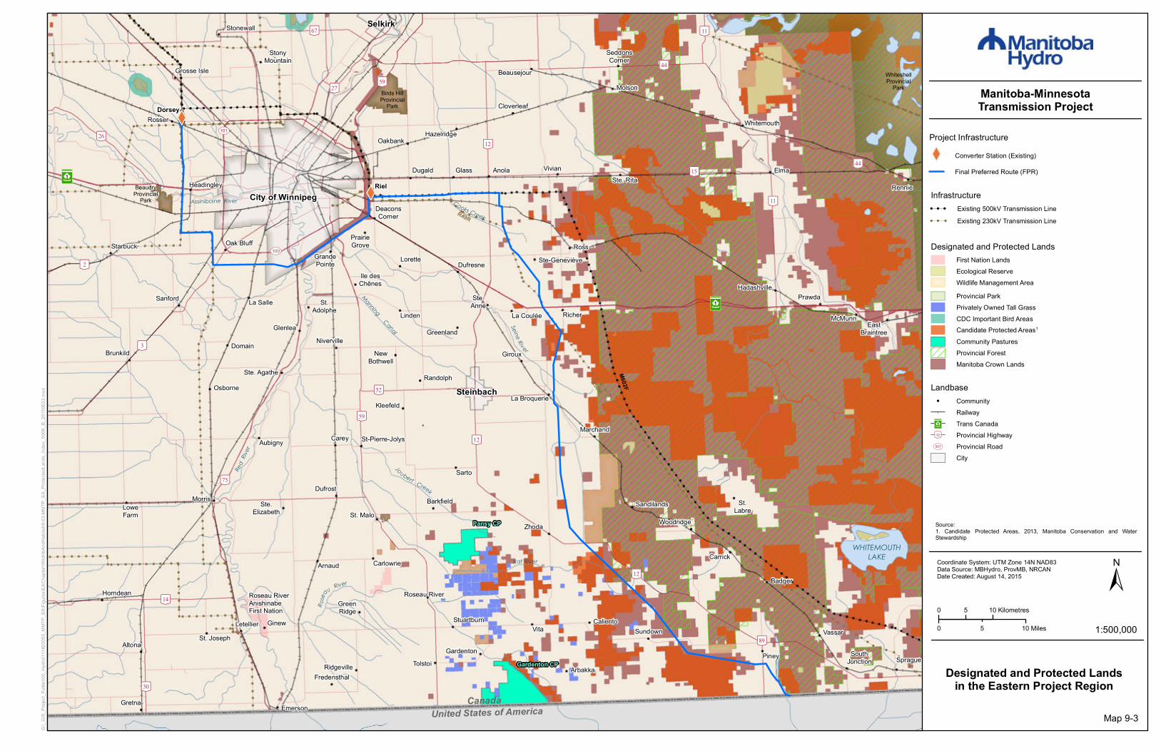
Designated and Protected Landsin the Eastern Project Region
Infrastructure! ! ! Existing 500kV Transmission Line! ! ! Existing 230kV Transmission Line
Designated and Protected LandsFirst Nation LandsEcological ReserveWildlife Management AreaProvincial ParkPrivately Owned Tall GrassCDC Important Bird AreasCandidate Protected Areas1
Community PasturesProvincial ForestManitoba Crown Lands
Source:1. Candidate Protected Areas, 2013, Manitoba Conservation and WaterStewardship
Landbase! Community
RailwayTrans CanadaProvincial HighwayProvincial RoadCity
³²1
[\12
UV301
Map 9-3

!!
!!
!
!!
!!!!!!!
!
!
!
!
!
!
!
!
!
!
!
!
!
!
!
!
!
!
!
!
!
!
!
!
!
!
!
!
!
!
!
!
!
!
!
!
!
!
!
!
!
!!
!!
!
!
!
!!!
!!
!!
!!
!
!
!!
!!
!!
!!
!!
!!
!!
!!
!!
!!
!
!!
!!
!!
!
!!
!!
!!!!
!!
!
!!!!!!!!!
!!
!!
!!
!!
!!
!!
!!
!
!
!!
!
!
!
!
!
!
!
!
!
!
!
!
!
!
!
!
!
!
!
!
!
!
!
!
!
!
!
!
!
!
!
!
!
!
!
!
!
!
!
!!!!
!
!
!
! !!"3E
!
!
Assiniboine River
Sewell Lake
NobleLake
BoneLake
Black Creek
Cypre
s sRiv
er
G37C - GLENBORO TO CORNWALLIS
CANADIAN PACIFIC RAILWAY (CPR)
CANADIAN NATIONAL (CN) RAILWAY
Swan LakeFirst
Nation
[\18
[\34
Glenboro South Station
G82R
- GLE
NBOR
O TO
RUG
BY
S53G - ST LEON TO GLENBORO
NORTHCYPRESS
NORTHNORFOLK
BRANDON
CORNWALLIS
SOUTHCYPRESS VICTORIA
OAKLAND
WAWANESA
GLENBORO
RIVERSIDE STRATHCONALORNE
ARGYLE
SOURIS RIVERBEND WILDLIFEMANAGEMENT AREA
WHITEMUDWATERSHED
WILDLIFEMANAGEMENT AREA
SPRUCE WOODSWILDLIFE
MANAGEMENT AREA
ASSINIBOINECORRIDORWILDLIFE
MANAGEMENT AREA
TIGER HILLSWILDLIFE
MANAGEMENTAREA
PEMBINA VALLEYWILDLIFE
MANAGEMENT AREA
UV675
UV605
UV344
UV530
UV532
UV453
UV245
UV340
UV352
UV342
Swan LakeFirst
Nation
[\18 [\5
[\34
[\2
[\23
Criddle/VaneHomestead
Provincial ParkSpruce Woods
ProvincialPark
Glenboro
Wawanesa
0 5 Kilometres
0 52.5 Miles 1:200,000
±Coordinate System: UTM Zone 14N NAD83Data Source: MBHydro, ProvMB, NRCANDate Created: August 14, 2015
Manitoba-MinnesotaTransmission Project
G:\_G
IS_P
rojec
t_Fold
er\00
_Hyd
ro\11
1420
050_
MMTP
_EA\
Figure
s\EAC
hapte
r\Wild
lifeAn
dHab
itat\9
-04-M
MTP_
EA_P
rotec
tedLa
nds_
Glen
boro_
200K
_B_2
0150
622.m
xd
Project Infrastructure"3E Electrical Station
Designated and Protected Landsin the Western Project Region
Infrastructure! ! Existing Transmission Line
Landbase! Community
Provincial HighwayProvincial RoadRailwayCDC Important Bird AreasFirst Nation LandsManitoba Crown LandsProvincial ParkCandidate Protected Areas1
Provincial Forest
Rural MunicipalityWildlife Management Area
[\12
UV301
Source:1. Candidate Protected Areas, 2013, Manitoba Conservation and WaterStewardship
Map 9-4
! ! ! ! ! ! ! ! ! !!! ! ! ! ! ! ! ! ! !!XW
!
!
!
!
!
!
!
!
!
!
!
!
!
!
!
!
!
!
!
!
!
!
!
!
!
!
!
!
!
!
!
!
!
!
!
!
!
!
!
!
!
[\59
[\59
[\3
³²1 City of Winnipeg Riel
Joubert Creek
R osea
u River
United States of AmericaRe
dRiv
e r
WHITEMOUTHLAKE
CanadaManning Canal
Cooks Creek
Seine Ri v er
Rat River
Steinbach
Brandon
Selkirk
Portage La Prairie
[\5
[\9
[\15
[\18
[\4
[\27
[\75
[\19
[\52
[\25
[\8
[\11
[\44
[\3
[\59
[\89
[\50
[\7
[\67
[\14
[\26
[\12
[\22
[\30
[\17
[\32[\31
[\34
[\23
[\2
[\13[\11
[\44
[\12
[\12[\26 UV101
UV100[\2
LakeWinnipeg
Assiniboine River
M602F
WhiteshellProvincial
Park
Birds HillProvincial
Park
NopimingProvincial Park
BeaudryProvincial
Park
Spruce WoodsProvincial Park
³²1
Dorsey
Altona
Arborg
Beausejour
Boissevain
Carberry
Carman
Cartwright
CrystalCity
Dunnottar
Emerson
Erickson
Gimli
Gladstone
Glenboro
Gretna
Killarney
Lac duBonnet
MacGregor
Manitou
McCreary
Minnedosa
Morden
Morris
Neepawa
NivervilleNotre Damede Lourdes
PilotMound
Piney
PlumCoulee
Powerview
Rapid City
Rivers
St. Claude
St-Pierre-JolysSomerset
Stonewall
Teulon
Treherne
Vivian
Wawanesa
Winkler
WinnipegBeach
Ste. Anne
0 10 20 Kilometres
0 10 205 Miles 1:1,000,000
±Coordinate System: UTM Zone 14N NAD83Data Source: MBHydro, ProvMB, NRCANDate Created: August 11, 2015
Manitoba-MinnesotaTransmission Project
G:\_G
IS_P
rojec
t_Fold
er\00
_Hyd
ro\11
1420
050_
MMTP
_EA\
Figur
es\EA
Chap
ter\W
ildlife
AndH
abita
t\9-05
-MMT
P_EA
_Wild
lifeHa
bitatA
sses
smen
tArea
s_60
0k_B
_201
5061
8.mxd
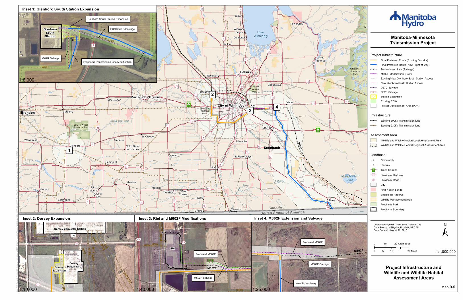
Project InfrastructureFinal Preferred Route (Existing Corridor)Final Preferred Route (New Right-of-way)
! ! ! Transmission Line (Salvage)! ! ! M602F Modification (New)
Existing/New Glenboro South Station AccessNew Glenboro South Station Access
! ! ! G37C Salvage! ! ! G82R Salvage
Station ExpansionExisting ROWProject Development Area (PDA)
Project Infrastructure andWildlife and Wildlife Habitat
Assessment Areas
Infrastructure! ! ! Existing 500kV Transmission Line! ! Existing 230kV Transmission Line
Proposed Transmission Line ModificationG82R Salvage
GlenboroSouth
Station
Glenboro South Station Expansion
G37C/S53G Salvage
[\5
G82R
S53GG37C
!!
!!
!!
!!
!!
!!
!!
!!
!!
!!
!!
!!
!!
!!
!!
!!
!!
!!
!!
!!
!
! ! ! ! ! ! ! ! ! ! ! ! ! ! ! ! ! ! ! ! ! ! ! ! ! ! ! ! ! ! !
! ! ! ! ! ! ! ! ! ! ! ! ! ! ! ! ! ! ! ! ! ! ! ! ! ! ! ! ! ! !
!!
!
!!
!!
!!
!!
!!
!!
!!
!
!!
!!
!!
!!
!!
!!
!!!
!!
!!
!!
!!
!!
!!
!!
!!
!!
!!
!!
!!
!
!!
!!
!!
!
!
!
!
!
!
!
!
!
!
!
!!
!!
!!
!!
!!
!!
!!
!!
!!
!!
!!
!!
!!
!!
!!
!!
!!
!!
!!
!
!!
!!
!!
!
!!
!!
!!
!!
!
!!
!!
!
!
!!
!!
!!
!
!!
!!
!!
!
!
!!
!!
!!
!
!!
!!!!!
!!
!!
!!
!!
!!
!!
!!
!!
!!
!!
!!
!!
!!
!!
!!
!!!!!
!!
!!
!!
!!
!!
!!
!!
!!
!!
!!
!!
!!
!!
!!
!!
!!
!
!
!
!
!
!
!!
!!
!!
!!
!
!
!
!
!
!
!
!
!
!
!
!
!
!
!!
!!
!
!
!
!
!
!
!!
!!
!!
!!
!
!
!
!
!
!
!
!
!
!
!
!
!
!
!!
!!
!!
!!
!!
!!
!!!
!!
!!
!!
!!
!!
!!
!!
!!
!!
!!
!!
!!
!
!!
!!
!!
!!
!!
!!
!!
!!
!!
!!
!!
!!
!!
!!
!!
!
!
!
!
!
!
!
!
!
!
!!
!!
!!
!!
!
Dorsey Converter Station
DorseyExpansion
DorseySwitch Yard
Rosser
D54C
A4D
D5RD13R
D72V
D36R
D16R
D14SD11Y
D15Y
D55Y
D12PUV221
UV236
!!!
!!
!!
!!
!!
!!
!!
!!
!!
!!
!!
!!
!!
!!
!!
!!
!!
!!!
!!
!!
!!
!!
!!
!!
!!
!!
!!
!!
!!
!!
!!
!!
!!
!!
!!!!!!!!!!!!!!!!!!
!!!!!!!!!!!!!!!!!!
!!
!!
!!
!!
!!
!!
!!
!!
!!
!!
!!
!!
!!
!!
!!
!!
!
!!
!!!!!!!!!!!!!!!!
!!
!!
!!
!!
!!
!!
!!
!!
!!
!!
!!
!!
!!
!!
!!
!!
!
!!
!
!
!!
!!
!!
!!
!!
!
! ! ! ! ! ! ! ! ! ! ! ! ! ! ! ! ! ! ! ! ! ! ! !
!!
!!
!!
!
! ! ! ! ! ! ! ! ! ! ! ! ! ! ! ! !
!
!!
!!
!!
!
! ! ! ! ! ! ! ! ! ! ! ! ! !!
!!
! ! ! ! ! ! ! ! ! ! ! ! ! ! ! ! ! ! ! ! ! ! ! ! ! ! ! ! ! ! ! ! ! ! ! ! ! ! ! ! ! !!!
!!
!! ! ! ! ! ! ! ! ! ! ! ! ! ! ! ! ! ! ! ! ! ! ! ! ! ! ! ! ! ! ! ! ! ! ! ! ! ! ! ! ! !
!!
!!
!
Riel
M602F
BPIII
M602F Salvage
Proposed M602F
UV101
Deacons Corner
UV101
R49R
M86VM87V
M33R
D72V
M32R
UV207
! ! ! ! ! ! ! ! ! ! ! ! ! ! ! ! ! ! ! ! ! ! ! ! ! ! ! ! ! ! ! ! ! ! ! ! ! ! ! ! ! ! ! ! ! ! ! ! ! ! ! ! ! ! ! ! ! ! ! ! ! ! ! ! ! ! ! ! ! ! ! ! ! ! ! ! ! ! ! ! ! ! ! ! ! ! ! ! ! ! ! ! ! ! ! !
! ! ! ! ! ! ! ! ! ! ! ! ! ! ! ! ! ! ! ! ! ! ! ! ! ! ! ! ! ! ! ! ! ! ! ! ! ! ! ! ! ! ! ! ! ! ! ! ! ! ! ! ! ! ! !! !
! ! !
! ! ! ! ! ! ! ! ! ! ! ! ! ! ! ! ! !
M602F
M602F Salvage
Proposed M602F
New Right-of-way
Inset 2: Dorsey Expansion Inset 3: Riel and M602F Modifications Inset 4: M602F Extension and Salvage
Inset 1: Glenboro South Station Expansion
1:8,000
1:10,000 1:40,000 1:25,000
1
2
3 4
Assessment AreaWildlife and Wildlife Habitat Local Assessment AreaWildlife and Wildlife Habitat Regional Assessment Area
Landbase! Community
RailwayTrans CanadaProvincial HighwayProvincial RoadCityFirst Nation LandsEcological ReserveWildlife Management AreaProvincial ParkProvincial Boundary
³²1
[\12
UV301
Map 9-5
#*#*
#*
#*
#*#*#*#*
#*#*
#*#*
#*#*
#*#*
#*#*
#*#*
#*#*
#*#*
#*#*
#*#*
#*
#*#*#*
#*#*
#*
#*#*
#*
#*
#*#*
#*#*
#*
#*
#*#*#*
#*
#*
#*
#*
#*
#*
#*#*
#*
#*
#*
#*
XW
XW
[\59
[\59
[\3
³²1
City of Winnipeg
St. Malo
Riel
Joubert Creek
Rose
au River
United States of America
Red
River
WHITEMOUTHLAKE
Canada
ManningCanal
Assiniboine River Cooks Creek
Seine Riv er
Rat River
[\9
[\15
[\4
[\27
[\75
[\52
[\11
[\44
[\59
[\89
[\67
[\14
[\26
[\12
[\30
[\32
[\11
[\44
[\12
[\12[\26
[\11
[\2UV100
UV101
M602F
R50M
R49R
WhiteshellProvincial
Park
Birds HillProvincial
Park
WhiteshellProvincial
Park
BeaudryProvincial
Park
³²1
Dorsey
Altona
Anola
Arbakka
Arnaud
Aubigny
Badger
Barkfield
Beausejour
Brunkild
Caliento
Carey
CarlowrieCarrick
Cloverleaf
DeaconsCorner
Domain
Dufresne
Dufrost
Dugald
EastBraintree
Elma
Emerson
Fredensthal
Gardenton
Giroux
Glass
Glenlea
GrandePointe
Greenland
GreenRidge
Gretna
Grosse Isle
Hadashville
Hazelridge
Headingley
Horndean
Ile desChênes
KleefeldLa Broquerie
La CouléeLa Salle
Letellier
Linden
Lorette
LoweFarm
Marchand
McMunn
Molson
Morris
NewBothwell
Niverville
Oakbank
Oak Bluff
Osborne
Piney
PrairieGrove
Prawda
Randolph
Rennie
Richer
Ridgeville
Roseau River
Ross
Rosser
St.Adolphe
Ste. Agathe
Ste.Elizabeth
Ste-Geneviève
Ste. Rita
St. Joseph
St.Labre
St-Pierre-Jolys
Sandilands
Sanford
Sarto
SeddonsCorner
SouthJunction Sprague
Starbuck
Steinbach
StonyMountain
StuartburnSundown
Tolstoi
VassarVita
Vivian
Whitemouth
Woodridge
Roseau RiverAnishinabeFirst Nation
Ste.Anne
Ginew
Stonewall Selkirk
Zhoda
0 5 10 Kilometres
0 105 Miles 1:500,000
±Coordinate System: UTM Zone 14N NAD83Data Source: MBHydro, ProvMB, NRCANDate Created: August 10, 2015
Manitoba-MinnesotaTransmission Project
G:\_G
IS_P
rojec
t_Fold
er\00
_Hyd
ro\11
1420
050_
MMTP
_EA\
Figur
es\EA
Chap
ter\W
ildlife
AndH
abita
t\9-06
-MMT
P_EA
_Mam
malC
amer
aTra
pLoc
ation
s_50
0K_B
_201
5062
2.mxd
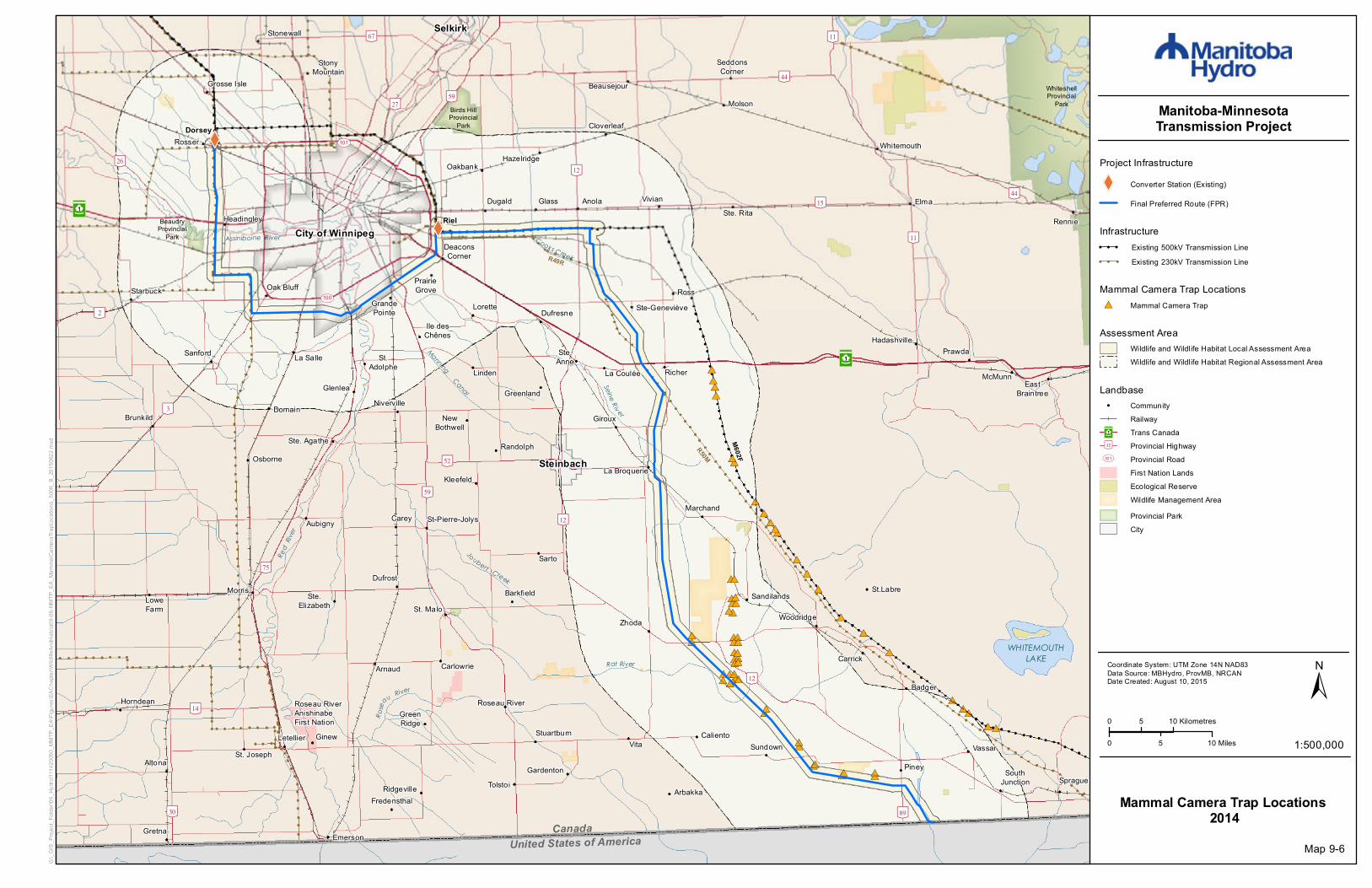
Project Infrastructure
XW Converter Station (Existing)
Final Preferred Route (FPR)
Mammal Camera Trap Locations 2014
Infrastructure! ! ! Existing 500kV Transmission Line! ! ! Existing 230kV Transmission Line
Assessment AreaWildlife and Wildlife Habitat Local Assessment AreaWildlife and Wildlife Habitat Regional Assessment Area
Map 9-6
Mammal Camera Trap Locations#* Mammal Camera Trap
Landbase! Community
RailwayTrans CanadaProvincial HighwayProvincial RoadFirst Nation LandsEcological ReserveWildlife Management AreaProvincial ParkCity
³²1
[\12
UV301
!(!(!(!(!(!(
!(!(!(
!(!(!(
!(!(!(!(!(!(
!(!(!(
!(!(!(
!(!(!(
!(!(!(
!(!(!( !(!(!( !(!(!(
!(!(!(
!(!(!(
!(!(!(!(!(!(!(!(
!(!(!(!(!(!(
!(
!(!(!(
!(!(!(
!(!(!(!(!(!(
!(!(!(!(!(!(!(!(!(
!(!(!(
!(!(!( !(!(!(
!(!(!(!(!(!(!(!(!(!(!(!(
!(!(!(!(!(!(!(!(!(!(!(!(
!(!(!( !(!(!(
!(!(!(!(!(!(!(!(!(!(!(!(
!(!(!(
!( !(!(
!(
!(
!(!(
!(!(
!(!(!(
!(!( !(
!(
!(!(
!(
!(
!(
!(!(
!(
!(
XW
XW
[\59
[\59
[\3
³²1
City of Winnipeg
St. Malo
Riel
Joubert Creek
Rose
au River
United States of America
Red
River
WHITEMOUTHLAKE
Canada
ManningCanal
Assiniboine River Cooks Creek
Seine Riv er
Rat River
[\9
[\15
[\4
[\27
[\75
[\52
[\11
[\44
[\59
[\89
[\67
[\14
[\26
[\12
[\30
[\32
[\11
[\44
[\12
[\12[\26
[\11
[\2UV100
UV101
M602F
R50M
R49R
WhiteshellProvincial
Park
Birds HillProvincial
Park
WhiteshellProvincial
Park
BeaudryProvincial
Park
³²1
Dorsey
Altona
Anola
Arbakka
Arnaud
Aubigny
Badger
Barkfield
Beausejour
Brunkild
Caliento
Carey
CarlowrieCarrick
Cloverleaf
DeaconsCorner
Domain
Dufresne
Dufrost
Dugald
EastBraintree
Elma
Emerson
Fredensthal
Gardenton
Giroux
Glass
Glenlea
GrandePointe
Greenland
GreenRidge
Gretna
Grosse Isle
Hadashville
Hazelridge
Headingley
Horndean
Ile desChênes
KleefeldLa Broquerie
La CouléeLa Salle
Letellier
Linden
Lorette
LoweFarm
Marchand
McMunn
Molson
Morris
NewBothwell
Niverville
Oakbank
Oak Bluff
Osborne
Piney
PrairieGrove
Prawda
Randolph
Rennie
Richer
Ridgeville
Roseau River
Ross
Rosser
St.Adolphe
Ste. Agathe
Ste.Elizabeth
Ste-Geneviève
Ste. Rita
St. Joseph
St.Labre
St-Pierre-Jolys
Sandilands
Sanford
Sarto
SeddonsCorner
SouthJunction Sprague
Starbuck
Steinbach
StonyMountain
StuartburnSundown
Tolstoi
VassarVita
Vivian
Whitemouth
Woodridge
Roseau RiverAnishinabeFirst Nation
Ste.Anne
Ginew
Stonewall Selkirk
Zhoda
0 5 10 Kilometres
0 105 Miles 1:500,000
±Coordinate System: UTM Zone 14N NAD83Data Source: MBHydro, ProvMB, NRCANDate Created: August 10, 2015
Manitoba-MinnesotaTransmission Project
G:\_G
IS_P
rojec
t_Fold
er\00
_Hyd
ro\11
1420
050_
MMTP
_EA\
Figur
es\EA
Chap
ter\W
ildlife
AndH
abita
t\9-07
-MMT
P_EA
_ElkB
reedin
gSurv
ey_5
00K_
B_20
1506
22.m
xd
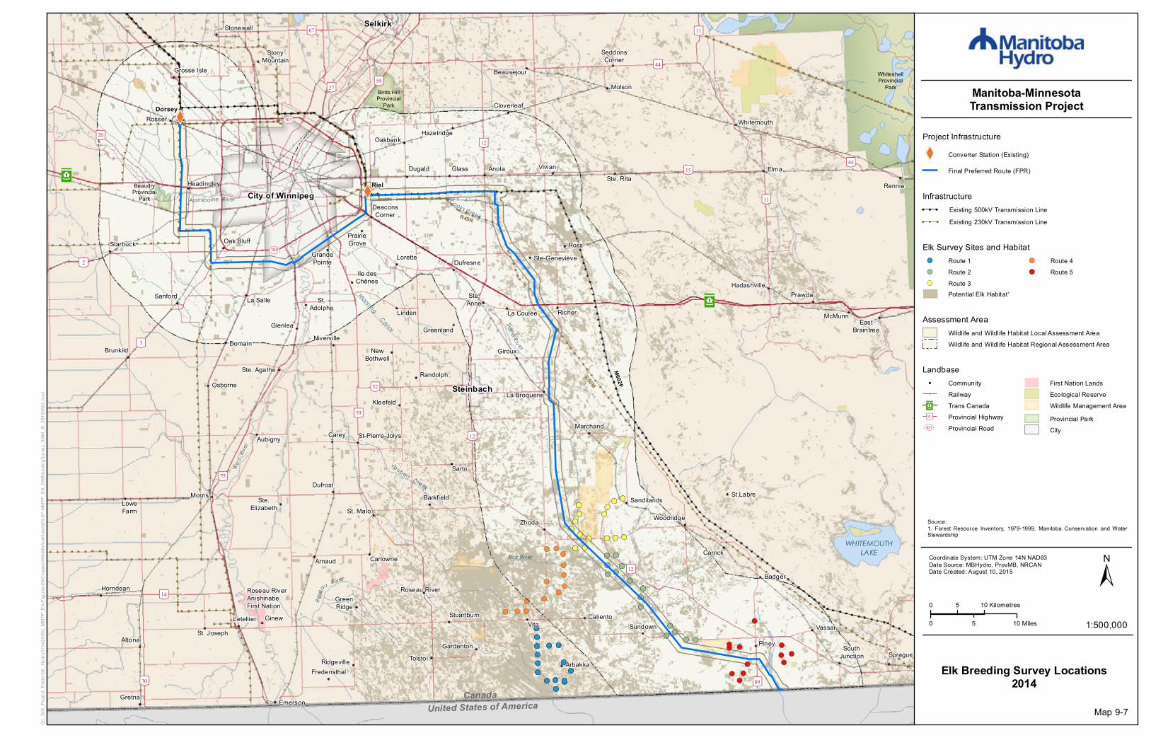
Project Infrastructure
XW Converter Station (Existing)
Final Preferred Route (FPR)
Elk Breeding Survey Locations2014
Infrastructure! ! ! Existing 500kV Transmission Line! ! ! Existing 230kV Transmission Line
Map 9-7
Source:1. Forest Resource Inventory, 1979-1999, Manitoba Conservation and WaterStewardship
Assessment AreaWildlife and Wildlife Habitat Local Assessment AreaWildlife and Wildlife Habitat Regional Assessment Area
Elk Survey Sites and Habitat!( Route 1!( Route 2!( Route 3
!( Route 4!( Route 5
Potential Elk Habitat1
Landbase! Community
RailwayTrans CanadaProvincial HighwayProvincial Road
First Nation LandsEcological ReserveWildlife Management AreaProvincial ParkCity
³²1
[\12
UV301

XW
XW
[\59
[\59
[\3
³²1
City of Winnipeg
St. Malo
Riel
Joubert Creek
Rose
au River
United States of America
Red
River
WHITEMOUTHLAKE
Canada
ManningCanal
Assiniboine River Cooks Creek
Seine Riv er
Rat River
[\9
[\15
[\4
[\27
[\75
[\52
[\11
[\44
[\59
[\89
[\67
[\14
[\26
[\12
[\30
[\32
[\11
[\44
[\12
[\12[\26
[\11
[\2UV100
UV101
M602F
R50M
R49R
WhiteshellProvincial
Park
Birds HillProvincial
Park
WhiteshellProvincial
Park
BeaudryProvincial
Park
³²1
Dorsey
Altona
Anola
Arbakka
Arnaud
Aubigny
Badger
Barkfield
Beausejour
Brunkild
Caliento
Carey
CarlowrieCarrick
Cloverleaf
DeaconsCorner
Domain
Dufresne
Dufrost
Dugald
EastBraintree
Elma
Emerson
Fredensthal
Gardenton
Giroux
Glass
Glenlea
GrandePointe
Greenland
GreenRidge
Gretna
Grosse Isle
Hadashville
Hazelridge
Headingley
Horndean
Ile desChênes
KleefeldLa Broquerie
La CouléeLa Salle
Letellier
Linden
Lorette
LoweFarm
Marchand
McMunn
Molson
Morris
NewBothwell
Niverville
Oakbank
Oak Bluff
Osborne
Piney
PrairieGrove
Prawda
Randolph
Rennie
Richer
Ridgeville
Roseau River
Ross
Rosser
St.Adolphe
Ste. Agathe
Ste.Elizabeth
Ste-Geneviève
Ste. Rita
St. Joseph
St.Labre
St-Pierre-Jolys
Sandilands
Sanford
Sarto
SeddonsCorner
SouthJunction Sprague
Starbuck
Steinbach
StonyMountain
StuartburnSundown
Tolstoi
VassarVita
Vivian
Whitemouth
Woodridge
Roseau RiverAnishinabeFirst Nation
Ste.Anne
Ginew
Stonewall Selkirk
Zhoda
0 5 10 Kilometres
0 105 Miles 1:500,000
±Coordinate System: UTM Zone 14N NAD83Data Source: MBHydro, ProvMB, NRCANDate Created: August 10, 2015
Manitoba-MinnesotaTransmission Project
G:\_G
IS_P
rojec
t_Fold
er\00
_Hyd
ro\11
1420
050_
MMTP
_EA\
Figur
es\EA
Chap
ter\W
ildlife
AndH
abita
t\9-08
-MMT
P_EA
_Aeri
alSurv
ey20
14_5
00K_
B_20
1506
22.m
xd
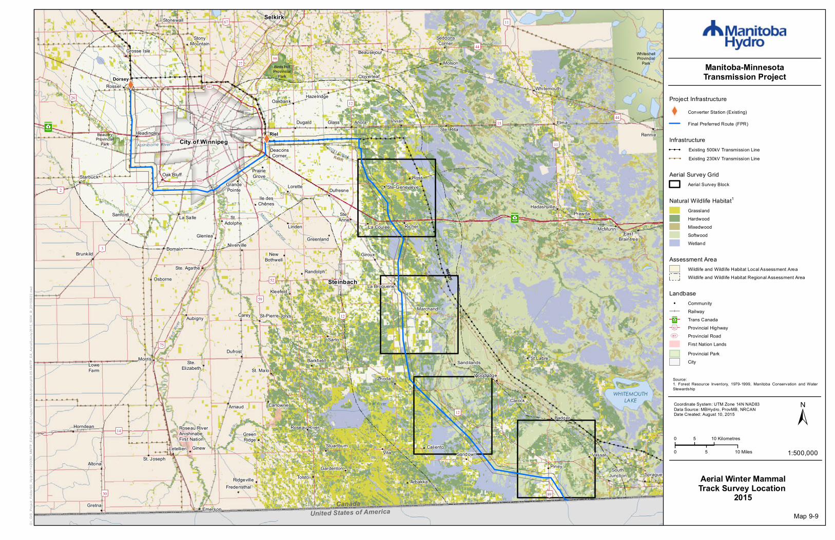
Project Infrastructure
XW Converter Station (Existing)
Final Preferred Route (FPR)
Aerial Winter MammalTrack Survey Location
2014
Infrastructure! ! ! Existing 500kV Transmission Line! ! ! Existing 230kV Transmission Line
Map 9-8
Aerial Survey GridAerial Survey Block
Natural Wildlife Habitat1GrasslandHardwoodMixedwoodSoftwoodWetland
Assessment AreaWildlife and Wildlife Habitat Local Assessment AreaWildlife and Wildlife Habitat Regional Assessment Area
Source:1. Forest Resource Inventory, 1979-1999, Manitoba Conservation and WaterStewardship
Landbase! Community
RailwayTrans CanadaProvincial HighwayProvincial RoadFirst Nation LandsProvincial ParkCity
³²1
[\12
UV301
XW
XW
[\59
[\59
[\3
³²1
City of Winnipeg
St. Malo
Riel
Joubert Creek
Rose
au River
United States of America
Red
River
WHITEMOUTHLAKE
Canada
ManningCanal
Assiniboine River Cooks Creek
Seine Riv er
Rat River
[\9
[\15
[\4
[\27
[\75
[\52
[\11
[\44
[\59
[\89
[\67
[\14
[\26
[\12
[\30
[\32
[\11
[\44
[\12
[\12[\26
[\11
[\2UV100
UV101
M602F
R50M
R49R
WhiteshellProvincial
Park
Birds HillProvincial
Park
WhiteshellProvincial
Park
BeaudryProvincial
Park
³²1
Dorsey
Altona
Anola
Arbakka
Arnaud
Aubigny
Badger
Barkfield
Beausejour
Brunkild
Caliento
Carey
CarlowrieCarrick
Cloverleaf
DeaconsCorner
Domain
Dufresne
Dufrost
Dugald
EastBraintree
Elma
Emerson
Fredensthal
Gardenton
Giroux
Glass
Glenlea
GrandePointe
Greenland
GreenRidge
Gretna
Grosse Isle
Hadashville
Hazelridge
Headingley
Horndean
Ile desChênes
KleefeldLa Broquerie
La CouléeLa Salle
Letellier
Linden
Lorette
LoweFarm
Marchand
McMunn
Molson
Morris
NewBothwell
Niverville
Oakbank
Oak Bluff
Osborne
Piney
PrairieGrove
Prawda
Randolph
Rennie
Richer
Ridgeville
Roseau River
Ross
Rosser
St.Adolphe
Ste. Agathe
Ste.Elizabeth
Ste-Geneviève
Ste. Rita
St. Joseph
St.Labre
St-Pierre-Jolys
Sandilands
Sanford
Sarto
SeddonsCorner
SouthJunction Sprague
Starbuck
Steinbach
StonyMountain
StuartburnSundown
Tolstoi
VassarVita
Vivian
Whitemouth
Woodridge
Roseau RiverAnishinabeFirst Nation
Ste.Anne
Ginew
Stonewall Selkirk
Zhoda
0 5 10 Kilometres
0 105 Miles 1:500,000
±Coordinate System: UTM Zone 14N NAD83Data Source: MBHydro, ProvMB, NRCANDate Created: August 10, 2015
Manitoba-MinnesotaTransmission Project
G:\_G
IS_P
rojec
t_Fold
er\00
_Hyd
ro\11
1420
050_
MMTP
_EA\
Figur
es\EA
Chap
ter\W
ildlife
AndH
abita
t\9-09
-MMT
P_EA
_Aeri
alSurv
ey20
15_5
00K_
B_20
1506
22.m
xd
Project Infrastructure
XW Converter Station (Existing)
Final Preferred Route (FPR)
Aerial Winter MammalTrack Survey Location
2015
Infrastructure! ! ! Existing 500kV Transmission Line! ! ! Existing 230kV Transmission Line
Map 9-9
Aerial Survey GridAerial Survey Block
Natural Wildlife Habitat1GrasslandHardwoodMixedwoodSoftwoodWetland
Assessment AreaWildlife and Wildlife Habitat Local Assessment AreaWildlife and Wildlife Habitat Regional Assessment Area
Source:1. Forest Resource Inventory, 1979-1999, Manitoba Conservation and WaterStewardship
Landbase! Community
RailwayTrans CanadaProvincial HighwayProvincial RoadFirst Nation LandsProvincial ParkCity
³²1
[\12
UV301

!(!(!(!(!(!(!(
!(
!(
!(
!(
!(
!(!(
!(!(!(!(
!(!(!(
!(
!(!(!(
!(
!(!(
!(!(
!(!(
!(!(
!(
!(
!(!(
!(
!(
!(
!(
!(
!(!(!(
!(!(!(
!(!(!(
!(!(
!(
!(
!(!(!(
!(!(
!(
!(!(!(!(
!(!( !(!(!(
!(
!(!(
!(!(!(!(!(
!(!(
!(!(
!(
!(!(
!(!(!(
!(!(
!(!(
!(
!(
!(
!(!(
!( !(!(
!(
!(
!(
!(!(
!(
!(!(!(
!(!(
!(!(
!(!(!(!(!(!(
!(!(!(
!(
!(!(
!(!(
!(!(
!(!(
!(!(
!(!(!(!(!(
!(
!(!(
!(
!(!(!(
!(!(
!(!(
!(
!(
!(!(
!(!(
!(!(!(
!(!(!(
!(!(!(
!(!(
!(
!(
!(
!(
!(!(
!( !(!(
!(
!(
!(
!(
!(
!(
XW
XW
[\59
[\59
[\3
³²1
City of Winnipeg
St. Malo
Riel
Joubert Creek
Rose
au River
United States of America
Red
River
WHITEMOUTHLAKE
Canada
ManningCanal
Assiniboine River Cooks Creek
Seine Riv er
Rat River
[\9
[\15
[\4
[\27
[\75
[\52
[\11
[\44
[\59
[\89
[\67
[\14
[\26
[\12
[\30
[\32
[\11
[\44
[\12
[\12[\26
[\11
[\2UV100
UV101
M602F
R50M
R49R
WhiteshellProvincial
Park
Birds HillProvincial
Park
WhiteshellProvincial
Park
BeaudryProvincial
Park
³²1
Dorsey
Altona
Anola
Arbakka
Arnaud
Aubigny
Badger
Barkfield
Beausejour
Brunkild
Caliento
Carey
CarlowrieCarrick
Cloverleaf
DeaconsCorner
Domain
Dufresne
Dufrost
Dugald
EastBraintree
Elma
Emerson
Fredensthal
Gardenton
Giroux
Glass
Glenlea
GrandePointe
Greenland
GreenRidge
Gretna
Grosse Isle
Hadashville
Hazelridge
Headingley
Horndean
Ile desChênes
KleefeldLa Broquerie
La CouléeLa Salle
Letellier
Linden
Lorette
LoweFarm
Marchand
McMunn
Molson
Morris
NewBothwell
Niverville
Oakbank
Oak Bluff
Osborne
Piney
PrairieGrove
Prawda
Randolph
Rennie
Richer
Ridgeville
Roseau River
Ross
Rosser
St.Adolphe
Ste. Agathe
Ste.Elizabeth
Ste-Geneviève
Ste. Rita
St. Joseph
St.Labre
St-Pierre-Jolys
Sandilands
Sanford
Sarto
SeddonsCorner
SouthJunction Sprague
Starbuck
Steinbach
StonyMountain
StuartburnSundown
Tolstoi
VassarVita
Vivian
Whitemouth
Woodridge
Roseau RiverAnishinabeFirst Nation
Ste.Anne
Ginew
Stonewall Selkirk
Zhoda
0 5 10 Kilometres
0 105 Miles 1:500,000
±Coordinate System: UTM Zone 14N NAD83Data Source: MBHydro, ProvMB, NRCANDate Created: July 29, 2015
Manitoba-MinnesotaTransmission Project
G:\_G
IS_P
rojec
t_Fold
er\00
_Hyd
ro\11
1420
050_
MMTP
_EA\
Figur
es\EA
Chap
ter\W
ildlife
AndH
abita
t\9-10
-MMT
P_EA
_BBS
Loca
tions
_500
K_B_
2015
0622
.mxd
Project Infrastructure
XW Converter Station (Existing)
Final Preferred Route (FPR)
Breeding Bird Survey Locations2014
Infrastructure! ! ! Existing 500kV Transmission Line! ! ! Existing 230kV Transmission Line
Map 9-10
Survey Feature!( Breeding Bird Survey Location
Assessment AreaWildlife and Wildlife Habitat Local Assessment AreaWildlife and Wildlife Habitat Regional Assessment Area
Landbase! Community
RailwayTrans CanadaProvincial HighwayProvincial RoadFirst Nation LandsEcological ReserveWildlife Management AreaProvincial ParkCity
³²1
[\12
UV301

XW
XW
!(
!(
!(
!( !(
!(
!(!(
!(
!(
!(
!(
!(
!(
!(
!(
!(
!(
!(
!(
!(
!(
[\59
[\59
[\3
³²1
City of Winnipeg
St. Malo
Riel
Joubert Creek
Rose
au River
United States of America
Red
River
WHITEMOUTHLAKE
Canada
ManningCanal
Assiniboine River Cooks Creek
Seine Riv er
Rat River
[\9
[\15
[\4
[\27
[\75
[\52
[\11
[\44
[\59
[\89
[\67
[\14
[\26
[\12
[\30
[\32
[\11
[\44
[\12
[\12[\26
[\11
[\2UV100
UV101
M602F
R50M
R49R
WhiteshellProvincial
Park
Birds HillProvincial
Park
WhiteshellProvincial
Park
BeaudryProvincial
Park
³²1
Dorsey
Altona
Anola
Arbakka
Arnaud
Aubigny
Badger
Barkfield
Beausejour
Brunkild
Caliento
Carey
CarlowrieCarrick
Cloverleaf
DeaconsCorner
Domain
Dufresne
Dufrost
Dugald
EastBraintree
Elma
Emerson
Fredensthal
Gardenton
Giroux
Glass
Glenlea
GrandePointe
Greenland
GreenRidge
Gretna
Grosse Isle
Hadashville
Hazelridge
Headingley
Horndean
Ile desChênes
KleefeldLa Broquerie
La CouléeLa Salle
Letellier
Linden
Lorette
LoweFarm
Marchand
McMunn
Molson
Morris
NewBothwell
Niverville
Oakbank
Oak Bluff
Osborne
Piney
PrairieGrove
Prawda
Randolph
Rennie
Richer
Ridgeville
Roseau River
Ross
Rosser
St.Adolphe
Ste. Agathe
Ste.Elizabeth
Ste-Geneviève
Ste. Rita
St. Joseph
St.Labre
St-Pierre-Jolys
Sandilands
Sanford
Sarto
SeddonsCorner
SouthJunction Sprague
Starbuck
Steinbach
StonyMountain
StuartburnSundown
Tolstoi
VassarVita
Vivian
Whitemouth
Woodridge
Roseau RiverAnishinabeFirst Nation
Ste.Anne
Ginew
Stonewall Selkirk
Zhoda
0 5 10 Kilometres
0 105 Miles 1:500,000
±Coordinate System: UTM Zone 14N NAD83Data Source: MBHydro, ProvMB, NRCANDate Created: August 10, 2015
Manitoba-MinnesotaTransmission Project
G:\_G
IS_P
rojec
t_Fold
er\00
_Hyd
ro\11
1420
050_
MMTP
_EA\
Figur
es\EA
Chap
ter\W
ildlife
AndH
abita
t\9-11
-MMT
P_EA
_Grou
seLe
kSurv
eyLo
catio
ns_5
00K_
B_20
1506
22.m
xd
Project Infrastructure
XW Converter Station (Existing)
Final Preferred Route (FPR)
Sharp-tailed Grouse LekSurvey Locations
2014
Infrastructure! ! ! Existing 500kV Transmission Line! ! ! Existing 230kV Transmission Line
Survey Features and Habitat!( Sharp-tailed Grouse Lek Survey Site
Potential Grouse Lek Habitat1
Assessment AreaWildlife and Wildlife Habitat Local Assessment AreaWildlife and Wildlife Habitat Regional Assessment Area
Landbase! Community
RailwayTrans CanadaProvincial HighwayProvincial RoadFirst Nation LandsEcological ReserveWildlife Management AreaProvincial ParkCity
³²1
[\12
UV301
Map 9-11
Source:1. Federal Land Cover Classification, 1996-2005, Natural Resources Canada
XW
XW
!(!(!(!(
!(!(!(!(!(!(
!(!(!(!(!(!(!(!(!(!(
!(!(!(!(
!(!(!(!(
!(!(!(!( !(!(!(!(!(
[\59
[\59
[\3
³²1
City of Winnipeg
St. Malo
Riel
Joubert Creek
Rose
au River
United States of America
Red
River
WHITEMOUTHLAKE
Canada
ManningCanal
Assiniboine River Cooks Creek
Seine Riv er
Rat River
[\9
[\15
[\4
[\27
[\75
[\52
[\11
[\44
[\59
[\89
[\67
[\14
[\26
[\12
[\30
[\32
[\11
[\44
[\12
[\12[\26
[\11
[\2UV100
UV101
M602F
R50M
R49R
³²1
Dorsey
Altona
Anola
Arbakka
Arnaud
Aubigny
Badger
Barkfield
Beausejour
Brunkild
Caliento
Carey
CarlowrieCarrick
Cloverleaf
DeaconsCorner
Domain
Dufresne
Dufrost
Dugald
EastBraintree
Elma
Emerson
Fredensthal
Gardenton
Giroux
Glass
Glenlea
GrandePointe
Greenland
GreenRidge
Gretna
Grosse Isle
Hadashville
Hazelridge
Headingley
Horndean
Ile desChênes
KleefeldLa Broquerie
La CouléeLa Salle
Letellier
Linden
Lorette
LoweFarm
Marchand
McMunn
Molson
Morris
NewBothwell
Niverville
Oakbank
Oak Bluff
Osborne
Piney
PrairieGrove
Prawda
Randolph
Rennie
Richer
Ridgeville
Roseau River
Ross
Rosser
St.Adolphe
Ste. Agathe
Ste.Elizabeth
Ste-Geneviève
Ste. Rita
St. Joseph
St.Labre
St-Pierre-Jolys
Sandilands
Sanford
Sarto
SeddonsCorner
SouthJunction Sprague
Starbuck
Steinbach
StonyMountain
StuartburnSundown
Tolstoi
VassarVita
Vivian
Whitemouth
Woodridge
Roseau RiverAnishinabeFirst Nation
Ste.Anne
Ginew
Stonewall Selkirk
Zhoda
0 5 10 Kilometres
0 105 Miles 1:500,000
±Coordinate System: UTM Zone 14N NAD83Data Source: MBHydro, ProvMB, NRCANDate Created: August 10, 2015
Manitoba-MinnesotaTransmission Project
G:\_G
IS_P
rojec
t_Fold
er\00
_Hyd
ro\11
1420
050_
MMTP
_EA\
Figur
es\EA
Chap
ter\W
ildlife
AndH
abita
t\9-12
-MMT
P_EA
_Com
monN
ightha
wkSu
rveyL
ocati
ons_
500K
_B_2
0150
810.m
xd
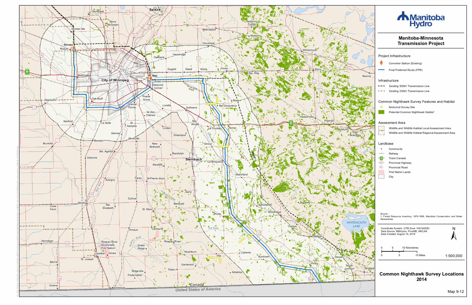
Project Infrastructure
XW Converter Station (Existing)
Final Preferred Route (FPR)
Common Nighthawk Survey Locations2014
Infrastructure! ! ! Existing 500kV Transmission Line! ! ! Existing 230kV Transmission Line
Assessment AreaWildlife and Wildlife Habitat Local Assessment AreaWildlife and Wildlife Habitat Regional Assessment Area
Map 9-12
Common Nighthawk Survey Features and Habitat!( Nocturnal Survey Site
Potential Common Nighthawk Habitat1
Landbase! Community
RailwayTrans CanadaProvincial HighwayProvincial RoadFirst Nation LandsCity
³²1
[\12
UV301
Source:1. Forest Resource Inventory, 1979-1999, Manitoba Conservation and WaterStewardship
XW
XW
!(!(!(!(
!(!(!(!(!(!(
!(!(!(!(!(!(!(!(!(!(
!(!(!(!(
!(!(!(!(
!(!(!(!( !(!(!(!(!(
[\59
[\59
[\3
³²1
City of Winnipeg
St. Malo
Riel
Joubert Creek
Rose
au River
United States of America
Red
River
WHITEMOUTHLAKE
Canada
ManningCanal
Assiniboine River Cooks Creek
Seine Riv er
Rat River
[\9
[\15
[\4
[\27
[\75
[\52
[\11
[\44
[\59
[\89
[\67
[\14
[\26
[\12
[\30
[\32
[\11
[\44
[\12
[\12[\26
[\11
[\2UV100
UV101
M602F
R50M
R49R
³²1
Dorsey
Altona
Anola
Arbakka
Arnaud
Aubigny
Badger
Barkfield
Beausejour
Brunkild
Caliento
Carey
CarlowrieCarrick
Cloverleaf
DeaconsCorner
Domain
Dufresne
Dufrost
Dugald
EastBraintree
Elma
Emerson
Fredensthal
Gardenton
Giroux
Glass
Glenlea
GrandePointe
Greenland
GreenRidge
Gretna
Grosse Isle
Hadashville
Hazelridge
Headingley
Horndean
Ile desChênes
KleefeldLa Broquerie
La CouléeLa Salle
Letellier
Linden
Lorette
LoweFarm
Marchand
McMunn
Molson
Morris
NewBothwell
Niverville
Oakbank
Oak Bluff
Osborne
Piney
PrairieGrove
Prawda
Randolph
Rennie
Richer
Ridgeville
Roseau River
Ross
Rosser
St.Adolphe
Ste. Agathe
Ste.Elizabeth
Ste-Geneviève
Ste. Rita
St. Joseph
St.Labre
St-Pierre-Jolys
Sandilands
Sanford
Sarto
SeddonsCorner
SouthJunction Sprague
Starbuck
Steinbach
StonyMountain
StuartburnSundown
Tolstoi
VassarVita
Vivian
Whitemouth
Woodridge
Roseau RiverAnishinabeFirst Nation
Ste.Anne
Ginew
Stonewall Selkirk
Zhoda
0 5 10 Kilometres
0 105 Miles 1:500,000
±Coordinate System: UTM Zone 14N NAD83Data Source: MBHydro, ProvMB, NRCANDate Created: August 10, 2015
Manitoba-MinnesotaTransmission Project
G:\_G
IS_P
rojec
t_Fold
er\00
_Hyd
ro\11
1420
050_
MMTP
_EA\
Figur
es\EA
Chap
ter\W
ildlife
AndH
abita
t\9-13
-MMT
P_EA
_Eas
ternW
hipPo
orWillS
urvey
Loca
tions
_500
K_B_
2015
0810
.mxd
Project Infrastructure
XW Converter Station (Existing)
Final Preferred Route (FPR)
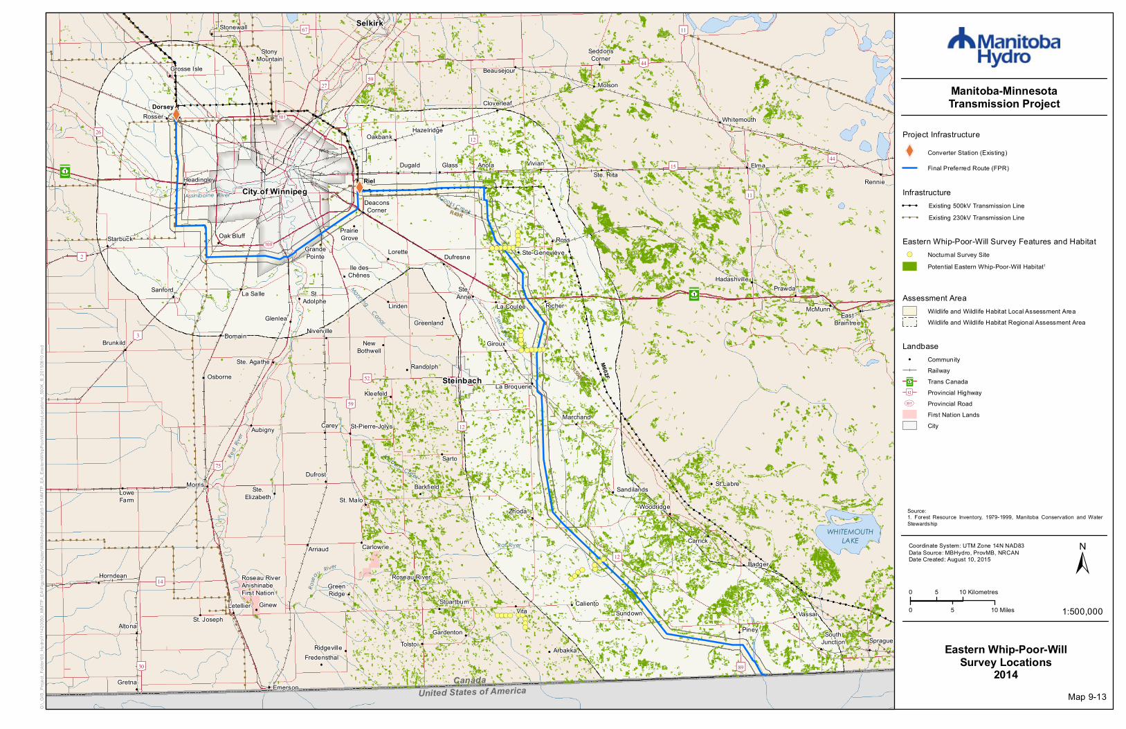
Eastern Whip-Poor-WillSurvey Locations
2014
Infrastructure! ! ! Existing 500kV Transmission Line! ! ! Existing 230kV Transmission Line
Assessment AreaWildlife and Wildlife Habitat Local Assessment AreaWildlife and Wildlife Habitat Regional Assessment Area
Map 9-13
Eastern Whip-Poor-Will Survey Features and Habitat!( Nocturnal Survey Site
Potential Eastern Whip-Poor-Will Habitat1
Landbase! Community
RailwayTrans CanadaProvincial HighwayProvincial RoadFirst Nation LandsCity
³²1
[\12
UV301
Source:1. Forest Resource Inventory, 1979-1999, Manitoba Conservation and WaterStewardship
XW
XW
!(!(
!(
!(
!(
!(
!(
!(
!(
!(
!(
!(
!(
[\59
[\59
[\3
³²1
City of Winnipeg
St. Malo
Riel
Joubert Creek
Rose
au River
United States of America
Red
River
WHITEMOUTHLAKE
Canada
ManningCanal
Assiniboine River Cooks Creek
Seine Riv er
Rat River
[\9
[\15
[\4
[\27
[\75
[\52
[\11
[\44
[\59
[\89
[\67
[\14
[\26
[\12
[\30
[\32
[\11
[\44
[\12
[\12[\26
[\11
[\2UV100
UV101
M602F
R50M
R49R
WhiteshellProvincial
Park
Birds HillProvincial
Park
WhiteshellProvincial
Park
BeaudryProvincial
Park
³²1
Dorsey
Altona
Anola
Arbakka
Arnaud
Aubigny
Badger
Barkfield
Beausejour
Brunkild
Caliento
Carey
CarlowrieCarrick
Cloverleaf
DeaconsCorner
Domain
Dufresne
Dufrost
Dugald
EastBraintree
Elma
Emerson
Fredensthal
Gardenton
Giroux
Glass
Glenlea
GrandePointe
Greenland
GreenRidge
Gretna
Grosse Isle
Hadashville
Hazelridge
Headingley
Horndean
Ile desChênes
KleefeldLa Broquerie
La CouléeLa Salle
Letellier
Linden
Lorette
LoweFarm
Marchand
McMunn
Molson
Morris
NewBothwell
Niverville
Oakbank
Oak Bluff
Osborne
Piney
PrairieGrove
Prawda
Randolph
Rennie
Richer
Ridgeville
Roseau River
Ross
Rosser
St.Adolphe
Ste. Agathe
Ste.Elizabeth
Ste-Geneviève
Ste. Rita
St. Joseph
St.Labre
St-Pierre-Jolys
Sandilands
Sanford
Sarto
SeddonsCorner
SouthJunction Sprague
Starbuck
Steinbach
StonyMountain
StuartburnSundown
Tolstoi
VassarVita
Vivian
Whitemouth
Woodridge
Roseau RiverAnishinabeFirst Nation
Ste.Anne
Ginew
Stonewall Selkirk
Zhoda
0 5 10 Kilometres
0 105 Miles 1:500,000
±Coordinate System: UTM Zone 14N NAD83Data Source: MBHydro, ProvMB, NRCANDate Created: August 10, 2015
Manitoba-MinnesotaTransmission Project
G:\_G
IS_P
rojec
t_Fold
er\00
_Hyd
ro\11
1420
050_
MMTP
_EA\
Figur
es\EA
Chap
ter\W
ildlife
AndH
abita
t\9-14
-MMT
P_EA
_Yell
owRa
ilSurv
eyLo
catio
ns_5
00K_
B_20
1506
22.m
xd
Project Infrastructure
XW Converter Station (Existing)
Final Preferred Route (FPR)
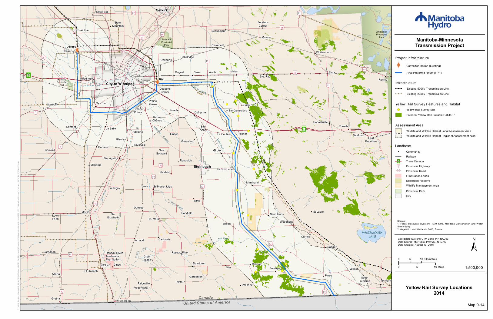
Yellow Rail Survey Locations2014
Infrastructure! ! ! Existing 500kV Transmission Line! ! ! Existing 230kV Transmission Line
Yellow Rail Survey Features and Habitat!( Yellow Rail Survey Site
Potential Yellow Rail Suitable Habitat1, 2
Assessment AreaWildlife and Wildlife Habitat Local Assessment AreaWildlife and Wildlife Habitat Regional Assessment Area
Landbase! Community
RailwayTrans CanadaProvincial HighwayProvincial RoadFirst Nation LandsEcological ReserveWildlife Management AreaProvincial ParkCity
³²1
[\12
UV301
Map 9-14
Source:1. Forest Resource Inventory, 1979-1999, Manitoba Conservation and WaterStewardship2. Vegetation and Wetlands, 2015, Stantec

XW
XW
[\59
[\59
[\3
³²1
City of Winnipeg
St. Malo
Riel
Joubert Creek
Rose
au River
United States of America
Red
River
WHITEMOUTHLAKE
Canada
ManningCanal
Assiniboine River Cooks Creek
Seine Riv er
Rat River
[\9
[\15
[\4
[\27
[\75
[\52
[\11
[\44
[\59
[\89
[\67
[\14
[\26
[\12
[\30
[\32
[\11
[\44
[\12
[\12[\26
[\11
[\2UV100
UV101
M602F
R50M
R49R
WhiteshellProvincial
Park
Birds HillProvincial
Park
WhiteshellProvincial
Park
BeaudryProvincial
Park
³²1
Dorsey
Altona
Anola
Arbakka
Arnaud
Aubigny
Badger
Barkfield
Beausejour
Brunkild
Caliento
Carey
CarlowrieCarrick
Cloverleaf
DeaconsCorner
Domain
Dufresne
Dufrost
Dugald
EastBraintree
Elma
Emerson
Fredensthal
Gardenton
Giroux
Glass
Glenlea
GrandePointe
Greenland
GreenRidge
Gretna
Grosse Isle
Hadashville
Hazelridge
Headingley
Horndean
Ile desChênes
KleefeldLa Broquerie
La CouléeLa Salle
Letellier
Linden
Lorette
LoweFarm
Marchand
McMunn
Molson
Morris
NewBothwell
Niverville
Oakbank
Oak Bluff
Osborne
Piney
PrairieGrove
Prawda
Randolph
Rennie
Richer
Ridgeville
Roseau River
Ross
Rosser
St.Adolphe
Ste. Agathe
Ste.Elizabeth
Ste-Geneviève
Ste. Rita
St. Joseph
St.Labre
St-Pierre-Jolys
Sandilands
Sanford
Sarto
SeddonsCorner
SouthJunction Sprague
Starbuck
Steinbach
StonyMountain
StuartburnSundown
Tolstoi
VassarVita
Vivian
Whitemouth
Woodridge
Roseau RiverAnishinabeFirst Nation
Ste.Anne
Ginew
Stonewall Selkirk
Zhoda
0 5 10 Kilometres
0 105 Miles 1:500,000
±Coordinate System: UTM Zone 14N NAD83Data Source: MBHydro, ProvMB, NRCANDate Created: August 10, 2015
Manitoba-MinnesotaTransmission Project
G:\_G
IS_P
rojec
t_Fold
er\00
_Hyd
ro\11
1420
050_
MMTP
_EA\
Figur
es\EA
Chap
ter\W
ildlife
AndH
abita
t\9-15
-MMT
P_EA
_Spri
ngMi
gratio
nSur
veyR
oute_
500K
_B_2
0150
622.m
xd
Project Infrastructure
XW Converter Station (Existing)
Final Preferred Route (FPR)
Spring Migration Survey Route2014
Infrastructure! ! ! Existing 500kV Transmission Line! ! ! Existing 230kV Transmission Line
Survey FeatureSpring Migration Survey Route
Assessment AreaWildlife and Wildlife Habitat Local Assessment AreaWildlife and Wildlife Habitat Regional Assessment Area
Landbase! Community
RailwayTrans CanadaProvincial HighwayProvincial RoadFirst Nation LandsEcological ReserveWildlife Management AreaProvincial ParkCity
³²1
[\12
UV301
Map 9-15
XW
XW
[\59
[\59
[\3
³²1
City of Winnipeg
St. Malo
Riel
Joubert Creek
Rose
au River
United States of America
Red
River
WHITEMOUTHLAKE
Canada
ManningCanal
Assiniboine River Cooks Creek
Seine Riv er
Rat River
[\9
[\15
[\4
[\27
[\75
[\52
[\11
[\44
[\59
[\89
[\67
[\14
[\26
[\12
[\30
[\32
[\11
[\44
[\12
[\12[\26
[\11
[\2UV100
UV101
M602F
R50M
R49R
WhiteshellProvincial
Park
Birds HillProvincial
Park
WhiteshellProvincial
Park
BeaudryProvincial
Park
³²1
Dorsey
Altona
Anola
Arbakka
Arnaud
Aubigny
Badger
Barkfield
Beausejour
Brunkild
Caliento
Carey
CarlowrieCarrick
Cloverleaf
DeaconsCorner
Domain
Dufresne
Dufrost
Dugald
EastBraintree
Elma
Emerson
Fredensthal
Gardenton
Giroux
Glass
Glenlea
GrandePointe
Greenland
GreenRidge
Gretna
Grosse Isle
Hadashville
Hazelridge
Headingley
Horndean
Ile desChênes
KleefeldLa Broquerie
La CouléeLa Salle
Letellier
Linden
Lorette
LoweFarm
Marchand
McMunn
Molson
Morris
NewBothwell
Niverville
Oakbank
Oak Bluff
Osborne
Piney
PrairieGrove
Prawda
Randolph
Rennie
Richer
Ridgeville
Roseau River
Ross
Rosser
St.Adolphe
Ste. Agathe
Ste.Elizabeth
Ste-Geneviève
Ste. Rita
St. Joseph
St.Labre
St-Pierre-Jolys
Sandilands
Sanford
Sarto
SeddonsCorner
SouthJunction Sprague
Starbuck
Steinbach
StonyMountain
StuartburnSundown
Tolstoi
VassarVita
Vivian
Whitemouth
Woodridge
Roseau RiverAnishinabeFirst Nation
Ste.Anne
Ginew
Stonewall Selkirk
Zhoda
0 5 10 Kilometres
0 105 Miles 1:500,000
±Coordinate System: UTM Zone 14N NAD83Data Source: MBHydro, ProvMB, NRCANDate Created: August 10, 2015
Manitoba-MinnesotaTransmission Project
G:\_G
IS_P
rojec
t_Fold
er\00
_Hyd
ro\11
1420
050_
MMTP
_EA\
Figur
es\EA
Chap
ter\W
ildlife
AndH
abita
t\9-16
-MMT
P_EA
_Fall
Migr
ation
Surve
yRou
te_50
0K_B
_201
5062
2.mxd
Project Infrastructure
XW Converter Station (Existing)
Final Preferred Route (FPR)
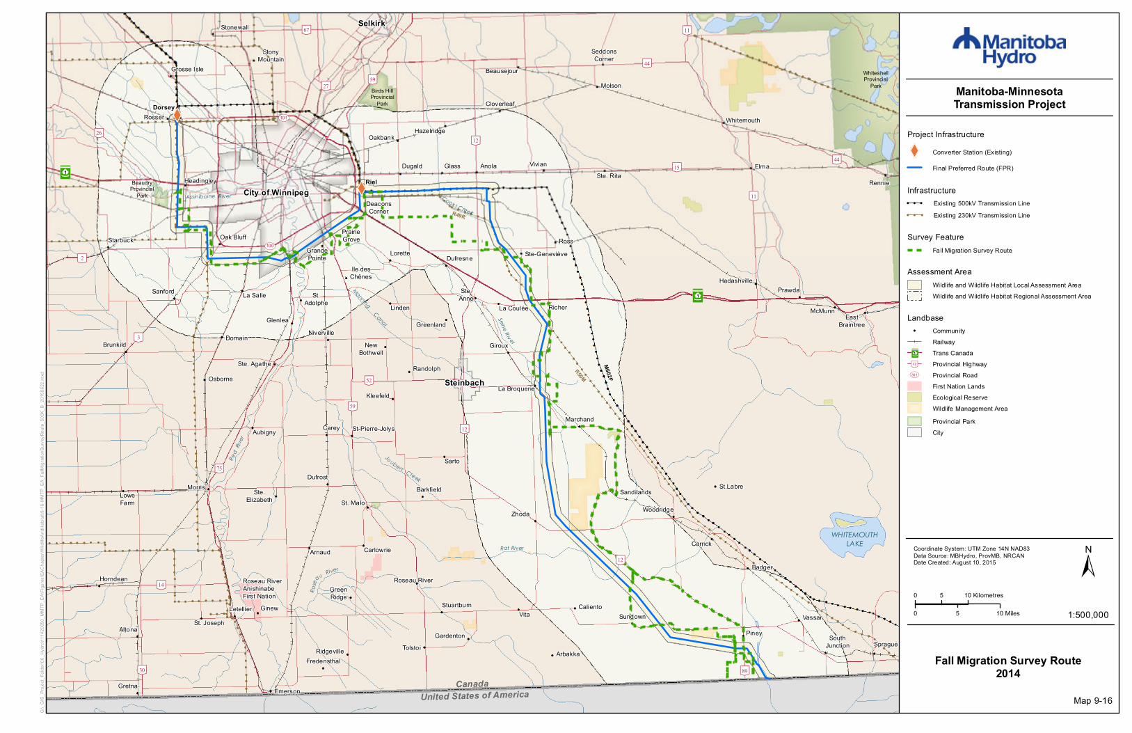
Fall Migration Survey Route2014
Infrastructure! ! ! Existing 500kV Transmission Line! ! ! Existing 230kV Transmission Line
Survey FeatureFall Migration Survey Route
Assessment AreaWildlife and Wildlife Habitat Local Assessment AreaWildlife and Wildlife Habitat Regional Assessment Area
Landbase! Community
RailwayTrans CanadaProvincial HighwayProvincial RoadFirst Nation LandsEcological ReserveWildlife Management AreaProvincial ParkCity
³²1
[\12
UV301
Map 9-16

XW
XW
#*
[\59
[\59
[\3
³²1
City of Winnipeg
St. Malo
Riel
Joubert Creek
Rose
au River
United States of America
Red
River
WHITEMOUTHLAKE
Canada
ManningCanal
Assiniboine River Cooks Creek
Seine Riv er
Rat River
Richer Lake642 individuals observed
over a 3 week period
[\9
[\15
[\4
[\75
[\52
[\11
[\44
[\59
[\89
[\67
[\14
[\26
[\12
[\30
[\32
[\11
[\44
[\12
[\26
[\11
[\2UV100
UV101
M602F
R50M
R49R
WhiteshellProvincial
Park
Birds HillProvincial
Park
WhiteshellProvincial
Park
BeaudryProvincial
Park
³²1
Dorsey
Altona
Anola
Arbakka
Arnaud
Aubigny
Barkfield
Beausejour
Brunkild
Caliento
Carey
CarlowrieCarrick
Cloverleaf
DeaconsCorner
Domain
Dufresne
Dufrost
Dugald
EastBraintree
Elma
Emerson
Fredensthal
Gardenton
Giroux
Glass
Glenlea
GrandePointe
Greenland
GreenRidge
Gretna
Grosse Isle
Hadashville
Headingley
Horndean
Ile desChênes
KleefeldLa Broquerie
La CouléeLa Salle
Letellier
Lorette
LoweFarm
Marchand
McMunn
Molson
Morris
NewBothwell
Niverville
Oakbank
Oak Bluff
Osborne
Piney
PrairieGrove
Prawda
Randolph
Rennie
Richer
Ridgeville
Roseau River
Ross
Rosser
St.Adolphe
Ste. Agathe
Ste.Elizabeth
Ste-Geneviève
Ste. Rita
St. Joseph
St.Labre
St-Pierre-Jolys
Sandilands
Sanford
Sarto
SeddonsCorner
SouthJunction Sprague
Starbuck
Steinbach
StonyMountain
StuartburnSundown
Tolstoi
VassarVita
Vivian
Whitemouth
Woodridge
Roseau RiverAnishinabeFirst Nation
Ste.Anne
Ginew
Stonewall Selkirk
Zhoda
0 5 10 Kilometres
0 105 Miles 1:500,000
±Coordinate System: UTM Zone 14N NAD83Data Source: MBHydro, ProvMB, NRCANDate Created: August 10, 2015
Manitoba-MinnesotaTransmission Project
G:\_G
IS_P
rojec
t_Fold
er\00
_Hyd
ro\11
1420
050_
MMTP
_EA\
Figur
es\EA
Chap
ter\W
ildlife
AndH
abita
t\9-17
-MMT
P_EA
_Bird
Move
mentS
urvey
Loca
tionS
pring
2014
_500
K_B_
2015
0727
.mxd
Project Infrastructure
XW Converter Station (Existing)
Final Preferred Route (FPR)
Bird Movement Survey LocationSpring 2014
Infrastructure! ! ! Existing 500kV Transmission Line! ! ! Existing 230kV Transmission Line
Assessment AreaWildlife and Wildlife Habitat Local Assessment AreaWildlife and Wildlife Habitat Regional Assessment Area
Map 9-17
Survey Feature#* Bird Movement Survey Location
Landbase! Community
RailwayTrans CanadaProvincial HighwayProvincial RoadFirst Nation LandsEcological ReserveWildlife Management AreaProvincial ParkCity
³²1
[\12
UV301

XW
XW
#*#*#*#*#*#*
#*#*#*#*
#*#*#*#*
#*#*#*#*
#*#*#*#*
#*#*#*#*
#*#*#*#*
[\59
[\59
[\3
³²1
City of Winnipeg
St. Malo
Riel
Joubert Creek
Rose
au River
United States of America
Red
River
WHITEMOUTHLAKE
Canada
ManningCanal
Assiniboine River Cooks Creek
Seine Riv er
Rat River
Assiniboine River21% (n=2353) of total individuals
observed for all bird movement sitesover a 4 week period
Red River 42% (n=4697) of total individuals
observed for all bird movement sitesover a 4 week period
Richer Lake4% (n=462) of total individuals
observed for all bird movement sitesover a 4 week period
Lonesand Lake1% (n=117) of total individuals
observed for all bird movement sitesover a 4 week period
Sundown Lake9% (n=973) of total individuals
observed for all bird movement sitesover a 4 week period
Deacon Reservoir 24% (n=2634) of total individuals
observed for all bird movement sitesover a 4 week period
[\9
[\15
[\4
[\75
[\52
[\11
[\44
[\59
[\89
[\67
[\14
[\26
[\12
[\30
[\32
[\11
[\44
[\12
[\26
[\11
[\2UV100
UV101
M602F
R50M
R49R
WhiteshellProvincial
Park
Birds HillProvincial
Park
WhiteshellProvincial
Park
BeaudryProvincial
Park
³²1
Dorsey
Altona
Anola
Arbakka
Arnaud
Aubigny
Barkfield
Beausejour
Brunkild
Caliento
Carey
CarlowrieCarrick
Cloverleaf
DeaconsCorner
Domain
Dufresne
Dufrost
Dugald
EastBraintree
Elma
Emerson
Fredensthal
Gardenton
Giroux
Glass
Glenlea
GrandePointe
Greenland
GreenRidge
Gretna
Grosse Isle
Hadashville
Headingley
Horndean
Ile desChênes
KleefeldLa Broquerie
La CouléeLa Salle
Letellier
Lorette
LoweFarm
Marchand
McMunn
Molson
Morris
NewBothwell
Niverville
Oakbank
Oak Bluff
Osborne
Piney
PrairieGrove
Prawda
Randolph
Rennie
Richer
Ridgeville
Roseau River
Ross
Rosser
St.Adolphe
Ste. Agathe
Ste.Elizabeth
Ste-Geneviève
Ste. Rita
St. Joseph
St.Labre
St-Pierre-Jolys
Sandilands
Sanford
Sarto
SeddonsCorner
SouthJunction Sprague
Starbuck
Steinbach
StonyMountain
StuartburnSundown
Tolstoi
VassarVita
Vivian
Whitemouth
Woodridge
Roseau RiverAnishinabeFirst Nation
Ste.Anne
Ginew
Stonewall Selkirk
Zhoda
0 5 10 Kilometres
0 105 Miles 1:500,000
±Coordinate System: UTM Zone 14N NAD83Data Source: MBHydro, ProvMB, NRCANDate Created: August 10, 2015
Manitoba-MinnesotaTransmission Project
G:\_G
IS_P
rojec
t_Fold
er\00
_Hyd
ro\11
1420
050_
MMTP
_EA\
Figur
es\EA
Chap
ter\W
ildlife
AndH
abita
t\9-18
-MMT
P_EA
_Bird
Move
mentS
urvey
Loca
tionF
all20
14_5
00K_
B_20
1507
27.m
xd
Project Infrastructure
XW Converter Station (Existing)
Final Preferred Route (FPR)
Bird Movement Survey LocationFall 2014
Infrastructure! ! ! Existing 500kV Transmission Line! ! ! Existing 230kV Transmission Line
Assessment AreaWildlife and Wildlife Habitat Local Assessment AreaWildlife and Wildlife Habitat Regional Assessment Area
Map 9-18
Survey Feature#* Bird Movement Survey Location
Landbase! Community
RailwayTrans CanadaProvincial HighwayProvincial RoadFirst Nation LandsEcological ReserveWildlife Management AreaProvincial ParkCity
³²1
[\12
UV301

XW
XW
!(!(#*!(#*!(!(!(
[\59
[\59
[\3
³²1
City of Winnipeg
St. Malo
Riel
Joubert Creek
Rose
au River
United States of America
Red
River
WHITEMOUTHLAKE
Canada
ManningCanal
Assiniboine River Cooks Creek
Seine Riv er
Rat River
[\9
[\15
[\4
[\27
[\75
[\52
[\11
[\44
[\59
[\89
[\67
[\14
[\26
[\12
[\30
[\32
[\11
[\44
[\12
[\12[\26
[\11
[\2UV100
UV101
M602F
R50M
R49R
WhiteshellProvincial
Park
Birds HillProvincial
Park
WhiteshellProvincial
Park
BeaudryProvincial
Park
³²1
Dorsey
Altona
Anola
Arbakka
Arnaud
Aubigny
Badger
Barkfield
Beausejour
Brunkild
Caliento
Carey
CarlowrieCarrick
Cloverleaf
DeaconsCorner
Domain
Dufresne
Dufrost
Dugald
EastBraintree
Elma
Emerson
Fredensthal
Gardenton
Giroux
Glass
Glenlea
GrandePointe
Greenland
GreenRidge
Gretna
Grosse Isle
Hadashville
Hazelridge
Headingley
Horndean
Ile desChênes
KleefeldLa Broquerie
La CouléeLa Salle
Letellier
Linden
Lorette
LoweFarm
Marchand
McMunn
Molson
Morris
NewBothwell
Niverville
Oakbank
Oak Bluff
Osborne
Piney
PrairieGrove
Prawda
Randolph
Rennie
Richer
Ridgeville
Roseau River
Ross
Rosser
St.Adolphe
Ste. Agathe
Ste.Elizabeth
Ste-Geneviève
Ste. Rita
St. Joseph
St.Labre
St-Pierre-Jolys
Sandilands
Sanford
Sarto
SeddonsCorner
SouthJunction Sprague
Starbuck
Steinbach
StonyMountain
StuartburnSundown
Tolstoi
VassarVita
Vivian
Whitemouth
Woodridge
Roseau RiverAnishinabeFirst Nation
Ste.Anne
Ginew
Stonewall Selkirk
Zhoda
0 5 10 Kilometres
0 105 Miles 1:500,000
±Coordinate System: UTM Zone 14N NAD83Data Source: MBHydro, ProvMB, NRCANDate Created: August 10, 2015
Manitoba-MinnesotaTransmission Project
G:\_G
IS_P
rojec
t_Fold
er\00
_Hyd
ro\11
1420
050_
MMTP
_EA\
Figur
es\EA
Chap
ter\W
ildlife
AndH
abita
t\9-19
-MMT
P_EA
_Bird
Morta
lityMo
nitori
ng_5
00K_
B_20
1506
22.m
xd
Project Infrastructure
XW Converter Station (Existing)
Final Preferred Route (FPR)
Bird Mortality Monitoring Locations
2014
Infrastructure! ! ! Existing 500kV Transmission Line! ! ! Existing 230kV Transmission Line
Survey Feature!( Agriculture (High Collision Risk)!( Agriculture (Moderate Collision Risk)!( Agriculture (Low Collision Risk)
Forest (High Collision Risk)Forest (Moderate Collision Risk)Forest (Low Collision Risk)
#* Grassland (Moderate Collision Risk)#* Grassland (Low Collision Risk)
Assessment AreaWildlife and Wildlife Habitat Local Assessment AreaWildlife and Wildlife Habitat Regional Assessment Area
Landbase! Community
RailwayTrans CanadaProvincial HighwayProvincial RoadFirst Nation LandsEcological ReserveWildlife Management AreaProvincial ParkCity
³²1
[\12
UV301
Map 9-19

XW
XW
!(
!(
!(
!(!(
!(
!(
!(!(
!(
!(
[\59
[\59
[\3
³²1
City of Winnipeg
St. Malo
Riel
Joubert Creek
Rose
au River
United States of America
Red
River
WHITEMOUTHLAKE
Canada
ManningCanal
Assiniboine River Cooks Creek
Seine Riv er
Rat River
[\9
[\15
[\4
[\27
[\75
[\52
[\11
[\44
[\59
[\89
[\67
[\14
[\26
[\12
[\30
[\32
[\11
[\44
[\12
[\12[\26
[\11
[\2UV100
UV101
M602F
R50M
R49R
WhiteshellProvincial
Park
Birds HillProvincial
Park
WhiteshellProvincial
Park
BeaudryProvincial
Park
³²1
Dorsey
Altona
Anola
Arbakka
Arnaud
Aubigny
Badger
Barkfield
Beausejour
Brunkild
Caliento
Carey
CarlowrieCarrick
Cloverleaf
DeaconsCorner
Domain
Dufresne
Dufrost
Dugald
EastBraintree
Elma
Emerson
Fredensthal
Gardenton
Giroux
Glass
Glenlea
GrandePointe
Greenland
GreenRidge
Gretna
Grosse Isle
Hadashville
Hazelridge
Headingley
Horndean
Ile desChênes
KleefeldLa Broquerie
La CouléeLa Salle
Letellier
Linden
Lorette
LoweFarm
Marchand
McMunn
Molson
Morris
NewBothwell
Niverville
Oakbank
Oak Bluff
Osborne
Piney
PrairieGrove
Prawda
Randolph
Rennie
Richer
Ridgeville
Roseau River
Ross
Rosser
St.Adolphe
Ste. Agathe
Ste.Elizabeth
Ste-Geneviève
Ste. Rita
St. Joseph
St.Labre
St-Pierre-Jolys
Sandilands
Sanford
Sarto
SeddonsCorner
SouthJunction Sprague
Starbuck
Steinbach
StonyMountain
StuartburnSundown
Tolstoi
VassarVita
Vivian
Whitemouth
Woodridge
Roseau RiverAnishinabeFirst Nation
Ste.Anne
Ginew
Stonewall Selkirk
Zhoda
0 5 10 Kilometres
0 105 Miles 1:500,000
±Coordinate System: UTM Zone 14N NAD83Data Source: MBHydro, ProvMB, NRCANDate Created: August 10, 2015
Manitoba-MinnesotaTransmission Project
G:\_G
IS_P
rojec
t_Fold
er\00
_Hyd
ro\11
1420
050_
MMTP
_EA\
Figur
es\EA
Chap
ter\W
ildlife
AndH
abita
t\9-20
-MMT
P_EA
_Wetl
andS
urvey
Sites
_500
K_B_
2015
0622
.mxd
Project Infrastructure
XW Converter Station (Existing)
Final Preferred Route (FPR)
Wetland Herptile Survey Locations
2014
Infrastructure! ! ! Existing 500kV Transmission Line! ! ! Existing 230kV Transmission Line
Survey Feature!( Wetland Herptile Survey Site
Assessment AreaWildlife and Wildlife Habitat Local Assessment AreaWildlife and Wildlife Habitat Regional Assessment Area
Landbase! Community
RailwayTrans CanadaProvincial HighwayProvincial RoadFirst Nation LandsEcological ReserveWildlife Management AreaProvincial ParkCity
³²1
[\12
UV301
Map 9-20

XW
XW
!(!(!(!(!(!(!(!(!(!(
!(!(!(!(
!(!(!(!(!(!(
!(!( !(!(!(!(!(!(!(!(
!(
!(
!(!(!(!(!(!(!(!(
!( !(!(!(!(!(!(!(!(!(
!(
!(
!(!(!(!(!(!(!(!(
!(
!(
!(
!(
!(
!(!(
[\59
[\59
[\3
³²1
City of Winnipeg
St. Malo
Riel
Joubert Creek
Rose
au River
United States of America
Red
River
WHITEMOUTHLAKE
Canada
ManningCanal
Assiniboine River Cooks Creek
Seine Riv er
Rat River
[\9
[\15
[\4
[\27
[\75
[\52
[\11
[\44
[\59
[\89
[\67
[\14
[\26
[\12
[\30
[\32
[\11
[\44
[\12
[\12[\26
[\11
[\2UV100
UV101
M602F
R50M
R49R
WhiteshellProvincial
Park
Birds HillProvincial
Park
WhiteshellProvincial
Park
BeaudryProvincial
Park
³²1
Dorsey
Altona
Anola
Arbakka
Arnaud
Aubigny
Badger
Barkfield
Beausejour
Brunkild
Caliento
Carey
CarlowrieCarrick
Cloverleaf
DeaconsCorner
Domain
Dufresne
Dufrost
Dugald
EastBraintree
Elma
Emerson
Fredensthal
Gardenton
Giroux
Glass
Glenlea
GrandePointe
Greenland
GreenRidge
Gretna
Grosse Isle
Hadashville
Hazelridge
Headingley
Horndean
Ile desChênes
KleefeldLa Broquerie
La CouléeLa Salle
Letellier
Linden
Lorette
LoweFarm
Marchand
McMunn
Molson
Morris
NewBothwell
Niverville
Oakbank
Oak Bluff
Osborne
Piney
PrairieGrove
Prawda
Randolph
Rennie
Richer
Ridgeville
Roseau River
Ross
Rosser
St.Adolphe
Ste. Agathe
Ste.Elizabeth
Ste-Geneviève
Ste. Rita
St. Joseph
St.Labre
St-Pierre-Jolys
Sandilands
Sanford
Sarto
SeddonsCorner
SouthJunction Sprague
Starbuck
Steinbach
StonyMountain
StuartburnSundown
Tolstoi
VassarVita
Vivian
Whitemouth
Woodridge
Roseau RiverAnishinabeFirst Nation
Ste.Anne
Ginew
Stonewall Selkirk
Zhoda
0 5 10 Kilometres
0 105 Miles 1:500,000
±Coordinate System: UTM Zone 14N NAD83Data Source: MBHydro, ProvMB, NRCANDate Created: August 10, 2015
Manitoba-MinnesotaTransmission Project
G:\_G
IS_P
rojec
t_Fold
er\00
_Hyd
ro\11
1420
050_
MMTP
_EA\
Figur
es\EA
Chap
ter\W
ildlife
AndH
abita
t\9-21
-MMT
P_EA
_Amp
hibRo
adsid
eSurv
eySi
tes_5
00K_
B_20
1506
22.m
xd
Project Infrastructure
XW Converter Station (Existing)
Final Preferred Route (FPR)
Roadside Amphibian Call CountSurvey Locations
2014
Infrastructure! ! ! Existing 500kV Transmission Line! ! ! Existing 230kV Transmission Line
Survey Feature!( Amphibian Roadside Survey Site
Assessment AreaWildlife and Wildlife Habitat Local Assessment AreaWildlife and Wildlife Habitat Regional Assessment Area
Landbase! Community
RailwayTrans CanadaProvincial HighwayProvincial RoadFirst Nation LandsEcological ReserveWildlife Management AreaProvincial ParkCity
³²1
[\12
UV301
Map 9-21
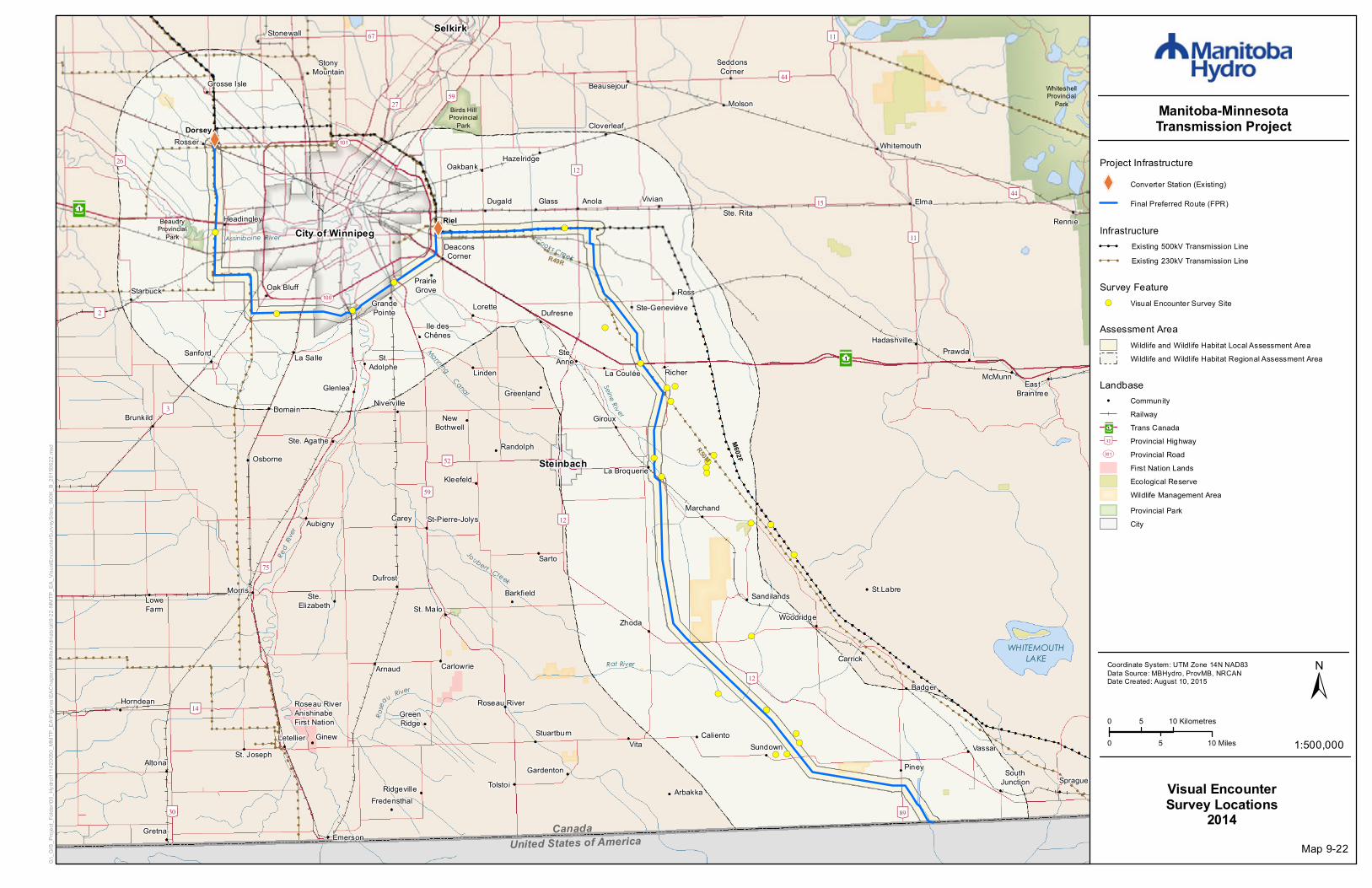
XW
XW
!(
!(
!(
!(
!(
!(
!( !(
!(
!(
!(
!(
!(
!( !(!(!(
!(
!(
!(
!(
!(
!(
!(
!(!(
!(
[\59
[\59
[\3
³²1
City of Winnipeg
St. Malo
Riel
Joubert Creek
Rose
au River
United States of America
Red
River
WHITEMOUTHLAKE
Canada
ManningCanal
Assiniboine River Cooks Creek
Seine Riv er
Rat River
[\9
[\15
[\4
[\27
[\75
[\52
[\11
[\44
[\59
[\89
[\67
[\14
[\26
[\12
[\30
[\32
[\11
[\44
[\12
[\12[\26
[\11
[\2UV100
UV101
M602F
R50M
R49R
WhiteshellProvincial
Park
Birds HillProvincial
Park
WhiteshellProvincial
Park
BeaudryProvincial
Park
³²1
Dorsey
Altona
Anola
Arbakka
Arnaud
Aubigny
Badger
Barkfield
Beausejour
Brunkild
Caliento
Carey
CarlowrieCarrick
Cloverleaf
DeaconsCorner
Domain
Dufresne
Dufrost
Dugald
EastBraintree
Elma
Emerson
Fredensthal
Gardenton
Giroux
Glass
Glenlea
GrandePointe
Greenland
GreenRidge
Gretna
Grosse Isle
Hadashville
Hazelridge
Headingley
Horndean
Ile desChênes
KleefeldLa Broquerie
La CouléeLa Salle
Letellier
Linden
Lorette
LoweFarm
Marchand
McMunn
Molson
Morris
NewBothwell
Niverville
Oakbank
Oak Bluff
Osborne
Piney
PrairieGrove
Prawda
Randolph
Rennie
Richer
Ridgeville
Roseau River
Ross
Rosser
St.Adolphe
Ste. Agathe
Ste.Elizabeth
Ste-Geneviève
Ste. Rita
St. Joseph
St.Labre
St-Pierre-Jolys
Sandilands
Sanford
Sarto
SeddonsCorner
SouthJunction Sprague
Starbuck
Steinbach
StonyMountain
StuartburnSundown
Tolstoi
VassarVita
Vivian
Whitemouth
Woodridge
Roseau RiverAnishinabeFirst Nation
Ste.Anne
Ginew
Stonewall Selkirk
Zhoda
0 5 10 Kilometres
0 105 Miles 1:500,000
±Coordinate System: UTM Zone 14N NAD83Data Source: MBHydro, ProvMB, NRCANDate Created: August 10, 2015
Manitoba-MinnesotaTransmission Project
G:\_G
IS_P
rojec
t_Fold
er\00
_Hyd
ro\11
1420
050_
MMTP
_EA\
Figur
es\EA
Chap
ter\W
ildlife
AndH
abita
t\9-22
-MMT
P_EA
_Visu
alEnc
ounte
rSurv
eySit
es_5
00K_
B_20
1506
22.m
xd
Project Infrastructure
XW Converter Station (Existing)
Final Preferred Route (FPR)
Visual EncounterSurvey Locations
2014
Infrastructure! ! ! Existing 500kV Transmission Line! ! ! Existing 230kV Transmission Line
Survey Feature!( Visual Encounter Survey Site
Assessment AreaWildlife and Wildlife Habitat Local Assessment AreaWildlife and Wildlife Habitat Regional Assessment Area
Landbase! Community
RailwayTrans CanadaProvincial HighwayProvincial RoadFirst Nation LandsEcological ReserveWildlife Management AreaProvincial ParkCity
³²1
[\12
UV301
Map 9-22
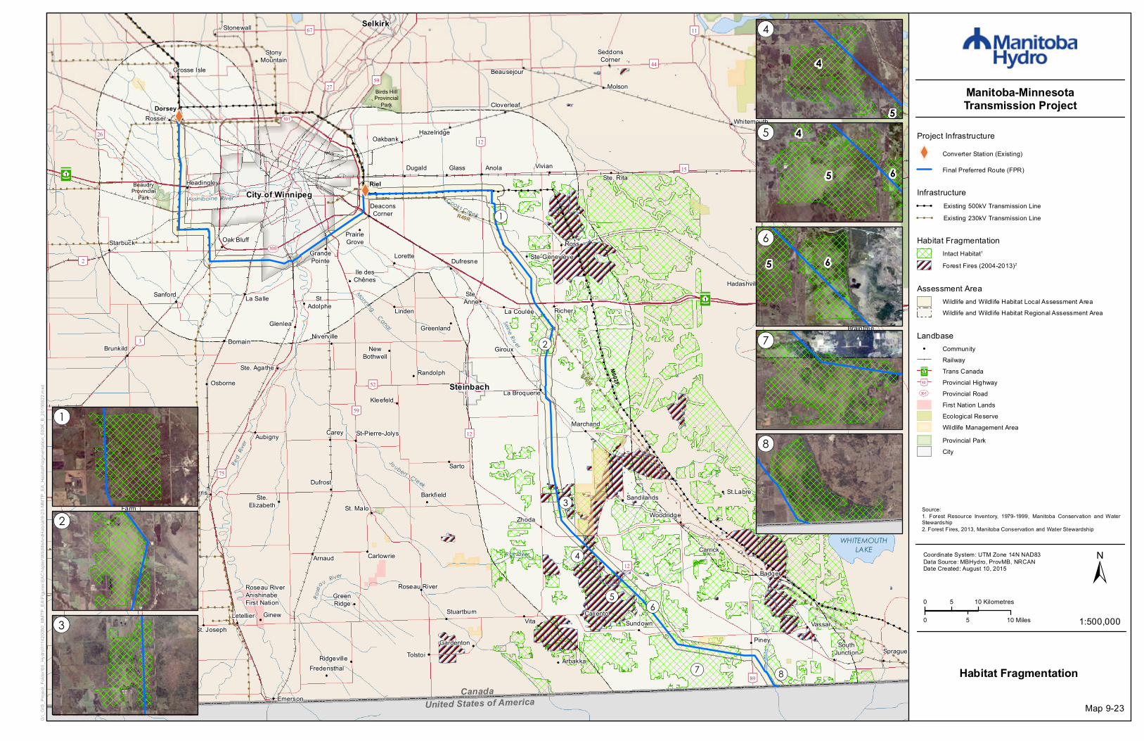
XW
XW
[\59
[\59
[\3
³²1
City of Winnipeg
St. Malo
Riel
Joubert Creek
Rose
au River
United States of America
Red
River
WHITEMOUTHLAKE
Canada
ManningCanal
Assiniboine River Cooks Creek
Seine Riv er
Rat River
[\9
[\15
[\4
[\27
[\75
[\52
[\11
[\44
[\59
[\89
[\67
[\14
[\26
[\12
[\30
[\32
[\11
[\44
[\12
[\12[\26
[\11
[\2UV100
UV101
M602F
R50M
R49R
WhiteshellProvincial
Park
Birds HillProvincial
Park
WhiteshellProvincial
Park
BeaudryProvincial
Park
³²1
Dorsey
Altona
Anola
Arbakka
Arnaud
Aubigny
Badger
Barkfield
Beausejour
Brunkild
Caliento
Carey
CarlowrieCarrick
Cloverleaf
DeaconsCorner
Domain
Dufresne
Dufrost
Dugald
EastBraintree
Elma
Emerson
Fredensthal
Gardenton
Giroux
Glass
Glenlea
GrandePointe
Greenland
GreenRidge
Gretna
Grosse Isle
Hadashville
Hazelridge
Headingley
Horndean
Ile desChênes
KleefeldLa Broquerie
La CouléeLa Salle
Letellier
Linden
Lorette
LoweFarm
Marchand
McMunn
Molson
Morris
NewBothwell
Niverville
Oakbank
Oak Bluff
Osborne
Piney
PrairieGrove
Prawda
Randolph
Rennie
Richer
Ridgeville
Roseau River
Ross
Rosser
St.Adolphe
Ste. Agathe
Ste.Elizabeth
Ste-Geneviève
Ste. Rita
St. Joseph
St.Labre
St-Pierre-Jolys
Sandilands
Sanford
Sarto
SeddonsCorner
SouthJunction Sprague
Starbuck
Steinbach
StonyMountain
StuartburnSundown
Tolstoi
VassarVita
Vivian
Whitemouth
Woodridge
Roseau RiverAnishinabeFirst Nation
Ste.Anne
Ginew
Stonewall Selkirk
Zhoda
!(8!(7
!(6!(5
!(4
!(3
!(2
!(1
0 5 10 Kilometres
0 105 Miles 1:500,000
±Coordinate System: UTM Zone 14N NAD83Data Source: MBHydro, ProvMB, NRCANDate Created: August 10, 2015
Manitoba-MinnesotaTransmission Project
G:\_G
IS_P
rojec
t_Fold
er\00
_Hyd
ro\11
1420
050_
MMTP
_EA\
Figur
es\EA
Chap
ter\W
ildlife
AndH
abita
t\9-23
-MMT
P_EA
_Hab
itatFr
agme
ntatio
n_50
0K_B
_201
5062
2.mxd
Project Infrastructure
XW Converter Station (Existing)
Final Preferred Route (FPR)
Habitat Fragmentation
Infrastructure! ! ! Existing 500kV Transmission Line! ! ! Existing 230kV Transmission Line
Habitat FragmentationIntact Habitat1
Forest Fires (2004-2013)2
Assessment AreaWildlife and Wildlife Habitat Local Assessment AreaWildlife and Wildlife Habitat Regional Assessment Area
4
5
5 6
4
65
!(1
!(2
!(3
!(4
!(5
!(6
!(7
!(8
Landbase! Community
RailwayTrans CanadaProvincial HighwayProvincial RoadFirst Nation LandsEcological ReserveWildlife Management AreaProvincial ParkCity
³²1
[\12
UV301
Source:1. Forest Resource Inventory, 1979-1999, Manitoba Conservation and WaterStewardship2. Forest Fires, 2013, Manitoba Conservation and Water Stewardship
Map 9-23
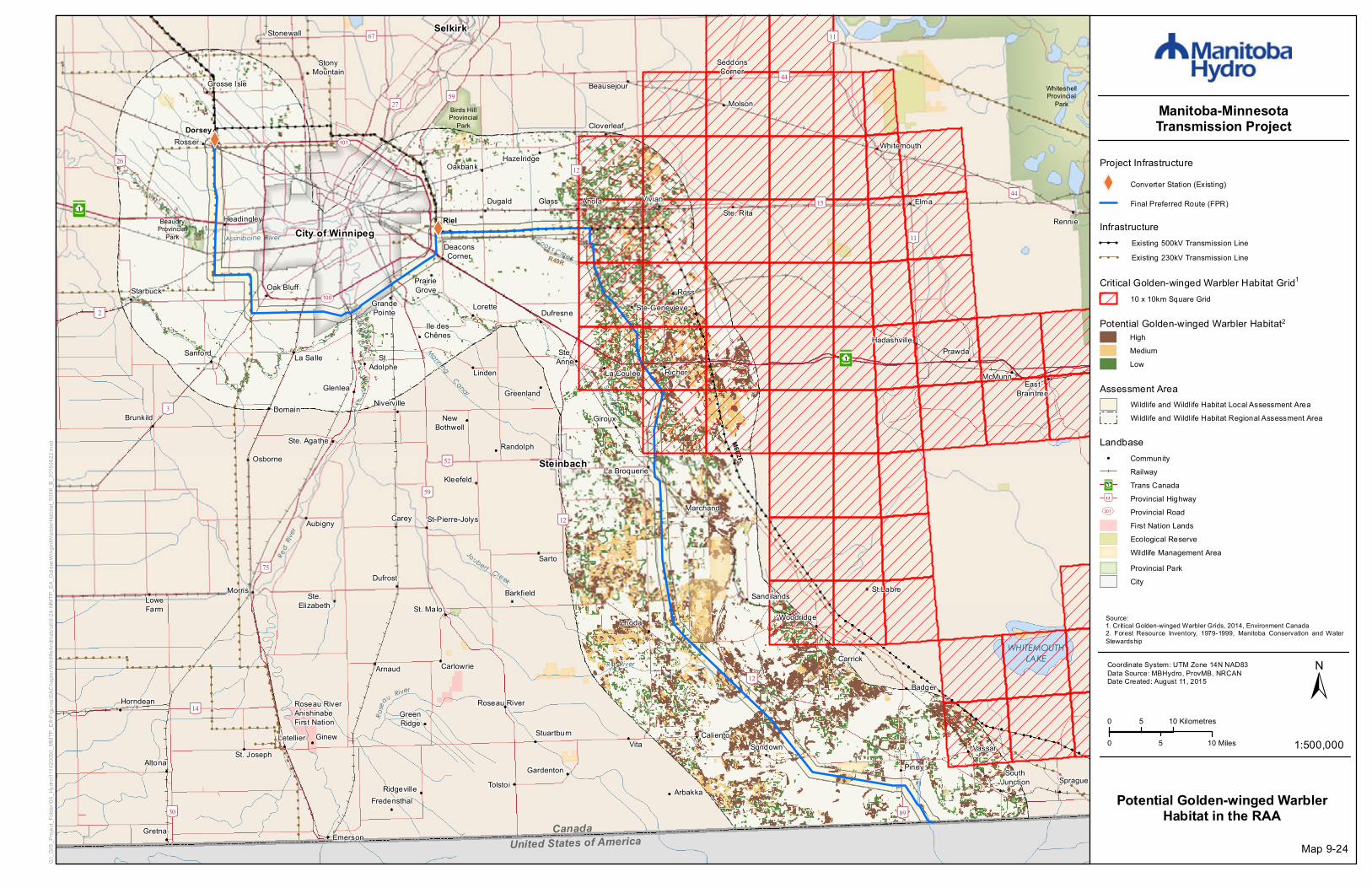
XW
XW
[\59
[\59
[\3
³²1
City of Winnipeg
St. Malo
Riel
Joubert Creek
Rose
au River
United States of America
Red
River
WHITEMOUTHLAKE
Canada
ManningCanal
Assiniboine River Cooks Creek
Seine Riv er
Rat River
[\9
[\15
[\4
[\27
[\75
[\52
[\11
[\44
[\59
[\89
[\67
[\14
[\26
[\12
[\30
[\32
[\11
[\44
[\12
[\12[\26
[\11
[\2UV100
UV101
M602F
R50M
R49R
WhiteshellProvincial
Park
Birds HillProvincial
Park
WhiteshellProvincial
Park
BeaudryProvincial
Park
³²1
Dorsey
Altona
Anola
Arbakka
Arnaud
Aubigny
Badger
Barkfield
Beausejour
Brunkild
Caliento
Carey
CarlowrieCarrick
Cloverleaf
DeaconsCorner
Domain
Dufresne
Dufrost
Dugald
EastBraintree
Elma
Emerson
Fredensthal
Gardenton
Giroux
Glass
Glenlea
GrandePointe
Greenland
GreenRidge
Gretna
Grosse Isle
Hadashville
Hazelridge
Headingley
Horndean
Ile desChênes
KleefeldLa Broquerie
La CouléeLa Salle
Letellier
Linden
Lorette
LoweFarm
Marchand
McMunn
Molson
Morris
NewBothwell
Niverville
Oakbank
Oak Bluff
Osborne
Piney
PrairieGrove
Prawda
Randolph
Rennie
Richer
Ridgeville
Roseau River
Ross
Rosser
St.Adolphe
Ste. Agathe
Ste.Elizabeth
Ste-Geneviève
Ste. Rita
St. Joseph
St.Labre
St-Pierre-Jolys
Sandilands
Sanford
Sarto
SeddonsCorner
SouthJunction Sprague
Starbuck
Steinbach
StonyMountain
StuartburnSundown
Tolstoi
VassarVita
Vivian
Whitemouth
Woodridge
Roseau RiverAnishinabeFirst Nation
Ste.Anne
Ginew
Stonewall Selkirk
Zhoda
0 5 10 Kilometres
0 105 Miles 1:500,000
±Coordinate System: UTM Zone 14N NAD83Data Source: MBHydro, ProvMB, NRCANDate Created: August 11, 2015
Manitoba-MinnesotaTransmission Project
G:\_G
IS_P
rojec
t_Fold
er\00
_Hyd
ro\11
1420
050_
MMTP
_EA\
Figur
es\EA
Chap
ter\W
ildlife
AndH
abita
t\9-24
-MMT
P_EA
_Gold
enW
inged
Warb
lerHa
bitat_
500K
_B_2
0150
622.m
xd
Project Infrastructure
XW Converter Station (Existing)
Final Preferred Route (FPR)
Potential Golden-winged WarblerHabitat in the RAA
Infrastructure! ! ! Existing 500kV Transmission Line! ! ! Existing 230kV Transmission Line
Critical Golden-winged Warbler Habitat Grid1
10 x 10km Square Grid
Assessment AreaWildlife and Wildlife Habitat Local Assessment AreaWildlife and Wildlife Habitat Regional Assessment Area
Landbase! Community
RailwayTrans CanadaProvincial HighwayProvincial RoadFirst Nation LandsEcological ReserveWildlife Management AreaProvincial ParkCity
³²1
[\12
UV301
Source:1. Critical Golden-winged Warbler Grids, 2014, Environment Canada2. Forest Resource Inventory, 1979-1999, Manitoba Conservation and WaterStewardship
Potential Golden-winged Warbler Habitat2HighMediumLow
Map 9-24

XW
XW
[\59
[\59
[\3
³²1
City of Winnipeg
St. Malo
Riel
Joubert Creek
Rose
au River
United States of America
Red
River
WHITEMOUTHLAKE
Canada
ManningCanal
Assiniboine River Cooks Creek
Seine Riv er
Rat River
[\9
[\15
[\4
[\27
[\75
[\52
[\11
[\44
[\59
[\89
[\67
[\14
[\26
[\12
[\30
[\32
[\11
[\44
[\12
[\12[\26
[\11
[\2UV100
UV101
M602F
R50M
R49R
WhiteshellProvincial
Park
Birds HillProvincial
Park
WhiteshellProvincial
Park
BeaudryProvincial
Park
³²1
Dorsey
Altona
Anola
Arbakka
Arnaud
Aubigny
Badger
Barkfield
Beausejour
Brunkild
Caliento
Carey
CarlowrieCarrick
Cloverleaf
DeaconsCorner
Domain
Dufresne
Dufrost
Dugald
EastBraintree
Elma
Emerson
Fredensthal
Gardenton
Giroux
Glass
Glenlea
GrandePointe
Greenland
GreenRidge
Gretna
Grosse Isle
Hadashville
Hazelridge
Headingley
Horndean
Ile desChênes
KleefeldLa Broquerie
La CouléeLa Salle
Letellier
Linden
Lorette
LoweFarm
Marchand
McMunn
Molson
Morris
NewBothwell
Niverville
Oakbank
Oak Bluff
Osborne
Piney
PrairieGrove
Prawda
Randolph
Rennie
Richer
Ridgeville
Roseau River
Ross
Rosser
St.Adolphe
Ste. Agathe
Ste.Elizabeth
Ste-Geneviève
Ste. Rita
St. Joseph
St.Labre
St-Pierre-Jolys
Sandilands
Sanford
Sarto
SeddonsCorner
SouthJunction Sprague
Starbuck
Steinbach
StonyMountain
StuartburnSundown
Tolstoi
VassarVita
Vivian
Whitemouth
Woodridge
Roseau RiverAnishinabeFirst Nation
Ste.Anne
Ginew
Stonewall Selkirk
Zhoda
0 5 10 Kilometres
0 105 Miles 1:500,000
±Coordinate System: UTM Zone 14N NAD83Data Source: MBHydro, ProvMB, NRCANDate Created: August 10, 2015
Manitoba-MinnesotaTransmission Project
G:\_G
IS_P
rojec
t_Fold
er\00
_Hyd
ro\11
1420
050_
MMTP
_EA\
Figur
es\EA
Chap
ter\W
ildlife
AndH
abita
t\9-25
-MMT
P_EA
_Gras
sland
Habit
at_50
0K_B
_201
5062
2.mxd
Project Infrastructure
XW Converter Station (Existing)
Final Preferred Route (FPR)
Grassland Habitat
Infrastructure! ! ! Existing 500kV Transmission Line! ! ! Existing 230kV Transmission Line
Grassland Habitat1Grassland
Assessment AreaWildlife and Wildlife Habitat Local Assessment AreaWildlife and Wildlife Habitat Regional Assessment Area
Landbase! Community
RailwayTrans CanadaProvincial HighwayProvincial RoadFirst Nation LandsEcological ReserveWildlife Management AreaProvincial ParkCity
³²1
[\12
UV301
Source:1. Federal Land Cover Classification, 1996-2005, Natural Resources Canada
Map 9-25
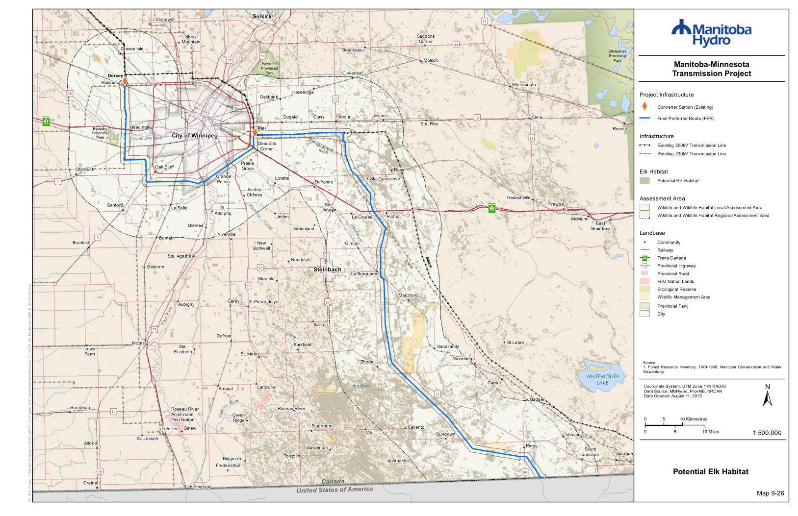
XW
XW
[\59
[\59
[\3
³²1
City of Winnipeg
St. Malo
Riel
Joubert Creek
Rose
au River
United States of America
Red
River
WHITEMOUTHLAKE
Canada
ManningCanal
Assiniboine River Cooks Creek
Seine Riv er
Rat River
[\9
[\15
[\4
[\27
[\75
[\52
[\11
[\44
[\59
[\89
[\67
[\14
[\26
[\12
[\30
[\32
[\11
[\44
[\12
[\12[\26
[\11
[\2UV100
UV101
M602F
R50M
R49R
WhiteshellProvincial
Park
Birds HillProvincial
Park
WhiteshellProvincial
Park
BeaudryProvincial
Park
³²1
Dorsey
Altona
Anola
Arbakka
Arnaud
Aubigny
Badger
Barkfield
Beausejour
Brunkild
Caliento
Carey
CarlowrieCarrick
Cloverleaf
DeaconsCorner
Domain
Dufresne
Dufrost
Dugald
EastBraintree
Elma
Emerson
Fredensthal
Gardenton
Giroux
Glass
Glenlea
GrandePointe
Greenland
GreenRidge
Gretna
Grosse Isle
Hadashville
Hazelridge
Headingley
Horndean
Ile desChênes
KleefeldLa Broquerie
La CouléeLa Salle
Letellier
Linden
Lorette
LoweFarm
Marchand
McMunn
Molson
Morris
NewBothwell
Niverville
Oakbank
Oak Bluff
Osborne
Piney
PrairieGrove
Prawda
Randolph
Rennie
Richer
Ridgeville
Roseau River
Ross
Rosser
St.Adolphe
Ste. Agathe
Ste.Elizabeth
Ste-Geneviève
Ste. Rita
St. Joseph
St.Labre
St-Pierre-Jolys
Sandilands
Sanford
Sarto
SeddonsCorner
SouthJunction Sprague
Starbuck
Steinbach
StonyMountain
StuartburnSundown
Tolstoi
VassarVita
Vivian
Whitemouth
Woodridge
Roseau RiverAnishinabeFirst Nation
Ste.Anne
Ginew
Stonewall Selkirk
Zhoda
0 5 10 Kilometres
0 105 Miles 1:500,000
±Coordinate System: UTM Zone 14N NAD83Data Source: MBHydro, ProvMB, NRCANDate Created: August 11, 2015
Manitoba-MinnesotaTransmission Project
G:\_G
IS_P
rojec
t_Fold
er\00
_Hyd
ro\11
1420
050_
MMTP
_EA\
Figur
es\EA
Chap
ter\W
ildlife
AndH
abita
t\9-26
-MMT
P_EA
_ElkH
abita
t_500
K_B_
2015
0622
.mxd
Project Infrastructure
XW Converter Station (Existing)
Final Preferred Route (FPR)
Potential Elk Habitat
Infrastructure! ! ! Existing 500kV Transmission Line! ! ! Existing 230kV Transmission Line
Assessment AreaWildlife and Wildlife Habitat Local Assessment AreaWildlife and Wildlife Habitat Regional Assessment Area
Source:1. Forest Resource Inventory, 1979-1999, Manitoba Conservation and WaterStewardship
Landbase! Community
RailwayTrans CanadaProvincial HighwayProvincial RoadFirst Nation LandsEcological ReserveWildlife Management AreaProvincial ParkCity
³²1
[\12
UV301
Map 9-26
Elk HabitatPotential Elk Habitat1

XW
XW
[\59
[\59
[\3
³²1
City of Winnipeg
St. Malo
Riel
Joubert Creek
Rose
au River
United States of America
Red
River
WHITEMOUTHLAKE
Canada
ManningCanal
Assiniboine River Cooks Creek
Seine Riv er
Rat River
[\9
[\15
[\4
[\27
[\75
[\52
[\11
[\44
[\59
[\89
[\67
[\14
[\26
[\12
[\30
[\32
[\11
[\44
[\12
[\12[\26
[\11
[\2UV100
UV101
M602F
R50M
R49R
WhiteshellProvincial
Park
Birds HillProvincial
Park
WhiteshellProvincial
Park
BeaudryProvincial
Park
³²1
Dorsey
Altona
Anola
Arbakka
Arnaud
Aubigny
Badger
Barkfield
Beausejour
Brunkild
Caliento
Carey
CarlowrieCarrick
Cloverleaf
DeaconsCorner
Domain
Dufresne
Dufrost
Dugald
EastBraintree
Elma
Emerson
Fredensthal
Gardenton
Giroux
Glass
Glenlea
GrandePointe
Greenland
GreenRidge
Gretna
Grosse Isle
Hadashville
Hazelridge
Headingley
Horndean
Ile desChênes
KleefeldLa Broquerie
La CouléeLa Salle
Letellier
Linden
Lorette
LoweFarm
Marchand
McMunn
Molson
Morris
NewBothwell
Niverville
Oakbank
Oak Bluff
Osborne
Piney
PrairieGrove
Prawda
Randolph
Rennie
Richer
Ridgeville
Roseau River
Ross
Rosser
St.Adolphe
Ste. Agathe
Ste.Elizabeth
Ste-Geneviève
Ste. Rita
St. Joseph
St.Labre
St-Pierre-Jolys
Sandilands
Sanford
Sarto
SeddonsCorner
SouthJunction Sprague
Starbuck
Steinbach
StonyMountain
StuartburnSundown
Tolstoi
VassarVita
Vivian
Whitemouth
Woodridge
Roseau RiverAnishinabeFirst Nation
Ste.Anne
Ginew
Stonewall Selkirk
Zhoda
0 5 10 Kilometres
0 105 Miles 1:500,000
±Coordinate System: UTM Zone 14N NAD83Data Source: MBHydro, ProvMB, NRCANDate Created: August 11, 2015
Manitoba-MinnesotaTransmission Project
G:\_G
IS_P
rojec
t_Fold
er\00
_Hyd
ro\11
1420
050_
MMTP
_EA\
Figur
es\EA
Chap
ter\W
ildlife
AndH
abita
t\9-27
-MMT
P_EA
_Ame
rican
Marte
nHab
itat_5
00K_
B_20
1506
22.m
xd
Project Infrastructure
XW Converter Station (Existing)
Final Preferred Route (FPR)
Potential American Marten Habitat
Infrastructure! ! ! Existing 500kV Transmission Line! ! ! Existing 230kV Transmission Line
Potential American Marten Habitat1American Marten Habitat
Assessment AreaWildlife and Wildlife Habitat Local Assessment AreaWildlife and Wildlife Habitat Regional Assessment Area
Landbase! Community
RailwayTrans CanadaProvincial HighwayProvincial RoadFirst Nation LandsEcological ReserveWildlife Management AreaProvincial ParkCity
³²1
[\12
UV301
Source:1. Forest Resource Inventory, 1979-1999, Manitoba Conservation and WaterStewardship
Map 9-27

XW
XW
!(
!(
!(
!( !(
!(
!(!(
!(
!(
!(
!(
!(
!(
!(
!(
!(
!(
!(
!(
!(
!(
")
")")
")")
!(
!(!(!( !(
!(
!(
!(
!(
!(
!(
!(!(
!(
!(!(
!(
!(
!(
!(
!(
!(!(
!(
!(
[\59
[\59
[\3
³²1
City of Winnipeg
St. Malo
Riel
Joubert Creek
Rose
au River
United States of America
Red
River
WHITEMOUTHLAKE
Canada
ManningCanal
Assiniboine River Cooks Creek
Seine Riv er
Rat River
[\9
[\15
[\4
[\27
[\75
[\52
[\11
[\44
[\59
[\89
[\67
[\14
[\26
[\12
[\30
[\32
[\13
[\11
[\44
[\12
[\12[\26
[\11
[\2UV100
UV101
M602F
R50M
R49R
³²1
Dorsey
Altona
Anola
Arbakka
Arnaud
Aubigny
Badger
Barkfield
Beausejour
Brunkild
Caliento
Carey
CarlowrieCarrick
Cloverleaf
DeaconsCorner
Domain
Dufresne
Dufrost
Dugald
EastBraintree
Elma
Emerson
Fredensthal
Gardenton
Giroux
Glass
Glenlea
GrandePointe
Greenland
GreenRidge
Gretna
Grosse Isle
Hadashville
Hazelridge
Headingley
Horndean
Ile desChênes
KleefeldLa Broquerie
La CouléeLa Salle
Letellier
Linden
Lorette
LoweFarm
Marchand
McMunn
Molson
Morris
NewBothwell
Niverville
Oakbank
Oak Bluff
Osborne
Piney
PrairieGrove
Prawda
Randolph
Rennie
Richer
Ridgeville
Roseau River
Ross
Rosser
St.Adolphe
Ste. Agathe
Ste.Elizabeth
Ste-Geneviève
Ste. Rita
St. Joseph
St.Labre
St-Pierre-Jolys
Sandilands
Sanford
Sarto
SeddonsCorner
SouthJunction Sprague
Starbuck
Steinbach
StonyMountain
StuartburnSundown
Tolstoi
VassarVita
Vivian
Whitemouth
Woodridge
Roseau RiverAnishinabeFirst Nation
Ste.Anne
Ginew
Stonewall Selkirk
Zhoda
0 5 10 Kilometres
0 105 Miles 1:500,000
±Coordinate System: UTM Zone 14N NAD83Data Source: MBHydro, ProvMB, NRCANDate Created: August 11, 2015
Manitoba-MinnesotaTransmission Project
G:\_G
IS_P
rojec
t_Fold
er\00
_Hyd
ro\11
1420
050_
MMTP
_EA\
Figur
es\EA
Chap
ter\W
ildlife
AndH
abita
t\9-28
-MMT
P_EA
_Grou
seLe
ks_5
00K_
B_20
1506
22.m
xd
Project Infrastructure
XW Converter Station (Existing)
Final Preferred Route (FPR)
Sharp-tailed Grouse Leks
Infrastructure! ! ! Existing 500kV Transmission Line! ! ! Existing 230kV Transmission Line
Assessment AreaWildlife and Wildlife Habitat Local Assessment AreaWildlife and Wildlife Habitat Regional Assessment Area
Map 9-28
Landbase! Community
RailwayTrans CanadaProvincial HighwayProvincial RoadFirst Nation LandsCity
³²1
[\12
UV301
Grouse Lek Survey Features and Habitat!( Incidental Sharp-tailed Grouse Observation") Lek Observation!( Grouse Lek Survey Site
3 Grouse Leks (MCWS data)Potential Grouse Lek Habitat1
Source:1. Federal Land Cover Classification, 1996-2005, Natural Resources Canada

!!
!!
!
!!
!!!!!!!
!
!
!
!
!
!
!
!
!
!
!
!
!
!
!
!
!
!
!
!
!
!
!
!
!
!
!
!
!
!
!
!
!
!
!
!
!
!
!
!
!
!!
!!
!
!
!
!!!
!!
!!
!!
!
!
!!
!!
!!
!!
!!
!!
!!
!!
!!
!!
!
!!
!!
!!
!
!!
!!
!!!!
!!
!
!!!!!!!!!
!!
!!
!!
!!
!!
!!
!!
!
!
!!
!
!
!
!
!
!
!
!
!
!
!
!
!
!
!
!
!
!
!
!
!
!
!
!
!
!
!
!
!
!
!
!
!
!
!
!
!
!
!
!!!!
!
!
!
! !!"3E
!
!
Assiniboine River
Sewell Lake
NobleLake
BoneLake
Black Creek
Cypre
s sRiv
er
G37C - GLENBORO TO CORNWALLIS
CANADIAN PACIFIC RAILWAY (CPR)
CANADIAN NATIONAL (CN) RAILWAY
Swan LakeFirst
Nation
[\18
[\34
Glenboro South Station
G82R
- GLE
NBOR
O TO
RUG
BY
S53G - ST LEON TO GLENBORO
NORTHCYPRESS
NORTHNORFOLK
BRANDO N
CORNWALLIS
SOUTHCYPRESS VICTORIA
OAKLAND
WAWANESA
GLENBORO
RIVERSIDE STRATHCONALORNE
ARGYLE
SOURIS RIVERBEND W ILDLIFEMANAGEMENT AREA
WHITEMUDWATERSHED
WILDLIFEMANAGEMENT AREA
SPRUCE WOODSWILDLIFE
MANAGEMENT AREA
ASSINIBOINECORRIDORWILDLIFE
MANAGEMENT AREA
TIGER HILLSWILDLIFE
MANAGEMENTAREA
PEMBINA VALLEYWILDLIFE
MANAGEMENT AREA
UV675
UV605
UV344
UV457
UV530
UV532
UV453
UV245
UV340
UV352
UV342
Swan LakeFirst
Nation
[\18 [\5
[\34
[\2
[\23
Criddle/VaneHomestead
Provincial Park
Spruce WoodsProvincial
Park
Glenboro
Wawanesa
0 5 Kilometres
0 52.5 Miles 1:200,000
±Coordinate System: UTM Zone 14N NAD83Data Source: MBHydro, ProvMB, NRCANDate Created: August 11, 2015
Manitoba-MinnesotaTransmission Project
G:\_G
IS_P
rojec
t_Fold
er\00
_Hyd
ro\11
1420
050_
MMTP
_EA\
Figur
es\EA
Chap
ter\W
ildlife
AndH
abita
t\9-29
-MMT
P_EA
_Grou
seLe
ks_G
lenbo
ro_20
0K_B
_201
5062
2.mxd
Project Infrastructure"3E Electrical Station
Sharp-tailed Grouse LeksGlenboro South Station
Map 9-29
Infrastructure! ! Existing Transmission Line
Assessment AreaWildlife and Wildlife Habitat Local Assessment AreaWildlife and Wildlife Habitat Regional Assessment Area
Grouse Lek Survey Features and Habitat4 Grouse Leks (MCWS data)Potential Grouse Lek Habitat1
Landbase! Community
Provincial HighwayProvincial RoadRailwayFirst Nation LandsWildlife Management AreaProvincial ParkRural Municipality
[\12
UV301
Source:1. Federal Land Cover Classification, 1996-2005, Natural Resources Canada

XW
XW
!(!(!(!(!(!(
!(!(!(!(
!(!(!(!(
!(!(!(!(
!(!(!(!(
!(!(!(!(
!(!(!(!(
[\59
[\59
[\3
³²1
City of Winnipeg
St. Malo
Riel
Joubert Creek
Rose
au River
United States of America
Red
River
WHITEMOUTHLAKE
Canada
ManningCanal
Assiniboine River Cooks Creek
Seine Riv er
Rat River
!(
[\9
[\15
[\4
[\27
[\75
[\52
[\11
[\44
[\59
[\89
[\67
[\14
[\26
[\12
[\30
[\32
[\11
[\44
[\12
[\12[\26
[\11
[\2UV100
UV101
M602F
R50M
R49R
WhiteshellProvincial
Park
Birds HillProvincial
Park
WhiteshellProvincial
Park
BeaudryProvincial
Park
³²1
Dorsey
Altona
Anola
Arbakka
Arnaud
Aubigny
Badger
Barkfield
Beausejour
Brunkild
Caliento
Carey
CarlowrieCarrick
Cloverleaf
DeaconsCorner
Domain
Dufresne
Dufrost
Dugald
EastBraintree
Elma
Emerson
Fredensthal
Gardenton
Giroux
Glass
Glenlea
GrandePointe
Greenland
GreenRidge
Gretna
Grosse Isle
Hadashville
Hazelridge
Headingley
Horndean
Ile desChênes
KleefeldLa Broquerie
La CouléeLa Salle
Letellier
Linden
Lorette
LoweFarm
Marchand
McMunn
Molson
Morris
NewBothwell
Niverville
Oakbank
Oak Bluff
Osborne
Piney
PrairieGrove
Prawda
Randolph
Rennie
Richer
Ridgeville
Roseau River
Ross
Rosser
St.Adolphe
Ste. Agathe
Ste.Elizabeth
Ste-Geneviève
Ste. Rita
St. Joseph
St.Labre
St-Pierre-Jolys
Sandilands
Sanford
Sarto
SeddonsCorner
SouthJunction Sprague
Starbuck
Steinbach
StonyMountain
StuartburnSundown
Tolstoi
VassarVita
Vivian
Whitemouth
Woodridge
Roseau RiverAnishinabeFirst Nation
Ste.Anne
Ginew
Stonewall Selkirk
Zhoda
0 5 10 Kilometres
0 105 Miles 1:500,000
±Coordinate System: UTM Zone 14N NAD83Data Source: MBHydro, ProvMB, NRCANDate Created: August 10, 2015
Manitoba-MinnesotaTransmission Project
G:\_G
IS_P
rojec
t_Fold
er\00
_Hyd
ro\11
1420
050_
MMTP
_EA\
Figur
es\EA
Chap
ter\W
ildlife
AndH
abita
t\9-30
-MMT
P_EA
_Bird
Conc
entra
tionS
ites_
500K
_B_2
0150
622.m
xd
Project Infrastructure
XW Converter Station (Existing)
Final Preferred Route (FPR)
Bird Concentration Sitesin the RAA
Infrastructure! ! ! Existing 500kV Transmission Line! ! ! Existing 230kV Transmission Line
Bird Concentration Sites!( Bird Concentration Site
Assessment AreaWildlife and Wildlife Habitat Local Assessment AreaWildlife and Wildlife Habitat Regional Assessment Area
Landbase! Community
RailwayTrans CanadaProvincial HighwayProvincial RoadFirst Nation LandsEcological ReserveWildlife Management AreaProvincial ParkCity
³²1
[\12
UV301
Map 9-30