Embed Size (px)
Citation preview
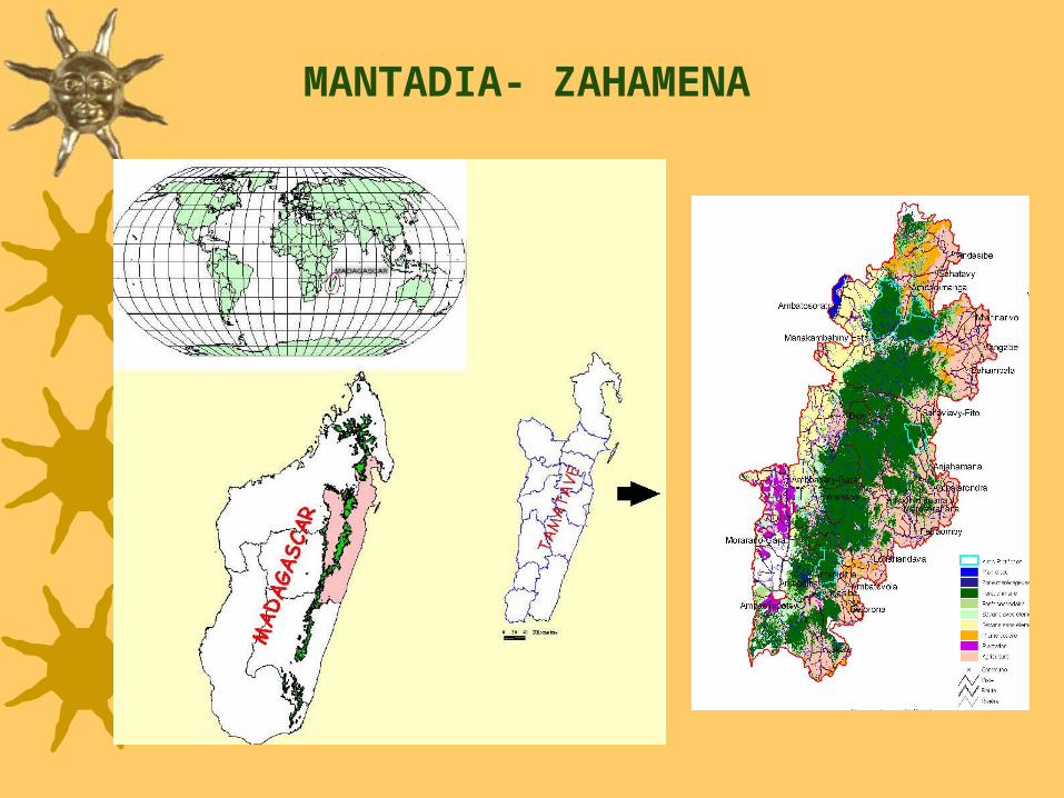
MANTADIA- ZAHAMENA

Deforestation across elevationBetween 1974 and 1994: around 90% of forest <800 m are lostBetween 1990-2000:
0-800 m – 17.8% of the remaining forest are lost800-1200 m – 5%1200-1600 m - <1% Forest logging
Few direct impact of forest extraction on biodiversity Major impacts in the short and medium termOpen up deforestation by local peopleRapid expansion of invasive plant species impeding regeneration of high economic valued species
CONTEXT OF ZAHAMENA-MANTADIA
Corridor area: 540,000 ha
No. Population: ~800,000
Population density:
46 inhabitants/ km2
Mining: small illegal mining activities and 4 companiesHunting: very few data, but in reserves Indri and Varecia populations are abundant compared to other sites

CONTEXT ANALYSIS IN ZAHAMENA-MANTADIA
Durban Vision implementation- Conservation Sites
Design the logical framework to understand links between socio-economic factors and deforestation: issue, factors, changes, data requirement.
Collection and compilation of existing biological and socio-economic data with partners
Identification of gaps of information: RAP
Gap analysis, spatial analysis, participatory appraisal
Combine biological, geographic and economic data layers
Assess the landscape scenarios with associated biodiversity and economic values

CONTEXT ANALYSIS PRODUCTS
Priority zones for conservation are identified, with management rules and options for each zone to achieve conservation goals
Deforestation trends are projected in the future
Opportunity costs and benefits of conservation alternatives are assessed
Landscape scenarios with associated biodiversity and economic values are evaluated

KEY QUESTIONS
Where should the core conservation zone be? => value of biodiversity and ecological services
Where the deforestation rate is the highest in Zahamena-Mantadia ? => vulnerable sites
What and where do ecological function benefits come from, and who received them? => cost-benefit analysis
What management scenarios and rules do we need in order to conserve biodiversity of the highest value across the corridor? => biological and economic criteria

Land use and forest cover
Roads
Protected areas
MCE Analysis
Population density DEM
Vulnerable sites
DATA LAYERSWatersheds
Mining Core Conservation sites

Business-As-Usual : Cellular Automata
Algorithm projects forest cover in 30
years
MCE: Integrate and correlate
socioeconomic variables affecting
deforestation and agricultural activities
Economic analysis of hydrological
benefits of watersheds
Cost-benefit analysis of forest
management transfer to communities
Evaluation of economic impacts from
community-based ecotourism
Development of sustainable and cost-
effective management scenarios
$ $$
$
$$
$
$$
$ $$ $
$$$$
#$
$
#$
$
$
$ $$ $
$#
$
$$
$ $
$
$$
$
$
$
$
$
$$
$ $
$ $
$$
$$
$ $
$$
#$
$$$ $# $
$ $$$
$ $
$$
$
$$
600 650 700
750800
850900
950
Amparafaravola
Ambatondrazaka
Moramanga
Brickaville
Vavatenina
RanomafanaBeforona
Amboasary-Gara
Ambodimanga
Ambatomainty
Sahaviavy-FitoDidy
ManakambahinyAtsinanana
$ Chef-Lieu-commune# Chef-Lieu-Fivondronana
Route nationale
Délimitation corridor Zahamena - Mantadia
No DataTrès fort risque de dégradationFort risque de dégradationMoyen risque de dégradationFaible risque de dégradationTrès faible risque de dégradationDégradation de sol négligeable
Typologie des risques de dégradation des sols
0 25 50 Km
DATA CONSOLIDATION

HURDLES AND AH-HAS
Difficulties: – Lack of data at communal and village level to refine
planning process: need for RAP and RACE – Tamarin modeling needs to be adapted to the
current Site de Conservation establishment process – Mechanism for transferring conservation benefits to
downstream populations should be designed and implemented
Innovative and helpful analysis: – Analysis of risks of erosion – Contribution to the refining of preliminary forest
zoning maps

ENGAGEMENT of STAKEHOLDERS
Regional Development Committees Authorities at provincial,
regional and local level Environment, Water and
Forest departments Local NGOs Private sectors
Local Communities and village Associations
Information- concertation
Communal Planning
Regional Planning
Decision-makingChefs de Region
Platform of coordinationCorridor Management Consolidation
USAID Alliance