Embed Size (px)
Citation preview
MAPPING DYNAMIC EVENTS: POPULAR CONTENTION IN CHINA OVER SPACE AND TIME
Patricia M. Thornton Department of Politics and International Relations, Contemporary Chinese
Studies Programme, and Merton College, University of Oxford, Oxford, United Kingdom
(Received 12 September 2011; final version received 30 November 2011) Students of popular contention have long observed that social unrest mimics the forces of nature, spreading rapidly across time and space, likening it to a “prairie-fire” or observing a “snowball effect” of strikes and work stoppages. Yet little is known or understood either about how unrest spreads across space over time, or regional susceptibility to unrest. In the attempt to test whether such metaphorical references may in fact be empirical grounded, this project links historical data on two documented waves of social unrest during the Republican (1911-1949) and reform (1978-present) eras in Chinese history to static GIS maps, using ArcGIS Tracking Analyst—designed to track dynamic events over time and space— in order to create animated time-series layer capable of revealing the clustering and diffusion of protest events across geographic space over time. Building upon the hierarchical regional space model (HRS) and G.W. Skinner’s work on macroregions in China, we test three key hypotheses regarding the concentration and spread of contentious events within two macroregions during two three-year waves of unrest in modern Chinese history. My longer term goals are to develop broader model to explain the emergence and spread of large-scale collective protest events in Chinese history, and to determine whether certain locales may demonstrate a higher propensity to engage in unrest through the passage of time. The use of animated data layers to capture and record dynamic events over time and space can help to determine whether patterns of clustering and diffusion of protest events remain stable over time, and to test whether spatial knots of “ungovernability”—long a feature of Chinese bureaucratic lore-- persist in the People’s Republic, despite changes in regime type, economic fluctuations, and the passage of time. Keywords: China, protest, dynamic events, clustering, diffusion, Tracking Analyst
1. Introduction Popular contention has risen steadily in post-Mao China, but existing evidence indicates a particularly dramatic and steep surge in protest over the past twelve years. Recently released statistics indicate a ten-fold rise in “collective public security incidents” between 1993 and 2005, and note that these protest events furthermore involve larger numbers of participants over longer durations, and appear better organized than earlier episodes (Chung, Lai and Xia 2006). Newspaper reports suggest that the number of mass incidents has risen again to 127,000—or nearly 326 per day-- in 2008. While some of the recent unrest may be attributable to external factors, most agree that the primary triggers appear to be endogenous. Even Chinese public security officials, who have frequently blamed unrest on externally derived “enemies of the people,” now frankly concede that internal causes underlie the current crisis of order (Tanner 2004: 137).
With a few noteworthy exceptions (Brustein and Levy, 1987; Tilly 2000, Tilly 2003, Sewell 2001, Miller 2000, Miller and Martin 2003), studies of social unrest have paid scant attention to the spatial elements that constrain and enable popular contention, and the field as a whole has remained largely indifferent to geographic considerations (Martin 2000). “Political opportunity” frameworks that link the rise of unrest to the reduction of power disparities between power-holders and challengers (Tarrow 1998; McAdam 1995; Koopmans 1993) do not explain adequately the differences in local susceptibility to protest. “Resource mobilization” approaches predict that higher levels of unrest in locales with relative access to the organizational and material resources to sustain protest movements, but fail to explain the timing of contentious mobilization. In both cases, conventional frameworks employed in empirical studies of protest diffusion assume temporal and spatial homogeneity among actors in a given system, and are insensitive to the ways in which geographic and temporal factors interact to shape collective action over time (Strang and Tuma 1993; Myers and Oliver 2008; Myers 2000).
However, regional variation in the susceptibility to unrest is well documented in Chinese bureaucratic lore dating back several centuries. Certain locales developed reputations for being particularly restive over time, even as neighboring areas remain quiescent. Officials since imperial times have derided such areas as backward (luohou), poverty-striken (pinkun), and desolate (pianpi), in contrast to developed (fada), wealthy (fuyu), civilized (wenming) regions. Prior to the 1949 revolution, early Communist activists especially courted underground networks, bandit gangs and secret societies in such locales, seeking to harness their restive potential to foment class struggle (Chen 1986);
Email: [email protected]
however, due in large part to their persistent inability to fully master these preexisting “local cultures of violence” (van de Ven 2003), Party and state agents continue to refer to areas considered difficult to govern as “old headaches” (lao toutong) (Thaxton, 2008). Significant contributions have documented historic waves of social unrest in specific regions, including strike waves in Shanghai (Perry, 1995; Perry 1994), peasant uprisings in Huaibei (Perry 1980) and the lower Yangzi region (Bernhardt 1992), and incidents of labor unrest in contemporary China’s northeastern rustbelt (Lee 2000). Yet students of collective action in China have only recently begun to pay particular attention to the geographic pattern of social unrest, noting, for example, important differences between the grievances and forms of collective action framed by laid-off workers in state-owned enterprises located in different cities (Hurst 2004), and the unequal distribution of recent collective public security incidents among China’s provinces (Tanner 2004; Chung, Lai and Xia 2006).
Internal documents and published news accounts suggest two broad patterns, both for the current cycle of unrest as well as previous ones: waves of social unrest tend to diffuse regionally within China, but also appear to cluster in certain locales. The analogy often drawn between infectious diseases and the spread of popular contention and conflict (Davis, Duncan, and Siverson 1978; Rapoport 1960; Siverson and Starr 1990) suggests that the probability of “contagion” should vary with both geographic proximity and degree of interaction between members of resident populations. Yet the specifics of how such incidents spread across space, or fail to, remain a mystery. Some researchers have begun using spatially lagged dependent variables to account for the contemporaneous dependence of conflict across neighboring geographical units (Buhaug and Rod, 2006; Urdal, 2008; Weidmann and Toft, 2010). Others deploy spatial variables like nearest neighbor distance and elevation as pre-treatment covariates for matching (Lyall, 2009). However, in both cases, such variables rely upon contiguity and Euclidean point-to-point distance measures that fail to realistically represent how people actually move or travel from one point to another, and therefore introduce bias into estimates of spatial dependence and predictions of how activity may actually cluster and diffuse through geographic space.
Tracking Analyst, an extension to the ArcGIS Desktop that enables users
to build time series visualizations as an animated data layer over static GIS maps, can help overcome such biases by facilitating the detection of patterns in the actual clustering and diffusion of popular contention (Griffin, et.al. 2006), and can help to determine whether certain locales demonstrate an higher propensity for collective protest and other forms of unrest over time. This project used Tracking Analyst to map the patterns of clustering and diffusion of unrest during two historic waves of popular protest five decades apart, centered in two different Chinese macroregions, a physiographic and socioeconomic unit of geographic space introduced by Skinner, drawing upon the broader literature on hierarchical conceptualizations of space.
2. Methodology 2.1. The Hierarchical Regional Space Model in practice
The Hierarchical Regional Space (hereafter, HRS) Model that informs much of the work conducted in China Historical GIS draws upon several fundamental concepts in modern geographical thought, including central place theory, location theory, regional systems theory, and diffusion theory (Skinner, Henderson and Yuan, 2000). Christaller’s (1966 [1933]) central place theory predicts the emergence of a hierarchy of settlements in agrarian societies, in which each level provides particular services and attains a corresponding level of development. Human communities orient their economic activities to specific central places within that hierarchy and the particular services provided there. For example, the nearby market town is frequented to acquire items for daily use, cities for fashionable clothes, and major metropolises for more specialized services. Hierarchical levels providing more specialized and therefore less easily acquired goods service a correspondingly wider hinterland, and, for reasons of transportation and economic efficiency, the hinterlands at each level become nested over time. Relatedly, von Thunen (1966 [1826]) observed how zones of economic activity that varied in terms of agricultural intensity, transport efficiency, and along other registers fill the geographic space around urban centers. Following von Thunen, regional systems theory subsequently conceptualized these regions as local or regional socioeconomic systems arrayed as core-periphery structures, centered at urban nodes and nested in a more or less integrated hierarchy. Finally, Hägerstrand’s (1965) diffusion theory draws attention to the diffusion of innovation across geographic space along two paths. Innovations introduced in cities or towns may radiate outward from urban centers to the surrounding rural hinterlands, but may also travel down the central place hierarchy from urban nodes to dependent towns, and from those towns diffuse into the wider hinterlands. Skinner, Henderson and Yuan (2000) suggest that successive diffusion of waves of innovation along these established pathways reinforce the regional systems hierarchy and core-periphery structures over time, persisting despite industrialization and socioeconomic change.
Building upon the HRS model in his spatial analysis of market towns in late imperial China, Skinner further noted the emergence of nine well-defined and internally integrated macroregions centered on major watersheds or drainage basins. Higher transportation costs on the peripheries of such regions minimized both transactions between macroregions and transboundary exchanges, prompting regional development within macroregions over time (Skinner 1964, 1965a, 1965b, 1985). Internal to each macroregion, Skinner observed the coexistence of three types of marketing communities: standard, intermediate and central, with the latter generally corresponding to the county (xian) capitals of the late imperial administrative system. The structure and geographic positioning of these rural markets, Skinner (1964: 3) posited, “inevitably shape[d] local social organization and provide[d] one of the crucial modes for integrating myriad peasant communities into the single social system
which is the total society.” Furthermore, while he conceded that both rural and urban settlement patterns shifted over time, Skinner nonetheless maintained that “an adequate interpretation of developments since 1949 in the Chinese countryside must rest on a prior analysis of premodern peasant marketing,” with the cities in each macroregion forming functional nodes that continue to “serve to articulate and integrate human activity in time and space” (1977:216-17) down to the present day, giving shape to crises and “internal disturbances” such as political and popular conflict.
While some have raised questions about the utility of the macroregion as a unit of geographic analysis, in one case going so far as to argue that Skinner’s “concepts are difficult to test… seriously flawed, and…lack real explanatory power” (Sands and Meyers 1986: 737), others have pointed out that when “viewing the macro-scale features of China’s regional analysis, there is a broad concordance between Skinner’s predictions and the available data” (Lavely, 1989:112; cf. Little and Esherick, 1989); and many regard Skinner’s models as a “the dominant paradigm in Chinese historiography for the study of regions” (Cartier 2002: 80). Given the focus of the current project on not only the concentration of social unrest, but also its diffusion across geographic space in China, Skinner’s macroregions provide an invaluable model against which to test the regional diffusion of sociopolitical phenomenon across multiple administrative jurisdictions over time. 2.2. Research hypotheses
I test three main hypotheses regarding the geographic distribution of unrest in modern China during waves of protest.
Following Skinner’s observations regarding the human geography of late imperial China, the first initial hypothesis tested is that protest events in both periods will cluster in less prosperous and urbanized counties around secondary trade routes within a particular macroregion. Although Hagerstrand’s application of the concept of diffusion to hierarchical place models suggests that processes associated with innovation diffuse downwards through the hierarchy from urban centers (Hudson 1969: 45), the diffusion of collective violence follows a rather more complex pattern. In their research on sixteenth- and seventeenth-century rebellions in France, England, and Spain, Brustein and Levy (1987) found that the highest incidence of agrarian anti-state collective action occurred in those regions where there was both a context for rebellion and higher levels of capacity, opportunity, and resources for collective action, as measured in terms of degrees of regional integration, conditional cooperation, and the existence of strong communal institutions. The degree of socioeconomic integration characteristic of macroregions encourages the formation of nested clusters of specialized activity within their boundaries; in their study of the spatial clustering of armed conflicts, Buhaug and Gleditsch (2008) find that the risk of contingent contagion correlates with both interaction opportunities and exposure, both obviously higher within a macroregion than between them. The uneven
concentration of state (repressive) resources along primary trade routes and in major urban commercial and administrative centers likewise facilitates the clustering of protest incidents along secondary trade routes and in less developed counties, where distance and inaccessibility are more likely to present series obstacles to authorities seeking to restore order. Barkey and van Rossem’s (1997) research on networks of contention in the Ottoman Empire found that isolated villages in peripheral regions tended to remain quiescent, as did villages located along major trade routes that benefit from state and market expansion; intermediate-sized villages exposed to the pressures of change that were less capable of insulating themselves from commercialization and state-making incursions were most prone to popular contention.
Second, given the lower transportation costs and regional integration described by Skinner’s model, I hypothesized that social unrest more easily diffuses within macroregions than across the borders between them. Historical studies of social unrest have noted that crowd action has often diffused along major transportation routes (Rude 1964: 25; Shibutani 1966: 103-6); it has also been observed that roads reduce the costs of sustaining and expanding insurgent operations, and therefore facilitate the spread of insurgent violence from one locale to another (Buhuag and Rod, 2006). The scholarly literature on social mobilization supports the view that organizers of protest actions frequently mobilize through preexisting local social networks after receiving news about developing riots (Singer 1968) and sit-in campaigns (Morris 1984) in neighboring areas. While improved transportation networks in the contemporary period have certainly had a significant impact on the costs of market transactions across macroregion borders, the historical legacies and shared human geography of previous decades will nonetheless continue to play a role in shaping networks of popular contention in the contemporary era. As the analogies often drawn between the spread of conflict and contagions of epidemic diseases suggest (Davis, Duncan, and Siverson 1978; Rapoport 1960; Siverson and Starr 1990), there is some evidence that the diffusion of protest varies with interaction (Watts 2003). Alternatively, a widely deployed gravity model suggests that the extent of interaction between two units is proportional to their combined size, and inversely proportional to the distance separating them (Linnemann 1966; Zipf 1949). If we assume that the same constraints that shape other forms of social interaction also apply to the diffusion of popular contention, it follows that diffusion effects would likely spread first along major transportation routes within macroregional borders.
However, third, I hypothesized that precisely for the foregoing reason, the correlation between protest diffusion and macroregional boundaries is likely to weaken over time demonstrating varying patterns of diffusion. Centralized economic planning during the Mao era indisputably disrupted traditional peasant marketing practices (Huang 1990; Potter and Potter 1990), and post-Mao market reforms brought even the more remote peripheral regions into greater and more sustained contact with “core” areas (i.e., Cartier 2002). As Rozman (1973) pointed out, the emergence of national markets for commodities of mass
consumption and the rise of interregional trade—both of which began in the late imperial era—has likewise tended to weaken internal regional integration, and create cross-regional linkages over time. The greater openness at all levels to transnational forces and increased levels of social mobility combined with new communication technologies all suggest that patterns of protest diffusion will be less constrained by the forces that constrain trans-macroregional development than those noted during the period of Republican rule. 2.3 Data
I selected two three-year waves of social unrest centered in two macroregions, separated by just over six decades. The first wave occurred during the final tumultuous years of the Republican era (1946-1949), when the Nationalist government was still attempting to restore order to territories relinquished by the defeated Japanese forces, while also suppressing the Communist insurgency to which it ultimately fell. The geographic unit tested was then China’s most prosperous and economically advanced Lower Yangzi macroregion, also long noted for its historic inclination to social disturbances (Bianco, 2001: 122; Huang, 2009). The second period runs from 2007-2010 and is centered in the southern Lingnan macroregion, a highly prosperous economic powerhouse fueling industrial growth during the reform era. However, insofar as this latest cycle of development has relied heavily upon low-paid migrant workers, the Pearl River Delta in the heart of the Lingnan macroregion has emerged as a center of labor-related protest in the contemporary period (Chan and Ngai, 2009).
Research began with the compilation of two protest event catalogs, one for each macroregion during the three-year cycle in question, using similar protocols. For the 1946-1949 an period, I relied on a well-known database of collected local historical and literary materials focused on the late Republican era. Regional compilation of the Historical and Literary Information series (Wenshi ziliao) originally began with former Premier Zhou Enlai’s 1959 directive to the People’s Consultative Conferences nationwide to record their reminiscences of historic events for posterity; these reminiscences of local and national events have since been digitized, with full-text online searching. The event catalog relied upon the online version of these published provincial- and county-level serials for the Republican era. The advantage of using this source for the study of collective action is that a rather full range of historical contentious incidents is detailed in the published accounts, a process overseen by divisions of local and municipal Communist Party Committees. However, for the same reason, incidents of resistance against Communist organizations, or those that may shed negative light on the historical development of the Chinese Communist Party are underreported. For the 2007-2o10 period, a similar protocol was used with the online China Core Newspaper Database (CNKI). Individual records for both periods were initially retrieved by searching on a list of keywords relating to protest events; incomplete records were checked using searches within additional county-level historical or news sources to fix time,
date, and location. The underreporting of incidents of collective action during the reform era in the Chinese press is endemic, and introduces a bias into the resulting data catalog that is likely to reduce the visibility of patterns of both clustering and diffusion. This effect was partially offset by the introduction of a lag in the animation sequences, as described below; but incidents that were not reported in the Chinese press could not be included in the dataset, and therefore are not represented in the animated data layer. Province, prefecture, county, and village/town, if available, were noted for incidents taking place in rural areas; municipality and district were noted for protest events in urban areas. These data were then checked for toponym changes and alterations to the jurisdictions of administrative units, and records were updated manually. Uncertainties in the data were reduced by applying fairly strict measures to insure confidence: events for which a precise onset date or location could not be fixed were discarded; if duration was not clearly stated in the historical record, the default duration of a single day was assigned.
The second stage of the project involved the linking of the protest event
data to GIS macroregion maps with TrackingAnalyst to create animated time series layers for each period. County polygon maps are available for most provinces, during both the early republican (1911) and reform (1990) eras, through the China Historical GIS (CHGIS) project website at Harvard University. Both the 1911 and 1990 GIS maps cover the administrative regions, presented at a scale of 1:1,000,000; the 1911 map was created by combining three contemporary layers circa 1990 (ArcChina county boundaries, ArcChina towns and administrative unit points, and ArcChina rivers) and one newly developed historical layer (CHGIS 1911 county boundaries). GIS polygon maps for Skinner’s 19th century macroregions have also recently been released; however, only three (Northwest China, Middle Yangzi, and Southeast Coast) possess internal physiography sufficient to allow for subregional system delineation. Therefore, for the purposes of this study, GIS macroregion maps with county polygon layers were generated for both the Republican-era Lower Yangzi macroregion and for contemporary Lingnan by overlaying the available macroregion maps onto the 1911 and 1990s county polygon maps and manually sorting the counties for inclusion. In using detailed socioeconomic data to analyze of contemporary macroregions, Skinner, Henderson and Yue (n.d.) recently concluded that while their cores were unchanged, their territorial extents had shifted somewhat. These revised and updated boundaries were used to create the Lingnan macroregion map for the 2007-2010 period; when the newly revised boundaries bisected counties, counties with more than half of their area included in the revised map were incorporated into the revised Lingnan region. 2.4 Mapping dynamic events
Tracking Analyst, an extension available on the ArcGIS Desktop, enables researchers to map complex time series and spatial patterns and interactions over static within the ArcGIS system, allowing playback animation in audio video interleave (AVI) format to facilitate the detection of spatiotemporal patterns
(Environmental Systems Research Institute, Inc., 2004). Since its introduction as an ArcGIS tool, Tracking Analyst has been used to map the spread of epidemic diseases (e.g., Fang, etal., 2009), terrorist activity and counter-terrorism efforts (e.g., Horowitz and Haimes, 2003), and the movements of both human (Renner, et.al., 2009) wildlife populations over time (Anderson and Lindzey, 2003). Event data overlaid on a static GIS map produces a flashing pattern linked to either point or polygon shape files and is automatically scaled to the user’s selected parameters.
However, the linking of the historical data to ArcGIS Tracking Analyst necessitated several additional modifications to the database in order develop a meaningful animated sequence. First, and most daunting, was the problem of geographic scale: while the original hypotheses focused on the diffusion and clustering of protest events within and between the macroregions identified by Skinner (1977), the decomposition to two individual macroregion maps delimited my ability to track the diffusion of popular contention across the macroregional boundaries. Earlier efforts to include parts of neighboring macroregions alongside the target areas in our pilot maps were unsuccessful, insofar as the space permitted for individual county polygon units on maps depicting more than a single macroregion was sufficiently small as to prevent easy visual detection of patterns and change, even over relatively short durations. This was a serious shortcoming, since certain patterns that emerged during the data collection process naturally linked some types of protests—most notably student strikes (ba ke)—to patterns of diffusion that clearly transcended the geography of the macroregion. This form of popular contention tends to originate in the universities located in either Beijing or Shanghai before spreading to campuses in other major metropolises, a dynamic that could not be captured with the decomposition to macroregion maps.
A second obstacle arose from the problem of temporal scale: the
construction of an animated data layer for each three-year period involved selecting a time frame sufficient to allow the visual representation of protest events that was both significant and meaningful. In constructing the animated data layer, if each episode were to be represented by a single second of animated time per recorded day, then an animated sequence representing a decade would approximately last an hour, during which the vast majority of time there would be little or no visible activity. Shortening the time frame dramatically to render one decade as one minute-- which would allow for an animated series representing the entire Republican era that would last just under four minutes (ideal for classroom use)-- would render each county- or district-level protest event as a flash lasting only one second, too short of a time frame to allow for the easy visual detection of patterns of clustering and/or diffusion between events.
The method ultimately devised to capture sustained protest activity as well as possible diffusion effects was to build a lag into the animated sequence in order to reflect the possibility that knowledge of events in nearby or neighboring areas might not be transmitted instantly, but instead inspire similar actions some
days later, once the news of events and their outcomes had had a chance to circulate. A graduated shading method was developed that involved having county polygons “flash” from white—indicating no activity-- to black during the actual duration of a recorded protest event, and gradually fade from black to gray and then white again over a period proportional to the length of the original event. Through trial and error, I settled on a ten-day period to demonstrate the lagged “shadow” effect of individual protest events. This type of “shadow” could easily be modified by using different colors to represent different types of protest actions (strikes vs. tax or rent resistance), or using graduated shading to reflect the severity of an incident (either numbers of participants or, possibly, the level of violence with which a protest was repressed). However, with respect to the current project, the decision was taken not to code event type visually, in large part because our reading of the historical data records upon which I relied indicated that most protest events had multiple precipitating factors and causes; and the severity of an event did appear causally related to either numbers of participants, or the level of violence: not infrequently, smaller episodes of contention with fewer casualties appeared to have a much greater impact that larger and more violent protest events.
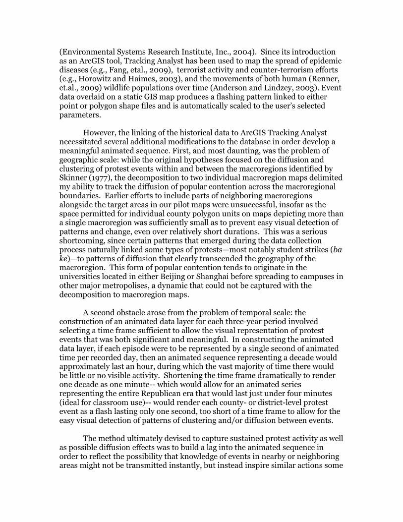
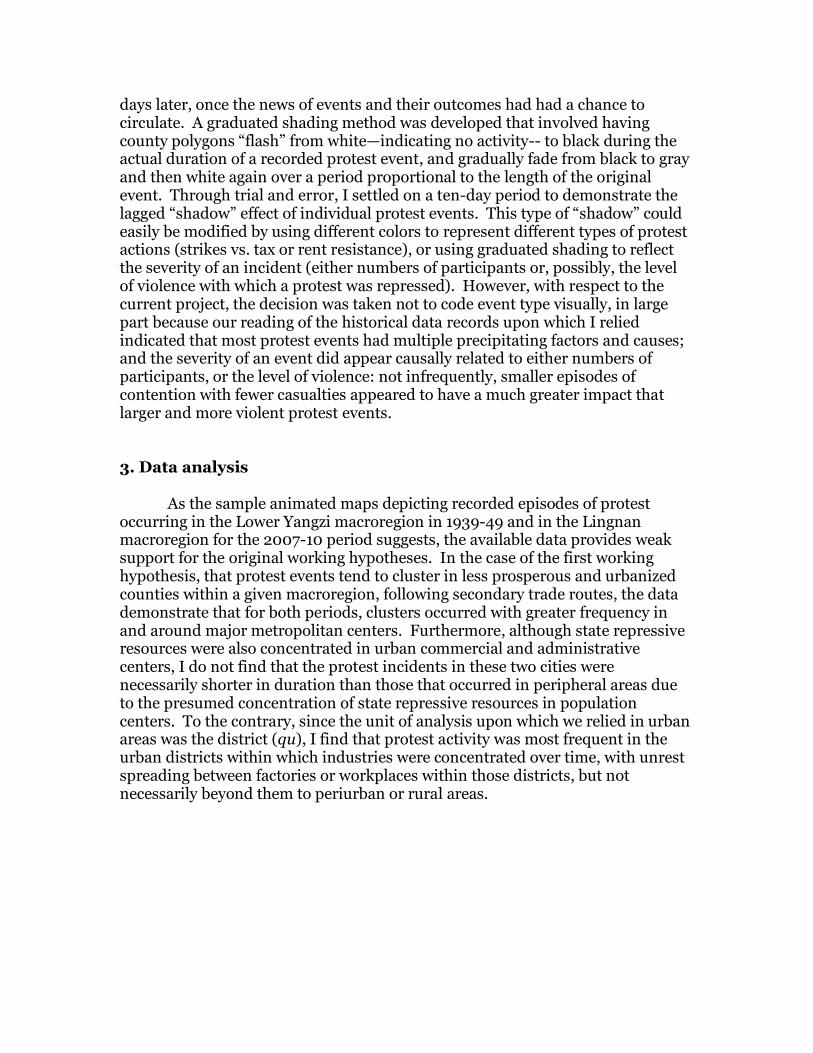
3. Data analysis As the sample animated maps depicting recorded episodes of protest occurring in the Lower Yangzi macroregion in 1939-49 and in the Lingnan macroregion for the 2007-10 period suggests, the available data provides weak support for the original working hypotheses. In the case of the first working hypothesis, that protest events tend to cluster in less prosperous and urbanized counties within a given macroregion, following secondary trade routes, the data demonstrate that for both periods, clusters occurred with greater frequency in and around major metropolitan centers. Furthermore, although state repressive resources were also concentrated in urban commercial and administrative centers, I do not find that the protest incidents in these two cities were necessarily shorter in duration than those that occurred in peripheral areas due to the presumed concentration of state repressive resources in population centers. To the contrary, since the unit of analysis upon which we relied in urban areas was the district (qu), I find that protest activity was most frequent in the urban districts within which industries were concentrated over time, with unrest spreading between factories or workplaces within those districts, but not necessarily beyond them to periurban or rural areas.
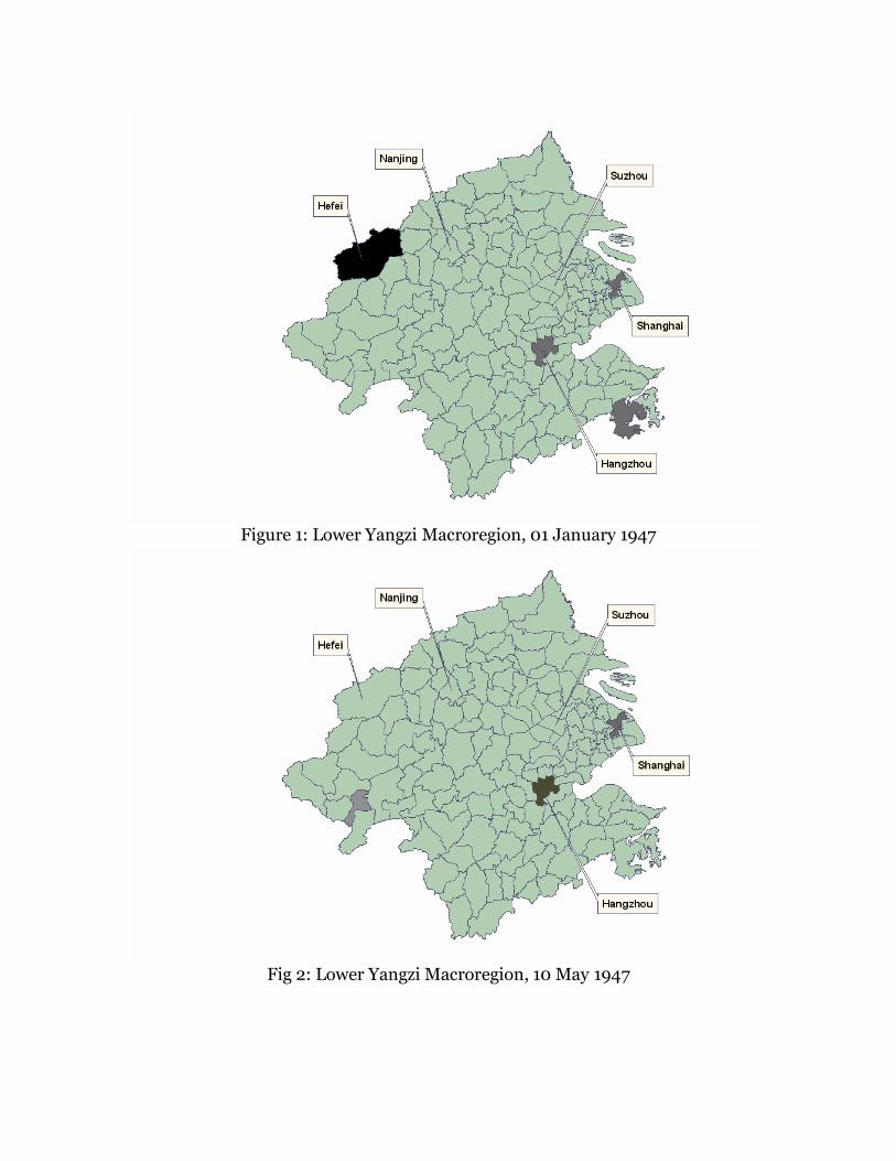
Figure 1: Lower Yangzi Macroregion, 01 January 1947
Fig 2: Lower Yangzi Macroregion, 10 May 1947
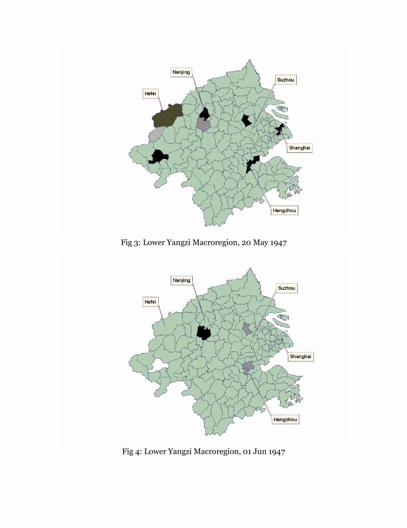
Fig 3: Lower Yangzi Macroregion, 20 May 1947
Fig 4: Lower Yangzi Macroregion, 01 Jun 1947
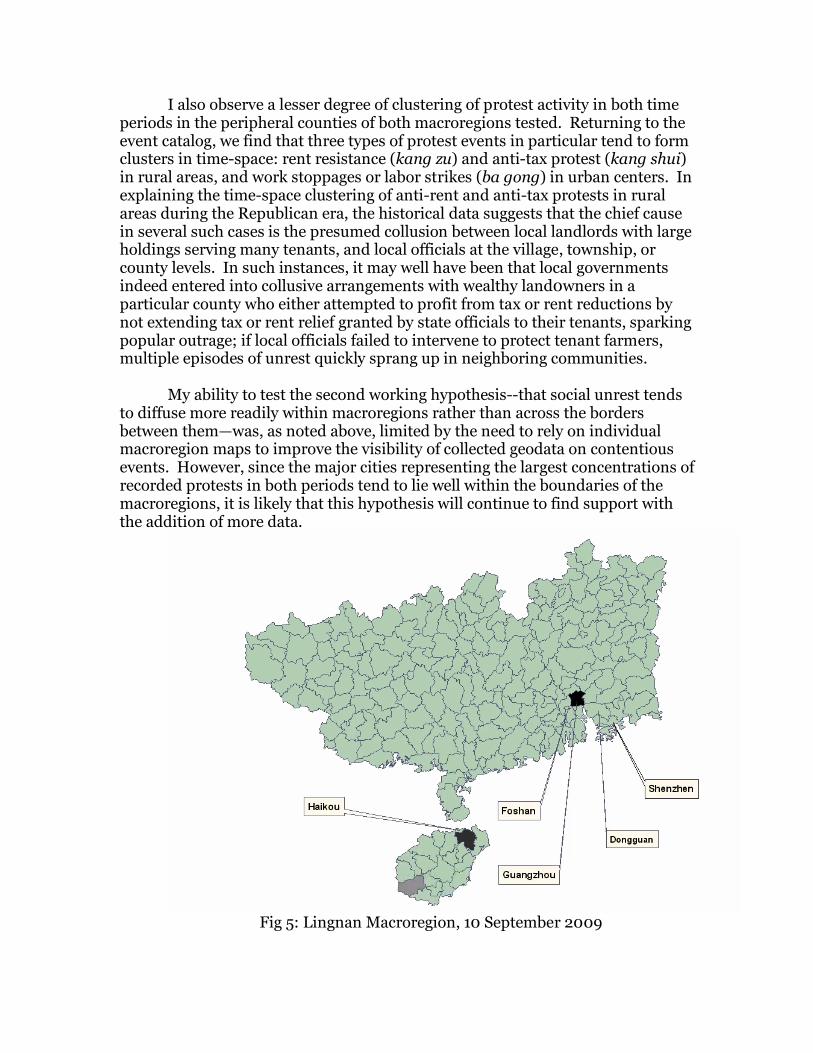
I also observe a lesser degree of clustering of protest activity in both time periods in the peripheral counties of both macroregions tested. Returning to the event catalog, we find that three types of protest events in particular tend to form clusters in time-space: rent resistance (kang zu) and anti-tax protest (kang shui) in rural areas, and work stoppages or labor strikes (ba gong) in urban centers. In explaining the time-space clustering of anti-rent and anti-tax protests in rural areas during the Republican era, the historical data suggests that the chief cause in several such cases is the presumed collusion between local landlords with large holdings serving many tenants, and local officials at the village, township, or county levels. In such instances, it may well have been that local governments indeed entered into collusive arrangements with wealthy land0wners in a particular county who either attempted to profit from tax or rent reductions by not extending tax or rent relief granted by state officials to their tenants, sparking popular outrage; if local officials failed to intervene to protect tenant farmers, multiple episodes of unrest quickly sprang up in neighboring communities.
My ability to test the second working hypothesis--that social unrest tends to diffuse more readily within macroregions rather than across the borders between them—was, as noted above, limited by the need to rely on individual macroregion maps to improve the visibility of collected geodata on contentious events. However, since the major cities representing the largest concentrations of recorded protests in both periods tend to lie well within the boundaries of the macroregions, it is likely that this hypothesis will continue to find support with the addition of more data.
Fig 5: Lingnan Macroregion, 10 September 2009
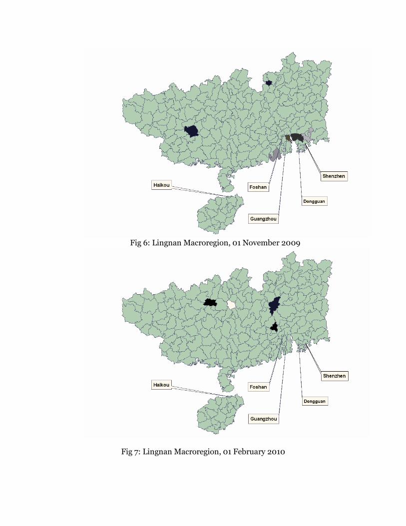
Fig 6: Lingnan Macroregion, 01 November 2009
Fig 7: Lingnan Macroregion, 01 February 2010
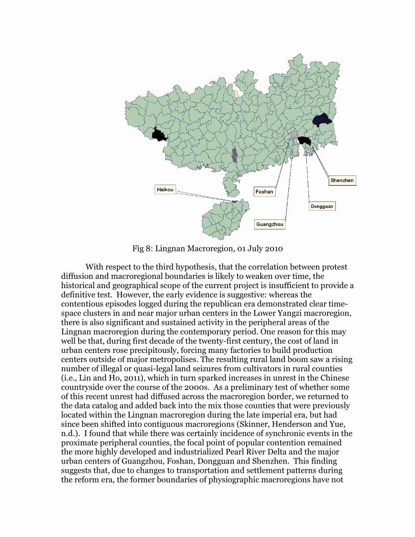
Fig 8: Lingnan Macroregion, 01 July 2010
With respect to the third hypothesis, that the correlation between protest
diffusion and macroregional boundaries is likely to weaken over time, the historical and geographical scope of the current project is insufficient to provide a definitive test. However, the early evidence is suggestive: whereas the contentious episodes logged during the republican era demonstrated clear time-space clusters in and near major urban centers in the Lower Yangzi macroregion, there is also significant and sustained activity in the peripheral areas of the Lingnan macroregion during the contemporary period. One reason for this may well be that, during first decade of the twenty-first century, the cost of land in urban centers rose precipitously, forcing many factories to build production centers outside of major metropolises. The resulting rural land boom saw a rising number of illegal or quasi-legal land seizures from cultivators in rural counties (i.e., Lin and Ho, 2011), which in turn sparked increases in unrest in the Chinese countryside over the course of the 2000s. As a preliminary test of whether some of this recent unrest had diffused across the macroregion border, we returned to the data catalog and added back into the mix those counties that were previously located within the Lingnan macroregion during the late imperial era, but had since been shifted into contiguous macroregions (Skinner, Henderson and Yue, n.d.). I found that while there was certainly incidence of synchronic events in the proximate peripheral counties, the focal point of popular contention remained the more highly developed and industrialized Pearl River Delta and the major urban centers of Guangzhou, Foshan, Dongguan and Shenzhen. This finding suggests that, due to changes to transportation and settlement patterns during the reform era, the former boundaries of physiographic macroregions have not
only weakened, but may well be in flux; and that while the geographic centers of such regions, and the basic hierarchical relationships of places contained within them, may have remained largely stable over time, new socioeconomic forces are at work in the formerly peripheral areas, shifting the alignment of subregional networks. 4. Conclusion
While the two three-year protest cycles tested here do not provide sufficient data to support major revision to our understanding of how human activity is organized within and between Skinner’s macroregions, the technique of building animated data layers over static GIS maps holds significant promise for historical GIS. As Gregory and Ell (2007: 110) noted, the chief challenge for those wishing to use animation in historical GIS research is cartographic: combining both spatial and temporal data requires the simplification of key data attributes in order to reduce the demands on human perception without over-simplifying any of the key components. This raises the question of whether current representations of space and time facilitate or constrain our understanding of complex and dynamic phenomena such as social unrest. Excessive focus on the geographic dimensions of human activity may in fact obscure underlying causal trends either unrelated to geographic space or not easily rendered in cartographic terms. For example, in the case the diffusion of collective unrest, protest actions may diffuse sectorally, and not necessarily through geographically contiguous regions. This is often the case with student protest activity, which often unfolds on college campuses at a regional or national level, but may not trigger unrest in interstitial regions. Furthermore, geographic patterns cannot predict which types of contentious incidents might inspire further collective action: some events are imbued with particular symbolic significance not easily measured or quantified in ways that can be reproduced on cartographic surfaces. For example, as Mitter (2004) eloquently observed, the impact of the 3,000 strong student demonstration of May 4, 1919 ended without injury to the protestors, yet its profound impact reverberates through Chinese history and politics down to the present day.
The lack of clearly discernible patterns—with the exception of the
clustering of repeated protest incidents in the major municipal centers during both historic periods under consideration-- is at least partially due to the aforementioned pressure to simplify the key attributes of historical data: relying upon the rural county and urban district polygon as the chief unit of analysis unfortunately does not enable a researcher to capture how particular contentious episodes may develop and diffuse intraregionally over time, let alone capture the possibility that certain types of episodes may spread across space via different networks, creating different patterns of diffusion. However, although increasing the scale beyond the macroregion level allows the researcher to capture more data, it greatly reduces the effective visual representation of patterns of both clustering and diffusion.
Overlaying temporal data further complicates this problem (i.e., Peuquet, 2001). Even at the macroregion level, when the constituent events comprising a long and tumultuous wave of social unrest is visually displayed as part of an animated sequence and temporally scaled, the impression to the viewer is that even the most restive areas remain more stable and quiescent than not. Acknowledging and visually representing temporal lags to represent the delayed impact of discrete historical events may help to ameliorate the issue, but the problem is one not unrelated to the issue of how to represent long-term historical change. One broader lesson we drew from this pilot exercise is that the animated representation of dynamic historic events on a static GIS map may well highlight in graphical form the pitfalls of what François Simiand once dubbed “eventual history” (histoire événementielle), which arguably reorients historical memory around sporadically occurring momentous events that are, in the broad scale of human history, of relatively short duration. As the AVI animated sequences demonstrate, even during the final tumultuous years of Republican rule when collective protest and unrest is frequently described in narrative historical accounts as “endemic” throughout much of the country, the overwhelming trend in the temporal data naturally demonstrates that quiescence was in fact the norm. I draw that lesson that, in the relentless search for those restive sparks capable of starting a prairie fire, the larger dormant forest is too often lost for the trees. Acknowledgements: The research for this project was carried out under the auspices of a 2010 British Academy Small Research Grant entitled, “Knots of Ungovernability: Mapping Popular Contention in China over Time and Space.” I gratefully acknowledge the research assistance of Xu Xibai, Ching-Yeung (Karita) Kan, Yu Tao, Rebecca Wong, and Yu (Christina) Zhao, without which this work could not have been completed; and the comments and suggestions of (Merrick) Lex Berman, Billy Kee-Long So, David W. Wong, and anonymous reviewers of this journal. References Anderson, C. R., Jr. and Lindzey, F. G., 2003. Estimating Cougar Predation Rates from GPS Location Clusters. The Journal of Wildlife Management 67 (2), 307-316. Barkey, K. and Van Rossem, R., 1997. Networks of Contention: Villages and Regional Structure in the Seventeenth-Century Ottoman Empire. The American Journal of Sociology, 102 (5), 1345-1382. Bernhardt, K., 1992. Rents, Taxes, and Peasant Resistance: The Lower Yangzi Region, 1840-1950. Palo Alto, CA: Stanford University Press. Brustein, W. and Levi, M., 1987. The Geography of Rebellion: Rulers, Rebels, and Regions, 1500 to 1700, Theory and Society, 16 (4), 467-495. Buhaug, H., and Gleditsch, K. S., 2008. Contagion or Confusion? Why Conflicts Cluster in Space. International Studies Quarterly, 52, 215–233.
Buhaug, H. and Rod, J. K., 2006. Local Determinants of African Civil Wars, 1970-2001. Political Geography 25 (3), 315-335. Cartier, C., 2002. Origins and Evolution of a Geographical Idea: The Macroregion in China. Modern China 28 (1), 79-142. Chan, C. and Pun N, 2009. The Making of a New Working Class? A Study of Collective Actions of Migrant Workers in South China. The China Quarterly, 198, 287–303. Chen, Y.F., 1986. Making Revolution: The Communist Movement in Eastern and Central China, 1937-1945. Berkeley, CA: University of California Press. Christaller, W., 1966 [1933]. Central Places in Southern Germany. Translated by Baskin, C.W. Englewood Cliffs, NJ: Prentice Hall. Chung, J. H., Lai, H. Y. and Xia, M., 2006. Mounting Challenges to Governance in China: Surveying Collective Protestors, Religious Sects and Criminal Organizations. The China Journal 56, 1-31. Davis, W., Duncan, G., and Siverson, R., 1978. The Dynamics of Warfare, 1816–1965. American Journal of Political Science 22(4), 772–792. Fang, L. Q. , et.al., 2009. Geographical Spread of SARS in mainland China. Tropical Medicine and International Health 14:s1, 14-20. Gregory, I. N. and Ell, P. S. 2007. Historical GIS: Technologies, Methodologies and Scholarship. Cambridge: Cambridge University Press. Griffin, A. L., et.al., 2006. A Comparison of Animated Maps with Static Small-Multiple Maps for Visually Identifying Space-Time Clusters, Annals of the Association of American Geographers, 96(4), 740–753. Horowitz, B. M. and Haimes, Y. Y., 2003. Risk-based methodology for scenario tracking, intelligence gathering, and analysis for countering terrorism. Systems Engineering, 6: 152–169. Huang, P., 1990. The Peasant Family and Rural Development in the Yangzi Delta, 1350-1988. Palo Alto, CA: Stanford University Press. Hudson, J. C., 1969. Diffusion in a Central Place System. Geographical Analysis 1(1), 45–58. Hurst, W., 2004. Understanding Contentious Collective Action by Chinese Laid-Off Workers: The Importance of Regional Political Economy. Studies in Comparative International Development 39:2, 94-120.
Koopmanns, R., 1993. The Dynamics of Protest Waves: West Germany, 1965 to 1989. American Sociological Review 58 (5), 637-58. Lavely, W., 1989. The Spatial Approach to Chinese History: Illustrations from North China and the Upper Yangzi. The Journal of Asian Studies 48 (1), 100-113. Lee, C.K., 2000. The “Revenge of History”: Collective Memories and Labor Protests in North-Eastern China. Ethnography 1 (2), 217-237. Lin, G. and Ho, S., 2005. The State, Land System, and Land Development Processes in Contemporary China. Annals of the Association of American Geographers, 95 (2), 411 — 436. Linnemann, H., 1966. An Econometric Study of International Trade Flows. Amsterdam: North-Holland. Little, D. and Esherick, J. W., 1989. Testing the Testers: A Reply to Barbara Sands and Ramon Myers's Critique of G. William Skinner's Regional Systems Approach to China. The Journal of Asian Studies, 48 (1), 90-99. Lyall, J., 2009. Does Indiscriminate Violence Incite Insurgent Attacks? Evidence from Chechnya. Journal of Conflict Resolution 53 (2), 331-362. Martin, D. G. and Miller, B., 2003. Space and Contentious Politics, Mobilization: An International Journal 8 (2), 143-156. McAdam, D., 1995 . “Initiator” and “Spin-Off” Movements: Diffusion Processes in Protest Cycles. In: M. Traugott, ed., Repertoires and Cycles of Collective Action, Durham, NC: Duke University Press, 217-39. Miller, B., 2000. Geography and Social Movements. Minneapolis, MN: University of Minnesota Press. Mitter, R., 2004. A Bitter Revolution: China’s Struggle with the Modern World. Oxford: Oxford University Press. Morris, A., 1984. The Origins of the Civil Rights Movement: Black Communities Organizing for Change. New York: Free Press. Myers, D. J., 2000. Modeling Social Diffusion Processes using Event History Analysis: Some Conceptual Issues, Practical Considerations, and Empirical Patterns. University of Notre Dame Department of Sociology Working Paper and Technical Report Series, 2001-07.
Myers, D. J. and Oliver, P., 2008. The Opposing Forces Diffusion model: the Initiation and Repression of Collective Violence. Dynamics of Asymmetric Conflict 2 (1), pp. 164 – 189. Peuquet, D., 2001. Making Space for Time: Issues in Space-Time Data Representation, GeoInformatica 5 (1), 11-32. Perry, E. J., 1980. Rebels and Revolutionaries in north China, 1845-1945. Palo Alto, CA: Stanford University Press. Perry, E. J., 1995. Shanghai on Strike: The Politics of Chinese Labor. Palo Alto, CA: Stanford University Press. Perry, E. J., 1994. Shanghai's Strike Wave of 1957, The China Quarterly 137, 1-27. Potter, S. H. and Potter, J. M., 1990. China’s Peasants; The Anthropology of a Revolution. Cambridge: Cambridge University Press. Rapoport, A., 1960. Fights, Games and Debates. Ann Arbor, MI: University of Michigan Press. Renner, R., et.al., 2009. Persistent Surveillance, Geoinformatics 12 (14), 1-5. Rude, G., 1964. The crowd in history; a study of popular disturbances in France and England, 1730-1848. New York: Wiley. Sands, B. and Myers, R. H., 1986. The Spatial Approach to Chinese History: A Test. The Journal of Asian Studies, 45 (4), 721-743. Sewell, W. H., 2001. Space in Contentious Politics. In Aminzade, R., et.al., Silence and Voice in the Study of Contentious Politics. Cambridge University Press, 51-88. Shibutani, T., 1966. Improvised news; a sociological study of rumor. Indianapolis, IN: Bobbs-Merrill. Singer, B. D., 1968. Mass Media and Communication Process in the Detroit Riot of 1967. Public Opinion Quarterly 34, 236 - 245. Siverson, R. M., and Starr, H., 1990. Opportunity, Willingness, and the Diffusion of War. American Political Science Review 84(1), 47–67. Skinner, G. W., Henderson, M. and Yuan J.H., 2000. China’s Fertility Transition through Regional Space: Using GIS and Census Data for a Spatial Analysis of Historical Demography. Social Science History 24 (3), 613-48.
Skinner, G. W., Henderson, M. and Yue, Z., no date. A note regarding the Physiographic and Socioeconomic Macroregions of China.” Available at http://www.fas.harvard.edu/~chgis/data/chgis/downloads/v4/datasets/PhysiographicMacroregions_Note.doc [Accessed 8 June 2011]. Skinner, G. W., 1985. Presidential Address: the structure of Chinese history. The Journal of Asian Studies 44, 271-92. Skinner, G. W., 1965a. Marketing and Social Structure in Chinese History (Part II). The Journal of Asian Studies 24, 195-228. Skinner, G. W., 1965b. Marketing and Social Structure in Chinese History (Part III). The Journal of Asian Studies 24, 363-400. Skinner, G. W., 1964. “Marketing and Social Structure in Chinese History (Part I). The Journal of Asian Studies 24, 3-44. Skinner, G. W., 1977. The City in Late Imperial China. Palo Alto, CA: Stanford University Press. Soule, S., 1997. The Student Divestment Movement in the United States and the Shantytown: Diffusion of a Protest Tactic. Social Forces 75 (3), 855-883. Strang, D. and Tuma, N.B., 1993. Spatial and Temporal Heterogeneity in Diffusion. American Journal of Sociology 99, 614-39. Tarrow, S., 1998. Power in Movement: Social Movements and Contentious Politics. Cambridge University Press. Thaxton, R., 2008. Catastrophe and Contention in Rural China: Mao's Great Leap Forward Famine and the Origins of Righteous Resistance in Da Fo Village. Cambridge: Cambridge University Press. Tilly, C., 2003. Contention over Space and Place. Mobilization: An International Journal 8(2), 221-225. Tilly, C., 2000. Spaces of Contention. Mobilization: An International Journal 5(2), 135-159. Urdal, H., 2008. Population, Resources, and Political Violence: A Subnational Study of India, 1956 - 2002. Journal of Conflict Resolution 52 (4), 590-617. van de Ven, H. J., 2003. War and Nationalism in China, 1925–1945. New York: Routledge Curzon, 2003. Watts, D. J., 2003. Six Degrees: The Science of a Connected Age. New York: Norton.

Weidmann, N. B. and Toft, M.D., 2010. Promises and Pitfalls in the Spatial Prediction of Ethnic Violence: A Comment. Conflict Management and Peace Science, 159-176. Zipf, G.K., 1949. Human Behavior and the Principles of Least Effort. Cambridge: Addison-Wesley.


![Formation contention MR-MRS 2011.ppt [Lecture seule]cardwb.e-monsite.com/.../files/formation-ref-dem-isosl-contention-.pdf · risques de la contention physique chez la personne âgée,](https://img.pdfslide.net/doc/110x75/5b98a78409d3f22f0a8c5ace/formation-contention-mr-mrs-2011ppt-lecture-seulecardwbe-risques-de-la.jpg)