Embed Size (px)
Citation preview
Monitor E-Notes: Sanctuary News & Events April 2016
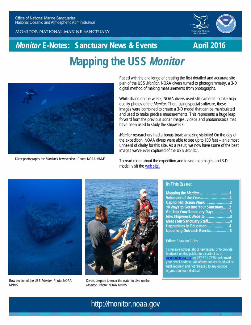
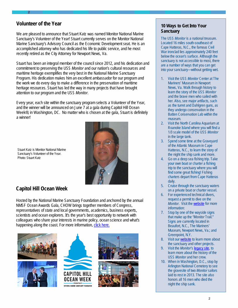
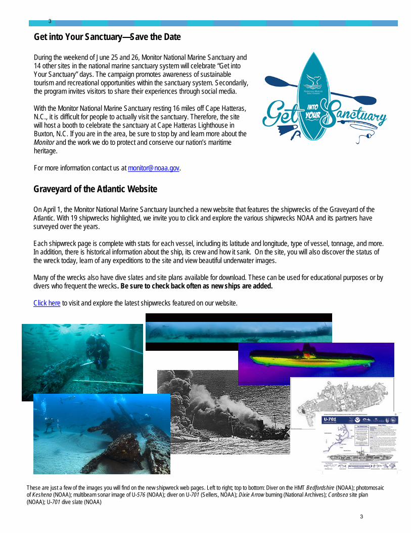
Faced with the challenge of creating the first detailed and accurate site plan of the USS Monitor, NOAA divers turned to photogrammetry, a 3-D digital method of making measurements from photographs. While diving on the wreck, NOAA divers used still cameras to take high quality photos of the Monitor. Then, using special software, these images were combined to create a 3-D model that can be manipulated and used to make precise measurements. This represents a huge leap forward from the previous sonar images, videos and photomosaics that have been used to study the shipwreck. Monitor researchers had a bonus treat: amazing visibility! On the day of the expedition, NOAA divers were able to see up to 100 feet -- an almost unheard of clarity for this site. As a result, we now have some of the best images we've ever captured of the USS Monitor. To read more about the expedition and to see the images and 3-D model, visit the web site.
Diver photographs the Monitor’s bow section. Photo: NOAA MNMS
Bow section of the USS Monitor. Photo: NOAA MNMS
http://monitor.noaa.gov
Divers prepare to enter the water to dive on the Monitor. Photo: NOAA MNMS
In This Issue: Mapping the Monitor …….. ………….…..1 Volunteer of the Year…. ……………….…2 Capitol Hill Ocean Week ……………….…2 10 Ways to Get Into Your Sanctuary…...2 Get Into Your Sanctuary Days..………….3 New Shipwreck Website ………………….3 Meet Your Sanctuary Staff………………..4 Happenings in Education ..……..…….....4 Upcoming Outreach Events………...……5 Editor: Shannon Ricles To receive notices about new issues or to provide feedback on this publication, contact us at [email protected] or 757-591-7328 and provide your email address. All information received will be held securely and not released to any outside organization or individual.
Mapping the USS Monitor
1
1
Volunteer of the Year We are pleased to announce that Stuart Katz was named Monitor National Marine Sanctuary’s Volunteer of the Year! Stuart currently serves on the Monitor National Marine Sanctuary’s Advisory Council as the Economic Development seat. He is an accomplished attorney who has dedicated his life to public service, and he most recently retired as the City Attorney for Newport News, Va. Stuart has been an integral member of the council since 2012, and his dedication and commitment to preserving the USS Monitor and our nation’s cultural resources and maritime heritage exemplifies the very best in the National Marine Sanctuary Program. His dedication makes him an excellent ambassador for our program and the work we do every day to make a difference in the preservation of maritime heritage resources. Stuart has led the way in many projects that have brought attention to our program and the USS Monitor. Every year, each site within the sanctuary program selects a Volunteer of the Year, and the winner will be announced on June 7 at a gala during Capitol Hill Ocean Week®, in Washington, DC. No matter who is chosen at the gala, Stuart is definitely a winner!
Capitol Hill Ocean Week Hosted by the National Marine Sanctuary Foundation and anchored by the annual NMSF Ocean Awards Gala, CHOW brings together members of Congress, representatives of state and local governments, academics, business experts, scientists and ocean explorers. It's the year's best opportunity to network with colleagues who share your interests in marine policy, ocean science and what's happening along the coast. For more information, click here.
Stuart Katz is Monitor National Marine Sanctuary’s Volunteer of the Year. Photo: Stuart Katz
10 Ways to Get Into Your Sanctuary The USS Monitor is a national treasure. Located 16 miles south-southeast of Cape Hatteras, N.C., the famous Civil War ironclad lies approximately 240 feet below the ocean’s surface. Although the sanctuary is not accessible to most, there are a number of ways that you can get into your sanctuary—without getting wet. 1. Visit the USS Monitor Center at The
Mariners’ Museum in Newport News, Va. Walk through history to learn the story of the USS Monitor and the brave men who sailed with her. Also, see major artifacts, such as the turret and Dahlgren guns, as they undergo conservation in the Batten Conservation Lab within the museum.
2. Visit the North Carolina Aquarium at Roanoke Island where you will find a 1/3 scale model of the USS Monitor in the large tank.
3. Spend some time at the Graveyard of the Atlantic Museum in Cape Hatteras, N.C., to learn the story of the night the ship sank and more.
4. Go on a deep sea fishing trip. Take your own boat or charter a fishing trip to the sanctuary where you will find some great fishing! Fishing charters depart from Cape Hatteras daily.
5. Cruise through the sanctuary waters on a private boat or charter vessel.
6. For experienced technical divers, request a permit to dive on the Monitor. Visit the website for more information:
7. Stop by one of the wayside signs that make up the “Monitor Trail.” Signs are currently located in Beaufort, N.C., The Mariners’ Museum, Newport News, Va.; and Greenpoint, N.Y.
8. Visit our website to learn more about the sanctuary and other projects.
9. Visit the Monitor’s legacy site, to learn more about the history of the USS Monitor and her crew.
10. When in Washington, D.C., stop by Arlington National Cemetery to see the gravesite of two Monitor sailors laid to rest in 2013. The site also honors all 16 men who died the night the ship sank.
2
2
Get into Your Sanctuary—Save the Date During the weekend of June 25 and 26, Monitor National Marine Sanctuary and 14 other sites in the national marine sanctuary system will celebrate “Get into Your Sanctuary” days. The campaign promotes awareness of sustainable tourism and recreational opportunities within the sanctuary system. Secondarily, the program invites visitors to share their experiences through social media. With the Monitor National Marine Sanctuary resting 16 miles off Cape Hatteras, N.C., it is difficult for people to actually visit the sanctuary. Therefore, the site will host a booth to celebrate the sanctuary at Cape Hatteras Lighthouse in Buxton, N.C. If you are in the area, be sure to stop by and learn more about the Monitor and the work we do to protect and conserve our nation’s maritime heritage. For more information contact us at [email protected].
These are just a few of the images you will find on the new shipwreck web pages. Left to right; top to bottom: Diver on the HMT Bedfordshire (NOAA); photomosaic of Keshena (NOAA); multibeam sonar image of U-576 (NOAA); diver on U-701 (Sellers, NOAA); Dixie Arrow burning (National Archives); Caribsea site plan (NOAA); U-701 dive slate (NOAA)
Graveyard of the Atlantic Website On April 1, the Monitor National Marine Sanctuary launched a new website that features the shipwrecks of the Graveyard of the Atlantic. With 19 shipwrecks highlighted, we invite you to click and explore the various shipwrecks NOAA and its partners have surveyed over the years. Each shipwreck page is complete with stats for each vessel, including its latitude and longitude, type of vessel, tonnage, and more. In addition, there is historical information about the ship, its crew and how it sank. On the site, you will also discover the status of the wreck today, learn of any expeditions to the site and view beautiful underwater images. Many of the wrecks also have dive slates and site plans available for download. These can be used for educational purposes or by divers who frequent the wrecks. Be sure to check back often as new ships are added. Click here to visit and explore the latest shipwrecks featured on our website.
3
3
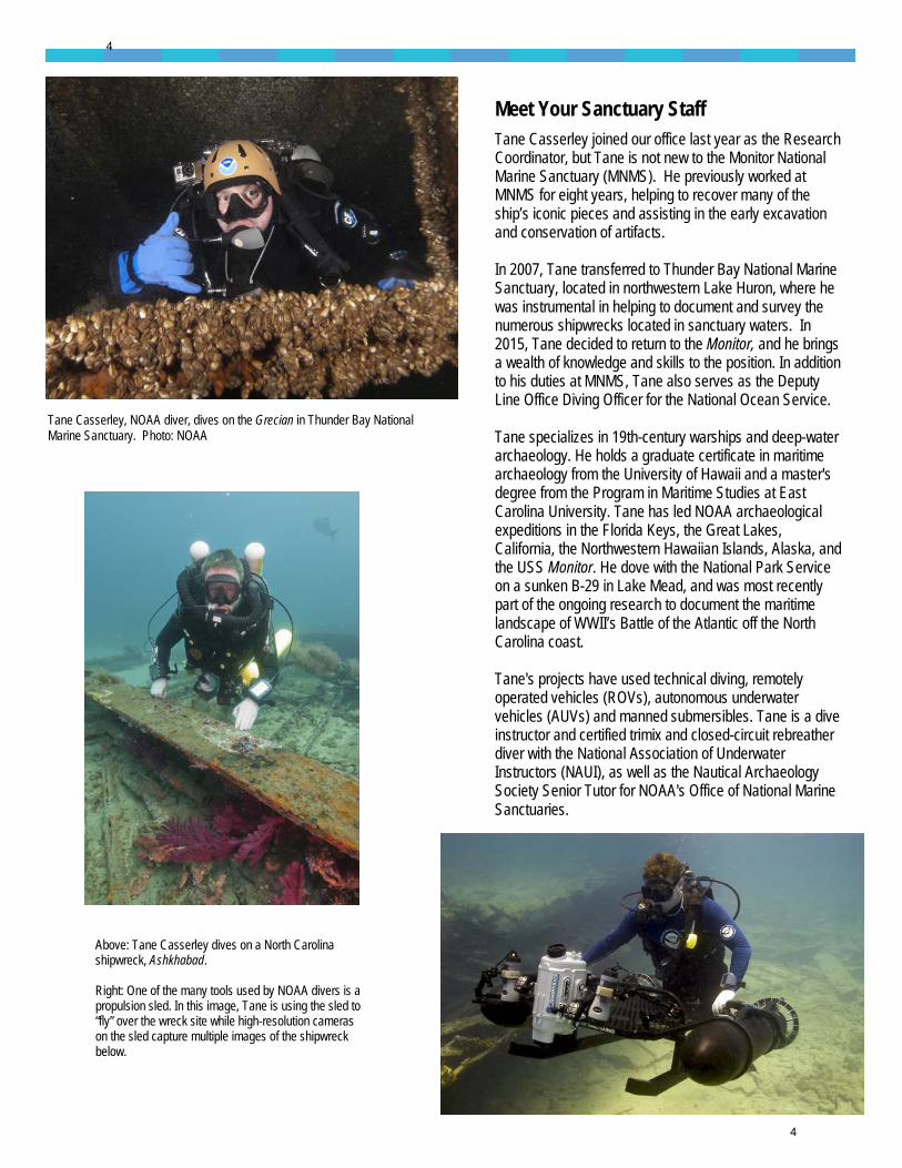
Meet Your Sanctuary Staff Tane Casserley joined our office last year as the Research Coordinator, but Tane is not new to the Monitor National Marine Sanctuary (MNMS). He previously worked at MNMS for eight years, helping to recover many of the ship’s iconic pieces and assisting in the early excavation and conservation of artifacts. In 2007, Tane transferred to Thunder Bay National Marine Sanctuary, located in northwestern Lake Huron, where he was instrumental in helping to document and survey the numerous shipwrecks located in sanctuary waters. In 2015, Tane decided to return to the Monitor, and he brings a wealth of knowledge and skills to the position. In addition to his duties at MNMS, Tane also serves as the Deputy Line Office Diving Officer for the National Ocean Service. Tane specializes in 19th-century warships and deep-water archaeology. He holds a graduate certificate in maritime archaeology from the University of Hawaii and a master's degree from the Program in Maritime Studies at East Carolina University. Tane has led NOAA archaeological expeditions in the Florida Keys, the Great Lakes, California, the Northwestern Hawaiian Islands, Alaska, and the USS Monitor. He dove with the National Park Service on a sunken B-29 in Lake Mead, and was most recently part of the ongoing research to document the maritime landscape of WWII’s Battle of the Atlantic off the North Carolina coast. Tane's projects have used technical diving, remotely operated vehicles (ROVs), autonomous underwater vehicles (AUVs) and manned submersibles. Tane is a dive instructor and certified trimix and closed-circuit rebreather diver with the National Association of Underwater Instructors (NAUI), as well as the Nautical Archaeology Society Senior Tutor for NOAA's Office of National Marine Sanctuaries.
Tane Casserley, NOAA diver, dives on the Grecian in Thunder Bay National Marine Sanctuary. Photo: NOAA
Above: Tane Casserley dives on a North Carolina shipwreck, Ashkhabad. Right: One of the many tools used by NOAA divers is a propulsion sled. In this image, Tane is using the sled to “fly” over the wreck site while high-resolution cameras on the sled capture multiple images of the shipwreck below.
4
4
Happenings in Education Here are a few of the exciting happenings in education at the Monitor NMS! • A new maritime archaeology curriculum was launched this spring. Check
out Maritime Archaeology: Discovering and Exploring Shipwrecks, along with other free resources.
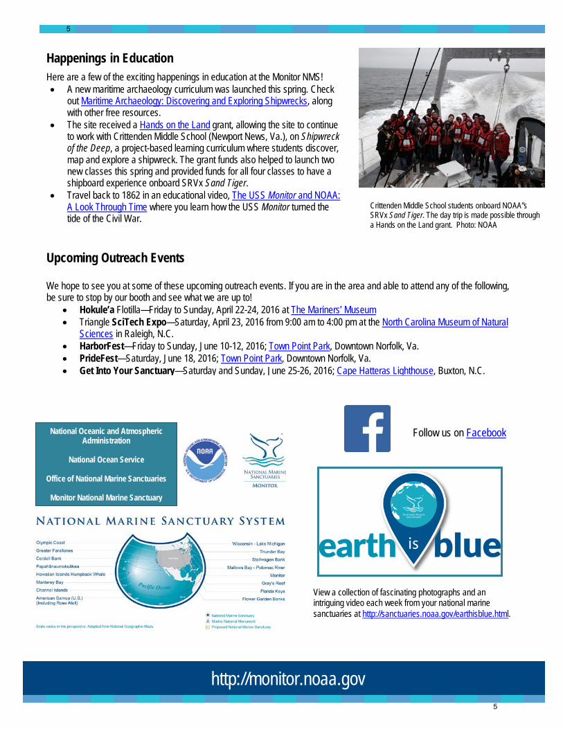
• The site received a Hands on the Land grant, allowing the site to continue to work with Crittenden Middle School (Newport News, Va.), on Shipwreck of the Deep, a project-based learning curriculum where students discover, map and explore a shipwreck. The grant funds also helped to launch two new classes this spring and provided funds for all four classes to have a shipboard experience onboard SRVx Sand Tiger.
• Travel back to 1862 in an educational video, The USS Monitor and NOAA: A Look Through Time where you learn how the USS Monitor turned the tide of the Civil War.
View a collection of fascinating photographs and an intriguing video each week from your national marine sanctuaries at http://sanctuaries.noaa.gov/earthisblue.html.
National Oceanic and Atmospheric Administration
National Ocean Service
Office of National Marine Sanctuaries
Monitor National Marine Sanctuary
http://monitor.noaa.gov
Upcoming Outreach Events We hope to see you at some of these upcoming outreach events. If you are in the area and able to attend any of the following, be sure to stop by our booth and see what we are up to!
• Hokule’a Flotilla—Friday to Sunday, April 22-24, 2016 at The Mariners’ Museum • Triangle SciTech Expo—Saturday, April 23, 2016 from 9:00 am to 4:00 pm at the North Carolina Museum of Natural
Sciences in Raleigh, N.C. • HarborFest—Friday to Sunday, June 10-12, 2016; Town Point Park, Downtown Norfolk, Va. • PrideFest—Saturday, June 18, 2016; Town Point Park, Downtown Norfolk, Va. • Get Into Your Sanctuary—Saturday and Sunday, June 25-26, 2016; Cape Hatteras Lighthouse, Buxton, N.C.
Follow us on Facebook
Crittenden Middle School students onboard NOAA”s SRVx Sand Tiger. The day trip is made possible through a Hands on the Land grant. Photo: NOAA
5
5