Embed Size (px)
Citation preview
March 2008Page 46
IndIana GenealoGIstVolume 19, Issue 1
IN-GENious!The reCTangular survey sysTem in inDiana
AnD uSInG THE GIS ATLAS by Annette Harper
public domain lands could not be sold until they had been surveyed into rectangular townships.
Several factors delayed the commence-ment of surveying in the Indiana area. One factor was that Great Britain maintained a presence in the area until the end of the War of 1812 in 1814.
Native American occupation was an-other factor. The Treaty of Greenville in 1795, as a result of the military victories of General Anthony Wayne, opened up large parts of Ohio and a small triangular portion of southeastern Indiana called “The Gore.” The Treaty line was officially surveyed in 1797.
Native American tribes continued to claim parts of the territory to the west of the Greenville Treaty Line, but various treaties between the Treaty of Fort Wayne in 1803 and the final treaty with the Miami on November 28, 1840, removed all tribes from the state.
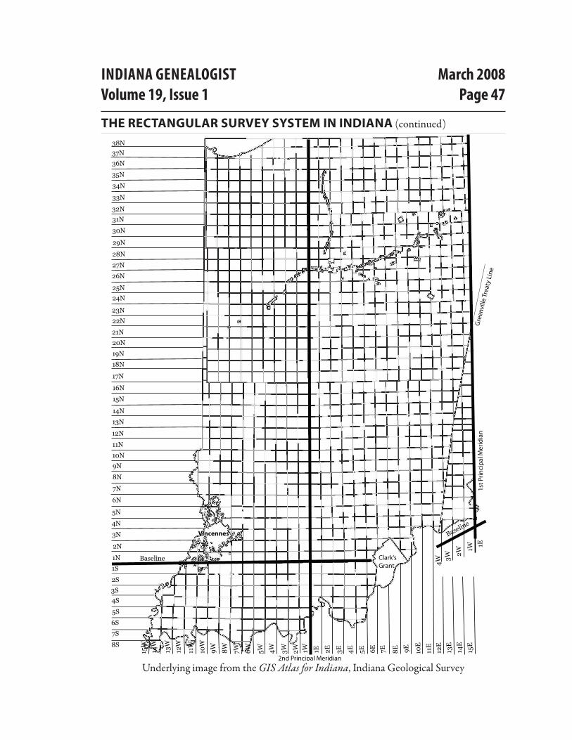
Indiana Survey TownshipsSurveying of the major portion of Indiana
began in 1803 and finished about 1834. See the illustration on the opposite page, which shows all Indiana townships. Note that these are survey townships, not civil townships or divisions of a county.
You will notice on the illustration that some areas are blank. These are areas that were already surveyed using a system other than the Rectangular Survey System.
One exception from the rectangular system is Clark’s Grant. George Rogers Clark was granted 150,000 acres of land on January
You’ve found a wonderful deed or land patent and now you’d like to pinpoint exactly where your ancestor owned that land. Or perhaps you’ve identified multiple patents or deeds of various ancestors and want to see how they are located in relation to each other. The Indiana GIS Atlas can help, but first you need to understand the Rectangular Survey System and how it was implemented in Indiana.
History of Land Ownership in IndianaThe wilderness area of the Old Northwest
Territory was claimed by many different entities prior to the American Revolution. The Native Americans, of course, claimed it for themselves, barring various treaties made with France and Great Britain. At the end of the French and Indian Wars, the French ceded it to Great Britain.
As British territory, at least two of the original thirteen colonies claimed the area encompassing Indiana. These were Virginia and New York. To allay fears of the other colonies concerning land ownership in the West, New York ceded its claims to the new United States government in 1790 and Virginia followed in 1794. The Northwest Territory, including what was to become Indiana, but excluding existing British forts, was ceded to the United States by Great Britain in the Treaty of Paris in 1783, and became public land.
The new government created the Land Ordinance of 1785 which stipulated how the land was to be surveyed and sold. It dictated that
IndIana GenealoGIstVolume 19, Issue 1
March 2008Page 47
The reCTangular survey sysTem in inDiana (continued)
8S
7S
6S
5S
3S
2S
1S
4S
2nd Principal Meridian
1st P
rinci
pal
Mer
idia
n
1N
2N
3N
4N
5N
6N
7N
8N
9N
10N
11N
12N
13N
14N
15N
16N
17N
18N
19N
20N
21N
22N
23N
24N
25N
26N
27N
28N
29N
30N
31N
32N
33N
34N
35N
36N
37N38N
1E 2E 3E 4E 5E 6E 7E 8E 9E 10E
11E
12E
1W2W3W4W5W6W7W8W9W10W
11W
12W
13W
14W
15W
Baseline
1E
13E
14E
15E
Baseline
1W
2W
3W4W
Gre
envi
lle T
reat
y Li
ne
Clark’sGrant
Vincennes
Underlying image from the GIS Atlas for Indiana, Indiana Geological Survey
March 2008Page 48
IndIana GenealoGIstVolume 19, Issue 1
The reCTangular survey sysTem in inDiana (continued)
2, 1781 by the Virginia General Assembly for bountyland due to the men of the “Illinois Regiment,” who had captured the British forts at Kaskaskia, Illinois, and Vincennes during the yet-to-be-concluded American Revolution.
Vincennes was populated before the Rectangular Survey System was implemented due to French, British, and American military and trading posts in the area. The blank areas surrounding Vincennes are areas that were previously claimed under French, British, or U.S. occupancy and not re-surveyed by the United States.
Many individual Native Americans were granted sections of land that were excluded from the Rectangular Survey. Most of these are adja-cent to rivers in the northern part of the state.
The 45 sections snaking approximately north to south in the northern third of the state were originally given to the U.S. by the Pottawatomi Indians in a treaty. The U.S. govern-ment gave them to the State of Indiana, which sold them to help pay for a road to be built between Michigan City, in the northwest, to Madison, in the southeast.
If you examine the township illustration closely, you will notice that there are places where the north-south lines are not straight, causing townships to be slightly offset from one another. This is due to corrections that were made to maintain the six-mile width of townships as the meridians came closer together in the north due to curvature of the earth.
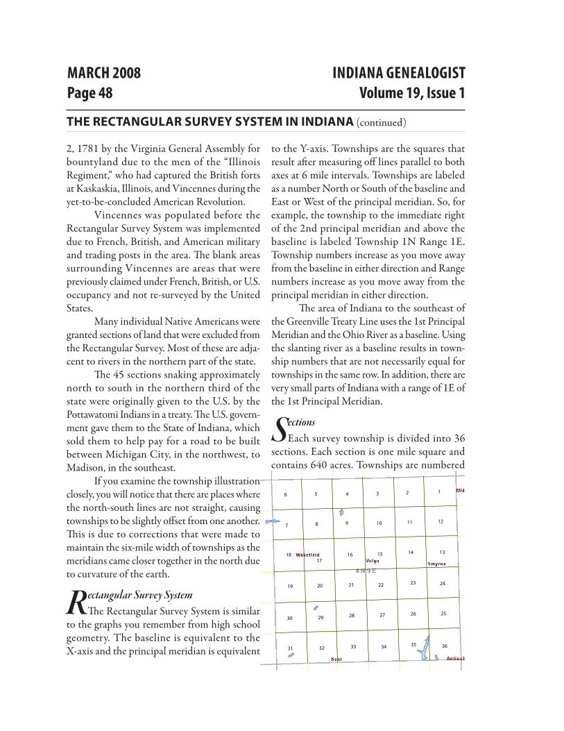
Rectangular Survey SystemThe Rectangular Survey System is similar
to the graphs you remember from high school geometry. The baseline is equivalent to the X-axis and the principal meridian is equivalent
to the Y-axis. Townships are the squares that result after measuring off lines parallel to both axes at 6 mile intervals. Townships are labeled as a number North or South of the baseline and East or West of the principal meridian. So, for example, the township to the immediate right of the 2nd principal meridian and above the baseline is labeled Township 1N Range 1E. Township numbers increase as you move away from the baseline in either direction and Range numbers increase as you move away from the principal meridian in either direction.
The area of Indiana to the southeast of the Greenville Treaty Line uses the 1st Principal Meridian and the Ohio River as a baseline. Using the slanting river as a baseline results in town-ship numbers that are not necessarily equal for townships in the same row. In addition, there are very small parts of Indiana with a range of 1E of the 1st Principal Meridian.
SectionsEach survey township is divided into 36
sections. Each section is one mile square and contains 640 acres. Townships are numbered
1516
21
14 13
121110987
123456
1718
19 20 2322 24
30 29 28 27 26 25
31 32 33 34 35 36
IndIana GenealoGIstVolume 19, Issue 1
March 2008Page 49
starting with 1 in the northeast corner and moving westward, then dropping down a row and moving eastward, and so on, until reach-ing section 36 in the southeast corner of the township.
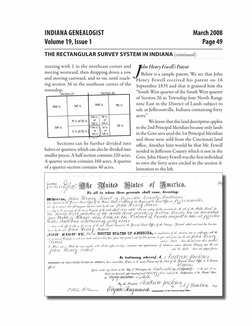
Sections can be further divided into halves or quarters, which can also be divided into smaller pieces. A half section contains 320 acres. A quarter section contains 160 acres. A quarter of a quarter-section contains 40 acres.
John Henry Fewell’s PatentBelow is a sample patent. We see that John
Henry Fewell received his patent on 16 September 1835 and that it granted him the “South West quarter of the South West quarter of Section 26 in Township four North Range nine East in the District of Lands subject to sale at Jeffersonville, Indiana containing forty acres.”
We know that this land description applies to the 2nd Principal Meridian because only lands in the Gore area used the 1st Principal Meridian and those were sold from the Cincinnati land office. Another hint would be that Mr. Fewell resided in Jefferson County which is not in the Gore. John Henry Fewell was the first individual to own the forty acres circled in the section il-lustration to the left.
The reCTangular survey sysTem in inDiana (continued)
Section 26Section 27
NW ¼ NE ¼
SW ¼S ½ of SE ¼
N ½ of SE ¼
SE ¼
NE ¼NW ¼
NW ¼ of
SW ¼
NE ¼ of
SW ¼
SW ¼ of
SW ¼
SE ¼ of
SW ¼
March 2008Page 50
IndIana GenealoGIstVolume 19, Issue 1
For More Information, See the Following Websites http://www.surveyhistory.org/greenville_&_grouseland_treaty_lines1.htm
http://www.ces.purdue.edu/extmedia/AY/AY-237.html http://www.connerprairie.org/HistoryOnline/indnam.html http://www.in.gov/icpr/4004.htm http://www.glorecords.blm.gov/Visitors/PublicLands.asp
The reCTangular survey sysTem in inDiana (continued)
But where is that really?
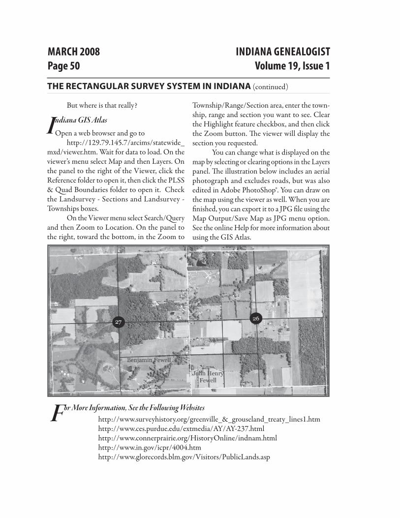
Indiana GIS AtlasOpen a web browser and go to
http://129.79.145.7/arcims/statewide_mxd/viewer.htm. Wait for data to load. On the viewer’s menu select Map and then Layers. On the panel to the right of the Viewer, click the Reference folder to open it, then click the PLSS & Quad Boundaries folder to open it. Check the Landsurvey - Sections and Landsurvey - Townships boxes.
On the Viewer menu select Search/Query and then Zoom to Location. On the panel to the right, toward the bottom, in the Zoom to
Township/Range/Section area, enter the town-ship, range and section you want to see. Clear the Highlight feature checkbox, and then click the Zoom button. The viewer will display the section you requested.
You can change what is displayed on the map by selecting or clearing options in the Layers panel. The illustration below includes an aerial photograph and excludes roads, but was also edited in Adobe PhotoShop®. You can draw on the map using the viewer as well. When you are finished, you can export it to a JPG file using the Map Output/Save Map as JPG menu option. See the online Help for more information about using the GIS Atlas.