Embed Size (px)
Citation preview

महाराष्ट्र शासन
शालेय शशक्षण व क्रीडा शवभाग राज्य शकै्षशणक संशोधन व प्रशशक्षण पररषद, महाराष्ट्र
७०८ सदाशिव पठे, कुमठेकर मार्ग, पणुे ४११०३० सपंकग क्रमांक (020) 2447 6938 E-mail: [email protected]
-----------------------------------------------------------------------------------------------
Question Bank
Standard:- 12th
Subject:- Geography
March 2021 सचूना 1. फक्त शवद्यार्थ्यांना प्रश्नप्रकारांचा सराव करून
देण्यासाठीच 2. सदर प्रश्नसचंातील प्रश्न बोर्डाच्या प्रश्नपशिकेत यतेीलच
अस ेनाही याची नोंद घ्यावी.

STD 12 GEOGRAPHY QUESTION BANK
Q1.A) Choose the correct option and complete the sentence-
1. Physical factor affecting on the distribution of population is ___.
a) Agriculture b) Mining c) Transportation d) Climate
2. Human factor affecting on the distribution of population is ___.
a) Agriculture b) Climate c) Availability of water d) Soil
3. Both birth rates and death rates are high during this phase, so population growth
is stable. It is known as ___.
a) stage one b) stage two c) stage three d) stage four
4. The stage that shows zero growth in population transition theory is ___.
a) stage one b) stage two c) stage three d) stage four
5. Broad base with narrowing apex shows that more people die at each higher band.
It shows ___.
a) birth rate and death rate both are very low
b) birth rate and death rate both are low
c) birth rate is high and death rate is low
d) birth rate and death rate both are high
6. Ratio of males and females in the population is ___.
a) Sex composition b) Age structure c) Literacy d) occupational structure
7. A person who can write, read and do mathematical calculations in the country
is known as ___.
a) illiterate b) literate c) resource person d) thinker
8. Indian economy is agrarian economy. Working population in the country is engaged in
___ activity.
a) quaternary b) tertiary c) secondary d) primary
9. Some tribes travel seasonally in search of fodder, this is called ___.

a) out migration b) long term migration c) short term migration d) social migration
10. Settlements that occur along a road, railway, canal or river are ___.
a) rectangular settlements b) pattern less settlements c) circular settlements
d) linear settlements
11. Settlements found at the confluence of two rivers or roads are ___.
a) pattern less settlements b) triangular settlements c) linear settlements
d) rectangular settlements
12. The physical extent of landonwhichcropsaresownandharvested is known as ___.
a) current fallow b) culturable waste land
c) area under permanent pastures and greasing lands d) net area sown
13. The land, where any of the manufacturing activity exists (land cover), where people
work for their livelihood is known as ___.
a) institutional area b) residential area c) industrial area d) recreational area
14. The area between urban and rural area is called ___.
a) recreational area b) urban rural fringe c) institutional area d) commercial area
15. Collection of forest products for subsistence is mainly carried in ___.
a) temperate coniferous forest b) temperate deciduous forest
c) tropical deciduous forest d) equatorial evergreen forest
16. Ideal location for fishing
a) rugged coasts, shallow seas, hot climate, growth of planktons
b) shallow seas, confluence of warm and cold ocean currents, growth of planktons,
cold climate
c) continental shelf, growth of planktons, good fishing skills, cold climate
d) continental shelf, rugged coasts, growth of planktons, cold climate
17. Primary Economic activity not related directly to latitudinal locations

a) Lumbering b) fishing
c) mining d) agriculture
18. Characteristics of extensive commercial agriculture
a) monoculture, use of water, tropical, cereal production
b) monoculture, use of machinery, tropical, cereal production
c) monoculture, use of manual labour, equator,Thailand, horticulture
d) monoculture, use of scientific know how, sub-tropical, production of pulses
19. The products obtained from the primary economic activities are used as raw material
in ___economic activities.
a) primary b) secondary c) tertiary d) quaternary
20. Many governments support establishing such zones or regions which are
specially developed for industrial production. In India, they are called______.
a) SEZ b) Transportation zone c) Market zone d) commercial zone
21. Tertiary activities _______.
a) use of resources b) finished goods c) raw material d) goods transport
22. Natural port_____.
a) Kochi b) Jawaharlal Nehru port trust c) Delhi international cargo terminal
d) Mihan project (Nagpur cargo hub)
23. Trans- Australian railway____.
a) Perth-sydney b) Perth-validivostock c) Sydney-vancuvar d) vancuvar-validivostock
24. Region is an area inhabited by people who have one or more characteristics in
common is____.
a) functional region b) physical region c) formal region d) political region
25. A region decided on major function in specific area is ___.
a) functional region b) physical region c) formal region d) political region
26. A region decided on the basis of physical factors is ___.

a) functional region b) physical region c) formal region d) political region
27. A region decided on the basis of human factors is ___.
a) functional region b) physical region c) formal region d) political region
28. A branch of geography which studies various subjects of social sciences
a) economic geography b) physical geography c) human geography d) political geography
29. A branch of geography which studies various aspects of natural sciences
a) economic geography b) physical geography c) human geography d) political geography
30. A man is more dominant than nature. This is ___.
a) naturalism b) possibilism c) environmental approach d) stop and go approach
31. A nature is more dominant than man. This is ___.
a) naturalism b) possibilism c) environmental approach d) stop and go approach
Q1.B) Complete the chain-
A B C
1. Australia Dense equatorial forest Highest population
2. Amazon basin Coastal region Sparse population
3. East America Desert High population area
4. India Permanently snow covered No residential population
5. Antarctica Monsoon climate Low density
Q1.B) Complete the chain-
A B C
1. expansive age pyramid Low birth-death rate High medical expenses
2. constrictive age pyramid Human capital Unwillingness
3. stationery age pyramid Low number of old people Demographic dividend
4. high working population Problem of subsistence Developed country
5. migration due to drought High number of old people Economically backward
Q1.B) Complete the chain-

A B C
1. class III Fringe of metro cities Mumbai
2. city 5000 population Matheran
3.class IV Million city Wai
4. outgrowth of city 20000 to 50000 population Suburb of Mumbai
5. Metropolitan cities Classification of settlement according to occupation
Very small city
Q1.B) Complete the chain-
Q1.B) Complete the chain-
A B C
1) Intensive Subsistence
agriculture
1) Dogger Bank 1) Small size of farm
2) Pampas Grassland region 2) Off shore oil and gas
production
2) Unfavorable
3) Fishing 3) Rice 3) Bombay High
4) Gathering 4) Dense forest 4) NE Atlantic Ocean
5) Mining 5) Commercial animal
husbandry
5) South
America
A B C
1) Small- scale industries 1) Manual manufacturing 1) Ceramics
2) Cottage industries 2) Skilled crafts person 2) Tata Iron and Steel
company
3) Consumer goods 3) Individual 3) Potters
4) Private 4)Ready for direct
consumption
4) Pharmaceutical

Q1.B) Complete the chain-
Q1.B) Complete the chain-
A B C
1. Uttarakhand Physical factor Regional imbalance
2. Formal region Mountainous region Functional region
3. Nagpur metro area Economic factor Ganga river basin
Q1.B) Complete the chain-
A B C
1. Human geography Geographical effect method Biology
2. Physical geography Economic geography Economics
3. Geographical method Bio geography statistics
Q1.B) Complete the chain-
A B C
1. Formal region Tribal people Highest population
2. Refugees Maximum capital investment Ganga river basin
3. Hunting Physical factor Tribes of Amazon
4. India Skilled base Forced migration
5. small industries Social problems Nagpur metro area
Monsoon climate region Pharmaceutical
A B C
1) Matheran Tea Communication
2) GPS Atlantic Ocean Tertiary Activity
3) Sri Lanka Satellite Export
4) Panama Canal
Tourism Pacific Ocean

C) Identify the correct correlation: A- Assertion, B- Reasoning.
1. A- Location and climate affect on primary activites.
B- Location and climate is not affecting on mining.
a) Only A is correct.
b) Only R is correct
c) Both A and R correct and R is correct explanation of A
d) Both A and R correct but R is not the correct explanation of A
2. A : Settlements can be of various types.
R : Various physical factors affect the growth of settlements.
a) Only A is correct.
b) Only R is correct
c) Both A and R correct and R is correct explanation of A
d) Both A and R correct but R is not the correct explanation of A
3. A : In India, industries are found concentrated in few areas are available.
R : India is predominantly agrarian country.
a) Only A is correct.
b) Only R is correct
c) Both A and R correct and R is correct explanation of A
d) Both A and R correct but R is not the correct explanation of A
4. A : International trade is imbalance.
B : Geographical diversity leads to occur trade.
a) Only A is correct.
b) Only R is correct
c) Both A and R correct and R is correct explanation of A
d) Both A and R correct but R is not the correct explanation of A

5. A : Geography is dualistic in nature.
B : It refers to existence of two contrasting or separate approaches of geographers.
a) Only A is correct.
b) Only R is correct
c) Both A and R correct and R is correct explanation of A
d) Both A and R correct but R is not the correct explanation of A
6. A : Areas which have fertile soil have dense population.
R : Fertile soils are good for agriculture.
a) Only A is correct.
b) Only R is correct
c) Both A and R correct and R is correct explanation of A
d) Both A and R correct but R is not the correct explanation of A
7. A : Population of a region does not change.
R : Birth rate, death rate and migration affect the population of a region.
a) Only A is correct.
b) Only R is correct
c) Both A and R correct and R is correct explanation of A
d) Both A and R correct but R is not the correct explanation of A
8. A : In stage 2, death rate reduces but birth rate is constant.
R : The population increases rapidly in stage 2.
a) Only A is correct.
b) Only R is correct
c) Both A and R correct and R is correct explanation of A
d) Both A and R correct but R is not the correct explanation of A

9. A : Increase in dependency ratio will affect the economy.
R : Medical costs are high when there are more elderly in the population.
a) Only A is correct.
b) Only R is correct
c) Both A and R correct and R is correct explanation of A
d) Both A and R correct but R is not the correct explanation of A
10. A : In population pyramid, a broad base indicates high number of children in a country.
R : Broad apex is an indicator of high number of elderly in a country.
a) Only A is correct.
b) Only R is correct
c) Both A and R correct and R is correct explanation of A
d) Both A and R correct but R is not the correct explanation of A
11. A : The working population classified according to occupations is known as occupational
Structure.
B : Occupational structure indicate development of a country.
a) Only A is correct.
b) Only R is correct
c) Both A and R correct and R is correct explanation of A
d) Both A and R correct but R is not the correct explanation of A
12. A : In second stage death rate decline but birth rate remain stationary.
B : Population increases rapidly in second stage.
a) Only A is correct.
b) Only R is correct
c) Both A and R correct and R is correct explanation of A
d) Both A and R correct but R is not the correct explanation of A

13. A : Settlements can be of various types.
R : Various physical factors affect the growth of settlements.
a) Only A is correct.
b) Only R is correct
c) Both A and R correct and R is correct explanation of A
d) Both A and R correct but R is not the correct explanation of A
14. 2) A : When cities grow, their functions also grow.
R : Cities can have only one function.
a) Only A is correct.
b) Only R is correct
c) Both A and R correct and R is correct explanation of A
d) Both A and R correct but R is not the correct explanation of A
15.A : Cities can have various functions.
B : State and national capitals provide various administrative services.
a) Only A is correct.
b) Only R is correct
c) Both A and R correct and R is correct explanation of A
d) Both A and R correct but R is not the correct explanation of A
16. A : Mining is developed in Chhota Nagpur plateau in India.
R :Chhota Nagpur plateau have large deposits of coal and iron ore.
a) Only A is correct.
b) Only R is correct
c) Both A and R correct and R is correct explanation of A
d) Both A and R correct but R is not the correct explanation of A

17. A : Commercial lumbering is developed in Canada.
R : Equatorial forests are very dense.
a) Only A is correct.
b) Only R is correct
c) Both A and R correct and R is correct explanation of A
d) Both A and R correct but R is not the correct explanation of A
18. A : Dogger Bank is famous for fisheries.
R : It has extensive continental shelf and availability of plankton.
a) Only A is correct.
b) Only R is correct
c) Both A and R correct and R is correct explanation of A
d) Both A and R correct but R is not the correct explanation of A
19. A : The humid climate of Mumbai offered great scope for the development of cotton
Textile industries.
R : Industries require ample amount of water.
a) Only A is correct.
b) Only R is correct
c) Both A and R correct and R is correct explanation of A
d) Both A and R correct but R is not the correct explanation of A
20. A : In India, diversity is found in industrial production.
R : India is predominantly agrarian country
a) Only A is correct.
b) Only R is correct
c) Both A and R correct and R is correct explanation of A
d) Both A and R correct but R is not the correct explanation of A

21. A : Some factors are unfavorable for the development of industries in south America.
R : Most of the region in South America is occupied by Amazon river basin.
a) Only A is correct.
b) Only R is correct
c) Both A and R correct and R is correct explanation of A
d) Both A and R correct but R is not the correct explanation of A
22.A : Manufacturing is not found in tertiary activites.
R : Tertiary activities provides various types of services.
a) Only A is correct.
b) Only R is correct
c) Both A and R correct and R is correct explanation of A
d) Both A and R correct but R is not the correct explanation of A
23. A : Quaternary activities are mostly on individual level.
R : Quaternary activities are intellectual base activities.
a) Only A is correct.
b) Only R is correct
c) Both A and R correct and R is correct explanation of A
d) Both A and R correct but R is not the correct explanation of A
24. A : Ocean water transport is the cheapest mode of transport.
R : 71% water is found on the earth surface.
a) Only A is correct.
b) Only R is correct
c) Both A and R correct and R is correct explanation of A
d) Both A and R correct but R is not the correct explanation of A

25. A : Population and regional development are affecting each other.
R : Population factors indicate regional development and regional development
Indicate qualitative factors of population.
a) Only A is correct.
b) Only R is correct
c) Both A and R correct and R is correct explanation of A
d) Both A and R correct but R is not the correct explanation of A
26. A : Functional region should not be homogeneous always.
R : Formal region should be homogeneous.
a) Only A is correct.
b) Only R is correct
c) Both A and R correct and R is correct explanation of A
d) Both A and R correct but R is not the correct explanation of A
27. A : The physical regions are based on physical factors.
R : Political regions are based on human factors.
a) Only A is correct.
b) Only R is correct
c) Both A and R correct and R is correct explanation of A
d) Both A and R correct but R is not the correct explanation of A
29. A : Physical geography studies about human activities.
R : Man is a center of Human geography.
a) Only A is correct.
b) Only R is correct
c) Both A and R correct and R is correct explanation of A
d) Both A and R correct but R is not the correct explanation of A

30. A : Nature of Human geography is dynamic.
R : Branches of Human geography are co related to each other.
a) Only A is correct.
b) Only R is correct
c) Both A and R correct and R is correct explanation of A
d) Both A and R correct but R is not the correct explanation of A.
D) Identify the incorrect factor:
1. Type of age-sex Pyramid.
a) stationary b) transition c) constrictive d) expansive
2. settlement type.
a) village b) suburb c) city d) Fringe settlement.
3. Agriculture type.
a) intensive agriculture b) Barren agriculture c) plantation agriculture d) market gardening.
4. Sub branch of Human geography.
a) Bio geography b) settlement geography c) population geography d) economic geography
5. The settlement having major function tourism.
a) Matheran b) Manmad c) Manali d) Mumbai
6. Stages of population transition theory.
a) high stationary b) declining c) late expanding d) Expansive
7. Regions have dense settlement due to availability of minerals.
a) kattanga in Zambia b) Western Europe c) Manchuria d) fertile basin of river Ganga.
8. Physical factors affects on population.
a) climate b) relief c) agriculture d) soil
9. Favorable factor for population.
a) fertile soil b) temperate climate c) availability of water d) hot climate
10. Unfavorable factor for population.
a) steep slope b) desert soil c) regur fertile soil d) hot climate
11. The countries in the second stage of population transition.
A) India b) Congo c) Bangladesh d) niger
12. Characteristics of first stage of Population transition theory.
a) high birth rate b) lack of medical facilities c) malnutrition d) low death rate
13. Dense population is found in Ganga plains.
a) fertile soil b) high industrialization c) water availability d) gentle slope
14. Concentration of population is found in cities.
a) good transport b) employment opportunities c) education and medical facilities
d) fertile soil for agriculture
15. Regions having sex ratio more than one thousand.
a) Lativia b) U A E c) Estonia d) Ukrain
16. Regions having literacy less than 80%.
a) Carrabiean islands b) North America c) West Asia d) South America
17. Difference in population according to rural-urban structure.
a) occupational structure b) sex ratio c) body height d) density of population.
18. Social causes of migration.
a) discrimination b) marriage c) earthquake d) lack of medical facilities
19. Characteristics of constrictive pyramid.
a) high number of youth b) apex is broader c) high number of elders d) very low birth
and death rate
20. Push factors of migration.
a) drought b) war c) polluted water d) opportunity of education
21. factors having direct relation with literacy.
a) lifestyle of people b) deposits of minerals c) social status of female
d) educational facilities
22. Physical causes of migration.

a) volcanic eruption b) storms c) search of employment d) earthquake
23. Pull factors of migration.
a) employment opportunities b) educational facilities c) polluted air d) pleasant climate
24. Skills of Geographer.
a) observation b) customs c) drawing of map c) data organization
25.Hecataeus- Scholar of Geography.
a) Greek scholar b) Gesperiodus c) Roman scholar d) First description of the world
26. Branch of human geography.
a) population geography b) soil geography c) economic geography d) political geography
27. Concept connected to Biosphere.
a) carnivorous b) food chain c) troposphere d) ecology
28. Comparatively less developed states in India.
a) Maharashtra b) Himachal Pradesh c) Uttarakhand d) North eastern states
29. Effect of forests on the region.
a) forest products b) hydroelectricity project c) Paper industry d) furniture making
30. Formal region.
a) Haveli taluka b) City cable service area c) Kolhapur district d) Uttar Pradesh
31. Favorable factors for settlements.
a) Plains b) lakes c) mountains d0 Plateau
32. Attributes of region.
a) Location b) Boundary c) Intellectualness d) Spatial extent
33. Mountainous region.
a) Sahara b) Himalaya c) Rocky d) Andes

Q 1 A) Identify the correct group.
1. Physical factors affecting on distribution of population.
a) Physical structure – availability of water – climate – soil
b) agriculture – urbanization – mining – transportation
c) Transportation – climate – agriculture – government policy
2. Human factors affecting on the distribution of population.
a) physical settings – water – climate – soil
b) agriculture – urbanization – mining- transportation
c) Transportation – climate - agriculture – government policy
3. Social factors affecting on distribution of population.
a) physical settings – water – climate – soil
b) agriculture – urbanization – mining- transportation
c) religion -Homogeanity _ social protection – family system
4. Population transition theory- first stage.
a) High stationary – high birth and death rate – presently no country
b) Early expanding – birth rate constant – decline in death rate –Congo, Niger,
Uganda, Bangladesh
c) Late expanding – declining birth and death rate – China, India
5. Population transition theory- second stage.
a) High stationary – high birth and death rate – presently no country
b) Early expanding – birth rate constant – decline in death rate –Congo, Niger,
Uganda, Bangladesh
c) Late expanding – declining birth and death rate – China, India

6. Population transition theory- third stage.
a) High stationary – high birth and death rate – presently no country
b) Early expanding – birth rate constant – decline in death rate –Congo, Niger,
Uganda, Bangladesh
c) Late expanding – declining birth and death rate – China, India
7. Population transition theory- fourth stage.
a) Shows less change – death rate is high than birth rate – U S A
b) Early expanding – birth rate constant – decline in death rate –Congo, Niger,
Uganda, Bangladesh
c) Late expanding – declining birth and death rate – China, India
8. Population transition theory- fifth stage.
a) Shows less change – death rate is high than birth rate – U S A
b) Early expanding – birth rate constant – decline in death rate –Congo, Niger,
Uganda, Bangladesh
c) Negative growth stage – birth rate is less than death rate – Sweden, Finland
9. Physical causes of migration.
a) Flood – draught – earthquake – volcano
b) Search of employment – increase standard of living – high salary job – business
c) Discrimination - education – health – marriage
10. Economic causes of migration.
a) Flood – draught – earthquake – volcano
b) Search of employment – increase standard of living – high salary job – business
c) Discrimination - education – health – marriage
11. Social causes of migration.
a) Flood – draught – earthquake – volcano
b) Search of employment – increase standard of living – high salary job – business

c) Discrimination - education – health – marriage
12. Political causes of migration.
a) Flood – draught – earthquake – volcano
b) Search of employment – increase standard of living – high salary job – business
c) Discrimination - education – health – marriage
13. Physical factors affecting on the location of settlement.
a) Relief – water supply – land – climate
b) Agriculture – industries – trade and market – transportation and communication
c) Social diversity – religion and languages – cast and race system –removal of epidemics
14. Social and cultural factors affecting on the location of settlement.
a) Relief – water supply – land – climate
b) Agriculture – industries – trade and market – transportation and communication
c) Social diversity – religion and languages – cast and race system – removal of epidemics
15. Economic factors affecting on the location of settlement.
a) Relief – water supply – land – climate
b) Agriculture – industries – trade and market – transportation and communication
c) Social diversity – religion and languages – cast and race system – removal of epidemics
16. Political factors affecting on the location of settlement.
a) Relief – water supply – land – climate
b) Wars – Defense – political tension – political policy
c) Social diversity – religion and languages – cast and race system – removal of epidemics
17. Types of settlements according to population.
a) Town – city – metropolitan city – mega city
b) Linear settlements – Rectangular settlements –circular settlements –
triangular settlements
c) Administrative – religious – tourism – transportation

18. Types of settlements according to function.
a) Town – city – metropolitan city – mega city
b) Linear settlements – Rectangular settlements – circular settlements –
triangular settlements
c) Administrative – religious – tourism – transportation
19. Types of settlements according to pattern.
a) Town – city – metropolitan city – mega city
b) Linear settlements – Rectangular settlements – circular settlements –
triangular settlements
c) Administrative – religious – tourism – transportation
20. Classification of urban land use.
a) Forest – Non agriculture – barren and waste land – permanent pastures and grazing land
b) Residential area – Industrial area – trade area – institutional area
c) Current fallow – net area sown – plot layout – recreational area
21. Classification of rural land use.
a) Forest – Non agriculture – barren and waste land – permanent pastures and grazing land
b) Residential area – Industrial area – trade area – institutional area
c) Current fallow – net area sown – plot layout – recreational area
22. Primary activities of man.
a) Hunting – fishery – lumbering – animal husbandry
b) Based on agriculture – based on marine production – based on minerals – based on forests
c) Trade – transportation – communication – other services
23. Tertiary activities of man.
a) Hunting – fishery – lumbering – animal husbandry
b) Based on agriculture – based on marine production – based on minerals – based on forests
c) Trade – transportation – communication – other services

24. Classification of industries based on raw material.
a) Hunting – fishery – lumbering – animal husbandry
b) Based on agriculture – based on marine production – based on minerals – based on forests
c) Trade – transportation – communication – other services
25. Secondary activities of man.
a) Hunting – fishery – lumbering – animal husbandry
b) Based on agriculture – heavy industries – micro, small and medium industries –
cottage industries
c) Trade – transportation – communication – other services
26. Agro based industries.
A) Sugar industries – textile industries – food processing industries – fruits and
Vegetables processing industry
b) Based on agriculture – heavy industries – micro, small and medium industries –
cottage industries
c) Trade – transportation – communication – other services
27. Marine based industries.
A) Sugar industries – textile industries – food processing industries – fruits and
Vegetables processing industry
b) Processing and canning of fish – sea shells – ornamental objects – fish oil
c) Trade – transportation – communication – other services
28. Pastoral based industries.
A) Sugar industries – textile industries – food processing industries – fruits and
Vegetables processing industry
b) Processing and canning of fish – sea shells – ornamental objects – fish oil
c) Meat processing – dairy processing – leather – bone,horn

29. Factors affecting on the location of industries.
a) Land availability – supply of water and electricity – availability of raw material – climate
b) Labour – Industries – trade and market – transportation
c) Proximity to market – capital – S E Z – split location
30. Industries based on ownership.
a) Sugar industries – textile industries – food processing industries – fruits and
Vegetables processing industry
b) Public sector – private sector – joint sector – co-operative sector
c) Meat processing – dairy processing – leather – bone, horn
Q 1 B) State whether right or wrong:
1. Least population is found in continent of Australia.
2. Land proportion of Asia is least in the world.
3. Population density is high in Antarctica.
4. Population density is less in equatorial region.
5. Population density is high on Tibet plateau.
6. Population density is high in polar region.
7. Various problems are develop in cities due to migration.
8. Migration is more towards urban areas.
9. Region loses its self sufficiency due to migration.
10. Literacy ratio of population is indicator of economic and social development of a
country.
11. Settlements are divided into rural and urban types.
12. Man is a social animal. He lives in society.
13. Nucleated settlements are developed around a center.
14. Rectangular settlements are found on the bank of confluence of two rivers or roads or
on the coastline.
15. Rural-urban fringe is found between rural and urban settlements.
16. Bushmens of Kalahari desert in South Africa do hunting for susistance.
17. Wood of tropical rainforest is soft.
18. One type of trees are found on large areas of coniferous forests.
19. Japan and china has high traditional skill in fisheries.

20. Distribution of agriculture land and animal husbandry is not found connected to each
other in most of the regions.
21. Man started taking production of oil and natural gas from the floor of oceans and seas.
22. Population engaged in agriculture is high in the continent of Africa.
23. Classification of industries is based on size, source of raw material, nature of production
and ownership.
24. Like primary activities, tertiary activities are also take production from nature.
25. Exchange of goods and services between two or more countries is known as trade.
26. International trade is depend on government policies.
27. Tourism is major tertiary activity.
28. A region can be arranged into various orders on the basis of common characteristics.
29. Geographical factors affecting on transportation and trade.
30. Industries are less developed on the eastern coast of U S A.
31. Factors like illiteracy, poverty are affecting on regional development.
32. Area under permanent pastures and grazing land mostly own by the government.
C) Complete the statements as per given instructions:
1. Arrange the following countries according to population from high to low.
a) Bangladesh b) Russia c) Indonesia d) Mexico
2. Arrange the following occupations from primary to tertiary.
a) Hunting b) industry c) animal husbandry d) wholesale trade
3. Arrange the following settlements according to increasing number of population.
a) city b) suburb c) village d) metropolitan city
Q2. Give geographical reasons-
1. Due to migration several problems arise in the city.
2. In the rural settlements land use is related to agriculture.
3. Japan is leading in commercial fisheries.
4. Industries are developed on the western cost of USA.
5. Geographical factors affect on transportation and trade.
6. Illiteracy and poverty affect on regional development.
7. India is passing through stage 3 of demographic transition.
8. Population distribution is uneven.
9. Human settlements increase due to transportational facilities.
10. Secondary and tertiary activities increase in the 3rd stage of demographic transition.
11. Population may increase though birth rates are low.

12. Population density is a function of population and area of a region.
13. Less population is engaged in agriculture in developed countries. 14. Literacy rate of a country is an indicator of its socio-economic development.
15. Demographic dividend increases when proportion of working
populationincreases.
16. Migration is not alwayspermanent.
17. Not all rural settlements change into urban settlements.
18. In rural settlements, land use is related to agriculture.
19. Rural-urban fringes have the characteristics of both urban and ruralsettlements.
20. Growth of urban areas is linked to landuse.
21. Agriculture is done on a large scale inIndia.
22. Mining is developed in the Chhota Nagpur plateau ofIndia.
23. Lumbering is developed on a large scale in Canada.
24. Extensive agriculture is a commercial type of agriculture.
25. Lumbering is practiced more in coniferous region than in tropicalregion.
26. Hunting has beenbanned.
27. Distribution of industries isuneven.
28. Iron and steel industries are found in mineral rich area ofDhanbad.
29. Fruit-processing industries are found in Ratnagiriand Sindhudurg districts of Konkan
region.
30. Whatarethemajorfactorswhichhavehindered the growth of industries in
SouthAmerica?
31. What factors are responsible for non- development of industries in
CentralAustralia?
32. Tertiary activities include both services and exchange.
33. The proportion of airways as means of transportation isincreasing.
34. Geographical diversity is responsible for trade to occur.
35. Regional development is dependent on physical setting.
36. Factors like illiteracy, poverty affect the regional development.
37. Development is not seen in the Himalayan region. 38. Human Geography is multidisciplinary in nature.
39. Geography is dynamic innature.
40. Geography is dualistic innature.
Q 3. Differentiate between
1. 1st and 5th stage of population transition theory.

2. Crude birth rate and crude death rate.
3. Push and pull factors of migration.
4. Quaternary occupations and quinary occupations
5. Physical regions and political regions.
6. Emergency migration and permanent migration.
7. Physical geography and human geography.
8. Possibilism and determinism.
9. Formal regions and functional regions.
10. Secondary and tertiary activities.
11. Internal migration and external migration.
12. Water transport and air transport. 13. Weight-losing and Weight-gainingindustries.
14. Primary and Secondaryactivities.
15. Basic industries and Consumerindustries.
16. Lumbering in equatorial forests and Temperate forests.
17. Plantation agriculture and extensive commercial agriculture.
18. Mining andFishing.
19. Land use and Landcover.
20. Linear settlements and dispersed settlements.
21. Isolated settlements and fragmented settlement.
22. Donor region and Recipientregion.
23. Expansive pyramid and Constrictivepyramid.
24. Barren and Non-agriculturalland
25. Radial pattern and Circularpattern
26. Nucleated and Dispersedsettlement
27. First stage and second stage of population transition theory.
28. Third stage and fourth stage of population transition theory.
29. Rural and urban composition of population.
30. Rural and urban land use.
31. Animal husbandry and fisheries.
32. Agriculture and mining.
33. Migratory farming and floriculture.
34. Market gardening and intensive subsistence agriculture.
35. Agriculture based industries and mineral based industries.
36. Forest based industries and pastoral based industries.
37. Heavy industries and micro, small and medium industries.
38. Heavy industries and consumer industries.
39. Cottage industries and ancillary industries.
40. Land use regional development.

Q 4 A) show the following in the world map. Index is necessary.
1. Uzbekistan 2. The canal which make revolutionary change in ocean transport. 3. Milan 4. Andes mountain 5. The country which has highest population 6. Industrial city in Europe 7. Area of lumbering in Asia.
Q 4 B) Observe the following graph and answer the questions given below:
Types of population pyramid
Questions:
1. Which pyramid(s) represent(s) a country with high medical expenditure?
2. Which pyramid(s) represent(s) a country with a large manpower?
3. In which pyramid(s) the number of old people will be the least?
4. What is the reason of the broad shape of A pyramid?
5. Why C pyramid looks vertical in shape?
Q 4 A) show the following in the world map. Index is necessary.
1. High population region in Australia.
2. A city of India has attraction of migration.
3. A mega city of U S A.
4. Dogger Bank – fishery centre
5. Rhur industrial centre
6. The canal which make revolutionary change in ocean transport.
7. Rocky mountain region.
8. A major river basin of India.
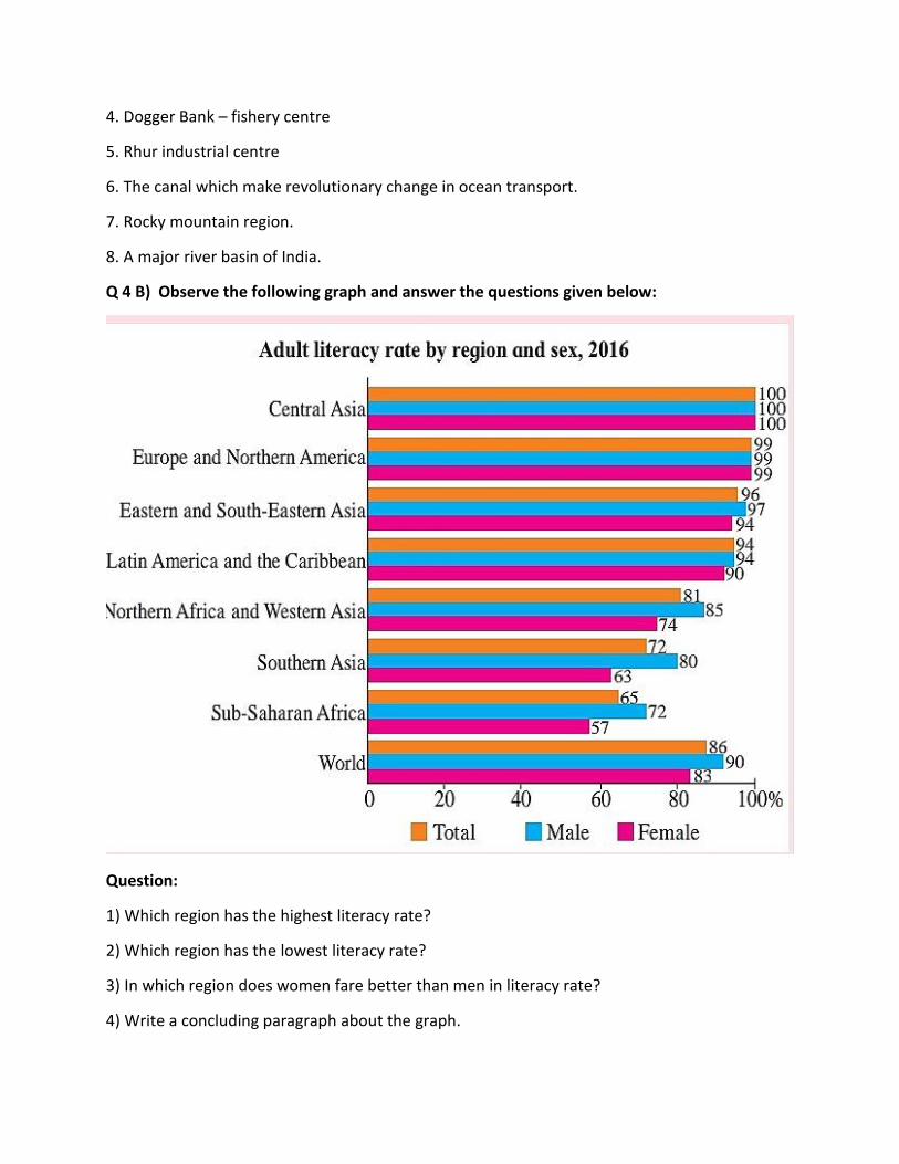
Q 4 B) Observe the following graph and answer the questions given below:
Question:
1) Which region has the highest literacy rate?
2) Which region has the lowest literacy rate?
3) In which region does women fare better than men in literacy rate?
4) Write a concluding paragraph about the graph.

5) Which is the type of graph?
Q 4 A) show the following in the world map. Index is necessary.
1. Any two countries in the fifth stage of population transition.
2. The country which has highest population
3. A metropolitan city in India.
5. North-east Atlantic fisheries field.
6. Industrial region near Five Great Lakes
7. The railway route join two continents
8. Coniferous forests of Canada.
Q 4 B) Observe the following graph and answer the questions given below:
Questions:
1. What type of graph is this?
2. In which continent the land percentage is highest?
3. In which continent the land percentage is lowest?
4. In which continent 9.2% land is found?
5. What is the land percentage of Europe?
Q 4 A) show the following in the world map. Index is necessary.
1. Any two countries in the second stage of population transition.
2. A country having sparse population in North America
3. Chennai- metro city
4. Gorges Bank
5. Siberian industrial region

6. Mumbai – London waterway
7. Himalayan mountain region
8. Brisben port.
Q 4 B) Observe the following graph and answer the questions given below:
Question:
1. Which type of the graph shown above?
2. In which age group male percentage is highest?
3. In which age group female percentage is lowest?
4. Whose percentage is highest in 30-39 age group?
5. In which age group female percentage is higher than male percentage?
Q 4 A) show the following in the world map. Index is necessary.
1. Any one country in the third stage of population transition.
2. A country having sparse population in North America
3. Moscow
4. Sable Bank
5. Chhota Nagpur plateau – industrial region
6. Johansberg to London – Air transportation
7. The country of animal husbandry in South America
8. chile.
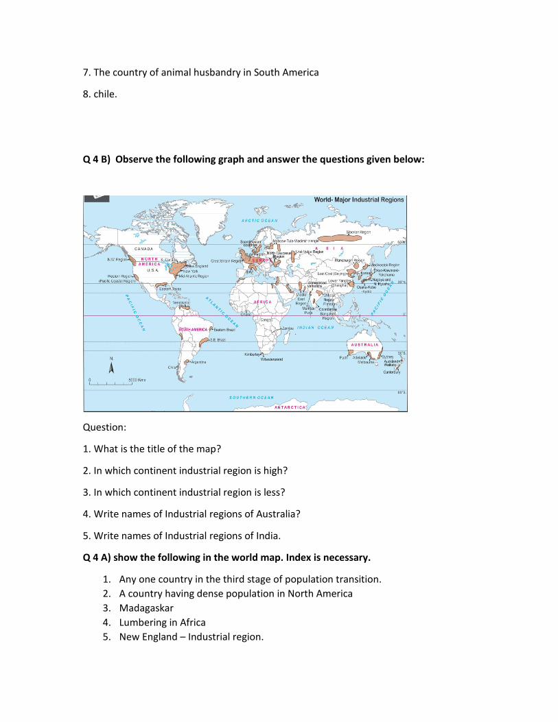
Q 4 B) Observe the following graph and answer the questions given below:
Question:
1. What is the title of the map?
2. In which continent industrial region is high?
3. In which continent industrial region is less?
4. Write names of Industrial regions of Australia?
5. Write names of Industrial regions of India.
Q 4 A) show the following in the world map. Index is necessary.
1. Any one country in the third stage of population transition.
2. A country having dense population in North America
3. Madagaskar
4. Lumbering in Africa
5. New England – Industrial region.

6. Kochi to Tokyo – ocean route.
7. Mining region of Australia
8. Kelao port.
Q 4 B) Observe the following graph and answer the questions given below:
Question:
1) Which economic activities are shown on the map?
2) In which regions do you don’t find any activity? What could be the reason?
3) In which latitudes do you primarily find the distribution of lumbering activity?
4) Why is fishing occupation only found in certain areas in the oceans?
5) Which primary economic activities are mostly found in Europe?
6) What production does the symbol of mining shown in seas and oceans depict?
7) In which continent is mining not found?
8) In which ocean is the world’s fishing mostly carried out?
9) Which primary economic activities are found to the south of Tropic of Capricorn?

10) Which primary activity is found in the islands of South East Asia?
11) Consideringall the four continents, in which continent do you find less agriculture being
practiced?
12) Write a paragraph on relationship between latitudinal extent of agriculture and climate in
your own words.
Q 5 Write short notes:
1. Third stage of population transition theory
2. Occupational structure of India
3. Intensive subsistence agriculture
4. Classification of industries based on ownership
5. Characteristic of quaternary activities
6. Importance of satellite in communication
7. Regional development
8. Relation of physical geography to other branches of sciences
9. Effect of relief on population distribution
10. Literacy and education
11. Population pyramid and sex ratio
12. Rural land use
13. Favorable factors for fisheries
14. Classification of industries based on source of raw material
15. Role of transportation in trade
16. Factors affecting on regional development
17. Correlation between birth rate and death rate
18. Urban land use
19. Plantation agriculture
20. Classification of industries based on production
21. Economies of scale
22. Tourism and gross domestic product of the country
23. Population and regional development
24. Rural – urban structure of population
25. Inter activities between rural – urban settlements
26. Physical factors affecting on fisheries
27. Classification of industries based on capital investment
28. Causes of regional imbalance
29. Latest trends in geography
30. Causes of migration
31. Functional classification of towns
32. Commercial lumbering
33. Effect of migration on population

34. Problems of urban settlements
35. Hunting and loss of ecology
36. Public sector industries
37. Role of transportation in development of industries
38. Strategies to reduce regional imbalance
39. Branches of geography
40. Population growth and migration
41. Suburbs
42. Mix land use
43. Footloose industries
44. Types of region
Q 6 A) Read the following passage and answer the question given below:
Different types of human settlements include padas, villages, small towns, big cities, all
remote places, towns and groups of towns. In some systems, human settlements are
divided into urban, suburban and rural.for example, The United States Census Bureau,
classifies settlements in urban or rural areas based on a defined definition. In small
settlements, such as padas and villages, access to low population and services is limited.
Larger settlements, such as cities, have higher populations, higher densities, and greater
access to services. For example, a village may have only one or two general stores, while a
large metropolis may have many specialized stores. These differences are known as low-
order service settlement and high-order service settlement. The functions of human
habitation are also different. Because settlements can be established as ports, markets and
resorts. Types of rural settlements can also be classified by activities such as agriculture,
fishing and mining. Settlements that focus on one economic activity are called single
functional settlements.
Human habitation can be permanent or temporary. For example, a refugee camp is
a temporary settlement, while a city is a permanent settlement.
1. Which human settlements are mentioned in the given passage?.
2. Urban and rural areas are classified on the basis of what.?
3. What works are done in rural areas.?
4. Explain the difference between low order service and high order service settlement

Q 6 B) Draw diagrams and label it:
1. Geographical factors affecting on the distribution of population
2. Linear settlement
3. Types of industries
Q 6 A) Read the following passage and answer the question given below:
The economic development of any country requires careful planning and
implementation. The need for planned development in the tourism sector is very important. In
this, many industries are working together in a complex way. And they need special attention.
Basically planning is an attempt to allocate limited resources with a view to maximizing the
production, income and employment in various competitions and ensuring proper growth of
different sectors. Tourism planning is one such process. Through which certain objectives can
be achieved and attention can be paid to tourism development. Creating, upgrading and
improving destinations for tourists is a long-term and ongoing process. Communities are the
basic principles of tourism. It mainly depends on the level of action shown by the local
community. Their participation in the process is essential. The development of tourism mainly
affects the economy of the host community through environmental, social, cultural and any
other destinations. These results create negative as well as positive effects. Planning is essential
for the sustainable development of the destination to minimize negative impacts and drive
positive outcomes.
1. Why the tourism sector feels the need for planning?
2. What is the importance of communities in planning?
3. State any two benefits of planning.
4. What factors affect the economy of the host community?
5. Why planning is a long term task?
Q 6 B) Draw diagrams and label it:
1. Expansive age – sex pyramid
2. Circular pattern settlement
3. Classification of tertiary economic activities.

Q 6 A) Read the following passage and answer the question given below:
Today the human index of most countries in the world is drawn. Three basic factors
(health, education and living standards) are considered when measuring human development
performance and the country's growth. Life expectancy at birth is first taken into account to
measure the 'health of the people' in the country. Countries with higher life expectancy are
ranked higher in merit and countries with lower life expectancy are ranked lower. The Human
Development Index measures the level of knowledge of a country. The second component of
the index is the measure of adult literacy and enrollment of students from primary to university
level. The third factor is considered to be the standard of living of the country in the Human
Development Index. Countries with high standard of living rank higher in merit, while countries
with low standard of living rank lower. The value of per capita gross national product
purchasing power is taken into account when calculating this factor.
1) Which three basic when measuring the performance of human development and the
growthof the country Factors are considered?
2) Which number is given to the countries with higher life expectancy?
3) Which stall ratio is taken into consideration while measuring the knowledge level of a
country in the Human Development Index?
4) What number do low-income countries get?
Q 6 B) Draw diagrams and label it:
1. Population transition theory
2. Rectangular pattern settlement
3. Quaternary andquinary activities.

Q 6 A) Read the following passage and answer the question given below:
In developing countries of the world, the development of infrastructure is very slow.
Power supply, network of transport routes, industrial and commercial services,
educational facilities are all components that are the skeleton that gives shape and
strength to economic business. And the immediate return from that is low. The economy
of most developing countries is inefficient and unbalanced. Agriculture provides at least
50% to 90% employment; On the other hand some basic items, e.g. Oil and some rare
minerals are becoming increasingly expensive. These countries cannot buy it. Mineral
fuels like copper, zinc, tin, etc. are becoming very expensive. Developing countries
cannot compete with developed countries in purchasing these goods. It is said that
creating potential hydropower in the tropics will solve all these problems, but the cost of
building it is huge.
1. Which facilities in developing countries of the world are underdeveloped?
2. The economy of a developing country depends on which business?
3. Developing countries cannot compete with developed countries in purchasing
which goods?
Q 6 B) Draw diagrams and label it:
1. Types of settlements.
2. Patternless settlements
3. Difference between formal and functional region

Q 6 A) Read the following passage and answer the question given below:
Transport is the movement of a person or thing from one place to another. So the transfer of
thoughts or ideas is communication. The distribution of resources is not the same everywhere
so where there is a shortage of resources. They are transported to such places. Raw materials
are processed in factories and finished goods are transported to markets by means of
transportation.
From time immemorial, human beings have been using the means of transportation to
transport goods. In the early days, humans used to carry loads to their destination for long
periods of time as a means of transportation. From the earliest times load-bearing humans to
animals and later handcarts to modern vehicles, the order of evolution evolved.
Even today, animals are widely used for transportation in rural, mountainous, desert or
snow-covered areas. The traditional system of transportation has been revolutionized by the
invention of powerful engines and vehicles. Modern vehicles have increased not only the speed
of transportation but also the carrying capacity. People are more in touch with each other
because of the faster transportation system.
1. What is transportation?
2. Write the order in which traffic evolved?
3. What is transportation used for?
4. In which region animals are used for transportation?
Q 6 B) Draw diagrams and label it:
1. Human factors affecting on distribution of population
2. Radial pattern settlement
3. Provision of public goods / services.
Q 6 A) Read the following passage and answer the question given below:
Iron and steel production started from the 18th century. About 50 to 60 countries are engaged
in iron and steel production. Some of these countries are leading and account for about 80% of
world production. These countries are United States, Russia, Japan, Germany, Great Britain,
France, Italy, Canada, Czech Republic, Slovakia, Belgium, Brazil, India, China, Taiwan etc.
The industries in which machinery is manufactured are known as 'engineering
industries'. The engineering industry is involved in the manufacture of heavy and bulky
machinery, such as railways, aircraft, shipbuilding, clocks, bicycles and other small items. These
industries depend on iron and steel industries. These industries are mainly set up in
economically developed areas. As railway locomotives are set up along the coast, shipbuilding
industries are set up mainly along the coast. The textile and sugar manufacturing industries are
attracting markets. But recently the approach of the machine industry has shifted from place to
place, attracting more and more urban areas. The engineering industry is understood as the
secret of the nation's development.
The availability of skilled labor, raw materials like basic iron and steel, modern and
technologically advanced regions and other factors play a vital role in the localization of the
engineering industry.
1. Which countries are leading in iron and steel production?
2. Which industries are mainly set up in economically developed areas?
3. The engineering industry includes the machinery required for the manufacture of
which goods?
4. What factors play an important role in the localization of the engineering industry?
Q 6 B) Draw diagrams and label it:
1. Provision of infrastructure and stimulus
2. Triangular pattern settlement
3. Skills of geographer

Q 6 A) Read the following passage and answer the question given below:
The word petroleum is derived from the original Latin words petra and olium. Petra means rock
and oleum means oil. Petroleum is a mixture of several types of hydrocarbons.
The stratified rock in which the remains of marine microbial plant plankton
(phytoplankton), algae and bacteria are found; such stratified rocks produce oil and natural gas.
The remains of marine flora and fauna are stored at the bottom of the ocean, and silt
accumulates and is buried beneath the silt layer. Due to the weight of the sludge and the heat
generated from it, the organic matter deposited under the sludge is converted into droplets of
fine oil. When the temperature of organic matter isreaches up to 120 degrees Celsius, then the
organic matter is converted into oil particles. These oil particles penetrate into the microscopic
pores of the rock and thus form rocks with a source of petroleum. Sandstones with high
porosity are more likely to contain oil. It consists mainly of biofuels. The fuels currently in use
include minerals such as coal, petroleum, natural gas and atoms.
1) How the word petroleum is formed?
2) How rocks with petroleum sources are formed?
3) Which rock is more likely to contain oil?
4) What minerals are present in the fuel currently in use?
Q 6 B) Draw diagrams and label it:
1. dispersed settlement
2. Rural land use
3. Branches of geography

Q 6 A) Read the following passage and answer the question given below:
Coal is a black or gray rock by color. Coal is made of carbon. Coal formation is due to the fact
that plant remains have been buried underground millions of years ago. Coal production has
been extensive in the Carboniferous era. This period is 300 million years old. According to
geologists, in the Carboniferous era, coal was produced in wetlands where temperate forest
growth occurs. Remains of dead plants such as bunds and branches are stored in the wetlands
and over time due to the accumulation of silt and mud on them, the plant does not rot
completely due to the weight of the silt. Plant remains are suppressed by pressure from the
sediment, as well as by the movements of the earth's crust, and sometimes by the heat of the
volcano. This causes chemical and physical changes in the buried plant layer, which is initially
converted to peat (crude coal) and then to other types of coal. There are many types of coal,
depending on the composition of the coal and the amount of carbon. There are four types of
coal based on the amount of carbon in the coal. Anthracite, bituminous, lignite, peat etc.
Coal is used as a fuel in thermal power generation. In many parts of the world, coal is
used to generate water vapor over heat. Coal is also used as a fuel in steam engines of ships
and trains. After power generation, coal is mostly used in the steel industry. Coal is used as fuel
in the cement industry. Many types of chemicals are produced from the coal component. E.g.
Asphalt, fennel, benzole, plastics, dyes, disinfectants, fertilizers, etc. The gas produced from
coal is used to make biochemicals. Even today, coal is used as a fuel for cooking and keeping the
house warm.
1) How coal is produced?
2) In which era was coal produced?
3) Explain from which component the types of coal occur?
4) What coal is used for?
Q 6 B) Draw diagrams and label it:
1. Urban land use
2. Primary economic activities
3. Expansive age – sex ratio.
Q 7 Write answers in detail:
1. Discuss the problems faced by countries in stage 4 and stage 5.
2. Write a note on the areas in the world practicing commercial animal husbandry.
3. Explain the physical factors affecting distribution of population.
4. Explain the physical factors affecting location of industries.
5. Explain the factors affecting location of sugar industries.
6. Outline the importance of population pyramids in the study of populations.
7. Explain rural and urban structure of settlement.
8. Explain the factors affecting trade between two countries.
9. Examine the impact of migration on the population structure of a country.
10. Development of transportation is dependent on geographical factors. Explain.
11. Explain characteristics of rural settlement.
12. Why is transportation system important in the development of any nation?
13. What factors are responsible for development of various patterns in a settlement? Give
examples.
14. Communication activities are expanding day-by-day. Explain the statement.
15. What are the factors affecting commercial fishing?
16. What is region? Explain.
17. Write a note on Intensive Subsistence agriculture.
18. On what factors are the regions differentiated? Give examples.
19. Give the characteristics of Market Gardening.
20. Per capita income is not the real indicator of regional development. Explain.
21. Explain how the knowledge of Geography is important in our day-to-day life. Give
examples.
22. Mining is dependent on the extraction of naturally occurring minerals. Explain.
23. Discuss the relationship between Geography and other subjects.
24. Write in detail about the characteristics of primary economic activities.
25. Explain the nature of Geography in detail.
*****************************END*****************************************