Embed Size (px)
Citation preview
Understanding and Mapping Large City Scapes 1(13)
Understanding and Mapping Large City Scapes
–Methodological approaches between sociology and Urban Architecture
Paper to Conference Architectural Inquiries in Göteborg, 2008.
Gitte Marling Associate Professor, Ph. D. Department of architecture & design, Aalborg University Aalborg, Denmark. TEL: +45. 28.96.76.16 [email protected] Abstract The paper discusses the modern challenges in the agency of mapping large city scapes. It argues for the current need for an integration of different methods and approaches: some new and some developed from the work of Kevin Lynch, Gordon Cullen and from Robert Venturi, Denise Scott Brown & Steven Izenour. The text will briefly go through these methods developed in the late 1950s and early 1960s, and it will investigate the mapping methods in order to pick up terms and approaches, which are useful even today. When discussing size XL cities, I find it helpful to include the work of the Dutch architect and writer, Rem Koolhaas. Since the mid 90s he has put a huge effort into convincing the world that the new kind of urbanism going on in large urbanised areas is important for the way we understand and analyse the contemporary city. In the end of the paper Rem Koolhaas’ approach will be presented. The paper ends up presenting my own methodological research for developing a holistic way of combining what could be namedinside out and outside in approaches, that is research between social science, storytelling and architectural design.

2(13) Understanding and Mapping Large City Scapes
Mapping City Images The industrial development in the last century led to new urban theories and city models. I will not go into details with the historical development in relation to this. I will, nevertheless, take my point of departure in some of the theories developed in the 1950s and 60s where the economic development and the mobility by cars changed the structures of the cities first of all in North America. Most architects were worried about the changes in the urban fabric, and about the increasing urban sprawl, the loss of the former townscapes and of historic architectural typologies. The disintegration of urban space was obvious, and the art of relationship (Gordon Cullen, 1961) was missing its historical essence in urban design. The questions asked were what happens to urbanism, and what can be done? As early as the late 1950s Gordon Cullen tried to present images for urban architecture, or the art of relationship, as he called it, to turn the architects’ and developers’ attention to urban architecture and the qualities in designing for an interesting, picturesque and exciting urban environment. “In fact, there is an art of relationship just as there is an art of architecture. Its purpose is to take all the elements that go to create the environment: buildings, trees, nature, water, traffic, advertisements and so on, and to weave them together in such a way that dram is released. For the city is a dramatic event in the environment.” (Cullen, 1961, p.7) Cullen is aware of the need of cooperation between experts in order to form the myriad of factors into a workable, viable and healthy city organisation; but research in these conditions is not enough, he stressed. He added that they may even result in dull, uninteresting and soulless cities.
What was needed according to Cullen, were terms or categories for emotional reactions and visions as ways of increasing the awareness of the art of relationship. In his work he comes up with three different ways of working with impacts on the emotions. The first concerns “optics”, or the moving eye in the moving body. Cullen works with serial visions; that is a drama of juxtapositions that come alive when we walk down the street and experience the contrasts between, for instance, the street and the courtyard, light and darkness etc. Having two contrasting pictures in mind “a vivid contrast is felt and the town becomes visible in a deeper sense. It comes alive through the drama of juxtapositions. Unless this happens the town will slip past us featureless and inert” (Cullen, 1961, p.8) Serial visions are the best known of Cullen’s approaches. Another is “place”. Place has to do with our reactions to the position of our body in the environment. It is the feeling of entering or being in a room. If you stand at the top of a tower, the feeling differs from that of standing at the bottom of a deep cave. He uses the terms “here and there”, meaning that I am here in contrast to there. The last category is “content”. The fabric of cities: colour, texture, scale, style, character, personality and uniqueness. Cullen sums up his contribution to urban theory, or understanding of the modern city, in the following way: “We discovered three gateway, that of motion, that of position and that of content. By the exercise of vision it became apparent that motion was not one simple, measurable progression useful in planning, it was in fact two things, the Existing and the Revealed view. We discovered that the human being is constantly aware of his position in the environment, that he feels the need
Understanding and Mapping Large City Scapes 3(13)
for a sense of place and that this sense of identity is coupled with the awareness of elsewhere.” (Cullen, 1961 p. 12) Cullen’s contribution has been valuable for the way the architect’s profession works today, even if his categories are neither exact nor specific. It is obvious - and he stresses this himself: He is an architect, and as such he is not trained as a researcher. Nevertheless, his concept of “the art of relationship”, and the way he uses the senses of the human body as a kind of instrument measuring the success of the urban design efforts signified a breakthrough in the architect’s way of focusing on buildings and objects as points of interest. Stressing the experiences of the city instead of using building and architectural typologies he contributed elements to what I would call a strategy of understanding and mapping the urban fabric inside out. What he missed was a way of testing his thesis in cooperation with citizens. He also missed a lifestyle perspective in his work. I shall return to this later. Kevin Lynch was more systematic or scientific in his work. Turned on, as he was, at the critique of the modern city, he had the same intention as Cullen to explore the elements, which had to be the value-base for good urban design praxis. Like Cullen, Lynch too worked with vision and the way the human being explored the city. “Every citizen has had a long association with some parts of his city, and his image is soaked in memories and meaning” (Lynch 1960. p.2), he stated. His goal was to study the mental images of city, as it was held by its citizens. His work in the late 1950s concentrated especially on one particular visual quality of the city: the apparent clarity and “legibility of the city-scape”. By this he meant the ease with which its parts can be organised into a coherent pattern. If the city is legible, it can be visually grasped as a pattern of recognisable symbols.
As we will see, the result of his studies is that a legible city would be one the districts, landmarks or pathways of which are easily identifiable and grouped into an overall pattern.You could say that his interest was in the city images as a communication system, communicating memories, history and identity. What Lynch did in the three different cities was to talk to the inhabitants in order to develop and test his idea of imageability, and also by comparing image with reality to learn which forms make for strong images. Together with a group of his students, he interviewed local people in the three cities. He asked the respondents to answer questions about what symbolises the word “Boston”, “Los Angeles” or “New Jersey” to them. He asked them to draw a city map on a blank piece of paper. He asked them to draw their route from home to job and describe the sequences. He asked them what they saw, heard, smelled etc. He asked about their feelings. Then he asked the respondents to map all the elements in central Boston, Los Angeles or New Jersey that they regarded as the most distinctive. He asked them several other questions about special places, districts etc., and again he asked about their feelings in relation to this. Some of the respondents were invited to participate in more interviews in which they were asked to lead the interviewer from one point in the city to another, and to explain the route. In the first part of these interviews the route was virtual and only described in writing on a piece of paper. In the second part of the interviews the volunteer respondents were taken out into the field to follow the former mental strips. Photos were taken, and the respondents were asked to comment on the important elements, which he or she found along the way.
4(13) Understanding and Mapping Large City Scapes
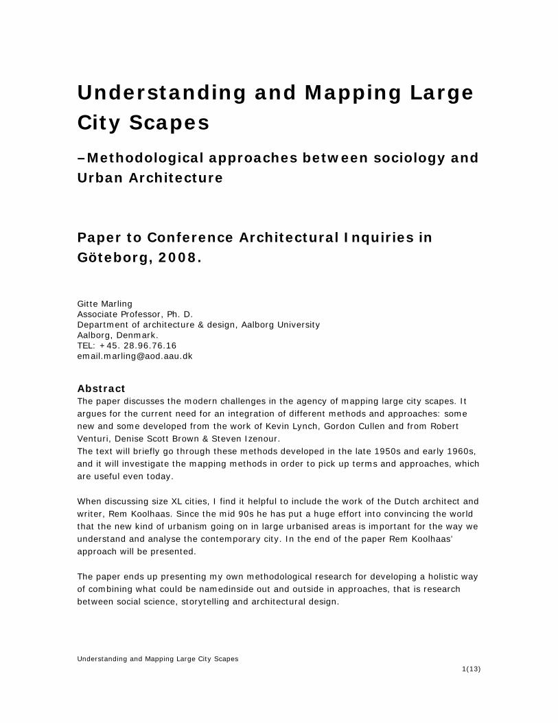
All the maps – those derived from verbal interviews, from sketch maps, or those showing the visual form as seen in the field - were studied, and they were compared to maps made by professionals. They all differed from one another,
but Kevin Lynch found that five distinctive elements could be derived from the studies. Five elements or analytic categories were common in all three cities. The categories Lynch derived from the dialogue with local citizens in Boston, New Jersey and Los Angeles were: path, edge, district, node and landmark. The force of the categories is that they are very easy to understand. They can also be handled by both professionals and citizens; even children can understand and use them. I have used the categories with great success in a workshop with twelve year old children. Particularly children had a good feel for the pathways, the nodes and the landmarks whilst walking around the city. They navigated especially by the use of small local landmarks.
Another force of the categories is that they can be used in any kind of city that is historic cities, modernistic cities or generic cities, as a part of an urban architectural mapping.
Lynch considered the five elements – path, edge, district, node and landmark – simply as convenient empirical categories. They had been useful, and it had been possible to group a lot of information around them. He further suggests that they may also be useful as building blocks for urban designers giving form to new urban projects. The categories of Kevin Lynch are well known. They have inspired architects and urban designers all over the world in mapping architectural values in urban environments. Nevertheless, the interesting part is to combine the elements and extract the relationship between them. Kevin Lynch names it “the sense of the whole”. It is in putting all the elements together in a pattern that the sense of a city’s image brings to life.
Mapping the city imagesMaps derived from interv iews with the c itizens and from sketces

Understanding and Mapping Large City Scapes 5(13)
“In such a whole paths would expose and prepare for the districts, and link together the various nodes. The nodes would joint and mark the paths, while the edges would bound off the districts and the landmark would indicate their cores. It is the total orchestration of these units which would knit together a dense and vivid image, and sustain it over areas of metropolitan scale” (Lynch, 1960 p.108) Art of relationship: Movement, scale and urban architecture Art of relationship, or relationships among different elements in urban architecture, is also a point of interest for the American architects Robert Venturi, Denise Scott Brown and Steven Izenour. In 1968 they set up a studio “Learning from Las Vegas or form analysis as design research”. Together with 13 students from architecture, geography and planning, they spent three weeks in a library and ten days in Las Vegas. They returned to the university – Yale - and spent ten weeks there analysing their registrations. The result was the book, “Learning from Las Vegas”. Why did Venturi et al focus on Las Vegas? For a long time, most architects and urban planners had turned their back on this extraordinary city formed and managed like a theme park. What excited the group was the fact that a lot of the architectural elements in Las Vegas could be found in all huge cities in America. They saw Las Vegas as a sort of extreme, or concentrated case, representing modern city development in the United States. In the preface to the first edition of their book they wrote: “Passing through Las Vegas is Route 91, the archetype of the commercial strip, the phenomenon at its purest and most intense. We believe a careful documentation and analysis of its physical form is as important to architects and
urbanists today as were the studies of medieval cities in Europe and ancient Rome and Greece to earlier generations. Such a study will help to define a new type of urban form emerging in America and Europe, radically different from what we have known; one that we have been ill-equipped to deal with and that, from ignorance, we define today as urban sprawl. An aim of this studio will be, through open minded and nonjudgmental investigation, to come to understanding this new form and to begin to evolve techniques for its handling”. (Venturi et al, 2000) The studio was based on research already done by the three instructors. In this research they characterise urban architecture as symbols and signs: The buildings were either a box or a container with a big sign, or the buildings were formed as a sign. They saw the architecture of this new city form as a communication system. In this way Venturi et al used the same approach as Kevin Lynch. They experienced the city through the pathways and looked for landmarks and focal points. Along the Strip a lot of landmarks could be found. All the signs were landmarks and monuments, which both informed and persuaded the customers. Signs and symbols were two main themes in their investigation. Another one was space – here mapped as waste land and parking lots. Like Gordon Cullen, the studio was interested in the way we experience the city by moving through it. Las Vegas is a car based city, so the conception of the moving eye in the moving body was essential to their work. You can say that they combined the categories of Kevin Lynch with the optic of Gordon Cullen. But this was not a study of how pedestrians moved around. The speed was not that of 3 miles per hour, it was rather 35 miles per hour, and this determined the work, both in regard to the themes they mapped and the relationship between them.
6(13) Understanding and Mapping Large City Scapes
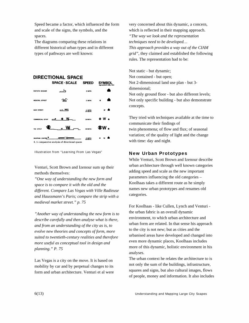
Speed became a factor, which influenced the form and scale of the signs, the symbols, and the spaces. The diagrams comparing these relations in different historical urban types and in different types of pathways are well known: Illustration from “Learning From Las Vegas”
Venturi, Scott Brown and Izenour sum up their methods themselves: ”One way of understanding the new form and space is to compare it with the old and the different. Compare Las Vegas with Ville Radieuse and Haussmann’s Paris; compare the strip with a medieval market street.” p. 75 ”Another way of understanding the new form is to describe carefully and then analyse what is there, and from an understanding of the city as is, to evolve new theories and concepts of form, more suited to twentieth-century realities and therefore more useful as conceptual tool in design and planning.” P. 75 Las Vegas is a city on the move. It is based on mobility by car and by perpetual changes to its form and urban architecture. Venturi et al were
very concerned about this dynamic, a concern, which is reflected in their mapping approach. “The way we look and the representation techniques need to be developed… This approach provides a way out of the CIAM grid”, they claimed and established the following rules. The representation had to be: Not static - but dynamic; Not contained - but open; Not 2-dimensional land use plan - but 3-dimensional; Not only ground floor - but also different levels; Not only specific building - but also demonstrate concepts. They tried with techniques available at the time to communicate their findings of twin phenomena; of flow and flux; of seasonal variation; of the quality of light and the change with time: day and night.
New Urban Prototypes While Venturi, Scott Brown and Izenour describe urban architecture through well known categories adding speed and scale as the new important parameters influencing the old categories – Koolhaas takes a different route as he simply names new urban prototypes and renames old categories. For Koolhaas - like Cullen, Lynch and Venturi - the urban fabric is an overall dynamic environment, to which urban architecture and urban form are related. In that sense his approach to the city is not new; but as cities and the urbanised areas have developed and changed into even more dynamic places, Koolhaas includes more of this dynamic, holistic environment in his analyses. The urban context he relates the architecture to is not only the sum of the buildings, infrastructure, squares and signs, but also cultural images, flows of people, money and information. It also includes

Understanding and Mapping Large City Scapes 7(13)
technology, media, cultures and power and bureaucracy. (Nielsen, 2004) The global size XL city is not the kind of city we are used to. In his famous article “The Generic City” he brings up realities in huge contemporary cities, and he focuses on the formerly unnoticed qualities of these cities. The main quality is – according to Koolhaas - the liberation from identity and from historic character. Rem Koolhaas’ texts map the public realm of big cities, they try to describe the ongoing urbanism as a kind of point-zero according to the cities we know and are familiar with. The size XL city is described as a negation of classical cities. There is no centre, no periphery, no identity, no history. One cannot tell where the cities stop and the landscapes begin. The street is dead. Master planning is useless. There are few or no public places, and many wastelands, theme parks or golf courses; and architecture is reduced to a copy and paste activity. The mass culture is mainstream, and devoid of anything that can incite strong feelings: soap opera, selected news and light entertainment. The only remaining social activity in the big cities is shopping. (S, M, L, XL, 1995) “The Generic city is a city liberated from the captivity of center, from the straitjacket of identity. The generic city breaks with this destructive cycle of dependency: it is nothing but a reflection of present need and present ability. It is the city without history. It is big enough for everybody. It is easy. It does not need maintenance. If it gets too small it just expands. If it gets old it just self-destructs and renews. It is equally exciting – or unexciting – everywhere. It is “superficial” – like a Hollywood studio lot, it can produce a new identity every Monday morning.” S, M, L, XL. P. p. 1250. Koolhaas has studied several huge urbanised areas, mainly located around the equator. One of these areas is the Pearl River Delta, a huge metropolitan area in South China. It includes cities
like Hong Kong, Macau, Shenzhen, Guangzhou, Zhuhai and other huge cities. This city-conglomeration with a radius of two hours is home and workplace to more than 40 million people. It has been planned and developed as a Special Economic Zone, and the development has been monitored by The Chinese Communist Party. The reason for studying this hyper-development has been explained by the research group led by Koolhaas in the following manner: “Where else can the nature of urbanism be characterized by excessive speed, stealth capitalism-cum-communist ideology, concessionary tactics, brutal confrontations between architecture and landscape, and incongruence between promise and delivery, but in Pearl River Delta? It is a region whose urbanism emphasis the greatest possible difference between its, parts whose infrastructure both enables and prevent a functioning hole, whose fabric is neither urban nor rural (but somewhere between architecture and landscape), whose substance is generated by architects who design the largest volume in the shortest time for the lowest fee …” Bernard Chang et al: “Pearl River Delta, Harvard Design School Project on the City”, In: Mutations. 1996. Like Venturi - and Lynch before him - he set up an urban studio with students and young assistants - this time from Harvard Design School - working on the registrations and mapping. “The Harvard Design School Project on the City” has been published in several articles and in the very comprehensive book “Great Leap Forward” from 2001. In the Harvard study of the city, the text works through a focus on the new phenomena or urban prototype. Koolhaas and his colleagues name the elements they see. In order to describe them, they use the same approach as Venturi: they look for

8(13) Understanding and Mapping Large City Scapes
the dynamic elements, for twin phenomena, for juxtapositions etc. The trademark or copyright mark symbolises the new linguistic innovation and the new meaning of the term. A couple of examples from “Great Leap Forward” p. 704- 709 illustrate this new linguistic innovation: 1. More is more © The conclusion of an evolution that began with Mies as “less is more” and passed through Venturi as “ less is a bore” now ends in a paroxysm of the quantitative in the pearl river delta as MORE IS MORE ©. Five hundred square kilometres of urban substance is found every year … etc.” 2. Photoshop ©. The same power offered by Photoshop, to combine everything into anything - the uncritical accumulation of desire - is exercised literally as urbanism in the Pearl River Delta. In the PRD PHOTOSHOP © is the freedom to manipulate not images but urban substance, regulated only by the rules of Feng Shui ©. 3. floating © A migration condition held by two-thirds of Shenzhen’s population who do not have jobs, legal status, or homes in the Special Economic Zone, yet are officially registered in their original provinces of residence. Attracted to the hyper-development of the coastal cities and the SEZ’, FLOATERS© form mobile reservoirs of flexible labour, a necessary ingredient for SHENZHEN SPEED©. In general you can say that Rem Koolhaas’ texts neither function as pre-investigations with the aim of preparing a theoretical base for praxis, nor reflect the architecture or buildings his firm OMA has designed. Rather, his texts have a character of independent documents, which formulate the problems, the conditions and the challenges to urbanist praxis. (Jensen 2004) His texts provide us with a new and refreshing approach to understanding and mapping new city forms and the dynamic of the cities. In this way Koolhaas is among the architects who have had
the greatest influence on the architectural agenda during the last 25 years. The categories he has named are useful in order to understand the cities on the move. But first of all they are based on feelings and creative registrations following certain ideas, and not on research. Using them in your mapping, you often feel the limits: you can put everything or nothing into the terms. Thus, they are more like themes than useful analytical terms. Secondly, they only describe a part of the urban fabric. Especially while working on the urban scale, Koolhaas seems to have what I would call an outside in approach. He is interested in the factors that generate a certain development in urbanism, rather than the experience of the city from an approach of an everyday praxis. We know that he was interested in the new role of the architect, and seen in this perspective, I think he is still missing an important point of who has the right to describe the values, problems of challenges of the city? Is the Architect or urban designer the judge in this regard? I shall go deeper into this in the following. Urban songlines and storytelling Who has the right to story-telling about the city? Working with the approach of Venturi or Koolhaas, these questions come up in my mind. If we return to Kevin Lynch again for a moment, it is obvious to me that the way he involved the citizens in registering their own city raises an interesting discussion of the approach to mapping. Both Cullen and Lynch work with an inside out approach. Lynch tested his findings with a professional test group. He compared many different ways of mapping in order to derive his analytic categories, and in order to avoid bias in his research. But, like Cullen, he missed a social and cultural dimension in his work.
Understanding and Mapping Large City Scapes 9(13)
In my research I have used theories derived from sociology and anthropology as stepping stones in conjunction with the research of architects and urban designer. I have used the theories of among others the French sociologist, Pierre Bourdieu, who has had an important international influence on upcoming research in lifestyle taste, values and everyday praxis related to the habitus of the individuals and culture of lifestyle domains. Mapping the city inside out is about combining a lifestyle approach with an approach to storytelling. I have called my approach urban songlines, which links storytelling about everyday practice to the geography of the city. The term urban songlines is inspired by the Aboriginals, the native people of Australia. To them, songlines means a mental line of a clan. Holy places and places of meaning and identity are connected to this line. Every member of the clan owns a piece of the songline, and can navigate across the continent along this songline. (Marling, 2004) I use the term urban songline about the lines or routes we follow in connection with our daily activities in the modern city. All of us move over huge areas every day, even children and elderly people. We follow the pathways in the city, and by doing so we explore the city and we produce meaning. (Lynch, 1961) Our songlines combine all the places of interest for us and all our domains. So, a songline comprises the urban space used by each individual and in which daily life is lived, that is dwelling, working, leisure activities etc. Drawn on a map, many songlines resemble a widely branched amoeba, while others are more limited. I have used my urban songlines methodology to combine the architectural mapping and the everyday practice of different lifestyle groups. Through interviews, mapping the everyday songlines and the weekend songlines, sorting pictures, photo safaris with the respondents or the
respondents own photo safaris, visiting places of meaning together with the respondents etc., I have mapped the urban architecture as it is explored by the respondents. Using the categories of Kevin Lynch I have added categories from Gordon Cullen and Robert Venturi et al as well. Landmarks and nodes have been mapped, that is the open urban spaces, parks, harbour fronts, golf courses, leisure parks, voids etc. and the indoor meeting places like shopping malls and clubs. I have mapped all the indoor or outdoor meeting places of importance for the respondent. Serial visions, the urban architecture in relation to the body (Cullen) and likes or dislikes along the pathways have been part of the mapping too. We have talked about the meaning of nature in the city, of the meaning of history, architectural values, taste and the contents (Cullen). To grasp the more formal structures of the respondents’ practices, I have carried out two sorts of investigations. The first is more descriptive, and, as mentioned above, the second series of investigations has concerned the scientific literature about life form and lifestyle in order to find analytical categories. Thus, I have worked in a manner similar to that of Michel de Certeau in his work with the practice of every day life. Through storytelling, the respondents have told the story of his experiences of the part of the city to which he relates himself. The sense of the whole is a summing up, not only on the mapping the urban architecture in a songline or the territory of the respondent. It is also combined to an understanding of the respondents’ lifestyle and values.

10(13) Understanding and Mapping Large City Scapes
Reidum’s everyday territory or songlines in Aalborg
Songlines in research and praxis The songlines method was first used in a study of Aalborg. Here six respondents participated in six different stories told about the images and urban architecture in Aalborg. The result was new knowledge about the social geography in not only the residential areas of the city, but also in the net of meeting places and different cultural and lifestyle domains of the city. A year later in 2005 I sat up an urban studio in Bangkok with 34 urban design students mapping Bangkok songlines. In 2007 another workshop was sat up with 16 students working in, Hong Kong, Shenzhen, Zhuhai and Bangkok. In the workshop I worked with a combination of different methods, that is on one hand registration
of signs, symbols, urban architecture, space and on the other hand storytelling about everyday life in the city in order to strengthen the analytical power. Planning praxis has also taken in the songline method. In Malmø, Sweden, the planning office has ordered a songline mapping in order to investigate in which way different cultural groups use the open spaces in the city. The questions asked were, what kind of meeting is taking place in the open spaces, and also if it is possible to make the songlines of different cultural groups meet. On this base, the goal is to design new meeting places, new public domains, where social and cultural exchange can take place.
Understanding and Mapping Large City Scapes 11(13)
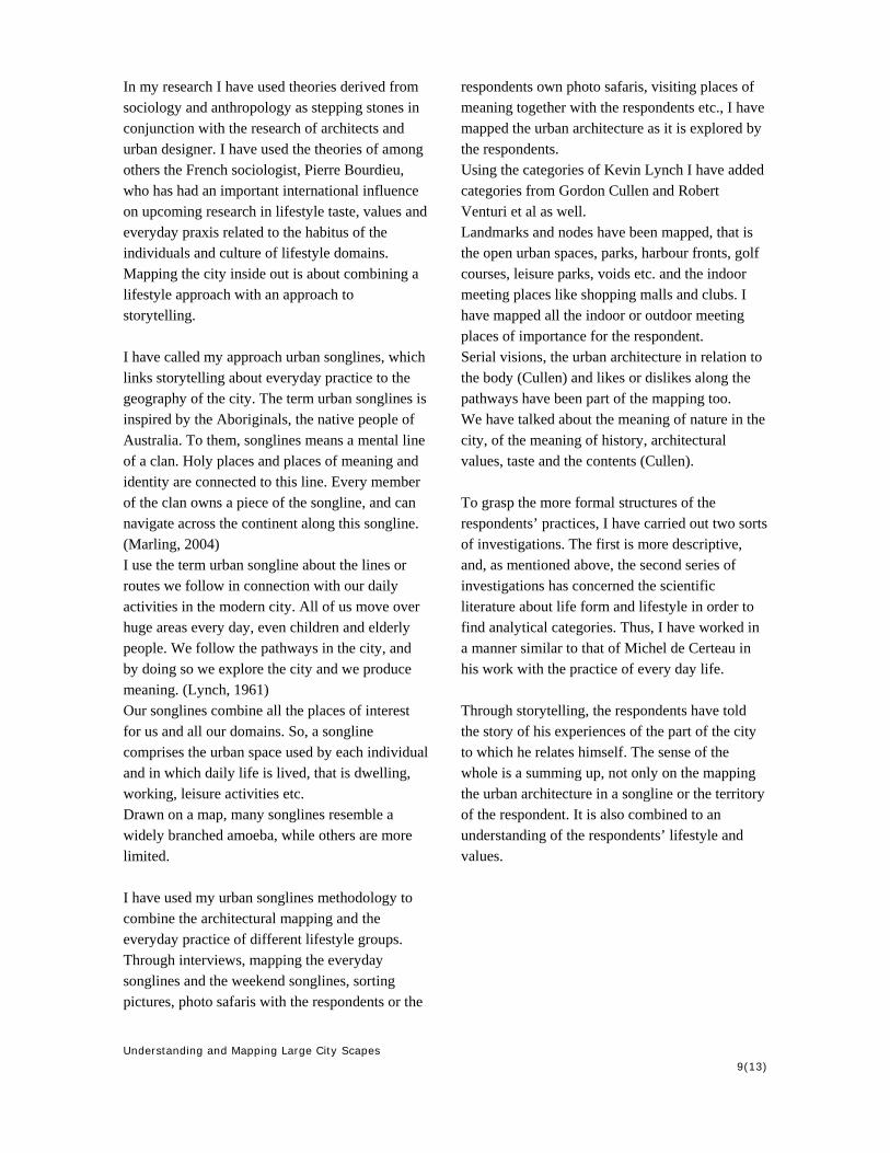
Combining methods An inside out approach by tracing everyday life provides us with knowledge about questions such as: What are the elements that create connections and produce meaning for urban life and modern city dwellers? Which places produce meaning, and which lifestyle groups or cultural croups find identity there? We even try to get knowledge about places of more spiritual meaning. The lesson from Kevin Lynch is that you need to be out in the field with your respondent. An interview or drawings on a blank piece of paper do not suffice. You have to start with the everyday praxis. You have to ask the respondents to tell you what they actually do. Show you the specific route they take, point out their use of specific places. Lifestyle is not what the respondents think they are. Nor is it the self-image that they attempt to project. To trace lifestyle is to trace the everyday praxis of the respondents. It is what they do naturally without thinking too much about it. The development and changes in economy, in structures and forms influences city life. The inside out approach can register this influence and produce new knowledge about the impact of different social and cultural groups; but it is not the topic to explain the forces that drive the development. For a purpose like that, an outside in approach is needed. Here there is a need of developing the methods of Koolhaas. As a teacher and researcher, I am - like Koolhaas - interested in the new role of the urban designer. I am interested in the urban fabric, which is going to be orchestrated, and in relation to that what knowledge and skills are needed for this praxis. I am also interested in knowing more about human perception and experience of the city in order to set up goals for better urban environments and architectures.
In that way my approach differs from that of Rem Koolhaas – it is meaningful to me to seek new knowledge about the urban elements, the landscape and the architecture that give quality to the daily life of different cultural groups in the city; and it is meaningful to work for better conditions for social integration, sustainable environment etc.
Mapping and exploring the city outside in /inside out. Workshop China 2007: Photos by Dina Brænstrup & Lærke Jørgensen
12(13) Understanding and Mapping Large City Scapes
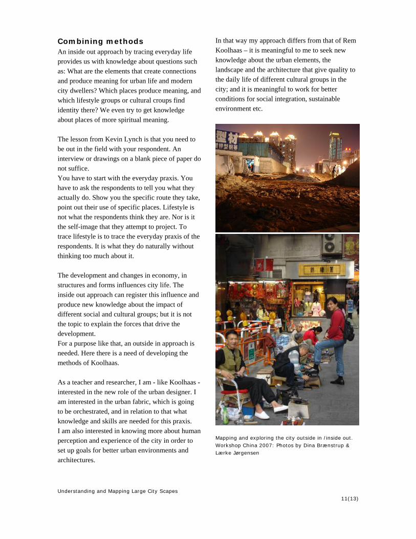
Mapping inside out: workshop & exhibition 2007
Inside out mapping made by Maria vestergaard Jensen & Dorte Baj Højerup, Urban Design, AAU.
Bangkok 2007
Inside out mapping made by Loa Dahl Iversen & Line Morsing Nielsen, Urban design, AAU 2007
Understanding and Mapping Large City Scapes 13(13)
References Chang, Bernard et al. (1996): The Harvard Design
School Project on the City – Pearl River Delta. In: Mutations. Barcelona.
Chung, C.J., Inaba, J. Koolhaas, R. Leong, S. T (1996): The Great Leap Forward. Project on the City 1: Harvard Design School. Massachusetts.
Corner, James (2002): the Agency of Mapping – speculation, critique & Invention In: Cosgrove, Dennis: Mappings. P. 213-252. Reaction Book. London.
Cullen, Gordon (1961): The Concise Townscape. Essex.
De Certeau, Michel (1984): The practice of everyday life. Berkley. Los Angeles. London.
Lynch, Kevin (1960): the Image of the City. Massachusetts
Lynch, Kevin (1991): City Sense and City Design. Massachusetts
Koolhaas, Rem (1995): The generic City In: Koolhaas, Rem & Mau, Bruce: S, M, L, XL.New York
Malmø Stadsbyggnadeskontor (2007): Möten I staden. Malmö.
Marling, Gitte (2004): Urban songlines – hverdagslivets drømmespor. Aalborg
Marling Gitte: Urban Songlines – the space of daily life in the City (2004) In: Marling, G., Kiib, H., Bech-Danielsen, C.; Jensen, O. M.: Urban Lifescapes. Aalborg
Marling, Gitte (2005): Bangkok Songlines. Aalborg
Nielsen, Rasmus Rune (2004): Rem Koolhaas – Learning from Manhattan. Aarhus
Venturi, Robert et al (2000): Learning from Las Vegas. Massachusetts