Embed Size (px)
Citation preview

SDG&E Mira Sorrento Substation NTP Request
June 14, 2013 Page 1
Mary I. TurleyProject Manager
8315 Century Park Ct.San Diego, California 92123
(858) 654‐1749 office(858) 637‐3770 fax
June 14, 2013
Mr. Michael Rosauer Project Manager California Public Utilities Commission 505 Van Ness Avenue, 4th Floor San Francisco, CA 94102
RE: Notice to Proceed (NTP) Request to Construct Mira Sorrento Substation
Dear Mr. Rosauer:
On December 27, 2012, the California Public Utilities Commission (CPUC) voted to grant the San Diego Gas & Electric Company (SDG&E) a Permit to Construct (Decision D.12‐12‐017) the Mira Sorrento Distribution Substation (Project) contingent upon implementation of the Mitigation Monitoring, Compliance and Reporting Program (MMCRP). Purpose
SDG&E is formally requesting a Notice to Proceed (NTP) from the CPUC to begin construction of the Mira Sorrento Substation. The Project will be situated on a 3.7‐acre parcel owned by SDG&E and located at the northeast corner of the intersection of Vista Sorrento Parkway and Mira Sorrento Place, just northeast of Interstate 805 (I‐805) within the Mira Mesa Community Plan area of the City of San Diego, California. Please refer to Project Vicinity Map (Attachment A).
The proposed substation at full build out is planned to have four, 30‐MVA transformer banks; four, 69‐kilovolt (kV) tie lines; sixteen 12‐kV circuits; four 12‐kV capacitors (i.e., four bays of standard steel rack approximately 30’ tall each consisting of 69 kV bus and 69 kV transformer); and a 40’ long x 20’ wide masonry block control shelter. Two tiered retaining walls would be constructed on the northeast side of the substation measuring approximately 32’ and 20’ in height, respectively. Access will be via two 30’ wide driveways from Mira Sorrento Place into the west side of the substation.
Power would be supplied to the new substation via an existing SDG&E 69 kV transmission line (TL665). A total of six 12‐kV underground distribution circuits will be routed to Mira Sorrento Place to tie into the existing underground system serving the area.
Construction is expected to last approximately 18 months from initial site development through energization, beginning in July 2013 and ending in the fourth quarter of 2014. Construction methods, equipment, and structures to be installed were described in detail and analyzed in the Final Initial Study / Mitigated Negative Declaration (MND) dated September 2012 (State Clearinghouse No. 20122061036). Project construction activities will include grading and site development; equipment and material staging and storage areas; substation below‐grade components, substation above‐grade components,

SDG&E Mira Sorrento Substation NTP Request
June 14, 2013 Page 2
utilities installation; and energization. Pre‐Construction Mitigation Measures
A status report summary of the approved mitigation measures from the MND is provided in the Table below. Measures that are required to be implemented during construction and post construction have been included for your convenience.
Measure Status Description
APM‐AES‐1 Complete Information was included in the contract documents as required.
APM‐AES‐2 Complete Information was included in the contract documents as required.
APM‐BIO‐1 Complete Information was included in the contract documents as required.
APM‐BIO‐2 Complete Information was included in the contract documents as required. CAGN survey scheduled for 1 week prior to start of construction.
MM‐BIO‐1 Complete Please see rare plant survey information in Attachment B.
MM‐BIO‐2 Complete Monitors are identified and awaiting start of construction.
MM‐BIO‐3 Complete Approved by CPUC June 6, 2013. See Attachment C.
MM‐BIO‐4 Complete Information was included in the contract documents as required.
MM‐BIO‐5 Complete Surveyors are identified and awaiting start of construction.
MM‐BIO‐6 Complete Information was included in the contract documents as required.
APM‐CUL‐1 Complete Please see paleontological monitor’s qualifications in Attachment D.
APM‐CUL‐2 Complete Information was included in the contract documents as required.
APM‐CUL‐3 This is a requirement during construction.
MM‐CUL‐1 A draft ADRP has been prepared. The ADRP will be provided to the CPUC for approval if a discovery is made during construction.
MM‐CUL‐2 This is a requirement during construction.
APM‐GEO‐1 Complete Information was included in the contract documents as required.
APM‐HAZ‐1 This information will be provided prior to substation above grade construction work which is expected April 2014.
MM‐HAZ‐1a Complete Information was included in the contract documents as required. Training will be provided to prior to commencement of work.
MM‐HAZ‐1b This information will be provided prior to substation above grade construction work which is expected April 2014.
MM‐HAZ‐1c The SPCC will be provided to the CPUC 60 days before operation of the substation.
MM‐HAZ‐2 Complete Information was included in the contract documents as required.
APM‐HYD‐1 Complete The Waste Discharger Identification (WDID) number is: 9 37C365222

SDG&E Mira Sorrento Substation NTP Request
June 14, 2013 Page 3
Pre‐Construction Permit Status
Grading Permit: Issued June 7, 2013 (Attachment E).
Structural Permit: Pending. Final signature expected June 17, 2013 (placeholder Attachment F)
Traffic Control Permits: Issued June 12, 2013 (Attachment H and Attachment I).
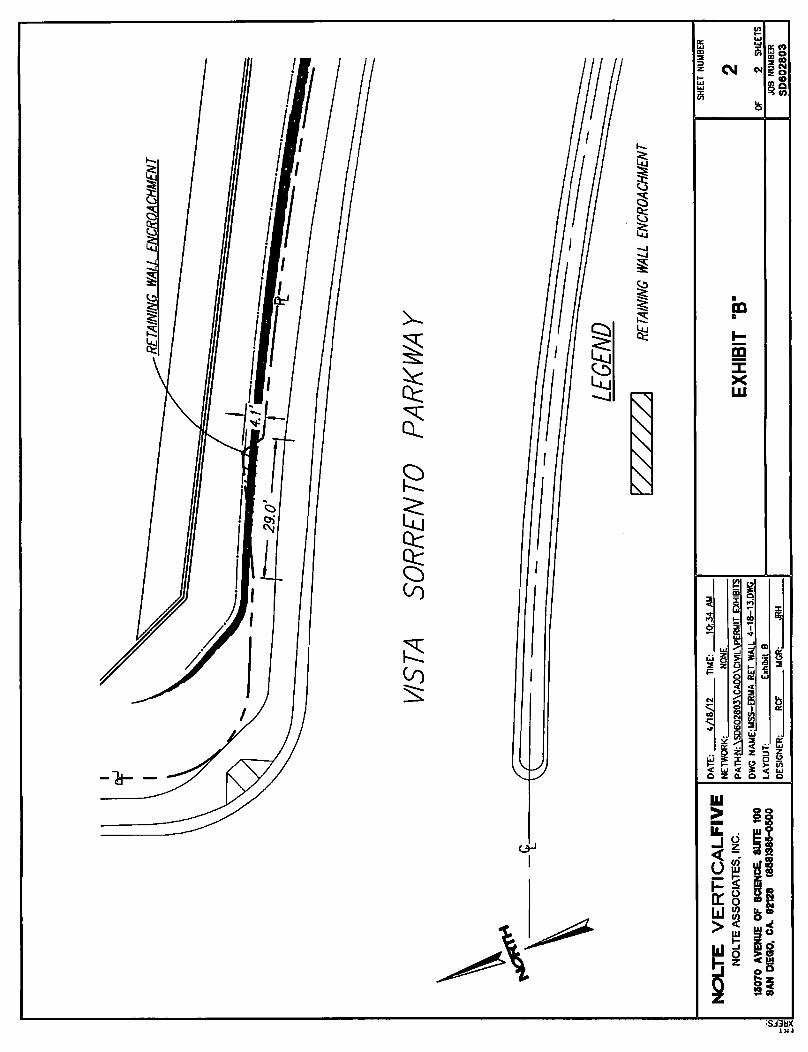
Encroachment Permits: Issued April 25, 2013 for a storm drain (Attachment J); and May 13, 2013 for a portion of the retaining wall (Attachment K).
Dewatering Permit: In process; expected July 11, 2013. Construction activities are not expected to encounter groundwater until the week of August 26, 2013 (8 weeks into excavation work). No dewatering activities will take place until permit issued.
Request for NTP
SDG&E respectfully requests authorization of the NTP. A pre‐construction kick‐off and WEAP training is scheduled on July 1, 2013. Should you have any questions or need additional information, please do not hesitate to contact me at (858) 654‐1749 or by email at [email protected]. Alternatively you may contact Rich Quasarano at (858) 654‐8211 or by email at [email protected].
Sincerely,
Mary I. Turley Project Manager San Diego Gas & Electric Company
MM‐HY‐1 In Process Construction activities are not expected to encounter groundwater until the week of August 26, 2013 (8 weeks into excavation work). No dewatering activities will take place until permit is issued, which is expected July 11, 2013.
MM‐HY‐2 In Process SDG&E will provide this together with the permit as required in MM‐HY‐1
MM‐NOI‐1 Complete Notification letter was approved by CPUC on June 12, 2013 and mailed to property owners within 300’ on June 14, 2013. See Attachment G.
MM‐NOI‐2 Complete Procedure was approved by CPUC on June 12, 2013
MM‐TT‐1 Complete Traffic Control Plans approved by City of San Diego on June 12, 2013 See Attachment H and Attachment I.
MM‐TT‐2 Complete Information was included in the contract documents as required.
MM‐TT‐3 Complete During construction workers will be encouraged to carpool.

SDG&E Mira Sorrento Substation NTP Request
June 14, 2013 Page 4
Attachment A: Project Vicinity Map Attachment B: Rare Plant Survey Letter Attachment C: Workers Environmental Awareness Program (WEAP) Booklet Attachment D: Paleontological Monitor’s Qualifications Attachment E: Grading Permit Attachment F: Structural Permit (Pending) Attachment G: Construction Notification Letter Attachment H: Traffic Control Permit (Grading) Attachment I: Traffic Control Permit (K‐Rail) Attachment J: Encroachment Permit (Storm Drain) Attachment K: Encroachment Permit (Retaining Wall)
cc: Richard Quasarano, SDG&E Environmental Project Manager David Hochart, Dudek Environmental Compliance Director

OfficeBuildings
Park andRide
OfficeBuildings
SorrentoTowers North
Existing Electrical Transmission Corridor
I-805 NB
I-805 SB
SCR
AN
TON
MIRA MESA
I-805 NB OFF
VISTA SORRENTO
I-805 SB ON
MIRA SORRENTO
I-805 SB O
FF
DIRECTORS
I-805 NB ON
SORRENTO VALLEY
PRIV
ATE
CARROLL CANYON
WATERIDGE VISTA
OBERLIN
I-805 SB ON
I-805 NB OFF
SORRENTO VALLEY
805
FIGURE 4-2Project Vicinity Map
4134-01Mira Sorrento Distribution Substation Project
SOURCE: SDGE 2011
0 600300Feet
Predecisional Working Draft
Project Boundary
Existing TL665 Trench Package
New 69kV Trench Package (Approx. 500ft per circuit)
Trench Interception Area
CircuitsNote: Figure revised based on comment E1-9 and response E1-9.

1927 Fifth Avenue 2033 East Grant Road 2027 Preisker Lane, Ste. G San Diego, CA 92101 Tucson, AZ 85719 Santa Maria, CA 93454 P 619.308.9333 P 520.325.9977 P 619.308.9333 F 619.308.9334 F 520.293.3051 F 619.308.9334 www.reconenvironmental.com
An Employee-Owned Company
August 1, 2012
Mr. Alex Jewell RBF Consulting 9755 Clairemont Mesa Blvd., Suite 100 San Diego, CA 92124
Reference: Results of the 2012 Rare Plant Focused Survey for the Mira Sorrento Substation Project (RECON Number 4938)
Dear Mr. Jewell:
Per San Diego Gas & Electric’s request, RECON biologists conducted surveys for rare plants within and adjacent to the Mira Sorrento Substation project area located in the community of Mira Mesa in the city of San Diego, San Diego County, California (Figures 1 and 2). The survey area included the project site and a surrounding 100-foot buffer (Figure 3).
Existing Conditions
Characteristics of the soils found within the survey area are summarized below from the Soil Survey of San Diego Area, California (USDA 1973).
One soil type of the Altamont series is present within the majority of the survey area. This series developed in material weathered from calcareous shale and consists of well-drained clays. Altamont clay, 30 to 50 percent slopes (AtF), is steep with rapid runoff and a high erosion hazard. The soil is typically 20 to 32 inches deep over shale.
One soil type of the Huerhuero series is present within this survey area. This series developed in sandy marine sediments and consists of moderately well-drained loams with a clay subsoil. Huerhuero loam, 15 to 30 percent slopes, eroded (HrE2), comprises a very small portion of the westernmost survey area. This soil type is moderately steep with medium to rapid runoff and a moderate to high erosion hazard. The soil is typically 20 to 36 inches deep.
Vegetation communities within the survey area include coastal sage scrub (including disturbed and restored), native grassland, freshwater marsh, mule fat scrub (including disturbed), southern willow scrub, disturbed habitat, ornamental vegetation, and developed land (Figure 4). The impact area contains disturbed habitat, coastal sage scrub, native grassland, and ornamental vegetation.
The disturbed habitat on-site is dominated by black mustard (Brassica nigra) with a mix of annual grasses and non-native herbs including ripgut brome (Bromus diandrus), soft chess (Bromus hordeaceus), tecalote (Centaurea melitensis), and bristly ox-tongue (Helminthotheca echioides).
Coastal sage scrub varies within the survey area is generally dominated by California sagebrush (Artemisia californica), California buckwheat (Eriogonum fasciculatum), coyote brush (Baccharis
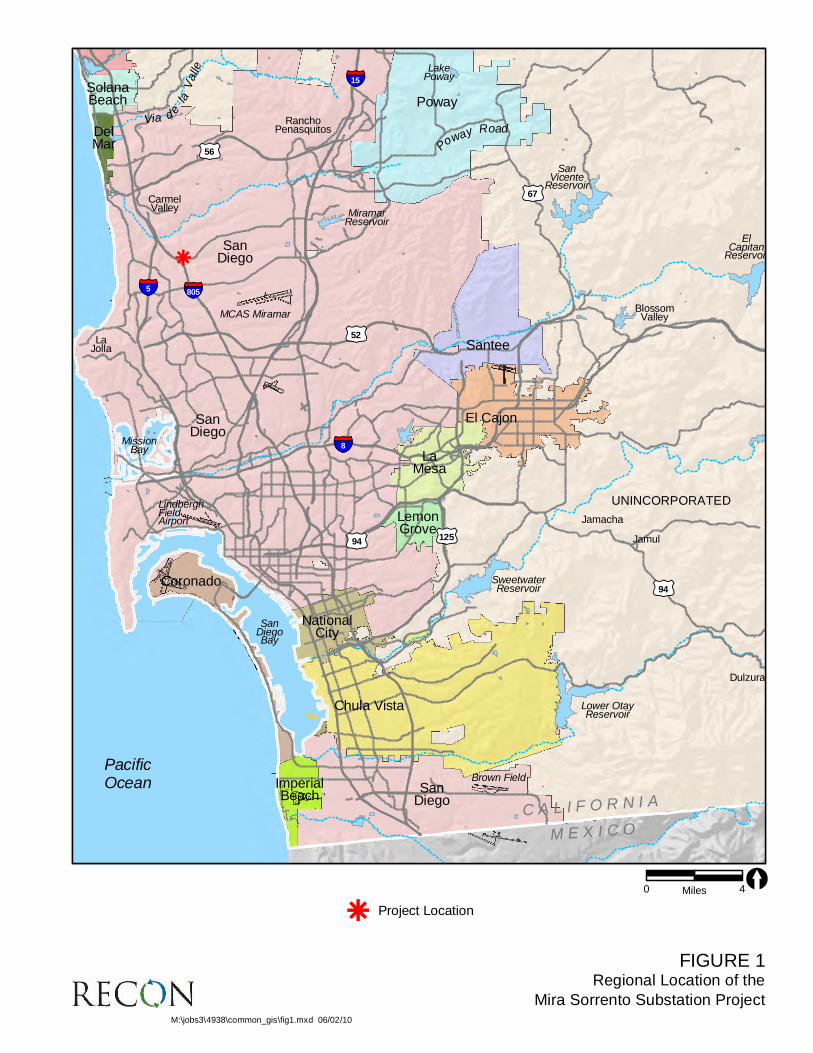
FIGURE 1Regional Location of the
Mira Sorrento Substation Project
Dulzura
Jamul
Jamacha
BlossomValley
SanDiego
SanDiego
ImperialBeach
Coronado
LakePoway
LaJolla
Brown Field
RanchoPenasquitos
CarmelValley
LindberghFieldAirport
MCAS Miramar
MiramarReservoir
SolanaBeach
DelMar
MissionBay
SanDiegoBay
SweetwaterReservoir
Lower OtayReservoir
ElCapitan
Reservoir
SanVicente
Reservoir
Santee
LemonGrove
El Cajon
Poway
LaMesa
NationalCity
SanDiego
Chula Vista
UNINCORPORATED
PacificOcean
C A L I F O R N I A
M E X I C O
§̈¦15
£¤67
Poway RoadVia d
e la
V
alle
£¤56
§̈¦5 §̈¦805
£¤52
§̈¦8
£¤94
£¤94
k
£¤125
Project Location
M:\jobs3\4938\common_gis\fig1.mxd 06/02/10
k
0 4Miles [

FIGURE 2Mira Sorrento Substation Project
Survey Area Location on USGS Map
Map Source: USGS 7.5 minute topographic map series, DEL MAR quadrangle, 1975, Pueblo Lands of San Diego and T15S R03W
M:\jobs3\4938\common_gis\fig2.mxd 06/02/10
0 2,000Feet[
Survey Area

FIGURE 3Mira Sorrento Substation Project
Survey Area Location on Aerial Photograph
MIR
A
SO
RR
EN
TO
P
L
MI R
A
ME
SA
B
L
V I S T A S O R R E N T O P Y
I -8
05
N
B
I-
80
5 N
B O
F
F R
A
MIR
A
SO
RR
EN
TO
P
L
MI R
A
ME
SA
B
L
V I S T A S O R R E N T O P Y
I -8
05
N
B
I-
80
5 N
B O
F
F R
A
Image Source: Courtesy of Microsoft Virtual Earth
M:\jobs3\4938\common_gis\fig3_biotec.mxd 06/02/10
0 150Feet[
Survey Area
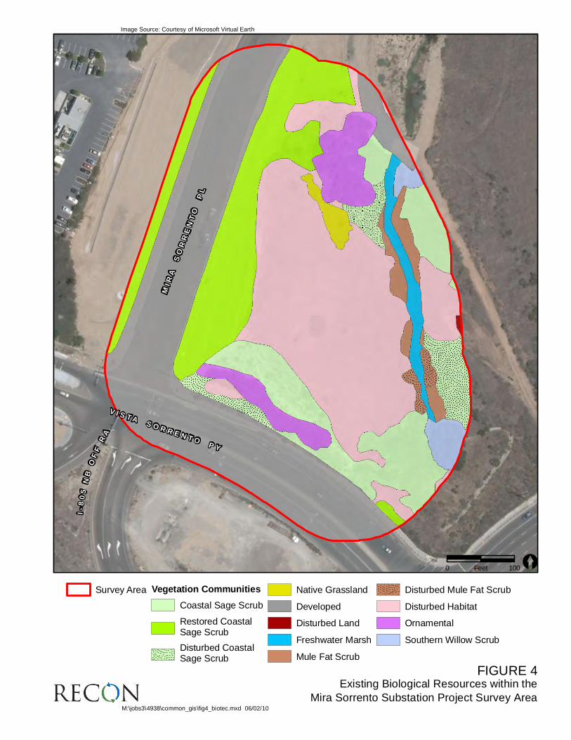
FIGURE 4Existing Biological Resources within the
Mira Sorrento Substation Project Survey Area
MIR
A
SO
RR
EN
TO
P
L
V I S T A S O R R E N T O P Y
I-
80
5 N
B O
FF
R
A
MIR
A
SO
RR
EN
TO
P
L
V I S T A S O R R E N T O P Y
I-
80
5 N
B O
FF
R
A
Image Source: Courtesy of Microsoft Virtual Earth
M:\jobs3\4938\common_gis\fig4_biotec.mxd 06/02/10
0 100Feet [
Survey Area Vegetation Communities
Coastal Sage Scrub
Restored CoastalSage Scrub
Disturbed CoastalSage Scrub
Native Grassland
Developed
Disturbed Land
Freshwater Marsh
Mule Fat Scrub
Disturbed Mule Fat Scrub
Disturbed Habitat
Ornamental
Southern Willow Scrub

Mr. Alex Jewell Page 2 August 1, 2012
pilularis), or spreading golden bush (Isocoma menziesii). Coastal sage scrub along Mira Sorrento Place occurs on a road cut slope and is likely the result of revegetation efforts as evidenced by uniform plant distributions, erosion control measures, and an irrigation system. Along Vista Sorrento Parkway and the crest of the hill, the coastal sage scrub is naturally occurring and consists primarily of California buckwheat and California sagebrush. The southwestern edge of this patch of coastal sage scrub is considered disturbed due to low scrub cover and presence of non-native herbs such as tecalote. A similar patch of disturbed coastal sage scrub occurs in the western edge of the impact area. In the north central portion of the impact area is a patch of native grassland dominated by a mix of nodding and foothill needlegrass (Nassella cernua and N. pulchra). The ornamental vegetation consists primarily of Peruvian pepper tree (Schinus molle).
Wetland vegetation communities were observed along the east side of the survey area, outside the impact area. Freshwater marsh consists of a matrix of open water stream channel and patches dominated by various herbaceous wetland species including southern cattail (Typha domingensis), water cress (Nasturtium officinale), sedge (Carex sp.) and pampas grass (Cortaderia selloana). Mule fat scrub is dominated by mule fat (Baccharis salicifolia), with disturbed areas having a significant cover of bristly ox-tongue and curly dock (Rumex crispus). Southern willow scrub is dominated by red and arroyo willow (Salix laevigata and S. lasiolepis) with water cress in the understory. The developed land on the northeast edge of the survey area is a gravel access road and culvert (see Figure 4).
Methods
RECON botanists Michael Nieto and JR Sundberg conducted three rare plant surveys consisting of two in spring and one in summer 2012 (Table 1). All portions of the survey area were traversed via meandering paths to map sensitive plant species. Surveyors recorded the location of all target special status plant species when encountered using handheld Trimble GeoXT. During the course of the surveys a species list of the plants observed was compiled (Attachment 1).
TABLE 1 SURVEY INFORMATION
Biologists Date Time
Michael Nieto 5/03/2012 0830–1300 JR Sundberg 5/11/2012 0815–1230 JR Sundberg 7/18/2012 0900–1300
Information on potential special status plant species habitat preference, soil types, vegetation maps, and known rare plant phenologies was compiled and used to guide survey efforts. Plant species are considered special status (sensitive) plant species if they are federally or California state listed as endangered or threatened or have California Native Plant Society (CNPS) Rank 1B (considered endangered throughout their range), Rank 2 (considered endangered in California but more common elsewhere), or Rank 4 (plants of limited distribution; CNPS 2012).
Rare Plant Survey Results
One rare plant species was observed during the rare plant survey: decumbent goldenbush (Isocoma menziesii var. decumbens; Table 2 and Figure 5). This species is not federally or state-listed. A description of the rare plant species observed on-site is presented below.

FIGURE 5
Location of Rare Plants within the
Mira Sorrento Substation Project Survey Area
MIRA
SORRENTO
PLACE
V I S T AS O R R E N T O
PA R K WAY
MIRA
SORRENTO
PLACE
V I S T AS O R R E N T O
PA R K WAY
Image Source: Copyright 2011, Aerials Express, All Rights Reserved (flown March 2010)
0 100Feet [Survey Area
Permanent Impact
Temporary Impact
Isocoma menziesii var. decumbens
M:\JOBS3\4938\common_gis\fig5_rare.mxd 7/31/2012 sab

Mr. Alex Jewell Page 3 August 1, 2012
TABLE 2 RARE PLANT OBSERVED
Scientific Name Common Name CNPS Rank
Individuals Observed
Impacts Permanent Temporary
Isocoma menziesii var. decumbens decumbent goldenbush 1B.2 45 10 35
Decumbent goldenbush (Isocoma menziesii [=Isocoma menziesii var. decumbens]). Decumbent goldenbush is a CNPS Rank 1B.2 species (CNPS 2012). This is a low, spreading shrub in the sunflower family (Asteraceae). It has stems up to 20 inches long and blooms between April and November (Munz 1974). Variety decumbens is distinguished by its nearly entire, tomentose leaves, and prostrate or ascending habit (Baldwin et al. 2012). This variety is found in the Channel Islands, Orange and San Diego counties, and in Baja California (CNPS 2012). Decumbent goldenbush grows in dry sandy mesas in coastal sage scrub (Munz 1974) intermixed with grassland. In San Diego County, this variety is concentrated in the vicinity of Bonita northward to the Marine Corps Air Station Miramar, but has been reported as far south as Otay Mesa and as far north as Carlsbad. Variety decumbens is known to grow sympatrically with the more common variety menziesii and populations with intermediate characteristics occur within the Camp Elliott area (Reiser 2001). Within the survey area, Isocoma menziesii individuals exhibited characteristics of both variety decumbens and menziesii as well as intermediates. Individual Isocoma menziesii shrubs lacking tomentose leaves and prostrate or ascending habit were excluded from variety decumbens for this survey.
A total of 45 decumbent goldenbush shrubs were observed within the survey area, within native grassland and disturbed coastal sage scrub. Ten individuals are located within the permanent impact area and the remaining 35 are within the temporary impact area (see Table 2). Two contiguous patches were observed in the north-central part of the survey area (see Figure 5).
Recommendations
Due to the intergrading varieties of Isocoma menziesii on-site, any revegetation with this species should employ stock propagated from seed collected within the project area. This measure would ensure the continuation of the unique genetics of the decumbent goldenbush occurring on-site.
If you have any questions concerning the contents of this letter, please contact me.
Sincerely,
JR Sundberg Biologist
JRS:sh
Attachment

Mr. Alex Jewell Page 4 August 1, 2012
References Cited Baldwin, B. G., D. H. Goldman, D. J. Keil, R. Patterson, T. J. Rosatti, and D. H. Wilken (editors) 2012 The Jepson Manual: Vascular Plants of California. Second edition, thoroughly revised
and expanded. University of California Press, Berkeley, Los Angeles, and London. California Native Plant Society (CNPS) 2012 CNPS Inventory of Rare and Endangered Plants of California (online). 7th ed.
http://cnps.site.aplus.net/cgi-bin/inv/inventory.cgi. Accessed July 19, 2012. Munz, P. A. 1974 A Flora of Southern California. University of California Press, Berkeley. Reiser, C. H. 2001 Rare Plants of San Diego County. Aquifir Press, Imperial Beach, CA. U.S. Department of Agriculture 1973 Soil Survey, San Diego Area, California. Soil Conservation Service and Forest Service.
Roy H. Bowman, ed. San Diego. December.

ATTACHMENT 1
Plant Species Observed in the Mira Sorrento Substation Project Survey Area

ATTACHMENT 1 PLANT SPECIES OBSERVED IN THE MIRA SORRENTO SUBSTATION PROJECT SURVEY AREA
Scientific Name Common Name Origin
ANGIOSPERMS: MONOCOTS CYPERACEAE SEDGE FAMILY Carex sp. sedge N IRIDACEAE IRIS FAMILY Sisyrinchium bellum S. Watson blue-eyed-grass N POACEAE (GRAMINEAE) GRASS FAMILY Avena sp. wild oats I Avena barbata Link slender wild oat I Brachypodium distachyon (L.) P. Beauv. purple falsebrome I Bromus diandrus Roth ripgut grass I Bromus hordeaceus L. soft chess I Bromus madritensis L. ssp. rubens (L.) Husnot red brome I Cortaderia selloana (Schult. & Schult. f.) Asch. & Graebn. pampas grass I Leymus triticoides (Buckley) Pilg. beardless wild rye N Lolium multiflorum Lam. Italian ryegrass I Lolium perenne L. perennial ryegrass I Nassella cernua (Stebbins & Love) Barkworth nodding needlegrass N Nassella pulchra (Hitchc.) Barkworth purple needlegrass N Polypogon monspeliensis (L.) Desf. annual beard grass I Polypogon viridis (Gouan) Breistr. Water beard grass I Vulpia myuros (L.) C.C. Gmel var. myuros rattail fescue I TYPHACEAE CATTAIL FAMILY Typha domingensis Pers. southern cattail N
ANGIOSPERMS: DICOTS ADOXACEAE ADOXA FAMILY Sambucus nigra [=mexicana] L. ssp. caerulea (Raf.) Bolli blue elderberry N ANACARDIACEAE SUMAC OR CASHEW FAMILY Malosma laurina Nutt. ex Abrams laurel sumac N Rhus integrifolia (Nutt.) Benth. & Hook. f. ex Rothr. lemonadeberry N Schinus molle L. Peruvian pepper tree I

ATTACHMENT 1 PLANT SPECIES OBSERVED IN THE MIRA SORRENTO SUBSTATION PROJECT SURVEY AREA
(continued)
Scientific Name Common Name Origin APIACEAE (UMBELLIFERAE) CARROT FAMILY Conium maculatum L. poison hemlock I Foeniculum vulgare Mill. fennel I ASTERACEAE SUNFLOWER FAMILY Ambrosia psilostachya DC. western ragweed N Artemisia californica Less. California sagebrush N Baccharis pilularis DC. coyote brush N Baccharis salicifolia (Ruiz & Pav.) Pers. mule fat, seep-willow N Baccharis sarothroides A. Gray broom baccharis N Carduus pycnocephalus L. Italian thistle I Centaurea melitensis L. tecalote, star-thistle I Conyza canadensis (L.) Cronquist horseweed N Corethrogyne filaginifolia [= all previously known Lessingia filaginifolia varieties in
California] (Hook. & Arn.) Nutt. California-aster N
Cotula australis (Sieber ex Spreng.) Hook. f. Australian brass-buttons I Cotula coronopifolia L. brass-buttons I Cynara cardunculus L. cardoon, artichoke thistle I Deinandra [=Hemizonia] fasciculata (DC.) Greene golden tarplant N Dimorphotheca sinuata DC. blue-eye cape-marigold I Encelia californica Nutt. common encelia N Eriophyllum confertiflorum (DC.) A. Gray var. confertiflorum golden-yarrow N Glebionis coronaria (L.) Spach [=Chrysanthemum coronarium] garland, crown daisy I Gnaphalium californicum DC. green everlasting N Hedypnois cretica (L.) Dum. Cours. crete weed I Helminthotheca [=Picris] echioides (L.) Holub bristly ox-tongue I Isocoma menziesii (Hook. & Arn.) G.L. Nesom var. decumbens (Greene) G.L.
Nesom decumbent goldenbush N
Isocoma menziesii (Hook. & Arn.) G.L. Nesom var. menziesii spreading goldenbush N Pluchea odorata (L.) Cass. salt marsh fleabane N Pseudognaphalium beneolens [=Gnaphalium canescens
ssp. beneolens] (Davidson) Anderb. fragrant everlasting N
Pseudognaphalium biolettii Anderb. bicolor cudweed N Sonchus asper (L.) Hill ssp. asper prickly sow thistle I Sonchus oleraceus L. common sow thistle I

ATTACHMENT 1 PLANT SPECIES OBSERVED IN THE MIRA SORRENTO SUBSTATION PROJECT SURVEY AREA
(continued)
Scientific Name Common Name Origin BRASSICACEAE (CRUCIFERAE) MUSTARD FAMILY Brassica nigra (L.) W.D.J. Koch black mustard I Hirschfeldia incana (L.) Lagr.-Fossat short-pod mustard I Nasturtium officinale [=Rorippa nasturtium-aquaticum] R. Br. water cress I CHENOPODIACEAE GOOSEFOOT FAMILY Atriplex lentiformis (Torr.) S. Watson ssp. lentiformis big saltbush N CONVOLVULACEAE MORNING-GLORY FAMILY Calystegia macrostegia (Greene) Brummitt chaparral morning-glory N FABACEAE (LEGUMINOSAE) LEGUME FAMILY Acacia redolens Maslin desert carpet I Medicago polymorpha L. California bur clover I Melilotus albus Medik. white sweetclover I Melilotus indicus (L.) All. sourclover I GERANIACEAE GERANIUM FAMILY Erodium cicutarium (L.) L’Hér. ex Aiton red stemmed filaree I Geranium dissectum L. cut-leaf geranium I LAMIACEAE MINT FAMILY Marrubium vulgare L. horehound I Salvia apiana Jeps. white sage N Salvia mellifera Greene black sage N Stachys ajugoides Benth. var. rigida (Nutt. ex Benth.) Jeps. & Hoover hedge nettle N MALVACEAE MALLOW FAMILY Malva parviflora L. cheeseweed, little mallow I MYRSINACEAE Anagallis arvensis L. scarlet pimpernel, poor-man’s
weatherglass I
ONAGRACEAE EVENING-PRIMROSE FAMILY Epilobium ciliatum Raf. ssp. ciliatum sticky willowweed N PAPAVERACEAE POPPY FAMILY Eschscholzia californica Cham. California poppy N PHRYMACEAE [=SCROPHULARIACEAE] HOPSEED FAMILY Mimulus aurantiacus Curtis low bush monkey-flower N

ATTACHMENT 1 PLANT SPECIES OBSERVED IN THE MIRA SORRENTO SUBSTATION PROJECT SURVEY AREA
(continued)
Scientific Name Common Name Origin POLYGONACEAE BUCKWHEAT FAMILY Eriogonum fasciculatum Benth. var. fasciculatum coast California buckwheat N Rumex crispus L. curly dock I ROSACEAE ROSE FAMILY Heteromeles arbutifolia (Lindl.) M. Roem. toyon, Christmas berry N SALICACEAE WILLOW FAMILY Salix laevigata Bebb red willow N Salix lasiolepis Benth. arroyo willow N TAMARICACEAE TAMARISK FAMILY Tamarix ramosissima Ledeb. saltcedar I URTICACEAE NETTLE FAMILY Urtica urens L. dwarf nettle I SOURCES: Jepson Online Interchange <http://ucjeps.berkeley.edu/interchange.html> (2009); K.N. Brenzel (editor), Sunset Western Garden Book (Sunset Publishing, Menlo Park, CA, 2001); John P. Rebman and Michael G. Simpson, Checklist of the Vascular Plants of San Diego County, 4th ed. (San Diego Natural History Museum, San Diego, CA, 2006); USDA Plants Database <http://plants.usda.gov/> (2008). ORIGIN N = Native to locality I = Introduced species from outside locality
Environmental Compliance Handbook
Mira Sorrento Substation (MTO)

Environmental Monitors and Key ResponsibilitiesThe construction site contains sensitive environmental resources, including biological and aquatic resources. Environmental Monitors will be on the job site during construction to ensure compliance with the project environmental mitigation measures and specifications. Environmental Monitors consist of biologists, archaeologists, and staff from SDG&E, California Public Utilities Commission (CPUC), and their consultants including RBF (Environmental Compliance Lead), RECON, ASM Affiliates, and Dudek. As the Environmental Compliance Lead, RBF will serve as the primary liaison between SDG&E staff, construction personnel (through the onsite Construction Manager), and the Environmental Monitors.
Monitoring staff will be available to answer any questions about the construction personnel’s environmental responsibilities. Key responsibilities are listed below:
� Ensure that all “project activities” remain within identified work limits. Project activities refer to disturbances associated with site development including brushing, grubbing, vegetation clearing, grading, excavation, trenching, and construction-related work. It also refers to substation construction, transmission and distribution work, and telecommunication work.
� Comply with direction from Environmental Monitors to temporarily stop work when resources are threatened.
� Ensure proper installation and functioning of Best Management Practices (BMPs).
Reporting ProtocolAll Environmental Monitors will report to the RBF Environmental Compliance Lead who will communicate with the Construction
Manager and SDG&E staff. In the event of inadvertent impacts to environmental resources, Environmental Monitors (e.g., SDG&E Specialists, CPUC Personnel, consultants) will have the authority to immediately halt project activities in the area requiring protection. At that time, the monitors will contact the Construction Manager and the RBF Environmental Compliance Lead via cell phone, if they are not already onsite. The RBF Environmental Compliance Lead will then communicate with the SDG&E Project Manager. If the Environmental Compliance Lead is not available, then the monitor will contact the SDG&E Project Manager directly and/or leave messages for both. SDG&E staff will coordinate with CPUC as necessary.
General ProvisionsSTAY IN THE WORK AREA. Ensure all approved work areas, access roads and staging areas are clearly marked. All project activities must remain in these areas.
DO NOT FEED OR DISTURB WILDLIFE. Do not disturb or harass any animal, including birds, rodents, rattlesnakes, etc. Some of these animals are protected by State and federal laws. If you see an animal that has been trapped, injured or killed, report it to the Environmental Monitor. If you see a nest in the area, report it to the Environmental Monitor immediately and halt work until further notice. Do not collect animals as pets; do not collect any plants.
DO NOT STOCKPILE IN SENSITIVE HABITATS. Stockpiling should be on already disturbed areas and staging areas.
DO NOT BRING PETS OR FIREARMS. Pets and firearms are prohibited for job-safety and protection of wildlife.
DO NOT DISTURB ARTIFACTS, BONES OR FOSSILS. Artifacts, bones, and fossils are protected by State and federal laws. If you uncover any historic or prehistoric resources during construction, stop work at that location and contact an Environmental Monitor

(e.g., SDG&E Specialists, CPUC Personnel, RBF Environmental Compliance Lead and/or consultants) who will notify the on-call archaeologist to conduct an investigation. Do not pick up any artifacts.
STABILIZE SOILS. Use straw bales, silt fences or other measures to stabilize slopes and keep dirt from washing off the work area into sensitive habitats or onto roads.
DO NOT LITTER. All litter, trash and construction debris must be collected and placed in an approved trash container daily. These trash containers must be legally disposed.
PRACTICE FIRE PREVENTION AND SAFETY. All fires are prohibited including burning of vegetation. Equip construction vehicles with water and shovels or fire extinguishers. Use fire protective mats or shields during grinding or welding. Smoke only in areas cleared of vegetation or in enclosed vehicles. Fieldstrip all cigarettes and remove them from the job site.
MAINTAIN AIR QUALITY. Stay within identified access roads. Keep vehicles speeds at the speed limit identified by the construction manager and never faster than 15 mph. Shut off equipment when it is not in use. Spray water to control dust.
CONSTRUCTION EQUIPMENT. Keep vehicles on existing roads or designated parking, staging, or construction areas. Driving or parking off existing roads impacts sensitive plants, compacts soil and may crush small animals or their homes.
CLEAN UP AND REPORT ALL HAZARDOUS MATERIAL SPILLS. The use of hazardous materials is strictly regulated by State and federal laws. Follow manufacturer’s instructions and your employer’s spill response program. Do not refuel equipment or change equipment fluids onsite without proper spill protection. Dispose of any hazardous waste or material offsite in a lawful manner.
Biology The following special-status species and other sensitive resources could occur within the protected Environmentally Sensitive Area (ESA). These resources and the anticipated work limits are shown on Figure 7.
� Aquatic Resources/Jurisditional Areas
Freshwater Marsh: occurs along the onsite drainage (within the protected ESA) where there is perennial water inundation(see Figure 7). Freshwater marsh communities, as with all wetland habitats, have been greatly reduced throughout their entire range and continue to decline as a result of urbanization.
FIGURE 7Impacts to Existing Biological Resources within the
Mira Sorrento Substation Project Survey Area
MIR
A
SO
RR
EN
TO
P
L
V I S T A S O R R E N T O P Y
I-
80
5 N
B O
FF
R
A
MIR
A
SO
RR
EN
TO
P
L
V I S T A S O R R E N T O P Y
I-
80
5 N
B O
FF
R
A
Image Source: Courtesy of Microsoft Virtual Earth
M:\jobs3\4938\common_gis\fig7_biotec.mxd 06/02/10
0 100Feet [
Survey Area
Permanent Impact
Temporary Impact
Vegetation Communities
Coastal Sage Scrub
Restored CoastalSage Scrub
Disturbed CoastalSage Scrub
Native Grassland
Developed
Disturbed Land
Freshwater Marsh
Mule Fat Scrub
Disturbed Mule Fat Scrub
Disturbed Habitat
Ornamental
Southern Willow Scrub

Southern Willow Scrub: occurs in a small stand at the southernmost extent of the onsite drainage (see Figure 7). Arroyo willow forms the canopy, and the understory vegetation is open with a few low-lying herbaceous species within and alongside the creek bed.
Mule Fat Scrub: borders the majority of the onsite drainage (see Figure 7). The vegetation is dense and dominated by mule fat with native herbaceous species scattered along the edges.
� Upland Habitat Resources
Diegan Coastal Sage Scrub: is composed of a mosaic of remnant, restored, and disturbed stands throughout the site (see Figure 7). The remnant, or naturally occurring, stands occur on a north-facing slope in the south portion of the site; on a west-facing slope east of the onsite drainage; and along a hilltop within the west portion of the site. The restored coastal sage scrub occurs on cut slopes adjacent to Mira Sorrento Place, with the northwest-facing slope containing very dense vegetation and the southeast-facing slope being more open. The disturbed coastal sage scrub occurs in small patches on either side of the onsite drainage and on the cut slope adjacent to Vista Sorrento Parkway.
Native Grassland: occurs as a small patch within the larger expanse of disturbed habitat on the east-facing slope onsite (see Figure 7), and is dominated by non-native grass species. However, native grasses and wildflowers comprise over 10 percent of the ground cover.
� Sensitive Plants
Between May 3 and July 18, 2012, rare plant surveys were performed onsite during which a population (approximately 45 shrubs) of the decumbent goldenbush (California Native Plant Society Rank 1B.2) was observed within the north-central portion of the project footprint, west of the onsite drainage (see Figure 5).
If additional plants of this species are observed during project activities, report it to the Environmental Monitor immediately and halt work until further notice.
FIGURE 5
Location of Rare Plants within the
Mira Sorrento Substation Project Survey Area
MIRA
SORRENTO
PLACE
V I S T AS O R R E N T O
PA R K WAY
MIRA
SORRENTO
PLACE
V I S T AS O R R E N T O
PA R K WAY
Image Source: Copyright 2011, Aerials Express, All Rights Reserved (flown March 2010)
0 100Feet [Survey Area
Permanent Impact
Temporary Impact
Isocoma menziesii var. decumbens
M:\JOBS3\4938\common_gis\fig5_rare.mxd 7/31/2012 sab
� Sensitive Wildlife
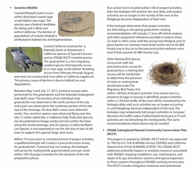
Coastal Whiptail Lizard: occurs within disturbed coastal sage scrub habitat (see map). The species was a federal candidate for listing and is likely rare within California. The decline of populations of coastal whiptail is attributed to habitat loss and fragmentation.
Coastal California Gnatcatcher: is federally listed as threatened, a California Species of Special Concern, and an SDG&E NCCP covered species. The gnatcatcher is a non-migratory, resident species that typically occurs in or near sage scrub habitat. Breeding occurs from February through August,
and nests are constructed most often in California sagebrush. The primary cause of decline is due to habitat loss and degradation.
Between May 3 and July 17, 2012, protocol surveys were performed for the gnatcatcher and the federally endangered least Bell’s vireo. The territory of an individual male gnatcatcher was observed in the north portion of the site and a pair was observed in the northeast portion of the site, east of the drainage. No least Bell’s vireos were detected onsite. Two sensitive raptors were observed flying over the site: (1) white-tailed kite, a California Fully Protected Species, has the potential to forage onsite and nest within the trees along the onsite drainage; and (2) osprey, a California Watch List Species, is not expected to use the site due to lack of tall trees to support this species’ large stick nests.
Within 72 hours prior to commencement of project activities, a qualified biologist will conduct a preconstruction survey for gnatcatchers. If present but not nesting, the biologist will survey for nesting birds approximately once per week within 100’ of project activities for the duration of the site preparation phase.
If an active nest is located within 100’ of project activities, then the biologist will monitor the nest daily until project activities are no longer in the vicinity of the nest or the fledglings become independent of their nest.
If the biologist determines that project activities are disturbing or disrupting gnatcatcher nesting, recommendations will include (1) turn off vehicle engines and other equipment whenever possible to reduce noise; (2) work in other areas until the young have fledged; and (3) place barriers to maintain noise levels at the nest to 60 dBA hourly Leq or less (or to the preconstruction ambient noise level if that exceeds 60 dBA hourly Leq).
Other Nesting Bird Species: Concurrent with the preconstruction survey for gnatcatchers, a nesting bird survey will be conducted to determine the presence of nests or nesting birds (protected under the Migratory Bird Treaty Act) within 100 feet of project activities. If an active nest (i.e., presence of eggs or young) is identified, project activities within a 100-foot buffer of the nest will be monitored by the biologist daily until such activities are no longer occurring or until fledglings become independent of the nest. The biologist may temporarily halt project activities or increase/decrease the buffer radius if determined necessary or if such activities are not disturbing the nesting birds. The same recommendations listed above may be needed.
� SDG&E Subregional Natural Community Conservation Plan (NCCP)
The project is covered by SDG&E’s NCCP which was approved in 1995 by U.S. Fish & Wildlife Service (USFWS) and California Department of Fish & Wildlife (CDFW). The SDG&E NCCP addresses potential impacts to sensitive resources associated with SDG&E’s ongoing installation, use, maintenance, and repair of its gas and electric systems and typical expansion to those systems throughout SDG&E’s existing service area. The NCCP includes mitigation measures and operational

protocols designed to avoid potential impacts to biological resources and to to ensure the protection and conservation of covered species. All workers should be aware of the following biological requirements consistent with the SDG&E NCCP:
• The work limits adjacent to restricted/sensitive areas will be temporarily fenced under the supervision of an Environmental Monitor to ensure that fence installation does not impact adjacent habitats.
• This fence shall include silt barriers to prevent sedimentation from stormwater runoff entering adjacent sensitive habitats.
• The area outside the fenced work limits must remain free of trash, parking, or other project activities.
• The Environmental Monitor will notify SDG&E, CPUC, and responsible agencies immediately if project activities occur outside the fenced work limits.
• At the end of each work day, to prevent the inadvertent entrapment of wildlife, all pipe ends will be capped and all trenches and open holes will be fully covered with steel plates or other effective coverings, after they have been inspected by the onsite biologist.
• If fully covering the excavations is impractical, ramps will be used to provide a means of escape for wildlife that enter the excavations, or open holes will be securely fenced with exclusionary fencing.
• At the beginning of each work day, the Environmental Monitor will inspect the ramped excavations and remove any trapped wildlife. If the animals are
sensitive species that require special handling authorization, the Monitor will notify a qualified biologist (agency-permitted or approved to handle a specific species) who will remove the animal before resumption of work in that immediate area.
• Any accidental or unauthorized impacts to habitat will be restored/revegetated in place and monitored, under separate SDG&E contracts with an approved habitat restoration installer and a habitat restoration monitor.
• Any project modifications/variances will be documented and none will be allowed with verbal approval only. Project modifications that are considered minor with little risk to sensitive resources may be approved onsite, but will be documented in writing. Project modifications that could affect sensitive resources, but are required to ensure the health and safety of work crews will also be documented in writing.
Noise � To minimize noise emissions into adjacent habitat (only if
it is occupied by noise-sensitive species such as breeding gnatcatchers):
• Construction, servicing of equipment and delivery of materials to and from the site will be performed between 7:00 AM - 7:00 PM, Monday through Saturday.
• Contractor will ensure that all construction equipment is fitted with operating mufflers, air intake silencers, and engine shrouds, and that equipment is properly maintained and tuned.
• All stationary noise sources (e.g., generators and compressors) onsite will be located as far as feasibly possible from adjacent gnatcatcher-occupied habitat.

� Advance notice has been mailed to all property owners within 300 feet of work limits indicating the construction start date, anticipated completion date, and hours of construction.
� SDG&E will provide a public liaison during construction to respond to concerns about construction noise disturbance, as well as a telephone number for receiving and responding to questions or complaints during construction.
Paleontological Resources � A paleontological monitor will be onsite daily to observe
excavation into previously undisturbed deposits with high or moderate paleontological resource sensitivity.
� In the event fossils are encountered, the paleontological monitor will have the authority to divert or temporarily halt construction activities in the area of discovery to allow recovery of fossil remains in a timely fashion. Due to the potential for recovery of small fossil remains (e.g., isolated mammal teeth), it may be necessary to set up a screen-washing operation onsite, or the paleontologist may recover bulk-sedimentary-matrix samples for offsite wet screening, as determined in the field.
Cultural Resources � A qualified archaeologist will be on-call during grading,
excavation and trenching if any artifacts are encountered.
� In the event that any prehistoric or historic subsurface cultural resources are discovered during ground-disturbing activities, all work within 50 feet of the resources will be halted, and a qualified archaeologist consulted to assess the significance of the find.
� If avoidance is infeasible, an archaeological data recovery program (ADRP) will be implemented which includes recovery and scientific analysis of all significant cultural materials. Data recovery will be limited to portions of the resource that could be adversely affected by project activities. Work may proceed on other parts of the site while the ADRP is carried out. A draft ADRP document has been
prepared to help expedite this process if necessary.
� If human remains are discovered, all work will stop immediately at the discovery site until the County coroner has been notified and has completed an investigation. If the remains are Native American, the coroner will notify the Native American Heritage Commission (NAHC) within 24 hours. The most likely descendant (MLD) of the deceased Native American will be notified by the NAHC and given the opportunity to make proper disposition of human remains. If the NAHC is unable to identify the MLD, or if no recommendations are made by the MLD within 48 hours, the human remains and any associated burial items will be reinterred.
Hazardous Materials � All personnel will comply with the Hazardous Substance
Management and Emergency Response Plan. The Plan is to help reduce or avoid potentially hazardous materials for the purposes of worker safety, protection from groundwater contamination, and proper disposal of hazardous materials.
� All SDG&E, contractor, and subcontractor personnel will receive training regarding the appropriate work practices necessary to effectively implement hazardous materials procedures and protocols and to comply with the applicable environmental laws and regulations, including hazardous materials spill prevention and response measures. Documentation of project personnel who have received training will be provided to SDG&E and CPUC on a regular basis.
Hydrology/Water Quality � Project activities must follow
the project-specific Stormwater Pollution Prevention Plan prepared under the State General Construction Permit. Best Management Practices (BMPs) will be implemented in

accordance with the SDG&E Water Quality Construction BMP Manual to avoid and minimize potential impacts to water quality.
� Groundwater must not be discharged to surface waters until an approved permit is obtained by SDG&E from the Regional Water Quality Control Board (RWQCB). SDG&E has submitted an application to the RWQCB for a permit to discharge groundwater to surface waters. SDG&E will notify the City of San Diego and Caltrans of the permit once obtained.
� If dewatering is required, a project-specific typical dewatering drawing will be prepared for review and approval by SDG&E and the CPUC to show the location of pumps within secondary containment, fuel storage areas, anticipated discharge point, scour protection measures, intake hose screening, and monitoring procedures to ensure that hazardous materials spills are addressed in a timely manner. Prior to dewatering activities, a discharge permit or waiver from the RWQCB must be obtained.
Traffic � Traffic Control Plans
(TCPs) have been approved by the City of San Diego, as part of the required traffic encroachment permits. The TCPs define the use of flag persons, warning signs, lights, barricades, cones, etc., according to standard Caltrans guidelines. For clarification, TCPs are also referred to as TMPs (Traffic Management Plans) in other supporting documents. Specific to the project site:
• Gates must be located and operated to prevent traffic backing up onto Mira Sorrento Place during peak traffic times (7:30 - 8:30 AM and 4:30 - 5:30 PM). No vehicles will be allowed to block any traffic lane for any purpose, including but not limited to loading or unloading of materials, during these peak traffic times.
• No lane closure will be allowed on Mira Sorrento Place or Vista Sorrento Parkway during peak traffic times to minimize disruption from construction traffic. Lane diversions (i.e., temporary restriping to realign travel lanes) may be utilized if approved by the City of San Diego.
• The TCPs will ensure access remains available to all private properties at all times.
� Work shifts will be staggered such that employee arrivals and departures will avoid peak times. Construction-related truck traffic will also be scheduled to avoid these peak traffic times.
� Construction workers should carpool to the job site to the extent feasible.
NOTE: This handbook was prepared as a guide to the environmental requirements and is not intended to be a complete list of mitigation or instructions. Consult the adopted MMCRP and State and federal laws and project mitigation requirements as necessary and as required.
Prepared by:
9755 Clairemont Mesa Blvd, Suite 100San Diego, California 92124
858.614.5000Contact: Mike Gonzales

INTRODUCTION: Ms. Siren received a Bachelor of Science Degree in Geology (1999) from The George Washington University and was awarded a Master's Degree in Paleontology (2002) from the South Dakota School of Mines and Technology. She has served as paleontologist for numerous projects throughout southern California, including San Diego, Imperial, Orange, Riverside, Los Angeles, and San Bernardino counties. These projects involved multiple agencies, public and private sector clients, a variety of resources, and multidisciplinary staff supervision. She has taught at Saddleback Community College in Mission Viejo, California as an associate geology professor and has worked as a curatorial assistant with the Natural History Museum of Los Angeles County. While pursuing her degrees, Sarah conducted studies at both the Smithsonian Institution and Badlands National Park, and supervised as lead research scientist for various field activities, curation projects, and laboratory preparations. Her diverse experience includes recovering, identifying, mapping, and preparing fossils. Sarah is a Geologist-in-Training (no.167) with the State of California, an Orange County Certified Paleontologist, and a Qualified Paleontologist with the City of San Diego. EDUCATION: M.S., Paleontology, South Dakota School of Mines and Technology, Rapid City, South
Dakota, 2002 B.S., Geology, The George Washington University, Washington, District of Columbia, 1999 B.A., French Language & Literature, The George Washington University, Washington,
District of Columbia, 1999 REGISTRATION AND CERTIFICATION: Geologist-in-Training, No. 167, State of California, 2007 40-hour HAZWOPER Training, 2008 Qualified Paleontologist, City of San Diego, 2007 Orange County Certified Paleontologist, 2004 County of Riverside Paleontology Consultant List, 2004 EXPERIENCE: 2008 – present: San Diego Natural History Museum, San Diego, CA; Paleontological Field Manager; managing field operations for multiple projects throughout southern California. 2004 – 2008: Saddleback College, Mission Viejo, CA; Associate Professor, teaching fossil preparation techniques, in addition to teaching lecture classes for the Department of Geology. 2003 – 2008: Stantec Consulting Inc. (formerly Keith Companies), Irvine, CA; Project Manager / Paleontologist; managed field operations for multiple projects throughout southern California.

2007 – 2008: Natural History Museum of Los Angeles County, Los Angeles, CA; Curatorial Assistant; assists collections manager with curation, and is well-versed in the latest preparation and casting and molding techniques. PUBLICATIONS: 2010 Comer Santos, K. Siren, S., Nouri, A., Deméré, T., and Randall, K.,
Paleontological Sensitivity Map for San Diego County: A Categorical Risk Analysis. ESRI Users Conference, Map Gallery Poster.
2007 Deering, M.R., Barnes, L.G., Siren, S.A., McLeod, S.A., Walsh, M.O., and
Rice, K.R., A Fossil Ziphiid Whale (Cetacea: Odontoceti) From The Latest Miocene Capistrano Formation In Southern Orange County, California. Southern California Academy of Sciences.
2006 Siren, S.A., Site Analysis of the Buffalo Alley Bone Bed Located in the
Lower Scenic Member of the Brule Formation (Oligocene), Badlands National Park, South Dakota, Abstract for poster presentation at the Sixty-Sixth Annual Society of Vertebrate Paleontology Meeting, Ottawa, Ontario, Canada.
2004 Deering, M.R., M.L. Kearin, S.A. Black, and L.G. Barnes, An Archaic
Baleen-Bearing Mysticete Whale Resembling Eomysticetus from the Lower Miocene Vaqueros Formation in Southern California. Abstracts, Western Association of Vertebrate Paleontologists, Annual Meeting, Occidental College, 14 February 2004, p. 2.
2002 Herbel, C.L., Benton, R.C., and Black, S.A., Bone Bed Surveys:Making Use
Of The Data, Abstract: Geological Society of AmericaAnnual Meeting, Abstracts with Programs, vol. 34, no. 6, paper no. 237-5.
2001 Black, S.A., Herbel, C.L., and Benton, R.C., Bone Beds in the Lower Scenic
Member, Brule Formation (Oligocene), Badlands National Park, South Dakota, Abstract for poster presentation at the Sixty-First Annual Society of Vertebrate Paleontology Meeting, Bozeman, Montana.
SELECTED TECHNICAL REPORTS: 2009 Deméré, T.A., and S.A. Siren, Paleontological Identification Report,
Paleontological Evaluation Report, & Paleontological Mitigation Plan, SR-76 South Mission Road to I-15 Highway Improvement Project, Caltrans District 11, San Diego County, California. Report Prepared by the San Diego Natural History Museum for EDAW, San Diego, California.
2008 Deméré, T.A., and S.A. Siren, Paleontological Mitigation Report, SDG&E
Encina-Penasquitos 230kV Transmission Line, San Diego County, California.

Report Prepared by the San Diego Natural History Museum for ASM Affiliates, Inc.
2008 Siren, S.A., Paleontological Mitigation Plan for a 4-acre Project Site, City of
Mira Loma, County of Riverside, California. Report Prepared by Stantec Consulting, Inc. for Storage Specialists, LLC., Beverly Hills, California.
2008 Siren, S.A., Paleontological Assessment of a 720-acre Parcel in Riverside
County, California. Report Prepared by Stantec Consulting, Inc. for Indio Sun, LLC., Carlsbad, California.
2008 Siren, S. and L.G. Barnes, A Paleontological Assessment of Fossils in Aliso
Creek, Orange County, California. Submitted to the County of Orange. Report Prepared by Stantec Consulting, Inc. for Ultrasystems, Irvine, California.
2007 Siren, S.A., and G.H. Archer, Report of Archaeological and Paleontological
Mitigation Program, Hollyhills Drain Units 7 and 8 Project, Los Angeles, California. Report Prepared by Stantec Consulting, Inc. for the Los Angeles County Department of Public Works.
2007 Siren, S.A., L.G. Barnes, and G.H. Archer, Report of Paleontological
Mitigation Program, Planning Area 17, Quail Hill, at the Intersection of SR-133 and Laguna Canyon Road, Irvine, California. Report Prepared by Stantec Consulting, Inc. for Irvine Community Development Company.
2007 Siren, S., S. Pentney, and G. Archer, Cultural Resources Identification Study
of a 4-acre Project Site, City of Mira Loma, County of Riverside, California. Report Prepared by Stantec Consulting, Inc., for Storage Specialists, LLC., Glendale, California.
2007 Siren, S., S. Pentney, L. Barnes, and G. Archer, Archaeological and
Paleontological Monitoring, Planning Area 6, Marshburn Storm Drain (Phase 1), City of Irvine, California. Report Prepared by Stantec Consulting, Inc. for Irvine Community Development Company.
2007 Siren, S., S. Pentney, L. Barnes, and G. Archer, Archaeological and
Paleontological Monitoring, Planning Area 6, Marshburn Storm Drain (Phase 2), City of Irvine, California. Report Prepared by Stantec Consulting, Inc. for Irvine Community Development Company.
2008 Siren, S.A., M.J. Wetherbee, L.G. Barnes, and G.H. Archer, Report of
Archaeological and Paleontological Mitigation Program, Four Seasons at Beaumont, Phases B and C, Beaumont, California. Submitted to the City of Beaumont. Report Prepared by Stantec Consulting Inc. for K. Hovnanian Companies of California, Irvine, California.

2006 Siren, S.A., Paleontological Assessment for the Jess Ranch Marketplace,
Phase 3 Project, Town of Apple Valley, San Bernardino County, California. Report Prepared by Stantec Consulting, Inc., for Malcolm Riley and Associates, Los Angeles, California.
2006 Barnes, L.G., S.A. Siren, G.H., Archer, and S.P. Pentney, Archaeological and
Paleontological Monitoring Report, Woodbury (Planning Area 9A) Project and Sewer Line Trenching In Planning Areas 9A, 9B, 9C, and 40. Report Prepared by Stantec Consulting, Inc., Irvine, California, for Irvine Community Development Company, Irvine, California, Stantec Project nos. 20413910-02, -06, -10, -11, -12 and -13, 67pp.
2005 Archer, G.H., S.A. Siren, and L.G. Barnes, Historical, Archaeological and
Paleontological Resources Identification and Evaluation Study for the Planning Area 18 Project, Including Impacts Analysis and Mitigation Measures. The Keith Companies, Irvine, California.
Archer, G.H., S.A. Siren, L.G. Barnes, and S. Crull, Historical,
Archaeological and Paleontological Resources Identification and Evaluation Study for the Planning Area 39 Project, Including Impacts Analysis and Mitigation Measures. The Keith Companies, Irvine, California.
Barnes, L.G., M.L. Barnes, G.H. Archer, S.A. Siren, and J.D. Stewart, Final
Report of Paleontological Mitigation Program, Vellano Project, City of Chino Hills, San Bernardino County, California. Stantec Consulting Inc., Irvine, California. Submitted to Chino Hills Land West, LLC., Brentwood, Tennessee.
2004 Black, S.A., Paleontological Assessment of a 655-acre Parcel for the Fiesta
De Vida project, Riverside County, California. The Keith Companies, Irvine, California, Document no. JN 014209.00.000, 9 p.
Barnes, L.G., M. L. Kearin, S.A. Black, and M.R. Deering, Final Report of Paleontological Mitigation Program, Planning Area 22, “Shady Canyon”, Irvine Community Development Company, Irvine, California. The Keith Companies, Irvine, California, Document no. JN 013667.06.000, pp. 1-66.
Archer, G.H., and S.A. Black, Historical, Archaeological, and Paleontological
Resources Identification Study for the SafeHouse of the Desert Project, Thousand Palms, Riverside County, California. The Keith Companies, Irvine, California.
2002 Black, S.A., Site Analysis of the Buffalo Alley Bone Bed Located in the
Lower Scenic Member of the Brule Formation, White River Group, Badlands

National Park, South Dakota: unpublished Master’s thesis, Rapid City, South Dakota, South Dakota School of Mines and Technology, 72 p.
SELECTED PROJECTS: Thomas Jefferson School of Law, San Diego, California Conducted multiple fossil salvages for this East Village project site. A mammoth skull, tusks, and partial skeleton were recovered and are currently awaiting preparation. In addition, a partial gray whale skeleton was discovered at the site, and is housed at the museum’s storage facility. Portola Springs (Planning Area 6), Irvine, California As Project Manager, Ms. Siren provided comprehensive paleontological consultation services for a large-scale development. This project yielded fossils that dated from the Cretaceous-age (over 65 million years ago) deposits up through the Pleistocene (until 11,000 years ago). Ms. Siren was responsible for overseeing the paleontological resource management, including large fossil salvages and monitoring during rough grading. Evaluation studies are in progress and large-scale mitigation efforts are on-going. Holly Hills Drain, Los Angeles County, California As Project Manager and Paleontologist for this project, Ms. Siren was responsible for providing on-call paleontological monitoring for the Holly Hills storm drain project in Los Angeles County, California. The scope of services included providing on-site monitoring and collection of archaeological or paleontological resources found. Salvaged fossils were evaluated and prepared in compliance with the California Environmental Quality Act (CEQA) guidelines. Quarterly reports were written on the findings. 607 Kings Road, Newport Beach, California Ms. Siren was the paleontologist for fossil salvage of a Pleistocene baleen whale skull from a private residence for the City of Newport Beach. She was instrumental in coordinating with the City, the property owner, and the Los Angeles Times journalists that covered the breaking news story. Marblehead Coastal, San Clemente, California As paleontologist, Ms. Siren was responsible for a paleontological assessment of the 266-acre property, and oversight of paleontological resource monitoring during rough grading. An archaeological survey was designed and implemented in consultation with the California Coastal Commission and local Native Americans. Survey methods were tailored in response to specific California Coastal Commission concerns regarding ground surface visibility, historical land use, previously recorded archaeological traces, and diverse development impacts. A detailed archaeological, Native American, and paleontological monitoring and discoveries treatment plan was successfully developed to address California Coastal Commission, Native American, and City of San Clemente concerns. Pelican Hill, Newport Beach, California
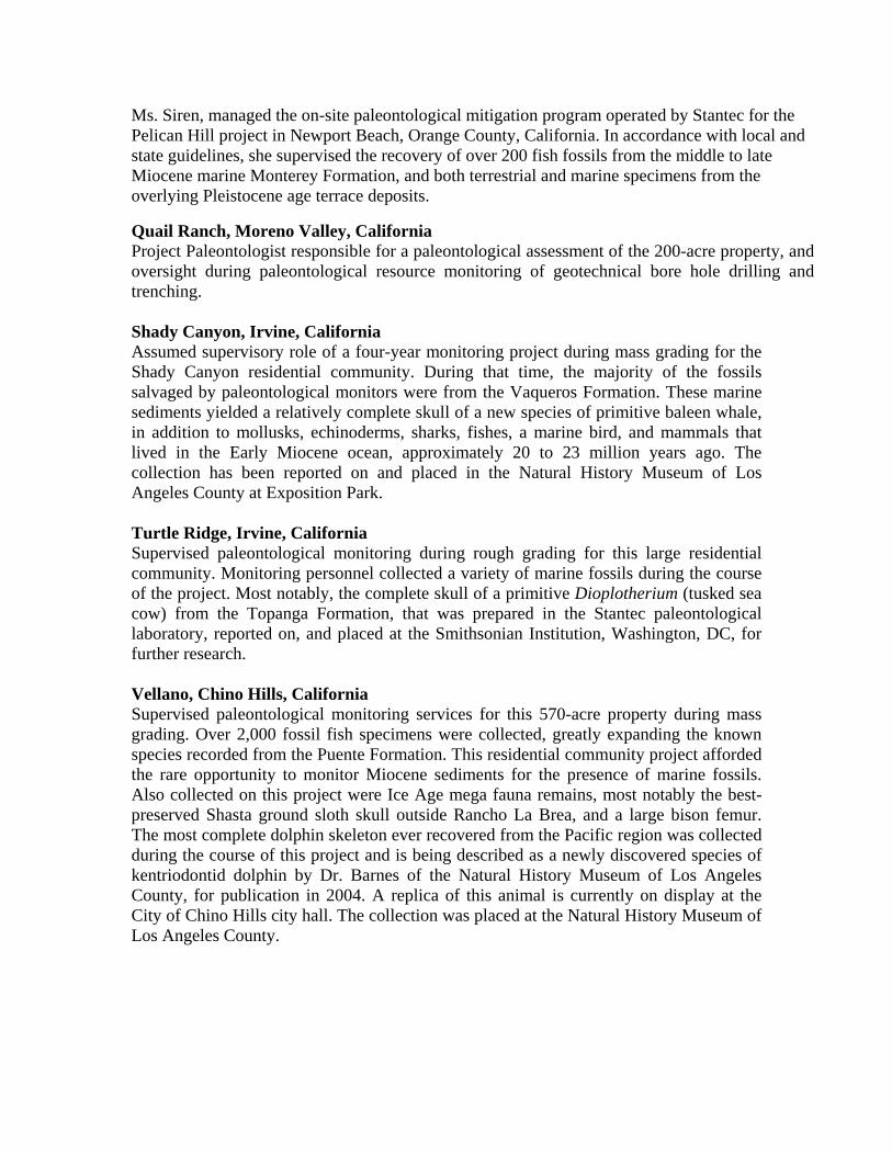
Ms. Siren, managed the on-site paleontological mitigation program operated by Stantec for the Pelican Hill project in Newport Beach, Orange County, California. In accordance with local and state guidelines, she supervised the recovery of over 200 fish fossils from the middle to late Miocene marine Monterey Formation, and both terrestrial and marine specimens from the overlying Pleistocene age terrace deposits.
Quail Ranch, Moreno Valley, California Project Paleontologist responsible for a paleontological assessment of the 200-acre property, and oversight during paleontological resource monitoring of geotechnical bore hole drilling and trenching. Shady Canyon, Irvine, California Assumed supervisory role of a four-year monitoring project during mass grading for the Shady Canyon residential community. During that time, the majority of the fossils salvaged by paleontological monitors were from the Vaqueros Formation. These marine sediments yielded a relatively complete skull of a new species of primitive baleen whale, in addition to mollusks, echinoderms, sharks, fishes, a marine bird, and mammals that lived in the Early Miocene ocean, approximately 20 to 23 million years ago. The collection has been reported on and placed in the Natural History Museum of Los Angeles County at Exposition Park. Turtle Ridge, Irvine, California Supervised paleontological monitoring during rough grading for this large residential community. Monitoring personnel collected a variety of marine fossils during the course of the project. Most notably, the complete skull of a primitive Dioplotherium (tusked sea cow) from the Topanga Formation, that was prepared in the Stantec paleontological laboratory, reported on, and placed at the Smithsonian Institution, Washington, DC, for further research. Vellano, Chino Hills, California Supervised paleontological monitoring services for this 570-acre property during mass grading. Over 2,000 fossil fish specimens were collected, greatly expanding the known species recorded from the Puente Formation. This residential community project afforded the rare opportunity to monitor Miocene sediments for the presence of marine fossils. Also collected on this project were Ice Age mega fauna remains, most notably the best-preserved Shasta ground sloth skull outside Rancho La Brea, and a large bison femur. The most complete dolphin skeleton ever recovered from the Pacific region was collected during the course of this project and is being described as a newly discovered species of kentriodontid dolphin by Dr. Barnes of the Natural History Museum of Los Angeles County, for publication in 2004. A replica of this animal is currently on display at the City of Chino Hills city hall. The collection was placed at the Natural History Museum of Los Angeles County.

ADDITIONAL EXPERIENCE: 1999 – 2002: South Dakota School of Mines & Technology, Rapid City, SD. Research Scientist I. Assisted Collections Manager/Preparator in several field activities,
curation projects, and laboratory preparation (Summer 2002). Graduate Research Assistant. Prepared, identified, mapped, and curated fossils from new
bone beds located during the 2000 and 2001 summer field seasons of the NRPP project (Fall 2001 and Spring 2002; Fall 2000 and Spring 2001).
Fossil Resource Monitor. Monitored potentially fossiliferous areas in the Badlands National
Park for construction crews (May 2001 and 2002). Co-Principal Investigator. Natural Resources Preservation Program 2001 in the Badlands
National Park, filled administrative duties, mapped using aerial photos and GPS unit, and collected and prepared fossils for transport to the Museum of Geology in Rapid City, SD (Summer 2001).
Supervisor. Interpreted fossil remains for tourists visiting an ongoing excavation site in the
Badlands National Park, filled administrative duties and collected and prepared fossils for transport to the Museum of Geology (Summer 2001).
Research Assistant. Badlands National Park for Museum of Geology Bone Bed Project
(Summer 2000).
Fossil Interpreter/Paleontologist. Pig Dig, Badlands National Park (Summer 1999 and 2000).
Graduate Research Assistant. Museum of Geology/Department of Geology & Geological
Engineering (Fall 1999 and Spring 2001). 2000: South Dakota School of Mines and Technology – Field Paleontology Course. 1999: Lehigh University – Geology Field School Course. 1998-1999: National Museum of Natural History, Smithsonian Institution; Invertebrate Paleobiology Department. Contract employee. Identified microfossil species for stable isotope analysis, and sorted microfossils based on morphology for population studies. 1998-1999: Disability Services, GWU. Tutor. Aided students in Physical and Historical Geology, and assisted one with his in-class activities.

1997: NSF Research Experience for Undergraduates, Green River, W. Field participant. Prospected and collected fossils for the Natural Science Museum, MI; prepared a report on the results of activities and presented same to group. 1998: Bahamas – Field Paleontology, Cerion snail fossil collection and documentation for Stephen J. Gould. 1997: Vertebrate Paleontology Laboratory, National Museum of Natural History, Smithsonian Institution – as a volunteer in this department, prepared fossil samples of vertebrates for study.
SKILLS:
Computer: Working knowledge of Windows XP and the following software packages: Office 2003, GPS Pathfinder Office, Terrasync, ArcGIS 9.3, Corel Draw X3, Adobe Creative Suite, EndNote, and ANCS/Rediscovery.
Language: Proficiency in written and spoken French.
PROFESSIONAL SOCIETIES, AFFILIATIONS AND AWARDS:
South Coast Geological Society, Treasurer, 2008. Departmental Associate, San Diego Natural History Museum, 2007-present. Museum Associate, Natural History Museum of Los Angeles County, 2003-present. Society of Vertebrate Paleontology, 1997-present. Geological Society of America, 1998-present. SDSM&T Award for Outstanding Contributions to Campus Leadership, April 2001 and 2002.
RESEARCH INTERESTS:
Tertiary Terrestrial Mammals (Paleogene and Neogene), Great Plains; Tertiary Marine Mammals, Southern California.


June 14, 2013 Dear Neighbor: SDG&E will soon begin constructing a new substation to meet existing and anticipated electrical load growth, and to improve electrical distribution service reliability. Construction is anticipated to begin in July pending issuance of a notice to proceed from the California Public utilities Commission (CPUC). Construction is scheduled for completion by December 2014 but may extend into 2015. The substation will be located on the corner of Vista Sorrento Parkway and Mira Sorrento Place in the Sorrento Mesa area within the Mira Mesa Community Plan area of the City of San Diego. The substation will include the construction of retaining walls and screening walls around the perimeter of the building pad. The retaining walls will range from 4 feet in height along Vista Sorrento Parkway, to a maximum of 52 feet of combined height along the southeasterly side, most of which will be below street grade in the canyon area. The larger retaining walls will be mechanically stabilized earth systems constructed of a concrete keystone type wall (brand name Verdura). Screening walls will be 10 feet in height around the perimeter of the substation and constructed of concrete blocks. Landscaping, which will be installed later in the construction process, will consist of native and non‐native plants, trees, and shrubs that are consistent with those already in the area. During construction, SDG&E crews and contractors will work as quickly and safely as possible to complete the project, and make every effort to minimize disruptions such as construction traffic, dust and noise. Construction hours will be Monday – Saturday, 7:00 a.m. – 7:00 p.m. Certain activities require unavoidable nighttime operations during construction of the electrical components. However, this nighttime work will be minimal. SDG&E does not expect any interruptions of electrical or gas service to customers as a result of our work. If you have any questions or concerns, please feel free to call our dedicated toll‐free Mira Sorrento Substation phone line at (866) 382‐0886. You may also contact me directly, at [email protected] or by phone (858) 654‐8307. We appreciate your patience and apologize in advance for any inconvenience. Sincerely, Claudia Valenzuela Public Affairs Manager


![VILS 20130208 8315[1] - Startseite » Schweppermannspiele](https://img.pdfslide.net/doc/110x75/61fb5e792e268c58cd5d5a61/vils-20130208-83151-startseite-schweppermannspiele.jpg)