Embed Size (px)
Citation preview


MARYLAND DEPARTMENT OF THE ENVIRONMENT
SWM GUIDELINES
FOR STATE AND FEDERAL PROJECTS
Table of Contents
Page 1.0 Purpose and Authority ..................................................................................1
1.1 Incorporation by Reference
2.0 Definitions ..................................................................................1 3.0 Applicability ..................................................................................4
3.1 Scope 3.2 Exemptions 3.3 Waivers 3.4 Institutional Management Plan 3.5 Redevelopment 3.6 Variance
4.0 Stormwater Management Criteria............................................................................8
4.1 Minimum Control Requirements 4.2 Stormwater Management Measures 4.3 Specific Design Criteria
5.0 Stormwater Management Plans ..........................................................................15
5.1 Review and Approval of Stormwater Management Plans 5.2 Preparation of the Stormwater Management Plan 5.3 Contents of the Stormwater Management Plan
6.0
7.0
Inspection Requirements During Construction for As-Built Certification ..........18
Maintenance ................................................................................20 Stormwater Management Waiver Application ....................................................21 As Built Certification ................................................................................22 Design Certification ................................................................................22

1.0 PURPOSE AND AUTHORITY The purpose of these Guidelines is to protect, maintain and enhance the public health, safety, and general welfare by establishing minimum requirements and procedures to control the adverse impacts associated with increased stormwater runoff. Proper management of stormwater runoff will minimize damage to public and private property, reduce the effects of development on land, control stream channel erosion, pollution and sediment deposition, reduce local flooding, and, in some instances, maintain the pre-development runoff characteristics. The provisions of these Guidelines are pursuant to the Annotated Code of Maryland, Environment Article, Title 4, Subtitle 2 and the Stormwater Management Regulations, Code of Maryland Regulation (COMAR) 26.17.02.01 through 26.17.02.12. These Guidelines supplement the Stormwater Management Regulations and the "2000 Maryland Stormwater Design Manual". They provide information necessary for submittal of stormwater management plans by State and federal agencies to the Maryland Department of the Environment (MDE), Water Management Administration (WMA) for review and approval. These Guidelines shall not affect the validity of any portion of either the Environment Article or Stormwater Management Regulations in any manner. 1.1 Incorporation By Reference. For the purpose of these Guidelines, the following documents are incorporated by reference: A. The 2000 Maryland Stormwater Design Manual Volumes I & II (Maryland Department
of the Environment, April 2000) is incorporated by reference and shall serve as the official guide for stormwater principles, methods, and practices.
B. USDA Natural Resources Conservation Service-Maryland, Conservation Practice Standard, Pond- Code 378 (January 2000).
2.0 DEFINITIONS A. For the purpose of these Guidelines, the following definitions describe the meaning of the
terms used in these Guidelines:
(1) “Administration” means the Maryland Department of the Environment, Water Management Administration.
(2) "Adverse impact" means any deleterious effect on waters or wetlands, including
their quality, quantity, surface area, species composition, aesthetics or usefulness for human or natural uses which are or may potentially be harmful or injurious to human health, welfare, safety or property, to biological productivity, diversity, or stability or which unreasonably interfere with the enjoyment of life or property, including outdoor recreation.
1

(3) "Agricultural land management practices" means those methods and procedures used in the cultivation of land in order to further crop and livestock production and conservation of related soil and water resources.
(4) "Applicant" means any State or federal governmental agency that executes the
necessary forms to procure official approval to carry out construction of a project. (5) “Channel Protection Storage Volume (Cpv)” means the volume used to design
structural management practices to control stream channel erosion. Methods for calculating the channel protection storage volume are specified in the 2000 Maryland Stormwater Design Manual, Volumes I & II.
(6) "Clearing" means the removal of trees and brush from the land but shall not
include the ordinary mowing of grass. (7) “Design Manual” means the 2000 Maryland Stormwater Design Manual,
Volumes I & II, that serves as the official guide for stormwater management principles, methods, and practices.
(8) “Direct discharge” means the concentrated release of stormwater to tidal waters
or vegetated tidal wetlands from new development or redevelopment projects in the Critical Area.
(9) "Drainage area" means that area contributing runoff to a specific location,
measured in a horizontal plane, which is enclosed by a ridge line. (10) “Easement" means a grant or reservation by the owner of land for the use of such
land by others for a specific purpose or purposes, and which must be included in the conveyance of land affected by such easement.
(11) "Exemption" means those land development activities that are not subject to the
stormwater management requirements contained in these Guidelines.
(12) "Grading” means any act by which soil is cleared, stripped, stockpiled, excavated, scarified, filled or any combination thereof.
(13) "Grubbing" means exposing the earth by removal of the root mat.
(14) "Infiltration" means the passage or movement of water through the soil into the
underlying soil profile.
(15) "Institutional Management Plan" means an MDE approved plan for any State or federal agency that provides stormwater management for the entire site that considers all watersheds affected by institution.
(16) "On-site stormwater management" means the design and construction of systems
necessary to control stormwater within an immediate project facility.
2
(17) “Overbank flood protection volume (Qp)” means the volume controlled by structural practices to prevent an increase in the frequency of out of bank flooding generated by development. Methods for calculating the overbank flood protection volume are specified in the Design Manual.
(18) “Recharge volume (Rev)” means that portion of the water quality volume used to
maintain groundwater recharge rates at development sites. Methods for calculating the recharge volume are specified in the Design Manual.
(19) "Redevelopment” means any construction, reconstruction, alteration, or
improvement of, or on, existing impervious area exceeding 5000 square feet. (20) "Retention structure" means a permanent structure that provides for the storage of
runoff by means of a permanent pool of water.
(21) "Sediment" means soils or other surficial materials transported and/or deposited by the action of wind, water, ice, or gravity as a product of erosion.
(22) "Site" means any tract, lot or parcel of land or combination of tracts, lots, or
parcels of land, which are in one ownership, or are contiguous and in diverse ownership where development is to be performed as part of a unit, subdivision, or project.
(23) "Stabilization" means the prevention of soil movement by covering exposed earth
using any of various vegetative and/or structural means. (24) "Stormwater management" means:
a. For quantitative control, a system of vegetative and structural measures that control the increased volume and rate of surface runoff caused by man-made changes to the land; and
b. For qualitative control, a system of vegetative, structural, and other measures
that reduce or eliminate pollutants that might otherwise be transported by surface runoff.
(25) "Stormwater Management Plan" means a set of drawings and/or other documents
which contain all of the information and specifications pertaining to stormwater management, submitted by an applicant as a prerequisite to obtaining a stormwater management approval.
(26) "Variance" means the modification of the minimum stormwater management
requirements for specific circumstances such that strict adherence to the requirements would result in unnecessary hardship and not fulfill the intent of these Guidelines.
(27) "Waiver" means the relinquishment of the Applicant from stormwater
management requirements for a specific project on a case-by-case review basis.
3
(28) "Watercourse" means any natural or artificial stream, river, creek, ditch, channel,
canal, conduit, culvert, drain, waterway, gully or ravine, in and including any adjacent area that is subject to inundation from overflow or flood water.
(29) "Watershed" means the total drainage area contributing runoff to a single point.
(30) "Watershed Management Plan" means an MDE approved plan for a county or
local municipality.
(31) ”Water quality volume (WQv)” means the volume needed to capture and treat 90 percent of the average annual runoff volume at a development site. Methods for calculating the water quality volume are specified in the Design Manual.
3.0 APPLICABILITY 3.1 Scope. No State or federal agency shall develop any land without having provided stormwater management measures that control or manage runoff from such development, except as provided within this section. The stormwater management measures must be designed consistent with the Design Manual and constructed according to the project plan approved by the Administration. 3.2 Exemptions. The following are exempt from the provisions of these Guidelines and the requirements of providing stormwater management: A. Agricultural land management practices; B. Projects that do not disturb over 5,000 square feet of land area. 3.3 Waivers A. The Administration may grant a waiver of the stormwater management QUANTITY and
QUALITY control requirements where the Applicant can demonstrate to the satisfaction of the Administration that:
1.
2.
3.
the project shall return the disturbed area to a predevelopment runoff condition (no hydrologic change and/or redevelopment occurs), i.e., pipeline or conduit projects, certain landscaping projects, certain maintenance projects, certain underground projects; or
the project lies within an area with an approved watershed management plan; or
the project lies within an approved institutional management plan that has been developed consistent with Section 3.4.
4

B. The Administration may grant a waiver of the stormwater management QUANTITY control requirements where the Applicant can demonstrate to the satisfaction of the Administration that:
1. the impervious area created by the project does not exceed six (6) feet in width, is
linear in nature, i. e., bike paths, walkways, highway noise barriers, etc., and retains the predevelopment drainage patterns; or
2. the project is served by an existing public storm drain system of adequate
capacity to accommodate the runoff from the proposed development; or
3. the project generates a maximum channel protection volume (Cpv) of 2 cfs; or
4. the project has direct discharge to tidally influenced receiving waters; or
5. the project discharges directly to a major waterway (see Table 2). [channel protection volume (Cpv) may be required]; or
6. historical downstream flooding problems do not exist, AND: the local jurisdiction
does not require management of the overbank flood protection volume within the watershed (see Table 1.) [Channel Protection Volume (Cpv) SHALL be provided as required by the Design Manual].
C. A Stormwater Management Waiver Application, submitted by the applicant, shall
specifically state the item of this section for which the project is eligible. The applicant shall provide sufficient descriptions, drawings, and other information necessary to evaluate the proposed project and confirm the applicability of the waiver request. A separate Stormwater Management Waiver Application may be required in accordance with the provisions of this section if there are subsequent additions, extensions, or modifications to a project receiving a waiver. Any waiver shall be valid only after written notice of granting such waiver is received from the Administration. A copy of the Stormwater Management Waiver Application may be found on page 21 of these Guidelines.
D. A Stormwater Management Waiver Application shall be required for each eligible
drainage area where runoff leaves the project site. E. Waivers granted shall:
1. be on a case-by-case basis; 2. consider the cumulative effects of the waiver policy; and
3. ensure no adverse impact on the downstream watercourse.
F. Redevelopment projects shall be in accordance with Section 3.5 of these guidelines.
5
3.4 Institution/Agency Management Plan An Institution/Agency Management Plan developed for the purpose of implementing site–wide stormwater management practices shall: A. Include detailed hydrologic and hydraulic analyses to determine hydrograph timing; B. evaluate both quantity and quality management; C. include cumulative impact assessment of institutional development; D. identify existing flooding and receiving stream channel conditions; E. be presented at a reasonable scale (dictated by the size of area in the analysis);
F. specify where on-site or off-site quantitative and qualitative stormwater management
practices and watershed improvement are (to be) implemented; G. be consistent with the General Performance Standards for Stormwater Management in
Maryland found in Section 1.2 of the Design Manual; H. be consistent with local watershed management plan(s), and I. be approved by the Administration. 3.5 Redevelopment Any reconstruction of, or new construction on, existing impervious area, exceeding 5000 square feet, shall be considered redevelopment. Stormwater management requirements for redevelopment shall be in accordance with the following: A. Stormwater management plans for redevelopment shall be consistent with the Design
Manual except that the recharge, channel protection storage volume, and overbank flood protection volume requirements do not apply unless required by the Administration. Examples of redevelopment projects are: construction of a building on an existing parking lot; demolition of a building and the construction of a new structure.
B. All redevelopment projects shall reduce existing impervious areas impacted within
project limits by a minimum of 20 percent. Where project site conditions prevent the reduction of impervious area, then stormwater management practices shall be implemented to provide qualitative control for a minimum of 20 percent of the project’s predevelopment impervious area. When a combination of impervious area reduction and stormwater practice implementation is used, the combined reduction and treated areas shall be equal to, or exceed, 20 percent of the predevelopment impervious area within the project limits.
C. Where conditions prevent impervious area reduction or on-site stormwater management,
practical alternatives may be considered, including but not limited to:
6

1. off-site BMP implementation within the project watershed for an impervious area
equal to 24 percent of the project impervious area impacted; 2. watershed or stream restoration;
3. retrofitting an existing BMP; or 4. other practices approved by the Administration.
D. If a net increase in impervious area occurs for the project, the increased impervious area shall be considered new development and shall follow Stormwater Management Criteria, Section 4.0 of these Guidelines. Additionally, water quality shall be provided for 20 percent of the project's predevelopment impervious area.
EXAMPLE #1: A new building and parking garage are constructed on an existing, one (1) acre paved parking lot. The footprint of the new building and parking garage is one and a half (1.5) acres and completely covers the footprint of the existing 1.0 acre parking lot. The total water quality required equals 0.7 acres [0.5 acres for the new impervious, plus 0.2 acres for redevelopment (20 percent of the predevelopment impervious area)]. EXAMPLE #2: A new building and parking garage are constructed on an existing, paved parking lot. The footprint of the new building and parking garage is one and a half (1.5) acres and covers one half (1/2) acre of the existing 1.0 acre parking lot (the remaining ½ acre parking lot will remain undisturbed). The total water quality required equals 1.1 acres [1.0 acre for the new impervious, plus 0.1 acres for redevelopment (20 percent of the ½ acre predevelopment impervious area replaced by new impervious)].
E. When a redevelopment project changes the site runoff characteristics, in a manner that
increases the discharge rate, channel protection volume and overbank flood protection volume may be required by the Administration.
F. When redevelopment reduces the impervious area by a minimum of twenty (20) percent,
qualitative control is not required for the redevelopment portion of the project. G. Pavement overlay and/or patching are considered maintenance practices, therefor
redevelopment criteria is not applicable. 3.6 Variance.
The Administration may grant a written variance from any requirement of Section 4.0, "Stormwater Management Criteria" of these Guidelines if there are exceptional circumstances applicable to the site such that strict adherence will result in unnecessary hardship and not fulfill the intent of the Guidelines. A written request for variance shall be provided to the Administration and shall state the specific variance sought and any evidence necessary to
7
support the request. A variance may be granted upon consideration and as deemed appropriate by the Administration. 4.0 STORMWATER MANAGEMENT CRITERIA 4.1 Minimum Control Requirements. A. The minimum control requirements established in this section and the Design Manual are
as follows:
1.
2.
3.
4.
For projects in Caroline, Cecil (south of the Chesapeake and Delaware [C&D] Canal), Dorchester, Kent, Queen Anne’s, Somerset, Talbot, Wicomico, and Worcester counties and their incorporated municipalities, the water quality volume, the recharge volume, and the overbank flood protection volume (the 2-year frequency storm event) criteria shall be used to design BMP’s according to the Design Manual; and
For projects in Baltimore City, Allegany, Anne Arundel, Baltimore, Calvert, Carroll, Cecil (north of the C&D canal), Charles, Frederick, Garrett, Harford, Howard, Montgomery, Prince George’s, St. Mary’s, and Washington counties and their incorporated municipalities, the water quality volume, the recharge volume, and the channel protection storage volume sizing criteria shall be used to design BMP’s according to the Design Manual. Control of the 24-hour, 10-year frequency storm event is required according to the Design Manual.
Designated Inter-jurisdictional Flood Hazard Watersheds shall require management measures necessary to maintain the post-development peak discharges for the 24-hour, 100-year frequency storm events at a level that is equal to, or less than, the 24-hour 100-year pre-development peak discharge rates. The stormwater management practices shall control the volume, timing, and rate of flows necessary to maintain a "no increase" in the downstream peak discharge for the 100-year frequency storm event.
The Administration may require more than the minimum control requirements specified in these Guidelines if hydrologic or topographic conditions warrant, or if flooding, stream channel erosion, or water quality problems exist downstream from a proposed project.
B. Stormwater management and development plans, where applicable, shall be consistent
with adopted and approved institutional management plans, watershed management plans or flood management plans as approved by the Maryland Department of the Environment in accordance with the Flood Hazard Management Act of 1976.
4.2 Stormwater Management Measures.
The structural and nonstructural stormwater management measures established in these Guidelines shall be used, either alone or in combination, in developing a stormwater management plan.
8
A. Nonstructural Stormwater Management Measures.
1. The following nonstructural stormwater management practices shall be applied according to the Design Manual to minimize increases in new development runoff:
a. natural area conservation; b. disconnection of rooftop runoff;
c. disconnection of non-rooftop runoff; d. sheet flow to buffers; e. grass channels; and f. environmentally sensitive development.
2. The use of nonstructural stormwater management practices shall be strongly encouraged to minimize the reliance on structural BMP’s.
3. The minimum control requirements listed in Section 4.1 of these Guidelines may be
reduced in accordance with the Design Manual, when nonstructural stormwater management practices are incorporated into site designs.
4. The use of nonstructural stormwater management practices may not conflict with
existing State laws, regulations, or policies.
5. Nonstructural stormwater management practices used to reduce the minimum control requirements must remain unaltered by owners. Approval from the Administration shall be obtained prior to alteration of nonstructural stormwater practices.
6. Alternative structural and nonstructural stormwater management practices may be
used for new development water quality control if they meet the performance criteria established in the Design Manual and are approved by the Administration. Practices used for redevelopment projects shall be approved by the Administration.
7. For the purposes of modifying the minimum control requirements or design criteria,
the applicant shall submit to the Administration an analysis of the impacts of stormwater flows downstream in the watershed. The analysis shall include hydrologic and hydraulic calculations necessary to determine the impact of hydrograph timing modifications of the proposed development upon a dam, highway, structure, or natural point of restricted streamflow. The point of investigation is to be established, with the concurrence of the Administration, at the first downstream tributary whose drainage area equals, or exceeds, the contributing area to the project or stormwater management facility.
9

B. Structural Stormwater Management Measures. 1. The following structural stormwater management practices shall be designed
according to the Design Manual to satisfy the applicable minimum control requirements established in Section 4.1 of these Guidelines:
a. Stormwater management ponds; b. Stormwater management wetlands; c. Stormwater management infiltration; d. Stormwater management filtering systems; and e. Stormwater management open channel systems.
2. The performance criteria specified in the Design Manual with regard to general
feasibility, conveyance, pretreatment, treatment and geometry, environment and landscaping, and maintenance shall be considered when selecting structural stormwater management practices.
3. Structural stormwater management practices shall be selected to accommodate the
unique hydrologic or geologic regions of the State. 4.3 Specific Design Criteria. The basic design criteria, methodologies, and construction specifications, subject to the approval of the Administration, shall be those of the Design Manual. A. Infiltration systems shall be designed in accordance with the Design Manual and shall
meet the following requirements:
1.
2.
The facility design shall provide an overflow system with measures to provide a non-erosive velocity of flow along its length and at the outfall.
Infiltration trenches shall be provided with observation wells in accordance with the Design Manual.
B. Ponds, wetlands, filtering systems and open channel systems shall be designed and
constructed in accordance with the Design Manual and shall include the following items:
1. Velocity dissipation devices shall be placed at the outfall of all detention or retention structures and along the length of any outfall channel as necessary to provide a non-erosive velocity of flow from the structure to a water course.
2. Where deemed necessary by the Administration, the applicant shall submit an
analysis of the impacts of stormwater flows downstream in the watershed. The analysis shall include hydrologic and hydraulic calculations necessary to
10

determine the impact of hydrograph timing modifications resulting from the proposed development upon a dam, highway, structure, or natural point of restricted stream flow, established with the concurrence of the Administration, and shall extend downstream:
a. to the first downstream tributary whose drainage area equals or exceeds the
contributing area to the pond; or b. to the first downstream tributary whose peak discharge exceeds the largest
designed release rate of the pond. 3. The designed release rate of the facility shall be modified if any increase in
flooding or stream channel erosion would result at the downstream dam, highway, structure, or natural point of restricted stream flow. The release rate of the facility shall:
a. Be reduced to a level that will prevent any increase in flooding or stream
channel erosion at the downstream control point; b. Be not less than 1-year pre-development peak discharge rate; and c. Meet the requirements established in Section 4.1. 4. Where the selected BMP is a pond, small pond approval shall be obtained from
the Administration pursuant to the Environmental Article, Annotated Code of Maryland, Title 5, Subtitle 5.
C. Off-site structures to be considered:
1. Shall have a contributory drainage area not in excess of 400 acres unless, on a case by case basis, a larger drainage area is approved by the Administration;
2. Shall provide for a permanent pool of water or provide for 24-hour detention
period (a 12-hour detention period may be approved, at the discretion of the Administration, for Use III or Use IV streams) for detaining and releasing the volume of runoff from the 1-year frequency storm;
3. Shall manage the increase in peak discharges for the 2 and 10 and possibly the
100-year frequency storm events; and
4. May not be located so as to discharge to Use III Natural Trout Waters identified in COMAR 26.08.02.08C, unless authorized by the Administration (see 4.3.C.2).
D. When calculating the overbank flood protection (Qp2, Qp10) the pre-development peak
discharge rate shall be computed assuming that all land uses within the project site are in good hydrologic condition.
11

1.
2.
Design considerations shall be given for incorporating the use of natural topography and land cover, such as wetlands, ponds, natural swales, and depressions, as they exist prior to development, to the degree that they can accommodate the increased flow of water.
Where deemed necessary, due to increased volume or rate of discharge from the project site, the Administration may require easements or other necessary property interests, concerning flowage of water, from adjacent property owners. It shall be the responsibility of the applicant to provide said easements or other necessary property interests. Approval of a stormwater management plan does not create or affect any such rights.
E. Water quality treatment for roadway and/or parking lot construction shall be in
accordance with the Design Manual and the following:
1. Grassed Channel Water Quality Credit.
a. When computing the discharge for the water quality storm for grassed channel credit, the out-of-project (off-site) drainage area contributing runoff to the grassed channel must be included.
b. Credit may be applied only for that portion of the impervious area that
reaches the grassed channel via sheet flow or approved pretreatment practice.
c. When expanding the limits of paving, grassed channel credit will be
applied as follows:
(1) the length of the post-development vegetative buffer (the grassed area between the edge of the paving and the centerline of the channel) shall be proportional to the ratio of the pre-development buffer/paving lengths; for EXAMPLE:
the pre-development buffer length (the length of vegetated buffer receiving sheet flow from the existing paved area) equals 50 feet. The pre-development paving length sheet flowing to the buffer equals 25 feet. The pre-development ratio of buffer/paving equals 50/25 or 2/1. The post-development paving length (the length of paving that sheet flows to the grassed buffer) equals 35 feet. Therefore, maintaining the2/1 ratio, the post-development vegetated buffer length must equal 70 feet minimum.
(2) where the buffer/paving length ratio cannot be provided, the
Administration may consider, on a case by case basis, mitigation for reduced buffer length in the form of landscaping and/or grading.
12

2. Conversion of open section paving to closed section.
a. Quantifying efficiency of water quality treatment provided by existing conditions.
The presence of an existing vegetated filter strip through which runoff sheet flows is an effective water quality measure for the runoff from existing open section paving. Likewise, the presence of an existing vegetated conveyance (swale or channel) that transports the runoff from a "one-inch rainfall" event, at a velocity of 1 fps or less, is an effective water quality measure. When converting open section paving to closed section, the quality of runoff may be negatively impacted due to the loss of these vegetative filtering and/or infiltration measures. This existing water quality value shall be quantified as follows: (1) Step 1
• Enter Figure 1 with the appropriate slope and read the filter length required to achieve removal goals for total suspended solids (TSS).
• Determine the length of the existing filter.
• The ratio of the existing filter length to the filter length
obtained from Figure 1 is the efficiency.
(2) Step 2
• Determine the velocity of the runoff from the one-inch rainfall event in the existing swale/channel.
• Determine the filter efficiency as follows:
a velocity of 1 fps or less, equals 100% water quality (WQ) efficiency; a velocity of 3 fps or greater equals 0% water quality efficiency. The efficiency is directly proportional to the velocities of the one-inch rainfall within the existing conveyance.
(3) Step 3
• The greater of the Step 1/Step 2 efficiencies is the percent of water quality provided by the existing conditions.
b. Compensation for the percent of water quality provided by the existing
conditions shall be as follows: The area of the existing impervious surface converted from open section to closed section shall be multiplied by the percent of water quality provided by the existing conditions (as
13

determined in Step 3 above). Water quality shall be provided for this area of existing paving due to the conversion of open section to closed section.
3. Conversion of closed section pavement to open section.
Water quality compensation for conversion of closed section paving to open section paving may be quantified by use of Steps 1 through 3 in Subsection 4.3.E.2.
4. Compensating Water Quality Treatment (WQv and Rev)
a. Projects may have drainage areas where it is not possible to provide water quality treatment for all new paved areas. Compensating water quality treatment of existing paving, equal to 120% of the untreated new paved area, may be provided elsewhere within the same watershed. Provision of the compensating water quality treatment shall be included within the project.
b. In order for existing paving to qualify as compensating water quality
treatment, there must be no, or substandard, existing water quality treatment for said existing paving. Substandard means less than 100 percent (%), as determined by the method in Subsection 4.3.E.2.a. of these Guidelines.
5. On-Line BMPs
Water quality practices that are placed On-Line (in medians or side channels/ditches/swales) shall include offsite impervious area in the calculation of the water quality requirements.
F. Channel Protection Volume (Cpv)
Channel Protection Volume (Cpv) shall be derived in accordance with the Design Manual. Extended detention facilities for projects that include combined redevelopment and new development, shall be in accordance with the following:
1. Cpv shall be computed using the new development drainage area only. 2. The extended detention facility may be designed to control the Cpv, as computed
in accordance with Subsection 4.3.F.1. of these Guidelines, and by-pass the excess runoff contribution from the redevelopment portion of the contributing drainage area.
14

5.0 STORMWATER MANAGEMENT PLANS 5.1 Review and Approval of Stormwater Management Plans. A. For any proposed project, the applicant shall submit a stormwater management plan
and/or waiver application to the Administration for review and approval, unless otherwise exempted in accordance with Section 3.2 of these Guidelines. The stormwater management plan shall contain supporting computations, drawings, and sufficient information describing the manner, location, and type of measures in which stormwater runoff will be managed from the entire project. The Administration shall review the plan to determine compliance with the requirements of these Guidelines prior to approval. The plan shall serve as the basis for all subsequent construction.
B. The stormwater management plan shall not be considered approved until it has been
signed and dated by the Administration's Sediment and Stormwater Plan Review Division Chief and the Administration has issued written approval for the project.
5.2 Preparation of the Stormwater Management Plan. A. The stormwater management plan shall be prepared by any individual whose
qualifications are acceptable to the Administration. The Administration may require that the design be prepared by either a professional engineer, professional land surveyor, or landscape architect licensed in the State of Maryland, as necessary to protect the public or the environment.
B. If a stormwater "Best Management Practice" (BMP), requires either a dam safety permit
or small pond approval from the Administration, the design shall be prepared by an engineer licensed in the State of Maryland.
5.3 Contents of the Stormwater Management Plan. The applicant is responsible for submitting a stormwater management plan that meets the design requirements of these Guidelines. The plan shall be accompanied by a report that includes sufficient information to evaluate the environmental characteristics of affected areas, the potential impacts of the proposed development on water resources, and the effectiveness and acceptability of measures proposed for managing stormwater runoff. The applicant shall certify on the drawings that all clearing, grading, drainage, construction, and development shall be conducted in strict accordance with the plan. The minimum information submitted, for support of a stormwater management plan, or application for a waiver, shall be in accordance with the following: A. Reports submitted for stormwater management plan approval shall include:
1. A brief narrative description of the project; 2. Geotechnical investigations including soil maps, borings, site specific
recommendations, and any additional information necessary for the proposed stormwater management design;
15
3. Descriptions of all water courses, impoundments, and wetlands on or adjacent to the
site or into which stormwater directly flows;
4. Hydrologic computations, including drainage area maps depicting pre development and, where appropriate, the post development runoff flow path segmentation and land use;
5. Hydraulic computations;
6. Structural computations;
7. Unified sizing criteria volume computations according to the Design Manual; and
8. Any other information required by the Administration.
C. Format of the Report.
1. The stormwater management report shall be on 8 1/2" x 11" paper. The report shall be typed; however, certain computational sheets may be handwritten. Any maps, diagrams, or figures (except computer printouts) which are larger than 8 1/2" x 11" shall be folded to a size of 8 1/2" x 11" or smaller and shall be placed within the report. Fold-outs or bound maps, diagrams, or figures are not acceptable unless the document is 8 1/2" x 11". All maps, diagrams, or figures shall be clearly labeled.
2. At a minimum each report shall contain the following:
a. Title Sheet. b. Table of Contents. c. List of Figures or Tables. d. Body of Report. (1) Introduction. (2) Methodologies Used. (3) Analysis. (4) Summary. (5) Conclusions.
16
e. Appendices
The Appendices shall include all the background information used in the stormwater management analysis. The background information shall be sufficient to facilitate a straightforward review and will include drainage area maps showing drainage areas, soil types, land uses, point(s) of investigation, and Time of Concentration (Tc) flow paths. Other information to be included: drainage area computations; runoff curve number computations; time of concentration computations; sizing criteria computations; elevation-discharge-storage data, which shall include the discharge computations, storage computations, and any details necessary to confirm those computations, i.e., contour maps, pipe, culverts, and bridge profiles; TR-55 worksheets; schematic diagrams; any and all hydraulic computations; any and all structural computations; including areas necessary to determine downstream analysis for the proposed stormwater management facility. In addition, projects in Cecil (south of the Chesapeake and Delaware Canal), Kent, Queen Anne's, Caroline, Dorchester, Talbot, Wicomico, Somerset and Worcester Counties, inter-jurisdictional watersheds and watersheds with a history of downstream flooding problems shall provide topographic survey maps showing existing drainage areas.
Schematic diagrams showing reach lengths, curve numbers, drainage areas, and structure locations shall be included for all computer printouts and shall be included as part of the Appendices. The Appendices shall be bound as part of the report.
D. Computer Printouts Computer printouts shall be original printouts or clear, legible, and complete
photostatic copies and shall be 8 1/2" x 11" in size and bound with the Appendices or in an additional bound volume. All computer printouts shall be clearly labeled throughout the printout for the various conditions of analyses, at critical sections, and for critical structures, such as stormwater management control structures. Additional bound volume(s) shall be labeled with a complete title block. The computer printouts shall include all input data, output data, hydrographs at critical sections where appropriate, and summary output.
E. Construction Drawings
Construction drawings submitted for stormwater management plan approval shall include the following:
1. A vicinity map
2. Site characteristics
a. A topographic survey showing all contours and existing features.
17

b. All watercourses, impoundments, and wetlands adjacent to the project which receive site stormwater runoff.
3. All proposed improvements including location of buildings or other structures,
impervious surfaces, storm drainage facilities, and all grading; 4. The location of existing and proposed structures and utilities;
5. Any easements and rights-of-way;
6. The delineation, if applicable, of the 100-year floodplain and any on site
wetlands;
7. Structural and construction details for all components of the proposed drainage system or systems, and stormwater management facilities;
8. All necessary construction specifications;
9. A sequence of construction which includes, in the appropriate order;
a. Notification of the Maryland Department of the Environment (MDE)
Compliance Program, a minimum of seven (7) days in advance of any earth disturbance activity.
b. Installation of perimeter erosion/sediment controls.
c. Development clearing, grubbing, rough grading.
d. Construction.
e. Final grading.
f. Vegetative stabilization.
g. Installation of stormwater management practices.
h. Removal, with MDE approval, of the erosion/sediment controls.
10. Data for total site area, disturbed area, new impervious area, and total impervious
area; 11. A table showing the unified sizing criteria volumes required in the Design
Manual;
12. A table of materials to be used for stormwater management facility planting;
13. All soil boring logs and locations;
18
14. A maintenance schedule;
15. Certification by the owner/developer that all stormwater management construction will be done according to this plan;
16. An As-Built certification signature block to be executed after project completion;
and
17. Any other information required by the Administration.
6.0 INSPECTION REQUIREMENTS DURING CONSTRUCTION FOR AS-BUILT CERTIFICATION A. At a minimum, regular inspections shall be made and documented at the following specified
stages of construction: 1. Ponds:
(a) Upon completion of excavation to sub-foundation and when required, installation of structural supports or reinforcement for structures, including but not limited to:
(i) Core trenches for structural embankments. (ii) Inlet and outlet structures, anti-seep collars or diaphragms, and
watertight connectors on pipes; and (iii) Trenches for enclosed storm drainage facilities.
(b) During placement of structural fill, concrete, and installation of piping and catchbasins;
(c) During backfill of foundations and trenches; (d) During embankment construction; and (e) Upon completion of final grading and establishment of permanent stabilization.
2. Wetlands – at the stages specified for pond construction in 6.0. A (1) of this section,
during and after wetland reservoir area planting, and during the second growing season to verify a vegetation survival rate of at least 50 percent.
3. Infiltration trenches:
(a) During excavation to subgrade; (b) During placement and backfill of underdrain systems and observation wells; (c) During placement of geotextiles and all filter media; (d) During construction of appurtenant conveyance systems such as diversion
structures, pre-filters and filters, inlets, outlets, and flow distribution structures; and
4. Upon completion of final grading and establishment of permanent stabilization.
5. Infiltration basins – at the stages specified for pond construction in 6.0. A (1) of this section and during placement and backfill of underdrain systems.
6. Filtering systems:
(a) During excavation to subgrade; (b) During placement and backfill of underdrain systems;
19

(c) During placement of geotextiles and all filter media; (d) During construction of appurtenant conveyance systems such as flow diversion
structures, pre-filters and filters, inlets, outlets, orifices, and flow distribution structures; and
(e) Upon completion of final grading and establishment of permanent stabilization.
7. Open channel systems: (a) During excavation to subgrade; (b) During placement and backfill of under drain systems for dry swales; (c) During installation of diaphragms, check dams, or weirs; and (d) Upon completion of final grading and establishment of permanent stabilization.
8. Nonstructural practices – upon completion of final grading and after the
establishment of permanent stabilization.
B. Once construction is complete, As-Built Plan Certification shall be submitted to the Administration by either a professional engineer or professional land surveyor licensed in the State of Maryland to ensure that constructed stormwater management practices and conveyance systems comply with the specifications contained in the approved plans. At a minimum, As-Built certification shall include a set of drawings comparing the approved stormwater management plan with what was constructed. The Administration may require additional information. A copy of the As-Built Certification may be found on page 23 of these Guidelines.
7.0 MAINTENANCE A. The owner of the property, or any other person or agent in control of such property, on
which work has been done pursuant to these Guidelines, shall maintain in good condition and promptly repair and restore all grade surfaces, walls, drains, dams and structures, vegetation, erosion and sediment control measures, and other protective devices. Such repairs or restoration and maintenance shall be in accordance with approved plans.
B. A maintenance schedule shall be developed for the life of any stormwater management
facility and shall state the maintenance to be completed, the time period for completion, and who shall perform the maintenance. This maintenance schedule shall be printed on the approved stormwater management plan.
20

STORMWATER MANAGEMENT WAIVER APPLICATION
OWNER: MDE NO.:
ADDRESS: PROJECT NO.:
LOCATION:
CONSULTANT:
DESCRIPTION: I/We, the Owner/Owners hereby request a stormwater management waiver be granted for the above referenced project in accordance with the following section of the Stormwater Management Guidelines for State and Federal Projects:
____ 3.3.A.1. Contract plans and provisions, stormwater management report.
____ 3.3.A.2. Contract plans and provisions, stormwater management report.
____ 3.3.A.3. Contract plans and provisions, stormwater management report.
____ 3.3.B.1. Contract plans and provisions, stormwater management report.
____ 3.3.B.2. Contract plans and provisions, stormwater management report, downstream impact investigation.
____ 3.3.B.3. Contract plans and provisions, stormwater management report.
____ 3.3.B.4. Contract plans and provisions, stormwater management report, downstream impact investigation
____ 3.3.B.5. Contract plans and provisions, stormwater management report, downstream impact investigation.
____ 3.3.B.6 Contract plans and provisions, stormwater management report, downstream impact investigation. . Other evidence submitted: ____________________________________________________________________
_____________________________ _________________________________ ________________________ Owner's Name Signature Date
____ Approved ____ Denied/Reason_______________________________________________ By _______________________________________________________ ______________________________ Water Resources Reviewer Date Submit to: Maryland Department of the Environment
Water Management Administration Sediment and Stormwater Plan Review Division
1800 Washington Boulevard, 4
th Floor Baltimore, MD 21230
If a project involves a waiver request for more than one (1) drainage area, a Stormwater Management Waiver Application is required for each drainage area.
MDE/WMA/PER.O58
MARYLAND DEPARTMENT OF THE ENVIRONMENT Water Management Administration. • Sediment, Stormwater & Dam Safety Program
1800 Washington Blvd. • Baltimore Maryland 21230 (410) 537-3543 • 1-800-633-6101 • http://www.mde.state.md.us
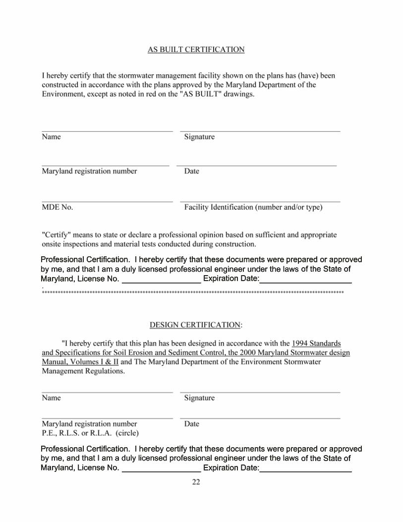
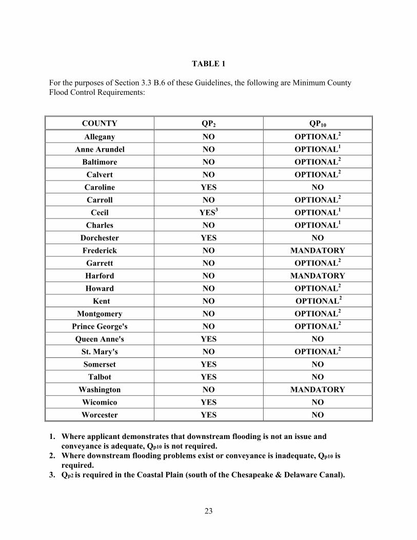
TABLE 1
For the purposes of Section 3.3 B.6 of these Guidelines, the following are Minimum County Flood Control Requirements:
COUNTY QP2 QP10 Allegany NO OPTIONAL2
Anne Arundel NO OPTIONAL1 Baltimore NO OPTIONAL2
Calvert NO OPTIONAL2 Caroline YES NO Carroll NO OPTIONAL2 Cecil YES3 OPTIONAL1
Charles NO OPTIONAL1 Dorchester YES NO Frederick NO MANDATORY Garrett NO OPTIONAL2 Harford NO MANDATORY Howard NO OPTIONAL2
Kent NO OPTIONAL2
Montgomery NO OPTIONAL2 Prince George's NO OPTIONAL2
Queen Anne's YES NO St. Mary's NO OPTIONAL2 Somerset YES NO
Talbot YES NO Washington NO MANDATORY Wicomico YES NO Worcester YES NO
1. Where applicant demonstrates that downstream flooding is not an issue and
conveyance is adequate, Qp10 is not required. 2. Where downstream flooding problems exist or conveyance is inadequate, Qp10 is
required. 3. Qp2 is required in the Coastal Plain (south of the Chesapeake & Delaware Canal).
23

TABLE 2 For the purposes of Section 3.3 B.5 of these Guidelines, the following are considered MAJOR WATERWAYS:
WATERWAY LIMITS
Susquehanna River mainstem from mouth to Pennsylvania line Pocomoke River mainstem from mouth to MD 12 Nanticoke River mainstem from mouth to Delaware line Choptank River mainstem from mouth to MD 404 Chester River mainstem from mouth to MD 290 Elk River mainstem from mouth to US 40 Bush River mainstem from mouth to US 40 Gunpowder River mainstem from mouth to US 40 Patapsco River mainstem from mouth to US 1 Patuxent River mainstem from mouth to MD 4 Potomac River mainstem from mouth to I 81 Youghiogheny River mainstem from Pennsylvania line to I 68 Wicomico River (Wicomico Co.) mainstem from mouth to US 50
24

Figure 1. Minimum Vegetative Filter Length Requirements To Meet TSS Removal Goals
(Manning’s “n” = 0.20)
25