Embed Size (px)
Citation preview

el\1K \ ~r;J210B
BUREAU OF MINERAL RESOURCES, GEOLOGY AND GEOPHYSICS
RECORD 1988/53
Maturation levels of some Proterozoic organic matter in northern Australia: implications for oil
exploration.
BY
I. H. CRICK
Division of Continental Geology Bureau of Mineral Resources, Geology and Geophysics.

> "
TABLE OF CONTENTS
ABSTRACT
INTRODUCTION
REGIONAL GEOLOGY
SAMPLES AND METHODS
RESULTS
DISCUSSION
CONCLUSIONS
REFERENCES
PLATE 1. Photomicrographs of organic matter
APPENDIX A - Location of samples
page
2
2
2
5
6
9
1 1
1 2
14
15
APPENDIX B - Petrographic descriptions of organic matter 1 6
APPENDIX C - Reflectances (maximum) of organic matter 1 8
APPENDIX D - Reflectances (random) of organic matter 1 9
APPENDIX E - Rock Eval analyses 20

.\
2
ABSTRACT
Reflectance measurements and Rock Eval analyses on organic matter contained
in fine-grained sediments in core samples from the Proterozoic northern Lawn
Hill Platform and eastern Victoria Basin indicate that the organic matter is
mature. Any hydrocarbon accumulations that may have occurred in the past would
not have become thermally degraded and therefore the oil prospectivity of these
regions is enhanced.
Reflectance measurements from the Proterozoic South Nicholson Basin
indicates the organic matter is slightly overmature whereas measurements from
the central Lawn Hill Platform indicates the organic matter is well overmature.
INTRODUCTION
Most organic matter in Precambrian sediments in Australia is overmature
and much of it is clearly graphitic and contained in greenschist or higher
metamorphic facies rocks. In such regions, the possibility of finding commercial
quantities of hydrocarbons are remote and any oil that may have formed in the
past has, at least, been totally thermally degraded. However, in northern
Australia large areas of middle Proterozoic sediments are sub-greenschist facies
and in the McArthur Basin (Fig. 1) the organiC matter is almost immature in
places (Crick et aI., 1987, 1988; Crick, 1988). Assessment of the level of
maturation of organic matter contained in the sediments in any region is therefore
the first step towards assessing that regions hydrocarbon potential.
REGIONAL GEOLOGY
Victoria River Basin
The Victoria River Basin (Fig. 1) contains up to 3500 m of mostly
flat-lying or very mildly deformed carbonate and terrigenous sequences separated
by several disconformities and consisting mainly of sandstone, siltstone, shale,
dolomite, claystone and conglomerate (Sweet, 1977; Plumb et aI., 1981).
Deposition took place between 1300 and 1000 Ma (Page et aI., 1984).

"(-\786 ~ '"IB 19 90ed !C::86 ~ ')JlIBJ>i) BV\J ~S =+= 6C::v ~ 10 90B leuomsod9P
wnwlulw B SBlI lIolllM (~86 ~ '"IB 19 qwnld) 1I1JOU 9ljl 01 UISBa JnljlNoV\J
9ljl ul dnoJE) J9doC:! 9lj} 10 9J\IIBI9JJOO B sl dnoJE) UOSIOljOIN lj}noS 911~ "(996 ~
'SWJBH ! ~86 ~ 'Ie 19 qwnld) SUOllBWJOI UOJI O!lIlOSld JOUIW PUB S9uOlSIllS
sn090BolW PUB S9uOlSPUBS OUnBUJ911B 10 lSISUOO PUB J9J\OO WJOneid IIlH UMBl 9ljl
91P9J\0 AlqBWJOIUOOUn (~ "Ol.::!) UlSBa UOSIOljOlN ljlnOS 911110 SlU9WlP9S
U!SB8 UOSIOll:l!N lItnOS
"UlSBa J9J\1C:! BPOIOIA
9ljl Ul 91dwBS dOJOlnO ~/v8c:!A PUB '~ ollns '119M 9111 10 UOnBOOI ljllM J9ljl9001
'J911UI BSI IV\J PUB WJOnBld IIlH UMBl 'SUlSBS UOSIOLJOIN ljlnoS PUB 'JnlllJVOV\J
'J9J\1C:! BPOIOIA 94110 SUOIIBOOI OUlM04S BlIBJlSnv UJ9LJIJOU 10 dBV\J" ~ 9mOl.::!
.JaHUI
W.JOJ1Bld lUH UMBl
W)I OOS
UJSBg UISBg UOSIOq:»IN -nnos .JaAJ~ BJ.J013J/\
£
,-

4
McA rt h u r Basi n
• Murphy Tectonic Ridge
t:'::'::::'::'::~'::':::l South Nicholson Basi n
S Lawn Hill Platform
Mount Isa 1 nlier
x Drill hole location o 50 100 km ~ __ ~~ __ ~~~~~~~~~~~~~~~ 20°01
Figure 2. Map {after Blake, 1987} showing location of drill holes in the South
Nicholson Basin and Lawn Hill Platform used in this study.
Lawn Hill Platform Cover
The Lawn Hill Platform Cover {Fig. 1} contains up to 8500 m of mainly
mildly deformed basal volcanics overlain by carbonates and terrigenous
sediments, separated by several unconformities {Hutton and Sweet, 1982}. The
age of one of the basal volcanic units (Carters Bore Rhyolite) is 1678 ± 1 Ma {U
Pb, zircon} and sedimentation was presumably completed before regional
metamorphism between 1620 Ma and 1500 Ma {Page et aI., 1984}.
140°30'
5
SOUTH NICHOLSON LAYN HILL PLATFORM VICTORIA RIVER
BASIN BASIN
NORTHERN CENTRAL YESTERN EASTERN Z 0 en
Mullera Fm. ...J 0
T ::J:o.. Bullo River U;:)
83/3 Constance -0 Zo:: Sandstone
.L Sandstone ::J:C) I-;:) 0
V"regiona 1 unconformity VV'v en "VVVVVV'V'VV" regional unconformity'VVV'VV'V'V'
T T
Lawn Hill AUVERGNE Doomadgee 83/2 Formation Formation
Tl Termite
-I'" GROUP a..
;:) Range Fm. a.. 0 :::> VR84/1 83/4 0:: 0
1 Mt. Les C)
83/1 Riversleigh 0::
""""regiona 1 unconformity~ Siltstone C) C) l. Siltstone ~
Walford ...J Shady Bore Stubb Fm.X ~ Dolomite ~ Quartzite
LL. W .. ndoan HHl
\, Lady Loretta Formation Bullo 1 Fish River Formation ~
Formation \. Esperanza <: ?\ Formation 0::: <C
Paradise I:
1 Creek Fm. <C z ()
Gunpowder I: Creek Fm.
Lawn Hi113 Torpedo •• I granite
~ ~ regional unconformity
-I Veldham 1 Granite
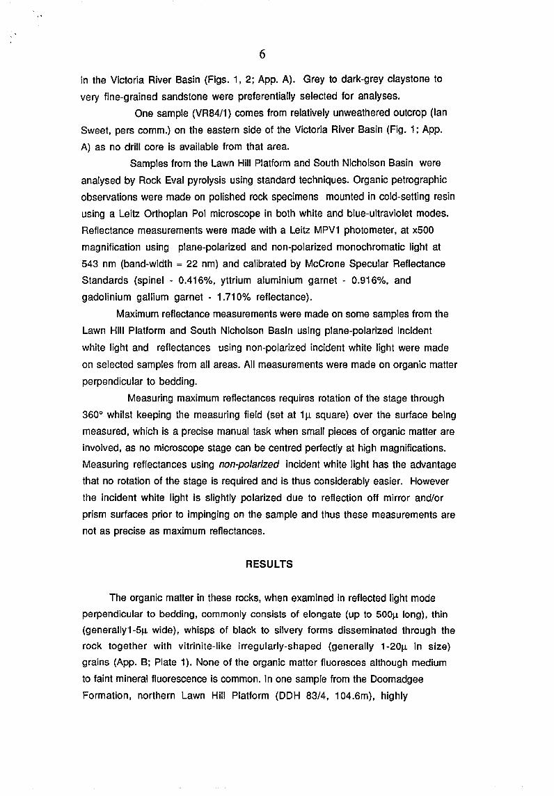
Figure 3. Stratigraphy of the South Nicholson Basin, Lawn Hill Platform
(excluding basal sequences) and the Victoria River Basin (after Sweet, 1977;
Hutton and Sweet, 1982) showing stratigraphic positions of the drill holes.
SAMPLES AND METHODS
Most samples used in this study come from continuously cored
I
stratigraphic drilling by Amoco and the Geological Survey of Queensland in the
Lawn Hill Platform Cover and the South Nicholson Basin (DOH's Amoco 83/1-4,
GSQ LH3) and from Queensland Petroleum Pty. Ltd. one dry wildcat well (Bullo 1)
BULLITA GROUP
WATTlE GROUP
6
in the Victoria River Basin (Figs. 1, 2; App. A). Grey to dark-grey claystone to
very fine-grained sandstone were preferentially selected for analyses.
One sample (VR84/1) comes from relatively unweathered outcrop (Ian
Sweet, pers comm.) on the eastern side of the Victoria River Basin (Fig. 1; App.
A) as no drill core is available from that area.
Samples from the Lawn Hill Platform and South Nicholson Basin were
analysed by Rock Eval pyrolysis using standard techniques. Organic petrographic
observations were made on polished rock specimens mounted in cold-setting resin
using a Leitz Orthoplan Pol microscope in both white and blue-ultraviolet modes.
Reflectance measurements were made with a Leitz MPV1 photometer, at x500
magnification using plane-polarized and non-polarized monochromatic light at
543 nm (band-width = 22 nm) and calibrated by McCrone Specular Reflectance
Standards (spinel - 0.416%, yttrium aluminium garnet - 0.916%, and
gadolinium gallium garnet - 1.710% reflectance).
Maximum reflectance measurements were made on some samples from the
Lawn Hill Platform and South Nicholson Basin using plane-polarized incident
white light and reflectances using non-polarized incident white light were made
on selected samples from all areas. All measurements were made on organic matter
perpendicular to bedding.
Measuring maximum reflectances requires rotation of the stage through
3600 whilst keeping the measuring field (set at 111 square) over the surface being
measured, which is a precise manual task when small pieces of organic matter are
involved, as no microscope stage can be centred perfectly at high magnifications.
Measuring reflectances using non-polarized incident white light has the advantage
that no rotation of the stage is required and is thus considerably easier. However
the incident white light is slightly polarized due to reflection off mirror and/or
prism surfaces prior to impinging on the sample and thus these measurements are
not as precise as maximum reflectances.
RESULTS
The organic matter in these rocks, when examined in reflected light mode
perpendicular to bedding, commonly consists of elongate (up to 500Jl long), thin
(generally1-5Jl wide), whisps of black to silvery forms disseminated through the
rock together with vitrinite-like irregularly-shaped (generally 1-20Jl in size)
grains (App. B; Plate 1). None of the organic matter fluoresces although medium
to faint mineral fluorescence is common. In one sample from the Doomadgee
Formation, northern Lawn Hill Platform (DOH 83/4, 104.6m), highly
· .
7
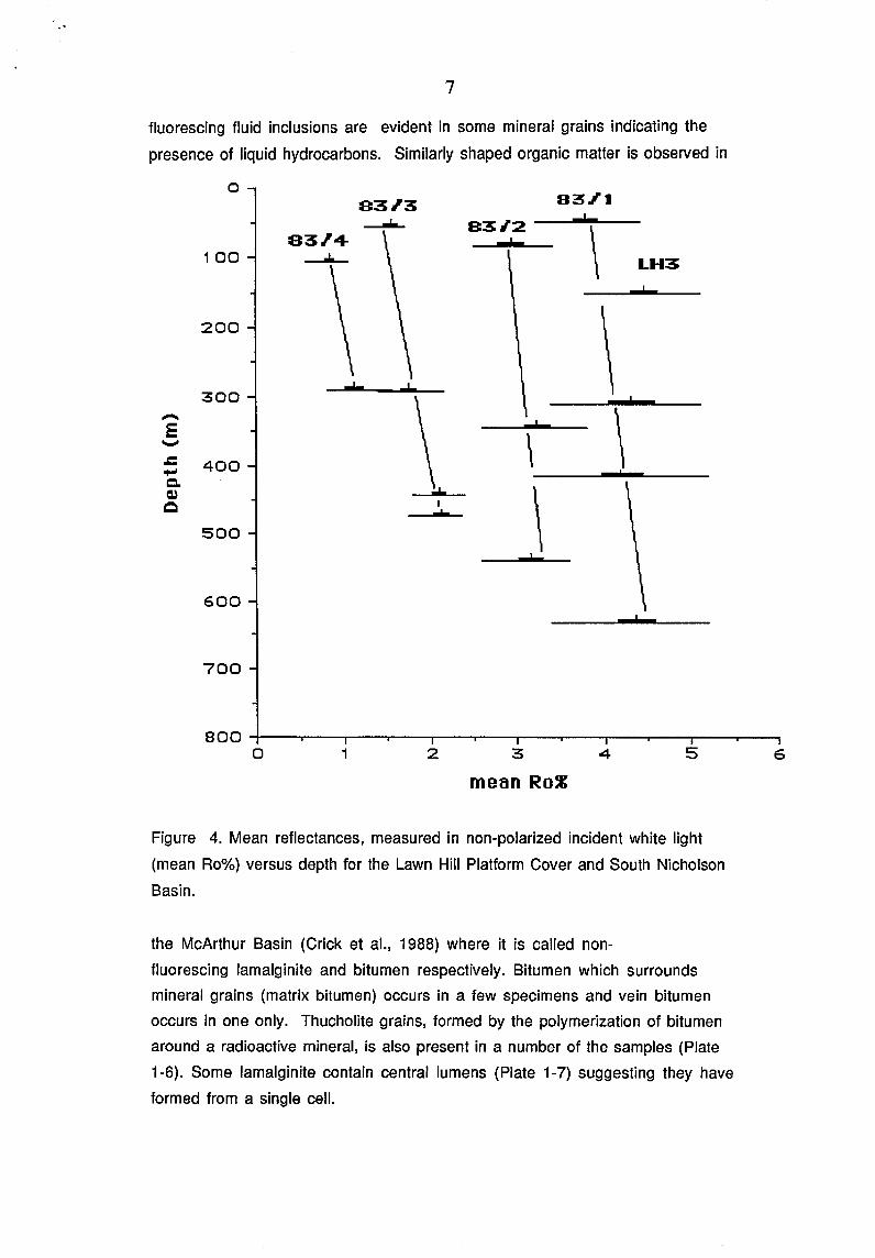
fluorescing fluid inclusions are evident in some mineral grains indicating the
presence of liquid hydrocarbons. Similarly shaped organic matter is observed in
a S3~3
-----83.14-100 ----"'"-
200
...I. 300 -E -.c 400 ....,
Q" Q,)
Q
500
600
700
o 1
I ...
2
83.1'1
831'2
\
\ !
:3
mean RoZ
I
\
\
4
LH3
\ ,
5
Figure 4. Mean reflectances, measured in non-polarized incident white light
(mean Ro%) versus depth for the Lawn Hill Platform Cover and South Nicholson
Basin.
the McArthur Basin (Crick et aI., 1988) where it is called non-
fluorescing lamalginite and bitumen respectively. Bitumen which surrounds
mineral grains (matrix bitumen) occurs in a few specimens and vein bitumen
occurs in one only. Thucholite grains, formed by the polymerization of bitumen
around a radioactive mineral, is also present in a number of the samples (Plate
1-6). Some lamalginite contain central lumens (Plate 1-7) suggesting they have
formed from a single cell.
6

~ ID ." ... :r -9 ...,
8
o YR 84/1
200 Bull0 1
400
...L..
600
\ 900~--~--~--~--~--~--~--T-~
0.0 1.0 2.0 Mean Ro~
3.0 4.0
Figure 5. Mean reflectances, measured in non-polarized incident white light
(mean Ro%) versus depth for the Victoria River Basin.
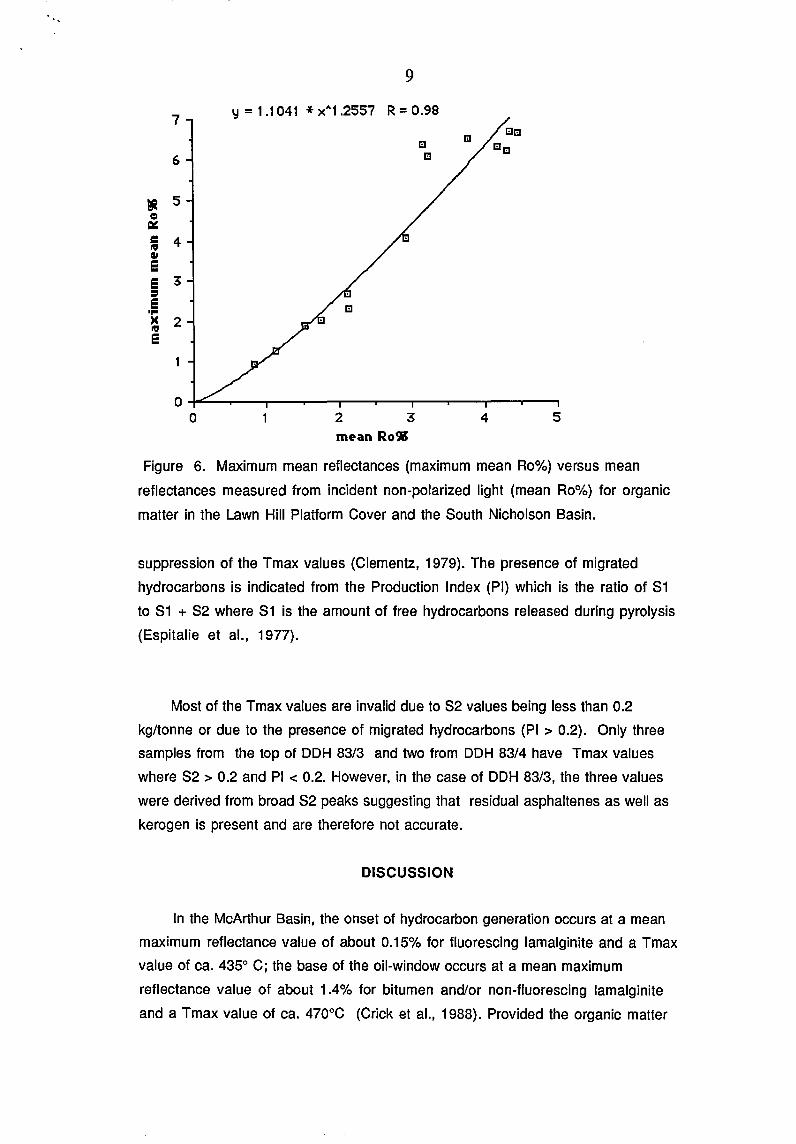
Reflectance measurements were made on the lamalginite and bitumen (App. C,
0; Figs. 4,5). Mean reflectances, measured in non-polarized white light, range
from 0.84% to 4.36% and when these measurements are compared to maximum
mean reflectances from the same specimens a good correlation (R=0.98) is
obtained (Fig. 6).
The reflectance results for lamalginite and bitumen from the outcrop
specimen, VR84/1, have probably not been significantly affected by weathering as
research into the effect of weathering on coals has shown that there are no
significant differences between vitrinite reflectances from naturally weathered
outcrops of coal with that of the same unweathered coal obtained at greater depths
(Chandra, 1962).
Rock Eval pyrolysis of samples from the Lawn Hill Platform Cover and the
South Nicholson Basin are given in Appendix E. The maturation index, Tmax,
derived from Rock-Eval analyses, represents the temperature of maximum
evolution of hydrocarbons during pyrolysis (Espitalie et aI., 1977). Tmax
measurements are unreliable in samples of low pyrolysis yields «0.2 kg/tonne)
and are also affected by the migration of hydrocarbons commonly causing a
7
6
~ 5 = " ~ 4 III 41 e e 3 :I e ... )( 2 III e
9
y = 1 .1 041 * x" 1 .2557 R = 0.98
O~~~--~--~--~--~--r---~--r---~~
o 2 3 4 5 mean Ro~
Figure 6. Maximum mean reflectances (maximum mean Ro%) versus mean
reflectances measured from incident non-polarized light (mean Ro%) for organic
matter in the Lawn Hill Platform Cover and the 80uth Nicholson Basin.
suppression of the Tmax values (Clementz, 1979). The presence of migrated
hydrocarbons is indicated from the Production Index (PI) which is the ratio of 81
to 81 + 82 where 81 is the amount of free hydrocarbons released during pyrolysis
(Espitalie et aI., 1977).
Most of the Tmax values are invalid due to 82 values being less than 0.2
kg/tonne or due to the presence of migrated hydrocarbons (PI> 0.2). Only three
samples from the top of DDH 83/3 and two from DDH 83/4 have Tmax values
where 82 > 0.2 and PI < 0.2. However, in the case of DDH 83/3, the three values
were derived from broad 82 peaks suggesting that residual asphaltenes as well as
kerogen is present and are therefore not accurate.
DISCUSSION
In the McArthur Basin, the onset of hydrocarbon generation occurs at a mean
maximum reflectance value of about 0.15% for fluorescing lam alginite and a Tmax
value of ca. 435° C; the base of the oil-window occurs at a mean maximum
reflectance value of about 1.4% for bitumen and/or non-fluorescing lamalginite
and a Tmax value of ca. 470°C (Crick et aI., 1988). Provided the organic matter

Region/Formation, Maturity
... South Nicholson Basin
Mullera Formation
Constance Sandstone
Northern Lawn Hill Platform Doomadgee Formation
Mt Les Siltstone
Central Lawn Hill Platform Lawn Hill Formation
Termite Range Formation
Riversleigh Siltstone
Gunpowder Creek Formation
Victoria River Basin
Angalarri Siltstone
Stubb Formation
10
Reflectances 1%)
mean max mean
1.5 1.9
1.8 - 2.1 2.1 -2.7
0.8 0.9
1 .1 1.2
2.9, 3.2 4.0, 6.1
3.2, 3.8 4.8, 5.9
4.2 - 4.4 6.3, 6.7
4.5 6.6
2.1 - 2.6 2.8-3.7
1.00 1 .1
Tmax Maturity
nrd overmature
nrd overmature
456 mature
459 mature
nrd overmature
nrd overmature
nrd overmature
nrd overmature
nrd overmature
nrd mature
Table 1. Maturation levels for organic matter in the South Nicholson Basin, Lawn
Hill Platform and Victoria River Basin. (nrd = no reliable data; maximum mean
values are those measured except for the Victoria River Basin which are
calculated).
in the Proterozoic rocks discussed here behaves in a similar manner to that of the
McArthur Basin with respect to these maturation indices, then organic matter
from the Stubb Formation, Doomadgee Formation and Mt Les Siltstone are within
the oil window whereas the remainder are overmature (Table 1).
The differences in maturation levels of organic matter from the Lawn Hill
Platform and South Nicholson Basin can probably be explained mostly in terms of
depth of burial and a relatively similar geothermal history. The Lawn Hill
Platform Cover is thinnest adjacent to the Murphy Tectonic Ridge and thickens
considerably towards the central Lawn Hill Platform where it reaches a maximum
thickness of 8500 m (Hutton and Sweet, 1982). It is likely that no great

1 1
thicknesses of younger rocks ever overlay the Fickling Group in the northern
Lawn Hill Platform as the organic matter observed in it is mature and not
overmature. Organic matter in the South Nicholson Group has slightly higher
maturation levels than in the older Fickling Group suggesting that it was more
deeply buried but these levels are significantly less than levels in the McNamara
Group from the central Lawn Hill Platform.
In the Victoria River Basin, it is likely that no great thicknesses of sediments
ever overlay the Stubb Formation in the east. However in the west, the Auvergne
Group and younger sediments were significantly thicker or palaeogeothermal
gradients were higher than to the east given the greater maturation level of
organic matter from DOH Bullo 1.
CONCLUSIONS
1. Organic matter maturation levels for the northern Lawn Hill Platform near the
Murphy Tectonic Ridge and on the eastern side of the Victoria River Basin are
mature and therefore any hydrocarbons that may have accumulated in these
regions would not have been thermally degraded. The potential for finding
hydrocarbons in these regions is therefore enhanced.
2. Maturation levels from the South Nicholson Basin are just overmature and
there may be areas where the organic matter is mature within this basin.
3. Maturation levels from the central Lawn Hill Platform and from the Angalarri
Siltstone on the western side of the Victoria River Basin are overmature.

12
REFERENCES
BLAKE, D.H., 1987. Geology of the Mount Isa Inlier and environs, Queensland and
Northern Territory. BMR Bulletin 225.
CHANDRA, D., 1962. Reflectance and microstructure of weathered coals. Fuel, 41
(2), London, 185-193.
CLEMENTZ, D.M., 1979. Effect of oil and bitumen saturation on source rock pyrolysis.
AAPG BulL, 60, 608-626.
CRICK, J.H., BOREHAM, C.J., and POWELL, T.G., (1987). Assessment of
Hydrocarbon Source Potential, McArthur Basin. Ch. 2, in: Powell T.G. (ed.),
Petroleum Geology and Geochemistry, Middle Proterozoic McArthur Basin.
BMR Record 1987/48.
CRICK, J.H., BOREHAM, C.J., COOK, A.C. and POWELL, T.G., (in press). Studies on
Petroleum Geology and Geochemistry of the Middle Proterozoic McArthur
Basin, Northern Australia II: Assessment of Source Rock Potential. AAPG
Bulletin.
ESPITALlE, J., DEROO, G. and F. MARQUIS, 1986. ROCK EVAL PYROLYSIS
AND ITS APPLICATIONS. Institute Francais du Petrole, publication no. 27299,
English Translation.
HARMS, J.E., 1965. Iron ore deposits of the Constance Range. In: J. McAndrew
(Editor), Geology of Australian Ore Deposits. 8th. Commonwealth Min.
MetalJ. Congr., Melbourne. 2dn. ed., 264-269.
HUTTON, L.J. and SWEET, J.P., 1982. Geological Evolution, Tectonic Style, &
Economic Potential of the Lawn Hill Platform Cover, Northwest Queensland.
BMR Journal of Australian Geology & Geophysics, 7, 125-134.

13
KRALIK, M., 1982. Rb-Sr age determinations on Precambrian carbonate rocks
of the Carpentarian McArthur Basin, Northern Territory, Australia.
Precambrian Research, 18, 157-170.
PAGE, R.W., MCCULLOCH, M.T. and BLACK, L.P., 1984. Isotopic record of
major precambrian events in Australia. Proceedings of the 27th
Internation Geological Congress, Volume 5, 25-72, Precambrian Geology.
PLUMB, K.A., DERRICK, G.M, NEEDHAM, R.S. and SHAW, R.D. 1981. The
Proterozoic of Northern Australia. In Hunter, D.R., (Ed.) Precambrian of
the Southern Hemisphere. Developments in Precambrian Geology, 2,
Elsevier, Amsterdam, 205-307.
SWEET, J.P., 1977. The Precambrian Geology of the Victoria River Region,
Northern Territory. BMR Bulletin 168.

14
Plate 1. Photomicrographs of organic matter in polished blocks perpendicular to
bedding, white reflected light mode; all at the same magnification, scale
bars = 20J..l.
1-1. Victoria River Basin, Auvergne Group, Angalarri Siltstone; DOH Bullo 1,
557.3m; isolated strands of non-fluorescing lamalginite.
1-2. Victoria River Basin, Stubb Formation, outcrop sample VR 84/1; an
isolated strand of non-fluorescing lamalginite.
1-3. Central Lawn Hill Platform, Riversleigh Siltstone; DOH 83/1, 631.0m,
strands of non-fluorescing lamalginite.
1-4. Central Lawn Hill Platform, Gunpowder Creek Formation; DOH Lawn Hill 3,
152.7m, vein bitumen.
1-5. Central Lawn Hill Platform, Termite Range Formation; DOH 83/2, 540.2m,
matrix bitumen surrounding rounded quartz grains.
1-6. South Nicholson Basin, Mullera Formation, DOH 83/3, 54.7m; a thucholite
grain showing a mineral (?zircon) nucleus.
1-7. South Nicholson Basin, Constance Sandstone, DOH 83/3, 292.0m; non
fluorescing lamalginite composed of two bifurcating strands.
1-8. Northern Lawn Hill Platform, Doomaggee Formation, DOH 83/4; a strand of
non-fluorescing lamalginite.

III^I^1^1111* R 8 8 0 5 3 0 2 *
PLIITE 1

· .
REGIONIDDHI DEPTH(m)
15
FORMATION
Central Lawn Hill Platform
83/1
83/2
0-77.8 77.8-655.4 TD
0-360.9 360.9-550.4 TD
Lawn Hill 3 0-95 95-434 434-451 451-460 TD
Termite Range Fm. Riversleigh Sltstn.
Lawn Hill Fm. Termite Range Fm.
Paradise Creek Fm. Gunpowder Creek Fm. Torpedo Creek Qtzte. Yeldham Granite
Northern Lawn Hill Platform
83/4 0-215 215-299 299-597.6 TD
Doomadgee Fm. Mt. Les Sltstn. Walford Dolomite
South Nicholson Basin
83/3 0-59 59-574.2 TD
Mullera Fm. Constance Sst.
Western Victoria River Basin
Bullo 1 (pers. comm. 0-803 803-880 880-969.7 TD
Ian Sweet) Angalarri Sltstn. Jasper Gorge Sst.. granite (basement)
Eastern Victoria River Basin
outcrop sample VR 84/1 Stubb Fm.
LAT., LONG.
APPENDIX A. Location of drill holes and outcrop sample site, with formation logs.
Ilm~IIIIIIIMI~1 *R8805303*

16
DDH/Depth(m) Descriptions of Organic Matter
83/1 49.3
311.5
415.8
631.0
83/2 84.2
344.8
540.3
83/3 54.7
292.0
444.4
473.75
83/4 104.6
287.6
Irregularly shaped bitumen grains up to ca. 30 11, generally :::; 1011, patchy to disseminated.
Irregularly shaped bitumen grains up to ca. 40 11 generally ::;; 1011, patchy to disseminated.
Irregularly shaped bitumen grains up to ca. 50 11 generally ::;; 7 11, patchy to disseminated.
Dispersed, non-fluorescing lamalginite up to 200 x 5 11, generally less than 100 11 long, some disseminated bitu men ::;; 1 0 11.
Irregularly shaped bitumen grains up to ca. 10 11 generally ::;; 511, patchy to disseminated, in places as matrix bitumen.
Dispersed to patchy bitumen up to ca. 50 11, some non-fluorescing lamalginite, up to 90 x 20 11.
Irregularly shaped bitumen grains up to ca. 30 11 generally ca. 15 11, patchy to disseminated.
Irregularly shaped bitumen grains up to ca. 30 11 generally :::; 1011, patchy to disseminated.
Non-fluorescing lamalginite, commonly thin (::;; 1 11), wavy, up to ca.100 11 long, some shorter fatter lam., rare double
walls, rare disseminated bitumen ::;; 15 11.
Non-fluorescing lamalginite up to 250 x 3 11, generally ::;; 5011 long, rare disseminated bitumen < 10 11.
Non-fluorescing lamalginite up to 120 11 long, generally ::;; 50 11 long, rare disseminated bitumen < 15 11, and thucholite.
Non-fluorescing lamalginite up to 500 x 30 11, generally ::;; 50 11 long, patchy to disseminated bitumen < 15 11, rare matrix bitumen and thucholite.
Non-fluorescing lamalginite up to 30 x 5 11, patchy to disseminated bitumen < 5 11, rare thucholite.
Organic Matter Measured for Reflectances
bitumen
bitumen
bitumen
non-fluorescing lamalginite
bitumen
non-fluorescing lamalginite bitumen
bitumen
bitumen
non-fluorescing lamalginite, bitumen
non-fluorescing lamalginite bitumen
non-fluorescing lamalginite bitumen
non-fluorescing lamalginite
non-fluorescing lamalginite bitumen
APPENDIX B. Petrographic descriptions of the organic matter from the Victoria and South Nicholson Basins, and the Lawn Hill Platform
· . ~
DDH/Depth(m)
Lawn Hill 3 152.7
Bullo 1 297.6
557.3
772.6
VR 84/1 outcrop
17
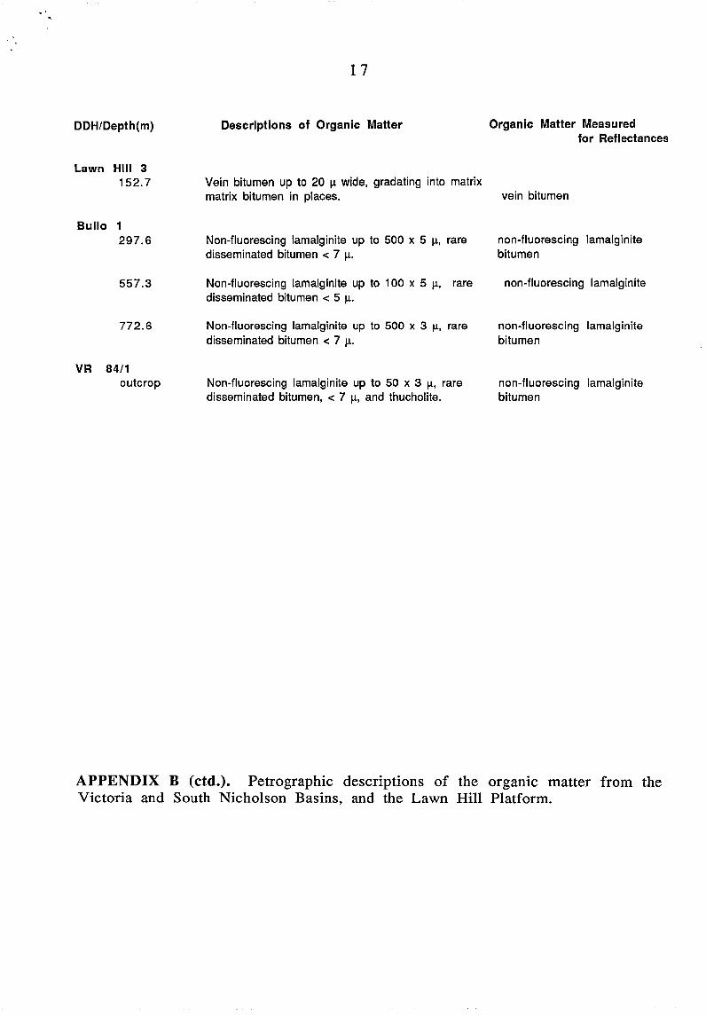
Descriptions of Organic Matter Organic Matter Measured for Reflectances
Vein bitumen up to 20 1.1. wide, gradating into matrix matrix bitumen in places. vein bitumen
Non-fluorescing lamalginite up to 500 x 5 1.1., rare disseminated bitumen < 7 1.1..
Non-fluorescing lamalginite up to 100 x 5 1.1., rare disseminated bitumen < 5 1.1..
Non-fluorescing lamalginite up to 500 x 3 1.1., rare disseminated bitumen < 7 1.1..
Non-fluorescing lamalginite up to 50 x 3 1.1., rare disseminated bitumen, < 7 1.1., and thucholite.
non-fluorescing lamalginite bitumen
non-fluorescing lamalginite
non-fluorescing lamalginite bitumen
non-fluorescing lamalginite bitumen
APPENDIX B (ctd.). Petrographic descriptions of the organic matter from the Victoria and South Nicholson Basins, and the Lawn Hill Platform.

· '
18
DDH/Formation Depth(m) max mean Ro%95%min 95%max X-min X-max no. 83/1 Termite Range Fm. 49.3 6.486 5.846 7.125 5.60 7.40 7 Riversleigh Sltstn. 415.8 6.309 5.831 6.788 5.00 7.40 11
631.0 6.671 5.978 7.365 5.60 7.80 7
83/2 Lawn Hill Fm. 84.2 4.057 3.583 4.531 3.40 5.00 7
344.8 6.067 5.638 6.495 5.20 6.80 9 Termite Range Fm. 540.3 6.360 5.951 6.769 5.40 7.20 10
83/3 Mullera Fm. 54.7 1.898 1.768 2.028 1.70 2.30 11 Constance Sandstone 292.0 2.057 1.887 2.227 1.70 2.50 10
444.4 2.690 2.407 2.973 2.00 3.40 10 473.8 2.311 2.117 2.505 1.80 2.60 9
83/4 Doomadgee Fm. 104.6 0.926 0.852 1.000 0.68 1.07 12 Mt Les Siltstone 287.6 1.274 1.181 1.367 0.93 1.40 10
LH3 Gunpowder Creek Fm. 152.7 6.622 5.592 7.652 5.00 9.00 9
APPENDIX C. Mean maximum reflectances measured (max mean Ro%), 95% confidence limits of the means (95%min, 95%max), range (Xmax, X-min) and number of measurements (no.).
19
DDH/Formation Depth(m) np mean Ro% 95%min 95%max X-min X-max no.
83/1 Termite Range Fm. 49.3 3.788 3.657 3.919 3.20 4.40 25 Ri versleigh Siltstone 311.5 4.321 4.054 4.588 3.40 5.10 19
415.8 4.196 3.957 4.435 3.20 5.20 23 631.0 4.363 4.155 4.570 3.40 5.20 16
83/2 Lawn Hill Fm. 84.2 2.927 2.789 3.047 2.50 3.40 15
344.8 3.235 3.096 3.373 2.60 3.80 23 Termite Range Fm. 540.3 3.165 3.038 3.292 2.60 3.60 20
83/3 Mullera Fm. 54.7 1.531 1.469 1.592 1.24 1.70 22 Constance Sandstone 292.0 1.751 1.668 1.835 1.40 2.16 25
444.4 2.102 2.037 2.166 1.82 2.40 24 473.8 2.137 2.066 2.208 1.76 2.36 21
83/4 Doomadgee Fm. 104.6 0.835 0.780 0.890 0.56 1.02 19 Mt Les Siltstone 287.6 1.115 1.035 1.194 0.84 1.56 22
LH3 Gunpowder Creek Fm. 152.7 4.461 4.311 4.611 3.80 5.10 23
Bullo 1 Augalarri Siltstone 297.6 2.108 1.955 2.261 1.80 2.60 13
557.3 2.353 2.221 2.485 1.90 2.90 19 772.6 2.629 2.433 2.824 2.10 3.10 14
VR 84/1 Stubb Fm. outcrop 1.001 0.937 1.065 0.70 1.28 21
APPENDIX D. Mean reflectances measured from non-polarised incident light (np mean Ro%), 95% confidence limits of the means (95%min, 95%max), range (X-max, X-min) and number of measurements (no.)

20
APPENDIX E Rock Eval Results
Abbreviations: S 1 = free hydrocarbons released on heating to 300°C S2 = hydrocarbons released on pyrolysis S3 = carbon dioxide released on pyrolysis Tmax = temperature of maximum release of hydrocarbons released on pyrolysis PI = Production Index HI = Hydrogen Index 01 = Oxygen Index TOC = Total Organic Carbon

,BASIN,VICTORIA RIV WELL BULLO NO 1
~*~************************************************************************* ID DEPTH TMAX 51 52 83 ORB C
UD LD DEB C I<G PER TONNE ~~**~*****************************************************'***'***'*****'**
FORMATION 1683 627.7 627.7 436 0.00 0.00 . I 1 • 17 1684 798.7 798.7 335 0.00' 0.00 0.00 ~ ... . ..::...::. 1685 696.8 696.8 '221 O. (Il) 0.00 0.00 .09 1686 470.4 470.4 177 0.00 0.00 .05 .07 1687 378.4 '378.4 222 .10 0.00 0.00 .12 1688 341.1 341.1 277 .20 0.00 • (ll • (16 1689 772.6 772.6 268 .18 0.(10 O. (II) .18
VR Slt-/l f-----;.-- ---- ;-.---- !.------;.----.--- ';------- ;.---- --- ;--- ---- ;------- ;-------; .' , . - 'I: 1~!T'l' : T:-1A~:: 5 1 : S 2 : TOC t-----r-----~----~------~------~------~------~------~------~--~---~
BASIN LAWN HILL PL WELL 83/1
********************~******************************************************** ID DEPTH-M TMAX 51 52 83 ORG C
UD LD DEG C KG PER TONNE X
***************************************************************************** FORMATION TERMITE RANGE
1758 49.3 49.3 275 0.00 .02 0.00 0.00
FORMATION RIVERSLEIGH SST
1759 311.5 311.5 337 0.0t) .04 0.00 0.00 1760 335.8 335.8 275 0.00 .01 0.00 0.00 1761 371. 7. 371.7 271) .. 01 .01 0.00 0.00 1762 415.8 415.8 271) .01 .02 0.00 0.00 1763, 446.7 446.7 235 0.00 • C) 1 O. (Il) 0.00 1764 631.0 631.0 233 0.01) .01 0.01) 0.00
BASIN LAWN HILL PL WELL 83/2
*****************************************************************~*********** 10 DEPTH-M
UO LO TMAX DEG C
81 52 I:~G FER TONNE
S3 ORG C 'l.
***************************************************************************** FORMATION LAWN HILL
1765 84.2 84.2 521 0.00 • 11 O. (/l) 0.(10 1766 276.8 276.8 '319 0.00 .02 0.00 (1.01) 1767 288.5 288.5 339 0.00 .04 (J. (II) I). (II)
1768 319.2 319.2 305 0.00 .02 0.00 0.00 1769 323.7 323.7 346 .01 .06 0.(1) 0.00 1770 ;::'37.1 337.1 299 .01 .03 0.00 0.00 1771 344.8 344.8 275 .02 .06 0.(1(1 0.00
FORMATION TERMITE RANGE
1772 479.9 479.9 437 O. (/l) 0.(10 0.(10 0,1)0 1773 540.3 540.3 325 0.(10 0.00 0.00 0.00

BA5IN I..flWN HILL. pI.. WELL 83/4
***************************************************************************** ID DEPTH-M TMAX 51 52 s:: ORG C
UD LD DEG C I<G PER TONNE i:
***************************************************************************** FORMATION DOOMADGEE
1781 92.1 92.1 452 .03 .12 0.00 0.00 1782 104.6 104.6 456 .14 .88 (t.00 1.04 1783 110.1 110.1 465 O. (II) .12 0.(1) 0.(1)
1784 117.4 117.4 4.<.7 ~.,. .. ,-"-' .54 .24 .68 1785 146.0 146.0 436' .54 1.30 1.86 0.00 1786 . 149.8 149.8 429 .48 1.47 1. 34 0.00 1787 . 157.0 157.0 447 .43 1. 44 .37 0.00 1788 163.6 163.6 440 .74 1.85 .23 0.00 1789 173.9 173.9 443 1.27 2.38 .24 0.00 1790 182.6 182.6 461 8.09 23.38 .77 0.00
FORMATION NT. LE5
1791 221 .. 9 221.9 454 .43 .58 .. :'0 0.00 1792 224.5 224.5 455 .66 1. 21 .22 0.00 1793 229.7 229.7 457 .62 1.03 .14 2.14 '1794 237.1 237.1 446 .04 .10 0.00 0.00 1795 250.5 250.5 363 .02 .05 0.0(1 0.00 1796 285.6 285.6 362 0.00 .06 0.00 0.00 1797 287.7 287.7 459 .34 1.94 1.09 4.07 1798 291.2 291.2 458 .49 1. 34 2.74 3.61 1799 295.1 295.1 462 .40 1 • 10 2.96 2.50
FORMATION WALFORD DOL
1800 310.1 310.1 450 .02 .09 2.47 0.00 1801 . 312.9 312.9 365 .01 .03 2.06 0.00 1802 337.6 337.6 350 • () 1 .05 1.99 (t. ')0 1803 349.5 349.5 313 .02 .04 1. 42 0.00 1804 360.4 360.4 276 (J. (I() .01 1. 46 0.00 1805 528.9 528.9 310 .03 .Q4 1.08 0.00 1806 564.5 564.5 249 .02 0.00 .71 0.00 1807 572.5, 572.5 245 .1)4 .03 C'")
• ..J .... 0.00

, '
BASIN t..AWN HlL-L- ('I- WELL 8:::/4
***************************************************************************** DEPTH ORG C 51+S2 S2/S3 PI TMAX HI OI ID-NO
M i'. KG/T DEG C
I **************************************************************************** FORMATION DOOMADGEE
92.1 0.00 .15 .20 452 1781 104.6 1. 04 1. 02 • 14 456 85 0 1782 110.1 0.00 .12 0.0(1 465 1783 117.4 .68 .87 ..., ...,co
• ;:-.8 467 79 "'C' 1784 .t.. • .La..J ~'.J
146.0 0.00 1.84 .70 .29 436 1705 149.8 0.00 1.95 1. 10 .25 429 1786 157.0 0.00 1. 87 3.89 ...,-
.4_"1 447 1787 163.6 0.00 2.59 8.04 .29 440 1788 173.9 0.00 3.65 9.92 ",co
• ....... -J 443 1789 182.6 0.00 31.47 30.36 .26 461 1791)
FORMATION MT. LES
221; 9 0.00 1.01 1.93 .43 454 1791 224.5 0.00 1.87 5.50 "'<=' 455 1792 ...... \...J
229.7 2.14 1.65 7.36 .38 457 48 7 1793 237.1 0.00 .14 .29 446 1794 250.5 0.00 .07 .29 363 1795 285.6 0.00 .06 0.00 362 1796 287.7 4.07 2.28 1.78 .15 459 48 27 1797 291.2 3.61 1.83 .49 .27 458 37 76 1798 295.1 2.50 1.50 .37 .27 462 44 110 1799
FORMATION WALFORD DOL
310.1 0.00 • 11 .04 .18 450 18(10 312.9 0.01) .04 .01 ...,C'
14.J 365 181)1 337.6 0.00 .06 .03 .17 350 1802 349.5 0.00 .06 .03 ~~ 313 1803 ............ \ 360.4 0.00 .01 .01 0.00 276 1804 528.9 0.00 .07 .• 04 .43 310 1805 564.5 0.00 .02 0.00 1 • 0(1 249 1806 572.5 0.00 • (17 .06 .57 245 1807
'BASIN LAWN HILL PL WELL LAWN HILL NO 3
***************************************************************************** ID DEPTH-M
UD LD TMAX DEG C
51 S2 I<G PER TONNE
C'~ i:)._, ORG C I.
***************************************************************************** FORI1ATION GUNF'OVJDER CREEl':
1633 126.1 126.1 403 .21 .09 .,.,.. 0.00 .... :..J
1634 152.7 152.7 .,...,7 .L...G.~ .57 0.00 .24 0.00
1635 160.0 160.0 265 .26 0.00 .18 0.00 1636 410.0 410.0 264 .04 .01 .14 0.0(1 1637 430.0 430.0 265 .17 0.00 .56 0.00

.. ,BASIN SH NICHOLSON WELL 83/3
***************************************************************************** ID DEPTH-11
UD LD TMAX DEG C
51 S2 ~;G PER TONNE
S3 ORG C 1.
***************************************************************************** FOBMATIOI>l MULLERA
1774 54.7 54.7 463 .03 "':'"'""=" .. .; . .,,) .07 .70 1889 56.9 56.9 455 .02 .22 0.00 .87
FORMATION CONSTANCE SST
1775 61. 8, 61.8 475 .01 .27 . (11 0.(1) 189\,) 263.2 263.2 474 .01 .09 0.00 0.00 1776 270.9 270.9 359 0.00 .02 0.00 0.00 1891 277.5 277.5 :!·(l2 Ct. 1)1) .02 0.00 0.(10 1777 296.0 296.0 375 .01 .13 0.00 0.00 1778 444.4 444.4 334 .01 .05 0.00 0.(10 1892 450.8 450.8 393 .01 • 11 0.00 i).00 1893 452.1 452.1 393 0.00 .10 O. (II) 0.(10 1779 460.3 460.3 347 0.00 .1)5 .01 0.00
, 1894 469.2 469.2 412 Ct. 00 .11 0.00 0.00 1780 473.7 473.7 395 .01 .15 0.00 0.00 1895 486.1 486.1 337 .01 .07 0.00 0.00 1896 492.2 492.2 398 .02 .13 0.00 0.00
fJAS!N SH NICHOLSON WELL 83/3
***************************************************************~*************
DEPTH M
ORG C t.
81+52 KG/T
82/53 PI TMAX DEG C
HI 01 ID-NO
***************************************************~*************************
54.7 56.9
61. 8 263.2 270.9 277.5 296.0 444.4 450.8, 452.1 460.3 469.2 473.7 486.1 492.2
.70
.87
0.00 0.00 0.00 0.00 0.00 0.00 0.00 0.00 0.00 0.00 0.00· 0.00 0.00
FORMATION MULLERA
.. 36
.24 .. 4.71 .08 .08
FORMATION CONSTANCE SST
.28 27.00 .04
.1(' .11)
.02 0.00
.02 0.00
.14 .07
.06 .17
.12 .08
.10 0.00
.05 5.00 0.00
.11 0.00
.16 .06
.08 .13
.15 .13
463 455
475 474 359 302 375 334 393 393 :::047 L\12 395 337 398
47 25
10 (I
1774 1889
1775 1890 1776 1891 1777 1778 1892 1893 1779 1894 1780 1895 1896