Embed Size (px)
Citation preview
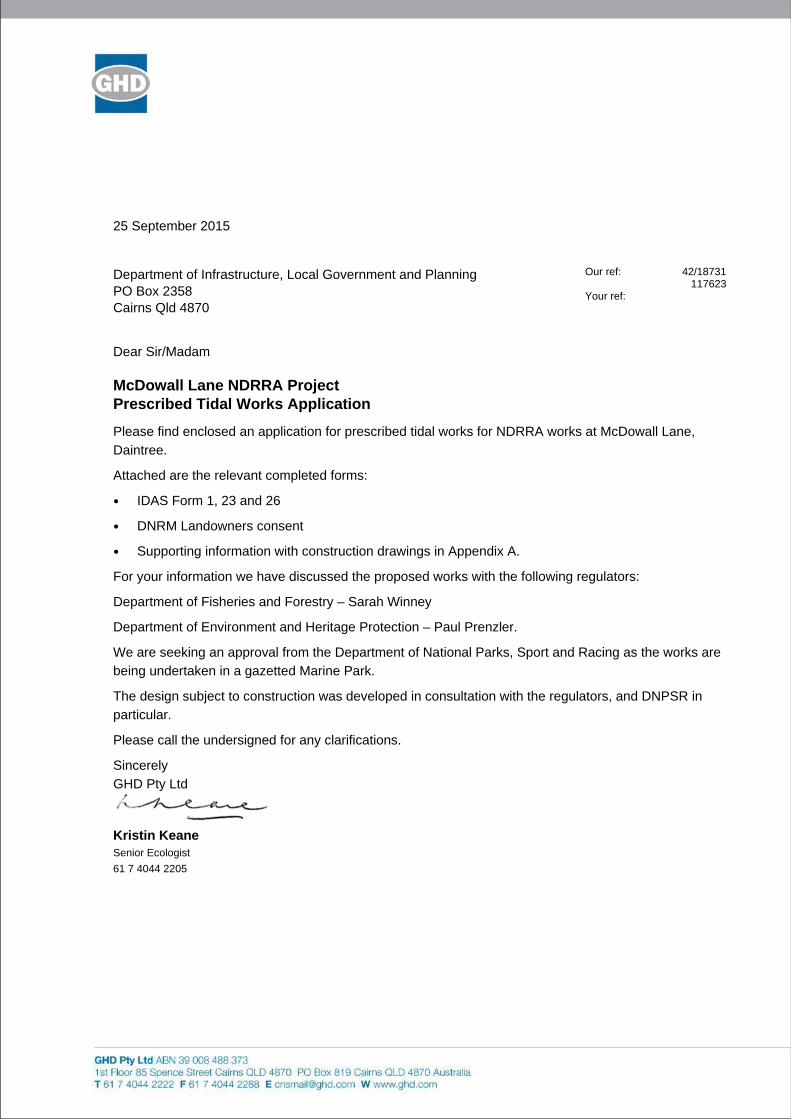
25 September 2015
Department of Infrastructure, Local Government and Planning PO Box 2358 Cairns Qld 4870
Our ref: 42/18731 117623 Your ref:
Dear Sir/Madam
McDowall Lane NDRRA Project Prescribed Tidal Works Application
Please find enclosed an application for prescribed tidal works for NDRRA works at McDowall Lane,
Daintree.
Attached are the relevant completed forms:
IDAS Form 1, 23 and 26
DNRM Landowners consent
Supporting information with construction drawings in Appendix A.
For your information we have discussed the proposed works with the following regulators:
Department of Fisheries and Forestry – Sarah Winney
Department of Environment and Heritage Protection – Paul Prenzler.
We are seeking an approval from the Department of National Parks, Sport and Racing as the works are
being undertaken in a gazetted Marine Park.
The design subject to construction was developed in consultation with the regulators, and DNPSR in
particular.
Please call the undersigned for any clarifications.
Sincerely
GHD Pty Ltd
Kristin Keane Senior Ecologist
61 7 4044 2205
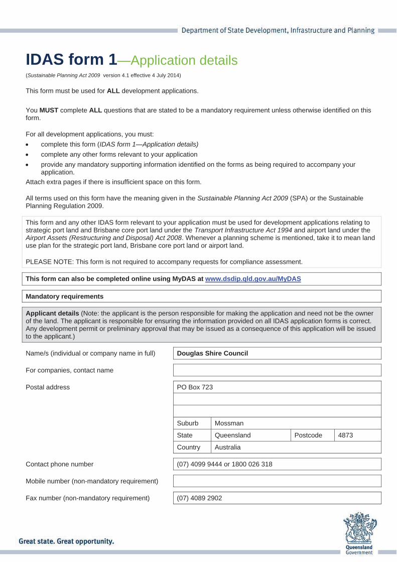
IDAS form 1—Application details(Sustainable Planning Act 2009 version 4.1 effective 4 July 2014)
This form must be used for ALL development applications.
You MUST complete ALL questions that are stated to be a mandatory requirement unless otherwise identified on this form.
For all development applications, you must:
complete this form (IDAS form 1—Application details)
complete any other forms relevant to your application
provide any mandatory supporting information identified on the forms as being required to accompany your application.
Attach extra pages if there is insufficient space on this form.
All terms used on this form have the meaning given in the Sustainable Planning Act 2009 (SPA) or the Sustainable Planning Regulation 2009.
This form and any other IDAS form relevant to your application must be used for development applications relating to strategic port land and Brisbane core port land under the Transport Infrastructure Act 1994 and airport land under the Airport Assets (Restructuring and Disposal) Act 2008. Whenever a planning scheme is mentioned, take it to mean land use plan for the strategic port land, Brisbane core port land or airport land.
PLEASE NOTE: This form is not required to accompany requests for compliance assessment.
This form can also be completed online using MyDAS at www.dsdip.qld.gov.au/MyDAS
Mandatory requirements
Applicant details (Note: the applicant is the person responsible for making the application and need not be the owner of the land. The applicant is responsible for ensuring the information provided on all IDAS application forms is correct. Any development permit or preliminary approval that may be issued as a consequence of this application will be issued to the applicant.)
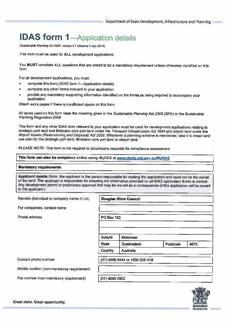
Name/s (individual or company name in full) Douglas Shire Council
For companies, contact name
Postal address PO Box 723
Suburb Mossman
State Queensland Postcode 4873
Country Australia
Contact phone number (07) 4099 9444 or 1800 026 318
Mobile number (non-mandatory requirement)
Fax number (non-mandatory requirement) (07) 4089 2902
IDAS form 1—Application details Version 4.1—4 July 2014
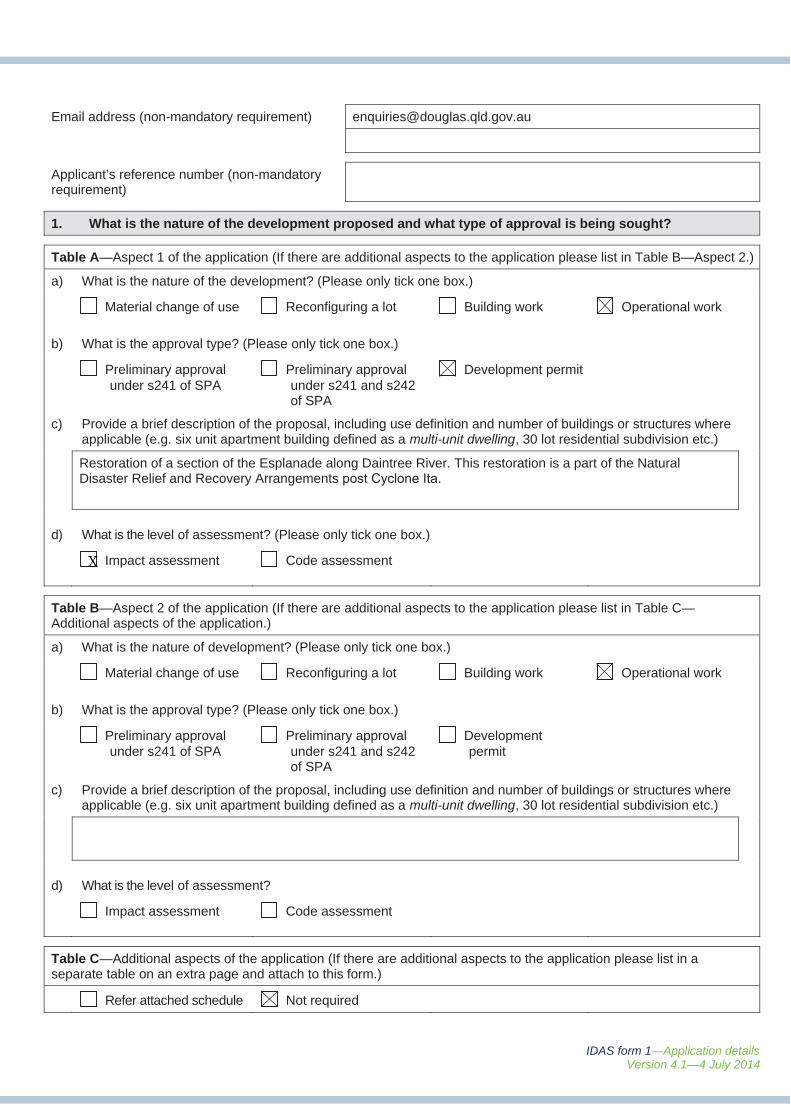
Email address (non-mandatory requirement) [email protected]
Applicant’s reference number (non-mandatory requirement)
1. What is the nature of the development proposed and what type of approval is being sought?
Table A—Aspect 1 of the application (If there are additional aspects to the application please list in Table B—Aspect 2.)
a) What is the nature of the development? (Please only tick one box.)
Material change of use Reconfiguring a lot Building work Operational work
b) What is the approval type? (Please only tick one box.)
Preliminary approval under s241 of SPA
Preliminary approval under s241 and s242 of SPA
Development permit
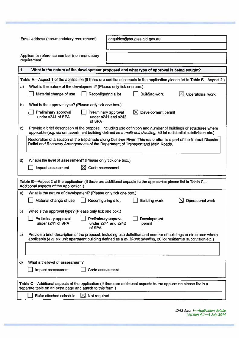
c) Provide a brief description of the proposal, including use definition and number of buildings or structures whereapplicable (e.g. six unit apartment building defined as a multi-unit dwelling, 30 lot residential subdivision etc.)
Restoration of a section of the Esplanade along Daintree River. This restoration is a part of the Natural Disaster Relief and Recovery Arrangements post Cyclone Ita.
d) What is the level of assessment? (Please only tick one box.)
Impact assessment Code assessment
Table B—Aspect 2 of the application (If there are additional aspects to the application please list in Table C—Additional aspects of the application.)
a) What is the nature of development? (Please only tick one box.)
Material change of use Reconfiguring a lot Building work Operational work
b) What is the approval type? (Please only tick one box.)
Preliminary approval under s241 of SPA
Preliminary approval under s241 and s242 of SPA
Development permit
c) Provide a brief description of the proposal, including use definition and number of buildings or structures whereapplicable (e.g. six unit apartment building defined as a multi-unit dwelling, 30 lot residential subdivision etc.)
d) What is the level of assessment?
Impact assessment Code assessment
Table C—Additional aspects of the application (If there are additional aspects to the application please list in a separate table on an extra page and attach to this form.)
Refer attached schedule Not required
X
IDAS form 1—Application details Version 4.1—4 July 2014
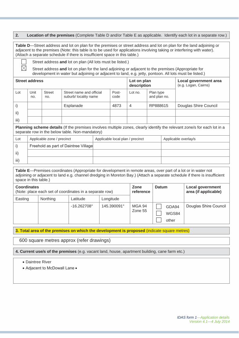
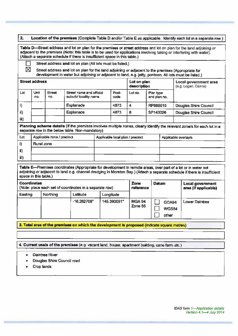
2. Location of the premises (Complete Table D and/or Table E as applicable. Identify each lot in a separate row.)
Table D—Street address and lot on plan for the premises or street address and lot on plan for the land adjoining or adjacent to the premises (Note: this table is to be used for applications involving taking or interfering with water). (Attach a separate schedule if there is insufficient space in this table.)
Street address and lot on plan (All lots must be listed.)
Street address and lot on plan for the land adjoining or adjacent to the premises (Appropriate for development in water but adjoining or adjacent to land, e.g. jetty, pontoon. All lots must be listed.)
Street address Lot on plan description
Local government area (e.g. Logan, Cairns)
Lot Unit no.
Street no.
Street name and official suburb/ locality name
Post-code
Lot no. Plan type and plan no.
i) Esplanade 4873 4 RP888615 Douglas Shire Council
ii)
iii)
Planning scheme details (If the premises involves multiple zones, clearly identify the relevant zone/s for each lot in a separate row in the below table. Non-mandatory)
Lot Applicable zone / precinct Applicable local plan / precinct Applicable overlay/s
i) Freehold as part of Daintree Village
ii)
iii)
Table E—Premises coordinates (Appropriate for development in remote areas, over part of a lot or in water not adjoining or adjacent to land e.g. channel dredging in Moreton Bay.) (Attach a separate schedule if there is insufficient space in this table.)
Coordinates (Note: place each set of coordinates in a separate row)
Zonereference
Datum Local governmentarea (if applicable)
Easting Northing Latitude Longitude
-16.262708° 145.390091° MGA 94Zone 55
GDA94
WGS84
other
Douglas Shire Council
3. Total area of the premises on which the development is proposed (indicate square metres)
4. Current use/s of the premises (e.g. vacant land, house, apartment building, cane farm etc.)
Daintree River
Adjacent to McDowall Lane
600 square metres approx (refer drawings)
IDAS form 1—Application details Version 4.1—4 July 2014
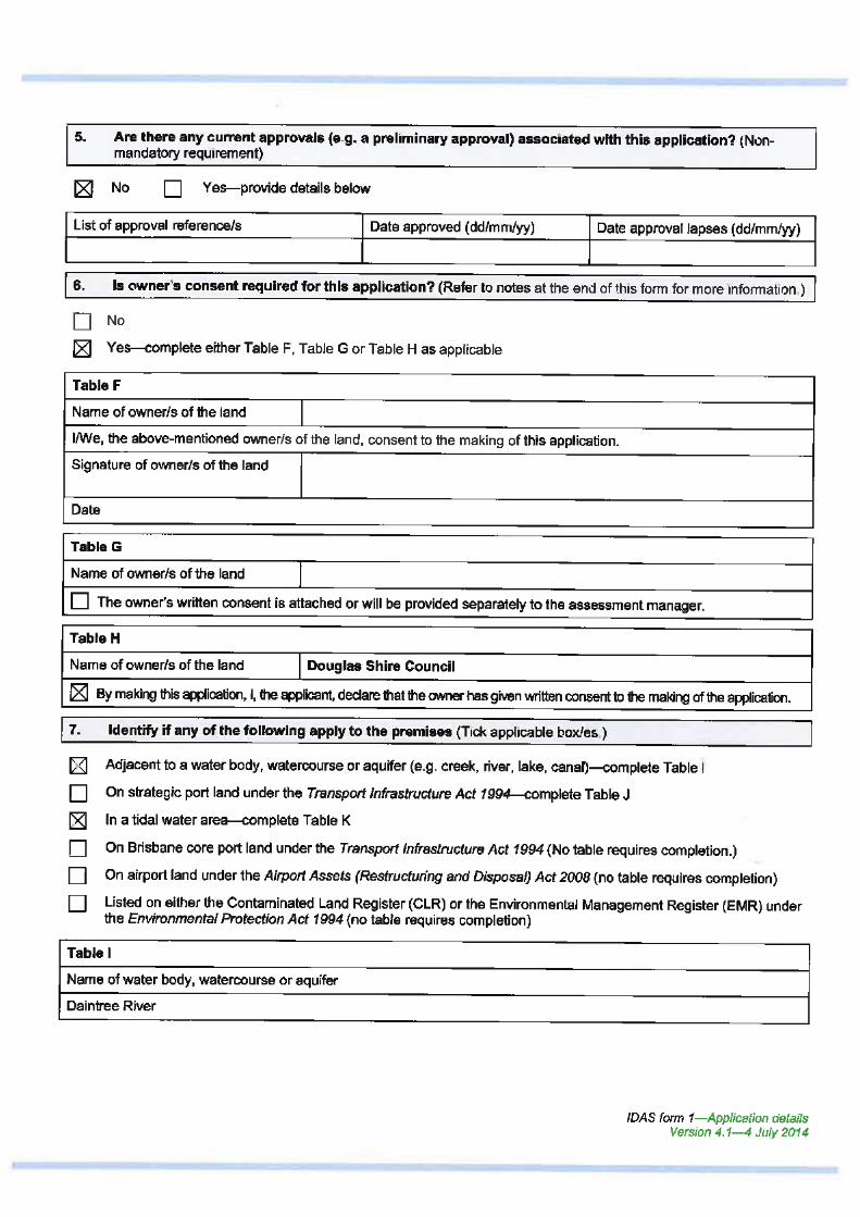
5. Are there any current approvals (e.g. a preliminary approval) associated with this application? (Non-mandatory requirement)
No Yes—provide details below
List of approval reference/s Date approved (dd/mm/yy) Date approval lapses (dd/mm/yy)
6. Is owner’s consent required for this application? (Refer to notes at the end of this form for more information.)
No
Yes—complete either Table F, Table G or Table H as applicable
Table F
Name of owner/s of the land Crown and Douglas Shire Council as custodian
I/We, the above-mentioned owner/s of the land, consent to the making of this application.
Signature of owner/s of the land
Date
Table G
Name of owner/s of the land
The owner’s written consent is attached or will be provided separately to the assessment manager.
Table H
Name of owner/s of the land Douglas Shire Council
By making this application, I, the applicant, declare that the owner has given written consent to the making of the application.
7. Identify if any of the following apply to the premises (Tick applicable box/es.)
Adjacent to a water body, watercourse or aquifer (e.g. creek, river, lake, canal)—complete Table I
On strategic port land under the Transport Infrastructure Act 1994—complete Table J
In a tidal water area—complete Table K
On Brisbane core port land under the Transport Infrastructure Act 1994 (No table requires completion.)
On airport land under the Airport Assets (Restructuring and Disposal) Act 2008 (no table requires completion)
Listed on either the Contaminated Land Register (CLR) or the Environmental Management Register (EMR) under the Environmental Protection Act 1994 (no table requires completion)
Table I
Name of water body, watercourse or aquifer
Daintree River
IDAS form 1—Application details Version 4.1—4 July 2014
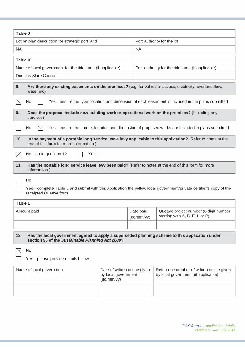
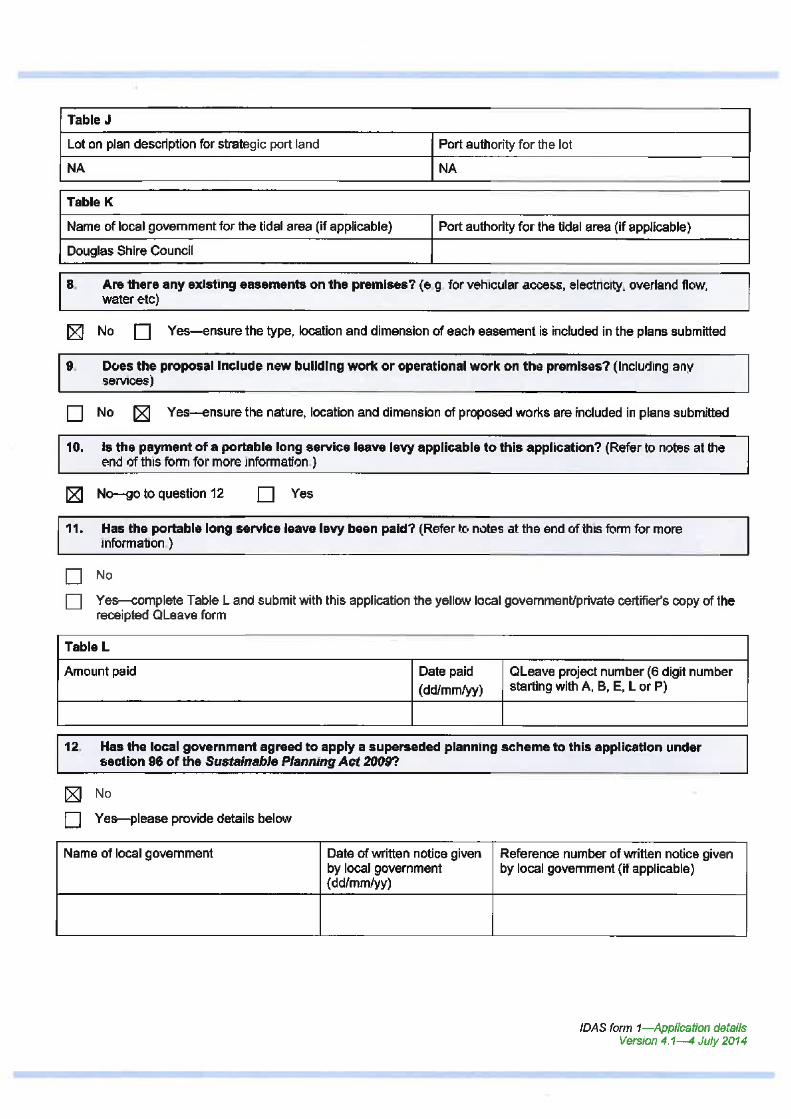
Table J
Lot on plan description for strategic port land Port authority for the lot
NA NA
Table K
Name of local government for the tidal area (if applicable) Port authority for the tidal area (if applicable)
Douglas Shire Council
8. Are there any existing easements on the premises? (e.g. for vehicular access, electricity, overland flow,water etc)
No Yes—ensure the type, location and dimension of each easement is included in the plans submitted
9. Does the proposal include new building work or operational work on the premises? (Including anyservices)
No Yes—ensure the nature, location and dimension of proposed works are included in plans submitted
10. Is the payment of a portable long service leave levy applicable to this application? (Refer to notes at theend of this form for more information.)
No—go to question 12 Yes
11. Has the portable long service leave levy been paid? (Refer to notes at the end of this form for moreinformation.)
No
Yes—complete Table L and submit with this application the yellow local government/private certifier’s copy of the receipted QLeave form
Table L
Amount paid Date paid
(dd/mm/yy)
QLeave project number (6 digit number starting with A, B, E, L or P)
12. Has the local government agreed to apply a superseded planning scheme to this application undersection 96 of the Sustainable Planning Act 2009?
No
Yes—please provide details below
Name of local government Date of written notice given by local government (dd/mm/yy)
Reference number of written notice given by local government (if applicable)
IDAS form 1—Application details Version 4.1—4 July 2014
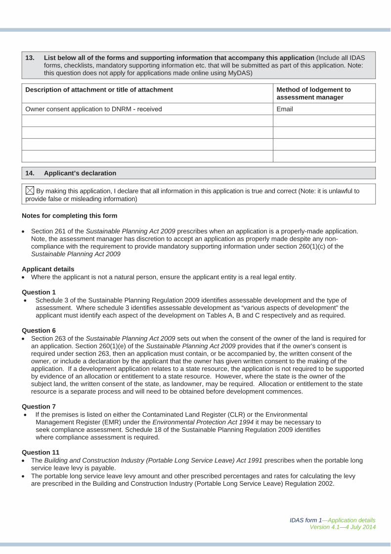
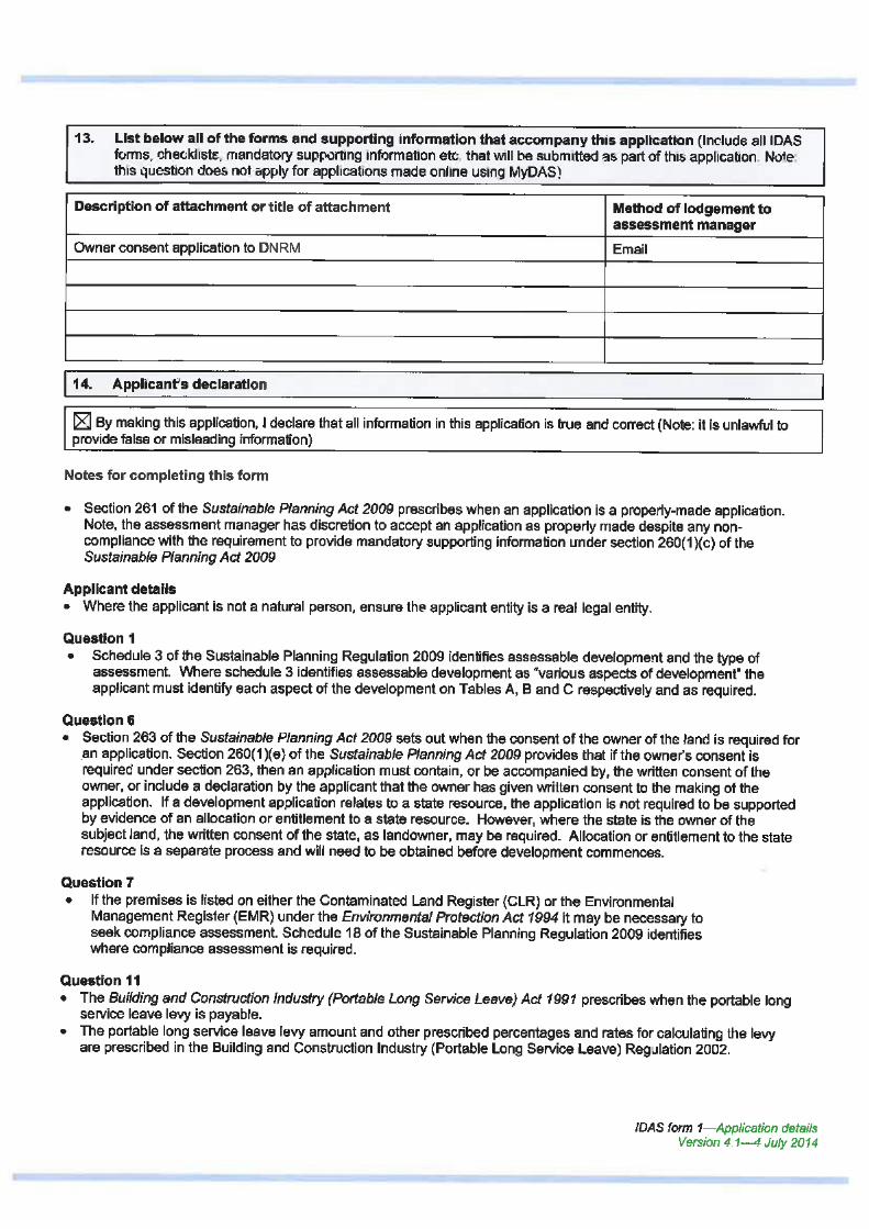
13. List below all of the forms and supporting information that accompany this application (Include all IDASforms, checklists, mandatory supporting information etc. that will be submitted as part of this application. Note:this question does not apply for applications made online using MyDAS)
Description of attachment or title of attachment Method of lodgement to assessment manager
Owner consent application to DNRM - received Email
14. Applicant’s declaration
By making this application, I declare that all information in this application is true and correct (Note: it is unlawful to provide false or misleading information)
Notes for completing this form
Section 261 of the Sustainable Planning Act 2009 prescribes when an application is a properly-made application. Note, the assessment manager has discretion to accept an application as properly made despite any non-compliance with the requirement to provide mandatory supporting information under section 260(1)(c) of the Sustainable Planning Act 2009
Applicant details Where the applicant is not a natural person, ensure the applicant entity is a real legal entity.
Question 1 Schedule 3 of the Sustainable Planning Regulation 2009 identifies assessable development and the type of
assessment. Where schedule 3 identifies assessable development as “various aspects of development” the applicant must identify each aspect of the development on Tables A, B and C respectively and as required.
Question 6 Section 263 of the Sustainable Planning Act 2009 sets out when the consent of the owner of the land is required for
an application. Section 260(1)(e) of the Sustainable Planning Act 2009 provides that if the owner’s consent is required under section 263, then an application must contain, or be accompanied by, the written consent of the owner, or include a declaration by the applicant that the owner has given written consent to the making of the application. If a development application relates to a state resource, the application is not required to be supported by evidence of an allocation or entitlement to a state resource. However, where the state is the owner of the subject land, the written consent of the state, as landowner, may be required. Allocation or entitlement to the state resource is a separate process and will need to be obtained before development commences.
Question 7 If the premises is listed on either the Contaminated Land Register (CLR) or the Environmental
Management Register (EMR) under the Environmental Protection Act 1994 it may be necessary to seek compliance assessment. Schedule 18 of the Sustainable Planning Regulation 2009 identifies where compliance assessment is required.
Question 11 The Building and Construction Industry (Portable Long Service Leave) Act 1991 prescribes when the portable long
service leave levy is payable. The portable long service leave levy amount and other prescribed percentages and rates for calculating the levy
are prescribed in the Building and Construction Industry (Portable Long Service Leave) Regulation 2002.
IDAS form 1—Application details Version 4.1—4 July 2014
Department of State Development, Infrastructure and Planning PO Box 15009 City East Qld 4002 tel 13 QGOV (13 74 68) [email protected]
www.dsdip.qld.gov.au
Question 12 The portable long service leave levy need not be paid when the application is made, but the Building and
Construction Industry (Portable Long Service Leave) Act 1991 requires the levy to be paid before a development permit is issued.
Building and construction industry notification and payment forms are available from any Queensland post office or agency, on request from QLeave, or can be completed on the QLeave website at www.qleave.qld.gov.au. For further information contact QLeave on 1800 803 481 or visit www.qleave.qld.gov.au.
Privacy—The information collected in this form will be used by the Department of State Development, Infrastructureand Planning (DSDIP), assessment manager, referral agency and/or building certifier in accordance with the processing and assessment of your application. Your personal details should not be disclosed for a purpose outside of the IDAS process or the provisions about public access to planning and development information in the SustainablePlanning Act 2009, except where required by legislation (including the Right to Information Act 2009) or as required by Parliament. This information may be stored in relevant databases. The information collected will be retained as required by the Public Records Act 2002.
OFFICE USE ONLY
Date received Reference numbers
NOTIFICATION OF ENGAGEMENT OF A PRIVATE CERTIFIER
To Council. I have been engaged as the private certifier for the building work referred to in this application
Date of engagement Name BSA Certification license number
Buildingclassification/s
QLEAVE NOTIFICATION AND PAYMENT (For completion by assessment manager or private certifier if applicable.)
Description of the work QLeave project number
Amount paid ($)
Date paid
Date receipted form sighted by assessment manager
Name of officer who sighted the form
The Sustainable Planning Act 2009 is administered by the Department of State Development, Infrastructure and Planning. This form and all other required application materials should be sent to your assessment manager and any referral agency.
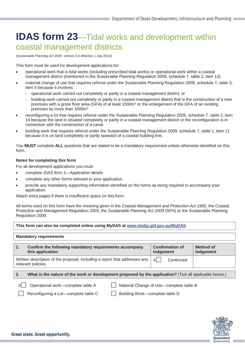
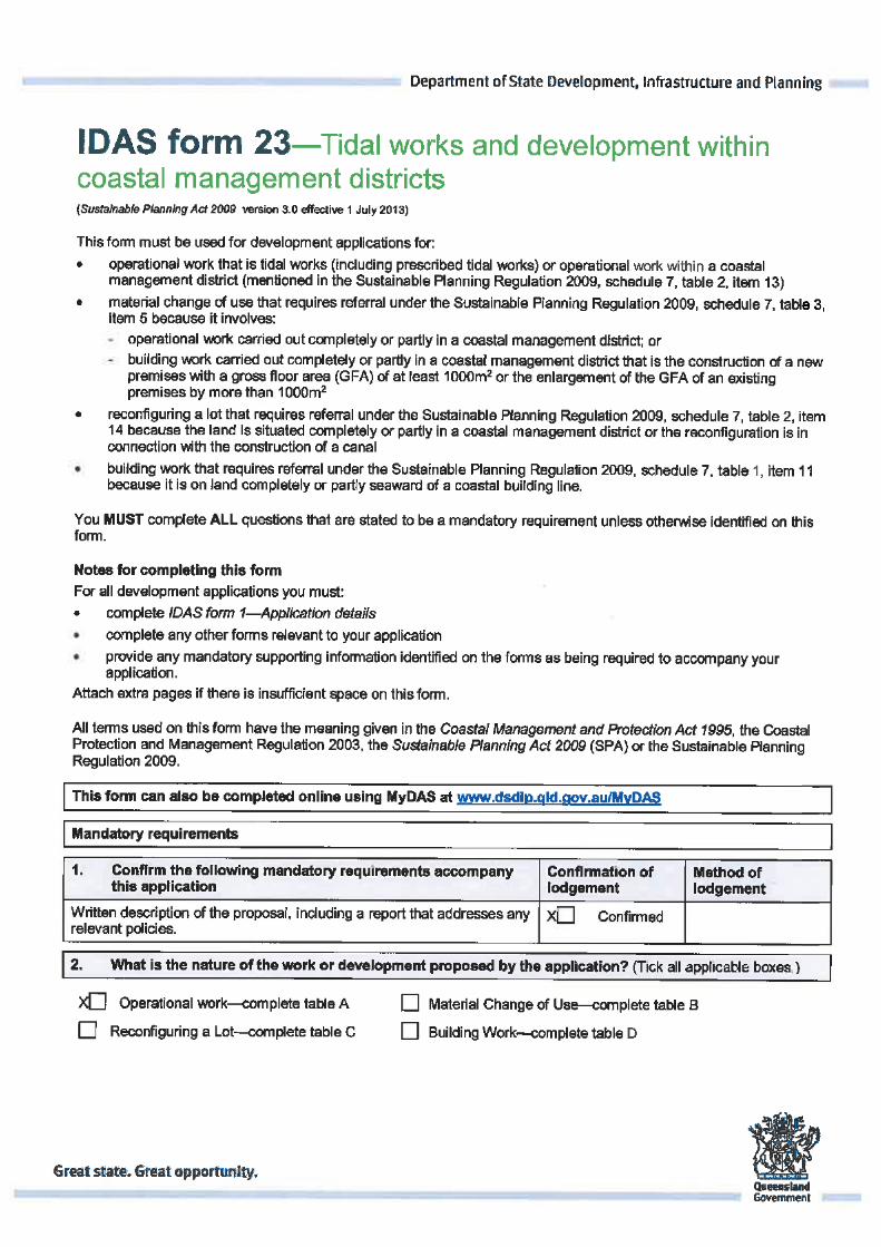
IDAS form 23—Tidal works and development withincoastal management districts(Sustainable Planning Act 2009 version 3.0 effective 1 July 2013)
This form must be used for development applications for:
operational work that is tidal works (including prescribed tidal works) or operational work within a coastal management district (mentioned in the Sustainable Planning Regulation 2009, schedule 7, table 2, item 13)
material change of use that requires referral under the Sustainable Planning Regulation 2009, schedule 7, table 3, item 5 because it involves:
- operational work carried out completely or partly in a coastal management district; or
- building work carried out completely or partly in a coastal management district that is the construction of a new premises with a gross floor area (GFA) of at least 1000m2 or the enlargement of the GFA of an existing premises by more than 1000m2
reconfiguring a lot that requires referral under the Sustainable Planning Regulation 2009, schedule 7, table 2, item 14 because the land is situated completely or partly in a coastal management district or the reconfiguration is in connection with the construction of a canal
building work that requires referral under the Sustainable Planning Regulation 2009, schedule 7, table 1, item 11 because it is on land completely or partly seaward of a coastal building line.
You MUST complete ALL questions that are stated to be a mandatory requirement unless otherwise identified on this form.
Notes for completing this form
For all development applications you must:
complete IDAS form 1—Application details
complete any other forms relevant to your application
provide any mandatory supporting information identified on the forms as being required to accompany your application.
Attach extra pages if there is insufficient space on this form.
All terms used on this form have the meaning given in the Coastal Management and Protection Act 1995, the Coastal Protection and Management Regulation 2003, the Sustainable Planning Act 2009 (SPA) or the Sustainable Planning Regulation 2009.
This form can also be completed online using MyDAS at www.dsdip.qld.gov.au/MyDAS
Mandatory requirements
1. Confirm the following mandatory requirements accompanythis application
Confirmation of lodgement
Method of lodgement
Written description of the proposal, including a report that addresses any relevant policies.
X Confirmed
2. What is the nature of the work or development proposed by the application? (Tick all applicable boxes.)
X Operational work—complete table A Material Change of Use—complete table B
Reconfiguring a Lot—complete table C Building Work—complete table D
IDAS form 23—Tidal works and development withincoastal management districts
Version 3.0—1 July 2013
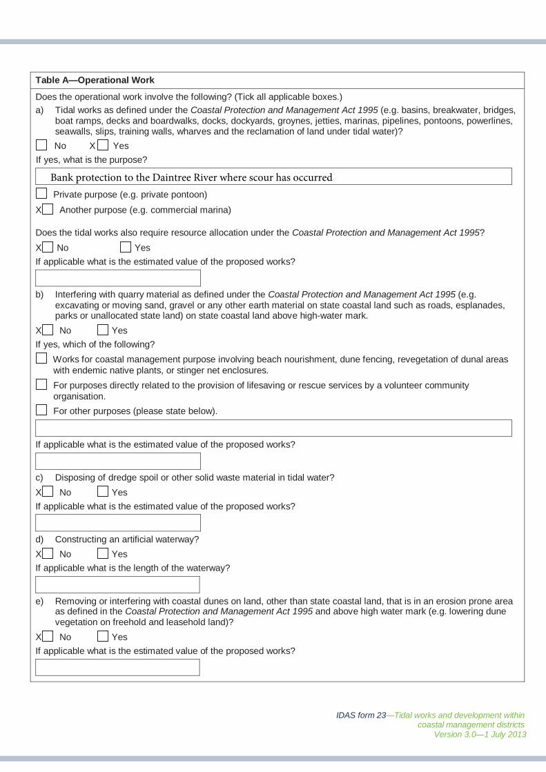
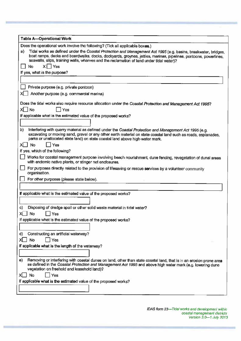
Table A—Operational Work
Does the operational work involve the following? (Tick all applicable boxes.)
a) Tidal works as defined under the Coastal Protection and Management Act 1995 (e.g. basins, breakwater, bridges,boat ramps, decks and boardwalks, docks, dockyards, groynes, jetties, marinas, pipelines, pontoons, powerlines, seawalls, slips, training walls, wharves and the reclamation of land under tidal water)?
No X Yes
If yes, what is the purpose?
Private purpose (e.g. private pontoon)
X Another purpose (e.g. commercial marina)
Does the tidal works also require resource allocation under the Coastal Protection and Management Act 1995?
X No Yes
If applicable what is the estimated value of the proposed works?
b) Interfering with quarry material as defined under the Coastal Protection and Management Act 1995 (e.g.excavating or moving sand, gravel or any other earth material on state coastal land such as roads, esplanades,parks or unallocated state land) on state coastal land above high-water mark.
X No Yes
If yes, which of the following?
Works for coastal management purpose involving beach nourishment, dune fencing, revegetation of dunal areas with endemic native plants, or stinger net enclosures.
For purposes directly related to the provision of lifesaving or rescue services by a volunteer community organisation.
For other purposes (please state below).
If applicable what is the estimated value of the proposed works?
c) Disposing of dredge spoil or other solid waste material in tidal water?
X No Yes
If applicable what is the estimated value of the proposed works?
d) Constructing an artificial waterway?
X No Yes
If applicable what is the length of the waterway?
e) Removing or interfering with coastal dunes on land, other than state coastal land, that is in an erosion prone areaas defined in the Coastal Protection and Management Act 1995 and above high water mark (e.g. lowering dunevegetation on freehold and leasehold land)?
X No Yes
If applicable what is the estimated value of the proposed works?
Bank protection to the Daintree River where scour has occurred
IDAS form 23—Tidal works and development withincoastal management districts
Version 3.0—1 July 2013
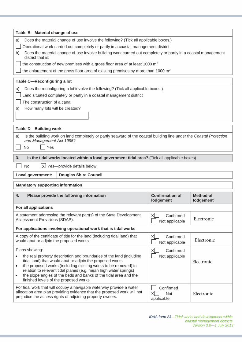
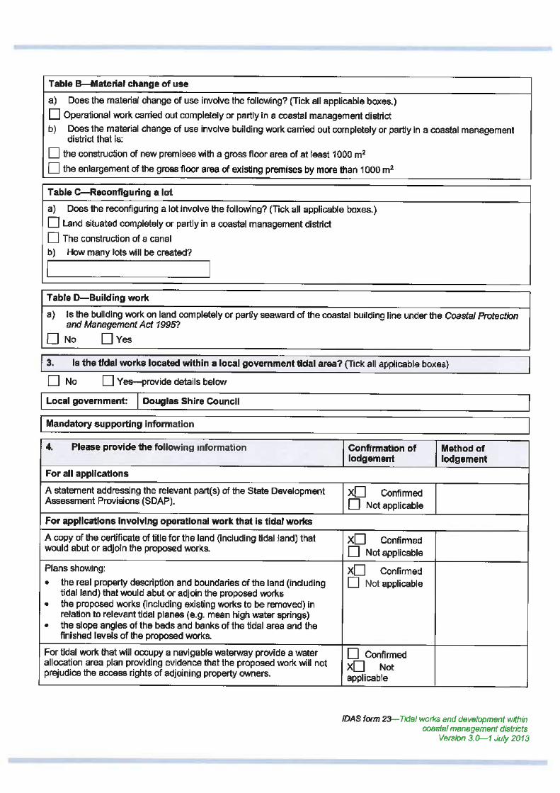
Table B—Material change of use
a) Does the material change of use involve the following? (Tick all applicable boxes.)
Operational work carried out completely or partly in a coastal management district
b) Does the material change of use involve building work carried out completely or partly in a coastal managementdistrict that is:
the construction of new premises with a gross floor area of at least 1000 m2
the enlargement of the gross floor area of existing premises by more than 1000 m2
Table C—Reconfiguring a lot
a) Does the reconfiguring a lot involve the following? (Tick all applicable boxes.)
Land situated completely or partly in a coastal management district
The construction of a canal
b) How many lots will be created?
Table D—Building work
a) Is the building work on land completely or partly seaward of the coastal building line under the Coastal Protectionand Management Act 1995?
No Yes
3. Is the tidal works located within a local government tidal area? (Tick all applicable boxes)
No Yes—provide details below
Local government: Douglas Shire Council
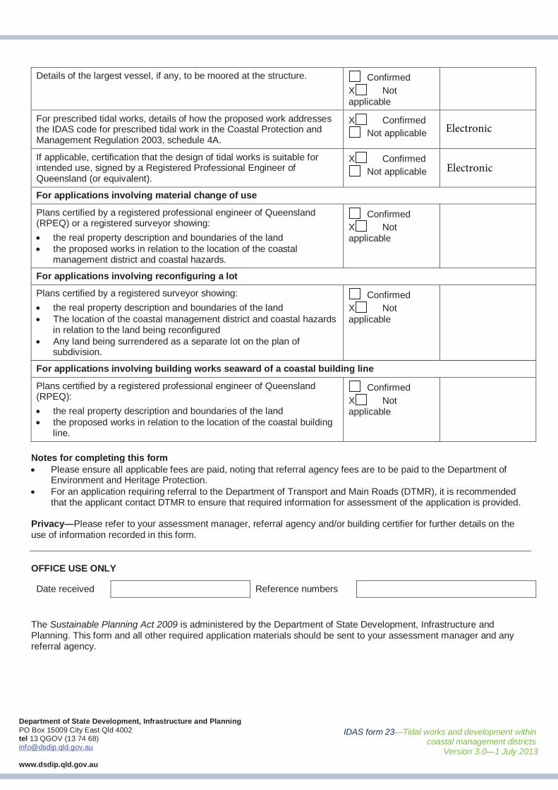
Mandatory supporting information
4. Please provide the following information Confirmation of lodgement
Method of lodgement
For all applications
A statement addressing the relevant part(s) of the State Development Assessment Provisions (SDAP).
X ConfirmedNot applicable
For applications involving operational work that is tidal works
A copy of the certificate of title for the land (including tidal land) that would abut or adjoin the proposed works.
X ConfirmedNot applicable
Plans showing:
the real property description and boundaries of the land (including tidal land) that would abut or adjoin the proposed worksthe proposed works (including existing works to be removed) in relation to relevant tidal planes (e.g. mean high water springs) the slope angles of the beds and banks of the tidal area and the finished levels of the proposed works.
X ConfirmedNot applicable
For tidal work that will occupy a navigable waterway provide a water allocation area plan providing evidence that the proposed work will not prejudice the access rights of adjoining property owners.
ConfirmedX Not applicable
X
Electronic
Electronic
Electronic
Electronic
IDAS form 23—Tidal works and development withincoastal management districts
Version 3.0—1 July 2013
Department of State Development, Infrastructure and PlanningPO Box 15009 City East Qld 4002tel 13 QGOV (13 74 68)[email protected]
www.dsdip.qld.gov.au
Details of the largest vessel, if any, to be moored at the structure. ConfirmedX Not applicable
For prescribed tidal works, details of how the proposed work addresses the IDAS code for prescribed tidal work in the Coastal Protection and Management Regulation 2003, schedule 4A.
X ConfirmedNot applicable
If applicable, certification that the design of tidal works is suitable for intended use, signed by a Registered Professional Engineer of Queensland (or equivalent).
X ConfirmedNot applicable
For applications involving material change of use
Plans certified by a registered professional engineer of Queensland (RPEQ) or a registered surveyor showing:
the real property description and boundaries of the landthe proposed works in relation to the location of the coastal management district and coastal hazards.
ConfirmedX Not applicable
For applications involving reconfiguring a lot
Plans certified by a registered surveyor showing:
the real property description and boundaries of the landThe location of the coastal management district and coastal hazards in relation to the land being reconfiguredAny land being surrendered as a separate lot on the plan of subdivision.
ConfirmedX Not applicable
For applications involving building works seaward of a coastal building line
Plans certified by a registered professional engineer of Queensland (RPEQ):
the real property description and boundaries of the landthe proposed works in relation to the location of the coastal buildingline.
ConfirmedX Not applicable
Notes for completing this formPlease ensure all applicable fees are paid, noting that referral agency fees are to be paid to the Department of Environment and Heritage Protection.For an application requiring referral to the Department of Transport and Main Roads (DTMR), it is recommended that the applicant contact DTMR to ensure that required information for assessment of the application is provided.
Privacy—Please refer to your assessment manager, referral agency and/or building certifier for further details on the use of information recorded in this form.
OFFICE USE ONLY
Date received Reference numbers
The Sustainable Planning Act 2009 is administered by the Department of State Development, Infrastructure and Planning. This form and all other required application materials should be sent to your assessment manager and any referral agency.
Electronic
Electronic
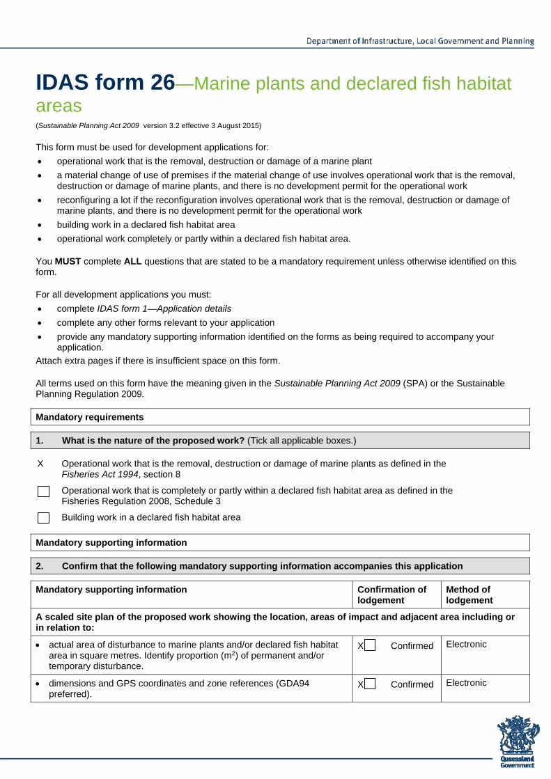
IDAS form 26—Marine plants and declared fish habitat areas (Sustainable Planning Act 2009 version 3.2 effective 3 August 2015)
This form must be used for development applications for:
operational work that is the removal, destruction or damage of a marine plant
a material change of use of premises if the material change of use involves operational work that is the removal, destruction or damage of marine plants, and there is no development permit for the operational work
reconfiguring a lot if the reconfiguration involves operational work that is the removal, destruction or damage of marine plants, and there is no development permit for the operational work
building work in a declared fish habitat area
operational work completely or partly within a declared fish habitat area.
You MUST complete ALL questions that are stated to be a mandatory requirement unless otherwise identified on this form.
For all development applications you must:
complete IDAS form 1—Application details
complete any other forms relevant to your application
provide any mandatory supporting information identified on the forms as being required to accompany your application.
Attach extra pages if there is insufficient space on this form.
All terms used on this form have the meaning given in the Sustainable Planning Act 2009 (SPA) or the Sustainable Planning Regulation 2009.
Mandatory requirements
1. What is the nature of the proposed work? (Tick all applicable boxes.)
X Operational work that is the removal, destruction or damage of marine plants as defined in the Fisheries Act 1994, section 8
Operational work that is completely or partly within a declared fish habitat area as defined in the Fisheries Regulation 2008, Schedule 3
Building work in a declared fish habitat area
Mandatory supporting information
2. Confirm that the following mandatory supporting information accompanies this application
Mandatory supporting information Confirmation of lodgement
Method of lodgement
A scaled site plan of the proposed work showing the location, areas of impact and adjacent area including or in relation to:
actual area of disturbance to marine plants and/or declared fish habitat area in square metres. Identify proportion (m2) of permanent and/or temporary disturbance.
X Confirmed Electronic
dimensions and GPS coordinates and zone references (GDA94 preferred).
X Confirmed Electronic
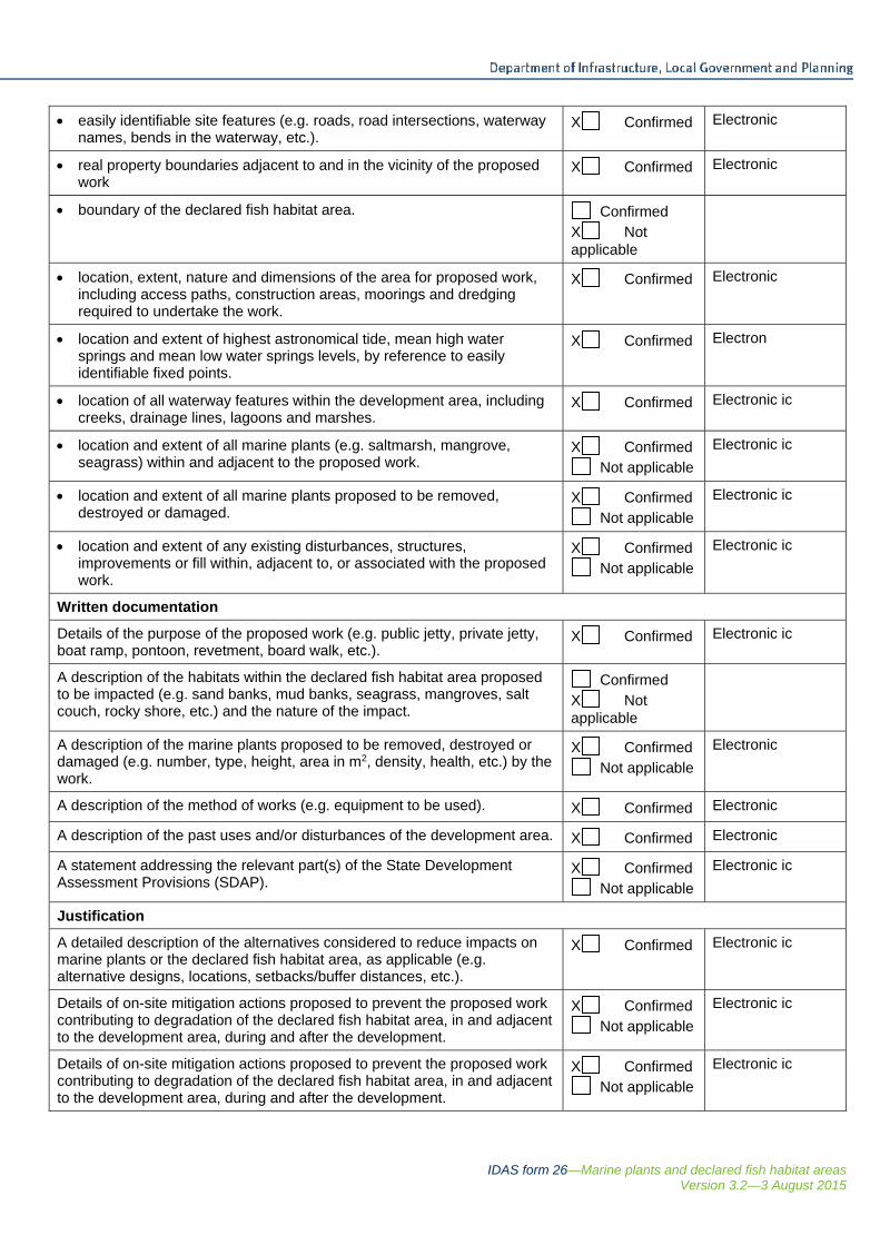
IDAS form 26—Marine plants and declared fish habitat areas Version 3.2—3 August 2015
easily identifiable site features (e.g. roads, road intersections, waterway names, bends in the waterway, etc.).
X Confirmed Electronic
real property boundaries adjacent to and in the vicinity of the proposed work
X Confirmed Electronic
boundary of the declared fish habitat area. Confirmed X Not applicable
location, extent, nature and dimensions of the area for proposed work, including access paths, construction areas, moorings and dredging required to undertake the work.
X Confirmed Electronic
location and extent of highest astronomical tide, mean high water springs and mean low water springs levels, by reference to easily identifiable fixed points.
X Confirmed Electron
location of all waterway features within the development area, including creeks, drainage lines, lagoons and marshes.
X Confirmed Electronic ic
location and extent of all marine plants (e.g. saltmarsh, mangrove, seagrass) within and adjacent to the proposed work.
X Confirmed Not applicable
Electronic ic
location and extent of all marine plants proposed to be removed, destroyed or damaged.
X Confirmed Not applicable
Electronic ic
location and extent of any existing disturbances, structures, improvements or fill within, adjacent to, or associated with the proposed work.
X Confirmed Not applicable
Electronic ic
Written documentation
Details of the purpose of the proposed work (e.g. public jetty, private jetty, boat ramp, pontoon, revetment, board walk, etc.).
X Confirmed Electronic ic
A description of the habitats within the declared fish habitat area proposed to be impacted (e.g. sand banks, mud banks, seagrass, mangroves, salt couch, rocky shore, etc.) and the nature of the impact.
Confirmed X Not applicable
A description of the marine plants proposed to be removed, destroyed or damaged (e.g. number, type, height, area in m2, density, health, etc.) by the work.
X Confirmed Not applicable
Electronic
A description of the method of works (e.g. equipment to be used). X Confirmed Electronic
A description of the past uses and/or disturbances of the development area. X Confirmed Electronic
A statement addressing the relevant part(s) of the State Development Assessment Provisions (SDAP).
X Confirmed Not applicable
Electronic ic
Justification
A detailed description of the alternatives considered to reduce impacts on marine plants or the declared fish habitat area, as applicable (e.g. alternative designs, locations, setbacks/buffer distances, etc.).
X Confirmed Electronic ic
Details of on-site mitigation actions proposed to prevent the proposed work contributing to degradation of the declared fish habitat area, in and adjacent to the development area, during and after the development.
X Confirmed Not applicable
Electronic ic
Details of on-site mitigation actions proposed to prevent the proposed work contributing to degradation of the declared fish habitat area, in and adjacent to the development area, during and after the development.
X Confirmed Not applicable
Electronic ic
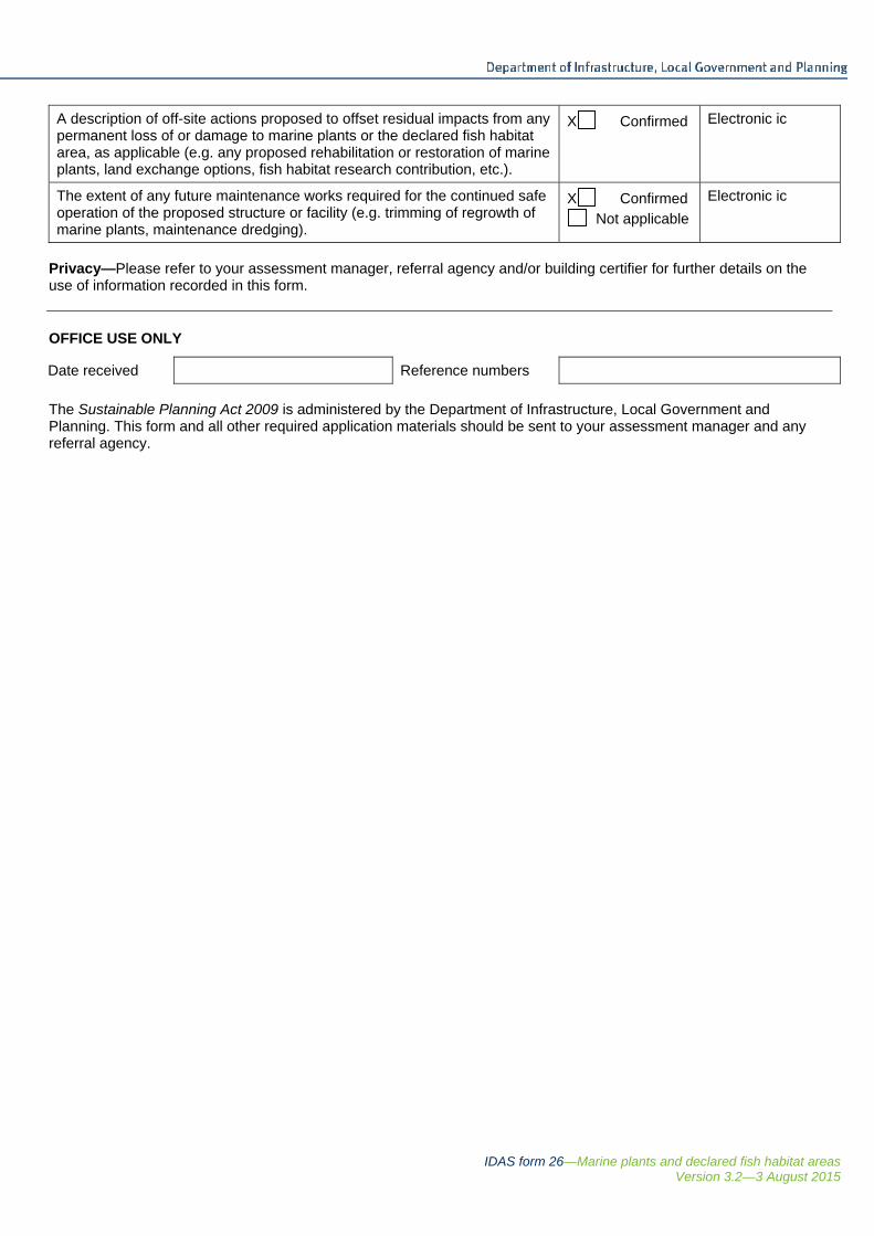
IDAS form 26—Marine plants and declared fish habitat areas Version 3.2—3 August 2015
A description of off-site actions proposed to offset residual impacts from any permanent loss of or damage to marine plants or the declared fish habitat area, as applicable (e.g. any proposed rehabilitation or restoration of marine plants, land exchange options, fish habitat research contribution, etc.).
X Confirmed Electronic ic
The extent of any future maintenance works required for the continued safe operation of the proposed structure or facility (e.g. trimming of regrowth of marine plants, maintenance dredging).
X Confirmed Not applicable
Electronic ic
Privacy—Please refer to your assessment manager, referral agency and/or building certifier for further details on the use of information recorded in this form. OFFICE USE ONLY
Date received Reference numbers
The Sustainable Planning Act 2009 is administered by the Department of Infrastructure, Local Government and Planning. This form and all other required application materials should be sent to your assessment manager and any referral agency.

Douglas Shire Council NDRRA
Environmental Approvals Supporting Information
September 2015
GHD | Report for Douglas Shire Council - NDRRA , 42/18731 | i
Table of contents 1. Introduction..................................................................................................................................... 1
1.1 Background .......................................................................................................................... 1
1.2 Location ............................................................................................................................... 2
1.3 Report purpose .................................................................................................................... 2
1.4 Consultation with the Regulators ......................................................................................... 2
2. Environmental Values .................................................................................................................... 4
2.1 Marine Parks ........................................................................................................................ 4
2.2 Water Quality ....................................................................................................................... 5
2.3 Vegetation ............................................................................................................................ 6
3. Management Measures ................................................................................................................. 9
3.1 Revegetation program ......................................................................................................... 9
4. State Development Assessment Provisions ................................................................................ 11
4.1 Operational works in tidal waters ....................................................................................... 14
Table index Table 1 Summary of remedial proposal ................................................................................................... 1
Table 2 Environmental Values ................................................................................................................. 5
Table 3 Marine Plants list ......................................................................................................................... 7
Table 4 Program for revegetation........................................................................................................... 11
Table 5 Module 5.3 Removal, destruction or damage of marine plants state code ................................. 1
Table 6 Module 10.1 Tidal works, or development in a coastal management district state
code ................................................................................................................................... 14
Figure index
Figure 1 Locality Map (Atlas, 2015).......................................................................................................... 3
Figure 2 Works Location with respect to Marine Parks Conservation Zone ........................................... 4
Figure 3 Regulated Vegetation ................................................................................................................. 7
Appendices Appendix A – Construction drawings
Appendix B – Protected Plants Flora Survey Report
GHD | Report for Douglas Shire Council - NDRRA , 42/18731 | 1
1. Introduction Douglas Shire Council has received funding from the Queensland Reconstruction Authority
(QRA) to repair infrastructure that was impacted by Cyclone Ita on April 1 2014. This funding
was released through the Natural Disaster Relief and Recovery Arrangements (NDRRA). To
complete certain works environmental approvals are required to undertake the operational
works.
1.1 Background
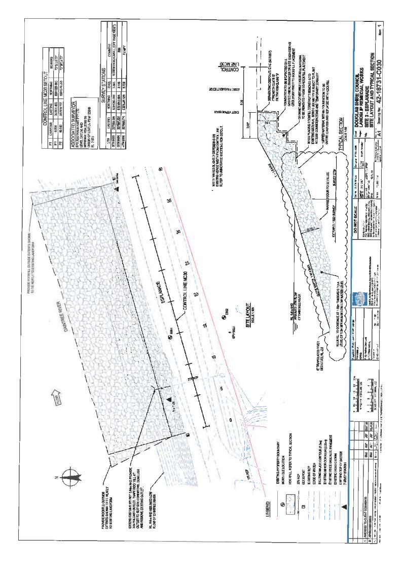
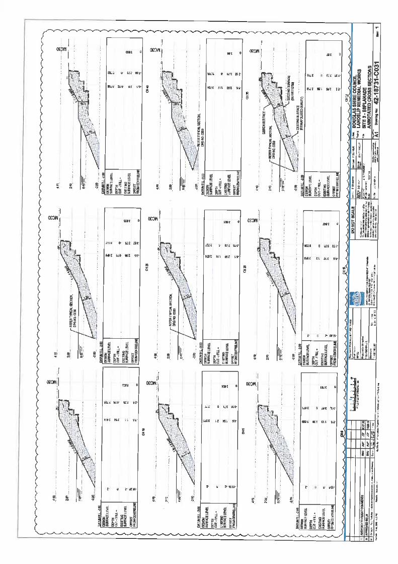
The work subject to this report is a 59 metre section of the Daintree River where scouring of the
bank and vegetation loss occurred which has subsequently put at risk a local government road
that provides access to the residents of McDowall Lane.
A summary of the remedial proposal is shown in Table 1.
Table 1 Summary of remedial proposal
Appendix A Response
Purpose of
works
Funds have been provided to repair landslips that occurred or were
exacerbated from Cyclone Ita. These funds are made available from
Queensland Recovery Authority to assist local governments with repairs to
infrastructure after natural disasters. These landslips are to be remediated
to protect local roads due to the proximity of these slips to this infrastructure.
Commencement
and duration
The works are to commence in September 2015 and will be finalised prior to
the 2015 Wet Season.
Location The works will occur on the southern bank of the Daintree River that is
adjacent to McDowall Lane Daintree at a latitude and longitude of -
16.262687,145.390148. The closest adjacent property is described as Lot 4
RP888615. The slip to be repaired is approximately 59 metres in length and
extends from the top to toe of the bank. Refer to Figure 1 for locality and
drawings in Appendix A for construction footprint.
Options A number of options were considered initially for the works:
Option 1 Loose rock placement
Option 2 Gabions
Option 3 Realignment of road infrastructure
The option agreed to in consultation with the regulators is a combination of
Option 1 and Option 2 (rock and use of reno instead of gabions), and the
implementation of a revegetation program.
Therefore in order to provide protection to the bank prior to the 2015/2016
Wet Season from further erosion and loss of riparian vegetation an approval
is being sought for the works shown in Appendix A.
Proposal Refer to the construction drawings in Appendix A.
In summary, loose rock, reno mattresses and active revegetation will be
undertaken. The design intent at the edges is that the rockfill abuts the non-
failed river bank without abrupt changes in geometry, hence the susceptibility
2 | GHD | Report for Douglas Shire Council - NDRRA , 42/18731
Appendix A Response
to erosion at this location is planned to be consistent with the original
riverbank condition. This will be completed in two stages:
Stage 1 – placement of rock and reno mattresses prior to the 2015/2016 Wet
Season
Stage 2 – revegetation after the 2015/2016 Wet Season when there are
reduced flows in the Daintree River and potentially an improved opportunity
for revegetation success. The revegetation will be undertaken by Douglas
Shire Council (DSC) and on-going monitoring will be undertaken by the local
government authority.
Approvals
required
1. Marine Parks Act 2004
Approval required as the works are to occur in a Marine Park
Conservation Zone
2. Sustainable Planning Act 2009
Prescribed Tidal works as project is to occur within a local government
tidal area. The referral agencies DAF, EHP and Queensland Transport
Harbourmaster.
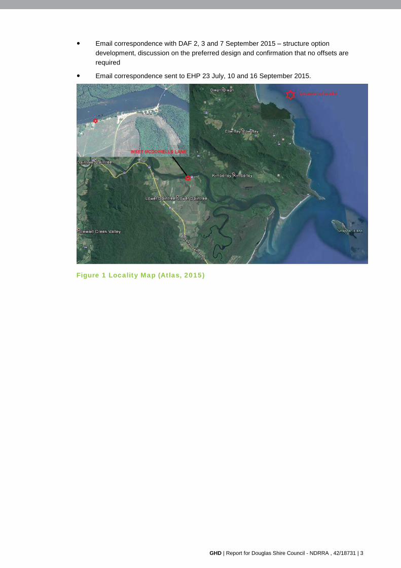
1.2 Location
The location of the works is on the southern bank of the Daintree River and is adjacent to the
McDowall Lane which is a local government road access for residents. McDowall Lane extends
from a public car park area associated with the public and tourist infrastructure provisions of the
Daintree River, including ferry access. The location of the proposed works is shown in Figure 1.
1.3 Report purpose
This report is to support applications being lodged to the following regulators for NDRRA works
as identified in Table 1. The report outlines:
Environmental values pertinent to the construction footprint and potential impact zones
State Development Assessment Provisions for Marine Plants and Operational Works
1.4 Consultation with the Regulators
A site inspection, meetings and email correspondence with the regulators has been undertaken
to determine the approval requirements and to determine the preferred design option for the
site. This is a summary of the discussions to date:
Site inspection attended by Marine Parks and DAF on 21 July 2015 to discuss the works
proposed, options for design and approval requirements
Meeting with Marine Parks 13 and 25 August 2015 – discussion of design options,
development of strategy to meet the objectives of the department and agreement on the
preferred option, methodology for progressing active revegetation to assist re-colonisation
and connectivity of the riparian zone and confirmation that offsets are not required.
Phone discussion with DAF 25 August 2015 – discussion related to the progress of
design options and the proposed active revegetation program to be undertaken after
engineering structures are constructed
GHD | Report for Douglas Shire Council - NDRRA , 42/18731 | 3
Email correspondence with DAF 2, 3 and 7 September 2015 – structure option
development, discussion on the preferred design and confirmation that no offsets are
required
Email correspondence sent to EHP 23 July, 10 and 16 September 2015.
Figure 1 Locality Map (Atlas, 2015)
4 | GHD | Report for Douglas Shire Council - NDRRA , 42/18731
2. Environmental Values The Environmental Values pertinent to the site that have the potential to be impacted from the
project are:
Marine Park Conservation Zone
Water Quality objectives
Marine Plants
Riparian connectivity
This section provides background on the values that are key to the management of the
operational works delivery. Additional values that relevant to this section of the Daintree River
are addressed as required in the SDAP in Section 0 as relevant.
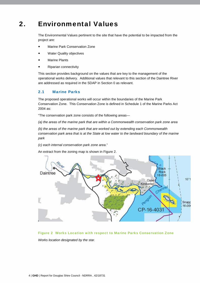
2.1 Marine Parks
The proposed operational works will occur within the boundaries of the Marine Park
Conservation Zone. This Conservation Zone is defined in Schedule 1 of the Marine Parks Act
2004 as:
“The conservation park zone consists of the following areas—
(a) the areas of the marine park that are within a Commonwealth conservation park zone area
(b) the areas of the marine park that are worked out by extending each Commonwealth
conservation park area that is at the State at low water to the landward boundary of the marine
park
(c) each internal conservation park zone area.”
An extract from the zoning map is shown in Figure 2.
Figure 2 Works Location with respect to Marine Parks Conservation Zone
Works location designated by the star.
GHD | Report for Douglas Shire Council - NDRRA , 42/18731 | 5
The preferred design option was selected based on negotiations with the Department of
National Parks, Sport and Racing. It was agreed at a meeting 25 August 2015 that the works
would be considered ‘habitat restoration’ and hence an off-set would not apply.
The works in the long term are expected to benefit the values of the Marine Park as the batter
that is currently denuded and eroded will be protected. Active revegetation to link fragmented
riparian vegetation will occur with the aim of re-instating the connectivity at this location. Refer
to the species list and proposed design in Appendix A.
2.2 Water Quality
The water quality values and objectives relevant to the Daintree River, a reef re-growth
watercourse, are identified in the policy ‘Environmental Protection (Water) Policy 2009 Daintree
River environmental values and water quality objectives Basin No. 108 (part), including all
tributaries of the river July 2010’. The proposed works will be undertaken in an area deemed to
be moderately disturbed due to its proximity to cleared residential land and road infrastructure
and the ferry and tourist commercial facilities.
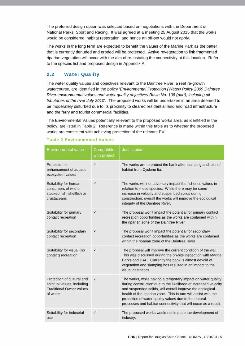
The Environmental Values potentially relevant to the proposed works area, as identified in the
policy, are listed in Table 2. Reference is made within this table as to whether the proposed
works are consistent with achieving protection of the relevant EV.
Table 2 Environmental Values
Environmental value Compatible
with project
Justification
Protection or enhancement of aquatic ecosystem values
The works are to protect the bank after slumping and loss of habitat from Cyclone Ita.
Suitability for human consumers of wild or stocked fish, shellfish or crustaceans
The works will not adversely impact the fisheries values in relation to these species. While there may be some increase in velocity and suspended solids during construction, overall the works will improve the ecological integrity of the Daintree River.
Suitability for primary contact recreation
The proposal won’t impact the potential for primary contact recreation opportunities as the works are contained within the riparian zone of the Daintree River
Suitability for secondary contact recreation
The proposal won’t impact the potential for secondary contact recreation opportunities as the works are contained within the riparian zone of the Daintree River
Suitability for visual (no contact) recreation
The proposal will improve the current condition of the wall. This was discussed during the on-site inspection with Marine Parks and DAF. Currently the bank is almost devoid of vegetation and slumping has resulted in an impact to the visual aesthetics.
Protection of cultural and spiritual values, including Traditional Owner values of water
The works, while having a temporary impact on water quality during construction due to the likelihood of increased velocity and suspended solids, will overall improve the ecological health of the riparian zone. This in turn will assist with the protection of water quality values due to the natural processes and habitat connectivity that will occur as a result.
Suitability for industrial use
The proposed works would not impede the development of industry.
6 | GHD | Report for Douglas Shire Council - NDRRA , 42/18731
Environmental value Compatible
with project
Justification
However the site isn’t zoned for industrial use in the local planning scheme.
Suitability for aquaculture The proposed works would not impede the development of aquaculture.
However due to this location being a frequent tourist spot, e.g. frequent commercial croc spotting boat tours, it is not suitable for aquaculture. T The zone is
The water quality objectives, as listed in the policy, most likely to be impacted from the
construction works will be:
Turbidity
Suspended solids
It is possible that elevated levels of turbidity and suspended solids will occur during construction
due to the disturbance of bank material such as through benching and placement of rock in tidal
waters. However this will be temporary and implementation of management measures in the
contractors EMP will aim to minimise this disturbance wherever possible. Additional details in
relation to water quality are in Table 5 and Table 6.
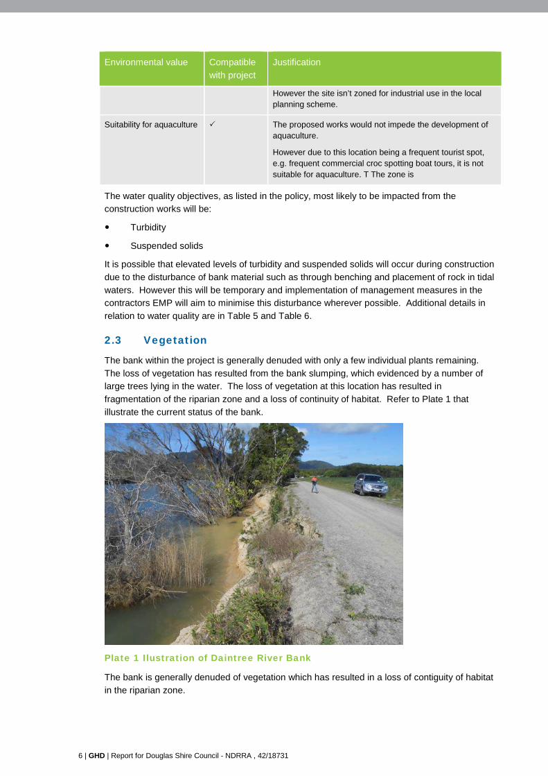
2.3 Vegetation
The bank within the project is generally denuded with only a few individual plants remaining.
The loss of vegetation has resulted from the bank slumping, which evidenced by a number of
large trees lying in the water. The loss of vegetation at this location has resulted in
fragmentation of the riparian zone and a loss of continuity of habitat. Refer to Plate 1 that
illustrate the current status of the bank.
Plate 1 Ilustration of Daintree River Bank
The bank is generally denuded of vegetation which has resulted in a loss of contiguity of habitat
in the riparian zone.
GHD | Report for Douglas Shire Council - NDRRA , 42/18731 | 7
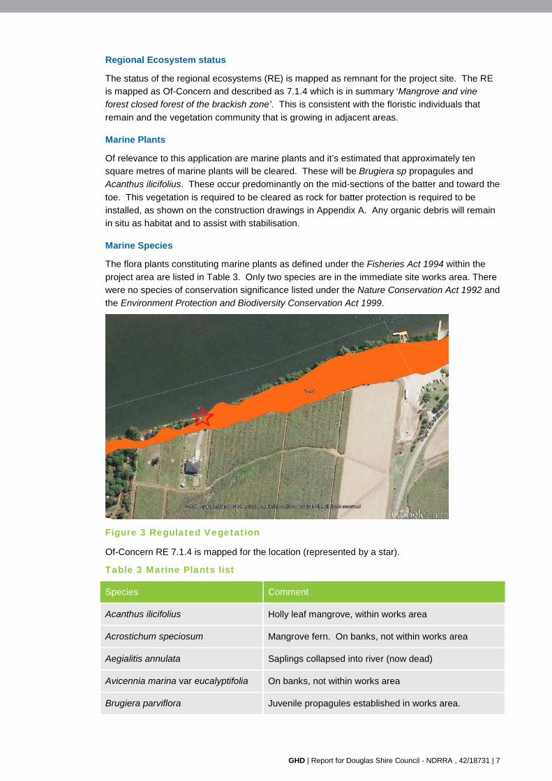
Regional Ecosystem status
The status of the regional ecosystems (RE) is mapped as remnant for the project site. The RE
is mapped as Of-Concern and described as 7.1.4 which is in summary ‘Mangrove and vine
forest closed forest of the brackish zone’. This is consistent with the floristic individuals that
remain and the vegetation community that is growing in adjacent areas.
Marine Plants
Of relevance to this application are marine plants and it’s estimated that approximately ten square metres of marine plants will be cleared. These will be Brugiera sp propagules and
Acanthus ilicifolius. These occur predominantly on the mid-sections of the batter and toward the
toe. This vegetation is required to be cleared as rock for batter protection is required to be
installed, as shown on the construction drawings in Appendix A. Any organic debris will remain
in situ as habitat and to assist with stabilisation.
Marine Species
The flora plants constituting marine plants as defined under the Fisheries Act 1994 within the
project area are listed in Table 3. Only two species are in the immediate site works area. There
were no species of conservation significance listed under the Nature Conservation Act 1992 and
the Environment Protection and Biodiversity Conservation Act 1999.
Figure 3 Regulated Vegetation
Of-Concern RE 7.1.4 is mapped for the location (represented by a star).
Table 3 Marine Plants list
Species Comment
Acanthus ilicifolius Holly leaf mangrove, within works area
Acrostichum speciosum Mangrove fern. On banks, not within works area
Aegialitis annulata Saplings collapsed into river (now dead)
Avicennia marina var eucalyptifolia On banks, not within works area
Brugiera parviflora Juvenile propagules established in works area.
8 | GHD | Report for Douglas Shire Council - NDRRA , 42/18731
Species Comment
Brugiera gymnorhiza On banks, not within works area.
Rhizophora apiculata Juvenile propagules, not in works area.
Rhizophora stylosa On banks, not within works area.
Protected Plants
Site 3 McDowall Lane is within a high –risk protected plants survey trigger area identified under
the Nature Conservation Act 1999. Subsequently a protected plants flora survey was
undertaken along the banks in accordance with the Queensland Flora Survey Guidelines –
Protected Plants. No protected plants were identified in the survey and the report was
submitted with an exempt clearing notification (protected plants). The report is attached as
Appendix B.
GHD | Report for Douglas Shire Council - NDRRA , 42/18731 | 9
3. Management Measures The contractor will be required to implement an EMP for the site and at minimum will include the
following recommendations in relation to environmental issues:
Minimise the amount of water applied to the site for dust suppression
Re-fuelling to be completed at depot or on a bunded hard stand area at least 50 metres
from the top of the bank of the Daintree River
Complete benching in lower portions of the bank and rock placement during low tides
wherever possible to manage velocity and suspended sediments
Minimise the timeframe of operational works as much as possible so that disturbance and
the potential risks are limited
Bund or place silt curtain around any stockpiles for the project unless they are large rock
that are clean and do not contain fines
Clearly delineate vegetation not to be cleared – this may be the placement of flagging
tape along the edges of adjacent habitat
Complete benching in lower portions of the bank and rock placement during low tides
wherever possible
Visually assess for visual plumes in the water that are a result of the works
If required install a silt curtain in the Daintree River to try and retain sediment within the
works area
Complete notifications to the Regulators as required pre and post works
Access to the site is made available to the Regulators if required at all times during
operational works
Operators to visually monitor for items of cultural heritage significance throughout the
works period. If items are observed a ‘stop work’ is to occur until investigations are
undertaken
Operators to visually observe for fauna at all times. Contact the local vet should any
fauna be injured on or adjacent to the project.
Revegetation works to be undertaken in accordance with the revegetation plan
Waste is to be disposed of properly off site. Putrescible goods and regulated waste are
not to be kept on site.
3.1 Revegetation program
At the start of the dry period active revegetation will commence on the rock protection, to be
undertaken by DSC. The location for revegetation, and the species to be used, is shown on the
construction drawings in Appendix A. The species have been nominated using the following
criteria:
Native
Compatible with the local area
Able to survive tidal inundation
Successful recruiters
10 | GHD | Report for Douglas Shire Council - NDRRA , 42/18731
Resilient.
Planting
The planting will occur at the start of the dry season in 2016. The native plants will be sourced
from the DSC nursery or other local supplier.
Individuals will be planted between rocks into soils mixed with absorbent and fertiliser
compatible for use near aquatic habitats. Personnel will hand dig in tube stock, and plants on
average will be placed approximately one metre apart wherever possible.
The soil will be restricted to crevices between rocks and reno initially so that run off of sediment
to the Daintree River will not occur during applied watering and rainfall events.
Over time as the revegetation stabilises the soils, organic material and plants will build up and
eventually cover the initially exposed rocks and reno. At this time the ground coverage will have
become stabilised and the risk of sediment run off will be reduced.
Maintenance
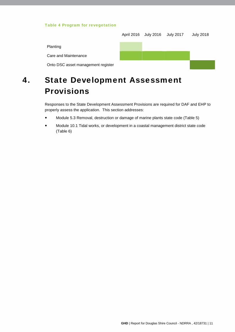
The DSC will undertake on-going maintenance of the revegetation and monitor the success of
recruitment. The following steps will be undertaken in accordance with the timeline program in
Table 4.
Planting – 3 months
Personnel will inspect the plants twice a week and apply water directly to each plant
During these inspections any mortalities will be replaced with a new seedling
Where the sun is impacting the health of the plants, and evidence of curling leaves or sun
burn is apparent then DSC may temporarily erect shade cloth to temporarily protect the
young plants from ultra violet rays until individuals appear increasingly healthy and robust
Three months to twelve months
Personnel will inspect the plants once a week and apply water directly to each plant as
required
During these inspections any mortalities will be replaced with a new seedling
Seedlings are considered to be robust enough by this time and hence shade cloth is
unlikely to be required. Personnel on site will evaluate this however and whether
protection is required.
Personnel to observe for the germination of exotic species. If observed these should be
removed by hand or by herbicide application by wand direct to leaves (using a product
compatible for use near aquatic habitats). Spraying of herbicides is not recommended as
aerial drift may result in mortalities of the native recruiting species.
Assess whether additional soil or conditioning is required to assist the growth of recruiting
individuals.
Twelve months to two years
Personnel to continue monitoring and maintenance program as listed above (refer to
three months to twelve months)
At the conclusion of this period personnel may consider whether this location is then
added to the DSC asset maintenance list and is monitored as part of the regular Council
asset monitoring program
GHD | Report for Douglas Shire Council - NDRRA , 42/18731 | 11
Table 4 Program for revegetation
April 2016 July 2016 July 2017 July 2018
Planting
Care and Maintenance
Onto DSC asset management register
4. State Development Assessment Provisions Responses to the State Development Assessment Provisions are required for DAF and EHP to
properly assess the application. This section addresses:
Module 5.3 Removal, destruction or damage of marine plants state code (Table 5)
Module 10.1 Tidal works, or development in a coastal management district state code
(Table 6)
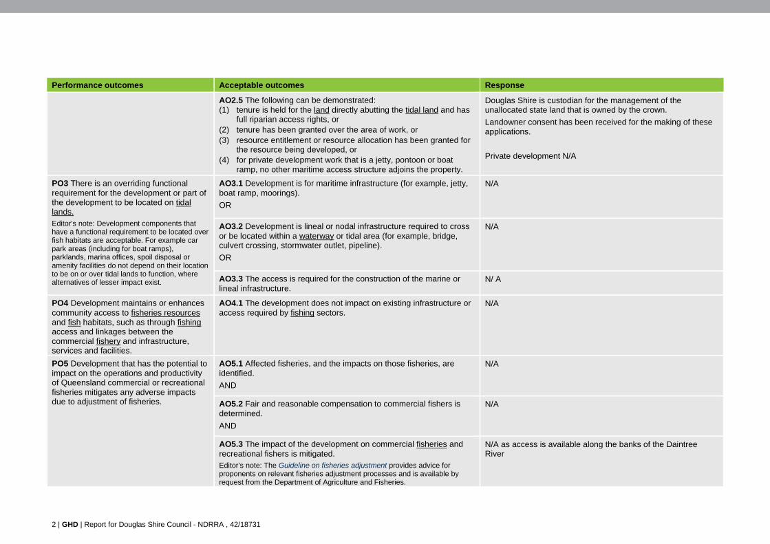
GHD | Report for Douglas Shire Council - NDRRA , 42/18731 | 1
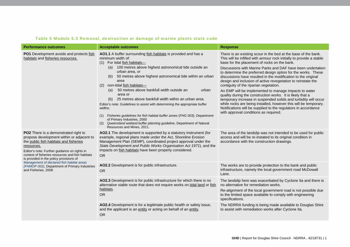
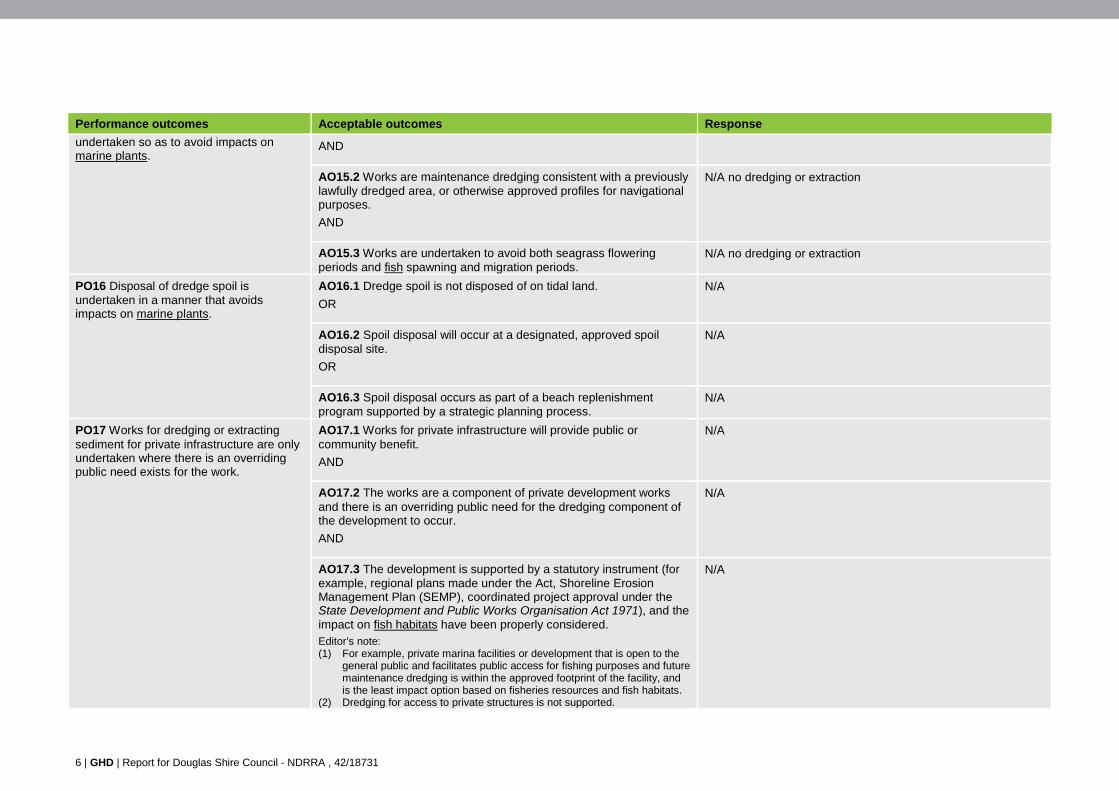
Table 5 Module 5.3 Removal, destruction or damage of marine plants state code
Performance outcomes Acceptable outcomes Response
PO1 Development avoids and protects fish habitats and fisheries resources.
AO1.1 A buffer surrounding fish habitats is provided and has a minimum width of: (1) For tidal fish habitats—
(a) 100 metres above highest astronomical tide outside an urban area, or
(b) 50 metres above highest astronomical tide within an urban area
(2) non-tidal fish habitats— (a) 50 metres above bankfull width outside an urban
area or (b) 25 metres above bankfull width within an urban area.
Editor’s note: Guidelines to assist with determining the appropriate buffer widths:
(1) Fisheries guidelines for fish habitat buffer zones (FHG 003), Department of Primary Industries, 2000
(2) Queensland wetland buffer planning guideline, Department of Natural Resources and Mines, 2011.
There is an existing scour in the bed at the base of the bank. This will be infilled with armour rock initially to provide a stable base for the placement of rocks on the bank.
Discussions with Marine Parks and DAF have been undertaken to determine the preferred design option for the works. These discussions have resulted in the modification to the original design and inclusion of active revegetation to reinstate the contiguity of the riparian vegetation.
An EMP will be implemented to manage impacts to water quality during the construction works. It is likely that a temporary increase in suspended solids and turbidity will occur while rocks are being installed, however this will be temporary. Notifications will be supplied to the regulators in accordance with approval conditions as required.
PO2 There is a demonstrated right to propose development within or adjacent to the public fish habitats and fisheries resources. Editor’s note: Further guidance on rights in context of fisheries resources and fish habitats is provided in the policy provisions of Management of declared fish habitat areas (FHMOP 002), Department of Primary Industries and Fisheries, 2008.
AO2.1 The development is supported by a statutory instrument (for example, regional plans made under the Act, Shoreline Erosion Management Plan (SEMP), coordinated project approval under the State Development and Public Works Organisation Act 1971), and the impacts on fish habitats have been properly considered.
OR
The area of the landslip was not intended to be used for public access and will be re-instated to its original condition in accordance with the construction drawings.
AO2.2 Development is for public infrastructure.
OR
The works are to provide protection to the bank and public infrastructure, namely the local government road McDowall Lane.
AO2.3 Development is for public infrastructure for which there is no alternative viable route that does not require works on tidal land or fish habitats.
OR
The landslip here was exacerbated by Cyclone Ita and there is no alternative for remediation works.
Re-alignment of the local government road is not possible due to the limited space available to comply with engineering specifications.
AO2.4 Development is for a legitimate public health or safety issue, and the applicant is an entity or acting on behalf of an entity.
OR
The NDRRA funding is being made available to Douglas Shire to assist with remediation works after Cyclone Ita.
2 | GHD | Report for Douglas Shire Council - NDRRA , 42/18731
Performance outcomes Acceptable outcomes Response
AO2.5 The following can be demonstrated: (1) tenure is held for the land directly abutting the tidal land and has
full riparian access rights, or (2) tenure has been granted over the area of work, or (3) resource entitlement or resource allocation has been granted for
the resource being developed, or (4) for private development work that is a jetty, pontoon or boat
ramp, no other maritime access structure adjoins the property.
Douglas Shire is custodian for the management of the unallocated state land that is owned by the crown.
Landowner consent has been received for the making of these applications.
Private development N/A
PO3 There is an overriding functional requirement for the development or part of the development to be located on tidal lands. Editor’s note: Development components that have a functional requirement to be located over fish habitats are acceptable. For example car park areas (including for boat ramps), parklands, marina offices, spoil disposal or amenity facilities do not depend on their location to be on or over tidal lands to function, where alternatives of lesser impact exist.
AO3.1 Development is for maritime infrastructure (for example, jetty, boat ramp, moorings).
OR
N/A
AO3.2 Development is lineal or nodal infrastructure required to cross or be located within a waterway or tidal area (for example, bridge, culvert crossing, stormwater outlet, pipeline).
OR
N/A
AO3.3 The access is required for the construction of the marine or lineal infrastructure.
N/ A
PO4 Development maintains or enhances community access to fisheries resources and fish habitats, such as through fishing access and linkages between the commercial fishery and infrastructure, services and facilities.
AO4.1 The development does not impact on existing infrastructure or access required by fishing sectors.
N/A
PO5 Development that has the potential to impact on the operations and productivity of Queensland commercial or recreational fisheries mitigates any adverse impacts due to adjustment of fisheries.
AO5.1 Affected fisheries, and the impacts on those fisheries, are identified.
AND
N/A
AO5.2 Fair and reasonable compensation to commercial fishers is determined.
AND
N/A
AO5.3 The impact of the development on commercial fisheries and recreational fishers is mitigated. Editor’s note: The Guideline on fisheries adjustment provides advice for proponents on relevant fisheries adjustment processes and is available by request from the Department of Agriculture and Fisheries.
N/A as access is available along the banks of the Daintree River
GHD | Report for Douglas Shire Council - NDRRA , 42/18731 | 3
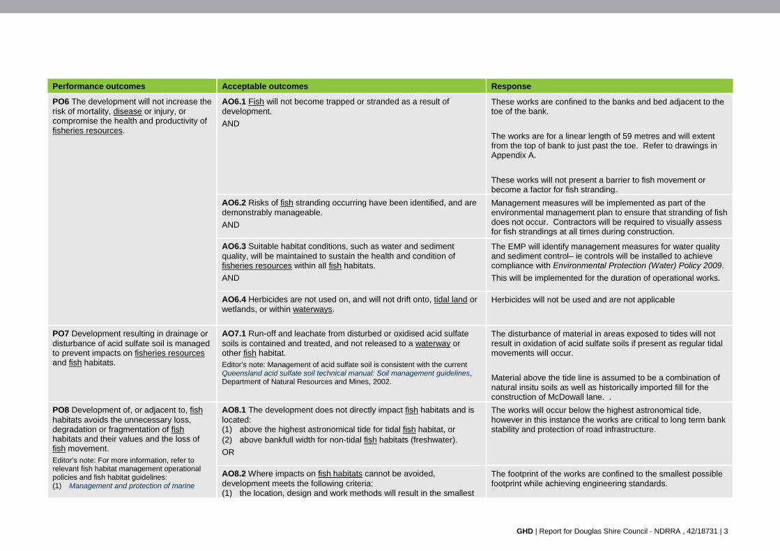
Performance outcomes Acceptable outcomes Response
PO6 The development will not increase the risk of mortality, disease or injury, or compromise the health and productivity of fisheries resources.
AO6.1 Fish will not become trapped or stranded as a result of development.
AND
These works are confined to the banks and bed adjacent to the toe of the bank.
The works are for a linear length of 59 metres and will extent from the top of bank to just past the toe. Refer to drawings in Appendix A.
These works will not present a barrier to fish movement or become a factor for fish stranding.
AO6.2 Risks of fish stranding occurring have been identified, and are demonstrably manageable.
AND
Management measures will be implemented as part of the environmental management plan to ensure that stranding of fish does not occur. Contractors will be required to visually assess for fish strandings at all times during construction.
AO6.3 Suitable habitat conditions, such as water and sediment quality, will be maintained to sustain the health and condition of fisheries resources within all fish habitats.
AND
The EMP will identify management measures for water quality and sediment control– ie controls will be installed to achieve compliance with Environmental Protection (Water) Policy 2009.
This will be implemented for the duration of operational works.
AO6.4 Herbicides are not used on, and will not drift onto, tidal land or wetlands, or within waterways.
Herbicides will not be used and are not applicable
PO7 Development resulting in drainage or disturbance of acid sulfate soil is managed to prevent impacts on fisheries resources and fish habitats.
AO7.1 Run-off and leachate from disturbed or oxidised acid sulfate soils is contained and treated, and not released to a waterway or other fish habitat. Editor’s note: Management of acid sulfate soil is consistent with the current Queensland acid sulfate soil technical manual: Soil management guidelines, Department of Natural Resources and Mines, 2002.
The disturbance of material in areas exposed to tides will not result in oxidation of acid sulfate soils if present as regular tidal movements will occur.
Material above the tide line is assumed to be a combination of natural insitu soils as well as historically imported fill for the construction of McDowall lane. .
PO8 Development of, or adjacent to, fish habitats avoids the unnecessary loss, degradation or fragmentation of fish habitats and their values and the loss of fish movement. Editor’s note: For more information, refer to relevant fish habitat management operational policies and fish habitat guidelines: (1) Management and protection of marine
AO8.1 The development does not directly impact fish habitats and is located: (1) above the highest astronomical tide for tidal fish habitat, or (2) above bankfull width for non-tidal fish habitats (freshwater).
OR
The works will occur below the highest astronomical tide, however in this instance the works are critical to long term bank stability and protection of road infrastructure.
AO8.2 Where impacts on fish habitats cannot be avoided, development meets the following criteria: (1) the location, design and work methods will result in the smallest
The footprint of the works are confined to the smallest possible footprint while achieving engineering standards.
4 | GHD | Report for Douglas Shire Council - NDRRA , 42/18731
Performance outcomes Acceptable outcomes Response
plants and other tidal fish habitats (FHMOP 001), Department of Primary Industries and Fisheries, 2007
(2) Tidal fish habitats, erosion control and beach replenishment (FHMOP 010), Department of Primary Industries and Fisheries, 2007
(3) Dredging, extraction and spoil disposal activities (FHMOP 004), Department of Primary Industries, 1998
(4) Departmental procedures for permit applications assessment and approvals for insect pest control in wetlands (FHMOP 003), Department of Primary Industries, 1996
(5) Fisheries guidelines for fish-friendly structures (FHG 006), Department of Primary Industries and Fisheries, 2006
impact possible to fish habitats (2) development does not increase the risk of transfer of, or impacts
from, pest fish and other relevant pest species (3) tidal and freshwater inundation and drainage patterns, extent and
timing are maintained such that ecological processes continue (4) works or development will not restrict fish access to fish habitats
or fisheries resources (5) tidal or freshwater fish habitats will not be substituted for another
type of habitat, for example, creation of mangrove communities from other tidal fish habitats
(6) works are undertaken to avoid both seagrass flowering periods and fish spawning and migration periods
(7) impacts are mitigated where possible.
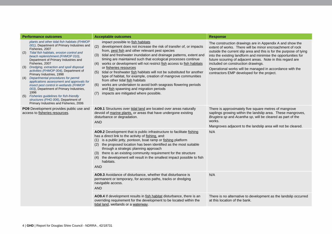
The construction drawings are in Appendix A and show the extent of works. There will be minor encroachment of rock outside the current slip area and this is for the purpose of tying into the existing landform and minimise the opportunities for future scouring of adjacent areas. Note in this regard are included on construction drawings.
Operational works will be managed in accordance with the contractors EMP developed for the project.
PO9 Development provides public use and access to fisheries resources.
AO9.1 Structures over tidal land are located over areas naturally devoid of marine plants, or areas that have undergone existing disturbance or degradation.
AND
There is approximately five square metres of mangrove saplings growing within the landslip area. These mangroves, Brugiera sp and Acantha sp, will be cleared as part of the works.
Mangroves adjacent to the landslip area will not be cleared.
AO9.2 Development that is public infrastructure to facilitate fishing has a direct link to the activity of fishing, and: (1) is a public jetty, pontoon, boat ramp or fishing platform (2) the proposed location has been identified as the most suitable
through a strategic planning approach (3) there is an existing community requirement for the structure (4) the development will result in the smallest impact possible to fish
habitats.
AND
N/A
AO9.3 Avoidance of disturbance, whether that disturbance is permanent or temporary, for access paths, tracks or dredging navigable access.
AND
N/A
AO9.4 If development results in fish habitat disturbance, there is an overriding requirement for the development to be located within the tidal land, wetlands or a waterway.
There is no alternative to development as the landslip occurred at this location of the bank.
GHD | Report for Douglas Shire Council - NDRRA , 42/18731 | 5
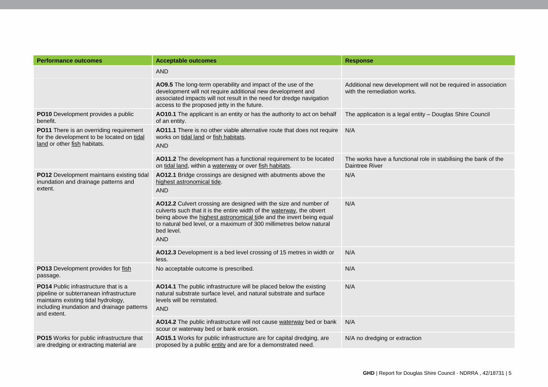
Performance outcomes Acceptable outcomes Response
AND
AO9.5 The long-term operability and impact of the use of the development will not require additional new development and associated impacts will not result in the need for dredge navigation access to the proposed jetty in the future.
Additional new development will not be required in association with the remediation works.
PO10 Development provides a public benefit.
AO10.1 The applicant is an entity or has the authority to act on behalf of an entity.
The application is a legal entity – Douglas Shire Council
PO11 There is an overriding requirement for the development to be located on tidal land or other fish habitats.
AO11.1 There is no other viable alternative route that does not require works on tidal land or fish habitats.
AND
N/A
AO11.2 The development has a functional requirement to be located on tidal land, within a waterway or over fish habitats.
The works have a functional role in stabilising the bank of the Daintree River
PO12 Development maintains existing tidal inundation and drainage patterns and extent.
AO12.1 Bridge crossings are designed with abutments above the highest astronomical tide.
AND
N/A
AO12.2 Culvert crossing are designed with the size and number of culverts such that it is the entire width of the waterway, the obvert being above the highest astronomical tide and the invert being equal to natural bed level, or a maximum of 300 millimetres below natural bed level.
AND
N/A
AO12.3 Development is a bed level crossing of 15 metres in width or less.
N/A
PO13 Development provides for fish passage.
No acceptable outcome is prescribed.
N/A
PO14 Public infrastructure that is a pipeline or subterranean infrastructure maintains existing tidal hydrology, including inundation and drainage patterns and extent.
AO14.1 The public infrastructure will be placed below the existing natural substrate surface level, and natural substrate and surface levels will be reinstated.
AND
N/A
AO14.2 The public infrastructure will not cause waterway bed or bank scour or waterway bed or bank erosion.
N/A
PO15 Works for public infrastructure that are dredging or extracting material are
AO15.1 Works for public infrastructure are for capital dredging, are proposed by a public entity and are for a demonstrated need.
N/A no dredging or extraction
6 | GHD | Report for Douglas Shire Council - NDRRA , 42/18731
Performance outcomes Acceptable outcomes Response
undertaken so as to avoid impacts on marine plants.
AND
AO15.2 Works are maintenance dredging consistent with a previously lawfully dredged area, or otherwise approved profiles for navigational purposes.
AND
N/A no dredging or extraction
AO15.3 Works are undertaken to avoid both seagrass flowering periods and fish spawning and migration periods.
N/A no dredging or extraction
PO16 Disposal of dredge spoil is undertaken in a manner that avoids impacts on marine plants.
AO16.1 Dredge spoil is not disposed of on tidal land.
OR
N/A
AO16.2 Spoil disposal will occur at a designated, approved spoil disposal site.
OR
N/A
AO16.3 Spoil disposal occurs as part of a beach replenishment program supported by a strategic planning process.
N/A
PO17 Works for dredging or extracting sediment for private infrastructure are only undertaken where there is an overriding public need exists for the work.
AO17.1 Works for private infrastructure will provide public or community benefit.
AND
N/A
AO17.2 The works are a component of private development works and there is an overriding public need for the dredging component of the development to occur.
AND
N/A
AO17.3 The development is supported by a statutory instrument (for example, regional plans made under the Act, Shoreline Erosion Management Plan (SEMP), coordinated project approval under the State Development and Public Works Organisation Act 1971), and the impact on fish habitats have been properly considered. Editor’s note: (1) For example, private marina facilities or development that is open to the
general public and facilitates public access for fishing purposes and future maintenance dredging is within the approved footprint of the facility, and is the least impact option based on fisheries resources and fish habitats.
(2) Dredging for access to private structures is not supported.
N/A
GHD | Report for Douglas Shire Council - NDRRA , 42/18731 | 7
Performance outcomes Acceptable outcomes Response
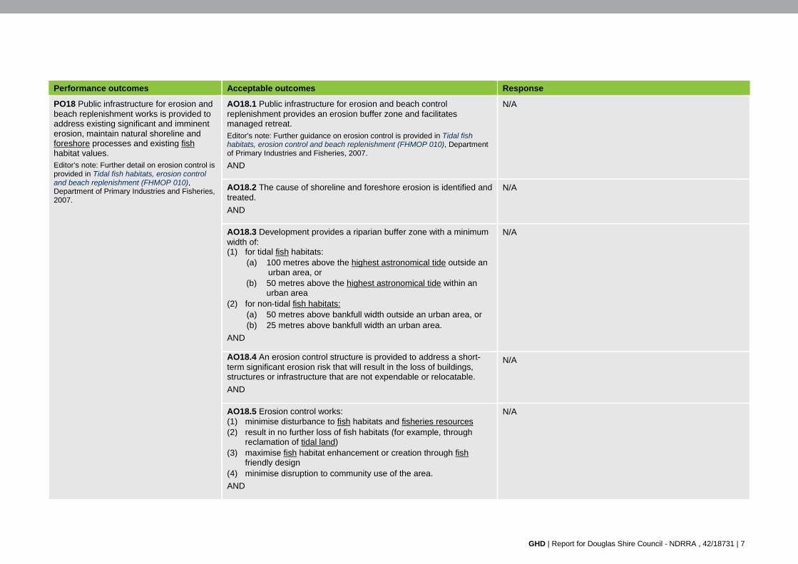
PO18 Public infrastructure for erosion and beach replenishment works is provided to address existing significant and imminent erosion, maintain natural shoreline and foreshore processes and existing fish habitat values. Editor’s note: Further detail on erosion control is provided in Tidal fish habitats, erosion control and beach replenishment (FHMOP 010), Department of Primary Industries and Fisheries, 2007.
AO18.1 Public infrastructure for erosion and beach control replenishment provides an erosion buffer zone and facilitates managed retreat. Editor’s note: Further guidance on erosion control is provided in Tidal fish habitats, erosion control and beach replenishment (FHMOP 010), Department of Primary Industries and Fisheries, 2007.
AND
N/A
AO18.2 The cause of shoreline and foreshore erosion is identified and treated.
AND
N/A
AO18.3 Development provides a riparian buffer zone with a minimum width of: (1) for tidal fish habitats:
(a) 100 metres above the highest astronomical tide outside an urban area, or
(b) 50 metres above the highest astronomical tide within an urban area
(2) for non-tidal fish habitats: (a) 50 metres above bankfull width outside an urban area, or (b) 25 metres above bankfull width an urban area.
AND
N/A
AO18.4 An erosion control structure is provided to address a short-term significant erosion risk that will result in the loss of buildings, structures or infrastructure that are not expendable or relocatable.
AND
N/A
AO18.5 Erosion control works: (1) minimise disturbance to fish habitats and fisheries resources (2) result in no further loss of fish habitats (for example, through
reclamation of tidal land) (3) maximise fish habitat enhancement or creation through fish
friendly design (4) minimise disruption to community use of the area.
AND
N/A
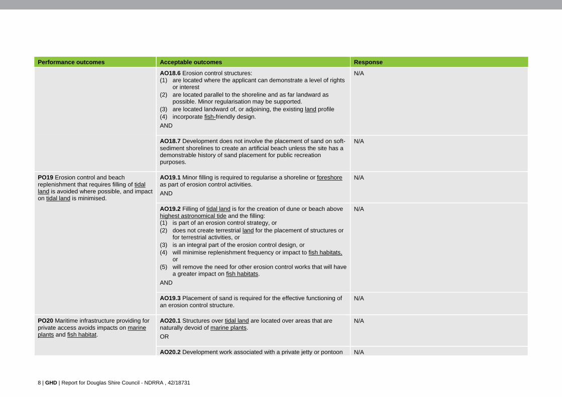
8 | GHD | Report for Douglas Shire Council - NDRRA , 42/18731
Performance outcomes Acceptable outcomes Response
AO18.6 Erosion control structures: (1) are located where the applicant can demonstrate a level of rights
or interest (2) are located parallel to the shoreline and as far landward as
possible. Minor regularisation may be supported. (3) are located landward of, or adjoining, the existing land profile (4) incorporate fish-friendly design.
AND
N/A
AO18.7 Development does not involve the placement of sand on soft-sediment shorelines to create an artificial beach unless the site has a demonstrable history of sand placement for public recreation purposes.
N/A
PO19 Erosion control and beach replenishment that requires filling of tidal land is avoided where possible, and impact on tidal land is minimised.
AO19.1 Minor filling is required to regularise a shoreline or foreshore as part of erosion control activities.
AND
N/A
AO19.2 Filling of tidal land is for the creation of dune or beach above highest astronomical tide and the filling: (1) is part of an erosion control strategy, or (2) does not create terrestrial land for the placement of structures or
for terrestrial activities, or (3) is an integral part of the erosion control design, or (4) will minimise replenishment frequency or impact to fish habitats,
or (5) will remove the need for other erosion control works that will have
a greater impact on fish habitats.
AND
N/A
AO19.3 Placement of sand is required for the effective functioning of an erosion control structure.
N/A
PO20 Maritime infrastructure providing for private access avoids impacts on marine plants and fish habitat.
AO20.1 Structures over tidal land are located over areas that are naturally devoid of marine plants.
OR
N/A
AO20.2 Development work associated with a private jetty or pontoon N/A
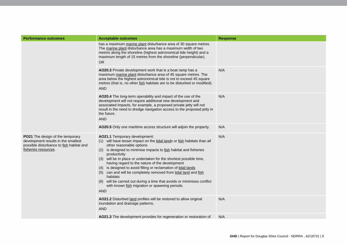
GHD | Report for Douglas Shire Council - NDRRA , 42/18731 | 9
Performance outcomes Acceptable outcomes Response
has a maximum marine plant disturbance area of 30 square metres. The marine plant disturbance area has a maximum width of two metres along the shoreline (highest astronomical tide height) and a maximum length of 15 metres from the shoreline (perpendicular).
OR
AO20.3 Private development work that is a boat ramp has a maximum marine plant disturbance area of 45 square metres. The area below the highest astronomical tide is not to exceed 45 square metres (that is, no other fish habitats are to be disturbed or modified).
AND
N/A
AO20.4 The long-term operability and impact of the use of the development will not require additional new development and associated impacts, for example, a proposed private jetty will not result in the need to dredge navigation access to the proposed jetty in the future.
AND
N/A
AO20.5 Only one maritime access structure will adjoin the property. N/A
PO21 The design of the temporary development results in the smallest possible disturbance to fish habitat and fisheries resources.
AO21.1 Temporary development: (1) will have lesser impact on the tidal lands or fish habitats than all
other reasonable options (2) is designed to minimise impacts to fish habitat and fisheries
productivity (3) will be in place or undertaken for the shortest possible time,
having regard to the nature of the development (4) is designed to avoid filling or reclamation of tidal lands (5) can and will be completely removed from tidal land and fish
habitats (6) will be carried out during a time that avoids or minimises conflict
with known fish migration or spawning periods.
AND
N/A
AO21.2 Disturbed land profiles will be restored to allow original inundation and drainage patterns.
AND
N/A
AO21.3 The development provides for regeneration or restoration of N/A
10 | GHD | Report for Douglas Shire Council - NDRRA , 42/18731
Performance outcomes Acceptable outcomes Response
fish habitat and fisheries resource values.
AND
AO21.4 The development will not result in the permanent substitution of fish habitat.
AND
N/A
AO21.5 The development provides for a post-works monitoring and maintenance program.
N/A
PO22 Development that is ensuring public health or safety is undertaken in a manner that minimises impacts on fish habitat and fisheries resources. Note: The following are not considered public health or safety issues: (1) management of ‘nuisance’ issues (for
example, biting midge control, or the management of odours from decaying vegetation)
(2) foreshore erosion, unless its control is required as a short-term emergency response to a catastrophic event that presents an immediate threat to public safety through undermining of dwellings or infrastructure. In such cases, the emergency provisions of the Sustainable Planning Act 2009 may apply. Where possible, erosion management measures should be developed prior to public safety becoming an issue.
(3) capital dredging for navigation.
AO22.1 Development for a public health issue: (1) is endorsed in writing by Queensland Health or the relevant local
government (2) is necessary, as all alternative options that do not require
removal or disturbance of marine plants have been considered and are not viable or achievable in the available timeframes for an adequate response to the public health issue
(3) if the development is for a long-term response with permanent or ongoing impacts to fish habitats—ensures an agreed program to identify and implement measures to reduce the impacts of the response over time on the area.
AND
N/A
AO22.2 Development for a public safety purpose has no viable alternative options and is for: (1) signage or aids to warn the public of a safety hazard (for
example, within a waterway to warn of submerged rocks, crocodiles, marine stingers), or
(2) preventing an impending public safety issue (for example, beach cleaning to remove dangerous items such as syringes), or
(3) the mitigation of a hazard to public safety that has resulted from a specific unforseen event (for example, a fallen tree that is a danger to safe navigation), or
(4) placement of a cyclone mooring identified under a cyclone contingency plan by the harbour master or controlling port authority or corporation, and is located in accordance with the plan.
The exacerbation of this landslip was from Cyclone Ita and the bank will require protection prior to the 2015/2016 Wet Season to avoid further erosion, impacts to water quality and increased risks to road infrastructure.
There is a threat to the road infrastructure that provides access to residents living in McDowall Lane. This risk will increase should protection works not be constructed prior to the 2015 Wet Season.
PO23 Restoration works to reinstate fish habitats, fisheries productivity and natural
AO23.1 Works will not result in additional fish habitat disturbance, removal or degradation.
N/A
GHD | Report for Douglas Shire Council - NDRRA , 42/18731 | 11
Performance outcomes Acceptable outcomes Response
ecological processes to a pre-existing natural condition are undertaken in a manner that mitigates impacts on marine plants and fish habitats. Editor’s note: For further guidance refer to Restoration of fish habitats: Fisheries guidelines for marine areas (FHG 002), Department of Primary Industries, 1998. Restoration works authorised through an endorsed restoration plan under the code for self- assessable development MP06 – Minor impact works in a declared fish habitat area or involving the removal, destruction or damage of marine plants, Department of Agriculture, Fisheries and Forestry, 2013, do not require a development permit.
AND
AO23.2 Land profiles are restored to original inundation and drainage patterns.
AND
N/A
AO23.3 Works are undertaken to encourage fish habitats and fisheries resource values to naturally regenerate.
AND
N/A
AO23.4 Fish habitat restoration work will not result in the substitution of fish habitats.
N/A
AO23.5 Physical restoration of fish habitats (for example, replanting) is undertaken where natural regeneration is, or is likely to be, unsuccessful.
AND
N/A
AO23.6 Permanent structures (for example, boardwalk) to facilitate restoration works: (1) provide a means of managing an identified impact or degrading
process (2) retain natural ecological processes (3) are the least impact alternative available.
AND
N/A
AO23.7 Works include a post-works monitoring and maintenance program, appropriate for the scale of the restoration works.
AND
N/A
AO23.8 Marine plants used in restoration works are collected within a 100 kilometre radius of the site to maintain the genetic integrity of the restoration site and local marine plant communities.
N/A
PO24 Removal, trimming or damage to marine plants to provide views or for aesthetic purposes is undertaken in a manner that maintains the integrity of fish habitat.
AO24.1 Works are undertaken in accordance with a mangrove management strategy endoresed by Fisheries Queensland.
N/A
PO25 Impacts to marine plants are avoided or mitigated, and an
AO25.1 Impact is avoided or where this cannot be reasonably achieved, impacts are minimised.
Five square metres of mangroves, mainly Brugiera and Acanthus ilicifolius, will be cleared. Some of the plants that are
12 | GHD | Report for Douglas Shire Council - NDRRA , 42/18731
Performance outcomes Acceptable outcomes Response
environmental offset is provided for any significant residual impact.
AND
present have re-colonised this area since Cyclone Ita.
The placement of rock in this location will result in the mortality of these individuals. The vegetation debris will remain in place for fisheries habitat purposes.
Note vegetation outside of the landslip zone will not be impacted.
AO25.2 Residual impact to marine plants, and associated fish habitats and fish passage is comprehensively and accurately documented. The level of significance of the residual impact is determined.
AND
Impacts to mangroves outside of the landslip area will not occur.
An active revegetation program will be undertaken in accordance with the construction drawings. DSC will undertake the plantings and continue with long term monitoring. There is also a good potential that re-colonisation of mangroves will occur with encroachment occurring from adjacent areas. This has evidently occurred in other historic slips that were observed in the general location.
AO25.3 An environmental offset is provided for any significant residual impact on marine plants. Editor’s note: Applications for development should identify whether there is likely to be a significant residual impact and a need for an environmental offset having regard to Section 3.9 (Marine plants) of the Significant Residual Impact Guideline and the relevant Queensland Environmental Offsets Policy.
Marine Parks and DAF have confirmed that offsets are not required as the works are considered:
Habitat restoration
No residual impact will occur.
PO26 Development minimises clearing of native marine plants including beyond the extent of operational work. Natural regeneration of any cleared or work area is facilitated wherever possible.
AO26.1 Clearing of marine plants is limited to the minimum area required for the works and to allow for maintenance.
AND
The extent of clearing of native vegetation will be limited to the project area, and include those individual plants that have re-colonised since Cyclone Ita.
AO26.2 There is no impediment to the natural regeneration of native plant species in the area of clearing and works following completion of works.
Active revegetation will occur, as shown in the construction drawings. It is expected that colonisation of the rock wall as a result of vegetation encroaching from adjacent areas will also occur.
The protection works are required to be undertaken prior to the 2015/2016 Wet Season to remediate the landslip and to reduce the threat of erosion to the local government road infrastructure and access for residents to McDowall Lane.
PO27 Development avoids or minimises adverse impacts on fish passage during
No acceptable outcome is prescribed. There will be no impacts to fish passage in the Daintree River as works are restricted to the bank whereby the proposal will
GHD | Report for Douglas Shire Council - NDRRA , 42/18731 | 13
Performance outcomes Acceptable outcomes Response
works and the carrying out of the activity. match the adjacent bank profile.
PO28 There is nil net loss in marine plants as a result of development.
AO28.1 Any marine plant damaged during construction is replaced at the completion of the development with the same species of plant in the disturbed area outside of the footprint of the development.
Approximately 5 square metres of marine plants will be cleared for the construction. Many of these plants, including Brugiera sp and Acantha sp, have colonised since Cyclone Ita with the exception of two individual mature Rhizophera sp. Clearing of these plants is required for benching of the bank in accordance with the engineering specifications and placement of rock, as per the construction drawings.
PO29 Development does not impact on fish habitat values.
AO29.1 Development in tidal waters is located, designed and constructed to ensure that the activities do not impact on fish habitat values and function.
The work is to match the banks profiles in adjacent areas as closely as possible. The rock will be placed to protect the batter against further erosion and has been sized based on the up to 3m/ second flows that is known to occur in the Daintree River in the wet season period.
The works will be temporary and result in some increased turbidity and suspended solids during construction. This will be minimised where possible through the implementation of measures in the contractors EMP.
PO30 Development avoids or minimises any adverse impacts from pollutants on environmental values and water quality objectives for receiving waters (surface and groundwater) on site or leaving a site.
AO30.1 Development demonstrates best practice environmental management to meet relevant environmental values and water quality objectives of the Environmental Protection (Water) Policy.
OR
The contractors EMP will be implemented for the works.
The measures outlined in the plan are to demonstrate a duty of care in accordance with section 319 of the Environmental Protection Act 1994, comply with the requirements of the EPP(Water) as well as conditions in the approval.
AO30.2 All stormwater, wastewater, discharges and overflows leaving the site are: (1) treated to the quality of the receiving waters prior to discharge, or
(2) reclaimed or re-used such that there is no export of pollutants to receiving waters.
A temporary increase in the level of suspended solids and velocity at the time of construction will occur. This will be mainly from the placement of rock into a large scour that has occurred at the toe of the bank. If possible works will be undertaken at low tide to avoid as much disturbance to water quality as possible. Additionally silt curtains will be installed to contain sediments wherever possible. Measures in accordance with the contractors EMP will be implemented to minimise impacts to water quality.
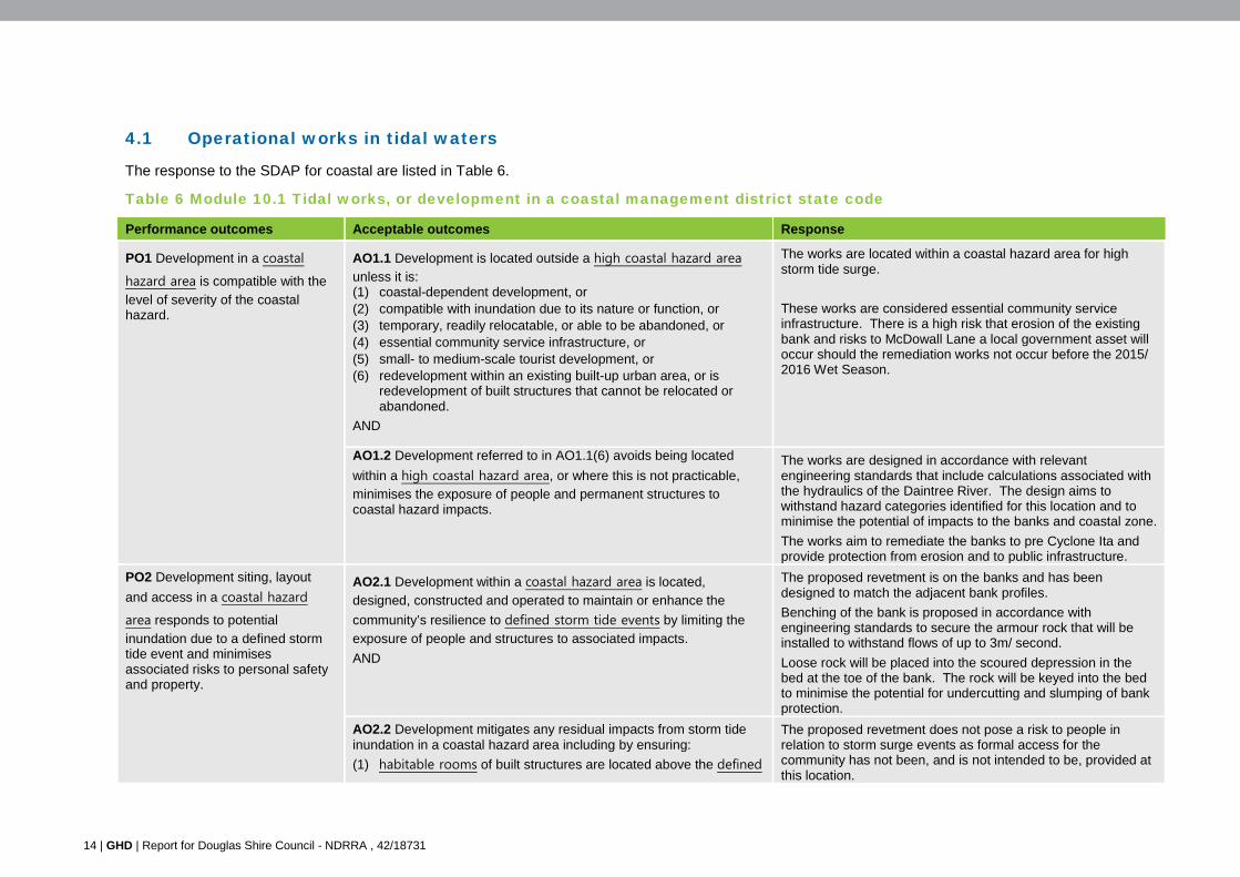
14 | GHD | Report for Douglas Shire Council - NDRRA , 42/18731
4.1 Operational works in tidal waters
The response to the SDAP for coastal are listed in Table 6.
Table 6 Module 10.1 Tidal works, or development in a coastal management district state code
Performance outcomes Acceptable outcomes Response
PO1 Development in a coastal
hazard area is compatible with the
level of severity of the coastal hazard.
AO1.1 Development is located outside a high coastal hazard area
unless it is: (1) coastal-dependent development, or (2) compatible with inundation due to its nature or function, or (3) temporary, readily relocatable, or able to be abandoned, or (4) essential community service infrastructure, or (5) small- to medium-scale tourist development, or (6) redevelopment within an existing built-up urban area, or is
redevelopment of built structures that cannot be relocated or abandoned.
AND
The works are located within a coastal hazard area for high storm tide surge.
These works are considered essential community service infrastructure. There is a high risk that erosion of the existing bank and risks to McDowall Lane a local government asset will occur should the remediation works not occur before the 2015/ 2016 Wet Season.
AO1.2 Development referred to in AO1.1(6) avoids being located
within a high coastal hazard area, or where this is not practicable, minimises the exposure of people and permanent structures to coastal hazard impacts.
The works are designed in accordance with relevant engineering standards that include calculations associated with the hydraulics of the Daintree River. The design aims to withstand hazard categories identified for this location and to minimise the potential of impacts to the banks and coastal zone.
The works aim to remediate the banks to pre Cyclone Ita and provide protection from erosion and to public infrastructure.
PO2 Development siting, layout
and access in a coastal hazard
area responds to potential
inundation due to a defined storm tide event and minimises associated risks to personal safety and property.
AO2.1 Development within a coastal hazard area is located,
designed, constructed and operated to maintain or enhance the
community’s resilience to defined storm tide events by limiting the
exposure of people and structures to associated impacts.
AND
The proposed revetment is on the banks and has been designed to match the adjacent bank profiles.
Benching of the bank is proposed in accordance with engineering standards to secure the armour rock that will be installed to withstand flows of up to 3m/ second.
Loose rock will be placed into the scoured depression in the bed at the toe of the bank. The rock will be keyed into the bed to minimise the potential for undercutting and slumping of bank protection.
AO2.2 Development mitigates any residual impacts from storm tide inundation in a coastal hazard area including by ensuring:
(1) habitable rooms of built structures are located above the defined
The proposed revetment does not pose a risk to people in relation to storm surge events as formal access for the community has not been, and is not intended to be, provided at this location.
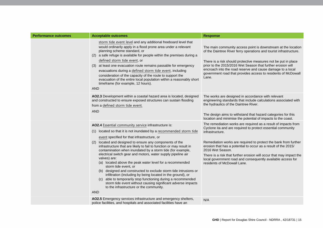
GHD | Report for Douglas Shire Council - NDRRA , 42/18731 | 15
Performance outcomes Acceptable outcomes Response
storm tide event level and any additional freeboard level that
would ordinarily apply in a flood prone area under a relevant planning scheme standard, or
(2) a safe refuge is available for people within the premises during a
defined storm tide event, or
(3) at least one evacuation route remains passable for emergency
evacuations during a defined storm tide event, including
consideration of the capacity of the route to support the evacuation of the entire local population within a reasonably short timeframe (for example, 12 hours).
AND
The main community access point is downstream at the location of the Daintree River ferry operations and tourist infrastructure.
There is a risk should protective measures not be put in place prior to the 2015/2016 Wet Season that further erosion will encroach into the road reserve and cause damage to a local government road that provides access to residents of McDowall Lane.
AO2.3 Development within a coastal hazard area is located, designed and constructed to ensure exposed structures can sustain flooding
from a defined storm tide event.
AND
The works are designed in accordance with relevant engineering standards that include calculations associated with the hydraulics of the Daintree River.
The design aims to withstand that hazard categories for this location and minimise the potential of impacts to the coast.
AO2.4 Essential community service infrastructure is:
(1) located so that it is not inundated by a recommended storm tide
event specified for that infrastructure, or
(2) located and designed to ensure any components of the infrastructure that are likely to fail to function or may result in contamination when inundated by a storm tide (for example, electrical switch gear and motors, water supply pipeline air valves) are: (a) located above the peak water level for a recommended
storm tide event, or (b) designed and constructed to exclude storm tide intrusions or
infiltration (including by being located in the ground), or (c) able to temporarily stop functioning during a recommended
storm tide event without causing significant adverse impacts to the infrastructure or the community.
AND
The remediation works are required as a result of impacts from Cyclone ita and are required to protect essential community infrastructure.
Remediation works are required to protect the bank from further erosion that has a potential to occur as a result of the 2015/ 2016 Wet Season.
There is a risk that further erosion will occur that may impact the local government road and consequently available access for residents of McDowall Lane.
AO2.5 Emergency services infrastructure and emergency shelters, police facilities, and hospitals and associated facilities have an
N/A
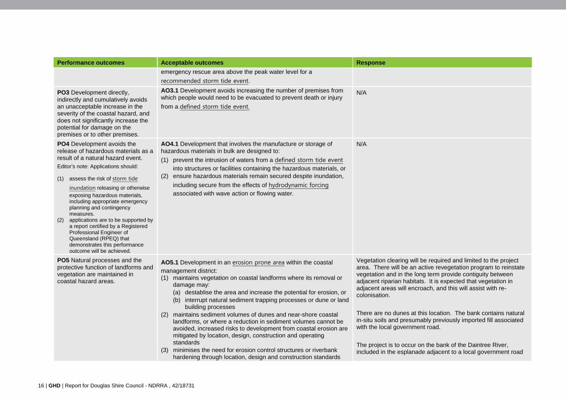
16 | GHD | Report for Douglas Shire Council - NDRRA , 42/18731
Performance outcomes Acceptable outcomes Response
emergency rescue area above the peak water level for a
recommended storm tide event.
PO3 Development directly, indirectly and cumulatively avoids an unacceptable increase in the severity of the coastal hazard, and does not significantly increase the potential for damage on the premises or to other premises.
AO3.1 Development avoids increasing the number of premises from which people would need to be evacuated to prevent death or injury
from a defined storm tide event.
N/A
PO4 Development avoids the release of hazardous materials as a result of a natural hazard event. Editor’s note: Applications should:
(1) assess the risk of storm tide
inundation releasing or otherwise exposing hazardous materials, including appropriate emergency planning and contingency measures.
(2) applications are to be supported by a report certified by a Registered Professional Engineer of Queensland (RPEQ) that demonstrates this performance outcome will be achieved.
AO4.1 Development that involves the manufacture or storage of hazardous materials in bulk are designed to:
(1) prevent the intrusion of waters from a defined storm tide event into structures or facilities containing the hazardous materials, or
(2) ensure hazardous materials remain secured despite inundation,
including secure from the effects of hydrodynamic forcing associated with wave action or flowing water.
N/A
PO5 Natural processes and the protective function of landforms and vegetation are maintained in coastal hazard areas.
AO5.1 Development in an erosion prone area within the coastal management district: (1) maintains vegetation on coastal landforms where its removal or
damage may: (a) destablise the area and increase the potential for erosion, or (b) interrupt natural sediment trapping processes or dune or land
building processes (2) maintains sediment volumes of dunes and near-shore coastal
landforms, or where a reduction in sediment volumes cannot be avoided, increased risks to development from coastal erosion are mitigated by location, design, construction and operating standards
(3) minimises the need for erosion control structures or riverbank hardening through location, design and construction standards
Vegetation clearing will be required and limited to the project area. There will be an active revegetation program to reinstate vegetation and in the long term provide contiguity between adjacent riparian habitats. It is expected that vegetation in adjacent areas will encroach, and this will assist with re-colonisation.
There are no dunes at this location. The bank contains natural in-situ soils and presumably previously imported fill associated with the local government road.
The project is to occur on the bank of the Daintree River, included in the esplanade adjacent to a local government road
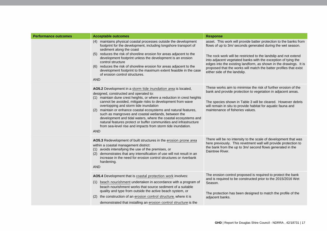
GHD | Report for Douglas Shire Council - NDRRA , 42/18731 | 17
Performance outcomes Acceptable outcomes Response
(4) maintains physical coastal processes outside the development footprint for the development, including longshore transport of sediment along the coast
(5) reduces the risk of shoreline erosion for areas adjacent to the development footprint unless the development is an erosion control structure
(6) reduces the risk of shoreline erosion for areas adjacent to the development footprint to the maximum extent feasible in the case of erosion control structures.
AND
asset. This work will provide batter protection to the banks from flows of up to 3m/ seconds generated during the wet season.
The rock work will be restricted to the landslip and not extend into adjacent vegetated banks with the exception of tying the edges into the existing landform, as shown in the drawings. It is proposed that the works will match the batter profiles that exist either side of the landslip.
AO5.2 Development in a storm tide inundation area is located,
designed, constructed and operated to: (1) maintain dune crest heights, or where a reduction in crest heights
cannot be avoided, mitigate risks to development from wave overtopping and storm tide inundation
(2) maintain or enhance coastal ecosystems and natural features, such as mangroves and coastal wetlands, between the development and tidal waters, where the coastal ecosystems and natural features protect or buffer communities and infrastructure from sea-level rise and impacts from storm tide inundation.
AND
These works aim to minimise the risk of further erosion of the bank and provide protection to vegetation in adjacent areas.
The species shown in Table 3 will be cleared. However debris will remain in situ to provide habitat for aquatic fauna and maintenance of fisheries values.
AO5.3 Redevelopment of built structures in the erosion prone area
within a coastal management district: (1) avoids intensifying the use of the premises, or (2) demonstrates that any intensification of use will not result in an
increase in the need for erosion control structures or riverbank hardening.
AND
There will be no intensity to the scale of development that was here previously. This revetment wall will provide protection to the bank from the up to 3m/ second flows generated in the Daintree River.
AO5.4 Development that is coastal protection work involves:
(1) beach nourishment undertaken in accordance with a program of beach nourishment works that source sediment of a suitable quality and type from outside the active beach system, or
(2) the construction of an erosion control structure, where it is
demonstrated that installing an erosion control structure is the
The erosion control proposed is required to protect the bank and is required to be constructed prior to the 2015/2016 Wet Season.
The protection has been designed to match the profile of the adjacent banks.
18 | GHD | Report for Douglas Shire Council - NDRRA , 42/18731
Performance outcomes Acceptable outcomes Response
only feasible option for protecting permanent structures from coastal erosion and those structures cannot be abandoned or relocated in the event of coastal erosion occurring.
Editor’s note: Applications for coastal protection work should be supported by a report certified by a Registered Professional Engineer of Queensland (RPEQ) that demonstrates how the engineering solution sought by the work will be achieved.
Editor’s note: Applications for erosion control structures should demonstrate
the consideration of beach nourishment techniques, and include a statement of why nourishment (in whole or part) has not been adopted as the preferred means of controlling the erosion risk.
AND
The proposal complies with the funding criteria of QRA.
The proposed will be limited to the existing disturbance footprint, a minor exception being the tying in of the edges into the existing landforms, as shown in the construction drawings.
AO5.5 Development involving reclamation:
(1) does not alter, or otherwise minimises impacts on, the physical
characteristics of a waterway or the seabed near the reclamation,
including flow regimes, hydrodynamic forces, tidal water and riverbank stability
(2) is located outside the active sediment transport area, or otherwise maintains sediment transport processes as close as possible to their natural state
(3) ensures activities associated with the operation of the development maintain the structure and condition of vegetation communities and avoid wind and water run-off erosion.
Editor’s note: Applications for reclamation should be supported by a report certified by an RPEQ that demonstrates how the engineering solutions sought by the work will be achieved
N/A there is no reclamation proposed
PO6 Erosion prone areas in a
coastal management district are maintained as development free buffers, or where permanent buildings or structures exist, coastal erosion risks are avoided or mitigated.
AO6.1 Development locates built structures outside the part of the
coastal management district that is the erosion prone area unless the
development is listed under AO1.1 (1) – (5).
AND
The built structure proposed is to protect the bank from further erosion. This is to preserve the current bank alignment as well as protecting local road infrastructure that is at risk from bank recession.
The engineering works are proposed to be undertaken prior to the 2015/2016 Wet Season.
AO6.2 Development is located outside the erosion prone area unless it is redevelopment.
The development is within the erosion prone area and is to stabilise the banks which was impacted from Cyclone Ita.
The works are to protect the bank from further erosion as well
GHD | Report for Douglas Shire Council - NDRRA , 42/18731 | 19
Performance outcomes Acceptable outcomes Response
AND as the local government road McDowall Lane. Should the works not be undertaken prior to the 2015/2016 Wet Season there is an increased risk if impacts to McDowall Lane and hence access to the local residents.
AO6.3 Coastal-dependent development: (1) locates, designs and constructs relevant buildings or structures to
withstand coastal erosion impacts, including by use of appropriate foundations, or
(2) installs and maintains coastal protection works to mitigate adverse impacts to people and permanent structures from coastal erosion at the location.
AND
(1 ) N/A
(2 ) The works are a coastal protection measure to protect a local government road and access for residents.
The proposal includes restoration works for native vegetation and an active revegetation will be undertaken.
AO6.4 Development that is temporary, readily relocatable or able to
be abandoned, or essential community service infrastructure:
(1) locates built structures landward of an applicable coastal building
line, or
(2) where there is no coastal building line, locates habitable built structures landward of the alignment of adjacent habitable buildings, or
(3) locates lifesaver towers or beach access infrastructure to minimise its impacts on physical coastal processes, or
(4) where it is demonstrated that (1) or (2) is not reasonable and (3) does not apply: (a) locates built structures as far landward as practicable (b) uses layout design to minimise the footprint of the
development that remains within the erosion prone area.
AND
N/A
AO6.5 Redevelopment of existing built structures not referred to in
AO6.4, and excluding marine development:
(1) relocates built structures outside that part of the erosion prone
area that is within the coastal management district, or
(2) relocates built structures as far landward as practicable, and
landward of an applicable coastal building line, or
N/A
20 | GHD | Report for Douglas Shire Council - NDRRA , 42/18731
Performance outcomes Acceptable outcomes Response
(3) where there is no coastal building line:
(a) relocates built structures landward of the alignment of adjacent habitable buildings, or
(b) uses layout design to minimise the footprint of the development that remains within the erosion prone area, or
(c) provides sufficient space seaward of the development within the premises to allow for the construction of erosion control structures.
AND
AO6.6 Redevelopment of built structures in the erosion prone area
within a coastal management district, which results in an intensification of use, mitigates the erosion threat to the development, having regard to: (1) design and construction standards
(2) installing and maintaining on-site erosion control structures within the premises if the development is not intended to be temporary.
N/A
PO7 Development avoids or minimises adverse impacts on coastal resources and their values, to the maximum extent reasonable.
AO7.1 Coastal protection work that is in the form of beach
nourishment uses methods of placement suitable for the location that do not interfere with the long-term use of the locality of, or natural values within or neighbouring, the proposed placement site.
AND
N/A beach nourishment not proposed
AO7.2 Marine development is located and designed to expand on or
redevelop existing marine infrastructure unless it is demonstrated that it is not practicable to co-locate the development with existing marine infrastructure.
AND
The development is to occur in an area that was previously stabilised.
AO7.3 Marine development: (1) relies on a natural channel of a depth adequate for the intended
vessels, or (2) where there are no feasible alternative locations for the facility in
the local area that do not require dredging for navigation channel purposes:
N/A
GHD | Report for Douglas Shire Council - NDRRA , 42/18731 | 21
Performance outcomes Acceptable outcomes Response
(a) involves capital dredging for new navigation channel purposes
(b) is located, designed and operated to minimise the need for capital and subsequent maintenance dredging for navigation channel purposes.
AND
AO7.4 Development minimises dredging or the disposal of material in
coastal waters during key biological events (such as fish aggregations
or spawning) for species found in the area.
AND
N/A no dredging required as operational works will be the placement of rock and mattresses.
The banks will be benched but no excavation from the bed will be undertaken.
AO7.5 Measures are to be incorporated as part of siting and design of the development to protect and retain identified ecological values and underlying ecosystem processes within or adjacent to the development site to the greatest extent practicable. This includes: (1) maintaining or restoring vegetated buffers between development
and coastal waters to the extent practicable, unless the
development is within ports or airports, or is marine development
(2) maintaining or enhancing the connectivity of ecosystems in consideration of the cumulative effect of the development in addition to existing developed areas
(3) retaining coastal wetlands, seagrass beds and other locally important feeding, nesting or breeding sites for native wildlife.
AND
The proposed works include active revegetation that seek to re-establish vegetation on the bank. This will assist with restoring habitat in this location and providing contiguity with riparian flora in adjacent areas.
There is evidence in other locations on the Daintree River that vegetation has successfully re-colonised in areas that have had rock protection installed. It is likely that this will occur in addition to the active revegetation program proposed.
AO7.6 Measures are incorporated as part of siting and design of the development to maintain or enhance water quality to achieve the
environmental values and water quality objectives outlined in the Environmental Protection (Water) Policy 2009.
AND
Impacts to water quality, such as an increase in velocity and suspended solids, will be temporary during construction.
The works will provide long term benefits as protection to the bank will reduce the loss of sediment and erosion to the Daintree River water body.
AO7.7 Development avoids the disturbance of acid sulphate soils, or where it is demonstrated that this is not possible, the disturbance of acid sulphate soils is carefully managed to minimise and mitigate the adverse effects of the disturbance on coastal resources.
A large portion of the works will be exposed to the tide and hence oxidation of acid sulfate that may be present is unlikely to occur.
There is a lower chance of acid sulfate occurring in the upper portions of the banks as it probably that imported fill was used
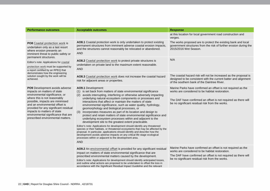
22 | GHD | Report for Douglas Shire Council - NDRRA , 42/18731
Performance outcomes Acceptable outcomes Response
at this location for local government road construction and verges.
PO8 Coastal protection work is
undertaken only as a last resort where erosion presents an imminent threat to public safety or permanent structures.
Editor’s note: Applications for coastal
protection work must be supported by a report certified by an RPEQ that demonstrates how the engineering solution sought by the work will be achieved.
AO8.1 Coastal protection work is only undertaken to protect existing permanent structures from imminent adverse coastal erosion impacts, and the structures cannot reasonably be relocated or abandoned.
AND
The works proposed are to protect the existing bank and local government structures from the risk of further erosion during the 2015/2016 Wet Season.
AO8.2 Coastal protection work to protect private structures is
undertaken on private land to the maximum extent reasonable.
AND
N/A
AO8.3 Coastal protection work does not increase the coastal hazard risk for adjacent areas or properties.
The coastal hazard risk will not be increased as the proposal is designed to be consistent with the current batter and alignment of the southern bank of the Daintree River.
PO9 Development avoids adverse impacts on matters of state environmental significance, or where this is not reasonably possible, impacts are minimised and an environmental offset is provided for any significant residual impacts to matters of state environmental significance that are prescribed environmental matters.
AO9.1 Development: (1) is set back from matters of state environmental significance (2) avoids interrupting, interfering or otherwise adversely impacting
underlying natural ecosystem components or processes and interactions that affect or maintain the matters of state environmental significance, such as water quality, hydrology, geomorphology and biological processes, or
(3) incorporates measures as part of its location and design to protect and retain matters of state environmental significance and underlying ecosystem processes within and adjacent to the development site to the greatest extent practicable.
Editor’s note: Applications for development should identify any threatened species or their habitats, or threatened ecosystems that may be affected by the proposal. In particular, applications should identify and describe how the development avoids adverse impacts on any critical life stage ecological processes within or adjacent to the development area.
AND
Marine Parks have confirmed an offset is not required as the works are considered to be habitat restoration.
The DAF have confirmed an offset is not required as there will be no significant residual risk from the works.
AO9.2 An environmental offset is provided for any significant residual
impact on matters of state environmental significance that are prescribed environmental matters caused by the development. Editor’s note: Applications for development should identify anticipated losses, and outline what actions are proposed to be undertaken to offset the loss in accordance with the Significant Residual Impact Guideline and the relevant
Marine Parks have confirmed an offset is not required as the works are considered to be habitat restoration.
The DAF have confirmed an offset is not required as there will be no significant residual risk from the works.
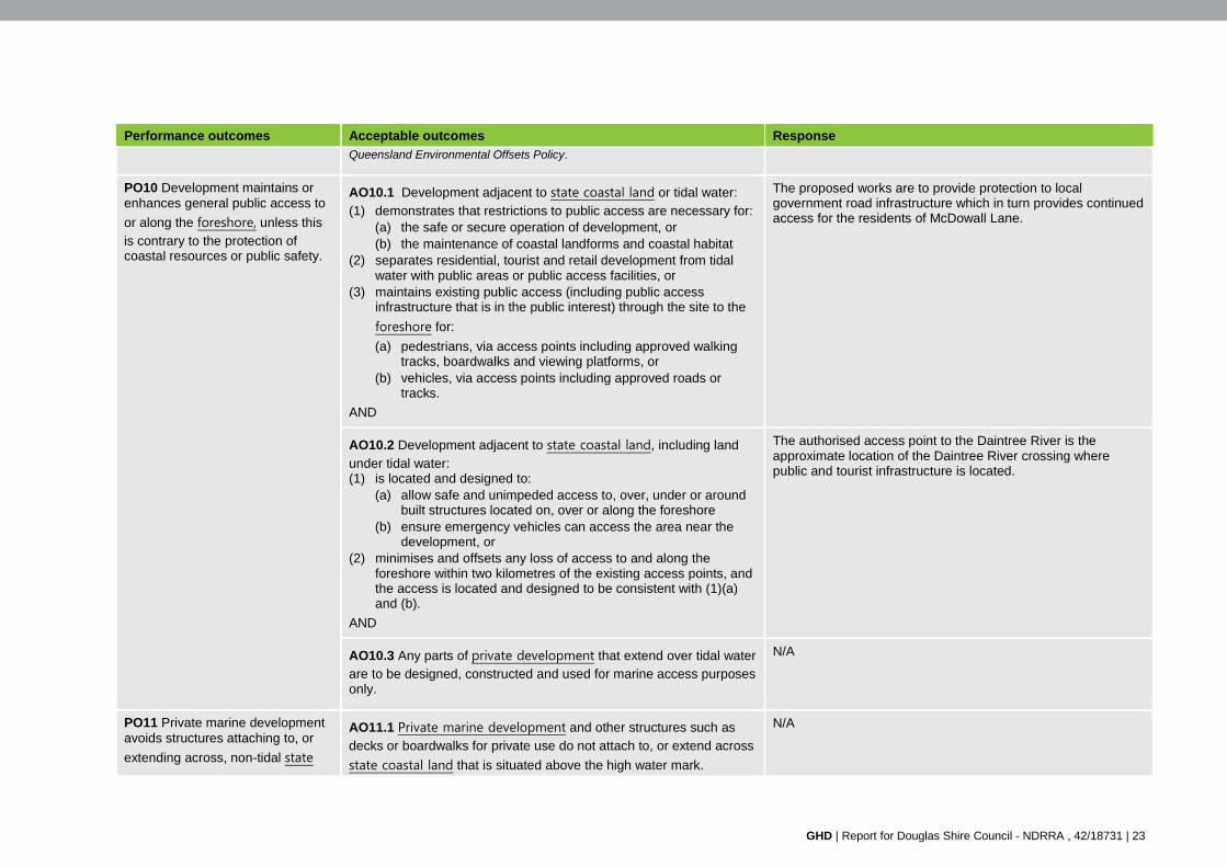
GHD | Report for Douglas Shire Council - NDRRA , 42/18731 | 23
Performance outcomes Acceptable outcomes Response
Queensland Environmental Offsets Policy.
PO10 Development maintains or enhances general public access to
or along the foreshore, unless this
is contrary to the protection of coastal resources or public safety.
AO10.1 Development adjacent to state coastal land or tidal water:
(1) demonstrates that restrictions to public access are necessary for: (a) the safe or secure operation of development, or (b) the maintenance of coastal landforms and coastal habitat
(2) separates residential, tourist and retail development from tidal water with public areas or public access facilities, or
(3) maintains existing public access (including public access infrastructure that is in the public interest) through the site to the
foreshore for:
(a) pedestrians, via access points including approved walking tracks, boardwalks and viewing platforms, or
(b) vehicles, via access points including approved roads or tracks.
AND
The proposed works are to provide protection to local government road infrastructure which in turn provides continued access for the residents of McDowall Lane.
AO10.2 Development adjacent to state coastal land, including land
under tidal water: (1) is located and designed to:
(a) allow safe and unimpeded access to, over, under or around built structures located on, over or along the foreshore
(b) ensure emergency vehicles can access the area near the development, or
(2) minimises and offsets any loss of access to and along the foreshore within two kilometres of the existing access points, and the access is located and designed to be consistent with (1)(a) and (b).
AND
The authorised access point to the Daintree River is the approximate location of the Daintree River crossing where public and tourist infrastructure is located.
AO10.3 Any parts of private development that extend over tidal water are to be designed, constructed and used for marine access purposes only.
N/A
PO11 Private marine development avoids structures attaching to, or
extending across, non-tidal state
AO11.1 Private marine development and other structures such as
decks or boardwalks for private use do not attach to, or extend across
state coastal land that is situated above the high water mark.
N/A
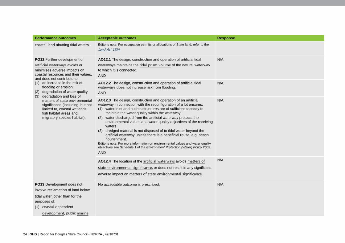
24 | GHD | Report for Douglas Shire Council - NDRRA , 42/18731
Performance outcomes Acceptable outcomes Response
coastal land abutting tidal waters. Editor’s note: For occupation permits or allocations of State land, refer to the
Land Act 1994.
PO12 Further development of
artificial waterways avoids or minimises adverse impacts on coastal resources and their values, and does not contribute to: (1) an increase in the risk of
flooding or erosion (2) degradation of water quality (3) degradation and loss of
matters of state environmental significance (including, but not limited to, coastal wetlands, fish habitat areas and migratory species habitat).
AO12.1 The design, construction and operation of artificial tidal
waterways maintains the tidal prism volume of the natural waterway to which it is connected.
AND
N/A
AO12.2 The design, construction and operation of artificial tidal waterways does not increase risk from flooding.
AND
N/A
AO12.3 The design, construction and operation of an artificial waterway in connection with the reconfiguration of a lot ensures: (1) water inlet and outlets structures are of sufficient capacity to
maintain the water quality within the waterway (2) water discharged from the artificial waterway protects the
environmental values and water quality objectives of the receiving waters
(3) dredged material is not disposed of to tidal water beyond the artificial waterway unless there is a beneficial reuse, e.g. beach nourishment.
Editor’s note: For more information on environmental values and water quality objectives see Schedule 1 of the Environment Protection (Water) Policy 2009.
AND
N/A
AO12.4 The location of the artificial waterways avoids matters of
state environmental significance, or does not result in any significant
adverse impact on matters of state environmental significance.
N/A
PO13 Development does not
involve reclamation of land below
tidal water, other than for the
purposes of:
(1) coastal-dependent
development, public marine
No acceptable outcome is prescribed. N/A
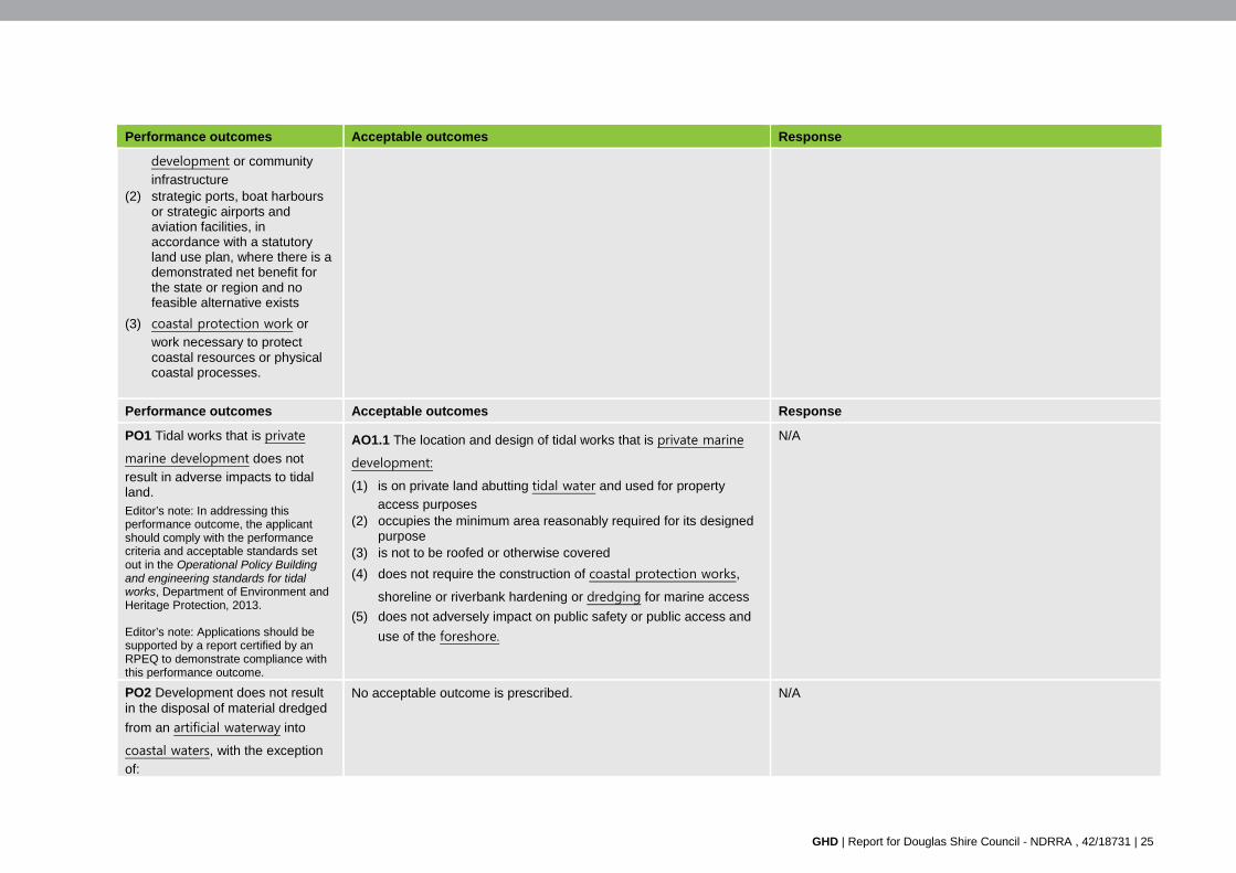
GHD | Report for Douglas Shire Council - NDRRA , 42/18731 | 25
Performance outcomes Acceptable outcomes Response
development or community
infrastructure (2) strategic ports, boat harbours
or strategic airports and aviation facilities, in accordance with a statutory land use plan, where there is a demonstrated net benefit for the state or region and no feasible alternative exists
(3) coastal protection work or work necessary to protect coastal resources or physical coastal processes.
Performance outcomes Acceptable outcomes Response
PO1 Tidal works that is private
marine development does not
result in adverse impacts to tidal land. Editor’s note: In addressing this performance outcome, the applicant should comply with the performance criteria and acceptable standards set out in the Operational Policy Building and engineering standards for tidal works, Department of Environment and Heritage Protection, 2013.
Editor’s note: Applications should be supported by a report certified by an RPEQ to demonstrate compliance with this performance outcome.
AO1.1 The location and design of tidal works that is private marine
development:
(1) is on private land abutting tidal water and used for property
access purposes (2) occupies the minimum area reasonably required for its designed
purpose (3) is not to be roofed or otherwise covered
(4) does not require the construction of coastal protection works,
shoreline or riverbank hardening or dredging for marine access
(5) does not adversely impact on public safety or public access and
use of the foreshore.
N/A
PO2 Development does not result in the disposal of material dredged
from an artificial waterway into
coastal waters, with the exception
of:
No acceptable outcome is prescribed. N/A
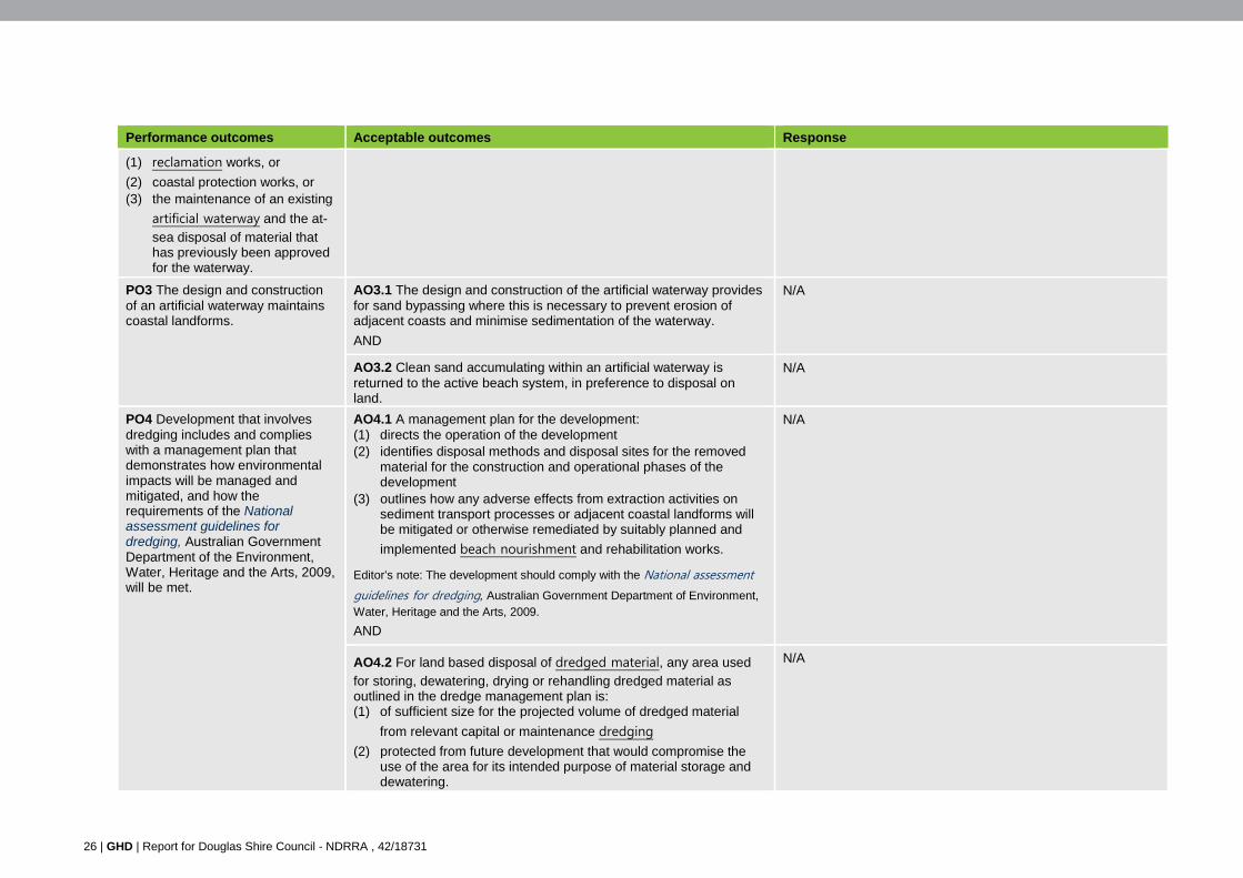
26 | GHD | Report for Douglas Shire Council - NDRRA , 42/18731
Performance outcomes Acceptable outcomes Response
(1) reclamation works, or
(2) coastal protection works, or (3) the maintenance of an existing
artificial waterway and the at-
sea disposal of material that has previously been approved for the waterway.
PO3 The design and construction of an artificial waterway maintains coastal landforms.
AO3.1 The design and construction of the artificial waterway provides for sand bypassing where this is necessary to prevent erosion of adjacent coasts and minimise sedimentation of the waterway.
AND
N/A
AO3.2 Clean sand accumulating within an artificial waterway is returned to the active beach system, in preference to disposal on land.
N/A
PO4 Development that involves dredging includes and complies with a management plan that demonstrates how environmental impacts will be managed and mitigated, and how the requirements of the National assessment guidelines for dredging, Australian Government Department of the Environment, Water, Heritage and the Arts, 2009, will be met.
AO4.1 A management plan for the development: (1) directs the operation of the development (2) identifies disposal methods and disposal sites for the removed
material for the construction and operational phases of the development
(3) outlines how any adverse effects from extraction activities on sediment transport processes or adjacent coastal landforms will be mitigated or otherwise remediated by suitably planned and
implemented beach nourishment and rehabilitation works.
Editor’s note: The development should comply with the National assessment
guidelines for dredging, Australian Government Department of Environment, Water, Heritage and the Arts, 2009.
AND
N/A
AO4.2 For land based disposal of dredged material, any area used
for storing, dewatering, drying or rehandling dredged material as outlined in the dredge management plan is: (1) of sufficient size for the projected volume of dredged material
from relevant capital or maintenance dredging
(2) protected from future development that would compromise the use of the area for its intended purpose of material storage and dewatering.
N/A
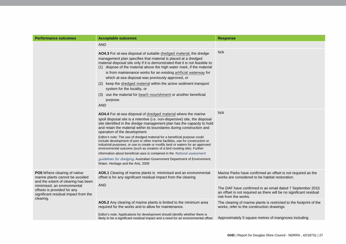
GHD | Report for Douglas Shire Council - NDRRA , 42/18731 | 27
Performance outcomes Acceptable outcomes Response
AND
AO4.3 For at-sea disposal of suitable dredged material, the dredge management plan specifies that material is placed at a dredged material disposal site only if it is demonstrated that it is not feasible to: (1) dispose of the material above the high water mark, if the material
is from maintenance works for an existing artificial waterway for
which at-sea disposal was previously approved, or
(2) keep the dredged material within the active sediment transport
system for the locality, or
(3) use the material for beach nourishment or another beneficial purpose.
AND
N/A
AO4.4 For at-sea disposal of dredged material where the marine
spoil disposal site is a retentive (i.e. non-dispersive) site, the disposal site identified in the dredge management plan has the capacity to hold and retain the material within its boundaries during construction and operation of the development. Editor’s note: The use of dredged material for a beneficial purpose could include development of port or other marine facilities, use for construction or industrial purposes, or use to create or modify land or waters for an approved environmental outcome (such as creation of a bird roosting site). Further
information about beneficial uses is contained in the National assessment
guidelines for dredging, Australian Government Department of Environment, Water, Heritage and the Arts, 2009
N/A
PO5 Where clearing of native marine plants cannot be avoided and the extent of clearing has been minimised, an environmental offsets is provided for any significant residual impact from the clearing.
AO5.1 Clearing of marine plants is minimised and an environmental offset is for any significant residual impact from the clearing
AND
Marine Parks have confirmed an offset is not required as the works are considered to be habitat restoration.
The DAF have confirmed in an email dated 7 September 2015 an offset is not required as there will be no significant residual risk from the works.
AO5.2 Any clearing of marine plants is limited to the minimum area required for the works and to allow for maintenance.
Editor’s note: Applications for development should identify whether there is likely to be a significant residual impact and a need for an environmental offset
The clearing of marine plants is restricted to the footprint of the works, refer to the construction drawings.
Approximately 5 square metres of mangroves including
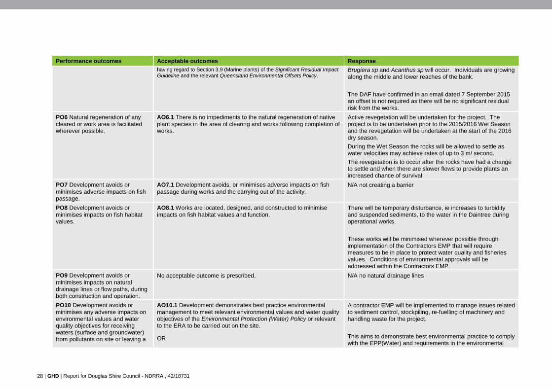
28 | GHD | Report for Douglas Shire Council - NDRRA , 42/18731
Performance outcomes Acceptable outcomes Response
having regard to Section 3.9 (Marine plants) of the Significant Residual Impact Guideline and the relevant Queensland Environmental Offsets Policy.
Brugiera sp and Acanthus sp will occur. Individuals are growing along the middle and lower reaches of the bank.
The DAF have confirmed in an email dated 7 September 2015 an offset is not required as there will be no significant residual risk from the works.
PO6 Natural regeneration of any cleared or work area is facilitated wherever possible.
AO6.1 There is no impediments to the natural regeneration of native plant species in the area of clearing and works following completion of works.
Active revegetation will be undertaken for the project. The project is to be undertaken prior to the 2015/2016 Wet Season and the revegetation will be undertaken at the start of the 2016 dry season.
During the Wet Season the rocks will be allowed to settle as water velocities may achieve rates of up to 3 m/ second.
The revegetation is to occur after the rocks have had a change to settle and when there are slower flows to provide plants an increased chance of survival
PO7 Development avoids or minimises adverse impacts on fish passage.
AO7.1 Development avoids, or minimises adverse impacts on fish passage during works and the carrying out of the activity.
N/A not creating a barrier
PO8 Development avoids or minimises impacts on fish habitat values.
AO8.1 Works are located, designed, and constructed to minimise impacts on fish habitat values and function.
There will be temporary disturbance, ie increases to turbidity and suspended sediments, to the water in the Daintree during operational works.
These works will be minimised wherever possible through implementation of the Contractors EMP that will require measures to be in place to protect water quality and fisheries values. Conditions of environmental approvals will be addressed within the Contractors EMP.
PO9 Development avoids or minimises impacts on natural drainage lines or flow paths, during both construction and operation.
No acceptable outcome is prescribed. N/A no natural drainage lines
PO10 Development avoids or minimises any adverse impacts on environmental values and water quality objectives for receiving waters (surface and groundwater) from pollutants on site or leaving a
AO10.1 Development demonstrates best practice environmental management to meet relevant environmental values and water quality objectives of the Environmental Protection (Water) Policy or relevant to the ERA to be carried out on the site.
OR
A contractor EMP will be implemented to manage issues related to sediment control, stockpiling, re-fuelling of machinery and handling waste for the project.
This aims to demonstrate best environmental practice to comply with the EPP(Water) and requirements in the environmental
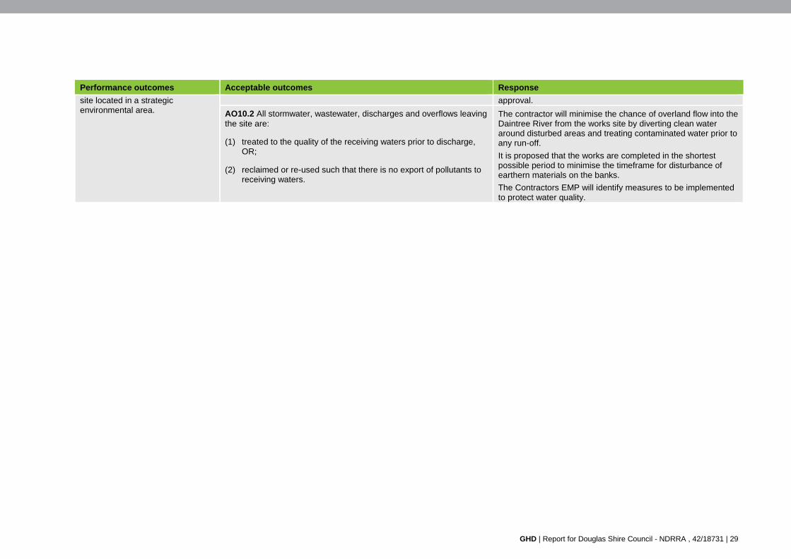
GHD | Report for Douglas Shire Council - NDRRA , 42/18731 | 29
Performance outcomes Acceptable outcomes Response
site located in a strategic environmental area.
approval.
AO10.2 All stormwater, wastewater, discharges and overflows leaving the site are:
(1) treated to the quality of the receiving waters prior to discharge, OR;
(2) reclaimed or re-used such that there is no export of pollutants to receiving waters.
The contractor will minimise the chance of overland flow into the Daintree River from the works site by diverting clean water around disturbed areas and treating contaminated water prior to any run-off.
It is proposed that the works are completed in the shortest possible period to minimise the timeframe for disturbance of earthern materials on the banks.
The Contractors EMP will identify measures to be implemented to protect water quality.

GHD | Report for Douglas Shire Council - NDRRA , 42/18731
Appendices

32 | GHD | Report for Douglas Shire Council - NDRRA , 42/18731
Appendix A – Construction drawings
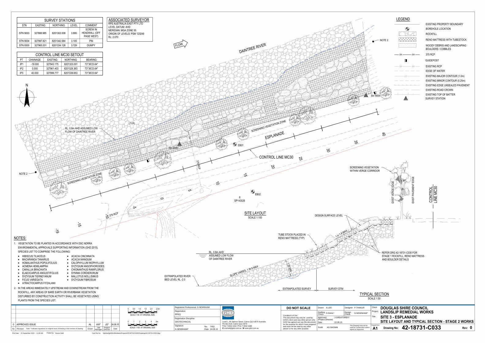
SW
SWSW| |
| || |
| || |
| || |
| || | | |
||
|
|
||
||
||
| || |
| || |
| || |
| || |
| || |
| || |
| |
||
||
||
||
||
||
||
||
||
||
||
||
|
|
|
|| |
| || |
||
||
|
ESPLANADE
DAINTREE RIVER
8SP143026
Stn 9300EB01
EB02
Stn 9004
375 RCP
375 RCP
0.0
1.0
2.0
3.0
0.0
1.0
2.03.0
0
25
10
20
5
15
SW
40
35
30
-5
-10
-15
-19
N
SITE LAYOUTSCALE 1:100
CONTROL LINE MC30
RL. 0.8m AHD ASSUMED LOWFLOW OF DAINTREE RIVER SCREENING VEGETATION ZONE
(TYP)
SCREENING VEGETATION ZONENOTE 2
NOTE 2
CONT
ROL
LINE
MC30
EXIS
T PA
VEME
NT E
DGE
EXTRAPOLATED SURVEY SURVEY DTM
TYPICAL SECTIONSCALE 1:50
EXTRAPOLATED RIVERBED LEVEL RL.-2.0
RL. 0.8m AHDASSUMED LOW FLOWOF DAINTREE RIVER
SLOPE VARIES, 1 IN 8 MAX
1.50 MIN
DESIGN SURFACE LEVEL
EXIS
T VE
RGE
EDGE
TUBE STOCK PLACED INRENO MATTRESS (TYP)
SCREENING VEGETATIONWITHIN VERGE CORRIDOR
1 in 1.8 MAX
REFER DRG 42-18731-C030 FORSTAGE 1 ROCKFILL, RENO MATTRESSAND BOULDER DETAILS
This Drawing must not be
used for Construction unless
signed as Approved
Date
Check
Drafting
DateDrawnRevisionNo
A1
Original Size
Title
Project
Client
Check
DesignerDrawn
Scale
Design
Conditions of Use.
This document may only be used by
GHD's client (and any other person who
GHD has agreed can use this document)
for the purpose for which it was prepared
and must not be used by any other
person or for any other purpose.
DO NOT SCALE
Note: * indicates signatures on original issue of drawing or last revision of drawing
Plot Date: Cad File No:23 September 2015 - 11:09 AM \\ghdnet\ghd\AU\Brisbane\Projects\42\18731\CADD\Drawings\42-18731-C033.dwg
Plotted by:
Darren Dahl
(Project Director)
Approved
Job
Manager
Project
Director
42-18731-C033
0
A.LEE P.THAKUR
D.DAHL* G.NEWNHAM*
J.GREATOREX*
22.09.15
AS SHOWN
275
CONTROL LINE MC30 SETOUTPT CHAINAGE EASTING NORTHING BEARINGIP1 -19.000 327943.175 8201323.001IP2 0.000 327961.403 8201328.363IP3 40.000 327999.777 8201339.653
ASSOCIATED SURVEYORRPS AUSTRALIA EAST PTY LTDLEVEL DATUM: AHDMERIDIAN: MGA ZONE 55ORIGIN OF LEVELS: PSM 123249RL: 2.070
SURVEY STATIONSSTN EASTING NORTHING LEVEL COMMENT
STN 9003 327888.985 8201302.008 3.895SCREW IN
HEADWALL (OFFPAGE WEST)
STN 9004 327997.821 8201342.584 3.105 PINSTN 9300 327965.531 8201334.128 3.729 DUMPY
0
SCALE 1:50 AT ORIGINAL SIZE
0.5 2.0 2.5m1.51.0
0 1 4 5m32
SCALE 1:100 AT ORIGINAL SIZE
Level 1, 85 Spence Street, Cairns QLD 4870 Australia
PO Box 819, Cairns QLD 4870
T 61 7 4044 2222 F 61 7 4044 2288
E [email protected] W www.ghd.com.au
Registered Professional
Registration
Signature
Date
Registration Discipline
No. 7452
G.NEWNHAM
24.09.15
RPEQ
G.NEWNHAM*
GEOTECHNICAL
EXISTING PROPERTY BOUNDARYLEGEND
BOREHOLE LOCATION
ROCKFILL
EDGE OF WATER
SW SW 375 RCP
SW SW EXISTING RCP
GUIDEPOST
| | | |
EXISTING MAJOR CONTOUR (1.0m)EXISTING MINOR CONTOUR (0.25m)EXISTING EDGE UNSEALED PAVEMENTEXISTING ROAD CROWNEXISTING TOP OF BATTERSURVEY STATION
2.0
RENO MATTRESS WITH TUBESTOCK
WOODY DEBRIS AND LANDSCAPINGBOULDERS / COBBLES
NOTES:1. VEGETATION TO BE PLANTED IN ACCORDANCE WITH DSC NDRRA
ENVIRONMENTAL APPROVALS SUPPORTING INFORMATION (GHD 2015).SPECIES LIST TO COMPRISE THE FOLLOWING:
2. IN THE AREAS IMMEDIATELY UPSTREAM AND DOWNSTREAM FROM THEROCKFILL, ANY AREAS OF BARE EARTH OR RIVERBANK VEGETATIONDISTURBED BY CONSTRUCTION ACTIVITY SHALL BE VEGETATED USINGPLANTS FROM THE SPECIES LIST.
HIBISCUS TILIACEUSMACARANGA TANARIUSHOMALANTHUS POPULIFOLIUSACMENA HEMILAMPRACARALLIA BRACHIATAELAEOCARPUS ANGUSTIFOLIUSSYZYGIUM TIERNEYANUMFICUS VARIEGATAATRACTOCARPUS FITZALANII
ACACIA CINCINNATAACACIA MANGIUMCALOPHYLLUM INOPHYLLUMSYZYGIUM ANGOPHOROIDESCHIONANTHUS RAMIFLORUSSYNIMA CORDIERORUMMALLOTUS MOLLISIMUSSYZYGIUM FIBROSUM
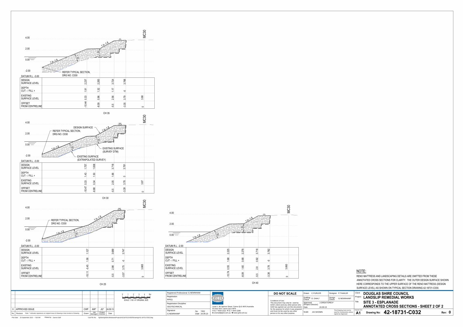
This Drawing must not be
used for Construction unless
signed as Approved
Date
Check
Drafting
DateDrawnRevisionNo
A1
Original Size
Title
Project
Client
Check
DesignerDrawn
Scale
Design
Conditions of Use.
This document may only be used by
GHD's client (and any other person who
GHD has agreed can use this document)
for the purpose for which it was prepared
and must not be used by any other
person or for any other purpose.
DO NOT SCALE
Note: * indicates signatures on original issue of drawing or last revision of drawing
Plot Date: Cad File No:25 September 2015 - 7:58 AM \\ghdnet\ghd\AU\Brisbane\Projects\42\18731\CADD\Drawings\42-18731-C032.dwg
Plotted by:
Darren Dahl
(Project Director)
Approved
Job
Manager
Project
Director
42-18731-C032
0
C.FURLER P.THAKUR
D. DAHL* G.NEWNHAM*
J.GREATOREX*
24.09.15
AS SHOWN
0 1 4 5m32
SCALE 1:100 AT ORIGINAL SIZE
Level 1, 85 Spence Street, Cairns QLD 4870 Australia
PO Box 819, Cairns QLD 4870
T 61 7 4044 2222 F 61 7 4044 2288
E [email protected] W www.ghd.com.au
Registered Professional
Registration
Signature
Date
Registration Discipline
No. 7452
G.NEWNHAM
24.09.15
RPEQ
G.NEWNHAM*
GEOTECHNICAL
-2.00
0.00
2.00
4.00
-2.00
0.00
2.00
4.00
0.00
2.00
4.00
3.865
MC30
0
1 in -1.8
-3%
-5.5
2.98
0.71
3.689
-3.57
3.75
-03.7
47
OFFSET FROM CENTRELINE
EXISTINGSURFACE LEVEL
DEPTHCUT - / FILL +
DESIGNSURFACE LEVEL
DATUM R.L. -3.00
3.87
MC30
0
CH 25
-3%
-5.5
2.05
1.66
3.718
-3.39
3.78
03.7
81
OFFSET FROM CENTRELINE
EXISTINGSURFACE LEVEL
DEPTHCUT - / FILL +
DESIGN
2.00
SURFACE LEVEL
DATUM R.L. -3.00
EXISTING SURFACE(SURVEY DTM)
DESIGN SURFACE
-2.00
0.00
4.00
1.50
1.50
0
CH 30
3.88
MC30
CH 35
-3%
2.56
-5.5
-3.35
1.17
3.724
3.79
-03.7
88
OFFSET FROM CENTRELINE
EXISTINGSURFACE LEVEL
DEPTHCUT - / FILL +
DESIGNSURFACE LEVEL
DATUM R.L. -2.00
DATUM R.L. -3.00
3.893
MC30
0CH 40
-3%
-5.5
2.80.9
23.7
18
-3.38
3.78
-03.7
82
OFFSET FROM CENTRELINE
EXISTINGSURFACE LEVEL
DEPTHCUT - / FILL +
DESIGNSURFACE LEVEL
1.50
1.50
REFER TYPICAL SECTION,DRG NO. C030
REFER TYPICAL SECTION,DRG NO. C030
REFER TYPICAL SECTION,DRG NO. C030
1 in -1.8
1 in -1.8
1 in -1.8
1.50
1.50
1.50
-8.09
1.60
0.68
2.278
-10.7
40.5
51.6
82.2
25
-8.09
0.96
1.32
2.283
-10.4
40.3
31.9
12.2
37
-8.88
0.34
1.50
1.838
-10.4
70.3
31.4
31.7
57
EXISTING SURFACE(EXTRAPOLATED SURVEY)
1 in -1.8
-10.1
1-0
.451.5
81.1
27
1 in -1.8
1 in -1.8
1 in -1.8
NOTE:RENO MATTRESS AND LANDSCAPING DETAILS ARE OMITTED FROM THESEANNOTATED CROSS SECTIONS FOR CLARITY. THE OUTER DESIGN SURFACE SHOWNHERE CORRESPONDS TO THE UPPER SURFACE OF THE RENO MATTRESS (DESIGNSURFACE LEVEL) AS SHOWN ON TYPICAL SECTION DRAWING 42-18731-C030.
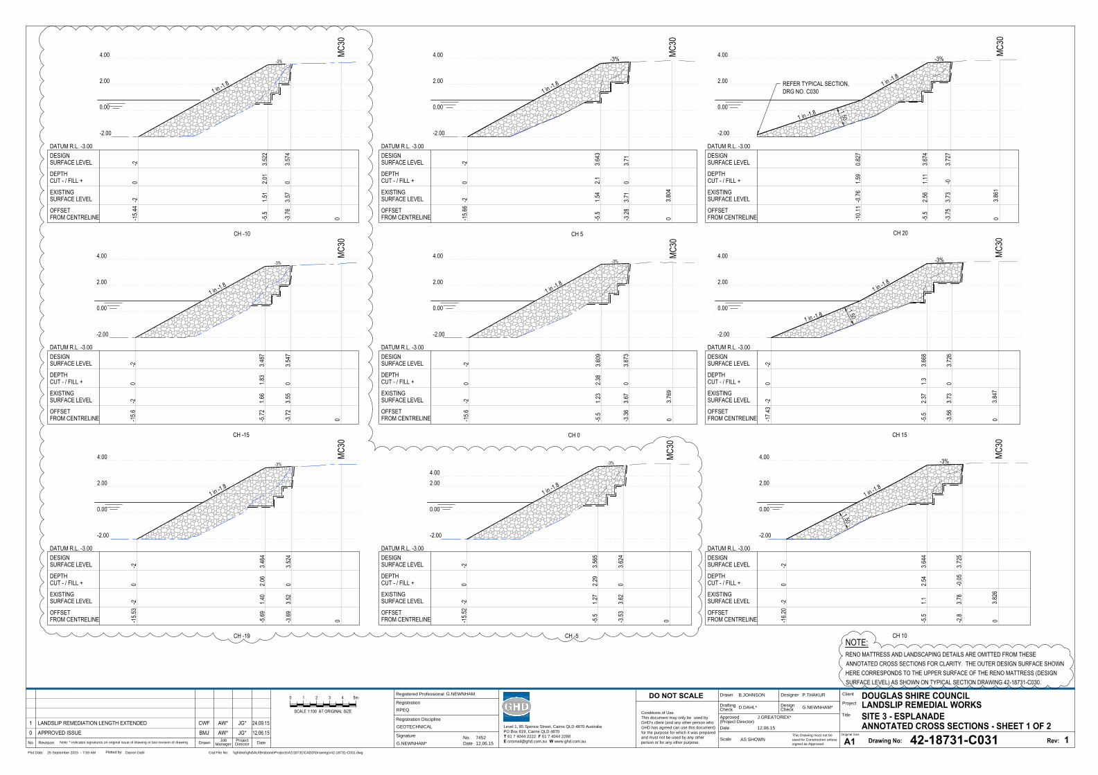
This Drawing must not be
used for Construction unless
signed as Approved
Date
Check
Drafting
DateDrawnRevisionNo
A1
Original Size
Title
Project
Client
Check
DesignerDrawn
Scale
Design
Conditions of Use.
This document may only be used by
GHD's client (and any other person who
GHD has agreed can use this document)
for the purpose for which it was prepared
and must not be used by any other
person or for any other purpose.
DO NOT SCALE
Note: * indicates signatures on original issue of drawing or last revision of drawing
Plot Date: Cad File No:25 September 2015 - 7:59 AM \\ghdnet\ghd\AU\Brisbane\Projects\42\18731\CADD\Drawings\42-18731-C031.dwg
Plotted by:
Darren Dahl
(Project Director)
Approved
Job
Manager
Project
Director
42-18731-C031
1
B.JOHNSON P.THAKUR
D.DAHL* G.NEWNHAM*
J.GREATOREX*
12.06.15
AS SHOWN
0 1 4 5m32
SCALE 1:100 AT ORIGINAL SIZE
3.804
MC30
0
CH 0
1 in -1.8
-3%
-15.6
6-2
0-2
-5.5
1.54
2.13.6
43
-3.28
3.71
03.7
1
OFFSET FROM CENTRELINE
EXISTINGSURFACE LEVEL
DEPTHCUT - / FILL +
DESIGNSURFACE LEVEL
DATUM R.L. -3.00
3.826
MC30
0
CH 5
1 in -1.8
-3%
-16.2
0-2
0-2
-5.5
1.12.5
43.6
44
-2.8
3.78
-0.05
3.725
OFFSET FROM CENTRELINE
EXISTINGSURFACE LEVEL
DEPTHCUT - / FILL +
DESIGNSURFACE LEVEL
DATUM R.L. -3.00
3.847
MC30
0
CH 10
1 in -1.8
-3%
-17.4
3-2
0-2
-5.5
2.37
1.33.6
68
-3.56
3.73
03.7
26
OFFSET FROM CENTRELINE
EXISTINGSURFACE LEVEL
DEPTHCUT - / FILL +
DESIGNSURFACE LEVEL
DATUM R.L. -3.00
3.861
MC30
0
CH 15
1 in -1.8
-3%
-5.5
2.56
1.11
3.674
-3.75
3.73
-03.7
27
OFFSET FROM CENTRELINE
EXISTINGSURFACE LEVEL
DEPTHCUT - / FILL +
DESIGNSURFACE LEVEL
DATUM R.L. -3.00
CH 20
-2.00
0.00
2.00
4.00
-2.00
0.00
2.00
4.00
-2.00
0.00
2.00
4.00
-2.00
0.00
2.00
4.00
1.501.50
EXISTING
1.50
MC30
3.769
0
1 in -1.8
-3%
-15.6
-20
-2
-5.5
1.23
2.38
3.609
-3.36
3.67
03.6
73
OFFSET FROM CENTRELINE
CUT - / FILL +
SURFACE LEVEL
DEPTH
DESIGNSURFACE LEVEL
DATUM R.L. -3.00
4.00
2.00
0.00
-2.00
REFER TYPICAL SECTION,DRG NO. C030
Level 1, 85 Spence Street, Cairns QLD 4870 Australia
PO Box 819, Cairns QLD 4870
T 61 7 4044 2222 F 61 7 4044 2288
E [email protected] W www.ghd.com.au
Registered Professional
Registration
Signature
Date
Registration Discipline
No. 7452
G.NEWNHAM
12.06.15
RPEQ
G.NEWNHAM*
GEOTECHNICAL
-10.1
1-0
.761.5
90.8
27
1 in -1.8
1 in -1.8
0
CH -19
-3%
-15.5
30
-2
-5.69
2.06
3.464
-3.69
03.5
24
OFFSET FROM CENTRELINE
DEPTHCUT - / FILL +
DESIGNSURFACE LEVEL
DATUM R.L. -3.00
CH -15
-3%
-15.6
0-2
-5.72
1.83
3.487
-3.72
03.5
47
OFFSET FROM CENTRELINE
DEPTHCUT - / FILL +
DESIGNSURFACE LEVEL
DATUM R.L. -3.00
CH -10
-3%
-15.4
40
-2
-5.5
2.01
3.522
-3.76
03.5
74
OFFSET FROM CENTRELINE
DEPTHCUT - / FILL +
DESIGNSURFACE LEVEL
DATUM R.L. -3.00
MC30
0
CH -5
-3%-1
5.52
-2
-5.5
1.27
3.565
-3.53
3.62
3.624
OFFSET FROM CENTRELINE
DEPTHCUT - / FILL +
DESIGNSURFACE LEVEL
DATUM R.L. -3.00
1 in -1.8
4.00
2.00
0.00
-2.00
1 in -1.8
4.00
2.00
0.00
-2.00
1 in -1.8
4.00
2.00
0.00
-2.00
1 in -1.8
4.00 2.00
0.00
-2.00
EXISTINGSURFACE LEVEL
EXISTINGSURFACE LEVEL
EXISTINGSURFACE LEVEL
EXISTINGSURFACE LEVEL
MC30
0MC
300
MC30
02.29
0-2-2
-2-2
1.40
3.52
1.66
3.55
1.51
3.57
NOTE:RENO MATTRESS AND LANDSCAPING DETAILS ARE OMITTED FROM THESEANNOTATED CROSS SECTIONS FOR CLARITY. THE OUTER DESIGN SURFACE SHOWNHERE CORRESPONDS TO THE UPPER SURFACE OF THE RENO MATTRESS (DESIGNSURFACE LEVEL) AS SHOWN ON TYPICAL SECTION DRAWING 42-18731-C030.
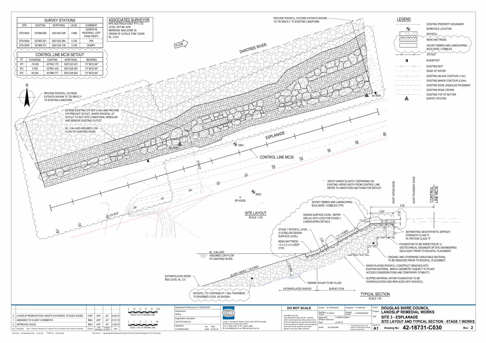
SW
SWSW| |
| || |
| || |
| || |
| || | | |
||
|
|
||
||
||
| || |
| || |
| || |
| || |
| || |
| || |
| |
||
||
||
||
||
||
||
||
||
||
||
||
|
|
||
| || |
| |
|
||
||
ESPLANADE
DAINTREE RIVER
8SP143026
Stn 9300EB01
EB02
Stn 9004
375 RCP
375 RCP
0.0
1.0
2.0
3.0
0.0
1.0
2.0
3.0
0
25
10
20
5
15
SW
40
35
30
-5
-10
-15
-19
N
SITE LAYOUTSCALE 1:100
PROVIDE ROCKFILL OUTSIDEEXTENTS SHOWN TO TIE NEATLYTO EXISTING LANDFORM
PROVIDE ROCKFILL OUTSIDE EXTENTS SHOWNTO TIE NEATLY TO EXISTING LANDFORM
CONTROL LINE MC30
EXTEND EXISTING 375 RCP 2.44m AND PROVIDE375 PRECAST OUTLET. SHAPE ROCKFILL ATOUTLET TO SUIT SITE CONDITIONS. DEMOLISHAND REMOVE EXISTING OUTLET.
RL. 0.8m AHD ASSUMED LOWFLOW OF DAINTREE RIVER
CONT
ROL
LINE
MC30
1 in 1.8 MAX
2.00*
EXIS
T PA
VEME
NT E
DGE
* WIDTH VARIES SLIGHTLY DEPENDING ONEXISTING VERGE WIDTH FROM CONTROL LINE.REFER TO ANNOTATED SECTIONS FOR SETOUT.
EXIS
T VE
RGE
EDGE
EXTRAPOLATED SURVEY SURVEY DTM
TYPICAL SECTIONSCALE 1:50
5.50
EXTRAPOLATED RIVERBED LEVEL RL.-2.0
RL. 0.8m AHDASSUMED LOW FLOWOF DAINTREE RIVER
SLOPE VARIES, 1 IN 8 MAX
1.50 MIN
ROCKFILL TO CONTINUE AT 1.50m THICKNESSTO RIVERBED LEVEL AS SHOWN
1.50
SEPARATING GEOSYNTHETIC (MTRS27)STRENGTH CLASS 'E'FILTRATION CLASS "II"
ORGANIC AND OTHERWISE UNSUITABLE MATERIALTO BE REMOVED PRIOR TO ROCKFILL PLACEMENT
WHEN PLACING ROCKFILL CONSTRUCT BENCHES INTOEXISTING MATERIAL. BENCH GEOMETRY SUBJECT TO PLANTACCESS CONSIDERATIONS AND TEMPORARY STABILITY.
FOUNDATION TO BE INSPECTED BY AGEOTECHNICAL ENGINEER OR SITE ENGINEERINGGEOLOGIST PRIOR TO ROCKFILL PLACEMENT
SLIPPED MATERIAL WITHIN FOUNDATION TO BEOVEREXCAVATED AND REPLACED WITH ROCKFILL.MARINE SCOUR TO BE FILLED
STAGE 1 ROCKFILL LEVEL(0.30 BELOW DESIGNSURFACE LEVEL)
DESIGN SURFACE LEVEL. REFERDRG 42-18731-C033 FOR STAGE 2LANDSCAPING DETAILS
0.30
WOODY DEBRIS AND LANDSCAPINGBOULDERS / COBBLES (TYP)
0.30
RENO MATTRESS1.0 x 2.0 x 0.3 DEEP(TYP)
This Drawing must not be
used for Construction unless
signed as Approved
Date
Check
Drafting
DateDrawnRevisionNo
A1
Original Size
Title
Project
Client
Check
DesignerDrawn
Scale
Design
Conditions of Use.
This document may only be used by
GHD's client (and any other person who
GHD has agreed can use this document)
for the purpose for which it was prepared
and must not be used by any other
person or for any other purpose.
DO NOT SCALE
Note: * indicates signatures on original issue of drawing or last revision of drawing
Plot Date: Cad File No:23 September 2015 - 11:02 AM \\ghdnet\ghd\AU\Brisbane\Projects\42\18731\CADD\Drawings\42-18731-C030.dwg
Plotted by:
Darren Dahl
(Project Director)
Approved
Job
Manager
Project
Director
42-18731-C030
2
B.JOHNSON P.THAKUR
D.DAHL* G.NEWNHAM*
J.GREATOREX*
12.06.15
AS SHOWN
275
CONTROL LINE MC30 SETOUTPT CHAINAGE EASTING NORTHING BEARINGIP1 -19.000 327943.175 8201323.001IP2 0.000 327961.403 8201328.363IP3 40.000 327999.777 8201339.653
ASSOCIATED SURVEYORRPS AUSTRALIA EAST PTY LTDLEVEL DATUM: AHDMERIDIAN: MGA ZONE 55ORIGIN OF LEVELS: PSM 123249RL: 2.070
SURVEY STATIONSSTN EASTING NORTHING LEVEL COMMENT
STN 9003 327888.985 8201302.008 3.895SCREW IN
HEADWALL (OFFPAGE WEST)
STN 9004 327997.821 8201342.584 3.105 PINSTN 9300 327965.531 8201334.128 3.729 DUMPY
0
SCALE 1:50 AT ORIGINAL SIZE
0.5 2.0 2.5m1.51.0
0 1 4 5m32
SCALE 1:100 AT ORIGINAL SIZE
Level 1, 85 Spence Street, Cairns QLD 4870 Australia
PO Box 819, Cairns QLD 4870
T 61 7 4044 2222 F 61 7 4044 2288
E [email protected] W www.ghd.com.au
Registered Professional
Registration
Signature
Date
Registration Discipline
No. 7452
G.NEWNHAM
12.06.15
RPEQ
G.NEWNHAM*
GEOTECHNICAL
EXISTING PROPERTY BOUNDARYLEGEND
BOREHOLE LOCATION
ROCKFILL
EDGE OF WATER
SW SW 375 RCP
SW SW EXISTING RCP
GUIDEPOST
| | | |
EXISTING MAJOR CONTOUR (1.0m)EXISTING MINOR CONTOUR (0.25m)EXISTING EDGE UNSEALED PAVEMENTEXISTING ROAD CROWNEXISTING TOP OF BATTERSURVEY STATION
2.0
RENO MATTRESS
WOODY DEBRIS AND LANDSCAPINGBOULDERS / COBBLES
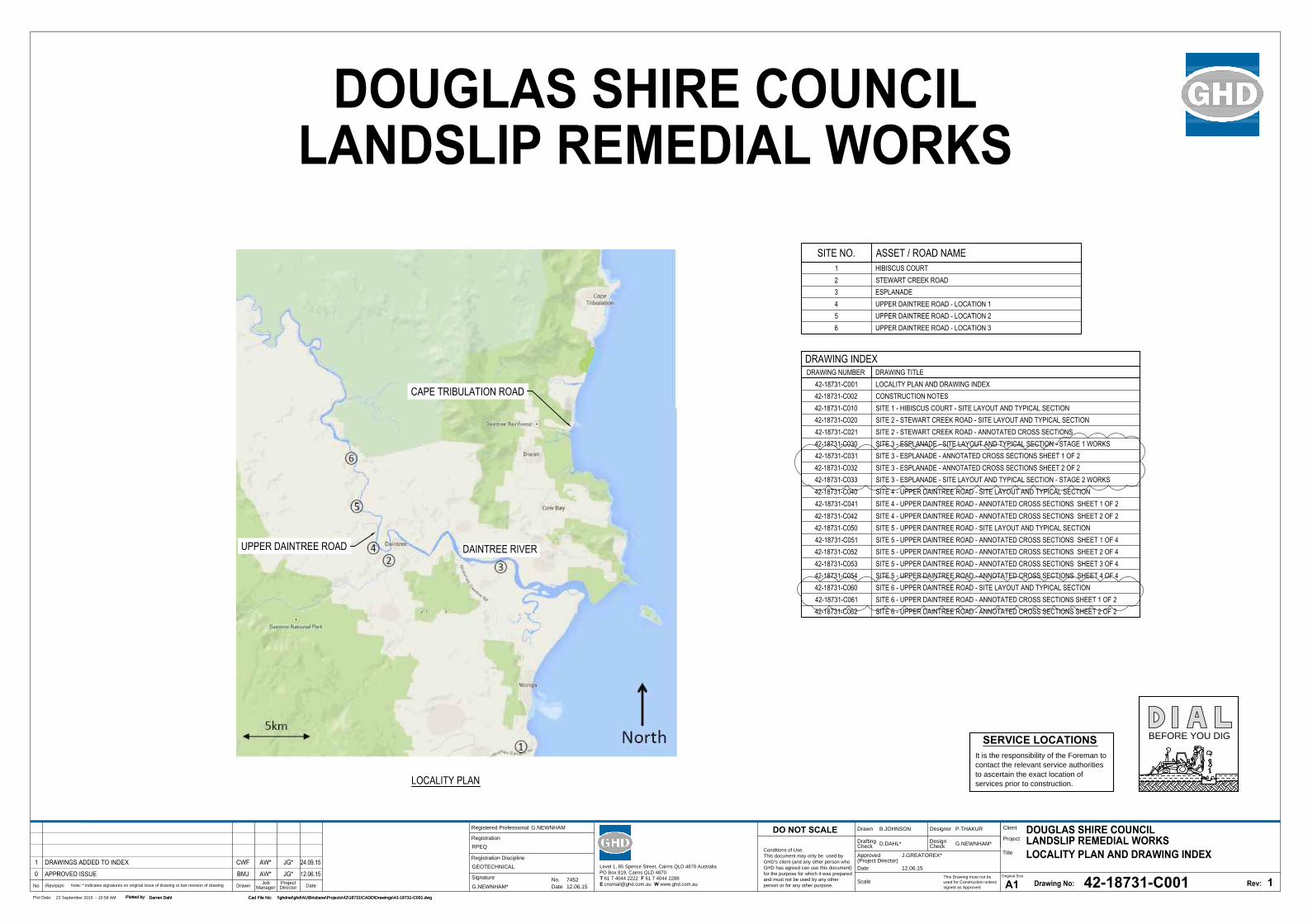
Registered Professional
Registration
Signature
Date
Registration Discipline
No. 7452
G.NEWNHAM
12.06.15
RPEQ
G.NEWNHAM*
GEOTECHNICAL
This Drawing must not be
used for Construction unless
signed as Approved
Date
Check
Drafting
DateDrawnRevisionNo
A1
Original Size
Title
Project
Client
Check
DesignerDrawn
Scale
Design
Conditions of Use.
This document may only be used by
GHD's client (and any other person who
GHD has agreed can use this document)
for the purpose for which it was prepared
and must not be used by any other
person or for any other purpose.
DO NOT SCALE
Note: * indicates signatures on original issue of drawing or last revision of drawing
Plot Date: Cad File No:23 September 2015 - 10:58 AM \\ghdnet\ghd\AU\Brisbane\Projects\42\18731\CADD\Drawings\42-18731-C001.dwg
Plotted by:
Darren Dahl
(Project Director)
Approved
Job
Manager
Project
Director
42-18731-C001
1
B.JOHNSON P.THAKUR
D.DAHL* G.NEWNHAM*
J.GREATOREX*
12.06.15
DRAWING INDEXDRAWING NUMBER DRAWING TITLE
42-18731-C001 LOCALITY PLAN AND DRAWING INDEX42-18731-C002 CONSTRUCTION NOTES42-18731-C010 SITE 1 - HIBISCUS COURT - SITE LAYOUT AND TYPICAL SECTION42-18731-C020 SITE 2 - STEWART CREEK ROAD - SITE LAYOUT AND TYPICAL SECTION42-18731-C021 SITE 2 - STEWART CREEK ROAD - ANNOTATED CROSS SECTIONS42-18731-C030 SITE 3 - ESPLANADE - SITE LAYOUT AND TYPICAL SECTION - STAGE 1 WORKS42-18731-C031 SITE 3 - ESPLANADE - ANNOTATED CROSS SECTIONS SHEET 1 OF 242-18731-C032 SITE 3 - ESPLANADE - ANNOTATED CROSS SECTIONS SHEET 2 OF 242-18731-C033 SITE 3 - ESPLANADE - SITE LAYOUT AND TYPICAL SECTION - STAGE 2 WORKS42-18731-C040 SITE 4 - UPPER DAINTREE ROAD - SITE LAYOUT AND TYPICAL SECTION42-18731-C041 SITE 4 - UPPER DAINTREE ROAD - ANNOTATED CROSS SECTIONS SHEET 1 OF 242-18731-C042 SITE 4 - UPPER DAINTREE ROAD - ANNOTATED CROSS SECTIONS SHEET 2 OF 242-18731-C050 SITE 5 - UPPER DAINTREE ROAD - SITE LAYOUT AND TYPICAL SECTION42-18731-C051 SITE 5 - UPPER DAINTREE ROAD - ANNOTATED CROSS SECTIONS SHEET 1 OF 442-18731-C052 SITE 5 - UPPER DAINTREE ROAD - ANNOTATED CROSS SECTIONS SHEET 2 OF 442-18731-C053 SITE 5 - UPPER DAINTREE ROAD - ANNOTATED CROSS SECTIONS SHEET 3 OF 442-18731-C054 SITE 5 - UPPER DAINTREE ROAD - ANNOTATED CROSS SECTIONS SHEET 4 OF 442-18731-C060 SITE 6 - UPPER DAINTREE ROAD - SITE LAYOUT AND TYPICAL SECTION42-18731-C061 SITE 6 - UPPER DAINTREE ROAD - ANNOTATED CROSS SECTIONS SHEET 1 OF 242-18731-C062 SITE 6 - UPPER DAINTREE ROAD - ANNOTATED CROSS SECTIONS SHEET 2 OF 2
LOCALITY PLAN
SERVICE LOCATIONS
It is the responsibility of the Foreman to
contact the relevant service authorities
to ascertain the exact location of
services prior to construction.
BEFORE YOU DIG
Cad File No: \\ghdnet\ghd\AU\Brisbane\Projects\42\18731\CADD\Drawings\42-18731-C001.dwg
Plotted by:
Darren Dahl
SITE NO. ASSET / ROAD NAME1 HIBISCUS COURT2 STEWART CREEK ROAD3 ESPLANADE4 UPPER DAINTREE ROAD - LOCATION 15 UPPER DAINTREE ROAD - LOCATION 26 UPPER DAINTREE ROAD - LOCATION 3
UPPER DAINTREE ROAD
CAPE TRIBULATION ROAD
DAINTREE RIVER
Level 1, 85 Spence Street, Cairns QLD 4870 Australia
PO Box 819, Cairns QLD 4870
T 61 7 4044 2222 F 61 7 4044 2288
E [email protected] W www.ghd.com.au
GHD | Report for Douglas Shire Council - NDRRA , 42/18731 | 33
Appendix B – Protected Plants Flora Survey Report
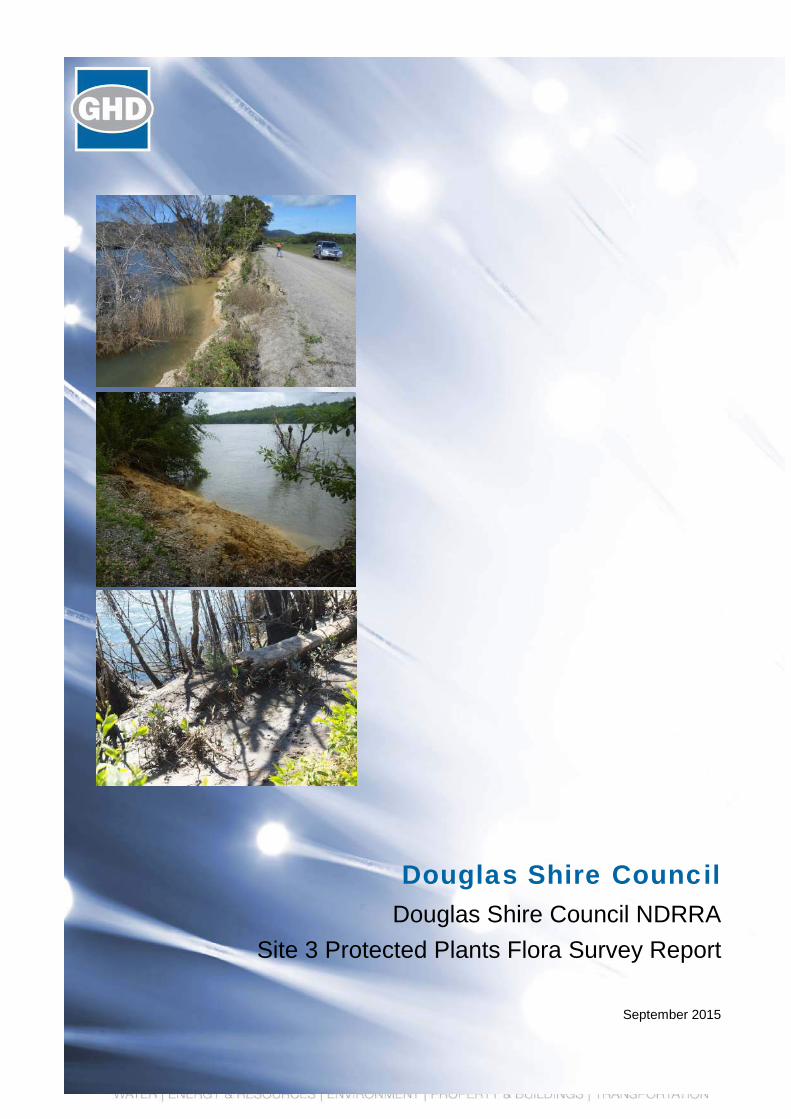
Douglas Shire Council Douglas Shire Council NDRRA
Site 3 Protected Plants Flora Survey Report
September 2015
GHD | Report for Douglas Shire Council - Douglas Shire Council NDRRA, 42/18731 | i
Table of contents 1. Introduction..................................................................................................................................... 1
1.1 Background and Project Description ................................................................................... 1
1.2 Purpose of this report........................................................................................................... 1
1.3 Project Location and Proposed Development ..................................................................... 2
2. Methodology ................................................................................................................................... 4
2.1 Desktop Assessment ........................................................................................................... 4
2.2 Survey Methodology .......................................................................................................... 10
2.3 Field Survey Team ............................................................................................................. 11
3. Survey Results ............................................................................................................................. 13
3.1 EVNT Species .................................................................................................................... 13
3.2 Description of Supporting Habitat ...................................................................................... 13
4. Impact Management Plan ............................................................................................................ 14
4.1 Purpose of the Impact Management Plan ......................................................................... 14
4.2 Avoid and Minimise Impact ................................................................................................ 14
4.3 Nature of Impact ................................................................................................................ 14
4.4 Management of Impact ...................................................................................................... 14
4.5 Justification of Proposed Management of Impacts ............................................................ 15
4.6 Survival of the Plant in the Wild ......................................................................................... 15
5. Conclusion.................................................................................................................................... 16
Table index Table 1 Database Search Results .................................................................................................... 8
Figure index
Figure 1 NDRRA Site 3, McDowall lane ............................................................................................ 1
Figure 2 Clearing Impact Area and site works area ........................................................................... 3
Figure 3 High Risk Flora Survey Trigger Mapping ............................................................................. 5
Figure 4 Regulated Vegetation Management Mapping ..................................................................... 6
Figure 5 Regional Ecosystem and Essential Habitat Mapping .......................................................... 7
Figure 6 Supporting Habitat and Survey Locations ......................................................................... 12

ii | GHD | Report for Douglas Shire Council - Douglas Shire Council NDRRA, 42/18731
Appendices Appendix A – Site Layout Drawing
Appendix B – Database Search Results
Appendix C - Curriculum Vitae
Appendix D – Field Survey Flora Species List
Appendix E – Site Reference Photographs
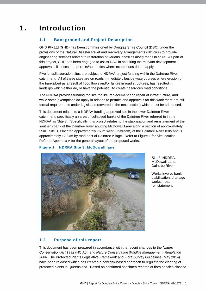
GHD | Report for Douglas Shire Council - Douglas Shire Council NDRRA, 42/18731 | 1
1. Introduction 1.1 Background and Project Description
GHD Pty Ltd (GHD) has been commissioned by Douglas Shire Council (DSC) under the
provisions of the Natural Disaster Relief and Recovery Arrangements (NDRRA) to provide
engineering services related to restoration of various landslips along roads in shire. As part of
this project, GHD has been engaged to assist DSC in acquiring the relevant development
approvals, licences and permits/authorities where exemptions do not apply.
Five landslips/erosion sites are subject to NDRAA project funding within the Daintree River
catchment. All of these sites are on roads immediately beside watercourses where erosion of
the banks/bed as a result of flood flows and/or failure in road structures, has resulted in
landslips which either do, or have the potential, to create hazardous road conditions.
The NDRAA provides funding for ‘like for like’ replacement and repair of infrastructure, and
while some exemptions do apply in relation to permits and approvals for this work there are still
formal requirements under legislation (covered in the next section) which must be addressed.
This document relates to a NDRAA funding approved site in the lower Daintree River
catchment, specifically an area of collapsed banks of the Daintree River referred to in the
NDRAA as ‘Site 3’. Specifically, this project relates to the stabilisation and reinstatement of the
southern bank of the Daintree River abutting McDowall Lane along a section of approximately
55m. Site 3 is located approximately 760m west (upstream) of the Daintree River ferry and is
approximately 12.3km by road east of Daintree village. Refer to Figure 1 for Site location.
Refer to Appendix A for the general layout of the proposed works.
Figure 1 NDRRA Site 3, McDowall lane
Site 3: NDRRA, McDowall Lane, Daintree River Works involve bank stabilisation, drainage works, road reinstatement
1.2 Purpose of this report
This document has been prepared in accordance with the recent changes to the Nature
Conservation Act 1992 (NC Act) and Nature Conservation (Wildlife Management) Regulation
2006. The Protected Plants Legislative Framework and Flora Survey Guidelines (May 2014)
have been released which has created a new risk-based approach to regulate the clearing of
protected plants in Queensland. Based on confirmed specimen records of flora species classed
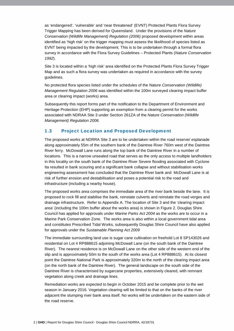
2 | GHD | Report for Douglas Shire Council - Douglas Shire Council NDRRA, 42/18731
as ‘endangered’, ‘vulnerable’ and ‘near threatened’ (EVNT) Protected Plants Flora Survey
Trigger Mapping has been derived for Queensland. Under the provisions of the Nature
Conservation (Wildlife Management) Regulation (2006) proposed development within areas
identified as ‘high risk’ on the trigger mapping must assess the likelihood of species listed as
EVNT being impacted by the development. This is to be undertaken through a formal flora
survey in accordance with the Flora Survey Guidelines – Protected Plants (Nature Conservation
1992).
Site 3 is located within a ‘high risk’ area identified on the Protected Plants Flora Survey Trigger
Map and as such a flora survey was undertaken as required in accordance with the survey
guidelines.
No protected flora species listed under the schedules of the Nature Conservation (Wildlife)
Management Regulation 2006 was identified within the 100m surveyed clearing impact buffer
area or clearing impact (works) area.
Subsequently this report forms part of the notification to the Department of Environment and
Heritage Protection (EHP) supporting an exemption from a clearing permit for the works associated with NDRAA Site 3 under Section 261ZA of the Nature Conservation (Wildlife
Management) Regulation 2006.
1.3 Project Location and Proposed Development
The proposed works at NDRRA Site 3 are to be undertaken within the road reserve/ esplanade
along approximately 55m of the southern bank of the Daintree River 760m west of the Daintree
River ferry. McDowall Lane runs along the top bank of the Daintree River in a number of
locations. This is a narrow unsealed road that serves as the only access to multiple landholders
in this locality on the south bank of the Daintree River Severe flooding associated with Cyclone
Ita resulted in bank scouring and a significant bank collapse and without stabilisation works
engineering assessment has concluded that the Daintree River bank and McDowall Lane is at
risk of further erosion and destabilisation and poses a potential risk to the road and
infrastructure (including a nearby house).
The proposed works area comprises the immediate area of the river bank beside the lane. It is
proposed to rock fill and stabilise the bank, reinstate culverts and reinstate the road verges and
drainage infrastructure. Refer to Appendix A. The location of Site 3 and the ‘clearing impact
area’ (including the 100m buffer about the works area) is shown in Figure 2. Douglas Shire
Council has applied for approvals under Marine Parks Act 2004 as the works are to occur in a
Marine Park Conservation Zone. The works area is also within a local government tidal area
and constitutes Prescribed Tidal Works, subsequently Douglas Shire Council have also applied
for approvals under the Sustainable Planning Act 2009
The immediate surrounding land use is sugar cane cultivation on freehold Lot 8 SP143026 and
residential on Lot 4 RP888615 adjoining McDowall Lane (on the south bank of the Daintree
River). The nearest residence is on McDowall Lane on the other side of the western end of the
slip and is approximately 50m to the south of the works area (Lot 4 RP888615). At its closest
point the Daintree National Park is approximately 320m to the north of the clearing impact area
(on the north bank of the Daintree River). The general landscape on the south side of the
Daintree River is characterised by sugarcane properties, extensively cleared, with remnant
vegetation along creek and drainage lines.
Remediation works are expected to begin in October 2015 and be complete prior to the wet
season in January 2016. Vegetation clearing will be limited to that on the banks of the river
adjacent the slumping river bank area itself. No works will be undertaken on the eastern side of
the road reserve.
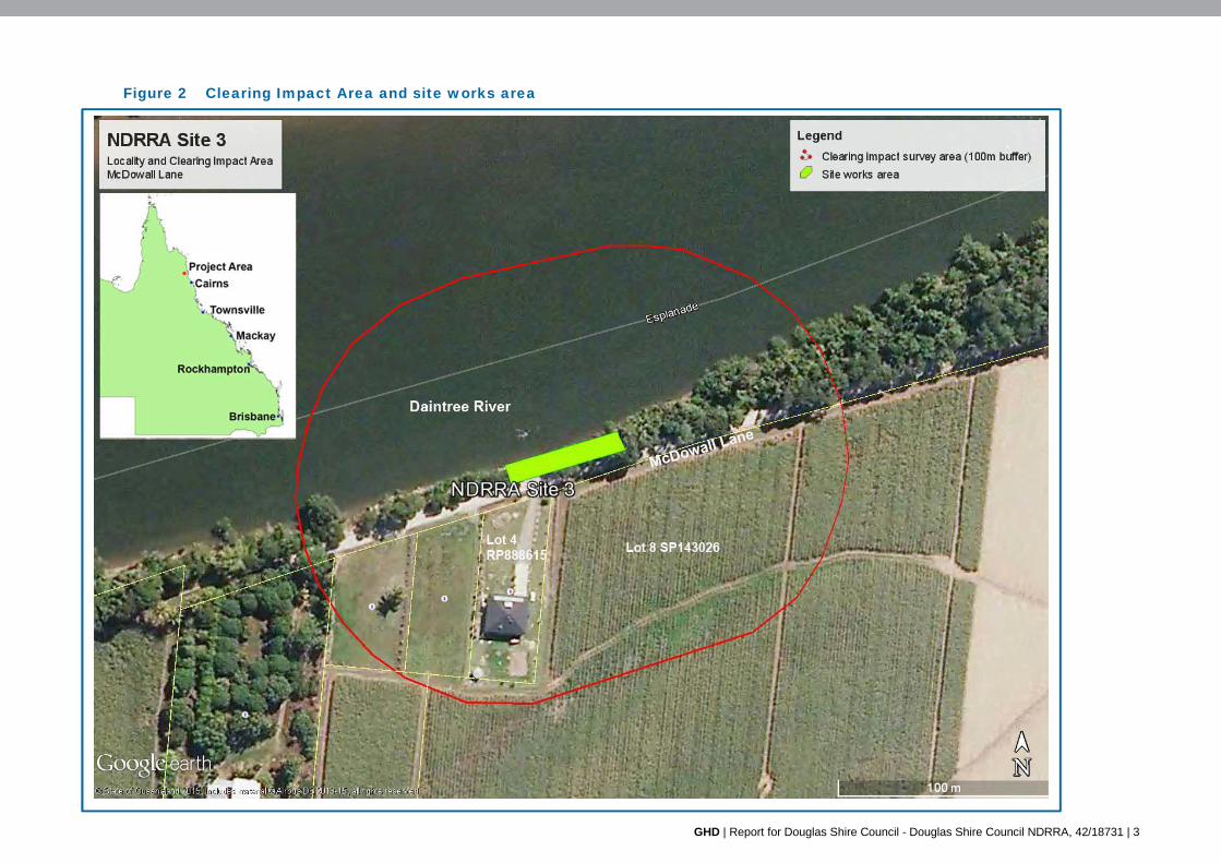
GHD | Report for Douglas Shire Council - Douglas Shire Council NDRRA, 42/18731 | 3
Figure 2 Clearing Impact Area and site works area
4 | GHD | Report for Douglas Shire Council - Douglas Shire Council NDRRA, 42/18731
2. Methodology 2.1 Desktop Assessment
A desktop assessment was undertaken to support the flora field survey. This included reviews
of a number of databases including:
HERBREC: Queensland Herbarium database, which provides actual locational
information for flora species.
Wildlife Online: a buffer of 5km about the site was undertaken to capture representative
habitats in the locality (https://environment.ehp.qld.gov.au/report-request/species-list/).
Regulated vegetation management mapping
(http://www.qld.gov.au/environment/land/vegetation/map-request/).
Queensland Globe and Category Globes including biota, boundaries, environment.
The relevant results are discussed below.
2.1.1 Protected Plants Trigger Mapping
A review of the Department of Environment and Heritage Protection (EHP) Protected Plants
Flora Survey trigger maps identifies NDRRA Site 3 as being located in a “High Risk Area” for
protected plants under the Nature Conservation Act 1992 (NC Act). Subsequently a field flora
survey was required in accordance with the EHP’s “Flora Survey Guidelines – Protected Plants”
to determine if any species listed as Endangered, Vulnerable, or Near Threatened (EVNT) are
present within the works area and the ‘clearing impact area’ including the required 100 m buffer
about the development site. The flora survey area with respect to the High Risk Mapping
trigger area is shown in Figure 3.
2.1.2 Regulated Vegetation Mapping
The review of the Regulated Vegetation Management Mapping (Figure 4) identifies Site 3 as
including reef-regrowth watercourse vegetation (Category R), remnant vegetation (Category B),
and non-regulated vegetation (Category X). The entirety of the actual works area is within
Category B.
2.1.3 Supporting Vegetation Management Regional Ecosystem Mapping
The certified RE mapping (Figure 5) identifies approximately two thirds of the impact clearing
area mapped as ‘of concern’ RE 7.1.4a. This area of RE within the clearing impact area is
within mapped essential habitat (southern cassowary- Figure 5).
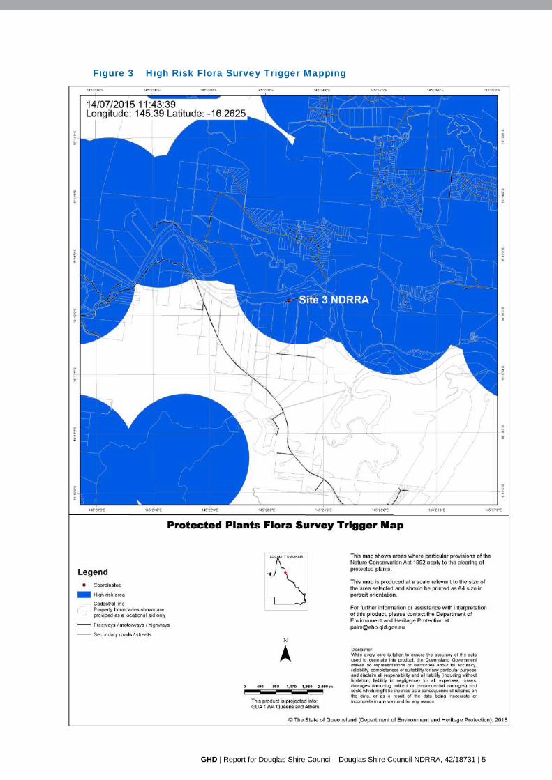
GHD | Report for Douglas Shire Council - Douglas Shire Council NDRRA, 42/18731 | 5
Figure 3 High Risk Flora Survey Trigger Mapping
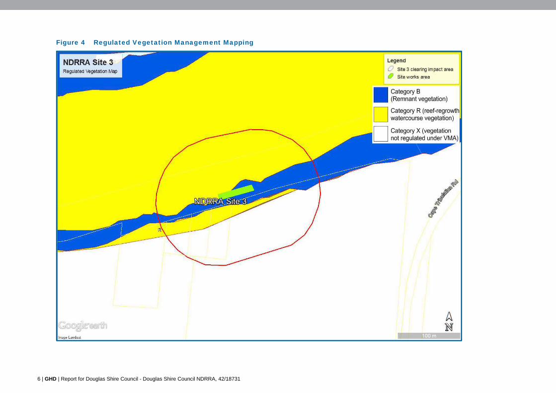
6 | GHD | Report for Douglas Shire Council - Douglas Shire Council NDRRA, 42/18731
Figure 4 Regulated Vegetation Management Mapping
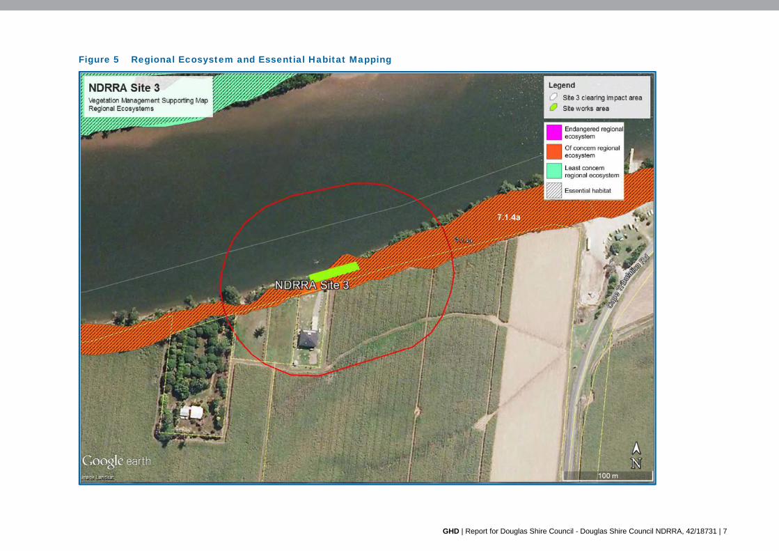
GHD | Report for Douglas Shire Council - Douglas Shire Council NDRRA, 42/18731 | 7
Figure 5 Regional Ecosystem and Essential Habitat Mapping
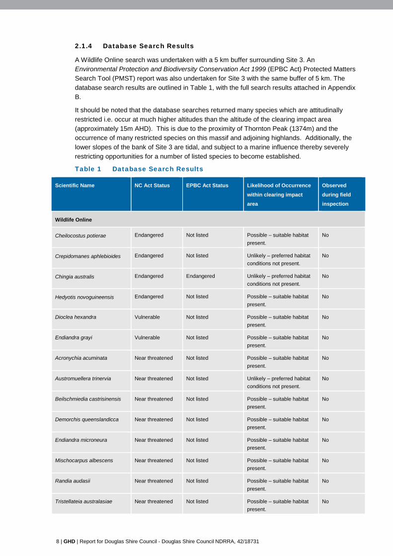
8 | GHD | Report for Douglas Shire Council - Douglas Shire Council NDRRA, 42/18731
2.1.4 Database Search Results
A Wildlife Online search was undertaken with a 5 km buffer surrounding Site 3. An
Environmental Protection and Biodiversity Conservation Act 1999 (EPBC Act) Protected Matters
Search Tool (PMST) report was also undertaken for Site 3 with the same buffer of 5 km. The
database search results are outlined in Table 1, with the full search results attached in Appendix
B.
It should be noted that the database searches returned many species which are attitudinally
restricted i.e. occur at much higher altitudes than the altitude of the clearing impact area
(approximately 15m AHD). This is due to the proximity of Thornton Peak (1374m) and the
occurrence of many restricted species on this massif and adjoining highlands. Additionally, the
lower slopes of the bank of Site 3 are tidal, and subject to a marine influence thereby severely
restricting opportunities for a number of listed species to become established.
Table 1 Database Search Results
Scientific Name NC Act Status EPBC Act Status Likelihood of Occurrence
within clearing impact
area
Observed
during field
inspection
Wildlife Online
Cheilocostus potierae Endangered Not listed Possible – suitable habitat
present.
No
Crepidomanes aphlebioides Endangered Not listed Unlikely – preferred habitat
conditions not present.
No
Chingia australis Endangered Endangered Unlikely – preferred habitat
conditions not present.
No
Hedyotis novoguineensis Endangered Not listed Possible – suitable habitat
present.
No
Dioclea hexandra Vulnerable Not listed Possible – suitable habitat
present.
No
Endiandra grayi Vulnerable Not listed Possible – suitable habitat
present.
No
Acronychia acuminata Near threatened Not listed Possible – suitable habitat
present.
No
Austromuellera trinervia Near threatened Not listed Unlikely – preferred habitat
conditions not present.
No
Beilschmiedia castrisinensis Near threatened Not listed Possible – suitable habitat
present.
No
Demorchis queenslandicca Near threatened Not listed Possible – suitable habitat
present.
No
Endiandra microneura Near threatened Not listed Possible – suitable habitat
present.
No
Mischocarpus albescens Near threatened Not listed Possible – suitable habitat
present.
No
Randia audasii Near threatened Not listed Possible – suitable habitat
present.
No
Tristellateia australasiae Near threatened Not listed Possible – suitable habitat
present.
No
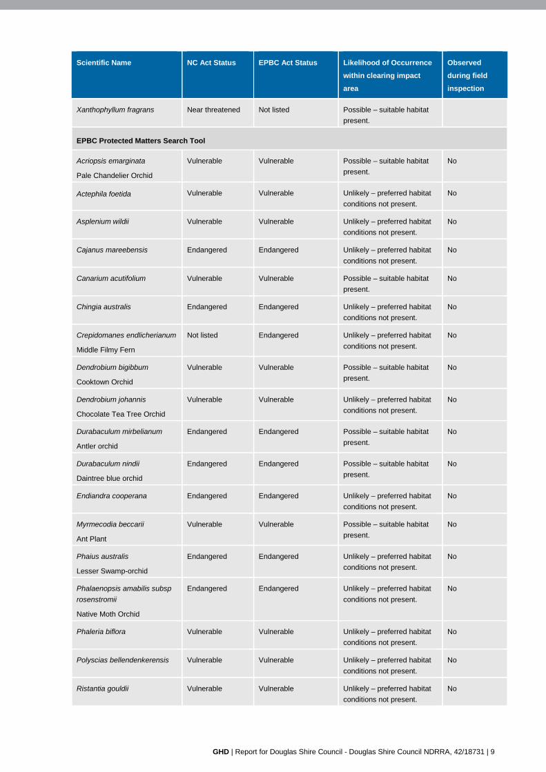
GHD | Report for Douglas Shire Council - Douglas Shire Council NDRRA, 42/18731 | 9
Scientific Name NC Act Status EPBC Act Status Likelihood of Occurrence
within clearing impact
area
Observed
during field
inspection
Xanthophyllum fragrans Near threatened Not listed Possible – suitable habitat
present.
EPBC Protected Matters Search Tool
Acriopsis emarginata
Pale Chandelier Orchid
Vulnerable Vulnerable Possible – suitable habitat
present.
No
Actephila foetida Vulnerable Vulnerable Unlikely – preferred habitat
conditions not present.
No
Asplenium wildii Vulnerable Vulnerable Unlikely – preferred habitat
conditions not present.
No
Cajanus mareebensis Endangered Endangered Unlikely – preferred habitat
conditions not present.
No
Canarium acutifolium Vulnerable Vulnerable Possible – suitable habitat
present.
No
Chingia australis Endangered Endangered Unlikely – preferred habitat
conditions not present.
No
Crepidomanes endlicherianum
Middle Filmy Fern
Not listed Endangered Unlikely – preferred habitat
conditions not present.
No
Dendrobium bigibbum
Cooktown Orchid
Vulnerable Vulnerable Possible – suitable habitat
present.
No
Dendrobium johannis
Chocolate Tea Tree Orchid
Vulnerable Vulnerable Unlikely – preferred habitat
conditions not present.
No
Durabaculum mirbelianum
Antler orchid
Endangered Endangered Possible – suitable habitat
present.
No
Durabaculum nindii
Daintree blue orchid
Endangered Endangered Possible – suitable habitat
present.
No
Endiandra cooperana Endangered Endangered Unlikely – preferred habitat
conditions not present.
No
Myrmecodia beccarii
Ant Plant
Vulnerable Vulnerable Possible – suitable habitat
present.
No
Phaius australis
Lesser Swamp-orchid
Endangered Endangered Unlikely – preferred habitat
conditions not present.
No
Phalaenopsis amabilis subsp
rosenstromii
Native Moth Orchid
Endangered Endangered Unlikely – preferred habitat
conditions not present.
No
Phaleria biflora Vulnerable Vulnerable Unlikely – preferred habitat
conditions not present.
No
Polyscias bellendenkerensis Vulnerable Vulnerable Unlikely – preferred habitat
conditions not present.
No
Ristantia gouldii Vulnerable Vulnerable Unlikely – preferred habitat
conditions not present.
No
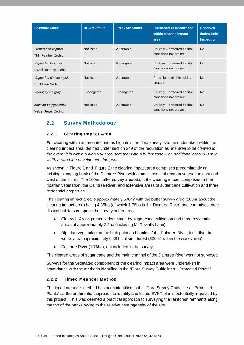
10 | GHD | Report for Douglas Shire Council - Douglas Shire Council NDRRA, 42/18731
Scientific Name NC Act Status EPBC Act Status Likelihood of Occurrence
within clearing impact
area
Observed
during field
inspection
Tropilis callitrophilis
Thin Feather Orchid
Not listed Vulnerable Unlikely – preferred habitat
conditions not present.
No
Vappodes lithocola
Dwarf Butterfly Orchid,
Not listed Endangered Unlikely – preferred habitat
conditions not present.
No
Vappodes phalaenopsis
Cooktown Orchid
Not listed Vulnerable Possible – suitable habitat
present.
No
Vrydagzynea grayi Endangered Endangered Unlikely – preferred habitat
conditions not present.
No
Zeuxine polygonoides
Velvet Jewel Orchid
Not listed Vulnerable Unlikely – preferred habitat
conditions not present.
No
2.2 Survey Methodology
2.2.1 Clearing Impact Area
For clearing within an area defined as high risk, the flora survey is to be undertaken within the
clearing impact area, defined under section 249 of the regulation as ‘the area to be cleared to
the extent it is within a high risk area, together with a buffer zone – an additional area 100 m in
width around the development footprint’.
As shown in Figure 1 and Figure 2 the clearing impact area comprises predominantly an
existing slumping bank of the Daintree River with a small extent of riparian vegetation east and
west of the slump. The 100m buffer survey area about the clearing impact comprises further
riparian vegetation, the Daintree River, and extensive areas of sugar cane cultivation and three
residential properties.
The clearing impact area is approximately 500m2 with the buffer survey area (100m about the
clearing impact area) being 4.35ha (of which 1.76ha is the Daintree River) and comprises three
distinct habitats comprise the survey buffer area.
Cleared. Areas primarily dominated by sugar cane cultivation and three residential
areas of approximately 2.2ha (including McDowalls Lane).
Riparian vegetation on the high point and banks of the Daintree River, including the
works area approximately 0.39 ha of vine forest (600m2 within the works area).
Daintree River (1.76ha), not included in the survey.
The cleared areas of sugar cane and the main channel of the Daintree River was not surveyed.
Surveys for the vegetated component of the clearing impact area were undertaken in
accordance with the methods identified in the “Flora Survey Guidelines – Protected Plants”.
2.2.2 Timed Meander Method
The timed meander method has been identified in the “Flora Survey Guidelines – Protected
Plants” as the preferential approach to identify and locate EVNT plants potentially impacted by
this project. This was deemed a practical approach to surveying the rainforest remnants along
the top of the banks owing to the relative heterogeneity of the site.
GHD | Report for Douglas Shire Council - Douglas Shire Council NDRRA, 42/18731 | 11
A single timed meanders were undertaken along the top of the bank and midslope/toe of the
bank but incorporating the entirety of the vegetation within the clearing impact area
(approximately 0.39 ha of vine forest).
The area of the main channel of the Daintree River was not surveyed. The river is tidal in this
location and marine in nature.
GPS tracks were kept of the meander locations, and are shown in Figure 6. Species were
recorded in the field and any species where there was doubt over the identification were
sampled and compared with reference specimens at the Australian Tropical Herbarium, James
Cook University, Cairns Campus.
2.2.3 Reliability of Sampling Methodology
The timed meander methodologies are entirely suitable survey methodologies for EVNT species
given the linear nature and small area of the proposed works, the heterogeneous nature of the
habitats represented, and the level of existing clearing. Confidence in the sampling
methodology to detect EVNT species is very high. The only limitations related to the possible
presence of EVNT listed orchids and epiphytic ferns, which may be unobservable in canopy
species (some in excess of 25m tall). While binoculars were used to survey any epiphytes
noted, small plants high in the canopy may have been unobserved. Notwithstanding, the
majority of the possible EVNT species are terrestrial species and sampling power was high, with
a >95% confidence level.
2.2.4 Survey Timing
Survey was undertaken in July and August 2015. The phenology of rainforest species is highly
variable, and fertile material was present on a number of species. While July/August is not
considered an optimal period for collection of fertile material, the EVNT species listed and
known to occur in the Daintree River valley are rainforest species with distinctive morphological
features and habitat requirements. Thus timing of the surveys was not a restriction in terms of
the collection and identification of EVNT species.
2.3 Field Survey Team
2.3.1 Suitably Qualified Personnel
Dr Andrew Small, Principal Botanist
Andrew is a Principal Botanist with GHD and has previously undertaken numerous EVNT
surveys in north Queensland and the Daintree in particular. His PhD thesis was on the
contribution of endemic species to the floristic patterns of the Daintree lowland rainforests and
he has exceptional knowledge of the ecology of the Daintree, floristic patterns and process and
botany in general in the region. He is a regular contributor to Herbarium collections and has
provided botanical support for numerous scientific research programs, and authored and/or co-
authored many of the subsequent published papers. He is a Director of the Australian Tropical
Research Foundation (AusTrop) based at Cape Tribulation and has over 30 years of experience
in the Daintree region as a botanist. He is an accredited scientific researcher by EHP, operating
under scientific purposes permit WISP06498409.
A detailed curriculum vitae is attached in Appendix C.
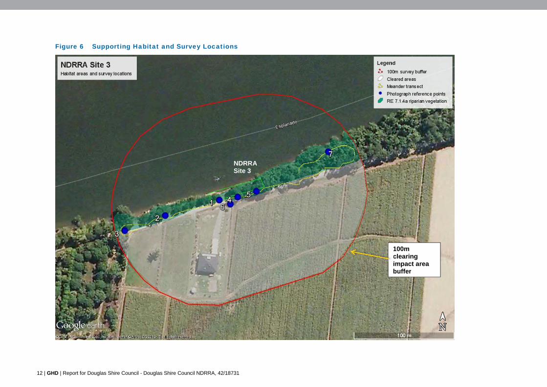
12 | GHD | Report for Douglas Shire Council - Douglas Shire Council NDRRA, 42/18731
Figure 6 Supporting Habitat and Survey Locations
100m clearing impact area buffer
NDRRA Site 3
GHD | Report for Douglas Shire Council - Douglas Shire Council NDRRA, 42/18731 | 13
3. Survey Results 3.1 EVNT Species
Site surveys of the clearing impact area were undertaken on 17th July August 2015. No protected plant species listed under the Schedules of the Nature Conservation (Wildlife)
Regulation 2006 were identified in the clearing impact area or in the buffer survey area.
3.2 Description of Supporting Habitat
As noted in Section 2.2.1 three broad habitat areas were identified within the clearing impact
area.
Cleared. Areas primarily dominated by sugar cane cultivation and three residential
areas of approximately 2.2ha (including McDowalls Lane).
Riparian vegetation on the high point and banks of the Daintree River, including the
works area approximately 0.39 ha of vine forest (600m2 within the works area).
Daintree River (1.76ha), not included in the survey.
These are discussed below.
3.2.1 Cleared Areas
The local area has been historically cleared for sugar cane production, and three residential
blocks (with a house on one block) presented in the western section of the buffer survey area.
No surveys were undertaken within this block or within the sugar cane field, however any
species located immediately along McDowall Lane (included in the cleared area) were noted.
Results of the field flora surveys are provided in Appendix D.
3.2.2 Riparian Vegetation
Riparian vegetation is present along the bank of the Daintree River within the clearing impact
area varying in width from approximately 25m in width at the eastern end of the buffer area, to
less than 5m within the Site 3 works area.
Approximately 2.2ha is vegetation included as ‘Category R’ Reef-regrowth watercourse
vegetation under the Regulated Vegetation Mapping Vegetation mapping for the locality (refer
Figure 4). However 1.75ha of this is mapped over the Daintree River and 0.37ha is mapped
over the residential lots and sugar cane. The actual area of vegetation within Category R on
site is 0.08ha of riparian vegetation on the western side of the site works area.
Approximately 0.65ha within the buffer survey area is mapped as remnant ‘Category B’
vegetation, The balance of the survey buffer area (1.5ha) is mapped as ‘Category X’.
Owing to proximity to the road and sugar cane fields, residential areas, tidal influences, flooding
and bank slumping the riparian vegetation is subject to varying degrees of impact related
stresses including weed invasion, dust settlement, bank erosion and road maintenance
(slashing and poisoning). This has generally resulted in a strip of vine forest of varying structural
integrity with a marine plants component in the lowest tidally affected section. The vegetation
has been previously cleared at a point on the western end of the survey buffer area to provide
boat access to the Daintree River. This area is now infested by introduced golden bamboo
Phyllostachys aurea.
14 | GHD | Report for Douglas Shire Council - Douglas Shire Council NDRRA, 42/18731
4. Impact Management Plan 4.1 Purpose of the Impact Management Plan
This Impact Management Plan has been developed in accordance with the ‘Protected Plants
Assessment Guidelines’ and as per requirements under the NC Act and associated regulations.
No protected plants were observed during the flora survey and no specific Impact Management
Plan for any particular species has subsequently been prepared.
The following Impact Management Plan has been developed to generally manage potential
issues in relation to the proposed works at Site 3 with respect to the Protected Plants Legislative
Framework and addresses the following criteria:
Avoids and minimise impacts
Considers the nature of the impact
The proposed management of potential impacts
Justification for proposed management of impacts
Survival of protected plants in the wild.
4.2 Avoid and Minimise Impact
Vegetation clearing of approximately 500m2 is necessary to support this project. This clearing is
unavoidable, but necessary in order to re-profile the river bank to place rock and geotextile
materials.
All attempts have been made in consideration of options that minimise the impacts of the project
with respect to vegetation removal and habitat disturbance. The project is a site remediation
project, therefore no alternative sites were able to be considered. The extent of clearing is
determined by the extent of the bank slumping and destabilisation however all attempts have
been made to minimise the area of riparian vegetation to be cleared.
4.3 Nature of Impact
No protected plant species will be directly impacted by the construction works, with no
individuals noted within the works areas and buffer survey area. The bank stabilisation works
will require earthworks to reshape the slump area, and contour and bench the bank for the
purposes of rock armouring and stabilising the bank. The area of vegetation to be cleared
(clearing impact area) is approximately 500m2 with the volume of fill and rock armouring being
approximately 2,600m3. Refer to Appendix A for the site drawings. The earthworks and rock
placement will result in the loss of all vegetation within the landslip area.
The vegetation to be cleared is mapped ‘Category R’ Reef-regrowth watercourse and ‘Category
B’ remnant under the Regulated Vegetation Management Mapping (see Figure 4) and as ‘of
concern’ RE 7.1.4a under the regional ecosystem Vegetation Management Supporting
Mapping. Only ‘least concern’ and introduced species will be removed.
4.4 Management of Impact
No clearing of EVNT protect plants will be undertaken and subsequently no direct impacts from
the remediation works are anticipated. Notwithstanding, there is the potential for vegetated
areas about the remediation site to be affected by works activities, including direct vegetation
removal, and downstream erosion, and a large number of heavy vehicle movements are
required to transport the estimated fill volumes to Site 3. Subsequently the following
GHD | Report for Douglas Shire Council - Douglas Shire Council NDRRA, 42/18731 | 15
management measures will be undertaken to minimise any potential impacts to the clearing
impact area and adjacent habitats.
Notification of clearing at least one week prior to DEHP via exempt clearing notification
(protected plants) form.
Large trees on top of bank outside of the clearing impact area are to be flagged with
survey tape, and marked as not to be cleared for works construction to maintain bank
stability.
Vegetation temporary fencing is to be erected to demarcate vegetation to be retained and
not disturbed during construction.
Any conditions related to other approvals e.g. rehabilitation and revegetation
requirements, are to be complied with as part of this Impact Management Plan.
Preparation of a site specific Construction Environmental Management Plan (EMP) that
includes (at a minimum) the following elements,
– Erosion and sediment control plan including monitoring protocols.
– Track access and vegetation removal layout plan.
– Fuel and oil and other hazardous substances spill response plan.
– Traffic management plan during construction, including the large number of dump
truck movements required to transport fill material to site along the Daintree – Cape
Tribulation Road and McDowall Lane.
4.5 Justification of Proposed Management of Impacts
Remediation and stabilisation of the Daintree River bank at NDRRA Site 3 is necessary to
prevent further river erosion and bank slumping which would result in the loss of McDowall Lane
in this location. Rock fill and armouring the slip area will restore stability to the steep slope and
maintain access for residents along McDowall Lane.
The proposed measures identified to mitigate and manage impacts are commensurate with a
scope of works that does not impact on EVNT species. An Impact Management Plan has been
included in this flora survey report to demonstrate that adverse impacts on nearby habitats will
not occur as a result of the proposed works.
4.6 Survival of the Plant in the Wild
No protected plant species listed under the schedules of the Nature Conservation (Wildlife)
Regulation 2006 were identified within the clearing impact area and survey buffer areas. The
proposed works at NDRRA Site 3 on McDowall Lane will not impact of the survival in the wild of
any listed protected plant species. Due to the distance of the works from the Daintree National
Park and other vegetated habitat there will be no reduction in the viability of local and regional
protected plant species populations.
16 | GHD | Report for Douglas Shire Council - Douglas Shire Council NDRRA, 42/18731
5. Conclusion The proposed remediation works for NDRRA Site 3 on McDowall Lane will include removal of
approximately 500m2 of vegetation within a ‘high risk’ area identified within the Protected Plants
Flora Survey Trigger Mapping. Site 3 is located within Category R reef-regrowth vegetation and
Category B remnant vegetation which comprises an ‘of concern’ RE 7.1.4a.
A flora survey in accordance with the Flora Survey Guidelines – Protected Plants determined
that there was no protected plant species within the buffer from the clearing impact area for the
proposed work area or within the clearing impact area.
This report has been provided to obtain an exemption for clearing within a ‘high risk’ area from
the Department of Environment Heritage and Protection (DEHP). Only Least Concern plants
within the mapped ‘high risk’ area will be cleared for the site remediation works at NDRRA Site
3 on McDowall Lane and there will be no disturbance to any adjacent habitat areas.
No protected plant species listed as EVNT were identified within the clearing impact area.
Subsequently an exemption from a clearing permit under 261ZA will be sought for the proposed
works at NDRRA Site 3 on McDowall Lane.

GHD | Report for Douglas Shire Council - Douglas Shire Council NDRRA, 42/18731
Appendices

18 | GHD | Report for Douglas Shire Council - Douglas Shire Council NDRRA, 42/18731
Appendix A – Site Layout Drawing
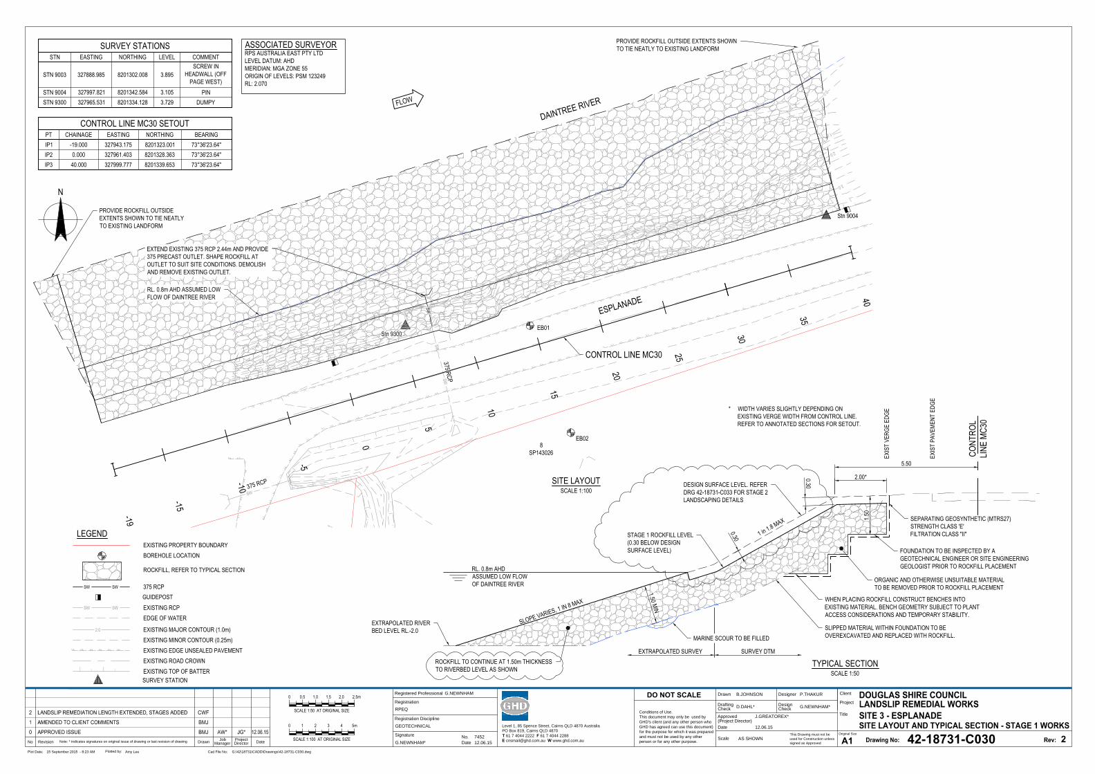
SW
SWSW| |
| || |
| || |
| || |
| || | | |
||
|
|
||
||
||
| || |
| || |
| || |
| || |
| || |
| || |
| |
||
|
||
||
||
||
||
||
||
||
||
||
|
|
||
| || |
| |
|
||
|
ESPLANADE
DAINTREE RIVER
8SP143026
Stn 9300EB01
EB02
Stn 9004
375 RCP
375 RCP
0.0
1.0
2.0
3.0
0.0
1.0
2.0
3.0
0
25
10
20
5
15
SW
40
35
30
-5
-10
-15
-19
N
SITE LAYOUTSCALE 1:100
PROVIDE ROCKFILL OUTSIDEEXTENTS SHOWN TO TIE NEATLYTO EXISTING LANDFORM
PROVIDE ROCKFILL OUTSIDE EXTENTS SHOWNTO TIE NEATLY TO EXISTING LANDFORM
CONTROL LINE MC30
EXTEND EXISTING 375 RCP 2.44m AND PROVIDE375 PRECAST OUTLET. SHAPE ROCKFILL ATOUTLET TO SUIT SITE CONDITIONS. DEMOLISHAND REMOVE EXISTING OUTLET.
RL. 0.8m AHD ASSUMED LOWFLOW OF DAINTREE RIVER
CONT
ROL
LINE
MC30
1 in 1.8 MAX
2.00*
EXIS
T PA
VEME
NT E
DGE
* WIDTH VARIES SLIGHTLY DEPENDING ONEXISTING VERGE WIDTH FROM CONTROL LINE.REFER TO ANNOTATED SECTIONS FOR SETOUT.
EXIS
T VE
RGE
EDGE
EXTRAPOLATED SURVEY SURVEY DTM
TYPICAL SECTIONSCALE 1:50
5.50
EXTRAPOLATED RIVERBED LEVEL RL.-2.0
RL. 0.8m AHDASSUMED LOW FLOWOF DAINTREE RIVER
SLOPE VARIES, 1 IN 8 MAX
1.50 MIN
ROCKFILL TO CONTINUE AT 1.50m THICKNESSTO RIVERBED LEVEL AS SHOWN
1.50
SEPARATING GEOSYNTHETIC (MTRS27)STRENGTH CLASS 'E'FILTRATION CLASS "II"
ORGANIC AND OTHERWISE UNSUITABLE MATERIALTO BE REMOVED PRIOR TO ROCKFILL PLACEMENT
WHEN PLACING ROCKFILL CONSTRUCT BENCHES INTOEXISTING MATERIAL. BENCH GEOMETRY SUBJECT TO PLANTACCESS CONSIDERATIONS AND TEMPORARY STABILITY.
FOUNDATION TO BE INSPECTED BY AGEOTECHNICAL ENGINEER OR SITE ENGINEERINGGEOLOGIST PRIOR TO ROCKFILL PLACEMENT
SLIPPED MATERIAL WITHIN FOUNDATION TO BEOVEREXCAVATED AND REPLACED WITH ROCKFILL.MARINE SCOUR TO BE FILLED
STAGE 1 ROCKFILL LEVEL(0.30 BELOW DESIGNSURFACE LEVEL)
DESIGN SURFACE LEVEL. REFERDRG 42-18731-C033 FOR STAGE 2LANDSCAPING DETAILS
0.30
0.30
This Drawing must not be
used for Construction unless
signed as Approved
Date
Check
Drafting
DateDrawnRevisionNo
A1
Original Size
Title
Project
Client
Check
DesignerDrawn
Scale
Design
Conditions of Use.
This document may only be used by
GHD's client (and any other person who
GHD has agreed can use this document)
for the purpose for which it was prepared
and must not be used by any other
person or for any other purpose.
DO NOT SCALE
Note: * indicates signatures on original issue of drawing or last revision of drawing
Plot Date: Cad File No:15 September 2015 - 8:23 AM G:\42\18731\CADD\Drawings\42-18731-C030.dwg
Plotted by:
Amy Lee
(Project Director)
Approved
Job
Manager
Project
Director
42-18731-C030
2
B.JOHNSON P.THAKUR
D.DAHL* G.NEWNHAM*
J.GREATOREX*
12.06.15
AS SHOWN
275
EXISTING PROPERTY BOUNDARYLEGEND
CONTROL LINE MC30 SETOUTPT CHAINAGE EASTING NORTHING BEARINGIP1 -19.000 327943.175 8201323.001IP2 0.000 327961.403 8201328.363IP3 40.000 327999.777 8201339.653
ASSOCIATED SURVEYORRPS AUSTRALIA EAST PTY LTDLEVEL DATUM: AHDMERIDIAN: MGA ZONE 55ORIGIN OF LEVELS: PSM 123249RL: 2.070
SURVEY STATIONSSTN EASTING NORTHING LEVEL COMMENT
STN 9003 327888.985 8201302.008 3.895SCREW IN
HEADWALL (OFFPAGE WEST)
STN 9004 327997.821 8201342.584 3.105 PINSTN 9300 327965.531 8201334.128 3.729 DUMPY
BOREHOLE LOCATION
ROCKFILL, REFER TO TYPICAL SECTION
0
SCALE 1:50 AT ORIGINAL SIZE
0.5 2.0 2.5m1.51.0
0 1 4 5m32
SCALE 1:100 AT ORIGINAL SIZE
EDGE OF WATER
SW SW 375 RCP
SW SW EXISTING RCP
Level 1, 85 Spence Street, Cairns QLD 4870 Australia
PO Box 819, Cairns QLD 4870
T 61 7 4044 2222 F 61 7 4044 2288
E [email protected] W www.ghd.com.au
GUIDEPOST
| | | |
EXISTING MAJOR CONTOUR (1.0m)EXISTING MINOR CONTOUR (0.25m)EXISTING EDGE UNSEALED PAVEMENTEXISTING ROAD CROWNEXISTING TOP OF BATTERSURVEY STATION
2.0
Registered Professional
Registration
Signature
Date
Registration Discipline
No. 7452
G.NEWNHAM
12.06.15
RPEQ
G.NEWNHAM*
GEOTECHNICAL
GHD | Report for Douglas Shire Council - Douglas Shire Council NDRRA, 42/18731 | 19
Appendix B – Database Search Results
Wildlife Online
Protected Matters Search Tool
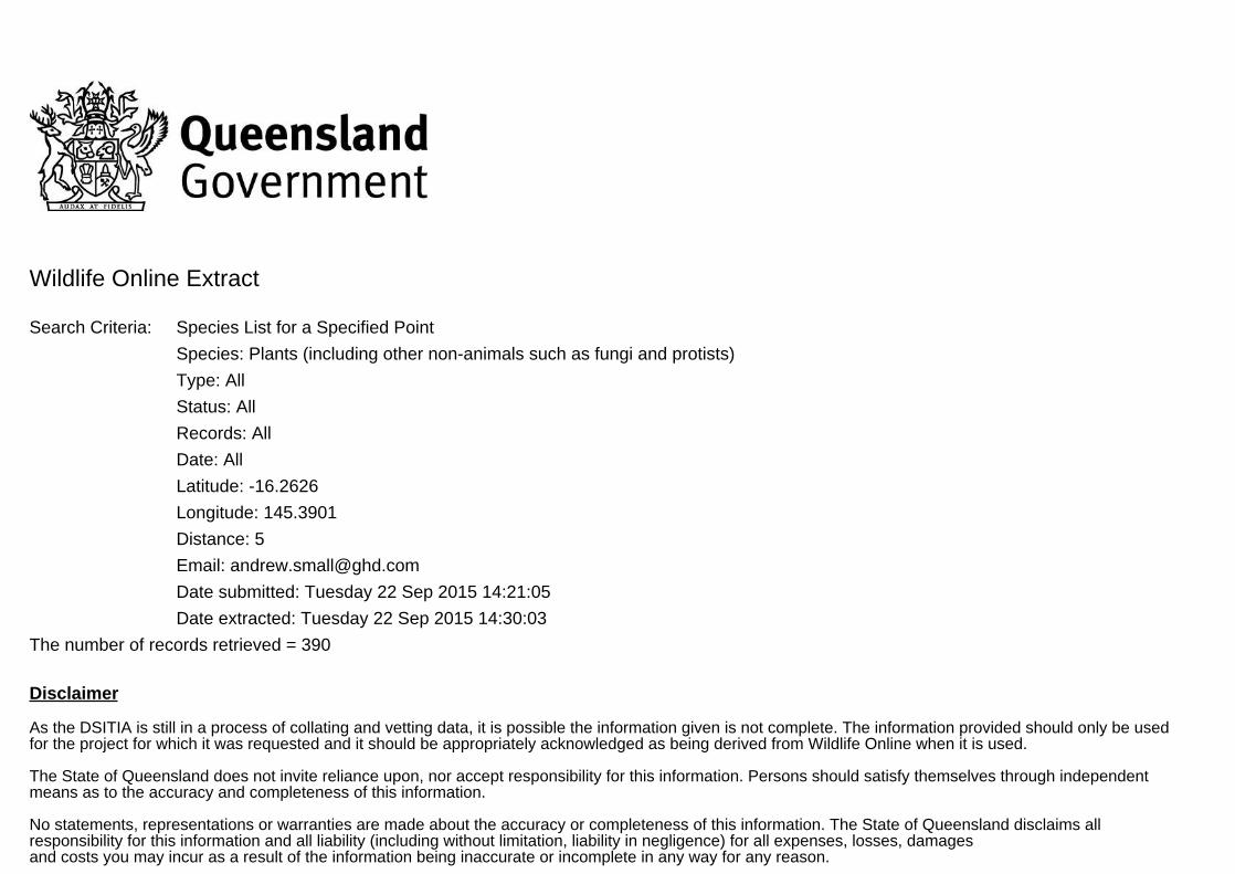
Wildlife Online Extract
Search Criteria: Species List for a Specified Point
Species: Plants (including other non-animals such as fungi and protists)
Type: All
Status: All
Records: All
Date: All
Latitude: -16.2626
Longitude: 145.3901
Distance: 5
Email: [email protected]
Date submitted: Tuesday 22 Sep 2015 14:21:05
Date extracted: Tuesday 22 Sep 2015 14:30:03
The number of records retrieved = 390
Disclaimer
As the DSITIA is still in a process of collating and vetting data, it is possible the information given is not complete. The information provided should only be usedfor the project for which it was requested and it should be appropriately acknowledged as being derived from Wildlife Online when it is used.
The State of Queensland does not invite reliance upon, nor accept responsibility for this information. Persons should satisfy themselves through independentmeans as to the accuracy and completeness of this information.
No statements, representations or warranties are made about the accuracy or completeness of this information. The State of Queensland disclaims allresponsibility for this information and all liability (including without limitation, liability in negligence) for all expenses, losses, damagesand costs you may incur as a result of the information being inaccurate or incomplete in any way for any reason.
Feedback about Wildlife Online should be emailed to [email protected]
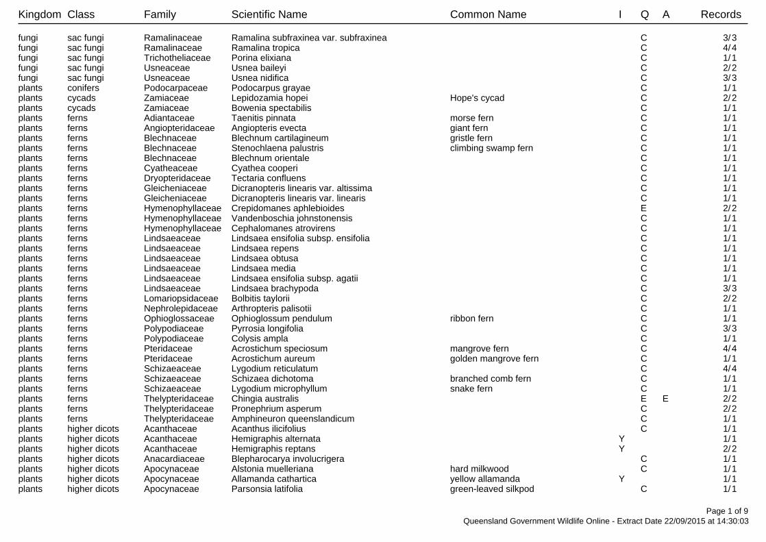
Kingdom Class Family Scientific Name Common Name I Q A Records
fungi sac fungi Ramalinaceae Ramalina subfraxinea var. subfraxinea C 3/3fungi sac fungi Ramalinaceae Ramalina tropica C 4/4fungi sac fungi Trichotheliaceae Porina elixiana C 1/1fungi sac fungi Usneaceae Usnea baileyi C 2/2fungi sac fungi Usneaceae Usnea nidifica C 3/3plants conifers Podocarpaceae Podocarpus grayae C 1/1plants cycads Zamiaceae Lepidozamia hopei Hope's cycad C 2/2plants cycads Zamiaceae Bowenia spectabilis C 1/1plants ferns Adiantaceae Taenitis pinnata morse fern C 1/1plants ferns Angiopteridaceae Angiopteris evecta giant fern C 1/1plants ferns Blechnaceae Blechnum cartilagineum gristle fern C 1/1plants ferns Blechnaceae Stenochlaena palustris climbing swamp fern C 1/1plants ferns Blechnaceae Blechnum orientale C 1/1plants ferns Cyatheaceae Cyathea cooperi C 1/1plants ferns Dryopteridaceae Tectaria confluens C 1/1plants ferns Gleicheniaceae Dicranopteris linearis var. altissima C 1/1plants ferns Gleicheniaceae Dicranopteris linearis var. linearis C 1/1plants ferns Hymenophyllaceae Crepidomanes aphlebioides E 2/2plants ferns Hymenophyllaceae Vandenboschia johnstonensis C 1/1plants ferns Hymenophyllaceae Cephalomanes atrovirens C 1/1plants ferns Lindsaeaceae Lindsaea ensifolia subsp. ensifolia C 1/1plants ferns Lindsaeaceae Lindsaea repens C 1/1plants ferns Lindsaeaceae Lindsaea obtusa C 1/1plants ferns Lindsaeaceae Lindsaea media C 1/1plants ferns Lindsaeaceae Lindsaea ensifolia subsp. agatii C 1/1plants ferns Lindsaeaceae Lindsaea brachypoda C 3/3plants ferns Lomariopsidaceae Bolbitis taylorii C 2/2plants ferns Nephrolepidaceae Arthropteris palisotii C 1/1plants ferns Ophioglossaceae Ophioglossum pendulum ribbon fern C 1/1plants ferns Polypodiaceae Pyrrosia longifolia C 3/3plants ferns Polypodiaceae Colysis ampla C 1/1plants ferns Pteridaceae Acrostichum speciosum mangrove fern C 4/4plants ferns Pteridaceae Acrostichum aureum golden mangrove fern C 1/1plants ferns Schizaeaceae Lygodium reticulatum C 4/4plants ferns Schizaeaceae Schizaea dichotoma branched comb fern C 1/1plants ferns Schizaeaceae Lygodium microphyllum snake fern C 1/1plants ferns Thelypteridaceae Chingia australis E E 2/2plants ferns Thelypteridaceae Pronephrium asperum C 2/2plants ferns Thelypteridaceae Amphineuron queenslandicum C 1/1plants higher dicots Acanthaceae Acanthus ilicifolius C 1/1plants higher dicots Acanthaceae Hemigraphis alternata Y 1/1plants higher dicots Acanthaceae Hemigraphis reptans Y 2/2plants higher dicots Anacardiaceae Blepharocarya involucrigera C 1/1plants higher dicots Apocynaceae Alstonia muelleriana hard milkwood C 1/1plants higher dicots Apocynaceae Allamanda cathartica yellow allamanda Y 1/1plants higher dicots Apocynaceae Parsonsia latifolia green-leaved silkpod C 1/1
Page 1 of 9Queensland Government Wildlife Online - Extract Date 22/09/2015 at 14:30:03
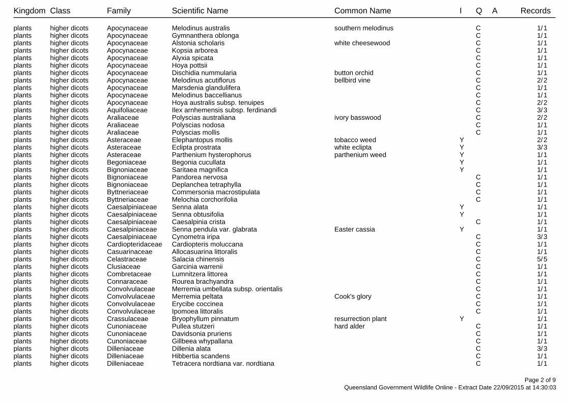
Kingdom Class Family Scientific Name Common Name I Q A Records
plants higher dicots Apocynaceae Melodinus australis southern melodinus C 1/1plants higher dicots Apocynaceae Gymnanthera oblonga C 1/1plants higher dicots Apocynaceae Alstonia scholaris white cheesewood C 1/1plants higher dicots Apocynaceae Kopsia arborea C 1/1plants higher dicots Apocynaceae Alyxia spicata C 1/1plants higher dicots Apocynaceae Hoya pottsii C 1/1plants higher dicots Apocynaceae Dischidia nummularia button orchid C 1/1plants higher dicots Apocynaceae Melodinus acutiflorus bellbird vine C 2/2plants higher dicots Apocynaceae Marsdenia glandulifera C 1/1plants higher dicots Apocynaceae Melodinus baccellianus C 1/1plants higher dicots Apocynaceae Hoya australis subsp. tenuipes C 2/2plants higher dicots Aquifoliaceae Ilex arnhemensis subsp. ferdinandi C 3/3plants higher dicots Araliaceae Polyscias australiana ivory basswood C 2/2plants higher dicots Araliaceae Polyscias nodosa C 1/1plants higher dicots Araliaceae Polyscias mollis C 1/1plants higher dicots Asteraceae Elephantopus mollis tobacco weed Y 2/2plants higher dicots Asteraceae Eclipta prostrata white eclipta Y 3/3plants higher dicots Asteraceae Parthenium hysterophorus parthenium weed Y 1/1plants higher dicots Begoniaceae Begonia cucullata Y 1/1plants higher dicots Bignoniaceae Saritaea magnifica Y 1/1plants higher dicots Bignoniaceae Pandorea nervosa C 1/1plants higher dicots Bignoniaceae Deplanchea tetraphylla C 1/1plants higher dicots Byttneriaceae Commersonia macrostipulata C 1/1plants higher dicots Byttneriaceae Melochia corchorifolia C 1/1plants higher dicots Caesalpiniaceae Senna alata Y 1/1plants higher dicots Caesalpiniaceae Senna obtusifolia Y 1/1plants higher dicots Caesalpiniaceae Caesalpinia crista C 1/1plants higher dicots Caesalpiniaceae Senna pendula var. glabrata Easter cassia Y 1/1plants higher dicots Caesalpiniaceae Cynometra iripa C 3/3plants higher dicots Cardiopteridaceae Cardiopteris moluccana C 1/1plants higher dicots Casuarinaceae Allocasuarina littoralis C 1/1plants higher dicots Celastraceae Salacia chinensis C 5/5plants higher dicots Clusiaceae Garcinia warrenii C 1/1plants higher dicots Combretaceae Lumnitzera littorea C 1/1plants higher dicots Connaraceae Rourea brachyandra C 1/1plants higher dicots Convolvulaceae Merremia umbellata subsp. orientalis C 1/1plants higher dicots Convolvulaceae Merremia peltata Cook's glory C 1/1plants higher dicots Convolvulaceae Erycibe coccinea C 1/1plants higher dicots Convolvulaceae Ipomoea littoralis C 1/1plants higher dicots Crassulaceae Bryophyllum pinnatum resurrection plant Y 1/1plants higher dicots Cunoniaceae Pullea stutzeri hard alder C 1/1plants higher dicots Cunoniaceae Davidsonia pruriens C 1/1plants higher dicots Cunoniaceae Gillbeea whypallana C 1/1plants higher dicots Dilleniaceae Dillenia alata C 3/3plants higher dicots Dilleniaceae Hibbertia scandens C 1/1plants higher dicots Dilleniaceae Tetracera nordtiana var. nordtiana C 1/1
Page 2 of 9Queensland Government Wildlife Online - Extract Date 22/09/2015 at 14:30:03
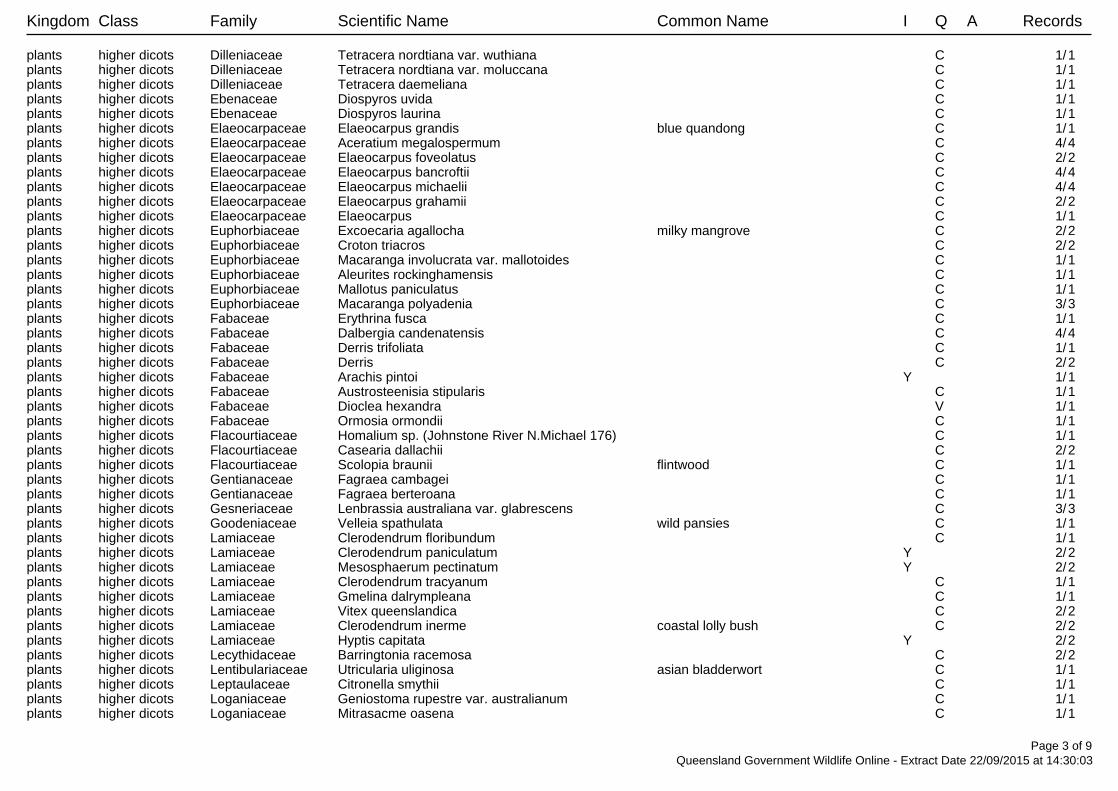
Kingdom Class Family Scientific Name Common Name I Q A Records
plants higher dicots Dilleniaceae Tetracera nordtiana var. wuthiana C 1/1plants higher dicots Dilleniaceae Tetracera nordtiana var. moluccana C 1/1plants higher dicots Dilleniaceae Tetracera daemeliana C 1/1plants higher dicots Ebenaceae Diospyros uvida C 1/1plants higher dicots Ebenaceae Diospyros laurina C 1/1plants higher dicots Elaeocarpaceae Elaeocarpus grandis blue quandong C 1/1plants higher dicots Elaeocarpaceae Aceratium megalospermum C 4/4plants higher dicots Elaeocarpaceae Elaeocarpus foveolatus C 2/2plants higher dicots Elaeocarpaceae Elaeocarpus bancroftii C 4/4plants higher dicots Elaeocarpaceae Elaeocarpus michaelii C 4/4plants higher dicots Elaeocarpaceae Elaeocarpus grahamii C 2/2plants higher dicots Elaeocarpaceae Elaeocarpus C 1/1plants higher dicots Euphorbiaceae Excoecaria agallocha milky mangrove C 2/2plants higher dicots Euphorbiaceae Croton triacros C 2/2plants higher dicots Euphorbiaceae Macaranga involucrata var. mallotoides C 1/1plants higher dicots Euphorbiaceae Aleurites rockinghamensis C 1/1plants higher dicots Euphorbiaceae Mallotus paniculatus C 1/1plants higher dicots Euphorbiaceae Macaranga polyadenia C 3/3plants higher dicots Fabaceae Erythrina fusca C 1/1plants higher dicots Fabaceae Dalbergia candenatensis C 4/4plants higher dicots Fabaceae Derris trifoliata C 1/1plants higher dicots Fabaceae Derris C 2/2plants higher dicots Fabaceae Arachis pintoi Y 1/1plants higher dicots Fabaceae Austrosteenisia stipularis C 1/1plants higher dicots Fabaceae Dioclea hexandra V 1/1plants higher dicots Fabaceae Ormosia ormondii C 1/1plants higher dicots Flacourtiaceae Homalium sp. (Johnstone River N.Michael 176) C 1/1plants higher dicots Flacourtiaceae Casearia dallachii C 2/2plants higher dicots Flacourtiaceae Scolopia braunii flintwood C 1/1plants higher dicots Gentianaceae Fagraea cambagei C 1/1plants higher dicots Gentianaceae Fagraea berteroana C 1/1plants higher dicots Gesneriaceae Lenbrassia australiana var. glabrescens C 3/3plants higher dicots Goodeniaceae Velleia spathulata wild pansies C 1/1plants higher dicots Lamiaceae Clerodendrum floribundum C 1/1plants higher dicots Lamiaceae Clerodendrum paniculatum Y 2/2plants higher dicots Lamiaceae Mesosphaerum pectinatum Y 2/2plants higher dicots Lamiaceae Clerodendrum tracyanum C 1/1plants higher dicots Lamiaceae Gmelina dalrympleana C 1/1plants higher dicots Lamiaceae Vitex queenslandica C 2/2plants higher dicots Lamiaceae Clerodendrum inerme coastal lolly bush C 2/2plants higher dicots Lamiaceae Hyptis capitata Y 2/2plants higher dicots Lecythidaceae Barringtonia racemosa C 2/2plants higher dicots Lentibulariaceae Utricularia uliginosa asian bladderwort C 1/1plants higher dicots Leptaulaceae Citronella smythii C 1/1plants higher dicots Loganiaceae Geniostoma rupestre var. australianum C 1/1plants higher dicots Loganiaceae Mitrasacme oasena C 1/1
Page 3 of 9Queensland Government Wildlife Online - Extract Date 22/09/2015 at 14:30:03
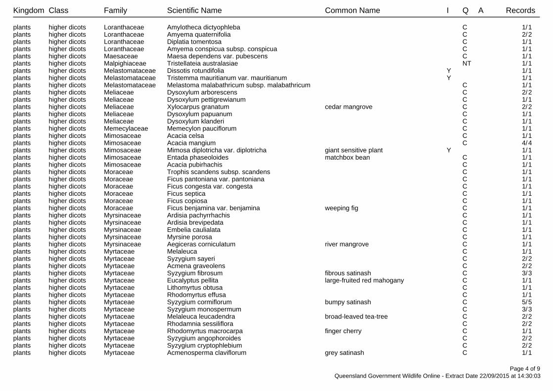
Kingdom Class Family Scientific Name Common Name I Q A Records
plants higher dicots Loranthaceae Amylotheca dictyophleba C 1/1plants higher dicots Loranthaceae Amyema quaternifolia C 2/2plants higher dicots Loranthaceae Diplatia tomentosa C 1/1plants higher dicots Loranthaceae Amyema conspicua subsp. conspicua C 1/1plants higher dicots Maesaceae Maesa dependens var. pubescens C 1/1plants higher dicots Malpighiaceae Tristellateia australasiae NT 1/1plants higher dicots Melastomataceae Dissotis rotundifolia Y 1/1plants higher dicots Melastomataceae Tristemma mauritianum var. mauritianum Y 1/1plants higher dicots Melastomataceae Melastoma malabathricum subsp. malabathricum C 1/1plants higher dicots Meliaceae Dysoxylum arborescens C 2/2plants higher dicots Meliaceae Dysoxylum pettigrewianum C 1/1plants higher dicots Meliaceae Xylocarpus granatum cedar mangrove C 2/2plants higher dicots Meliaceae Dysoxylum papuanum C 1/1plants higher dicots Meliaceae Dysoxylum klanderi C 1/1plants higher dicots Memecylaceae Memecylon pauciflorum C 1/1plants higher dicots Mimosaceae Acacia celsa C 1/1plants higher dicots Mimosaceae Acacia mangium C 4/4plants higher dicots Mimosaceae Mimosa diplotricha var. diplotricha giant sensitive plant Y 1/1plants higher dicots Mimosaceae Entada phaseoloides matchbox bean C 1/1plants higher dicots Mimosaceae Acacia pubirhachis C 1/1plants higher dicots Moraceae Trophis scandens subsp. scandens C 1/1plants higher dicots Moraceae Ficus pantoniana var. pantoniana C 1/1plants higher dicots Moraceae Ficus congesta var. congesta C 1/1plants higher dicots Moraceae Ficus septica C 1/1plants higher dicots Moraceae Ficus copiosa C 1/1plants higher dicots Moraceae Ficus benjamina var. benjamina weeping fig C 1/1plants higher dicots Myrsinaceae Ardisia pachyrrhachis C 1/1plants higher dicots Myrsinaceae Ardisia brevipedata C 1/1plants higher dicots Myrsinaceae Embelia caulialata C 1/1plants higher dicots Myrsinaceae Myrsine porosa C 1/1plants higher dicots Myrsinaceae Aegiceras corniculatum river mangrove C 1/1plants higher dicots Myrtaceae Melaleuca C 1/1plants higher dicots Myrtaceae Syzygium sayeri C 2/2plants higher dicots Myrtaceae Acmena graveolens C 2/2plants higher dicots Myrtaceae Syzygium fibrosum fibrous satinash C 3/3plants higher dicots Myrtaceae Eucalyptus pellita large-fruited red mahogany C 1/1plants higher dicots Myrtaceae Lithomyrtus obtusa C 1/1plants higher dicots Myrtaceae Rhodomyrtus effusa C 1/1plants higher dicots Myrtaceae Syzygium cormiflorum bumpy satinash C 5/5plants higher dicots Myrtaceae Syzygium monospermum C 3/3plants higher dicots Myrtaceae Melaleuca leucadendra broad-leaved tea-tree C 2/2plants higher dicots Myrtaceae Rhodamnia sessiliflora C 2/2plants higher dicots Myrtaceae Rhodomyrtus macrocarpa finger cherry C 1/1plants higher dicots Myrtaceae Syzygium angophoroides C 2/2plants higher dicots Myrtaceae Syzygium cryptophlebium C 2/2plants higher dicots Myrtaceae Acmenosperma claviflorum grey satinash C 1/1
Page 4 of 9Queensland Government Wildlife Online - Extract Date 22/09/2015 at 14:30:03
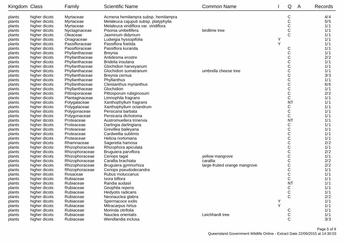
Kingdom Class Family Scientific Name Common Name I Q A Records
plants higher dicots Myrtaceae Acmena hemilampra subsp. hemilampra C 4/4plants higher dicots Myrtaceae Melaleuca cajuputi subsp. platyphylla C 5/5plants higher dicots Myrtaceae Melaleuca viridiflora var. viridiflora C 1/1plants higher dicots Nyctaginaceae Pisonia umbellifera birdlime tree C 1/1plants higher dicots Oleaceae Jasminum didymum C 1/1plants higher dicots Onagraceae Ludwigia hyssopifolia Y 1/1plants higher dicots Passifloraceae Passiflora foetida Y 1/1plants higher dicots Passifloraceae Passiflora kuranda C 1/1plants higher dicots Phyllanthaceae Breynia C 1/1plants higher dicots Phyllanthaceae Antidesma erostre C 2/2plants higher dicots Phyllanthaceae Bridelia insulana C 1/1plants higher dicots Phyllanthaceae Glochidion harveyanum C 1/1plants higher dicots Phyllanthaceae Glochidion sumatranum umbrella cheese tree C 1/1plants higher dicots Phyllanthaceae Breynia cernua C 3/3plants higher dicots Phyllanthaceae Phyllanthus C 1/1plants higher dicots Phyllanthaceae Cleistanthus myrianthus C 6/6plants higher dicots Phyllanthaceae Glochidion C 1/1plants higher dicots Pittosporaceae Pittosporum rubiginosum C 2/2plants higher dicots Plantaginaceae Limnophila fragrans C 1/1plants higher dicots Polygalaceae Xanthophyllum fragrans NT 1/1plants higher dicots Polygalaceae Xanthophyllum octandrum C 1/1plants higher dicots Polygonaceae Persicaria barbata C 1/1plants higher dicots Polygonaceae Persicaria dichotoma C 1/1plants higher dicots Proteaceae Austromuellera trinervia NT 1/1plants higher dicots Proteaceae Darlingia darlingiana C 1/1plants higher dicots Proteaceae Grevillea baileyana C 1/1plants higher dicots Proteaceae Cardwellia sublimis C 1/1plants higher dicots Proteaceae Helicia nortoniana C 1/1plants higher dicots Rhamnaceae Sageretia hamosa C 2/2plants higher dicots Rhizophoraceae Rhizophora apiculata C 1/1plants higher dicots Rhizophoraceae Bruguiera parviflora C 2/2plants higher dicots Rhizophoraceae Ceriops tagal yellow mangrove C 1/1plants higher dicots Rhizophoraceae Carallia brachiata carallia C 2/2plants higher dicots Rhizophoraceae Bruguiera gymnorhiza large-fruited orange mangrove C 2/2plants higher dicots Rhizophoraceae Ceriops pseudodecandra C 1/1plants higher dicots Rosaceae Rubus moluccanus C 1/1plants higher dicots Rubiaceae Ixora biflora C 1/1plants higher dicots Rubiaceae Randia audasii NT 1/1plants higher dicots Rubiaceae Geophila repens C 1/1plants higher dicots Rubiaceae Hedyotis radicans C 1/1plants higher dicots Rubiaceae Neonauclea glabra C 2/2plants higher dicots Rubiaceae Spermacoce exilis Y 1/1plants higher dicots Rubiaceae Mitracarpus hirtus Y 1/1plants higher dicots Rubiaceae Morinda citrifolia C 1/1plants higher dicots Rubiaceae Nauclea orientalis Leichhardt tree C 1/1plants higher dicots Rubiaceae Wendlandia inclusa C 3/3
Page 5 of 9Queensland Government Wildlife Online - Extract Date 22/09/2015 at 14:30:03
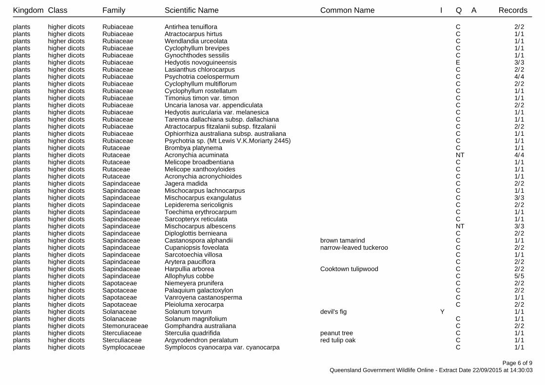
Kingdom Class Family Scientific Name Common Name I Q A Records
plants higher dicots Rubiaceae Antirhea tenuiflora C 2/2plants higher dicots Rubiaceae Atractocarpus hirtus C 1/1plants higher dicots Rubiaceae Wendlandia urceolata C 1/1plants higher dicots Rubiaceae Cyclophyllum brevipes C 1/1plants higher dicots Rubiaceae Gynochthodes sessilis C 1/1plants higher dicots Rubiaceae Hedyotis novoguineensis E 3/3plants higher dicots Rubiaceae Lasianthus chlorocarpus C 2/2plants higher dicots Rubiaceae Psychotria coelospermum C 4/4plants higher dicots Rubiaceae Cyclophyllum multiflorum C 2/2plants higher dicots Rubiaceae Cyclophyllum rostellatum C 1/1plants higher dicots Rubiaceae Timonius timon var. timon C 1/1plants higher dicots Rubiaceae Uncaria lanosa var. appendiculata C 2/2plants higher dicots Rubiaceae Hedyotis auricularia var. melanesica C 1/1plants higher dicots Rubiaceae Tarenna dallachiana subsp. dallachiana C 1/1plants higher dicots Rubiaceae Atractocarpus fitzalanii subsp. fitzalanii C 2/2plants higher dicots Rubiaceae Ophiorrhiza australiana subsp. australiana C 1/1plants higher dicots Rubiaceae Psychotria sp. (Mt Lewis V.K.Moriarty 2445) C 1/1plants higher dicots Rutaceae Brombya platynema C 1/1plants higher dicots Rutaceae Acronychia acuminata NT 4/4plants higher dicots Rutaceae Melicope broadbentiana C 1/1plants higher dicots Rutaceae Melicope xanthoxyloides C 1/1plants higher dicots Rutaceae Acronychia acronychioides C 1/1plants higher dicots Sapindaceae Jagera madida C 2/2plants higher dicots Sapindaceae Mischocarpus lachnocarpus C 1/1plants higher dicots Sapindaceae Mischocarpus exangulatus C 3/3plants higher dicots Sapindaceae Lepiderema sericolignis C 2/2plants higher dicots Sapindaceae Toechima erythrocarpum C 1/1plants higher dicots Sapindaceae Sarcopteryx reticulata C 1/1plants higher dicots Sapindaceae Mischocarpus albescens NT 3/3plants higher dicots Sapindaceae Diploglottis bernieana C 2/2plants higher dicots Sapindaceae Castanospora alphandii brown tamarind C 1/1plants higher dicots Sapindaceae Cupaniopsis foveolata narrow-leaved tuckeroo C 2/2plants higher dicots Sapindaceae Sarcotoechia villosa C 1/1plants higher dicots Sapindaceae Arytera pauciflora C 2/2plants higher dicots Sapindaceae Harpullia arborea Cooktown tulipwood C 2/2plants higher dicots Sapindaceae Allophylus cobbe C 5/5plants higher dicots Sapotaceae Niemeyera prunifera C 2/2plants higher dicots Sapotaceae Palaquium galactoxylon C 2/2plants higher dicots Sapotaceae Vanroyena castanosperma C 1/1plants higher dicots Sapotaceae Pleioluma xerocarpa C 2/2plants higher dicots Solanaceae Solanum torvum devil's fig Y 1/1plants higher dicots Solanaceae Solanum magnifolium C 1/1plants higher dicots Stemonuraceae Gomphandra australiana C 2/2plants higher dicots Sterculiaceae Sterculia quadrifida peanut tree C 1/1plants higher dicots Sterculiaceae Argyrodendron peralatum red tulip oak C 1/1plants higher dicots Symplocaceae Symplocos cyanocarpa var. cyanocarpa C 1/1
Page 6 of 9Queensland Government Wildlife Online - Extract Date 22/09/2015 at 14:30:03
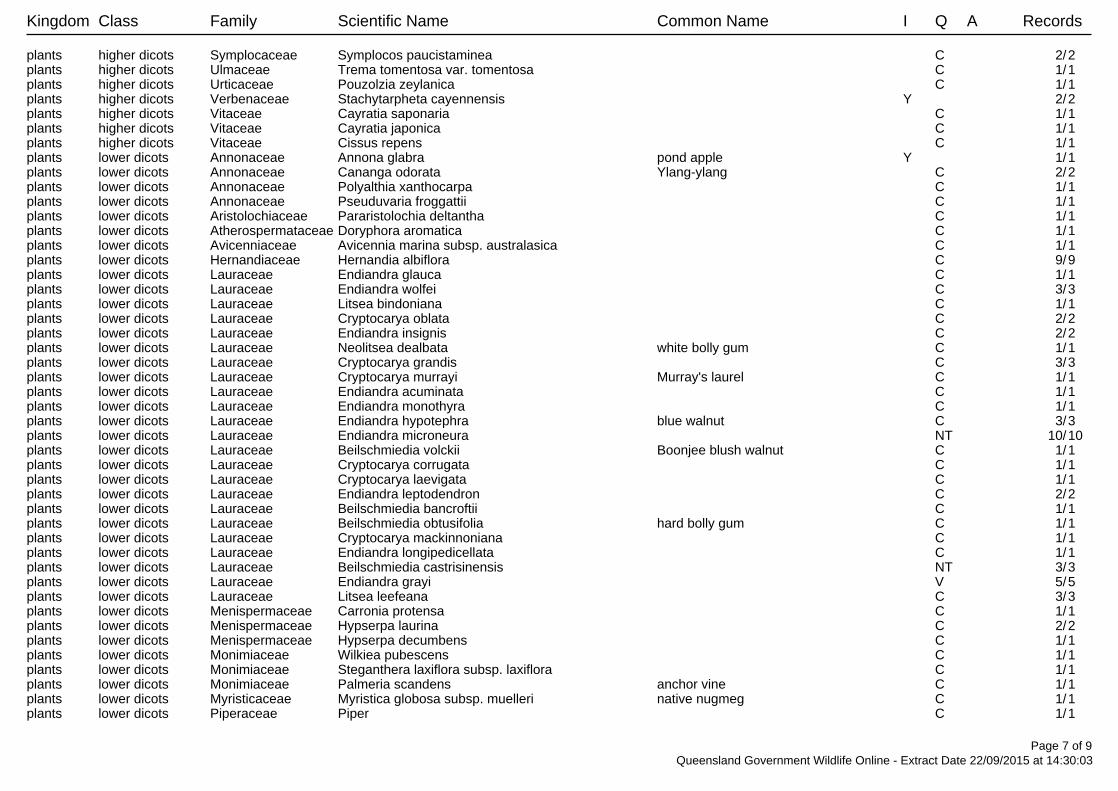
Kingdom Class Family Scientific Name Common Name I Q A Records
plants higher dicots Symplocaceae Symplocos paucistaminea C 2/2plants higher dicots Ulmaceae Trema tomentosa var. tomentosa C 1/1plants higher dicots Urticaceae Pouzolzia zeylanica C 1/1plants higher dicots Verbenaceae Stachytarpheta cayennensis Y 2/2plants higher dicots Vitaceae Cayratia saponaria C 1/1plants higher dicots Vitaceae Cayratia japonica C 1/1plants higher dicots Vitaceae Cissus repens C 1/1plants lower dicots Annonaceae Annona glabra pond apple Y 1/1plants lower dicots Annonaceae Cananga odorata Ylang-ylang C 2/2plants lower dicots Annonaceae Polyalthia xanthocarpa C 1/1plants lower dicots Annonaceae Pseuduvaria froggattii C 1/1plants lower dicots Aristolochiaceae Pararistolochia deltantha C 1/1plants lower dicots Atherospermataceae Doryphora aromatica C 1/1plants lower dicots Avicenniaceae Avicennia marina subsp. australasica C 1/1plants lower dicots Hernandiaceae Hernandia albiflora C 9/9plants lower dicots Lauraceae Endiandra glauca C 1/1plants lower dicots Lauraceae Endiandra wolfei C 3/3plants lower dicots Lauraceae Litsea bindoniana C 1/1plants lower dicots Lauraceae Cryptocarya oblata C 2/2plants lower dicots Lauraceae Endiandra insignis C 2/2plants lower dicots Lauraceae Neolitsea dealbata white bolly gum C 1/1plants lower dicots Lauraceae Cryptocarya grandis C 3/3plants lower dicots Lauraceae Cryptocarya murrayi Murray's laurel C 1/1plants lower dicots Lauraceae Endiandra acuminata C 1/1plants lower dicots Lauraceae Endiandra monothyra C 1/1plants lower dicots Lauraceae Endiandra hypotephra blue walnut C 3/3plants lower dicots Lauraceae Endiandra microneura NT 10/10plants lower dicots Lauraceae Beilschmiedia volckii Boonjee blush walnut C 1/1plants lower dicots Lauraceae Cryptocarya corrugata C 1/1plants lower dicots Lauraceae Cryptocarya laevigata C 1/1plants lower dicots Lauraceae Endiandra leptodendron C 2/2plants lower dicots Lauraceae Beilschmiedia bancroftii C 1/1plants lower dicots Lauraceae Beilschmiedia obtusifolia hard bolly gum C 1/1plants lower dicots Lauraceae Cryptocarya mackinnoniana C 1/1plants lower dicots Lauraceae Endiandra longipedicellata C 1/1plants lower dicots Lauraceae Beilschmiedia castrisinensis NT 3/3plants lower dicots Lauraceae Endiandra grayi V 5/5plants lower dicots Lauraceae Litsea leefeana C 3/3plants lower dicots Menispermaceae Carronia protensa C 1/1plants lower dicots Menispermaceae Hypserpa laurina C 2/2plants lower dicots Menispermaceae Hypserpa decumbens C 1/1plants lower dicots Monimiaceae Wilkiea pubescens C 1/1plants lower dicots Monimiaceae Steganthera laxiflora subsp. laxiflora C 1/1plants lower dicots Monimiaceae Palmeria scandens anchor vine C 1/1plants lower dicots Myristicaceae Myristica globosa subsp. muelleri native nugmeg C 1/1plants lower dicots Piperaceae Piper C 1/1
Page 7 of 9Queensland Government Wildlife Online - Extract Date 22/09/2015 at 14:30:03
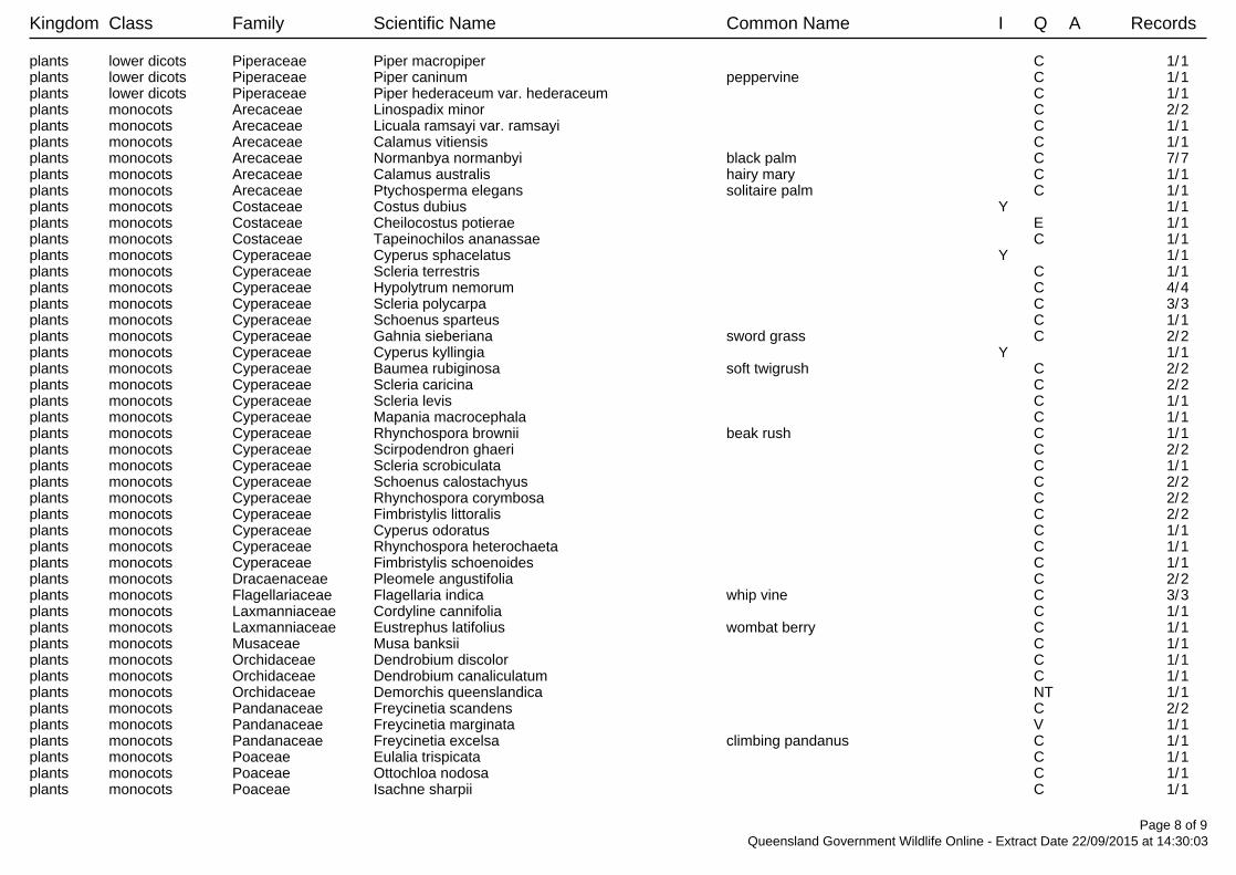
Kingdom Class Family Scientific Name Common Name I Q A Records
plants lower dicots Piperaceae Piper macropiper C 1/1plants lower dicots Piperaceae Piper caninum peppervine C 1/1plants lower dicots Piperaceae Piper hederaceum var. hederaceum C 1/1plants monocots Arecaceae Linospadix minor C 2/2plants monocots Arecaceae Licuala ramsayi var. ramsayi C 1/1plants monocots Arecaceae Calamus vitiensis C 1/1plants monocots Arecaceae Normanbya normanbyi black palm C 7/7plants monocots Arecaceae Calamus australis hairy mary C 1/1plants monocots Arecaceae Ptychosperma elegans solitaire palm C 1/1plants monocots Costaceae Costus dubius Y 1/1plants monocots Costaceae Cheilocostus potierae E 1/1plants monocots Costaceae Tapeinochilos ananassae C 1/1plants monocots Cyperaceae Cyperus sphacelatus Y 1/1plants monocots Cyperaceae Scleria terrestris C 1/1plants monocots Cyperaceae Hypolytrum nemorum C 4/4plants monocots Cyperaceae Scleria polycarpa C 3/3plants monocots Cyperaceae Schoenus sparteus C 1/1plants monocots Cyperaceae Gahnia sieberiana sword grass C 2/2plants monocots Cyperaceae Cyperus kyllingia Y 1/1plants monocots Cyperaceae Baumea rubiginosa soft twigrush C 2/2plants monocots Cyperaceae Scleria caricina C 2/2plants monocots Cyperaceae Scleria levis C 1/1plants monocots Cyperaceae Mapania macrocephala C 1/1plants monocots Cyperaceae Rhynchospora brownii beak rush C 1/1plants monocots Cyperaceae Scirpodendron ghaeri C 2/2plants monocots Cyperaceae Scleria scrobiculata C 1/1plants monocots Cyperaceae Schoenus calostachyus C 2/2plants monocots Cyperaceae Rhynchospora corymbosa C 2/2plants monocots Cyperaceae Fimbristylis littoralis C 2/2plants monocots Cyperaceae Cyperus odoratus C 1/1plants monocots Cyperaceae Rhynchospora heterochaeta C 1/1plants monocots Cyperaceae Fimbristylis schoenoides C 1/1plants monocots Dracaenaceae Pleomele angustifolia C 2/2plants monocots Flagellariaceae Flagellaria indica whip vine C 3/3plants monocots Laxmanniaceae Cordyline cannifolia C 1/1plants monocots Laxmanniaceae Eustrephus latifolius wombat berry C 1/1plants monocots Musaceae Musa banksii C 1/1plants monocots Orchidaceae Dendrobium discolor C 1/1plants monocots Orchidaceae Dendrobium canaliculatum C 1/1plants monocots Orchidaceae Demorchis queenslandica NT 1/1plants monocots Pandanaceae Freycinetia scandens C 2/2plants monocots Pandanaceae Freycinetia marginata V 1/1plants monocots Pandanaceae Freycinetia excelsa climbing pandanus C 1/1plants monocots Poaceae Eulalia trispicata C 1/1plants monocots Poaceae Ottochloa nodosa C 1/1plants monocots Poaceae Isachne sharpii C 1/1
Page 8 of 9Queensland Government Wildlife Online - Extract Date 22/09/2015 at 14:30:03
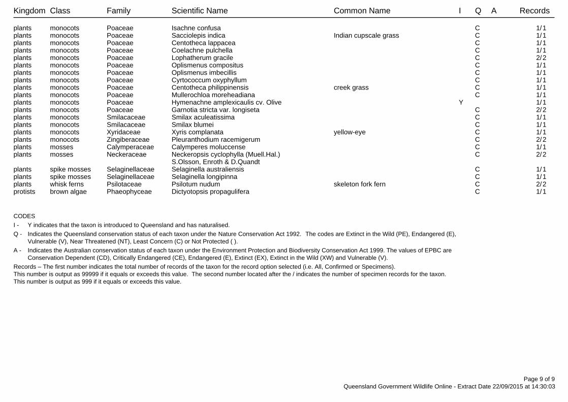
Kingdom Class Family Scientific Name Common Name I Q A Records
plants monocots Poaceae Isachne confusa C 1/1plants monocots Poaceae Sacciolepis indica Indian cupscale grass C 1/1plants monocots Poaceae Centotheca lappacea C 1/1plants monocots Poaceae Coelachne pulchella C 1/1plants monocots Poaceae Lophatherum gracile C 2/2plants monocots Poaceae Oplismenus compositus C 1/1plants monocots Poaceae Oplismenus imbecillis C 1/1plants monocots Poaceae Cyrtococcum oxyphyllum C 1/1plants monocots Poaceae Centotheca philippinensis creek grass C 1/1plants monocots Poaceae Mullerochloa moreheadiana C 1/1plants monocots Poaceae Hymenachne amplexicaulis cv. Olive Y 1/1plants monocots Poaceae Garnotia stricta var. longiseta C 2/2plants monocots Smilacaceae Smilax aculeatissima C 1/1plants monocots Smilacaceae Smilax blumei C 1/1plants monocots Xyridaceae Xyris complanata yellow-eye C 1/1plants monocots Zingiberaceae Pleuranthodium racemigerum C 2/2plants mosses Calymperaceae Calymperes moluccense C 1/1plants mosses Neckeraceae Neckeropsis cyclophylla (Muell.Hal.) C 2/2
S.Olsson, Enroth & D.Quandtplants spike mosses Selaginellaceae Selaginella australiensis C 1/1plants spike mosses Selaginellaceae Selaginella longipinna C 1/1plants whisk ferns Psilotaceae Psilotum nudum skeleton fork fern C 2/2protists brown algae Phaeophyceae Dictyotopsis propagulifera C 1/1
CODES
I - Y indicates that the taxon is introduced to Queensland and has naturalised.
Q - Indicates the Queensland conservation status of each taxon under the Nature Conservation Act 1992. The codes are Extinct in the Wild (PE), Endangered (E),Vulnerable (V), Near Threatened (NT), Least Concern (C) or Not Protected ( ).
A - Indicates the Australian conservation status of each taxon under the Environment Protection and Biodiversity Conservation Act 1999. The values of EPBC areConservation Dependent (CD), Critically Endangered (CE), Endangered (E), Extinct (EX), Extinct in the Wild (XW) and Vulnerable (V).
Records – The first number indicates the total number of records of the taxon for the record option selected (i.e. All, Confirmed or Specimens).This number is output as 99999 if it equals or exceeds this value. The second number located after the / indicates the number of specimen records for the taxon.This number is output as 999 if it equals or exceeds this value.
Page 9 of 9Queensland Government Wildlife Online - Extract Date 22/09/2015 at 14:30:03
EPBC Act Protected Matters Report
This report provides general guidance on matters of national environmental significance and other mattersprotected by the EPBC Act in the area you have selected.
Information on the coverage of this report and qualifications on data supporting this report are contained in thecaveat at the end of the report.
Information is available about Environment Assessments and the EPBC Act including significance guidelines,forms and application process details.
Other Matters Protected by the EPBC Act
Acknowledgements
Buffer: 5.0Km
Matters of NES
Report created: 14/07/15 11:47:15
Coordinates
This map may contain data which are©Commonwealth of Australia(Geoscience Australia), ©PSMA 2010
CaveatExtra Information
DetailsSummary
Summary
This part of the report summarises the matters of national environmental significance that may occur in, or mayrelate to, the area you nominated. Further information is available in the detail part of the report, which can beaccessed by scrolling or following the links below. If you are proposing to undertake an activity that may have asignificant impact on one or more matters of national environmental significance then you should consider theAdministrative Guidelines on Significance.
Matters of National Environmental Significance
Listed Threatened Ecological Communities:
Listed Migratory Species:
1
Great Barrier Reef Marine Park:
Wetlands of International Importance:
Listed Threatened Species:
None
49
3
2
National Heritage Places:
Commonwealth Marine Area:
World Heritage Properties:
None
None
23
The EPBC Act protects the environment on Commonwealth land, the environment from the actions taken onCommonwealth land, and the environment from actions taken by Commonwealth agencies. As heritage values of aplace are part of the 'environment', these aspects of the EPBC Act protect the Commonwealth Heritage values of aCommonwealth Heritage place. Information on the new heritage laws can be found athttp://www.environment.gov.au/heritage/index.html
This part of the report summarises other matters protected under the Act that may relate to the area you nominated.Approval may be required for a proposed activity that significantly affects the environment on Commonwealth land,when the action is outside the Commonwealth land, or the environment anywhere when the action is taken onCommonwealth land. Approval may also be required for the Commonwealth or Commonwealth agencies proposing totake an action that is likely to have a significant impact on the environment anywhere.
A permit may be required for activities in or on a Commonwealth area that may affect a member of a listed threatenedspecies or ecological community, a member of a listed migratory species, whales and other cetaceans, or a member ofa listed marine species.
Other Matters Protected by the EPBC Act
None
None
3
Listed Marine Species:
Whales and Other Cetaceans:
67
Commonwealth Heritage Places:
None
None
Critical Habitats:
Commonwealth Land:
Commonwealth Reserves Terrestrial:
NoneCommonwealth Reserves Marine:
Extra Information
This part of the report provides information that may also be relevant to the area you have nominated.
1
6State and Territory Reserves:
Nationally Important Wetlands:
NoneRegional Forest Agreements:
Invasive Species: 22
NoneKey Ecological Features (Marine)
Details
Listed Threatened Species [ Resource Information ]Name Status Type of PresenceBirds
Southern Cassowary (Australian), SouthernCassowary [25986]
Endangered Species or species habitatknown to occur within area
Casuarius casuarius johnsonii
Red Goshawk [942] Vulnerable Species or species habitatknown to occur within area
Erythrotriorchis radiatus
Australian Painted Snipe [77037] Endangered Species or species habitatmay occur within area
Rostratula australis
Masked Owl (northern) [26048] Vulnerable Species or species habitatlikely to occur within area
Tyto novaehollandiae kimberli
Frogs
Australian Lace-lid, Lace-eyed Tree Frog [86707] Endangered Species or species habitatlikely to occur within area
Litoria dayi
Waterfall Frog, Torrent Tree Frog [1817] Endangered Species or species habitatlikely to occur within area
Litoria nannotis
Common Mistfrog [1802] Endangered Species or species habitatknown to occur within area
Litoria rheocola
Mammals
World Heritage Properties [ Resource Information ]Name StatusStateGreat Barrier Reef Declared propertyQLDWet Tropics of Queensland Declared propertyQLD
National Heritage Properties [ Resource Information ]Name StatusStateNaturalGreat Barrier Reef Listed placeQLDWet Tropics of Queensland Listed placeQLDIndigenousWet Tropics World Heritage Area (Indigenous Values) Within listed placeQLD
For threatened ecological communities where the distribution is well known, maps are derived from recoveryplans, State vegetation maps, remote sensing imagery and other sources. Where threatened ecologicalcommunity distributions are less well known, existing vegetation maps and point location data are used toproduce indicative distribution maps.
Listed Threatened Ecological Communities [ Resource Information ]
Name Status Type of PresenceBroad leaf tea-tree (Melaleuca viridiflora) woodlands inhigh rainfall coastal north Queensland
Endangered Community may occurwithin area
Matters of National Environmental Significance
Name Status Type of Presence
Northern Quoll [331] Endangered Species or species habitatmay occur within area
Dasyurus hallucatus
Spotted-tailed Quoll or Yarri (North Queenslandsubspecies) [64475]
Endangered Species or species habitatlikely to occur within area
Dasyurus maculatus gracilis
Semon's Leaf-nosed Bat, Greater Wart-nosedHorseshoe-bat [180]
Endangered Species or species habitatmay occur within area
Hipposideros semoni
Humpback Whale [38] Vulnerable Breeding known to occurwithin area
Megaptera novaeangliae
Black-footed Tree-rat (north Queensland) [87620] Vulnerable Species or species habitatlikely to occur within area
Mesembriomys gouldii rattoides
Koala (combined populations of Queensland, NewSouth Wales and the Australian Capital Territory)[85104]
Vulnerable Species or species habitatmay occur within area
Phascolarctos cinereus (combined populations of Qld, NSW and the ACT)
Spectacled Flying-fox [185] Vulnerable Species or species habitatknown to occur within area
Pteropus conspicillatus
Greater Large-eared Horseshoe Bat [66890] Endangered Species or species habitatknown to occur within area
Rhinolophus philippinensis (large form)
Bare-rumped Sheathtail Bat [66889] Critically Endangered Species or species habitatlikely to occur within area
Saccolaimus saccolaimus nudicluniatus
Water Mouse, False Water Rat, Yirrkoo [66] Vulnerable Species or species habitatmay occur within area
Xeromys myoides
Plants
Pale Chandelier Orchid [83928] Vulnerable Species or species habitatknown to occur within area
Acriopsis emarginata
[12078] Vulnerable Species or species habitatknown to occur within area
Actephila foetida
[19154] Vulnerable Species or species habitatknown to occur within area
Asplenium wildii
[8635] Endangered Species or species habitatmay occur within area
Cajanus mareebensis
[23956] Vulnerable Species or species habitatlikely to occur within area
Canarium acutifolium
[24603] Endangered Species or species habitatknown to occur within area
Chingia australis
Middle Filmy Fern [65889] Endangered Species or species habitatlikely to occur within area
Crepidomanes endlicherianum
Cooktown Orchid [10306] Vulnerable Species or species habitatmay occur within area
Dendrobium bigibbum
Name Status Type of Presence
Chocolate Tea Tree Orchid [13585] Vulnerable Species or species habitatlikely to occur within area
Dendrobium johannis
an orchid [78703] Endangered Species or species habitatlikely to occur within area
Durabaculum mirbelianum
an orchid [78704] Endangered Species or species habitatknown to occur within area
Durabaculum nindii
[52889] Endangered Species or species habitatlikely to occur within area
Endiandra cooperana
Ant Plant [11852] Vulnerable Species or species habitatlikely to occur within area
Myrmecodia beccarii
Lesser Swamp-orchid [5872] Endangered Species or species habitatmay occur within area
Phaius australis
Native Moth Orchid [15984] Endangered Species or species habitatlikely to occur within area
Phalaenopsis rosenstromii
[82049] Vulnerable Species or species habitatlikely to occur within area
Phaleria biflora
[7237] Vulnerable Species or species habitatlikely to occur within area
Polyscias bellendenkerensis
[18776] Vulnerable Species or species habitatlikely to occur within area
Ristantia gouldii
Thin Feather Orchid [82771] Vulnerable Species or species habitatlikely to occur within area
Tropilis callitrophilis
Dwarf Butterfly Orchid, Cooktown Orchid [78893] Endangered Species or species habitatmay occur within area
Vappodes lithocola
Cooktown Orchid [78894] Vulnerable Species or species habitatmay occur within area
Vappodes phalaenopsis
[83575] Endangered Species or species habitatlikely to occur within area
Vrydagzynea grayi
Velvet Jewel Orchid [46794] Vulnerable Species or species habitatlikely to occur within area
Zeuxine polygonoides
Reptiles
Loggerhead Turtle [1763] Endangered Foraging, feeding or relatedbehaviour likely to occurwithin area
Caretta caretta
Green Turtle [1765] Vulnerable Foraging, feeding or relatedbehaviour known to occurwithin area
Chelonia mydas
Leatherback Turtle, Leathery Turtle, Luth [1768] Endangered Foraging, feeding or relatedbehaviour likely to occurwithin area
Dermochelys coriacea
Name Status Type of Presence
Yakka Skink [1420] Vulnerable Species or species habitatmay occur within area
Egernia rugosa
Hawksbill Turtle [1766] Vulnerable Species or species habitatknown to occur within area
Eretmochelys imbricata
Olive Ridley Turtle, Pacific Ridley Turtle [1767] Endangered Foraging, feeding or relatedbehaviour likely to occurwithin area
Lepidochelys olivacea
Flatback Turtle [59257] Vulnerable Foraging, feeding or relatedbehaviour known to occurwithin area
Natator depressus
Sharks
Largetooth Sawfish, Freshwater Sawfish, RiverSawfish, Leichhardt's Sawfish, Northern Sawfish[60756]
Vulnerable Species or species habitatknown to occur within area
Pristis pristis
Green Sawfish, Dindagubba, Narrowsnout Sawfish[68442]
Vulnerable Species or species habitatknown to occur within area
Pristis zijsron
Listed Migratory Species [ Resource Information ]* Species is listed under a different scientific name on the EPBC Act - Threatened Species list.Name Threatened Type of PresenceMigratory Marine Birds
Fork-tailed Swift [678] Species or species habitatlikely to occur within area
Apus pacificus
Migratory Marine Species
Loggerhead Turtle [1763] Endangered Foraging, feeding or relatedbehaviour likely to occurwithin area
Caretta caretta
Green Turtle [1765] Vulnerable Foraging, feeding or relatedbehaviour known to occurwithin area
Chelonia mydas
Salt-water Crocodile, Estuarine Crocodile [1774] Species or species habitatlikely to occur within area
Crocodylus porosus
Leatherback Turtle, Leathery Turtle, Luth [1768] Endangered Foraging, feeding or relatedbehaviour likely to occurwithin area
Dermochelys coriacea
Hawksbill Turtle [1766] Vulnerable Species or species habitatknown to occur within area
Eretmochelys imbricata
Olive Ridley Turtle, Pacific Ridley Turtle [1767] Endangered Foraging, feeding or relatedbehaviour likely to occurwithin area
Lepidochelys olivacea
Giant Manta Ray, Chevron Manta Ray, Pacific MantaRay, Pelagic Manta Ray, Oceanic Manta Ray [84995]
Species or species habitatmay occur within area
Manta birostris
Humpback Whale [38] Vulnerable Breeding known to occurwithin area
Megaptera novaeangliae
Flatback Turtle [59257] Vulnerable Foraging, feeding or relatedbehaviour known to occurwithin area
Natator depressus
Irrawaddy Dolphin [45] Species or speciesOrcaella brevirostris
Name Threatened Type of Presencehabitat may occur withinarea
Indo-Pacific Humpback Dolphin [50] Species or species habitatlikely to occur within area
Sousa chinensis
Migratory Terrestrial Species
White-throated Needletail [682] Species or species habitatmay occur within area
Hirundapus caudacutus
Barn Swallow [662] Species or species habitatmay occur within area
Hirundo rustica
Rainbow Bee-eater [670] Species or species habitatmay occur within area
Merops ornatus
Black-faced Monarch [609] Species or species habitatknown to occur within area
Monarcha melanopsis
Spectacled Monarch [610] Species or species habitatknown to occur within area
Monarcha trivirgatus
Satin Flycatcher [612] Species or species habitatknown to occur within area
Myiagra cyanoleuca
Rufous Fantail [592] Species or species habitatknown to occur within area
Rhipidura rufifrons
Migratory Wetlands Species
Great Egret, White Egret [59541] Species or species habitatknown to occur within area
Ardea alba
Cattle Egret [59542] Species or species habitatmay occur within area
Ardea ibis
Latham's Snipe, Japanese Snipe [863] Species or species habitatmay occur within area
Gallinago hardwickii
Eastern Osprey [82411] Breeding known to occurwithin area
Pandion cristatus
Listed Marine Species [ Resource Information ]* Species is listed under a different scientific name on the EPBC Act - Threatened Species list.Name Threatened Type of PresenceBirds
Magpie Goose [978] Species or species habitatmay occur within area
Anseranas semipalmata
Fork-tailed Swift [678] Species or species habitatlikely to occur within area
Apus pacificus
Great Egret, White Egret [59541] Species or speciesArdea alba
Other Matters Protected by the EPBC Act
Name Threatened Type of Presencehabitat known to occurwithin area
Cattle Egret [59542] Species or species habitatmay occur within area
Ardea ibis
Latham's Snipe, Japanese Snipe [863] Species or species habitatmay occur within area
Gallinago hardwickii
White-bellied Sea-Eagle [943] Species or species habitatknown to occur within area
Haliaeetus leucogaster
White-throated Needletail [682] Species or species habitatmay occur within area
Hirundapus caudacutus
Barn Swallow [662] Species or species habitatmay occur within area
Hirundo rustica
Rainbow Bee-eater [670] Species or species habitatmay occur within area
Merops ornatus
Black-faced Monarch [609] Species or species habitatknown to occur within area
Monarcha melanopsis
Spectacled Monarch [610] Species or species habitatknown to occur within area
Monarcha trivirgatus
Satin Flycatcher [612] Species or species habitatknown to occur within area
Myiagra cyanoleuca
Osprey [952] Breeding known to occurwithin area
Pandion haliaetus
Rufous Fantail [592] Species or species habitatknown to occur within area
Rhipidura rufifrons
Painted Snipe [889] Endangered* Species or species habitatmay occur within area
Rostratula benghalensis (sensu lato)
Fish
Shortpouch Pygmy Pipehorse [66187] Species or species habitatmay occur within area
Acentronura tentaculata
Davao Pughead Pipefish [66190] Species or species habitatmay occur within area
Bulbonaricus davaoensis
Pacific Short-bodied Pipefish, Short-bodied Pipefish[66194]
Species or species habitatmay occur within area
Choeroichthys brachysoma
Sculptured Pipefish [66197] Species or species habitatmay occur within area
Choeroichthys sculptus
Pig-snouted Pipefish [66198] Species or species habitatmay occur within area
Choeroichthys suillus
Fijian Banded Pipefish, Brown-banded Pipefish[66199]
Species or species habitatmay occur within
Corythoichthys amplexus
Name Threatened Type of Presencearea
Reticulate Pipefish, Yellow-banded Pipefish, NetworkPipefish [66200]
Species or species habitatmay occur within area
Corythoichthys flavofasciatus
Australian Messmate Pipefish, Banded Pipefish[66202]
Species or species habitatmay occur within area
Corythoichthys intestinalis
Orange-spotted Pipefish, Ocellated Pipefish [66203] Species or species habitatmay occur within area
Corythoichthys ocellatus
Paxton's Pipefish [66204] Species or species habitatmay occur within area
Corythoichthys paxtoni
Schultz's Pipefish [66205] Species or species habitatmay occur within area
Corythoichthys schultzi
Maxweber's Pipefish [66209] Species or species habitatmay occur within area
Cosmocampus maxweberi
Banded Pipefish, Ringed Pipefish [66210] Species or species habitatmay occur within area
Doryrhamphus dactyliophorus
Bluestripe Pipefish, Indian Blue-stripe Pipefish, PacificBlue-stripe Pipefish [66211]
Species or species habitatmay occur within area
Doryrhamphus excisus
Cleaner Pipefish, Janss' Pipefish [66212] Species or species habitatmay occur within area
Doryrhamphus janssi
Girdled Pipefish [66214] Species or species habitatmay occur within area
Festucalex cinctus
Gibbs' Pipefish [66215] Species or species habitatmay occur within area
Festucalex gibbsi
Red-hair Pipefish, Duncker's Pipefish [66220] Species or species habitatmay occur within area
Halicampus dunckeri
Mud Pipefish, Gray's Pipefish [66221] Species or species habitatmay occur within area
Halicampus grayi
Whiskered Pipefish, Ornate Pipefish [66222] Species or species habitatmay occur within area
Halicampus macrorhynchus
Samoan Pipefish [66223] Species or species habitatmay occur within area
Halicampus mataafae
Glittering Pipefish [66224] Species or species habitatmay occur within area
Halicampus nitidus
Spiny-snout Pipefish [66225] Species or species habitatmay occur within area
Halicampus spinirostris
Blue-speckled Pipefish, Blue-spotted Pipefish [66228] Species or species habitatmay occur within area
Hippichthys cyanospilos
Name Threatened Type of Presence
Madura Pipefish, Reticulated Freshwater Pipefish[66229]
Species or species habitatmay occur within area
Hippichthys heptagonus
Beady Pipefish, Steep-nosed Pipefish [66231] Species or species habitatmay occur within area
Hippichthys penicillus
Belly-barred Pipefish, Banded Freshwater Pipefish[66232]
Species or species habitatmay occur within area
Hippichthys spicifer
Pygmy Seahorse [66721] Species or species habitatmay occur within area
Hippocampus bargibanti
Spiny Seahorse, Thorny Seahorse [66236] Species or species habitatmay occur within area
Hippocampus histrix
Spotted Seahorse, Yellow Seahorse [66237] Species or species habitatmay occur within area
Hippocampus kuda
Flat-face Seahorse [66238] Species or species habitatmay occur within area
Hippocampus planifrons
Zebra Seahorse [66241] Species or species habitatmay occur within area
Hippocampus zebra
Anderson's Pipefish, Shortnose Pipefish [66253] Species or species habitatmay occur within area
Micrognathus andersonii
thorntail Pipefish, Thorn-tailed Pipefish [66254] Species or species habitatmay occur within area
Micrognathus brevirostris
Short-tail Pipefish, Short-tailed River Pipefish [66257] Species or species habitatmay occur within area
Microphis brachyurus
Painted Pipefish, Reef Pipefish [66263] Species or species habitatmay occur within area
Nannocampus pictus
Pale-blotched Pipefish, Spined Pipefish [66266] Species or species habitatmay occur within area
Phoxocampus diacanthus
Softcoral Pipefish, Soft-coral Pipefish [66270] Species or species habitatmay occur within area
Siokunichthys breviceps
Pallid Pipehorse, Hardwick's Pipehorse [66272] Species or species habitatmay occur within area
Solegnathus hardwickii
Robust Ghostpipefish, Blue-finned Ghost Pipefish,[66183]
Species or species habitatmay occur within area
Solenostomus cyanopterus
Rough-snout Ghost Pipefish [68425] Species or species habitatmay occur within area
Solenostomus paegnius
Ornate Ghostpipefish, Harlequin Ghost Pipefish,Ornate Ghost Pipefish [66184]
Species or species habitatmay occur within area
Solenostomus paradoxus
Name Threatened Type of Presence
Double-end Pipehorse, Double-ended Pipehorse,Alligator Pipefish [66279]
Species or species habitatmay occur within area
Syngnathoides biaculeatus
Bentstick Pipefish, Bend Stick Pipefish, Short-tailedPipefish [66280]
Species or species habitatmay occur within area
Trachyrhamphus bicoarctatus
Straightstick Pipefish, Long-nosed Pipefish, StraightStick Pipefish [66281]
Species or species habitatmay occur within area
Trachyrhamphus longirostris
Reptiles
Loggerhead Turtle [1763] Endangered Foraging, feeding or relatedbehaviour likely to occurwithin area
Caretta caretta
Green Turtle [1765] Vulnerable Foraging, feeding or relatedbehaviour known to occurwithin area
Chelonia mydas
Salt-water Crocodile, Estuarine Crocodile [1774] Species or species habitatlikely to occur within area
Crocodylus porosus
Leatherback Turtle, Leathery Turtle, Luth [1768] Endangered Foraging, feeding or relatedbehaviour likely to occurwithin area
Dermochelys coriacea
Hawksbill Turtle [1766] Vulnerable Species or species habitatknown to occur within area
Eretmochelys imbricata
Olive Ridley Turtle, Pacific Ridley Turtle [1767] Endangered Foraging, feeding or relatedbehaviour likely to occurwithin area
Lepidochelys olivacea
Flatback Turtle [59257] Vulnerable Foraging, feeding or relatedbehaviour known to occurwithin area
Natator depressus
Whales and other Cetaceans [ Resource Information ]Name Status Type of PresenceMammals
Humpback Whale [38] Vulnerable Breeding known to occurwithin area
Megaptera novaeangliae
Irrawaddy Dolphin [45] Species or species habitatmay occur within area
Orcaella brevirostris
Indo-Pacific Humpback Dolphin [50] Species or species habitatlikely to occur within area
Sousa chinensis
State and Territory Reserves [ Resource Information ]Name StateAcaciavale QLDDaintree QLDEastern Kuku Yalanji QLDKaba-Kada QLDRainforest Rescue QLDThe Swamp Forest QLD
Extra Information
Invasive Species [ Resource Information ]Weeds reported here are the 20 species of national significance (WoNS), along with other introduced plantsthat are considered by the States and Territories to pose a particularly significant threat to biodiversity. Thefollowing feral animals are reported: Goat, Red Fox, Cat, Rabbit, Pig, Water Buffalo and Cane Toad. Maps fromLandscape Health Project, National Land and Water Resouces Audit, 2001.
Name Status Type of PresenceBirds
Common Myna, Indian Myna [387] Species or species habitatlikely to occur within area
Acridotheres tristis
Rock Pigeon, Rock Dove, Domestic Pigeon [803] Species or species habitatlikely to occur within area
Columba livia
Nutmeg Mannikin [399] Species or species habitatlikely to occur within area
Lonchura punctulata
House Sparrow [405] Species or species habitatlikely to occur within area
Passer domesticus
Spotted Turtle-Dove [780] Species or species habitatlikely to occur within area
Streptopelia chinensis
Common Starling [389] Species or species habitatlikely to occur within area
Sturnus vulgaris
Frogs
Cane Toad [83218] Species or species habitatlikely to occur within area
Rhinella marina
Mammals
Domestic Dog [82654] Species or species habitatlikely to occur within area
Canis lupus familiaris
Cat, House Cat, Domestic Cat [19] Species or species habitatlikely to occur within area
Felis catus
Feral deer species in Australia [85733] Species or species habitatlikely to occur within area
Feral deer
Black Rat, Ship Rat [84] Species or species habitatlikely to occur within area
Rattus rattus
Pig [6] Species or species habitatlikely to occur within area
Sus scrofa
Plants
Nationally Important Wetlands [ Resource Information ]Name StateLower Daintree River QLD
Name Status Type of Presence
Pond Apple, Pond-apple Tree, Alligator Apple,Bullock's Heart, Cherimoya, Monkey Apple, Bobwood,Corkwood [6311]
Species or species habitatlikely to occur within area
Annona glabra
Madeira Vine, Jalap, Lamb's-tail, Mignonette Vine,Anredera, Gulf Madeiravine, Heartleaf Madeiravine,Potato Vine [2643]
Species or species habitatlikely to occur within area
Anredera cordifolia
Buffel-grass, Black Buffel-grass [20213] Species or species habitatmay occur within area
Cenchrus ciliaris
Rubber Vine, Rubbervine, India Rubber Vine, IndiaRubbervine, Palay Rubbervine, Purple Allamanda[18913]
Species or species habitatlikely to occur within area
Cryptostegia grandiflora
Hymenachne, Olive Hymenachne, Water Stargrass,West Indian Grass, West Indian Marsh Grass [31754]
Species or species habitatlikely to occur within area
Hymenachne amplexicaulis
Lantana, Common Lantana, Kamara Lantana, Large-leaf Lantana, Pink Flowered Lantana, Red FloweredLantana, Red-Flowered Sage, White Sage, Wild Sage[10892]
Species or species habitatlikely to occur within area
Lantana camara
Parthenium Weed, Bitter Weed, Carrot Grass, FalseRagweed [19566]
Species or species habitatlikely to occur within area
Parthenium hysterophorus
Delta Arrowhead, Arrowhead, Slender Arrowhead[68483]
Species or species habitatlikely to occur within area
Sagittaria platyphylla
Salvinia, Giant Salvinia, Aquarium Watermoss, KaribaWeed [13665]
Species or species habitatlikely to occur within area
Salvinia molesta
Reptiles
Asian House Gecko [1708] Species or species habitatlikely to occur within area
Hemidactylus frenatus
- non-threatened seabirds which have only been mapped for recorded breeding sites
- migratory species that are very widespread, vagrant, or only occur in small numbers
- some species and ecological communities that have only recently been listed
Not all species listed under the EPBC Act have been mapped (see below) and therefore a report is a general guide only.Where available data supports mapping, the type of presence that can be determined from the data is indicated in generalterms. People using this information in making a referral may need to consider the qualifications below and may need to seekand consider other information sources.
For threatened ecological communities where the distribution is well known, maps are derived from recovery plans, Statevegetation maps, remote sensing imagery and other sources. Where threatened ecological community distributions are lesswell known, existing vegetation maps and point location data are used to produce indicative distribution maps.
- seals which have only been mapped for breeding sites near the Australian continent
Such breeding sites may be important for the protection of the Commonwealth Marine environment.
For species where the distributions are well known, maps are digitised from sources such as recovery plans and detailedhabitat studies. Where appropriate, core breeding, foraging and roosting areas are indicated under 'type of presence'. Forspecies whose distributions are less well known, point locations are collated from government wildlife authorities, museums,and non-government organisations; bioclimatic distribution models are generated and these validated by experts. In somecases, the distribution maps are based solely on expert knowledge.
The information presented in this report has been provided by a range of data sources as acknowledged at the end of thereport.
Caveat
- migratory and
The following species and ecological communities have not been mapped and do not appear in reports produced from thisdatabase:
- marine
This report is designed to assist in identifying the locations of places which may be relevant in determining obligations underthe Environment Protection and Biodiversity Conservation Act 1999. It holds mapped locations of World and National Heritageproperties, Wetlands of International and National Importance, Commonwealth and State/Territory reserves, listed threatened,migratory and marine species and listed threatened ecological communities. Mapping of Commonwealth land is not completeat this stage. Maps have been collated from a range of sources at various resolutions.
- threatened species listed as extinct or considered as vagrants
- some terrestrial species that overfly the Commonwealth marine area
The following groups have been mapped, but may not cover the complete distribution of the species:
Only selected species covered by the following provisions of the EPBC Act have been mapped:
-16.26258 145.39005
Coordinates
-Department of the Environment, Climate Change, Energy and Water-Birds Australia-Australian Bird and Bat Banding Scheme
-Department of Environment and Conservation, Western Australia
Acknowledgements
-Department of Environment, Climate Change and Water, New South Wales
-Department of Primary Industries, Parks, Water and Environment, Tasmania
-Parks and Wildlife Service NT, NT Dept of Natural Resources, Environment and the Arts-Environmental and Resource Management, Queensland
-Department of Sustainability and Environment, Victoria
-Australian National Wildlife Collection
-Department of Environment and Natural Resources, South Australia
This database has been compiled from a range of data sources. The department acknowledges the followingcustodians who have contributed valuable data and advice:
-Australian Museum
-National Herbarium of NSW
-State Forests of NSW-Australian Government, Department of Defence
-State Herbarium of South Australia
The Department is extremely grateful to the many organisations and individuals who provided expert adviceand information on numerous draft distributions.
-Natural history museums of Australia
-Queensland Museum
-Australian National Herbarium, Atherton and Canberra
-Royal Botanic Gardens and National Herbarium of Victoria
-Geoscience Australia
-Ocean Biogeographic Information System
-Online Zoological Collections of Australian Museums-Queensland Herbarium
-Western Australian Herbarium
-Tasmanian Herbarium
-Northern Territory Herbarium
-SA Museum
-Museum Victoria
-University of New England
-CSIRO-Other groups and individuals
© Commonwealth of Australia
+61 2 6274 1111
Canberra ACT 2601 Australia
GPO Box 787
Department of the Environment
Please feel free to provide feedback via the Contact Us page.

20 | GHD | Report for Douglas Shire Council - Douglas Shire Council NDRRA, 42/18731
Appendix C - Curriculum Vitae
Dr Andrew Small
Curriculum Vitae
1 Andrew Small– Curriculum Vitae
Andrew Small Principal Scientist
Project Gondwana, Wet Tropics Management Authority On behalf of the Wet Tropics Management Authority he was a recipient of a Project Gondwana grant and mapped and reported on the distribution of a number of endemic species in the lowlands Daintree area. This included a number of extremely rare species whose populations were under threat as a result of ongoing rural-residential expansion in the Daintree River to Cape Tribulation area.
Daintree Vegetation Audit, Douglas Shire Council In collaboration with James Cook University, AUSTROP and the CSIRO Tropical Forest Research Centre he undertook extensive audits and surveys over the period 1988 to 2006 to produce a mapping audit of the endemic, restricted and otherwise EVNT species of the area between the Daintree River and Cape Tribulation. This also included extensive habitat mapping, forest type assessment, vegetation mapping and large scale (1ha) plot inventories at a number of sites. The Daintree Vegetation Audit formed the cornerstone of the technical data used by the Commonwealth as part of the $23M Daintree Buyback Program to make prioritise purchases and management actions. This project continues to be used by the Douglas Shire Council to assist in management and development decisions north of the Daintree River. This project is now being reviewed, and research is ongoing.
Surat Basin Transmission Project, Powerlink Queensland EVNT surveys The Surat Basin project is a large project with over 200km of transmission lines and seven substation/switching yards. The project required the development of nine Environmental Impact Statements and associated Environmental Management Plans. To support permits for this project EVNT surveys were required for extensive lengths of transmission lines in
accordance with the May 2014 DEHP Protected Plants Survey Guidelines. Lannercost Bridge Upgrade, Hinchinbrook Shire Council Hinchinbrook Shire Council are currently proposing to upgrade a single lane bridge to a double lane over Lannercost Creek in north Queensland. Initial inspections identified the presence of the listed EVNT species Livistona drudei. (Halifax fan palm). Andrew was responsible for all field surveys, species identifications and report preparation in accordance with the Protected Plants Survey Guidelines. This is an ongoing project.
Upper Daintree NDRRA EVNT Site Assessments, Douglas Shire Council Under the provisions of the National Disaster Relief and Restoration Authority (NDRRA) Douglas Shire have embarked on a program to repair roads damaged through flooding, cyclones and other recent natural disasters. Andrew has lead the flora surveys and headed up the reporting for 5 sites in the upper Daintree area where vegetation clearing will be required. All the sites are within high risk flora trigger areas and surveys for the five sites were undertaken over a two week period for EVNT in accordance with the DEHP Protected Plants Survey Guidelines. Reporting and submission of clearing permits and/or applications for exemptions are ongoing as of August 2015.
Daintree Powerline EIS, FNQEB The FNQEB commissioned GHD to undertake an EIS for a proposed mains electricity grid to the area north of the Daintree River. Andrew led all the flora and fauna survey components of the project and was responsible for the lead authorship of the relevant sections of the EIS. Surveys associated with this EIS expanded the known range of many endemic, EVNT and collected the first known records of a number of species from the Daintree.
Qualified. PhD (Ecology), (SIMAB, Universiti de Tucuman) BSc (Ecology), Biodiversity Monitoring and Inventory (Smithsonian Institute, USA), Director: Australian Tropical Research Centre (AUSTROP)
Relevance to project. Andrew has more than 27 years of experience
involved in a range of ecology environmental planning and management
issues throughout northern Australia, the south-west Pacific, south-east Asia
and the Americas. In particular he has extensive experience in botanical and
ecological surveys, identification of water quality thresholds for aquatic
ecosystem health, and in biodiversity monitoring and impact assessment. His
PhD was undertaken in the Daintree lowlands and he maintains ongoing
research projects in the area focusing on the distribution of endemic species.
Curriculum Vitae
2 Andrew Small– Curriculum Vitae
Gulf LNG Project, InterOil, PNG On behalf of InterOil between 2011 and ongoing into 2012/2013, Andrew is currently project managing the Environmental Impact Assessment Process and subsequent EIS for a large LNG infrastructure project in the Gulf Province of PNG. This is an ongoing project of national significance to the PNG government and as such he has developed a close working relationship with government agencies. Andrew is directly responsible for the technical flora and aquatic environment risk assessment and identification of the project parameters impacting on human and ecological health. Reporting entails satisfying the requirements of the Department of Environment and Conservation of the PNG government. This project is ongoing and is now transitioning into the next phase of the project. Bauxite Hills Alumina Project, Cape Alumina GHD was engaged by Cape Alumina to undertake flora/fauna baseline assessments for the proposed Bauxite Hills Project. Andrew’s role involved liaison and finalisation of survey methodologies with (then) DERM biodiversity officers, with a team to undertake wet season and dry season baseline surveys with the purpose for these to be incorporated into a potential future EIS study. GHD has finalised survey methodologies and approaches, but the current commission is on indefinite “hold” pending the outcome of the Pisolite Hills EIA process. Wet Tropics Road Environmental Management Plan: Dept Main Roads Andrew was the Manager and lead investigator for the preparation of road side management plans for the World Heritage sections of the Cook Highway and Rex Range within Douglas Shire. This entailed systematic investigation of the various ecological and World Heritage features of these sections of road and producing Environmental Management Plans for these sections of road for the Department of Main Roads. Cairns Regional Council Water Supply Options: Cairns Water GHD was engaged by CRC/NQ Water to undertake baseline assessments for either new or upgraded water supply options for the previous Douglas Shire. Andrew’s role was the assessment of environmental flow implications for abstraction locations including Rex Creek, Mossman River, Stewart Creek, Hartley Creek. He was also responsible for the site specific assessment of infrastructure upgrade impacts on environmental values, specifically with reference to EVNT flora species.
Other General Botany/Ecology Experience Biodiversity impacts assessment (fauna/flora), development of monitoring protocols and planning, Ulu Temburong National Park, Batu Apoi Forest Reserve, Brunei (Universiti Brunei Darussalam, Brunei Forestry). In conjunction with Griffith University (Australia) and Earthwatch International, worked in conjunction with agencies of the Brunei government and the local Iban community, to identify the biodiversity values of an area in the Batu Apoi Forest Reserve with a view to declaring the first ever National Park in Brunei. Over a period of 3 years a comprehensive management and planning framework was established for the newly declared park. This included the continuation of research work (Kuala Belalong Field Study Centre), tourism opportunities and habitat management and preservation. Suriname National Forest Program, biodiversity and habitat resource assessment, management planning; rehabilitation and monitoring protocols (University of Suriname, Forest Research and Conservation Centre). Under the Smithsonian Man and Biosphere Biodiversity Monitoring Program worked in cooperation with the Suriname government through the University of Suriname to undertake a large scale assessment of the countries natural resources, and potential impacts of timber concessions. A management plan was prepared which identified native Indian interests, potential timber cutting coups, and nature reserves. As of August 2000, over half of the management recommendations, including declaration of all nature reserves, had been fulfilled. Etna Bay habitat and resource assessment, West Papua, Indonesia. (UNESCO Man and Biosphere Project), recommendations on future management options for area. Etna Bay (on the north coast of West Papua) is an area rich in natural resources. The forest community is relatively undisturbed, however there are large commercial deposits of gold and other minerals in the area which have been identified for mining. The challenge was to firstly undertake an assessment of the natural values of the area, and secondly to identify a series of natural resource management programs to mitigate the mining activity to be undertaken. Fauna/flora survey and habitat assessment, Danum Valley Conservation Area, Sabah, Malaysia (Innoprise Jungle Lodge Sdn Bhd, Danum Valley Field Research Centre and Universiti Kebangsaan). The Danum Valley Conservation Area is the last remaining intact lowland dipterocarp forest on the east coast of Sabah (Malaysian Borneo). The area is subject to many pressures, including illegal logging, tourism, and pressure from other Malaysian agencies to open the area up for commercial timber cutting and oil palm plantations. In order to justify the continued gazettal of the park at its present size, it was necessary to detail the biological values of the area and to recommend a series of planning and
Curriculum Vitae
3 Andrew Small– Curriculum Vitae
management measures to ensure the preservation of these areas without impacting on the environment. Fauna and flora assessment and monitoring protocol for Malita Community Forestry Program, Solomon Islands (TKM Services, Malita). Malita is one of the largest islands in the Solomon Islands archipelago and retains significant tracts of the last remaining high value forests in the country. These tracts of forest are not only important biologically, but also from a cultural heritage to the islanders. Much of the forest is under pressure from government granted logging coups to overseas logging companies, in opposition to local villagers. The challenge was to identify firstly the biological values of the area, and then to recommend a series of management regimes that would benefit both villagers and the Solomon Island government without requiring the signing over of large tracts of traditional forest to overseas logging interests. A sustainable timber cutting management plan was implemented, utilising portable mill saws that were able to be used by local villagers in areas designated as being suitable for timber cutting. Other areas were declared cultural reserves, and held entirely in the villager’s own interests, and opportunities for other commercial ventures, notable tourism were also identified. Flora baseline surveys, Christmas Island, Indian Ocean (Asia Pacific Space Centre). On behalf of the Asia Pacific Space Centre established baseline flora surveys and undertook field methodologies in support of the project. Christmas Island is the intended site of a future satellite launch facility, and the establishment of baseline flora data was a required part of the Environmental Management Plan for the construction and operation of the launch facility. Upper Ramu River catchment flora and fauna field sampling program, Madang Province, Papua New Guinea (Arnold Herbaria, Harvard University, USA). In conjunction with the Arnold Herbaria prepared a sampling program for area. This program was implemented by the Herbaria and in consultation with the Papuan government and Forestry Institute, and the subsequent results were used to formulate a management plan for the upper Ramu River catchment in Madang Province. Establishment of permanent monitoring site and development of associated monitoring protocols at Smithsonian Institute Conservation Research Centre, Virginia, USA (UNESCO Man and the Biosphere Program, Smithsonian Institute). Shenandoah National Park is a well-known National Park on the east coast of the United States that spans over 5 different states. As a component of an integrated approach to the management of this park a series of permanent monitoring program was established which included the establishment of a site at the Conservation
Research Centre, near the town of Front Royal in Virginia. Development and implementation of rehabilitation and revegetation monitoring programs for Itaupu dam community revegetation project (Uruguay) and Eucalyptus firewood and high altitude oak forest management project (Colombia). The Itaupu dam is one of the largest in the world, being located on the border of Uruguay and Brazil. As a compensatory measure, World Bank funding and with coordination by the Smithsonian Tropical Forest Research Institute and the joint Uruguay/Brazil Itaupu Management Committee a long term rehabilitation program was planned and implanted with the displaced villagers being retrained to be employed for the program. To alleviate pressures on these forests, fast growing Australian eucalypts (sterile hybrids) were introduced as part of a management plan to reduce villagers reliance on old growth forests. This program is proving to be very successful. Fauna and flora habitat preference assessment and development of habitat management plans and long term monitoring protocols, Jatun Sacha Forest Reserve, Ecuador In conjunction with management of the Jatun Sacha Field Studies Centre, undertook training of visiting scientist and students in international best practice in biodiversity monitoring and assessment. Supervised the development of a subsequent planning exercise for the Jatun Sacha Forest Reserve, and recommendations for management of various issues, including weeds, tourism facilities, habitat and future research priorities. Key areas of experience
Statutory legislative and planning frameworks, including Ministerial Designation process and Planning/Development Applications
Environmental planning and ecological assessments
Community consultation
Ecological Survey
Extensive resource industry legislative experience
Remote area sensing and geographic information systems
Management of Environmental Impact Assessment process for large scale infrastructure
GHD | Report for Douglas Shire Council - Douglas Shire Council NDRRA, 42/18731 | 21
Appendix D – Field Survey Flora Species List
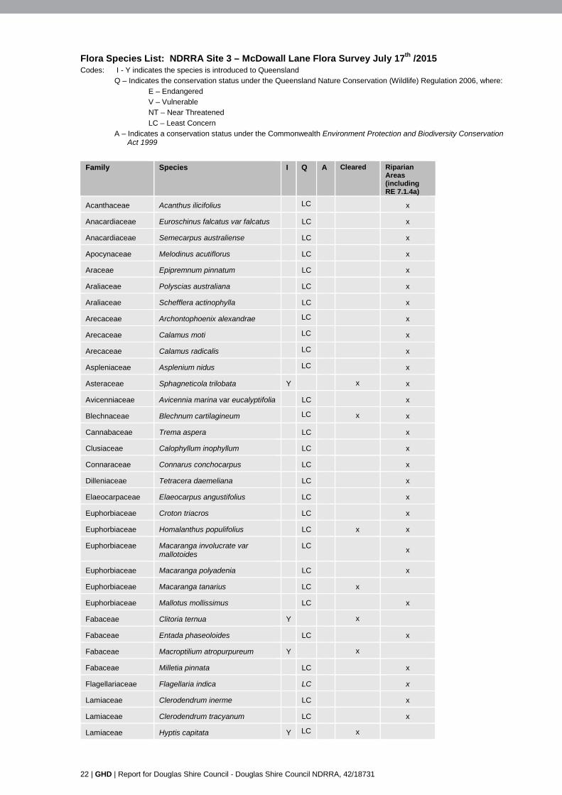
22 | GHD | Report for Douglas Shire Council - Douglas Shire Council NDRRA, 42/18731
Flora Species List: NDRRA Site 3 – McDowall Lane Flora Survey July 17th /2015 Codes: I - Y indicates the species is introduced to Queensland Q – Indicates the conservation status under the Queensland Nature Conservation (Wildlife) Regulation 2006, where:
E – Endangered V – Vulnerable NT – Near Threatened
LC – Least Concern A – Indicates a conservation status under the Commonwealth Environment Protection and Biodiversity Conservation
Act 1999
Family Species I Q A Cleared Riparian
Areas (including RE 7.1.4a)
Acanthaceae Acanthus ilicifolius LC x
Anacardiaceae Euroschinus falcatus var falcatus LC x
Anacardiaceae Semecarpus australiense LC x
Apocynaceae Melodinus acutiflorus LC x
Araceae Epipremnum pinnatum LC x
Araliaceae Polyscias australiana LC x
Araliaceae Schefflera actinophylla LC x
Arecaceae Archontophoenix alexandrae LC x
Arecaceae Calamus moti LC x
Arecaceae Calamus radicalis LC x
Aspleniaceae Asplenium nidus LC x
Asteraceae Sphagneticola trilobata Y x x
Avicenniaceae Avicennia marina var eucalyptifolia LC x
Blechnaceae Blechnum cartilagineum LC x x
Cannabaceae Trema aspera LC x
Clusiaceae Calophyllum inophyllum LC x
Connaraceae Connarus conchocarpus LC x
Dilleniaceae Tetracera daemeliana LC x
Elaeocarpaceae Elaeocarpus angustifolius LC x
Euphorbiaceae Croton triacros LC x
Euphorbiaceae Homalanthus populifolius LC x x
Euphorbiaceae Macaranga involucrate var mallotoides
LC
x
Euphorbiaceae Macaranga polyadenia LC x
Euphorbiaceae Macaranga tanarius LC x
Euphorbiaceae Mallotus mollissimus LC x
Fabaceae Clitoria ternua Y x
Fabaceae Entada phaseoloides LC x
Fabaceae Macroptilium atropurpureum Y x
Fabaceae Milletia pinnata LC x
Flagellariaceae Flagellaria indica LC x
Lamiaceae Clerodendrum inerme LC x
Lamiaceae Clerodendrum tracyanum LC x
Lamiaceae Hyptis capitata Y LC x

GHD | Report for Douglas Shire Council - Douglas Shire Council NDRRA, 42/18731 | 23
Family Species I Q A Cleared Riparian Areas (including RE 7.1.4a)
Lauraceae Cryptocarya cunninghamiana LC x
Lauraceae Cryptocarya laevigata LC x
Lauraceae Cryptocarya vulgaris x
Lauraceae Neolitsea brassii LC x
Lauraceae Neolitsea dealbata LC x
Malvaceae Commersonia bartamia LC x
Malvaceae Hibiscus tiliaceus LC x
Malvaceae Urena lobata Y x
Meliaceae Dysoxylum oppositifolium LC x
Mimosaceae Acacia celsa LC x
Mimosaceae Acacia cincinnata LC x
Mimosaceae Acacia mangium LC x x
Mimosaceae Mimosa pudica Y x x
Monimiaceae Palmeria scandens LC x
Monimiaceae Wilkea pubescens LC x
Moraceae Ficus congesta LC x x
Myristicaceae Myristica globosa LC x
Myrtaceae Acmena hemilampra LC x
Myrtaceae Rhodamnia sessiliflora LC x
Myrtaceae Syzygium angophoroides LC x
Myrtaceae Syzygium hemilamprum subsp hemilamprum
LC
x
Myrtaceae Syzygium tierneyanum LC x
Oleaceae Chionanthus ramiflorus LC x
Phyllanthaceae Breynia cernua LC x
Phyllanthaceae Glochidion sumatranum LC x
Plumbaginaceae Aegialitis annulata LC x
Poaceae Chloris virgata Y x
Poaceae Megathyrsus maximus Y x x
Poaceae Phyllostachys aurea Y x x
Poaceae Urochloa mutica Y x x
Podocarpaceae Podocarpus grayae LC x
Primulaceae Maesa dependens var pubescens LC x
Proteaceae Helicia nortoniana LC x
Pteridaceae Acrostichum speciosum LC x
Rhamnaceae Alphitonia oblata LC x
Rhizophoraceae Brugiera gymnorrhiza LC x
Rhizophoraceae Brugiera parviflora LC x
Rhizophoraceae Carallia brachiata LC x
Rhizophoraceae Rhizophora apiculata LC x
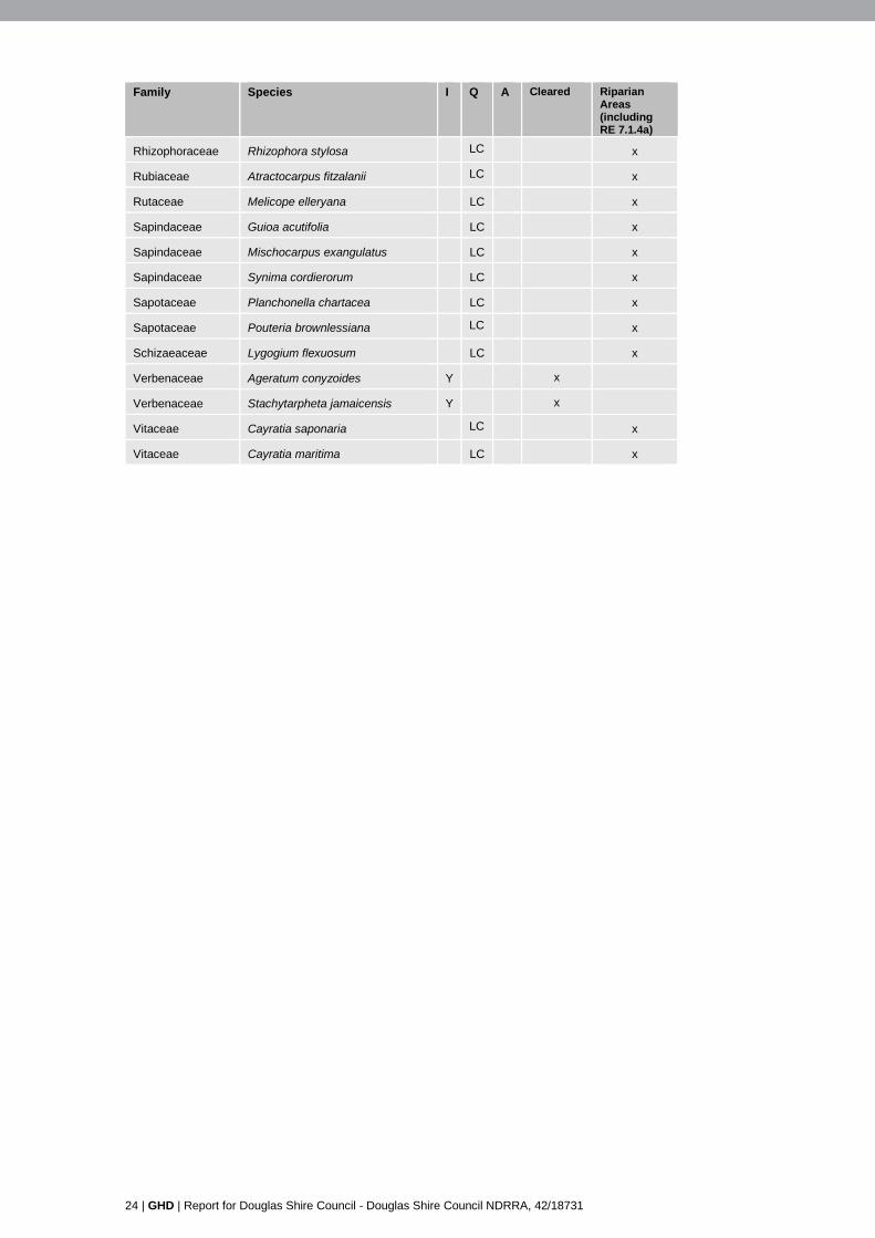
24 | GHD | Report for Douglas Shire Council - Douglas Shire Council NDRRA, 42/18731
Family Species I Q A Cleared Riparian Areas (including RE 7.1.4a)
Rhizophoraceae Rhizophora stylosa LC x
Rubiaceae Atractocarpus fitzalanii LC x
Rutaceae Melicope elleryana LC x
Sapindaceae Guioa acutifolia LC x
Sapindaceae Mischocarpus exangulatus LC x
Sapindaceae Synima cordierorum LC x
Sapotaceae Planchonella chartacea LC x
Sapotaceae Pouteria brownlessiana LC x
Schizaeaceae Lygogium flexuosum LC x
Verbenaceae Ageratum conyzoides Y x
Verbenaceae Stachytarpheta jamaicensis Y x
Vitaceae Cayratia saponaria LC x
Vitaceae Cayratia maritima LC x

Appendix E – Site Reference Photographs
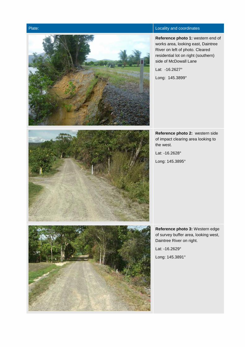
Plate: Locality and coordinates
Reference photo 1: western end of
works area, looking east, Daintree
River on left of photo. Cleared
residential lot on right (southern)
side of McDowall Lane
Lat: -16.2627°
Long: 145.3899°
Reference photo 2: western side
of impact clearing area looking to
the west.
Lat: -16.2628°
Long: 145.3895°
Reference photo 3: Western edge
of survey buffer area, looking west,
Daintree River on right.
Lat: -16.2629°
Long: 145.3891°
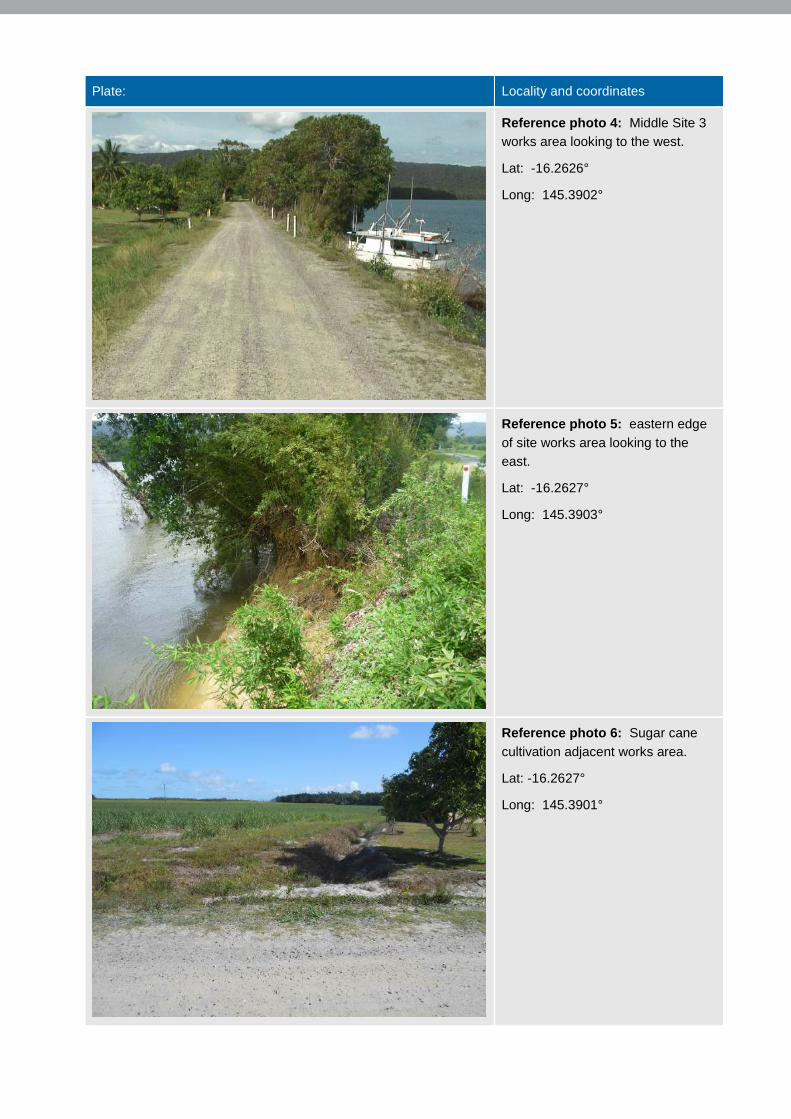
Plate: Locality and coordinates
Reference photo 4: Middle Site 3
works area looking to the west.
Lat: -16.2626°
Long: 145.3902°
Reference photo 5: eastern edge
of site works area looking to the
east.
Lat: -16.2627°
Long: 145.3903°
Reference photo 6: Sugar cane
cultivation adjacent works area.
Lat: -16.2627°
Long: 145.3901°
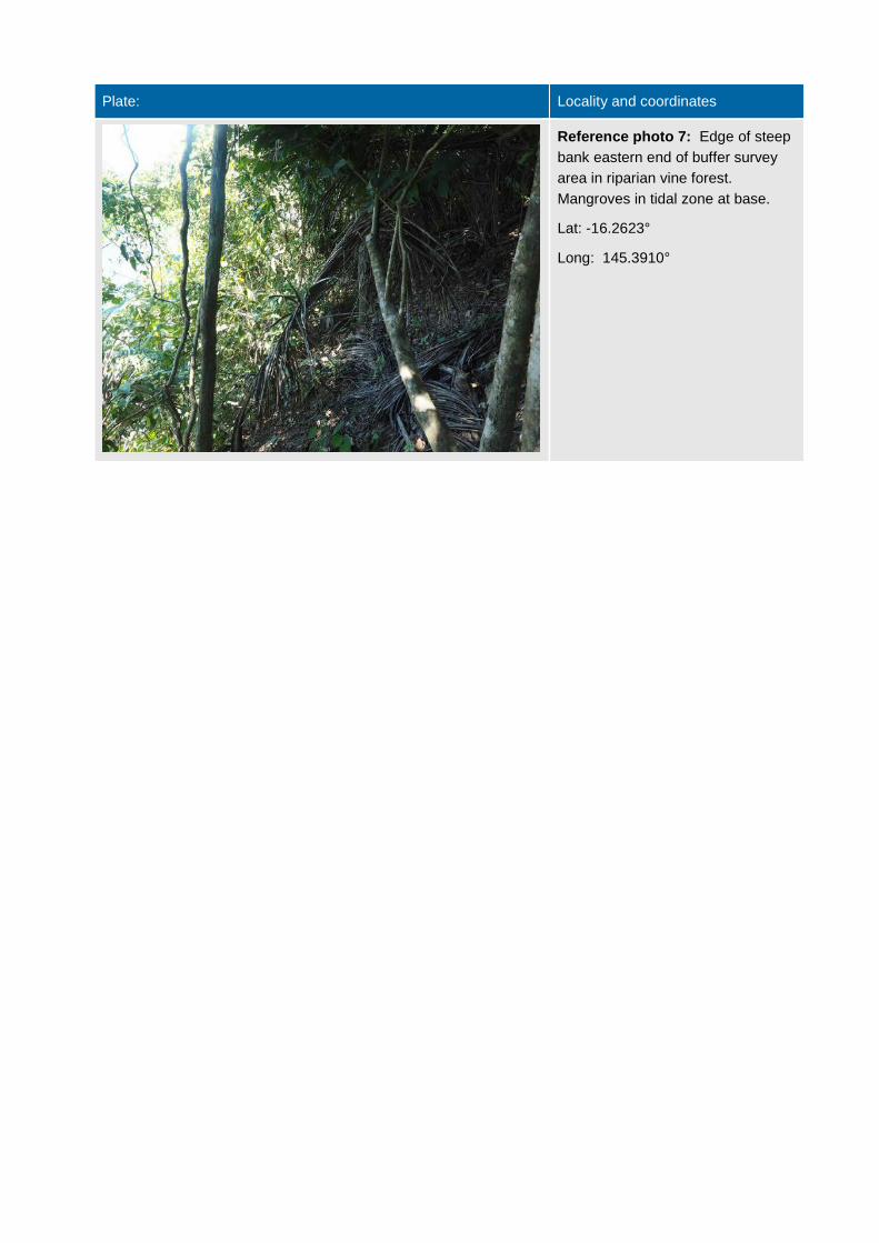
Plate: Locality and coordinates
Reference photo 7: Edge of steep
bank eastern end of buffer survey
area in riparian vine forest.
Mangroves in tidal zone at base.
Lat: -16.2623°
Long: 145.3910°
This report: has been prepared by GHD for Douglas Shire Council and may only be used and relied on by Douglas
Shire Council for the purpose agreed between GHD and the Douglas Shire Council as set out in this report.
GHD otherwise disclaims responsibility to any person other than Douglas Shire Council arising in connection with this
report. GHD also excludes implied warranties and conditions, to the extent legally permissible.
The services undertaken by GHD in connection with preparing this report were limited to those specifically detailed in
the report and are subject to the scope limitations set out in the report.
The opinions, conclusions and any recommendations in this report are based on conditions encountered and
information reviewed at the date of preparation of the report. GHD has no responsibility or obligation to update this
report to account for events or changes occurring subsequent to the date that the report was prepared.
The opinions, conclusions and any recommendations in this report are based on assumptions made by GHD described
in this report. GHD disclaims liability arising from any of the assumptions being incorrect.
GHD has prepared this report on the basis of information provided by Douglas Shire Council and others who provided
information to GHD (including Government authorities)], which GHD has not independently verified or checked beyond
the agreed scope of work. GHD does not accept liability in connection with such unverified information, including errors
and omissions in the report which were caused by errors or omissions in that information.
GHD
1st Floor 85 Spence Street Cairns QLD 4870 PO Box 819 Cairns QLD 4870 Australia T: 07 4044 2222 F: 07 4044 2288 E: [email protected]
© GHD 2015
This document is and shall remain the property of GHD. The document may only be used for the purpose for which it was commissioned and in accordance with the Terms of Engagement for the commission. Unauthorised use of this document in any form whatsoever is prohibited.
g:\42\18731\WP\117614.docx
Document Status
Rev No.
Author Reviewer Approved for Issue Name Signature Name Signature Date
0 M Estrada A Small AS A Small
22/09/2015

www.ghd.com
This report: has been prepared by GHD for Douglas Shire Council and may only be used and relied on by Douglas Shire Council for the purpose agreed between GHD and the Douglas Shire Council as set out in section 1 of this report.
GHD otherwise disclaims responsibility to any person other than Douglas Shire Council arising in connection with this report. GHD also excludes implied warranties and conditions, to the extent legally permissible.
The services undertaken by GHD in connection with preparing this report were limited to those specifically detailed in the report and are subject to the scope limitations set out in the report.
The opinions, conclusions and any recommendations in this report are based on conditions encountered and information reviewed at the date of preparation of the report. GHD has no responsibility or obligation to update this report to account for events or changes occurring subsequent to the date that the report was prepared.
The opinions, conclusions and any recommendations in this report are based on assumptions made by GHD described in this report. GHD disclaims liability arising from any of the assumptions being incorrect.
GHD
1st Floor 85 Spence Street Cairns QLD 4870 PO Box 819 Cairns QLD 4870 Australia T: 07 4044 2222 F: 07 4044 2288 E: [email protected]
© GHD 2015
This document is and shall remain the property of GHD. The document may only be used for the purpose for which it was commissioned and in accordance with the Terms of Engagement for the commission. Unauthorised use of this document in any form whatsoever is prohibited.
\\ghdnet\ghd\AU\Cairns\Projects\42\18731\WP\117486.docx
Document Status
Rev No.
Author Reviewer Approved for Issue Name Signature Name Signature Date
0 K. Keane A. Small A. Small 17/09/2015

www.ghd.com