Embed Size (px)
Citation preview
DR. HUGH S. BOSTOCK 2150 West bourne Avenue, Ottawa, Ontario, Canada
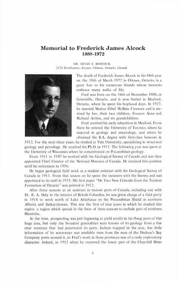
The death of Frederick James Alcock in his 84th year on the 18th of March 1972 in Ottawa, Ontario, is a great loss to his numerous friends whose interests embrace many walks o f life.
Fred was born on the 16th o f November 1888, in Giiersville, Ontario, and is now buried in Meaford, Ontario, where he spent his boyhood days. In 1927, he married Marion Ethel McBain Freeman and is survived by her, their two children, Frances Anne and Richard Arthur, and six grandchildren.
Fred received his early education in Meaford. From there he entered the University o f Toronto, where he majored in geology and mineralogy, and where lie obtained his B.A. degree with first-class honours in
1912. For the next three years, lie studied at Yale University, specializing in structural geology and petrology. Ile received his Ph.D. in 1915. The following year was spent at the University of Wisconsin where he concentrated on Precambrian geology.
From 1911 to 1947 he worked with the Geological Survey of Canada and was then appointed Chief Curator o f the National Museum of Canada. He retained this position until his retirement in 1956.
He began geological field work as a student assistant with the Geological Survey of Canada in 1911. From that season on he spent the summers with the Survey and was appointed to its staff in 1915. His first paper “On Two New C’rinoids from the Trenton Formation of Ontario” was printed in 1912.
After three seasons as an assistant in various parts o f Canada, including one with Dr. R. A. Daly in the interior o f British Columbia, lie was given charge o f a field party in 1914 to work north of Lake Athabasca on the Precambrian Shield in northern Alberta and Saskatchewan. This was the first o f nine years in which he studied this region a region which spread in the later of these seasons to include part o f northern Manitoba.
At the time, prospecting was just beginning to yield results in far-flung parts o f this huge area, but only the broadest generalities were known of its geology from a few river traverses that had penetrated its parts. Indians trapped in the area, but little information of its waterways was available even from the men o f the Hudson’s Bay Company posts around it, so Fred’s work in these provinces was of a truly exploratory character. Indeed, in 1915 when lie traversed the lower part o f the Churchill River
M em orial to Frederick Jam es A lcock1888-1972
4
FREDERICK JAMES ALCOCK 5
(one o f the major streams o f North America) not even the Indians knew its course as it was taboo for them to follow it. His work in these years entailed exploration along waterways o f the Shield. It was often fraught with unexpected hazards that demanded alertness and sound judgment to avoid mishap. Fred’s parties operated without accident—evidence o f his ability in planning, direction, and leadership.
In his work, he developed a keen interest in history, geography, and allied fields related to the regions he traversed. From his notes, he drew up many papers on these side subjects, as well as his reports, memoirs, and maps o f the geology.
In 1921, Dr. Alcock was sent to the Gaspé Peninsula o f Quebec and from that year Gaspé, New Brunswick, and other parts o f the Maritime Provinces became his main field, though he returned some seasons to the Shield. In 1923 he came back to study the Mandy and Flin Flon mines that had recently been developed in northern Manitoba. Hiis work and studies o f mineral deposits in Gaspé led him to write papers on mineral deposits, particularly o f lead and zinc in eastern Canada. These were steps to one of his outstanding works, “Zinc and Lead Deposits in Canada,” published in 1930. His last years in the Shield (1934 and 1935) were spent in northern Saskatchewan doing more detailed geology and systematic mapping than before.
In 1935, his field work, which covered an area o f nearly 8,000 sq mi north o f Lake Athabasca, was notable for the plan he devised for its execution. Drainage maps plotted from oblique air photographs o f the region had now become available and float planes were in vogue. With some experience from 1934, he made full use o f these two new tools. His party included 32 men from whom he formed eight groups o f four. These groups with their canoes and other equipment were airlifted to widely scattered lakes in the area. Throughout the season, Fred visited each group biweekly to supervise and supply them as they traversed along their allotted waterways mapping the geology for publication (1 in = 4 mi). At the same time on spare days, he attended to his own more detailed geological mapping and examination of mineral claims around Goldfields on the north shore o f Lake Athabaska where an important lode gold strike was being prospected. In this work, he discovered the presence o f pitchblende that led to finding the Beaverlodge uranium mining camp at Uranium City, an important source o f this metal for Canada.
After the 1935 season, Fred’s field was consistently in the Appalachian Region o f Canada. In his first years (in the 1920s) in Gaspé Peninsula, he found and mapped an interesting area which included the Mount Albert ultrabasics and then extended his work to the country around Chaleur Bay and on southward into New Brunswick as the years went by. He also visited Nova Scotia, Prince Edward Island, and the Magdalen Islands. This region o f Paleozoic rocks with fossiliferous formations allowed him to do more explicit research in stratigraphy and structure than the Precambrian Shield had allowed. Though some legal land survey maps were available, for some years he still had to make his own base maps as he went along. In this region too, besides compiling geological reports, papers, and maps, he wrote papers on geographical subjects.
His memoir on Chaleur Bay, published in 1936, was a great step forward in the knowledge o f the region; it assembled in one clear, concise volume the geology of the large, surrounding area. As his field spread southward over New Brunswick on which
6 THE GEOLOGICAL SOCIETY OF AMERICA
he brought out a number o f memoirs and papers of local interest, he acquired a massive knowledge o f the whole country. This enabled him to write an excellent summary o f the geology o f the entire Appalachian Region in Canada in his chapter in “The Economic Geology and Minerals o f Canada,” published in 1947. In 1948 he forecast the discovery o f graptolites in the Oak Bay area o f New Brunswick where they were finally found in 1962. He compiled the first general geological maps o f the region, notably the “Geological Map o f the Maritime Provinces: New Brunswick, Nova Scotia and Prince Edward Island,” published in 1949 (1 in = 12 mi). This map, on which he introduced a number o f generalizations and correlations, still remains the authoritative guide to the geology o f the region, despite almost complete coverage by one-mile work in recent years.
Among his other achievements in this region was the major part he played in setting up the plan for gravity determinations in the Maritime Provinces. Of his geographical papers, “Across Gaspe,” published in the Geographical Review in 1924, is a good example. It gives an account of the birds, botany, and scenery encountered, and with his other similar papers did much to popularize the Appalachian Region o f which little was known in other parts o f Canada and the United States. Another notable work of his was “A Century in the History o f the Geological Survey o f Canada,” published in 1947.
When Fred left the Geological Survey in 1947 to take up his new position as head o f the National Museum, it was a personal loss to the staff o f the Survey. Actually, though, he had only moved along the hall, as both organizations were then in the same building and their staffs were closely associated. He was still as approachable as ever and never too busy to see any one o f us.
His appointment to the National Museum gave it a substantial raise in morale as he was the first full-time curator and now it was an independent organization. His broad interests in its work and his tactful leadership, backed by the great respect everyone had for him, fitted him well for the position and enabled him to instill a new life into the museum. He set to work to put it on a modern basis and was responsible for its active postwar expansion into several fields. Though his tasks were now nearly all administrative and dealt primarily with the museum, he continued to publish works on geology and other subjects from time to time, even after he had retired in 1956.
In summing up his work, Fred was an accurate, clear and easy writer. His publications included 38 geological maps and more than 150 reports and articles, mainly on geological subjects. He left a worthy record o f contributions to the geology, mineral deposits, geography, and history o f Canada. These works are evidence to his unusually broad perspective and wide interests. They were written when information on many o f their subjects was scarce or non-existent and so have a value beyond that suggested by a mere listing.
Fred’s natural, considerate regard for people, particularly youth, led him into many activities beyond the call o f his normal employment. He was, indeed, a busy man.
FREDERICK JAMES ALCOCK 7
Among these activities, his work at Carleton University at Ottawa was a vital contribution to this then new institution. He served as special lecturer in geology for 21 years from 1942 to 1963. He was the first teacher o f this subject at Carleton College (as the organization was first known) and laid the foundation for the present department o f geology. He was also a member o f the first senate o f the university in 1949 and continued in that position until his resignation in 1965. In 1969, Carleton University bestowed upon him the honorary degree o f Doctor o f Laws as a tribute to half a century o f service to the science o f geology and to the National Museum.
In recognition o f his geological work and ability, he was elected a Fellow o f The Geological Society o f America in 1920 and a Fellow o f the Royal Society o f Canada in 1925. He was also a Fellow o f the Royal Canadian Geographical Society, a member o f the Canadian Institute o f Mining and Metallurgy, the Canadian Historical Association, and the Canadian Museum Association. In 1953, he was awarded the Coronation Medal o f Queen Elizabeth II. In recognition o f his valuable service to the nation, the Centennial Medal was conferred on him in 1967, the 100th anniversary o f the Confederation o f Canada.
He accepted without stint the obligations o f his memberships in these various societies. He served as honorary secretary o f the Royal Society o f Canada (1944 to 1949), and was elected president o f Section IV (geology) for the year o f 1947. He acted as chairman, and in various other capacities, on the editorial committee o f the Canadian Geographical Journal. He was a member o f the Council o f The Geological Society o f America (1943 to 1945) and was chairman o f the Society’s Program Committee for its 60th Annual Meeting in Ottawa in 1947, at which he presented an address on “The Highlights o f the Geology of Canada.” He was chairman of the National Committee on Stratigraphic Nomenclature of the Royal Society o f Canada, and in 1934 he published its recommendations, which are a guide for many geologists. During his term o f office as head o f the museum, he was chairman o f the Speaker’s Committee responsible for the highly successful lecture series given in Ottawa and across Canada. He was a member o f the Ottawa Field Naturalist’s Club. He assisted at the inception in 1948 o f the Macoun Field Club for junior naturalists.
In addition, he found time for things completely outside his profession. He was president o f the Ottawa Young Men’s Christian Association (1956 and 1957), and chairman o f the World Service Committee o f that organization for several years. He was also an active layman o f the United Church o f Canada, serving as chairman for various committees and as an elder for many years in Ottawa. He was also largely responsible for starting the church’s University o f Religion.
To all his activities he applied his able and generous mind whole-heartedly. It was this that won for him the respect and affection o f those around him and makes his passing genuinely felt. He is greatly missed, but he laid a sound base for his successors in his chosen fields. He made the path for those around him brighter.
8 THE GEOLOGICAL SOCIETY OF AMERICA
BIBLIOGRAPHY OF F. J. ALCOCK
1912 (with Parks, W. A.) On two new crinoids from the Trenton Formation ofOntario: Ottawa Naturalist, v. 25, nos. 3 and 4, June-July 1912, p. 41-45, Pl. IV, Figs. 1-4.
1915 Geology of the north shore of Lake Athabaska, Alberta and Saskatchewan: Geol. Survey Canada, Summ. Rept. 1914, 1915, p. 60-61.
1916 Lower Churchill River region, Manitoba: Geol. Survey Canada, Summ. Rept. 1915, 1916, p. 133-136, Map no. 1391.
------ The Churchill River: Geog. Rev., v. 11, no. 6, December 1916, p. 433-448.1917 Black Bay and Beaverlodge Lake areas, Saskatchewan: Geol. Survey Canada, Summ. Rept.
1916, 1917, p. 152-156, Map no. 1991.1918 The origin of the gold deposits o f Wekusko Lake: Canadian Mining Inst. Bull. no. 77,
September 1918, p. 801-803.------ Wekusko Lake area, northern Manitoba: Geol. Survey Canada, Summ. Rept. 1917, pt. D,
1918, p. 8-17.1919 Reed-File Lake, Manitoba: Geol. Survey Canada, Summ. Rept. 1918, pt. D, 1919, p. 6-8.1920 Wekusko Lake area, Manitoba: Geol. Survey Canada, Summ. Rept. 1918, pt. D, 1920,
p. 9-10.------ The Athabaska Series: Am. Jour. Sci., 4th Series, v. 50, July 1920, p. 25-32.------ The origin of Lake Athabaska: Geog. Rev., v. 10, no. 6, December 1920, p. 400-407.------ Cross-Pipestone map area, Manitoba: Geol. Survey Canada, Summ. Rept. 1919, pt. D, 1920,
p. 11-18, Map no. 1995.------ Past and present trade routes to the Canadian Northwest: Geog. Rev., v. 10, no. 2, August
1920, p. 57-83.------ The Reed-Wekusko map area, northern Manitoba: Geol. Survey Canada, Mem. 119, 1920,
47 p., 6 pis., Map nos. 1763 and 1801.1921 The norite rocks o f the Lake Athabaska region: Royal Soc. Canada Proc. and Trans.,
3d Series, v. 14, Sect. IV, 1921, p. 25-29.------ A local occurrence o f differentiation in granite on the Churchill River, northern Manitoba,
Canada: Royal Soc. Canada Proc. and Trans., 3d Series, v. 14, Sect. IV, 1921, p. 31-33.------ (with Bruce, E. L.) Pre-Cambrian rocks of Manitoba: Geol. Soc. America Bull., v. 32, no. 2,
1921, p. 267-292.------ The terminal moraine o f the Seal-Churchill Divide [Manitoba] : Geol. Survey Canada,Summ.
Rept. 1920, pt. C, 1921, p. 13-18, Map no. 1839.------ Rat River route from Threepoint Lake to southern Indian Lake, Manitoba: Geol. Survey
Canada, Summ. Rept. 1920, pt. C, 1921, p. 6-12, Map no. 1838.------ The Opswagan Lake-Burnt wood River area, northern Manitoba: Geol. Survey Canada,
Summ. Rept. 1920, pt. C, 1921, p. 1-6, Map no. 1861.------ The occurrence of gold at Herb Lake [Manitoba]: Canadian Inst. Mining and Metallurgy,
Monthly Bull. no. 107, March 1921, p. 210-215.1922 Geology o f Lemieux Township, Gaspe County, Québec: Geol. Survey Canada, Summ. Rept.
1921, pt. D, 1922, p. 71-96, Map nos. 1934 and 1935.------ A historic monument on Hudson Bay: Canadian Historical Assoc., Ann. Rept., 1922, 1923,
p. 47-51.1923 The Flinflon map area, Manitoba and Saskatchewan: Geol. Survey Canada, Summ. Rept.
1922, pt. C, p. 1-36, Map nos. 1978 and 1994.------ A new zinc prospect: Canadian Mining Jour., v. 44, March 16, 1923, p. 208.1924 Across Gaspé: Geog. Rev., v. 14, no. 2, April 1924, p. 197-214.------ The Pas Mineral Belt [Saskatchcwan-Manitoba| : Canadian Mining Jour., v. 45, no. 30,
July 25, 1924, p. 713-715.
FREDERICK JAMES ALCOCK 9
1924 The mineral deposits of Gaspé: Canadian Mining Jour., v. 45, no. 41, October 10, 1924, p. 1000-1003.
------ Copper prospects in Gaspé Peninsula, Québec: Geol. Survey Canada, Summ. Rept. 1923,pt. C II, 1924, p. 1-12.
1926 Shickshock Mountain, central Gaspé, Québec: Geol. Survey Canada, Summ. Rept. 1924, pt. C, 1926, p. 127-133, Map no. 2047.
—— Geology o f Mount Serpentine, Gaspé, Québec: Geol. Survey Canada, Summ. Rept. 1924, pt. C, 1926, p. 134-141, Fig. no. 10.
------ Lead and zinc in eastern Canada: Mining and Metallurgy, v. 7, no. 230, 1926, p. 51-56;Canadian Mining Jour., v. 47, no. 19, May 7, 1926, p. 488-492.
------ Memorial o f William Mclnness: Geol. Soc. America Bull., v. 37, no. 1, p. 96-99.------ Mount Albert map area, Québec: Geol. Survey Canada, Mem. 144, 75 p., 6 pis., Map no.
2060.------ The Pre-Cambrian of Canada and its possibilities for mineral production: The Financial Post
Survey of Mines, p. 23-25.------ Geology o f the Great Lakes area: Ottawa, Canada Yearbook, 1925, p. 24.1927 Review of Our mobile earth by R. A. Daly: Canadian Field-Naturalist, v. 41, no. 5, May
1927, p. 115.------ Diamond Jubilee celebration in the Gaspé mineral area: Canadian Mining Jour., v. 48,
July 22, 1927, p. 580.------ (with Bingay, T. W.) Lead and zinc in Canada: Canadian Mining and Metallurgical Bull.,
no. 184, August 1927, p. 930-943; Canadian Inst. Mining and Metallurgy Trans., v. 30,1928, p. 225-251; Second (Triennial) Empire Mining and Metallurgical Congress, Canada,1927, Proc., pt. 1, 1928, p. 633-659.
1928 Zinc-lead field o f central Gaspé, Québec: Geol. Survey Canada Summ. Rept., 1927, pt. C,1928, p. 27-46, with Map no. 210A, Part o f Lemieux Township.
------ Recent developments in Gaspé Peninsula: Canadian Mining and Metallurgical Bull., no. 191,March 1928, p. 367-385.
------ Rivers o f Gaspé: Geol. Soc. America Bull., v. 39, no. 2, June 1928, p. 403-420; Geol.Soc. America Bull. [abs.], v. 39, no. 1, March 1928, p. 158; Pan-American Geologist, v. 49, no. 1, February 1928, p. 70.
------ Gaspé Peninsula, its geology and mineral possibilities: Report on Mining Operations, 1927:Quebec, Dept. Colonization, Mines and Fisheries, p. 162-181.
1929 Notes on the Devonian plant and other observations on a visit to Cross Point, Gaspé: Canadian Field-Naturalist, v. 43, no. 3, March 1929, p. 47-49.
1930 Some mineral occurrences o f economic interest in New Brunswick: Geol. Survey Canada Summ. Rept. 1928, pt. C, 1930, p. 90-93.
------ The value o f geological maps: The Institute Bull. Jour. Professional Inst. Civil ServiceCanada, May 1930, p. 4-6.
------ Zinc and lead deposits o f Canada: Geol. Survey Canada, Economic Geology Series, no. 8,406 p., 8 pis.
------ Outline o f the geology of Canada, in Prospecting in Canada, Chap. IV: Geol. Survey Canada,Economic Geology Series, no. 7, p. 154-182.
1931 Relationship of the Devonian and Silurian in Gaspé Peninsula and northern New Brunswick: Royal Soc. Canada Proc. and Trans., 3d Series, v. 25, Sect. IV, p. 113-117.
------ Map of New Brunswick-Gaspé Sheet: Geol. Survey Canada Pubi. 2254, Map no. 259A,Scale: 1 = 8 mi (reprint 1939).
1932 The geology of New Brunswick and Gaspé: Canadian Mining Jour., v. 53, no. 3, March1932, p. 120-122.
10 THE GEOLOGICAL SOCIETY OF AMERICA
------ Scow brigade on the Athabaska: Canadian Geog. Jour., v. 4, no. 2, February 1932, p. 9 7 -107 (reprint 1967).
------ A national committee on stratigraphical nomenclature: Royal Soc. Canada Proc. and Trans.,3d Scries, v. 26, Sect. IV, May 1932, p. 317-319.
------ (with Miller, A. II.) Plumb-line deflections and gravity anomalies in Gaspé Peninsula andtheir significance: Royal Soc. Canada Proc. and Trans., 3d Series, v. 26, Sect. IV, May 1932, p. 321-333.
1933 Middle River gold field, Victoria County, Nova Scotia: Geol. Survey Canada Summ. Rept.1932, pt. D, Pubi. 2330, 1933, p. 58-68.
1934 Lead and zinc deposits o f the Cordilleran region, Canada: 5th Pacific Sci. Cong., Canada,1933, Proc., v. 2, p. 1425-1430.
------ Report o f the national committee on stratigraphical nomenclature: Royal Soc. Canada Proc.and Trans., 3d Series, v. 28, Sect. IV, May 1934, p. 113-122.
1935 Copper in Canada, in Copper resources o f the world: Internat. Geol. Cong., 16th, Washington 1933, p. 65-136.
------ Airplanes aid in geologic studies: Eng. and Mining Jour., v. 136, no. 11, November 1935,p. 546-548.
------ Mudjatik-Haultain area, Saskatchewan: Geol. Survey Canada, Mem. 180, 16 p., 8 pis., Mapnos. 317A, 318A, 319A, 320A.
1936 Geology o f Chaleur Bay region: Geol. Survey Canada, Mem. 183, 146 p., 22 pis., Map no. 330A.
------ Geology of Lake Athabaska region, Saskatchewan: Geol. Survey Canada, Mem. 196, 41 p.,13 pis., Map nos. 339A, 363A, 364A, 365A.
------ The gold deposits o f Lake Athabaska [Saskatchewan] : Canadian Inst. Mining and MetallurgyTrans., v. 39, August 1936, p. 531-546.
------ Escuminac Sheet, Bonaventure County, Quebec: Geol. Survey Canada Map no. 286A, scale1: 1 .
1937 Geology and physiography, in Canada’s western northland: Its history, resources, population and administration: Ottawa, Dept. Mines and Resources, Lands, Parks and Forests Branch, p. 145-160.
1938 Geology o f Canada and economic geology: Ottawa, The Canada Year Book, p. 16-28.------ Geology of Saint John region, New Brunswick: Geol. Survey Canada, Mem. 216, 65 p.,
7 pis., Map nos. 477A, 478A, 497A.------ Geology o f Canada: Ottawa, The Canada Year Book, p. 16-27.------ Reindeer Lake South map-area, Saskatchewan (preliminary): Geol. Survey Canada, Paper
38-15, 17 p., 2 pis., unnumbered geological maps.1939 Ground water in Canada: Assoc. Internat. d’Hydro logie Scientifique, Réunion de Washington,
Comptes rendus des séances et rapports, T. 2, Rapport no. 12 [1948], 6 p.1941 Geology, Matapedia, Restigouche and Bonaventure counties, New Brunswick and Quebec:
Geol. Survey Canada, Map no. 620A, scale 1:1.------ Geology, Campbellton, Restigouche County, New Brunswick: Geol. Survey Canada, Map
no. 621 A, scale 1:1.------ Jacquet River and Tetagouch River map areas, New Brunswick: Geol. Survey Canada,
Mon. 227, 46 p., 2 pis., Map nos. 640A, 641A.------ Logan: Reminiscences o f a great man: Canadian Mining Jour., v. 62, June 1941, p. 373-378.------ Around Gaspé: Canadian Geog. Jour., v. 23, no. 2, August 1941, p. 80-103.------ William Spafford Dyer (1894-1941): Royal Soc. Canada Proc. and Trans., 3d Series, v. 35,
19 4 1 ,p. 101-102.------ The geology of Long Reach, King’s County, New Brunswick: Royal Soc. Canada Proc. and
Trans., 3d Series, v. 35, Sect. IV, p. 17-24.
FREDERICK JAMES ALCOCK 11
1941 The Magdalen Islands: Their geology and mineral deposits: Canadian Inst. Mining and Metallurgy Trans., v. 44, 4 maps, p. 623-649.
1942 (with Swartz, C. K., and others) Correlation o f the Silurian formations o f North America: Geol. Soc. America Bull., v. 53, p. 533-538.
1943 Retirement of G. A. Young, chief geologist, Geological Survey of Canada: Canadian Inst. Mining and Metallurgy Bull. 34, p. 240-241.
------ The Geological Survey o f Canada from 1842 to 1942: The Pre-Cambrian, v. 16, no. 7,July 1943, p. 6-12, 27.
------ New Brunswick, past and present: Canadian Geog. Jour., v. 27, no. 2, August 1943, p. 64-83.
1944 Memorial o f Albert Peter Low [1861-1942]: Geol. Soc. America Proc. Volume, Annual Report for 1943, 1944, pi. 19, p. 195-200.
------ (with MacKenzie, G. S.) Map o f Sussex, New Brunswick (preliminary): Geol. Survey Canada,Paper 44-3 , scale 1:1.
1945 Further information on glaciation in Gaspé: Royal Soc. Canada, Proc. and Trans., 3d Series, v. 38, Sect. IV, 1944, p. 15-21.
------ Memorial to Richard George McConnell [1857-1942] : Geol. Soc. America Proc. Volume,Annual Report for 1944, May 1945, pi. 15, p. 265-270.
------ Logan’s Fault: Royal Astron. Soc. Canada Jour., v. 39, July-August 1945, p. 213-216.------ Map o f Musquash, New Brunswick (preliminary): Geol. Survey Canada, Paper 45-2 , scale
1:1.------ (with Perry, S. C.) Map o f St. George, New Brunswick (preliminary): Geol. Survey Canada,
Paper 45-1 , scale 1:1.— Map o f Waterford, New Brunswick: Geol. Survey Canada, Map 829A, scale 1:1.1946 Oil residuals in volcanic rocks in Gaspé: Royal Soc. Canada Proc. and Trans., 3d Series,
v. 39, Sect. IV, May 1945, map, p. 13-19.------ Conglomerates of Recent age in New Brunswick: Acadian Naturalist, v. 2, no. 7, May 1946,
p. 21-25, 5 pis.------ Map o f Honeydale, New Brunswick (preliminary): Geol. Survey Canada, Paper 46-3 , scale
1 : 1.------ Map o f Sussex, New Brunswick: Geol. Survey Canada, Map 845A, scale 1:1.------ Map of St. Stephen, New Brunswick (preliminary): Geol. Survey Canada, Paper 46-2 ,
scale 1:1.1947 A century in the history o f the Geological Survey o f Canada: Canadian Mining Jour., May
1947, p. 307-315; June 1947, p. 410-419; July 1947, p. 491-503.------ The Appalachian region [Canada], in Geology and economic minerals o f Canada (3d ed.):
Geol. Survey Canada, Economic Geology Series, no. 1, p. 98-155.------ A century in the history o f the Geological Survey o f Canada: Natl. Museum Canada, Spec.
Contr. no. 47-1 , 94 p.1948 Exploration o f oil shales in the Taylor Village area of New Brunswick, in Summary of
investigations on New Brunswick oil shales, Canada: Canada Dept. Mines and Resources Pub. no. 825, Sect. 2, p. 8-10.
------ Exploration o f oil shales in the Albert Mines area o f New Brunswick, in Summary o finvestigations on New Brunswick oil shales, Canada: Canada Dept. Mines and Resources Pub. no. 825, Sect. 3, p. 11-18.
------ Mineral occurrences in the Appalachian region of Canada: Their origin and relation tostructure, in Structural geology o f Canadian ore deposits: Canadian Inst. Mining and Metallurgy, Geol. Div., p. 49-64.
— Map o f Campobello, New Brunswick: Geol. Survey Canada, Map no. 964A, scale 1:1.------ Map o f Grand Manan, New Brunswick: Geol. Survey Canada, Map no. 965A, scale 1:1.
12 THE GEOLOGICAL SOCIETY OF AMERICA
------ The Geological Society of America: Canadian Geog. Jour., v. 36, no. 6, June 1948, p. 278-281.
------ Problems o f New Brunswick geology: Presidential address: Royal Soc. Canada Proc. andTrans., 3d Series, v. 42, Sect. IV, May 1948, p. 1-15.
------ The father of Canadian geology, the story of Sir William Logan (1798-1875 ] : Earth Sci.Digest, v. 2, no. 7, April 1948, p. 5-10; v. 2, no. 8, May 1948, p. 15-18.
1949 Geology, in One hundred years o f science in Canada: Toronto, Royal Canadian Inst. Centennial Volume, 1849-1949, p. 61-71.
------ The isles o f I 'undy: Canadian Geog. Jour., v. 39, no. 3, September 1949, p. 92-107.------ Preface: Annual reports: Natl. Museum Canada 1939-1947, Bull. no. 112, p. vii-viii.------ General activities o f the National Museum of Canada: Annual report: Natl. Museum Canada
1947-1948, Bull. no. 113, p. 1-16.------ A classification of gneisses: Royal Soc. Canada Proc. and Trans., 3d Series, v. 43, Sect. IV,
June 1949, p. 1-5.------ Geological map of the Maritime Provinces: New Brunswick, Nova Scotia and Prince Edward
I sland: Geol. Survey Canada, Map 910A, scale 1:1.1950 Memorial to Everend Lester Bruce [1884-1949]: Geol. Soc. America Proc. Volume, Annual
Report for 1949, June 1950, p. 121-125.------ General activities o f the National Museum of Canada: Annual report: Natl. Museum Canada
1948-1949, Bull. no. 118, p. 1-17.------ Preface to Canadian number: Jour. American Folklore, v. 63, no. 248, April-June 1950,
p. 129.1951 The geology of Canada: Ottawa, The Canada Yearbook, p. 14-26.------ General activities o f the National Museum of Canada: Annual report: Natl. Museum Canada
1949-1950, Bull. no. 123, p. 1-23.1952 The Long Sault o f the Ottawa: Canadian Geog. Jour.,v. 45, no. 6, December 1952, p. 252—
261.------ General activities o f the National Museum of Canada: Annual report: Natl. Museum Canada
1950-1951, Bull. no. 126, p. 1-22.1953 Joseph Burr Tyrrell: Canadian Geog. Jour., v. 47, no. 6, December 1953, p. 253-255.------ General activities o f the National Museum of Canada: Annual report: Natl. Museum Canada
1951-1952, Bull. no. 128, p. 1-22.1954 Folklore studies at the National Museum of Canada: Jour. American Folklore, v. 67, no.
264, April-June 1954, p. 99-101.------ Albert Peter Low [1861-1952]: Canadian Geog. Jour., v. 48, no. 6, April 1954, p. 160-163.------ Charles Camsell: Canadian Geog. Jour., v. 49, no. 2, August 1954, p. 87-89.------ General activities o f the National Museum of Canada: Annual report: Natl. Museum Canada
1952-1953, Bull. no. 132, p. 1-19.------ Wealth from the rocks, in Wilson, C., ed., North of 55 : Toronto, The Ryerson Press,
p. 142-154.1955 General activities o f the National Museum of Canada: Annual report: Natl. Museum Canada
1953-1954, Bull.no. 136, p. 1-21.1956 Harold Caswell Cooke [ 1884—19561: Royal Soc. Canada, Minutes o f the Proceedings, 3d
Series, v. 50, p. 79-81.------ Show case for the nation: Food for Thought, v. 16, no. 6, March 1956, p. 245-249.------ General activities o f the National Museum of Canada: Annual report: Natl. Museum Canada
1954-1955, Bull. no. 142, p. 1-24.1958 Joseph Burr Tyrrell, 1858-1957: Royal Soc. Canada Minutes Proc., 3d Series, v. 52, p. 105—
109.------ Geological Survey o f Canada: Encyclopedia Canadiana, p. 343.
FREDERICK JAMES ALCOCK 13
1958 The romance of northern exploration: Canadian Geog. Jour., v. 57, no. 3, September 1958, p. 76-83.
1960 Walter Halcro Boyd [1878-1960] : Royal Soc. Canada Proc. and Trans., 3d Series, v. 54, p. 95-97.
1962 Rudolph Martin Anderson: Royal Soc. Canada Proc. and Trans., 3d Series, v. 56, p. 159-160.1964 Epeirogeny, in Advancing frontiers in geology and geophysics: Hyderabad, Osmania Univer
sity Press, p. 39-49.1966 Morley Evans Wilson [1881-1965] : Royal Soc. Canada Proc. and Trans., 4th Series, v. 4,
p. 123-125.1967 Scow brigade on the Athabaska: Canadian Geog. Jour., v. 74, p. 92-99, map.