Embed Size (px)
Citation preview
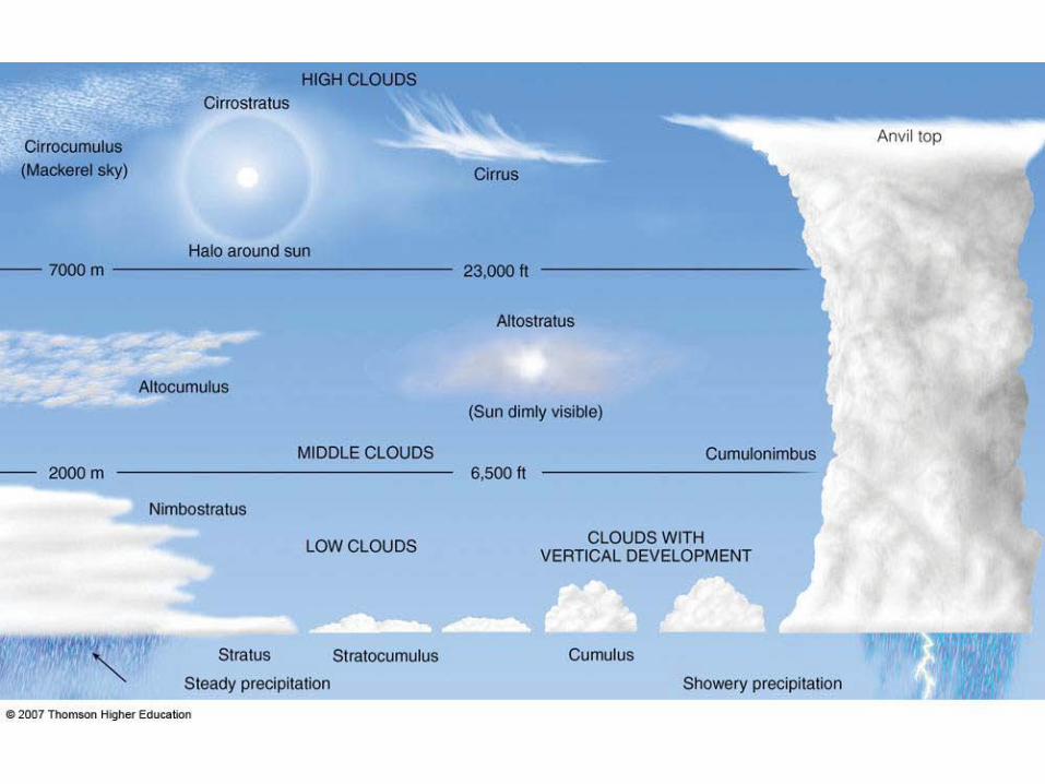
Meteorology
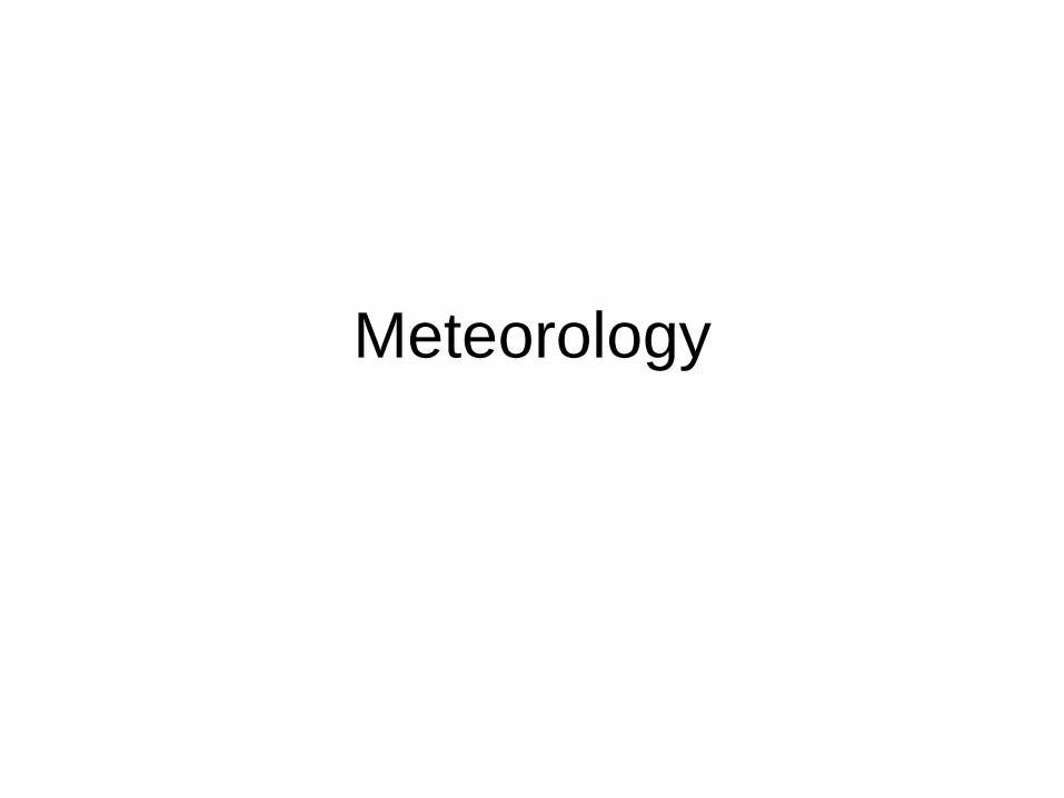
Most types of clouds are found in the
troposphere, and almost all weather occurs within this
layer.
Air pressure and the density of the air also
decrease with altitude. That's why the cabins of high-
flying jet aircraft are pressurized.
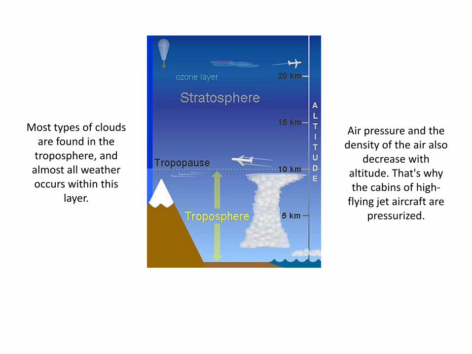
The dew point is the temperature at
which the water vapour in air at
constant barometric
pressure condenses into
liquid water
Clouds form when the invisible water vapour in the
air condenses into visible water droplets or ice
crystals.
Clouds form when the air is saturated and cannot hold any more water vapour,
this can happen in two ways: The amount of water in the air has
increased - for example through evaporation - to the point that the air
cannot hold any more water. The air is cooled to its dew point - the point where condensation occurs - and
the air is unable to hold any more water.
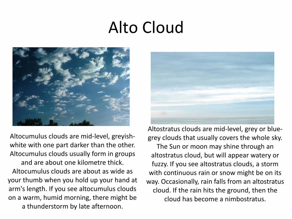
Alto Cloud
Altocumulus clouds are mid-level, greyish-white with one part darker than the other. Altocumulus clouds usually form in groups
and are about one kilometre thick. Altocumulus clouds are about as wide as
your thumb when you hold up your hand at arm's length. If you see altocumulus clouds on a warm, humid morning, there might be
a thunderstorm by late afternoon.
Altostratus clouds are mid-level, grey or blue-grey clouds that usually covers the whole sky.
The Sun or moon may shine through an altostratus cloud, but will appear watery or fuzzy. If you see altostratus clouds, a storm
with continuous rain or snow might be on its way. Occasionally, rain falls from an altostratus
cloud. If the rain hits the ground, then the cloud has become a nimbostratus.
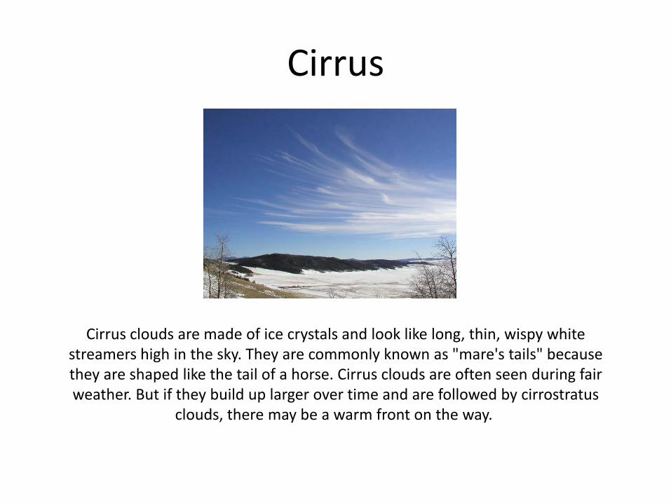
Cirrus
Cirrus clouds are made of ice crystals and look like long, thin, wispy white streamers high in the sky. They are commonly known as "mare's tails" because they are shaped like the tail of a horse. Cirrus clouds are often seen during fair weather. But if they build up larger over time and are followed by cirrostratus
clouds, there may be a warm front on the way.
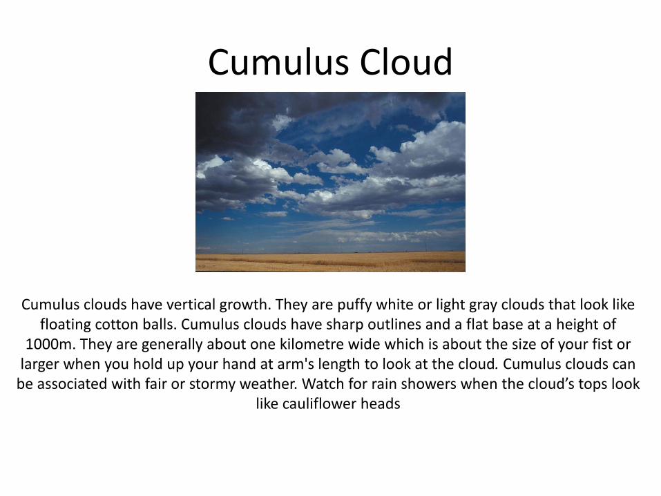
Cumulus Cloud
Cumulus clouds have vertical growth. They are puffy white or light gray clouds that look like floating cotton balls. Cumulus clouds have sharp outlines and a flat base at a height of
1000m. They are generally about one kilometre wide which is about the size of your fist or larger when you hold up your hand at arm's length to look at the cloud. Cumulus clouds can
be associated with fair or stormy weather. Watch for rain showers when the cloud’s tops look like cauliflower heads
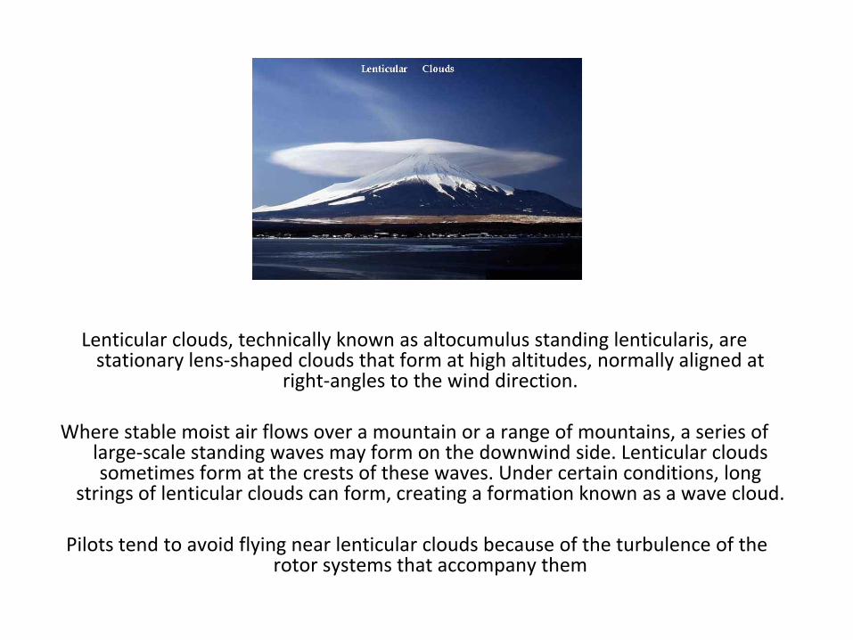
Lenticular clouds, technically known as altocumulus standing lenticularis, are stationary lens-shaped clouds that form at high altitudes, normally aligned at
right-angles to the wind direction.
Where stable moist air flows over a mountain or a range of mountains, a series of large-scale standing waves may form on the downwind side. Lenticular clouds sometimes form at the crests of these waves. Under certain conditions, long
strings of lenticular clouds can form, creating a formation known as a wave cloud.
Pilots tend to avoid flying near lenticular clouds because of the turbulence of the rotor systems that accompany them
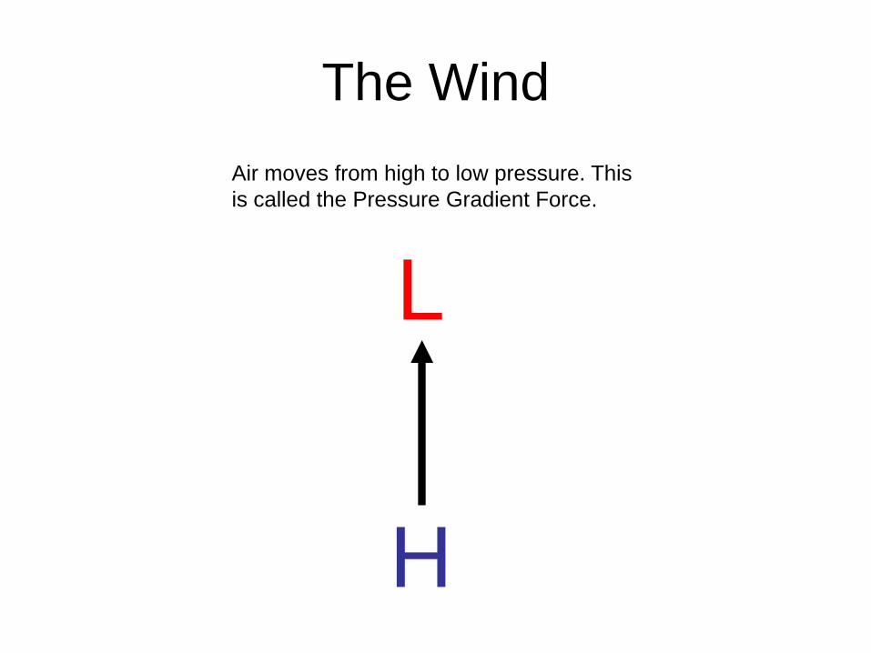
The Wind Air moves from high to low pressure. This is called the Pressure Gradient Force.
L
H
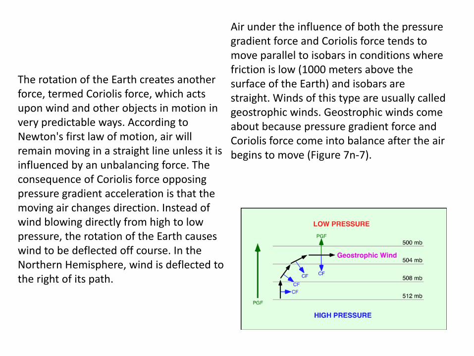
The rotation of the Earth creates another force, termed Coriolis force, which acts upon wind and other objects in motion in very predictable ways. According to Newton's first law of motion, air will remain moving in a straight line unless it is influenced by an unbalancing force. The consequence of Coriolis force opposing pressure gradient acceleration is that the moving air changes direction. Instead of wind blowing directly from high to low pressure, the rotation of the Earth causes wind to be deflected off course. In the Northern Hemisphere, wind is deflected to the right of its path.
Air under the influence of both the pressure gradient force and Coriolis force tends to move parallel to isobars in conditions where friction is low (1000 meters above the surface of the Earth) and isobars are straight. Winds of this type are usually called geostrophic winds. Geostrophic winds come about because pressure gradient force and Coriolis force come into balance after the air begins to move (Figure 7n-7).
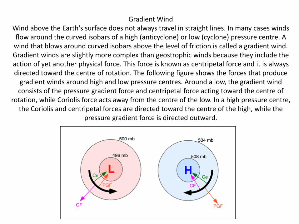
Gradient Wind Wind above the Earth's surface does not always travel in straight lines. In many cases winds flow around the curved isobars of a high (anticyclone) or low (cyclone) pressure centre. A
wind that blows around curved isobars above the level of friction is called a gradient wind. Gradient winds are slightly more complex than geostrophic winds because they include the action of yet another physical force. This force is known as centripetal force and it is always directed toward the centre of rotation. The following figure shows the forces that produce
gradient winds around high and low pressure centres. Around a low, the gradient wind consists of the pressure gradient force and centripetal force acting toward the centre of
rotation, while Coriolis force acts away from the centre of the low. In a high pressure centre, the Coriolis and centripetal forces are directed toward the centre of the high, while the
pressure gradient force is directed outward.
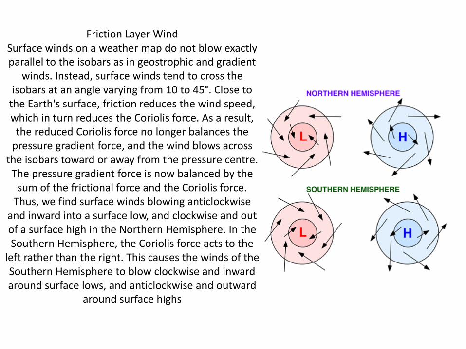
Friction Layer Wind Surface winds on a weather map do not blow exactly parallel to the isobars as in geostrophic and gradient
winds. Instead, surface winds tend to cross the isobars at an angle varying from 10 to 45°. Close to
the Earth's surface, friction reduces the wind speed, which in turn reduces the Coriolis force. As a result,
the reduced Coriolis force no longer balances the pressure gradient force, and the wind blows across
the isobars toward or away from the pressure centre. The pressure gradient force is now balanced by the
sum of the frictional force and the Coriolis force. Thus, we find surface winds blowing anticlockwise
and inward into a surface low, and clockwise and out of a surface high in the Northern Hemisphere. In the Southern Hemisphere, the Coriolis force acts to the
left rather than the right. This causes the winds of the Southern Hemisphere to blow clockwise and inward around surface lows, and anticlockwise and outward
around surface highs
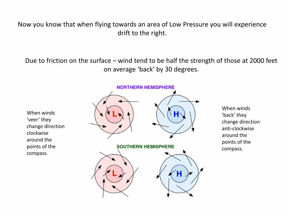
Now you know that when flying towards an area of Low Pressure you will experience drift to the right.
Due to friction on the surface – wind tend to be half the strength of those at 2000 feet on average ‘back’ by 30 degrees.
When winds ‘veer’ they change direction clockwise around the points of the compass.
When winds ‘back’ they change direction anti-clockwise around the points of the compass.
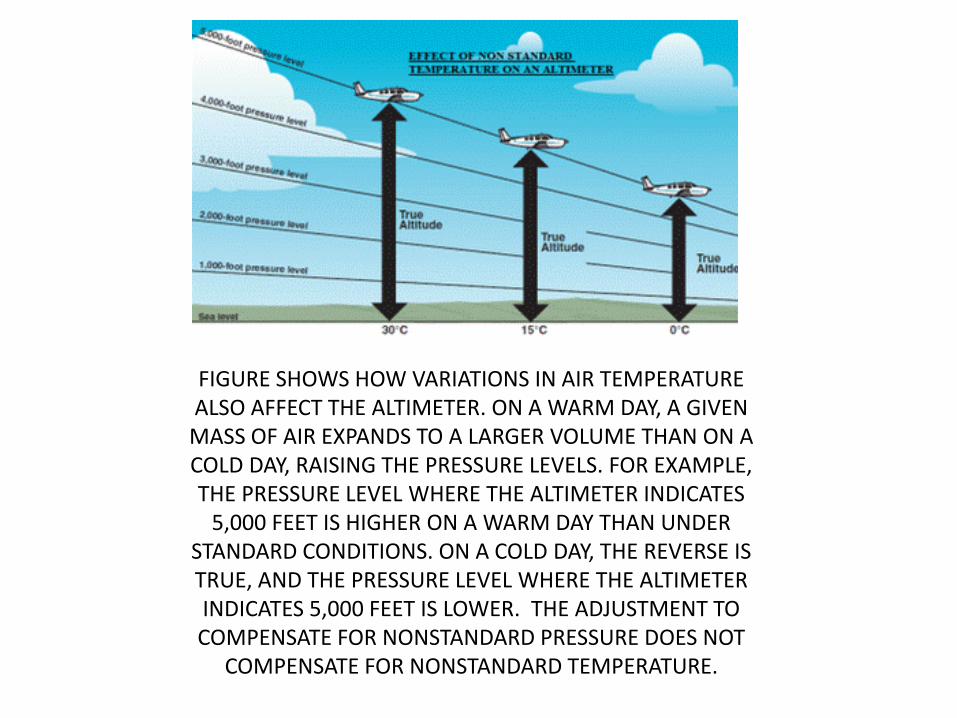
FIGURE SHOWS HOW VARIATIONS IN AIR TEMPERATURE ALSO AFFECT THE ALTIMETER. ON A WARM DAY, A GIVEN
MASS OF AIR EXPANDS TO A LARGER VOLUME THAN ON A COLD DAY, RAISING THE PRESSURE LEVELS. FOR EXAMPLE, THE PRESSURE LEVEL WHERE THE ALTIMETER INDICATES
5,000 FEET IS HIGHER ON A WARM DAY THAN UNDER STANDARD CONDITIONS. ON A COLD DAY, THE REVERSE IS TRUE, AND THE PRESSURE LEVEL WHERE THE ALTIMETER INDICATES 5,000 FEET IS LOWER. THE ADJUSTMENT TO COMPENSATE FOR NONSTANDARD PRESSURE DOES NOT
COMPENSATE FOR NONSTANDARD TEMPERATURE.
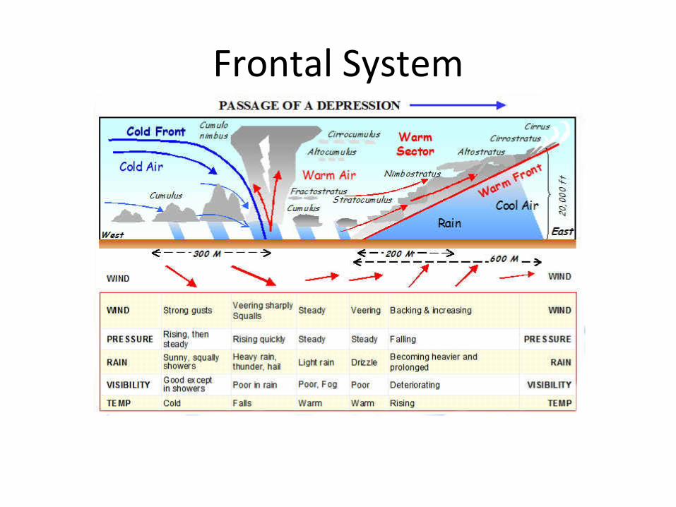
Frontal System
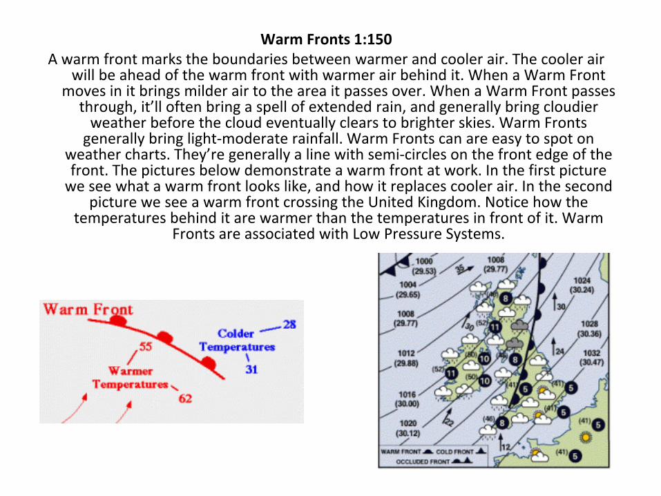
Warm Fronts 1:150 A warm front marks the boundaries between warmer and cooler air. The cooler air
will be ahead of the warm front with warmer air behind it. When a Warm Front moves in it brings milder air to the area it passes over. When a Warm Front passes
through, it’ll often bring a spell of extended rain, and generally bring cloudier weather before the cloud eventually clears to brighter skies. Warm Fronts
generally bring light-moderate rainfall. Warm Fronts can are easy to spot on weather charts. They’re generally a line with semi-circles on the front edge of the front. The pictures below demonstrate a warm front at work. In the first picture
we see what a warm front looks like, and how it replaces cooler air. In the second picture we see a warm front crossing the United Kingdom. Notice how the
temperatures behind it are warmer than the temperatures in front of it. Warm Fronts are associated with Low Pressure Systems.
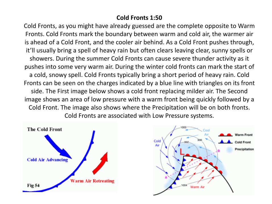
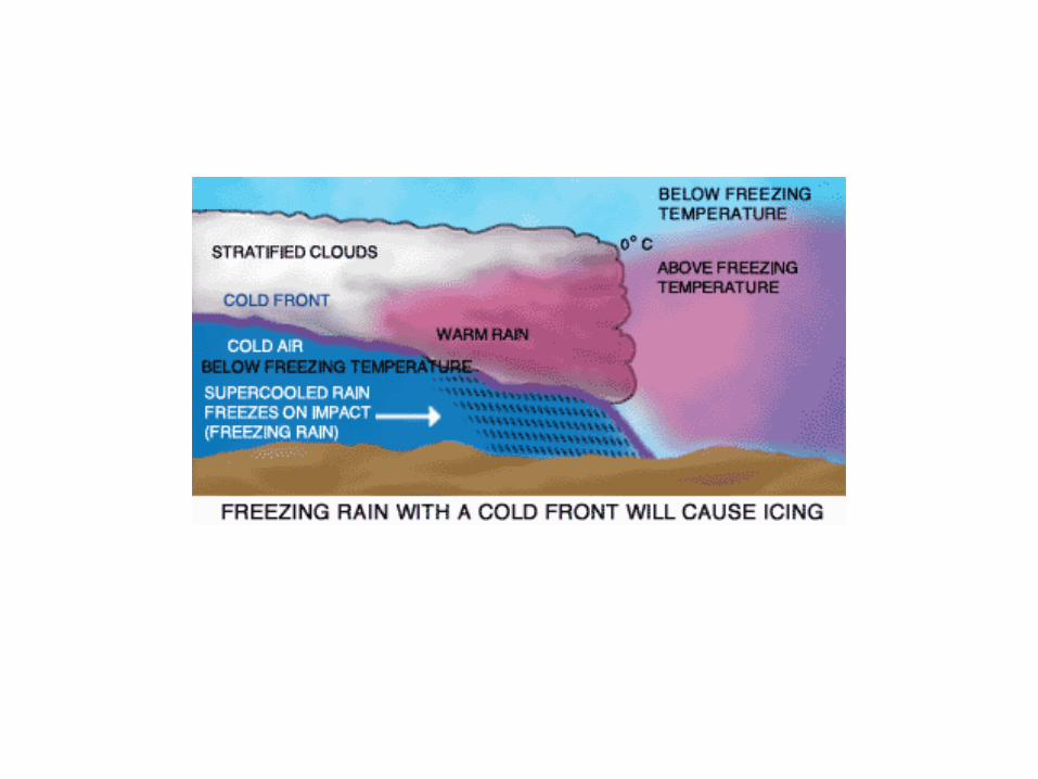
Cold Fronts 1:50 Cold Fronts, as you might have already guessed are the complete opposite to Warm Fronts. Cold Fronts mark the boundary between warm and cold air, the warmer air is ahead of a Cold Front, and the cooler air behind. As a Cold Front pushes through, it’ll usually bring a spell of heavy rain but often clears leaving clear, sunny spells or
showers. During the summer Cold Fronts can cause severe thunder activity as it pushes into some very warm air. During the winter cold fronts can mark the start of
a cold, snowy spell. Cold Fronts typically bring a short period of heavy rain. Cold Fronts can be seen on the charges indicated by a blue line with triangles on its front
side. The First image below shows a cold front replacing milder air. The Second image shows an area of low pressure with a warm front being quickly followed by a
Cold Front. The image also shows where the Precipitation will be on both fronts. Cold Fronts are associated with Low Pressure systems.
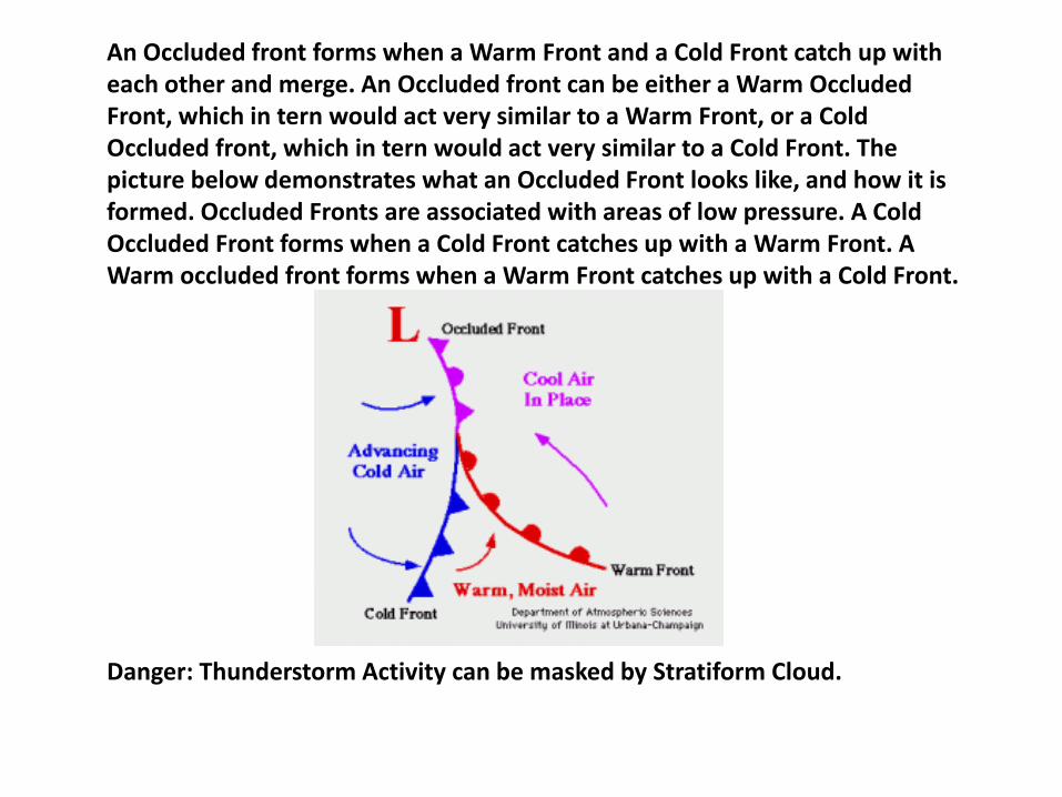
An Occluded front forms when a Warm Front and a Cold Front catch up with each other and merge. An Occluded front can be either a Warm Occluded Front, which in tern would act very similar to a Warm Front, or a Cold Occluded front, which in tern would act very similar to a Cold Front. The picture below demonstrates what an Occluded Front looks like, and how it is formed. Occluded Fronts are associated with areas of low pressure. A Cold Occluded Front forms when a Cold Front catches up with a Warm Front. A Warm occluded front forms when a Warm Front catches up with a Cold Front.
Danger: Thunderstorm Activity can be masked by Stratiform Cloud.
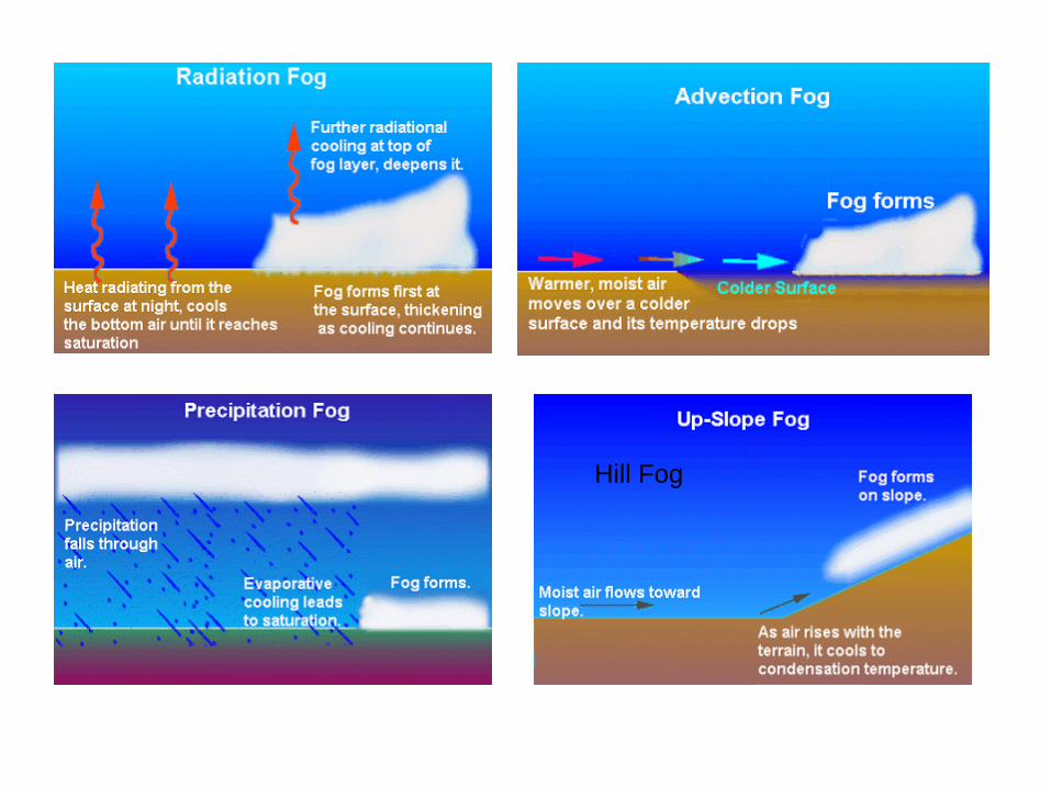
Hill Fog
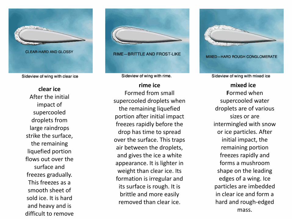
clear ice After the initial
impact of supercooled
droplets from large raindrops
strike the surface, the remaining
liquefied portion flows out over the
surface and freezes gradually. This freezes as a smooth sheet of sold ice. It is hard and heavy and is
difficult to remove
rime ice Formed from small
supercooled droplets when the remaining liquefied
portion after initial impact freezes rapidly before the drop has time to spread
over the surface. This traps air between the droplets, and gives the ice a white
appearance. It is lighter in weight than clear ice. Its
formation is irregular and its surface is rough. It is brittle and more easily removed than clear ice.
mixed ice Formed when
supercooled water droplets are of various
sizes or are intermingled with snow
or ice particles. After initial impact, the remaining portion freezes rapidly and forms a mushroom
shape on the leading edges of a wing. Ice
particles are imbedded in clear ice and form a hard and rough-edged
mass.
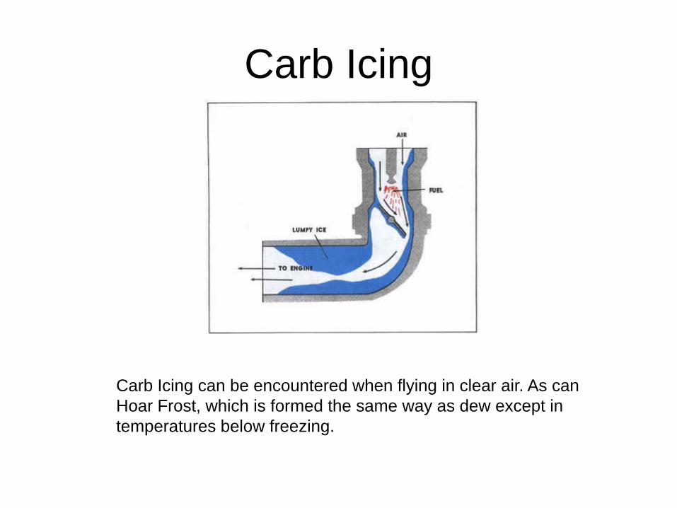
Carb Icing
Carb Icing can be encountered when flying in clear air. As can Hoar Frost, which is formed the same way as dew except in temperatures below freezing.
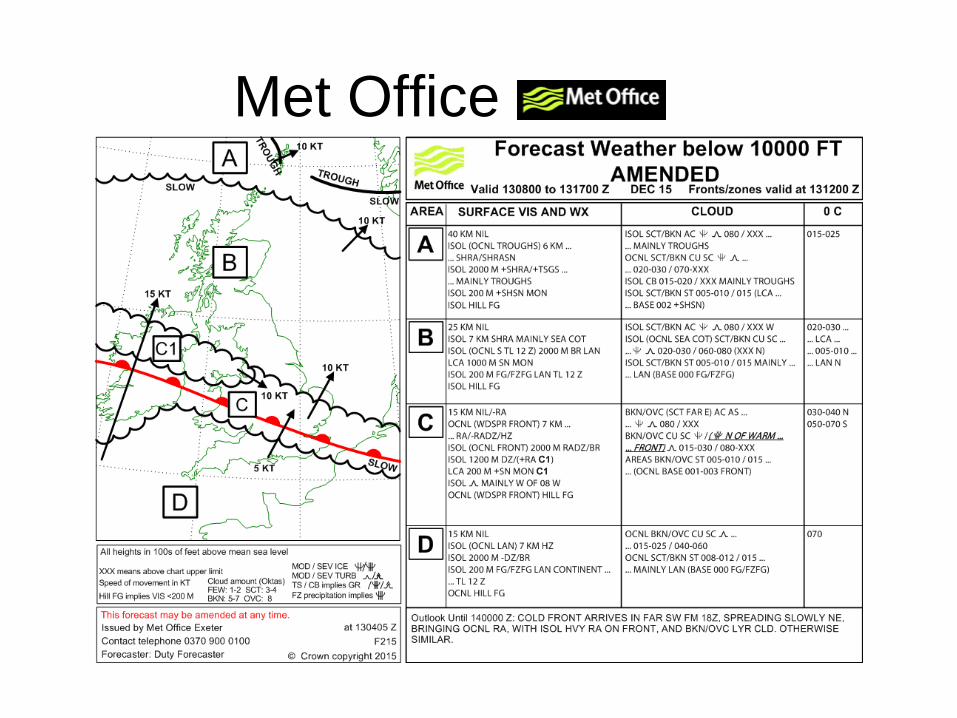
Met Office
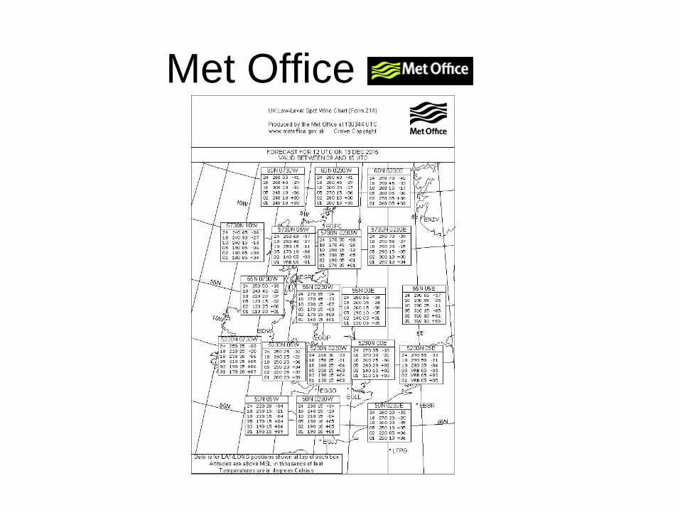
Met Office
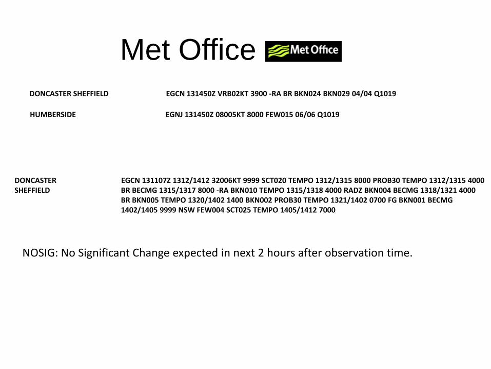
Met Office DONCASTER SHEFFIELD EGCN 131450Z VRB02KT 3900 -RA BR BKN024 BKN029 04/04 Q1019
HUMBERSIDE EGNJ 131450Z 08005KT 8000 FEW015 06/06 Q1019
DONCASTER SHEFFIELD
EGCN 131107Z 1312/1412 32006KT 9999 SCT020 TEMPO 1312/1315 8000 PROB30 TEMPO 1312/1315 4000 BR BECMG 1315/1317 8000 -RA BKN010 TEMPO 1315/1318 4000 RADZ BKN004 BECMG 1318/1321 4000 BR BKN005 TEMPO 1320/1402 1400 BKN002 PROB30 TEMPO 1321/1402 0700 FG BKN001 BECMG 1402/1405 9999 NSW FEW004 SCT025 TEMPO 1405/1412 7000
NOSIG: No Significant Change expected in next 2 hours after observation time.