Embed Size (px)
Citation preview
MICHAEL CHURCHJUNE M. RYDER
Department of Geography, University of British Columbia, Vancouver 8, BritishColumbia, Canada
Paraglacial Sedimentation: A Consideration of
Fluvial Processes Conditioned by Gkciation
ABSTRACTGlaciation is schematically considered as a
perturbation of "normal" fluvial conditions.Drift is unstable in a proglacial or postglacialfluvial environment, resulting in heightenedsediment movement that continues as long asdrift material remains easily accessible forfluvial erosion and transportation. Sedimentyield bears no relation to concurrent primaryproduction of weathered debris.
Examples of such "paraglacial" denudationand sedimentation are reported from two con-trasting areas. Postglacial valley alluvialdeposits are widespread in central Baffin Islandwhere rapid sedimentation continues today;estimated denudation rates are an order ofmagnitude higher than in comparable unper-turbed areas. In south-central British Colum-bia, rapid sedimentation during the paraglacialperiod contrasts sharply with present-dayconditions.
DEFINITION
The term "paraglacial" is introduced todefine nonglacial processes that are directlyconditioned by glaciation. It refers both toproglacial processes, and to those occurringaround and within the margins of a formerglacier that are the direct result of the earlierpresence of the ice.
It is specifically contrasted with the term"periglacial," which does not imply thenecessity of glacial events occurring (see thediscussion by Tricart in Fairbridge, 1968, p.829). The term "paraglacial" has previouslybeen introduced by Ryder (1971a, 1971b), butwas not critically defined there.
In this paper the term is used, additionally,as an adjective of time; such as, "paraglacialperiod," to define the time during whichparaglacial processes occur.
INTRODUCTIONGlaciation introduces an abrupt and radical
change in a terrestrial erosional environment.The magnitude, duration, and extent of ero-sional forces beneath a glacier are altogetherdifferent from those that occur in the moreusual, subaerial environment, and the resultingpatterns of sediment production and move-ment are highly disparate. Glaciation producesa large amount of detrital material that is leftin the form of glacial drift. While this materialmay have reached a position of stability withrespect to the glacial environment (that is,deposition at the ice margin), it usually is notstable with respect to the succeeding fluvialenvironment.
Large volumes of drift may be appropriatedby proglacial rivers and transported away atrates far in excess of "normal" material supplyby subaerial weathering processes. This condi-tion is not restricted to proglacial situations:heightened sediment movement will continueas long as drift remains easily accessible tofluvial activity. The extraordinary sedimenttransfer during this time results in manyfluvial deposits that represent temporarystorage areas for material. The occurrence ofmany alluvial cones and fans, in particular,indicates the lack of complete integration ofthe fluvial sediment transporting system.Sediment yield during periods as long as severalthousand years bears no relation to contempo-rary production of weathered material. Littledirect emphasis has been given to these special,"paraglacial" effects, directly conditioned byglaciation and occurring in the transition fromone environment to the other.
The broad relation between glaciation andfluvial sediment movement has been consideredby many writers. Broecker and others (1958)have shown that gross sedimentation ratesare generally much higher during glacial periods
Geological Society of America Bulletin, v. 83, p. 3059-3072, 9 figs., October 1972
3059

3060 CHURCH AND RYDER
than during interglacial times. Tricart (1952),Frye (1961), and Embleton and King (1968)have discussed various relations between glacieractivity and outwash sedimentation. Thedistinction among several possible schemesprobably depends on climate and glacier regi-men. Zeuner (1959) has examined the natureof fluvial activity in periglacial environments,while other studies (notably Frye, 1961; Tricartand Lillies-Lacroix, 1962) have discussed thedevelopment of alluvial fills in nonglacialregions during Pleistocene times. Schumm(1965) and Tricart (1966) have providedsystematic summaries of the development ofsuch "climatic terraces."
Paraglacial sediment movement has beeninvestigated in two areas: a region of east-central Baffin Island, N.W.T., where glaciersare still present and where paraglacial sedi-mentation is still highly active (Fig. 1); and aregion in south-central British Columbia(Fig. 6) where deglaciation occurred some10,000 yrs ago, and the process of relaxationafter the glacial event should be nearing com-pletion or should have passed it. Following the
presentation of the field data, some comparisonsare made with other relevant data from theliterature.
Gage (1970) has noted that data derivedfrom short-term observations—as was the casewith most of the data given in the paper—maybe very misleading when applied to changesover geological spans of time. Average ratesmay also mask a complex structure of realevents. This will be particularly so when theactual generating events involve "thresholds"of significant activity (as of sediment motion ina stream), and when the true structure of theduration-frequency series of events is unknown(compare with Tricart, 1962). With theserestrictions in mind, the paper concludes withsome speculations concerning the generalnature of paraglacial processes.
PARAGLACIAL SEDIMENTATION INEAST-CENTRAL BAFFIN ISLAND
Valley alluvium is a prominent post-glacialfeature of the Canadian Arctic. It is composedof coarse sands and gravels, with frequentcobble beds. Braided streams characterize
Figure 1. Location of field sites in central Baffin Island.

PARAGLACIAL SEDIMENTATION 3061
Figure 2. Alluvial cone at Nudlung Fjord, BaffinIsland.
Figure 3. Alluvial fan at Ekalugad Fjord, BaffinIsland.
Figure 4. Alluvial plain at Ekalugad Fjord; thedark surface is an earlier alluvial plain dating fromabout 5,700 yrsB.P.
presently active surfaces. The deposits rangefrom alluvial cones, which exhibit surfacegradients in excess of 20°, and upon which massmovements may also be important (Fig. 2),through alluvial fans (Fig. 3), to large alluvialplains (Fig. 4) and deltaic deposits in lakes orthe sea.
Many of the older deposits appear to be ofgreater extent than the recent ones. Suchdeposits probably date from the period of mostrapid reduction of late-glacial ice, commencingsometime after 9,000 yrs B.P. (compare dateand discussions in Falconer and others, 1965,and Blake, 1966) and extending through thehypsithermal interval. Nevertheless, consider-able activity still occurs, particularly in water-sheds where glaciers still exist. Measurements oipresent sediment transport in the rivers, and ofthe total volume of sediments have been madeat two sites in east-central Baffin Island (Fig. 1).One site, at Lewis River, at the northwestcorner of the Barnes Ice Cap (70°24' N.,74°53' W.), is in direct proglacial position. Theother, at Ekalugad Fjord on the Home Baycoast (68°50' N., 69°20' W.), is at the con-fluence of three watersheds with contemporaryice cover occupying between 11 and 49 percentof the total area (Table 1). The rocks at LewisRiver are Precambrian granite gneiss, whereasat Ekalugad Fjord, metamorphosed Precam-brian sediments occur.
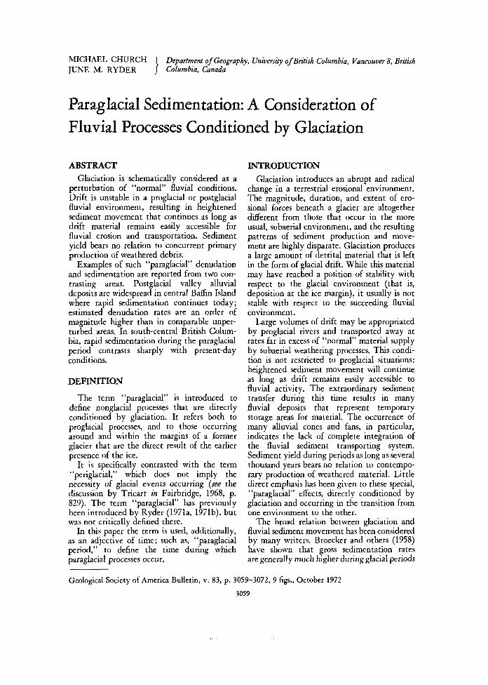
Summary data of sediment transport aregiven in Table 1. Of course, not all of thesediment moved within the watershed passedthe gauging points on the valley alluvial plain;and in any event, the results of one or a fewseasons' observations are not likely to berepresentative of long-term yields. Yet theresults indicate the order of magnitude ofsediment movement.
Another measure of sediment movement isthe total volume of sediment contained in therecent alluvial deposit at Ekalugad Fjord.Radiocarbon evidence (Andrews, 1969) indi-cates that deposition commenced not morethan 4,000 yrs ago, while regional evidencesuggests that most activity has occurred duringthe last 2,000 yrs since an early neoglacialperiod. The plain has advanced 1,300 m intothe fjord, indicating progression at a rate ofless than 0.65 m/yr on a 1.5-km front. Totalvolume of sediment, as determined from elec-trical resistivity profiling for depths of uncon-solidated materials, soundings in the fjord toestimate the thickness of the outwash wedge,
3062 CHURCH AND RYDER
TABLE 1. CHARACTERISTICS OF AND SEDIMENT YIELD FROM BAFFIN ISLAND WATERSHEDS
Basin
Lewis River
Ekalugad Fjord:
North Valley
Middle Valley
South Valley
Total watershed
Total areaof watershed
(km2)
205
189
106
90
385
Proportionalice-cover(percent)
89
11
15
49
21
Basinrelief
(m)
735
1,060
865
1,025
1,060
Annualrunoff
(cm depth)
59
62
54
62
60
Annualspecificsedimentyield*
(metrictons/km2)
7351-
720§
610S
1,170s
790S
Equivalentdenudation
rate(ran/1 ,000 yr)
280
270
230
440
300
*Dissolved and suspended sediment load were sampled directly ("several times weekly for the former; several times dailyfor the latter) throughout the runoff season between late June and late August. Sediment concentration was determined byusual laboratory procedures. Bed load was computed usiny the Meyer-Peter and Mu'ller (1948) formula, modified for actualthreshold conditions in the sections for which computations were made. Threshold conditions were determined from directbedload sediment transport measurements using a basket-type sampler at low and moderate flow levels. Continuous dischargerecords, derived via stage recordings and discharge rating curves, were used to estimate total sediment discharge from thesample measurements. See church (1972) for further details.
Mean of three years' data, 1963-1965? in 1964, measurements ended 2 weeks before the end of the runoff season and theresults were not adjusted.
One season's data only: 1967. North Valley results include estimated bedload sediment transport.
and projection of valley side morphology todetermine the shape of the wedge, is about 1X 10⁸ ms. This represents an annual sediment
delivery of between 2.5 and 5 X 10⁴ m3, or150 to 300 metric tons/km2 of the total con-tributing watershed (assuming a bulk densityof 2.25 for the sediment) (Church, 1972). Thisprobably accounts for about 75 percent of totaldelivery (suspended sediment load would notcome to rest on the delta, while some materialwill have remained on the alluvial plain), sothat 200 to 400 metric tons per annum, orabout one-half of the amount indicated fromthe 1967 observations presented in Table 1,appears to represent an upper limit for averagedelivery. The apparent disparity of the twoestimates may be somewhat reconciled if it isrecalled that much of the past 2,000 yrs hasbeen cooler than the present, so that fluvialactivity during this period would have beensomewhat less than that of today (Ives, 1962).
An interesting comparative measure ofsediment movement and deposition in Ekal-ugad Valley in earlier postglacial time is ob-tained from consideration of an old alluvialplain (Fig. 4), deposited during the final retreatof late Wisconsinan ice from the valley(Church, 1972). J. T. Andrews (1969) hasprovided a radiocarbon chronology for thedevelopment of this outwash plain. Construc-tion commenced about 5,700 yrs B.P., whenthe ice began to retreat from valley-headmoraines, and was essentially complete by 4,300yrs B.P. During this 1,400-yr span, between4 and 5 X 10⁸ m3 of sediment was delivered to
the plain, for an average annual delivery ofabout 3.0 to 3.5 X 10⁵ m3 of sediment. Whilecomparison with recent events cannot be madecomplete, as it is uncertain what the con-tributing drainage area (largely glacier surface)or the magnitude of discharges were at thattime, it is nevertheless evident that sedimentyields were much higher than in recent times(compare the rate of 2.5 to 5 X 10⁴ m3/yr forthe last 2,000 to 4,000 yrs, quoted above).
A further aspect of the relation between theolder surface and the contemporary alluvialplain illuminates the role of base-level changesin paraglacial sedimentation. The usual isostaticuplift following removal of the glacial load, ad-justed for eustatic effects, produced 23 m ofemergence during the active life of the oldalluvial plain. Another 20 m of emergence hassubsequently occurred (Andrews, 1969). Theold surface appears to have continuously re-graded itself during its life, so that redistribu-tion of sediment on the surface must haveoccurred. During the last 4,000 yrs at least 0.5X 10⁸ m3 of material has been eroded from theold deposit: this represents just one-half of thetotal amount of material incorporated in thecontemporary alluvial plain. Much materialmoved during later phases of the paraglacialperiod therefore may not be derived directlyfrom glacial deposits at all.
In the Ekalugad area, there is an apparentrelation between the fraction of a watershedpresently covered by glaciers and sedimentyield (Fig. 5). Such a relation might be affectedby variations in total runoff among the different

PARAGLACIAL SEDIMENTATION 3063
\\\
\ "North
\
O4
Proportion ofO.6
f-freeFigure 5. Relation between proportional ice cover
and sediment-removal rate.
watersheds, but this does not appear to be afactor in the present case (see runoff data inTable 1).
PARAGLACIAL SEDIMENTATION INSOUTH-CENTRAL BRITISHCOLUMBIA
Since the final recession of Pleistoceneglaciers 10,000 yrs ago (Fulton, 1971), thetrunk valleys of the region have been the siteof as much as 175 m of deposition underparaglacial conditions. Although some beds oftill are present within the sequence, they con-stitute only a small proportion of the totalvolume of material and present minor glacialfluctuations. Within the areas of detailed study(Fig. 6), recent degradation by the Fraser andThompson Rivers has led to the dissection ofthe valley-fill sediments and the formation ofextensive sections where detailed observationswere carried out. Where natural sections arescarce, data from well logs were utilized.
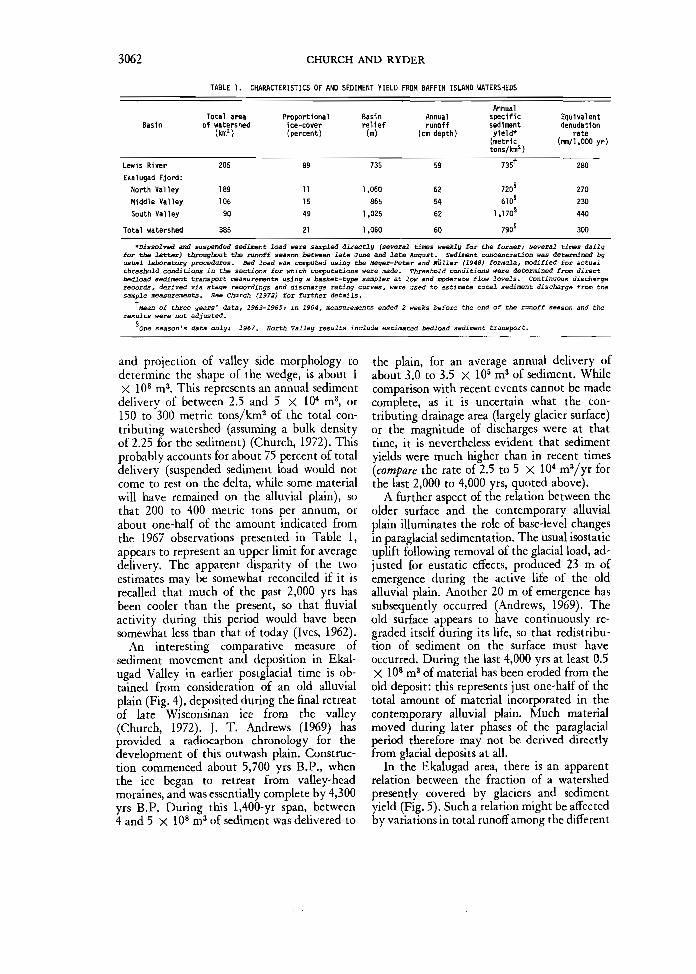
Three major types of nonglacial sedimentsoccur: (1) alluvial fan sediments deposited asdebris flows or fluvial gravels derived fromtributary valleys (Fig. 7) are common in all fiveof the areas investigated; (2) fluvial sedimentsdeposited by trunk rivers (Fig. 8) predominatein Fraser, Bonaparte, and Similkameen Valleysand the lower 25 km of Thompson Valleys; and(3) lacustrine sediments of proglacial lakes areextensive in the remainder of Thompson Valleyand along a 20-km stretch of Fraser Valley nearLillooet.
Paraglacial alluvial fans were constructedfrom reworked drift concurrently with the
•52°N
SIMILKAMEENVALLEY
100 km
Figure 6. Location of study areas in south-centralBritish Columbia.
general aggradation of valley floors by trunkstreams. In general, the proportion of mud-flowgravel is higher in fans that originated fromsmall, steep basins, while fluvial gravels pre-dominate in fans from larger basins withperennial streams. However, in places, thecharacter of available drift strongly influencedthe mode of deposition. For example, mud-flowand debris-flow deposition were most commonwhere suitably fine-textured "mud" matrixwas present as glacio-lacustrine silt or as siltyor clayey till. The thickest debris-flow beds(as much as 3 m in thickness) occur in the lowerpart of the fan sequences. They indicate therelatively greater magnitude of mud-flowevents during the early part of the paraglacialperiod.
There is little evidence of fan deposition to-day and degradation is occurring along many ofthe major valleys rather than aggradation. TheFraser and Thompson Rivers have eroded downthrough the valley sediments as much as 225m. Minor degradation and fan-head trenchinghave occurred in the other valleys. The dissec-tion may be chiefly attributed to reduction ofsediment supply toward and after the end of theparaglacial period.
The Mazama ash bed of 6,600 yrs B.P. (Wil-cox and Powers, 1964) was found (and identi-fied mineralogically) in fans throughout theregion (except in Fraser Valley), providing anexcellent time-stratigraphic marker and a use-ful reference horizon for studies of sedimenta-tion rates. It occurs at an average depth of 2 m,with a range of 1 to 6.5 m. This indicates thatmost fan deposition took place prior to 6,000
3064 CHURCH AND RYDER
yrs ago, and that this date, in fact, approxi-mately marks the end of paraglacial sedimenta-tion.
Within Thompson Valley, up to 175 m ofearly postglacial gravels and sands weredeposited by a large braided stream (Anderton,1970). Fan material was not observed withinthese sediments, indicating that the early post-glacial Thompson River was sufficiently com-petent to rework tributary sediment into itsown deposits. Stratigraphic evidence and radio-carbon dates from terraces in adjacent areassuggest extremely rapid accumulation of thisvalley fill, possibly entirely within 1,000 yrs(Anderton, 1970). Similar gravels occur inFraser Valley; but elsewhere, equivalent riversediments are thinner, comprising 45 m of sandygravel in Similkameen Valley and 20 m of sandand gravel in Bonaparte Valley.
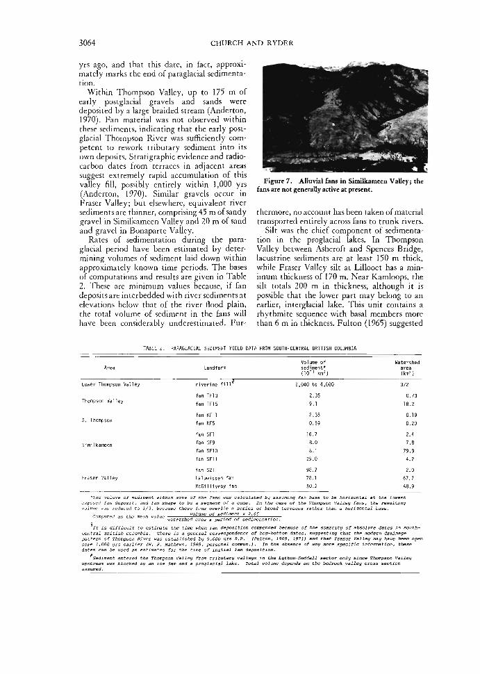
Rates of sedimentation during the para-glacial period have been estimated by deter-mining volumes of sediment laid down withinapproximately known time periods. The basesof computations and results are given in Table2. These are minimum values because, if fandeposits are interbedded with river sediments atelevations below that of the river flood plain,the total volume of sediment in the fans willhave been considerably underestimated. Fur-
Figure 7. Alluvial fans in Similkameen Valley; thefans are not generally active at present.
thermore, no account has been taken of materialtransported entirely across fans to trunk rivers.
Silt was the chief component of sedimenta-tion in the proglacial lakes. In ThompsonValley between Ashcroft and Spences Bridge,lacustrine sediments are at least 150 m thick,while Fraser Valley silt at Lillooet has a min-imum thickness of 170 m. Near Kamloops, thesilt totals 200 m in thickness, although it ispossible that the lower part may belong to anearlier, interglacial lake. This unit contains arhythmite sequence with basal members morethan 6 m in thickness. Fulton (1965) suggested
TABLE 2. PARAGLACIAL SEDIMENT YIELD DATA FROM SOUTH-CENTRAL BRITISH COLUMBIA
Area
Lower Thompson
Thompson Val ley
S. Thompson
Simi 1 kameen
Fraser Va l ley
*The volume
Computed as
It is diffi
Landform
Valley riverine fill*
fan TF13
fan TF15
fan KF 1
fan KF5
fan SF1
fan SF9
fan SF10
fan SF11
fan 521Laluwissen fan
McGillivray fan
Volume ofsediment*(10 ' km3)
2,040 to 4,080
2.35
9.1
2.35
0.59
16.7
8.0
8.1
29.0
98.7
78.1
50.2
of sediment within some of the fans was calculated by assuming fan base to be horizontal at
volume of sediment x 2.65'"- """' "'"" watershed area x period of sedimentation
cult to estimate the time when fan deposition commenced
Watershedarea(km2)
372
0.73
18.2
0.19
0.20
2.4
7.8
79.9
4.2
2.0
67.7
48.9
the lowestresulting
because of the scarcity of absolute dates in south-central British Columbia. There is a general correspondence of bog-bottom dates, suggesting that the modern drainagepattern of Thompson River was established by 9,000 yrs B.P. (Fulton, 1969, 1971) and that Fraser Valley may have been opensome 1,000 grs earlier (W. H. Mathews, 1969, personal cornmun.). In the absence of any more specific information, thesedates can be used as estimates for the time of initial fan deposition.
'Sediment entered the Thompson Valley from tributary valleys in the Lytton-Seddall sector only since Thompson Valleyupstream was blocked by an ice dam and a proglacial lake. Total volume depends on the bedrock valley cross section
assumed.
PARAGLACIAL SEDIMENTATION 3065
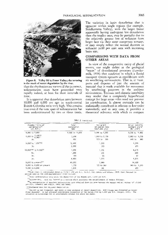
Figure 8. Valley fill in Fraser Valley; the terracingis the result of recent degradation by the river.that the rhythmitesare varves: if this is correct,sedimentation must have proceeded veryrapidly indeed, at least for short intervals oftime.
It is apparent that denudation rates between10,000 and 6,000 yrs ago in south-centralBritish Columbia were very high. This remainstrue even if the time span of sedimentation hasbeen underestimated by two or three times.
The variation in basin denudation that isapparent within single regions (for example,Similkameen Valley), with the larger basinsapparently having undergone less denudationthan the smaller ones, may be partially due tothe relatively greater loss of sediment fromlarger fans via their more competent streams,or may simply reflect the normal decrease insediment yield per unit area with increasingbasin size.
COMPARISONS WITH DATA FROMOTHER AREAS
In view of the comparative rarity of glacialevents, one might define as the geological"norm" of denudational processes (Lowder-milk, 1934) that condition in which a fluvialtransport system operates in equilibrium withits weathering environment. That is, it trans-ports and disposes of just the amount ofmaterial that is made available for movementby weathering processes in the ambientenvironment. Tectonic and climatic instabilitymay render this a completely hypotheticalconcept for large areas—this need not preventits consideration. It almost certainly can berealistically considered in relation to low-orderwatersheds; and in any case, it provides atheoretical reference with which to compare
TABLE 2 (continued)
Assumed l i m i t s ofsed imenta t ion^
(yrs B . P . )99
9
10
999
,000 to,000 to
Do.,000' to
Do.,000'**
Do.Do.Do.
,000 to,000 to,000 to••Time
MinorMinirr.Bn ex
7,5007,500**
1,000'**
to 6,000"!"+
present^6,000 or present6,000limit is radiocarbon dated as
P 11
turn date. Fans are located on
Total Equ iva l en tdegradat ion denudat ion rate
(mm) (mm/1 ,000 yrs)6,500
3
12271
649
11
7,530 i 2
a terrace
to 1 1 ,,200500
,400,950,000,000100
,900,000,150,03070 yrs
which
,000 3,700 to 7,3001,050 to 2,100
170 to 3351,550
3701 ,750
25025
1,7255,440
125 to 380340
S.p. (G.S.C.-530; Lowden and others, 1969)
postdates the establishment of modern draii
A n n u a l spec i f i csediment yield"1"( M . T . / k m 2 )9,700 to 192,850 to 5
440 to4,100
9754,610
68067
4,57514,500
340 to 1900
,400,700880
,020
from charcoal in
lags.St. Helens "Y" (3,200
yrs B.P.; Crandell and others, 1962) ash bands.
***Estimated date for regional deglaciation.
Fan S21 is not dissected, and there is some evidence of recent deposition. McGillivray was dissected as FraserRiver degraded: it had achieved considerable dissection of the valley fill by 6,000 yrs B.P. (Sanger, 1970). Thesituation on Laluwissen fan is intermediate between the above two cases.
3066 CHURCH AND RYDER
conditions in real landscapes. Glacial eventsmay be looked upon as perturbations of thefluvial evolution of the landscape.
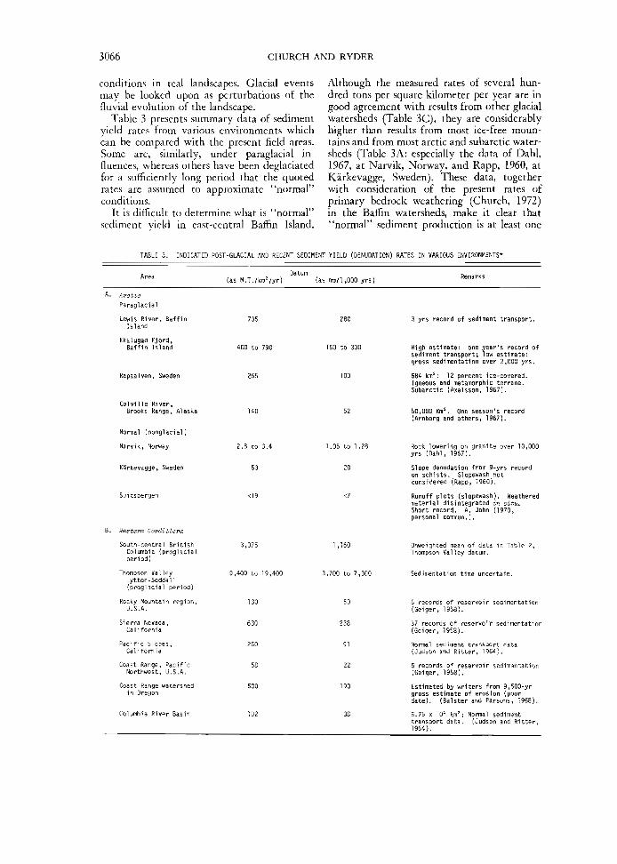
Table 3 presents summary data of sedimentyield rates from various environments whichcan be compared with the present field areas.Some are, similarly, under paraglacial influences, whereas others have been deglaciatedfor a sufficiently long period that the quotedrates are assumed to approximate "normal"conditions.
It is difficult to determine what is "normal"sediment vield in east-central Baffin Island.
Although the measured rates of several hun-dred tons per square kilometer per year are ingood agreement with results from other glacialwatersheds (Table 3C), they are considerablyhigher than results from most ice-free moun-tains and from most arctic and subarctic water-sheds (Table 3A: especially the data of Dahl,1967, at Narvik, Norway, and Rapp, 1960, atKarkevagge, Sweden). These data, togetherwith consideration of the present rates ofprimary bedrock weathering (Church, 1972)in the Baffin watersheds, make it clear that"normal" sediment production is at least one
TABLE 3. INDICATED POST-GLACIAL AND RECENT SEDIMENT VIELD (DENUDATION) RATES IN VARIOUS ENVIRONMENTS*
(as M.T./km2/yr) (as mm/1,000 yrs)Remarks
A. ArcticParaglacial
Lewis River, BaffinIsland
Ekalugad Fjord,Baffin Island
Rapaalven, Sweden
Colville River,Brooks Range, Alaska
Normal (nonglacial)
Narvik, Norway
Ka'rkevagge, Sweden
Spitsbergen
Vestem Cordillera
150 to 300
100
1.05 to 1.28
20
<7
3 yrs record of sediment transport.
High estimate: one year's record ofsediment transport; low estimate:gross sedimentation over 2,000 yrs.
684 km2: 12 percent ice-covered.Igneous and metamorphic terrane.Subarctic {Axelsson, 1967).
50,000 Km2. One season's record(Arnborg and others, 1967).
Rock lowering on granite over 10,000yrs (Dahl, 1967).
Slope denudation from 9-yrs recordon schists. Slopewash notconsidered {Rapp, 1960).
Runoff plots (s lopewash). Weatheredmaterial disintegrated in s-itu.Short record. A. John (1970,personal commun.).
South-central British 3,075Columbia {proglacialperiod)
Thompson Valley 9,400 to 19,400Lytton-Seddall(proglacial period)
Rocky Mountain region, 130U.S.A.
Sierra Nevada, 630California
Pacific Slopes, 250California
Coast Range, Pacific 58Northwest, U.S.A.
Coast Range watershed 500in Oregon
Columbia River Basin 102
1 ,160
3,700 to 7,300
50
238
91
22
190
38
Unweighted mean of data in Table 2,Thompson Valley datum.
Sedimentation time uncertain.
5 records of reservoir sedimentation(Geiger, 1958).
37 records of reservoir sedimentation(Geiger, 1958).
Normal sediment transport data(Judson and Ritter, 1964).
6 records of reservoir sedimentation(Geiger, 1958).
Estimated by writers from 9,500-yrgross estimate of erosion (poordate). (Balster and Parsons, 1968).
6.75 x 10s km2; Normal sedimenttransport data. (Judson and Ritter,1964).
PARAGLACIAL SEDIMENTATION 3067
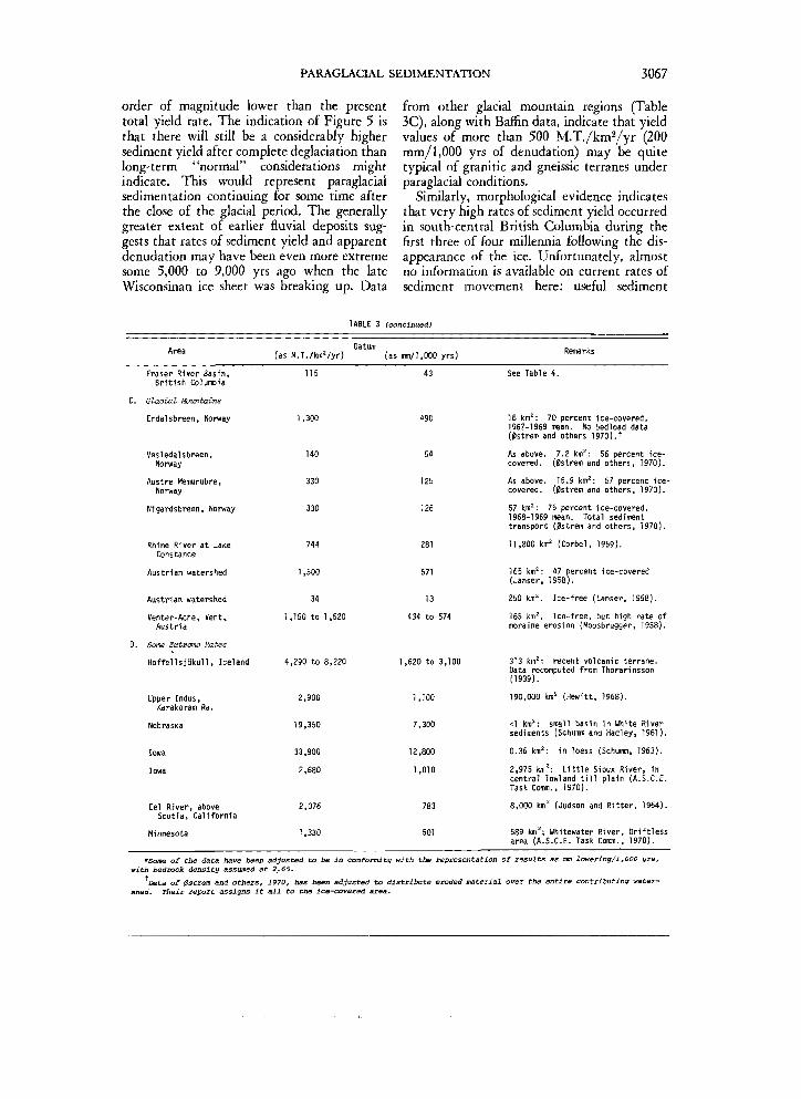
order of magnitude lower than the presenttotal yield rate. The indication of Figure 5 isthat there will still be a considerably highersediment yield after complete deglaciation thanlong-term "normal" considerations mightindicate. This would represent paraglacialsedimentation continuing for some time afterthe close of the glacial period. The generallygreater extent of earlier fluvial deposits sug-gests that rates of sediment yield and apparentdenudation may have been even more extremesome 5,000 to 9,000 yrs ago when the lateWisconsinan ice sheet was breaking up. Data
from other gkcial mountain regions (Table3C), along with Baffin data, indicate that yieldvalues of more than 500 M.T./km2/yr (200mm/1,000 yrs of denudation) may be quitetypical of granitic and gneissic terranes underparaglacial conditions.
Similarly, morphological evidence indicatesthat very high rates of sediment yield occurredin south-central British Columbia during thefirst three of four millennia following the dis-appearance of the ice. Unfortunately, almostno information is available on current rates ofsediment movement here: useful sediment
Area
Fraser River Basin,British Columbia
C. Glaa-ial Mountains
Erdalsbreen, Norway
Vesledalsbreen,Norway
Austre Memurubre,Norway
Nigardsbreen, Norway
Rhine River at LakeConstance
Austrian watershed
Austrian watershed
Venter-Ache, Vent,Austria
TABLE 3
Datum(as M.T./km'/yr)
115
1,300
140
330
330
744
1,500
34
1,150 to 1,520
(continued)
(as mm/1, 000 yrs)
43
490
54
125
126
281
571
13
434 to 574
Remarks
See Table 4.
16 km2: 70 percent ice-covered.1967-1969 mean. No bedload data(0strem and others 1970). t
As above. 7.2 km2: 56 percent ice-covered. (Bstrem and others, 1970).
As above. 15.9 km2: 57 percent ice-covered. (0strem and others, 1970).
57 km2: 75 percent ice-covered.1968-1969 mean. Total sedimenttransport (0strem and others, 1970).
11,800 km2 (Corbel, 1959).
165 km2: 47 percent ice-covered(Lanser, 1958).
250 km2. Ice-free (Lanser, 1958).
165 km2. Ice-free, but high rate ofmoraine erosion (Moosbrugger, 1958).
D. Some Extreme Rates
HoffellsjSkull, Iceland 4,290 to 8,220 1,620 to 3,100 313 km2: recent volcanic terrane.Data recomputed from Thorarinsson(1939).
Upper Indus,Karakoram Ra.
Nebraska
Iowa
Iowa
Eel River, aboveScotia, California
Minnesota
2,900
19,350
33,900
2,680
2,076
1,330
1,100
7,300
12,800
1,010
783
501
190,000 km2 (Hewitt, 1968).
<1 km2: small basin in White Riversediments (Schumm and Hadley, 1961).
0.36 km2: in loess (Schumm, 1963).
2,975 km2: Little Sioux River, incentral lowland till plain (A.S.C.E.Task Comm., 1970).
8,000 km2 (Judson and Ritter, 1964).
589 km2; Whitewater River, Driftlessarea (A.S.C.E. Task Comm., 1970).
*Some of the data have betwith bedrock density assumed
Data of 0strem and othenshed. Their report assigns :
sn adjusted to be in conformity with the representation of results as mm lowering/1,000 yrs,at 2.65.
f, 1970, has been adjusted to distribute eroded material over the entire contributing water-it all to the ice-covered area.

3068 CHURCH AND RYDER
TABLE 4. CONTEMPORARY SEDIMENT YIELD FROM FRASER RIVER WATERSHED(AS MEASURED AT HOPE)*
Year
1950 through 1952t
19665
1967§
1929 through 1959*
Annual totalsediment yield(metric tons)
17 x 10s (mean)
20 x 10s
23 x 10s
23 x 10' (mean)
Annual specificsediment yield
(M.T./km )
85100115115
Equ1 val entdenudation
(mm/1 ,000 yrs)
31374343
Contributing area, 200,450 km : observed results based on suspended sediment only, which probably accounts for morethan 80 percent of the sediment transport at Hope.
Kidd (19531 .
Inland Waters Branch: Sediment Data fox Canadian Rivers, 1966 and 196? Reports.
Hathews and Shepard (1962) . Indirect estimate of sediment transport at Hope, based on observed sediment deposition atFraser River mouth, adjusted for changes in transport below Hope.
transport data are available only for the FraserRiver at Hope; this river drains a large area ofdiverse characteristics, only part of which istypified by the montane forest and semiaridvalleys of the study area. Table 4 summarizesthe data and shows that watershed sedimentyield is very much lower than most valuesreported in Table 2. Nowhere in western NorthAmerica (except perhaps in some high moun-tain proglacial situations) are rates in excessof 2,500 M.T./km2/yr (1,000 mm/1,000 yrs)approached today over considerable areas. Infact the deduced paraglacial rates approach themagnitude of some of the most extreme re-corded sediment-movement data (Table 3D),
The degree to which depositional landforms,essentially completed 6,000 yrs ago, are stillpreserved in south-central British Columbiadoes indicate that rates of erosion and deposi-tion have since been very small. The alluvialfans and valley-fill deposits of the regionmay comprise only temporary storage forsediment that will ultimately be moved fartherthrough the fluvial transport system, but theyare certainly more stable in the ambient envir-onment than was the glacial drift from whichthe material has been derived.
DISCUSSIONIt is difficult to make generalizations about
the nature of the paraglacial period from thesparse existing data. In attempting to comparethe data on paraglacial sediment yields withappropriate geological norms, it has beennecessary to make comparisons with otherbasins. This involves several difficulties. Thebasin denudation rate may ordinarily beexpected to decline as the basin becomeslarger (Brune, 1948; Schumm, 1963), becauseof the increase in proportion of eroded material
that may again be deposited within the con-fines of larger basins. Schumm's relation, givingspecific yield « (area) -°-16, is relatively in-sensitive and has not been considered in thispaper in virtue of the low precision attainedfrom the data. Relief (Schumm and Hadley,1961; Schumm, 1963; Ahnert, 1970) is alsoimportant in determining sediment yield. Asthis factor does not vary greatly among thestudy areas, no data pertaining to it can bepresented here. It seems reasonable to speculatethat, other things being equal, paraglacialredistribution of sediment will be more severein areas of high relief then in ones of low relief.
The effects of geology and climate must alsobe considered. In the two regions studied here,the geology is an important point of contrast:the granite-gneiss terrane of Baffin Island andits predominantly coarse-grained weatheredmaterial are relatively resistant to glacial andfluvial erosion; thus, maximum paraglacialdenudation rates remain modest. The variedintrusive and extrusive, metamorphic andsedimentary terrains of southern BritishColumbia have produced a wide range of rates.
Climate undoubtedly has significant in-fluences as well. The relative length of the run-off season during the paraglacial period and themagnitude, duration, and frequency of periodsof rapid snow and ice melt, and of major sum-mer (rain) storms, all probably favored morerapid erosion and sedimentation in the southernregion during the paraglacial period than in theArctic today.
The period of major sedimentation in south-western British Columbia appears to havedrawn to a close by the time of the warm, dryhypsithermal period (Heusser, 1960) ~ 6,500yrs ago. Whether the increasing dryness of theperiod contributed to a significant reduction in

PARAGLACIAL SEDIMENTATION 3069
the efficiency of fluvial processes is unknown.Precipitation in the valleys today (125 mm to375 mm) lies within the range of effectiveprecipitation totals for which Langbein andSchumm (1958) found the greatest character-istic sediment yields. The higher precipitationin the mountains, and the concentration ofrunoff during spring snowmelt, should alsoprovide relatively efficient conditions formoving sediment. Nevertheless, sediment yieldsremain relatively low today.
Simple proximity to the extraordinarysupply of water represented by melting icesheets is important. The largest proportion ofmaterial is probably moved during the pro-glacial phase when frequent floods may occuras a result of melt. As glaciers have maintaineda long, lingering existence in east Baffin Island,marked by several post-Wisconsinan advances,the paraglacial period has been extendedgreatly over that apparently experienced in thesouth.
Vegetation (in part a climatically controlledfactor) also influences the duration of para-glacial conditions. Immediately after deglacia-tion, bare slopes are very vulnerable to erosiveforces. The rapid influx of a relatively richflora, including tree species, such as occurredin southwestern British Columbia, removesmany deposits from the category of "unstablein the fluvial environment," hence makingthem unavailable for erosion and redepositionelsewhere. This has not occurred in the severeenvironment of the Arctic.
Finally, regional uplift, as has been notedabove, has undoubtedly been significant in thetiming of shifts in the balance from depositionto erosion, in trunk valleys, and then in sidevalleys. When sediment supply is no longersufficient to maintain the rate of progradationof sediment deposits ahead of the effect of fall-ing base level, then dissection of the depositsmust occur. This in itself has the effect of pro-viding material for transport and redepositionfarther downstream. Such multi-generationactivity has demonstrably occurred in easternBaffin Island. It prolongs the total period ofparaglacial effects.
With reservations concerning the crudenessof the data still in mind, the sequence sketchedin Figure 9 is tentatively suggested as rep-resenting the progress of paraglacial sedimentmovement in the two study areas during thelate glacial and postglacial periods. Little is
- geological norrn in suba&rial environment -
uJproglacia! period
paraglacial period
Figure 9. Schematic diagram of the pattern ofsedimentation during the paraglacial period.
known of conditions during the full-glacialperiod. Andrews (1971) estimates denudationrates of 25 to 90 mm/1,000 yrs (correspondingto sediment yields of 65 to 240 M.T./km2/yr)in Baffin Island from cirque and moraine vol-umes. While well above subaerial "norms," thisremains below indications for the early para-glacial period. Maximum sediment movementprobably occurs very soon after deglaciation,with rates declining rapidly as the ice disap-pears. After that, the rate of paraglacial sedi-ment yield probably follows an asymptoticdecline toward the regional "norm."
ACKNOWLEDGMENTSThis paper is speculative in nature, and is
meant to stimulate discussion. The authorshave already received the benefit of discussionswith M. A. Melton and W. F. Rannie. J. T.Andrews, W. H. Mathews, and S. A. Schummhave also reviewed the manuscript and madevaluable comments. The sympathetic critiquesprovided by the reviewers have contributedgreatly to clarification of many points.
REFERENCES CITEDAhnert, F., 1970, Functional relationships between
denudation, relief, and uplift in large mid-latitude drainage-basins: Am. lour. Sci., v.268, p. 243-263.
American Society of Civil Engineers, Task Com-mittee for Preparation of Manual on Sedimen-tation, 1970, Sedimentation in Engineering,Chap. 3: Sediment measurement techniques:C. Accelerated valley deposits: Am. Soc.Civil Engineers, Proc. Jour. Hydraulics D:.v.,
3070 CHURCH AND RYDER
v. 96. p. 1157-1166.Anderton, L. J., 1970, Quaternary stratigraphy and
geomorphology of the lower Thompson Valley,British Columbia [M.A. thesis]: Vancouver,Dept. Geography, Univ. British Columbia,100 p.
Andrews, J. T., 1969, The importance of the radio-carbon standard deviation in the determina-tion of relative sea levels and glacial chronol-ogies: An example from East Baffin Island,N.W.T., Canada: Arctic, v. 22, p. 13-24.1971, Estimates of variations in glacial erosion
from the volume of corries and moraines: Geol.Soc. America, Abs. with Programs, v. 3, p. 493.
Arnborg, L., Walker, H. J., and Peippo, J., 1967,Suspended load in the Colville River, Alaska,1962: Geog. Annaler, v. 49A, p. 131-144.
Axelsson, V., 1967, the Laitaure delta: Geog.Annaler, v. 49A, p. 1-127.
Balster, C. A., and Parsons, R. B., 1968, Sedimenttransportation on steep terrain: NorthwestSci., v. 42, p. 62-70.
Blake, W., Jr., 1966, End moraines and deglaciationchronology in northern Canada with specialreference to southern Baffin Island: CanadaGeol. Survey Paper 66-26, 31 p.
Broecker, W. S., Turekian, K. K., and Heezen,B. C., 1958, The relation of deep sea sedimenta-tion rates to variations of climate: Am. Jour.Science, v. 256, p. 503-517.
Brune, G., 1948, Rates of sediment production inmidwestern United States: U.S. Dept. Agricul-ture Soil Conserv. Service Tech. Pub. no. 65,40 p.
Canada Dept. Energy, Mines and Resources, 1966,1967, Inland Waters Branch Water Survey ofCanada, 1966 and 1967: Ottawa, Sediment datafor Canadian rivers, Ann. Repts.
Church, M., 1972, Baffin Island sandurs: CanadaGeol. Survey Bull., no. 216, 205 p.
Corbel, J., 1959, Vitesse de 1'erosion: Zeitschr.Geomorphologie, v. 3, p. 1-28.
Crandell, D. R., Mullineaux, D. R., Miller, R. D.,and Rubin, M., 1962, Pyroclastic deposits ofrecent age at Mt. Rainier, Washington: U.S.Geol. Survey. Prof. Paper 450-D. p. 64-67.
Dahl, R., 1967, Post-glacial micro-weathering ofbedrock surfaces in the Narvik district ofNorway: Geog. Annaler, v. 49A, p. 155-166.
Embleton, C., and King, C.A.M., 1968, Glacialand periglacial geomorphology: London, Ar-nold, 608 p.
Falconer, G., Ives, J. D., L0ken, O. H., and An-drews, J. T., 1965, Major end moraines ineastern and central arctic Canada: Geog. Bull.,v. 7, p. 137-154.
Frye, J. C., 1961, Fluvial deposition and the glacialcycle: Jour. Geology, v. 69, p. 600-603.
Fulton, R. J., 1965, Silt deposition in late-glaciallakes of southern British Columbia: Am. Jour.Sci., v. 263, p. 553-570.
1969, Glacial lake history, southern interiorplateau, British Columbia: Canada Geol.Survey Paper no. 69-37, 14 p.1971, Radiocarbon geochronology of southern
British Columbia: Canada Geol. Survey.Paper no. 71-37, 28 p.
Gage, M., 1970, The tempo of geomorphic change:Jour. Geology, v. 78, p. 619-625.
Geiger, A. F., 1958, Sediment yields from smallwatersheds in the United States: Internal.Union Geodesy and Geophysics, l l th Gen.Assembly, Toronto, 1957: Internal. Assoc. Sci.Hydrology. Pub. no. 43, p. 269-276.
Heusser, C. J., 1960, Late Pleistocene environmentsof North Pacific North America: Am. Geog.Soc. Spec. Pub. no. 35, 308 p.
Hewitl, K., 1968, The freeze-lhaw environmenl ofthe "Karakoram Himalaya": Canadian Geo-grapher, v. 12, p. 85-98.
Ives, J. D., 1962, Indications of recenl exlensiveglacierization in norlh-cenlral Baffin Island,N.W.T.: Jour. Glaciology, v. 4, p. 197-205.
Judson, S., and Riller, D. F., 1964, Rales of regionaldenudation in the United States: Jour.Geophys. Research, v. 69, p. 3395-3401.
Kidd, G.J.A., 1953, Fraser River suspendedsediment survey, Interim Report for period1949-1952: Victoria, B. C., British ColumbiaDepl. Lands and Forests, Waier Righls Branch,46 p. (mimeo.).
Langbein, W. B., and Schumm, S. A., 1958, Yieldof sedimenl in relalion lo mean annual pre-cipitalion: Am. Geophys. Union. Trans., v.39, p. 1076-1084.
Lanser, O., 1958, Reflexions sur les debils solides ensuspension des cours d'eau glaciaires: Inlernal.Assoc. Sci. Hydrology Bull., v. 4, p. 37-43.
Lowden, J. A., Wilmelh, R., and Blake, Jr., W.,1969, Geological Survey of Canada radio-carbon dales VIII: Canada Geol. Survey Paperno. 69-2B, 42 p.
Lowdermilk, W. C., 1934, Acceleration of erosionabove geologic norms: Am. Geophys. UnionTrans., v. 15, p. 505-509.
Mathews, W. H., and Shepard, F. P., 1962,Sedimentalion of Fraser River Delia, BrilishColumbia: Am. Assoc. Peiroleum GeologislsBull., v. 46, p. 1416-1443.
Meyer-Peler, E., and Muller, R., 1948, Formulasfor bed-load Iransporl: Inlernat. Assoc.Hydraulic Research, Stockholm, Proc., Ap-pendix 2, p. 1-26.
Moosbrugger, H., 1958, Le charriage el le debilsolide en suspension des cours d'eau de mon-lagnes: Inlernat. Union Geodesy and Geo-physics, lllh Gen. Assembly, Toronto, 1957:Inlernal. Assoc. Sci. Hydrology Pub. no. 43,p. 203-231.
0strem, G., Ziegler, T., and Ekman, S. R., 1970,Slamtransportundersokelser i Norske Bre-elver, 1969: Vassdragsdirekloralel: Hydrol-

PARAGLACIAL SEDIMENTATION 3071
ogisk Avdeling. Oslo. Rapport, nr. 6/70. 68 p.Rapp, A., 1960, Recent development of mountain
slopes in Ka'rkevagge and surroundings, north-ern Scandinavia: Geog. Annaler, v. 42, p.65-200.
Ryder, J. M., 197 la, The stratigraphy and mor-phology of paraglacial alluvial fans in south-central British Columbia: Canadian Jour.Earth Sci., v. 8, p. 279-298.
Ryder, J. M., 1971b, Some aspects of the mor-phometry of paraglacial alluvial fans in south-central British Columbia: Canadian Jour.Earth Sci., v. 8, p. 1252-1264.
Sanger, D., 1970, The archaeology of the Lochore-Nesikep locality, British Columbia: Syesis, v.3, supp. 1, p. 1-146.
Schumm, S. A., 1963, The disparity between pres-ent rates of denudation and orogeny: U.S.Geol. Survey. Prof. Paper 454-H, 13 p.1965, Quaternary paleohydrology, in Wright,
H. E., Jr., and Frey, D. G., eds., The Quater-nary of the United States: Princeton Univ.Press, p. 783-794.
Schumm, S. A., and Hadley, R. F., 1961, Progressin the application of landform analysis instudies of semiarid erosion: U.S. Geol. SurveyCirc. no. 437, 14 p.
Thorarinsson, S., 1939, Hoffellsjokull, its move-ments and drainage: Chap. 8 of Vatnajokull—Scientific results of the Swedish-Icelandic
investigations, 1936-1938: Geog. Annaler, v.21, p. 189-215.
Tricart, J., 1952, Accumulation glaciaire, fluviogla-ciaire et periglaciaire: PExemple de la Durance:IV Congres du Quaternaire Actes, v. 1, p. 48-56.1962, Les discontinuites dans les phenomenes
d'erosion: Internat. Assoc. Sci. Hydrology,Commission Continental Erosion, Pub. no.59, p. 233-243.1966, Paleoclimats et terrasses quaternaires:
Soc. Geol. France Compte Rendu Sommaire,1966, p. 202-203.1968, Periglacial landscapes, in Fairbridge,
R. W., ed., Encyclopedia of geomorphology:New York, Reinhold, p. 829-833.
Tricart, J., and Lillies-Lacroix, A., 1962, Les ter-rasses quaternaires des Andes venezueliennes:Soc. Geol. France Bull., ser. 7, v. 4 (pub.1963), p. 201-218.
Wilcox, R. E., and Powers, H. A., 1964, Volcanicash from Mt. Mazama (Crater Lake) and fromGlacier Peak: Science, v. 144, p. 1334-1336.
Zeuner, F. E., 1959, The Pleistocene period: Lon-don, Hutchinson, 447 p.
MANUSCRIPT RECEIVED BY THE SOCIETY NOVEMBER29, 1971
REVISED MANUSCRIPT RECEIVED MARCH 30, 1972