Embed Size (px)
Citation preview

MINERAL RESOURCES POTENTIAL
ASSESSMENTS OF SELECTED AREAS
IN THE GREAT WESTERN TIERS, TASMANIA
DEPARTMENT OF RESOURCES AND ENERGY
DIVISION OF MINES AND MINERAL RESOURCES
OCTOBER 1990
MRPA_05

CONTENTS
PAGE
INTRODUCTION 2
DEFINITIONS 3
PRESENTATION 5
CONCLUSIONS 6
AREA 1. PINE RIVER AND CLARENCE LAGOON 8
AREA 2. SANDBANKS TIER AND MILLERS BLUFF 13
AREA 3. QUAMBY BLUFF AND WARNERS SUGAR LOAF 20
AREA 4. MOTHER CUMMING PEAK, SASSAFRAS CREEK AND 25 LITT L E FISHER RIVER
AREA 5. BORRADAILE PLAINS AND ARM RIVER 34
BIBLIOGRAPHY 38
APPENDIX 1. GEOLOGICAL MAPPING PROGRAMS 39
APPENDIX 2. ASSESSMENT OF GEOPHYSICAL COVERAGE 42
1
L I S T OF FIGURES
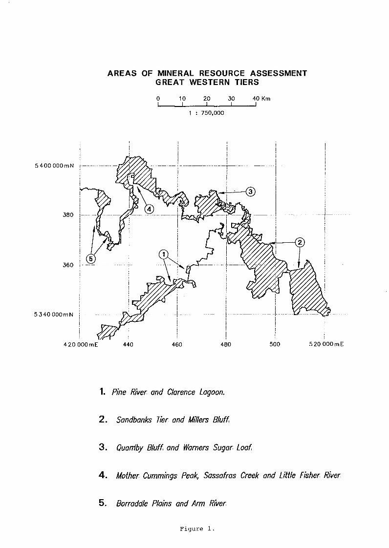
F i g u r e 1. Areas of m i n e r a l resource assessment, Great Western T i e r s .
F i g u r e 2. P r e l i m i n a r y m i n e r a l r e s o u r c e p o t e n t i a l zones, Great Western
T i e r s .
F i g u r e 3. G e o l o g i c a l legend (1:^5 M) , Tasmania.
F i g u r e 4. G e o l o g i c a l map ( 1 : % M), Great Western T i e r s .
F i g u r e 5. Confidence l e v e l s of g e o l o g i c a l mapping, Great Western
T i e r s .
F i g u r e 6. G r a v i t y s t a t i o n coverage, Great Western T i e r s .
F i g u r e 7. Mineral and c o n s t r u c t i o n m a t e r i a l s o c c u r r e n c e s , Great Western T i e r s .

2
INTRODUCTION
At the request of the Mining Forum, f i v e s e l e c t e d a r e a s of the Great Western T i e r s and a d j a c e n t a r e a s of the C e n t r a l P l a t e a u have been a s s e s s e d f o r t h e i r m i n e r a l r e s o u r c e p o t e n t i a l .
The assessments a r e p r e l i m i n a r y . There have been no d e t a i l e d s y n t h e s i s or r e i n t e r p r e t a t i o n of the surveys c a r r i e d out by m i n e r a l e x p l o r a t i o n companies nor have a l l r e l e v a n t data from open f i l e company r e p o r t s been consi d e r e d .

3
DEFINITIONS
A p r e v i o u s r e p o r t by the D i v i s i o n e n t i t l e d " C o n t r a s t i n g Approaches to the Assessment of M i n e r a l Resource P o t e n t i a l " adopted p r e f e r r e d d e f i n i t i o n s of the v a r i o u s c l a s s e s - high, moderate, low and unknown. These d e f i n i t i o n s are r e s t a t e d below.
A HIGH MINERAL RESOURCE POTENTIAL e x i s t s where the g e o l o g i c a l c h a r a c t e r i s t i c s f a v o u r a b l e f o r r e s o u r c e accumulation are known to be p r e s e n t , or where enough of t h e s e f e a t u r e s are p r e s e n t to support the r e l e v a n t g e n e t i c model and where the r e i s evidence t h a t m i n e r a l i s a t i o n , not n e c e s s a r i l y of economic s i z e or grade, has taken p l a c e .
A MODERATE MINERAL RESOURCE POTENTIAL e x i s t s where the g e o l o g i c a l data suggest t h a t the f a c t o r s favourable f o r formation of a c l a s s of d e p o s i t are p r e s e n t or c a n be reasonably i n f e r r e d , or where the g e o l o g i c a l f e a t u r e s of the a r e a show a reasonable degree of f i t w i t h those of the d e p o s i t c l a s s c o n s i d e r e d . There need not be evidence of m i n e r a l i s a t i o n i n the a r e a .
A LOW MINERAL RESOURCE POTENTIAL e x i s t s where the g e o l o g i c a l c o n d i t i o n s suggest t h a t m i n e r a l c o n c e n t r a t i o n s are u n l i k e l y and t h a t the r e l e v a n t g e n e t i c model cannot be supported. As noted by T a y l o r and Steven (1983) , t h i s r e q u i r e s an element of p o s i t i v e knowledge.
A c a t e g o r y of UNKNOWN MINERAL RESOURCE POTENTIAL i s used i n s i t u a t i o n s where e i t h e r the g e o s c i e n t i f i c data base i s inadequate to a s s e s s the l i k e l i h o o d of the r e s o u r c e accumulation, or the r e l e v a n t d e p o s i t models are so p o o r l y understood t h a t a reasonable assessment cannot be made. T h i s d e f i n i t i o n i s not to be equated w i t h low m i n e r a l r e s o u r c e p o t e n t i a l , but takes i n t o account a high degree of u n c e r t a i n t y or incompleteness i n the a v a i l a b l e i n f o r m a t i o n .
I t i s important to remember t h a t a m i n e r a l r e s o u r c e p o t e n t i a l assessment i s a product of the circumstances p r e v a i l i n g a t any one time. As the a v a i l a b l e data, t h e o r e t i c a l concepts, e x p l o r a t i o n techniques, m e t a l l u r g i c a l and mining p r a c t i c e s , commodity p r i c e s and p a t t e r n s of use a l l change w i t h time, so w i l l the assessments.

4
As i n other branches of s c i e n c e , e x p l o r a t i o n concepts and ore g e n e s i s t h e o r i e s are a t the mercy of f u t u r e d i s c o v e r i e s . Therefore i t i s e s s e n t i a l to provide f o r p e r i o d i c , i f not c o n t i n u i n g , resource assessments so t h a t new, emerging in f o r m a t i o n can be a p p l i e d to a l l areas of Tasmania.
5
PRESENTATION
The format of the r e p o r t f o l l o w s t h a t of a pre v i o u s r e p o r t by the D i v i s i o n "Mineral r e s o u r c e p o t e n t i a l assessments of s e l e c t e d areas i n C e n t r a l to Southern Tasmania."
Each a r e a ( F i g u r e 1) i s t r e a t e d s e p a r a t e l y under the headings "DATA" and "ASSESSMENT". I n the data s e c t i o n , there are accounts of the g e o l o g i c a l ( F i g u r e 4) , g e o p h y s i c a l ( F i g u r e 6) and previous m i n e r a l e x p l o r a t i o n coverages as w e l l as a g e o l o g i c a l summary and a l i s t of the known m i n e r a l occurrences ( F i g u r e 7 ) . The r e p o r t s of previous mineral e x p l o r a t i o n are h e l d i n the OPEN F I L E by the D i v i s i o n of Mines and Mineral Resources and form an i n v a l u a b l e data base of g r e a t importance f o r the S t a t e ' s m i n e r a l r e s o u r c e s . The r e p o r t s r e l e v a n t to c u r r e n t e x p l o r a t i o n l i c e n c e s are h e l d i n confidence i n the CLOSED F I L E f o r a p e r i o d of f i v e y e a r s .
I n the assessment s e c t i o n , the adequacy of the g e o l o g i c a l ( F i g u r e 5 ) , g e o p h y s i c a l ( F i g u r e 6) and geochemical coverage i s reviewed, the a p p l i c a b l e m i n e r a l r e s o u r c e models are l i s t e d and areas are a s s i g n e d a p p r o p r i a t e r e s o u r c e p o t e n t i a l zones ( F i g u r e 2 ) .

6
CONCLUSIONS
The zones of g r e a t e s t m i n e r a l r e s o u r c e p o t e n t i a l - the high and moderate category - correspond w i t h the exposed pre-Permian basement near B o r r a d a i l e P l a i n s , Mole Creek and the l i t t l e Den a r e a near Lake R i v e r . I n the former two areas, the p o t e n t i a l i s f u r t h e r enhanced by the presence of g r a n i t e w i t h i n some 4 km of the s u r f a c e .
The zones which have s u b s t a n t i a l a r e a s covered by d o l e r i t e are a s s i g n e d an unknown c l a s s i f i c a t i o n due to l a c k of information.
The zones i n which the Parmeener Supergroup r e p r e s e n t a t i v e s are exposed are a s s i g n e d a low category f o r c o a l , o i l s h a l e and m e t a l l i c s ( p a l a e o p l a c e r s ) , except where o i l s h a l e i s known i n the v i c i n i t y , and an unknown category f o r m e t a l l i c s i n the basement.
An unknown category f o r petroleum has been a s s i g n e d to a l l areas based on the assessment i n Appendix 2 of the D i v i s i o n ' s r e p o r t on C e n t r a l and Southern Tasmania.
C o n s t r u c t i o n m a t e r i a l s and to some ex t e n t b u i l d i n g stone are of l o c a l l y high p o t e n t i a l because they are commodities of convenience and a c c e s s i b i l i t y .
For a l l of the areas considered, g e o l o g i c a l and g e o p h y s i c a l coverage i s inadequate to achieve a l e v e l of confidence n e c e s s a r y f o r s a t i s f a c t o r y r e s o u r c e p o t e n t i a l assessment.
Appendix 1 l i s t s the c o s t of upgrading the g e o l o g i c a l mapping to present-day 1:50,000 mapping standards.
G e o p h y s i c a l coverage i s important i n e s t i m a t i n g s u b s u r f a c e depths to g r a n i t e , the p o s s i b l e compositions of the basement and the t h i c k n e s s of the c o v e r i n g Parmeener Supergroup and J u r a s s i c d o l e r i t e . The c o s t s of a c q u i r i n g the n e c e s s a r y i n f o r m a t i o n are estimated i n Appendix 2.
7
E v e n t u a l l y , a programme of deep d r i l l i n g w i l l be r e q u i r e d to d e f i n e the broad composition of the Pre-Permian basement p a r t i c u l a r l y i n a r e a s which are covered by l a r g e expanses of cover sequences ( s p e c i f i c a l l y Areas 1 and 2 of t h i s r e p o r t ) l i k e the e n t i r e C e n t r a l P l a t e a u .
A R E A S OF MINERAL R E S O U R C E A S S E S S M E N T G R E A T W E S T E R N T I E R S
0 10 2 0 3 0 4 0 K m
1 : 7 5 0 , 0 0 0
5 4 0 0 O O O m N
380
i 1
360
5 3 4 0 O O O m N
4 2 0 0 0 0 m E 4 4 0 4 6 0 4 8 0 5 0 0 5 2 0 0 0 0 m E
1 . Pine River and Clarence Lagoon.
2 . Sandbanks Tier and Millers Bluff
3 . Quamby Bluff and Warners Sugar Loaf
4 . Mother Cummings Peak, Sassafras Creek and Little Fisher River
5. Borradale Plains and Arm River
F i g u r e 1.

PRELIMINARY MINERAL R E S O U R C E POTENTIAL Z O N E S G R E A T W E S T E R N T I E R S
4 0 K m
Granite outcrop
Depth to granite (km), position approximate.
1 : 7 5 0 , 0 0 0
5 4 0 0 OOOmN '
5 3 4 0 OOOmN
4 2 0 0 0 0 m E 4 4 0 4 6 0 4 8 0
MINERAL RESOURCE POTENTIAL
5 0 0 5 2 0 O O O m E
Moderate for vein tin-tungsten and gold -mobybdenum deposits; low for diamonds
Low for coal and oil shale, low for palaeoplacers and uranium, unknown for metallics in pre-Permian basement
Unknown for cool and oil shale; palaeoplacers and uranium, and metallics in pre-Permian basement
Moderate for oil shale, low for palaeoplacers, uranium and coal, unknown for metallics in pre-Permian basement
High for lead-zinc deposits and limestone, moderate for gold strotobound and vein deposits, moderate for skarn, replacement and vein tin-tungsten deposits
High for Cambrian base and precious metal deposits
Petroleum potential of Great Western Tiers - unknown All areas locally high for construction materials and building stone
F i g u r e 2 .

LEGEND - 1:500,000 TASMANIA, GEOLOGY
HOLOCENE
P L E I S T O C E N E
TERTIARY
TRIASSIC
PERMIAN UPPER CARBONIFEROUS
w v v w v
Alluvium, sand, gravel and talus. Till, fluvioglacial, periglacial, and associated deposits. Erosional surface.
Non-marine sequences (l); marine limestone (2); basalt and related igneous rock types (J).
Low angle unconformity. Fluvio-lacustrine sequences of sandstone, siltstone, mudstone (I) with carbonaceous sequences indicated (2). Fresh water sequence with some coal measures. Upper glacio-marine sequence of pebbly mudstone, pebbly sandstone and limestone. Fresh water sequence with some coal measures. Lower glacio-marine sequence of pebbly mudstone, pebbly sandstone, minor limestone, Tasmanite oil shale and basal tillite.
UPPER
J PARMEENER S U P E R GROUP LOWER
W E S T E R N TASMANIA U P P E R - M I D D L E DEVONIAN
LOWER-DEVONIAN SILURIAN
ORDOVICIAN
Terrestrial cavern fillings (grid ref. 442 436) w v w w w v w w w Unconformity attributed to the Tabberabberan Orogeny.
Quortzite, sandstone, siltstone, and shale; Devonian limestone-siltstone (l) , Limestone sequence with siltstone in some areas. Siliceous conglomerate, shallow water quartzose sandstone & siltstone.
EUGENANA BEDS
ELOON GROUP 4 C O R R E L A T E S ; SPERO BAY GROUP
JUNEE GROUP AND CORRELATES
CAMBRIAN
PRECAMBRIAN I
Middle-Upper Cambrian fossiliferous usually greywacke turbidite sequences (1); acid with intermediate volcanic and associated rocks dominant (2), basic-intermediate volcanic and associated rocks dominant (J); probably Cambrian unfossiliferous usually greywacke turbidite sequences (4); probably Cambrian unfossiliferous orthoquartzite sequence (5).
INCLUDING DUNDAS GROUP ( f o s s i l i f e r o u s ) ; MT READ VOLCANICS
AND OTHER FORMATIONS
Usually unconformity attributed to Cambrian movements; occasionally unconformity e.g. parts of western Tasmania Comparatively unmetamormorphosed sequences. Orthoquortzite-mudstone sequences (1); quartzwacke turbidite successions (2); dolomite (J); basalt lava (4).
Metamorphic rocks of dominantly metaquartzite and pelitic sequences, amphibolite indicated (1).
E A S T E R N TASMANIA
W\AAA/\A/
LOWER DEVONIAN TREMADOCIAN-CAMBRIAN(?)
Unconformity attributed to the Tabberabberan Orogeny.
Micaceous quartzwacke turbidite sequences dominant (1); mudstone sequences dominant (2). MATHINNA B E D S
TERTIARY
C R E T A C E O U S
JURASSIC
LOWER C A R B O N I F E R O U S -( ? ) - D E V O N I A N
IGNEOUS R O C K S
Basalt and related rock types.
Syenite.
Appinite.
Dolerite and related rock types.
Dominantly adamellite-granite; biotite hypersthene-adamellite porphyry (1).
Dominantly granodiorite.
CAMBRIAN
PRECAMBRIAN
Granitic rocks.
Coarser grained basic rocks
Serpentinite, peridotite and associated rocks.
Acid with intermediate volcanic and ossoc. rocks.
Basic-intermediate volcanic and associated rocks.
Granite.
Dolerite.
Figure 3

G R E A T WESTERN T IERS G E O L O G Y 40 km 30 •>0 1 0
5 0 0 , 0 0 0
•' *\ 0 i
-V
5 40 OOOmN 1 i
H v
i 7t
53 c
B
5 3 4 0 OOOmN
;
:
420 OOOmE 440 460 480 500 5 20 OOOmE

CONFIDENCE L E V E L S O F G E O L O G I C A L MAPPING IN A R E A S OF MINERAL R E S O U R C E A S S E S S M E N T
G R E A T W E S T E R N T I E R S
0 10 2 0 3 0 4 0 K m I I I I I
1 : 7 5 0 , 0 0 0
5 4 0 0 OOOmN
© 3 8 0
1
3 6 0
}
5 3 4 0 OOOmN
4 2 0 O O O m E 4 4 0 4 6 0 4 8 0 5 0 0 5 2 0 OOOmE
Mopping of sufficiently detailed scale and currency for preliminary assessment.
A R E A S
1. Pine River and Clarence Lagoon.
2. Sandbanks Tier and Millers Bluff
Mapping on sufficiently detailed scale but too old for preliminary assessment. Acceptable with check traverses.
3. Quamby Bluff and Warners Sugar Loaf
4. Mother Cummings Peak, Sassafras Creek and Little Fisher River
Reconnaissance information only, largely photointerpretation Mapping at i : 50000 scale required for preliminary assessment.
5. Borradale Plains and Arm River
F i g u r e 5.
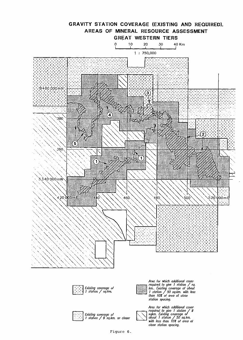
GRAVITY STATION C O V E R A G E (EXISTING AND REQUIRED). A R E A S OF MINERAL R E S O U R C E A S S E S S M E N T
G R E A T W E S T E R N T I E R S 10 2 0
I 3 0
_ J _ 4 0 K m
1 : 7 5 0 , 0 0 0
i V ' i V ' i ' i ' i ' i ' i 1 , 1 1 , 1 1 1 , 1
i i i i i i i i i i t i ) i f » i » i i i
i i r i i i i i i i t i t i i i i t i i i
i i i i i i i i ' i i i i i i i i i i i i i i i r i i r i i r i i i t I t i i t i [ i I I I I I I 1 I I 1 I
I I I I I I I I I i ) i f ) 1 ) I ) I I I 1 I I I I I I 1 1 ! I ) t I I | I ( [ |
i V $ ' 4 0 0 O O O m N 1
. ' I ' T ' i ' i ' i ' i ' i ' i ' i ' r I ' ' I ' ' ' I ' 1 1 ' ' ' I
( i j l l j l l j l I I I I I I I I I I I
) 1 ) I I 1 1 ) I ) ) I f I ) ) I I I 1 I
I I I I I I I I I I . I . ) ! I I ' 1 I 11 I 1 1
, 3 6 0
5,3 4 0 - 0 0 0 m N \
\ \ V \ \ | v 4 2 0 0 3 4/ 0 \ \ \ \ \ . 4 6 0 - 5 2 0 > ( 0 0 m E
i i i Existing coverage of I station / sq.km.
Area for which additional cover required to give I station / sq. km.. Existing coverage of about I station / 50 sq.km. with less than 10% of area at close station spacing.
Existing coverage of I station / 9 sq.km. or closer
Area for which additional cover required to give I station / 9 sqkm. Existing coverage of about I station / 50 sq.km. with less than 10X of area at close station spacing.
F i g u r e 6 .

MINERAL AND CONSTRUCTION MATERIAL O C C U R R E N C E S G R E A T W E S T E R N T I E R S
o i_
10 I
2 0 I
3 0 4 0 K m
7 5 0 , 0 0 0
Bm, Sn, Au, Ag, F, Fe
*VAU 5 4 0 0 O O O m N
* Bm Bm, Au, Ag
380
Au
3 6 0
5 3 4 0 0 0 0 m N !
4 2 0 O O O m E 4 4 0 4 6 0 4 8 0 5 0 0 5 2 0 O O O m E
CROSSES ( + ) : METALLIC & INDUSTRIAL MINERALS
Au Gold (including placer) Fe : Iron
Bm Base Metals (Cu.Pb.Zn) L : Limestone
Sn Tin / Tungsten F : Fluorite
Ag Silver
SQUARES ( - ) : CONSTRUCTION MATERIALS
F i g u r e 7.

8
AREA 1. PINE RIVER AND CLARENCE LAGOON
LOCATION
S i t u a t e d between Lake S t C l a i r and Great Lake, C e n t r a l P l a t e a u ( F i g u r e 1 ) .
DATA
(a) G e o l o g i c a l Maps
Blake, F., Everard, G.B., Voisey, A.H., M c k e l l a r , J.B.A., 1956. Tasmanian G e o l o g i c a l A t l a s 1 mile to 1 i n c h S e r i e s , Zone 7, Sheet No. 53, Great Lake. Dep.Mines Tasm.
G u l l i n e , A.B. and F o r s y t h , S.M. 1976. Tasmanian G e o l o g i c a l A t l a s 1:250 000 S e r i e s . SK55-6. Oatlands, Dep.Mines Tasm.
Corbett, K.D. and Brown, A.V. 1975. G e o l o g i c a l A t l a s of Tasmania 1:250 000 S e r i e s , Sheet SK55-5, Queenstown. Dep.Mines Tasm.
G u l l i n e , A.B., Longman, M.J., Matthews, W.L. 1963. Tasmanian G e o l o g i c a l A t l a s 1 mile to 1 i n c h S e r i e s , Zone 7, sheet No. 59, St C l a i r . Dep.Mines Tasm.
Jennings, I.B., MacLeod, W.N., Burns, K.L.,Jack, R.H., Matthews, W.L., Robinson, R.G., Threader, V.M. 1961. Tasmanian G e o l o g i c a l A t l a s 1 mile to 1 i n c h S e r i e s , Zone 7, Sheet No. 52, Du Cane. Dep.Mines Tasm.
The e n t i r e a r e a i s covered by 1 in c h to 1 mile g e o l o g i c a l mapping p u b l i s h e d i n the 1956 to 1963 pe r i o d . The l e v e l of mapping a t l e a s t i n the e a s t e r n h a l f of the Du Cane map she e t i s r e s t r i c t e d to pho t o g e o l o g i c a l methods (MacLeod and Threader, 1961).
The above mapping was compiled i n t o the 1:250 000 s h e e t s - Oatlands and Queenstown.

9
(b) G e o l o g i c a l Summary
The bedrock i s predominantly J u r a s s i c d o l e r i t e w i t h some T e r t i a r y b a s a l t p r o t e c t i n g T r i a s s i c sandstones and s h a l e s (Ossa Formation) o v e r l y i n g the d o l e r i t e i n the c e n t r e of the a r e a ( F i g u r e 4 ) .
I n the south west of the ar e a , near Lake S t C l a i r , u n c o n s o l i d a t e d Quaternary d e p o s i t s I n c l u d i n g g l a c i a l types up to 30 m t h i c k obscure d o l e r i t e bedrock. ( G u l l i n e , 1965).
The d o l e r i t e t h i c k n e s s i s not p r e c i s e l y known i n the a r e a but nearby (Lake St C l a i r ) i t can be as much as 400 m. The pre-Permian basement i s of unknown composition and depth.
( c ) G e o p h y s i c a l Coverage
Richardson, R.G., Leaman, D.E. 1987. Tasgrav - the Tasmanian g r a v i t y data base. Rep.Dep.Mines Tasm. 1987/02.
Few g r a v i t y s t a t i o n s have been measured w i t h i n t h i s a r e a of i n t e r e s t . G r a v i t y coverage on the surrounding a r e a i s based on s t a t i o n s about 7 km a p a r t i . e . reconnaissance standard.
Aeromagnetic data i s of reco n n a i s s a n c e standard w i t h f l i g h t l i n e s p a c i n g of 1.5 km by Bureau of Mi n e r a l Resources (BMR) i n 1985.
(d) M i n e r a l i s a t i o n
No known occurrences of m e t a l l i c m i n e r a l s or c o a l .
Along the southern margin of the a r e a and to the north e a s t , d o l e r i t e , b a s a l t and g r a v e l have been e x t r a c t e d f o r road making m a t e r i a l s ( F i g u r e 7 ) . To the e a s t near Mienna, a T e r t i a r y b a s a l t i s c u r r e n t l y being e x t r a c t e d f o r high q u a l i t y ornamental, b l a c k stone.

10
( e ) Previous m i n e r a l e x p l o r a t i o n
EL 25/79
T h i s l i c e n c e was i s s u e d f o r z e o l i t e s , b e n t o n i t e s , b a u x i t e s and r e l a t e d i n d u s t r i a l m i n e r a l s w i t h i n T e r t i a r y b a s a l t s . The l i c e n c e a r e a was j u s t west of Great Lake and encroached m a r g i n a l l y on Area 1. The l i c e n c e was gi v e n up without any work being c a r r i e d out.
EL 31/80 T h i s was a l a r g e l i c e n c e f o r c o a l , o i l s h a l e and petroleum s t r e t c h i n g from Lake King W i l l i a m to Coles Bay. I t covered most of Areas 1 and 2. E x p l o r a t i o n l e d to the d i s c o v e r y and e v a l u a t i o n of the Woodbury c o a l d e p o s i t s . Other than o c c a s i o n a l rock sampling, there i s no r e c o r d of work being c a r r i e d out i n the above a r e a s .
Reference: W i l t s h i r e , M.J. 1980. EL 31/80, Tasmania, o i l s h a l e , c o a l and petroleum p r o s p e c t s f o r V i c t o r Petroleum and Resources L t d . Tasm.Dept.Mines TCR 81-1562A.
EL 1/88 T h i s c u r r e n t l i c e n c e covers a l a r g e p a r t of e a s t e r n Tasmania i n c l u d i n g most of Areas 1 , 2 , 3 and 4. I t i s h e l d by Conga O i l Pty L t d to explore f o r petroleum.
EL 17/90 T h i s i s a l i c e n c e a p p l i c a t i o n which covers most of the western h a l f of Tasmania i n c l u d i n g a l l of Area 5 and p a r t s of Areas 1 and 4. The a p p l i c a t i o n i s by Conga O i l Pty L t d to explore f o r petroleum.
Assessment
( a ) Q u a l i t y of data
The e n t i r e a r e a i s covered by 1 i n c h to 1 m i l e g e o l o g i c a l mapping on a s u f f i c i e n t l y d e t a i l e d s c a l e f o r p r e l i m i n a r y assessment but i t i s more than 20 y e a r s o l d and a t l e a s t p a r t of i t i s r e s t r i c t e d to p h o t o g e o l o g i c a l methods ( F i g u r e 5 ) .
11
G r a v i t y s t a t i o n coverage i s of reconnaissance s t a n d a r d only and i s not adequate f o r the p r e c i s e determination of sub s u r f a c e s t r u c t u r e s of sha l l o w to moderate depth ( F i g u r e 6 ) .
Aeromagnetic data i s a l s o only of reco n n a i s s a n c e standard.
There i s no r e c o r d of geochemical e x p l o r a t i o n .
M i n e r a l Resource Models
M e t a l l i c Resources
1. P a l a e o p l a c e r s ( t i n , gold, chromite, platinum group elements) i n b a s a l Parmeener Supergroup sediments.
2. Uranium i n sandstones of the Parmeener Supergroup ( e q u i v a l e n t to d e p o s i t s i n S. A f r i c a ) .
3. M e t a l l i c d e p o s i t s i n pre-Permian basement.
P o t e n t i a l i s unknown due to l a c k of any known m e t a l l i c m i n e r a l s i n the a r e a and the d o l e r i t e cover. Depth and composition of the pre-Permian basement i s poorly known ( F i g u r e 2 ) .
Non-metallic and F u e l Resources
1. Coal and o i l s h a l e i n Parmeener Supergroup.
2. Petroleum sourced i n Or d o v i c i a n carbonates.
3. C o n s t r u c t i o n m a t e r i a l s .
4. B u i l d i n g and ornamental stone i n T e r t i a r y b a s a l t and J u r a s s i c d o l e r i t e .
5. Z e o l i t e s , c l a y s and b a u x i t e s i n T e r t i a r y b a s a l t .

12
P o t e n t i a l i s unknown f o r c o a l , o i l s h a l e , petroleum, z e o l i t e s , c l a y and b a u x i t e but h i g h f o r c o n s t r u c t i o n m a t e r i a l s , b u i l d i n g and ornamental stone ( F i g u r e 2 ) .
13
AREA 2. SANDBANKS TIER AND MILLERS BLUFF
LOCATION
E a s t of Great Lake, c o v e r i n g A r t h u r s Lake and north of Lake S o r e l l , Great Western T i e r ( F i g u r e 1) .
DATA
(a ) G e o l o g i c a l Maps
Barton, CM., Bravo, A.P., G u l l i n e , A.B. , Longman, M.J., M a r s h a l l , B. , Matthews, W.L., Moore, W.R., Naqvi, I.H., Pike, G.P., 1969. Tasmanian G e o l o g i c a l A t l a s 1 mile to 1 i n c h S e r i e s , Zone 7, Sheet No. 46 (8214N), Quamby. Dep.Mines Tasm.
Blake, F., Everard, G.B., Voisey, A.H., M c k e l l a r , J.B.A., 1956. Tasmanian G e o l o g i c a l A t l a s 1 mile to 1 i n c h S e r i e s , Zone 7, Sheet No. 53, Great Lake, Dep.Mines Tasm.
Fo r s y t h , S.M., 1986. Tasmanian G e o l o g i c a l A t l a s 1:50 000 S e r i e s , Sheet No. 61 (8313N), I n t e r l a k e n . Dep.Mines Tasm.
G u l l i n e , A.B. and F o r s y t h , S.M. 1976. Tasmanian G e o l o g i c a l A t l a s 1:250 000 S e r i e s . SK55-6. Oatlands. Dep.Mines Tasm.
Matthews, W.L., 1974. Tasmanian G e o l o g i c a l A t l a s 1:50 000 S e r i e s , Sheet No. 54 (8314S), Lake R i v e r . Dep.Mines Tasm.
McClenaghan, M.P. and B a i l l i e , P.W. 1974. Tasmanian G e o l o g i c a l A t l a s 1:250 000 S e r i e s , Sheet SK55-4, Launceston. Dep.Mines Tasm.
The western p a r t of the a r e a i s covered by 1 i n c h to 1 m i l e g e o l o g i c a l mapping p u b l i s h e d between 1956 and 1969. The e a s t e r n p a r t o f the a r e a has 1:50 000 mapping p u b l i s h e d between 1974 and 1986.

14
The above i n f o r m a t i o n ( a p a r t from I n t e r l a k e n 1986) was used i n compiling the 1:250 000 s h e e t s - Oatlands and Launceston.
G e o l o g i c a l Summary
Throughout the whole area, the bedrock i s l a r g e l y J u r a s s i c d o l e r i t e . However, the nort h e r n f r i n g e s of the a r e a encroach on the u n d e r l y i n g Parmeener Supergroup formations exposed on the s c a r p f a c e of the Great Western T i e r s ( F i g u r e 4 ) .
I n the western p a r t of the area, the northern boundary i n c l u d e s T r i a s s i c formations and a l s o encroaches onto u n d e r l y i n g Permian formations between Dry B l u f f and B i l l o p B l u f f .
I n the e a s t e r n p a r t of the ar e a , the no r t h e r n boundary encroaches on un d e r l y i n g T r i a s s i c and Permian formations. Drainage d i s s e c t i o n of d o l e r i t e has exposed two areas of u n d e r l y i n g Permian sediments near Stevensons Lookout, the western a r e a r e v e a l i n g Cambrian v o l c a n i c s below the Permian.
Throughout the ar e a , the high r e l i e f of the d o l e r i t e produces t a l u s d e p o s i t s which obscure the u n d e r l y i n g Parmeener Supergroup rocks p a r t i c u l a r l y the T r i a s s i c .
The d o l e r i t e t h i c k n e s s i s v a r i a b l e throughout the ar e a . On the p l a t e a u of the Great Western T i e r s , the t h i c k n e s s i s about 200 m ( P i k e , 1973) or 400 to 500 m maximum t h i c k n e s s i f the h i g h e s t peaks are consid e r e d . To the e a s t , d i s s e c t i o n has reduced the t h i c k n e s s to the p o i n t where i n p l a c e s the d o l e r i t e i s absent having been removed completely by e r o s i o n .
G e o p h y s i c a l Coverage Reference as f o r Area 1.
G r a v i t y s t a t i o n coverage approaches r e g i o n a l i n the south of the area. Elsewhere the coverage i s of a reco n n a i s s a n c e nature only.
Aeromagnetic data i s of re c o n n a i s s a n c e standard (see Area 1 ) .

15
M i n e r a l i s a t i o n
From Tasm.Dep. Mines data base MIRLOCH. Reference numbers r e l a t e to MIRLOCH.
54001 508,400 m E 5,355,000 m N. L i t t l e Den (Lake R i v e r ) G o l d f i e l d . A l l u v i a l gold occurrence.
54002 508,400 m E 5,355,000 m N Fa u l k n e r s A d i t . Gold v e i n s i n Cambrian v o l c a n i c rocks (Mt. Read V o l c a n i c s c o r r e l a t e s ) .
I n the n o r t h of the a r e a near Poatina, d o l e r i t e and Permian mudstone have been e x t r a c t e d f o r road making m a t e r i a l s . Also Permian s i l t s t o n e has been used f o r the same purpose i n the Lake R i v e r a r e a ( F i g u r e 7 ) .
M i n e r a l i s a t i o n and c o n s t r u c t i o n m a t e r i a l s are known i n the f o l l o w i n g l o c a l i t i e s p e r i p h e r a l to Area 2.
U n l i s t e d 501,100 m E 5,365,500 m N. The Glen, Sulphides i n Cambrian limestone. A d i t s .
U n l i s t e d 516,800 m E 5,358,400 m N near B i c t o n , Permian limes t o n e used f o r mortar production.
U n l i s t e d 515,700 m E 5,366,200 m N NW of B i c t o n , T r i a s s i c sandstone q u a r r i e d f o r b u i l d i n g stone.
P r e v i o u s m i n e r a l e x p l o r a t i o n
EL 17/79 T h i s l i c e n c e was composed of 4 p a r t s - one of which (Golden V a l l e y and B r a c k n e l l ) occupied the n o r t h e r n p o r t i o n s of Areas 2, 3 and 4. The s u b j e c t of the l i c e n c e was mainly o i l s h a l e e x p l o r a t i o n .
Apart from some l i m i t e d channel sampling, no new work was c a r r i e d out.

16
Reference: Glazebrook, C. 1980. Tasmanian o i l s h a l e p r o s p e c t s . F i n a l Report f o r Petro Quest Pty L t d . Tasm.Dept.Mines TCR 80-1449.
EL 31/79 The purpose of t h i s l i c e n c e a p p l i c a t i o n was to cover Cambrian rocks f o r a l l m e t a l l i c m i n e r a l s i n c l u d i n g gold. The l i c e n c e encroached on Area 2 i n c l u d i n g the L i t t l e Den g o l d f i e l d . The a p p l i c a t i o n was withdrawn due to d i f f i c u l t i e s w i t h p r i v a t e land owners.
EL 31/80 T h i s was a l a r g e l i c e n c e f o r c o a l , o i l s h a l e and petroleum s t r e t c h i n g from Lake King W i l l i a m to Coles Bay. I t covered most of Areas 1 and 2. E x p l o r a t i o n l e d to the d i s c o v e r y and e v a l u a t i o n of the Woodbury c o a l d e p o s i t s . Other than o c c a s i o n a l rock sampling, t h e r e i s no r e c o r d of work being c a r r i e d out i n the above a r e a s .
Reference: W i l t s h i r e , M.J. 1980. EL 31/80, Tasmania, o i l s h a l e , c o a l and petroleum prospects f o r V i c t o r Petroleum and Resources Ltd . Tasm.Dep.Mines TCR 81-1562A.
EL 43/80 The i n t e n t i o n of t h i s l i c e n c e was to p r o s p e c t f o r c o a l , o i l s h a l e and o i l i n p a r t s of Areas 2, 3,4 and 5. The a p p l i c a t i o n was lodged by North West Bay Co. Pty L t d and e v e n t u a l l y withdrawn b e f o r e i s s u e .
EL 65/80 T h i s l i c e n c e covered p a r t of Areas 2. The t a r g e t was gold and base metal m i n e r a l i s a t i o n r e l a t e d to Cambrian v o l c a n i c - d e r i v e d sediments. Geochemical e x p l o r a t i o n - bulk l e a c h , stream sediment and rock c h i p sampling - f a i l e d to l o c a t e any s i g n i f i c a n t anomalies.
Reference: C a r t e r , D.N. 1985. EL 65/80 - O'Connors Peak. Relinquishment r e p o r t . B i l l i t o n Aust.Tasm.Dep.Mines TCR 85-2462.

17
EL 40/82 T h i s l i c e n c e , which encroached onto the n o r t h e r n margins of Areas 2 and 3, was f o r c o a l e x p l o r a t i o n . F i e l d a c t i v i t i e s c o n s i s t e d of g e o l o g i c a l t r a v e r s e s along roads. I t was concluded t h a t both the Permian and T r i a s s i c sequences had zero c o a l p o t e n t i a l .
Reference: Summons, T.G. 1984. B r a c k n e l l EL 40/82. E x p l o r a t i o n r e p o r t f o r the year ending 12th August, 1984. CRA E x p l o r a t i o n Pty L t d . Tasm.Dep.Mines TCR 84-2199.
E L 42/82 T h i s l i c e n c e covered p a r t of Area 2 and was taken out f o r c o a l , o i l and s h a l e . Data e v a l u a t i o n and numerous road t r a v e r s e s i n d i c a t e d t h a t the Permian and T r i a s s i c sequences had v e r y low p o t e n t i a l f o r c o a l .
Reference: Summons, T.G. 1984. O'Connors Peak EL 42/82. F i r s t and f i n a l r e p o r t . CRA E x p l o r a t i o n Pty L t d . Tasm.Dep.Mines TCR 84-2167.
E L 1/88 T h i s c u r r e n t l i c e n c e covers a l a r g e p a r t of e a s t e r n Tasmania i n c l u d i n g most of Areas 1, 2, 3 and 4. I t i s h e l d by Conga O i l Pty L t d to explore f o r petroleum.
Assessment
( a ) Q u a l i t y of data
Most of the a r e a has been g e o l o g i c a l l y mapped a t the a c c e p t a b l e s c a l e of 1:50,000 or the e q u i v a l e n t 1 i n c h to 1 mile but, w i t h the e x c e p t i o n of I n t e r l a k e n , a l l maps are over or c l o s e to twenty y e a r s o l d ( F i g u r e 5 ) .
About 5% of the a r e a , a t the southern end of A r t h u r s Lake, has not been mapped a t s c a l e other than 1:250,000.

18
G r a v i t y s t a t i o n coverage and aeromagnetic data i s h a r d l y b e t t e r than r e c o n n a i s s a n c e standard and i s not adequate f o r the p r e c i s e determi n a t i o n of subsurface s t r u c t u r e s of shallow to moderate depth. ( F i g u r e 6 ) .
Geochemlcal e x p l o r a t i o n has o c c u r r e d on the no r t h e r n f r i n g e s of the a r e a but has not been attempted w i t h i n the bulk of t h i s a r e a .
M i n e r a l Resource Models
M e t a l l i c Resources
1. Base and pre c i o u s metal d e p o s i t s i n Cambrian v o l c a n i c and a s s o c i a t e d sediments ( p o s s i b l e Mt Read c o r r e l a t e s ) .
2. P a l a e o p l a c e r s i n b a s a l Parmeener Supergroup sediments.
3. Uranium i n sandstones of the Parmeener Supergroup.
P o t e n t i a l i s low to unknown f o r p a l a e o p l a c e r s and uranium due to l a c k of known occurrences i n the a r e a and the co v e r i n g d o l e r i t e . P o t e n t i a l i s l o c a l l y h i gh f o r Cambrian m e t a l l i c d e p o s i t s . E x p l o r a t i o n has taken p l a c e but has been r e s t r i c t e d due to d i f f i c u l t i e s w i t h p r i v a t e l a n d owners. P r e c i s e depth and composition of basement i s po o r l y known. ( F i g u r e 2 ) .
Non-metallic and F u e l Resources
1. Coal and o i l s h a l e i n Parmeener Supergroup.
2. Petroleum sourced i n O r d o v i c i a n Carbonates.
3. C o n s t r u c t i o n m a t e r i a l s e.g. d o l e r i t e and Permian mudstone and s i l t s t o n e .
4. Limestone i n Permian sediments.

19
5. B u i l d i n g stone i n T r i a s s i c sandstone and J u r a s s i c d o l e r i t e .
P o t e n t i a l i s low to unknown f o r c o a l and o i l s h a l e and unknown f o r petroleum but h i g h f o r c o n s t r u c t i o n m a t e r i a l s , b u i l d i n g stone and limestone ( F i g u r e 2 ) .

20
AREA 3. QUAMBY BLUFF AND WARNERS SUGAR LOAF
LOCATION
Nor t h - f a c i n g s l o p e s of Great Western T i e r s ( j u s t n orth of Great Lake) from Drys B l u f f to B a s t i o n B l u f f t a k i n g i n the o u t l i e r s of Warners Sugar Loaf and Quamby B l u f f ( F i g u r e 1 ) .
DATA
(a ) G e o l o g i c a l Maps
Barton, CM. , Bravo, A.P., G u l l i n e , A.B., Longman, M.J., M a r s h a l l , B. Matthews, W.L., Moore, W.R. , Naqvi, I.H., Pike, C P . , 1969. Tasmanian G e o l o g i c a l A t l a s 1 mile to 1 i n c h S e r i e s , Zone 7, Sheet No. 46 (8214N), Quamby. Dep.Mines Tasm.
McClenaghan, M.P. and B a i l l i e , P.W. 1974. Tasmanian G e o l o g i c a l A t l a s 1:250 000 S e r i e s , Sheet SK55-4, Launceston. Dep.Mines Tasm.
The a r e a i s covered by 1 i n c h to 1 mile g e o l o g i c a l mapping p u b l i s h e d i n 1969 and compiled i n t o the Launceston 1:250 000 sheet i n 1974.
(b) G e o l o g i c a l Summary
The bedrock of t h i s a r e a i s predominantly Parmeener Supergroup w i t h both T r i a s s i c and Permian sediments represented. These rocks are covered by J u r a s s i c d o l e r i t e and p a r t i a l l y obscured by d o l e r i t e t a l u s on the f a c e of the Great Western T i e r s s carp from B a s t i o n B l u f f to Drys B l u f f and a l s o on the two o u t l i e r s of Warners Sugar Loaf and Quamby B l u f f ( F i g u r e 4 ) .
Lower P a l a e o z o i c rocks i n c l u d i n g Cambrian sediments w i t h c o n t a i n e d v o l c a n i c m a t e r i a l are exposed i n a n o r t h west t r e n d i n g b e l t ending a t Golden V a l l e y j u s t n o r t h of t h i s a r e a .

21
S t r u c t u r a l c o n s i d e r a t i o n suggest t h a t these rocks c o u l d be p r e s e n t 300 to 500 m below the Permian bedrock s u r f a c e i n t h i s a r e a and t h a t O r d o v i c i a n limestone or conglomerate c o u l d be the most l i k e l y r e p r e s e n t a t i v e s .
Geophysical Coverage
Reference as f o r Area 1.
G r a v i t y s t a t i o n coverage approaches r e g i o n a l i n about 50% of the a r e a (about 1 km a p a r t ) . The remainder i s reconnaissance i n data coverage. Good r e g i o n a l coverage i s p r e s e n t to the north of the a r e a .
Aeromagnetic data i s of reco n n a i s s a n c e standard (see Area 1 ) .
M i n e r a l i s a t i o n
There are no known occurrences of m e t a l l i c m i n e r a l s or c o a l i n the ar e a .
Some 4 km no r t h of Quamby B l u f f , a m i n e r a l i s e d a r e a occurs i n Cambrian b a s i c igneous rocks ( p o s s i b l e Mt Read V o l c a n i c c o r r e l a t e s ) .
46001 475,000 m E 5,393,700 m N K e n t i s h H i l l . Copper i n Cambrian b a s i c v o l c a n i c s ( F i g u r e 7 ) .
U n l i s t e d 477,000 m E 5,391,500 m N Golden V a l l e y . Permian o i l s h a l e 1.5 m t h i c k .
Within a few k i l o m e t r e s of the margins of the are a , d o l e r i t e and Permian mudstone have been e x t r a c t e d f o r road making m a t e r i a l s .
22
Previous m i n e r a l e x p l o r a t i o n
EL 1 5 / 7 5
T h i s l i c e n c e i s a d j a c e n t to the northern boundary of Area 3. L i m i t e d s o i l and auger sampling recorded weak base metal anomalies over the K e n t i s h H i l l copper prospect. Previous e x p l o r a t i o n was summarised i n the r e p o r t showing t h a t the m a l a c h i t e - v e i n e d b a s i c l a v a (Cambrian) had been d r i l l e d p r e v i o u s l y by s i x h o l e s w i t h copper v a l u e s up to 0.4%. E x p l o r a t i o n was not continued.
Reference: McGregor-Dawson, J . L . 1975. I n t e r i m Report - Quamby, Tasmania. EL 15/75 Union' O i l Development Corp. Tasm.Dep.Mines TCR 75-1144.
EL 17/76 T h i s l i c e n c e covers Cambrian sequences i n the D e l o r a i n e a r e a and only m a r g i n a l l y encroaches on Area 3. The t a r g e t s were volcanogenic massive s u l p h i d e d e p o s i t s - both Cyprus type and Rosebery type - and skarns (e.g. Moina) . R e g i o n a l e x p l o r a t i o n e v e n t u a l l y l e d i n t o s e v e r a l p r o s p e c t s which were f u r t h e r t e s t e d : K e n t i s h H i l l ( c o p p e r ) , L o b s t e r R i v u l e t -Punches T e r r o r ( t i n - t u n g s t e n ) , Beef e a t e r H i l l ( s i l v e r - c o p p e r - c o b a l t ) and Native Top ( g o l d ) . A l l work f a i l e d to i n d i c a t e economic m i n e r a l i s a t i o n and the l i c e n c e was r e l i n q u i s h e d .
Reference: Weste, G. 1979. EL 17/76 Quamby, Tasmania. F i n a l r e p o r t c o v e r i n g a l l e x p l o r a t i o n from November 1978 to J u l y 1979. Comalco L t d . Tasm.Dep.Mines TCR 79-1326.
EL 17/79 T h i s l i c e n c e was composed of 4 p a r t s - one of which (Golden V a l l e y and B r a c k n e l l ) occupied the northern p o r t i o n s of Areas 2, 3 and 4. The s u b j e c t of the l i c e n c e was mainly o i l s h a l e e x p l o r a t i o n .
Apart from some l i m i t e d channel sampling, no new work was c a r r i e d out.
Reference: Glazebrook, C. 1980. Tasmanian o i l s h a l e p r o s p e c t s . F i n a l Report f o r Petro Quest Pty L t d . Tasm.Dep.Mines TCR 80-1449.
23
E L 40/82 T h i s l i c e n c e , which encroached onto the northern margins of Areas 2 and 3, was f o r c o a l e x p l o r a t i o n . F i e l d a c t i v i t i e s c o n s i s t e d of g e o l o g i c a l t r a v e r s e s along roads. I t was concluded t h a t both the Permian and T r i a s s i c sequences had zero c o a l p o t e n t i a l . Reference: Summons, T.G. 1984. B r a c k n e l l EL 40/82. E x p l o r a t i o n r e p o r t
f o r the year ending 12th August, 1984. CRA E x p l o r a t i o n Pty L t d . Tasm.Dep.Mines TCR 84-2199.
EL 43/80 The i n t e n t i o n of t h i s l i c e n c e was to prospect f o r c o a l , o i l s h a l e and o i l i n p a r t s of Areas 2, 3,4 and 5. The a p p l i c a t i o n was lodged by North West Bay Co. Pty L t d and e v e n t u a l l y withdrawn before i s s u e .
E L 41/82 T h i s l i c e n c e a p p l i c a t i o n covered p a r t of Areas 3 and 4 and was f o r c o a l , o i l and s h a l e . Before i s s u e , the a p p l i c a t i o n was withdrawn.
EL 1/88 T h i s c u r r e n t l i c e n c e covers a l a r g e p a r t of e a s t e r n Tasmania i n c l u d i n g most of Areas 1, 2, 3 and 4. I t i s h e l d by Conga O i l Pty L t d to explore f o r petroleum.
Assessment
( a ) Q u a l i t y of data
The e n t i r e a r e a i s covered by 1 i n c h to 1 mile g e o l o g i c a l mapping on a s u f f i c i e n t l y d e t a i l e d s c a l e f o r p r e l i m i n a r y assessment but the mapping i s more than 20 y e a r s o l d ( F i g u r e 5 ) .
G r a v i t y s t a t i o n coverage i s adequate over about 50% of the a r e a but i s only of r e c o n n a i s s a n c e standard over the remainder ( F i g u r e 6 ) . Aeromagnetic data i s only of r e c o n n a i s s a n c e s t a n d a r d over the e n t i r e a r e a .

24
Some geochemical e x p l o r a t i o n took p l a c e over the Lower P a l a e o z o i c rocks to the n o r t h but not i n the a r e a i t s e l f .
M i n e r a l Resource Models
M e t a l l i c Resources
1. Base and p r e c i o u s metal d e p o s i t s i n Cambrian v o l c a n i c and a s s o c i a t e d sediments ( p o s s i b l e Mt Read c o r r e l a t e s ) .
2. Base ( I r i s h - s t y l e and M i s s i s s i p p i V a l l e y - s t y l e ) and p r e c i o u s metal ( C a r l i n - s t y l e ) d e p o s i t s a s s o c i a t e d w i t h Gordon limestone.
3. P a l a e o p l a c e r s i n b a s a l Parmeener Supergroup sediments.
4. Uranium i n sandstones of the Parmeener Supergroup.
P o t e n t i a l i s low f o r p a l a e o p l a c e r s and uranium and unknown f o r other m e t a l l i c s because of l a c k of knowledge of the composition and p r e c i s e depth of pre-Permian basement. Because of cover sequences, no e x p l o r a t i o n has been c a r r i e d out i n t h i s a r e a ( F i g u r e 2 ) .
Non-metallic and F u e l Resources
1. Coal and o i l s h a l e i n Parmeener Supergroup.
2. Petroleum sourced i n O r d o v i c i a n carbonates.
3. C o n s t r u c t i o n m a t e r i a l s e.g. d o l e r i t e and Permian mudstone.
4. B u i l d i n g stones i n J u r a s s i c d o l e r i t e and T r i a s s i c sandstones.
P o t e n t i a l i s low f o r c o a l and unknown f o r petroleum but moderate f o r o i l
s h a l e , and high f o r c o n s t r u c t i o n m a t e r i a l s and b u i l d i n g stone ( F i g u r e
2 ) .
25
AREA 4. MOTHER CUMMINGS PEAK, SASSAFRAS CREEK AND LITTLE FISHER RIVER
LOCATION
North - f a c i n g s l o p e s of Great Western T i e r s from Mother Cummings Peak to Western B l u f f then south along w e s t - f a c i n g s l o p e s to L i t t l e F i s h e r R i v e r , Clumner B l u f f and Howells B l u f f along the Mersey R i v e r V a l l e y ( F i g u r e 1 ) .
DATA
(a) G e o l o g i c a l Maps
Barton, CM., Bravo, A.P., G u l l i n e , A.B., Longman, M.J., M a r s h a l l , B. Matthews, W.L., Moore, W.R. , Naqvi, I.H., Pike, C P . , 1969. Tasmanian G e o l o g i c a l A t l a s 1 mile to 1 i n c h S e r i e s , Zone 7, Sheet No. 46 (8214N), Quamby. Dep.Mines Tasm.
Corbett, K.D. and Brown, A.V. 1975. Tasmanian G e o l o g i c a l A t l a s 1:250 000 S e r i e s , Sheet SK55-5, Queenstown. Dep.Mines Tasm.
Jennings, I.B. and Burns, K.L., 1958. Tasmanian G e o l o g i c a l A t l a s 1 mile to 1 in c h S e r i e s , Zone 7, Sheet No. 45, Middlesex. Dep.Mines Tasm.
Jennings, I.B., MacLeod, W.N., Burns, K.L., Jack, R.H., Matthews, W.L., Robinson, R . C , Threader, V.M. 1961. Tasmanian G e o l o g i c a l A t l a s 1 mile to 1 i n c h S e r i e s , Zone 7, Sheet No. 52, Du Cane. Dep.Mines Tasm.
McClenaghan, M.P. and B a i l l i e , P.W. 1974. Tasmanian G e o l o g i c a l A t l a s 1:250 000 S e r i e s , Sheet SK55-4, Launceston. Dep.Mines Tasm.
W i l l i a m s , E. and Turner, N.J., 1973. Tasmanian G e o l o g i c a l A t l a s 1:250 000 S e r i e s , Sheet SK55-3, Burnie. Dep.Mines Tasm.
The a r e a i s covered by 1 inc h to 1 mile g e o l o g i c a l mapping p u b l i s h e d i n the p e r i o d 1958 to 1969 and compiled i n t o the Launceston, Burnie and Queenstown 1:250 000 s h e e t s .

26
G e o l o g i c a l Summary
The a r e a f o l l o w s the l i n e of the Great Western T i e r s , the s c a r p f a c e of which exposes T r i a s s i c and Permian sediments, as f a r as Western B l u f f . From there, the southern e x t e n s i o n of the a r e a f o l l o w s the same sedimentary h o r i z o n s as they are exposed i n the h i g h e s t s l o p e s of the Mersey V a l l e y . Scree and t a l u s d e r i v e d from the capping J u r a s s i c d o l e r i t e covers a s u b s t a n t i a l p r o p o r t i o n of the s t r a t i g r a p h y ( F i g u r e 4) .
To the north, the a r e a departs from the T i e r s and covers f o l d e d Lower P a l a e o z o i c rocks composed of Ordovician' conglomerate, limestone and sandstone and other sediments of the Eldon Group ( S i l u r i a n ) .
As the a r e a extends i n t o the Mersey V a l l e y , p r o g r e s s i v e l y o l d e r rocks are exposed (the Cambrian Dove g r a n i t e ) or are p r e s e n t (Precambrian metasediments) under up to 400 m of Permo T r i a s s i c sediments. Devonian to Carboniferous g r a n i t e s occur w i t h i n 4 km of the s u r f a c e i n the north and west of the a r e a .
Geophysical Coverage
Reference as f o r Area 1.
G r a v i t y s t a t i o n coverage i s r e g i o n a l i n the north of the a r e a near Mole Creek. Elsewhere i t i s r e c o n n a i s s a n c e i n s p a c i n g only.
Aeromagnetic data i s of r e c o n n a i s s a n c e standard (see Area 1) . A l s o most of a r e a i s contained i n a 1966 h e l i c o p t e r - b o r n e survey ( Z a r z a v a t j i a n , P.A.) on east-west l i n e s nominally \ to h m i l e s a p a r t . Because the survey i s 25 y e a r s o l d , the d a t a has been a s s e s s e d as r e c o n n a i s s a n c e r a t h e r than d e t a i l e d . The extreme n o r t h e r n t i p of the a r e a was covered by a Tasmanian Department of Mines (TDM) survey i n 1985 a t the standard r e g i o n a l l i n e s p a c i n g of 500 m.

27
(d) M i n e r a l i s a t i o n
Reference: Tasm.Dep.Mines MIRLOCH data base.
45016 435,500 m E 5,399,000 m N. Mersey R i v e r . A l l u v i a l gold occurrence.
45022 437,530 m E 5,398,760 m N. Wattle V a l l e y prospect. Disseminated l e a d and z i n c i n limestone ( F i g u r e 7 ) .
U n l i s t e d 440,000 mE 5,397,000 m N. Mayberry prospect. Disseminated l e a d and z i n c i n limestone.
Minor occurrences of impure Permian c o a l i n seams up to 15 cm t h i c k have been recorded i n Marakoopa Creek.
There are a number of c o n s t r u c t i o n m a t e r i a l s i t e s throughout the a r e a . I n the north, Moina sandstone ( O r d o v i c i a n ) and Eldon Group sandstone ( S i l u r i a n ) have been e x t r a c t e d f o r road making m a t e r i a l s . I n the south, Permian s i l t s t o n e and J u r a s s i c d o l e r i t e have been used f o r a s i m i l a r purpose.
P e r i p h e r a l occurrences
37046 445,200 m E 5,409,100 m N. S t a r of the West, Gold i n v e i n s and disseminated i n Cambrian porphyry.
37051 445,300 m E 5,409,100 m N. S t a r t of the E a s t . M i n e r a l i s a t i o n as above.
37109 445,100 m E 5,409,100 m N. Unnamed. Gold i n v e i n s i n Cambrian r o c k s .
37111 448,600 m E 5,407,200 m N. Gregory Road. Gabbros and t o m a l i t e s w i t h a s s o c i a t e d quartz tourmaline v e i n s and anomalous gold.

28
37112 445,000 m E 5,409,600 m N. Minnow R i v e r . A l l u v i a l gold.
U n l i s t e d 447,000 m E 5,402,300 m N. Quarry i n O r d o v i c i a n Limestone. Crushed aggregate. *X
/
U n l i s t e d 459,700 m E 5,393,500 m N. Gibsons Sugarloaf. Disused quarry i n O r d o v i c i a n limestone. Used f o r a g r i c u l t u r e . /
Adjac e n t to the southern p a r t of the are a , i n the Mersey V a l l e y , Precambrian q u a r t z i t e , s c h i s t and conglomerate have been used to produce g r a v e l , crushed aggregate and other road making m a t e r i a l s .
( e ) Previous m i n e r a l e x p l o r a t i o n
EL 19/69 T h i s l i c e n c e was concerned with e x p l o r a t i o n f o r limestone i n the north e r n p a r t of Area 4 to the west of Mole Creek. Records a r e incomplete but i t appears t h a t the c u r r e n t quarry being operated near Den P l a i n s (ML 96M/71) by Mole Creek Limestone Pty L t d was developed from the above l i c e n c e .
EL 7/74 T h i s l i c e n c e encroached on the western p a r t of Area 4 i n the L i e n a a r e a . The t a r g e t s were t i n / t u n g s t e n skarns and M i s s i s s i p p i V a l l e y - t y p e l e a d / z i n c m i n e r a l i s a t i o n i n Gordon Limestone.
Two aeromagnetic anomalies were i n v e s t i g a t e d by geochemical sampling. The n o r t h e r n one recorded anomalous r e s u l t s (up to 810 ppm Pb, 280 ppm Zn) but was abandoned as i t was p a r t i a l l y c o i n c i d e n t w i t h the Croesus Cave S t a t e Reserve.
Geochemical and g e o p h y s i c a l e x p l o r a t i o n of an extremely anomalous s o i l sample (4100 ppm Pb, 2050 ppm Zn) i n Gordon limestone culminated i n d r i l l t e s t i n g of the Wattle V a l l e y g r i d . Two h o l e s were completed but as the base metal contents were low the ground was given up.

29
Reference: Wright, R.G. 1984. EL 7/74 - Moina. Report on a r e a r e l i n q u i s h e d on 18.7.84. B i l l i t o n A u s t r a l i a . Report No. 08.2269 Tasm.Dep. Mines TCR 84-2211.
EL 13/74 T h i s l i c e n c e covered the n o r t h e r n p a r t of Area 4 and was aimed a t e x p l o r i n g the O r d o v i c i a n limestone f o r C a r l i n - t y p e gold m i n e r a l i s a t i o n . Geochemical surveys d e t e c t e d l e a d / z i n c anomalies only a t Mayberry. These were a t t r i b u t e d to b r e c c i a t e d limestone and were not pursued.
Reference: Cummings, A.J. 1975. Tasmania Gold P r o j e c t , Mole Creek Area. EL 13/74. F i n a l Report Cygnatrex Pty L t d . Tasm.Dep.Mines TCR 75-1087.
SPL 792 T h i s l i c e n c e was a p p l i e d f o r over the L i t t l e F i s h e r R i v e r v i c i n i t y which covers the southern e x t e n s i o n of Area 4. The l i c e n c e was not i s s u e d .
EL 17/79 T h i s l i c e n c e was composed of 4 p a r t s - one of which (Golden V a l l e y and B r a c k n e l l ) occupied the n o r t h e r n p o r t i o n s of Areas 2, 3 and 4. The s u b j e c t of the l i c e n c e was mainly o i l s h a l e e x p l o r a t i o n .
Apart from some l i m i t e d channel sampling, no new work was c a r r i e d out.
Reference: Glazebrook, C. 1980. Tasmanian o i l s h a l e p r o s p e c t s . F i n a l Report f o r Petro Quest Pty L t d . Tasm.Dep.Mines TCR 80-1449.
EL 2/80 T h i s l i c e n c e covers p a r t of Area 4 and was taken out to examine the p o t e n t i a l f o r carbonate-hosted l e a d , z i n c and s i l v e r d e p o s i t s . E x p l o r a t i o n l e d i n t o the Mayberry prospect where previous s o i l anomalies were confirmed and i n v e s t i g a t e d f u r t h e r by power auger d r i l l i n g . The r e s u l t s were c o n s i d e r e d not to be of economic i n t e r e s t .

30
Reference: Jones, P.A. 1981. Relinquishment r e p o r t , D e l o r a i n e . EL 2/80. Amoco Mi n e r a l s A u s t r a l i a Co. Tasm.Dep.Mines TCR 81-1572.
EL 28/80 The ground covered by t h i s l i c e n c e was c o n s i d e r e d p r o s p e c t i v e f o r t i n , tungsten, molybdenum and g o l d / s i l v e r m i n e r a l i s a t i o n , r e l a t e d to g r a n i t e i n t r u s i o n i n t o Precambrian metasediments. The l i c e n c e covers most of Area 5 and the southern e x t e n s i o n of Area 4.
Regional stream sediment geochemistry turned up two areas of i n t e r e s t a t Sardine Creek and i n t r i b u t a r i e s of the Cambell R i v e r . Follow up i n v e s t i g a t i o n downgraded these a r e a s .
Reference: Ruxton, P.A. 1982. Progress r e p o r t . E x p l o r a t i o n L i c e n c e 28/80 - B o r r a d a i l e P l a i n s . S h e l l Co. of A u s t r a l i a L t d . Tasm.Dep.Mines TCR 82-1803.
EL 43/80 The i n t e n t i o n of t h i s l i c e n c e was to prospect f o r c o a l , o i l s h a l e and o i l i n p a r t s of Areas 2, 3,4 and 5. The a p p l i c a t i o n was lodged by North West Bay Co. Pty L t d and e v e n t u a l l y withdrawn before i s s u e .
EL 41/82 T h i s l i c e n c e a p p l i c a t i o n covered p a r t of Areas 3 and 4 and was f o r c o a l , o i l and s h a l e . Before i s s u e , the a p p l i c a t i o n was withdrawn.
EL 43/81 T h i s l i c e n c e covered the northern p a r t of Area 4. The Mayberry pro s p e c t was f u r t h e r i n v e s t i g a t e d by geophysics f o l l o w e d up by p e r c u s s i o n d r i l l i n g i n the s e a r c h f o r carbonate - hosted l e a d - z i n c d e p o s i t s . No m i n e r a l i s a t i o n was seen i n the d r i l l i n g and a n a l y t i c a l r e s u l t s were uniformly low.
Reference: Smyth, W.D. 1983. Relinquishment r e p o r t EL 43/81 - Mole Creek. S h e l l Co. of A u s t r a l i a Tasm.Dep.Mines TCR 83-2038.

31
EL 40/84 T h i s l i c e n c e covered the northern p a r t of Area 4 and was taken out to explore f o r gold d e p o s i t s s i m i l a r to the Tasmania Mine a t B e a c o n s f i e l d . The only work performed p r i o r to r e l i n q u i s h m e n t was r e g i o n a l mapping.
Reference: Shannon, C.H. 1986. Relinquishment r e p o r t EL 40/84 -De l o r a i n e . Savage Resources L t d . Tasm.Dep.Mines TCR 86-2564.
EL 9/89 T h i s l i c e n c e i s almost wholly w i t h i n the nor t h e r n p a r t of Area 4. The programme was designed to t e s t the Gordon limestone f o r gold and base-metal d e p o s i t s . E x p l o r a t i o n produced n o r t h i n g more than low l e v e l geochemical anomalies and the a r e a was dropped.
Reference: E l l i s , P.D. 1990. Relinquishment r e p o r t . EL 9/89 Mole Creek Tasmania. P l a c e r E x p l o r a t i o n L t d . Tasm.Dep.Mines. TCR 90-3144.
EL 1/88 T h i s c u r r e n t l i c e n c e covers a l a r g e p a r t of e a s t e r n Tasmania i n c l u d i n g most of Areas 1 , 2 , 3 and 4. I t i s h e l d by Conga O i l Pty L t d to ex p l o r e f o r petroleum.
EL 17/90 T h i s i s a l i c e n c e a p p l i c a t i o n which covers most of the western h a l f o f Tasmania i n c l u d i n g a l l of Area 5 and p a r t s of Areas 1 and 4. The a p p l i c a t i o n i s by Conga O i l Pty L t d to explore f o r petroleum.
Assessment
( a ) Q u a l i t y of data
The e n t i r e a r e a i s covered by 1 i n c h to 1 mile g e o l o g i c a l mapping on a s u f f i c i e n t l y d e t a i l e d s c a l e f o r p r e l i m i n a r y assessment but the mapping i s more than 20 y e a r s o l d ( F i g u r e 5 ) .

32
G r a v i t y s t a t i o n coverage approaches r e g i o n a l standard only i n the north
of the a r e a . Mostly i t i s of reconnaissance standard ( F i g u r e 6 ) .
Aeromagnetic surveys are adequate only i n the extreme n o r t h of the a r e a . Elsewhere they have been a s s e s s e d as r e c o n n a i s s a n c e .
A number of geochemical surveys have been conducted i n the Lower P a l a e o z o i c and o l d e r rocks i n the north and west of the a r e a .
Mineral Resource Models
M e t a l l i c Resources
1. Carbonate-hosted l e a d - z i n c d e p o s i t s i n Gordon Limestone.
2. Carbonate-hosted gold d e p o s i t s i n Gordon limestone.
3. Vein, shear or f a u l t - r e l a t e d gold d e p o s i t s i n O r d o v i c i a n conglomerates and sandstones.
4. Skarn and replacement t i n / t u n g s t e n d e p o s i t s i n O r d o v i c i a n carbonate.
5. V e i n - r e l a t e d t i n / t u n g s t e n or gold, s i l v e r , molybdenum d e p o s i t s i n s i l i c e o u s rocks from Precambrian to O r d o v i c i a n i n age.
6. P a l a e o p l a c e r s i n b a s a l Parmeener Supergroup sediments.
7. Uranium i n sandstones of Parmeener Supergroup.
P o t e n t i a l i s low f o r p a l a e o p l a c e r s and uranium due to l a c k of known occurrences i n a r e a . P o t e n t i a l i s high f o r l e a d , z i n c d e p o s i t s and moderate f o r the other m i n e r a l r e s o u r c e models l i s t e d above ( F i g u r e 2 ) .
Non-metallic or F u e l Resources
1. Limestone i n O r d o v i c i a n sediments.

33
2. Coal and o i l s h a l e i n Parmeener Supergroup.
3. Petroleum sourced i n O r d o v i c i a n carbonates.
4. C o n s t r u c t i o n m a t e r i a l s i n sandstones, s i l t s t o n e s , d o l e r i t e , q u a r t z i t e s , s c h i s t s and conglomerates.
5. B u i l d i n g stone i n T r i a s s i c sandstone and J u r a s s i c d o l e r i t e .
P o t e n t i a l i s low f o r c o a l , o i l s h a l e and unknown f o r petroleum but high f o r limestone, c o n s t r u c t i o n m a t e r i a l s and b u i l d i n g stone ( F i g u r e 2 ) .
34
AREA 5 . BORRADAILE PLAINS AND ARM RIVER
LOCATION
Western s l o p e s of Arm r i v e r v a l l e y from B o r r a d a i l e P l a i n s to Mt. P i l l i n g e r ( F i g u r e 1 ) .
DATA
(a ) G e o l o g i c a l Maps
Corbett, K.D. and Brown, A.V. 1975. Tasmanian G e o l o g i c a l A t l a s of 1:250 000 S e r i e s , Sheet SK55-5, Queenstown. Dep.Mines Tasm.
Jennings, I.B. and Burns, K.L., 1958. Tasmanian G e o l o g i c a l A t l a s 1 mile to 1 i n c h S e r i e s , Zone 7, Sheet No. 45, Middlesex. Dep.Mines Tasm.
Jennings, I.B., MacLeod, W.N., Burns, K.L., Jack, R.H., Matthews, W.L. , Robinson, R.G., Threader, V.M. 1961. Tasmanian G e o l o g i c a l A t l a s 1 m i l e to 1 i n c h S e r i e s , Zone 7, Sheet No. 52, Du Cane. Dep.Mines Tasm.
W i l l i a m s , E. and Turner, N.J., 1973. Tasmanian G e o l o g i c a l A t l a s 1:250 000 S e r i e s , Sheet SK55-3, Burnie. Dep.Mines Tasm.
The a r e a i s covered by 1 i n c h to 1 mile g e o l o g i c a l mapping p u b l i s h e d between 1958 and 1961 and compiled i n t o the 1:250 000 s h e e t s - Burnie and Queenstown.
(b) G e o l o g i c a l Summary
G e o l o g i c a l l y , the a r e a l i e s on J u r a s s i c d o l e r i t e and d o l e r i t e s c r e e and t a l u s c o v e r i n g Permian s t r a t i g r a p h y and Precambrian metasediments i n the south. The d o l e r i t e has been s t r i p p e d o f f i n the n o r t h where Precambrian metasediments are exposed except where covered by T e r t i a r y b a s a l t a t B o r r a d a i l e P l a i n s ( F i g u r e 4 ) .
35
From the topography, the d o l e r i t e t h i c k n e s s i s e s t i m a t e d as up to 200 m and the b a s a l t t h i c k n e s s as up to 50 m.
Devonian to Carboniferous g r a n i t e s occur w i t h i n 4 km of the s u r f a c e throughout most of the a r e a .
Geophysical Coverage
Reference as f o r Area 1.
G r a v i t y s t a t i o n coverage i s of reconnaissance standard only.
Aeromagnetic data i s of reconnaissance standard (see Area 1 ) . A l s o most of t h i s a r e a was i n c l u d e d i n the 1966 r e g i o n a l survey of Z a r z a v a t j i a n (see Area 4 ) .
M i n e r a l i s a t i o n
U n l i s t e d 430,200 m E 5,388,600 m N. McCoy's Prospect. Tungsten m i n e r a l i s a t i o n i n quartz v e i n s i n Precambrian q u a r t z i t e .
No c o a l occurrences are known i n t h i s a r e a .
C o n s t r u c t i o n m a t e r i a l s have been e x t r a c t e d a d j a c e n t to the a r e a i n the north and e a s t . These i n c l u d e g r a v e l s and aggregates (some f o r c o n c r e t e ) d e r i v e d from Precambrian q u a r t z i t e s and s c h i s t s mainly f o r road making m a t e r i a l s . One q u a r t z i t e s i t e i s w i t h i n the a r e a j u s t to the west of B o r r a d a i l e P l a i n s ( F i g u r e 7 ) .
Previous m i n e r a l e x p l o r a t i o n
EL 28/80 The ground covered by t h i s l i c e n c e was c o n s i d e r e d p r o s p e c t i v e f o r t i n , tungsten, molybdenum and g o l d / s i l v e r m i n e r a l i s a t i o n , r e l a t e d to g r a n i t e i n t r u s i o n i n t o Precambrian metasediments. The l i c e n c e covers most of Area 5 and the southern e x t e n s i o n of Area 4.
36
Regional stream sediment geochemistry turned up two a r e a s of i n t e r e s t a t Sardine Creek and i n t r i b u t a r i e s of the Cambell R i v e r . Follow up i n v e s t i g a t i o n downgraded these a r e a s .
Reference: Ruxton, P.A. 1982. Progress r e p o r t . E x p l o r a t i o n L i c e n c e 28/80 - B o r r a d a i l e P l a i n s . S h e l l Co. of A u s t r a l i a L t d . Tasm.Dep.Mines TCR 82-1803.
EL 43/80 The i n t e n t i o n of t h i s l i c e n c e was to p r o s p e c t f o r c o a l , o i l s h a l e and o i l i n p a r t s of Areas 2, 3,4 and 5. The a p p l i c a t i o n was lodged by North West Bay Co. Pty L t d and e v e n t u a l l y withdrawn before i s s u e .
EL 48/82 T h i s l i c e n c e covered most of Area 5. I t was s e l e c t e d to t e s t f o r diamondiferous k i m b e r l i t e p i p e s . Stream sediment samples c o l l e c t e d by a p r e v i o u s company were f u r t h e r p r o c e s s e d to i d e n t i f y i n d i c a t o r m i n e r a l s . None were found and the l i c e n c e was r e l i n q u i s h e d .
Reference: C h a r c h a l i s , N. 1987. Relinquishment r e p o r t . EL 48/82. B o r r a d a i l e P l a i n s . Base Resources L t d . Tasm.Dep.Mines TCR 88-2766.
EL 17/90 T h i s i s a l i c e n c e a p p l i c a t i o n which covers most of the western h a l f of Tasmania i n c l u d i n g a l l of Area 5 and p a r t s of Areas 1 and 4. The a p p l i c a t i o n i s by Conga O i l Pty L t d to explore f o r petroleum.
Assessment
( a ) Q u a l i t y of data
The e n t i r e a r e a i s covered by 1 i n c h to 1 mile g e o l o g i c a l mapping on a s u f f i c i e n t l y d e t a i l e d s c a l e f o r p r e l i m i n a r y assessment but the mapping i s more than 20 y e a r s o l d ( F i g u r e 5 ) .
G r a v i t y and aeromagnetic coverage i s of r e c o n n a i s s a n c e s t a n d a r d only ( F i g u r e 6 ) .

L i m i t e d geochemical e x p l o r a t i o n has taken p l a c e .
M i n e r a l Resource Models
M e t a l l i c Resources
1. V e i n - r e l a t e d t i n / t u n g s t e n m i n e r a l i s a t i o n or gold, s i l v e r , molybdenum de p o s i t s i n s i l i c e o u s Precambrian r o c k s .
2. P a l a e o p l a c e r s i n b a s a l Parmeener Supergroup sediments.
3. Diamonds i n p l a c e r s or i n k i m b e r l i t e i n t r u s i o n s .
P o t e n t i a l i s low f o r p a l a e o p l a c e r s and diamonds, and moderate f o r the v e i n r e l a t e d d e p o s i t s ( F i g u r e 2 ) .
Non-metallic or F u e l Resources
1. Coal and o i l s h a l e i n Parmeener Supergroup.
2. Petroleum sourced i n O r d o v i c i a n carbonates.
3. C o n s t r u c t i o n m a t e r i a l s i n Precambrian q u a r t z i t e s and s c h i s t s .
4. B u i l d i n g stone i n J u r a s s i c d o l e r i t e and T e r t i a r y b a s a l t .
5. Z e o l i t e s , c l a y s and b a u x i t e s i n T e r t i a r y b a s a l t .
P o t e n t i a l i s low f o r a l l of the above except f o r c o n s t r u c t i o n m a t e r i a l s where i t i s l o c a l l y h i gh and f o r petroleum where i t i s unknown ( F i g u r e 2 ) .

38
BIBLIOGRAPHY
Fo r s y t h , S.M. 1989. G e o l o g i c a l a t l a s 1:50,000 s e r i e s . Sheet 61 (8313 N) . I n t e r l a k e n . Explan.Rep.Geol.Surv.Tasm.
G u l l i n e , A.B. 1965. G e o l o g i c a l a t l a s 1 Mile s e r i e s s h e e t 59 (8113 N) St . C l a i r . Explan.Rep.Geol.Surv.Tasm.
Hughes, T.D. 1957. Limestones i n Tasmania. Geol.Surv.Tasm.Mines.Resour. 10: 1-291.
Jennings, I.B. 1963. G e o l o g i c a l a t l a s 1 Mile s e r i e s . Sheet 45 (8114 N) . Middlesex Explan.Rep.Geol.Surv.Tasm.
Jennings, I.B., Noldart, A.J. and Wil l i a m s , E. 1967. G e o l o g i c a l m i n e r a l r e s o u r c e s of Tasmania. Bull.Geol.Surv.Tasm 50.
MacLeod, W.N., Jack, R.H. and Threader, V.M. 1961. G e o l o g i c a l a t l a s 1 Mile s e r i e s . Sheet 52 (8114 S ) . Du Cane. Explan.Rep.Geol.Surv.Tasm.
Matthews, W.L. 1990. G e o l o g i c a l a t l a s 1:50,000 s e r i e s . Sheet 54 (8314 S) . Lake R i v e r . Explan.Rep.Geol.Surv.Tasm.
Pike, G.P. 1973. G e o l o g i c a l a t l a s 1 Mile s e r i e s . Sheet 46 (8219 N). Quamby. Explan.Rep.Geol.Surv.Tasm.
Richardson, R.G. and Leaman, D.E. 1987. Tasgrav - the Tasmanian g r a v i t y d a ta base. Unpubl.Rep.Dep.Mines Tasm. 1987/02.
T y a l o r , R.B. and Steven, T.A. 1983. D e f i n i t i o n of m i n e r a l r e s o u r c e p o t e n t i a l . Econ.Geol. 78, 1268-1270.
A l l r e f e r e n c e s to OPEN F I L E e x p l o r a t i o n r e p o r t s h e l d by the D i v i s i o n of Mines and M i n e r a l Resources are given i n the t e x t .

39
APPENDIX 1
GEOLOGICAL MAPPING PROGRAMS COST OF UPGRADING COVERAGE (See Fi g u r e 5 )
40
GEOLOGICAL MAPPING PROGRAMS
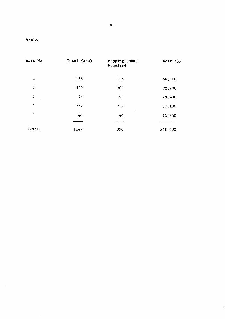
Estimated c o s t s of g e o l o g i c a l mapping programmes have been prepared and are d i s p l a y e d i n the accompanying t a b l e f o r each a r e a .
The c o s t s have been a r r i v e d a t i n the f o l l o w i n g way -
1. Costs are based on $300/skm which i s the standard g e o l o g i c a l survey c o s t f o r 1:50 000 s c a l e mapping i n c l u d i n g f i e l d work, l a b o r a t o r y work and map productions.
2. The c o s t s f o r each a r e a are those r e q u i t e d to update the g e o l o g i c a l mapping a t the 1:50 000 s c a l e b e l i e v e d to be s u f f i c i e n t f o r p r e l i m i n a r y assessment of these a r e a s . As f a r as c o s t s are concerned, t r a v e r s e mapping has been t r e a t e d a t the same r a t e as 1:50 000 s c a l e mapping as the l o c a t i o n and d e f i n i t i o n of basement rocks e n c l o s e d i n d o l e r i t e or Parmeener Group rocks i s r e q u i r e d .
41
TABLE
Area No. T o t a l (skm) Mapping (skm) Cost ($) Required
1 188 188 56,400
2 560 309 92,700
3 98 98 29,400
4 257 257 77,100
5 44 44 13,200
T O T A L 1147 896 268,000

42
APPENDIX 2
ASSESSMENT OF GEOPHYSICAL COVERAGE OF SELECTED AREAS IN THE GREAT WESTERN TIERS (See F i g . 6 ) .
43
GEOPHYSICAL COVERAGE - EXISTING AND REQUIRED
The r e l i a b l e d etermination of subsurface s t r u c t u r e s of s h a l l o w to medium depth r e q u i r e s c e r t a i n minimum l e v e l s of g r a v i t y s t a t i o n and aeromagnetic coverage. S t r u c t u r a l a s p e c t s of p a r t i c u l a r i n t e r e s t here a r e :
(1) the depth of g r a n i t e below the s u r f a c e ; (2) the t h i c k n e s s of J u r a s s i c d o l e r i t e and Parmeener Supergroup o v e r l y i n g
basement.
GRAVITY COVERAGE
Determination of shallow s t r u c t u r e s r e q u i r e s a coverage of 1 station/sq.km w i t h i n the a r e a of i n t e r e s t and f o r a d i s t a n c e of 5 km i n a l l d i r e c t i o n s around the a r e a .
Determination of deep s t r u c t u r e s r e q u i r e s a coverage of 1 s t a t i o n / 9 sq.km f o r a d i s t a n c e of 40 km i n a l l d i r e c t i o n s around the a r e a of i n t e r e s t .
The requirements f o r s a t i s f a c t o r y coverage a r e : ( i ) 1 s t a t i o n / s q u a r e km i n the a r e a i n d i c a t e d i n F i g u r e 6. T h i s w i l l
p rovide an a c c e p t a b l e r e g i o n a l cover w i t h i n the a r e a s .
( i i ) 1 s t a t i o n / 9 square km i n the a r e a i n d i c a t e d i n F i g u r e 6, i . e . from 395 E (west of a r e a shown i n F i g u r e 6) and a c r o s s to the e a s t . T h i s provides a s e m i - r e g i o n a l coverage and a l l o w s a s t r u c t u r a l i n t e r p r e t a t i o n w i t h i n the areas of i n t e r e s t .
Area ( i ) 4920 sq.km = 4920 s t a t i o n s ( i i ) 6269 sq.km = 697 s t a t i o n s
Using an average t o t a l c o s t (labour, t r a n s p o r t e t c . ) of $ 1 5 0 / s t a t i o n and weighting t h i s by 30% f o r the remoteness of the a r e a and, rugged topography makes a t o t a l c o s t of $1,095,315.

44
AEROMAGNETIC COVERAGE
To provide an adequate coverage would r e q u i r e d a ta from 395 E to 580 E and from 53260 n o r t h to 5400 N wi t h a f l i g h t l i n e s p a c i n g of 500 m, a t i e l i n e s p a c i n g of 5000 m and a t e r r a i n c l e a r a n c e of 150 m nominal. T h i s would only be a rough r e g i o n a l coverage - use of a h e l i c o p t e r would be n e c e s s a r y f o r a good coverage.
T h i s i s 59570 l i n e km assume $ 1 8 / l i n e km + 25% f o r standby charges
$1,340,325
COSTING SUMMARY
G r a v i t y 1,095,315 Aeromagnetics 1,340,325 F u r t h e r p r o c e s s i n g 120,000 I n t e r p r e t a t i o n 150.000
$2,705,640 as a t 31 August 1990


![Mineral Resources of the West Potrillo Mountains …PLATE [Plate is in pocket] 1. Map showing identified resources, mineral resource potential, and simplified geology of the West Potrillo](https://img.pdfslide.net/doc/110x75/5f3b15ed21885c3a8c665e77/mineral-resources-of-the-west-potrillo-mountains-plate-plate-is-in-pocket-1-map.jpg)