Embed Size (px)
Citation preview

MINING PLAN FOR MULTI COLOUR GRANITE (RED MULTI) QUARRY
Sandanapalli Village, Denkanikottai Taluk, Krishnagiri District, Tamil Nadu
(Prepared under Rule 16 of GCDR, 1999 for Fresh Mining Lease)
Extent : 1.70.5 Hectares
S.F. No. : 1753/1(P) & 1753/2
Village : Sandanapalli
Taluk : Denkanikottai
District : Krishnagiri
State : Tamil Nadu
Applicant
THIRU D.DHANAPAL, 7/395, Melbatchapet, Harur Post & Taluk,
Krishnagiri District. T.N.
Mobile : 9442622147 Prepared by
S.SURIYAKUMAR, M.Sc.,M.Phil.(Applied Geology),F.C.C.(Mining), PGDBA,
PGDIPC (Industrial Pollution Control)
Recognised Qualified Person & EIA Coordinator (Mining Sector – “A” Category & Mineral Beneficiation & Pelletization
Sectors -“A” Category)
Reg. No. RQP\MAS\013\87\A 3/216, K.S.V.Nagar, Narasothipatti, SALEM-4. Phone (0427) 2440446, Mob: 9842729655
www.suriyamining.com
2013

2
CONTENTS
S. No. Description Page No.
i) List of Annexure (a)
ii) List of Plans and Sections (b)
iii) Certificates (i)-(iv)
PART – A
01. General 5
02. Location and Accessability 6
03. Geology and Exploration 13
04. Mining 18
05. Blasting 25
06. Mine Drainage 27
07. Stacking of Granite Rejects and Disposal of
Waste
27
08. Uses of Granite 28
09. Others 28
10. Granite Cutting and Polishing 30
PART – B
11. Environment Management Plan 31
12. Any Other Information 40

3
(a)
LIST OF ANNEXURES
S. No. Description Page No.
I Precise Area Letter of State Govt. 45
II Copy Of FMB Certificate & Combined Sketch 48
III Copy of Patta and Chitta Adangal 50
IV Copy of RQP certificate 52

4
(b)
LIST OF PLATES
S. No. Description Page No.
01. Key Plan I
02. Lease Plan II
03. Geological Plan III
04. Geological Sections IV
05. Surface Plan V
06. Production and Development Plan for First,
Second, Third and Fourth Years
VI
07. Production and Development Plan for Fifth
Year
VIA
08. Section of Production and Development Plan VII
09. Conceptual Mining Plan VIII
10. Sections of Ultimate Pit Limit IX
11. Progressive Mine Closure Plan Showing Land
Use Pattern for the First Five Years
X
12. Final Mine closure Plan XA
13. Environment Plan XI

5
CONSENT LETTER FROM APPLICANT
The Mining Plan in respect of Multi colour Granite prospects over an extent of
1.70.5 Hectares in S.F. N0. 1753/1(P) & 1753/2 of Sandanapalli Village , Denkanikottai
Taluk, Krishnagiri District, Tamil Nadu State has been prepared by
Shri.S.Suriyakumar Recognised Qualified Person, Reg.No. RQP\MAS\013\87\A.
I request the Dept. of Geology and Mining, Chennai to make further
correspondence regarding modifications of the mining scheme with the said
Recognised Person on this following Address,
S.SURIYAKUMAR, M.Sc., M.Phil.(Geology),F.C.C.(Mining), PGDBA,
PGDIPC (Industrial Pollution Control) Consultant – Geology, Mining & Environment
3/216,K.S.V.Nagar,Narasothipatti, Alagapuram Post, Salem - 636 004.
Phone (0427) 2440446, Cell: 98427 29655
I hereby under take that all modifications so made in the Scheme of Mining by
the Recognized Qualified Person may be deemed to have been made with my
knowledge and consent and shall be acceptable to me and binding on me in all
respects.
Place : Salem
Date : 12.10.2013
Signature of the Applicant

6
THIRU D.DHANAPAL,
s/o Duraisamy Udayar
7/395,Melbatchapet, Harur Post & Taluk, Krishnagiri District. T.N. Mobile : 9442622147
DECLARATION OF MINE OWNER
The Mining Plan in respect of multi colour Granite prospects over an extent of
1.70.5 Hectares in S.N0 1753/1(P) & 1753/2, Sandanapalli village , Denkanikottai
Taluk of Krishnagiri District, Tamil Nadu has been prepared with my consultation and
I have understood the contents and agree to implement the same in accordance with
the Mining Laws.
Place : Salem
Date : 12.10.2013
Signature of the Applicant

7
S.SURIYAKUMAR, M.Sc.,M.Phil. (Geo),F.C.C.(Min),PGDBA,DIPC.
Recognised Qualified Person, 3/216,K.S.V.Nagar, Narasothipatti, Salem - 636 004. www.suriyamining.com, Email : [email protected]
Phone (0427) 2440 446, Cell: 98427 - 29655.
CERTIFICATE
This is to certify that the provisions of Granite Conservation and Development
Rules, 1999 (GCDR) have been observed in the Mining plan for Sandanapalli Multi
colour granite prospects in S.F.No. 1753/1(P) & 1753/2, Denkanikottai Taluk of
Krishnagiri District over an extent of 1.70.5 Hectares, Tamil Nadu State applied by
Thiru D.Dhanapal, Harur for the fresh mining lease.
Wherever specific permissions/exemptions/relaxations or approvals are
required, the applicant will approach the concerned authorities of State and Central
Governments for granting such permissions etc.
Certified Place : Salem
Date : 12.10.2013
Signature of Recognised Qualified Person

8
S.SURIYAKUMAR,
M.Sc.,M.Phil. (Geo),F.C.C.(Min),PGDBA,DIPC.
Recognised Qualified Person, 3/216,K.S.V.Nagar, Narasothipatti, Salem - 636 004. www.suriyamining.com, Email : [email protected]
Phone (0427) 2440 446, Cell : 98427 - 29655.
CERTIFICATE
Certified that in preparation of Mining Plan for multi colour Granite prospects
over an extent of 1.70.5 Hectares in S.No. 1753/1(P) & 1753/2, Sandanapalli Village ,
Denkanikottai Taluk, Krishnagiri District, Tamil Nadu for Thiru D.Dhanapal, Harur
covers all the provisions of Mines Act, Rules, and Regulations etc. made there under
and whenever specific permissions are required the applicant will approach the
Director of Mines safety, Chennai. The standards prescribed by DGMS in respect of
Miners Health will be strictly implemented.
Certified Place : Salem
Date : 12.10.2013
Signature of Recognised Qualified Person

9
MINING PLAN
Including Environmental Management Plan FOR QUARRYING MULTI COLOUR GRANITE
(RED MULTI) in SF.No. 1753/1(P) & 1753/2
Sandanapalli Village, Denkanikottai Taluk, Krishnagiri District
(Prepared under Rule 16 of GCDR, 1999 for Fresh Mining Lease)
EXECUTIVE SUMMARY 1) Thiru D.Dhanapal residing at 7/395, Melbatchapet, Harur Post and Taluk,
Dharmapuri district has applied for grant of Granite Quarry lease to the
Secretary to Government, Industries Dept, Fort St. George, Chennai-9 through
District Collector, Krishnagiri and Commissioner of Geology and Mining, Chennai
for quarrying Red multi colour granite from a patta land over an extent of
1.70.5 hectares in SF.No. 1753/1(P) & 1753/2 in Sandanapalli Village,
Denkanikottai Taluk, Krishnagiri District, Tamil Nadu.
2) The Principal Secretary to Government in his letter No. 10087/MME-
2/2013-1, Dated 23.09.2013 has directed the applicant Thiru D.Dhanapal to
get Approved Mining Plan and Environmental clearance certificate from the
state Environmental Impact Assessment Authority (SEIAA), Chennai as per the
orders of Hon’ble Supreme court dated 27.02.2012 in IA No, 12-13 of 2011 in
SLP(C) No. 19628-19629 of 2009 and Govt. of India, Ministry of Environment
and Forest Circular No. L-11011/47/2011- IA.II(M) dated 18.05.2012.
3) Accordingly, the Mining Plan is prepared as per the special conditions stipulated
in letter No. 10087/MME-2/2013-1, Dated 23.09.2013 and the provisions of
Tamil Nadu Minor Minerals Concession Rules, 1959 and amended provisions of
GCDR,1988 for quarrying granite with due consideration of environmental
parameters so as to obtain Environmental clearance (EC) form State EIA

10
Authority (SEIAA), Chennai region as per the Memorandum dated. 18.5.2012
from MOEF.
4) Geological resource is estimated as 29484m3 and Mineable reserves is
estimated as 20930 m3 to a depth of 18m from the ground level.
5) Average production is taken as 400 M3 per annum and Quarry is designed
accordingly to win rough blocks saleable materials with proper safety measures
under mechanized quarrying as per the provisions of Reg. 106 (2) (b)
Metalliferous Mines Regulation,1961 and other labour welfare Amenities as per
the Mines Rules, 1955 and amended DGMS circulars to be followed strictly.
6) Life of Mine at a rate of 400M3 is estimated as 52 years up to a depth of 18m
from the ground level including top soil.
7) Environmental Constraints,
i) Forest: Gullatty RF beyond Kuppasandram village is located about 2 kms
from the site on the eastern side.
ii) Aerial distance to the interstate boundary is located at 22.20 kms towards
Kanagapura of Karnataka State.
iii) There is no wild animal sanctuary within 15Km. radius from the project site
area under the Wildlife (Protection) Act, 1972.
iv) The quarry is located >200kms from sea coast on the east.
There is no Eco sensitive Zones around 15 kms from the quarry site. It is elevated
to a height of 902m above MSL. Therefore, the project seeks clearance only from
SEIAA, Chennai under B2 Category.
8) Environmental measures to be adopted shall be,
i) Dust control at source while loading and transport haul roads including metal
and mud roads of all the off-high ways particularly near villages by periodical
spraying of water,
ii) Land degradation by unnecessary quarrying other the approved Mining Plan
should be avoided. Waste lands must be reclaimed with green development.

11
iii) Non active dumps should be terraced properly with uniform height, spread
top soil and humus matter to season the waste rock for afforestation. In this
iv) connection, Forest officials and Agricultural officers shall be consulted for
planting regional trees suggested by them,
v) Emission test of vehicles should be in tack to maintain minimum emission
level of flue gases,
vi) Noise level should not exceed 80dB and the vehicles should use only
permitted Air Horn while on road near residential areas,
vii) Water quality for drinking purposes of mine workers should be tested once in
a year for its physical, chemical and biological matters with in the
permissible limits for drinking particularly its colour, hardness, TDS,BOD and
COD or otherwise potable water from public source should be provided,
viii) Top soil should be tested for its organic and inorganic contents including
heavy metals and toxic contents if any so as to control leachites from soil
dumps,
ix) And such other conditions as stipulated by the concerned authorities or by
the local bodies.
INTRODUCTION :
The applicant, Thiru D.Dhanapal residing at 7/395, Melbatchapet,Harur Post and
Taluk, Dharmapuridistrict is an Individual and he is in the field of granite quarrying
and trading for the last eight years. He has adequate knowledge and skill on quarrying
and export of dimensional granite blocks (rough) to various countries as well as to
have a capacity to retain the domestic market. Based on his applications for Quarry
Lease made to the State government, the precise area communication letter is given
vide No. 10087/MME-2/2013-1, Dated 23.09.2013 over an extent of 1.70.5 hectares
in S.F. No. 1753/1(P) & 1753/2 in Sandanapalli Village of Krishnagiri district to consider
his application for grant of quarry lease. The State Government has directed the

12
applicant to produce approved mining plan and Environmental clearance certificate
from SEIAA, Chennai with conditions of safety distance as given below,
1) 7.5m safety distance from the adjacent patta lands,
2) The black granite noticed over an extent of 0.24.0 Ha in S.F. No.
1753/1 in which the occurrence of black granite is established should
not be disturbed,
3) 7.5 safety distance to be maintained to the northern side of lease area
in S.F. 1753/1 in which occurrence of black granite is established,
4) A Safety distance of 10m should be left out for the adjacent
Government lands
5) The applicant should fence the lease granted area with Barbed wire
before execution of lease deed,
The pillar post shall be firmly grounded with concrete
foundation of height not less than 2m and the distance between
two pillars shall not be more than 3m,
6) The applicant shall produce Environmental clearance obtained from the state
Environmental Impact Assessment Authority (SEIAA), Chennai over the
subject area as per the orders of Hon’ble Supreme court dated 27.02.2012 in
IA No, 12-13 of 2011 in SLP(C) No. 19628-19629 of 2009 and Govt. of India,
Ministry of Environment and Forest Circular No. L-11011/47/2011- IA.II(M)
dated 18.05.2012 of the Ministry of Environment and Forest before granting
quarry lease.
7) The applicant should submit latest mining due clearance certificate, income
Tax clearance certificate and solvency certificate before the execution of the
lease deed,
8) The lessee shall strictly adhere to the statutory requirements,
9) The waste material should not be dumped in the river and no hindrance
should be caused to the flow of water in the river.
10) Quarrying shall be done as per the approved Mining plan
11) The lessee shall submit scheme of mining, Mine closure plan and other
statutory requirements within the time stipulated for submission of
the above ,as per Rules of GCDR,1988
12) The District Collector, Krishnagiri shall obtain a sworn –in- affidavit
from the applicant containing the above conditions before execution of

13
lease deed and also ensure that the instructions issued in Government
letter No. 12789/MMB-2/2002-7, Industries Department, dated
09.1.2003 are complied with.
The multi colour Granite deposits of this area is rich in orthoclase feldspar with
excellent wave pattern. It is commercially called as Red Multi. The light colour
Granite deposits of this area appears similar to Indian Jubrana. It mainly composed of
mineral constituents such as biotite, Quartz, orthoclase feldspar and less plagioclase
feldspar. It is a type of Para gneiss with alternative bands of orthoclase and dark
minerals. The biotite is fine grained and other minerals like alkaline and soda
feldspars are medium grained. The graphic texture and intergrowth of quartz and
feldspar indicates that younger intrusive was invaded into the pre-existing country
rock, which preferably would have been a biotite gneisses (Peninsular Gneisses)
which was converted into a type of a Migmatite with rich orthoclase feldspar.
Dimensional cutting and polishing of these type of hard and compact rocks exhibits an
attractive alternative bands of Light Pink and dark minerals with excellent wave
patterns.
By virtue of its excellent appearance, it find a niche in the commercial market in
the building Industry for decorative purposes in the form of labs, tiles, monuments,
cut to size, markers etc and to some extent in Engineering Industries also.
01. GENERAL
a) NAME AND ADDRESS OF THE APPLICANT
Name and : Shri D.Dhanapal S/o Duriasamy Udayar,
Address : 7/395,Melbatchapet,
Harur Post & Taluk,
Dharmapuri District
Contact No. : 9442622147
b) STATUS : Individual
c) TYPE OF GRANITE THE APPLICANT INTENDS TO MINE :
Multi colour Granite : Red Multi (Migmatite)
d) Period of Mining Lease : 20 years
e) Name and address of the RQP / Authorised person preparing the Mining
plan

14
Name : S.SURIYAKUMAR
M.Sc., M.Phil (Geology). F.C.C. (Mining),
PGDBA, DIPC (Industrial Pollution Control).
Address : Suriya Mining Services,
3/216, K.S.V. Nagar,
Narasothipatti,
Alagapuram Post,
Salem – 636 004.
Web site : www.suriyamining.com
E-mail : [email protected],
Phone : 0427 – 2440446
Fax : 0427 – 2444297
Mobile : +91 9842729655
Reg.No (IBM) : RQP/MAS/013/87/A.
Validity : Valid up to 08.11.2021
f) NAME OF PROSPECTING AGENCY
No prospecting agency was engaged. The area was identified by the applicant by
outcrop observation.
g) REFERENCE NO. AND DATE OF CONSENT LETTER FROM THE STATE
GOVERNMENT:
Fresh Mining Lease – Precise area communication letter No.
10087/MME-2/2013-1, Dated 23.09.2013. It is attached in Annexure –V.
2.0 LOCATION AND ACCESSABILITY
a) DETAILS OF THE AREA
__________________________________________________________________
State & District Taluk Village S.F.N0. Extent (Hec) Ownership\
Occupancy
_______________________________________________________________________
Tamil Nadu, DenkaniKottai Sandanapalli 1753/1(P) 0.73.5 Patta Land
Krishnagiri. 1753/2 0.97.0
_______________________________________________________________
Total = 1.70.5 Hec.
__________________________________________________________________
The area is approachable from Krishnagiri as given below,
Krishnagiri - Denkani kottai = 65 kms

15
Denkanikottai – Sandanapalli = 11 kms
Sandanapalli - Quarry Site = 3 kms
It is represented by Survey of India Topo sheet No. 57H/15 with co-
ordinates Latitude 12○ 28’45.0”N , Longitude 77
○50’23.3”E.
b) Location map showing route and boundaries
Fig.1 Showing location of Quarry site and route map
c) Details of the mining lease area is shown in FMB and toposketch given in the
annexure.

16
DGPS Survey:
All boundary pillars are
fixed precisely with
Differential Global
positioning System
(DGPS) to a millimeter
accuracy using post processing Business centre software of Trimble. Readings as
obtained are tabulated below,
The above co ordinates are converted into Easting and Northing so as to develop a
Geo- referenced cadastral\ lease plan in metric system (Units in meters). The
converted meter values (UTM values in WGS 1984 datum) are tabulated below,
ID Latitude (Global) Longitude (Global) Elevation
(Meter)
A N12°28'42.66936" E77°50'21.48028" 879.238
B N12°28'46.99975 E77°50'20.96417" 901.156
C N12°28'46.77752 E77°50'23.51038" 902.201
E N12°28'45.54675 E77°50'26.17793" 898.101
F N12°28'42.33802 E77°50'25.14976" 899.106

17
Elevations are given in meters “ Geoid” above Mean sea Level.
All boundary pillars are plotted as per the above UTM values and the lease
plan is perfectly geo referenced to global positioning.
All side measurements of FMB and extent of lease area (1.70.55 Ha) are
also properly verified. Details of field work done by DGPS survey is shown in the photo
below,
Fig.2: BASE Unit of DGPS at Pillar “ x” ( Known point- little away from the
lease boundary)
ID Easting
(Meter)
Northing
(Meter)
Elevation
(Meter)
A 808642.990 1381121.710 879.238
B 808,625.970 1381254.640 901.156
C 808,702.980 1381248.700 902.201
E 808784.000 1381211.720 898.101
F 808753.990 1381112.710 899.106
18
Fig.3 : ROVER Unit of DGPS at rock mark in point “ A” and “ C”
Fig.4: ROVER Unit of DGPS at rock mark in point “ E”
Existing Land Use:
It is totally a virgin area without any excavation. The area shows presence of
granite outcrops as sheet in 30% of the area and 70% is covered by morum soil,
below which also the granite may extend. It is a patta land owned by the applicant.
19
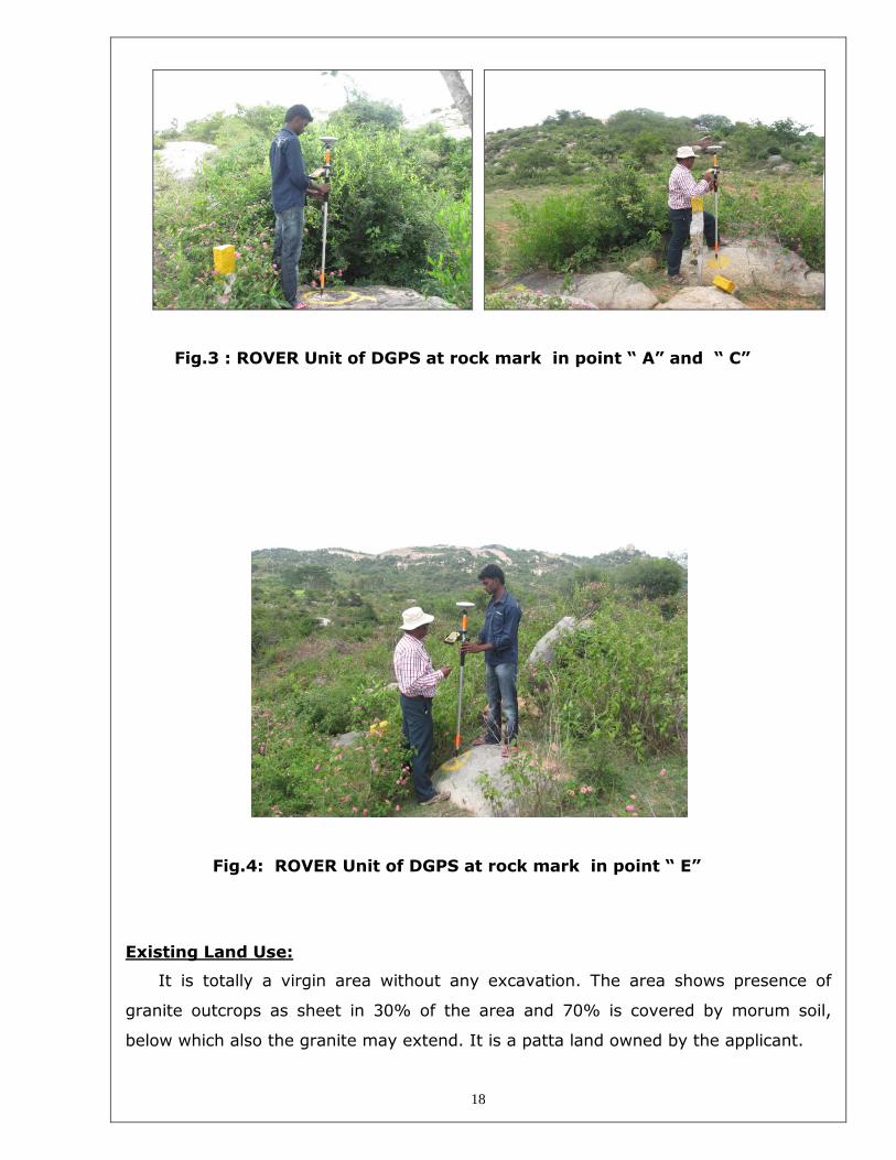
Fig.5 General view of the area with massive outcrop
Fig.6 Photo shows Wave pattern of Red multi Granite
b) Location map showing route and boundaries is given in Plate I & II
c) Details of the mining lease area is shown in FMB and topo sketch given in the
Annexure.
The area around 500m radius is shown below in Goggle image,

20
Fig. 7 Shows surface features around 500m radius

21
Fig. 8 Showing Lease boundary of proposed Quarry

22
PART - A
3.0 GEOLOGY AND EXPLORATION
a) Physiography :
The area applied for quarry lease is an elevated ground to a height of 5-10m from the
adjacent ground level, sloping gently towards SW. No major Pond or H.T. electric line
is found nearby. Water table is located at a depth of 24m from the surface in the open
wells in the neighbor areas. It is a waste land with rock exposure and bushes.
Temperature of the region is reported to be 30ºC to a max. of 40º C during summer.
Rain fall of this area is about 400 mm during monsoons in a year. Regional crops are
ragi, paddy and maize. There is no monuments or area of public interest are found in
the vicinity. Nearest Rail head is Hosur 38 kms from the area. Post office is available
in Sandanapalli village and Police station is located in Denkanikottai .
Details of Infrastructure is given as under,
S.No. Description Place Distance (Kms)
1 Railway Hosur 38
2 Road Denkanikottai- Kuppasandram 0.5
3 Post office Sandanapalli 2
4 Airport Bangalore 130
5 Police station Denkanikottai
14
6 Fire service Denkanikottai 14
7 Primary Health centre Denkanikottai 14
8 Villages
i) North Jarakalatti 2.5
ii) South Eruthukota 5.2
iii) East Kuppasandram 1.5
iv) West Sandanapalli 2
b) Regional Geology:
Krishnagiri District is comprised of Archaean peninsular gneisses such as
Charnockites, Hornblende gneisses, Biotite gneisses and migmatites, dolerites and are
intruded by younger formations like pegmatite and quartz veins. The peninsular

23
gneiss \ migmatite consists of biotite mica, plagioclase and orthoclase feldspars and
Quartz and are found as sheet rocks running to several kms from NE –SW as a
massive rock formation.
The order of superposition of geological sequence are given as under,
Description Geological Age
Top soil - Morum (2m Thick) - Recent Age
Pegmatite and Quartz veins - Archaean Age
Dolerite Dyke - Archaean Age
Migmatites (Paradiso & Red- Multi) - Archaean “( Kolar Group)
Biotite gneisses - Archaean complex
The regional rocks mostly composed of Quartz, plagioclase feldspar,
orthoclase feldspar and accessories like mica.
c) GEOLOGY OF THE PRECISE AREA
i) Mineralogy :
The area of mining lease is comprised of Migmatite with rich orthoclase feldspar
(Light Pink). Its mineral constituents are biotite, Quartz, orthocalse feldspar and less
plagioclase feldspar. The biotite is fine grained and other minerals are medium
grained. The graphic texture and intergrowth of quartz and feldspar indicates that
younger intrusive were invaded into the pre-existing country rock, which preferably
would have been a biotite gneisses (Peninsular Gneisses). The regional flow structure
and texture of wave pattern indicates that the rock would be a type of Migmatite.
Dimensional cutting and polishing of these type of hard and compact rocks exhibits an
attractive pinkish and Brown shades of background with less wave patterns. It is a
part of Peninsular gneisses migmatised by younger intrusives. It is commercially called
as Red-Multi by the buyers in view of its rich assemblages of light Pink feldspar. It is
Multi colour granite covered partly by Morum soil at the top. The rock is hard, compact
and sheet in nature so as to cut required sizes of blocks. The mineral constituents of

24
the rock mass shall be about Orthoclase feldspar 45%, quartz roughly 20%,
Plagioclase feldspar 15% , mica 15 % and others 5%.
Dolerite dyke is found about 6m away on the NW side of the lease area trending in
west to east direction.
ii) Geological setting and structure
The order of geological sequence are,
Description Geological Age
Top soil - Morum soil (Intermittent) - Recent
Dolerite Dyke - Arcaean
Migmatite (Red Multi) with wave pattern - Archaean
Biotite Gneisses (Peninsular Gneisses) - Archaean
The top soil cover is found on lower elevation of the area but on the higher elevations
fresh massive migmatite are exposed on the NE and eastern sides. The strike of the
granite body is almost NE-SW and dips vertical. The regional trend is shown in the
geological plan. The multi colour granite that occur in this area is massive with less
boulders or fractures. It is suitable for commercial exploitation of gang saw size rough
blocks.
The following photograph illustrates the nature of granite formation in this area,
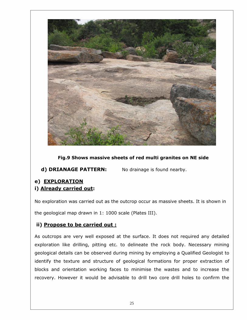
25
Fig.9 Shows massive sheets of red multi granites on NE side
d) DRIANAGE PATTERN: No drainage is found nearby.
e) EXPLORATION
i) Already carried out:
No exploration was carried out as the outcrop occur as massive sheets. It is shown in
the geological map drawn in 1: 1000 scale (Plates III).
ii) Propose to be carried out :
As outcrops are very well exposed at the surface. It does not required any detailed
exploration like drilling, pitting etc. to delineate the rock body. Necessary mining
geological details can be observed during mining by employing a Qualified Geologist to
identify the texture and structure of geological formations for proper extraction of
blocks and orientation working faces to minimise the wastes and to increase the
recovery. However it would be advisable to drill two core drill holes to confirm the

26
colour, massiveness of the formation at depth for long term investment decision
making.
f) METHOD OF ESTIMATION OF RESERVES
The geological and mineable reserves are estimated by cross-sectional method.
Since the granite band is occur widely over the entire area and dips vertically and
further exposed in the working pits, the depth of mining is taken as 18m from the
surface. Leaving the top soil and boulders , the average thickness of granite available
for extraction is 18m. The following recovery rate is taken for estimation of reserves
based on field conditions.
Bench Height (m) Depth(m) Recovery
Bench 2m 0-2 0%
Slice or Bench II-IV 6m 2-18m 20%
g) GEOLOGICAL RESERVES
The geological reserves is estimated for the area allowed for mining by the Cross-
Sectional method is as 29484 cubic meters up to a depth of 18m , having considered
the depth of mining, recovery, safety barriers etc. Details of estimation of geological
reserves is given in the Annexure I.
h) MINEABLE RESERVES AND ANTICIPATED LIFE OF MINE
The mineable reserves is estimated by cross-sectional method having considered
the recovery factor, depth of mining, safety barriers etc., The mineable reserves is
estimated as 20930 cubic meters. Details of estimation of mineable reserve is given
in Annexure II.
The overall pit slope is taken as 60 deg. from the horizontal. The recovery factor is
taken as 20% for benches II-III(2-18m ) depth based on the field experience of
adjacent mines. Depth of mining is taken as 18m from the ground level.
The life of the mine is computed as 52 years at a production rate of 400 cubic
meters per annum.

27
4.0 MINING
a) Proposed Method of Working:
Open cast method of Semi- mechanised mining shall be adopted to extract the
dimensional blocks of required size from this area. It is proposed to form benches and
road as per Plates VII-X. Man power and machinery to be engaged are discussed in
later chapter.
b) Year Wise Production and Development for the first five Years :
The development involves only removal of small amount of top soil and Rejects
amounts to 80%. The annual production is proposed as 400M3 for the first five years
and generation of rejects are shown as under,
----------------------------------------------------------------------------------------
Year Bench Overburden ROM Saleable Reject of Granite Granite to
(m3) (m3) Granite(m3) (m3) O/B ratio
----------------------------------------------------------------------------------------
I I --- 2000 400 1600 1 : 4
II I --- 2000 400 1600 1 : 4
III I --- 2000 400 1600 1 : 4
IV I --- 2000 400 1600 1 : 4
V II --- 2000 400 1600 1 : 4
-----------------------------------------------------------------------------------------
Total --- 10000 2000 8000 1 : 4
-----------------------------------------------------------------------------------------
28
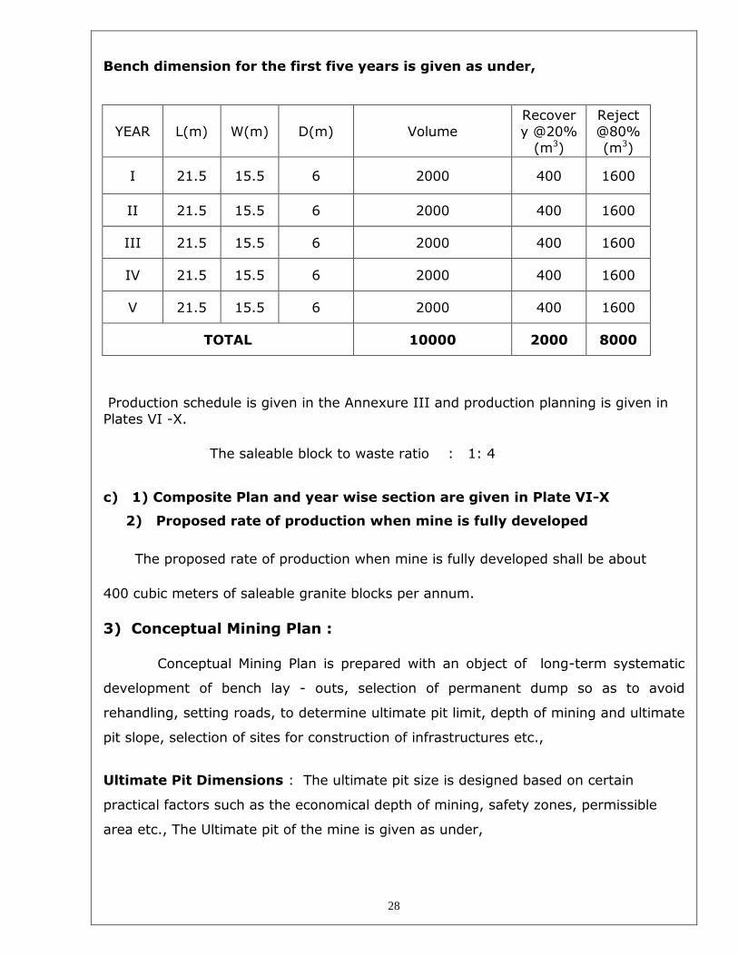
Bench dimension for the first five years is given as under,
YEAR L(m) W(m) D(m) Volume
Recover
y @20%
(m3)
Reject
@80%
(m3)
I 21.5 15.5 6 2000 400 1600
II 21.5 15.5 6 2000 400 1600
III 21.5 15.5 6 2000 400 1600
IV 21.5 15.5 6 2000 400 1600
V 21.5 15.5 6 2000 400 1600
TOTAL 10000 2000 8000
Production schedule is given in the Annexure III and production planning is given in
Plates VI -X.
The saleable block to waste ratio : 1: 4
c) 1) Composite Plan and year wise section are given in Plate VI-X
2) Proposed rate of production when mine is fully developed
The proposed rate of production when mine is fully developed shall be about
400 cubic meters of saleable granite blocks per annum.
3) Conceptual Mining Plan :
Conceptual Mining Plan is prepared with an object of long-term systematic
development of bench lay - outs, selection of permanent dump so as to avoid
rehandling, setting roads, to determine ultimate pit limit, depth of mining and ultimate
pit slope, selection of sites for construction of infrastructures etc.,
Ultimate Pit Dimensions : The ultimate pit size is designed based on certain
practical factors such as the economical depth of mining, safety zones, permissible
area etc., The Ultimate pit of the mine is given as under,

29
Ultimate Pit Dimensions (m)PIT-I
Bench L W Ht
I 23 14 Outcro
p
II 50 30 6
III 44 24 6
IV 38 18 6
Total = 18
Ultimate Pit Dimensions (m)PIT-I
Bench L W Ht
I 43 50 outcrop
II 87 56 6
III 73 42 6
IV 63 30 6
Total = 18
However ,during extraction of blocks each bench will be of 3m height with vertical
slope for proper dimensional cutting. The quantum of excavation is estimated as
119908 m3 to a depth of 18m . Of which, the rejects and up to the ultimate pit limit is
estimated as 98978 m3 rejects and 20930 m3 of saleable granite blocks. Part of rejects
will be dumped on the NE side and rest by back filling. Details of Ultimate dump
dimensions (m) are given as under,
DUMP DIMENSIONS (M)
TOPSOIL (ALB) = 3810m3
REJECT BACKFILLING 57mx9.129mx22m = 11448 m3
REJECT 63mx 60mx22m = 83720 m3
TOTAL = 98978m3
Production = 20930
----------------------------------------------------------------
Total Volume of Excavation up to = 119908 m3
Ultimate pit Limit with 18m depth
----------------------------------------------------------------

30
d) OPEN CAST MINES
i) Mode of Working :
The Granite blocks of the following standard sizes will be extracted from this mine
by Open cast semi-mechanised method of mining using Shot hole drilling with a aid
of compressor and Jack hammers ,smooth blasting, block lifting using cranes and
waste and rejects removal using Hydraulic excavators and tippers combination.
Working plans and sections showing the layout of faces and direction of mining are
given in Plate VII-X.
The economical depth of mining is taken as 18m having considered several field
phenomenon such as limit of lease boundary. Three benches are designed to exploit
the granite blocks by conventional methods. The benches each of 6m height and width
not less than the height are designed to win the blocks.
BENCH DESIGN PARAMETERS :
Top soil shall be removed and stacked separately along Lease boundary as
earth Bund which will be used for afforestation purposes in phases. Granite benches
will be formed to a height of 6m and width not less than 10m for movement of
machineries while working and the final slope shall be 60°. Initially the granite
benches will be vertical for dimensional cutting of blocks. The applicant is proposed to
produce dimensional blocks to measure ,
Minimum size = 1.50 x 1.00 x 1.00 m = 1.50 cu.m.
Maximum size = 3.40 x 1.90 x 1.80m = 11.62 cu.m.
Construction of parapet as a fencing around such ultimate pit limit on top of opencast
workings will be arranged to safeguard the mine from inadvertent entry and hazards.

31
PROPOSED BENCH DIMENSIONS (M)
--------------------------------------------------------------------------------------
Year Bench Prod\Waste Length (m) Width(m) Height (m) Slope
--------------------------------------------------------------------------------------
I I Prod. 21.5 x 15 x 6 Vertical
II I “ 21.5 x 15 x 6 “
III I “ 21.5 x 15 x 6 “
IV I “ 21.5 x 15 x 6 “
V I “ 21.5 x 15 x 6 “
Final slope 60 deg.
-------------------------------------------------------------------------------------
PRE-SPLITTING :
Preface development is must for extraction of dimensional blocks without cracking
or fissuring of the body during drilling and blasting . To achieve such preface a pre
splitting technique using Jet burners on the advanced direction are resorted to a
distance of 6 –10m so as to isolate the working face from the remaining area. This
practice are followed to minimise the formation of artificial cracks and tensional
fissures that are developed after blasting in the advance direction.
Shot - hole drilling with jack hammers and line drilling with top hammers will be
used at close spaced intervals to develop cracks along the line of drilling and to open
the blocks. Low strength explosives or merely detonating fuse may be used to create
a “pre-determined line of cracks “ so as to pull out the blocks from the working
faces.
Block - Lifting is an art to remove the cracked rough block from the face by a
Crane/Excavator. The debris and rejects and waste will be cleared from the face by
Hydraulic Excavator and tipper combinations. The rough blocks will further subjected
to dressing to a desired size by secondary cut at the surface.
The rough dimensional blocks will be supplied to the potential domestic and
overseas customers. The waste will be dumped on the specified place earmarked for
dumping as shown in the Plate VII-X.

32
e) EXTENT OF MECHANISATION
The machineries proposed to engage in the mines for systematic operation and
development of quarry to augment extraction of blocks are in Annexure IV.
1. Drilling :
Drilling of shot-holes will be carried out using compressor and Jack Hammers
combination. Depth of holes shall be 2.5m for 3m bench height. The spacing shall be
30 - 40 cms and burden from the preface depends upon the size of block. However
the it is preferred to have 1 - 1.5m burden from the preface for effective pulling of
blocks. In case of burden in excess of 1.5m the spacing should be adjusted smaller,
less than 30cms.To achieve a correct blasting geometry certain amount of trial blast is
pre-requisite to effect a perfect pre-determined crack to release the block from the
parent rock.
Details of Drilling equipments are tabulated below,
--------------------------------------------------------------------------------------
Type N0s. Dia. of Hole Size /Capacity Make Motive Power H.P.
--------------------------------------------------------------------------------------
Jack 3 32mm Hand held Atlas Copco Air ---
Hammer
Compressor 1 7.5 kgs/cm2 Portable ELGI Diesel 60 HP
--------------------------------------------------------------------------------------
2) Loading Equipment :
Loading of waste and granite rejects shall be done by Hydraulic Excavators into 10
tonners tippers for clearing of waste and rejects from the working place periodically.
Such waste and rejects shall be dumped in the site earmarked for dumping as shown
in the Plates VI - X. The applicant is proposed to engage. One Hydraulic excavators
with 1.7m3 . capacity and one tipper of 10 tonnes capacity for internal transport of
rejects from the working face to the dumps.
Details of Loading equipments are tabulated below,

33
--------------------------------------------------------------------------------------
Type N0s. Bucket Capacity (m3) Make Motive Power H.P.
--------------------------------------------------------------------------------------
Hydraulic 1 1.7 m3 EX300 Diesel 180
Excavator
--------------------------------------------------------------------------------------
Details of machineries are given the Annexure IV.
3) Haulage and Transport Equipments :
Transport of Rejects and waste shall be done by Tippers of 10 tonne capacity
--------------------------------------------------------------------------------------
Type N0s. Size/ Capacity (m3) Make Motive Power H.P.
--------------------------------------------------------------------------------------
Tipper 2 10 M.T . Ashok Leyland Diesel 110
--------------------------------------------------------------------------------------
4) Miscellaneous Operations :
i) Extent of Manual Mining
Manpower will be engaged for drilling shot-holes, line drilling, smooth
blasting, Jet burner operation, dressing of granite blocks, cutting and removal of small
amount waste or rejects and support service labours for operation of machineries .
The materials required for manual workings are listed as under,
1. Drill rods - 450mm , 800mm,1650mm,3900mm and up to 7200mm.
2. Steel alloy chains of sufficient lengths with dia. of 12 - 18mm with “D’
shackles.
3. Crow bars of 1500 - 1800mm lengths,
4. Rubber hose and clamps, Feather and wedges of 15 cm and 30 cm sizes
utilised for splitting of blocks.
5. Spades, Sludge hammers, Iron Pans and chisels.
ii) Pumping :
Dewatering arrangements shall be made to pump out the rain and
percolation of ground water during rainy seasons. A stand by pump with 10 H.P.
capacity is essential to meet the emergency.
5.0 BLASTING

34
A controlled Blasting technique will be adopted to open a pre-determined crack
of the block from the parent body. Shot-hole with 32-36mm dia. which are drilled by
line drilling and Jack hammers at a close spaced interval of 30 cms will be initiated
suitably with any one or more of the following methods,
i) Pre-splitting
ii) Cushing blasting with low strength and very low dia. cartridges by
axial priming or standard dia. cartridge with intermittent stemming
materials.
ii) Water impulsion with Detonating cords of sufficient power, Preferably
10 gms per metre to develop cracks along the line of drilling,
a) BROAD BLASTING PARAMETER
Dia. of the hole = 32 - 36 mm
Spacing = 30 cms
Depth = 2.5 m
Burden = Min =1m ; Max = 2m
Charge per Hole = D.cord with water or 70 gms of
gun powder or slurry.
Burner Cutting & Drilling
Vertical Holes
Burner cut
Burner Cut
Horizontal Holes
Charging of Vertical Holes
Detonating Fuse 5-10 gms/m
--
-- Holes filled with water

35
Charging of Horizontal Holes
OD with safe fuse Explosive Column 42--62.5 gms of Cartridge
+++++++ -----EEEE
Stemming Material in the form of cartridge
In watery holes, the water pressure that are developed while initiating the detonating
fuse will act as a cushion to move the blocks and form a line of crack. In other cases,
small vibration created by low explosives open the artificial shear plane \tensional
crack formed by a line of drilling. Sometimes wedges are used to cut the major blocks
into smaller sizes after drilling of holes to a depth of 30-40 cms. Then the blocks are
dressed to desire sizes.
b) TYPE OF EXPLOSIVES :
Common explosives used to develop a line of crack along the line of drilling are,
i) Detonating Fuse or Cord with 10gms of Expl. per metre,
ii) Low explosives like Gun powder or 70 gms of slurry cartridges,
iii) Ordinary Detonator, class- 6
iv) Safety fuse, class -6.
c) Powder factor : The Powder factor for waste rock development shall be
7 tonnes per Kg. of explosives.
d) STORAGE OF EXPLOSIVES
The applicant is advised to store the explosives as per the Indian Explosives Act,
1958. The explosives to be used in mines being a small quantity the District collector
may be approached to keep the stocks not exceeding 5 kgs at time or any other
quantity permitted by the concerned authorities in a portable magazine of S & B
types.
6.0 MINE DRAINAGE

36
a) Surface Water control : There is no water body is located nearby except a
drainage track on the eastern side used to take flood water during rainy season
from higher elevations.
b) Water Table: The ground water table is observed at a depth of 24m in the
open wells at lower levels. As the mining is proposed for a depth of 18m at higher
levels it may not disturb the ground water.
c) Quantity and Quality of Ground water: The recuperation of ground water
may not raise immediately due to shallow mining. The rain water percolation and
collection shall be less than 300 lpm and it shall be pumped about periodically by a
stand by diesel powered centrifugal pump motivated with 5 H.P. Motor. The quality of
water is potable without any contamination and it shall be pumped into the adjacent
agricultural fields.
7.0 STACKING OF GRANITE REJECTS AND DISPOSAL OF WASTE
Granite rejects which amounts to 80% of the total excavation, about 98978 cu..m.
will be generated for mining up to 18m depth. It is revealed in the Conceptual mining
plan showing the ultimate depth of mining and ultimate pit configuration. Maximum
height and spread of dumps for the first five years are given as under,
Year wise production of Reject and waste are tabulated as under,
---------------------------------------------------------------------------------------
Year Top Soil (m3) Overburden /Waste (m3) Rejects (m3)
---------------------------------------------------------------------------------------
I --- ---- 1600
II --- ---- 1600
III --- ---- 1600
IV ----- ---- 1600
V ----- ---- 1600
-------------------------------------------------------------------------------------------------------------------
Total = ---- 8000
-------------------------------------------------------------------------------------------------------------------
Maximum height and spread of dumps for the first five years are given as
under,

37
DUMP DIMENSION (M) ------------------------------------------------------------------------------------------- Year Dump Length(m) Width(m) Height(m) Volume(m3) --------------------------------------------------------------------------------------------
I – V Rejects 53.33 30 5 = 8000
--------------------------------------------------------------------------------------
All the rejects shall be dumped on the NW side of the area as per Plate VII-VIII. The
undressed blocks will be stacked at the entry of mine within the lease area for
dressing and lifting into the carriers. Land chosen for dumping is barren and virgin it
does not contain any massive deposit.
8.0 USES OF GRANITE
Polished multi colour granite are widely used for decorative purposes in
building, monument, Institutional, commercial and residential buildings in the form of
slabs, tiles, cut to size ,markers etc.,
The multi colour granite found in the applicant’s area has Light Pink to pinkish
background with wave pattern. Its demand is high both in domestic and international
market even for the rough blocks preferably in Europe.
9.0 OTHERS a) SITE SERVICES :
Sufficient stock of spares, lubricants and fuels have to be maintained at the mine
site for effective and optimum Utilization of man power and machineries.
Infrastructure required for such mines like office, stores, canteen, First-aid station,
shelter, latrine and bath rooms have to be provided as per the Mines Rules,1961 as a
welfare amenities for mine Labourers. All such infra structures are shown in the Plates
VII-X.
b) EMPLOYMENT POTENTIAL:
i) Management and supervisory Personnel :
38
The mine shall be operated with a system of deploying heavy machineries like
Hydraulic excavator, cranes etc., a Qualified Mining Engineer as per Rule 38(1)(a) of
GCDR,1999 should be appointed to perform the duties specified to him under these
provisions.
For the purpose of Mines safety under the provisions of MMR,1961 under the Mines
Act,1952 the Mining Engineer so appointed should have First /second class Mine
Manager certificate to act as a Manager of the Mine as per the Mining laws. To
supervise daily, of all workings and the persons employed therein the first class
Manager so appointed must be assisted by a second class Manager or a Foreman
certificate holder. Wherever the workers are employed more than 10, it is preferred to
have a qualified Mining Mate to keep all the production workers directly under his
control and supervision.
A mines clerk shall also be appointed to keep the registers and record of
the mine and make necessary entries for the persons employed in the mines.
ii) Labour - skilled-semi skilled and unskilled :
The following labours are working in the mines,
Level Designation
Category
Executive Staff Skilled Semi-
skilled
Un
skilled
I Mines Manager / Mining
Engineer
1
II Geologist 1
II Mechanical Engineer 1
III Foreman / Mining Mate /
Clerk
2
IV Blaster 1
IV Machanic / Operator 5
V Compressor Operator /
Burner Driller
13
VI Face Cleaning / Dressing
/ Miscellaneous
6
TOTAL 3 2 6 13 6 = 30

39
The following scientific organization is proposed to monitor the
production, quality and conservation of granite the following chart is proposed for
scientific and systematic mining of deposit.
ORGANISATION CHART
(Proposed)
10. GRANITE CUTTING AND POLISHING
The applicant have a cutting and polishing unit in Harur and part of the rough
blocks shall be export to the potential buyers of the Domestic and world market.
PART - B
11.0 ENVIRONMENT MANAGEMENT PLAN
OWNER / AGENT
Finance Mines Manager Manager (Admn.) I
II
Staff
Geologist
Fore Man
Engineer (Mech)
III
Office staff IV Blaster Mining Mate
Production Labours
Supervisor
(Maintenance)
Mech. Helpers /
Cleaners

40
a) BASE LINE INFORMATION
i) Existing Land use Pattern:
The area is comprised of morum soil and outcrops of multi -colour granite. Water
table of the area is said to be fluctuated between 21-24m during a year in the
adjacent area. The existing land use pattern and land usages at the end of fifth year is
given in a tabular form as below,
Land Use Pattern At
presen
t
At the end of
5th
Year
Extent (Hec.) Extent (Hec.)
i) MINING AREA 0.00.0 0.16.95
ii) ROAD 0.00.0 0.02.45
iii) SAFTY AND PLANTATION
AREA
0.00.0 0.40.75
iv) WASTE AND DUMPING
AREA
0.00.0 0.25.40
v) LABOUR SHED AND OFFICE 0.00.0 0.00.80
vi) OTHERS (VIRGIN AREA) 1.70.5 0.84.15
Total Lease Area 1.70.5 1.70.5 Hec
The average thickness of top soil is 2m occur on higher elevations only,
ii) Water Regime:
It is a dry area without any surface body of water. Water table is located at a depth of
24m on lower elevations. Rain water shall be allowed freely in to the natural drainage.
Rain fall data of Krishnagiri district is ranging from 500mm in a year. Rainy season
starts from Middle of October to December.
Scattered rains experience during July month. Total period of rain fall is three months
in a year. The rain water flows freely to the low lying areas by natural gradient at 1:
50 from west to east. The ground water is potable and pumping out of this water into
the neighbour tanks will increase the level of water in the tank without any alteration
in its quality.

41
iii) Flora and Fauna:
a) Flora is represented by few scattered bushes.
b) Fauna:
The fauna of the area is represented by rabbits and Fox. Rabbits are common in
this area. No sanctuaries or wild life is found nearby.
iv) Quality of Air, Ambient Noise level and water
Being a small area the Ambient Air Quality is not tested by the applicant. There is
no heavy Industries nearby, the noise level of the area will be as same as the regional
level. More over the noise level measurements does not raise for this area since very
low explosives will be used for mining and the machineries to be used shall hydraulic
types, it does not create much noise except the compressor, drilling and jet burners.
Water drawn from the tube and open wells are potable and the villagers are
using such water for a long period. No adverse health hazardous was reported due to
quality of water like flurosis. TDS, COD, BOD, Salinity, hardness etc have to be
tested by the applicant within one year for consumption of water by the mine workers
one sample each from open and tube wells.
iv) Climatic Conditions:
a) The average actual rain fall of Krishnagiri is reported as 1000.8mm per annum.
Pictorial representation and annual statistics for the last 10 years of rain fall data
of Krishnagiri district is given as under,

42

43
b) Temperature Throughout the month of May daytime temperatures will generally reach highs of
around 33°C that's about 91°F. At night the average minimum temperature drops
down to around 22°C, that's 71°F.
In recent times the highest recorded temperature in May has been 38°C that's 101°F,
with the lowest recorded temperature 15°C, about 60°F.
Relative Humidity
The average daily relative humidity for May is around 64%.
c) Heat Index
The Heat Index is a measure of how hot it feels when relative humidity is added to
actual air temperature. From this a comfort level is calculated providing categories on
how heat conditions might adversely affect someone.
Comfort Levels: Given average maximum temperatures and humidity levels you can
expect dangerous heat conditions. Sunstroke, muscle cramps and heat exhaustion are
likely. Heatstroke is possible with prolonged exposure and/or physical activity (see
heat index for more information).

44
d) Precipitation
The average monthly amount of precipitation has been recorded at around 122 mm,
that's 5 inches. Throughout the month you can expect to see rain or drizzle falling on
10 days of the month.
e) Wind
The average daily wind speed in May has been around 6 km/h, that’s the equivalent to
about 4 mph, or 3 knots. In recent years the maximum sustained wind speed has
reached 63 km/h, that’s the equivalent of around 39 mph, or 34 knots.
f) YEARLY TRENDS: WEATHER AVERAGES & EXTREMES
The following charts show yearly weather trends with information on monthly weather
averages and extremes.
Temperature
The chart below plots the average high and low temperature for each month of the
year. It also shows the maximum and minimum recorded temperatures.

45

46
vi) Human Settlement :
The nearby villages with their population and distance are given as under,
------------------------------------------------------------------------------
Name of Village Direction Distance from Mines Population
(Approx.)
-------------------------------------------------------------------------------------
Jarakalatti North 2.5km >1000
Sandanapalli West 2km 6545
Rathnagiri East 1.5km 2542
Hanumanthapuram South 5.2 kms 5241
-----------------------------------------------------------------------------------------------------------
vii) Public Building Places of worship and Monuments:
No infrastructures like residential building, places of special interest like temples,
architects, Sanctuaries etc., are found around 5 kms radius.
b) ENVIRONMENTAL IMPACT ASSESSMENT (EIA)
Being a small mine impact of mining on environment will be negligible. There is
no chance for cutting of trees. On the other hand the applicant propose to plant more
trees as per the mining plan. There will not be any change in the quality of water to be
47
pumped from the mines during rainy season. Wherever the noise level is found in
excess of the stipulated limits, necessary protective devices like ear plug, mask will be
provide to the employees exposed to such noisy and dusty conditions. In addition,
dust will be controlled at the source by wet drilling, periodic spraying of water over
haul roads, etc The mining operation will provide more employment to the rural
people and environment friendly operations. It impact on environment will be
minimum or negligible. However generation of noise should be controlled or adequate
protective devices should be provided for use of persons employed in the vicinity.
c) ENVIRONMENT MANAGEMENT PLAN
i) Dust: Dust expected to be generated from drilling, hauling roads, place of
excavation etc will be suppressed by periodical wetting of land by spraying using MgCl2
solutions. Wet drilling and dust extractor arrangements will be provided to drilling
units so as to control raise of dust from the site of drilling. Operators, those exposed
directly to such conditions will be provide such protective equipments like mask, ear
plug, helmet, gloze etc as per the Mines Act.
ii) Temporary storage and Utilization of Top Soil :
Small quantity of Top soil shall be dumped separately for dump afforestation in
future.
iii) Proposal for reclamation land affected by mining activities during and at the end mining lease period:
The depth of granite deposit is not known. However for economical planning, the
depth is taken as 18m from the surface. Immediate reclamation of land does not raise
for this deposit. However it pit will be used for miscellaneous purposes like fish bond
etc., after completion of mining. All waste and reject materials will be dumped as per
the mining plan.
iv) Programme of Afforestation:
Regional trees like Casuarinas. Eucalyptus, Neem, acacia ,Tamarind etc will be
planted along the Lease boundary and avenues as well as over Non-active dumps at a

48
rate of 20 trees per annum with interval 5m in between. The rate of survival expected
to be 80% in this area. Land use and Afforestation Plan is given Plate X.
v) Stabilisation and Vegetation of Dumps:
The materials to be dumped shall be very hard in nature and it does not require any
grading separately. The materials like granite rejects shall be graded automatically
during dumping by Excavator and tipper combinations. Part of top soil will be spread
over the Non-active dumps along the slope and edges to plant tree sapling to form
vegetal cover over the dumps. Such vegetal cover will prevent erosion of dumps
during rainy seasons. The program of tree planting is given as under,
Year Place Type of Trees Number rate of survival
I Lease Boundary Neem,acacia, Casuarina, 20 80
Eucalyptus, Tamarind etc.,
II Lease Boundary Neem,acacia, Casuarina, 20 80
Eucalyptus, Tamarind etc.,
III Lease Boundary Neem,acacia, Casuarina, 20 80
Eucalyptus, Tamarind etc.,
IV Lease Boundary Neem,acacia, Casuarina, 20 80
Eucalyptus, Tamarind etc.,
V Lease Boundary Neem,acacia, Casuarina, 20 80
Eucalyptus, Tamarind etc.,
vi) Treatment and Disposal of water from mines :
The water to be pumped from the mine will pure and potable. It will not be
harmful and it does not require any treatment before discharging into the natural
course or tanks. Granite sheet extraction will not produce any waste which will pollute
the ground water. Drinking water to mine labour will be supplied from public source or
bore well to be drilled by the applicant.
vii) Measures for minimizing adverse affect on water regime :
The water to be pumped out will be very pure and potable and therefore it will not
affect any water regime s of the area. Depth of mining is also moderate and it does
not affect even the ground water table.
viii) Socio-economic benefits arising out of Mining:

49
The mining operation will create an employment of about 29 persons, of which 80 %
will be from local people (Son of Soil). After development of mine from this area, not
only provide employment opportunities but also the industrial culture and civilization
to the village people. Beneficiary villages are Sandanapalli and its hamlets
12.0 ANY OTHER RELEVENT INFORMATION
The Light colour granite of this area is commercially called as Red-Multi. But
geologically, it is type of Migmatite rock intruded in to the pre existing country rock.
The geological reserves and mineable reserves are estimated as 29484 and 20930 m3
respectively for the lease area up to a depth of 18m. Systematic mining with proper
orientation of working faces and blasting techniques will improve the recovery, by
which the mining cost will be so low from the present status of mining; also the
valuable rock will be conserved. Engaging Diamond wire saw cutting machine will
improve the rate of recovery to more than 20%.
Diamond wire saw cutting shall be followed for massive sheets of rocks where the
formation having less cracks or fissures.
Signature of Recognised Qualified Person

50

51

52

53

54

55

56

57

58

59

60

61

62

63

64

65

66